The Spatial Distribution of Commercial Fish Stocks of ... · The Spatial Distribution of Commercial...
30
The Spatial Distribution of Commercial Fish Stocks of Interest to Scotland in UK Waters A report prepared by the University of Aberdeen for the Scottish Fishermen’s Federation January 2017
Transcript of The Spatial Distribution of Commercial Fish Stocks of ... · The Spatial Distribution of Commercial...

i
The Spatial Distribution of Commercial Fish
Stocks of Interest to Scotland in UK Waters
A report prepared by the University of Aberdeen for the Scottish Fishermen’s Federation
January 2017

ii

iii
Executive Summary
1. This report presents analyses of the spatial
distribution of 17 selected commercial fish
stocks of interest to Scotland. With the
exception of mackerel, the data were taken
from fishery independent surveys. In most
cases these were trawl surveys co-ordinated
by the International Council for the
Exploration of the Sea.
2. Comparisons were made between the
percentages of fish contained within the
UKs Exclusive Economic Zone (EEZ) - the
estimated spatial percentage (incorporating
survey uncertainty), and the percentage of
Total Allowable Catch (TAC) allocated to
the UK – the quota. The estimated spatial
percentages were reasonably stable
throughout the analysis periods of three and
five years.
3. For most stocks the percentage of TAC
allocated (quota) to the UK is much lower
than the estimated average percentage of
the spatial distribution in the UK. The
comparison between the estimated average
spatial percentages and quota are given in
the following summary table.
Summary Table. Comparison of the UK’s quota allocation (%TAC) of stocks of importance to Scotland
with the estimated spatial percentage, expressed as the average percentage of the stock in UK waters over 5
years. Stocks are ordered by the magnitude of the difference between these two percentages (red indicates
quota is less than the average percentage in UK waters, blue indicates quota is more than the average).
Region Species UK quota (% TAC) Average percentage in UK EEZ (%) over 5
years
Difference from
average
No
rth
Sea
Herring (mature) 15 88 -73 Hake 18 60 -42 Saithe 8 46 -38 Cod 39 60 -21 Whiting 62 79 -17 Haddock 65 80 -15 Anglerfish 73 61 12 Herring (immature) - 10
Wes
t o
f Sc
otl
and
Hake 18 79 -61 Saithe 46 84 -38 Cod 60 93 -33 Herring 60 87 -27 Whiting 57 83 -26
Haddock 76 87 -11 Anglerfish VIa & VIb 31 68 -37
Other Mackerel 23 36 -13 Rockall Haddock 78 56 22

iv
4. When the uncertainty associated with the
survey data is taken into account, there
were two stocks where the UK quota is in
line with the amount of fish in the UK EEZ:
haddock, in both the North Sea and west of
Scotland. In both of these cases the quota
allocation (%TAC) lies within the bounds
of uncertainty of the estimated spatial
distribution percentages. Mackerel is also
likely to have a quota allocation in line with
the estimated spatial distribution
percentages, but no uncertainty estimates
were available for this stock.
5. Two stocks have quota allocations that are
in excess of the estimated spatial
distribution percentages: North Sea
anglerfish and Rockall haddock. The quota
allocations (73% and 78% of the TACs,
respectively) were 6% and 7% greater than
the maximum estimates of spatial
distribution percentages of these stocks
(67% and 71%) respectively.
6. All other stocks have quota allocations that
are less than the minimum estimates of
spatial distribution percentages. The largest
discrepancies were for North Sea herring,
west of Scotland hake, anglerfish in VIa and
VIb, west of Scotland herring, cod, saithe
and whiting, and North Sea hake (all with
differences between the quota allocation
and minimum estimates of spatial
distribution percentage greater than 10%).
Smaller but significant discrepancies were
found in North Sea whiting, cod, saithe,
and haddock (all with differences of less
than 10%).
7. With the exception of haddock, all of the
stocks on the west of Scotland considered
here, have quota allocations that are at least
15% less than the minimum estimates
spatial distribution percentages in UK
waters.

v

vi
Contents
Table of Contents
Executive Summary ......................................................................................................................... iii
Introduction ....................................................................................................................................... 1
Brexit and the CFP ........................................................................................................................ 1
Spatial Distributions of Fish Stocks ............................................................................................. 1
Methods.............................................................................................................................................. 2
Data Sources .................................................................................................................................. 2
Stock Definitions ........................................................................................................................... 2
Conditional Geostatistical Simulations (CGS) ........................................................................... 2
Percentages per ICES Statistical Rectangle ................................................................................. 3
Results ................................................................................................................................................ 5
Discussion points ............................................................................................................................... 9
Acknowledgments ........................................................................................................................... 10
References ........................................................................................................................................ 10
Figures .............................................................................................................................................. 12

vii

1
Introduction
European Union (EU) fisheries are currently
managed in accordance with the Common
Fisheries Policy (CFP), established in 1983. A
Total Allowable Catch (TAC) is set annually
for each fish stock, and a portion of this TAC
is then allocated to each member state as a
national quota. Quotas are apportioned
according to the relative stability key which
reflects historical catch percentages in each
fishery (Bellanger et al., 2016). TACs are set
according to scientific advice in order to
maximise catch and ensuring long-term
sustainability (Carpenter et al., 2016).
Brexit and the CFP
In the 2016 United Kingdom (UK) European
Union referendum, a majority of British voters
expressed a lack of support for the United
Kingdom’s continued membership of the EU.
No definitive timetable has been outlined for
Britain’s exit (“Brexit”) from the EU, but the
process is likely to involve extensive
negotiations regarding the UK’s commitment
to various pieces of EU environmental
legislation (Boyes and Elliott, 2016) including
the CFP. It is also unclear at the time of
writing what type of fisheries agreements will
be in place in the event of UK leaving the EU.
Spatial Distributions of Fish Stocks
Regardless of how Brexit negotiations unfold,
it is worth considering the spatial distribution
of fish stocks which occupy UK waters, with
future negotiations surrounding changes to
European fisheries agreements in mind. The
best available understanding of actual fish
spatial distributions can be obtained from
scientific fish survey data. Fishery catch data
is a result of the activity of commercial fishing
operations whereby cost-effectiveness is
maximised in terms of overall expenditure per
catch. Fisheries will thus tend to routinely
operate in areas of higher fish density, and so
any information on spatial distributions of fish
obtained from catch data will be biased.
Scientific surveys, on the other hand, aim to
capture an unbiased estimate of the entire
distribution of fish stocks across the areas they
occupy through appropriate sampling schemes
(Gunderson, 1993). Nevertheless, scientific
surveys have their limitations in terms of
survey frequency and sample coverage. The
outcomes of scientific surveys are thus subject
to uncertainties arising from these logistic
limitations. Conditional geostatistical
simulations (CGS) may be used to evaluate
spatial sampling error in fish survey data,
providing estimates of density across the
survey domain with associated uncertainty
measures (Woillez et al., 2009).
The following work was undertaken by request
of the Scottish Fishermen’s Federation. The
objective of the analysis was to determine the
percentage of various commercial fish stocks
within the Exclusive Economic Zone (EEZ) of
the United Kingdom from survey data where
available.

2
Methods
Data Sources
Unless otherwise specified below, data were
downloaded as International Bottom Trawl
Survey (IBTS) exchange data from the
International Council for the Exploration of
the Sea (ICES) DATRAS online database, for
years spanning 2011-2015. Swept-area
densities (kg km-2) per haul for each species
considered were calculated by dividing the
weight caught by the product of distance
trawled, and either door spread, wingspread or
beam length, of each gear type, as appropriate.
Anglerfish data (Lophius piscatorius and L.
budegassa survey catches combined) were
provided by Marine Scotland Science’s (MSS)
joint industry-science anglerfish survey, from
which swept-area bottom trawl densities (kg
km-2) were derived for years spanning 2012-
2016. Data for herring stocks was in the form
of estimated numbers of immature and mature
individuals per ICES statistical rectangle from
2010-2014, obtained from acoustic surveys
carried out by the ICES Working Group of
International Pelagic Surveys (WGIPS).
Mackerel data was in the form of total catch (t)
per ICES statistical rectangle from 2010 to
2014, obtained from the ICES Working Group
on Widely Distributed Stocks (WGWIDE).
Spatial extents of EEZs were obtained from the
Marine Regions online database (Claus et al.,
2016).
Stock Definitions
The areal extent of each fish stock was aligned
as closely as possible with the stock
management units outlined in EU council
regulations (EC 2016; Table 1) as the analysis
would allow. For herring the spatial extent of
each stock was assumed to encompass all
ICES statistical rectangles within the ICES
areas outlined in the stock definitions in Table
1. The mackerel catch dataset was considered
in its entirety, with percentages calculated for
the UK EEZ, the combined EEZs of other
EEA countries, non-EEA EEZs and
international waters. For anglerfish, the areal
extent of the stock was assumed to encompass
the shelf within the ICES areas outlined in the
stock definitions to a depth of 1000 m. For all
other stocks, their areal extents were assumed
to encompass the shelf within the ICES areas
outlined in the stock definitions to a depth of
300 m.
Conditional Geostatistical Simulations
(CGS)
Where trawl survey data were available, CGS
were implemented to generate 500 realisations
of the spatial distribution of each stock (see
Woillez et al., 2009 for a description of
methods). Trawl swept-area density (kg km-2)
was the variables simulated, calculated from
the weight of each species caught as a function
of the area trawled (horizontal door spread
multiplied by distance trawled). The first step

3
in CGS involves characterising the spatial
structure of fish density using variography
(Rivoirard et al., 2000): i.e. the calculation and
modelling of variability in density as a function
of sample separation distance. Variogram
models were implemented as follows:
Where density data contained both zero
values and a small proportion of extreme
high density values (these were the
conditions observed in the majority of all
stocks), data was transformed using an
empirical Gaussian anamorphosis before
calculation of experimental variograms on
the truncated Gaussian-transformed
variable. Haul densities with a value of
zero were simulated in the Gaussian-
transformed variable using a Gibbs
sampler.
Where density data contained extreme
high density values but no zeros, the
empirical Gaussian anamorphosis
transformation was performed and the
variograms calculated from the resulting
normal distribution.
Where a random spatial structure was
observed in the experimental variogram,
an average variogram was calculated on
standardised data for all other surveys of
the same stock where a spatial structure
was detected, and used as a proxy (as per
Fernandes and Rivoirard, 1999).
Once a satisfactory variogram model was
obtained, 500 realisations of each stock unit
were generated using turning band simulations
(Woillez et al., 2009) for each survey in a three
and five year time-series. The resulting
distributions of density realisations were
spatially partitioned to give percentages of
each stock inside and outside the UK EEZ
with upper and lower 95% quantiles for each
survey. These distributions were then
combined to give percentages of each stock
inside and outside the UK EEZ over periods of
three and five years.
Percentages per ICES Statistical
Rectangle
Where data to facilitate CGS were not
available (i.e. herring and mackerel), the
percentage of each ICES statistical rectangle
lying inside the UK EEZ was calculated using
the EEZ shapefile. Catch or assessment data
could then be partitioned to percentages inside
and outside the UK EEZ, and averaged over
periods of three and five years.

4
Table 1. Stock definitions as outlined in EC (2016).
Region Species Stock Definition Analysis area
North Sea
Cod IV; Union waters of IIa; that part of IIIa not covered by the Skagerrak and Kattegat Union waters of IIa, part of IIIa
not covered by Skagerrak and
Kattegat, IV – to a depth of 300m Haddock IV; Union waters of IIa
Hake Union waters of IIa and IV
Herring Union and Norwegian waters of IV north
of 53° 30′ N and IVc & VIId Union waters of IIa, IV and VIId
Anglerfish Union waters of IIa and IV, Norwegian
waters of IV
Union waters of IIa, part of IIIa not covered by Skagerrak and
Kattegat, IV – to a depth of 1000m
Saithe IIIa and IV; Union waters of IIa, IIIb, IIIc and Subdivisions 22-32
Union waters of IIa, part of IIIa not covered by Skagerrak and
Kattegat, IV – to a depth of 300m Whiting IV; Union waters of IIa
Rockall
Haddock Union and international waters of VIb, XII and XIV
Union waters of VIb down to 300m
Anglerfish VI; Union and international waters of Vb; international waters of XII and XIV
Union waters of VIb down to 1000m
West of Scotland
Cod VIa; Union and international waters of
Vb east of 12° 00′ W
VIa shelf to a depth of 300m Haddock
Union and international waters of Vb and VIa
Hake
VI and VII; Union and international
waters of Vb; international waters of XII and XIV
Herring Union and international waters of Vb,
VIb and VIaN
Statistical rectangles covered by the assessment which fall within
the areas defined for TAC allocation
Anglerfish See Rockall, above VIa shelf to a depth of 1000m
Saithe VI; Union and international waters of Vb, XII and XIV
VIa shelf to a depth of 300m
Whiting VI; Union and international waters of Vb;
international waters of XII and XIV
Other Mackerel
IIIa and IV; Union waters of IIa, IIIb,
IIIc, and sub divisions 22-32; VI, VII, VIIIa, VIIIb, VIIId and VIIIe; Union and
international waters of Vb; international waters of IIa, XII and XIV.
Total Northeast Atlantic fishery

5
Results
For each stock, the 500 realisation
distributions of fish density from CGS were
reasonably symmetrical, and were thus equally
well represented by the median or the average.
Figures 1-3 outline example results from each
area analysed. Tables 2 and 3 contain the
derived estimates of spatial percentages (with
95% quantiles, where available) inside the UK
EEZ for each stock unit considered: estimates
are provided as averages over 5 years (Table 2)
and 3 years (Table 3). The quantiles represent
the minimum (lower 95% quantile) and
maximum (upper 95% quantile) percentages of
fish that occur in the UK’s EEZ. The interval
between these minimum and maximum
percentages reflects the uncertainty in the
survey data from the spatial (sampling
locations) and temporal (sampling frequency)
coverage. These minimum and maximum
values can then be compared to the percentage
of TAC allocated to the UK (quota) for each
stock unit (Table 2).
There was very little difference
between the 3 year and 5 year average
percentages. This is evident in the individual
survey percentages (Figures 4-20) which were
largely stable over time. This reflects some
stability in the distribution of fish from year to
year. The only case where there was a slight
difference between the time periods considered
was in North Sea hake, where the 5 year
average had a slightly higher lower quantile
(31%, Table 2) than the 3 year average (26%,
Table 3); but in either case these lower
quantiles were higher than the 18% TAC
allocation. The North Sea hake estimates were
the most variable (Fig. 6) reflecting the
potential for the stock to be distributed across
the various EEZs. Given this variability, it is
better to consider the longer term (5 year)
average (Table 2). The estimates of the spatial
percentages of saithe were also quite variable
(Fig. 10).
The comparison between the average
estimated spatial percentages and quota are
given in the summary table in the Executive
Summary. For most stocks the average
percentage of the spatial distribution in the UK
is much higher than the percentage of TAC
allocated (quota). However, in order for some
confidence to be ascribed to any difference
between the quota allocation (%TAC) and the
[spatial] distributional percentage of the stock
in UK EEZ, the upper and lower 95%
quantiles (minima and maxima respectively)
of the spatial distributions need to be taken into
account. Three cases need to be considered:
i) The %TAC is lower than the minimum
(lower 95% quantile) estimate of spatial
percentage. This indicates that the UK
quota is lower than it should be relative to
the amount of fish in the UK EEZ.
ii) The %TAC is higher than the maximum
(upper 95% quantile) estimate of spatial
percentage. This indicates that the UK
quota is higher than it should be relative to
the amount of fish in the UK EEZ.

6
iii) The %TAC falls between the minimum and
maximum estimates of spatial percentage.
The spatial percentage 95% quantile
interval includes the quota allocation, so
there is no significant difference between
the two. This indicates that the UK quota
is in line with the amount of fish in the UK
EEZ.
There was only one stock where the UK quota
is just in line with the spatial distribution of fish
in the UK EEZ (case iii above). This was for
haddock in the west of Scotland: the allocated
quota is 76% of the TAC and the 95% quantiles
of the spatial percentage lie between 76% and
96% over 5 years. In all but two of the other
cases (North Sea anglerfish, and Rockall
haddock) the UK TAC allocation was lower
than the minimum estimate of spatial
percentage of the stock within the UK EEZ.
In the North Sea, herring, hake,
whiting, cod, saithe and haddock, all have
%TACs which are lower than the estimated
spatial percentages in the UK EEZ (case i
above, and see the last column of Table 2
which shows the difference between the
%TAC and the minimum estimate of spatial
percentage). The biggest difference is in
herring, where the UK is allocated 15% of the
TAC, but on average, 88% of adult herring are
in the UK EEZ. When considered as its
immature and mature components, the North
Sea herring stock presents an interesting case.
The majority of the immature component of
the herring stock consistently occurred outside
the UK EEZ, whereas the majority of the
mature component occurred inside the UK
EEZ (Table 2). However, no uncertainty was
estimated for this stock, due to the nature of the
data. Applying the largest uncertainty interval
in the analysis (68% - 12% = 56% for North Sea
saithe which is ±23%), would indicate that the
herring minimum estimate of spatial
percentage would be 65%, which is still very
much higher (47%) than the %TAC of 15%.
The next largest discrepancy in the North Sea
is for hake. The %TAC is 18% yet the
minimum estimate of spatial percentage (over
5 years) is 31%, representing a difference of
13%. Whiting is allocated 62% of the TAC, yet
the minimum estimate of spatial percentage
(over 5 years) is 69%, representing a difference
of 7%. Cod, saithe and haddock all have
%TACs which are lower than the minimum
estimated spatial percentages, but with
differences of less than 5%. North Sea
anglerfish is the only case in the North Sea
where the %TAC (73%) is higher than the
maximum estimate of spatial percentage of
67% (case ii, above). This indicates that the
UK quota for North Sea anglerfish is higher
than it should be relative to the amount of
anglerfish in the UK EEZ.
With the exception of haddock, all of
the stocks in the West of Scotland have
%TACs which are lower than the estimated
spatial percentages in the UK EEZ (case i
above). This outcome was somewhat expected
as the majority of the shelf area(s) of the West
of Scotland stocks (81% and 82% of the shelf
area at 300 m and 1000 m, respectively) are
within the UK EEZ. The biggest discrepancy
is, once again for hake: the quota is set at 18%

7
of the TAC and the minimum estimate of
spatial percentage was 62%, a difference of
44%. Cod, saithe and whiting stocks on the
west of Scotland all had large differences
between the quota (%TAC) and the estimated
spatial percentage (differences of 19%, 16%
and 16% respectively). The herring quota is
60% of the TAC and the average estimated
spatial percentage was 87%, without estimate
of uncertainty. Using the same largest value of
uncertainty as above (±23%), this indicates a
potential minimum estimate of spatial
percentage of 64%, so the %TAC is still lower,
with a difference of 4%, assuming that level of
uncertainty. Anglerfish on the west coast
encompasses both the west of Scotland and the
Rockall bank. The %TAC for this component
of the stock is 31%, whereas the minimum
estimate of spatial percentage was 65%. So
anglerfish, like hake, has much less (34% less)
allocated to it as a percentage of the TAC than
would be inferred from the spatial distribution
in the UK EEZ.
There were two other stocks to
consider. Rockall haddock is allocated a quota
which is 78% of the TAC, whereas the
maximum estimate of spatial percentage was
71%. This indicates that the UK quota for
Rockall haddock is higher (by at least 7%) than
it should be relative to the amount of haddock
in the UK EEZ. Finally, the mackerel stock
represented a case where quota (%TAC) was
less than the average estimate of spatial
percentage, but no uncertainty estimates were
available. Given the likely spatial and
temporal variability of the other stocks, the
mackerel quota seems likely to be in line with
the spatial distribution, although at 23% it is
13% lower than the average estimate of spatial
percentage of 36%.

8
Table 2. Average percentage of stocks (%) inside the UK EEZ with 95% quantiles where available over 5
years. Percentage of 2016 TAC (unless alternative year is specified) allocated to the UK for each area (EC
2016) is included for comparative purposes. Percentages are colour-coded according to whether: the
allocated TAC is 0-5% less than the lower quantile or fixed value (*) of the spatial distribution, 5-10% less
than the lower quantile or fixed value (*), or >10% less than the lower quantile or fixed value (*) [%TAC
are significantly lower than the distribution implies]; or the allocated TAC is 5-10% more than the lower
quantile or fixed value (*) [%TAC are significantly higher than the distribution implies]; or no shading,
which indicates that the quantiles overlap the TAC allocation [%TAC are in line with the spatial
distribution]. Diff is the difference between %TAC and the lower quantile of the spatial distribution (for
negative values, indicating the %TAC is too low by at least this percentage) or between %TAC and the upper
quantile of the spatial distribution (for positive values indicating the %TAC is too high by at least this
percentage), unless indicated* which are differences from average values.
Re
gio
n
Species UK quota
(% TAC)
Average percentage in
UK EEZ (%) over 5 years
Upper 95%
Quantile
Lower 95%
Quantile
Diff from quantile
No
rth
Se
a
Herring (mature) 15 88 - - -73*
Hake 18 60 84 31 -13
Whiting 62 79 89 69 -7
Cod 39 60 74 43 -4
Saithe 8 46 68 12 -4
Haddock 65 80 93 66 -1
Anglerfish 73 61 67 56 6
Herring (immature) - 10 - -
We
st o
f Sc
otl
and
Hake 18 79 91 62 -44
Anglerfish VIa & VIb 31 68 73 65 -34
Herring 602 87 - - -27*
Cod 601 93 99 79 -19
Saithe 46 84 98 62 -16
Whiting 57 83 93 73 -16
Haddock 76 87 96 76 0
Oth
er
Mackerel 233 36 - - -13*
Rockall Haddock 78 56 71 27 7
1EC (2011): Council Regulation (EU) No 57/2011
2EC (2015): Council Regulation (EU) No 2015/104
3Based on UK 2015 allocation of 247,296 t from total of 1,054,000 t coastal states total catch limitation.
Data sources: percentages of herring stocks were calculated from WGIPS stock assessment abundance
estimates (numbers of fish); percentages of the mackerel stock were calculated based on commercial catch
weight data; all other percentages were calculated based on survey swept-area density (kg km-2) data.
9
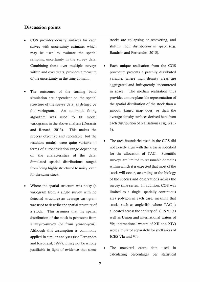
Discussion points
CGS provides density surfaces for each
survey with uncertainty estimates which
may be used to evaluate the spatial
sampling uncertainty in the survey data.
Combining these over multiple surveys
within and over years, provides a measure
of the uncertainty in the time domain.
The outcomes of the turning band
simulation are dependent on the spatial
structure of the survey data, as defined by
the variogram. An automatic fitting
algorithm was used to fit model
variograms in the above analysis (Desassis
and Renard, 2013). This makes the
process objective and repeatable, but the
resultant models were quite variable in
terms of autocorrelation range depending
on the characteristics of the data.
Simulated spatial distributions ranged
from being highly structured to noisy, even
for the same stock.
Where the spatial structure was noisy (a
variogram from a single survey with no
detected structure) an average variogram
was used to describe the spatial structure of
a stock. This assumes that the spatial
distribution of the stock is persistent from
survey-to-survey (or from year-to-year).
Although this assumption is commonly
applied in similar analyses (see Fernandes
and Rivoirard, 1999), it may not be wholly
justifiable in light of evidence that some
stocks are collapsing or recovering, and
shifting their distribution in space (e.g.
Baudron and Fernandes, 2015).
Each unique realisation from the CGS
procedure presents a patchily distributed
variable, where high density areas are
aggregated and infrequently encountered
in space. The median realisation thus
provides a more plausible representation of
the spatial distribution of the stock than a
smooth kriged map does, or than the
average density surfaces derived here from
each distribution of realisations (Figures 1-
3).
The area boundaries used in the CGS did
not exactly align with the areas as specified
for the allocation of TAC. Scientific
surveys are limited to reasonable domains
within which it is expected that most of the
stock will occur, according to the biology
of the species and observations across the
survey time-series. In addition, CGS was
limited to a single, spatially continuous
area polygon in each case, meaning that
stocks such as anglerfish where TAC is
allocated across the entirety of ICES VI (as
well as Union and international waters of
Vb; international waters of XII and XIV)
were simulated separately for shelf areas of
ICES VIa and VIb.
The mackerel catch data used in
calculating percentages per statistical
10
rectangle is biased in terms of its
representation of the actual spatial
distribution of the stock, because fishery
activity is concentrated on areas of high
fish density. However, given the regular
migratory pattern exhibited by the stock
and the tendency of the fishery to operate
according to it, the catch data should give
a reasonable representation of the stock
distribution across a given year. However,
the percentage share of the total catch has
also been affected by the fact that some
countries increased their own catch
allocation unilaterally.
Acknowledgments
With thanks to the crews, fishers, and scientists
from whom data was obtained. This work was
funded by the Scottish Fishermen’s
Federation.
References
Baudron, A. R., and Fernandes, P. G. 2015. Adverse consequences of stock recovery:
European hake, a new ‘choke’ species under a
discard ban? Fish and Fisheries, 16: 563–575. Bellanger, M., Macher, C., and Guyader, O. 2016.
A new approach to determine the distributional effects of quota management in fisheries.
Fisheries Research, 181: 116–126.
Boyes, S. J., and Elliott, M. 2016. Brexit: The marine governance horrendogram just got more horrendous! Marine Pollution Bulletin: 8–11.
Carpenter, G., Kleinjans, R., Villasante, S., and O’Leary, B. C. 2016. Landing the blame: The
influence of EU Member States on quota setting.
Marine Policy, 64: 9–15. Claus, S., De Hauwere, N., Vanhoore, B., Souza
Dias, F., Oset Garcia, P., Hernandez, F., and Mees, J. 2016. MarineRegions.org. Accessed at http://www.marineregions.org on 2016-11-22.
EC (2016). Council Regulation (EU) 2016/72 of 22 January 2016 fixing for 2016 the fishing
opportunities for certain fish stocks and groups of fish stocks, applicable in Union waters and, for Union fishing vessels, in certain non-Union
waters, and amending Regulation (EU) 2015/104. OJ L22/1.
Desassis, N., and Renard, D. 2013. Automatic
Variogram Modeling by Iterative Least Squares: Univariate and Multivariate Cases.
Mathematical Geosciences, 45: 453–470.
EC (2011). Council Regulation (EU) No 57/2011 of 18 January 2011 fixing for 2011 the fishing
opportunities for certain fish stocks and groups of fish stocks, applicable in EU waters and, for EU vessels, in certain non-EU waters. OJ L 24.
EC (2015). Council Regulation (EU) 2015/104 of 19 January 2015 fixing for 2015 the fishing
opportunities for certain fish stocks and groups of fish stocks, applicable in Union waters and, for Union vessels, in certain non-Union waters,
amending Regulation (EU) No 43/2014 and repealing Regulation (EU) No 779/2014. OJ L 22.
Fernandes, P., and Rivoirard, J. 1999. A geostatistical analysis of the spatial distribution
and abundance of cod, haddock and whiting in North Scotland. Quantitative Geology and
geostatistics, 10: 201–212.
Gunderson, D. 1993. Surveys of Fisheries Resources. Wiley, New York.
Rivoirard, J., Simmonds, J., and Foote, K. G.
2000. Geostatistics for Estimating Fish Abundance. Blackwell Science Ltd, Oxford,
UK. Woillez, M., Rivoirard, J., and Fernandes, P. G.
2009. Evaluating the uncertainty of abundance
estimates from acoustic surveys using geostatistical simulations. ICES Journal of
Marine Science, 66: 1377–1383.

11
Table 3. Average percentage of stocks (%) inside the UK EEZ with 95% quantiles where available over 3
years. Percentage of 2016 TAC (unless alternative year is specified) allocated to the UK for each area (EC
2016) is included for comparative purposes. Percentages are colour-coded according to whether: the
allocated TAC is 0-5% less than the lower quantile or fixed value (*) of the spatial distribution, 5-10% less
than the lower quantile or fixed value (*), or >10% less than the lower quantile or fixed value (*) [%TAC
are significantly lower than the distribution implies]; or the allocated TAC is 5-10% more than the lower
quantile or fixed value (*), [%TAC are significantly higher than the distribution implies]; or no shading,
which indicates that the quantiles overlap the TAC allocation [%TAC are in line with the spatial
distribution]. Diff is the difference between %TAC and the lower quantile of the spatial distribution (for
negative values, indicating the %TAC is too low by at least this percentage) or between %TAC and the upper
quantile of the spatial distribution (for positive values indicating the %TAC is too high by at least this
percentage), unless indicated* which are differences from average values.
Re
gio
n
Species UK quota
(% TAC)
Average percentage in
UK EEZ (%) over 3 years
Upper 95%
Quantile
Lower 95%
Quantile
Diff from quantile
No
rth
Se
a
Herring (mature) 15 85 - - -70*
Hake 18 60 84 26 -8
Whiting 62 78 88 67 -5
Cod 39 59 73 41 -2
Saithe 8 43 67 10 -2
Haddock 65 77 89 66 -1
Anglerfish 73 61 67 56 6
Herring (immature) - 9 - -
We
st o
f Sc
otl
and
Hake 18 79 91 60 -42
Herring 60 88 - - -28*
Anglerfish VIa & VIb 31 65 73 57 -26
Cod 60 93 99 78 -18
Whiting 57 80 87 71 -14
Saithe 46 82 96 59 -13
Haddock 76 85 91 75 1
Oth
er Mackerel 23 37 - - -14*
Rockall Haddock 78 65 71 60 7
1 EC (2011): Council Regulation (EU) No 57/2011
2 EC (2015): Council Regulation (EU) No 2015/104
3Based on UK 2015 allocation of 247,296 t from total of 1,054,000 t coastal states total catch limitation.
Data sources: percentages of herring stocks were calculated from WGIPS stock assessment abundance
estimates (numbers of fish); percentages of the mackerel stock were calculated based on commercial catch
weight data; all other percentages were calculated based on survey swept-area density (kg km-2) data.

12
Figures
Figure 1. Conditional geostatistical simulation analysis plots for 2013 Quarter 1 North Sea haddock: IBTS swept-area density data used for the analysis
(left), with 300m bathymetry contours in grey; average density surface calculated from 500 simulated realisations (centre) with survey haul locations
represented as black points; median density surface of the 500 simulated realisations (right). The UK EEZ is delineated with a solid grey line, and ICES
areas with dotted black lines (centre and right).

13
Figure 2. Conditional geostatistical simulation analysis plots for 2014 Rockall anglerfish: Joint industry-science survey swept-area density data used for
the analysis (left), with 500m and 100m bathymetry contours in grey; average density surface calculated from 500 simulated realisations (centre) with
survey haul locations represented as black points; median density surface of the 500 simulated realisations (right). The UK EEZ is delineated with a solid
grey line, and ICES areas with dotted black lines (centre and right).

14
Figure 3. Conditional geostatistical simulation analysis plots for 2013 Quarter 4 West of Scotland cod: IBTS swept-area density data used for the analysis
(left), with 300m bathymetry contours in grey; mean density surface calculated from 500 simulated realisations (centre) with survey haul locations
represented as black points; median density surface of the 500 simulated realisations (right). The UK EEZ is delineated with a solid grey line, and ICES
area VIa with a dotted black line (centre and right).

15
Figure 4. Percentage of North Sea cod stock (%) within the UK EEZ (blue), simulated
using Q1 and Q3 IBTS data. The white dotted lines show the upper and lower 95%
quantiles. The solid black line shows the UK TAC allocation as a % of the total
allocation.
Figure 5. Percentage of North Sea haddock stock (%) within the UK EEZ (blue),
simulated using Q1 and Q3 IBTS data. The white dotted lines show the upper and
lower 95% quantiles. The solid black line shows the UK TAC allocation as a % of the
total allocation.

16
Figure 6. Percentage of North Sea hake stock (%) within the UK EEZ (blue), simulated
using Q1 and Q3 IBTS data. The white dotted lines show the upper and lower 95%
quantiles. The solid black line shows the UK TAC allocation as a % of the total
allocation.
Figure 7. Percentage of the immature component of the North Sea herring stock (%)
within the UK EEZ (blue), calculated as the percentage of estimated abundance per
ICES statistical rectangle inside the UK EEZ.

17
Figure 8. Percentage of the mature component of the North Sea herring stock (%)
within the UK EEZ (blue), calculated as the percentage of estimated abundance per
ICES statistical rectangle inside the UK EEZ. The solid black line shows the UK TAC
allocation as a % of the total allocation.
Figure 9. Percentage of North Sea anglerfish stock (%) within the UK EEZ (blue),
simulated using Q1 and Q3 IBTS data. The white dotted lines show the upper and
lower 95% quantiles. The solid black line shows the UK TAC allocation as a % of the
total allocation.

18
Figure 10. Percentage of North Sea saithe stock (%) within the UK EEZ (blue),
simulated using Q1 and Q3 IBTS data. The white dotted lines show the upper and
lower 95% quantiles. The solid black line shows the UK TAC allocation as a % of the
total allocation.
Figure 11. Percentage of North Sea whiting stock (%) within the UK EEZ (blue),
simulated using Q1 and Q3 IBTS data. The white dotted lines show the upper and
lower 95% quantiles. The solid black line shows the UK TAC allocation as a % of the
total allocation.

19
Figure 12. Percentage of Rockall haddock stock (%) within the UK EEZ (blue),
simulated using Q3 IBTS data. The white dotted lines show the upper and lower 95%
quantiles. The solid black line shows the UK TAC allocation as a % of the total
allocation.
Figure 13. Percentage of anglerfish stock in VIa & VIb (%) within the UK EEZ (blue),
simulated using joint industry-science anglerfish survey data. The white dotted lines
show the upper and lower 95% quantiles. The solid black line shows the UK TAC
allocation as a % of the total allocation.

20
Figure 14. Percentage of West of Scotland cod stock (%) within the UK EEZ (blue),
simulated using Q1 and Q4 IBTS data. The white dotted lines show the upper and
lower 95% quantiles. The solid black line shows the UK TAC allocation as a % of the
total allocation.
Figure 15. Percentage of West of Scotland haddock stock (%) within the UK EEZ
(blue), simulated using Q1 and Q4 IBTS data. The white dotted lines show the upper
and lower 95% quantiles. The solid black line shows the UK TAC allocation as a % of
the total allocation.

21
Figure 16. Percentage of West of Scotland hake stock (%) within the UK EEZ (blue),
simulated using Q1 and Q4 IBTS data. The white dotted lines show the upper and
lower 95% quantiles. The solid black line shows the UK TAC allocation as a % of the
total allocation.
Figure 17. Percentage of West of Scotland herring stock (%) within the UK EEZ (blue),
calculated as the percentage of estimated abundance per ICES statistical rectangle
inside the UK EEZ. The solid black line shows the UK TAC allocation as a % of the total
allocation.

22
Figure 18. Percentage of West of Scotland saithe stock (%) within the UK EEZ (blue),
simulated using Q1 and Q4 IBTS data. The white dotted lines show the upper and
lower 95% quantiles. The solid black line shows the UK TAC allocation as a % of the
total allocation.
Figure 19. Percentage of West of Scotland whiting stock (%) within the UK EEZ (blue),
simulated using Q1 and Q4 IBTS data. The white dotted lines show the upper and
lower 95% quantiles. The solid black line shows the UK TAC allocation as a % of the
total allocation.

23
Figure 20. Percentage of mackerel stock (%) within the UK EEZ (blue), within the EEZs
of other EEA countries (orange), and outside of the EEA (black), calculated as the
percentage of catch per ICES statistical rectangle. The solid black line shows the UK
TAC allocation as a % of the total allocation.