The shaded blocks below indicate reports What’s of … have completed emplacement of a new...
14
1 of 14 07 January 2016 | Issue 01 For ‘live’ Kingfisher updates of offshore activities, visit www.fishsafe.eu and follow @KingfisherInfo on Twitter Produced by The Kingfisher Information Service of Seafish, in conjunction FLTC Services Ltd and with support from The Scottish Government. Any queries please contact Kingfisher Information Services, Sea Fish Industry Authority, Humber Seafood Institute, Origin Way, Europarc, Grimsby, DN37 9TZ email: [email protected] website: www.kingfishercharts.org tel: +44 (0)1472 252307 fax: +44 (0)1472 268792 The shaded blocks below indicate reports of fishing hazards and offshore activities. What’s inside? New Hazards (p.2) Area 1 (p.3-5) 1. Notice to Fishermen 2. Seabed Activity Area 2 (p.6) 1. Notice to Fishermen 2. Seabed Activity Area 3 (p.7) 1. Seabed Activity Area 4 1. N/A Area 5 (p.8) 1. Notice to Fishermen Area 6 1. N.A Extra... (p.9-14) 1. Rig List 2. Anchor List 3. Survey List 4. Disclaimer
Transcript of The shaded blocks below indicate reports What’s of … have completed emplacement of a new...

1 of 14
07 January 2016 | Issue 01
For ‘live’ Kingfisher updates of offshore activities, visit www.fishsafe.eu and follow @KingfisherInfo on Twitter
Produced by The Kingfisher Information Service of Seafish, in conjunction FLTC Services Ltd and with support from The Scottish Government. Any queries please contact Kingfisher Information Services, Sea Fish Industry Authority, Humber Seafood Institute, Origin Way, Europarc, Grimsby, DN37 9TZ
email: [email protected] website: www.kingfishercharts.org tel: +44 (0)1472 252307 fax: +44 (0)1472 268792
The shaded blocks below indicate reports of fishing hazards and offshore activities.
What’s inside?
New Hazards (p.2)
Area 1 (p .3-5) 1. Notice to Fishermen 2. Seabed Activity
Area 2 (p .6) 1. Notice to Fishermen 2. Seabed Activity
Area 3 (p .7) 1. Seabed Activity
Area 4 1. N/A
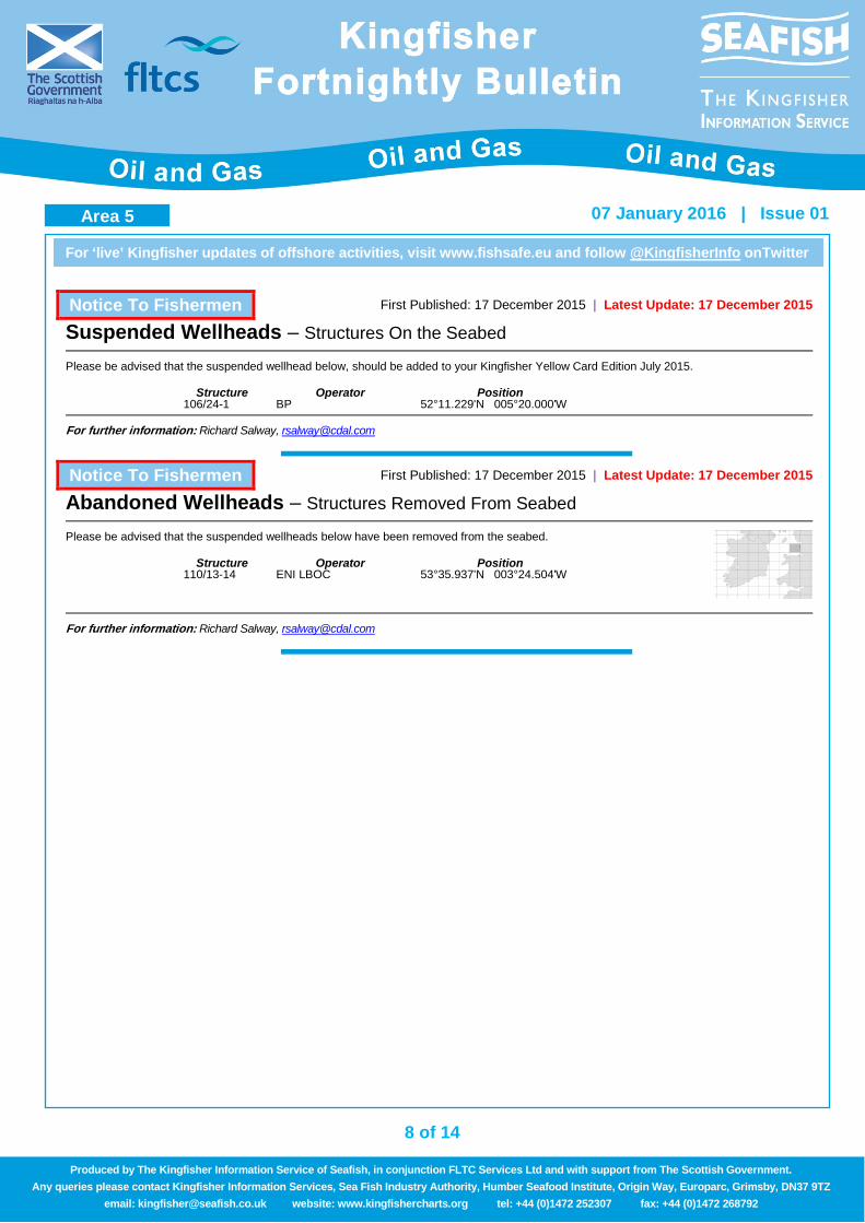
Area 5 (p .8) 1. Notice to Fishermen
Area 6 1. N.A
Extra... (p.9-14) 1. Rig List 2. Anchor List 3. Survey List
4. Disclaimer

2 of 14
For ‘live’ Kingfisher updates of offshore activities, visit www.fishsafe.eu and follow @KingfisherInfo onTwitter
07 January 2016 | Issue 01
Produced by The Kingfisher Information Service of Seafish, in conjunction FLTC Services Ltd and with support from The Scottish Government. Any queries please contact Kingfisher Information Services, Sea Fish Industry Authority, Humber Seafood Institute, Origin Way, Europarc, Grimsby, DN37 9TZ
email: [email protected] website: www.kingfishercharts.org tel: +44 (0)1472 252307 fax: +44 (0)1472 268792
Area 1 – Hazard List
Area 2 – Hazard List
Area 3 – Hazard List
Area 5 – Hazard List
Hazard Type Position Issue Date Contact Details Map
Lost 2 x 3 ton buoys 61°03.320'N 001°42.680'E 07 Jan 2016 [email protected] Lost 5 ton Buoy 60°03.813'N 003°58.493'W 07 Jan 2016 [email protected] New Suspended Wellhead – 9/19-2 59°25.949'N 001°42.308'E 17 Dec 2015 [email protected] Damaged Subsea Tree & Lost Debris Cap (4m x 4m &3.5 tons) 58°01.185'N 000°55.577'W 19 Nov 2015 [email protected]
Partial Anchor Debris 61°04.920'N 002°09.130'W 16 July 2015 [email protected] New Suspended Wellhead - 15/21a-51 58°14.108'N 000°06.723'E 24 Sept 2015 [email protected] Stainless Steel Grab 1m x 1m x1m 200kgs 60°35.160'N 03°01.390'W 02 July 2015 [email protected] New Suspended Wellhead - 214/30a-G1 New Suspended Wellhead - 214/30a-G2
61°04.650'N 002°05.250'W 61°04.620'N 002°05.290'W 16 July 2015 [email protected]
Buoy and 750kgs Balast (Chain Block) 60°03.790'N 03°59.375'W 08 Oct 2015 George MacKenzie [email protected] New Suspended Wellhead – 205/27-3Z 60°08.002'N 03°42.663'W 08 Oct 2015 [email protected] New Suspended Wellhead – 9/19b-18X 59°26.887'N 01°37.155'E 08 Oct 2015 [email protected]
Hazard Type Position Issue Date Contact Details Map New Suspended Wellhead – 20/02a-8 57°50.083'N 000°37.677'W 17 Dec 2015 [email protected]
New Suspended Wellhead – 204/24-1A 60°18.768'N 004°16.068'W 17 Dec 2015 [email protected] New Suspended Wellhead – 21/28a-10Z New Suspended Wellhead – 21/28a-9Y
57°09.386'N 000°31.515'E 57°08.850'N 000°32.482'E
17 Dec 2015 [email protected]
New Suspended Wellhead – 22/14b-5 New Suspended Wellhead – 22/14b-6Q
57°36.136'N 001°37.621'E 57°36.136'N 001°37.604'E
17 Dec 2015 [email protected]
Pigging equipment outside of 500m SZ (1m x 1.3m)
57°43.547'N 000°45.643'E 57°43.532'N 000°45.617'E 30 July 2015 [email protected]
Culzean Pin Piles covered by frames that measure 14m x 14m x 7.6 m high. 57°11.546'N 001°54.684'E 30 July 2015 [email protected]
Hazard Type Position Issue Date Contact Details Map Anchor & Chain 468m long, each link40mm in diameter with a breadth of 144mm 52°32.600'N 01°53.600'E 02 July 2015 [email protected] Bethnic Grab large steel bucket held within a solid 1 m3 support frame & short cable 51°49.764'N 01°32.306'E 02 July 2015 [email protected]
Hazard Type Position Issue Date Contact Details Map New Suspended Wellhead – 106/24-1 52°11.229'N 005°20.000'W 17 Dec 2015 [email protected]
Extra… New Hazards New Hazards New Hazards

3 of 14
For ‘live’ Kingfisher updates of offshore activities, visit www.fishsafe.eu and follow @KingfisherInfo onTwitter
07 January 2016 | Issue 01
Produced by The Kingfisher Information Service of Seafish, in conjunction FLTC Services Ltd and with support from The Scottish Government. Any queries please contact Kingfisher Information Services, Sea Fish Industry Authority, Humber Seafood Institute, Origin Way, Europarc, Grimsby, DN37 9TZ
email: [email protected] website: www.kingfishercharts.org tel: +44 (0)1472 252307 fax: +44 (0)1472 268792
Notice To Fishermen First Published: 07 January 2016 | Latest Update: 07 January 2016
Hazard – Lost 2 x 3 ton buoys
Please note that 2 x 3 ton buoys have broken free from close to the Brent B Platforms and have drifted Last known position: 61°03.320'N 001°42.680'E
For further information: Lee Stewart, Shell UK Ltd, Tel: +44(0)1224 882000 email: [email protected]
Notice To Fishermen First Published: 07 January 2016 | Latest Update: 07 January 2016
Hazard – Lost 5 ton buoy
Please note that a 5 ton sub surface bright yellow, anchor buoy has broken free from close to the Solan Platform and has drifted Last known position: 60°03.813'N 003°58.493'W
For further information: George MacKenzie OIM Ocean Valiant 158 Diamond Offshore Tel:+44 (0)1224 501435 email: [email protected]
Notice To Fishermen First Published: 17 December 2015 | Latest Update: 17 December 2015
Suspended Wellheads – Structures On the Seabed
Please be advised that the suspended wellhead below, should be added to your Kingfisher Yellow Card Edition July 2015.
Structure Operator Position 9/19-2 Apache 59°25.949'N 001°42.308'E
For further information: Richard Salway, [email protected]
Notice To Fishermen First Published: 19 November 2015 | Latest Update: 19 November 2015
Hazard – Damaged Subsea Tree & Lost Debris Cap
Please note that damaged subsea xmas tree which we have recently discovered during a DSV inspection at the northern drill centre of the Golden Eagle Field. (4m x 4m &3.5 tons) It was reported to be at the following approximate location: 58°01.185'N 000°55.577'W
For further information: Garron Owen, Nexen Tel: 01224 371134 email: [email protected]
Area 1

4 of 14
For ‘live’ Kingfisher updates of offshore activities, visit www.fishsafe.eu and follow @KingfisherInfo onTwitter
07 January 2016 | Issue 01
Produced by The Kingfisher Information Service of Seafish, in conjunction FLTC Services Ltd and with support from The Scottish Government. Any queries please contact Kingfisher Information Services, Sea Fish Industry Authority, Humber Seafood Institute, Origin Way, Europarc, Grimsby, DN37 9TZ
email: [email protected] website: www.kingfishercharts.org tel: +44 (0)1472 252307 fax: +44 (0)1472 268792
Notice To Fishermen First Published: 22 October 2015 | Latest Update: 22 October 2015
Hazard – Abandoned TA Cap
During Abandonment of Well Ptarmigan 15/29a-15. The TA cap has been pulled off the well by a trawler. The TA cap is 77kgs 25”OD 35”Height
Further investigation with the ROV has uncovered a crater where it is presumed wellhead has sank into the seabed
Positon: 58°08.186’N 00°46.240’E
For further information: Mike Swankie, Premier Oil, Tel: 01224 618965 email: [email protected]
Notice To Fishermen First Published: 08 October 2015 | Latest Update: 08 October 2015
Hazard – Solan - Sunk Buoy & 750kg Ballast (Chain Block)
A wave rider buoy has sunk and the associated 750kg ballast (chain block) are now creating a potential hazard 1km West of the Solan Platform
Positon: 60°03.790’N 03°59.375’W
For further information: George MacKenzie, Diamond Offshore, Tel: +44(0) 1224 501435 email: [email protected]
Seabed Activity First Published: 17 December 2015 | Latest Update: 17 December 2015
Sturgeon Exploration Well 16/01a-E – Drilling Operations
TAQA plan to drill an exploration well in Block 16/01 into the Sturgeon prospect, in the central North Sea. The well will be drilled by the Transocean John Shaw. Well 16/01a‐4 will be drilled as a vertical exploration well. After reaching its target, the well will be permanently plugged and abandoned, regardless of well results.
Drilling Rig/Ship Installation / Well No Position Start / Finish Duration
Trans John Shaw Sturgeon Exploration Well 16/01a-E 61°08.853'N 00°47.154'E 20/012/15 – 31/01/16 -
For further information: Derek Harrold, TAQA Bratani, Tel:+44 1224 275557, Email: [email protected]
Seabed Activity First Published: 21 May 2014 | Latest Update: 20 October 2015
Ellon & Grant Life Extension Project – New Umbilical
TEPUK have completed emplacement of a new umbilical between Dunbar Platform and Ellon / Grant subsea 500m zone in 2015. Currently awaiting results to prove everything installed correctly.
Please avoid the area during this time.
Block Coordinates 3/14a to 3/15b 60°37.730’N 01°39.050’E to 60°35.840’N 01°48.330’E
For further information: Luis McArthur, Total, Tel:01224 297903 email: [email protected]
Area 1 Area 1 Area 1 Area 1

5 of 14
For ‘live’ Kingfisher updates of offshore activities, visit www.fishsafe.eu and follow @KingfisherInfo onTwitter
07 January 2016 | Issue 01
Produced by The Kingfisher Information Service of Seafish, in conjunction FLTC Services Ltd and with support from The Scottish Government. Any queries please contact Kingfisher Information Services, Sea Fish Industry Authority, Humber Seafood Institute, Origin Way, Europarc, Grimsby, DN37 9TZ
email: [email protected] website: www.kingfishercharts.org tel: +44 (0)1472 252307 fax: +44 (0)1472 268792
Seabed Activity First Published: 21 May 2014 | Latest Update: 22 September 2015
Edradour / Glenlilvet Field Development – Construction Activities
TEPUK will have vessels in-field commencing construction activities on Edradour / Glenlivet project.
Please note that TEPUK have two new permanent subsea 500m safety zones which come into effect 14 July 2015
Area Block Coordinates Glenlivet UKCS 214/30a 61°04.600’N 02°05.010’W Edradour UKCS 206/4a 60°56.040’N 02°14.010’W
For further information: Luis McArthur, Total, Tel:01224 297903 email: [email protected]
Area 1

6 of 14
For ‘live’ Kingfisher updates of offshore activities, visit www.fishsafe.eu and follow @KingfisherInfo onTwitter
07 January 2016 | Issue 01
Produced by The Kingfisher Information Service of Seafish, in conjunction FLTC Services Ltd and with support from The Scottish Government. Any queries please contact Kingfisher Information Services, Sea Fish Industry Authority, Humber Seafood Institute, Origin Way, Europarc, Grimsby, DN37 9TZ
email: [email protected] website: www.kingfishercharts.org tel: +44 (0)1472 252307 fax: +44 (0)1472 268792
Notice To Fishermen First Published: 17 December 2015 | Latest Update: 17 December 2015
Suspended Wellheads – Structures On the Seabed
Please be advised that the suspended wellhead below, should be added to your Kingfisher Yellow Card Edition July 2015.
Structure Operator Position 20/02a-8 Nexen 57°50.083'N 000°37.677'W 204/24-1A BP 60°18.768'N 004°16.068'W 21/28a-10Z Antrim 57°09.386'N 000°31.515'E 21/28a-9Y Antrim 57°08.850'N 000°32.482'E 22/14b-5 EON 57°36.136'N 001°37.621'E 22/14b-6Q EON 57°36.136'N 001°37.604'E
For further information: Richard Salway, [email protected]
Notice To Fishermen First Published: 17 December 2015 | Latest Update: 17 December 2015
Abandoned Wellheads – Structures Removed From Seabed
Please be advised that the suspended wellheads below have been removed from the seabed.
Structure Operator Position 22/22b-5z Centrica 57°12.501'N 001°14.674'E 49/21-10 Verus Petroleum 57°14.604'N 002°05.006'E
For further information: Richard Salway, [email protected]
Seabed Activity First Published: 03 March 2014 | Latest Update: 15 December 2015
Montrose BLP Project – Development Operations
Offshore campaigns currently in progress or upcoming;
• Installation of new pipeline bundles along the 10km corridor between Montrose BLP and the Cayley Drill Centre (Now Complete see note below)
• Shaw pipeline installation (18km) between Montrose BLP and Shaw Drill Centres (Complete) • The Rock dumping vessel Stornes mobilised on the 10th of December and arrived in field 11th of December to perform rock
dumping activities along the Shaw 10” Pipeline route for Upheaval Buckling Mitigation. The vessel plans to be in field until the end of December currently.
Please note: HSE recognised 500m Safety Zone are now in force at the following: Cayley drill centre 57°25.167’N 001°13.804’E Cayley/Montrose intermediate towhead 57°26.160’N 001°18.420’E Shaw Production drill centre 57°17.813’N 001°21.755’E Shaw WI drill centre 57°17.369’N 001°22.299’E
Key Coordinates Coordinates Key Coordinates Coordinates Montrose BLP 57°27.068’N 001°23.214’E Shaw Prod DC 57°17.813’N 01°21.755’E Cayley Drill Centre 57°25.167’N 001°13.804’E Shaw Water Injection DC 57°17.369’N 01°22.299’E 44” Langeled Crossing 57°25.924’N 001°17.332’E 24” GAEL crossings 57°25.757’N 01°22.760’E 24” GAEL Crossing 57°26.671’N 001°20.804’E 14” Forties Crossings- 57°27.054’N 01°22.987’E
For further information: Lilla Onodi, Talisman, Tel+44 (0)1224 358867 email: [email protected]
Area 2 Area 2

7 of 14
For ‘live’ Kingfisher updates of offshore activities, visit www.fishsafe.eu and follow @KingfisherInfo onTwitter
07 January 2016 | Issue 01
Produced by The Kingfisher Information Service of Seafish, in conjunction FLTC Services Ltd and with support from The Scottish Government. Any queries please contact Kingfisher Information Services, Sea Fish Industry Authority, Humber Seafood Institute, Origin Way, Europarc, Grimsby, DN37 9TZ
email: [email protected] website: www.kingfishercharts.org tel: +44 (0)1472 252307 fax: +44 (0)1472 268792
Notice To Fishermen First Published: 17 December 2015 | Latest Update: 17 December 2015
Suspended Wellheads – Structures On the Seabed
Please be advised that the suspended wellhead below, should be added to your Kingfisher Yellow Card Edition July 2015.
Structure Operator Position 47/04b-5 Perenco 53°59.522'N 000°45.948'E 47/09b-6 Perenco 53°45.365'N 000°42.191'E 48/11b-6 Perenco 53°33.220'N 001°03.093'E 49/29a-7 Perenco 53°09.443'N 002°44.377'E
For further information: Richard Salway, [email protected]
Seabed Activity First Published: 24 April 2014 | Latest Update: 01 December 2015
Cygnus Field – Development Operations
The installation phase is segregated into two offshore campaigns 2014 and 2015. Infield activities: Subsea Pipelines & Tie-ins
• 2 guard vessels Advance and Copious located at ETS Wye Manifold and Cygnus Bravo respectively. • Dive Support Vessel- Bibby Polaris mobilising on 19th October for work at Cygnus Alpha, Bravo and ETS Wye
Manifold for approx. 1 month.
Drilling • Ensco 80 interfaced with/cantilevered over Cygnus BWH Platform. • Supply Vessel- Maersk Feeder. • ERRV on Location Cygnus Sentinel.
Key Locations: Structures Coordinates Structures Coordinates
Cygnus AWH Platform 54°34.146'N 002°17.465'E Cygnus BWH Platform 54°35.878'N 002°11.696'E Cygnus APU Platform 54°34.118'N 002°17.385'E Cygnus SSIV Manifold 54°34.159'N 002°17.320'E Cygnus AUQ Platform 54°34.090'N 002°17.305'E Cygnus WYE Manifold 54°18.030'N 001°40.578'E
For further information, David Hawkins, GDF Suez E&P UK Ltd, Tel: +44 1224 281 082 email: [email protected]
Deployment of Buoys First Published: 24 April 2014 | Latest Update: 08 December 2015
Suffolk Coast – Oceanographic Deployments
Five seabed oceanographic instruments are to be deployed off the Suffolk Coast during December 2015 and will remain in place until April 2016. The instruments will be indicated by a surface buoy with a light (Gp Fl. (5) Y 20s). The instrument may be up to 200m from the buoy with ground tackle on the seabed between them. A wide berth of 500m around the buoys is requested.
Deployment Name Coordinates
ISS 52°12.477'N 001°37.868'E OSS 52°11.888'N 001°38.625'E CA3 52°12.885'N 001°37.951'E ISN 52°13.068'N 001°38.062'E OSN 52°13.879'N 001°38.788'E
For further information, Dean Foden, Cefas. Tel: +44(0)1502 521320 email: [email protected]
Area 3
8 of 14
For ‘live’ Kingfisher updates of offshore activities, visit www.fishsafe.eu and follow @KingfisherInfo onTwitter
07 January 2016 | Issue 01
Produced by The Kingfisher Information Service of Seafish, in conjunction FLTC Services Ltd and with support from The Scottish Government. Any queries please contact Kingfisher Information Services, Sea Fish Industry Authority, Humber Seafood Institute, Origin Way, Europarc, Grimsby, DN37 9TZ
email: [email protected] website: www.kingfishercharts.org tel: +44 (0)1472 252307 fax: +44 (0)1472 268792
Notice To Fishermen First Published: 17 December 2015 | Latest Update: 17 December 2015
Suspended Wellheads – Structures On the Seabed
Please be advised that the suspended wellhead below, should be added to your Kingfisher Yellow Card Edition July 2015.
Structure Operator Position 106/24-1 BP 52°11.229'N 005°20.000'W
For further information: Richard Salway, [email protected]
Notice To Fishermen First Published: 17 December 2015 | Latest Update: 17 December 2015
Abandoned Wellheads – Structures Removed From Seabed
Please be advised that the suspended wellheads below have been removed from the seabed.
Structure Operator Position 110/13-14 ENI LBOC 53°35.937'N 003°24.504'W
For further information: Richard Salway, [email protected]
Area 5

9 of 14
For ‘live’ Kingfisher updates of offshore activities, visit www.fishsafe.eu and follow @KingfisherInfo onTwitter
07 January 2016 | Issue 01
Produced by The Kingfisher Information Service of Seafish, in conjunction FLTC Services Ltd and with support from The Scottish Government. Any queries please contact Kingfisher Information Services, Sea Fish Industry Authority, Humber Seafood Institute, Origin Way, Europarc, Grimsby, DN37 9TZ
email: [email protected] website: www.kingfishercharts.org tel: +44 (0)1472 252307 fax: +44 (0)1472 268792
Area 1 – Rig List Latest Update: 04 January 2016
MOVEMENT RIG POSITION MOVEMENT RIG POSITION COSL Rival 58°02.90’N 01°08.06’E Maersk Intrepid 60°30.30’N 02°00.80’E Blackford Dolphin 58°06.10’N 00°41.70’E Borgsten Dolphin 60°37.66’N 01°39.29’E
New Paragon MSS1 58°14.30’N 00°12.50’E New Flotel Victory 60°44.20’N 02°29.90’W Maersk Integrator 58°34.30’N 01°41.80’E COSL Promoter 60°45.30’N 03°38.20’E Bredford Dolphin 58°42.40’N 02°09.80’E New Songa Equinox 60°53.50’N 03°40.20’E Rowan Viking 58°50.60’N 02°14.90’E Stena Don 60°55.00’N 03°33.60’E West Epsilon 58°50.70’N 01°44.50’E West Elara 61°02.30’N 02°20.30’E West Alpha 59°10.70’N 02°22.70’E Deepsea Atlantic 61°04.90’N 02°15.20’E Sedco 704 59°32.70’N 01°39.50’E Borgland Dolphin 61°09.40’N 03°20.50’E Transocean Winner 59°34.60’N 01°55.40’E Bideford Dolphin 61°23.60’N 02°07.50’E Transocean Leader 59°53.50’N 01°12.30’E New Leiv Eiriksson 61°38.50’N 02°49.20’E Ocean Valiant 60°03.80’N 03°58.50’W Transocean Arctic 64°03.70’N 06°50.60’E Deepsea Aberdeen 60°24.70’N 04°03.30’W Island Innovator 64°07.80’N 07°01.40’E Songa Delta 60°28.10’N 02°40.90’E
Area 2 – Rig List Latest Update: 04 January 2016
MOVEMENT RIG POSITION MOVEMENT RIG POSITION Paragon C20052 55°06.30’N 03°50.00’E Rowan Norway 56°32.80’N 03°13.20’E
New Ensco 71 55°28.70’N 05°06.50’E New Mearsk Giant 56°40.50’N 05°24.70’E New Atlantic Amsterdam 55°28.80’N 05°06.60’E Ensco 100 56°46.30’N 00°46.40’E
Ensco 72 55°38.40’N 04°53.00’E Ocean Patriot 56°50.20’N 01°50.90’E New Noble Sam Turner 55°38.40’N 04°53.10’E Rowan Gorilla 5 56°57.55’N 01°48.33’E New Seafox 5 55°43.00’N 04°45.00’E Prospector 1 56°57.96’N 01°52.10’E New COSL Rigmar 55°43.30’N 04°48.20’E GSF Galaxy 1 57°00.79’N 01°50.37’E
Ensco 121 55°52.90’N 04°14.00’E Prospector 5 57°00.80’N 01°50.50’E New Mearsk Resolute 56°05.70’N 04°13.20’E Noble Hans Deul 57°01.90’N 01°57.30’E New Mearsk Resilient 56°10.40’N 04°10.05’E Byford Dolphin 57°04.80’N 02°05.00’E
Energy Enhancer 56°10.70’N 04°10.80’E Maersk Guardian 57°15.00’N 02°34.10’E Maersk Resolve 56°14.80’N 03°57.60’E Safe Caledonia 57°17.59’N 01°39.58’E Maersk Reacher 56°16.90’N 03°23.80’E Ensco 101 57°22.50’N 01°59.80’E Maersk Innovator 56°22.60’N 03°15.50’E Rowan Gorilla 7 57°43.90’N 00°58.40’W Maersk Gallant 56°22.60’N 03°15.90’E Ensco 120 57°57.70’N 00°55.00’W
Rowan Gorilla 6 56°31.20’N 03°13.30’E
Area 3 – Rig List Latest Update: 04 January 2016
MOVEMENT RIG POSITION MOVEMENT RIG POSITION Seafox 4 53°04.90’N 02°10.90’E New GMS Endevour 6102 53°45.10’N 03°54.90’E Ensco 122 53°16.20’N 03°52.40’E Paragon B391 53°53.10’N 00°26.00’E Seafox 1 53°19.40’N 02°34.50’E Paragon C463 53°56.90’N 03°39.80’E
New GMS Endurance 53°26.80’N 02°15.40’E Seafox 2 54°34.10’N 02°18.10’E Ensco 92 53°31.70’N 02°13.40’E Seafox 7 54°34.20’N 02°17.50’E Swift 10 53°37.30’N 03°00.30’E Ensco 102 54°34.20’N 02°17.60’E Paragon C461 53°37.70’N 05°08.60’E New Ensco 80 54°36.00’N 02°11.80’E Paragon C20051 53°40.60’N 04°00.20’E
Area 5 – Rig List Latest Update: 04 January 2016
MOVEMENT RIG POSITION MOVEMENT RIG POSITION Irish Sea Pioneer 53°32.20’N 03°34.60’W Seajacks Kraken 53°57.60’N 3°40.40’W
Extra… Extra…

10 of 14
For ‘live’ Kingfisher updates of offshore activities, visit www.fishsafe.eu and follow @KingfisherInfo onTwitter
07 January 2016 | Issue 01
Produced by The Kingfisher Information Service of Seafish, in conjunction FLTC Services Ltd and with support from The Scottish Government. Any queries please contact Kingfisher Information Services, Sea Fish Industry Authority, Humber Seafood Institute, Origin Way, Europarc, Grimsby, DN37 9TZ
email: [email protected] website: www.kingfishercharts.org tel: +44 (0)1472 252307 fax: +44 (0)1472 268792
Rig anchors may extend over one mile from rig positions; anchor buoys are not always deployed. There may be additional structures called anchor pennants, deployed up to 200 metres from each anchor. In the interests of safety and to avoid fishing gear damage, fishing close to, or within anchor patterns, should be avoided. Fishermen may contact the installation or the ERRV (standby vessel) for positions of the anchors.
Area 1 – Anchor List | Latest Update: 07 January 2016
PBLJ – Pre- laid Anchors at the Magnus Field
Transocean Leader – At Kraken DC1 9/02b-A1
Paragon MSS1 – Telford H2 Well
Anchor No. Anchor Position Laydown Pennant Recovery Pennant End Rig 3 61°39.495'N 01°22.465'E 61°39.574'N 01°22.871'E 61°39.191'N 01°22.547'E 4 61°38.706'N 01°22.481'E 61°38.627'N 01°22.879'E 61°39.015'N 01°22.521'E
Anchor No. Anchor Position Laydown Pennant s Anchor Position Laydown Pennant s Rig 59°53.510'N 01°12.230'E 1 59°54.290'N 01°11.580'E 59°54.380'N 01°11.500'E 5 59°52.760'N 01°12.810'E 59°52.680'N 01°12.870'E 2 59°54.310'N 01°12.690'E 59°54.400'N 01°12.740'E 6 59°52.740'N 01°11.590'E 59°52.660'N 01°11.540'E 3 59°54.760'N 01°13.790'E 59°53.790'N 01°13.980'E 7 59°53.200'N 01°10.670'E 59°53.170'N 01°10.520'E 4 59°53.210'N 01°13.700'E 59°53.170'N 01°13.880'E 8 59°53.820'N 01°10.660'E 59°53.850'N 01°10.510'E
Anchor No. Anchor Position Laydown Pennant s Anchor Position Laydown Pennant s Well 58°12.320'N 00°16.720'E 7 58°11.760'N 00°17.300'E 58°11.700'N 00°17.380'E
1 58°12.850'N 00°16.160'E 58°12.930'N 00°16.050'E 8 58°11.690'N 00°16.720'E 58°11.610'N 00°16.720'E 2 58°12.940'N 00°16.720'E 58°12.950'N 00°16.580'E 9 58°11.770'N 00°16.150'E 58°11.700'N 00°16.090'E 3 58°12.840'N 00°17.270'E 58°12.900'N 00°17.130'E 10 58°12.020'N 00°15.690'E 58°11.980'N 00°15.570'E 4 58°12.610'N 00°17.720'E 58°12.680'N 00°17.660'E 11 58°12.320'N 00°15.500'E 58°12.320'N 00°15.370'E 5 58°12.320'N 00°17.860'E 58°12.320'N 00°18.000'E 12 58°12.620'N 00°15.670'E 58°12.660'N 00°15.550'E 6 58°12.020'N 00°17.760'E 58°11.990'N 00°17.880'E
Blackford Dolphin – Proposed Anchor Pattern Alder Anchor No. Position Anchor No. Position Anchor No. Position
Rig 58°06.121'N 00°41.692'E 3 58°06.504'N 00°42.665'E 6 58°05.483'N 00°41.550'E 1 58°06.640'N 00°40.956'E 4 58°06.043'N 00°42.909'E 7 58°05.370'N 00°40.718'E 2 58°06.759'N 00°41.833'E 5 58°05.601'N 00°42.426'E 8 58°06.198'N 00°40.474'E
Schiehallion – At Loyal Dri l l Centre Anchor No. Position Anchor No. Position Anchor No. Position
Rig 3 60°26.113'N 04°04.521'W 6 60°24.113'N 04°00.377'W 1 60°24.059'N 04°06.246'W 4 60°26.130'N 04°02.145'W 7 60°23.251'N 04°01.900'W 2 60°25.259'N 04°06.271'W 5 60°25.289'N 04°00.377'W 8 60°23.195'N 04°04.443'W
Borgsten Dolphin – Dunbar Plat form 3/14a Anchor No. Position Anchor No. Position Anchor No. Position
Rig 60°37.660‘N 01°39.290‘E 5 60°37.820‘N 01°37.750‘E 10 60°37.390‘N 01°40.390‘E 1 60°36.930‘N 01°38.730‘E 6 60°37.930‘N 01°37.820‘E 11 60°37.290‘N 01°40.320‘E 2 60°37.000‘N 01°38.510‘E 7 60°38.350‘N 01°39.510‘E 12 60°37.190‘N 01°40.180‘E 3 60°37.060‘N 01°38.300‘E 8 60°38.300‘N 01°39.750‘E 4 60°37.700‘N 01°37.700‘E 9 60°38.250‘N 01°39.980‘E
Sedco 704 – At Fair leads Well G2G Anchor No. Position Anchor No. Position Anchor No. Position
Rig 59°21.080'N 01°32.980'E 3 59°21.760'N 01°32.610'E 6 59°20.880'N 01°34.170'E 1 59°20.770'N 01°31.760'E 4 59°21.790'N 01°32.880'E 7 59°20.380'N 01°34.130'E 2 59°21.410'N 01°31.680'E 5 59°20.990'N 01°34.140'E 8 59°20.370'N 01°32.800'E
Extra…

11 of 14
For ‘live’ Kingfisher updates of offshore activities, visit www.fishsafe.eu and follow @KingfisherInfo onTwitter
07 January 2016 | Issue 01
Produced by The Kingfisher Information Service of Seafish, in conjunction FLTC Services Ltd and with support from The Scottish Government. Any queries please contact Kingfisher Information Services, Sea Fish Industry Authority, Humber Seafood Institute, Origin Way, Europarc, Grimsby, DN37 9TZ
email: [email protected] website: www.kingfishercharts.org tel: +44 (0)1472 252307 fax: +44 (0)1472 268792
Area 2 – Anchor List First Published: 16 July 2015 | Latest Update: 19 November 2015
West Phoenix – At Cromarty Firth – Anchorage No.11
Please note that the Sedco 714 is in Cromarty Firth Anchor No. Position Anchor No. Position Anchor No. Position
Rig 57°41.240'N 04°02.960'W #3 Pennant end 57°40.960'N 04°03.120'W #7 Clump 57°41.520'N 04°02.890'W 1 57°41.150'N 04°02.490'W 4 57°41.080'N 04°03.560'W #7 Pennant End 57°41.480'N 04°03.020'W 2 57°40.990'N 04°02.560'W 5 57°41.350'N 04°03.560'W 8 57°41.390'N 04°02.490'W 3 57°40.930'N 04°03.220'W 6 57°41.550'N 04°03.500'W
#3 Clump 57°40.610'N 04°03.230'W 7 57°41.510'N 04°02.890'W
Byford Dolphin – Pre-Laid at the Machar Field Anchor No. Anchor Position Pennant Position Anchor No. Anchor Position Pennant Position
Rig 57°04.742'N 02°04.910'E 1 57°05.540'N 02°03.664'E 57°05.609'N 02°03.542'E 7 57°04.364'N 02°05.749'E 57°04.313'N 02°05.881'E 2 57°05.531'N 02°04.499'E 57°05.631'N 02°04.449'E 8 57°04.085'N 02°05.290'E 57°04.005'N 02°05.341'E 3 57°05.558'N 02°05.098'E 57°05.640'N 02°05.120'E 9 57°03.922'N 02°04.635'E 57°03.839'N 02°04.617'E 4 57°05.231'N 02°06.141'E 57°05.290'N 02°06.291'E 10 57°04.117'N 02°03.792'E 57°04.118'N 02°03.675'E 5 57°04.996'N 02°06.367'E 57°05.023'N 02°06.522'E 11 57°04.490'N 02°03.454'E 57°04.460'N 02°03.297'E 6 57°04.842'N 02°06.447'E 57°04.851'N 02°06.607'E 12 57°04.861'N 02°03.537'E 57°04.876'N 02°03.378'E
Stena Spey – At Alma Anchor No. Position Anchor No. Position Anchor No. Position
Rig 56°11.090'N 002°45.750'E 3 57°12.270'N 002°46.960'E 6 57°11.060'N 002°44.930'E 1 56°12.640'N 002°45.290'E 4 57°11.680'N 002°47.000'E 7 57°11.640'N 002°43.830'E 2 56°12.670'N 002°46.260'E 5 57°11.150'N 002°46.300'E 8 57°12.260'N 002°43.160'E
Sedco 714 – At Cromarty Firth – Anchorage No.12
Please note that the Sedco 714 is in Cromarty Firth Anchor No. Position Anchor No. Position Anchor No. Position
Rig 57°41.180'N 04°00.790'W 3 57°41.300'N 04°00.690'W 6 57°40.860'N 04°00.420'W 1 57°41.170'N 04°01.350'W 4 57°41.170'N 04°00.430'W 7 57°40.860'N 04°00.720'W 2 57°41.300'N 04°01.090'W 5 57°40.950'N 04°00.420'W 8 57°40.950'N 04°00.350'W
Safe Caledonia Flotel – At ETAP Anchor No. Position Anchor No. Position Anchor No. Position
Rig 57°17.576’N 001°39.588’E 4 57°17.170'N 001°37.220'E 8 57°17.884'N 001°41.775'E 1 57°16.250'N 001°39.942'E 5 57°18.740'N 001°38.764'E 9 57°16.292'N 001°40.303'E 2 57°16.236'N 001°39.646'E 6 57°18.806'N 001°39.416'E 10 57°17.412'N 001°37.130'E 3 57°17.012'N 001°37.388'E 7 57°18.179'N 001°41.507'E
Extra…

12 of 14
For ‘live’ Kingfisher updates of offshore activities, visit www.fishsafe.eu and follow @KingfisherInfo onTwitter
07 January 2016 | Issue 01
Produced by The Kingfisher Information Service of Seafish, in conjunction FLTC Services Ltd and with support from The Scottish Government. Any queries please contact Kingfisher Information Services, Sea Fish Industry Authority, Humber Seafood Institute, Origin Way, Europarc, Grimsby, DN37 9TZ
email: [email protected] website: www.kingfishercharts.org tel: +44 (0)1472 252307 fax: +44 (0)1472 268792
Area 1 – Survey List Company & Vessels Towed Cable
Length / Depth Area Covered & Quad Blocks Duration
Gardline MV Ocean Observer
GHXX
58°01.285'N 000°44.155'E 58°02.838'N 000°42.951'E 58°02.383'N 000°45.030'E 58°01.737'N 000°42.118'E
15 20/01/2016 - 29/02/2016
For 14 Days
Schlumberger TBA 750m / 5m 58°05.053'N 001°34.587'E 16
01/12/2015 - 31/03/2016
For 1 Day Gardline
Ocean Reliance J8B2707
56°50.082'N 000°39.930'E 56°49.846'N 000°39.670'E
16/11/2015 - 29/02/2016
For 21 Days
Gardline Geosurvey Ltd Ocean Observer
GHXX
59°28.345'N 001°36.286'E 59°26.350'N 001°43.610'E 59°24.451'N 001°41.612'E 59°26.443'N 001°34.294'E
9 28/09/2015 - 31/07/2016
For 45 Days
Baker Hughes Wireline 2m x 4m 58°29.334'N 001°02.188'E Quad Block: 16 01/08/2015 - 31/01/2016
For 1 Day
Area 2 – Survey List Company & Vessels Towed Cable
Length / Depth Area Covered & Quad Blocks Duration
Gardline MV Ocean Observer
GHXX
56°41.380'N 002°19.844'E 56°42.050'N 002°19.711'E 56°41.880'N 002°20.720'E
30 20/01/2016 - 29/02/2016
For 25 Days
ABB AB Skate 3E - J8B5005
Forth Boxer - MYEM6 Boreholes
57°40.941'N 003°01.992'W 57°40.941'N 003°01.791'W 57°39.875'N 003°02.015'W 57°39.874'N 003°01.815'W
Boreholes 05/01/2016 - 28/02/2016
Fugro Survey Ltd MV Fugro Galaxy
57°00.350'N 001°49.520'E 57°00.970'N 001°49.500'E 57°00.980'N 001°51.070'E 57°00.360'N 001°51.090'E
22/30c 11/01/2016 - 31/05/2016
For 3 Days
Enquest Heather Ltd TBA 57°35.899'N 001°38.466'E 21
01/01/2016 - 31/01/2016
For 5 Days
Area 3 – Survey List Company & Vessels Towed Cable
Length / Depth Area Covered & Quad Blocks Duration
Gardline MV Ocean Observer
GHXX
53°31.958'N 002°15.204'E 53°25.350'N 002°22.440'E 53°28.448'N 002°13.801'E 53°31.640'N 002°13.221'E 53°19.600'N 002°21.654'E 53°23.121'N 002°08.828'E
49 20/01/2016 - 29/02/2016
For 6 Days
Bibby Hydromap Bibby Athena - 2ICA5
52°54.000'N 002°13.000'E 52°54.000'N 002°44.000'E 52°27.000'N 001°48.000'E 53°01.000'N 002°24.000'E
52°23.866'N 002°03.800'E 52°23.849'N 002°34.454'E 52°25.016'N 001°48.167'E 52°24.817'N 001°50.033'E 52°24.317'N 001°57.700'E 52°23.883'N 002°07.617'E
20/01/2016 - 09/02/2016
For 20 Days
Fugro Survey Ltd 53°03.308'N 002°10.181'E 53°03.662'N 002°11.540'E 53°02.930'N 002°12.065'E 53°02.576'N 002°10.707'E
49 04/12/2015 - 01/02/2016
For 1 Day
Gardline Geosurvey Ltd MV Kommandor - PBQW 54°34.150'N 002°17.476'E 44
25/11/2015 - 08/12/2015
For 3 Days
Extra…

13 of 14
For ‘live’ Kingfisher updates of offshore activities, visit www.fishsafe.eu and follow @KingfisherInfo onTwitter
07 January 2016 | Issue 01
Produced by The Kingfisher Information Service of Seafish, in conjunction FLTC Services Ltd and with support from The Scottish Government. Any queries please contact Kingfisher Information Services, Sea Fish Industry Authority, Humber Seafood Institute, Origin Way, Europarc, Grimsby, DN37 9TZ
email: [email protected] website: www.kingfishercharts.org tel: +44 (0)1472 252307 fax: +44 (0)1472 268792
EGS Wessex Explorer - 2WWE
EGS Pioneer - 2EGS9
54°08.00'N 000°00.11'W 54°08.61'N 000°04.64'W 54°10.22'N 000°10.17'W 54°10.70'N 000°12.90'W 54°09.71'N 000°13.40'W 54°09.53'N 000°13.93'W 54°11.27'N 000°17.34'W
54°13.14'N 000°17.03'W 54°15.04'N 000°23.03'W 54°23.35'N 000°28.16'W 54°27.53'N 000°14.79'W 54°07.93'N 000°13.72'E 54°06.95'N 000°00.07'W 54°08.00'N 000°00.11'W
17/11/2015 - 31/03/2016
Extra… Extra…

14 of 14
For ‘live’ Kingfisher updates of offshore activities, visit www.fishsafe.eu and follow @KingfisherInfo onTwitter
07 January 2016 | Issue 01
Produced by The Kingfisher Information Service of Seafish, in conjunction FLTC Services Ltd and with support from The Scottish Government. Any queries please contact Kingfisher Information Services, Sea Fish Industry Authority, Humber Seafood Institute, Origin Way, Europarc, Grimsby, DN37 9TZ
email: [email protected] website: www.kingfishercharts.org tel: +44 (0)1472 252307 fax: +44 (0)1472 268792
Disclaimer and Limitation of Liability Whilst reasonable steps have been taken to ensure its accuracy, the data contained in this Bulletin (“Bulletin Data”) is not verified. Except to the extent required by law, the Seafish Industry Authority and FLTC Services Limited shall have no liability to You, meaning any person, firm, partnership, corporate body or any other legal person receiving or otherwise using, or benefitting from the use of, Bulletin Data for any damage or losses (including consequential losses) caused by any error or omission in the Bulletin Data. Notwithstanding the foregoing exclusion of liability, in the event that we are found liable to You, then our entire liability in such event, whether in contract, delict (including negligence) or otherwise, shall not exceed £10,000. The Admiralty Notices to Mariners should also be consulted.
Extra…