The Sail Baltimore
80
The Sail Baltimore Curriculum Collection Resources for Teaching about Ships, Sailing, and Baltimore’s Port
Transcript of The Sail Baltimore

The Sail Baltimore Curriculum Collection Resources for Teaching about Ships,
Sailing, and Baltimore’s Port
Sail Baltimore Curriculum Collection - 2
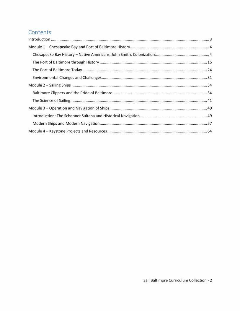
Contents Introduction .................................................................................................................................................. 3
Module 1 – Chesapeake Bay and Port of Baltimore History ......................................................................... 4
Chesapeake Bay History – Native Americans, John Smith, Colonization .................................................. 4
The Port of Baltimore through History ................................................................................................... 15
The Port of Baltimore Today ................................................................................................................... 24
Environmental Changes and Challenges ................................................................................................. 31
Module 2 – Sailing Ships ............................................................................................................................. 34
Baltimore Clippers and the Pride of Baltimore ....................................................................................... 34
The Science of Sailing .............................................................................................................................. 41
Module 3 – Operation and Navigation of Ships .......................................................................................... 49
Introduction: The Schooner Sultana and Historical Navigation .............................................................. 49
Modern Ships and Modern Navigation ................................................................................................... 57
Module 4 – Keystone Projects and Resources ............................................................................................ 64

Sail Baltimore Curriculum Collection - 3
Introduction
The purpose of this curriculum is to introduce middle-school students to the opportunities that living in
the great port city of Baltimore provides and to provide background lessons for students that will
enhance field trips in collaboration with Sail Baltimore and other port, maritime, and historical partners.
Baltimore’s economy and culture has been driven by its location on the Chesapeake, and the port
continues to drive the local economy and to attract visitors, particularly maritime vessels, from around
the world. This provides an incredible gateway to introduce students to all manner of subjects related to
being a port city.
The curriculum includes four modules that provide an introductory overview of the expansive history,
economics, geography, science, technology, engineering, and math involved in the maritime world. With
the intention of partnering with a visiting vessel or a local partner, this common core-aligned curriculum
covers a sampling of all of the learning and opportunities available to students through the port. A class
should be able to complete the curriculum in about two weeks, depending on how the teacher chooses
to adopt it. It will facilitate students’ exposure to many relevant topics and also provide an opportunity
to engage in a deeper student-directed keystone project allowing the students to become more involved
in a topic of their choice.
Many thanks to the numerous organizations who shared their resources for this compilation. A list of
some of these resources is available at the end of the collection. While a sampling is provided here,
many of these groups have much more to offer on their websites.
With all of the sites to visit and all the visiting ships here in Baltimore, we hope your students enjoy the
many opportunities living in the port city of Baltimore provides.
For More Information, Contact Us at Sail Baltimore
For more information on opportunities available to students, reach out to Sail Baltimore. Sail Baltimore
brings ships – glorious tall ships, high-tech naval warships and other ships of historic, environmental and
educational interest – from around the world to Baltimore. Since 1976, we have hosted more than 700
ships, providing millions of Baltimore residents and visitors a thrilling firsthand look at some of the
world’s greatest seagoing vessels. Check us out for opportunities to connect with a visiting ship and even
bring students to visit, or with any comments or questions. Our website is http://sailbaltimore.org/.
Sail Baltimore Curriculum Collection - 4
Module 1 – Chesapeake Bay and Port of
Baltimore History
Chesapeake Bay History – Native Americans, John Smith, Colonization Directions: Read the informational text and answer the questions that follow.
Vocabulary: Adapted = made adjustments to be successful Sophisticated = advanced Archaeologist = a person who studies human history by looking at artifacts and remains humans left behind Anthropologists = a person who studies human society and culture Cultivate = grow, farm Harvest = gather, collect Subsistence = enough to survive Alliances = agreements to support one another, friendships Ritualistic = traditional Retaliatory = to get revenge Pelt = skin of an animal
Pre-Contact
Estimates vary, but it is likely that 50,000 or more people called the Chesapeake region home before the English arrived on its shores. Their ancestors had lived here for more than 12,000 years, so the ways of life of the native people were highly adapted to the geographic environment. Their economic, cultural, social, political, and spiritual systems were well established and sophisticated. Through their cultural traditions and values, American Indians retain knowledge of ways of life prior to the arrival of Europeans. By combining this knowledge with the research of archaeologists, scientists, anthropologists and historians, it has been possible to reconstruct an image of the Chesapeake region before the arrival of English settlers, known as "pre-contact." Bay Resources There were many cultural differences among the various Indian tribes living around the Chesapeake Bay, but they also had much in common. They all had a unique relationship with the bay's resources and took advantage of all that was available. American Indians cultivated crops, harvested oysters, mussels, hunted deer as well as various small game, and fished on a large scale. Many groups practiced subsistence farming in semi-permanent towns and once the land was drained of nutrients from over farming, ranging from 10-20 years, towns would relocate. This was not always the case as some groups were able to sustain themselves year-round in the same locations.
Sail Baltimore Curriculum Collection - 5
Diverse Languages and Cultures
There were many different groups and cultures of Indians who called the Chesapeake region home. Before contact, there were at least three different language families (Algonquian, Siouan, and Iroquoian) and multiple dialects and cultural identities. The situation could be compared to Europe - everyone was European, but the French, German and Spanish were not the same.
Different tribes were connected by political alliances, but life was not always peaceful. Inter-tribal conflict and raids were common. Raids and conflicts had many motivations ranging from ritualistic, retaliatory, demonstration, or territory acquisition.
Powhatan Tribes The dominant American Indian group in the Chesapeake region was Algonquian speakers known collectively as the Powhatan tribes. The paramount chief, Powhatan, whose familiar or personal name was Wahunsenacawh, had inherited leadership of a number of tribes, including the Powhatan, Pamunkey, Mattaponi, Arrohateck, Appomatuck, and Youghtanund, He gained leadership of additional tribes, either by conquest or threat of conquest. The groups of this paramount chiefdom provided military support and paid tribute of food, animal pelts, copper, or other gifts. Powhatan's leadership extended from the Rappahannock River, west to the fall line of Virginia, and south just below the James River. Living in Communities The Indians of the Chesapeake Bay lived in towns situated along the rivers and waterways where they could get fresh drinking water. Towns ranged in size from about 50 to more than 200 inhabitants and contained homes, storehouses, gathering places, ceremonial and religious structures, and garden plots. Wooden fences, known as palisades surrounded some communities to protect them from military action and wild animals. The Indians moved their housing sites and sometimes entire towns to avoid draining the natural resources. Homes Two types of homes were common: wigwams and longhouses. Both were built of wooden frames covered by bark or reed mats. The sapling-and-mat houses were remarkably strong and could withstand hurricanes and heavy snows. Food and Sustenance Indian women and men worked side by side to feed their families. Women were responsible for farming and foraging; men took the lead hunting and fishing. Foods changed with the seasons which were defined by plentiful times and lean times. The varied diet of pre-contact American Indians was probably healthier than that of Europeans at the time.
Farming: The main crops cultivated were corn, beans, squash, pumpkins, and sunflowers.
Foraging: Women gathered nuts, seeds, berries, roots, and plants.

Sail Baltimore Curriculum Collection - 6
Fishing: An abundance of fish and shellfish were found in the Chesapeake Bay and its tributaries.
Hunting: Game included turkeys, rabbits, squirrels, raccoons, bear, and deer.
Trade Networks The natural abundance of the Chesapeake region meant that its Indian tribes could find nearly everything they needed for daily life close at hand. They obtained luxury goods, such as copper, by trading with distant tribes. A sophisticated trade network connected the Indians of the Chesapeake with other native peoples across the continent. Living Lightly The Indians of the Chesapeake had been living on the land for at least 12,000 years before Smith ever arrived. Their communities were small, dispersed, and often they moved so they did not strain the resources in any one location. They had minimal possessions, harvested only the resources they needed, and adapted to the seasons. Questions from the text:
1. Describe the people who lived in the Chesapeake Bay region prior to the arrival of the Europeans.
2. How do we know about the people who lived in the Chesapeake Bay region prior to the arrival of
the Europeans?
3. How did American Indians sustain themselves in the Chesapeake Bay region?
4. Would you have liked to live in the way the American Indians did? Why or why not?
5. Who was Powhatan and why was he important?
6. Describe the American Indian communities.
7. What was the diet of the American Indian communities? What was their life like?
8. What are some of the major ways that life in this area changed since the arrival of the English?

Sail Baltimore Curriculum Collection - 7
Directions: Read the informational text and answer the questions that follow.
Vocabulary: Pivotal = very important, changing everything Colonization = countries moving to new places and taking control of them and the people who were already there Lore = famous stories that may or not actually be true
Captain John Smith (1580-1631)
Smith was an English explorer who played a pivotal role in the
exploration and settlement of America. His leadership at Jamestown,
his contacts with Chesapeake Indians and his Chesapeake Bay
voyages - documented through his maps and journals - helped
ensure the success of early English colonization efforts.
Captain Smith's incredible adventures have gone down in history.
However, his real achievements have sometimes been obscured by
legend and lore, due largely to his own storytelling. Scholars
continue to debate aspects of Captain John Smith's life story. Even
so, there is no doubt that he was an outstanding leader, explorer,
diplomat, and communicator who made a lasting mark on America.
Life Before Jamestown
John Smith was born to a farming family in Willoughby, England,
either late in 1579 or early 1580. When he was 16, Smith left home
to become a soldier. He fought in Europe and the Middle East
eventually earning the rank of Captain, a title which he carried the
rest of his life. In Turkey, he was captured and sold into slavery, but
eventually he escaped. After further adventures in Europe and
Africa, he returned to England in 1605.
Smith and Virginia
At age 27 Captain John Smith was one of the colonists who embarked on the first Virginia Company
expedition to the Chesapeake region. During the voyage, he was accused of mutiny and imprisoned on
board the ship. His fortunes changed on arrival when letters of instruction from the Virginia Company
named Smith to the governing council.
After assuming a leadership position at Jamestown, Smith undertook two landmark voyages exploring
the Chesapeake Bay. He is credited with saving the colony through his leadership, organizational ability,
fighting skills, and talent for building alliances and trading relationships with the Chesapeake Indians.
However, his relationships with other leaders of the Jamestown governing council were often
antagonistic.

Sail Baltimore Curriculum Collection - 8
Smith's journals and maps were eventually published while he was still in Virginia, which described lush
resources and his encounters with the native people of the Chesapeake. His writings attracted great
attention to the Chesapeake region.
The Voyages
During Captain John Smith's three years in Virginia he traveled thousands of miles, exploring areas
previously unknown to Europeans. His two remarkable voyages of the Chesapeake in 1608 revealed the
rich natural wonders of the region as well as the complex social world of the Chesapeake area Indians.
His maps, journals and his claim that "Heaven and Earth never agreed better to frame a place for Man's
habitation" lured many English colonists to America and marked the start of a lasting English presence
on the continent.
Mission of the Explorations Smith's explorations were not a personal quest for adventure but a fundamental goal of the Jamestown colony. At the time, Europeans had no idea how big North America was or what was inland. The colonists were instructed by England to:
Find a route to the Pacific. Uncover gold, silver and mineral wealth; Trade with the Indians; Map the area; Claim land for the Crown.
1607 Explorations In June of 1607, Captain Christopher Newport led 23 men, including John Smith, on an exploration of the James River until they reached waterfalls blocking further navigation. Later that fall, Captain Smith tried to find another route to the Pacific along the Chickahominy River. He was captured and taken to the headquarters of Powhatan, a paramount chief of several area tribes. Accounts of his captivity and his interactions with Powhatan remain controversial. But by the time he was released, Captain Smith had learned a great deal about the customs, language, and politics of the native people and had formed a strategic alliance with Powhatan.

Sail Baltimore Curriculum Collection - 9
1608 Chesapeake Voyages Captain John Smith led two major voyages of exploration in the Chesapeake Bay in 1608. Traveling by shallop, he and his men headed into unknown waters for three months of discovery, hardship, and history-making encounters with the people and places of the region.
Questions from the text:
1. Why was John Smith important?
2. What were some examples of how John Smith was successful?
3. How did we learn about John Smith’s voyages?
4. What was the purpose of John Smith’s voyages? In what ways was he successful?

Sail Baltimore Curriculum Collection - 10
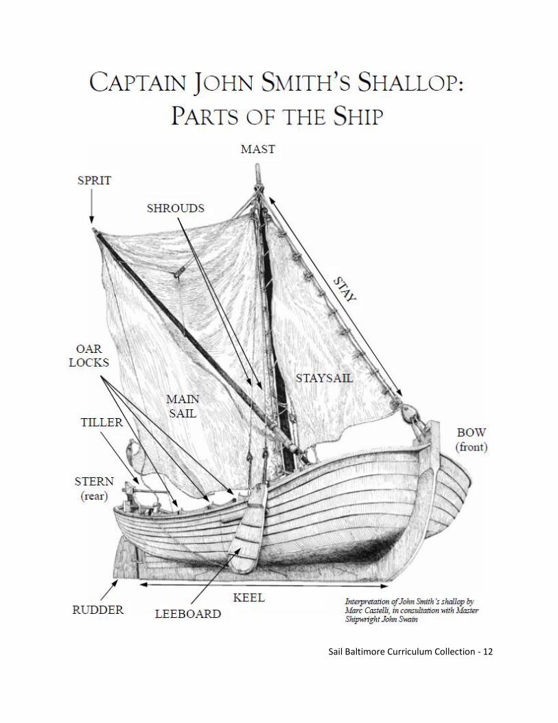
Directions: In the next activity, you will learn about John Smith’s ‘shallop’. Read the articles and complete
the questions and activities.
Sail Baltimore Curriculum Collection - 11
Sail Baltimore Curriculum Collection - 12

Sail Baltimore Curriculum Collection - 13

Sail Baltimore Curriculum Collection - 14
Extension: U.S. History Powhatan Final (See supplemental)

Sail Baltimore Curriculum Collection - 15
The Port of Baltimore through History
Fell’s Point
When people first came to settle in Baltimore, many of them wanted to live and work in Fell’s Point.
Some were men who built or sailed ships, while others were traders who shipped their goods by water.
One reason they picked Fell’s Point was that the water there was deep. Even the largest ships from the
Chesapeake Bay and the Atlantic Ocean could sail right to the docks in Fell’s Point without going
aground. Not many ships were able to go into the Inner Harbor area because the water was shallow and
marshy. As a result, Fell’s Point became the most important shipping area in the Baltimore harbor. For
many years it remained so, until the water in the Inner Harbor was made deeper in 1826 and large ships
could dock there as well.
Directions: This map of the harbor is from 1822. Fell’s Point is marked with a star. The Inner Harbor is
marked with a dot. Answer the following questions about the map.
1. Do you see the small number printed in the water areas? These numbers show the depth of the
water measured in feet. How deep was the water around Fell’s Point? How deep was the water
in the Inner Harbor area?
Sail Baltimore Curriculum Collection - 16
2. With a colored pencil, trace a sailing route for a ship needing 16 feet of water to float. Where
could such a ship dock? Where was it not able to dock? Where could shipbuilders launch such a
boat?
3. Why do you think Fell’s Point became important as a shipping center during Baltimore’s earliest
days?
In 1797, a tall tower was built on top of Federal Hill. Using a telescope to look from a window high in the
tower, a watchman could see ships sailing to Baltimore while they were still many miles away. Each ship
flew a special signal flag called a “house flag” which showed who owned the ship. After a ship was
sighted and its flag recognized, a signal flag just like it was flown from a flagpole near the tower. People
all over Baltimore could see the flag flying and know which ship was coming. In this way, owners had
plenty of time to call their workers to the dock and prepare for unloading and selling their goods. The
tower is no longer standing on Federal Hill, but you can see copies of some of the flags flying every day
at Harborplace in Baltimore’s Inner Harbor.
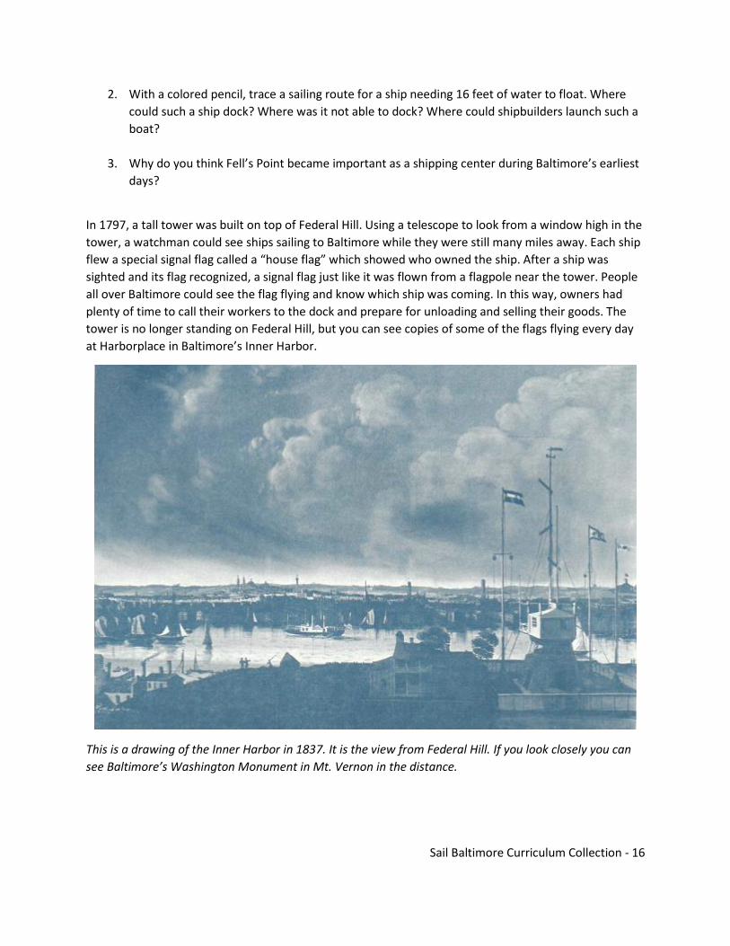
This is a drawing of the Inner Harbor in 1837. It is the view from Federal Hill. If you look closely you can
see Baltimore’s Washington Monument in Mt. Vernon in the distance.

Sail Baltimore Curriculum Collection - 17
There are some of the flags that were flown at the tower on Federal Hill.
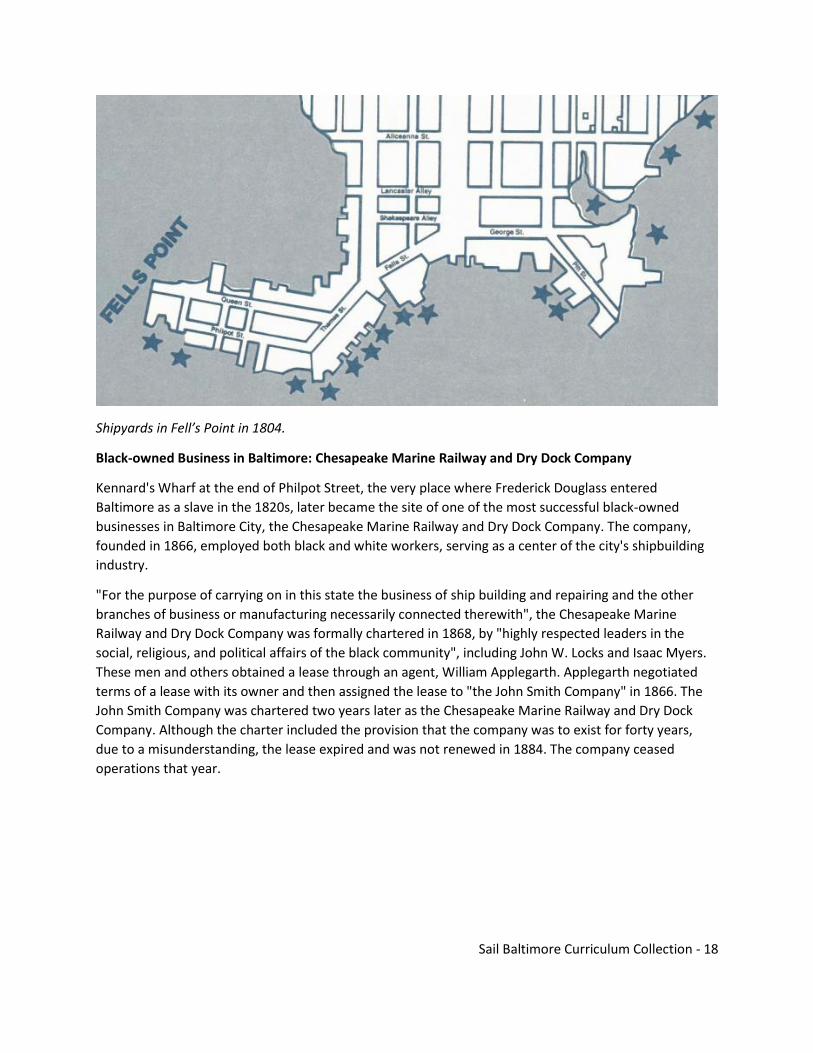
During its early days, life in Fell’s Point centered around building and repairing ships. William Fell, who
bought Fell’s Point in 1730, built the first shipyard there. By 1804 there were fifteen more shipyards
around the Point (see next page). Among the many famous ships that were built in Fell’s Point was the
Chasseur, after which the Pride of Baltimore II was modeled.
Sail Baltimore Curriculum Collection - 18
Shipyards in Fell’s Point in 1804.
Black-owned Business in Baltimore: Chesapeake Marine Railway and Dry Dock Company
Kennard's Wharf at the end of Philpot Street, the very place where Frederick Douglass entered
Baltimore as a slave in the 1820s, later became the site of one of the most successful black-owned
businesses in Baltimore City, the Chesapeake Marine Railway and Dry Dock Company. The company,
founded in 1866, employed both black and white workers, serving as a center of the city's shipbuilding
industry.
"For the purpose of carrying on in this state the business of ship building and repairing and the other
branches of business or manufacturing necessarily connected therewith", the Chesapeake Marine
Railway and Dry Dock Company was formally chartered in 1868, by "highly respected leaders in the
social, religious, and political affairs of the black community", including John W. Locks and Isaac Myers.
These men and others obtained a lease through an agent, William Applegarth. Applegarth negotiated
terms of a lease with its owner and then assigned the lease to "the John Smith Company" in 1866. The
John Smith Company was chartered two years later as the Chesapeake Marine Railway and Dry Dock
Company. Although the charter included the provision that the company was to exist for forty years,
due to a misunderstanding, the lease expired and was not renewed in 1884. The company ceased
operations that year.

Sail Baltimore Curriculum Collection - 19
Directions: Using the picture below, answer the questions.
1. What details can you notice in the picture? What do they say about what the process of building
a boat is like?
2. There are two boats that are pulled out of the water. What do you think is being done to these
ships?
3. Do you think ships are built this same way today? What is different? What is the same?
4. What do you think were some of the challenges of having a black-owned business in the years
immediately following slavery?

Sail Baltimore Curriculum Collection - 20
A Slave in the Baltimore Shipyards: Frederick Douglass
Frederick Douglass stood at the podium,
trembling with nervousness. Before him sat
abolitionists who had travelled to the
Massachusetts island of Nantucket. Only 23
years old at the time, Douglass overcame his
nervousness and gave a stirring, eloquent speech
about his life as a slave. Douglass would continue
to give speeches for the rest of his life and would
become a leading spokesperson for the abolition
of slavery and for racial equality.
The son of a slave woman and an unknown white
man, "Frederick Augustus Washington Bailey"
was born in February of 1818 on Maryland's
eastern shore. He spent his early years with his
grandparents and with an aunt, seeing his
mother only four or five times before her death
when he was seven. (All Douglass knew of his
father was that he was white.) During this time
he was exposed to the degradations of slavery, witnessing firsthand brutal whippings and spending
much time cold and hungry. When he was eight he was sent to Baltimore to live with a ship carpenter
named Hugh Auld. There he learned to read and first heard the words abolition and abolitionists. "Going
to live at Baltimore," Douglass would later say, "laid the foundation, and opened the gateway, to all my
subsequent prosperity."
Douglass spent seven relatively comfortable years in Baltimore before being sent back to the country,
where he was hired out to a farm run by a notoriously brutal "slavebreaker" named Edward Covey. And
the treatment he received was indeed brutal. Whipped daily and barely fed, Douglass was "broken in
body, soul, and spirit."
On January 1, 1836, Douglass made a resolution that he would be free by the end of the year. He
planned an escape. But early in April he was jailed after his plan was discovered. Two years later, while
living in Baltimore and working at a shipyard, Douglass would finally realize his dream: he fled the city on
September 3, 1838. Travelling by train, then steamboat, then train, he arrived in New York City the
following day. Several weeks later he had settled in New Bedford, Massachusetts, living with his
newlywed bride (whom he met in Baltimore and married in New York) under his new name, Frederick
Douglass.
Always striving to educate himself, Douglass continued his reading. He joined various organizations in
New Bedford, including a black church. He attended Abolitionists' meetings. He subscribed to William
Lloyd Garrison's weekly journal, the Liberator. In 1841, he saw Garrison speak at the Bristol Anti-Slavery
Society's annual meeting. Douglass was inspired by the speaker, later stating, "no face and form ever
Sail Baltimore Curriculum Collection - 21
impressed me with such sentiments [the hatred of slavery] as did those of William Lloyd Garrison."
Garrison, too, was impressed with Douglass, mentioning him in the Liberator. Several days later
Douglass gave his speech at the Massachusetts Anti-Slavery Society's annual convention in Nantucket--
the speech described earlier. Of the speech, one correspondent reported, "Flinty hearts were pierced,
and cold ones melted by his eloquence." Before leaving the island, Douglass was asked to become a
lecturer for the Society for three years. It was the launch of a career that would continue throughout
Douglass' long life.
Despite apprehensions that the information might endanger his freedom, Douglass published his
autobiography, Narrative of the Life of Frederick Douglass, an American Slave, Written By Himself. The
year was 1845. Three years later, after a speaking tour of England, Ireland, and Scotland, Douglass
published the first issue of the North Star, a four-page weekly, out of Rochester, New York.
Ever since he first met Garrison in 1841, the white abolitionist leader had been Douglass' mentor. But
the views of Garrison and Douglass ultimately diverged. Garrison represented the radical end of the
abolitionist spectrum. He denounced churches, political parties, even voting. He believed in the
dissolution (break up) of the Union. He also believed that the U.S. Constitution was a pro-slavery
document. After his tour of Europe and the establishment of his paper, Douglass' views began to
change; he was becoming more of an independent thinker, more pragmatic. In 1851 Douglass
announced at a meeting in Syracuse, New York, that he did not assume the Constitution was a pro-
slavery document, and that it could even "be wielded in behalf of emancipation," especially where the
federal government had exclusive jurisdiction. Douglass also did not advocate the dissolution of the
Union, since it would isolate slaves in the South. This led to a bitter dispute between Garrison and
Douglass that, despite the efforts of others such as Harriet Beecher Stowe to reconcile the two, would
last into the Civil War.
Frederick Douglass would continue his active involvement to better the lives of African Americans. He
conferred with Abraham Lincoln during the Civil War and recruited northern blacks for the Union Army.
After the War he fought for the rights of women and African Americans alike.
Directions: Imagine you are Frederick Douglass about to give a speech to the abolitionists of Nantucket.
What would you say? Write a speech, including details from Frederick Douglass’s background.
Sail Baltimore Curriculum Collection - 22
Extension: The Port that Built a City Viewing Guide – DVD available from the Baltimore Museum of
Industry
VIEWING GUIDE: THE PORT THAT BUILT A CITY AND STATE (1950 – 1965)
1. As you watch, note some examples of how this video is itself an artifact.
2. What products were historically shipped out of Baltimore?
3. Where did a lot of the brick and marble in Baltimore’s houses come from?
4. Who was largely responsible for turning Baltimore into a major shipbuilding center?
5. What war did Baltimore play a major role in?
6. What was the Tom Thumb?
7. What are some examples of cultural leaders whose names you recognize from institutions today?
8. What about Baltimore’s location allowed it to become one of the foremost ports on the East Coast?
9. Describe some of the businesses that grew because of the Port of Baltimore.
10. What was Baltimore’s role in World War II?
11. Describe this video’s outlook for the Port of Baltimore.
Sail Baltimore Curriculum Collection - 23
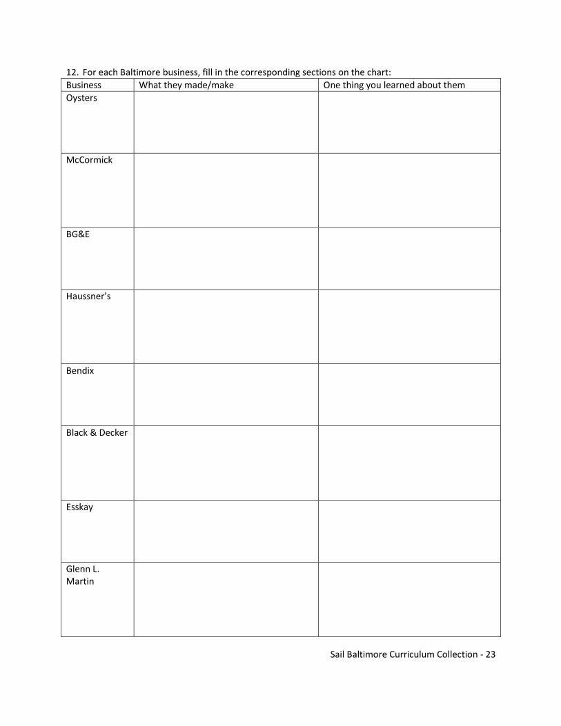
12. For each Baltimore business, fill in the corresponding sections on the chart:
Business What they made/make One thing you learned about them
Oysters
McCormick
BG&E
Haussner’s
Bendix
Black & Decker
Esskay
Glenn L. Martin

Sail Baltimore Curriculum Collection - 24
The Port of Baltimore Today
From the beginning of Baltimore Town in
1729 to the modern city of today, many
different kinds of ships have served the
Port of Baltimore. The first small ships seen
in the Harbor were tobacco ships loading
locally-grown tobacco for England. After
the Revolution, Baltimore merchants
developed a flourishing trade in flour and
grain with the West Indies and South
America. This trade was carried out in the
fast Baltimore Clipper schooners that made
Baltimore’s name known worldwide.
During the 19th century, ships grew larger and larger. When gold was found in California in 1849,
Baltimore sent beautiful Clipper ships to the gold fields, with return voyages by way of China. Similar
ships sailed to South America with Baltimore flour and pork products, bring back tons of coffee, one of
the most important imports of the Port after the Civil War. At the same time, large coasting schooners
carried coal and lumber from one East Coast port to another.
Within the Bay itself, the handy skipjacks (pictured above) dredged for oysters and brought them to
Baltimore to sell, along with Eastern Shore fruits and vegetables during the summer season. With the
invention of the steam engine, Bay steamboats connected isolated rural Bay towns with Baltimore,
carrying livestock and produce to Baltimore and bring back manufactured goods. Today, huge container
ships connect the Port of Baltimore to the world, carrying everything imaginable aboard the multi-
decked ships – even automobiles that can drive on and off certain types of container ships which have a
rear gate that drops down like a drawbridge.
The Port continues to grow today with new cranes to unload even larger ships that now come to the
Port.

Sail Baltimore Curriculum Collection - 25
Directions: Read the following article from the Baltimore Sun and then complete a chart of the pros and cons and then write a power-paragraph stating your decision.
Job On The Waterfront Is A Family Tradition June 07, 2009|By Nancy Jones-Bonbrest
Tony Revels, Longshoreman, Ports America, Baltimore Salary: $30/hour
Age: 49
Years on the job: 31
How he got started: Knowing he didn't want to go into the military or on to college, Tony Revels began
working at the port of Baltimore as a longshoreman before he graduated from high school. His father
also worked at the port as a longshoreman, and the two had a chance to work side by side until his
father, Jesse, who has since passed away, retired in 1993. Revels calls that experience "awesome."
The job is a union position, and Revels belongs to the International Longshoremen's Association Local
333.
Typical day: "Every day is different," Revels said about his job. He usually works 50 to 60 hours a week,
but his days and hours vary and are determined by the number of vessels that come in and out of
Baltimore's Seagirt Marine Terminal or Dundalk Marine Terminal. About three to six ships usually arrive
each day.
The port operates seven days a week, 24 hours a day, with only a few holidays. Revels must call at 4 p.m.
to find out when he'll be working the next day, and he is often on call.
As a longshoreman, it's his job to unload and load cargo from ships. He's trained to operate most of the
equipment at the port, including forklifts, top loaders, bulldozers and cranes.
For most of his 31 years he has worked as a lasher, which involves securing containers, cars and cargo to
be shipped or loosening the cargo and getting it ready to be unloaded. The work is physically demanding
and includes climbing on the containers to properly secure them.
"I loved it, but my body started to wear out," he said.
Recently, Revels began taking on the job of crane operator, which involves moving the containers on
and off the ship. The towering cranes, with an operator cab about 120 feet off the ground, offer a great
view of the waterfront and surrounding area, Revels says. The job is less physically demanding but one
where safety is a constant issue.
Quickness on the job also counts, as the port of Baltimore averages moving 37 containers per hour.
Changes to the job: With increased technology and better equipment, the number of longshoremen's
jobs has decreased over the years, but work has remained steady, and the port and the state do a good

Sail Baltimore Curriculum Collection - 26
job of competing with other ports along the East Coast, Revels says. Overall, the port of Baltimore is
ranked 12th nationally for total dollar value of foreign cargo and 14th for foreign cargo handled.
Strange cargo: Revels has helped to load the Moscow Circus and the Batmobile, and unload live cattle
with a veterinarian onboard to deliver calves. "Just when you think you've seen it all, you see something
different. There's never a dull moment."
Family tradition: Revels not only had the opportunity to work alongside his father, but also with two
brothers and a brother-in-law. His son, Tony Jr., and four nephews are continuing the tradition. Revel's
17-year-old son, Austin, is also contemplating a job at the port.
The good: "The fact that I never know what I'm going to do from day to day or how long I'll work," he
says. "I couldn't handle routine."
The bad: Although not having a set schedule is something he enjoys, it's also hard to make plans in
advance and can be stressful for his family. "It's a double-edged sword."
Philosophy on the job: "Don't ever bad-mouth your job," Revels said he tells his son who works at the
port. "This job has been taking care of your family for 50 years."
WOULD YOU LIKE A JOB AS A LONGSHOREMAN?
Pros: Cons:
Sail Baltimore Curriculum Collection - 27
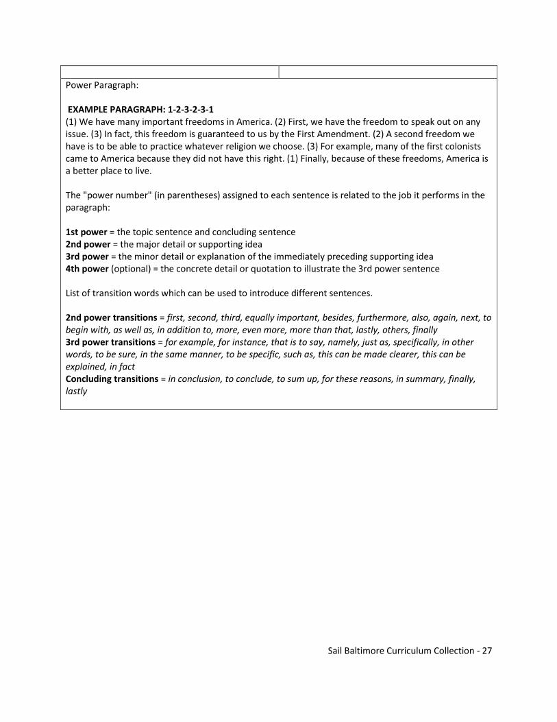
Power Paragraph: EXAMPLE PARAGRAPH: 1-2-3-2-3-1 (1) We have many important freedoms in America. (2) First, we have the freedom to speak out on any issue. (3) In fact, this freedom is guaranteed to us by the First Amendment. (2) A second freedom we have is to be able to practice whatever religion we choose. (3) For example, many of the first colonists came to America because they did not have this right. (1) Finally, because of these freedoms, America is a better place to live. The "power number" (in parentheses) assigned to each sentence is related to the job it performs in the paragraph: 1st power = the topic sentence and concluding sentence 2nd power = the major detail or supporting idea 3rd power = the minor detail or explanation of the immediately preceding supporting idea 4th power (optional) = the concrete detail or quotation to illustrate the 3rd power sentence List of transition words which can be used to introduce different sentences. 2nd power transitions = first, second, third, equally important, besides, furthermore, also, again, next, to begin with, as well as, in addition to, more, even more, more than that, lastly, others, finally 3rd power transitions = for example, for instance, that is to say, namely, just as, specifically, in other words, to be sure, in the same manner, to be specific, such as, this can be made clearer, this can be explained, in fact Concluding transitions = in conclusion, to conclude, to sum up, for these reasons, in summary, finally, lastly
Sail Baltimore Curriculum Collection - 28
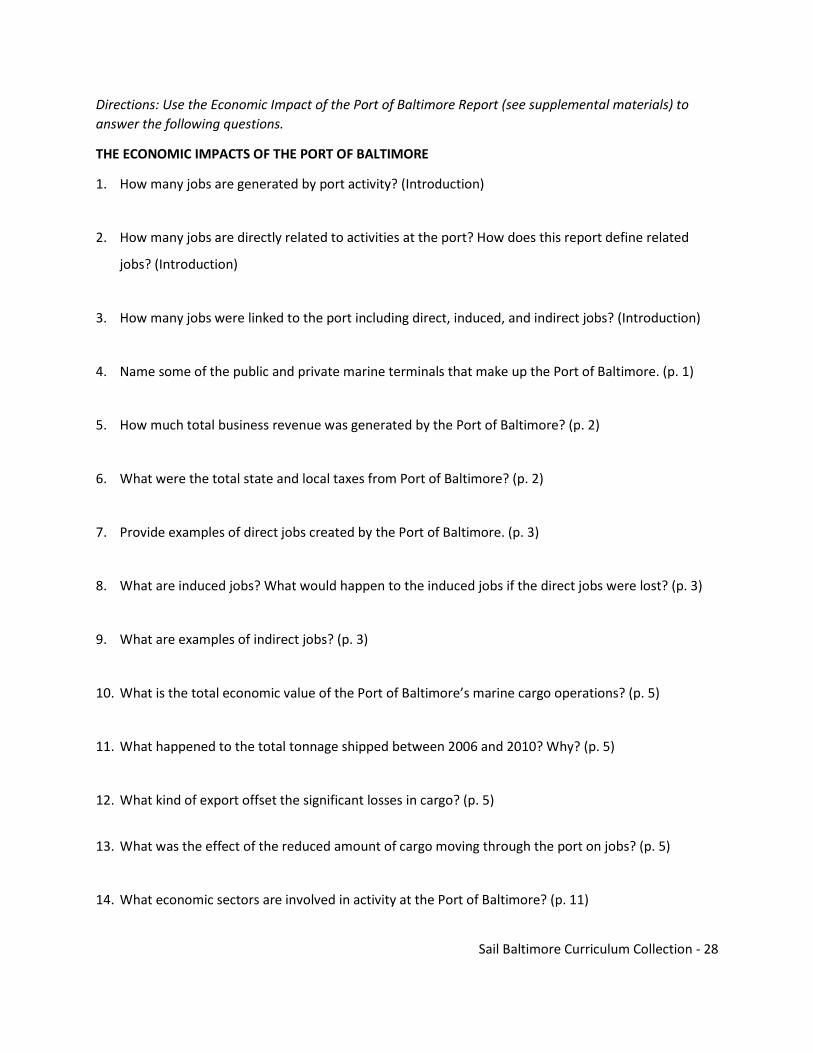
Directions: Use the Economic Impact of the Port of Baltimore Report (see supplemental materials) to
answer the following questions.
THE ECONOMIC IMPACTS OF THE PORT OF BALTIMORE
1. How many jobs are generated by port activity? (Introduction)
2. How many jobs are directly related to activities at the port? How does this report define related
jobs? (Introduction)
3. How many jobs were linked to the port including direct, induced, and indirect jobs? (Introduction)
4. Name some of the public and private marine terminals that make up the Port of Baltimore. (p. 1)
5. How much total business revenue was generated by the Port of Baltimore? (p. 2)
6. What were the total state and local taxes from Port of Baltimore? (p. 2)
7. Provide examples of direct jobs created by the Port of Baltimore. (p. 3)
8. What are induced jobs? What would happen to the induced jobs if the direct jobs were lost? (p. 3)
9. What are examples of indirect jobs? (p. 3)
10. What is the total economic value of the Port of Baltimore’s marine cargo operations? (p. 5)
11. What happened to the total tonnage shipped between 2006 and 2010? Why? (p. 5)
12. What kind of export offset the significant losses in cargo? (p. 5)
13. What was the effect of the reduced amount of cargo moving through the port on jobs? (p. 5)
14. What economic sectors are involved in activity at the Port of Baltimore? (p. 11)

Sail Baltimore Curriculum Collection - 29
15. What government agencies play a role in operations at Port of Baltimore? (p.13)
16. What commodities are handled by the Port of Baltimore? (p. 14)
17. Where do most people who work at the Port of Baltimore live? (p. 20)
18. What type of cargo provided the most jobs? (p. 21)
19. What cargo generates the greatest revenue impact at the Port of Baltimore in terms of total
revenue? (p. 33)
20. How many passengers took cruise ships in and out of Baltimore? (p. 37)
21. How many jobs are projected are supported in Maryland due to cruise activity? (p. 42)
22. What types of cargo decreased from 2006 to 2012? What types increased? (p. 44)
23. What was the average salary for direct workers in 2010? (p. 46)
FOREIGN COMMERCE STATISTICAL REPORT
24. What was the total tonnage of U.S. foreign waterborne commerce? What was its total value? (p. 1)
25. Describe the trend in foreign waterborne commerce through the Port of Baltimore from 2002 to
2011. What is the general trend? What is the exception to this trend, and why do you think this
exception occurred? (p. 2)
26. Are there more imports or exports from the Port of Baltimore? Why do you think this is? (p. 2)
27. Where did the Port of Baltimore rank overall in terms of total tonnage of cargo relative to other U.S.
ports? (p. 7)

Sail Baltimore Curriculum Collection - 30
28. What country is the Port of Baltimore’s top trading partner for exports? For imports? (p. 8)
29. What were the top three exports in tons? What were the top three exports in value? (p. 8)
30. How is the Port of Baltimore doing overall? Support your argument with details from the questions
you have answered above.
Sail Baltimore Curriculum Collection - 31
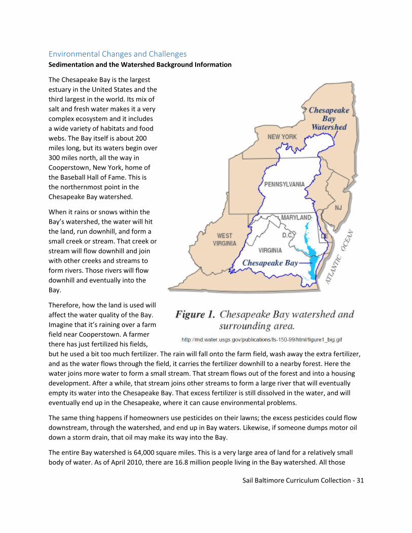
Environmental Changes and Challenges Sedimentation and the Watershed Background Information
The Chesapeake Bay is the largest
estuary in the United States and the
third largest in the world. Its mix of
salt and fresh water makes it a very
complex ecosystem and it includes
a wide variety of habitats and food
webs. The Bay itself is about 200
miles long, but its waters begin over
300 miles north, all the way in
Cooperstown, New York, home of
the Baseball Hall of Fame. This is
the northernmost point in the
Chesapeake Bay watershed.
When it rains or snows within the
Bay’s watershed, the water will hit
the land, run downhill, and form a
small creek or stream. That creek or
stream will flow downhill and join
with other creeks and streams to
form rivers. Those rivers will flow
downhill and eventually into the
Bay.
Therefore, how the land is used will
affect the water quality of the Bay.
Imagine that it’s raining over a farm
field near Cooperstown. A farmer
there has just fertilized his fields,
but he used a bit too much fertilizer. The rain will fall onto the farm field, wash away the extra fertilizer,
and as the water flows through the field, it carries the fertilizer downhill to a nearby forest. Here the
water joins more water to form a small stream. That stream flows out of the forest and into a housing
development. After a while, that stream joins other streams to form a large river that will eventually
empty its water into the Chesapeake Bay. That excess fertilizer is still dissolved in the water, and will
eventually end up in the Chesapeake, where it can cause environmental problems.
The same thing happens if homeowners use pesticides on their lawns; the excess pesticides could flow
downstream, through the watershed, and end up in Bay waters. Likewise, if someone dumps motor oil
down a storm drain, that oil may make its way into the Bay.
The entire Bay watershed is 64,000 square miles. This is a very large area of land for a relatively small
body of water. As of April 2010, there are 16.8 million people living in the Bay watershed. All those
Sail Baltimore Curriculum Collection - 32
people each have an impact on the water quality of the Chesapeake Bay, and that is why the Bay faces
so many environmental challenges.
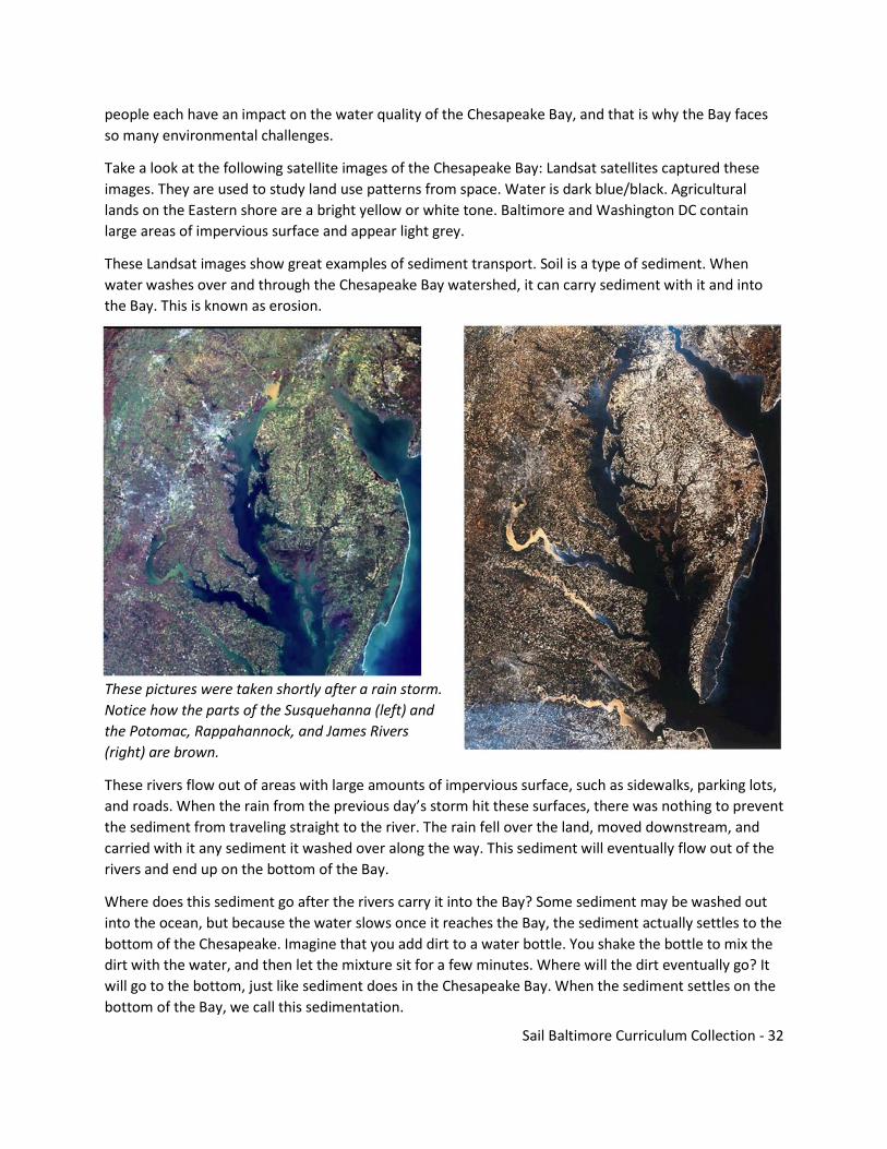
Take a look at the following satellite images of the Chesapeake Bay: Landsat satellites captured these
images. They are used to study land use patterns from space. Water is dark blue/black. Agricultural
lands on the Eastern shore are a bright yellow or white tone. Baltimore and Washington DC contain
large areas of impervious surface and appear light grey.
These Landsat images show great examples of sediment transport. Soil is a type of sediment. When
water washes over and through the Chesapeake Bay watershed, it can carry sediment with it and into
the Bay. This is known as erosion.
These pictures were taken shortly after a rain storm.
Notice how the parts of the Susquehanna (left) and
the Potomac, Rappahannock, and James Rivers
(right) are brown.
These rivers flow out of areas with large amounts of impervious surface, such as sidewalks, parking lots,
and roads. When the rain from the previous day’s storm hit these surfaces, there was nothing to prevent
the sediment from traveling straight to the river. The rain fell over the land, moved downstream, and
carried with it any sediment it washed over along the way. This sediment will eventually flow out of the
rivers and end up on the bottom of the Bay.
Where does this sediment go after the rivers carry it into the Bay? Some sediment may be washed out
into the ocean, but because the water slows once it reaches the Bay, the sediment actually settles to the
bottom of the Chesapeake. Imagine that you add dirt to a water bottle. You shake the bottle to mix the
dirt with the water, and then let the mixture sit for a few minutes. Where will the dirt eventually go? It
will go to the bottom, just like sediment does in the Chesapeake Bay. When the sediment settles on the
bottom of the Bay, we call this sedimentation.

Sail Baltimore Curriculum Collection - 33
Because of all the excess sediment sitting at its bottom, the average depth of the Chesapeake Bay is
about 21 feet. A person who is 6 feet tall could wade through over 700,000 acres of the Bay and never
get his/her hat wet.
Activity: How to Build a Watershed Model
Materials:
Modeling clay
1 aluminum paint pan (for class demonstration)
Additional aluminum paint pans (enough for each group to have one)
Paper cups
Sponges, scraps of indoor/outdoor carpet, leaves/twigs/branches
Hot glue gun(s)
Cups of soil
Water
Procedure:
Part 1: Class demonstration:
1. Spread a layer of modeling clay in the top half of the paint pan to represent land/impervious surface.
The bottom half will be empty to represent the Chesapeake Bay.
2. The clay should be shaped so that it slopes down to the water. Press the clay into the side of the pans
to seal the edges; you may need to use hot glue around the edge of the clay. These models won’t work
well if there are large spaces between the clay and sides of the pans.
3. This model will represent a watershed with large amounts of impervious surface (the clay).
4. Spread a thin layer of soil over the model.
5. Poke holes in the bottom of one cup and slowly pour water from the other cup through this
“sprinkler” over the top of the watershed model. Observe what happens to the soil as the water makes
its way down into the deeper part of the pan, which represents the Chesapeake Bay.
Part 2: Individual groups:
6. Distribute a paint pan and paper cups to each group. Allow students to build their own watershed.
This time they will use the sponges, carpet, leaves/twigs/branches, etc. to create a way to reduce the
amount of sediment that ends up on the bottom of the Bay after rainfall occurs. Be sure sponges are hot
glued to the clay.
7. Spread a thin layer of soil over the model.
8. Observe how much soil ends up at the bottom of the watershed that has large amounts of impervious
surface compared to a watershed with buffer areas.

Sail Baltimore Curriculum Collection - 34
Module 2 – Sailing Ships
Baltimore Clippers and the Pride of Baltimore
The Baltimore Clipper designed in the Chesapeake Bay in the late 1700’s and early 1800’s were built for
speed. They were very different from the large merchant ships and cargo ships of Europe. The Clippers
could not carry the large amounts of cargo that European ships did, but they were much lighter, faster,
and easier to maneuver. Their names often reflected their speed and grace: Mosquito, Catch Me Who
Can, Comet, Highflyer.
This diagram shows some of the design features that made Baltimore Clippers so fast.
Sail Baltimore Curriculum Collection - 35
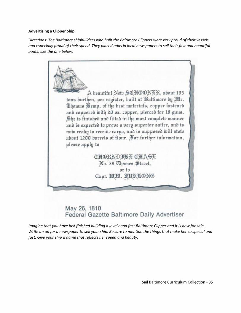
Advertising a Clipper Ship
Directions: The Baltimore shipbuilders who built the Baltimore Clippers were very proud of their vessels
and especially proud of their speed. They placed adds in local newspapers to sell their fast and beautiful
boats, like the one below:
Imagine that you have just finished building a lovely and fast Baltimore Clipper and it is now for sale.
Write an ad for a newspaper to sell your ship. Be sure to mention the things that make her so special and
fast. Give your ship a name that reflects her speed and beauty.

Sail Baltimore Curriculum Collection - 36
Privateering
At the beginning of the War of 1812 between England and the United States, the young nation did not
have as many large ships as the powerful British Navy. So the U.S. government allowed individual
citizens to use their own vessels to seize and capture enemy ships. Very often, several individuals would
put their money together, buy a ship and hire a captain. Most of these vessels, called privateers, that
sailed out of Baltimore harbor were Baltimore Clippers, small but extremely fast vessels that could
outrun larger British ships. These daring privateers sank or captured 1700 British vessels during the War,
greatly embarrassing that mighty navy. When they captured an enemy merchant ship, the cargo was
auctioned off and the individuals who owned shares in the vessel divided up the profits. Many
Baltimoreans became very wealthy from privateering.
Privateering is when a private citizen (someone who was not in the military) went to sea to capture
enemy ships. During the War of 1812, people did this for many reasons – some because they were
patriots who wanted to help their country, others because it made them lots of money. We were at war
with England because after the Revolutionary War, England was at war with France. British sailors were
leaving their ships to sail with the Americans who were not at war. So England decided to “take back
their sailors”. Thousands of sailors were taken off American ships, but the British took both Brits and
Americans. This was called impressment. This was one reason that the War of 1812 started. America at
this time had a very small navy, so owners of smaller ships like Pride of Baltimore II were given a letter
from the President that gave them permission to attack British merchant/trading ships who had few or
no cannons. The captain and crew were allowed to keep the ship and all the goods that were aboard.
The private ships that helped in the war were called privateers.

Sail Baltimore Curriculum Collection - 37
The Success of Privateers
Directions: Look at the accounting book of one Baltimorean, Jesse Eichelberger. He bought shares in two
privateers; one of them was very successful, the other was not. See if you can answer the following
questions and fill in the blanks in Mr. Eichelberger’s book. Show your work.
1. Mr. Eichelberger’s 1/13 share in the Chasseur cost him $3,357.84, and his 1/16 share in the
Saranac cost him $1,250.00. How much did each of the ships cost to build?
2. If Mr. Eichelberger owned 1/13 of the Chasseur, what was his share of each of the Chasseur’s
prizes?
3. What was his total share from the Chasseur?
4. What was his total profit from the Chasseur? (remember his original investment)
5. How much did Mr. Eichelberger lose on the Saranac?
6. Between his profit on the Chasseur and his loss on the Saranac, what did Mr. Eichelberger make
as a final profit?

Sail Baltimore Curriculum Collection - 38
Black Seamen
Approximately 18,000 African-American sailors sailed on Baltimore Clippers and other vessels during the
War of 1812. This is about 1/5 of all the sailors. Many of them were free Blacks or runaways. They
became sailors because they couldn’t own land. They often had very little money. Some were familiar
with ships by helping with plantation delivery boats. Sailing was a hard job they could step into because
many whites did not want the hard life of being a sailor who was often away from home. Blacks were
more desirable as crew than white men because they were more often stable, sober and married heads
of households. As crewmen, they would clean, set and stow sail, steer, mend sail, load and off-load
cargo, and maintain the ship.
Directions: Read the following sources about Black sailors and answer the questions.

Sail Baltimore Curriculum Collection - 39
SECONDARY SOURCE: ARTICLE WRITTEN BY A RESEARCHER IN THE RECENT YEARS TO TELL THE STORY
OF BLACKSEAMEN ON PRIVATEERS
African-American Sailors Served in Our Nation’s “Private Navy”
by Christopher T. George, 1998
“One of the black sailors from Baltimore…is George R. Roberts,
a man who early in the war enlisted in the crew of Captain
Richard Moon’s privateer Sara Ann.
“Later in the war, Roberts served as gunner on board Captain
Thomas Boyle’s privateer Chasseur…Not for nothing did
Hezekiah Niles, editor of the Niles Weekly Register, hail Boyle’s
ship as the “Pride of Baltimore.” Boyle and his crew had many
narrow escapes while they sailed the oceans preying on British
shipping.
“Possibly the most famous engagements fought by the men of
Chasseur was that on February 27, 1815 with the British
schooner St. Lawrence …skipper Thomas Boyle himself recorded
the scene: ‘At the time both fires were very severe and
destructive and we found we had a heavy enemy to contend
with…Saw blood run freely from her scuppers. Gave orders for
boarding which was cheerfully obeyed…[By] various…reports
[the British had] 15 killed and 19 wounded [out of 75 men]. She was a perfect wreck in her hull, and had
scarcely a sail or rope standing. We…had 5 men killed and 19 wounded.’
“Black seaman George Robert took part in the triumphal return of Chasseur to Baltimore on April 8,
1815, when she was saluted by the cannons of Fort McHenry as she sailed into port. For decades
afterwards, Roberts was honored as a hero as he paraded with the other ‘Old Defenders’ of the city. He
was remembered for his ‘brave character.’”
PRIMARY SOURCE: AN INTERVIEW AT AGE 95 THAT WAS RECORDED IN A BOOK ~ 50 YEARS AFTER THE
WAR OF 1812 TO CAPTURE THE DETAILS OF THE WAR
“I spent some time in the humble dwelling of Henry Van Meter, a remarkable black man, then ninety-
five years of age. He was a slave to Governor Nelson of Virginia, during the Revolution became a seamen
in long after years and he was one of the crew of the privateer Lawrence which sailed from Baltimore in
1814*. He was captured and sent to Plymouth, and confined in the Dartmoor Prison. Van Meter’s
history, as he related it to me, was an eventful one. His mind seemed clear, and his body not very feeble;
and when I finished the sketch of him, he signed his name.”
“Henry remembered seeing Washington many times. When Governor Nelson’s estate was sold after the
war to pay his debts, Henry became the property of a planter beyond the Blue Ridge on the extreme
frontier. He was discontented and wished to leave - not withstanding this master was kind. So the
master sold [him] to a man near Lexington in Kentucky, and there was only one log house in that town
when [he] went there. He was soon sold to one of those vile men engaged in the slave-trading business

Sail Baltimore Curriculum Collection - 40
who treated him shamefully. Henry mounted one of his master’s horses one night, and fled to the
Kentucky River where he turned him loose, and told him to go home if he had mind to, as he didn’t wish
to steal him. Some white people helped him on to the Ohio (river).
“He took the name of Van Meter, borne by some of the family of one his kind masters. Henry became a
servant of an officer in St. Clair’s army in the Northwest. After the peace in 1795, he came East with
some Englishmen with horses to Philadelphia. In the latter city some Quakers sent him to school and he
learned to read and write. When the war broke out, he shipped out as a common sailor in the privateer,
Lawrence, having previously been to Europe several times in the same capacity and once cast into
Dartmoor Prison.”
1. Where did Black seamen come from?
2. Why would an African-American become a sailor instead of some other job/profession?
3. The facts in which story are probably more accurate/correct? Why?
4. Is the author’s purpose the same or different? Why?
Extension: Create a comic book of the adventures of the Privateers in the War of 1812. Go to
http://www.pride2.org/education/privateer-history/ for information and see the rubric in the last
section of this resource.
Sail Baltimore Curriculum Collection - 41
The Science of Sailing
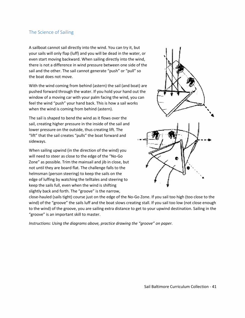
A sailboat cannot sail directly into the wind. You can try it, but
your sails will only flap (luff) and you will be dead in the water, or
even start moving backward. When sailing directly into the wind,
there is not a difference in wind pressure between one side of the
sail and the other. The sail cannot generate “push” or “pull” so
the boat does not move.
With the wind coming from behind (astern) the sail (and boat) are
pushed forward through the water. If you hold your hand out the
window of a moving car with your palm facing the wind, you can
feel the wind “push” your hand back. This is how a sail works
when the wind is coming from behind (astern).
The sail is shaped to bend the wind as it flows over the
sail, creating higher pressure in the inside of the sail and
lower pressure on the outside, thus creating lift. The
“lift” that the sail creates “pulls” the boat forward and
sideways.
When sailing upwind (in the direction of the wind) you
will need to steer as close to the edge of the “No-Go
Zone” as possible. Trim the mainsail and jib in close, but
not until they are board flat. The challenge falls to the
helmsman (person steering) to keep the sails on the
edge of luffing by watching the telltales and steering to
keep the sails full, even when the wind is shifting
slightly back and forth. The “groove” is the narrow,
close-hauled (sails tight) course just on the edge of the No-Go Zone. If you sail too high (too close to the
wind) of the “groove” the sails luff and the boat slows creating stall. If you sail too low (not close enough
to the wind) of the groove, you are sailing extra distance to get to your upwind destination. Sailing in the
“groove” is an important skill to master.
Instructions: Using the diagrams above, practice drawing the “groove” on paper.
Sail Baltimore Curriculum Collection - 42
Activity: Buoyancy
Materials:
Student Response Sheet
One half stick (about 2 ounces of modeling clay (non-hardening) per student
Heavy duty aluminum foil (alternative to clay)
One tub of water, at least six inches deep, per four or five students
One hundred large washers, e.g. 1.5” fender washers (available from hardware stores) or other weights. Coins also work.
Paper towels
2 glasses
1 ounce of oil
10 objects that sink or float
Vocabulary: Archimedes Principle= any object that is completely or partially submerged in a fluid (either liquid or gas) is acted on by an upward, or buoyant, force. The magnitude, or strength, of the force equals the weight of the fluid displaced by the object. The weight of the object is reduced by the weight of the displaced fluid Gravity = the force of attraction between any two objects due to their mass Weight = measure of the force of gravity on an object Mass = the quantity of matter in an object Displacement = the moving of something by something else taking its place Buoyancy = the upward force exerted on an object by the surrounding fluid (in most cases water) in which the object is immersed. Buoyancy acts against the force of gravity Density = the mass per unit volume of an object. Density = Mass/Volume Center of Gravity = the point on your boat where all the mass would be concentrated if it had to be compressed to a single point. For a boat to float properly on its designed waterline, then the Center of Gravity must be in line vertically with the Center of Buoyancy
Buoyancy is the upward force exerted on an object by the surrounding fluid (in most cases water) in
which the object is immersed. Buoyancy acts against the force of gravity.
Density is defined as the mass per unit volume of an object. D=M/V. Remind students that mass is not
the same as weight. Different fluids have different densities. Since oil is less dense than water, it actually
floats on top of the water!
If the density of an object is greater than that of the surrounding fluid, the object sinks. (Density of
Object > Surrounding Fluid = Object Sinks). If the densities are equal, the object is neutrally buoyant and
hovers in the fluid. (Density of Object = Surrounding Fluid = Hovers). If the density of the object is less
than that of surrounding fluid, the object floats. (Density of Object < Surrounding Fluid = Object Floats).
Extension: Visit density and buoyancy Interactive Simulations at the University of Colorado to explore the
density and buoyancy of a variety of objects and fluids.
(http://phet.colorado.edu/en/simulation/bouyancy)
Sail Baltimore Curriculum Collection - 43
Part 1 – Sink or Float?
1. Access Prior Knowledge: Ask students, “Do sailboats float or sink?” Get several responses to engage
students and explain their responses. The interesting fact is sometimes they sink and sometimes
they float. Tell students, “Today we are going to investigate why some objects float and why some
sink. When we go sailing what are some things that we think will float? And some things that may
sink.”
2. Ask students to list things on a sailboat or a motor boat that may fall in the water while sailing
(snacks, sunglasses, hats, shoes, lifejackets, tools, whistles, sails, tiller extensions, rudders, motor,
cell phone, keys, fishing poles, etc.)
3. Ask students to predict whether these objects will float or sink and why. Categorize the objects in
the appropriate columns. Ask students about the water in the Inner Harbor and the Chesapeake
Bay. Is it fresh or salt water? How deep is it? What is the required water depth for different boats
and ships?
4. Ask students, “Why do sailboats float? Does it make a difference if they are in salt water or
freshwater? Let’s investigate.”
5. Ask students, “What happens to the water level in a bath tub when you get in it?” (It rises.) “Why?”
(When an object is placed in water it takes up space, water is displaced forcing the water level to
rise – Water Displacement.)
6. Demonstrate this with two glasses of water and an object that sinks.
7. Ask students, “What forces are affecting the object?” (There are two primary forces acting on it,
gravity pushing down, and buoyancy pushing up.) Note: The gravitational force is determined by the
object’s weight, and the buoyancy force is determined by the weight of the water displaced by the
objective when it is placed in water. If the gravitational force is less than the buoyancy force then
the object floats (like a boat) otherwise it sinks (like a rock). That is, if the object weighs less than the
amount of water it displaces then it floats otherwise it sinks.
8. Ask students to predict if the oil will sink or float and why. Check predictions by pouring 1 ounce of
oil into it.
9. Explain to students that liquids of different densities (that don’t become a solution) separate into
layers. Density is measured in kg/m3 meaning kilograms per cubic meter.
10. Pure water’s density is 100kg/m3, therefore one cubic meter of pure water weighs one metric ton.
Oil is usually around the 800kg/m3 area (as there are many oils which all have different densities)
this means a cubic meter of this oil is 800 kg. Therefore the lighter less dense fluid floats to the top.
Just like helium is lighter than air, a balloon full of helium would fly upwards, as oil does in water.
11. Sea water (salt water) is usually 1015kg/m3. Keep in mind, the density of fluid affects buoyancy of
an object. For example, if a ship moves from sea water, salt water, to river water, fresh water, the
ship will sink slightly. To allow the ship to continue to float, the weight of the water displaced by the
ship must equal the weight of the ship. As the density of fresh water is less than sea water, the ship
sinks a little further into the water to displace the extra 15kg per m3.
12. Mariners, especially those involved in cargo carrying, must calculate a fresh water allowance if they
plan to go from sea water to fresh water to prevent the ship from becoming unstable in the fresh
water. Do ships have to do this when they sail to the Port of Baltimore?
Sail Baltimore Curriculum Collection - 44
13. Have students investigate what sinks and what floats using Student Sheet 1. Students will make a
prediction and then they will test the objects with their tub of water in groups of four. Try to keep
objects sailing related. Review results with the class.
Part 2 – Clay Boats
1. Write on the board, “Create an object out of clay that will float.” Give each student a half stink (2
oz.) of clay, and have several tubs of water placed throughout the classroom. Let them know that
they can test their objects as often as they like. The paper towels can be used to pat the clay dry
before shaping into new designs. This should take no more than 5 minutes.
2. As students successful complete Step 1, challenge them with a new goal. Write on the board, Design
an object out of clay that can carry the largest load of weights possible.” Show students the weights
that will be used to make the load. Allow about 15-20 minutes.
3. As student works, encourage them to continue making improvements every time their boats sink.
Show the best designed clay boats to the class and ask them what characteristics about these
designs carry a heavier load or more weight.
4. So how do sailboats float? In the 3rd century BC, the Greek mathematician Archimedes realized that
when he got into the bathtub, his body displaced the water making the water level rise. His
discovery led to two laws of buoyancy that are still the basis of shipbuilding today.
5. Law 1 states that any floating object displaces a volume of water whose mass is equal to the mass of
the object. Law 2 describes the effect that the boat’s shape has on how well it floats.
Part 3 – Boat Design Challenge
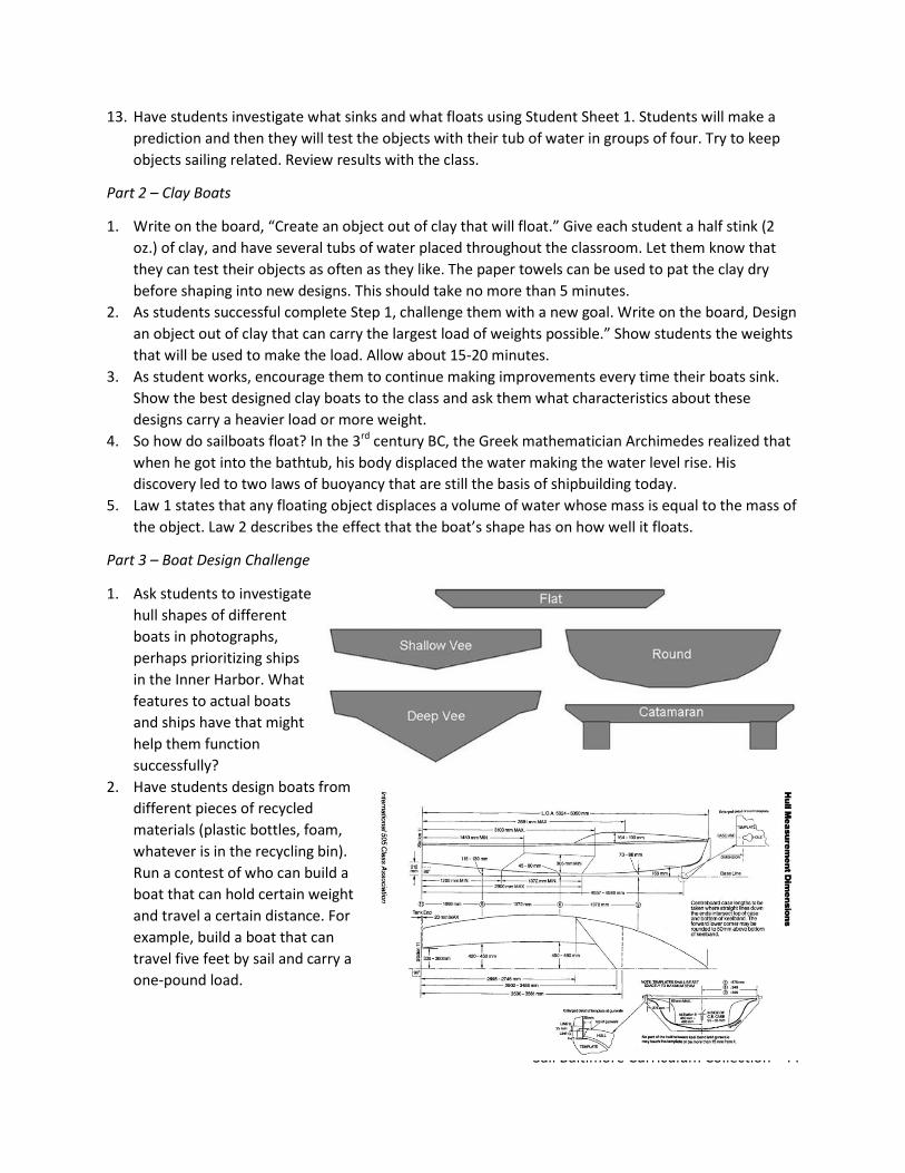
1. Ask students to investigate
hull shapes of different
boats in photographs,
perhaps prioritizing ships
in the Inner Harbor. What
features to actual boats
and ships have that might
help them function
successfully?
2. Have students design boats from
different pieces of recycled
materials (plastic bottles, foam,
whatever is in the recycling bin).
Run a contest of who can build a
boat that can hold certain weight
and travel a certain distance. For
example, build a boat that can
travel five feet by sail and carry a
one-pound load.

Sail Baltimore Curriculum Collection - 45
SINK OR FLOAT
Take a few minutes to list the objects you would like to investigate. Then, predict if the object will sink,
float, or in between. Last, test the buoyancy of the objects and record your results. Prepare to discuss
your results, where your predictions correct or incorrect and why?
Object Prediction Actual
1.
2.
3.
4.
5.
6.
7.
8.
Activity – Sail Area and Perimeter
Materials:
Sails (contact local sailing clubs to ask to borrow several – the condition and type do not matter).
Clipboards
Measuring tapes
Calculators
Student Response Sheet
Vocabulary: Right Triangle = a triangle with an inner angle of 90 degrees Hypotenuse = the side of a right triangle that is opposite the right angle Leg = the side of a right triangle that is not the hypotenuse Pythagorean Theorem = the square of the length of the hypotenuse of right triangle equals the sum of the squares of the lengths of the other two sides Surface Area = the total area of the faces and curved surface of a solid figure Luff = the front or leading edge of a sail Leech = the after edge of a fore and aft sail Trade Winds = the prevailing surface winds over the tropical ocean are the trade winds that blow persistently from the northeast (toward the southwest) in the Northern Hemisphere and from the southeast (toward the northwest) in the Southern Hemisphere. The name for these winds was coined

Sail Baltimore Curriculum Collection - 46
by sea captains who sailed for trading companies and took advantage of their present speed and direction when crossing the ocean. Foot = the bottom of the sail, or a standard customary unit of measurement in the United States. One foot = 1/3 yard or 12 inches or .3048 meters
Part 1 – Features
1. Place the word “sail” on the board. Ask
students, “Have you ever seen a sail before?
What are they used for?” Have a student draw
on on the board. Ask students, “What are
some of the features of sails? When do you
see sails?” Originally, sails were rectangular in
shape in order to use the wind to “push” boats
forward. Sailors used the trade winds to leave
from port and to eventually sail home again.
Show students an image of an early sailing
vessel with rectangular sails.
2. Ask students, “What are some limitations of
only using the wind to push your boat,
downwind sailing?”
3. What shape are most of the sails on boats
today? (triangular) Today we are going to
calculate the area and perimeter of a few of
our sails. What are some of the reasons we may want to calculate area of our sails? (calculate the
area of our sails to compare sail area to boat speed, to identify situations where less sail might be a
good idea).
Sail Baltimore Curriculum Collection - 47
Part 2 – Measuring Surface Area of Sails
1. Tell students that the class is going to learn more about sails. Tell them that they will calculate the
area of a few sails.
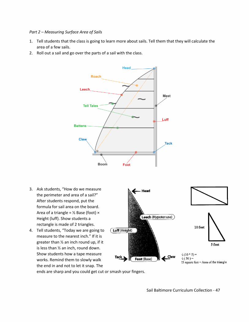
2. Roll out a sail and go over the parts of a sail with the class.
3. Ask students, “How do we measure
the perimeter and area of a sail?”
After students respond, put the
formula for sail area on the board.
Area of a triangle = ½ Base (foot) ×
Height (luff). Show students a
rectangle is made of 2 triangles.
4. Tell students, “Today we are going to
measure to the nearest inch.” If it is
greater than ½ an inch round up, if it
is less than ½ an inch, round down.
Show students how a tape measure
works. Remind them to slowly walk
the end in and not to let it snap. The
ends are sharp and you could get cut or smash your fingers.
Sail Baltimore Curriculum Collection - 48
5. Draw a triangle on the board and ask two students to help you find the perimeter and area of the
triangle. Ask one student to be the recorder, taking down the measurements and the other to hold
the end of the tape measure. You as the instructor will read the measurements of the base and
height of the triangle. Have the rest of the class practice rounding your measurements to the
nearest inch.
6. Split the class into groups of three: a recorder, measuring taper reader, and measuring tape holder.
Ask students to measure the sail area of the sails.
7. Once students have measured and calculated the sail area of all three sails, ask students to return to
their individual clipboards and transfer their measurements. Next, they should calculate the sail
perimeter.
8. From the data collected ask students to compare the sail area and perimeter. How does sail area
impact sailing?
SAIL AREA AND PERIMETER
Using a sail, calculate the area and perimeter of the sail. Remember: Perimeter = luff + foot + leech and
Area of a Right Triangle = ½ (base × height).
Sail 1: Sail 2: Sail 3:
Luff
Foot
Leech
Sail Perimeter
Sail Area
Challenge: Pretend you are designing a new boat. The new boat will need a sail. The sail will need to be
15 feet high and 8 feet long. Find the length of the hypotenuse using Pythagorean’s Theorem
𝑎2 + 𝑏2 = 𝑐2. Design and calculate the sail dimensions for the new design.

Sail Baltimore Curriculum Collection - 49
Module 3 – Operation and Navigation of
Ships
Introduction: The Schooner Sultana and Historical Navigation
Have you heard of the Boston Tea Party? While Boston's was by far the most famous tea party that
occurred in the colonies, it was only the first of many protests against the Tea Act that took place along
the Atlantic Coast. In fact, two tea parties took place on the Chesapeake Bay! The first occurred in
Chester Town, Maryland (known today as Chestertown). When news of the closing of the port of
Boston reached Chester Town in the spring of 1774, town leaders called a public meeting to discuss
what actions should be taken. In a paper called the "Chestertown Resolves" they stated that it was
unlawful to buy, sell, or drink tea shipped from England. Shortly after these resolves were printed, a
ship called the Geddes arrived in Chester Town with a shipment of British tea. On May 23, 1774, a small
group of men boarded the ship and threw its cargo into the Chester River. Today, this event is
celebrated every Memorial Day Weekend at the Chestertown Tea Party Festival (see photo on next
page).
In October 1774, another tea party occurred just outside of Annapolis, Maryland. There, a ship called
the Peggy Stewart arrived with tea from England. When the ship's owner, Anthony Stewart, paid the
tax, an angry mob demanded that he destroy his cargo. The mob soon forced Mr. Stewart to burn his
entire ship!
The events in Boston, Chester Town and Annapolis marked a turning point in relations between England
and the thirteen colonies. After these "tea parties", it was clear that the colonists were not going to
accept "taxation without representation" in any form, and that they were willing to act forcefully to get
their point across. It was also clear that it was going to be very hard to solve the differences between
England and the colonies without going to war.
The Schooner Sultana was a British Ship sent to the Colonies to enforce the hated “Tea Taxes” before
the American Revolutionary War. Instead of trying to pay the taxes to Great Britain, many Colonial
merchants tried to smuggle goods to avoid paying the fee. To help enforce these taxes, King George III
and the British Royal Navy purchased a fleet of ships to patrol the Atlantic coast and make sure that
colonial merchants weren't smuggling goods to avoid paying the taxes. For four years, the schooner
Sultana was part of this small fleet. When Great Britain sent a ship to the Colonies, how did it find its
way around?

Sail Baltimore Curriculum Collection - 50
Latitude and Longitude
Directions: Use the map below to practice plotting latitude and longitude coordinates. For each
coordinate given, put a dot where you think the ship would be. In some cases, you will need to estimate
where the point is located.
Directions: Now that you have practiced plotting points, use the latitude and longitude coordinates
below to plot Sultana's actual course as the schooner sailed from the English Channel to Halifax, Nova
Scotia in the fall of 1768. Record a specific point on the map for the coordinates given on each date, then
connect the dots to create a visual image of Sultana's sail path. The first and last points have been
plotted for you. When finished, answer the questions in the next section.

Sail Baltimore Curriculum Collection - 51

Sail Baltimore Curriculum Collection - 52

Sail Baltimore Curriculum Collection - 53
Directions: Answer each of the following questions in a complete sentence.
1. How long did it take for Sultana to reach North America?
2. In general, what direction was Sultana traveling?
3. Look at the progress Sultana made between September 19 and September 23, 1768. Why
do you think the ship made more progress than usual on these dates?
4. Look at the progress Sultana made from October 17th through October 21st. Why do you
think so little progress was made on these days?
5. Look at the latitude coordinates given. Why do they vary so little in comparison to the
longitudinal coordinates?
Sultana Patrols the Chesapeake
Directions: Now that you know how the
Sultana got around, read the following
article about its voyage in the Chesapeake
Bay and answer the questions that follow.
The Schooner Sultana was never busier than
during her 1769 - 1770 Tour of the Bay.
The schooner Sultana spent nearly a year
patrolling the Chesapeake Bay for smugglers
while enforcing the Townshend Duties.
Most of the schooner's time was spent near
the mouth of the Bay in the
Norfolk/Hampton Roads area. This was the
perfect place for Sultana to anchor, as crew
members could easily spot ships leaving and
entering the Chesapeake from this position.
Other areas patrolled by Sultana included
Williamsburg, Yorktown, Cape Charles and
the Potomac River.
In the 18th century, ships from all over the
world sailed into the Chesapeake to deliver
imported goods to Maryland and Virginia.
Sultana's log books from 1769-1770 show
that crew members searched incoming
ships from England, Scotland, Portugal and
other countries in Europe. These vessels
brought manufactured goods such as
furniture, weapons, tools, wine, clothing
and tea to the colonies. The log books also

Sail Baltimore Curriculum Collection - 54
record incoming ships from Barbados, Jamaica, Antigua and other islands in the West Indies. These
boats brought products like sugar, molasses, raisins and slaves to the Bay. Other ships entering the
Chesapeake came from ports within the colonies such as Boston, Philadelphia and New York. Many of
the ships searched by Sultana were leaving the Bay with cargo bound for ports all over the world. Goods
sent from Maryland and Virginia to ports overseas were called exports. Some of the major exports from
the Chesapeake during this time were com, grain, tobacco and lumber. Corn and grain have remained
very important items in the economies of these two states today.
After a year of hard work in the Chesapeake, Sultana was badly in need of repairs and fresh food. On
August 11, 1770, the schooner set sail and headed north for Halifax, Nova Scotia. Except for a brief
return in October 1770, Sultana never sailed in the Chesapeake Bay again.
1. Where did Sultana spend most of her time in the Chesapeake Bay? Why was this a good
area to patrol?
2. What were some other areas in the Bay where Sultana patrolled?
3. What were some of the items that were imported from Europe to the Chesapeake?
4. What items were imported from the West Indies to the Bay?
5. What were four items exported from the Chesapeake in the 18th century?
Sextants and Chronometers Help Sailors Find Their Position at Sea
Directions: Read the following article and answer the questions that follow.
Figuring out the location of the ship without modern
technology was a huge challenge for 18th century
sailors. To locate their position on a map, navigators
used the system of latitude and longitude.
Look at a globe in your classroom. If you look
carefully, you will notice a series of parallel lines
running horizontally around the globe. These are
called latitude lines. The horizontal line which runs
around the center of the earth is called the equator.
Half of the latitude lines run from the equator to the
top of the globe. These lines measure distances north
of the equator. The lines which run towards the

Sail Baltimore Curriculum Collection - 55
bottom of the globe measure distances
south of the equator.
Another set of lines run vertically around
the globe. These are called longitude
lines. They are used to measure distances
traveled east and west from a fixed point
on the earth. The fixed point from which
longitude lines are measured is
Greenwich, England.
When latitude and longitude lines are
drawn on a map or globe, they form a
grid. If a navigator knew both his
latitudinal and longitudinal position on
that grid, he could figure out exactly where his ship was positioned at sea. To find the ship's latitude,
sailors used a tool called a sextant. The sextant measured the angle created by the noon sun, the ship,
and the visible horizon. When the measurement of this angle was found, it could be converted to
degrees latitude by using a chart in the Nautical Almanac.
While most skilled navigators could easily find their latitude, figuring out the ship's longitudinal position
was a more difficult task. One way longitude was determined was by telling time. If a captain had a
timepiece set to Greenwich time, he could compare differences in time zones as the ship traveled east
or west. For every four minutes that Greenwich time differed from the local time observed on board,
the ship had traveled one longitudinal degree. There was one problem with using this method during
the years which Sultana sailed the Atlantic Coast: they did not have a clock on board that could
accurately keep time at sea. If a clock was off by
only a few minutes per week, it would throw the
navigator 's calculations off by hundreds of miles!
What did navigators do about this problem? One
solution was to sail to the desired latitude, then
set a course due east or west until landfall was
reached. Another solution was called deductive
(ded) reckoning. In this technique, navigators
would keep track of the ship's speed every half
hour, then calculate the distance they had
traveled over the course of the day. If one knew
the latitude, course and distance the ship had
traveled, an educated guess could be made as to
the ship's longitudinal position on a map or globe.
Problems determining longitude led to many lost vessels and lots of shipwrecks. In fact, finding
longitude was such a large problem that for hundreds of years European governments offered rewards
for the first person who invented a device that helped sailors find their longitude. Finally, in the 1730's
an English carpenter named John Harrison invented a device called a chronometer. The chronometer
Sail Baltimore Curriculum Collection - 56
was able to keep accurate time at sea, and towards the end of the 18th century nearly every captain had
one on board to find his longitude. Chronometers were not widely available in the late 1760s.
1. What do latitude lines measure? 2. What do longitude lines measure?
3. How did navigators determine their latitude? 4. What was the problem with using clocks to calculate longitude? 5. What is "ded" reckoning? 6. What invention finally solved the longitude problem? How would it be used?

Sail Baltimore Curriculum Collection - 57
Modern Ships and Modern Navigation
Activity: Sound on the Water
Background: Two boats may occasionally find themselves on the same path, traveling toward each other
– and one or both must move out of the way to avoid a collision. In this case, the boats must decide
which direction one or both of them will turn – if they turn the same way, they might still be on a collision
path! Sound signals are used to help boats avoid collisions, or in some cases, to alert other boaters of
danger or call for help. Have you ever been walking down a hallway and almost bumped into someone,
only to go one way and then the other as you both try to get out of each other’s way? This would be a
dangerous situation at sea! Ships avoid this by communicating with clear signals that let other vessels
know how and where they plan to move.
Vocabulary: Rules of the Road = the accepted set of rules and regulations for all ships traveling on the ocean, including signs, lights, colors, sounds and situational standards that all mariners abide by Give Way Vessel = in a crossing, overtaking or head-on situation involving two vessels, this vessel alters its course to avoid a collision Stand-on Vessel = this vessel maintains its speed, direction and course while the give way vessel passes or overtakes it Port = the left side of a boat Starboard = the right side of a boat Overtake = when a vessel comes from behind another vessel to pass it, like a fast car passing a slower car on the highway Pass = when two boats travel past each other in opposite directions. Boats usually pass port-to-port, so each boat keeps the other boat on its port (left) side
MATERIALS:
• Index cards • Markers • Masking tape

Sail Baltimore Curriculum Collection - 58

Sail Baltimore Curriculum Collection - 59
1. Begin this activity by demonstrating each of the vocabulary terms, making sure that students
understand that port and starboard are terms used to mean “left” and “right,” respectively on a
boat. A good way to remember the difference is that p-o-r-t and l-e-f-t both have four letters!
Explain that boats use sound signals to alert each other to the actions they intend to take when
navigating on the water. These sound signals are usually made by the vessel’s horn, or are
sometimes blasted on a whistle, and all mariners must know what each signal means. See Figures 1
and 2 for a visual. The common sound signals that you’ll need to know for this activity are: • One
short blast: I’m going to turn to starboard (right) • Two short blasts: I’m going to turn to port (left) •
Three short blasts: I’m going to back up • Five short blasts: Warning – either “your boat is in danger”
or “I don’t understand what you communicated”
2. Divide the class into groups of four, pass out index cards and markers and ask each group to make
one index card for each of the sound signals. On the front of the card, have the students write what
the signal is (ex. “One short blast”), and on the back what the message is (“I’m going to turn to
starboard”). Explain that when both boats understand a signal and can safely let the signaling boat
perform the action, the boat must sound the same signal back in response. If it does not understand
the signal or does not want to allow the boat to do an action, it must sound five short blasts to
indicate this. When this is done, ask the students to quiz each other on what each sound signal
means. One student can make the sound signal (either vocally or by whistling) while the others in
the group follow the direction. When the students seem comfortable with the meanings behind
each of these four sound signals, gather the class together for the group activity.
3. During this part of the activity, students in the class will act out certain ship crossing, meeting, and
overtaking scenarios while communicating via sound signals. The first scenario is a crossing scenario.
Have two students volunteer to be “boats,” and ask them to stand so their paths are perpendicular.
In a crossing scenario, the give-way vessel must change its course so that it crosses astern (in back of
) the stand-on vessel, and may have to slow down and turn to do so. In order to cross in back of the
stand-on vessel, the give-way vessel will have to turn to starboard, so the boat should sound one
short blast. In a crossing scenario, the give-way vessel is the one that has the other vessel to
starboard, or sees the other boat on its right side.
4. In certain cases, ships find themselves traveling along the same course in opposite directions and
one or both of them must change their course in order to avoid a collision. This scenario is called
meeting head-to-head, and in this case both ships must alter their course, usually by turning a bit to
starboard so that the ships pass port-to-port. In this case, one ship will sound 1 blast to indicate that
it will move starboard, and the other ship will sound 1 blast to say that it understands and agrees,
and will also move to starboard. Practice this situation with two students in the class who volunteer
to be two vessels meeting head on. Have one student sound the 1 blast signal, and the other answer
him or her with a 1 blast signal. See how both “boats” move slightly starboard to avoid a collision.
Also explain that in this scenario, neither boat has the “right of way,” and therefore both boats must
change their course. Practice an overtaking scenario. Just like cars on a highway, sometimes faster
vessels want to pass slower moving ones by coming up from behind. In an overtaking scenario, the
stand on vessel is the boat being passed, and the give way vessel is the one who is passing the other.
Sail Baltimore Curriculum Collection - 60
You can run this scenario at least twice – once where the overtaking vessel passes to starboard, and
once where it passes to port. When the two students demonstrate this scenario, have one student
stand about 10 feet behind the other, and ask them to start walking. When the student in the back
gets close to the one in the front, tell them they can sound either one short blast (to pass on the
starboard side) or two short blasts (to pass on the port side). Remind the stand-on vessel that
he/she must sound the same signal in response to indicate that he/she understands and allows the
give-way vessel to overtake them.
5. To wrap-up this lesson, you can initiate a discussion about how and why these signals might have
been developed. How does applying simple, universal code of sound signals help avoid accidents
and keep mariners safe at sea? With radio technology available, it is certainly possible to
communicate specifically between vessels, and this happens often. However, what are some
advantages to the sound signal system?
6. To learn more about the Rules and Regulations of maritime navigation, check out the US Coast
Guard’s online resource, at www. navcen.uscg.gov/?pageName=navRulesContent. A description of
the sounds signals and their definitions can be found online from BoatSafe, at
www.boatingbasicsonline.com/ content/general/6_2_b2.php. For more fun activities on maritime
safety and to learn about the industry, please visit www.namepa.net/education.
Activity: Introduction to Navigation Techniques – Triangulation
Background: Triangulation is a method of determining one’s approximate position on a map by
measuring the angles of three fixed objects relative to a movable one. This method has been useful to
mariners since the 16th century, when Willebrord Snellius – a mathematician from the Netherlands –
first used it to find the length of the meridian by measuring the distance between church towers in two
Dutch cities. The calculations used in triangulation are the same basic principles that were used to
develop modern GPS (Global Positioning System) technology. Triangulation allows a relatively precise
position to be determined from three bearings in a straightforward, simple and dependable manner. A
compass is used to determine relative angles from a boat to three objects on shore, and then standard
geometry is strategically employed to determine the boat’s approximate location.
Vocabulary: Triangulation = the tracing and measurement of a series of triangles that have points at fixed objects in order to determine relative position of a boat or other movable object on a map Position Fix = a position or point on a map determined from measuring external reference points Relative Angle = the angle that is formed between a movable object (in this activity, a boat) and two fixed objects. When the movable object moves, the relative angle between it and the two fixed objects changes Snellius Construction = a method of determining approximate position on a map or chart by using triangulation that was developed in the 16th century by a Dutch mathematician named Willebrord Snellius Compass = a navigation tool that contains a magnetized pointer which shows the direction of magnetic north, used to find exact direction Heading = a direction, usually the direction you are traveling

Sail Baltimore Curriculum Collection - 61
MATERIALS:
• Whiteboard or large piece of paper • Picture or drawing of a compass (to illustrate degrees, used to find angles) • Protractor • String/yarn • Model “boat” (can be a piece of cardboard, a block, etc.) • 3 objects to use to determine position, labeled A, B, and C or names of objects on land (lighthouse, factory, statue, etc.) • Masking tape (at least 2 colors: white and blue are easy to find!) 1. Most students will probably know that a circle contains 360 degrees. A compass measures direction,
but can also be used to measure the relative angle from your heading to an object in sight – after all, it’s a circle! You can demonstrate to students that by reading the direction you are facing (which will always correspond to 360 degrees – straight ahead), and then noticing how far you’d have to rotate your body to be facing something else (say, the door, a student volunteer, etc.), you can determine the degree angle between the two objects. For example, say you read the compass and see that a student is standing at 320 degrees. You can subtract 320 from 360 (your “heading”) and find that there is a difference of 40 degrees between your two positions. This corresponds to a 40-degree angle between the direction you are facing and the student’s position relative to you. Explain that this concept can be used by ships at sea to determine their approximate location. While Global Positioning System (GPS) technology has made navigation much safer and more readily accessible, sometimes it is useful for mariners to be able to determine their position using other techniques, like triangulation. This method is based on finding the relative angle of a ship to three stationary objects that are usually on land such as lighthouses, buildings, rock formations, or any other stationary object. When the relative angles are known, it is possible to calculate the location of a ship with some accuracy. When this position is compared to a nautical chart, it can help mariners navigate safely. Using three objects greatly improves the accuracy of this method, because the point where they intersect is verified in three dimensions - hence the name “triangulation.”
2. Students will eventually be able to use triangulation to determine their location on their own.
However, it helps to work out at least one problem as a class to demonstrate some of the calculations and present a diagram of what the students will be expected to do. For the practice problem, use Figures 1 and 2 on the following page to draw a diagram on the board. Following the directions provided, show how the location of the hypothetical boat would be determined.
3. Keep this diagram on the board for reference during this second part of the activity, where students will be creating a 3D version of what you just demonstrated. Divide the class into groups of 3-4 and ask the students to set up three objects in a similar formation to the practice problem. Masking tape can be used to label the objects A, B, and C, as well as to delineate a “shoreline.” Ask the students to place their boat on the table, facing object “B” straight on (a 0 or 360-degree angle). Have students measure the angles between their boat and objects A and C, respectively. They can do this by placing masking tape in a line between their boat and objects A, B, and C – just like the lines you drew in the practice problem. Have the students record these angles carefully as angle A and angle C. Students should place lines of tape between objects A and B, and B and C, following the same protocol as the practice problem. Using blue masking tape, students should find the center of line AB and place a length of tape there at a 90-degree angle pointing offshore, toward their boat. The

Sail Baltimore Curriculum Collection - 62
same should be done with line BC, so the lines are facing each other and pointing offshore. Now, students should tape the “construction lines” at objects A and C, as in the practice problem. These lines should be drawn from lines AB and BC, respectively, at the same degree angles as angle A and angle C. So, if angle A (the angle between object A and object B from the boat) is 60 degrees, the construction line from object A should be taped at a 60 degree angle pointing inland from line AB. Follow the same rule to draw the construction line at object C. Then, students should tape a line from object A perpendicular to the construction line they just taped. This line will lead out into the water. Tape the same line from object C – perpendicular to the construction line on that side, leading out into the water. Students should see that these lines cross the blue lines of tape on either side. These points where the two lines of tape cross will become the center of two circles. Have the students measure a length of string from crossing point A to object A (the radius) and cut it. One student should hold the string in the center of the circle while another uses a pencil held with the other end of the string to trace a circle around the center point. The same should be done around crossing point C. Take note of where these two circles overlap offshore. This is the position fix that has been determined by the process of triangulation! If your students are at this point, they will have figured out the precise location of the boat. If they were using a nautical chart, they would know exactly where on the chart they were.
4. Have the students discuss what they liked and found challenging about this activity. How was geometry used in these calculations? Ask why this method uses a triangle shape, and how finding a position from three fixed objects can possibly give an accurate reading.
5. Want to learn more about the kind of skills necessary to be a mariner? Did you know there are six maritime academies devoted to maritime education and training across the United States? Visit the Department of Transportation - Maritime Administration (MARAD) website to view a list of the academies, and click the links to learn more about the programs they offer. Check it out here: www. marad.dot.gov/education_landing_page/state_maritime_acadamies/state_maritime_academies.htm For more fascinating information about the marine industry, please visit www.namepa.net/education.
Instructions and Figures Draw objects A, B, and C on the board like so: Compass bearings: 320 on A, 360 or 0 on B, 050 on C. Therefore, the angle between you in the boat and A is 40 (360-320), and the angle between the boat and C is 50 (0 +50). Draw lines from A to B and from B to C. Add lines (light blue) that bisect AB and BC at 90 degree angles and come out toward your boat. Measure a 40 degree angle (identical to the angle between objects A and B from the boat) from line AB toward object A and draw a construction line inland from object A. Measure a 50 degree angle (identical to the angle between objects B and C from the boat) from line BC toward object C and draw a construction line inland from object C. At object A, draw a line perpendicular to the construction line, out into the water (facing right). At object C, draw a line perpendicular to the construction line, out into the water (facing left). The two intersections with the light blue lines that bisect AB and BC are the centers of two circles you will use to determine your approximate position. Draw the first circle with this center and passes through points A and B. Draw the second circle with this center and passes through points B and C. The offshore intersection of these two circles gives us our position fix.

Sail Baltimore Curriculum Collection - 63

Sail Baltimore Curriculum Collection - 64
Module 4 – Keystone Projects and Resources
Rubrics and Projects
The following includes ideas and resources to help teachers and students create a project involving one
of the ships that visits the Port of Baltimore or calls Baltimore home. Suggestions include informational
writing in the form of an op-ed, a comic strip containing information about a key issue or learning from
the activities in this collection, or a PowerPoint presentation about an important vessel. In addition to
using these resources in the classroom, there are many opportunities outside of the classroom to
engage students in marine education. Reach out to Sail Baltimore and these other organizations to look
for opportunities to partner, either with a local group, or even a ship that is coming to visit the Port of
Baltimore.
Possible Rubric for Informational Writing
Grading Scale
1 2 3 4 5
Does Not Meet Expectations (Response is inaccurate or
there is no response)
Partially Meets Expectations (Part of the response is inaccurate)
Approaching Expectations (Response is accurate but incomplete)
Meets Expectations (Response is accurate and
complete)
Exceeds Expectations
(Response goes above and beyond
by including a deeper analysis or extensive support)
Formatting/ Structure
Paper Formatting (name, date, title, etc.)
1 2 3 4 5
Intro./Concluding Paragraph Structure 1 2 3 4 5
Body Paragraph(s) Structure 1 2 3 4 5
Comments:
Content Understanding
Main Idea/Thesis (intro. paragraph) 1 2 3 4 5
Topic Sentence(s) (body paragraphs) 1 2 3 4 5
Evidence #1/Details (reliable, appropriate, worthy)
1 2 3 4 5
Analysis #1 (connects evidence to main idea)
1 2 3 4 5
Evidence #2/Details (reliable, appropriate, worthy)
1 2 3 4 5
Analysis #2 (connects evidence to main idea)
1 2 3 4 5

Sail Baltimore Curriculum Collection - 65
Evidence #3/Details (reliable, appropriate, worthy)
1 2 3 4 5
Analysis #3 (connects evidence to main idea)
1 2 3 4 5
Content vocabulary is used accurately 1 2 3 4 5
Grade level vocabulary is used accurately
1 2 3 4 5
Comments:
Mechanics 0 errors = 5
1-2 errors = 4 3-4 errors = 3 5 errors = 2
More than 5 errors = 1
Punctuation (periods, quotations, etc.) 1 2 3 4 5
Spelling 1 2 3 4 5
Sentence Structure (run-ons, fragments)
1 2 3 4 5
Grammar (capitalization, noun-verb agreement) 1 2 3 4 5
Comments:
Assignment Completed ON TIME = 15 points Total Score: ________/100
Possible Rubric for Comic Strip
CATEGORY 4 3 2 1
Clarity and
Neatness
Comic is easy to read
and all elements are so
clearly written, labeled
and illustrated.
Comic is easy to read
and most elements are
clearly written, labeled
and illustrated.
Comic is hard to read
with few illustrations
and labels
Comic is hard to
read and
understand.
Use of Time Used time well during
each class period (as
shown by observation
by teacher, and
documentation of
progress in journal)
with no adult
reminders.
Used time well during
most class periods (as
shown by observation
by teacher, and
documentation of
progress in journal)
with no adult
reminders.
Used time well (as
shown by observation
by teacher and
documentation of
progress in journal),
but required adult
reminders on one or
more occasions to do
so.
Used time poorly
(as shown by
observation by
teacher and/or
documentation
of progress in
journal) in spite
of several adult
reminders to do
so.
Sail Baltimore Curriculum Collection - 66
Spelling &
Grammar
No spelling or
grammatical mistakes on
comic strip with lots of
text.
No spelling or
grammatical mistakes
on a comic strip with
little text.
One to 4 spelling or
grammatical errors
on the comic strip.
More than 4
spelling and/or
grammatical
errors on the
comic.
Content There are references to
the topic assigned in
each frame.
There are references
to the topic assigned in
most frames.
There are very few
references to the
assigned topic in the
a few frames.
There are no
references to the
assigned topic in
the comic strip.
Graphics The graphics are
meaningful, colorful, and
appropriate. It is clear
that time and effort
went into their creation.
The graphics are
somewhat meaningful,
colorful, and
appropriate. It is clear
that some time and
effort went into their
creation.
The graphics are
scarce throughout
the piece and not
much time or effort
was put forth.
Little or no
graphics were
evident. It is
clear that the
effort was
lacking and they
did not complete
the assignment.
Format They have included at
least 6 frames to their
comic strip.
They have included 5
frames to their comic
strip.
They have included
4 frames to comic
strip.
They have 3 or
less frames to
the comic strip.
Assignment Completed ON TIME = 1 point Total Score: x/25 multiplied by 4 = ___/100
INNER HARBOR SHIPS POWERPOINT
Summary of the Project
Though you may only have barely noticed the ship Constellation at Baltimore’s Inner Harbor,
the ship is actually a piece of evidence of history that you have studied before or will study this
year in U.S. History! All of the ships in the Inner Harbor have fascinating stories from the past
that you should be aware of – and many of these ships have been involved in many of the
historical events that we will be looking at this year. Your job is to work with a group to create a
PowerPoint describing the history of one of those ships. Use the provided resources as well as
internet resources to complete a summary of the ship and some of the adventures it was
involved in.

Sail Baltimore Curriculum Collection - 67
Required components:
1. Title slide with name of presenters 2. Description of the ship 3. At least four pictures from online which accurately reflect material covered in your
presentation 4. At least four slides detailing events the ship was involved in 5. Brief explanation of what the larger historical significance of the events 6. Works Cited Page – Use the MLA format
Rubric for grading
CONTENT
All required components?
Slideshow is organized?
Slideshow is specific and detailed?
Works cited page included?
25 pts.
GRAMMAR
Grammar is correct?
Spelling is correct?
PowerPoint is proofread, at least twice?
25 pts.
APPEARANCE
Slideshow is neat?
Slideshow has pictures?
Slideshow formatting is consistent?
25 pts.
EFFORT
Classtime was used effectively?
PowerPoint shows effort?
All work is original?
25 pts.
TOTAL : ( ____________ / 100)
Resources
http://www.ussconstellation.org/ http://www.usstorsk.org/ http://www.hnsa.org/ http://www.historicships.org/ http://www.history.navy.mil/danfs/ http://www.lighthousefriends.com/light.asp?ID=420
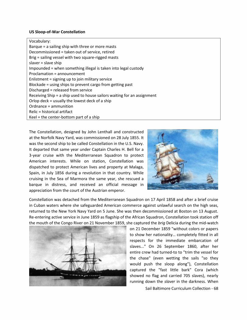
Sail Baltimore Curriculum Collection - 68
US Sloop-of-War Constellation
Vocabulary: Barque = a sailing ship with three or more masts Decommissioned = taken out of service, retired Brig = sailing vessel with two square-rigged masts slaver = slave ship Impounded = when something illegal is taken into legal custody Proclamation = announcement Enlistment = signing up to join military service Blockade = using ships to prevent cargo from getting past Discharged = released from service Receiving Ship = a ship used to house sailors waiting for an assignment Orlop deck = usually the lowest deck of a ship Ordnance = ammunition Relic = historical artifact Keel = the center-bottom part of a ship
The Constellation, designed by John Lenthall and constructed
at the Norfolk Navy Yard, was commissioned on 28 July 1855. It
was the second ship to be called Constellation in the U.S. Navy.
It departed that same year under Captain Charles H. Bell for a
3-year cruise with the Mediterranean Squadron to protect
American interests. While on station, Constellation was
dispatched to protect American lives and property at Malaga,
Spain, in July 1856 during a revolution in that country. While
cruising in the Sea of Marmora the same year, she rescued a
barque in distress, and received an official message in
appreciation from the court of the Austrian emperor.
Constellation was detached from the Mediterranean Squadron on 17 April 1858 and after a brief cruise
in Cuban waters where she safeguarded American commerce against unlawful search on the high seas,
returned to the New York Navy Yard on 5 June. She was then decommissioned at Boston on 13 August.
Re-entering active service in June 1859 as flagship of the African Squadron, Constellation took station off
the mouth of the Congo River on 21 November 1859, she captured the brig Delicia during the mid-watch
on 21 December 1859 "without colors or papers
to show her nationality… completely fitted in all
respects for the immediate embarcation of
slaves..." On 26 September 1860, after her
entire crew had turned-to to "trim the vessel for
the chase" (even wetting the sails "so they
would push the sloop along"), Constellation
captured the "fast little bark" Cora (which
showed no flag and carried 705 slaves), nearly
running down the slaver in the darkness. When

Sail Baltimore Curriculum Collection - 69
captured, the slavers were impounded and sold at auction, their captains required to post bond and
await trial, while their crews were landed at the nearest port and released. The newly freed slaves were
taken to Monrovia, Liberia. The U.S. government paid a bounty of $25 for each freed slave freed, and
"prize money" for each impounded ship to be divided among the crew proportionally according to rank.
On 19 April 1861, one week after Confederate forces fired on Fort Sumter, President Abraham Lincoln
issued a proclamation declaring a blockade of southern ports and on 2 May called for the enlistment of
18,000 additional seamen. Constellation's seizure of the brig Triton on 21 May 1861 proved one of the
U.S. Navy's first captures of the Civil War. Although Constellation's men found no slaves on board the
captured vessel, they noted that "...every preparation for their reception had been made..."
Ordered home in August 1861, Constellation, Captain
Thomas A. Dornin in command, reached Portsmouth
(New Hampshire) Navy Yard on 28 September, but soon
received orders to the Mediterranean, where her
economy and endurance would enable her to
outperform less reliable steam ships, to guard Union
merchant ships against attack by Confederate cruisers
and commerce raiders. On 11 March 1862 Constellation
sailed from Portsmouth under the command of
Commodore Henry K. Thatcher. Arriving on 19 April,
Constellation spent two years (April 1862 to May 1864)
engaged in patrolling, at one point assisting in blockading the Confederate warship Sumter, abandoned
by her captain and officers except for a token, caretaker crew, at Gibraltar, and later participating in the
attempt to prevent the Confederate Navy from taking possession of the British-built steamer Southerner
in Italy for use as a commerce raider.
Returning home via the West Indies, Constellation operated briefly in the latter region, wrote one of her
sailors, "trying to capture Rebel privateers and cruisers and blockade runners. The process of reasoning
... seems to be that our ship is supposed to be in European waters, and there is no United States warship
resembling her cruising about here, and consequently she might approach closely to a Rebel vessel or
blockade runner without exciting suspicion..."
With the terms of enlistment of most of the crew expiring, Admiral David G. Farragut ordered
Constellation to Hampton Roads on 27 November 1864. After pursuing a blockade-runner along the
coast, Constellation reached Fortress Monroe on Christmas Day 1864. In January 1865, the men whose
enlistments had expired were "paid off" and discharged, the remainder of the crew was transferred to
St. Lawrence, and the officers sent on leave to await orders. Constellation finished the Civil War as a
Receiving Ship at Norfolk, a duty she performed there, and later at Philadelphia, until 1869.
Recommissioned on 25 May 1871, she took midshipmen (also classed as "naval cadets" at varying
periods) on their summer training cruises for the next twenty-two years. In 1871-1872, she received
further modification so she could also be utilized for gunnery instruction with a main battery of eight 9-
inch Dahlgren guns, plus one 100-pound Parrott Rifle and one 11-inch Dahlgren gun.
Sail Baltimore Curriculum Collection - 70
During her assignment at the Naval Academy, Constellation received several special missions that
punctuated her training regimen. From March to July 1878, she transported exhibits to France for the
Paris Exposition. On 10 November 1879, she was placed in commission for a special voyage to Gibraltar,
carrying crew and stores for the flagship of the Mediterranean Squadron and thereafter returning to
New York. From March to June 1880, she carried relief supplies to victims of famine in Ireland. To
modify Constellation for that mission, her armament and some ballast were removed, and carpenters at
the New York Navy Yard built bins on the orlop deck to carry a cargo of over 2,500 barrels of potatoes
and flour. Reaching Queenstown on 20 April and offloading the cargo onto lighters, she took on ballast
for the return trip. Again active in September 1892 she sailed for Gibraltar in order to assemble works of
art for the Columbian Exposition, stopping en route at Naples and Le Havre, and ultimately reached New
York in February 1893. She departed on her final training cruise to Gibraltar on 7 June 1893, returning
under sail for the last time on August 29. On 2 September 1893, she was placed out of commission at
Annapolis, and was subsequently towed by the tug Leyden to Norfolk for repairs.
Converted to a stationary training ship, Constellation reached Newport on 22 May 1894, and remained a
permanently moored vessel, with the exception of two excursions and occasional trips to the repair
yard, into the second decade of the 20th century. In June 1904 Constellation was dry-docked at the New
York Navy Yard for extensive survey and repair. Retained for her historic value and for conducting drills
on her spars, rigging and sails, Constellation remained in Newport seeing decreased activity over the
next twenty years until the Navy stopped sail training in 1920.
In recognition of the one-hundredth anniversary of the writing of the national anthem, the National Star
Spangled Banner Centennial commission asked that Constellation participate. Acting Secretary of the
Navy Franklin D. Roosevelt ordered the vessel restored "as she appeared in 1814," but to minimize
costs, "include only such general details as would be noticed by the layman." Constellation, towed to
Norfolk by the tug Uncas, underwent the necessary modifications (19th-century ordnance fabricated at
the Boston Navy Yard, dummy sails stuffed with straw and alterations such as removal of the 1880's-era
bridge platform and 1890's deck housing), and was towed thence to Baltimore harbor, where she lay on
display from 7 September (the anniversary of the 1797 frigate's launching) until 29 October 1914. She
was then towed to Washington, DC where she lay on display from 31 October to 4 December. After
repairs at Norfolk in December, she returned to training duty at Newport on 19 May 1915.
On 1 December 1917, to clear the name Constellation for assignment to a projected battle cruiser
authorized on 29 August 1916, the ship was renamed Old Constellation. She reverted to her original
name on 24 July 1925 when the battle cruiser was scrapped under the provisions of the Washington
Treaty for the Limitation of Naval Armaments.
On 15 May 1926, Constellation was towed to Philadelphia and moored alongside the second-line light
cruiser Olympia (CL-15), the ship that had been Admiral George Dewey's flagship at the Battle of Manila
Bay in 1898. Constellation made her last public appearance as a commissioned U.S. Navy ship during the
ceremonies accompanying the 150th anniversary of the signing of the Declaration of Independence on 4
July 1926. After a short drydocking at Philadelphia, she was towed back to Newport in November.
On 16 June 1933 a Navy Department order placed Constellation in a decommissioned status for
preservation as a naval relic. Although numerous surveys were conducted and estimates given for the
cost of restoring the vessel as a national historic shrine, no decisions on the ship's fate were taken.

Sail Baltimore Curriculum Collection - 71
Global conflict, however, soon saw Constellation's return to active service. Recommissioned on 24
August 1940, she was classified as a miscellaneous, unclassified, auxiliary, IX-20, on 8 January 1941. On
21 May 1941, Constellation was designated relief flagship for Admiral Ernest J. King, Commander-in-
Chief of the U.S. Atlantic Fleet. Subsequently, with King's appointment as Chief of Naval Operations at
the beginning of 1942, the venerable sloop continued in this capacity under Vice Admiral Royal E.
Ingersoll from 19 January to 20 July 1942, when the flag was shifted to the gunboat Vixen (PG-53).
Ingersoll again used Constellation as his flagship during 1943-1944.
Plans to memorialize Constellation brought her to Boston in October 1946 but lack of funds delayed the
project. Decommissioned for the last time on 4 February 1955, the old ship was moved to Baltimore in a
floating dry-dock for restoration and preservation as a historic ship by a private, non-profit organization.
With little money and no government funds available, it took nearly a decade of work before she was
restored enough to allow the public on board. During that period, the ship was configured to resemble
the 1797 frigate Constellation, which had been built in Baltimore. In 1968, the ship was moved to the
inner harbor where she served as the centerpiece of the city's revitalization effort. Lack of maintenance
funds, however, led to significant dry rot over the next two decades, resulting in damage to her keel and
severely damaged her structural integrity.
In 1994, her rigging was removed and she was closed to the public. A new Constellation Foundation
raised the funds needed for a major renovation project and the repaired sloop-of-war returned to her
permanent berth in Baltimore's Inner Harbor on 2 July 1999.
USCGC Taney
Vocabulary: Cutter = medium-sized ship, often a government ship Commissioned = put into service Interdicted = prevented Sonar = method of detecting objects that you cannot see by using sound, like underwater objects Convoy = group of ships
The US Coast Guard Cutter Taney is
one of the famed
Secretary/Treasury Class Coast
Guard cutters built in the mid-
1930s and which saw extensive
service in war and peace for half a
century. Taney's keel was laid on 1
May 1935 at the Philadelphia Navy
Yard where she was built alongside
three of her sister ships,
CAMPBELL, DUANE and INGHAM.
327 feet long with a beam of 41
feet, and originally displacing 2000

Sail Baltimore Curriculum Collection - 72
tons, Taney was designed for peacetime missions of law enforcement, search and rescue, and maritime
patrol. Her original armament consisted of two 5”/51 caliber deck guns, and two 6-pounder saluting
guns. Taney was also originally equipped to carry a Grumman JF-2 “Duck” float plane.
Commissioned on 24 October 1936, Taney was first home ported in Honolulu, Hawaii, where, until the
outbreak of World War II, she interdicted opium smugglers and carried out search and rescue duties
from the Hawaiian Islands through the central Pacific Ocean. In the pre-war years, Taney also made
regular cruises to the equatorial Line Islands, some 1500 miles southwest of Oahu, to re-supply and
support to American colonists there.
In 1940 and 1941, Taney received successive armament upgrades in anticipation of war. These upgrades
included an additional 5”/51 caliber gun on the fantail where her float plane once stood, three 3”/50
caliber dual purpose guns (capable of shooting at both surface and airborne targets), additional .50
caliber machine guns, depth charge racks and throwers, and sonar for locating submarines.
On the eve of Pearl Harbor, Taney was officially assigned to the US Navy's Destroyer Division 80, though
she retained her Coast Guard crew. When Japanese aircraft attacked Pearl Harbor and other American
military installations in Hawaii on 7 December 1941, Taney was tied up at Pier 6, Honolulu, where she
was able to repeatedly engage Japanese planes which flew over the city. When the attack subsided,
Taney immediately commenced anti-submarine patrol duties off Pearl Harbor.
From December 1941 until the fall of 1943, USCGC Taney operated from the west coast of the US
through the Central Pacific carrying out anti-submarine patrols, convoy escort duties as well as special
assignments. In July 1943 the cutter fought off an attack by a Japanese “Mavis” patrol bomber while
delivering a US Navy survey party to Baker Island along the Equator.
After a major refit in the fall of 1943, during which the ship lost her older 5”/51s and 3”/50s and
received four 5”/38 caliber dual purpose guns, Taney was transferred to the Atlantic Theater where she
served as Flagship of Task Force 66, US Atlantic Fleet. During this Atlantic stint, Taney was the command
vessel for six convoys of troop and supply ships between the US and North Africa. On the evening 20
April 1944, Taney narrowly dodged several torpedoes while fending off a large scale attack by German
aircraft against Convoy UGS-38. Three ships were lost in the attack including the ammunition ship SS
Paul Hamilton and the destroyer USS Lansdale.
In 1945, Taney returned to the Pacific after a dramatic reconfiguration as an Amphibious Command Ship
(AGC). During the battle for Okinawa, the cutter was the Flagship for Rear Admiral Calvin Cobb, USN,
who commanded a variety of naval operations off the island of Ie Shima, immediately northwest of
Okinawa. During April and May 1945, at the height of the campaign, Taney was under frequent attack
and was credited with destroying four Kamikaze planes and 1 “Betty” bomber during 119 separate
engagements in which her crew stood to battle stations. Immediately after the end of the Pacific war in
September 1945, Taney steamed into Japanese home waters where she assisted with the evacuation of
Allied prisoners of war.
Following World War II, Taney was reconfigured for peacetime duties and from 1946 until 1972 she was
home ported in Alameda, California. Known as “The Queen of the Pacific,” Taney carried out virtually
every peacetime Coast Guard duty including decades of Ocean Weather Patrol throughout the Pacific,
fisheries patrols in the Bearing Sea and countless search and rescue missions. During the Korean War,

Sail Baltimore Curriculum Collection - 73
Taney received additional anti-submarine weapons and frequently carried out plane-guard duties off
Midway Island and Adak, Alaska. In April 1960, Taney had the honor to host French President Charles
DeGaulle on a VIP tour of San Francisco harbor.
By the late 1960s, Taney had become the last United States vessel still in commission that had seen
action during the 7 December 1941 Japanese attack on Hawaii. Consequently, from that time on she was
often referred to as “The Last Survivor of Pearl Harbor.”
In 1969-70, during the Vietnam War, Taney participated in “Operation Market Time” in the South China
Sea. As a unit of Coast Guard Squadron III, Taney interdicted illegal arms and supplies along the coast of
South Vietnam, fired over 3,400 rounds of 5”/38 ammunition in support of American and South
Vietnamese troops, and provided medical assistance to more than 5,000 Vietnamese civilians.
In February 1972, Taney was reassigned from the 12th Coast Guard District in San Francisco to the 5th
Coast Guard District in Virginia. From 1973 to 1977, Taney carried out Ocean Weather Patrol at Weather
Station HOTEL, some 200 miles off the coast of New Jersey, as well as “hurricane hunting” for which she
received a special Doppler weather radar installation atop her pilot house. In September 1977, Taney
had the distinction of completing the Coast Guard's last ocean weather patrol when she closed out
Ocean Weather Station HOTEL.
From 1977 until 1986, Taney carried out search and rescue duties, fisheries patrols in the North Atlantic,
drug interdiction patrols in the Caribbean, and summer training cruises for the Coast Guard Academy.
During this period she made 11 major seizures of illegal drug including a 1985 bust which netted 160
tons of marijuana – the largest in US history.
On 7 December 1986, after more than 50 years of continuous service, Taney was decommissioned at
Portsmouth, Virginia, and donated to the City of Baltimore to serve as a memorial and museum.
USS Torsk
Vocabulary: Distinction = good thing about someone/something Tonnage = weight Snorkel = a tube that allows air down into something under the water Citation = in this case, an award, (but can also be a ticket/punishment) Decommissioned = taken out of service, retired Blockade = using ships to prevent cargo from getting past

Sail Baltimore Curriculum Collection - 74
Commissioned on 16
December 1944, USS Torsk
was built at the Portsmouth
Naval Shipyard and was one
of only ten Tench Class fleet
type submarines to see
service in World War II.
Deployed to the Pacific,
TORSK operated from Pearl
Harbor and made two war
patrols off Japan during the
spring and summer of 1945.
During her first patrol, which
lasted from 15 April to 16
June 1945, Torsk carried out
plane guard duties for
American B-29 aircraft
engaged in bombing raids on
Japan. Torsk was underway on her second war patrol from 17 July until 9 September 1945. On 11 August
she rescued seven Japanese seamen whose ship had been sunk by a U.S. plane. On 12 August she had
her first combat action when she fired two torpedoes at a small freighter. The ship appeared to be
damaged, but postwar investigation failed to show that she sank.
The next day Torsk torpedoed and sank a small cargo ship, the Kaiho Maru. The following day, 14
August, she completed her wartime career by sinking two more small ships, Coast Defense Vessel No. 13
and Coast Defense Vessel No. 47 . This action earned Torsk the distinction of firing the last torpedo and
sinking the last Japanese combatant ships of World War II as the “Cease Fire” order went out to all U.S.
forces on 15 August. The combined tonnage of the three ships sunk on her second patrol was 2,473
tons.
After World War II, Torsk alternated between duties as a training boat at the Navy's Submarine School in
New London, CT, and active deployments in the Atlantic and Mediterranean. While assigned to the
Submarine Squadron 8 at the Submarine School in New London, she trained officers and enlisted men
for submarine duty. This assignment earned her the title of the “divingest” submarine in the U.S. Navy
as she made dives several times a day in the course of her training activities. In 1952, the boat
underwent a fleet snorkel conversion. The snorkel, developed by the German Navy, is a long tube that
can be extended above the submarine allowing her to take in fresh air for the diesel engines. This means
she can run submerged on diesel power making greater speed than if she used the batteries to run her
electric motors. She can also charge her batteries while submerged, thus extending her time below the
surface from approximately 24 hours to several days.
In the mid-1950s, Torsk received equipment for use in the testing and development of the Regulus
missile. In 1960, Torsk received a Presidential Unit Citation for service during the Lebanon Crisis, and in
1962 earned the Navy Commendation Medal for actions during the Cuban Naval Blockade during the
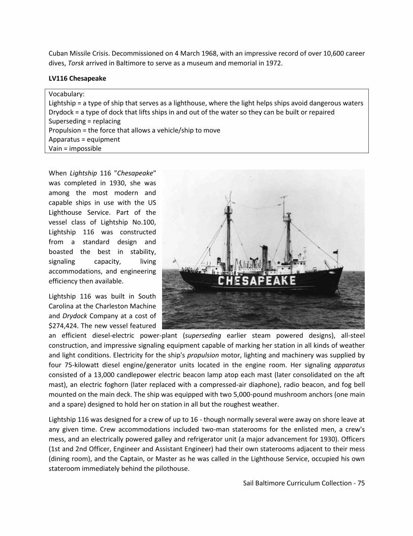
Sail Baltimore Curriculum Collection - 75
Cuban Missile Crisis. Decommissioned on 4 March 1968, with an impressive record of over 10,600 career
dives, Torsk arrived in Baltimore to serve as a museum and memorial in 1972.
LV116 Chesapeake
Vocabulary: Lightship = a type of ship that serves as a lighthouse, where the light helps ships avoid dangerous waters Drydock = a type of dock that lifts ships in and out of the water so they can be built or repaired Superseding = replacing Propulsion = the force that allows a vehicle/ship to move Apparatus = equipment Vain = impossible
When Lightship 116 "Chesapeake"
was completed in 1930, she was
among the most modern and
capable ships in use with the US
Lighthouse Service. Part of the
vessel class of Lightship No.100,
Lightship 116 was constructed
from a standard design and
boasted the best in stability,
signaling capacity, living
accommodations, and engineering
efficiency then available.
Lightship 116 was built in South
Carolina at the Charleston Machine
and Drydock Company at a cost of
$274,424. The new vessel featured
an efficient diesel-electric power-plant (superseding earlier steam powered designs), all-steel
construction, and impressive signaling equipment capable of marking her station in all kinds of weather
and light conditions. Electricity for the ship's propulsion motor, lighting and machinery was supplied by
four 75-kilowatt diesel engine/generator units located in the engine room. Her signaling apparatus
consisted of a 13,000 candlepower electric beacon lamp atop each mast (later consolidated on the aft
mast), an electric foghorn (later replaced with a compressed-air diaphone), radio beacon, and fog bell
mounted on the main deck. The ship was equipped with two 5,000-pound mushroom anchors (one main
and a spare) designed to hold her on station in all but the roughest weather.
Lightship 116 was designed for a crew of up to 16 - though normally several were away on shore leave at
any given time. Crew accommodations included two-man staterooms for the enlisted men, a crew's
mess, and an electrically powered galley and refrigerator unit (a major advancement for 1930). Officers
(1st and 2nd Officer, Engineer and Assistant Engineer) had their own staterooms adjacent to their mess
(dining room), and the Captain, or Master as he was called in the Lighthouse Service, occupied his own
stateroom immediately behind the pilothouse.

Sail Baltimore Curriculum Collection - 76
The US Lighthouse Service first assigned Lightship 116 to the Fenwick Island Shoal (DE) Station from
1930-33; after that assignment she marked the entrance to Chesapeake Bay until the beginning of
World War II. During the war most coastal lightships were withdrawn for security reasons and were
often converted for wartime duties. During 1942-45 Lightship 116 was painted battleship gray, armed
with two 20mm cannons, and used as a patrol/inspection vessel near the entrance to the Cape Cod
Canal. In 1945, Lightship 116 returned to the waters off Cape Henry (VA) where her bright red hull,
beacon light and "Chesapeake" station designation guided maritime traffic in and out of the Chesapeake
Bay for the next 20 years.
On two occasions (1936 and 1962) while marking the entrance to the Chesapeake Bay, Lightship 116
rode out hurricanes so powerful that the ship's anchor chain broke, forcing the crew to drop the spare
anchor and run full ahead into the wind for many hours in vain attempts to remain on station.
Despite some equipment upgrades, such as radar, technology began to overtake Lightship 116 by the
1960s. In 1965, the Chesapeake Lightship Station was replaced by a Coast Guard offshore light tower
built on stout pilings strong enough to withstand the roughest seas. Manned by a crew of just four, the
light tower was cheaper to run and had a more powerful beacon visible for a distance of 17 miles. After
being relieved at the mouth of the Chesapeake Bay, Lightship 116's final duty station was marking the
approaches to Delaware Bay until replaced there by a large automated light buoy in 1970.
In 1971, Lightship 116 was acquired by the National Park Service and was open to the public on the
Potomac River. Since 1982, the ship has been part of the Baltimore Maritime Museum, now Historic
Ships in Baltimore, and has continued to serve as an important link with the history of American aids to
navigation.
Resources used in these materials are available for further use:
Kalmar Nyckel
The Kalmar Nyckel Foundation is a non-profit educational organization with a mission of “preserving and
promoting the cultural and maritime heritage of Delaware and the Delaware Valley for the education and
enrichment of all.” The Foundation is a volunteer-based organization that built, owns, and operates the Tall Ship
of Delaware, Kalmar Nyckel.
The tall ship Kalmar Nyckel serves as a floating classroom and an inspirational platform for educational
outreach. We offer people of all ages a variety of sea- and land-based learning and recreational experiences.
The Kalmar Nyckel Foundation is a unique resource in the greater Delaware community, known for innovative
educational and outreach programs. They also serve as a catalyst for social and economic development in and
beyond the state of Delaware.
http://www.kalmarnyckel.org/
Sail Baltimore Curriculum Collection - 77
Gazela
Philadelphia Ship Preservation Guild maintains and sails historic ships to bring the past to the present.
They are a non-profit organization that teaches and practices seamanship, traditional restoration,
maritime culture, and sailing skills in a fun and team focused setting.
http://philashipguild.org/
S.S. John Brown
A liberty ship built and now berthed in Baltimore, the Project Liberty Ship is a non-profit organization
dedicated to educating people of all ages about the vital role of the wartime American merchant
marine, Naval Armed Guard, and shipbuilders, three largely unheralded groups that were instrumental
in the Allied victory in World War II, as well as the sealift for Korea and Vietnam, by presenting living
history aboard the authentically restored Liberty ship John W. Brown.
http://www.ssjohnwbrown.org/
N.S. Savannah
The N/S Savannah Association, Inc. is dedicated to preserving and protecting the N.S. Savannah, a non-
functional one-of-a-kind nuclear cargo/passenger ship. The Savannah is presently located in the Port of
Baltimore, Maryland, under a long-term layberth contract with Canton Marine Terminals.
http://www.ns-savannah.org/
USCGC Eagle
The Barque Eagle is a U.S. Coast Guard training vessel. Throughout the summer months, Eagle trains
cadets and officer candidates, teaching them practical seamanship skills while indoctrinating them in the
Coast Guard’s afloat leadership laboratory.
Built at the Blohm + Voss Shipyard in Hamburg, Germany in 1936, and commissioned as Horst Wessel,
Eagle was one of three sail-training ships operated by the pre-World War II German navy. At the close of
the war, the ship was taken as a war reparation by the U.S., re-commissioned as the U.S. Coast Guard
Cutter Eagle and sailed to New London, Connecticut, which has been her permanent homeport ever
since. Eagle has offered generations of Coast Guard Academy cadets, and more recently officer
candidates, an unparalleled leadership experience at sea.
http://www.cga.edu/eagle/
USS Oak Hill
A U.S. Navy Harpers Ferry-class dock landing ship based in Virginia Beach, VA. She has visited Baltimore
for various occasions in the past.
http://www.public.navy.mil/surflant/lsd51/Pages/default.aspx
Sail Baltimore Curriculum Collection - 78
NOAA Research Vessels
The National Oceanic and Atmospheric Administration operates many ships to help with observations
and research related to the mission of NOAA. Various NOAA ships have visited Baltimore in the past.
https://www.omao.noaa.gov/learn/marine-operations/ships
Army Corps of Engineers
The Army Corps of Engineers mission included delivering vital public and military engineering services;
partnering in peace and war to strengthen our Nation’s security, energize the economy, and reduce risks
from disasters. They operate a facility and some vessels based in Baltimore
http://www.nab.usace.army.mil/
MarineTraffic
A database of all ship locations updated in near real time. You can track where a vessel is, how fast it
going, and where it is heading to try to estimate arrival times. This site will also provide additional
details on the vessels which can be included in research projects.
https://www.marinetraffic.com/
National Park Service
The NPS website includes extensive history, particularly around the early exploration and settlement of
the Chesapeake Bay.
https://www.nps.gov
North American Marine Environment Protection Association (NAMEPA)
The North American Marine Environment Protection Association (NAMEPA) is a marine industry-led
organization of environmental stewards preserving the marine environment by promoting sustainable
marine industry best practices and educating seafarers, students and the public about the need and
strategies for protecting global ocean, lake and river resources.
www.namepa.net/education
US Sailing
An organization promoting sailing and sailing education in the U.S. which offers extensive opportunities
and resources, many of which are available for free.
ussailing.org
Pride of Baltimore II
Pride of Baltimore II is a reproduction of an 1812-era topsail schooner privateer. Pride II offers onboard
education programs that are well-worth setting up a visit.
http://www.pride2.org/
Sail Baltimore Curriculum Collection - 79
Sultana Education
Website includes various educational resources including information about their major project, the
Schooner Sultana.
http://sultanaeducation.org/
Waterfront Partnership of Baltimore
In this program, baby oysters are grown at designated oyster garden locations in Baltimore’s Inner
Harbor. After nine months, the matured oysters are taken by boat to a protected oyster sanctuary in the
Patapsco River, where they will live out the rest of their lives. Besides preserving Chesapeake Bay’s
native oyster population, the goal of the Great Baltimore Oyster Partnership is to also train its
volunteers to become “citizen scientists” who can speak to others about the water pollution challenges
facing Baltimore Harbor, and the role that oysters play in improving water health.
http://baltimorewaterfront.com/healthy-harbor/oyster-partnership/
Historic Ships of Baltimore
This is the website for the ships that are permanently located in the Port of Baltimore. All of these
vessels offer tours and experiences on board, including overnights. There are discounted rates available
for students.
http://www.historicships.org/
Living Classrooms
In addition to their educational resources, they are a great resource for getting your students out on the
water. They have numerous boats, including the Lady Maryland, Buyboat Mildred Belle, Buyboat Half
Shell, Skipjack Sigsbee, and the Skipjack Minnie V. A voyage on one of their boats is unforgettable.
https://livingclassrooms.org/
Chesapeake Bay Foundation
CBF is a watchdog that fights for effective, science-based solutions to the pollution degrading the
Chesapeake Bay and its rivers and streams. For more than 40 years, CBF has provided meaningful
watershed experiences to more than one million students. Join them out in the field!
http://www.cbf.org/
Sail Baltimore
Sail Baltimore brings ships – glorious tall ships, high-tech naval warships and other ships of historic,
environmental and educational interest – from around the world to Baltimore. Since 1976, we have
hosted more than 700 ships, providing millions of Baltimore residents and visitors a thrilling firsthand
look at some of the world’s greatest seagoing vessels. Contact us for opportunities to connect with a
visiting ship and bring students to visit.
http://sailbaltimore.org/
Sail Baltimore Curriculum Collection - 80
Standards Alignment and Resources Used in the Collection
CCRS Alignment
RH.6-8.1 Cite specific textual evidence to support analysis of primary and secondary sources
RH.6-8.3 Analyze how and why individuals, events, or ideas develop and interact over the course of a
text
RH.6-8.7 Integrate visual information (e.g., in charts, graphs, photographs, videos, or maps) with
other information in print and digital texts
WHST.6-8.2 Write informative/explanatory texts, including the narration of historical events,
scientific procedures/ experiments, or technical processes
7.EE.B Solve real-life and mathematical problems using numerical and algebraic expressions
6.G.2; 7.G.6 Geometry Solve real-world and mathematical problems involving area, surface area, and
volume
7.G.5-6 Geometry Solve real-life and mathematical problems involving angle measure, area, surface
area, and volume
5.MD.1 Convert like measurement units within a given measurement system
NGSS Alignment
Practice 8. Obtaining, Evaluating, and Communicating Information • 6-8 – Communicate scientific
and/or technical information (e.g. about a proposed object, tool, process, system) in writing and/or
through oral presentations.
Practice 1. Asking Questions and Defining Problems • 9-12 – Ask questions to clarify and refine a
model, an explanation, or an engineering problem. • 9-12 – Ask questions that arise from examining
models or a theory, to clarify and seek additional information and relationships.
Practice 2. Developing and Using Models • 9-12 – Develop a complex model that allows for
manipulation and testing of a proposed process or system.
Practice 4. Analyzing and Interpreting Data • 9-12 – Analyze data using tools, technologies, and/or
models (e.g., computational, mathematical) in order to make valid and reliable scientific claims or
determine an optimal design solution. • 9-12 – Consider limitations of data analysis (e.g.,
measurement error, sample selection) when analyzing and interpreting data.
Practice 5. Using Mathematics and Computational Thinking • 9-12 – Create and/or revise a
computational model or simulation of a phenomenon, designed device, process, or system. • 9-12 –
Apply ratios, rates, percentages, and unit conversions in the context of complicated measurement.
Final Note
The resources in this collection have been thoughtfully created and generously shared by numerous
organizations for the benefit of students everywhere. This collection has not been assembled to be used
for profit, but rather solely for education. Thank you for sharing it with your students and others –
hopefully it inspires some great learning.