The Rozarks - Southeast Rosedale Trails Plan
28
THE ROZARKS SOUTHEAST ROSEDALE TRAILS PLAN
-
Upload
brett-shoffner -
Category
Documents
-
view
436 -
download
0
description
Natural surface trail development in Rosedale is rooted in the desires of the surrounding community: to be connected, to provide opportunities for active living, and to access the local, gorgeous natural terrain. Trails within Mt. Marty Park, site of the Rosedale Arch and abutting Rosedale Middle School, will be a key system piece in the vision for a larger, linked system known as “The Rozarks”. This larger vision will connect the trail system within Mt. Marty Park through the Mission Cliffs hills toward the west and through Rosedale Park.
Transcript of The Rozarks - Southeast Rosedale Trails Plan

THE ROZARKS SOUTHEAST ROSEDALE TRAILS PLAN
1
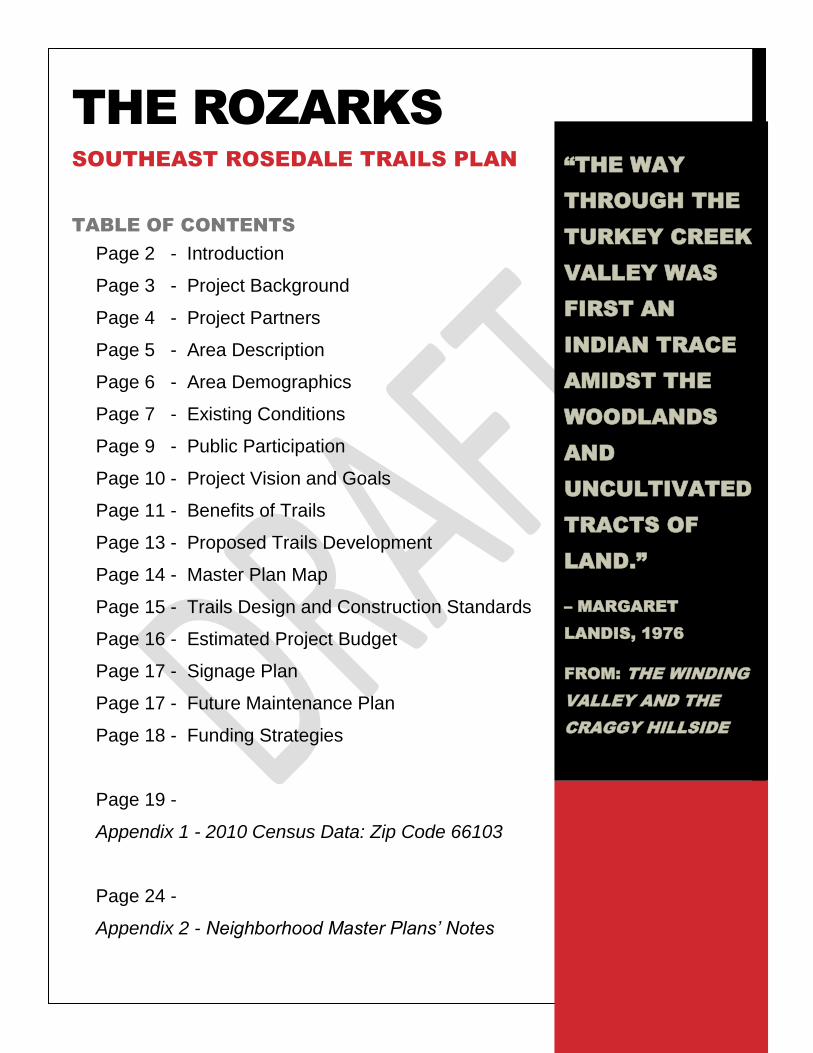
THE ROZARKS
SOUTHEAST ROSEDALE TRAILS PLAN
TABLE OF CONTENTS
Page 2 - Introduction
Page 3 - Project Background
Page 4 - Project Partners
Page 5 - Area Description
Page 6 - Area Demographics
Page 7 - Existing Conditions
Page 9 - Public Participation
Page 10 - Project Vision and Goals
Page 11 - Benefits of Trails
Page 13 - Proposed Trails Development
Page 14 - Master Plan Map
Page 15 - Trails Design and Construction Standards
Page 16 - Estimated Project Budget
Page 17 - Signage Plan
Page 17 - Future Maintenance Plan
Page 18 - Funding Strategies
Page 19 -
Appendix 1 - 2010 Census Data: Zip Code 66103
Page 24 -
Appendix 2 - Neighborhood Master Plans’ Notes
“THE WAY
THROUGH THE
TURKEY CREEK
VALLEY WAS
FIRST AN
INDIAN TRACE
AMIDST THE
WOODLANDS
AND
UNCULTIVATED
TRACTS OF
LAND.”
– MARGARET
LANDIS, 1976
FROM: THE WINDING
VALLEY AND THE
CRAGGY HILLSIDE
2
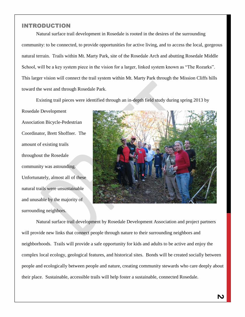
INTRODUCTION
Natural surface trail development in Rosedale is rooted in the desires of the surrounding
community: to be connected, to provide opportunities for active living, and to access the local, gorgeous
natural terrain. Trails within Mt. Marty Park, site of the Rosedale Arch and abutting Rosedale Middle
School, will be a key system piece in the vision for a larger, linked system known as “The Rozarks”.
This larger vision will connect the trail system within Mt. Marty Park through the Mission Cliffs hills
toward the west and through Rosedale Park.
Existing trail pieces were identified through an in-depth field study during spring 2013 by
Rosedale Development
Association Bicycle-Pedestrian
Coordinator, Brett Shoffner. The
amount of existing trails
throughout the Rosedale
community was astounding.
Unfortunately, almost all of these
natural trails were unsustainable
and unusable by the majority of
surrounding neighbors.
Natural surface trail development by Rosedale Development Association and project partners
will provide new links that connect people through nature to their surrounding neighbors and
neighborhoods. Trails will provide a safe opportunity for kids and adults to be active and enjoy the
complex local ecology, geological features, and historical sites. Bonds will be created socially between
people and ecologically between people and nature, creating community stewards who care deeply about
their place. Sustainable, accessible trails will help foster a sustainable, connected Rosedale.
3
PROJECT BACKGROUND
Rosedale Development Association, the Unified Government of Wyandotte County/Kansas City,
Kansas, Unified School District #500, Earth Riders Trails Association, Hilltop Neighborhood
Association, Mission Cliffs Home Owners Association, and local volunteers are undertaking the first
regional development of natural surface trails that will directly connect a local school and regional
historical site through currently underutilized parkland and open space. The active center of these
community nature trails will be located in Mt. Marty Park, connecting Rosedale Arch with Rosedale
Middle School, and will eventually include over four miles. The trails development is an actionable
implementation of many Rosedale neighborhood master plans that will provide neighborhood residents
with opportunities for active living and connections to access the local, gorgeous natural terrain. The
trails will also be used in conjunction with an environmental education curriculum at Rosedale Middle
School.
Phase 1 development began in September 2013 and was completed in late 2013 with the help of
over 70 different volunteers. The development timeline of Phase 1 was greatly accelerated by use of
mechanized trail building equipment by professional volunteers with the Earth Riders Trails
Association. Mechanized trail building not only performs the same amount of work that approximately
8-10 volunteers can in the same time (depending on terrain), but also provides a wider surface that can
easily be fine-tuned by finishing crews of trail builders and local volunteers.
Rosedale Development Association hopes to secure funding/donations to hire the mechanical
trail building crew for accelerated development of the Rozarks, particularly the Mt. Marty – Rosedale
Arch – Rosedale Middle School Trails: Phase Two, Phase Three, and Phase Four. With this assistance,
we anticipate that the entire Mt. Marty system of 2+ miles can be completed by mid-2014. Additional
funding for development within Steketee’s Slopes and at Mission Cliffs would provide a completed 4 ¼
mile loop system within Southeast Rosedale by late 2014.
*Please see Master Plan Map – Page 14
4
PROJECT PARTNERS
This natural surface trails development project is led by Rosedale Development Association in
conjunction with the Unified Government of Wyandotte County/Kansas City, Kansas, Unified School
District #500, Earth Riders Trails Association, Mission Cliffs Home Owners Association, Hilltop
Neighborhood Association, and local residents and volunteers.
5
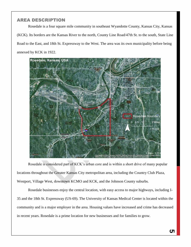
AREA DESCRIPTION
Rosedale is a four square mile community in southeast Wyandotte County, Kansas City, Kansas
(KCK). Its borders are the Kansas River to the north, County Line Road/47th St. to the south, State Line
Road to the East, and 18th St. Expressway to the West. The area was its own municipality before being
annexed by KCK in 1922.
Rosedale is considered part of KCK’s urban core and is within a short drive of many popular
locations throughout the Greater Kansas City metropolitan area, including the Country Club Plaza,
Westport, Village West, downtown KCMO and KCK, and the Johnson County suburbs.
Rosedale businesses enjoy the central location, with easy access to major highways, including I-
35 and the 18th St. Expressway (US-69). The University of Kansas Medical Center is located within the
community and is a major employer in the area. Housing values have increased and crime has decreased
in recent years. Rosedale is a prime location for new businesses and for families to grow.
6
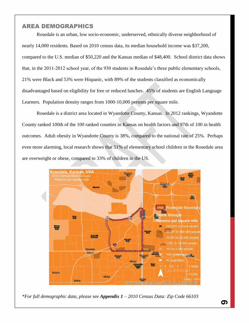
AREA DEMOGRAPHICS
Rosedale is an urban, low socio-economic, underserved, ethnically diverse neighborhood of
nearly 14,000 residents. Based on 2010 census data, its median household income was $37,200,
compared to the U.S. median of $50,220 and the Kansas median of $48,400. School district data shows
that, in the 2011-2012 school year, of the 930 students in Rosedale’s three public elementary schools,
21% were Black and 53% were Hispanic, with 89% of the students classified as economically
disadvantaged based on eligibility for free or reduced lunches. 45% of students are English Language
Learners. Population density ranges from 1000-10,000 persons per square mile.
Rosedale is a district area located in Wyandotte County, Kansas. In 2012 rankings, Wyandotte
County ranked 100th of the 100 ranked counties in Kansas on health factors and 97th of 100 in health
outcomes. Adult obesity in Wyandotte County is 38%, compared to the national rate of 25%. Perhaps
even more alarming, local research shows that 51% of elementary school children in the Rosedale area
are overweight or obese, compared to 33% of children in the US.
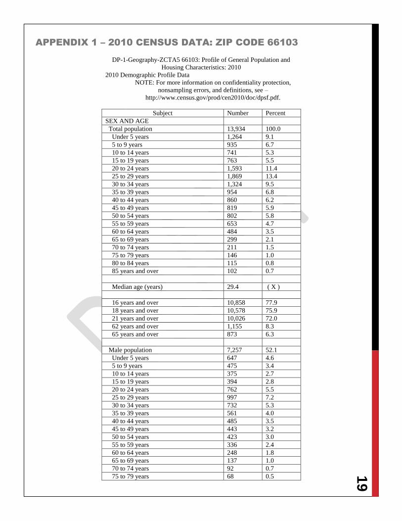
*For full demographic data, please see Appendix 1 – 2010 Census Data: Zip Code 66103
7
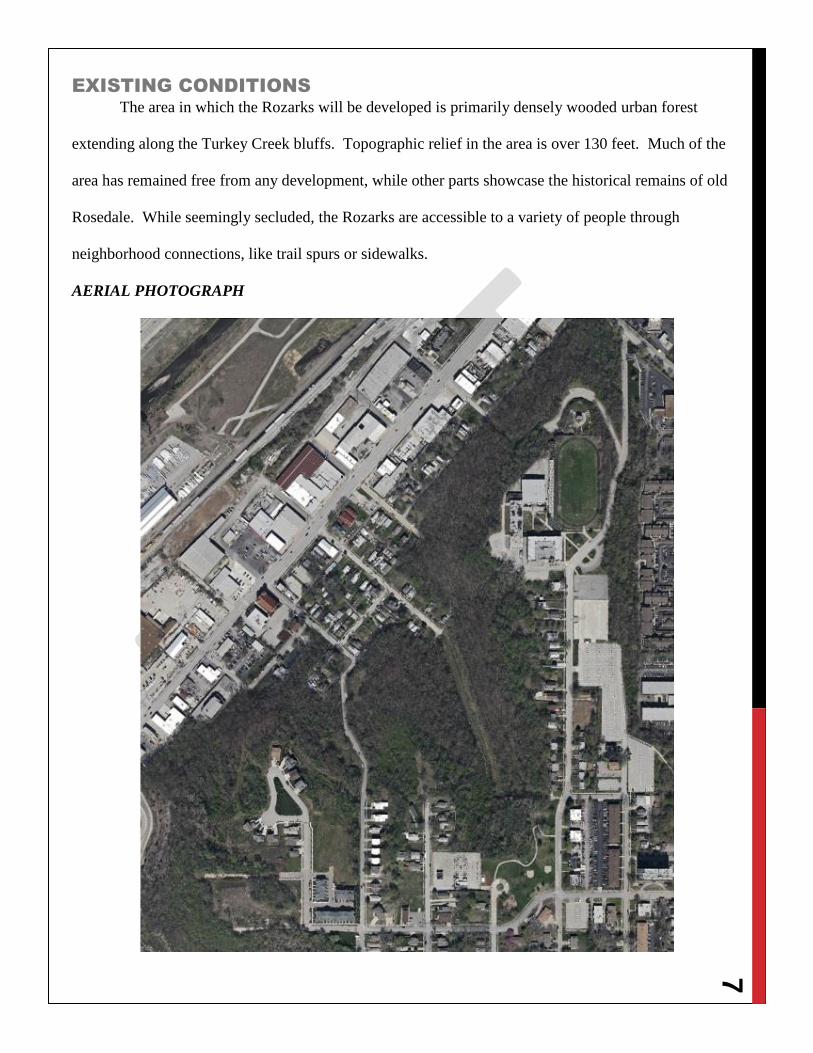
EXISTING CONDITIONS
The area in which the Rozarks will be developed is primarily densely wooded urban forest
extending along the Turkey Creek bluffs. Topographic relief in the area is over 130 feet. Much of the
area has remained free from any development, while other parts showcase the historical remains of old
Rosedale. While seemingly secluded, the Rozarks are accessible to a variety of people through
neighborhood connections, like trail spurs or sidewalks.
AERIAL PHOTOGRAPH
8
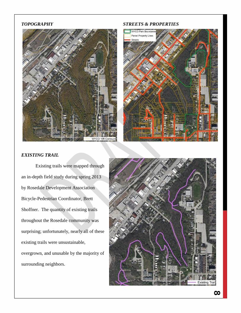
TOPOGRAPHY STREETS & PROPERTIES
EXISTING TRAIL
Existing trails were mapped through
an in-depth field study during spring 2013
by Rosedale Development Association
Bicycle-Pedestrian Coordinator, Brett
Shoffner. The quantity of existing trails
throughout the Rosedale community was
surprising; unfortunately, nearly all of these
existing trails were unsustainable,
overgrown, and unusable by the majority of
surrounding neighbors.
9
PUBLIC PARTICIPATION
Trail development within Rosedale is direct, on-the-ground implementation of many
neighborhood master plans. Nature trail development, neighborhood walkability, and community
connectivity are mentioned in these plans:
47th
and Mission Road Area Concept Plan – 2000
39th
Street Corridor Plan – 2003
Rosedale Master Plan – 2005
City-Wide Master Plan – 2008
Rosedale Green Corridor Trail Network and Revitalization Study – 2010
Rosedale Environmental Action Lab – 2010
Southwest Boulevard/Merriam Lane Corridor Master Plan – 2011
Sidewalk and Trails Master Plan for Unified Government/Kansas City, Kansas – 2012
Healthy Communities Wyandotte Recommendations for a Better Future – 2012
*For more information, please see Appendix 2 – Neighborhood Master Plans’ Notes
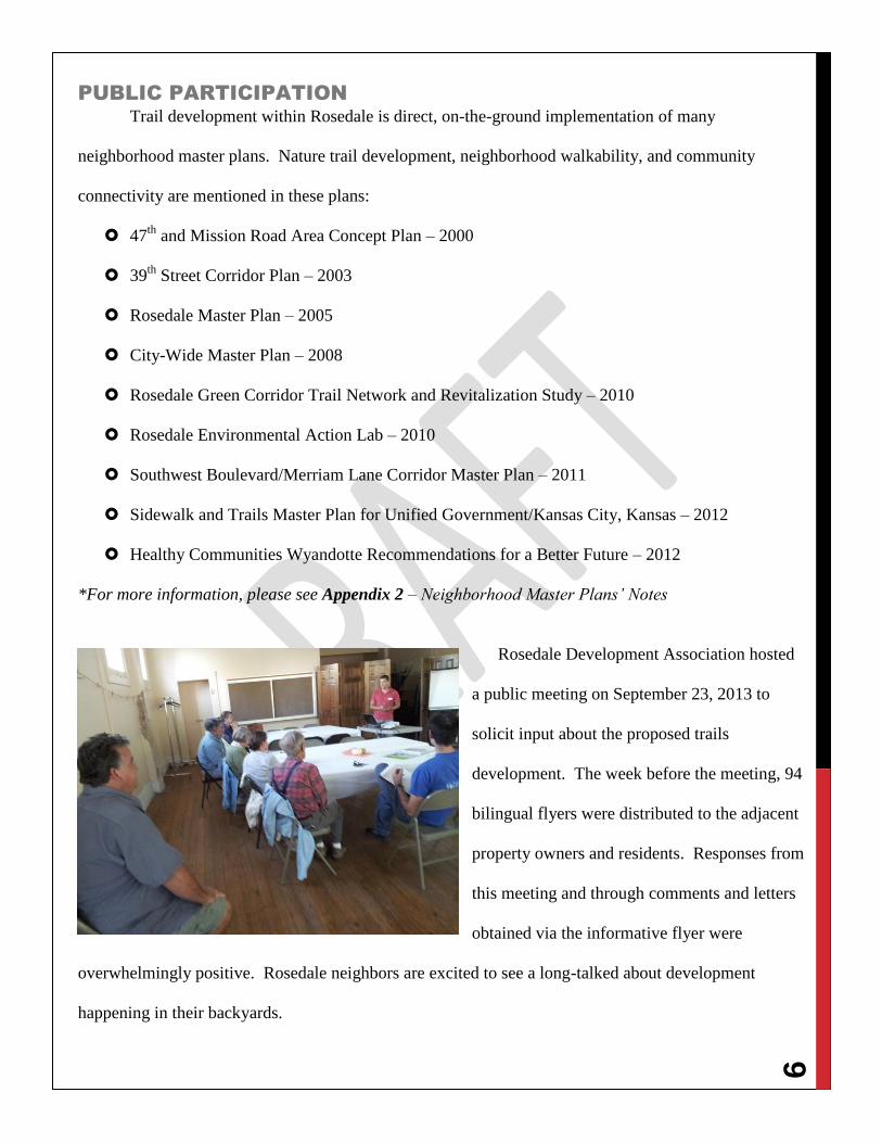
Rosedale Development Association hosted
a public meeting on September 23, 2013 to
solicit input about the proposed trails
development. The week before the meeting, 94
bilingual flyers were distributed to the adjacent
property owners and residents. Responses from
this meeting and through comments and letters
obtained via the informative flyer were
overwhelmingly positive. Rosedale neighbors are excited to see a long-talked about development
happening in their backyards.
10
PROJECT VISION AND GOALS
Rosedale Development Association (RDA) has formalized a trails development partnership
agreement with Earth Riders Trails Association (ERTA), supporting three primary objectives:
1) Protect the land that they manage,
2) Increase the number of visitors to the lands through the creation and management of
singletrack trails, and
3) Accomplish these objectives through an efficient and economical combination of volunteer
and professional labor.
RDA and ERTA believe these
objectives will be achieved through an
active focus on system connectivity,
accessibility, stewardship, biodiversity,
enjoy-ability, partnerships, and
sustainability. By involving people
throughout the process, we hope that
people will remain involved in their
communities after project completion.
RDA has also formalized partnership
with the primary land manager, Wyandotte
County Parks and Recreation, through a
Memorandum of Understanding (MOU) to
assist with trails development on public land
at Mt. Marty Park. RDA is working to
secure formal partnerships for trails
development on private land.
11
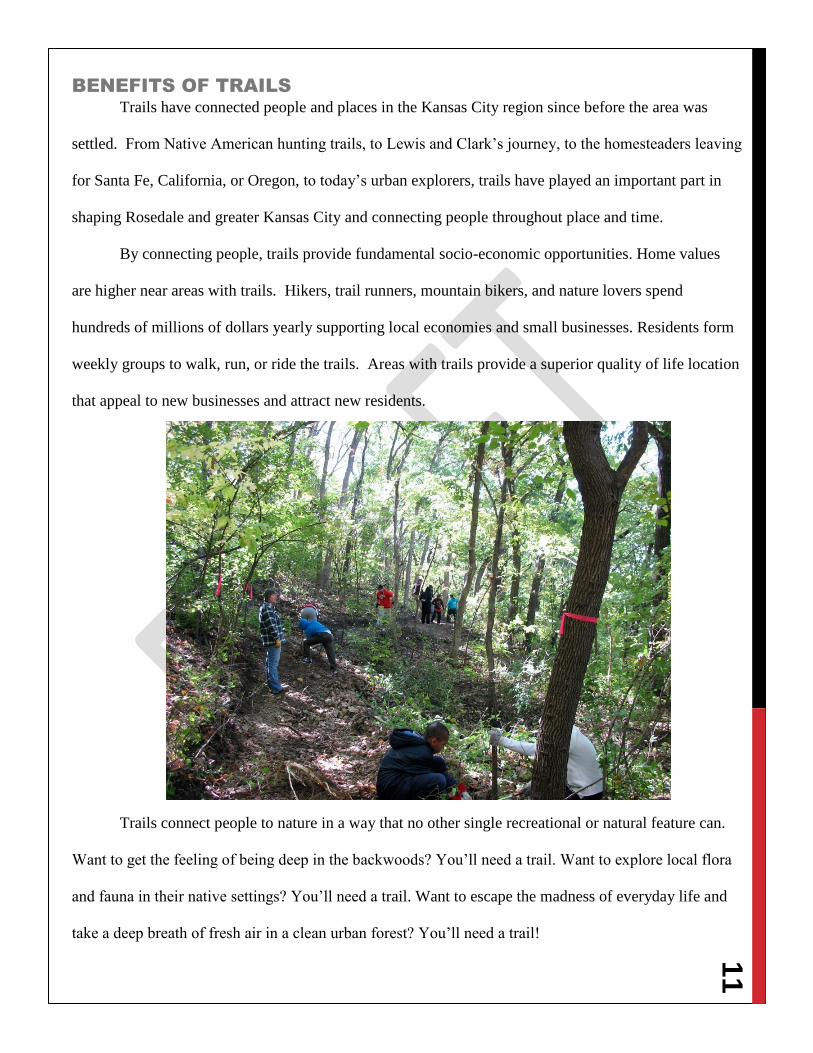
BENEFITS OF TRAILS
Trails have connected people and places in the Kansas City region since before the area was
settled. From Native American hunting trails, to Lewis and Clark’s journey, to the homesteaders leaving
for Santa Fe, California, or Oregon, to today’s urban explorers, trails have played an important part in
shaping Rosedale and greater Kansas City and connecting people throughout place and time.
By connecting people, trails provide fundamental socio-economic opportunities. Home values
are higher near areas with trails. Hikers, trail runners, mountain bikers, and nature lovers spend
hundreds of millions of dollars yearly supporting local economies and small businesses. Residents form
weekly groups to walk, run, or ride the trails. Areas with trails provide a superior quality of life location
that appeal to new businesses and attract new residents.
Trails connect people to nature in a way that no other single recreational or natural feature can.
Want to get the feeling of being deep in the backwoods? You’ll need a trail. Want to explore local flora
and fauna in their native settings? You’ll need a trail. Want to escape the madness of everyday life and
take a deep breath of fresh air in a clean urban forest? You’ll need a trail!
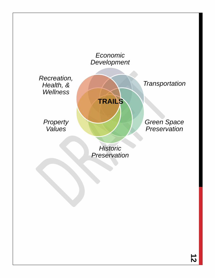
12
Economic Development
Transportation
Green Space Preservation
Historic Preservation
Property Values
Recreation, Health, & Wellness
TRAILS
13
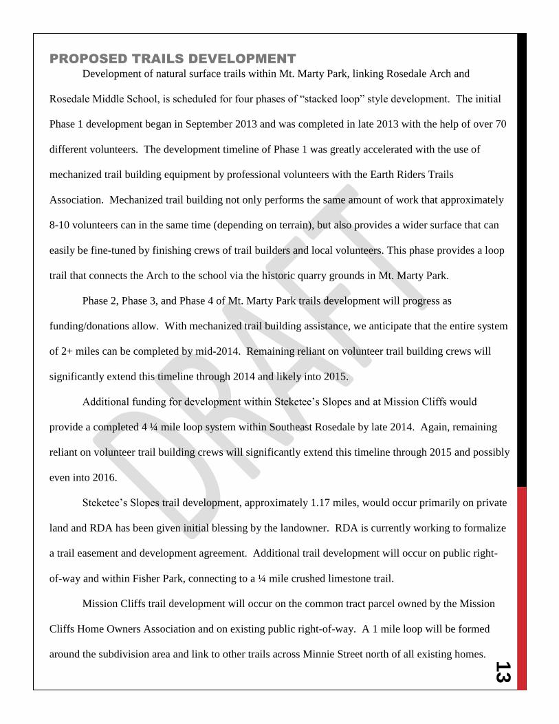
PROPOSED TRAILS DEVELOPMENT
Development of natural surface trails within Mt. Marty Park, linking Rosedale Arch and
Rosedale Middle School, is scheduled for four phases of “stacked loop” style development. The initial
Phase 1 development began in September 2013 and was completed in late 2013 with the help of over 70
different volunteers. The development timeline of Phase 1 was greatly accelerated with the use of
mechanized trail building equipment by professional volunteers with the Earth Riders Trails
Association. Mechanized trail building not only performs the same amount of work that approximately
8-10 volunteers can in the same time (depending on terrain), but also provides a wider surface that can
easily be fine-tuned by finishing crews of trail builders and local volunteers. This phase provides a loop
trail that connects the Arch to the school via the historic quarry grounds in Mt. Marty Park.
Phase 2, Phase 3, and Phase 4 of Mt. Marty Park trails development will progress as
funding/donations allow. With mechanized trail building assistance, we anticipate that the entire system
of 2+ miles can be completed by mid-2014. Remaining reliant on volunteer trail building crews will
significantly extend this timeline through 2014 and likely into 2015.
Additional funding for development within Steketee’s Slopes and at Mission Cliffs would
provide a completed 4 ¼ mile loop system within Southeast Rosedale by late 2014. Again, remaining
reliant on volunteer trail building crews will significantly extend this timeline through 2015 and possibly
even into 2016.
Steketee’s Slopes trail development, approximately 1.17 miles, would occur primarily on private
land and RDA has been given initial blessing by the landowner. RDA is currently working to formalize
a trail easement and development agreement. Additional trail development will occur on public right-
of-way and within Fisher Park, connecting to a ¼ mile crushed limestone trail.
Mission Cliffs trail development will occur on the common tract parcel owned by the Mission
Cliffs Home Owners Association and on existing public right-of-way. A 1 mile loop will be formed
around the subdivision area and link to other trails across Minnie Street north of all existing homes.
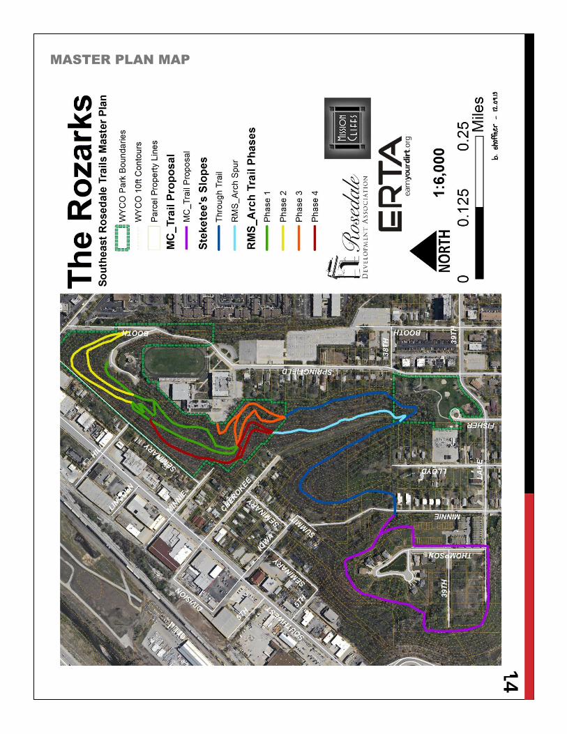
14
MASTER PLAN MAP
15
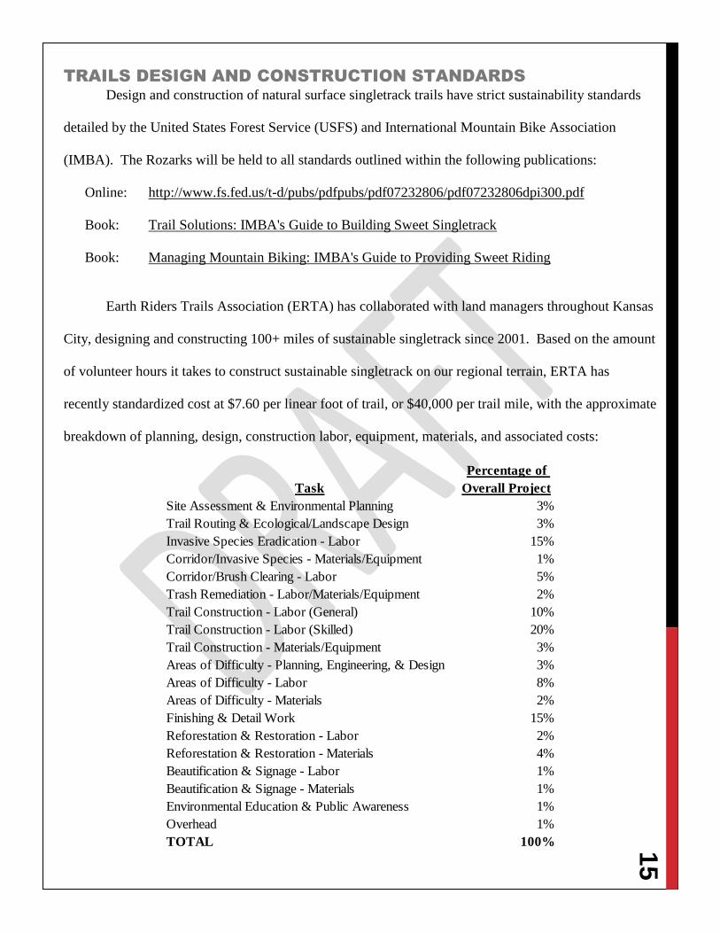
TRAILS DESIGN AND CONSTRUCTION STANDARDS
Design and construction of natural surface singletrack trails have strict sustainability standards
detailed by the United States Forest Service (USFS) and International Mountain Bike Association
(IMBA). The Rozarks will be held to all standards outlined within the following publications:
Online: http://www.fs.fed.us/t-d/pubs/pdfpubs/pdf07232806/pdf07232806dpi300.pdf
Book: Trail Solutions: IMBA's Guide to Building Sweet Singletrack
Book: Managing Mountain Biking: IMBA's Guide to Providing Sweet Riding
Earth Riders Trails Association (ERTA) has collaborated with land managers throughout Kansas
City, designing and constructing 100+ miles of sustainable singletrack since 2001. Based on the amount
of volunteer hours it takes to construct sustainable singletrack on our regional terrain, ERTA has
recently standardized cost at $7.60 per linear foot of trail, or $40,000 per trail mile, with the approximate
breakdown of planning, design, construction labor, equipment, materials, and associated costs:
Task
Percentage of
Overall Project
Site Assessment & Environmental Planning 3%
Trail Routing & Ecological/Landscape Design 3%
Invasive Species Eradication - Labor 15%
Corridor/Invasive Species - Materials/Equipment 1%
Corridor/Brush Clearing - Labor 5%
Trash Remediation - Labor/Materials/Equipment 2%
Trail Construction - Labor (General) 10%
Trail Construction - Labor (Skilled) 20%
Trail Construction - Materials/Equipment 3%
Areas of Difficulty - Planning, Engineering, & Design 3%
Areas of Difficulty - Labor 8%
Areas of Difficulty - Materials 2%
Finishing & Detail Work 15%
Reforestation & Restoration - Labor 2%
Reforestation & Restoration - Materials 4%
Beautification & Signage - Labor 1%
Beautification & Signage - Materials 1%
Environmental Education & Public Awareness 1%
Overhead 1%
TOTAL 100%
16
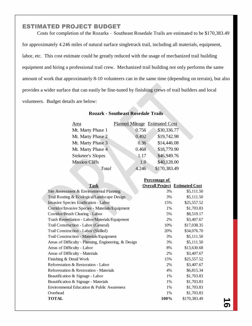
ESTIMATED PROJECT BUDGET
Costs for completion of the Rozarks – Southeast Rosedale Trails are estimated to be $170,383.49
for approximately 4.246 miles of natural surface singletrack trail, including all materials, equipment,
labor, etc. This cost estimate could be greatly reduced with the usage of mechanized trail building
equipment and hiring a professional trail crew. Mechanized trail building not only performs the same
amount of work that approximately 8-10 volunteers can in the same time (depending on terrain), but also
provides a wider surface that can easily be fine-tuned by finishing crews of trail builders and local
volunteers. Budget details are below:
Area Planned Mileage Estimated Cost
Mt. Marty Phase 1 0.756 $30,336.77
Mt. Marty Phase 2 0.492 $19,742.98
Mt. Marty Phase 3 0.36 $14,446.08
Mt. Marty Phase 4 0.468 $18,779.90
Steketee's Slopes 1.17 $46,949.76
Mission Cliffs 1.0 $40,128.00
Total 4.246 $170,383.49
Rozark - Southeast Rosedale Trails
Task
Percentage of
Overall Project Estimated Cost
Site Assessment & Environmental Planning 3% $5,111.50
Trail Routing & Ecological/Landscape Design 3% $5,111.50
Invasive Species Eradication - Labor 15% $25,557.52
Corridor/Invasive Species - Materials/Equipment 1% $1,703.83
Corridor/Brush Clearing - Labor 5% $8,519.17
Trash Remediation - Labor/Materials/Equipment 2% $3,407.67
Trail Construction - Labor (General) 10% $17,038.35
Trail Construction - Labor (Skilled) 20% $34,076.70
Trail Construction - Materials/Equipment 3% $5,111.50
Areas of Difficulty - Planning, Engineering, & Design 3% $5,111.50
Areas of Difficulty - Labor 8% $13,630.68
Areas of Difficulty - Materials 2% $3,407.67
Finishing & Detail Work 15% $25,557.52
Reforestation & Restoration - Labor 2% $3,407.67
Reforestation & Restoration - Materials 4% $6,815.34
Beautification & Signage - Labor 1% $1,703.83
Beautification & Signage - Materials 1% $1,703.83
Environmental Education & Public Awareness 1% $1,703.83
Overhead 1% $1,703.83
TOTAL 100% $170,383.49
17
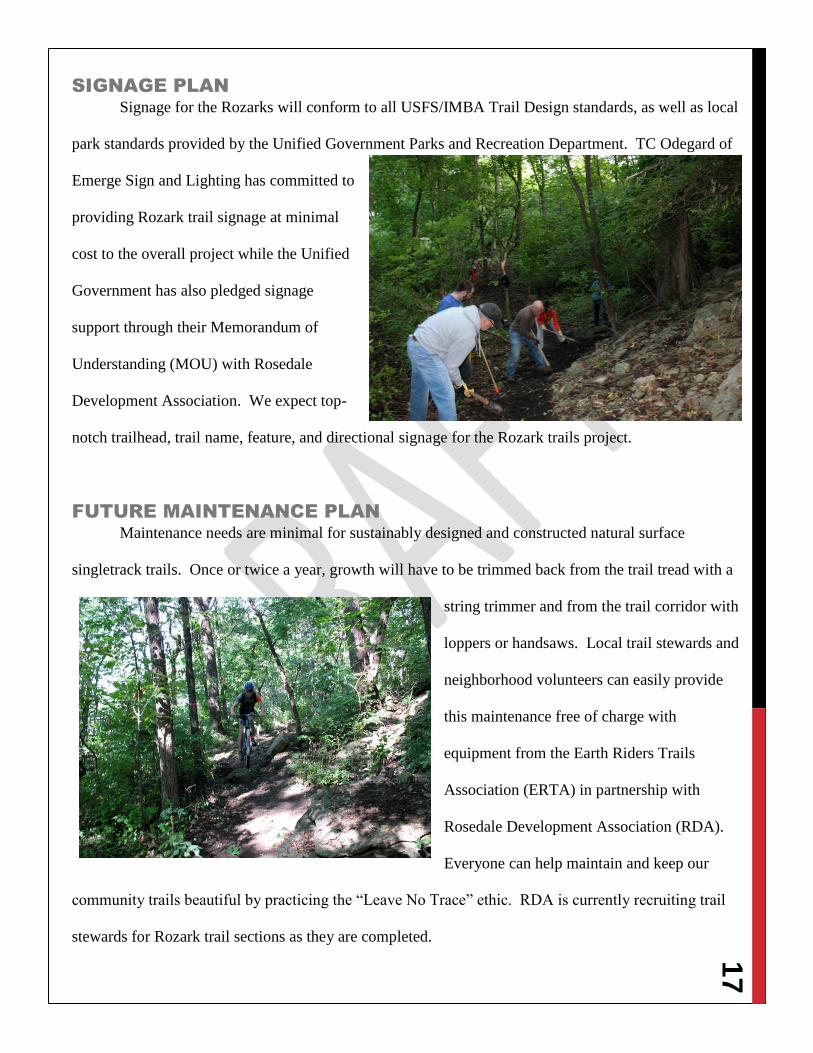
SIGNAGE PLAN
Signage for the Rozarks will conform to all USFS/IMBA Trail Design standards, as well as local
park standards provided by the Unified Government Parks and Recreation Department. TC Odegard of
Emerge Sign and Lighting has committed to
providing Rozark trail signage at minimal
cost to the overall project while the Unified
Government has also pledged signage
support through their Memorandum of
Understanding (MOU) with Rosedale
Development Association. We expect top-
notch trailhead, trail name, feature, and directional signage for the Rozark trails project.
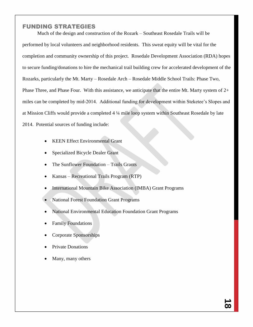
FUTURE MAINTENANCE PLAN
Maintenance needs are minimal for sustainably designed and constructed natural surface
singletrack trails. Once or twice a year, growth will have to be trimmed back from the trail tread with a
string trimmer and from the trail corridor with
loppers or handsaws. Local trail stewards and
neighborhood volunteers can easily provide
this maintenance free of charge with
equipment from the Earth Riders Trails
Association (ERTA) in partnership with
Rosedale Development Association (RDA).
Everyone can help maintain and keep our
community trails beautiful by practicing the “Leave No Trace” ethic. RDA is currently recruiting trail
stewards for Rozark trail sections as they are completed.
18
FUNDING STRATEGIES
Much of the design and construction of the Rozark – Southeast Rosedale Trails will be
performed by local volunteers and neighborhood residents. This sweat equity will be vital for the
completion and community ownership of this project. Rosedale Development Association (RDA) hopes
to secure funding/donations to hire the mechanical trail building crew for accelerated development of the
Rozarks, particularly the Mt. Marty – Rosedale Arch – Rosedale Middle School Trails: Phase Two,
Phase Three, and Phase Four. With this assistance, we anticipate that the entire Mt. Marty system of 2+
miles can be completed by mid-2014. Additional funding for development within Steketee’s Slopes and
at Mission Cliffs would provide a completed 4 ¼ mile loop system within Southeast Rosedale by late
2014. Potential sources of funding include:
KEEN Effect Environmental Grant
Specialized Bicycle Dealer Grant
The Sunflower Foundation – Trails Grants
Kansas – Recreational Trails Program (RTP)
International Mountain Bike Association (IMBA) Grant Programs
National Forest Foundation Grant Programs
National Environmental Education Foundation Grant Programs
Family Foundations
Corporate Sponsorships
Private Donations
Many, many others
19
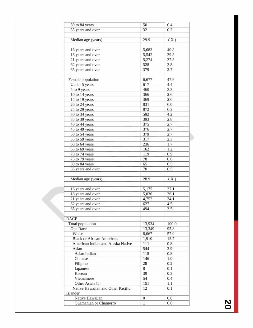
APPENDIX 1 – 2010 CENSUS DATA: ZIP CODE 66103
DP-1-Geography-ZCTA5 66103: Profile of General Population and
Housing Characteristics: 2010
2010 Demographic Profile Data
NOTE: For more information on confidentiality protection,
nonsampling errors, and definitions, see –
http://www.census.gov/prod/cen2010/doc/dpsf.pdf.
Subject Number Percent
SEX AND AGE
Total population 13,934 100.0
Under 5 years 1,264 9.1
5 to 9 years 935 6.7
10 to 14 years 741 5.3
15 to 19 years 763 5.5
20 to 24 years 1,593 11.4
25 to 29 years 1,869 13.4
30 to 34 years 1,324 9.5
35 to 39 years 954 6.8
40 to 44 years 860 6.2
45 to 49 years 819 5.9
50 to 54 years 802 5.8
55 to 59 years 653 4.7
60 to 64 years 484 3.5
65 to 69 years 299 2.1
70 to 74 years 211 1.5
75 to 79 years 146 1.0
80 to 84 years 115 0.8
85 years and over 102 0.7
Median age (years) 29.4 ( X )
16 years and over 10,858 77.9
18 years and over 10,578 75.9
21 years and over 10,026 72.0
62 years and over 1,155 8.3
65 years and over 873 6.3
Male population 7,257 52.1
Under 5 years 647 4.6
5 to 9 years 475 3.4
10 to 14 years 375 2.7
15 to 19 years 394 2.8
20 to 24 years 762 5.5
25 to 29 years 997 7.2
30 to 34 years 732 5.3
35 to 39 years 561 4.0
40 to 44 years 485 3.5
45 to 49 years 443 3.2
50 to 54 years 423 3.0
55 to 59 years 336 2.4
60 to 64 years 248 1.8
65 to 69 years 137 1.0
70 to 74 years 92 0.7
75 to 79 years 68 0.5
20
80 to 84 years 50 0.4
85 years and over 32 0.2
Median age (years) 29.9 ( X )
16 years and over 5,683 40.8
18 years and over 5,542 39.8
21 years and over 5,274 37.8
62 years and over 528 3.8
65 years and over 379 2.7
Female population 6,677 47.9
Under 5 years 617 4.4
5 to 9 years 460 3.3
10 to 14 years 366 2.6
15 to 19 years 369 2.6
20 to 24 years 831 6.0
25 to 29 years 872 6.3
30 to 34 years 592 4.2
35 to 39 years 393 2.8
40 to 44 years 375 2.7
45 to 49 years 376 2.7
50 to 54 years 379 2.7
55 to 59 years 317 2.3
60 to 64 years 236 1.7
65 to 69 years 162 1.2
70 to 74 years 119 0.9
75 to 79 years 78 0.6
80 to 84 years 65 0.5
85 years and over 70 0.5
Median age (years) 28.9 ( X )
16 years and over 5,175 37.1
18 years and over 5,036 36.1
21 years and over 4,752 34.1
62 years and over 627 4.5
65 years and over 494 3.5
RACE
Total population 13,934 100.0
One Race 13,349 95.8
White 8,067 57.9
Black or African American 1,910 13.7
American Indian and Alaska Native 111 0.8
Asian 544 3.9
Asian Indian 118 0.8
Chinese 146 1.0
Filipino 28 0.2
Japanese 8 0.1
Korean 39 0.3
Vietnamese 54 0.4
Other Asian [1] 151 1.1
Native Hawaiian and Other Pacific
Islander
12 0.1
Native Hawaiian 0 0.0
Guamanian or Chamorro 1 0.0
21
Samoan 0 0.0
Other Pacific Islander [2] 11 0.1
Some Other Race 2,705 19.4
Two or More Races 585 4.2
White; American Indian and Alaska
Native [3]
73 0.5
White; Asian [3] 53 0.4
White; Black or African American [3] 146 1.0
White; Some Other Race [3] 177 1.3
Race alone or in combination with one or
more other races: [4]
White 8,560 61.4
Black or African American 2,146 15.4
American Indian and Alaska Native 247 1.8
Asian 636 4.6
Native Hawaiian and Other Pacific
Islander
26 0.2
Some Other Race 2,951 21.2
HISPANIC OR LATINO
Total population 13,934 100.0
Hispanic or Latino (of any race) 5,080 36.5
Mexican 4,117 29.5
Puerto Rican 37 0.3
Cuban 24 0.2
Other Hispanic or Latino [5] 902 6.5
Not Hispanic or Latino 8,854 63.5
HISPANIC OR LATINO AND RACE
Total population 13,934 100.0
Hispanic or Latino 5,080 36.5
White alone 2,018 14.5
Black or African American alone 59 0.4
American Indian and Alaska Native
alone
37 0.3
Asian alone 8 0.1
Native Hawaiian and Other Pacific
Islander alone
0 0.0
Some Other Race alone 2,683 19.3
Two or More Races 275 2.0
Not Hispanic or Latino 8,854 63.5
White alone 6,049 43.4
Black or African American alone 1,851 13.3
American Indian and Alaska Native
alone
74 0.5
Asian alone 536 3.8
Native Hawaiian and Other Pacific
Islander alone
12 0.1
Some Other Race alone 22 0.2
Two or More Races 310 2.2
RELATIONSHIP
Total population 13,934 100.0
In households 13,934 100.0
Householder 6,077 43.6
Spouse [6] 1,672 12.0
22
Child 3,703 26.6
Own child under 18 years 2,950 21.2
Other relatives 994 7.1
Under 18 years 324 2.3
65 years and over 68 0.5
Nonrelatives 1,488 10.7
Under 18 years 72 0.5
65 years and over 23 0.2
Unmarried partner 615 4.4
In group quarters 0 0.0
Institutionalized population 0 0.0
Male 0 0.0
Female 0 0.0
Noninstitutionalized population 0 0.0
Male 0 0.0
Female 0 0.0
HOUSEHOLDS BY TYPE
Total households 6,077 100.0
Family households (families) [7] 2,963 48.8
With own children under 18 years 1,570 25.8
Husband-wife family 1,672 27.5
With own children under 18 years 778 12.8
Male householder, no wife present 425 7.0
With own children under 18 years 223 3.7
Female householder, no husband
present
866 14.3
With own children under 18 years 569 9.4
Nonfamily households [7] 3,114 51.2
Householder living alone 2,338 38.5
Male 1,326 21.8
65 years and over 123 2.0
Female 1,012 16.7
65 years and over 190 3.1
Households with individuals under 18
years
1,740 28.6
Households with individuals 65 years
and over
704 11.6
Average household size 2.29 ( X )
Average family size [7] 3.15 ( X )
HOUSING OCCUPANCY
Total housing units 7,072 100.0
Occupied housing units 6,077 85.9
Vacant housing units 995 14.1
For rent 617 8.7
Rented, not occupied 8 0.1
For sale only 95 1.3
Sold, not occupied 32 0.5
For seasonal, recreational, or
occasional use
21 0.3
All other vacants 222 3.1
23
Homeowner vacancy rate (percent) [8] 4.1 ( X )
Rental vacancy rate (percent) [9] 13.6 ( X )
HOUSING TENURE
Occupied housing units 6,077 100.0
Owner-occupied housing units 2,166 35.6
Population in owner-occupied housing
units
5,249 ( X )
Average household size of owner-
occupied units
2.42 ( X )
Renter-occupied housing units 3,911 64.4
Population in renter-occupied housing
units
8,685 ( X )
Average household size of renter-
occupied units
2.22 ( X )
X Not applicable.
[1] Other Asian alone, or two or more Asian categories.
[2] Other Pacific Islander alone, or two or more Native
Hawaiian and Other Pacific Islander categories.
[3] One of the four most commonly reported multiple-race
combinations nationwide in Census 2000.
[4] In combination with one or more of the other races listed.
The six numbers may add to more than the total population,
and the six percentages may add to more than 100 percent
because individuals may report more than one race.
[5] This category is composed of people whose origins are
from the Dominican Republic, Spain, and Spanish-speaking
Central or South American countries. It also includes general
origin responses such as "Latino" or "Hispanic."
[6] "Spouse" represents spouse of the householder. It does not
reflect all spouses in a household. Responses of "same-sex
spouse" were edited during processing to "unmarried partner."
[7] "Family households" consist of a householder and one or
more other people related to the householder by birth,
marriage, or adoption. They do not include same-sex married
couples even if the marriage was performed in a state issuing
marriage certificates for same-sex couples. Same-sex couple
households are included in the family households category if
there is at least one additional person related to the householder
by birth or adoption. Same-sex couple households with no
relatives of the householder present are tabulated in nonfamily
households. "Nonfamily households" consist of people living
alone and households which do not have any members related
to the householder.
[8] The homeowner vacancy rate is the proportion of the
homeowner inventory that is vacant "for sale." It is computed
by dividing the total number of vacant units "for sale only" by
the sum of owner-occupied units, vacant units that are "for sale
only," and vacant units that have been sold but not yet
occupied; and then multiplying by 100.
[9] The rental vacancy rate is the proportion of the rental
inventory that is vacant "for rent." It is computed by dividing
the total number of vacant units "for rent" by the sum of the
renter-occupied units, vacant units that are "for rent," and
vacant units that have been rented but not yet occupied; and
then multiplying by 100.
Source: U.S. Census Bureau, 2010 Census
24
APPENDIX 2 - NEIGHBORHOOD MASTER PLANS’ NOTES
1. 47th
and Mission Road Area Concept Plan – 2000
a. Town Hall Meetings – Issues prioritized include: less asphalt, more green; pedestrian
links; and, easy biking/walking/connection to parks. (Pages 7-10)
b. Neighborhoods – Connection “connect people within and between neighborhoods” (12)
c. Key Elements for Design and Development concepts - #1) “Pedestrian linkages
throughout the area, providing access between and among neighborhoods and
commercial development, and enhancement of pedestrian crossings” (13)
2. 39th
Street Corridor Plan – 2003
a. Conceptual Plan – Park/Open Space and Amenities (15-16)
i. “This development should be tied to the corridor through the addition of parkland
on the north and south sides of Lake Street, at the intersection with Minnie
Street.” (15)
ii. “A multi-purpose trail should be incorporated into the corridor to improve the
pedestrian accessibility of the resident within the corridor and connections to
surrounding areas. The general alignment of the trail should follow 39th
Street
and Lake Streets serving as the main east and west connection….The trail should
use the park (Fisher) as a central point to make connections to the north along
Springfield Street to Rosedale Middle School….Additional connections to the
surrounding areas should be made through the use of the natural topography,
particularly east and south of Minnie Street.” (16)
b. Development Policies (17-18)
i. “Connections throughout the neighborhood, with special attention to pedestrians,
should be preserved and enhanced.” (18)
ii. “Expand and improve the park and open space system in the corridor and
surrounding neighborhood when possible.” (18)
c. Design Concepts (19-24)
i. “Eventually, this park system could be further developed with neighborhood
trails, following natural areas, and linking other neighborhoods together.” (22)
ii. “Where parks and conservation areas meet, the opportunity exists to develop
interpretive elements, such as natural environment education nodes along the
trail.” (22)
3. Rosedale Master Plan – 2005
a. The Rosedale Plan – Major Components (Chapter 6)
i. Pedestrian Connectivity (6-3)
ii. “A comprehensive pedestrian trail system is recommended for Rosedale. This
designated trail would connect centers, green space, and neighborhoods to each
other.” (6-3)
iii. “The connection of the individual parks and open space parcels should be pursued
through the creation of a trail network that serves the area” (6-8)
iv. “The Rosedale Plan calls for a comprehensive pedestrian/bicycle trail to be
developed in the study area. The trail system would bring continuity to Rosedale
by connecting neighborhoods, open space, and centers. The trail system would be
used as a form of recreation and as a means of getting to and from community
activities….When possible, trails should be linked to existing trails in neighboring
communities to improve overall connectivity” (6-9)
25
v. “The natural amenities in Rosedale provide definition to the area and should be
enhanced and expanded. The creation of a defined trail system that links parks,
other amenities, and neighborhood centers should be pursued” (6-14)
b. Design Guidelines (Chapter 7)
i. Public or Open Spaces
1. “Link open spaces throughout the community through a variety of
methods, including trails or greenways….” (7-3)
2. “Public or open spaces should generally support the linear function of a
corridor, such as trails and greenways.” (7-11)
c. Implementation (Chapter 8)
i. “Utilize natural features, water features, topography, and vegetation” (8-5)
ii. “Enhance the bicycle and pedestrian network” (8-5)
4. City-Wide Master Plan (2008)
a. Parks, Open Space and Trails (61-66)
i. Recommends a comprehensive greenway and trail system to connect all parks,
schools, and other community cultural amenities.
5. Rosedale Green Corridor Trail Network and Revitalization Study – 2010
a. PURPOSE AND GOALS – PAGE 2
b. ISSUES AND OPPORTUNITIES – PAGE 3
c. PUBLIC PROCESS – PAGES 4-7
d. TRAIL NETWORK ANALYSIS – PAGES 12-23
e. DESIGN GUIDELINES – PAGES 24-31
f. NATURAL ECOLOGY – PAGES 32-35
g. PUBLIC HEALTH – PAGES 36-37
h. REVITALIZATION AND REDEVELOPMENT – PAGES 38-41
i. IMPLEMENTATION – PAGE 42
6. Rosedale Environmental Action Lab – 2010
a. “….green spaces that children can experience and manipulate with their own hands
should be considered essential to an urban community.” (1)
b. Rosedale is unique for an urban community in that it is built upon bluffs which are
difficult to develop. The bluffs adjacent to the school are densely landscaped and lend
themselves to be urban woodland of sorts. To incorporate this resource, trails will be
added throughout the woodland connecting two important nodes in the locality; the
environmental lab and the historical Rosedale Arch. The trails can be used for field study
and interaction with the natural world as part of the outside portion of the lab.” (2)
c. Guiding Principles (2): Education is the key to behavioral change, nature in a reachable
location, a promotion of healthy eating, a real world experience curriculum, to increase
environmental awareness, a central gathering node, a usable space, an adaptable
environment, and, an expandable program.
d. Connections (3) –
i. “A system of trail ways linking nodes such as parks, shopping and dining, and
other activities will also link the Rosedale Middle School and the environmental
lab. Accessible trails encourage a connection between students and their natural
world. The trails located in the urban wild land adjacent to the environmental lab
will be beneficial to incorporate field study type lessons of native plant species
26
and identification. This also helps promote an active and healthy lifestyle the
green corridor is committed to.” (3)
ii. “Rosedale should work to use the approximately 16 acres of urban wild land
surrounding the school to connect to Fisher Park….” (3)
iii. “Rosedale should work to connect the historical marker, Rosedale Arch, to the
environmental lab with the trail system.” (3)
e. “The historical marker, Rosedale Arch, should serve as a visual “gateway” to the
community gathering node through the trail system” (4)
7. Southwest Boulevard/Merriam Lane Corridor Master Plan – 2011
a. “One of the major topics discussed at every public meeting and every session with
business owners was the need for better pedestrian and bicycling systems” (63)
b. GOALS (66-69)
i. “Become a healthier community. Promote active lifestyles to make it easy and
safe to walk and bike. Encourage trails and recreation, bike lanes, urban farming,
permanent farmers market, corner markets, and access to healthy foods.” (66)
ii. “Take advantage of existing area community assets such as local parks, schools
and other public investments as central focus points of neighborhood development
and make them accessible to everyone” (67)
iii. “Create compact, connected walkable neighborhoods that provide safe,
convenient and comfortable sidewalks, but also have interesting places to walk to
– such as parks, schools, stores and civic institutions.” (67)
iv. “Embrace efforts to involve students within the community. Create opportunities
for a middle school urban environmental lab, safe routes, and after-school and
youth activities.” (67)
v. “Promote a variety of transportation choices. Dependence on cars will continue
until it is safe, convenient and comfortable to walk, bicycle and use transit as an
alternative.” (69)
vi. “Promote ease of access through the community.” (69)
c. IMPLEMENTATION
i. Public Open Space (74) – “Creation of public plaza and green open space to link
and strengthen the future trail systems and environmental enhancement areas is
critical. A regulatory approach could include development flexibility for the
creation of these place-making and linkage spaces. Provisions for public artwork
in these spaces would be encouraged.”
ii. Recreational Trail Access (75) – “Inventory open space assets to support
additional youth-related recreational activities within and adjacent to the
Corridor.”
iii. Identify Walking Routes (75) – “Understand and develop walking routes for
greater safety and ease of access through the Corridor.”
iv. Safe Routes to School (77) – “Collaborate with City to pursue additional safe-
route programming.”
v. Public and Private Schools (77) – Partner with area schools to identify and
implement outdoor urban labs and other hands-on environmental education….”
8. Sidewalk and Trails Master Plan for Unified Government/Kansas City, Kansas – 2012
a. Plan Goals (1)
i. Improve the health and well-being of residents
27
ii. Provide a safe, convenient and attractive transportation alternative to the
automobile
iii. Provide a sidewalk and trail network that meets the needs of all skill levels and
physical abilities
iv. Connect major activity centers and destinations within the County
v. Connect to surrounding local and regional pedestrian bicycle networks
9. Healthy Communities Wyandotte Recommendations for a Better Future – 2012
a. Environmental Infrastructure
i. Provide physical activity opportunities throughout the county
ii. Improve neighborhood safety through infrastructure developments
iii. Create stronger neighborhoods through infrastructure developments that promote
social connectedness
iv. Pursue policy changes that ensure improvements to environmental infrastructure
v. Launch an educational campaign to inform the public about infrastructure
improvements and strategies to lead an active life