The role of small aerosols in cloud microphysics or … · or “why do we see lightning in...
23
The role of small aerosols in cloud microphysics or “why do we see lightning in eyewalls of hurricanes”? Alexander Khain Department of Atmospheric Sciences, The Hebrew University of Jerusalem Co-authors: Vaughan Phillips , University of Leeds and Andrei Pokrovsky, the Hebrew University of Jerusalem DOE workshop September 2011
Transcript of The role of small aerosols in cloud microphysics or … · or “why do we see lightning in...
The role of small aerosols in cloud microphysics
or “why do we see lightning in eyewalls of hurricanes”?
Alexander KhainDepartment of Atmospheric Sciences, The
Hebrew University of Jerusalem
Co-authors:
Vaughan Phillips , University of Leeds
and
Andrei Pokrovsky, the Hebrew University of Jerusalem
DOE workshop September 2011
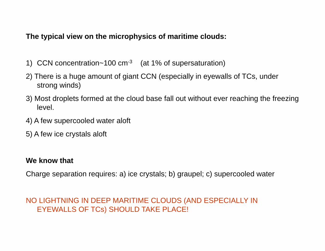
The typical view on the microphysics of maritime clouds:
1) CCN concentration~100 cm-3 (at 1% of supersaturation)
2) There is a huge amount of giant CCN (especially in eyewalls of TCs, under strong winds)
3) Most droplets formed at the cloud base fall out without ever reaching the freezing level.
4) A few supercooled water aloft
5) A few ice crystals aloft
We know that
Charge separation requires: a) ice crystals; b) graupel; c) supercooled water
NO LIGHTNING IN DEEP MARITIME CLOUDS (AND ESPECIALLY IN EYEWALLS OF TCs) SHOULD TAKE PLACE!
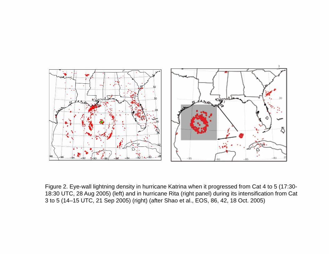
Figure 2. Eye-wall lightning density in hurricane Katrina when it progressed from Cat 4 to 5 (17:30-18:30 UTC, 28 Aug 2005) (left) and in hurricane Rita (right panel) during its intensification from Cat 3 to 5 (14–15 UTC, 21 Sep 2005) (right) (after Shao et al., EOS, 86, 42, 18 Oct. 2005)

We ask:
"Why does lightning take place in deep maritime convective clouds in the Intertropical Convergence zone and in hurricane eyewalls at all?"

1) Amounts of supercooled water of ~0.3 g/m3 were observed by aircraft in deep convective updrafts with peak vertical velocities of up to 20 m/sec in The Cirrus Regional Study of Tropical Anvils and Cirrus Layers - Florida Area Cirrus Experiment (CRYSTAL-FACE) over the sea near Florida (Fridlind et al. 2004; Heymsfield et al. 2005; Phillips et al. 2005).
2) Aircraft observations in the Kwajalein Experiment (KWAJEX) showed droplet concentrations of about 50 cm-3 up to about 9 km altitude (about -30 C) throughout most of the depth of the mixed-phase region, averaged over deep, highly visible cloud-decks.
3) The optical depth of anvils of deep convective clouds in the ITCZ is quite significant. This is consistent with the existence of concentrations of about 1-10 cm-3 of small ice crystals in the cloud anvils. Such concentrations were measured in situ by Takahashi and Kuhara (1993)
Some observations:


1 Hz droplet size distributions in cloud core of monsoon cloud (22 Jun 2009)In the Cloud Aerosol Interaction and Precipitation Enhancement Experiment
(CAIPEEX) (Prabha et al , JAS 2011)

Pinsky and Khain 2002
~4-6 km Nucleation caused by collisions and drop
sedimentation
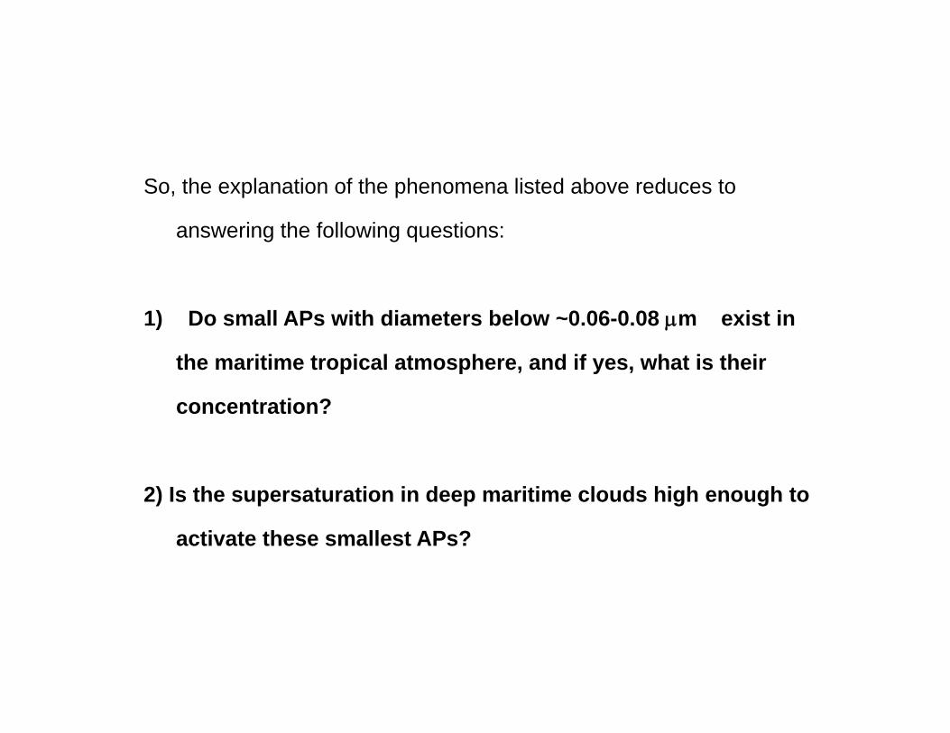
So, the explanation of the phenomena listed above reduces to
answering the following questions:
1) Do small APs with diameters below ~0.06-0.08 m exist in
the maritime tropical atmosphere, and if yes, what is their
concentration?
2) Is the supersaturation in deep maritime clouds high enough to
activate these smallest APs?

Remote maritime APs
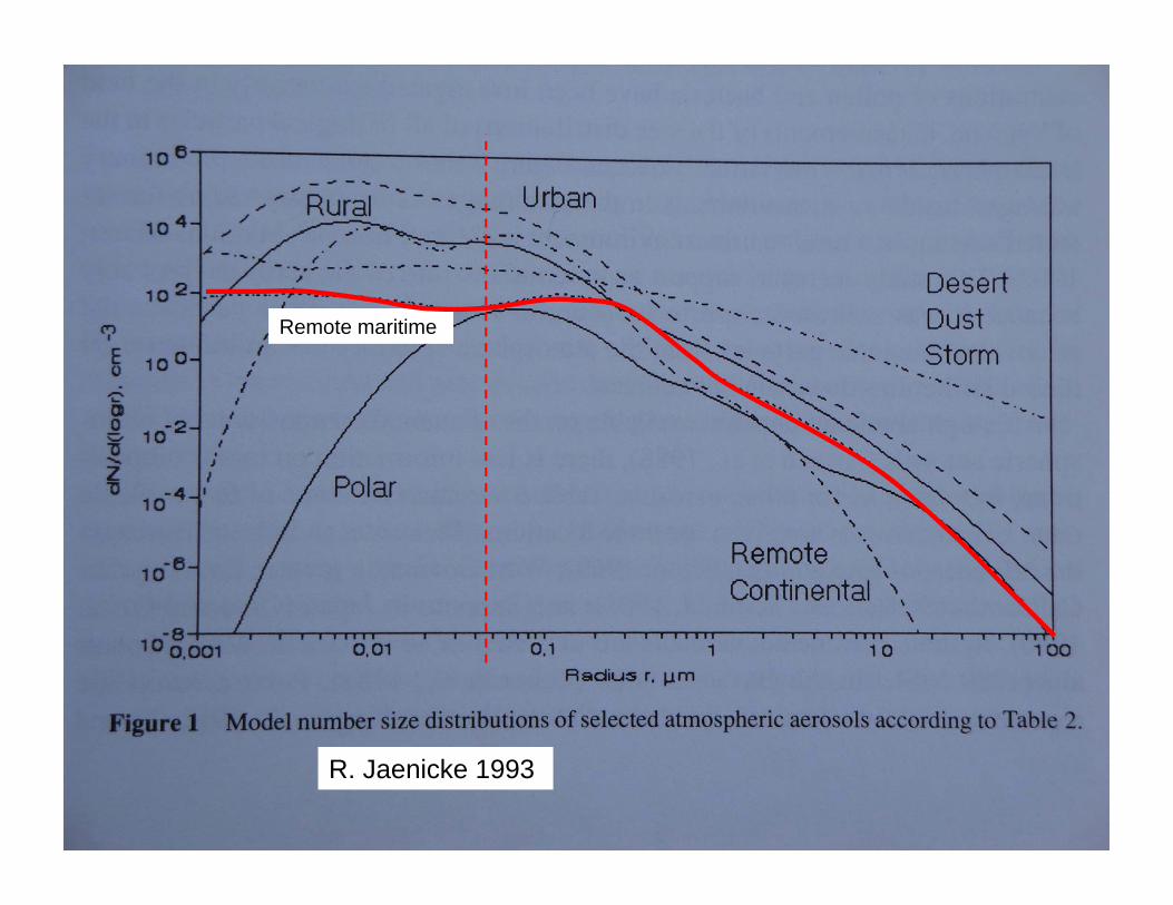
Remote maritime
R. Jaenicke 1993
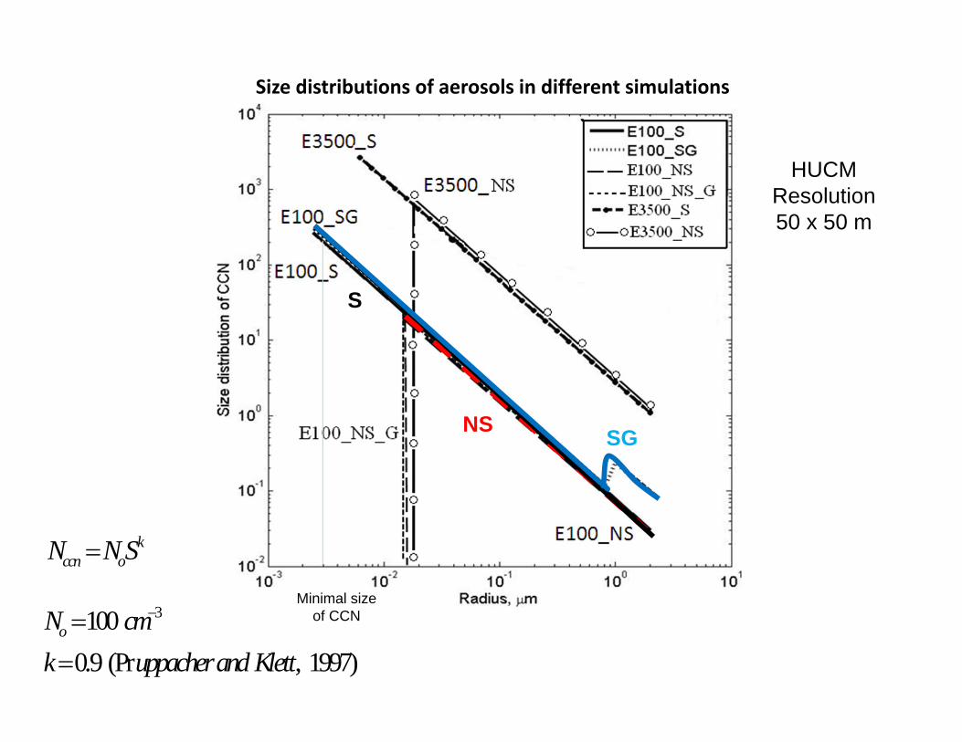
Size distributions of aerosols in different simulations
kccn oN NS
31000.9 (Pr , 1997)
oN cmk uppacherand Klett
HUCMResolution50 x 50 m
NS
S
SG
Minimal size of CCN
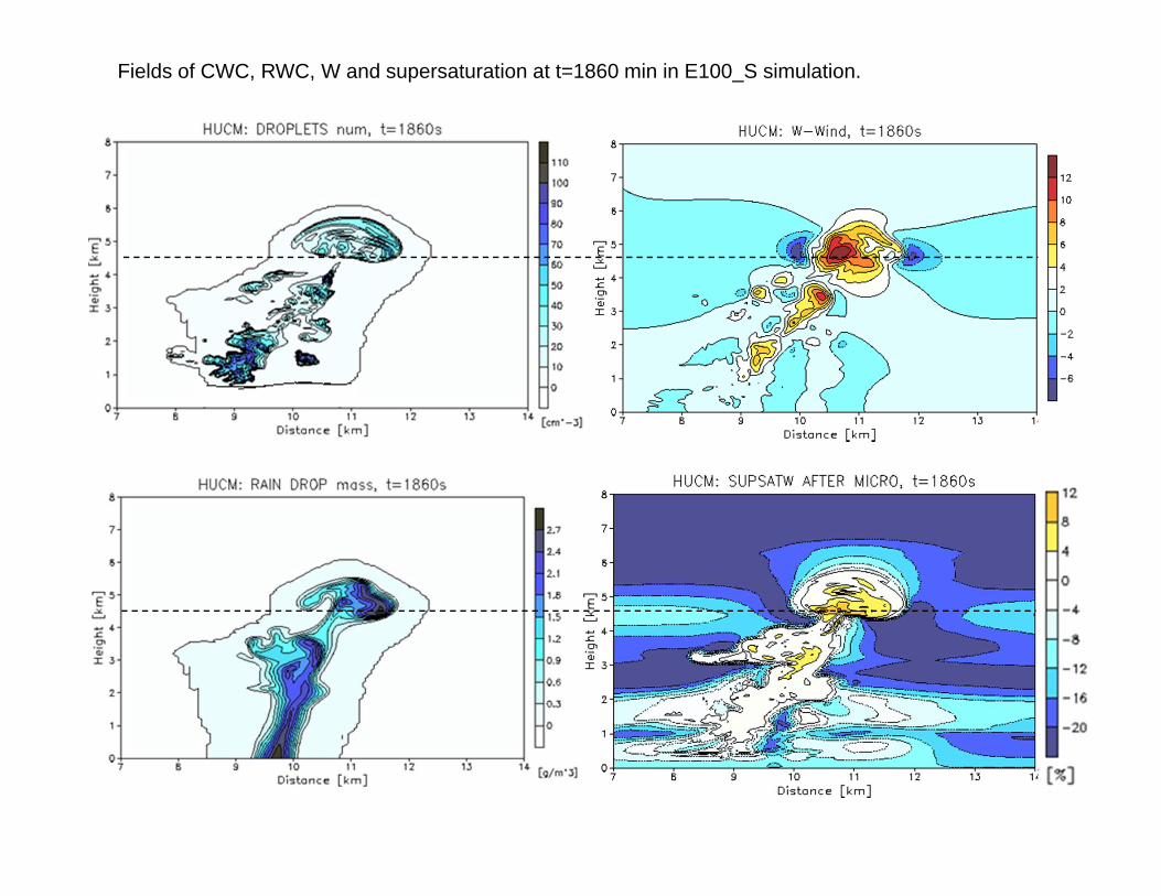
Fields of CWC, RWC, W and supersaturation at t=1860 min in E100_S simulation.
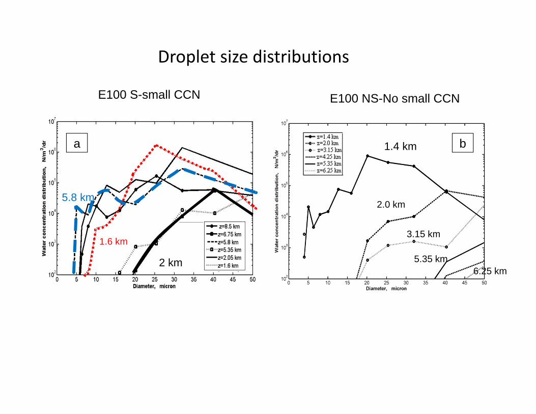
Droplet size distributions
a b
1.6 km
5.8 km
1.4 km
2.0 km
3.15 km
5.35 km6.25 km
E100 S-small CCN E100 NS-No small CCN
2 km

ba
Droplet concentration, cm-3 Liquid water content , g m-3
a b
NSS
NS
S
Max droplet concentration Max LWC

total ice content ice crystal concentration
NSS
NSS
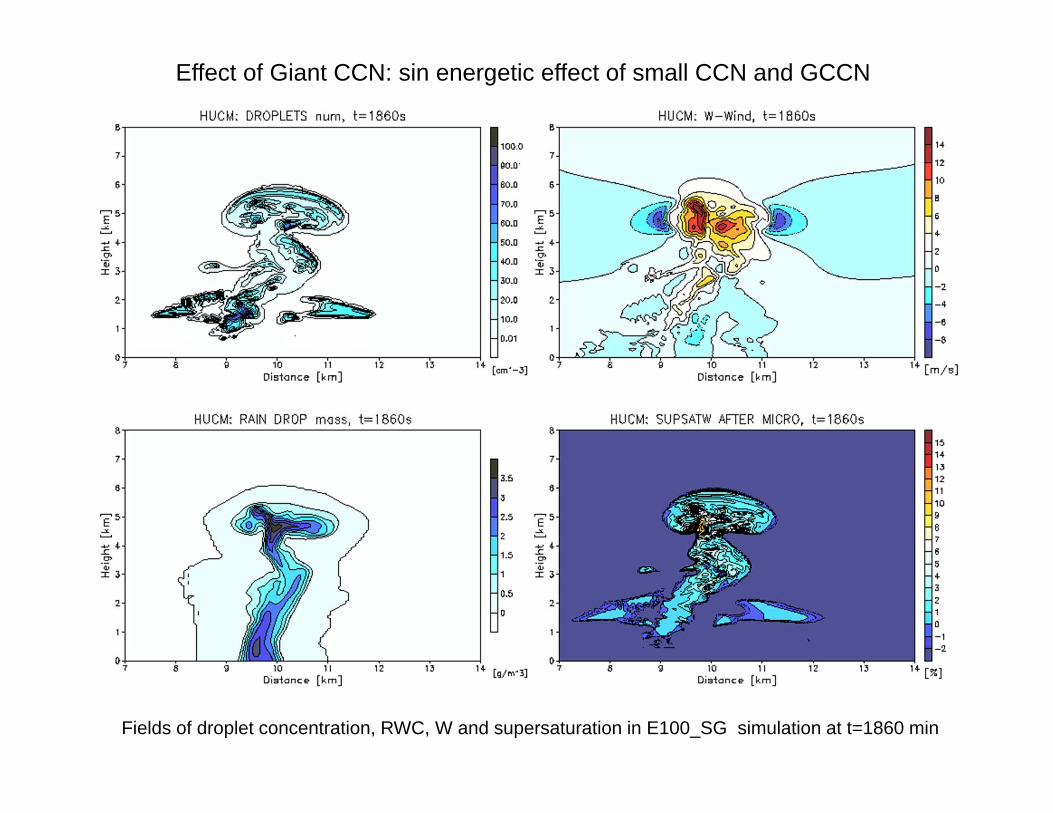
Fields of droplet concentration, RWC, W and supersaturation in E100_SG simulation at t=1860 min
Effect of Giant CCN: sin energetic effect of small CCN and GCCN

Effect of Giant CCN: sinenergetic effect of small CCN and GCCN
ba
Droplet concentration, cm-3 Liquid water content , g m-3
a b
S
S
Max droplet concentration Max LWC
S+GS+G
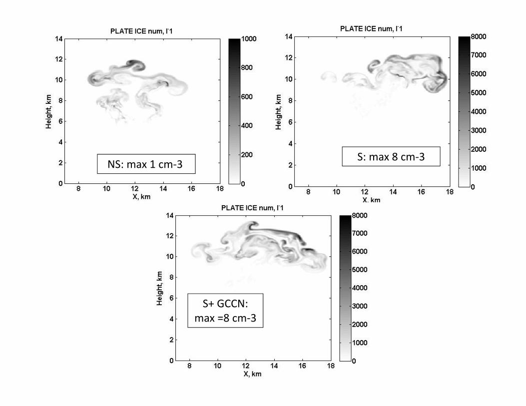
NS: max 1 cm‐3 S: max 8 cm‐3
S+ GCCN: max =8 cm‐3

Lightning potential
a b
c
NS S
S+GCCN
E100_S, Lightning potential, cm-9E100_NS, Lightning potential, cm-9
E100_SG, Lightning potential, cm-9

Figure 2. Eye-wall lightning density in hurricane Katrina when it progressed from Cat 4 to 5 (17:30-18:30 UTC, 28 Aug 2005) (left) and in hurricane Rita (right panel) during its intensification from Cat 3 to 5 (14–15 UTC, 21 Sep 2005) (right) (after Shao et al., EOS, 86, 42, 18 Oct. 2005)

Discussion and conclusions
1) atmospheric aerosols with diameters below ~0.08 m play an important role in the creation of microphysical structure of deep convective clouds over the ocean.
2) In-cloud nucleation and formation of small cloud droplets several km above the cloud base explain formation of supercooled water at high levels, formation of graupel and ice crystals in cloud anvils.
5) The existence of giant CCN and other factors accelerating warm rain formation cannot prevent formation of new droplets aloft. Moreover, the faster is washout due to warm rain, the higher can be supersaturation in clouds aloft and the greater the production of supercooled droplets at upper levels.
4) The process of in-cloud nucleation allows one to explain formation of lighting in extremely maritime clouds in eyewall of hurricanes, high optical depth of anvils of deep tropical clouds in the ITCZ.

THANK YOU!