The Role Of Institutional Mechanisms In Spatial Data Infrastructure Development That Supports
27
1 The Role Of Institutional Mechanisms In Spatial Data Infrastructure Development That Supports Decision-Making Mary-Ellen Feeney and Ian Williamson Centre for Spatial Data Infrastructure and Land Administration, Department of Geomatics, The University of Melbourne, Victoria 3010, Australia http://www.geom.unimelb.edu.au/research/SDI_research/ 1 PhD Candidate Email: [email protected] 2 Professor of Surveying and Land Information, Phone: +61 3 8344 4431 Fax: +61 3 9347 4128 Email: [email protected] Keywords: Institutional mechanisms, institutional framework, spatial data infrastructures (SDI), decision-making, decision process, decision phases ABSTRACT Improved economic, social and environmental decision–making are principal objectives for investing in the development of spatial data infrastructure (SDI) at all political and administrative levels. So much so, resolution 7 of the recent 5 th Global Spatial Data Infrastructure (GSDI) conference in Cartagena, Colombia argued that the purpose of the GSDI is to improve the availability, accessibility, and applicability of spatial information for decision-making (GSDI 2001). While accepting the development of institutional mechanisms support decision-making by promoting the availability and accessibility of spatial information as part of SDI institutional frameworks, many institutional mechanisms fall short of addressing the applicability of spatial data to the decision environments. From an institutional perspective the motivation for SDI implementation is driven by the impracticality of a single organisation producing and maintaining the wide variety of data and models needed to inform many decisions, which results in a need for sharing of data and a range of analytical and display tools. This is being seen particularly in the natural resource, environment and government sectors in Australia. These sectors are utilising institutional mechanisms to support spatial decision-making processes in a number of different ways including the development of community resource centers, departmental development of decision support tools, as well as the development of atlases, spatial data
Transcript of The Role Of Institutional Mechanisms In Spatial Data Infrastructure Development That Supports

1
The Role Of Institutional Mechanisms In Spatial Data Infrastructure Development
That Supports Decision-Making
Mary-Ellen Feeney and Ian Williamson
Centre for Spatial Data Infrastructure and Land Administration, Department of Geomatics, The University of Melbourne, Victoria 3010, Australia
http://www.geom.unimelb.edu.au/research/SDI_research/
1PhD Candidate Email: [email protected]
2Professor of Surveying and Land Information, Phone: +61 3 8344 4431 Fax: +61 3 9347 4128
Email: [email protected]
Keywords: Institutional mechanisms, institutional framework, spatial data infrastructures (SDI), decision-making, decision process, decision phases
ABSTRACT
Improved economic, social and environmental decision–making are principal objectives for investing in
the development of spatial data infrastructure (SDI) at all political and administrative levels. So much
so, resolution 7 of the recent 5th Global Spatial Data Infrastructure (GSDI) conference in Cartagena,
Colombia argued that the purpose of the GSDI is to improve the availability, accessibility, and
applicability of spatial information for decision-making (GSDI 2001). While accepting the
development of institutional mechanisms support decision-making by promoting the availability and
accessibility of spatial information as part of SDI institutional frameworks, many institutional
mechanisms fall short of addressing the applicability of spatial data to the decision environments.
From an institutional perspective the motivation for SDI implementation is driven by the impracticality
of a single organisation producing and maintaining the wide variety of data and models needed to
inform many decisions, which results in a need for sharing of data and a range of analytical and display
tools. This is being seen particularly in the natural resource, environment and government sectors in
Australia. These sectors are utilising institutional mechanisms to support spatial decision-making
processes in a number of different ways including the development of community resource centers,
departmental development of decision support tools, as well as the development of atlases, spatial data

2
directories and on-line land information services. In Australia these institutional mechanisms are
playing a crucial role in providing the building blocks for the institutional framework of SDIs and
address different levels of the decision-making process.
This paper looks at how availability and accessibility of spatial data are being achieved by examples
from each of the institutional mechanisms mentioned. The variety of decision-making levels supported
by these different initiatives is reviewed in terms of decision process theory. The paper concludes with
a discussion of the implications of the approaches to developing institutional support for decision-
making as part of SDI development, as well as a consideration of directions for SDI development in the
future to support spatial decision-making processes.

3
INTRODUCTION
Many national and regional programs and projects are working to improve access to available
spatial data, promote its reuse, and ensure that additional investment in spatial information
collection and management results in an ever-growing, readily available and useable pool of
spatial information. This is considered a key function of a Spatial Data Infrastructure or SDI
(GSDI 2001). Resolution 7 of the recent 5th Global Spatial Data Infrastructure (GSDI) conference
in Cartagena, Colombia, proposed that the purpose of the GSDI is to improve the availability,
accessibility, and applicability of spatial information for decision-making and set up a working
group to investigate the topic (GSDI 2001).
Availability, accessibility and applicability are data functions that are essential to the three
functional components (phases) of decision-making – intelligence/problem formulation, design
and choice (identified by Simon (1960) and still the basis of modern decision process theory and
decision science (Cleaves 1999)). The intelligence (or problem formulation) phase involves
scanning the environment for data relevant to finding the answer(s) to the decision, and thus is
essentially about the discovery of what data is available to support the decision-making process.
The design phase requires that data be obtained, processed and examined for clues towards the
answer(s) to the decision, and is thus reliant on access to data and technologies enabling the
analysis of possible courses of action, generating possible solutions and for testing solutions for
feasibility. The choice phase involves the selection of an alternative/course of action from those
available and relies completely on how the available and accessible data were able to be applied
(visualised, analysed and modelled) to the decision.
To address the functions of availability, accessibility, and applicability institutional frameworks
have been developed to implement and support spatial data use and access. Institutional
frameworks are those supporting the organising, promotion and use of public objects (Turner
1984 p422), in this case interoperable digital geographic data and technologies. The role of the
institutional framework in the development of the Australian SDI (ASDI) was recognised in 1996
(ANZLIC 1996) when it was identified as one of the ASDI’s four key components, alongside the
clearinghouse network, standards and fundamental datasets, which were the other three
components named.
The institutional framework of the ASDI constitutes the policy and administrative arrangements
for building, maintaining, accessing and applying the standards and datasets (ANZLIC 1996 p5).

4
Whilst inroads have been made in promoting data availability and access, the shortfall in current
institutional frameworks occur in the promotion of the applicability of data to support decision-
making beyond information discovery and visualisation, through to analysis and modelling.
This paper aims to discuss the development of SDI institutional frameworks that not only support
data products but address the inclusion of technologies and services in order to support a broader
range of spatial decision-making processes. It will review the institutional mechanisms currently
being utilised in Australia towards developing institutional frameworks that support access to
data, data availability and accessibility and in some instances also technologies, for spatial
decision-making processes. The variety of decision-making levels supported by these different
initiatives is reviewed in terms of decision process theory. The paper concludes with a discussion
of the implications of the approaches to developing institutional support for decision-making as
part of SDI development, as well as a consideration of directions for SDI development in the
future to support spatial decision-making processes.
SPATIAL DATA INFRASTRUCTURES
Spatial Data Infrastructure (SDI) is developed for the purpose of supporting ready access to
geographic information to support decision-making processes at different scales for multiple
purposes. SDI is achieved through the coordinated actions of organisations (people) that promote
awareness and implementation of complementary policies, common standards, and effective
institutional mechanisms for the development and availability of interoperable digital geographic
data and technologies. It is the institutional mechanisms, in particular, which are of interest in this
paper.
The institutional framework of the ASDI constitutes the policy and administrative arrangements
for building, maintaining, accessing and applying the standards and datasets (ANZLIC 1996 p5).
The “institutional framework” is about ‘who’ does what and the provision of “leadership” (Rush
2000 p5). SDI development is now recognised as both a private and public sector endeavour and
involves the academic sector as well. The creation of a national private sector spatial information
organisation, the Australian Spatial Industry Business Association (ASIBA), to complement the
work of the public coordination body, Australia New Zealand Land Information Council
(ANZLIC), has arisen from identifying the benefit of joint dialogue and decision-making on SDI
development (ISR 2001). However, it is largely through the institutional mechanisms, or the
‘how’ of the institutional framework, that the benefits of collaboration have been demonstrated.

5
This can be seen through examples of private and public sectors formalising arrangements for the
availability, pricing, access and custodial arrangements for data (ISR 2001, CIC 2001).
Spatial information is potentially very useful for many applications within the community but has
historically not been easily accessible to the majority of people without geographical information
systems (GIS) software or skills. There are a variety of institutional mechanisms that bridge this
gap to viewing and manipulating spatial data to support spatial decision-making processes within
the user community. These include the development of atlases, spatial data directories, on-line
cadastral-based services, community resource centres as well as the development of specific
decision support tools. These approaches will be discussed subsequently, but move progressively
from visualisation tools and interoperable digital geographic data development towards those that
also provide the availability of technologies to support spatial decision-making at different levels,
including analysis and modelling.
Including technological support as part of the developing infrastructure (Figure 1) is a more
expansive understanding of SDI than many definitions (see for example those reviewed in Chan
et al. 2001, as well as the definition proposed by Rajabifard et al. 2002). However, the role of
spatial technologies in the operations of the infrastructure has been recognised as essential to
meeting the needs of the multi-disciplinary and multi-participant environments that characterise
decision-making for sustainable development (Agenda21 1993, GSDI 2001). SDI cannot exist as
a means in itself – it is essential the infrastructure support the development of spatial data
products, services and the needs of diverse decision-making environments.

6
Further to this, as the infrastructure evolves people may access spatial data through the technical
components (defined by Rajabifard et al. (2002) as access networks, policies and standards and
equivalent to the clearinghouse network and standards of the ASDI model (ANZLIC 1996)) either
directly (Figure 1a), or through technologies that will visualise, map or model the data (Figure 1b)
prior to the data being used as information in decision-making activities. The current emphasis for
people accessing data through SDI is on these technical components (Figure 1a). However, the
authors’ believe these will become increasingly transparent to data users, as access is increasingly
sought to ‘simplified answers’, or data shaped (integrated, analysed, modelled) through
technologies like decision support systems (DSS), rather than in its raw form. The transition to
this model of ‘applied’ data access and use (delta SDI (?SDI) in Figure 1b) will require
institutional mechanisms to support the availability and access to integrated data and
interoperable technologies. Clearinghouse development, online services, decision support
technologies and community resource centers are examples of institutional mechanisms that may
contribute to the transition.
Access Networks
Standards Policies
Data
People
SDI
Technologies
Access Networks
Standards Policies
Data
People
SDI
Technologies ?SDI
Figure 1a: Proposed model of current SDI access and use, where users access the data directly via the technical components (shaded) or at times employ decision support technologies for the visualisation, analysis or modelling of data. Denotes lesser method of data access
Denotes prominent method of data access
Figure 1b: Delta SDI (?SDI) represents transition to an SDI model of integrated data and interoperable technology access and use, where the technological components of SDIs (shaded) will become increasingly transparent to data users, as access is sought to data shaped (integrated, analysed, modelled) through decision support technologies, rather than in its raw form.

7
INSTITUTIONAL MECHANISMS TO SUPPORT
DECISION MAKING PROCESSES
Many communities are now using spatial information to help address business needs regarding
resources or industries. Examples such as the Murray Darling Basin Commission
(http://www.mdbc.gov.au/) and the Fitzroy Basin Association demonstrate influence in
instigating regional community cooperation towards spatial information sharing and
development. These two examples have developed across local and state jurisdictions, driven by
the urgent need for a coordinated and participatory approach to natural resource and
environmental decision-making. The SunRISE21 project (Victoria (VIC)), Herbert Resource
Information Centre (Queensland (QLD)) and the Central Highlands Regional Information Service
(QLD) are three other examples of communities using spatial information to assist decision-
making (Barker et al. 1999). These and similar projects (Barker et al. 1999) demonstrate the need
for more communities to have access to spatial information and the tools and skills which allow
for them to plan better and make more informed decisions.
Government agencies are the custodians of large amounts of spatial data useful to the community.
Recent technological developments have caused the democratisation in the ways communities
access information and knowledge as well as the demand for more flexible service delivery from
government, including access to tools, spatial information and the skills to interpret the
information (Barker et al. 1999). Recent work has been done to propose ways by which
government can interact with community and industry to improve the flow of information (Barker
et al. 1999), particularly spatial information, between data custodians and users. Government has
an important role to play in developing infrastructure that supports the discovery, access and
applications of spatial information and tools for decision support.
There are a number of delivery mechanisms currently used for communities to get access to
spatial data and knowledge. These range from individuals including consultants, government
representatives and data brokers, who have access to data, GIS and other spatial technologies, and
interpretative skills; through to online services delivered through web sites either created and
maintained by communities and centred on the business and information needs of that
community, or government web sites. Resource Centres for communities are a further example
where a suitable combination of integrated data sets, internet tools, web sites, extranets and
facilitators/consultants are selected to help users with their information needs. These mechanisms

8
are being used as part of the SDI institutional framework being developed to support access to
data, and in some instances also technologies, for structuring spatial data for decision-making.
To this end government are providing support for decision-making through institutional
mechanisms providing the availability and access to spatial information and facilitating varying
degrees of spatial data applications. These institutional mechanisms include the development of
atlases, spatial data directories, on-line cadastral-based services, community resource centres as
well as the development of specific decision support tools. These approaches will be discussed in
the following section with a particular focus on the degree each institutional mechanism supports
data availability, access to data, and in some instances also technologies, for structuring spatial
data for decision-making processes at different levels. Examples of each of the institutional
mechanisms will be provided.
Atlases
Atlases represent a network of spatial data nodes which give citizens map-based access to
viewing a wide variety of data held by different custodian agencies. The data may be gathered in
different formats, using a range of variables and being presented at a range of scales. At any
particular scale specified the atlases present to a user the datasets for which spatial data are
available.
Atlases function as a way of discovering, selecting and visualising spatial data, with many
providing facilities for overlays and map customisation. They are principle tools in the
intelligence phase of the decision process, detecting data availability, especially for linking levels
of data between local, state and national jurisdictions. For instance, the Australian Coastal Atlas is
a network of Commonwealth and State/Territory nodes using a variety of interactive desktop
mapping tools to provide information about the Australian coastal environment. The Atlas
includes maps and images of the coastal zone showing information about water quality, climate,
fisheries and more. It enables users to view layers of information about the Australian coast, as
well as assemble and print user-developed custom maps. The Tasmanian (TAS) node of the
Australian Coastal Atlas is pictured in figure 2, as part of the Land Information System of
Tasmania (LIST).

9
Figure 2: Tasmanian node of the Coastal Atlas
Different agencies within each state jurisdiction have custodial responsibilities for the data that
gets presented in the atlases and thus different institutional arrangements. The national node of
the Australian Coastal Atlas has recently been integrated with the Australian Natural Resources
Atlas (http://www.ea.gov.au/coasts/atlas/). However, whilst the QLD node of the Natural
Resource Atlas (http://www.dnr.qld.gov.au/resourcenet/atlas/) is coordinated by the Department
of Natural Resources and Mines’, the QLD node of the Australian Coastal Atlas
(http://acaweb.dpi.qld.gov.au/atlas/atlaspage.html), is coordinated by the Environmental
Protection Agency and the Department of Primary Industries (DNRM 2001). Taking a slightly
different approach, both the Northern Territory (NT) nodes of the Coastal Atlas and Natural
Resource Atlas, occur under the umbrella of the NT Atlas (http://www.lpe.nt.gov.au/
atlas/index.html), pictured in Figure 3, which is coordinated by the Department of Land, Planning
and Environment.
Whilst the nodes may be accessed via different entry points in each state (generally as a function
of their different governments’ institutional arrangements), what is important to note is that the
atlases provide a network through which publicly available spatial data, relevant to particular
locations, is discoverable and viewable both within and between jurisdictions. This is exemplified
by the Western Australian (WA) Boating Atlas (http://www.transport.wa.gov.au/
imarine/coastal_fac/boating_atlas/index.html), which presents information about recreational and
commercial boating facilities around the State from local governments, State porting authorities

10
and Department of Transport, alongside tidal information from the Australian Hydrographic
Office. This atlas provides details of boat harbours, boat ramps and other boating facilities, with
links to tides and waves data.
At a regional level the QLD Central Highlands Regional Resource Use Planning Project
(CHRRUPP) has produced the Central Highlands Atlas (http://chrrupp.tag.csiro.au/Resources/)
that presents on-line maps featuring basic coverages of vegetation, soils, land systems and socio-
demographic data. The process of overlaying data on maps gives the user the opportunity to
examine whether the data is fit for use towards answering the question at hand and contributes to
the preliminary design phase of the decision process. CHRRUPP supports a range of stakeholders
and assists them in managing regional natural resource management issues and decisions with a
focus on regional planning for sustainable natural resource use. CHRRUPP coordination is via
representatives/observers from a range of groups and agencies such as pastoralists; graingrowers;
aboriginal community; food and fibre producers; mining industry; local government; state
government; federal government; Central Queensland University, and Landcare (DNRM 2001).
Individual local government areas (LGAs) have also begun to make spatial information available
to the public via atlas facilities. Caloundra City Council (in QLD) has established an atlas facility
(using ArcIMS) (http://maproom.caloundra.qld.gov.au/Other/entry.htm) where clients can inquire
about tourist and environmental information within the Caloundra LGA area (DNRM 2001).
Spatial Data Directories
A spatial data directory is a tool to improve data discovery for the spatial data industry,
government, education and the general community by collecting and storing information about
datasets (metadata) and databases. Such a directory is supported through effective documentation,
advertisement and distribution of spatial data. The agency coordinating the directory is able to
increase the knowledge infrastructure for a community by enabling members to better identify
appropriate datasets and communication links with custodial agencies, often facilitating data
accessibility, and the intelligence and design phases of the decision process.
The Australian Spatial Data Directory (ASDD) is a national example
(http://www.environment.gov.au/net/asdd/), with nodes supported and maintained by all
governments under the auspices of ANZLIC (Australia and New Zealand Land Information
Committee) as well as the private sector (for example AIRESEARCH (ANZLIC 2000)). The

11
directory is a distributed system of links between government and commercial nodes in each
state/territory as well as spatial data agencies within the federal government. The directory
incorporates information about datasets (metadata) from all jurisdictions and is thus a key
component linking local, state and national SDIs.
This is further exemplified through Interragator On-line, the WA spatial data directory, which has
both textual and spatial search capabilities and is the first step in accessing geographic and land
information in WA. With Interragator On-line a comprehensive index to over 10,000 records of
WA's geographic and land information held by public and private sector organisations can be
searched (WALIS 2001) using metadata for the discovery and locating of digital mapping, spatial
databases, aerial photography, satellite imagery and environmental impact statements.
Interragator On-line is part of the ASDD, thus linking various directory services around Australia,
but is further searchable from the USA Federal Geographic Data Committee (FGDC) Entry Point
to the Geospatial Data Clearinghouse (WALIS 2001). This entry point provides several interfaces
to search for spatial data, which demonstrates the consistency attainable between different
jurisdictions’ metadata initiatives and the potential for a global directory service once
compatibility is achieved at the international level.
Other examples of directories in Australia include the Australian Geographic Information on the
Web (http://www.gsdi.org/canberra/asdd.html) and the InterNet Resources for Land Information
Systems (http://www.library.unisa.edu.au/internet/pathfind/land.htm ). At the State government
level the New South Wales (NSW) Natural Resources Data Directory
(http://www.nrims.nsw.gov.au/nrdd); the NT (http://www.lpe.nt.gov.au/servlet/NTSDD), South
Australian (SA) (http://www.environment.gov.au/net/asdd/tech/node/sa-1.html), VIC
(http://www.giconnections.vic.gov.au/), and TAS (http://www.thelist.tas.gov.au/) Spatial Data
Directories; as well as the data menu for the QLD Spatial Information Infrastructure Strategy
(http://www.qsiis.qld.gov.au/cgi-bin/php/index.phtml?menu=QSIIS+Home) are several
examples. These can be further augmented by detailed government department directories such as
that for the VIC Department of Natural Resources and Environment (http://www.nrsc.com.au/).
Whilst these spatial data directories are primarily services for distributed data discovery, using
metadata, they may be extended to form the basis of a clearinghouse, which is a distributed model
for data access. In principle a clearinghouse is developed from the building block of a spatial data
directory through the addition of several new metadata elements, the key being the URL

12
providing the link to Web sites for data access/ordering (ANZLIC 2000). Clearinghouses are
considered a key component of the Australian SDI (ANZLIC 1996) as they are considered the
technological framework established to give the community access to fundamental datasets. This
is achieved where data from distributed databases would be able to be linked and integrated by
common standards and policies in order to be accessible to the community (ANZLIC 1996).
Whilst improved data dissemination is facilitated by a clearinghouse in the short term, on-going
access to the data will eliminate the need for users to incrementally update their data copies,
because they will always have access to the most recently maintained data. This will greatly
increase the support for the design phase of the decision process.
On-line Cadastral-based Services
In practice the technical difficulties of interoperability and the lack of comprehensive standards
mean there are fewer successful examples of clearinghouse models than directories and integrated
on-line data visualisation and service facilities developed in the different states in Australia.
Access to direct data down-loading is also still frequently constrained by the development of
institutional agreements, the implementation of pricing and licensing policies, and the market
definition of user needs. The development of on-line land information, or cadastral-based services
has provided the intermediary systems for accessing different forms of land information (often
summaries, graphs, tables or reports rather than raw data) and technological services for the
presentation or desk-top manipulation of that information. These functions facilitate the design
and choice phases of the decision process through the examination of available data and the
limitations that may influence the decision alternatives generated from these for the choices
phase.
The activities of Community Access to Natural Resource Information (CANRI) in NSW in the
provision of data discovery, visualisation and preliminary data delivery and dissemination
mechanisms through a generic graphical user interface, are an example of such online services,
centred in the domain of natural resource information. The CANRI technology framework is
based on the Integrated Community Mapping and Information Support System (ICMISS), which
pioneered distributed web mapping with its release in 1998-99 and has been an influential model
for the development of international standards for web mapping by the OpenGIS Consortium
(CANRI 2002). CANRI applications like the NSW Natural Resources Atlas use the NSW Natural
Resources Data Directory (NRDD) as a catalogue to discover and access online datasets.
However, in addition to the ANZLIC-standard metadata, accessible to NRDD users, CANRI

13
applications use metadata extensions designed specifically for online data access. (Though at
present this does not extend data-download access directly to users due to the nature of many of
the institutional agreements with data providers for many of the datasets). The ongoing
modification of the format of this metadata and the interface to comply with the OpenGIS
Catalogue Interface specifications enable CANRI applications to also make use of other
catalogues of data and services as they emerge.
CANRI has been conceived as a framework for information sharing to meet the increasing need
for easy, integrated access to a wide range of natural resource and environmental data. CANRI
uses the Internet to connect the information resources of many different organisations in situ,
without requiring them to surrender data to a centralised depository, but additionally without need
for users to ‘click through’ from site to site to source data they are after – access to data is
through the single CANRI web site. The CANRI framework supports access to a wide range of
remote data servers over the web; any data server which complies with the OpenGIS Web Map
Server specification is supported (CANRI 2002). A growing number of GIS vendors are now
providing such products and alternative low-cost bridges can be built for most data sources. This
enables The CANRI framework to make use of independent information services available on the
web, therefore not only making government information available to the community, but enabling
community groups and individuals the opportunity to contribute their own information and share
it with others through the CANRI website. The flexibility of the CANRI model will accommodate
the transition proposed by the authors (Figure 3) from SDI being predominantly a raw data
facility to an infrastructure providing access to derived data, models and data applications and
services. The ?SDI accomodates the evaluation, analysis and modelling of the design phase of the
decision process and the comparative analysis of alternatives of the choice phase.

14
Figure 3: The Northern Territory Atlas
The key priorities of CANRI users are perceived to be web-based discovery of suitable data, easy
access to visualisation tools, and for some datasets also data downloads of key data sets (NSW
State of the Environment data are one example utilised frequently by local councils) (CANRI
2002). In terms of the provision of on-line technologies, a geographic projection service is
currently built in to the CANRI application server and this area of the architecture is expected to
grow with the availability of gazetteers, address geocoding, image processing and other services
(CANRI 2002).
The land information systems service centres developed to facilitate spatial data product
discovery, access and visualisation and services in relation to government transactions, are a
particular example of the online services that have achieved widespread interpretation through
different jurisdiction in Australia and around the world. Service New Brunswick (SNB Canada),
Land Information Systems Tasmania (LIST, Figure 4), the Western Australian Land Information
System (WALIS, Figure 5) and GIconnections (VIC) represent three examples of these, generally
cadastre-based spatial information systems (GIconnections 2002, LIST 2001, SNB 2001).

15
Figure 4: The LIST – Land Information System Tasmania
Figure 5: The WA Land Information System – WALIS
Within the QLD Government, a number of agencies are creating or have created applications that
provide interpreted spatial information on GovNet and/or the Internet. These applications target
general as well as specific audiences. They include, Department of Primary Industries’ Coastal
Habitat Research Information System (CHRIS, http://chrisweb.dpi.qld.gov.au/chris/); Public
Works’ Queensland Building Information System (QBIS, http://www.build.qld.gov.au/
amps/qbis.htm); Sport and Recreation Queensland’s Outdoor Resource Inventory System (ORIS);
and Natural Resources and Mines’ Burnett Catchment Web GIS (http://www.dnr.qld.gov.au/
resourcenet/land/lris/webgis/burnett/maps/mapdisplay.html) and the Interactive Resource and
Tenure Maps of QLD (http://www.dme.qld.gov.au/resdev/qmin_ims.htm) (DNRM 2001).

16
Aside from cadastral-based projects the Federal Government has established a Government
Online Project which aims to make information concerning all appropriate Federal Government
services available online by 2002 and to establish a single point of access to information about
Government agencies (AUSLIG 2001). The development of whole -of-Government standards and
systems will provide online access to Commonwealth geographic data holdings. The project aims
to provide some simple interactive mapping applications where data is sourced from various
custodian agencies, integrated and delivered via the Internet (AUSLIG 2001). This will build
experience for more complex projects, test the technology for more widespread use and test data
access issues within the Commonwealth.
Community Resource Centres
The main aim of Community Resource Centres (CRCs) is to assist community empowerment by
making tools, information, and the skills with which to interpret information, more accessible.
Ideally resource centres for communities provide opportunities for stakeholders to share and
exchange information, so the process is not simply one of dissemination. If a CRC is to improve
access to information for a community so that they can participate in planning and decision-
making processes, Barker et al. (1999) believe it must have skills, technology, products and tools,
data and credibility. These elements are elaborated on in Table 1.
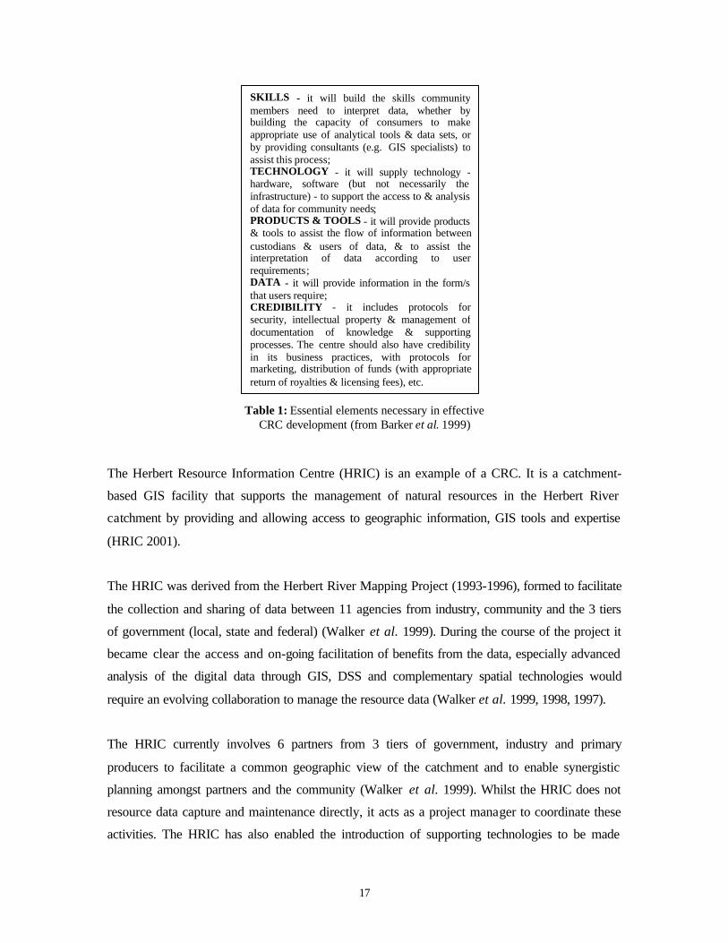
17
SKILLS - it will build the skills communitymembers need to interpret data, whether bybuilding the capacity of consumers to makeappropriate use of analytical tools & data sets, orby providing consultants (e.g. GIS specialists) toassist this process;TECHNOLOGY - it will supply technology -hardware, software (but not necessarily theinfrastructure) - to support the access to & analysisof data for community needs;PRODUCTS & TOOLS - it will provide products& tools to assist the flow of information betweencustodians & users of data, & to assist theinterpretation of data according to userrequirements;DATA - it will provide information in the form/sthat users require;CREDIBILITY - it includes protocols forsecurity, intellectual property & management ofdocumentation of knowledge & supportingprocesses. The centre should also have credibilityin its business practices, with protocols formarketing, distribution of funds (with appropriatereturn of royalties & licensing fees), etc.
Table 1: Essential elements necessary in effectiveCRC development (from Barker et al. 1999)
The Herbert Resource Information Centre (HRIC) is an example of a CRC. It is a catchment-
based GIS facility that supports the management of natural resources in the Herbert River
catchment by providing and allowing access to geographic information, GIS tools and expertise
(HRIC 2001).
The HRIC was derived from the Herbert River Mapping Project (1993-1996), formed to facilitate
the collection and sharing of data between 11 agencies from industry, community and the 3 tiers
of government (local, state and federal) (Walker et al. 1999). During the course of the project it
became clear the access and on-going facilitation of benefits from the data, especially advanced
analysis of the digital data through GIS, DSS and complementary spatial technologies would
require an evolving collaboration to manage the resource data (Walker et al. 1999, 1998, 1997).
The HRIC currently involves 6 partners from 3 tiers of government, industry and primary
producers to facilitate a common geographic view of the catchment and to enable synergistic
planning amongst partners and the community (Walker et al. 1999). Whilst the HRIC does not
resource data capture and maintenance directly, it acts as a project manager to coordinate these
activities. The HRIC has also enabled the introduction of supporting technologies to be made

18
available to users of the centre facilities, as well as consultation as to the application and
modification of such technologies for appropriate decision-making. The commitment of the HRIC
to assisting the interpretation of data according to user decision-making requirements is a
distinguishing factor of the CRC model and its support of the design phase of the decision
process.
One particular example of the introduction of technologies to support decision analysis and
alternative generation has been the web-based spatial DSS, NRM-Tools (CSIRO 2001). NRM-
Tools has been designed to explore issues and options in integrated natural resource management
and is being run in prototype through the HRIC such that the data and tools being run within the
current version are focussed on integrated resource issues from the Herbert River catchment
(CSIRO 2001).
Another example of a CRC is the Integrated Information Management System (IIMS) initiative
developed between 1996-1999 for catchment managers due to the lack of resources (data, models
and human skills) available to adequately respond to management issues (IREM 2000). It was
funded by the Land and Water Resources Research and Development Corporation, and has been
developed in collaboration between the Department of Natural Resources (QLD) and the
University of QLD in consultation with stakeholders and potential users (IREM 2000).
The aims of IIMS are to facilitate the use of research outcomes and government information by
Catchment Management Committees (CMCs) and allow them to identify the resource use options
available to stakeholders (other CMCs, rural landowners and Local Governments) to improve the
management of their land and water resources (IREM 2000). One key issue behind the project
was the design phase of the decision process and the few attempts made in Australia, to integrate
social, behavioural and economic data into spatial decision support systems (DSS) that could
assist planning decision-making (IREM 2000).
The results of the IIMS development were three prototype facilities developed for catchments in
QLD and NSW. IIMS prototypes for assessment in the Dee (QLD), Dawson (QLD) and
Liverpool (NSW) catchments (IREM 2000) were established as web-based facilities where
information, links to related information/legislation/technologies, research and particular DSS
could be established to aid catchment decision-making. The IIMS provides web-link access to

19
and advertises workshops for a Multiple Objective Decision Support System (MODSS) named
Facilitator (IREM 2000).
Well-established models of similar regional spatial data and technology initiatives exist, such as
the Central Highlands Regional Information Service (CHRIS with its online decision support
system Java AHP) in QLD (CHRIS 2001, CHRRUPP 2001) and Service New Brunswick in
Canada (SNB 2001). Although there are distinctive characteristics for each CRC and the
objectives behind them, similarities between models can be identified. Figure 6 demonstrates
Barker et al. ‘s (1999) model of a generic community resource centre.
Resource Centre for Community(skills, technology, products & tools, data, credibility)
Established by Joint Venture Partners – can be outsourced
JointVenturePartner(Federal
Govt)
JointVenturePartner(PrivateSector)
JointVenturePartner
(LocalGovt)
JointVenturePartner
(CommunityGroup)
JointVenturePartner
(StateGovt)
Organisations choose whether to be involved based on their business needs
Cost ofcommunityaccessoffset bycommunitycontribution(e.g. data,time incollection ofdata, etc.) Community Access
Government choice based oncontribution towards business
needs
Individual
Organisation
Trading directly with theResource Centre
Individuals or Community
DataSuppliers(Govt., Private
Sector,Community)
Clarity of licensearrangements (useof data, price, etc.)
Figure 6: Generic model for resource centres for communities (from Barker et al. 1999)
Decision Support Technologies
Decision support technologies, often integrated into systems (and therefore called DSS) can be
generally defined as “an interactive, computer-based tool or collection of tools that uses
information and models to improve both the process and the outcomes of decision-making”
(Lessard and Gunther 1999). The classic DSS is composed of a number of components:
1. Interface between the human and the computer
2. Model base (where the models of phenomena, rules, and other analytical capabilities reside)
3. Database

20
4. Communication among components
5. Analytical engine (to assemble the models and data and conduct the analysis)
6. Output and visualisation capability
This can reside within one computer, within an enterprise, or in a much broader context such as
distributed regionally or even globally across the Internet. This classic structure for a DSS is
within a human environment to identify and define problems, provide context, etc. and is
impoverished without the human component.
DSS’s have been developed and deployed for some time, particularly in the private sector, in
business-like activities in the public sector, and in the military. Applications to civilian public
policy issues are newer, although many economic policy models do provide support for monetary
and fiscal policy decisions. In recent years, there has been a considerable increase in interest in
combining the capabilities provided by DSS with those from geographic information systems
(GIS). The results, still evolving, are a new class of DSS, referred to as Spatial DSS, which apply
to geographically defined areas, such as catchments, cities, forests, or national parks.
Spatial DSS differ in several important ways from more traditional DSS, as a result of the type
and context of the problems they address: they apply to entire communities, public lands, or
publicly owned natural resources; they must attempt to bring together the disparate values and
objectives of multiple stakeholders; and they need to incorporate multiple sources of expertise
(e.g., hydrology, economics, biology, and engineering). By contrast, traditional DSS focus on
private sector resources, single decision-makers, and a narrower base of expertise. They are an
example of how DSS are evolving: from systems typically used by one or a small number of
specialists, which focus on narrowly defined private sector objectives using proprietary databases,
to those that are capable of reflecting broad social objectives, which encourage collaborative
decision-making about the places we live and work. Citizens and community groups are
increasingly demanding a voice in these decisions, and developers are responding.
An example is the development of Catchment and Natural Resource decision support
technologies in Australia. Already mentioned in relation to CRCs have been the online DSS Java
AHP as well as the natural resource management tool box, NRM Tools, and the Multiobjective
Decision Support System, Facilitator. Government departments have also been involved in the
development of DSS, which are becoming important institutional mechanisms for

21
interdepartmental sharing of information, analyses and communication with stakeholders on
cross-disciplinary issues.
Victoria’s Department of Natural Resources and Environment (DNRE) have developed
Catchment Decision Assistant (CDA), which is a windows based software package for building
decision trees, defining and recording criteria and ranking projects, issues and sites (Itami et al.
1999). The CDA software is an implementation of the Analytical Hierarchy process (AHP), a
method that helps experts identify criteria and weight the relative importance of each criteria for
complex decision making (Itami et al. 2000).
The motivations for developing CDA were provision of better access to information on catchment
conditions, expert interpretation of the data for decision makers, high quality outputs in the form
of maps, tables and graphs, and promotion of an information-based approach to decision making
using the best available knowledge (Itami et al. 2000). These motivations have been the same for
the NSW Department of Land and Water Conservation, which has similarly been developing a
business case for using comprehensive spatial analysis in catchment-scale planning, and
specifically for adopting the LAMPS Targets Analysis Process (TAP) as the standard method for
this type of analysis in NSW (DLWC 2001).
The Targets Analysis Process (and its supporting ‘Targets Toolkit’ of ArcView software and
Excel templates) has already been prototyped and fully trialed in the Murray and Murrumbidgee
regions, and has been partially trialed in the Central West (DLWC 2001). It involves a method of
harnessing the available expert and local knowledge to rapidly produce valid maps showing the
relative impact of a single action across the landscape towards a single target. These maps can be
overlayed to analyse relationships between actions (such as co-benefits and synergies) to
determine where maximum advantage will be obtained. A wide range of analytical and statistical
tools is available as a direct result of regional requirements identified during the prototyping
phase (DLWC 2001). Grid based analysis under the flexible and widely available ArcView GIS
environment allow more detailed techniques to be easily integrated into the framework – the
process is not intended to replace scientific modelling, but to offer an alternative in cases where
modelling is not available.
Despite these and other examples of the tools and systems available or under development to
support decision making, no one system will provide the broad range of capabilities required by

22
decision-makers and stakeholders. Some systems will be very sophisticated and others will still
be in their infancy. Furthermore, no one agency or developer will have the resources or mission to
develop and maintain the range of tools needed by the decision-maker. These considerations,
inconjunction with the current and evolving technology, fixed and shrinking budgets, and
increasingly complex challenges of resource management (Gunther 1999) combine to provide an
opportunity for expanded cooperation in accessing and developing interoperable decision support
tools and systems. They also provide the impetus for models and derived datasets to be equally
available and accessible through SDI. The latter will only foster an open and competitive supply
chain of value-added data and decision-support resellers and stimulate an evolving market of
spatial data and service provision.
FUTURE DIRECTIONS FOR SDI DEVELOPMENT
The institutional mechanisms discussed above provide different levels of support for the decision
process (intelligence, design and choice phases) in terms of the discovery, access to and
applicability of information available as well as the desired intent-of use. Obviously, there are
many existing methods to distribute data and knowledge to communities to assist spatial decision-
making. Ideally, the SDI institutional framework provides the facilities for stakeholders to share
and exchange information, so the process is not simply one of spatial data dissemination.
Atlases and directories provide the means for text and often spatial searches for data
discovery/availability to satisfy the intelligence phase of the decision process. These institutional
mechanisms as yet fall short of providing access to data for analysis and modelling or to derived
data products where this analysis has already been done by value-adding resellers, or where
models could be found through which to achieve this design phase of the decision process. The
capability for directories to provide more than unidirectional links to other sources of data and
accept the addition of independent data provide the foundations to support a competitive data
market and preliminary clearinghouse development for access and two-way dissemination of
data, but as yet are not widely used. Until such a time, however, the design and choice phases of
the decision process are limited to that based on available data visualisation in customisable data
atlases, and the proposed current SDI model (Figure 1a) of users accessing data directly through
the technical components of the SDI.
The online cadastral-based services, the community resource centres and decision support
technologies have a different emphasis to the atlases and directories. These institutional

23
mechanisms have greater capability to extend data availability and the intelligence phase of the
decision process to making tools, information, and the skills with which to interpret data, more
accessible, as well as offering broader support to the design and choice phases of decision
making. In terms of decision support technologies and systems (DSS) this refers more to
extending the interpretative capabilities to those without the analytical or modelling resources,
experience or alternatively extending the datasets derived from such analyses. In the existing
model of SDI (Figure 1a) the ability for DSS to contribute these advantages to supporting spatial
decision processes is much reduced by the focus of SDI on users accessing datasets directly. The
delta SDI model (Figure 1b) alternatively enables the exchange of derived datasets, models, and
other data services that not only increases the capacity of the spatial data market, but also the
ability for different phases of decision making. Participants with different levels of spatial data
skills are able to access the data directly, or through technologies able to visualise, model, analyse
and/or summarise spatial data. The variety of mechanisms enabling the presentation of spatial
data to be used for decision-making activities ultimately makes the derived delta SDI model more
flexible to the evolution of the spatial data market and adaptable to the changes presented by
users and the ongoing development of spatial technologies to support presentation and decision-
making.
Future directions for SDI development following the proposed delta-model (in Figure 1b) will
continue to require greater institutional framework development through mechanisms to meet the
challenges of diverse decision-making environments and spatial data interpretation. Issues such as
urban renewal, forest management, native title administration, coastal economic zone
management, defence, drought relief and landcare cannot be addressed without available,
accessible and applicable spatial data that address the decision process. This will require a greater
consideration be given to the range of mechanisms available to support decision processes,
provide interpretation, analysis and flexible applicability of spatial data to decision-making in
SDIs, as well as the perception of the infrastructure as purely a data facility.
CONCLUSIONS
The concept of a derived SDI model with institutional and technical frameworks enabling the
production of spatial data products, services, the long term support of spatial industry processes
and decision-making needs to be examined and debated. The ability of SDI to support decision-
making processes and a varied user environment is dependent on the current and developing

24
capabilities of SDIs to support spatial data and derived data products, models and decision
support technologies, through the mechanisms developed within institutional frameworks.
The interaction of the spatial data users and suppliers and any value-adding agents in between,
drive the development of any SDI. These present significant influences on the changing spatial
data relationships within the context of SDI jurisdictions. This paper looks at how availability and
accessibility of spatial data are being achieved by examples from a range of institutional
mechanisms. These mechanisms include spatial atlases, spatial data directories, online cadastral-
based services, community resource centres and decision support technologies. The variety of
decision-making levels supported by these different initiatives is reviewed in terms of the three
stage decision process theory established by Simon (1960) and still reviewed as the foundation of
decision process and decision science theory. While accepting that these mechanisms support
decision-making by promoting the availability and accessibility of spatial information to support
the discovery of data and the preliminary design and evaluation of data that may be used in the
decision-making activity the mechanisms largely fall short of addressing the applicability of
spatial data to the decision environment. The paper concludes with a discussion of the
implications of the approaches to developing institutional support for decision-making as part of
SDI development, as well as a consideration of directions for SDI development in the future to
support spatial decision-making processes.
ACKNOWLEDGEMENTS
The author wishes to gratefully acknowledge the support of the following institutions: Land
Victoria (LV) of the Victorian Government, Land and Property Information New South Wales
(LPI), and the Australian Research Council (ARC). Thanks are due to the aforementioned
institutions and the members of The University of Melbourne (UM) Centre for SDI and Land
Administration (http://www.geom.unimelb.edu.au/research/SDI_research/) in the preparation of
this paper and the associated research. However, the views expressed in the paper are those of the
author and do not necessarily reflect the views of LV, LPI, ARC or UM.
REFERENCES Agenda 21 (1993) The Earth Summit: the United Nations Conference on environment and development,
United Nations Conference on Environment and Development (1992), Rio de Janeiro, Brazil, Graham & Trotman/Martinus Nijhoff, London.
ANZLIC (1996) Spatial Data Infrastructure for Australia and New Zealand, Discussion Paper, ANZLIC -
The Spatial Information Council.

25
ANZLIC (2000) ANZLIC Clearinghouse Workshop-Discussion and Background Papers, 3-4 May 2000,
Adelaide, 7pp. AUSLIG (2001) Online Action Plan, Prepared for Office of Government Online, March 2001. 19pp. Barker, A., Fry, W., Hardman, J. R. Peter and Nelson, K. 1999 Model for community resource centers to
empower the community. Discussion Paper, Department of Natural Resources (Project DNRS9819), Queensland, Australia. 43pp.
Birk, R. J. (2000) Decision Support. Space Imaging May/June 15(3). www.imagingnotes.com. CANRI (2002) Community Access to Natural Resource Information Home Page.
http://www.canri.nsw.gov.au (Accessed 16 Jan 2002) Chan, T. O., Feeney, M., Rajabifard, A. and Williamson, I. (2001) The Dynamic Nature of Spatial Data
Infrastructures: A Method of Descriptive Classification. GEOMATICA 55(1):451-462 CHRIS (2001) Central Highlands Regional Information Service homepage.
http://www.centralhighlands.com.au (Accessed 16 Jan 2001) CHRRUPP (2001) Central Highlands Regional Resource Use Planning Project homepage.
http://chrrupp.tag.csiro.au/ (Accessed 16 Jan 2001) CIC (2001) A Proposal for a Commonwealth Policy on Spatial Data Access and Pricing. Report of the
Commonwealth Interdepartmental Committee (CIC) on Spatial Data Access and Pricing, June 2001, 70pp.
Cleaves, D. (1999) Supporting the Decision Process: What can we hope for and expect from DSS’s? Report
on the Decision Support Systems Workshop, Denver, Colorado February 18-20, 1998. US Department for the Interior and US Geological Survey Open file Report 99-351, 1999, pp19-24.
CSIRO (2001) CSIRO Sustainable Ecosystems. NRM Tools- Providing Decision Support for Natural
Resource Management. http://nrmtools-tv.tvl.tag.csiro.au:81/ (Accessed 16 January 2001). GSDI (2001) Resolutions of the 5th Global Spatial Data Infrastructure Conference, Cartagena, Colombia,
May 21-24, 2001 http://www.gsdi.org/docs/240501.htm HRIC (2001) Herbert River Information Centre website. http://hric.tag.csiro.au/ (Accessed 16 Jan 2001) DLWC (2001) Business Case – Comprehensive Catchment Analysis under the LAMPS Framework.
Department of Land & Water Conservation, Information Management & Technology, September 2001 DNRM (2001) Increasing Community Capabilities. Discussion Paper, Queensland Spatial Information
Infrastructure Council Capabilities Committee, July 2001. Department of Natural Resources and Mines. 18pp. http://www.qsiis.qld.gov.au/documents/disc_paper_comcap/disc_paper_comcap.pdf (Accessed 8 September 2001)
GIconnections (2002) Giconnections Victoria. http://www.giconnections.vic.gov.au (Accessed 18 January
2001) Gunther, T. (1999) The Interagency Group on Decision Support. Proceedings of the Decision Support
Systems Workshop. Denver, Colorado. 18-20 February 1998. U.S. Department of the Interior and U.S. Geological Survey. USGS Open-File Report 99-351, 1999

26
IREM (2000) An Integrated Information Management System for Catchment Managers. IRM Research project. Integrated Resource and Environmental Management web page. http://www.geosp.uq.edu.au/irm/Project.html (Accessed 18 December 2000)
ISR (2001) Spatial Information Action Agenda "Positioning for Growth", Department of Industry Science
and Resources, Canberra, ACT. Itami R.M., G. MacLaren and Hirst, K. (2000) Integrating the Analytical Hierarchy Process with GIS to
Capture Expert Knowledge for Land Capability Assessment. 4th International Conference on Integrating GIS and Environmental Modeling (GIS/EM4): Problems, Prospects and Research Needs. Banff, Alberta, Canada. 2- 8 September, 2000.
Itami, R.M., MacLaren, G. and Sposito, V. (1999) The Victorian Catchment Management and Sustainable
Agriculture Decision Support System. Proceedings of the MODSS’99, Brisbane, Australia. Aug 1-6, 1999.
Lessard, G. and Gunther, T. (eds) 1999 Introduction. In Report of Decision Support Systems Workshop,
Denver, Colorado, February 18-20, 1998. U.S. Department of the Interior and U.S. Geological Survey. USGS Open-File Report 99-351, 1999: 1-5
LIST (2001) Land Information System Tasmania. http://www.thelist.tas.gov.au (Accessed 23 November
2001) Rajabifard, A., Feeney, M., and Williamson, I.P. 2002. Future Directions for the Development of Spatial
Data Infrastructure'. International Journal of Applied Earth Observation and Geoinformation Forthcoming, The Institute for Aerospace Survey and Earth Sciences, ITC, The Netherlands.
Rush, G. (2000) A Discussion paper on the Role of Sponsors in the Australian Spatial Data Infrastructure
(ASDI). ANZLIC Clearinghouse Workshop-Discussion and Background Papers, 3-4 May 2000, Adelaide, 7pp.
SNB (2000) Service New Brunswick – An Integrated Approach to Service Delivery. January 2000
publication. http://ceonet.ccrs.nrcan.gc.ca/ (Accessed 19 January 2000). Turner, G.W. (Ed.) (1984) The Australian Pocket Oxford Dictionary, Second Edition, Oxford University
Press, Melbourne, p 422. Simon, H. (1960) The New Science of Management Decision. Prentice Hall, Englewood Cliffs, N.J. UNDSD (2001) Land Management; About Commission on Sustainable Development. United Nations
Division for Sustainable Development. http://www.un.org/esa/sustdev/ (Accessed 26 March 2001) WALIS (2001) Western Australian Land Information System.
http://www.walis.wa.gov.au/walis/content/interragator.html (Accessed 8 September 2001) Walker, D., De Lai, R., Johnson, A. and Leitch, A. (1999) Collaborative GIS in a Rural Catchment: History
and achievements of the Herbert River Information Centre. Information Kit produced by the Herbert River Information Centre in Collaboration with the CSIRO, Tropical Agriculture
Walker, D.H., Cowell, S.G. and Johnson, A.K.L. (1998) Integrating R&D into Decision-Making for
Natural Resource Management at a Regional Scale. Association for Farming Systems Research and Extension Conference.
Walker, D.H., Johnson, A.K.L. and Bellamy, J.A. (1997) Integrating R&D into decision-making for natural
resource management in coastal northern Australia. Proceedings of The Great Barrier Reef, Science,

27
Use and Management National Conference. Nov 25-29, 1996. James Cook University of North Queensland, Townsville. 2:122-127.