The Role of Geospatial Technologies in Communicating a ... · in Communicating a More Effective...
23
The Role of Geospatial Technologies in Communicating a More Effective Hazard Assessment: Application of Remote Sensing Data P. W. Webley and I. M. Watson Abstract Remote sensing data and the application of geo-spatial technologies have progressively been built into real-time volcanic hazard assessment. Remote sensing of volcanic processes provides a unique synoptic view of the developing hazard, and provides insights into the ongoing activity without the need for direct, on-the-ground observations. Analysis and visualization of these data through the geospatial tools, like Geographical Information Systems (GIS) and new virtual globes, brings new perspec- tives into the decision support system. In this chapter, we provide examples of (i) how remote sensing has assisted in real-time analysis of active volcanoes; (ii) how by combining multiple sensors at different spatial, spectral and temporal resolutions one is able to better understand a given hazard, leading to better communication and decision making; and (iii) how visualizing this in a common platform, like a GIS tool or virtual globe, augments effective hazard assessment system. We will illustrate how useful remote sensing data can be for volcanic hazard assessment, including the benefits and challenges in real-time decision support, and how the geo-spatial tools can be useful to communicate the potential hazard through a common operation protocol. List of Acronyms AIRS Airborne Infrared Remote Sounder ASTER Advanced Spaceborne Thermal Emission and Reflection Radiometer P. W. Webley (&) Geophysical Institute, University of Alaska Fairbanks, Fairbanks, AK 99775, USA e-mail: [email protected] I. M. Watson School of Earth Sciences, University of Bristol, Bristol, UK https://doi.org/10.1007/11157_2017_7 © The Author(s) 2017 Published Online: 22 June 2017 Advs in Volcanology (2018) 641–663
Transcript of The Role of Geospatial Technologies in Communicating a ... · in Communicating a More Effective...

The Role of Geospatial Technologiesin Communicating a More EffectiveHazard Assessment: Applicationof Remote Sensing Data
P. W. Webley and I. M. Watson
AbstractRemote sensing data and the application of geo-spatial technologies haveprogressively been built into real-time volcanic hazard assessment.Remote sensing of volcanic processes provides a unique synoptic viewof the developing hazard, and provides insights into the ongoing activitywithout the need for direct, on-the-ground observations. Analysis andvisualization of these data through the geospatial tools, like GeographicalInformation Systems (GIS) and new virtual globes, brings new perspec-tives into the decision support system. In this chapter, we provideexamples of (i) how remote sensing has assisted in real-time analysis ofactive volcanoes; (ii) how by combining multiple sensors at differentspatial, spectral and temporal resolutions one is able to better understand agiven hazard, leading to better communication and decision making; and(iii) how visualizing this in a common platform, like a GIS tool or virtualglobe, augments effective hazard assessment system. We will illustratehow useful remote sensing data can be for volcanic hazard assessment,including the benefits and challenges in real-time decision support, andhow the geo-spatial tools can be useful to communicate the potentialhazard through a common operation protocol.
List of AcronymsAIRS Airborne Infrared Remote SounderASTER Advanced Spaceborne Thermal Emission and Reflection
Radiometer
P. W. Webley (&)Geophysical Institute, University of AlaskaFairbanks, Fairbanks, AK 99775, USAe-mail: [email protected]
I. M. WatsonSchool of Earth Sciences, University of Bristol,Bristol, UK
https://doi.org/10.1007/11157_2017_7© The Author(s) 2017Published Online: 22 June 2017
Advs in Volcanology (2018) 641–663

AVHRR Advanced Very High Resolution RadiometerCIMSS Cooperative Institute for Meteorological Satellite StudiesCNES Centre National d’Etudes SpatialeCOMET Centre for Observation and Modelling of Earthquakes,
Volcanoes, and TectonicsCONAE Comision Nacional De Actividades EspacialesEDS Expedited Data SetEM ElectromagneticENVI Environment for Visualizing ImagesERDAS Earth Resources Data Analysis SystemESA European Space AgencyEUMETSAT European Organisation for the Exploitation
of Meteorological SatellitesGEOTIFF Geostationary Earth Orbit Tagged Image File FormatGIS Geographical Information SystemsGOES-R Geostationary Operational Environmental Satellite-RGOME-2 Global Ozone Monitoring Experiment-2GPS Global Positioning SystemHDF Hierarchical Data FormatIASI Infrared Atmospheric Sounding InterferometerILWIS Integrated Land and Water Information SystemIMO Icelandic Meteorological OfficeKML Keyhole Markup LanguageKMZ Keyhole Markup ZippedKVERT Kamchatka Volcanic Eruption Response TeamLANDSAT Land Remote-Sensing Satellite (System)MIR Mid-InfraredMODIS Moderate Resolution Imaging SpectroradiometerMTSAT Multifunctional Transport SatellitesNASA National Aeronautics and Space AdministrationNERC Natural Environment Research CouncilNOAA National Oceanic and Atmospheric AdministrationNRT Near Real-TimeOMI Ozone Monitoring InstrumentOMPS Ozone Mapping Profiler SuiteORFEO Optical and Radar Federated Earth ObservationRADAR Radio Detection and RangingRGB Red, Green, BlueROI Region of InterestSACS Support to Aviation Control ServiceSEVIRI Spinning Enhanced Visible and Infrared ImagerSHP ShapeSO2 Sulfur dioxideSOPI Software de Procesamiento de ImágenesSPIRITS Software for the Processing and Interpretation
of Remotely sensed Image Time SeriesSWIR Short Wave InfraredTIR Thermal Infrared
642 P. W. Webley and I. M. Watson

URP Urgent Request ProtocolUSGS United States Geological SurveyUV UltravioletVEI Volcano Explosivity IndexVIIRS Visible Infrared Imaging Radiometer SuiteVLP Very long PeriodVNIR Visible Near Infrared
1 Introduction
Timely analysis of volcanic activity makes forenhanced hazard assessment, and provides thebest available information to both mitigate thehazard and reduce the risk it could pose. Forexample, seismic data can be collected andprocessed with sub-second acquisition frequency(McNutt 1996) to assess earthquake location andsignal changes relating to volcanic tremor (Akiet al. 1977; McNutt 1986; Zuccarello et al.2013), and very long period (VLP) earthquakes(Jousset et al. 2013). Global positioning system(GPS) data can produce time series of verticaland horizontal motion at similar frequencies (e.g.Owen et al. 2000). These two datasets providepoint location information of volcanic activityand often require modeling of the volcanic edi-fice (e.g. Poland et al. 2006) to correlate the datato large changes in the volcanic system. Whilenot having the sub-second periodicity of thesegeophysical data, satellite-based remote sensingdata can be used to examine the large scalespatial changes at a volcano, before, during andafter a volcanic event (Rothery et al. 1988; Prataet al. 1989; Guo et al. 2004; Bailey et al. 2010;Thomas et al. 2011; Webley et al. 2013).
Real-time satellite data and new data visual-ization techniques and software allow the deci-sion maker to evaluate the local, regional,country-wide, continental, and global scales ofthe volcanic events and impending volcaniccrises. Enhanced visualizations of the remote
sensing data can be critical to communicate thescale and impact of the volcanic events andconnect with those most at risk. Satellite remotesensing data have been readily available forseveral decades, and while no sensor has beenspecifically designed for volcanoes only, thereare a large number of satellite-based sensors usedto analyze volcanoes and detect and map theirassociated hazards. While listing all past, currentand future sensors is beyond this chapter, wediscuss the different regions of the electromag-netic spectrum that can be useful for monitoringvolcanoes and the tradeoffs between spectral,temporal and spatial resolutions when assessingthe most appropriate sensor for the type of haz-ard assessment. Some satellites and their sensorsare useful for mapping ground deposits andstudying the volcano as it inflates and deflatesunder changing volcanic activity, while othersare most applicable to detecting atmosphericemissions, such as volcanic ash and sulfurdioxide (SO2).
2 Remote Sensing Basics
Lillesand et al. (2015) define remote sensing as“the science and art of obtaining informationabout an object, area or phenomena through theanalysis of data acquired by a device that is notin contact with the object, area or phenomenaunder investigation”. Satellite remote sensors areeither an active system, like RADAR (RadioDetection and Ranging), that sends a pulse and
The Role of Geospatial Technologies … 643

waits for a return, or a passive system, thatmeasures the response at a specific wavelength asradiation passes through the Earth’s atmosphere.Wavelengths of emitted and reflected electro-magnetic (EM) radiation, as measured by currentsatellite sensors, are divided into regions fromultraviolet (UV) to microwave (Fig. 1). Most,though not all observations, are made through‘atmospheric windows’ where the absorption bythe atmosphere is minimal. For some observa-tions high opacity is useful such as infraredwavelengths around 7.3 µm where the absorp-tion features of SO2 can be used to measure theamount of SO2 released by a volcano (Thomaset al. 2009, 2011). In order to undertake a vol-canic hazard assessment, the type of satellitesensor is therefore determined by the processbeing examined and the availability of atmo-spheric windows (Thomas and Watson 2010).
When describing remote sensing satellites andtheir sensors, the terms ‘spectral’, ‘spatial’ and‘temporal’ resolutions are often used to assess ifthe available data can provide the required cov-erage for the hazardous event. Sensors can havelow spectral resolution, such as the NationalOceanic and Atmospheric Administration(NOAA) Advanced Very High ResolutionRadiometer (AVHRR) with three broad range
channels in the mid and thermal infrared wave-lengths of the EM spectrum (Fig. 2a). This iscompared to the low spectral resolution sensors,like NASA’s Moderate Resolution ImagingSpectroradiometer (MODIS) with 11 broad andnarrow range channels across this portion of theEM spectrum. These are compared to multi- orhyperspectral sensors, like the NASA AirborneInfrared Remote Sounder (AIRS), which hasover 2000 channels from 3.7 to 15.4 µm.
Trade-offs in the best sensor to use will occurbetween pixel size and detail level required(Fig. 2b). Finer spatial resolutions are often afunction of a narrower swath width, i.e. coverageacross the satellite track. Therefore, there is atrade-off between the spatial resolution and therepeat rate of measurements from the same sen-sor, i.e. its temporal resolution. Differences intemporal resolution generally relate to the chosenorbits of the different satellites (Fig. 2c). Sensorson satellites with a polar orbit, like AVHRR andMODIS, have a longer repeat period than thosefrom a geostationary orbit, such as the Geosta-tionary Operational Environmental Satellite(GOES-R). However, these geostationary satel-lites, which remain stationary at one point abovethe equator, have as a consequence a coarserspatial resolution than from a polar orbit. The
100%
50%
0.1µm 1µm 10 µm 100 µm 1 mm 10 mm 100 mm
UV VIS IR FAR IR MicrowaveRadarWavelength
loss due to
no absorptions
atm
osph
eric
win
dow
Rel
ativ
e Tr
ansm
issi
on
Fig. 1 Electromagnetic spectrum highlighting theregions, UV, IR and microwave, where remote sensinganalysis from space is possible; last viewed February 17,2015 (http://upload.wikimedia.org/wikipedia/commons/
thumb/d/d9/Atmospheric_window_EN.svg/2000px-Atmospheric_window_EN.svg.png). Dashed line repre-sents the scattering losses due to absorption across the fullspectrum defined in the figure
644 P. W. Webley and I. M. Watson

Mid- and Thermal-Infrared Region
AIRS
AVHRR
MODIS low Res.(1km)
0 2 4 6 8 10 12 14 16 Wavelength (μm)
instantaneousfield of view
Spatial ResolutionEnlarged view
80
80 m
40
5
80 x 80 m40 x 40 m5 x 5m 1
Polar-Orbiting and Geostationary Satellites
Polar Orbit
Polar-OrbitingSatellite
Geostationary Orbit
GeostationarySatellite
(a)
(b)
(c)
Fig. 2 a Varying spectral ranges of satellite channels forAIRS, AVHRR and MODIS (NASA 2003)—note thatAIRS data represents multispectral data with narrowbands while AVHRR and MODIS represent individualbroad band channels; b Changes in image resolution‘smooths’ out useful data (the same image is shown at
5 � 5, 40 � 40 and 80 � 80 m pixels to illustrate thedata smoothing at coarser resolutions); and c differencesin polar and geostationary orbits for repeat coverage(adapted from http://www.meted.ucar.edu/satmet/npp/media/graphics/geo_leo_satellites.jpg)
The Role of Geospatial Technologies … 645

spectral resolution is limited by available energy,and hence, as larger footprints provide moreenergy there is a trade-off with spatial resolution.The chosen applications of the satellite sensorinform the decisions around the spectral, spatialand temporal resolutions of the data available.NOAA (2015a) and JPL (2015) provide anoverview of the NOAA and NASA satellitemissions currently in operation, while WMO(2013) provide information on different satellitesand their sensors specifically for detecting vol-canic ash and SO2 clouds. In the following sec-tion, we highlight some of the online toolscurrently available that routinely process satellitedata and provide derived products for volcanichazard assessment and decision support.
3 Accessing Real-Time Data
Gaining timely access to remote sensing forhazard assessment is essential for rapid analysis.Users can download available data from onlinesites provided by the satellite data providers(Table 1). To fully analyze the available dataoften requires access to expensive software, suchas ENVI® (Environment for Visualizing Images),as well as proficiency in remote sensing imageanalysis (Table 2). Other projects and agencies
have provided online access to products fromavailable polar, geostationary/geosynchronoussatellite data (Table 3). These online servicesare often designed by specific groups or organi-zations for their own monitoring capabilities andso may not be optimally designed for others touse in their hazard assessment and mitigation.However, they do provide excellent routinelyprocessed products that can be used in real-timeto assess the hazardous events and mitigate theirimpact.
Other groups have set up their own receivingstations (Kaneko et al. 2002; Webley et al. 2008)for local access to data to reduce the time delaybetween acquisition and data processing. Again,as with accessing data from the services listed inTable 1, there is need for either a local remotesensing expert or a fully automated system andonline tool for all to use the derived data during avolcanic event.
4 Applications During VolcanicEruptions
To illustrate how remote sensing data have beensuccessfully used during volcanic eruptions, thefollowing section focuses on three differenteruptive events (Fig. 3) with examples from
Table 1 Some of the available online tools available for accessing the multispectral and high spatial resolution remotesensing data
Primary Org. Website/Tool name Capabilities for the user
NASA https://earthdata.nasa.gov/data/data-tools/search-and-order-tools
Lists all possible online tools for search and ordering ofdata from NASA sensors
USGS EarthExplorerhttp://earthexplorer.usgs.gov/
Search for data from archival and NRT data, view premadeimages, download data in HDF form
NASA Reverbhttp://reverb.echo.nasa.gov/
Can search any data from NASA or affiliate agencies;download data in HDF form
USGS/NASA ASTER EDS datahttps://astereds.cr.usgs.gov/
View all newly acquired ASTER data from urgent request,premade browse images, download HDF data
USGS GloVishttp://glovis.usgs.gov/
Java based interface for viewing archival data, premadebrowse images, request data in HDF format.
EUMETSAT Earth Observation Portalhttps://eoportal.eumetsat.int/
Requires account, can view all EUMETSAT data, needspecific agreement to download data
ASTER Advanced Spaceborne Thermal Emission and Reflection Radiometer, EDS Expedited Data Sets, NRT NearReal-Time and EUMETSAT European Organisation for the Exploitation of Meteorological Satellites
646 P. W. Webley and I. M. Watson

Table 3 Sample list of online resources, specifically designed for volcanoes, for access to derived products fromsatellite data
Name Website/Toolname
Sensor/Satellite analyze Focus/Details
Volcview http://volcview.wr.usgs.gov/
AVHRR/MODIS/MTSAT/GOES Access to a number of satellites in near realtime for the North Pacific region
VolcanicCloudMonitoring
http://volcano.ssec.wisc.edu/
AVHRR/MODIS/MTSATGOES/SEVIRI/VIIRS
NOAA-CIMSS satellite imagery pages.Includes a range of single, two andmulti-channel products
ASTERVolcanoArchive
http://ava.jpl.nasa.gov/
ASTER Provides users access to search for allASTER data for volcanoes
SACS http://sacs.aeronomie.be/nrt/
GOME-2, IASI, OMI,OMP, AIRS
Near real time SO2 and ash alert notificationand imagery
NASA SO2 http://so2.gsfc.nasa.gov/
OMI, OMPS NASA Global SO2 monitoring page
SEVIRI Spinning Enhanced Visible and Infrared Imager, IASI Infrared Atmospheric Sounding Interferometer,MTSAT Multifunctional Transport Satellites, VIIRS Visible Infrared Imaging Radiometer Suite and OMI OzoneMonitoring Instrument
Table 2 Example of remote sensing software that can be used to analyze spaceborne data and producetwo-dimensional datasets and imagery per channel and satellite overpass
Software Manufacturer Platform Capabilities for the user
BEAM/SNAP ESA Unix Display, basic image processing, band arithmetic,rectification, ROI statistics
ENVI Harris Unix,Windows,MacOSX
Display, band arithmetic, rectification, ROI statistics,advanced algorithms for image processing
ILWIS 52 North Windows Digitizing, editing, display, GIS, basic analysis
Imagine ERDAS Unix,Windows,MacOSX
Display, band arithmetic, rectification, ROI statistics,advanced algorithms for image processing
ORFEO CNES Unix,Windows,MacOSX
Display, band arithmetic, rectification, ROI statistics
Opticks BATC Unix,Windows
Display, image manipulation, statistics
Geomatica PCI Unix,Windows,MacOSX
Display, Mosaics, DEM extraction, rectification
REMOTE-VIEW Textron Windows Display, multispectral analysis, calibration
SOPI CONAE Unix,Windows
Display, basic image processing, rectification
SPIRITS JRC Windows Display, basic image processing, band arithmetic,rectification
The Role of Geospatial Technologies … 647

across the EM spectrum. Through these casestudies, we show examples of available onlinedata as well as post-processed data and imagerythat encapsulate multiple sources (Table 4) anddifferent types of analyses.
4.1 Merapi Volcano and Its 2010Eruption
Merapi Volcano in Indonesia (Fig. 3a) has, since1900, typical recurrence intervals of 4–6 yearswith lava dome generation that collapse to
generate pyroclastic flows and lahars (Suronoet al. 2012). In 2010, the volcano eruptedexplosively with the main explosive events onOctober 26, 29, 31 and November 1, 3, and 4.Surono et al. (2012) along with Jousset et al.(2013) provide an excellent overview of theeruption. Here, however, we focus on the use ofradar data, as this provided a spectacular view ofthe growing dome and was essential in aidingforecasting of the eruptive crisis in terms ofpredicting the impact that could be generated if(or when) the dome collapsed. After the firstphreatomagmatic explosive phase on October 26,
Merapi
PLOSKY TOLBACHIK
(a)
(b) (c)
Fig. 3 a Indonesia and its volcanoes, highlighting Mer-api volcano (modified from Gertisser and Keller 2003);b The volcanoes of Kamchatka emphasizing the location
of Plosky Tolbachik (adapted from Kirianov et al. 2002);and c Icelandic volcanoes and associated geology show-ing the site of Bárðarbunga volcano (GVP 2011)
648 P. W. Webley and I. M. Watson

remote sensing data became a critical tool inmonitoring and guiding those in crisis manage-ment (Pallister et al. 2013). The availability ofcommercial satellite radar data fromRADARSAT-2 and TerraSAR-X, at 0.5–3 mpixel resolution, provided a unique view of thesummit activity and the data to analyze the domegrowth occurring at the summit between eachexplosive event (Fig. 4).
Pallister et al. (2013) stated that the speed ofavailability for these data was critical in provid-ing the best available analysis of the growing
dome for life-saving crisis response. For exam-ple, estimates based on radar data suggest that thedome grew 5 million m3 between October 26(Fig. 4a) and November 4 and by the early hoursof November 6, the dome was gone (Fig. 4b).However, a new dome of approx. 1.6 million m3
grew in the space of 11 h that same day (Fig. 4c). The fact that local volcanologists and emer-gency managers were able to examine theactivity at the summit of Merapi at sub 3 mresolution enabled them to make short termassessments on the dome’s stability. By
Table 4 All sensors described in chapter, for full names of sensors and agencies see descriptions within the chapter
Sensor (Agency) Spatiala Spectral Temporalb References
SEVIRI (EUMETSAT) 1–3 km 0.635–12.4 µm 15 min EUMETSAT(2015a)
MTSAT (JMA) 1–4 km 0.55–12.5 µm 30 min BOM (2015)
IASI (EUMETSAT) 25 km 3.6–15.5 µm Twice a day EUMETSAT(2015b)
OMI (NASA) 13 � 24 km(nadir)
0.27–0.5 µm Daily Krotkov et al.(2006)
AIRS (NASA) 13.5 km 3.7–15.4 µm 16 days NASA (2003)
GOME-2 40 km (nadir) 0.25–0.79 µm 29 daysc EUMETSAT (2014)
OMPS (NOAA) 50 km (nadir) 0.3–0.38 µm 16 days NASA (2015a)
ALI (NASA) 10–30 m 0.48–2.35 µm 16 days NASA (2011a)
HYPERION (NASA) 30 m 0.4–2.5 µm 16 days NASA (2011b)
ASTER (NASA) 15–90 m 0.52–11.65 µm 16 daysd USGS (2014a)
AVHRR (NOAA) 1 km 0.58–12.5 µm Multiple aday
NOAA (2013)
MODIS (NASA) 250 m–1 km 0.459–14.3 µm Twice a day NASA (2015b)
GOES-R (NOAA) 500 m–2 km 0.47–13.3 µm 15 min NOAA (2014)
TerraSAR (Astrium) 1–18 m 3.1 cm 2.5 days Astrium (2015)
RadarSAT-2 (CSA) 1–8 m 5.6 cm 24 days CSA (2015)
VIIRS (NOAA/NASA) 375 m (nadir) 0.412–12.013 µm
Twice a day NOAA (2015b)
LANDSAT-8(USGS/NASA)
15–100 m 0.43–12.5 µm 16 days USGS (2014b)
aSpatial resolution is defined as the range across swath unless specifiedbTHIS is the orbital repeat time, rather than the time it takes to view the same point on the earth. Also, note that forseveral sensors, such as AVHRR, MODIS and GOME-2, the time is specified per sensor and there are multiple sensorsin orbit on different satellitescGOME-2 images the same location more than once every 29 days but at different locations within the swathdASTER sensor can be tasked and data can be requested to view specific locations more frequently than the 16 day orbitrepeat time
The Role of Geospatial Technologies … 649

~2kmN
~2kmN
~2kmN
~2kmN
1kmN
1kmN
11:08 UTC 22:07 UTC
4 Nov. TerraSAR
6 Nov. RADARSAT-2
No dome
Dome
DPF
Kj
G
D
PFG
K
CS
C
G G
11 Oct. RADARSAT-2 26 Oct. TerraSAR-X
(a)
(b)
(c)
Fig. 4 MerapiRADARSAT-2 andTerraSAR data, adapted fromPallister et al. (2013) showingdata from a October 11 and26, 2010; b November 4 and6, 2010; and c November 6,2010 at 11:08 and 22:07 UTCwhere PF pyroclastic flow,K Kali Kuning, Kj Kinorejo,C empty crater, D lava dome,and S surge deposits. OnOctober 11 and 26, 2010, thered arrow highlights the 2006dome while ‘G’ indicates thelocation of Kali Gendoi,where a pyroclastic densitycurrent flowed down. The 1and 2 km distances areequivalent to the length of thearrow line segment
650 P. W. Webley and I. M. Watson

measuring the extrusion rate of the dome as itgrew between explosive events volcanologistswere able to assess the likelihood of domedestabilization.
Radar data were just one form of remotesensing data that were available during theeruption. High temporal frequency visible andinfrared data (see Sect. 5) were available to detectand analyze the location of the dispersing ashclouds for aviation safety. Time series analysis ofthe dome growth and its potential to destabilizeprovided the inputs to build probabilistic sce-narios of the likelihood for an eruption (Pallisteret al. 2013) and for a significant dome collapsethat could impact the surrounding populationcenters.
4.2 Tolbachik Volcano and Its2012–2013 Eruption
Tolbachik or Plosky Tolbachik volcano, situatedon the Kamchatka Peninsula, is a massivebasaltic volcano sitting at the southern end of theKlyuchevskaya volcano group. GVP (2017) statethat the majority of its activity is relatively lowlevel with volcano explosivity indices (VEI) of 1and 2 (see Newhall and Self (1982) for expla-nation of VEI). However, it had a major fissureeruption in 1975–1976 (Fedotov et al. 1980) thatwas classified as a VEI 4. Tolbachik was quietuntil late 2012, when the local volcano moni-toring group, Kamchatka Volcanic EruptionResponse Team (KVERT), reported that aneruption had begun on November 27.
We examine the mid and thermal infraredwavelength data from both high temporal (multiviews a day), low spatial (one [1] km in IR) dataand low temporal (one overpass every few days),high spatial (<100 m in IR). Figure 5a showsimages from the NASA Advanced Land Imager(ALI) sensor, where differences in the extent ofthe fissure can be seen from choice of bandcombinations. Bands 3, 2, 1 represent a true colorimage. Switch the combination to bands 5′, 4′,and 4, and the red color in the RGB composite isenhanced. Finally, with the composite of Bands7, 5′, and 5 the thermal signals from the fissures
at Band 7, 2.35 µm, are close to saturation andtherefore a ‘red glow’ effect occurs. These ALIdata (Figs. 5a–d) illustrate that by using differentband combinations and comparing signals atdifferent wavelengths it is possible to determinethe hottest part of the eruptive feature.
For example, Fig. 5b shows ALI data fromDecember 1, five days after the first reportedactivity. The visible data show the steamingflows as they interact with the surrounding snowand ice, while the SWIR, right-hand side ofFig. 5b, shows the thermal signals being emittedfrom the flows. Combining visible and SWIRimagery, the ALI data is able to capture thelocation and intensity of- thermal signals fromthe fissure eruption. Figure 5c shows visible andthermal infrared (TIR) data from the NASAAdvanced Spaceborne Thermal Emission andReflection Radiometer (ASTER) sensor onFebruary 13, 2013 ‘tasked’ using the ASTERUrgent Request Protocol (URP), see Ramsey andDehn (2004). The TIR data shows the hottest partof the flow on the eastern side, noting the earlierwestern erupted flows are still warmer than thesurrounding region. Compare to this to SWIRfrom the ALI data on December 1, 2012, Fig. 5b.This cooler material on February 13 correspondsto the hot active flows six weeks earlier. With its10.6 µm data, the ASTER URP data could beused to determine the effusion rates from thefissure eruption and assess if the activity wasincreasing or waning.
With the chosen channels for the RGB com-posite (Fig. 5d), it is possible to differentiate thehigher radiances at 2.193 µm, indicating warmertemperatures. This composite analysis forHYPERION shows how with hyperspectral datait is possible to assess subtle variations in thethermal signals of active flows. Additional anal-yses can include examining the full suite of 220channels to determine the surface characteristics,such as rock type and mineral composition (seeHubbard et al. 2003).
The high spatial resolution imagery fromASTER, ALI and HYPERION were not the onlythermal infrared data to capture the activity atTolbachik volcano. The high temporal, lowerspatial resolution data from the NOAA AVHRR
The Role of Geospatial Technologies … 651

and NASA MODIS sensors provided a vital toolin monitoring the fissure eruption. March 2, 2013provided an ideal opportunity to compare thethermal signals available from the three differentsensors (Fig. 6) The ASTER data resolutionallows finer details in the flow pattern to becaptured and therefore is closer to the actualspatial extent of the flow. The MODIS andAVHRR data have much larger pixels, 1.1 km2
at nadir that grows in size towards the swath edgeimpacting the ability to detect small scale (spatialand thermal output) thermal events.
The timely data from the MODIS andAVHRR sensor meant that they could be used to
assess relative changes from one overpass to thenext, given the sub-daily temporal frequency ofthe available data. The ASTER data, while moreaccurate given its pixel size, is one point in time.Therefore, for enhanced hazard assessment theMODIS and AVHRR data, coupled to the finerspatial resolution ASTER for comparison,became a critical tool in the daily monitoring ofthe ongoing hazard. The MODIS and AVHRRdata (Fig. 6) were routinely collected by KVERTfor analysis of the ongoing hazard, while theASTER data were acquired by NASA URP andthe ALI/HYPERION data were available via theonline tools from satellite providers. This satellite
(a) (d)
(b)
(c) 0 10 km
0 10 km
0 10 km
0 10 km
0 10 km
N
Fig. 5 Different sensors over time for Tolbachik volcanoin 2012–2013 where differences in the extent of thefissure can be seen based on the choice of bandcombinations. a NASA ALI on February 14, 2013 ofBands 3, 2, 1 (0.63–0.69 lm; 0.525–0.605 lm; 0.45–0.515 lm) showing a true color image; Bands 5′, 4′ and 4(1.1–1.3 lm; 0.845–0.89 lm; 0.775–0.805 lm) andBands 7, 5, and 5′ (2.08–2.35 lm; 1.55–1.75 lm; 1.2–1.3 lm); b NASA visible and SWIR ALI from December
1, 2012; c NASA ASTER Urgent Request Protocol(URP) data (visible and TIR) from February 13, 2013with subset in the red box showing a thermal signal fromthe most active part of the fissure as the red color iselevated; and d NASA HYPERION RGB composite withChannels 204, 150 and 93 at 2.193, 1.649 and 1.074 lmfrom February 14, 2013 data showing the most activeportion of the flows (red and yellow regions in the inset)
652 P. W. Webley and I. M. Watson

remote sensing data was useful to analyze therelative change in the fissure eruption andshowed how, by coupling multi resolution data,one could assess if the eruption was over or if itwas increasing towards a new level of heightenedactivity.
4.3 Bárðarbunga Volcano and Its2014–2015 Eruption
Bárðarbunga volcano is situated beneath thenorthwestern part of Vatnajökull ice cap insouth-eastern Iceland. In August 2014, the Ice-landic Meteorological Office (IMO) reportedincreased seismicity at the volcano. By August23, this activity had developed into a 150–400 mlong dyke beneath the Dyngjujökull glacier,prompting a change in the aviation color code tored (GVP 2014). By August 29, IMO reportedthat a small fissure eruption had started inHoluhraun and lava started to erupt on August 31along a 1.5 km long fissure (GVP 2014).
Following the eruptions from Eyjafjallajökull2010 (Gudmundsson et al. 2010, 2012) andGrimsvötn 2011 (GVP 2011), there had been a lotof focus on the potential impact of another Ice-landic eruption on Europe and its transportationinfrastructure. Routine satellite remote sensingdata were collected and processed to buildderived products from ultraviolet data with OzoneMapping Profiler Suite (OMPS) and GlobalOzone Monitoring Experiment-2 (GOME-2)sensors, in addition to infrared data from VIIRS,AIRS and other geosynchronous/polar-orbitingsensors.
IMO provided daily online updates on theongoing eruption from Bárðarbunga volcano(Holuhraun fissure) (IMO 2015), including anyfield observations and notes from meetings of theScientific Advisory board. Satellite remote sens-ing data was an integral part of this monitoringand daily reporting of volcanic activity. Forexample, IMO used LANDSAT-8 (LandRemote-Sensing Satellite (System)-8) data toanalyze the spatial footprint of lava flows,
(c)(b)(a)
20 km0
N
Fig. 6 Intercomparison of sensors on the same date:a ASTER Band 13 at 00:32 UTC; b AVHRR Band 4 at01:18 UTC; and c MODIS Band 31 at 00:30 UTC onMarch 2, 2013. Here ASTER Band 13 data, 9.1 lm, iscompared to AVHRR Band 4, 10.6 lm, and MODIS
Band 31, 11.02 lm. ASTER with 90 m spatial resolutioncaptures more of the flow’s details, and shows an area of30 km2. Compare this with the MODIS data with an areaof 54.8 km2 and AVHRR with 47.3 km2
The Role of Geospatial Technologies … 653

(a)
(b)
(c)
Fig. 7 Data from theIcelandic MeteorologicalOffice (IMO) websitea LANDSAT data as RGBcomposite of the flows onJanuary 3, 2015; b as GISlayer see http://en.vedur.is/media/jar/myndsafn/full/20150115_afstodukort_ornefni_300dpi.png; andc ALI thermal from January16, 2015 using the samegeographical projection toallow comparison to theLANDSAT-8 data fromJanuary 3
654 P. W. Webley and I. M. Watson

determine the most active portion (Fig. 7a) anddevelop a map of the ongoing activity for deci-sion making (Fig. 7b). The combined images(Fig. 7a–c) show how IMO and other localauthorities were able to use the high spatial res-olution data to map out the full flow extent andalso generate GIS data layers for use in com-parison to other data from field observations andor seismic activity.
The activity from Bárðarbunga volcano alongthe Holuhraun fissure generated more satellitederived SO2 imagery than for volcanic ash(Fig. 8). Figure 8a for AIRS on September 1shows less detectable SO2 than from GOME-2,Fig. 8b, and OMPS, Fig. 8c. Figure 8d–f, illus-trate the influence of the sunlight on deriving UVsatellite based measurements. For the OMPSsensor, Fig. 8f, the derived SO2 is cut off as aresult of the lack of sunlight. This impact can besignificant for any northerly drift of the SO2
cloud from the Holuhraun fissure.Figure 8 shows the usefulness of using com-
mon spatial domains and temporal averaging of
satellite data to analyze for relative change.However, the background information on localinfrastructure, populated locations, and trans-portation links as well as the ability to overlaymutli satellite data together is limited. OftenGeographical Information Systems (GIS) areused to display different datasets together or togenerate maps for hazard assessment. The needto compare different data sources and includesupplementary information has led to the use ofVirtual Globes.
5 Geo-Spatial Tools and VirtualGlobe Applications
Satellite remote sensing has become an integralpart of daily monitoring of volcanic activity(Webley et al. 2008) and is part of a suite ofgeophysical data utilized by volcano observato-ries (Webley et al. 2013). To combine all of thesedatasets together requires a Geospatial tool,remote sensing processing software or a virtual
Fig. 8 Real-time daily Support to Aviation ControlService (SACS, http://sacs.aeronomie.be/) products,AIRS, GOME-2 and OMPS on September 1 (a, b,c) and October 1, 2014 (d, e, f) from Bárðarbunga/Holu-ruhan volcanic activity. Note these are daily compositesgiven the polar orbiting nature of the satellites and that
SACS (2015) have set both common geographicaldomains and measurement scales to ensure quick com-parisons. These common geographical regions and tem-poral periods allow those in hazard assessment to comparethe relative change in the SO2 output without the need toprocess and/or re-project the data
The Role of Geospatial Technologies … 655

globe. These Geospatial or Virtual Globe toolsallow the user to overlay many different datasetsand add in other geophysical data such asearthquake locations or GPS point data. To dis-play remote sensing data within a Geospatialtool, the satellite imagery (often in HierarchicalData Format [HDF], or Geostationary EarthOrbit Tagged Image File Format [GEOTIFF])needs to be converted into shape (SHP) files withassociated metadata. These files can be displayedalong with other GIS data layers to producehazard maps which can be used to assess the riskand mitigate impacts.
It is possible to use Virtual Globes to displaythe imagery and make rapid assessments of thehazard and its potential impact. Recently, GoogleEarth has been used for visualizing geospatialdata (Webley et al. 2009; Prata and Prata 2012)but it requires the user to generate a KeyholeMarkup Language (KML) or Keyhole MarkupZipped (KMZ) file of their own satellite imagery(Bailey et al. 2010). In early 2015, the ability forall to use Google Earth Pro was made possible(Google 2015) as it was publically available freeof charge. This has the added advantage of beingable to read in GEOTIFF and GIS SHP files, butthere are still some limitations. Google Earth Prowill open automatically to its pre-defined startup. The user is then able to simply drag and droptheir GEOTIFF or SHP file and Google Earth Prowill fly to the center location from the geospatialinformation in the associated file (Fig. 9). If theGEOTIFF file is too large in size or the SHP filehas a large number of entries, the software willrequest the user to choose the desired imageresolution. Once chosen, it will display the data,but as Fig. 9 shows, the scaling of the GEOTIFFdata may lead to no useful information beingshown in the overlay. By generating a GEOTIFFimage file from ENVI or similar software ratherthan the default GEOTIFF data file, the user candisplay their data in Google Earth Pro with amore useful scaling for visualization. ENVI® is ageospatial product (see Table 2 for list) providedby Harris Geospatial (Harris Geospatial 2016)that combines advanced image processing andgeospatial technology to allow the user to extract
useful information from remote sensing data andmake better informed decisions.
Once the data are available in either aGeospatial tool or Virtual Globe, users can mapthe hazard and measure its spatial extent andpotential for further impacts. Virtual Globes likeGoogle Earth Pro bring a new mapping capa-bility not available in Google Earth. Figure 10shows how a hazard manager would load thedata into ENVI or a similar image processingtool, and then map out a region of interest(ROI) using either points (red) or as a polygon(green). This can also be done in Google EarthPro where the imagery is loaded and displayed asan overlay. Using the polygon tool, the hazardmanager can map out the edge of the flow.Comparing the area from ENVI with its ROI tooland a pixel by pixel analysis to the results fromGoogle Earth Pro with its polygon tool, the totalmapped area for this flow was calculated as76.13 and 76 km2 respectively. The relative dif-ferent was 0.13 km2 or 0.02% difference, thushighlighting that Google Earth Pro allows thosein hazard assessment and mitigation to quicklyand accurately map out volcanic features, with-out the need for access to specific and oftenexpensive remote sensing software.
Virtual Globes also allow for the intercom-parison of satellite data from different sensorsand across different spectral ranges with the samesensor. Figure 11 shows the ALI data, fromFig. 10, by displaying Band 1 (0.48–0.69 µmand 10 m spatial resolution panchromatic data)and a set of RGB composites using the VNIR,SWIR and MIR channels (0.43–2.35 µm and30 m spatial resolution data). Note that the blackarea in the image overlay is a result of thesatellite overpass and therefore no data is recor-ded in this region. It is important information forthe decision maker as it shows that there is nosatellite data but the flow could still exist in thislocation. More data is needed in this region toconfirm the lack of lava flow. As the data aregeolocated, the relative differences betweenchannels can be easily compared and used toassess the location of the hottest part of the flow.Small, hot targets will produce the strongest
656 P. W. Webley and I. M. Watson

Fig. 9 How to displayGEOTIFF data in GoogleEarth Pro, using examplefrom ALI Band 1 on January16, 2015. Google Earth Proallows the use of ‘drag anddrop’, where the user cansimply drop the GEOTIFF fileinto software. © 2016 GoogleInc. All rights reserved.Google and the Google Logoare registered trademarks ofGoogle Inc.
The Role of Geospatial Technologies … 657

radiant signal in the SWIR and MIR data and bycomparing the RGB data from the VNIR to theSWIR, operational hazard managers can assessthe most hazardous parts of the flow and thuswhere to prioritize resources.
For some of the shorter wavelengths, theresultant satellite data may be saturated so longerwavelength data, greater than 2–3 µm, may beneeded to assess subtle changes (see use ofthermal infrared data (10 µm) over mid-infrared
(c)(b)(a)
(f)(e)(d)
Fig. 11 ALI data from January 16, 2015 displayed inGoogle Earth Pro®. a Band 1; b RGB Bands 432; c RGBBands 543; d RGB Bands 654; e RGB Bands 765; and
f RGB Bands 876. © 2016 Google Inc. All rightsreserved. Google and the Google Logo are registeredtrademarks of Google Inc.
ROI asred Points
ROI asgreen polygon
ENVI processing
Google Earth visualization
Fig. 10 ENVI® and Google Earth Pro workflow toanalyze the spatial footprint of the flow from Band 1 ALIdata on January 16, 2015. ENVI® analyzed area was761,359 points or area of 76.13 km2, Google Earth
Polygon was 76 km2. © 2016 Google Inc. All rightsreserved. Google and the Google Logo are registeredtrademarks of Google Inc.
658 P. W. Webley and I. M. Watson

data (3.7 µm) in Webley et al. (2013)). Bycombining the data together (both across differ-ent satellite sensors and across different spectralranges), hazard managers can make a quickassessment that can assist those in the field andreduce the potential impact to local population orinfrastructure.
Virtual Globes, like Google Earth Pro high-lighted here, and GIS tools (see Fig. 7b) can beused as the interfaces for those in hazardassessment to visualize and analyze the availablesatellite data. From the analysis in Figs. 10 and11, KMZ and KML data files can be generatedfor comparison to other geophysical data alongwith georeferenced maps, with associated datasuch as latitude/longitudinal grids, distance scalebars, population centers and transportation links(Fig. 12). As with Fig. 11, the black area high-lights the region of no data due to the swathedges from the satellite data.
The insert in Fig. 12 shows how a user is ableto define site visit locations using the placemarker option in Google Earth Pro. The latitudeand longitude location can be extracted and usedfor fieldwork planning and logistics. With morereal-time geophysical data being developed forthe Virtual Globe market, as well as the devel-opment of online geospatial tools, such as theGoogle Earth Engine and Google Maps Engine,
the use of the tool will continue to increaseamong the real-time hazard assessmentcommunity.
6 Summary
There has been an integration of remote sensingdata and geospatial tools into day-to-day opera-tions for volcano monitoring. They are used toperform a more effective hazard assessment ofongoing volcanic activity. Remote sensing dataare now available from ultraviolet to microwavewavelengths (spectral); from m’s to km resolu-tions (spatial) and from daily to weekly repeattimes (temporal). There is a trade-off between thespectral, spatial and temporal and it has been thecombination of all available data that hasincreased the uptake of the remote sensing datainto routine volcano monitoring. Satellite dataprovides an overview of the local, regional,country-wide, continental, and global scale of thevolcanic eruptive events. Effective visualizationof these data can then significantly help decisionmakers to communicate the impact to those atrisk in an effective and efficient manner.
This chapter highlights examples wheresatellite remote sensing was used during volcaniceruptions to: (1) improve the assessment of
Fig. 12 ALI data from January 16, 2015 map asgenerated from Google Earth Pro. Map shows latitudeand longitude grid, scale bar to show distances in km,North arrow to align image N–S, the locations of all thevolcanoes, airports, roads (yellow lines) and also any
population centers. Inset shows area zoomed in on theflow with user defined locations for site visits of Flowedge-North and Flow edge-South. © 2016 Google Inc. Allrights reserved. Google and the Google Logo areregistered trademarks of Google Inc.
The Role of Geospatial Technologies … 659
potential for dome collapse using meter resolu-tion radar data (Merapi 2010); (2) examine thechanging shape and thermal properties of a largefissure eruption using multi wavelength andresolution data (Tolbachik 2012–2013); and(3) map the spatial extent of thermal activityfrom volcanic flows using high resolution dataand routinely available volcanic gas measure-ments (Bardarbunga/Holuhraun 2014–2015).Additionally, the chapter shows how VirtualGlobes have become an integral tool for hazardassessment and new developments will lead to agreater use of these in real-time assessments.
Remote sensing data and geospatial tech-nologies are now critical parts of the monitoringtoolbox. To be used in a real-time event, the dataneeds to be collected, processed and displayedroutinely, i.e. for every possible satellite overpassand using the same geographical domain. Satel-lite data providers have created several onlinetools to undertake the initial hazard assessment.To combine all the data together, they need to beon common projections and have associatedmetadata on the spectral, spatial and temporalresolutions. Then the choice is on the bestgeospatial technology for the application and/orassessment required. This can be a GIS toolwhere ancillary data is already in a GIS format,or it could be a Virtual Globe where other data isin a KML/KMZ format. Using the new geospa-tial technologies to display, visualize and analyzethe routinely (automatically) acquired and pro-cessed remote sensing data will provide the besttools for real-time hazard assessment, in essencebuilding a system ready if an eruption occurs,rather than building the system as it isdeveloping.
Acknowledgements We would like to thank the remotesensing students of the Geophysical Institute, Universityof Alaska Fairbanks for assisting us in acquiring andanalyzing the Tolbachik AVHRR, ASTER and MODISdata. This work was undertaken partially as part of agraduate level class and allowed us to further analyze themost appropriate data for this manuscript. We thank theNatural Environment Research Council (NERC) Centrefor Observation and Modelling of Earthquakes, Volca-noes and Tectonics (COMET) for support for Dr. Watson.
References
Aki K, Fehler M, Das S (1977) Source mechanism ofvolcanic tremor: fluid-driven crack models and theirapplication to the 1963 Kilauea eruption. J VolcanolGeotherm Res 2(3):259–287
Astrium (2015) TerraSAR-X specifications, http://www.satpalda.com/product/terrasar-x/, last viewed Apr 13,2015
Bailey JE, Dean KG, Dehn J, Webley PW (2010)Integrated satellite observations of the 2006 eruptionof Augustine Volcano, Chap. 20. In: Power JA,Coombs ML, Freymueller JT (eds) The 2006 eruptionof Augustine Volcano, Alaska: U.S. Geological Sur-vey Professional Paper, vol 1769, pp 481–506
Bureau of Meteorology (BOM) (2015) Multi-functionaltransport satellite (MTSAT). http://www.bom.gov.au/australia/satellite/mtsat.shtml, last viewed Apr 13, 2015
Canadian Space Agency (CSA) (2015) RADARSATsatellite characteristics. http://www.asc-csa.gc.ca/eng/satellites/radarsat/radarsat-tableau.asp, last viewed Apr13, 2015
European Organization for the Exploitation of Meteoro-logical Satellites (EUMETSAT) (2014) Global ozonemonitoring experiment-2 (GOME-2) fact sheet. http://www.eumetsat.int/website/wcm/idc/idcplg?IdcService=GET_FILE&dDocName=PDF_GOME_FACTSHEET&RevisionSelectionMethod=LatestReleased&Rendition=Web, last viewed Feb 17, 2015
European Organization for the Exploitation of Meteoro-logical Satellites (EUMETSAT) (2015a) IASI mis-sion. http://www.eumetsat.int/website/home/Satellites/CurrentSatellites/Metop/MetopDesign/IASI/index.html, last viewed Apr 13, 2015
European Organization for the Exploitation of Meteoro-logical Satellites (EUMETSAT) (2015b) Meteosat 2ndgeneration channels for the SEVIRI sensors. http://oiswww.eumetsat.org/WEBOPS/msg_interpretation/PowerPoints/Channels/MSGChannels.htm, lastviewed April 13, 2015
Fedotov SA, Chirkov AM, Gusev NA, Kovalev GN,Slezin YB (1980) The large fissure eruption in theregion of Plosky Tolbachik volcano in Kamchatka,1975–1976. Bull Volcanol 43(1):47–60
Gertisser R, Keller J (2003) Trace element and Sr, Nd, Pband O isotope variations in medium-K and high-Kvolcanic rocks from Merapi Volcano, Central Java,Indonesia: evidence for the involvement of subductedsediments in Sunda Arc magma genesis. J Petrol 44(3):457–489
Global Volcanism Program (GVP) (2011) June 2011report of the Bulletin of Global Volcanism Network(BVGN). http://www.volcano.si.edu/volcano.cfm?vn=373010#bgvn_201106, viewed Feb 17, 2015
Global Volcanism Program (GVP) (2014) August 2014report of the Bulletin of Global Volcanism Network
660 P. W. Webley and I. M. Watson

(BVGN). http://www.volcano.si.edu/volcano.cfm?vn=373030#August2014
Global Volcanism Program (GVP) (2017) Eruptive His-tory of Tolbachik Volcano provided by the Bulletin ofGlobal Volcanism Network (BVGN). https://volcano.si.edu/volcano.cfm?vn=300240&vtab=Eruptions,viewed May 26, 2017
Google (2015) Google earth for desktop. http://www.google.com/earth/explore/products/desktop.html, lastviewed Feb 17, 2015
Gudmundsson MT, Pedersen R, Vogfjörd K, Thorb-jarnardóttir B, Jakobsdóttir S, Roberts MJ (2010)Eruptions of Eyjafjallajökull Volcano, Iceland. EOSTrans AGU 91(21):190–191
Gudmundsson MT, Thordarson T, Höskuldsson Á,Larsen G, Björnsson H, Prata FJ, Oddsson B, Mag-nusson E, Hognadottir T, Petersen GN, Hayward CL,Stevenson JA, Jónsdóttir I (2012) Ash generation anddistribution from the April-May 2010 eruption ofEyjafjallajökull, Iceland. Scientific reports, 2
Guo S, Bluth GJ, Rose WI, Watson IM, Prata AJ (2004)Re‐evaluation of SO2 release of the 15 June 1991Pinatubo eruption using ultraviolet and infrared satel-lite sensors. Geochem Geophys Geosyst 5(4)
Harris Geospatial (2016) ENVI geospatial products.http://www.harrisgeospatial.com/ProductsandSolutions/GeospatialProducts/ENVI.aspx,viewed Sept 23, 2016
Hubbard BE, Crowley JK, Zimbelman DR (2003)Comparative alteration mineral mapping using visibleto shortwave infrared (0.4–2.4 lm) Hyperion, ALI,and ASTER imagery. IEEE Trans Geosci RemoteSens 41(6):1401–1410
Icelandic Meteorological Office (IMO) (2015) Bárðar-bunga—update. http://en.vedur.is/earthquakes-and-volcanism/articles/nr/2947, last viewed Feb 17, 2015
Jet Propulsion Laboratory (JPL) (2015) All currentsatellite missions. http://www.jpl.nasa.gov/missions/,last viewed Feb 18, 2015
Jousset P, Pallister J, Surono (2013) The 2010 eruption ofMerapi volcano. J Volcanol Geotherm Res 261:1–6
Kaneko T, Yasuda A, Ishimaru T, Takagi M,Wooster MJ, Kagiyama T (2002) Satellite hot spotmonitoring of Japanese volcanoes: a prototypeAVHRR-based system. Adv Environ Monit Model 1(1):125–133
Kirianov VY, Neal CA, Gordeev EI, Miller TP (2002)The Kamchatkan Volcanic Eruption Response Team(KVERT). US Geological Survey Fact Sheet, 64-02
Krotkov NA, Carn SA, Krueger AJ, Bhartia PK, Yang K(2006) Band residual difference algorithm for retrievalof SO2 from the Aura Ozone Monitoring Instrument(OMI). IEEE Trans Geosci Remote Sens (AURASpecial Issue) 44:1259–1266. doi:10.1109/TGRS.2005.861932
Lillesand T, Kiefer RW, Chipman J (2015) Remotesensing and image interpretation, 7th edn. Wiley,London
McNutt SR (1986) Observations and analysis of B-typeearthquakes, explosions, and volcanic tremor at Pavlof
Volcano, Alaska. Bull Seismol Soc Am 76(1):153–175
McNutt SR (1996) Seismic monitoring and eruptionforecasting of volcanoes: a review of thestate-of-the-art and case histories. In: Monitoring andmitigation of volcano hazards. Springer, Berlin,pp 99–146
National Aeronautical and Space Administration (NASA)(2003) Atmospheric Infrared Sounder (AIRS) Instru-ment Guide. http://disc.sci.gsfc.nasa.gov/AIRS/documentation/airs_instrument_guide.shtml, lastviewed Feb 17, 2015
National Aeronautics and Space Administration (NASA)(2011a) Sensors—Advanced Land Imager (ALI).http://eo1.usgs.gov/sensors/ali, last viewed March 23,2015
National Aeronautics and Space Administration (NASA)(2011b) Sensors hyperion. http://eo1.usgs.gov/sensors/hyperion, last viewed March 23, 2015
National Aeronautical and Space Administration (NASA)(2015a) Ozone mapping profiler suite. http://npp.gsfc.nasa.gov/omps.html, last viewed Feb 17, 2015
National Aeronautics and Space Administration (NASA)(2015b) MODIS specifications. http://modis.gsfc.nasa.gov/about/specifications.php, last viewed Apr 13,2015
National Oceanic and Atmospheric Administration(NOAA) (2013) Advanced Very High ResolutionRadiometer—AVHRR. http://noaasis.noaa.gov/NOAASIS/ml/avhrr.html, last viewed Apr 13, 2015
National Oceanic and Atmospheric Administration(NOAA) (2014) GOES-R series concept of operations.http://www.goes-r.gov/syseng/docs/CONOPS.pdf, lastviewed Apr 13, 2015
National Oceanic and Atmospheric Administration(NOAA) (2015a) NESDIS NOAA: satellite missions.http://www.nesdis.noaa.gov/about_satellites.html; lastviewed Feb 18, 2015
National Oceanic and Atmospheric Administration(NOAA) (2015b) Suomi NPP VIIRS land. http://viirsland.gsfc.nasa.gov/index.html, last viewed Apr13, 2015
Newhall CG, Self S (1982) The volcanic explosivityindex (VEI) an estimate of explosive magnitude forhistorical volcanism. J Geophys Res Oceans (1978–2012) 87(C2):1231–1238
Owen S, Segall P, Lisowski M, Miklius A, Murray M,Bevis M, Foster J (2000) January 30, 1997 eruptiveevent on Kilauea Volcano, Hawaii, as monitored bycontinuous GPS. Geophys Res Lett 27(17):2757–2760
Pallister JS, Schneider DJ, Griswold JP, Keeler RH,Burton WC, Noyles C, Newhall CG, Ratdomopurbo A(2013) Merapi 2010 eruption—chronology and extru-sion rates monitored with satellite radar and used ineruption forecasting. J Volcanol Geotherm Res261:144–152
Poland M, Bürgmann R, Dzurisin D, Lisowski M,Masterlark T, Owen S, Fink J (2006) Constraints onthe mechanism of long-term, steady subsidence atMedicine Lake volcano, northern California, from
The Role of Geospatial Technologies … 661
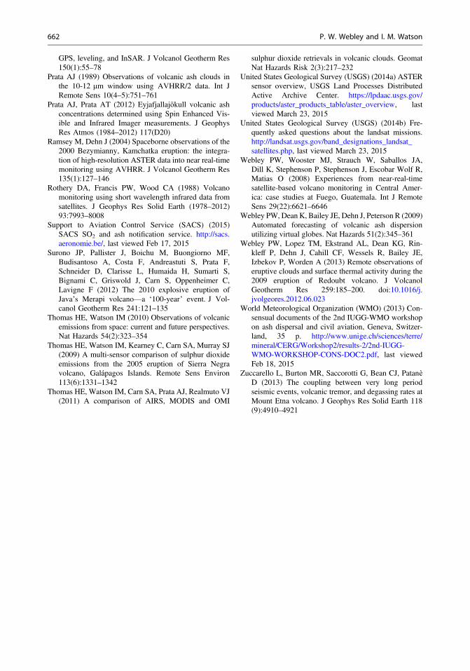
GPS, leveling, and InSAR. J Volcanol Geotherm Res150(1):55–78
Prata AJ (1989) Observations of volcanic ash clouds inthe 10-12 lm window using AVHRR/2 data. Int JRemote Sens 10(4–5):751–761
Prata AJ, Prata AT (2012) Eyjafjallajökull volcanic ashconcentrations determined using Spin Enhanced Vis-ible and Infrared Imager measurements. J GeophysRes Atmos (1984–2012) 117(D20)
Ramsey M, Dehn J (2004) Spaceborne observations of the2000 Bezymianny, Kamchatka eruption: the integra-tion of high-resolution ASTER data into near real-timemonitoring using AVHRR. J Volcanol Geotherm Res135(1):127–146
Rothery DA, Francis PW, Wood CA (1988) Volcanomonitoring using short wavelength infrared data fromsatellites. J Geophys Res Solid Earth (1978–2012)93:7993–8008
Support to Aviation Control Service (SACS) (2015)SACS SO2 and ash notification service. http://sacs.aeronomie.be/, last viewed Feb 17, 2015
Surono JP, Pallister J, Boichu M, Buongiorno MF,Budisantoso A, Costa F, Andreastuti S, Prata F,Schneider D, Clarisse L, Humaida H, Sumarti S,Bignami C, Griswold J, Carn S, Oppenheimer C,Lavigne F (2012) The 2010 explosive eruption ofJava’s Merapi volcano—a ‘100-year’ event. J Vol-canol Geotherm Res 241:121–135
Thomas HE, Watson IM (2010) Observations of volcanicemissions from space: current and future perspectives.Nat Hazards 54(2):323–354
Thomas HE, Watson IM, Kearney C, Carn SA, Murray SJ(2009) A multi-sensor comparison of sulphur dioxideemissions from the 2005 eruption of Sierra Negravolcano, Galápagos Islands. Remote Sens Environ113(6):1331–1342
Thomas HE, Watson IM, Carn SA, Prata AJ, Realmuto VJ(2011) A comparison of AIRS, MODIS and OMI
sulphur dioxide retrievals in volcanic clouds. GeomatNat Hazards Risk 2(3):217–232
United States Geological Survey (USGS) (2014a) ASTERsensor overview, USGS Land Processes DistributedActive Archive Center. https://lpdaac.usgs.gov/products/aster_products_table/aster_overview, lastviewed March 23, 2015
United States Geological Survey (USGS) (2014b) Fre-quently asked questions about the landsat missions.http://landsat.usgs.gov/band_designations_landsat_satellites.php, last viewed March 23, 2015
Webley PW, Wooster MJ, Strauch W, Saballos JA,Dill K, Stephenson P, Stephenson J, Escobar Wolf R,Matias O (2008) Experiences from near-real-timesatellite-based volcano monitoring in Central Amer-ica: case studies at Fuego, Guatemala. Int J RemoteSens 29(22):6621–6646
Webley PW, Dean K, Bailey JE, Dehn J, Peterson R (2009)Automated forecasting of volcanic ash dispersionutilizing virtual globes. Nat Hazards 51(2):345–361
Webley PW, Lopez TM, Ekstrand AL, Dean KG, Rin-kleff P, Dehn J, Cahill CF, Wessels R, Bailey JE,Izbekov P, Worden A (2013) Remote observations oferuptive clouds and surface thermal activity during the2009 eruption of Redoubt volcano. J VolcanolGeotherm Res 259:185–200. doi:10.1016/j.jvolgeores.2012.06.023
World Meteorological Organization (WMO) (2013) Con-sensual documents of the 2nd IUGG-WMO workshopon ash dispersal and civil aviation, Geneva, Switzer-land, 35 p. http://www.unige.ch/sciences/terre/mineral/CERG/Workshop2/results-2/2nd-IUGG-WMO-WORKSHOP-CONS-DOC2.pdf, last viewedFeb 18, 2015
Zuccarello L, Burton MR, Saccorotti G, Bean CJ, PatanèD (2013) The coupling between very long periodseismic events, volcanic tremor, and degassing rates atMount Etna volcano. J Geophys Res Solid Earth 118(9):4910–4921
662 P. W. Webley and I. M. Watson

Open Access This chapter is licensed under the terms ofthe Creative Commons Attribution 4.0 InternationalLicense (http://creativecommons.org/licenses/by/4.0/),which permits use, sharing, adaptation, distribution andreproduction in any medium or format, as long as yougive appropriate credit to the original author(s) and thesource, provide a link to the Creative Commons licenseand indicate if changes were made.
The images or other third party material in this chapter areincluded in the chapter’s Creative Commons license,unless indicated otherwise in a credit line to the material.If material is not included in the chapter’s CreativeCommons license and your intended use is not permittedby statutory regulation or exceeds the permitted use, youwill need to obtain permission directly from the copyrightholder.
The Role of Geospatial Technologies … 663