The REDD+ Database - Bappenasgreengrowth.bappenas.go.id/en/program/download/... · 1 The REDD+...
30
1 The REDD+ Database A Synthesis Report December 2013 Produced by GGGI in collaboration with the REDD+ Special Team as part of the GoI-GGGI Green Growth Program
Transcript of The REDD+ Database - Bappenasgreengrowth.bappenas.go.id/en/program/download/... · 1 The REDD+...

1
The REDD+ DatabaseA Synthesis Report
December 2013
Produced by GGGI in collaboration with the REDD+ Special Teamas part of the GoI-GGGI Green Growth Program

2
Table of Contents
Table of Contents .................................................................................................................................... 2
Acronyms and abbreviations ................................................................................................................... 3
Executive Summary ................................................................................................................................. 4
1. Introduction .................................................................................................................................... 5
1.1. Goals and objectives of this report............................................................................................ 5
1.2. Approach.................................................................................................................................. 5
2. Policy and Project Themes extracted from the REDD+ Database ...................................................... 6
2.1. Central Kalimantan ................................................................................................................... 9
2.2. East Kalimantan...................................................................................................................... 13
2.3. Jambi...................................................................................................................................... 17
2.4. Aceh ....................................................................................................................................... 21
2.5. Central Sulawesi ..................................................................................................................... 22
2.6. Papua ..................................................................................................................................... 23
2.7. Riau........................................................................................................................................ 24
2.8. South Sumatra........................................................................................................................ 25
2.9. West Kalimantan .................................................................................................................... 26
2.10. West Papua ............................................................................................................................ 27
2.11. West Sumatra......................................................................................................................... 28
3
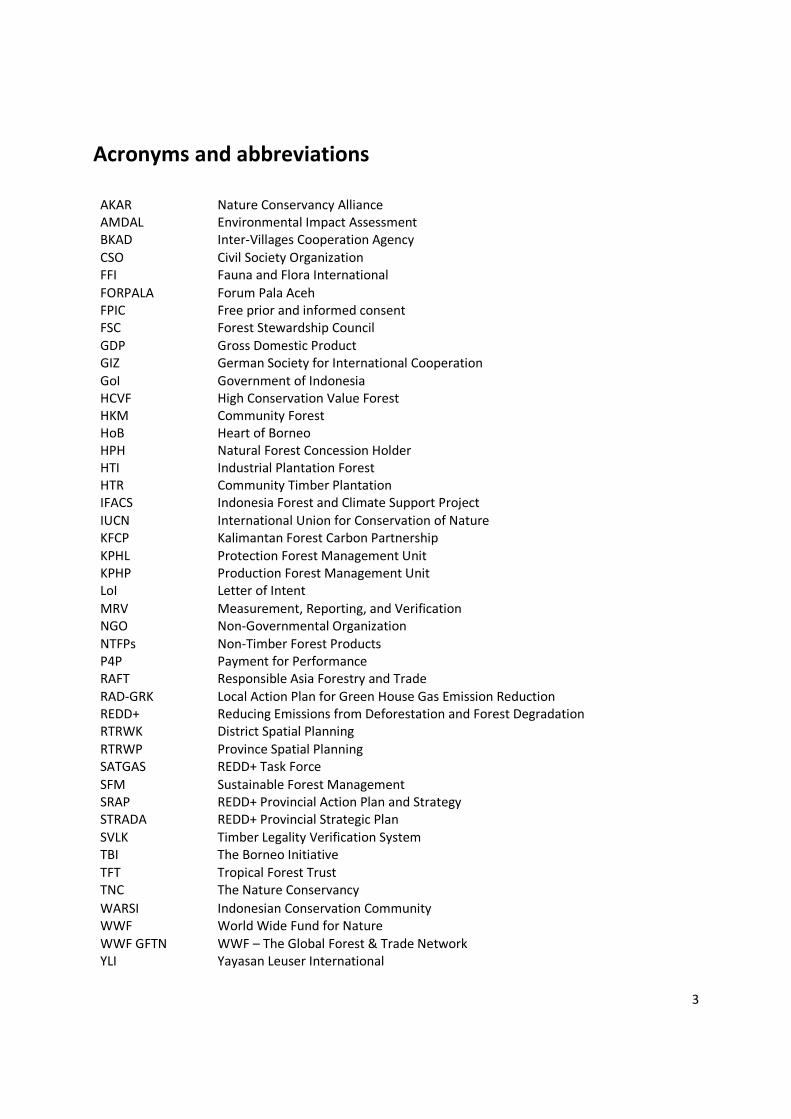
Acronyms and abbreviations
AKAR Nature Conservancy AllianceAMDAL Environmental Impact AssessmentBKAD Inter-Villages Cooperation AgencyCSO Civil Society OrganizationFFI Fauna and Flora InternationalFORPALA Forum Pala AcehFPIC Free prior and informed consentFSC Forest Stewardship CouncilGDP Gross Domestic ProductGIZ German Society for International CooperationGoI Government of IndonesiaHCVF High Conservation Value ForestHKM Community ForestHoB Heart of BorneoHPH Natural Forest Concession HolderHTI Industrial Plantation ForestHTR Community Timber PlantationIFACS Indonesia Forest and Climate Support ProjectIUCN International Union for Conservation of NatureKFCP Kalimantan Forest Carbon PartnershipKPHL Protection Forest Management UnitKPHP Production Forest Management UnitLoI Letter of IntentMRV Measurement, Reporting, and VerificationNGO Non-Governmental OrganizationNTFPs Non-Timber Forest ProductsP4P Payment for PerformanceRAFT Responsible Asia Forestry and TradeRAD-GRK Local Action Plan for Green House Gas Emission ReductionREDD+ Reducing Emissions from Deforestation and Forest DegradationRTRWK District Spatial PlanningRTRWP Province Spatial PlanningSATGAS REDD+ Task ForceSFM Sustainable Forest ManagementSRAP REDD+ Provincial Action Plan and StrategySTRADA REDD+ Provincial Strategic PlanSVLK Timber Legality Verification SystemTBI The Borneo InitiativeTFT Tropical Forest TrustTNC The Nature ConservancyWARSI Indonesian Conservation CommunityWWF World Wide Fund for NatureWWF GFTN WWF – The Global Forest & Trade NetworkYLI Yayasan Leuser International

4
Executive SummaryIn order to assist the REDD+ Agency to better understand the current status of REDD+ implementationacross Indonesia, GGGI has been working with the REDD+ Special Team, as part of the GoI-GGGI GreenGrowth Program, to identify the existing and planned activities in the 11 REDD+ provinces. Thisinformation has been captured in the REDD+ Database, which includes the priority activities outlined in8 SRAPs and 10 RAD-GRKs, as well as the existing REDD+ projects supported by NGOs, CSOs, donors andthe private sector across the 11 provinces.
The REDD+ Database and this Synthesis Report will be an important resource and tool for decisionmakers within the REDD+ Agency. It will help staff and other stakeholders to better understand theREDD+ landscape across each provinces, explore the trends in current and planned REDD+ activities, andidentify the priority areas in each province to which funding could be directed during Phase 2.
This Synthesis Report has been written to extract the most important and relevant information from theREDD+ Database, which is an Excel spreadsheet with three worksheets and includes a total of 526activities. While the database has been designed to be user-friendly and is suitable for searching forinformation on specific projects or examining a province’s existing project portfolio, it does not provideany narrative or offer a succinct summary of REDD+ progress in each province.
This is the purpose of this Synthesis Report, which includes 11 provincial summaries that extractinformation from the REDD+ Database around the following topics:
1. Emerging themes in REDD+ policy2. Key trends and status of existing REDD+ activities3. High-potential interventions for Phase 2 funding (only in the three priority provinces)
The REDD+ Database and this Synthesis Report demonstrate the different approaches that eachprovince is adopting to implement REDD+, which reflects the great diversity of deforestation issuesthroughout Indonesia. However, while each province is unique, there is a clear focus across Indonesia onthe need for broad governance reform in the forestry sector. In addition, each province emphasizes theimportance of improving licensing and permitting systems, and spatial planning processes. Finally, thereis also consensus on the need to improve forest management systems and to seek greater inclusion ofstakeholders, which is reflected in a large number of forest management units (KPHs) and communitybased forest management (CBFM) systems being developed.
The REDD+ Special Team has identified three provinces that will be the initial focus of Phase 2 support,which this Synthesis Report considers in more detail. The summaries of these provinces identify high-impact REDD+ activities that are aligned with political priorities and existing capacity, thusdemonstrating high-potential interventions for Phase 2 funding. Below is a short summary of thelocation-specific activities that have the greatest potential for achieving multiple REDD+ goals.
Central Kalimantan: (i) the conservation and rehabilitation of the southern peat belt and (ii) theimplementation of sustainable forest management (SFM) in the upper highlands and watersheds.
East Kalimantan: (i) improving the sustainability of the forestry sector through improvements in timberlegality and SFM in the northern highlands, and (ii) the development of KPHs in Kutai Barat and Berau.
Jambi: (i) promoting CBFM through village forest concessions and reducing land tenure conflict in thewestern highlands, and (ii) ensuring the protection of the Berbak National Park and the effectiveimplementation of KPHs in the coastal region of the province.

5
1. Introduction
1.1. Goals and objectives of this reportThe overall objective of this report is provide the REDD+ Agency with an overview of the REDD+ projectactivities that are currently ongoing and planned in each of the 11 priority REDD+ provinces in Indonesia.The information from this report is based on the REDD+ Database that GGGI submitted to the REDD+Special Team on Friday 13th December.
Specifically the report aims to:
1. Provide a summary of the emerging themes in REDD+ policy in each of the provinces as outlined inthe Strategi dan Rencana Aksi Propinsi (SRAP) and the forestry and agriculture projects in theRencana Aksi Daerah penurunan emisi Gas Rumah Kaca (RAD-GRK);
2. Provide a summary of the current ongoing project activities being conducted by donors, non-governmental organizations (NGOs), civil society organizations (CSOs) and other REDD+ projectdevelopers in each of the provinces;
3. Provide recommendations for high-potential interventions for Phase 2 funding in the three priorityprovinces of Central Kalimantan, East Kalimantan and Jambi, as defined by the REDD+ Special Team.
1.2. ApproachThe REDD+ Database includes projects and activities from the 11 REDD+ provinces; Central Kalimantan,East Kalimantan, Jambi (all of which are priorities for Phase 2), and Aceh, Central Sulawesi, Papua, Riau,South Sumatera, West Kalimantan, West Papua and West Sumatera. This Synthesis Report provides ashort overview of the REDD+ policy priorities and the existing projects taking place in each province. Inaddition, more in-depth analysis has been carried out for the three priority provinces to highlight high-potential interventions for Phase 2 funding.
The REDD+ Database has been developed using desktop research and the information contained withinit has been taken from a range of sources, including REDD+ project documents (8 SRAPs and 10 RAD-GRKs), and existing REDD+ projects across the 11 provinces. The summary of each province in thisSynthesis Report is divided into the following sections:
1. An overview of REDD+ policy in the province: This section presents a summary of the activitiesoutlined in the SRAP and the forestry and agricultural activities in the RAD-GRK, and identifies thecommon themes in each. Some of these provinces have not yet completed their SRAP or RAD-GRK.
2. Existing project summary: This section presents a summary of the existing REDD+ projects beingconducted by donors, NGOs, CSOs and other groups within each of the 11 provinces.
3. High-potential interventions for Phase 2 funding (three priority provinces only): This section buildson the information from the SRAP, RAD-GRK and the existing projects to identify interventions thathave the potential to deliver emissions reductions and other REDD+ goals in a relatively shorttimeframe. Along with having potential for green growth impacts during Phase 2, high-potentialactivities must also be aligned with the provincial priorities and have existing technical capacity.
Note that at this stage there has been limited stakeholder engagement to discuss the activities identifiedin the 11 provinces. In addition, the conclusions in this Synthesis Report are based only on theinformation contained in the database. The REDD+ Database and the Synthesis Report have beendeveloped in such a way to allow it to be easily updated and expanded by the REDD+ Agency followingfurther research and engagement with stakeholders, so it should be considered as living documents.

6
2. Policy and Project Themes extracted from the REDD+ DatabaseTable 1 below presents a brief overview of the overall policy and project themes from the 11 provinces. The subsequent section of the reportpresents the summary of each of the provinces.
Table 1: Summary of REDD+ activities in the 11 provinces
Province Overview of REDD+ policy environment in the province Summary of existing projectsCentral
Kalimantan Facilitate implementation of SFM in forest concessions through
improved management practices, creating demand forsustainable products, and improved spatial planning and licensepermitting
Restore and rehabilitate peatlands and prevent peat fires Strengthen the role of forest communities through clarification
of land tenure, improved mapping and development of villageforests (hutan desa)
Sustainable management practices in plantations and mining Creation of provincial REDD+ institutions
Government REDD+ demonstration activities in place TBI and IFACS supporting concessions to implement SFM Large scale peat projects taking place in Sebangau, Rimba
Raya, Lamandau , Hutan Amanah Heart of Borneo (HoB) supporting sustainable landscapes
approach Several concessions have received RSPO certification
EastKalimantan
Create REDD+ institutions and regulatory frameworks Promote SFM in timber sector Establish model forest management units (KPH) in the province Build capacity of forest communities to manage and monitor
forest areas and strengthen local economies Reform plantation and mining licensing mechanisms
Jurisdictional program being developed in Berau Model KPHs being developed in Berau and Kutai Barat Conservation projects in areas lead by TNC and FFI HoB supporting multiple conservation efforts TBI and TNC support for concessions to implement SFM Several concessions have received RSPO certification
Jambi Establish model KPHs in the province Support private sector on sustainable forest management Prevent forest fires Governance reform of agricultural sector and engagement with
the sector on improving productivity Establish REDD+ laws and policies and strong provincial REDD+
commission
WARSI led village forests (hutan desa) program covering 26communities
Berbak Carbon Initiative covering national park and bufferzone managed by ZSL
Model KPH being developed in the province Harapan ecosystem restoration project managed by Birdlife
International
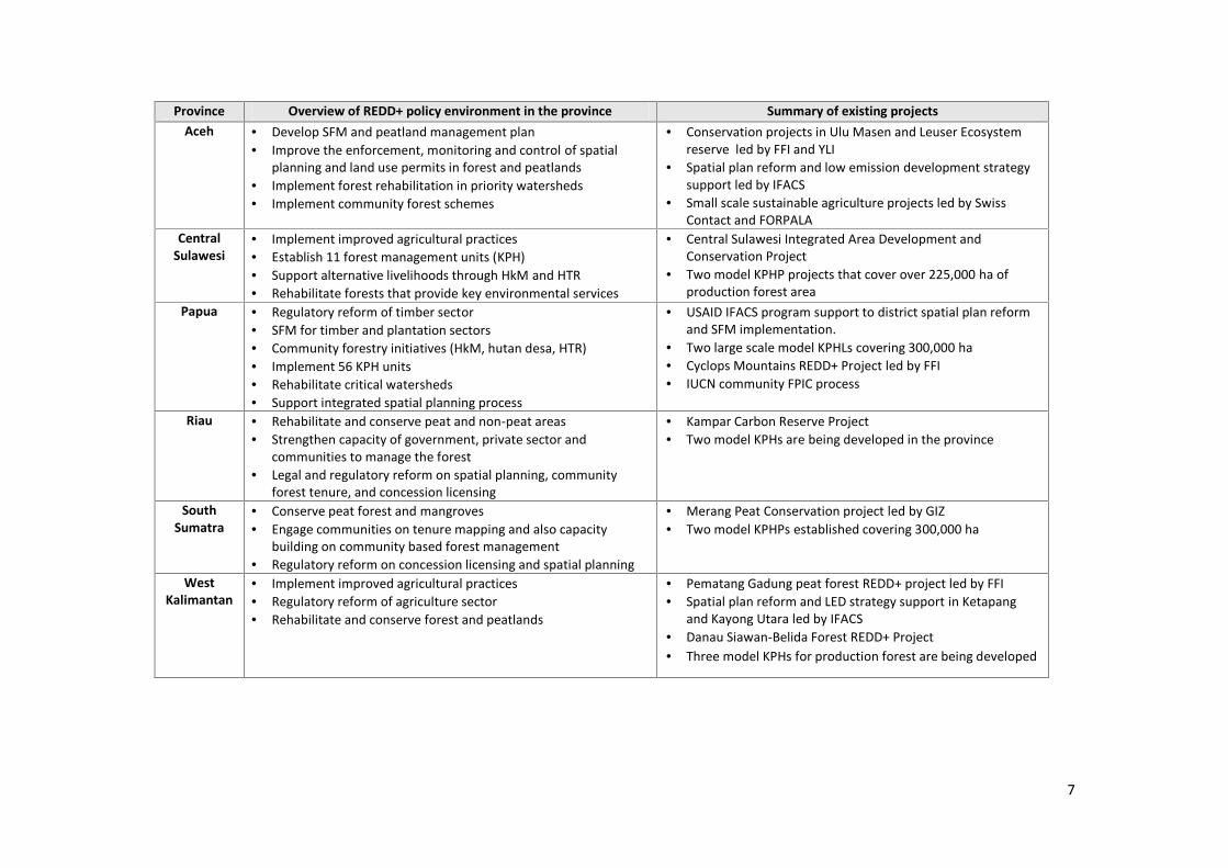
7
Province Overview of REDD+ policy environment in the province Summary of existing projectsAceh Develop SFM and peatland management plan
Improve the enforcement, monitoring and control of spatialplanning and land use permits in forest and peatlands
Implement forest rehabilitation in priority watersheds Implement community forest schemes
Conservation projects in Ulu Masen and Leuser Ecosystemreserve led by FFI and YLI
Spatial plan reform and low emission development strategysupport led by IFACS
Small scale sustainable agriculture projects led by SwissContact and FORPALA
CentralSulawesi
Implement improved agricultural practices Establish 11 forest management units (KPH) Support alternative livelihoods through HkM and HTR Rehabilitate forests that provide key environmental services
Central Sulawesi Integrated Area Development andConservation Project
Two model KPHP projects that cover over 225,000 ha ofproduction forest area
Papua Regulatory reform of timber sector SFM for timber and plantation sectors Community forestry initiatives (HkM, hutan desa, HTR) Implement 56 KPH units Rehabilitate critical watersheds Support integrated spatial planning process
USAID IFACS program support to district spatial plan reformand SFM implementation.
Two large scale model KPHLs covering 300,000 ha Cyclops Mountains REDD+ Project led by FFI IUCN community FPIC process
Riau Rehabilitate and conserve peat and non-peat areas Strengthen capacity of government, private sector and
communities to manage the forest Legal and regulatory reform on spatial planning, community
forest tenure, and concession licensing
Kampar Carbon Reserve Project Two model KPHs are being developed in the province
SouthSumatra
Conserve peat forest and mangroves Engage communities on tenure mapping and also capacity
building on community based forest management Regulatory reform on concession licensing and spatial planning
Merang Peat Conservation project led by GIZ Two model KPHPs established covering 300,000 ha
WestKalimantan
Implement improved agricultural practices Regulatory reform of agriculture sector Rehabilitate and conserve forest and peatlands
Pematang Gadung peat forest REDD+ project led by FFI Spatial plan reform and LED strategy support in Ketapang
and Kayong Utara led by IFACS Danau Siawan-Belida Forest REDD+ Project Three model KPHs for production forest are being developed

8
Province Overview of REDD+ policy environment in the province Summary of existing projectsWest Papua Legal and regulatory reform of forestry sector
Implement RIL and rehabilitate degraded forest zones. Build capacity to implement REDD+ at the institutional level Revise spatial planning process and enforcement of forest laws
West Papua Forest Carbon project targeting 16 concessions TBI supporting two concessions to implement SFM and SVLK Large scale KPH covering 200,000 ha IUCN project on FPIC process, land tenure and alternative
sustainable livelihoodsWest
Sumatra Develop REDD+ institutions and MRV systems Reform forestry sector (new regulations, implement BMPs) Implement improved agricultural practices Rehabilitate critical watersheds Support community based forest management systems
Two model KPHLs and 1 KPHP are being developed Siberut Conservation Project

9
2.1. Central Kalimantan
Background Land area: 15.3 million ha and is Indonesia’s third largest provincei
Population: 2.2 million, of whom 67% of the population lives in rural areasii
Major economic sectors: Agriculture, forestry and fisheries (19.3% GDP), services (13% GDP),mining (10% GDP)iii
Forest coverage: 10 million ha, of which 3 million ha is peatland forestiv
Deforestation rate: 63,100 ha annuallyv
Major drivers of deforestation: Logging and draining of peatlands for expansion of agriculture,especially palm oil; large scale fires; illegal and unsustainable logging and poor regulation andenforcement of spatial plans in timber and palm oil concessions.vi
Overview of REDD+ policyIn recent years Central Kalimantan has been the focus of government and donor initiatives to protectand conserve its large remaining forest. In 2010 the province was selected by the government as theREDD+ pilot province, in which to trial REDD+ demonstration activities. The Central Kalimantangovernment has developed a RAD-GRK that has been approved. A draft of the provincial REDD+ Strategyor STRADA has been produced and an ‘enrichment’ process to align this document with the SRAP formatwill be finished by the end of December 2013.
Both the original version of the STRADA and the RAD-GRK contain a broad range of cross sectoralactivities. However, there is a clear emphasis in both on promoting sustainable forest management(SFM) and the conservation and the rehabilitation of forests and peatlands.
Within the forestry sector the STRADA and the RAD-GRK activities aim to promote better forestmanagement by improving silvicultural practices, implementing RIL and assisting companies to attaintimber legality (Timber Legality Verification System or SVLK). On the demand side, the STRADA also aimsto encourage value added industries for sustainable forestry products by supporting small and mediumsized companies which produce green products, through schemes such as investment credits andsubsides.
Peatlands are important for the implementation of REDD+ in Central Kalimantan, and this is reflected inthe activities of the STRADA and the RAD-GRK. Both contain activities aimed at rehabilitating peatlandsand the STRADA provides specific details of activities to block canals and replant dried peat areas.Critically peat conservation and rehabilitation efforts are supported by a number of other activities, suchas more focused implementation of the moratorium through improved licensing and site allocation, andthe demarcation of peat area buffer zones. Importance is also placed on the prevention of fires andfurther expansion of agricultural lands.
Strengthening the role of local and indigenous people in managing forest areas is important both to SFMand the conservation of peat areas. The STRADA, and to a lesser extent the RAD-GRK, outlines activitiesto improve the land tenure status of forest communities through improved mapping and legislation,facilitating the development of community forest programs (hutan desa), and improving communityforestry industries by creating markets for NTFPs.
In agricultural plantations and mining, activities are orientated towards the development andimplementation of sustainable management practices such as certification schemes that assess andmitigate the impacts of operations.
10
At the institutional level, the STRADA details activities aimed at developing the capacity, both intechnical skills, data and physical resources (hardware, computers etc.), and processes of the provincialREDD+ institution, the provincial MRV institution and a provincial REDD+ funding mechanism.
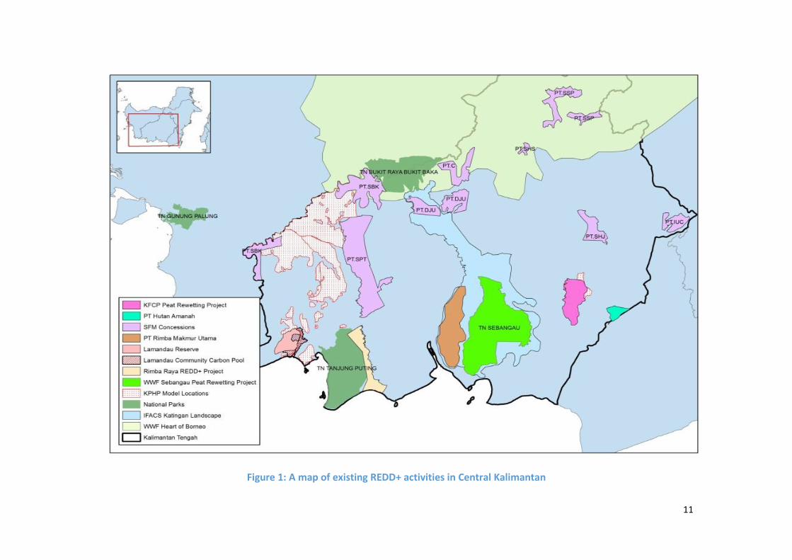
Existing projectsAs the pilot province for REDD+ in Indonesia, Central Kalimantan has been the focus of donor,multilateral and NGO funding for the last 5 years and already has a large number of ongoing REDD+project activities. As a result, there is a strong network of international NGOs, local CSOs andmultilateral organizations with good technical capacity and resources operating in the province. Figure 1shows the current location of existing project activities.
As the pilot province, Central Kalimantan hosts a number of REDD+ DAs supported by the Governmentof Norway and overseen by UNDP. These projects are all located in a number of districts surrounding theex-Mega Rice Project and are managed by a number of local CSO and NGOs. These activities are largelyfocused on small-scale alternative livelihood activities and empowerment of local economies. Forexample, BKAD Jabiren Raya, a local CSO in the Pulang Pisau District, has been training villagers to makerattan wickerwork and encouraging the development of local enterprises by assisting villagers to marketrattan products and access new markets.
Beyond the DAs, the majority of other donor and NGO activities have focused on peat conservation andsupport for the implementation of SFM practices in timber concessions. Peat conservation projects havebeen focused on the southern peat belt area. Projects tend to be aimed at better enforcement ofpeatland conservation areas and/or the rehabilitation of dried areas through canal blocking. There are anumber of large scale REDD+ projects operating in this area such as the Sebangau project run by WWFand the Rimba Raya project. The KFCP has also been operating in the ex-Mega Rice Project for over 4years and has carried out extensive research on peatland hydrology and restoration.1
The implementation of SFM has also been a focus for donors and NGOs in the region. One of the largestinitiatives in the area over the last 5 years has been TBI. TBI provides financial support toconcessionaires to get certified and in most cases also fund organizations such as TNC, WWF GFTN, theTFF and TFT to provide technical support. The HoB and USAIDs IFACS projects are both taking alandscape approach to conservation and SFM in the region and are working with a range of stakeholdersfrom government, communities and concessions to develop district level spatial and economic planning.The HoB landscape covers the province’s northern border, which has vast natural forest areas, while theIFACS project landscape follows a major watershed in the central portion of the province coveringhighland forests and coastal peat forests.
In terms of agriculture, the Roundtable on Sustainable Palm Oil (RSPO) has been working with a numberof companies in the area to support the development of sustainable palm oil production in plantations.
1 Funding for the KFCP from the Government of Australia expires in mid-2014
11
Figure 1: A map of existing REDD+ activities in Central Kalimantan

12
High-potential interventions for Phase 2In Central Kalimantan, high-potential interventions have been identified in two distinct geographical andecological regions; (1) Peat rehabilitation and conservation in the southern peat belt and (2) Sustainableforest management in upper highlands and water shed areas.
a. Peat rehabilitation and conservation in the southern peat beltThe rehabilitation and conservation of the Central Kalimantan southern peat belt has the potential todeliver multiple REDD+ goals. The high carbon content of peatlands represent a large potential forcarbon sequestration and peat ecosystems are often areas of high biodiversity. Although peatconservation efforts do not offer large economic gains, project activities often involve initiatives topromote alternative livelihoods and promote localized economic development.2
There are a number of capable organizations already working on such activities in Central Kalimantanand many donors have previously placed emphasis on the importance of this region. It is clear from theSTRADA and RAD-GRK that the Central Kalimantan government also recognizes the importance of thisarea, so there is political support for the scaling up of activities that reduce emissions from peatlands inthe province.
Alongside the technical interventions required to prevent emissions and increase carbon stocks,improvements are required in the spatial planning and licensing processes to ensure that plantationsand buffer zones are sited in the correct areas. Greater support for the effective implementation of themoratorium is also a necessity. Finally, it is critical that local communities are involved in themanagement of peat areas and that sustainable local economies are established by coordinatingconservation activities with programs that generate alternative livelihoods.
b. Sustainable Forest Management in upper highlands and water shed areasGiven that there a large number of natural forest concessions in the province (approx. 4.5 million ha),promoting SFM is an important intervention in Central Kalimantan. Although SFM offers only moderatelevels of carbon emissions reductions and additional carbon sequestration, the carbon gains across sucha large area could be substantial. In addition, certified concessions can result in the protection ofbiodiversity and contribute to improved local economic development and job creation.3
Timber concessions are already working with initiatives, such as TBI and IFACS to implement SFMpractices. These initiatives and partner organisations, such as TNC and WWF GFTN, have good technicalskills and experience of working with concessionaires. Similarly the STRADA and RAD-GRK contain anumber of activities focused on implementing more sustainable practices within timber concessions,demonstrating political support for this activity. Engagement with concessions should be combined withimproved enforcement of spatial plans and regulations within the forestry sector, as well as the creationof local markets for sustainable timber products to generate additional incentives to become SFMcertified.
2 Based on GGGI analysis of the potential impact of peat rehabilitation projects on the four goals of the REDD+National Strategy.3 Based on GGGI analysis of the potential impact of SFM projects on the four goals of the REDD+ National Strategy.

13
2.2. East Kalimantan
Background Land area: 20 million ha and is Indonesia’s second largest provincevii
Population: 3.5 million people of whom about half live in rural villagesviii
Major economic sectors: Mining and quarrying (45% of GDP), services (4.2%) and agriculture,livestock, forestry and fisheries (4%)ix
Forest coverage: 14.6 million hax
Deforestation rate: 150,000 ha annually between 2003 and 2008xi
Drivers of deforestation and carbon emissions: land clearing for coal mining, illegal logging andover exploitation of natural forest concessions, expansion of palm oil and agricultural plantations,small holder agricultural expansion, land and forest fires.xii
Overview of REDD+ policyIn recent years, East Kalimantan has been the focus of government and donor efforts to develop REDD+,due to the large tracts of remaining forest and high rates of deforestation. The province has alreadydeveloped and approved a RAD-GRK and SRAP. The East Kalimantan SRAP contains 15 priority activitiesfor the implementation over the next two years.
Recognizing that REDD+ is still at an early stage of development in the province, both the SRAP and RAD-GRK focus on the creation of the institutions, processes and legal and regulatory frameworks needed toready the province for REDD+. At the institutional level, the main focus of the SRAP is on the creationand capacity building of a provincial REDD+ institution to coordinate the various REDD+ activities in theprovince.
As unsustainable and illegal logging practices are a large driver of deforestation in the province, both theSRAP and RAD-GRK focus on activities in the forestry sector. In particular, there is a strong emphasis onimproving both legality and sustainability in and around concessions by strengthening mapping andspatial planning, increasing the collection and analysis of forestry data, and improving monitoring,management and enforcement of permits. The RAD-GRK also specifically outlines activities to ensurebetter monitoring and enforcement of the moratorium areas.
Importantly, both the SRAP and the RAD-GRK contain activities to accelerate the capacity of forestcommunities to manage and monitor forest areas. Strengthening local forest based economies providesa clear incentive for better, more localized management systems. Importance is also placed onaccelerating the establishment of forest management units (KPH), which provide active management tolarge forest landscapes, can help resolve conflicts over forest boundaries and support community forestmanagement.
The expansion of palm oil and mining are also key drivers of deforestation in East Kalimantan. Both theSRAP and the RAD-GRK outline activities to reduce the impact of this expansion, in particular throughthe creation of plantation and mining licensing mechanisms. In particular, the SRAP promotes theidentification and management of HCVF for palm oil and mining concessions, carrying out environmentalimpact assessment (AMDAL) and the development of criteria and indicators to assess land suitability.

14
Existing projectsEast Kalimantan is already the focus of donor and multilateral funding and hosts several large REDD+demonstration activitiesxiii, which are supported by the East Kalimantan provincial and districtgovernment. As a result, there are a number of organizations already operating in the province withgood technical capacity and resources to support the scaling up of project activities. Figure 2 shows theexisting projects in the province.
A large proportion of existing site level projects in East Kalimantan, are focused on the implementationof legality and SFM practices in natural forest concessions. As in Central Kalimantan, TBI is a leadinginitiative in the province supporting timber concessionaries to attain SVLK and FSC certification. Inaddition GIZ Forclime and TNC are supporting the implementation of two model KPHs. The model KPH inBerau has completed its ten year management plan and is moving into the implementation phase.
East Kalimantan is also an important area for forest conservation projects. There are a number of REDD+conservation projects taking place, such as the Murung Raya Conservation & Sustainable DevelopmentProject lead by FFI and the Lesan Protection Forest Area lead by TNC.4 An important regional initiative isthe HoB project which is coordinating the management of the region’s protected areas and buffer zonesthrough implementation of sustainable land practices at the community and commercial level. In KutaiBarat district, the HoB project is building the capacity of local institutions to better managetransboundary protected areas, develop ecotourism infrastructure and support the timber sector toimplement SFM.
TNC has been working in Berau district since 2007 and is currently supporting the development of adistrict wide approach to REDD+. After conducting a series of feasibility studies on this jurisdictionalapproach, TNC are now working extensively with communities to establish village forest concessions andare supporting communities to negotiate better terms with neighboring timber concessions on revenuesharing. This project has also engaged a series of timber concessions on SFM and FSC certificationthrough the USAID funded RAFT project.
In the palm oil sector, a few concessions have been certified by the RSPO and a number of companiesoperating in East Kalimantan have become members of the organization showing an emerging trendwithin the sector.
4 Projects have not been placed on the map, as the location data was not available

15
Figure 2: A map of existing REDD+ activities in East Kalimantan
16
High-potential interventions for Phase 2In East Kalimantan, high-potential interventions have been identified in two distinct geographical andecological regions; (1) Sustainable Forest Management and RIL in the northern highlands; and (2)Implementation of model KPHs in Berau and Kutai Barat.
a. Sustainable Forest Management and RIL in the northern highlandsSimilar to Central Kalimantan, encouraging and enforcing the development of timber legality and SFMhas the potential to deliver multiple REDD+ goals. Although SFM offers only moderate levels of carbonemissions reductions and additional carbon sequestration, the carbon gains across such a large areacould be substantial. In addition certified concessions can result in the protection biodiversity andcontribute to improved local economic development and job creation.5
There are a large number of natural forest concessions in the region and many are already working withthe TBI or RAFT initiatives to implement SFM practices. These initiatives and partner organisations, suchas TNC and WWF GFTN, have good technical skills and experience of working with concessionaires.These initiatives are supported by other ongoing and planned initiatives, such as the development ofmodel KPHs. SFM and the reduction of illegal logging through the SVLK are clearly aligned with plannedactivities in East Kalimantan’s SRAP and RAD-GRK.
Scaling up these existing initiatives can deliver REDD+ goals; however, this must be carried out in parallelto the SRAP activities that help create the necessary enabling conditions to accelerate SFM, such asimproved mapping and enforcement of licensing and spatial planning.
b. Model KPHs in Berau and Kutai Kartanegara/Kutai BaratKPHs present a promising opportunity to the combine the protection and sustainable utilization offorests over a large landscape. The KPH approach engages local government and communities in thedesign and implementation of forest management systems, thus increasing local ownership. This shouldprovide an added incentive to manage forests sustainably, and has the potential to lead to reducecarbon emissions, conservation in biodiversity hotspots and localized, inclusive economic growth.6
The current model KPH projects in Berau and in Kutai Kartanegara/Kutai Barat, which are led by TNC andGIZ Forclime, are fairly advanced and have completed their 10-year management plans. Bothorganizations have been working in the region for over 5 years in close collaboration with localgovernment stakeholders and have the technical capacity to scale up the implementation of theseprojects.
Phase 2 REDD+ funding could be used to implement the 10-year management plans; however, this mustbe supported by complementary regulatory and institutional reform. For example, support is required toimprove the demarcation and enforcement of project boundaries, licenses in KPH areas must beenforced and spatial planning can be improved with better forestry and socio economic data.
5 Based on GGGI analysis of the potential impact of SFM projects on the four goals of the REDD+ National Strategy.6 Based on GGGI analysis of the potential impact of KPH projects on the four goals of the REDD+ National Strategy.

17
2.3. Jambi
Background Land area: 5.3 million haxiv
Population: 3 million people (2010) xv
Major economic sectors: Agriculture and mining Forestry cover: 4.9 million ha xvi
Deforestation rate: 98,900 ha per years between 1990-2000xvii
Drivers of deforestation: Conversion from forest to plantation (HPH, HTI), mining, forestfires, unplanned mosaic deforestation by small holders xviii
Overview of REDD+ policyJambi has developed and approved a RAD-GRK and a SRAP. A key theme to emerge from both of thesedocuments is the need to reduce land tenure conflict between the agriculture, forestry and miningsectors. Both the SRAP and RAD-GRK support the creation of systems to mediate and resolve conflict inthese sectors, for example, by increasing land tenure rights for communities through theimplementation of forest co-management schemes, including community and village forests (hutankemasyakaratan and hutan desa).
Another critical intervention to resolve land tenure disputes is improved mapping and enforcement ofspatial plans. The RAD-GRK has a significant focus on forest monitoring and patrols to ensure land useborders are respected. Similarly, the SRAP outlines activities that work with communities onparticipatory mapping to help establish community zone boundaries. The Jambi Government’scommitment to ensure tangible local community benefits are derived from REDD+ is highlighted by theseries of project-level activities in the SRAP aimed at creating livelihood opportunities through thepromotion of NTFPs and economic empowerment of communities around forest zones.
Jambi’s forests have experienced high levels of degradation as a result of commercial logging activities.The SRAP and RAD-GRK both identify the importance of engaging with the private sector on theimplementation of sustainable forest management practices, including reduced impact logging andassisting companies obtain SVLK and FSC certification. At a larger landscape level, the SRAP and theRAD- GRK aim to accelerate SFM through the implementation of KPHs, with the RAD-GRK setting aspecific target of implementing two KPHs within the province.
Given the scale of the carbon emissions released as a result of fires in the region, the SRAP and RAD-GRKoutline activities to improve fire monitoring, early warning systems, capacity building to fight forestfires, awareness campaigns and enforcement of laws that prevent the use of fire as a land clearing tool.
The RAD-GRK has a strong focus on project-level activities within the agricultural sector. There are anumber of proposed projects that focus on farmer training and the dissemination of improved seedstocks with the goal of intensifying agriculture in order to reduce the pressure on forest areas due tofarm expansion. The SRAP’s focus on the agriculture sector is limited to conflict resolution andgovernance reform within the palm oil sector.
Underpinning all this is the establishment of the REDD+ laws and policies and the establishment of astrong provincial REDD+ commission. At the monitoring level, the RAD-GRK lists a series of activities thatare designed to monitor and evaluate progress in forest conservation, while the SRAP also lists a numberof activities aimed at developing a functioning MRV system.

18
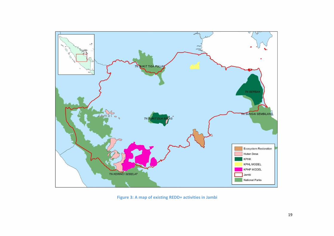
Existing projectsJambi has been an important province for many environmental organizations due to its high levels ofbiodiversity and endangered species such as the Sumatran tiger. As a result, international NGOs withtechnical capability in conservation projects are present in the region, and there is a network of localCSOs, organized under the umbrella organization named WARSI. Figure 3 shows the current location ofexisting project activities.
The majority of donor and NGO activities have focused on securing community land tenure rights forforest areas and also the implementation of improved forest management through initiatives such asvillage forests and KPHs in buffer zones around the province’s major national parks.
In the western part of the province, a major REDD+ initiative is being spearheaded by WARSI and itspartner organizations, which have developed 26 village forests (hutan desas) as a way to preventcommercial expansion of agriculture and forestry activities into upper highland forest areas. Thesevillage forest concessions (hutan desas) represent a large area of forest and are now moving towardsimplementation of management plans. These village forest areas (hutan desas) also border KerenciNational Park where groups like WARSI, AKAR, and FFI are working on community forest managementand creation of alternative livelihoods through NTFPs and agroforestry.
In the coastal region, the most significant project is the Berbak Carbon Initiative in the Berbak NationalPark and the surrounding buffer zone. Here the park administration and the Zoological Society ofLondon (ZSL) are working to protect and conserve the national park. The project has alreadyimplemented environmental monitoring systems, forest patrols and engagement strategies withcommunities as well as timber companies in the park’s buffer zone. The model KPHK surrounding thepark has also been officially authorized for implementation. Similarly, forest rehabilitation andconservation are also being piloted at a large scale through the implementation of the Harapanecosystem restoration project by Birdlife Indonesia.
19
Figure 3: A map of existing REDD+ activities in Jambi
20
High-potential interventions for Phase 2In Jambi, high-potential interventions have been identified in two distinct geographical and ecologicalregions; (1) implementation of village forests and a KPHP in the western highlands of the province; (2)increased protection of Berbak National Park and implementation of KPHK and KPHL in the coastalregion of the province.
a. Village forests and KPHP in the western highlands of the provinceBatang Hari watershed, in the western highlands, is an important area for agriculture and water supplyto the province. As such, continued support for the development and implementation of village forestmanagement plans combined with the implementation of the KPHP system in the upper highlands offersthe potential to deliver impact across the REDD+ goals. Implementation of KPHP has the potential tolead to moderate carbon emissions reductions and maintain carbon stocks, as well as protect speciesrichness in areas of high biodiversity. The model is premised on the inclusion of communities inmanagement and the development of localized enterprises resulting in new economic opportunities.7
Considerable work by WARSI and its partners has already been completed in 26 villages. The SRAP andRAD-GRK also clearly identify these project types as a key part of the province’s overall strategy onreducing conflict over land tenure. In addition, the respective district governments are supportive ofvillage forest implementation. In the short term, support should be focused on supporting thedevelopment and implementation of village forest plans by working with WARSI and its partnerorganizations who have the capability to scale up current work. In parallel to this, it is important thatefforts are focused on SRAP activities to support the development of regional spatial planning, creationof forest patrols, alternative livelihood development, NTFP market development and small-scale timberharvesting.
b. Protection of Berbak National Park and KPHK and KPHL is the coastal region of the provinceThe coastal forest region of Jambi is highly threatened by agriculture expansion and oil and gas facilities.Work is already underway to improve the protection efforts of the Berbak National Park and toimplement KPHs in the surrounding buffer zone. The protection of the forest area has the potential tosubstantially reduce carbon emissions, maintain carbon stocks and protect important ecosystems andbiodiversity.8 Although conservation activities are not expected to lead to substantial economic gains,the development of a KPH in the surrounding buffer zone can support the development of localenterprises and job creation as a result.
The organisations working in the region, such as ZSL, have the relevant skills and capability to scale upthe activities and the project is clearly aligned with the priorities of the province’s SRAP and RAD-GRK.Targeted funding to increase conservation activities in this area could have a direct impact on reducingemissions and achieving the other REDD+ goals. For example, increasing the number of patrols andmonitoring, promoting income generating activities for local communities and increasing managementof KPHK of concessions surrounding the park would all promote the sustainable management of thearea. However, it is also important that SRAP activities aimed at promoting KPHs, community capacitybuilding and empowerment, and clarification of tenure and spatial planning are supported. The projectarea is also severely affected by fires, so activities to improve capacity to prevent and fight forest firesare necessary and consistent with both Jambi’s RAD-GRK and SRAP.
7 Based on GGGI analysis of the potential impact of KPH projects on the four goals of the REDD+ National Strategy.8 Based on GGGI analysis of the potential impact of forest conservation projects on the four goals of the REDD+National Strategy.

21
2.4. Aceh
Overview of REDD+ policyAceh is still in the process of developing its SRAP; however, the provincial government has completed itsRAD-GRK. The RAD-GRK contains a broad mix of activities that address the legal and institutionalunderpinnings of REDD+ and project-level activities in both the forestry and agriculture sector.
In the forestry sector, activities focus on improving the sustainable management and conservation offorests and peatlands. This will be achieved by developing a sustainable forest and peatlandmanagement plan for the province and also through forest rehabilitation within priority watersheds.Communities are also recognised as a critical stakeholder in the RAD-GRK and activities focus on buildingawareness of the importance of forest services, developing capacity to design and implement villageforests (hutan desas), and supporting projects that provide alternative sources of income tocommunities around forest areas.
Agriculture is an important sector in Aceh and the RAD-GRK contains activities that improve theenforcement of spatial planning and control land use permits in forests and peatlands. At the site level,activities aim to intensify the use of agricultural land and to develop crops (e.g. palm, cacao, rubber) onnon-forest area or degraded APL area.
Existing projectsThe forests of Aceh are an important area for biodiversity and this is recognized by donors, NGOs andCSOs, who have recently established projects that aim to conserve key ecosystems in the province.
In Ulu Masen, FFI have been working with the provincial government to improve land use planning andreforest, restore and sustainably manage community logging on 750,000 ha of forest. In the LeuserEcosystem Reserve, YLI has been working with communities in the area to raise awareness and enforcethe boundaries of the reserve. Similarly, IFACS are working in the area to improve spatial planning,strategic environmental assessments and conduct GIS training for the local forestry department staff. Inaddition, IFACS have been supporting small-scale community initiatives to manage and restorecommunity forest in a number of locations.
There are a small number of projects focused on sustainable agriculture; however, these are generalsmall-scale activities. For example, Swiss Contact is working with cacao growers in the landscape toimprove incomes and reduce the potential need for expansion into forest areas. Also, FORPALA workswith farmers to increase nutmeg production and improve the value chain of nutmeg oil and foodproducts in Aceh Selatan. This project includes training on good practice for nutmeg cultivation systems,especially in integrated pest and disease management.
Background Land area: 5.7 million haxix
Population: 4.3 million of whom 86% live in rural areasxx
Major economic sectors: Agriculture, livestock, forestry and fisheries (18% GDP), mining andquarrying, mainly oil and natural gas (11.6% GDP) services (11.5% GDP)xxi
Forest coverage: 3.3 million haxxii
Deforestation rate: 300 ha per year on average between 1996 -2012xxiii
Drivers of deforestation: Extensive farming and plantation, mining area expansionxxiv

22
2.5. Central Sulawesi
Background Land area: 27 million haxxv
Population: 2.6 million people (2010)xxvi
Major economic sectors: agriculture, mining, forestryxxvii
Forestry cover: 4.3 million haxxviii
Deforestation rate: Average 16,800 ha per year from 2000-2011xxix
Drivers of deforestation: Extensive farming and plantation, mining area expansionxxx
Overview of REDD+ policyCentral Sulawesi is still in the process of developing its SRAP; however, the provincial government hascompleted its RAD-GRK.
Within the agricultural sector a number of activities are identified in the RAD-GRK with the goal ofreducing emission through the implementation of integrated pest management systems, use of organicfertilizer, and the development of improved irrigation systems. In addition, the RAD-GRK targetsagricultural development of oil palm and cocoa on degraded APL land in order to avoid further forestclearance through agriculture expansion.
The forestry sector is also an important intervention area in the RAD-GRK, which includes a target toestablish 11 KPHs in the province as a way to reform the land governance systems. Another key forestrysector strategy in Central Sulawesi’s RAD-GRK is to provide support to HTIs in order to improve theproductivity of the forestry industry and reduce pressure on the surrounding natural forests. At thecommunity level, the RAD-GRK calls for support to community timber plantations (HTR) and alternativelivelihoods within community forest systems (hutan kemasyakaratan).
Under the RAD-GRK’s thematic focus on the forestry sector, there is also an emphasis on therehabilitation of forest ecosystems that provide valuable environmental services along with importanteconomic benefits. Specifically, the RAD-GRK targets environmental rehabilitation in former naturaltimber concessions, highland watersheds and coastal mangroves.
Existing projectsCentral Sulawesi does not have a large number of ongoing REDD+ activities. However, there are a fewkey projects that cover large areas of natural forest and surrounding buffer zones where agriculturalexpansion is a key driver of deforestation.
In the district of Donggala, TNC is implementing the Central Sulawesi Integrated Area Development andConservation Project that is geared towards enhancing protection of Lore Lindu National Park and itsbuffer zone. This project is designed to, firstly, improve the socioeconomic welfare of villagessurrounding the National Park so that they are economically independent from the park’s resources and,secondly, to protect the park’s biodiversity through the strengthening of park management.
The two other documented REDD+-relevant projects in the province are two model KPHs projects thatcover over 225,000 ha of production forest area. These KPHs have already been officially approved andare now entering into the implementation phase.

23
2.6. Papua
Overview of REDD+ policyPapua has developed and approved both its RAD-GRK and SRAP.
Given the large extent of remaining natural forest in Papua, the SRAP and RAD-GRK of Papua focusalmost entirely on forestry and the reformation of the timber sector. Both documents target capacitybuilding in the timber sector to support the implementation of best management practices in bothtimber plantations and the natural forest industries sector, for example, through the reduction of theannual allowable cut in concessions.
Communities form an important focus of the SRAP and RAD-GRK activities for the province. Both refer tothe development of community plantations (HTR) and small-scale timber harvesting and processing. TheSRAP specifically calls for the promotion of community and village forestry initiatives (hutankemasyakaratan and hutan desa) that work with farmers to implement agroforestry systems in areaspreviously used for shifting agriculture. In ex-logging concessions and critical watershed areas, activitiesare aimed at ecosystem restoration and rehabilitation. In addition, the RAD-GRK calls for theimplementation of 56 KPH units in the province.
Underpinning all of this is the development of an integrated spatial planning process that reduces landconversion. This cross-sectoral regulatory reform is a critical step in enabling the Papuan provincialgovernment to effectively site activities to maximize economic benefits and mitigate forest conversion.
Existing projectsA number of donors and NGOs carry out activities in Papua aimed at protecting the high levels ofbiodiversity and endangered endemic species, as well as tackling the high levels of poverty.
The IFACS project is currently conducting a range of activities in the Papua, including supporting districtsto develop spatial plans and incorporate low emission development plans into their overall economicdevelopment planning process. This project also includes working with five timber concessions on theimplementation of SFM practices. In addition, IFACS is supporting small-scale agricultural andcommunity based forest management schemes. Similarly DFID have just begun a programme of work tosupport the Papuan government to develop and implement their provincial spatial plan in the provinceand develop a green fund to support local sustainable forestry enterprises.
In the Cyclops mountain region, Norway is supporting a project focused on forest patrols andenforcement of anti-logging and animal trade laws, whilst USAID is supporting FFI to implement anintegrated conservation and development project that generates revenue from carbon financing as away to rehabilitate and protect the highland forest watershed area. In addition, IUCN has been workingin the province to develop FPIC processes with local communities.
Background Land area: 32 million haxxxi
Population: 2.83 million people Major economic sectors: Mining, forestry, fishing, subsistence agriculture xxxii
Forestry cover: 25 million ha xxxiii
Deforestation rate: Average 53,000 ha per year from 2000 - 2009xxxiv
Drivers of deforestation: Logging of primary forest to secondary forest, large scale plantationagriculture.

24
2.7. Riau
Background Land area: 8.7 million haxxxv
Population: 5.5 million people Major economic sectors: Petroleum, natural gas, rubber, palm oil and fiber plantationsxxxvi
Forestry cover: 2.45 million haxxxvii
Deforestation rate: 286,156 ha from 2005 to 2006xxxviii
Drivers of deforestation: Expansion of palm oil and logging for paper production, peatfiresxxxix
Overview of REDD+ policyRiau has developed and approved its RAD-GRK and SRAP.
Both the SRAP and RAD-GRK focus their activities on the rehabilitation, restoration and conservation ofpeat and non-peat areas. In particular, the SRAP focuses its activities on strengthening the capacity ofinstitutions and stakeholders that manage forests, including communities and concessionaries. The SRAPproposes that this is achieved through a variety of legal and regulatory levers but the emphasis is placedon the implementation of the spatial plans (RTRWP/RTRWK), recognition and protection of tenure incommunity forest lands, improvements in the management and granting of licenses, and increasedMRV. Underpinning all these is the establishment and operationalization of a provincial REDD+institution with an accompanying MRV institution. At the project level, activities aim to restore andconserve peatland areas and prevent fires by restoring the hydrology of dried areas and replanting.
In forested areas, activities are orientated towards improvements in the financial and technical capacityof concessionaires and communities to implement legality and SFM. In support of this, there are alsoactivities that support the development of downstream industries to promote value add in the province,both in timber and palm oil sectors. The RAD-GRK places more emphasis on rehabilitation andrestoration of the forest in degraded timber concessions.
The SRAP also focusses on building community awareness and capacity to engage in forestmanagement, primarily through training and establishing village institutions that manage the interactionwith government, NGOs and the private sector. Additional activities aim to improve local economies inand around forests through, for example, recognizing community land tenure, identifying alternativesources of income and increasing productivity in community plantations (HTR).
Existing projectsThere are a limited number of ongoing REDD+-relevant projects taking place in Riau. The focus of theseprojects is on peat and forest conservation. In particular, the Kampar Carbon Reserve Project in the eastof Riau aims to work with various corporate stakeholders to protect and manage the remaining intactpeat swamp forests in the region. APRIL and APP are two major corporate stakeholders in this projectand APRIL has already obtained a license to manage an ecosystem restoration license.
Two KPHs are being developed in the province, one in Tebing Tinggi and one in Tasik Besar Serkap. Bothhave been authorized by the provincial government, however, the level of implementation is not knownat this time.
25
2.8. South Sumatra
Background Land area: 9.1 million haxl
Population: 7.4 million people xli
Major economic sectors: Timber, oil, gas, coal, rubber, palm Forestry cover: 3.8 million haxlii
Deforestation rate: 4.41% per year from 2006-2011xliii
Drivers of deforestation: Agricultural expansion, forest fire, forest degradation from illegallogging xliv
Overview of REDD+ policySouth Sumatra has developed and approved its RAD-GRK and SRAP.
Given the prominence of peat in the area as a carbon sink, many of the activities listed in the SRAP andthe RAD-GRK are aimed at conserving peat forest and mangroves. In peatland areas, activities includeimproved hydrology and irrigation network management, wetland and forest rehabilitation, and forestfire prevention and implementing fire monitoring systems.
Communities play an important role in the development of REDD+ in the province. The SRAP and RAD-GRK both highlight the importance of engaging communities on a range of activities, including tenuremapping, capacity building for community based forest management systems and establishingcommunity forest management schemes that include village and community forests (hutan desa andhutan kemasyakaratan) and community plantations (HTR). The SRAP also has a strong theme ofincluding stakeholders and includes numerous activities that are designed to increase participation andensure that a broad range of stakeholders understand and accept REDD+ within the province.
Legal and regulatory reform are highlighted in the SRAP with numerous activities listed that seek toreform laws and policies covering concession licensing, spatial planning and environmental lawenforcement.
Reducing emissions from agriculture is more prominent in the RAD-GRK, where activities are aimed atthe production and use of organic fertilizers and methane capture from livestock, as well as increasingthe capacity of small-holder farmers within the palm oil sector to implement best practice.
Existing projectsSouth Sumatra has not been a major target province for many environmental NGOs and therefore thereare not many ongoing REDD+ projects in the province as compared to other REDD+ pilot provinces. Withrelevance to peat conservation, the main REDD+ demonstration activity in South Sumatra is the MerangPeat Conservation project, which was started by GIZ in 2008. The project has collected significant dataon the project and developed a number of project design documents.
In support of the province’s SRAP activities on community forestry, the province also has two modelKPHs established covering over 300,000 ha of natural production forests. While these projects are stillin the early development phase, KPH boundaries have been established and have received officialauthorization for establishment.
26
2.9. West Kalimantan
Overview of REDD+ policyWest Kalimantan has developed and approved a RAD-GRK; however, it has not yet finished the processof developing its SRAP9.
The RAD-GRK identifies a small number of emission reduction activities in the agricultural sector,including improvements to irrigation systems, use of fertilizers, general farming practices and a reviewand evaluation of the policies governing the sector. Forestry is also considered in the RAD-GRK withinterventions supporting the rehabilitation and conservation of forest and peat swamp ecosystems. Thegoal is to increase forest cover in these areas combined with a review and evaluation of policiesgoverning the forest sector.
Existing projectsThere are a number of REDD+ projects taking place in West Kalimantan due to the strong presence ofNGOs that have developed pilot projects that focus on protecting large blocks of peat swamp forest andorangutan habitat.
FFI has been one of the biggest proponents of REDD+ in the province and has targeted two criticallandscapes. The first covers the expansive peat belt area along the coast, beginning at Gunung PalungNational Park and extending south of Ketapang to the Pematung Gadung peat belt. In this landscape FFIhas worked on peat conservation with a palm oil concession and also a large-scale village forest (hutandesa) project in the Pematung Gadung peat forest. The other focus area for FFI is the Danau Siawan-Belida Forest landscape, which also covers a large-scale peat swamp forest. A series of other local NGOsare implementing conservation programs in key National Park buffer zones funded by IFACS.
At the district level, Ketapang and Kayong Utara have been selected as project landscapes within theUSAID funded IFACS project due to the large presence of threatened peat forests. This project is workingwith local governments of these two landscapes to revise and enhance their spatial plans. In addition,IFACS is working with a number of palm oil companies and timber companies on the implementation ofbest practices that will increase productivity.
The West Kalimantan government has also developed three model KPH for production forest as a wayof improving overall management of the commercial timber concessions in the province. These KPHshave been formally authorized and boundaries have been delineated.
9 GGGI is aware that the West Kalimantan SRAP was completed in early December; however, this document wasshared in time to be included in this version of the report.
Background Land area: 14.6 million haxlv
Population: 4 million people (2004)xlvi
Major economic sectors: Agriculture (palm plantation, rubber, paddy field, others), forestry,energy, transportation
Forestry cover: 9.1 million haxlvii
Deforestation rate: 76,610 ha per year average between 2000-2011xlviii
Drivers of deforestation: Conversion of forest for agriculture, forest encroachment, economicdevelopment.xlix
27
2.10. West Papua
Overview of REDD+ policyThe government of West Papua has already developed and approved a SRAP and is in the process ofdeveloping a RAD-GRK.
The SRAP is heavily focused on the forestry sector as West Papua has a high percentage of remainingnatural forest. Forestry sector activities in the SRAP cover legal and regulatory reforms, includingreducing the annual allowable cut area of timber concessions to ensure more sustainable harvests andmaking concession license approval dependent on a company’s commitment to RIL.
At the project level, the SRAP calls for engagement with concessionaires to implement RIL andrehabilitate degraded forest zones. Revising the spatial planning process and enforcing forestboundaries are also seen as priorities to achieve West Papua’s REDD+ strategy. At the community level,the SRAP seeks to assist communities in the development of community timber plantations (HTR).
Furthermore, the SRAP lists a series of activities that will build the province’s capacity to implementREDD+ at the institutional level including developing a system of MRV, implementing FPIC, developing abenefit distribution system and increased support to the province’s REDD+ institutions.
Existing projectsThe existing REDD+ projects in the province are focused on engagement of timber concessions that havebeen degraded and are therefore at risk of conversion due to the low remaining timber stocks. The WestPapua Forest Carbon project managed by New Forest and Asia Pacific Carbon is targeting 16 concessionstotaling over 1 million ha. Project activities include accessing carbon financing for rehabilitation activitiesand the implementation of sustainable forest management in active timber concessions. TBI is alsoworking with three large-scale timber concessions to achieve SVLK and FSC certification for an areacovering close to 300,000 ha of natural forest. In the district of Sorong, the province has established alarge-scale KPHL that covers over 200,000 ha.
There are limited projects focused on community forestry; however, IUCN is implementing a projectwith a strong community engagement focus. This involves developing FPIC processes for working withcommunities on establishing land tenure rights and promoting sustainable alternative livelihoods.
Background Land area: 11.5 million hal
Population: 760,422 people li
Major economic sectors: Forestry and mining Forest cover: 9.7million halii
Deforestation rate: 300,000 ha per year on average between 2009-2010liii
Drivers of deforestation: Unsustainable timber harvesting and mining

28
2.11. West Sumatra
Background Land area: 4.2 million haliv
Population: 4.8 million people (2010)lv
Major economic sectors: Rubber, mining, forestry, agriculture Forestry cover: ~2.6 million Halvi
Deforestation rate: 210,000 Ha per year on average between 2000-2010lvii
Drivers of deforestation: Extensive forest clearing by large-scale extractive industries (timberminerals, palm oil, rubber, and coal), agriculture expansion.lviii
Overview of REDD+ policyWest Sumatra has developed and approved its RAD-GRK and SRAP.
The province’s SRAP mainly focuses on creating the enabling conditions for future REDD+ institutions,building technical capacity of these institutions and creating a REDD+ MRV systems for the province.Community engagement is also a focus of West Sumatra’s SRAP with a focus on community based forestmanagement schemes, such as village and community forests (hutan desa, hutan kemasyakaratan), andcommunity plantations (HTR), which are seen as ways of improving forest management across theprovince.
The RAD-GRK goes into significant detail outlining a number of activities that are designed to reduceemissions. One of the major focuses in the forestry sector is on engaging the private sector toimplement best management practices, such as reduced impact logging. West Sumatra’s RAD-GRK alsohighlights the need for SFM certification to make the sector more sustainable. At the policy level,reducing the annual allowable cut is seen as a way to ensure sustainable harvesting practices, whileforest rehabilitation in key watershed regions is also identified as a critical action.
The agriculture sector is the other focus area of the RAD-GRK, which includes a number of activities toincrease productivity through the use of organic fertilizer, improvements in irrigation, expansion intodegraded lands and use of agroforestry systems that include livestock. Capacity building to small holderfarmers is also included within interventions in the agriculture sector.
Existing projectsWest Sumatra has not witnessed the high number of REDD+ pilot projects compared to other provincesin Sumatra like Jambi and Aceh. However, there a few important REDD+ activities that are taking place.The first is the long term Siberut Conservation Program that has been working in the Mentawai islandsimplementing an integrated approach to conservation that combines field research and communitybased conservation.
The province has also established two large scale protection KPHL in the highlands totaling over 200,000ha and a production forest KPH that covers 130,000 ha of natural forest area slated for timberconcessions. The level of implementation is not known at this stage.

29
End notes
i Central Kalimantan, Governors Climate and Forests Task Force Knowledge Database [online] Avaliable at:www.gcftaskforce-database.org/stateoverview/centralkalimantan [Accessed 12 December 2013]ii Ibidiii Ibidiv Ibidv Ibidvi Ibidvii East Kalimantan, Governors Climate and Forests Task Force Knowledge Database [online] Avaliable at:<www.gcftaskforce-database.org/stateoverview/EastKalimantan [Accessed 12 December 2013]viii Ibidix Ibidx Ibidxi Ibidxii Ibidxiii Ibidxiv Local Action Plan for GHG Emission Reduction (RAD-GRK)for Jambi, page 6xv BPS, taken from: http://sp2010.bps.go.id/index.php/site?id=1500000000&wilayah=Jambixvi Local Action Plan for GHG Emission Reduction (RAD-GRK)for Jambi, page 6, page 9xvii Local Action Plan for GHG Emission Reduction (RAD-GRK)for Jambi, page 6, page 17xviii Local Action Plan for GHG Emission Reduction (RAD-GRK)for Jambi, page 6, page 17xix Aceh, Governors Climate and Forests Task Force Knowledge Database [online] Avaliable at:<www.gcftaskforce-database.org/stateoverview/Aceh>[Accessed 12 December 2013]xx Ibidxxi Ibidxxii Ibidxxiii Ibidxxiv Ibidxxv Local Action Plan for GHG Emission Reduction (RAD-GRK) for Sulawesi Tengah, II-1, page 11xxvi Local Action Plan for GHG Emission Reduction (RAD-GRK), for Sulawesi Tengah,II-3 (page 13)xxvii Local Action Plan for GHG Emission Reduction (RAD-GRK), for Sulawesi Tengah , II-6 (page 16)xxviii Local Action Plan for GHG Emission Reduction (RAD-GRK), for Sulawesi Tengah ,III-16 (page 61)xxix Local Action Plan for GHG Emission Reduction (RAD-GRK), for Sulawesi Tengah ,IV-5 (page 128)xxx Local Action Plan for GHG Emission Reduction (RAD-GRK), for Sulawesi Tengah ,, III-75 (page 120)xxxi Potret Keadaaan Hutan Indonesia, 2000-2009, Forest Watch Indonesia, 2011, Available at: http://fwi.or.id/wp-content/uploads/2013/02/PHKI_2000-2009_FWI_low-res.pdf> [Accessed 12th December 2013]xxxii Economy of Papua New Guinea, Wikipedia [online] Available at<http://en.wikipedia.org/wiki/Economy_of_Papua_New_Guinea#Economy> [Accessed 12 December 2013]xxxiii Potret Keadaaan Hutan Indonesia, 2000-2009, Forest Watch Indonesia, 2011, Available at: http://fwi.or.id/wp-content/uploads/2013/02/PHKI_2000-2009_FWI_low-res.pdf> [Accessed 12th December 2013]xxxiv Ibidxxxv WWF, Deforestation, Forest Degradation, Biodiversity Loss and CO2 Emissions in Riau, Sumara, Indonesia,(2008), WWFxxxvi Ibidxxxvii Ibidxxxviii Ibidxxxix Ibidxl Local Action Plan for GHG Emission Reduction (RAD-GRK) for Sumatera Selatan, 4, page 22xli Local Action Plan for GHG Emission Reduction (RAD-GRK) for Sumatera Selatan, 10, page 28xlii Local Action Plan for GHG Emission Reduction (RAD-GRK) for Sumatera Selatan, 14, page 32xliii Local Action Plan for GHG Emission Reduction (RAD-GRK) for Sumatera Selatan, 63, page 81
30
xliv Local Action Plan for GHG Emission Reduction (RAD-GRK) for Sumatera Selatan, 63, page 81xlv Local Action Plan for GHG Emission Reduction (RAD-GRK) for Kalimantan Barat RAD-GRK, II-1, Page 13xlvi Papua Barat, Wikipedia [online] Available at < http://id.wikipedia.org/wiki/Papua_Barat> [Accessed 12December 2013]xlvii Local Action Plan for GHG Emission Reduction (RAD-GRK) for Kalimantan Barat, Page 19xlviii Local Action Plan for GHG Emission Reduction (RAD-GRK) for Kalimantan Barat, II-31, Page 43xlix Local Action Plan for GHG Emission Reduction (RAD-GRK) for Kalimantan Barat, II-29, Page 42l Papua Barat, Wikipedia [online] Available at < http://id.wikipedia.org/wiki/Papua_Barat> [Accessed 12 December2013]li Badan Pusat Statistik [Online] Available at:<http://www.bps.go.id/tab_sub/view.php?kat=1&tabel=1&daftar=1&id_subyek=12¬ab=1> [Accessed 12December 2013]lii Kehutanan, Website Pemerintah Propinsi Papua Barat [Online} Available at<http://papuabaratprov.go.id/index.php?option=com_content&view=article&id=52&Itemid=60> [Accessed on 12December 2013]liii Omona, J, 2012, Deforestation rate in West Papua still ‘alarming’ says Greenpeace, Pacific Scoop, Available at <http://pacific.scoop.co.nz/2012/08/deforestation-rate-in-west-papua-still-alarming-says-greenpeace/> [AccessedDecember 12th 2013]liv Local Action Plan for GHG Emission Reduction (RAD-GRK) for Sumatera Barat, II-1, page19lv Local Action Plan for GHG Emission Reduction (RAD-GRK) for Sumatera Barat, II-1, page19lvi Local Action Plan for GHG Emission Reduction (RAD-GRK) for Sumatera Barat, II-3, page 21lvii Margono BA, Turubanova S, Zhuravleva I, Potapov P, Tyukavina A, Baccini A, Goetz S, Hansen MC (2012)Mapping and monitoring deforestation and forest degradation in Sumatra (Indonesia) using Landsat time seriesdata sets from 1990–2010. Environ Res Lett 7(3):034010lviii Overview, Borneo and Sumatra, WWF [online] Available at: <http://worldwildlife.org/places/borneo-and-sumatra> [Accessed 12th December 2013]