
The Recovery Story - Forest Fire Management Victoria Web viewA local architectural firm was engaged...
109
1 ASSET REPAIR and REPLACEMENT 12 The Recovery Story - The 2003 Alpine Fires
Transcript of The Recovery Story - Forest Fire Management Victoria Web viewA local architectural firm was engaged...

1ASSET REPAIRand REPLACEMENT
12 The Recovery Story - The 2003 Alpine Fires

The Recovery Story - The 2003 Alpine Fires 13
IN PARKS, FORESTS AND ALPINE RESORTS, many visitorand management facilities were destroyed or damaged by the fires. It was important to replace these assets quickly to facilitate the recovery of the recreation and tourism sectors and ensure safe access for visitorsand land managers.Assets needing repair or replacement included picnic areas, camping grounds, refuge huts, lookouts, toilets, car parks, roads, walking tracks, signs, visitor information boards, snow poles and resort assets.
14 The Recovery Story - The 2003 Alpine Fires
Repairing and replacing assets in our parks, forests and alpine resorts
Many visitor and management facilities and built infrastructure in parks, forests and alpine resorts were destroyed or damaged by the 2003 Alpine fires.
Government agencies responded quickly to repair or replace assets such as roads, bridges and snow poles, and to assess all the other damaged but non-critical assets to determine a works program.
VicRoads crews and contractors worked around the clock throughout February and March 2003 toassess and reopen stretches of road affected by fire. Thousands of fallen and unstable trees had to be removed, along with damaged barriers and signs, before roads could be repaired. In total, 4435 km of roadway was affected, including 11 arterial roads covering 870 km, and thousands of roadside signs, posts and guardrails.
Around 200 visitor sites were affected and 46 bridges in National Parks and 109 in State forests damaged or destroyed.
Priority assets were replaced or repaired within the first few months, to facilitate the recovery of the recreation and tourism sectors in the alps, and to ensure safe access for visitors and land managers.
Assets requiring repair or replacement in parks, ski resorts and forests included picnic areas, camping grounds, huts needed for refuge or management, lookouts, toilets, car parks, roads, walking tracks, signs, visitor information boards, snow pole lines and gates.
Walking tracks in National ParksParks Victoria carried out considerable rehabilitation work on walking tracks atMt Buffalo, Mt Bogong and Mt Feathertop. Tracks that had either been directly affected by the fire, or as a result of run-off after the fires, were restored across a wide area.
In most cases tracks were repaired usingdry-stone construction techniques completed by specialist walking track construction crews, ensuring the results will be long lasting.
In the Mt Buffalo National Park and the Alpine National Park, restoration works were undertaken on 16 tracks covering nearly 40 km.
Many kilometres of walking tracks also needed to be cleared so that visitors could once again walk in the more remote areas of the alps.The tracks were covered with fallen timber and vegetation had grown rapidly, making navigation difficult.
A staged works program to repair and replace assets burnt or damaged in the fires ensured safe visitor accessto National Parks, alpine resorts and State forests.

The Recovery Story - The 2003 Alpine Fires 15
Risk managementEnsuring the safety of visitors to National Parks in the fire-affected areas was a high priority for Parks Victoria. It was important to make areas and sites safe where there were potential threats to visitors.
Destroyed huts were cleaned up, burnt structural materials taken away and contaminated asbestos matter identified and removed.
Two of Victoria’s most popular alpine resorts, Falls Creek and Mount Hotham, were affected by the 2003 bushfires. While damage to infrastructure at both resorts was minimised, significant areas of skiing terrain were burnt and wider areas surrounding the resorts were severely affected.
Early repair and the replacement of damaged assets was critical to allowing the resorts to operate safely in the 2003 snow season.
Signs for roads, car parks and trails, toboggan area fencing, ski trail bridges and ski pole lines within resorts were repaired or replaced.
In Gippsland State forests, new recycled plastic signs for track names were trialled and proved to be a cost-effective, labour-saving and environmentally friendly alternative to the treated pine fingerboardsigns previously used. The advantages of the recycled plastic signs include: non-rotting, insect resistant, low maintenance, high UV stability, reduced dust toxicity compared to routing timber, no need to paint the letters, colour matching is available and the mounting options are similar to timber.
Replacing damaged log fill crossings in the burnt areas with concrete culverts was also identified as a high priority.

16 The Recovery Story - The 2003 Alpine Fires
Seldom Seen Fire Tower replacementMt Seldom Seen Fire Tower at Gelantipy in East Gippsland was destroyed in the January 2003 bushfires.
Fire-spotting towers are one of the best means of detecting fires in remote areas, so it was important to rebuild this tower quickly, so that it would be operational for the following fire season.
Early detection of fires is vital in restricting their spread. DSE has more than 70 fire towers in strategic locations to ensure maximum coverage of Victoria’s parks and forests.Some of these lookouts are staffed during the fire season for varying periods, including Mt Seldom Seen Tower. It has a hut to accommodate the staff member on fire watch duty.
The rebuilding of the fire tower and replacement of damaged equipment was completed by June 2003 and it wasoperational for the next summer. The hut was rebuilt by February 2005.
Fire control lines were stabilised and rehabilitated, tracks and trails repaired, and fire-damaged trees and other obstacles removed to ensure the ski slopes were safe.
The rehabilitation of Victoria’s alpine resorts was critical in providing confidence, economic benefits, job opportunities and security throughout the region, particularly for the townships and communities around Mt Beauty, Bright, Harrietville and Omeo.
Parks Victoria engaged local tour operators to help with track assessments and identify priorities for work crews, which provided an alternative source of income for the operators whose businesses were affected by the fires.
Local community groups and recreation organisations worked with government agencies on the repair and replacement of assets program.
VicWalk (the Federation of Victorian walking clubs) and the Melbourne Bushwalkers club were involved with surveying pole lines. The peak body for four wheel drivers in Victoria, 4WD Victoria, assisted with track clearing. A ‘round table’ consultation group was formed (including the Victorian High Country Huts Association which was set up following the 2003 bushfires) to assist with developing a strategy for hut repair and replacement and some members of the group also worked on rebuilding the huts.
DSE and Parks Victoria also consulted with a range of groups including the Australian Alps Liaison Committee, the Omeo Business Group, the Friends of Cobberas, Alpine Region Tourism, Indigenous communities and the Omeo Historic Society to determine works programs and priorities.

18 The Recovery Story - The 2003 Alpine Fires
Assessing damage to high country huts – reconstructing huts of historic and refuge significance
When bushfires swept through Victoria’s alpine region in January 2003, almost 45 historic high country huts were destroyed and of these 29 were in the Alpine National Park. The loss was significant, as many of these huts were an important part of Australia’s post-settlement history, providing shelter for recreational users, forestry workers and cattlemen.
Many of these huts were of historical importance, so it was necessary to work closely with heritage experts to assess fire damage before proceeding with any repair or reconstruction work. In particular, any work on huts listed on the Victorian Heritage Register or Heritage Inventory involved seeking permits from Heritage Victoria.
Destroyed hutsDetermining which huts should be reconstructed was a complex process, due to the significant public and stakeholder interest in the issue.
Immediately after the fires, enthusiastic members of the public formed the Victorian High Country Huts Association. A workshop was held in late August 2003,with representatives from this Association together with other stakeholders including: the Mountain Cattlemen’s Association, the Federation of Victorian Bushwalking Clubs, the Victorian National Parks Association, Falls Creek Alpine Resort Management, Parks Victoria, Department of Sustainability and Environment (Forests Service), NSW Parks and Wildlife Service; and the Victorian Association of Four Wheel Drive Clubs.
The objectives of the workshop were to agree on a process for assessing hut replacement and to recommend which huts should be replaced. Participants also debated the best method of replacing and maintaining these huts.
A workshop with stakeholders determined a process for identifying huts to be reconstructed.A comprehensive post-fire assessment of all the surviving huts was completed by June 2005, providing crucial information on the condition and community significance of these huts, which will inform future repair and management directions.
Alpine National ParkThe decision whether or not to replace a destroyed hut in the Alpine National Park (ANP) was guided by the existing Management Plan (1992). Under this plan,a hut may only be replaced if it fulfils an essential need for licensed grazing, management or refuge purposes. In all cases, approval is required.
Huts required for licence purposesFive huts in the Alpine National Park were linked to grazing licences. As grazing is no longer permitted in the ANP, refuge huts are being re-assessed for other values to determine if they need to be rebuilt.
Huts required for management purposesHuts used for other management purposes are also required to have a small refuge section open to the public.
Huts required for refugeSeveral huts were identified as being of significant refuge value because they were situated along popular walking or skiing routes and provided shelter from extreme alpine conditions.
Huts required for exceptional social purposesIn recognition of the existing social value of some huts at the time they were destroyed, it was decided that huts not falling into any of the above categories might also be replaced in the future.
Huts to be replacedIn all, it was agreed that six huts would be replaced. These included:Management huts• Mt Benambra Fire Tower Hut (primarily
for accommodation of DSE tower personnel)
• Bogong Aqueduct Hut (part of Southern Hydro lease arrangement)
Previous Cattlemen Huts with Social Value• Roper Hut• McNamara’s Hut
Refuge huts• Michell Hut – very high refuge and shelter value• Federation Hut – very high refuge and shelter value
Replacement of Federation, Michell and McNamara’s HutBy the beginning of 2005, five of the destroyed huts – Federation, Michell, Mt Benambra Fire Tower, Bogong Aqueduct and McNamara’s Huts – had been replaced. (Replacing McNamara’s Hut was a special case as outlined below.)
Some of the design guidelines for the reconstruction of Federation and Michell included:• All rebuilt huts to be designed and built in
sympathy with the natural environment.• Building materials to be in keeping with the purpose
of the hut and the setting, but not to be sourced from within the National Park.
• Site selection to be based upon indigenous community consultation, environmental assessment, fire protection and recreational needs.
A local architectural firm was engaged to design the new huts and stakeholders were invited to contribute suggestions to the design. A builder was then awarded the contract for fabricating the two huts – a not inconsiderable challenge given the harsh nature of the terrain and the need for the huts to be prefabricated and flown in pieces by helicopter to the remote sites.
It was decided that it would be impractical to replicate the old structures, with their hotchpotch of building styles and environmental inefficiency. The design for the new huts is both functional and robust, while still reflecting traditional values.
The bushfire also provided an excellent opportunity to raise the standard of the huts in line with their primary purpose as refuges. Both huts now easily accommodate 15 people for emergency refuge and come equipped with a bench for food preparation and water tanks. They are constructed of Cyprus pine, which weathers well under exposure to the elements and is resistant to insect damage.
Both huts were prefabricated in Stanley and then dismantled into 400 kg lots ready to be flown to their respective locations.
Federation HutThe original Federation Hut was nestled on a narrow ridge just south-west of Mt Feathertop in the Alpine National Park. Being located above the snow line, the hut at this popular site was considered essential for replacement because of its significant refuge value.
Helicopters flew in the materials for Federation Hut to the site in mid-December 2004, but weather conditions deteriorated and remained stormy throughout the entire construction phase.Builders and staff chose to remain on-site and continue working whenever possible.Construction of Federation Hut was completed in 11 days, just before Christmas 2004.
The Recovery Story - The 2003 Alpine Fires 19

20 The Recovery Story - The 2003 Alpine Fires
Michell HutMichell Hut is situated along the popular Eskdale Spur walking route to the Mt Bogong massif in the Alpine National Park. Built in 1967, it has a long history of providing shelter to those caught unprepared by sudden changes in temperature, heavy snow, fierce winds and other emergency conditions. Replacement was considered essential.
Work on Michell Hut began in early January 2005 and, with better weather conditions than were experienced for building Federation Hut, it was completed in eight days.

McNamara’s HutMcNamara’s Hut on the Bogong High Plains was the first hut to be replaced. Parks Victoria, in conjunction with the Victorian High Country Huts Association (VHCHA) and Mittagundi Children’s Camp, determined it was important to rebuild the hut, as it is a popular destination and regularly used by school groups. It is valuable for providing young people with an opportunity to enjoy the alpine environment and relive the alpine heritage.
Mittagundi staff and volunteers, together with the VHCHA, rebuilt the hut in April and May 2004 in the original style, using traditional bush skills. The biggest hurdle was transporting 40 tonnes of 11 m logs from the bush to the hut site – quite an effort given that they didn’t fit on one log truck. The hut is not for refuge use, but it is a well-used camping site and has a high educational purpose.
Other hutsMany other huts were assessed for a range of values including historic, social, aesthetic, management and refuge. It was determined by the stakeholder group that although there was evidence that some had local values, there was little ongoing identified social value that was severed by their loss which would justify rebuilding.
If an historic hut was not to be replaced, it was decided that the hut ruins would be protected and the site would be interpreted in line with heritage principles. Of the 1001 huts in the National Park prior to the fires, 81 are still in existence with five being rebuilt and one still be to be built.
Assessing the damage to surviving hutsTo assess the extent of the damage to surviving huts, a comprehensive survey of 85 huts across the Alps was carried out. Scattered across one million hectares, most huts were located in National Parks, State forests and the alpine resort, with only a couple on freehold land.
The assessment considered information from the 1996 Victorian Alpine Huts Heritage Survey, as well as looking at details of the fabric, condition and risks to previously unsurveyed huts. Each hut was also assessed for its social value, comparative significance and to identify user requirements and opportunities.
The assessment of the 85 surviving huts took place between February 2004 and June 2005, with some delays experienced due to access problems over winter. Vegetation regrowth did not pose a problem in finding the huts.
The process of reporting on each hut’s condition, protection and management proved to be straightforward. However, determining a hut’s social and historical significance was a more complex matter, involving community consultation on a topic that invokes firmly held and differing views.

2PROTECTION and RESTORATIONof CATCHMENTS and WATERWAYS

IN THE FIRST 6 TO 12 MONTHS after the fires, rain in the catchment caused the movement of soils, ash, nutrients and debris overland and into streams, rivers and water storages. Critical works were undertaken to minimise the potential for landslips and restore stream environments, and to monitor changes to water quality.Immediate works focused on:• soil conservation works;• rehabilitation of 6000 km of fire containment
lines constructed during firefighting operations on private and public land;
• clearing debris to stop it being washed into waterways;
• repairing and revegetating eroded riverbanks; and• upgrading water storage areas and treatment
works to ensure drinkable water was available to the alpine resorts and fire-affected townships.

24 The Recovery Story - The 2003 Alpine Fires
Controlling soil erosion and rehabilitating fire control lines to protect catchment health
The 2003 Alpine fires burnt a significant amount of vegetation in the water catchment areas in the North East and East Gippsland regions leaving a risk of soil erosion. The thousands of kilometres of fire control lines created during the fires to protect alpine resort, National Parks and State forest assets and to halt the spread of the fires were also likely to add to erosion problems. Rehabilitation was needed immediately to prevent serious erosion and damage to the catchments.
The loss of vegetation and the newly made control lines posed a real threat. Follow-up rain was likely to wash soil, ash and other debris into rivers and waterways, affecting water flow and water quality, and leaving sediment and debris accumulations.
Soil erosion and sediment deposits in rivers and waterways affects stream life, including fish and invertebrates. Burnt vegetation and cleared ground provides an ideal opportunity for weeds to grow and flourish, whichthen often out-compete the revegetating native flora.
The burning of such a large amount of vegetation also meant that the links between the flora and fauna communities were broken and needed reconnecting. Foxes and wild dogs could potentially start using the control line tracks to hunt native wildlife.
Another reason for immediate soil erosion control work on control lines was to prevent recreational vehicles using the new tracks. Once people start driving vehicles on tracks like these it is hard to stop their use.
A key part of the fire suppression strategy was to create control lines, which range from rake hoe trails constructed with hand tools to fire breaks up to 60 metres wide constructed with heavy earth moving equipment.
Some breaks could be seen for many kilometres, leaving scars on the forests. Soil disturbance ranged from the top layer of soil being scraped off to deep excavation with much of the vegetation removed. It all needed rehabilitation.
The many fire vehicles that used the alpine roads during the fire period caused deterioration to the existing road network, which also needed stabilisation works to prevent additional erosion.
Once it was safe to enter the alpine area (even while the fires were still burning), DSE, Parks Victoria and the North East and East Gippsland Catchment Management Authorities acted swiftly to rehabilitate fire control lines, roads, tracks and waterway crossings to minimise the impact on catchment health.
Most fire control lines were treated within three months of the fire and an audit in 2004 showed that 95% of the disturbed areas in the National Parks were recovering well.
Local tour operators were employed to help with track assessments to identify priorities for work crews. This provided financial support to tour operators whose businesses were affected because of the fires.
Guidelines based on the existing Code of Forest Practices for Timber Production and the Code of Practice for Fire Management on Public Land were developed and approved soon after the fires for work on or near waterways.
A priority was to rehabilitate disturbances in the catchments of town and domestic water supplies. Most of the work was done in the first three months after the fires, before the onset of winter.
A priority zone system covering catchment values, legislative overlays and ecological vegetation classes (EVCs) determined what rehabilitation work was needed and when it needed to be done.
In some areas, full rehabilitation – pulling soil and windrows back over the disturbed area and revegetation– was done immediately after the fire with equipment on-site. In other locations, basic breaching and barring work of roads and tracks was done immediately, with full rehabilitation occurring some time later. Doing full rehabilitation work straight away was found to be more effective and cost-efficient than returning later to complete the work.
Sediment and nutrient input into streams was controlled by good road drainage. There were only a few control lines that could not be fully rehabilitated because of their proximity to creeks.
It was found that trees fallen as a result of control line construction being pulled over the lines gave more protection to new vegetation coming through than other lines which just had a bit of dirt pulled back over the top of the tracks.

Timing is critical to the successful rehabilitation of disturbances. The quicker disturbed areas can be fully rehabilitated, the quicker will be the full recovery of habitat. If control lines are left for more than a few months, vegetation and habitat starts to establish which then shouldn’t be re-disturbed because any further machinery work on the area will damage what regrowth has occurred.
In total, 6120 kilometres of control lines were successfully rehabilitated in parks and forests, and most areas were treated in the first three months after the fires. Six bridges were replaced and seven major stream culverts were installed in the North East. In Gippsland, one bridge was replaced, three fords rebuilt and a new one installed, 14 earth topped log fills crossings were reconstructed using concrete pipes. A total of 11 new sets of culverts were installed to improve drainage and 32 km of road graded, as well as ten sets of gates replaced, 715 signs and three picnic tables.
The State forest road network in the fire-affected area in Gippsland was surveyed and each crossing assessed for its potential to deposit sediment into waterways. This data determined the priorities for stream crossing replacement.
A 2004 audit of soil erosion control work in National Parks showed that about 95% of disturbed areas were recovering well.
Some fire control lines have been left as strategic fire breaks to help provide protection in the event of future fires. The value of trained and dedicated rehabilitation teams (including specialists in biodiversity, plant management and cultural heritage) to manageon-ground works can provide a consistent approach across public land tenures.

26 The Recovery Story - The 2003 Alpine Fires
How water quality and yields were affected – research of international interest
The damage to vegetation caused by the 2003 Alpine fires had a tremendous impact on the quality and quantity of water flowing into catchments. Vegetation loss affected not only water storage levels and treatment programs, but also aquatic flora and fauna.
Changes in nutrient levels normally increase the riskof algal blooms; while altered water flows can increase the amount of sediment present. Both these factors can suffocate waterways.
The location and extent of the fires meant that six of Victoria’s major waterways were affected.
Various projects were set up to determine the extent of change in aquatic and water conditions, and to identify what DSE and Parks Victoria needed to do to deal with these changes. The researchers were drawn from the Forest Science Centre (School of Forest and Ecosystem Science, The University of Melbourne), Monash University and the Cooperative Research Centre for Catchment Hydrology. The North East and East Gippsland Catchment Management Authorities were also involved.
DSE and Parks Victoria held a series of talks in the fire- affected areas to keep the public and stakeholders informed and to report on catchment research projects. This helped strengthen the community’s understanding of the damage and raised awareness of the work being done to mitigate the effects of fire – both immediately and in the management of future fires.
The extent and severity of the 2003 Alpine fires was an opportunity for extensive scientific study of the hydrologic effects of fire on water catchments. This information added significantly to the existing body of knowledge and will be invaluable to everyone involved in managing catchments and water use – in Victoria and internationally.
Water quality monitoringAlthough it is widely recognised that bushfires result in elevated levels of sediments and nutrients, relatively few studies have been carried out in Australia. It is an important issue though – fires can cause a substantial change in the quality of water available for downstream users.
Replacement of forest litter with an ash/charcoal layer affects water quality. Increased run-off carrying solids (such as charcoal, soil particles and clay) and dissolved materials (such as nutrients and dissolved organic matter) also cause changes.
Eight water quality monitoring sites were established immediately after the bushfires to measure and predict changes, and assess the implications for future water resource management. Data was collected from automatic pumping samplers and routine periodic samples collected before and after the fires.
Analysis of the data showed that there was a significant increase in sediment and nutrient export from all the fire-affected catchments, with the Mitta Mitta, Tambo and Snowy Rivers the worst affected. Monitoring at locations that were further away from the burnt areas, such as the Kiewa at Bandiana and the Wonnangatta at Waterford, suffered the least.
The presence of large unburnt areas and upstream impediments that trapped sediment and nutrients helped minimise damage. It was also clear that water quality improved further down the catchment the further away from the burnt areas.
The extensive rainfall in February made a big difference to water quality, too, with catchments such as the Tambo (which experienced heavy rain) generating a lot of sediment. This had important implications for managing the effects of future fires. If there is intense rain following a bushfire, greatly increased loads and movement of sediment and nutrients will be expected.

Water yields – East and West Kiewa research projectA team of scientists from the Forest Science Centre at The University of Melbourne re-established experimental sites in the East Kiewa Basin while the fires were still burning. With extensive pre-fire data for these areas, and the catchments almost entirely burnt, the fires provided an excellent opportunity to observe the response of the forest to fire and, in particular, changes to water yields (streamflow).
As expected, the loss of vegetation and changes to the nature of the fire-burned soils combined to allow more water to flow into waterways.
If trees have not been killed completely by the fire, catchments tend to become wetter over the following few months. As the trees recover, water yield returns to normal levels. If, however, trees have been killed, the forest must regenerate from seed. Regrowing forests use substantially more water than mature forests, so yields can decrease substantially as the trees grow. That means less water for activities such as irrigation and decreased environmental flows.
The analysis at these catchments has been extremely successful. A huge amount of data have been collected, and some of the conclusions on water yield and sediment flows have implications for water managers, not just in Victoria but world-wide.
This is a long-term project, with data still being collected on the recovery of water quality and the impacts on water yield. As bushfire-damaged areas continue to recover, further hydrological changes can be expected in these areas. The research foundations laid over the past two years will become a cornerstone for future research.
Ovens/Buckland Rivers – sedimentAlong with measuring the impact of the fires and sediment on fish species in this region, the sediment itself was assessed to allow evaluation of its possible effects as it moves down through the river system.
A large amount of sediment and ash was deposited on the banks and streambed of the Ovens and Buckland rivers in the immediate aftermath of the fires. Within 12 months, most of the deposits had been washed downstream and into Lake Mulwala. Two years after the fires, no further significant amounts of sediment had been washed into the system and what was there continued to dissipate.
This research offered an insight into the post-fire movement of sediment within our waterways and will inform future rehabilitation and catchment management programs.
Cutting-edge modellingSome of the research projects used cutting-edge modelling tools to try and better understand and quantify the effects on water resources. The modelling is continuing, with initial reports shedding light on how the fires affect runoff and water quality in catchments over the long term. Once modelling components are completed, researchers and land management agencies will have a better understanding of how the bushfires impacted on the State’s water resources.
Assessment of the water quality in receiving watersMonash University is carrying out further DSE-funded research on the effect of bushfires on receiving waters, such as lakes, reservoirs and estuaries, in Eastern Victoria. Little is known yet about how bushfire contaminates affect these water bodies, and knowledge gained in this area will help improve management plans and guidelines for future protection and rehabilitation.
The preliminary analysis indicated that the sediment and nutrient loads calculated for rivers in the upper catchments were likely to be substantially higher than the loads actually delivered to water impoundments in the lower catchments, particularly for the Gippsland Lakes. That is because sediment and absorbed nutrients are stored within stream channels in the lower reaches of streams. Therefore, the large increases identified in the research projects relatively high up in the catchments, will represent much smaller percentage increases at a whole-of-catchment scale.
.
The Recovery Story - The 2003 Alpine Fires 27

28 The Recovery Story - The 2003 Alpine Fires
The impact on aquatic fauna – the chanceto understand and rehabilitate our waterway ecosystems
The loss of vegetation in the 2003 Alpine fires had a tremendous impact on river ecosystems in the burnt areas. Factors affecting the post-fire survival and health of aquatic fauna included decreased water quality, altered hydrology, loss of habitat, increased risk of predation, loss of refuge areas and loss of food sources.
RehabilitationProtection and rehabilitation of the waterways began immediately after the fires. This entailed assessing the damage initially, emergency works such as the relocation of debris to slow water velocity and volume, and repairing damaged waterways. The drainage of roadways was improved, silt traps and pits installed,and high country moss beds rehabilitated.
Because high levels of sediment affect drinking water quality, disrupting filtration and water treatment systems, the State Government provided financial assistance to upgrade water treatment facilities after the fires.
More than 7000 km of fire control lines on private and public land were rehabilitated using excavators and bulldozers to bring displaced earth and grasses back to their original location. This was essential to stop erosion and prevent the runoff of sediments and nutrients into the waterways.
Further fencing work has been done and revegetation to halt any further sediment movement and erosion.
Various research projects were also initiated to determine exactly how the fires affected aquatic populations, including a number of vulnerable species.
Research projects carried out after the fires discovered valuable information about in-stream fauna and their response to bushfires.
Ovens/Buckland Rivers – fishThe fires burnt large sections of the Ovens River’s upper catchment. Heavy storm rains in February at the headwaters of the Buckland River, a tributary of the Ovens, compounded the problems. The resulting floodwaters distributed huge amounts of ash and sediment down through the Ovens and Buckland River system.
Native fish species in these rivers include Murray Cod, Trout Cod, Golden Perch, Two-spined Blackfish, Australian Smelt and Mountain Galaxies. These populations are well documented and there is a large amount of historical data covering fish numbers and diversity in the region. This allowed for a thorough quantitative analysis of the impact of the fire and the resulting sediment.
Ongoing studies will help develop a picture ofre-colonisation patterns in these parts of the rivers, giving an idea of what action might be needed to deal with the long-term effects of these events.
In the areas studied, fish numbers dropped substantially due to post-fire sediment. In some sample sites, numbers dropped by as much as 95% immediately after the fires. Twelve months after the event, fish numbers had begun to recover, with some samplesites showing increases over pre-fire populations.
By the beginning of 2005, fish populations at all but a handful of the sample sites had returned to pre-fire levels and even the most severely damaged areas showed some recovery. In some cases, there are significantly more fish than were recorded before the fires.
Threatened fish sitesScientists have completed more studies on the effect of the fires and post-fire sediment on known populations of threatened fish and decapod crustaceans. This information will assist in decision-making about how best to protect these populations.
An audit of 21 North East Victorian native fish and decapod crustacean sites found that populations at six sites were affected by the fires. Those sites with the greatest decreases in populations had also experienced heavy sedimentation.
Two years after the fires, the populations of threatened fish at most sites were continuing to recover.

Australian GraylingThe Tambo River is home to the threatened fish species, the Australian grayling, which depends on gravel/pebble substrates for breeding. The upper tributaries of the Tambo River were burnt by the 2003 Alpine fires and, soon after, hit with heavy rains.
The combined effect was to wash a massive amount of ash and sediment into the Tambo. Scientists feared this would reduce the amount of spawning habitat available to the fish. There was also concern that the increased water flows required to trigger the grayling’s breeding cycle would bring increased sediment flows that would be dumped on eggs or larvae.
A survey of the species in the Tambo found that numbers were comparable to pre-fire samples. It was noted, however, that none of the fish sampled were in spawning condition. Previous surveys at the same time of year showed fish were usually preparing to spawn.
The conclusion was that grayling would probably not spawn in 2004 and that further sampling was futile. Unfortunately, there was insufficient data available to conclude whether the lack of spawning was directly attributable to stresses caused by increased sediment.
Monitoring during 2005 is trying to assess the possible continued effects of the 2003 bushfires on spawning.
In general, the fires and subsequent sediment slug disrupted the river systems more than expected, but at the same time fish populations recovered much faster than anticipated.
Macroinvertebrates in the Rocky Valley/Pretty Valley catchmentsMacroinvertebrates (such as insects, snails and worms) are often used as an indicator of river health because they are easy to identify and an important food source for fish. Following the fires, the Pretty Valley and Rocky Valley catchments of the Alpine National Park were investigated to determine how the 2003 bushfires affected macroinvertebrate populations.
Scientists took samples from the underside of rocks at two-week periods, along with physico-chemical measurements, and habitat and site measurements and observations. Collected animals were identified in the laboratory and scientists analysed water quality and habitat variables to determine differences between the macroinvertebrate populations in burnt and unburnt streams.
With no pre-fire information on the macroinvertebrates and their habitat, the information that was gathered will inform future projects.
No significant difference was found between the populations in burnt and unburnt streams, however the project did not start until some nine months after the fires. Sampling immediately after future fires would provide better information on the impact of fires on the streams and their subsequent recovery.
The Recovery Story - The 2003 Alpine Fires 29

30 The Recovery Story - The 2003 Alpine Fires
Protecting the water supplies of the alpine resorts and upper catchment towns
The 2003 Alpine fires burnt much of the Mount Hotham and Falls Creek alpine resorts’ water catchment areas, causing serious ramifications for the water supplies in these two popular alpine tourism destinations.
The area surrounding the Rocky Valley Reservoir Catchment, which services the Falls Creek village, was severely burnt, which had significant implications for water supply. Similarly, around 80% of the catchment that supports Mount Hotham was burnt, in total, about 90% of the resort’s 3000 hectares.
Very heavy rainfall in late February 2003 assisted firefighting operations, but it also resulted in high sediment loads and turbidity in the water supplies of both resorts. The runoff sediment loads entering the water storages were full of ash, loose soil and dead vegetation washed from all parts of the catchments, causing a bad odour and taste.
The creation of firebreak lines while the fires were burning had the potential to cause further damage to water supplies through erosion and runoff. It was a priority to stabilise and revegetate these areas to minimise any impact.
For three weeks immediately after the fires, the Falls Creek Resort Management Board recommended residents boil their drinking water. The situation at Mount Hotham was also serious. Rectification works and new infrastructure were needed to ensure the reliability of a quality water supply at both resorts.
At Falls Creek, two new 0.6 ML water supply storage tanks were installed to ensure that water supply needs could meet peak demand during the ski season. The new tanks have increased storage retention times and improved the quality of supplies.
Extensive work was undertaken to maintain the supply of drinking quality water for the alpine resorts and affected upper catchment townships in the North East and East Gippsland. In late 2004, the State Government announced upgrades and construction of water treatment plants in key towns.
In 2005/06, the Falls Creek Resort Management Board is looking to install a high rate sand filter unit on the reticulation delivery pipeline to further improve the quality of the water supply to the village.
At Mount Hotham, a new 1.4 km water supply line and pumping station was installed, along with a filtration plant capable of filtering out fine particles.
In addition, the Mount Hotham Resort Management Board commissioned aerial photographs of the resort to provide a reference point for catchment recovery, vegetation management and soil stability, and committed to carrying out biannual water quality monitoring. The monitoring of water quality and investigation of catchment hydrology continues.
It appears that the rapid runoff within the burnt catchments has reduced the recharge of local groundwater supplies.

A combination of fire impacts and the extended drought has resulted in insufficient water supply for Mount Hotham. In autumn 2005, the resort reported that the daily discharge of the Swindlers Creek was just a trickle and the average daily discharge of the weir at Heavenly Valley was less than 0.1 ML per day, compared to the 12-year average of 5.1 ML. This is a major concern because it does not meet the daily consumption demand, although good rain in early June 2005 alleviated this situation to some extent.
By mid-2005 the Resort Management Board reported that vegetation was recovering, but slowly, and it is anticipated that reasonable recovery may take up to 10 years.
The quality of the water supply of a number of the towns in upper catchments in the North East and East Gippsland regions were also affected after the fires.
The regional water authorities, North East Water and East Gippsland Water, had to try to maintain the drinking quality water supply to the key communities in the upper catchments affected by the fires and the following rainfall.
In East Gippsland, the townships of Buchan and Swifts Creek were most affected, needing alternative water supply and/or additional treatment of water supplied from the Buchan and Tambo Rivers. In the North East, 11 communities that receive water directly from the burnt catchments were affected because they didn’t have full water treatment facilities.
Immediate works were carried out so that communities didn’t suffer, and future capital works were identified and planned to increase the security of the treated water supply for relevant townships. Much of this work is scheduled for 2005-08.
The Recovery Story - The 2003 Alpine Fires 31

32 The Recovery Story - The 2003 Alpine Fires
Rehabilitating waterway ecosystems and rebuilding damaged Catchment Management Authority assets
Immediately after the 2003 Alpine fires, considerable emergency works were needed on waterways in the upper catchments in the North East and East Gippsland to minimise the impact on the environment, and the rivers and streams. A thorough assessment of the damage caused by the fires and the February floods to the environment and the assets of the North East and East Gippsland Catchment Management Authorities (CMAs) was made.
Following on from this assessment, the CMAs each developed a works program to rebuild their assets and rehabilitate waterways.
The North East CMA activities undertaken included:• mapping fire intensity, slope and geology;• an on-going response to rainfall events, including
the relocation of debris (collapsing willow, realignment of fallen native trees);
• repair and replacement of burnt fencing;• removal of sand blockages in waterways (e.g. removal
of sediment build up in Omeo on major roads);• sediment stabilisation in critical areas with pile fields;• revegetation of burnt areas, including fenced areas;• repair of waterway damage and rebuilding of
CMA assets (rock chutes/pile fields on selected rivers and creeks);
• rehabilitation of control lines on waterways; and• control of ‘new’ willow growth and weeds (with
the assistance of volunteers from 4WD clubs).
In East Gippsland it wasn’t necessary to carry out most of the program that was initially identified. The program was developed on the basis of likely problems that would result from rain following thefires. Anticipated problems included sediment deposits on floodplains moving into waterways and the downstream travel of sediment in waterways affecting the natural stream environment and other critical areas, such as water offtakes.
Rainfall in the upper East Gippsland catchmentsin the years since the fires has been below average and, in fact, some of the burnt catchments have sufficiently ‘self-healed’.
The East Gippsland CMA, following investigations by consultants and recommendations from its Scientific Panel, decided to delay investment in the restoration works after the threat of major erosion had passed. After a further assessment in 2005, the CMA concluded that there was only a low risk of problems emerging and so only limited restoration works were needed. Only emergency works and localised removal of sediment blockages and debris in critical areas were required.
The North East and East Gippsland Catchment Management Authorities successfully carried out emergency work to protect the waterways from further damage after the fires and heavy rainfall.

Recreational trout fisheries in fire-affected waterways
Almost half of all recreational angling in Victoria occurs on freshwater lakes, rivers and streams. Trout and redfin are the two most caught species in these waters. The Victorian trout fishery is a major social and economic contributor to regional communities with nearly halfof all trout harvested annually in Australia caught in Victoria. Inland anglers spend more than $170 million a year pursuing trout, redfin and native species such as Murray Cod and Golden Perch. In addition to providing good sport fishing, many people consider trout to bea choice table fish.
The 2003 Alpine fires burnt large areas of land in the North East and East Gippsland that contain some of Victoria’s most popular trout streams. Given the intensity and extent of these fires, there was real potential for trout populations to be badly affected by the loss of streamside vegetation and sedimentation.
To make informed management decisions about the timing and level of any required restocking of fisheries in the fire-affected areas, it was necessary to assess and determine the nature and extent of any decline in fish populations.
Primary Industries Research Victoria (PIRVic) surveyed the impact of fire on streamside (riparian) and in-stream habitat and associated recreational fish stocks in streams within and downstream of areas that had been burnt. Starting in late 2003, scientists conducted electro-fishing surveys at 29 sites in 17 fire-affected rivers and streams.
Despite widely held fears, research showed that the devastating fires did not have a catastrophic impact on trout fisheries. Scientists found the fires had only affected populations in localised areas. Importantly, the research supported angler reports that most fisheries were largely unaffected.
Alpine waterways with trout populations were assessed, surveyed and restocked where required to ensure the speedy recovery of recreational fisheries in the fire-affected areas.
Most of the 29 sites surveyed had trout populations similar to those anticipated if the fires had not occurred. Surveys failed to catch trout in only six of the streams assessed as being generally suitable for trout. Subsequent surveys in 2005 have found that natural recolonisation of streams from connected waterways containing self-sustaining populations is progressingas originally predicted by PIRVic scientists.
In the summer of 2004/05, DPI stocked three waterways– Crooked River, Suggan Buggan River and Buckland River – where the surveying had not found any trout.
To ensure that recreational anglers were aware and knowledgeable about the recovery of the fisheriesin the North East and East Gippsland, the results of the assessment and research were a major focus at DPI’s display at the 2004 Great Fishing and Outdoor Expo. There were also regular updates in DPI’s fortnightly recreational fishing newsletter and articles in popular fishing and tourism media.
The Recovery Story - The 2003 Alpine Fires 33

3RESTORATION of ECOLOGICAL and CULTURAL HERITAGE ASSETS

PROTECTING ENDANGERED SPECIES in the alpine areas and maintaining biodiversity is important for the health of the environment and the well-being of local communities. The economic recovery of the fire-affected regions depended on the recovery of the natural environment.Recovery initiatives included:• controlling newly emergent weeds;• controlling pest animals to protect vulnerable fauna;• managing alpine grazing to assist alpine areas to
recover;• protecting threatened fauna and vegetation
communities; and• revegetating key communities that cannot regenerate
naturally.Indigenous and non-Indigenous cultural heritage sites were assessed for damage, documented appropriately, and restored or protected.

36 The Recovery Story - The 2003 Alpine Fires
Seizing the opportunity to reduce weed infestations in National Parks, State forests and on boundaries with private land
Protecting our National and State Parks and State forests from weeds is a major challenge. Unfortunately, the vegetation in parks and forests isn’t all natural native flora. Exotic weeds compete with indigenous plants, threaten the survival of rare plant species, reduce habitat and food sources for native animals, birds and reptiles, and provide shelter for pest animals.
Parks Victoria and DSE also have a responsibility to control weeds on Crown land, so that they don’t impact on adjoining private property.
The 2003 fires burnt large areas of exotic weeds that were posing a significant threat to forests and fragile alpine ecosystems. Weeds quickly re-establish after fires often germinating more quickly than native species.This presented Parks Victoria and DSE with an excellent opportunity to eradicate, or at least control, major weed infestations, particularly in National Parks. Out of a negative came a positive.
The most important exotic weed species identified for control after the fires were English Broom, Willow, Orange Hawkweed and Himalayan Honeysuckle.
Major weed control programs across 80,000 hectares of National Parks and State forests aimed to reduce the impact of pest plants on high-priority biodiversity values across the fire- affected areas.
.
English BroomEnglish Broom (Cytisus scoparius) was introduced to Australia around 1800 and it has become particularly virulent in parks, reserves and forests, invading natural bush environments with little or no competition. On private land, broom forms thickets that reduce grazing area and dense infestations provide cover for pest animals. The seeds can also be toxic if eaten by stock.
Large tracts of the Bogong and Dartmouth Units of the Alpine National Park have been invaded by English Broom with considerable infestations also in State forests and on private property.
Over the past decade, both Parks Victoria and DSE have put a lot of effort into English Broom control. The focus has been on controlling it in areas of high value, along watercourses, on 4WD tracks and sections of the Australian Alps Walking Track, and containing it on and around private property. The aim has been to halt the spread and eliminate new infestations. The area around Taylors Crossing was the target for DSE’s English Broom control effort.
The majority of English Broom infestations in the Alpine National Park were burnt and many of the mature plants were killed. However, broom regenerates prolifically after fire from stores of seed in the soil, so it was important to reassess the control program and take advantage of the effects of the fires.
The Department of Primary Industries’ Keith Turnbull Research Institute developed a post-fire plan to help guide future planning and management, which included mapping and recording infestation locations and using biological control agents and chemical control measures where appropriate.
A Strategic Action Plan for the period 2004-10 was developed and public awareness is being raised through signage, posters, leaflets and information days for regular park user groups.
An Adaptive Experimental Management (AEM) approach has been established for key sites to measure the effectiveness of management strategies over time.
Important new partnerships have been built in the fight against English Broom, extending the already strong working collaboration between Parks Victoria, DSE and DPI, and the North East and East Gippsland Catchment Management Authorities. Goulburn-Murray Water and Mount Wills Mining, who have provided sponsorship funding for control projects, are also on board.The High Country Landcare Network, Friends of the Mitta Mitta and private landowners have been involved with control efforts.
The Recovery Story - The 2003 Alpine Fires 37

38 The Recovery Story - The 2003 Alpine Fires
Himalayan HoneysuckleIn the Mt Buffalo National Park, Himalayan Honeysuckle (Leycesteria formosa or Elisha’s Tears as it is also known) has become well established and is causing significant damage to ecosystems. The large shrub, originally from the Himalayas and western China, is dispersed by birds, foxes and, in particular, Sambar Deer. It is ranked as one of the most serious environmental weeds invading Australia, threatening the higher rainfall areas and flourishing in sheltered locations such as gullies and protected hillsides.
Since the late 1980s, Parks Victoria has run a targeted control program and controlled honeysuckle in many areas of the park. Although the bushfires that swept across the Mt Buffalo National Park destroyed the majority of the mature infestations, there was quick and widespread germination of seedlings. Infestations were discovered in areas of the park where it posed a significant threat to the habitat of the Spotted Tree Frog and two Rare or Threatened plant species.
Minor infestations of Himalayan Honeysuckle were also within the Bogong Management Unit of the Alpine National Park, with a real potential for colonisation in undisturbed bushland in the park.
As with English Broom, the 2003 Alpine fires provided an opportunity to make great inroads into the control of Himalayan Honeysuckle at Mt Buffalo and to eradicate the species in the Alpine National Park before it has the chance to get firmly established.
In the first 12 months after the fire, more than 200 hectares of honeysuckle infested land was treated and 4200 hectares of the Mt Buffalo National Park were surveyed and mapped in order to have a greater understanding of the extent of infestation.
In 2004/05, previously treated areas were revisited to eradicate any plants that may have been overlooked and treat any new germinations. New control works were done in areas where initial rapid and extensive regrowth of native vegetation made it difficult to spot the smaller honeysuckle plants.
It is hoped that through this management approach a high percentage of individual honeysuckle plants will have been found and treated. This will mean that future control work will only require minor follow-up each year. The eradication program developed in response to the Alpine fires has provided an excellent opportunity to control Himalayan Honeysuckle in the park.
Contractors surveyed and mapped the infestations in January 2004 and sprayed herbicide, as well as monitoring the success of previous work and identifying areas for respraying. The aim is to eradicate the weed within a 2-3 year period.

WillowsWillows are recognised as a serious environmental weed which damage waterways and their ecosystems. The 2003 Alpine fires exposed ground and allowed additional light, providing ideal conditions for willow growth and reproduction. Willows are prolific seeders and can quickly colonise riparian and wetland habitats.
The Grey Sallow Willow was targeted for control in two key areas immediately after the fires.
The Dargo River Willow Control Program focused on a 65 km stretch of the Dargo River after an aerial survey determined the extent of the willow infestation. The targeted area started at Mount Hotham, at the top of the catchment, to prevent reinfestation problems and extended downstream to Harrisons Cut in the State forest.
An experienced contractor was engaged to carry out the arduous task of traversing the river by foot in this remote area to inject herbicide into the stem of every willow along the way.
The Bogong High Plains (BHP) was the other important target area because willows have been identified as posing a significantly high threat to this fragile alpine environment.
The wide, open flat areas with slow-moving water and alpine bogs make it an ideal place for the Grey Sallow Willow to thrive.
After the fires swept through, there was abundant willow seedling germination, particularly in the high value wetlands. It is critical that these seedlings are removed before they start to out-compete and displace native species.
Mapping and surveying has been conducted, mature stands of trees poisoned and seedlings removed by hand, with the assistance of volunteer groups. Parks Victoria has developed a five-year eradication plan and adjacent land managers and private landowners have been approached to carry out complementary willow control to prevent further reinfestation.
Other weeds that were targeted for control work after the Alpine fires included Blackberry, St John’s Wort, Paterson’s Curse and Cape Broom.
State forests and boundaries with private landThe bushfires were an opportunity to reduce the area of weed infestation in State forests and to clear weeds along forest boundaries with private land.
The focus of the post-bushfire pest plant program was areas where follow-up works would be possible through existing government programs such as Good Neighbour and the Labour Financial Statement. The weeds targeted were Blackberry, English Broom, Cape Broom and Gorze.
Lineal strips of weed-infested land were treated along the private land and State forest interface. Weed infestations along waterways were treated to reduce the chance of spread.
Landowners with property adjoining State forests were told about the weed control program and DSE staff members attended Landcare meetings to give briefings about the work.
After two years of spraying, the control program has reduced the area of land infested with weeds. The areas will be regularly reviewed and treated if needed to maintain the buffer between private property and State forest and to capitalise on the effects of the fires.

The Recovery Story - The 2003 Alpine Fires 39

40 The Recovery Story - The 2003 Alpine Fires
Protecting native animals by controlling pest animals
The 2003 Alpine fires had a potentially devastating impact on native alpine fauna. Although fire is a natural part of ecological processes, and most flora and fauna species respond well to fire, others do not, particularly those in high-altitude environments. The fires put the long-term survival of some species at risk.
Even before the fires, there were five species in the alpine areas that were listed as critically endangered – the Alpine Water Skink, Alpine Tree Frog, Spotted Tree Frog, Bush-tailed Rock Wallaby and the Mountain Pygmy-possum.
Foxes, rabbits, deer, wild pigs, goats, wild horses and wild dogs have been a problem in parks and forests for many years. Pest animals eat or damage native vegetation that native fauna depend on. They can also be dangerous predators of native species or represent competition for food sources.
Parks Victoria and DSE combined resources to fund 10 priority threatened fauna species projects. The projects aimed to assess the status of the populations of priority fauna and determine their management needs. In addition, pest animal control programs were initiated under the Bushfire Recovery Program as a way of reducing populations to help protect the threatened species and the other natural values of parks and forests.
Control programs across more than 261,000 hectares were established to reduce the impact of pest animals on high-priority biodiversity values across the fire-affected areas in National and State Parks and State forests.
Fox control to protect the Mountain Pygmy-possumOne post-bushfire threatened species project centred on a fox control and monitoring program to help protect the nationally endangered Mountain Pygmy-possum (Burramys parvus). Before the fires, there was an estimated adult population of less than 2000. It is the only mammal to live in the alpine and subalpine areas of mainland Australia and it has a very restricted habitat.
The Mountain Pygmy-possum feeds mainly on the seasonal supply of Bogong Moths supplemented with other insects, and the fruit and seeds of Mountain Plum- pine and other alpine vegetation. It is estimated that the bushfires affected more than 80% of the species’ habitat.
The loss of dense tall alpine heath vegetation led to increased exposure and predation from native and introduced predators. Foxes were the major threat.
Parks Victoria and DSE, in conjunction with the Mount Hotham and Falls Creek Alpine Resorts, set up the fox control program according to Adaptive Experimental Management (AEM) standards, whereby the effectiveness of the work is monitored and the program adjusted in response to any findings.
The program involved a poisoned treatment area around Mount Hotham and a non-poisoned experimental control area focused around Falls Creek. Monitoring sites were also established near Dinner Plain.
Starting in May 2004, a preliminary monitoring phase used non-poisoned baits to determine a base level of fox activity in the two areas. Baits were checked weekly and animal tracks and signs identified and recorded to get a good understanding of fox movement. Once a bait take pattern was determined, an on-going program of baiting with 1080 poison was established, including under-snow baiting – a first for Victoria.
Assessment and regular monitoring will continue to determine numbers and location in an effort to ensure the survival of the species.
Foxes aren’t the only introduced species that prey on the Mountain Pygmy-possum. Cats are potentially an even bigger management challenge as there is no specific method available for selective control.

Phot
o: G
len
John
son
.
Other fox control work is being done to protect the Long Footed Potoroo in the Buffalo River (North East) and Riley Creek (Gippsland) catchments and to protect what scientists describe as critical weight or mid-range mammals, such as Quoll and Bandicoot in the east around the Cobberas.
Other pest animals in the Alpine National Park and on forested public land are feral horses, pigs, goats and deer. All have some level of negative impact on the environment and native species in the alpine area.
Parks Victoria has an agreement with the Alpine Brumby Management Association (ABMA) to manage the feral horses in the Alpine National Park. The fires reducedthe population of feral horses by about half, but the remaining 800 to 1000 are still damaging the environment.
In 2004/05, Parks Victoria contracted ABMA to remove brumbies from the park under specific conditions. Experienced brumby handlers captured the wild horses and took them out of the park. Each year, the target numbers will be reviewed and set by Parks Victoria, with the intention of managing and controlling the population.
Wild pigs are an emerging problem in some isolated areas on public land in the Alps. Parks Victoria and DSE are working together on pig control and have set up a trapping program. In mid-2005, a collaborative feral pig workshop was held with public land management agencies from Victoria, ACT and NSW, where the problem has been more significant. The intention was to share information about management issues and best practice approaches and, subsequently, a management strategy is being developed for Victoria.
There is a wild goat population on public land near Corryong, which Parks Victoria is addressing through a partnership with the Sporting Shooters Association of Victoria. The GAMECON contract enlists the support of sporting shooters to control the number of goats. At the moment, the number of goats is not a major problem; but Parks Victoria is monitoring the size of the population and the spread of the herds.
Parks Victoria is also researching the environmental impact of deer, the other non-indigenous animal population occurring across the Alps. Currently, there is no specific control or management program in place, although hunting deer is allowed on public land in certain areas. Parks Victoria is developing deer monitoring protocols to guide regular monitoring programs that will help get a better picture of population locations and determine whether specific areas may need targeted control in the future.
In total, the Bushfire Recovery pest animal control program has treated pest animals at agreed locations across an estimated 261,000 hectares of Alpine National Park, State Parks and State forest.
The Recovery Story - The 2003 Alpine Fires 41

42 The Recovery Story - The 2003 Alpine Fires
Photo: DSE
Post-fire Indigenous archaeological surveying – unearthing a rich cultural heritage
The 2003 Alpine fires provided the opportunity to examine the archaeological landscape in great detail. Large areas of ground were left uncovered, allowing Parks Victoria, DSE and local Indigenous communities to carry out extensive surveying as part of a joint project. A number of Indigenous communities consider the Alps to be their country, so it was important to work with all these groups.
In all, 14 surveys were carried out across 10,000 hectares between January and April 2004. Taking into account the small proportion of the total area surveyed in detail, the surveys uncovered a remarkably rich history of Aboriginal use in the Victorian Alps and revealed travelling routes previously hidden by alpine vegetation.
Each heritage team included at least one archaeologist, together with Indigenous people from the survey area. The survey work was important for understanding and protecting cultural heritage, and also proved to be a great training and employment opportunity for local Indigenous people. Community elders acted as mentors to increase the skills of each survey team.
An excellent co-operative working relationship was developed between public land management agencies and Indigenous communities. Part of the project’s success can be attributed to the involvement of people held in high esteem by Indigenous communities.
Revealing the secrets of the pastThe fires allowed more than 350 new sites to be identified and documented. The location, content and extent of these cultural sites was recorded and mapped, which will help future management and site protection. The artefacts were left in situ after the recordings were completed and photographs taken. These sites have been placed on the Aboriginal Affairs Victorian Sites Register.
One of the notable findings included the presence of signature stone artefacts indicating Late Holocene use of the highlands (within the past 5000 years).Distinct differences between the raw materials used in the southern and northern areas were noted. Possible evidence for ceremonies and ritual behaviour was also found.
The many new Indigenous cultural heritage sites discovered during post- fire surveying can now be better managed and protected in the future. The project has resulted in an improved relationship with, and respect for, Aboriginal people and their ongoing connection to the high country. Public land managers now have a greater knowledge and understanding of how Indigenous people used the Alps.
It was decided that the distribution of small ephemeral sites around rocky outcrops was most likely associated with Bogong Moth exploitation. Large sites on the Bogong High Plains and near Dinner Plain were associated with more intense use of diverse resources, larger groups of people, and possible social congregations for ceremonies and trade activities.
It appears that some groups travelled seasonally to the high plains and peaks using the north/south ridgelines and river valleys, while other large populations lived permanently in the highlands.

Photo: Perspectives Heritage Solutions Pty Ltd
Effects of the wildfireThe fire not only exposed many previously unknown rock shelters, grinding grooves and artefacts, it caused splitting, crazing and potlidding of these artefacts and destroyed many scarred trees. Post-fire erosion movement of artefacts was also noted.This was particularly notable in areas with steep slopes and granite geology, including Bundarra and Mitta Mitta.
The necessary construction of fire control lines affected all the areas surveyed. Survey results suggest that placing fire control lines on broader ridges may help ensure they miss important sites completely or, at least, minimise disturbance. Educating firefighting personnel in the need to recognise and protect Aboriginal heritage will also help ensure the protection of these sites during future fires.
Through communication and consultation with Indigenous communities and traditional owners, firefighters need to seek advice on the best ways to avoid disturbance to known and unrecorded sites. The post-fire recovery project has developed a greater level of recognition and respect for Indigenous cultural heritage values.
Many sites of Indigenous cultural value were found near sites of later European occupation. Wherever flat land is at a premium, evidence of past human occupation is likely. Similarly, easy access routes for machinery are most likely to have been easy access routes in the past for pre-contact populations.
Having members of the Indigenous community on hand during and after future fires will help minimise the impact of fire suppression activities on cultural values, and some communities now have trained people on standby. In all cases, and as a precautionary measure, the use of machinery around Indigenous cultural heritage sites should be limited.
Future fire management practices should also aim to minimise disturbance to Indigenous cultural heritage values. In particular, frequent controlled ‘cool’ burns could help in the management and protection of these sites. Cool burns do not destroy bush tucker, are more easily controlled and help to reduce fuel build up.
After any future fires, lower altitude areas should be surveyed first, as the lower elevation and higher rainfall of these areas results in faster regrowth of the vegetation. Likewise, sites at lower altitudes should be rehabilitated first, before new growth conceals artefacts and sites of cultural importance.
As a result of the surveys, the sensitive rehabilitation of sites and erosion control has been carried out. Heritage Action Plans are now being developed for three sites of high significance and value.
In all areas, Indigenous representation added real strength to the success of the project. DSE and Parks Victoria worked with many local Indigenouscommunities, including the Gunai Kurnai, Taunurong, Monaro, Bidawal, Waveroo and Dhudoroa peoples, as well as the Bangerang Cultural Centre, theMungabareena Aboriginal Corporation, the Gippsland and East Gippsland Aboriginal Cooperative and the Moogji Aboriginal Council.
The Recovery Story - The 2003 Alpine Fires 43

44 The Recovery Story - The 2003 Alpine Fires
Threatened species – protecting Victoria’s flora and fauna most at risk
The Alpine and Eldorado fires in January 2003 and the wildfires in north-western Victoria in the Big Desert in December 2002, together with associated suppression activities, put a number of threatened flora and fauna species and communities at serious risk.
Species or communities that are classified as ‘threatened’ are those already identified as being at risk of extinction, either at the State or national level. Species determined as ‘endangered’ are threatened species most at risk. The next level is that of ‘vulnerable’.
Generally, native vegetation recovers after fire – a natural event in the cycle of life in the environment – but there are particular threats to the recovery of high-priority flora affected, which require extra management effort. Threats after fire include the rapid growth of weeds, browsing by animals, loss of adult plants and no recruitment of new seedlings, or a second fire that occurs too soon after the initial fire.
The soil disturbance that resulted from suppression activities encouraged weed invasion. Altogether, there were more than 6000 km of control lines created as part of the efforts to halt the fires, representing a major chance for weeds to establish.
The fires burnt hollow-bearing trees, fallen timber and understorey, which has both an immediate and long- term effect on the fauna that rely on this habitat.
The recovery of fauna is put at risk by introduced animals that either prey on the native species or eat the vegetation that the native species rely on.
Even before the fires, fauna numbers and breeding success were down after many dry years, so the fires placed added stress on population numbers. It could be years, or even decades, before some species return to pre-drought numbers. It is essential for the long-term survival of threatened species to retain the surrounding unburnt forest and to protect habitat from further disturbance.
DSE and Parks Victoria identified 20 high-priority projects to help protect key threatened species and communities. The projects aimed to assess the status of populations or sites of priority flora and faunal values and determine management needs.
Scientists from the Arthur Rylah Institute for Environmental Research and DSE regional ecologists carried out the majority of the work, with assistance from staff and students from La Trobe University, The University of Melbourne and Charles Sturt University.
Some projects started soon after the fires and others in the following spring or summer. There is selected ongoing monitoring of some threatened fauna species. Two years after the fires, most native plants and vegetation communities have proved to be recovering well.
Particularly vulnerable flora and fauna species, communities, sites or areas were identified that needed special protection from further disturbance after the fires. Any ongoing threats to flora and fauna values were also identified to assist recovery.

The priority flora and vegetation projects
ALPINE PROJECTS LOCATIONAlpine Fire – Threatened Flora & Vital AttributesAssess 43 threatened or rare species for their presence and status after fire and how they respond to fire, time to regenerate and age of maturity.
Alpine Fire – Bogong TreelessUtilise long-term plots (which have pre-fire data) to determine the fire effects and response in alpine grassland, heathland and snowpatch plant communities.
Alpine Fire – Gippsland Threatened Ecological Vegetation Classes (EVCs)Investigate the fire response of two EVCs that occur only in Gippsland.
Alpine Fire – Mt Buffalo Vegetation MonitoringContinue monitoring the long-term effects of fire and assess the impact of fire on vegetation communities not commonly burnt (rocky outcrops, bogs). Identify threats and management requirements for alpine and sub-alpine communities and fire-sensitive communities.
Alpine Mt Plum-pine Shrubland (Cobberas)Determine the current status of the Mountain Plum-pine Shrubland at Mts Cobberas 1 and 2.
Australian Alps Liaison Committee Fire Ecology PlotsMonitor the 10 Victoria plots in the Alpine National Park established by the Australian Alps Liaison Committee (AALC) in 1996/97 as part of a national alpine vegetation fire response monitoring system.
Alpine Moss-bed Monitoring and Rehabilitation
NON-ALPINE PROJECTS
Eldorado Fire Area – Priority Flora species and communities
Mallee Fire Area – Threatened Flora
Across the fire-affected areas from Buffalo to Bogong, including the High Plains and the Cobberas
Bogong High Plains
Marble Gully & Benambra mine site
Mt Buffalo National Park
The Cobberas, Alpine National Park
Alpine National Park
Alpine National Park
Chiltern-Mt Pilot, National Park
Big Desert wilderness
The Recovery Story - The 2003 Alpine Fires 45
46 The Recovery Story - The 2003 Alpine Fires
The priority fauna projects
ALPINE PROJECTS LOCATIONAlpine Aquatic InvertebratesAssess the risk of fire to the survival of alpine flatworms and two stonefly species, and provide recommendations for their future management.
Alpine National Park
Alpine HerpetofaunaAnalyse existing monitoring data for four threatened reptile species and one threatened amphibian, and develop a monitoring program to assess the impact of wildfire on populations and habitat of these and other alpine ‘herps’.
Bogong High Plains
Brush-tailed Rock-wallabyDetermine the post-fire vegetation response, its impact on Brush- tailed Rock-wallaby, habitat use and population size.
East Gippsland
Long-footed PotorooInvestigate the impact of wildfire on populations in SMAs, undertake predator control, assess interactions between these impacts and predation, and revise population monitoring and methodology.
North East alpine area Special Management Areas (SMAs)
Mountain Pygmy-possumInvestigate the impact of wildfire (including suppression) on Victorian populations and habitat, undertaken predator control, assess impact of predation and provide direction and priorities for future management of population and habitat.
Bogong High Plains
Spotted Tree-frogAssess the short (one year) and long-term (five years) impact of fire and associated catchment rehabilitation works on populations, assess interaction between these impacts and predation, and revise population monitoring and methodology.
North East Victoria – rocky mountain streams
Threatened fauna, Cobberas MountainsAssess the fire response and threats for Broad-toothed Rat, Smoky Mouse and Alpine Water Skink populations and habitat, and communicate this information to land managers. Establish permanent monitoring plots for Broad-toothed Rat at one location.
The Cobberas, Alpine National Park
Threatened Fish Selected streams in Alpine Fire Area
Aquatic Invertebrates Streams in alpine area
NON-ALPINE PROJECTS
Barking OwlAssess the relative impact of the fire on Barking Owl pairs.
Chiltern-Mt Pilot National Park, Eldorado Fire Area
Bush-tailed PhascogaleDetermine population trends of the Brush-tailed Phascogale with the restoration of the forest as it regenerates after fire.
Chiltern-Mt Pilot National Park, Eldorado Fire Area

Photo: DSE
Alpine moss beds on the Bogong High PlainsAlpine moss beds or bogs are important biological, hydrological and soil (peat) assets in alpine and sub-alpine environments. They help to regulate water flow and maintain water quality in the headwaters of Victoria’s most important catchments. They are highly susceptible to extensive damage from activities such as grazing and the subsequent effects of fire.
Many of the bogs were drought-stressed and degraded before the fires and the intensity of the fires has meant that the many of the alpine moss beds on the Bogong High Plains needed to be rehabilitated.
Moss beds are a difficult ecosystem to restore and naturally recover slowly. Rehabilitation of the moss beds involved installing weirs, which was to achieve two things. Any water in the wetland is spread and slowed by the weirs and silt collects behind the structures. The spreading of the water removes the potential for erosion and helps indigenous wetland species to re-grow by re-instating high soil moisture. The build-up of silt also promotes the growth of native wetland species such as sedges and Sphagnum moss.
Once the indigenous wetland establishes it acts as a series of natural weirs, accelerating the whole process of spreading the waters and catching silt as a substrate for plant growth.
Because some of the moss beds were so badly burnt and degraded much of the plant material had disappeared; thousands of indigenous wetland species have been replanted.
The 2003 fires have provided a unique opportunity to develop sophisticated land rehabilitation techniques that can be applied to other degraded ecosystems.
.
The Recovery Story - The 2003 Alpine Fires 47

48 The Recovery Story - The 2003 Alpine Fires
Brush-tailed Rock-wallabyThe Brush-tailed Rock-wallaby (Petrogale penicillata) is classified as critically endangered in Victoria and vulnerable Australia-wide. There are 16 species of rock-wallaby in Australia, only one of which occurs in Victoria at only three sites in East Gippsland.
The Brush-tailed Rock-wallaby was once widespread, but hunting for the fur trade and predators such as the fox have caused a dramatic decline in numbers, to the point where the species was thought to be extinct by the early 1900s. They were rediscovered by local landholders in East Gippsland in 1937/38 and later discoveredin the Grampians during the 1960s.
The Grampians population continued to decline until the only known animal was removed toa captive breeding program in 1999. No more animals have been seen nor sign of them found since.
In East Gippsland, numbers continued to decline and a predator control program in 1995 was followed by the capture of animals for a captive breeding program.
Before the 2003 Alpine fires, the wild Victorian population was estimated to be 10 adults.
Brush-tailed Rock-wallabies have a wide diet, but some studies show they prefer grasses. Reduced fire frequency in the past and associated change in fire intensity has probably tended to favour shrubs over grasses in the understorey, reducing the quality and abundance of food for the species.
DSE established vegetation plots at one site in 1999 to record responses to ecological burning. This has provided an excellent opportunity to compare pre- and post-fire vegetation data.
Although some Brush-tailed Rock-wallabies survived, the effect of the fires is yet to be fully determined. Initial assessment has revealed that a number of known Brush-tailed Rock-wallabies and some new individuals have survived.

Mountain Pygmy-possumThe Alpine fires in January 2003 affected all known Victorian populations of the Mountain Pygmy- possum, except for the Mt Buller population.To varying degrees, the bushfires affected more than 80% of the species’ habitat.
The Mountain Pygmy-possum (Burramys parvus), once thought extinct, is the only mammal to live in the alpine and subalpine areas of mainland Australia. The adult population is less than 2000 and its habitat is very restricted. For these reasons, it is a nationally classified endangered species.
Mountain Pygmy-possums live in alpine boulderfields above 1400 m. They mainly feed on the seasonal supply of Bogong Moths and supplement their diets with other insects and the fruit and seeds of Mountain Plum-pine and other alpine vegetation. They are the only marsupial to hibernate as a survival mechanism during the snow-bound periods in the alps.
The Mountain Plum-pine is a slow-growing species, taking 20-35 years before fruiting, so the 2003 Alpine fires had a severe impact on the Mountain Pygmy-possums’ habitat and food. Loss of dense, tall alpine heath vegetation leads to increased exposure to predation from native and introduced predators. The fires also created increased competition for habitat, with the Mountain Pygmy-possum now forced to share limited rocky fire-free space with other small, native mammals displaced by the fires.
A revegetation strategy was developed and burnt areas and control lines were re-planted with snow grass seed and selected tubestock, including Mountain Plum-pine and Mountain pepper.
The alpine resorts’ management teams are working with Parks Victoria and DSE on predator control programs at Mount Hotham and Falls Creek. In a first for Victoria, under-snow fox baiting was carried out throughout the winter of 2004.
Preliminary survey results demonstrate that local populations of the Mountain Pygmy-possum survived the fires, but at much lower numbers than pre-fire surveys indicated. It is too early to know whether the rehabilitation and revegetation of habitat will contribute sufficiently to the long-term survival of the species, but scientists will continue to monitor and assess its recovery.
Brush-tailed PhascogaleThe Brush-tailed Phascogale or Tuan (Phascogale tapotafa) is a small insectivorous marsupial listed as a threatened species in Victoria. It lives in dry, open sclerophyll forests (a typical Australian vegetation type that has plants with hard, short and often spiky leaves). The Box-Ironbark forests of Victoria’s Central and North East regions are a favoured home, where the Brush-tailed Phascogale forages for insects and other arthropods on the trunks and major branches of the rough-barked trees and fallen logs.
A section of the Chiltern-Mt Pilot National Parks is one of Victoria’s 40 Priority Management Areas(PMAs) for the species. The Eldorado bushfires that started on 22 January 2003 and suppression works destroyed many nest trees and foraging sites for the Brush-tailed Phascogale.
The Brush-tailed Phascogale has been monitored annually since 2001 in the Mt Pilot PMA, when four animals were captured. As part of the Bushfire Recovery Threatened Species Program it wasidentified as important to assess the short-term (one year) and long-term impact the fires, suppression work and droughts had on the Brush-tailed Phascogale of the Chiltern-Mt Pilot National Park.
A survey in March 2004 trapped no individuals of the species. This survey was repeated in March 2005 with again no Brush-tailed Phascogales trapped, however a number of the common Yellow-footed Antechinus were recorded compared with none in 2004.
It is unclear whether these poor results reflect the direct impact of the fires or the indirect effects of drought conditions or a combination of these factors. Annual monitoring will be continued to assess the impact of fire and drought and long-term implications for the Brush-tailed Phascogale population in this area.
The Recovery Story - The 2003 Alpine Fires 49

50 The Recovery Story - The 2003 Alpine Fires
Barking OwlThe Barking Owl (Ninox connivens connivens) is listed as an endangered species in Victoria and it is the most threatened owl in the State.
Once found across southern Australia, the species is now found in larger forest remnants and the River Red Gum forests along the River Murray.Up until the Eldorado bushfire in January 2003, the Chiltern-Mt Pilot National Park area in the North East had one of the densest populations of Barking Owl in south-east Australia – 23 pairs were being monitored at the time of the fires.
Barking Owls are at the top of the food chain, eating bats, possums and parrots and other endangered species such as squirrel gliders. Barking Owls either prey from the air or an exposed perch and they prefer to hunt in clearings. They use large trees as nesting hollows (as does most of the wildlife they prey on). They breed annually from August to November and normally produce two or three young each year.
The fires destroyed many nest trees and roost sites for the Barking Owl pairs and the prey base was reduced, with many of the prey species also depending on tree hollows for nest and den sites. A project was established to assess the short-term impact of the Eldorado bushfire on Barking Owls.
Charles Sturt University’s Johnstone Centre worked with DSE and Parks Victoria on this study.
Results indicate that of the 23 Barking Owl pairs being monitored, seven had disappeared from the area after the fire. At least some of the home range of 10 pairs was burnt and two of these individual birds were subsequently confirmed dead.
Seven pairs were absent from their territories during the breeding season in 2003 and none of the fire-affected pairs bred that year.
The fire burnt three Barking Owl nest trees and, because of their territorial behaviour, pairs are unlikely to relocate to new areas despite severe fire damage to their own territory. Before the fire, the Barking Owl pairs in the park occupied nearly all the available owl habitat, leaving one owl pair displaced with nowhere to relocate.
Researchers collected detailed pre-fire information and immediate post-fire data on range, geographic spread and the breeding success of pairs by radio- tracking three Barking Owls. Observations revealed that in the month after the fires, the owls chose to forage in burnt areas of forest (presumably finding easy prey in mammals and birds injured and/or deprived of shelter). Later the owls shifted their foraging to unburnt areas of their range. While their ranges changed shaped, they essentially maintained the same home range, suggesting an inability to relocate to new areas.
Of the 13 Barking Owl pairs not directly affected by the fire, only eight could be located during the 2003 breeding season. Only two pairs successfully fledged young that season.
Annual surveys of Barking Owl pairs during breeding season will be needed for at least five years to assess the longer-term impacts of the fire and the drought.

She-oak SkinkThe alps are home to six threatened scincid lizard species and one threatened frog species. The 2003 Alpine fires resulted in a loss of habitat quality, reduced food availability and increased predation of these species, broadly known as herpetofauna. Studies were needed to more clearly understand the species’ distribution andthe status and response to threatening processes.
Little is known about the endangered Alpine She-oak Skink, with previous studies limited to incidental records. The lizard is rarely seen when basking or active, but is sometimes found beneath cover.
Sheet metal plates were installed in transects in earlier survey efforts, but became very hot once the sun hit them so they were suitable for sheltering reptiles for only brief periods during surveying.
Started in 2004, the Bushfire Recovery Program project to assess and monitor the fires’ impact on threatened species used roof tiles instead of sheet metal plates because they don’t heat up so quickly and more closely resemble rocks. If the initial trials prove successful, DSE and Parks Victoria could use this survey technique more widely in the future. The research is continuing.

52 The Recovery Story - The 2003 Alpine Fires
Post-fire surveying of historic mining sites – protecting our gold rush history
The 2003 Alpine fires in East Gippsland and the North East caused significant damage to historic mining huts and workings. As links to Victoria’s gold rush era, these sites are a vital part of the State’s cultural heritage. A number of the more easily accessible sites are important attractions in an area that relies heavily on tourism for its economic sustainability. The fires themselves posed the risk of severe damage tohistorically valuable structures and visitor infrastructure at the sites.
The fires actually improved access to known sites, providing an excellent opportunity for a thorough accounting of their condition and value. This burning of the biomass, particularly ground-level scrub, also revealed a lot of previously unrecorded mining infrastructure. The thickness of the bush and the fact that mining works tend to be very low relief (e.g. races, foundations, tramways, shafts) meant that potentially important locations often remain undiscovered in spite of being in close proximity to well-documented sites.
Fieldwork for the project began in January 2004 and, after poor weather conditions forced a break during winter, was completed in September that year. A Heritage Action Plan (HAP) was finalised by December 2004.
A survey centred on the principal goldfields at Buckland River, Upper Ovens, Zulu Creek/Dart River (Corryong) and the Mount Wills (Mitta Mitta) goldfields, as well as some associated outlying fields. The overwhelming numberof individual mining sites in the areas meant that the focus of the survey had to be narrowed according to vulnerability to fire damage, reflection of the particular mining themes of each field, the likelihood that new features had been revealed, and management implications such as high visitor turnover.
Broad-scale mapping of known mine sites was completed, along with a comparative assessment of the nature and level of historical activity.
As was expected, there was extensive fire damage at a number of locations. Timber engine beds and old mine buildings had been destroyed by fire and extensive damage was caused by post-fire erosion.
The burning of the biomass that presented the opportunity for a thorough survey by the DSE and Parks Victoria unfortunately also presented the same access opportunities for bottle collectors and other ‘treasure hunters’. The survey found evidence of such activity was extensive at previously undisturbed sites.
Surveying and assessing fire damage and the destruction of known mining sites, and the revelation of unknown sites, provided information to public land managers that supports rehabilitation, restoration and protection of heritage sites in the future.
Fires present an excellent opportunity for the surveying of mining sites due to biomass reduction. However,it was discovered that the window of opportunity for a survey project such as this is actually quite small.Regrowth after the fires was rapid and had, to alarge extent, obscured much of the targeted structures by the time the survey fieldwork had commenced.
The fires allowed the general public access to known and newly uncovered heritage sites, resulting in considerable damage through the theft of artefacts and digging for bottles. In the future, temporary signs should be put in place as soon after the fire as is practical – possibly at the same time as track closure signs. Patrols by departmental staff and wider education about the Heritage Act may be a partial solution to the problem, but the remoteness of the sites in question makes enforcement difficult.
A large amount of information was collected which will be useful to public land managers during site rehabilitation. The information will be useful for predicting the results of future fires and protecting heritage sites.
Information about heritage sites needs to be made available during firefighting activities. Important locations should be marked on maps and the information made available to the planning teams. Such information could aid firefighting, as well as aiding communication and site protection during the post-fire clean up.
While many important new heritage sites and artefacts were discovered as a result of the survey, the best results would occur if experts were on the ground immediately after the fires.

Historic mining projectPlans to protect and stabilise mining heritage assets affected by the 2003 Alpine fires were started in June of that year.
Maude and Yellow Girl MinesThe Maude and Yellow Girl Mine sites in the Mt Wills Historic Area were badly damaged by fire. A Heritage Action Plan (HAP) was developed in close consultation with Mt Wills Gold Mines NL, the company that owns mining licences on the site and all the infrastructure on the land.
Some infrastructure damaged beyond repair is to be removed, while the battery and compressor sheds are to be repaired and/or replaced. Mt Willis Gold Mines is contributing substantially to the restoration of the battery shed, which will start in late 2005. Parks Victoria will develop on-site interpretation and methods to control visitor access.
Red Robin and Monarch MinesBy June 2005, a Heritage Action Plan for the Red Robin Mine and a Landscape Management Plan for Monarch Mine was completed.
Land managers realised that the opportunities presented by the fires for new discoveries and comprehensive surveying of sites were best exploited as soon after the fires as possible. Any delay in surveying and rehabilitating areas increases the risk of damage through erosion and pilfering.
The work carried out in the aftermath of the fires yielded a lot of information that will be useful in predicting the impact of future fires and protecting historic mining sites. It will also provide a valuable resource for Parks Victoria and DSE staff and help them to recognise, manage and appreciate the rich mining heritage of the Australian Alps.
The Wallaby MineThe Wallaby Mine near Beechworth is a significant heritage tourist attraction in the area and is considered to be of high heritage importance by virtue of being one of the most complete sites of its type. It is also considered to be of high educational and interpretative value and enjoys high visitor numbers.
The 2003 Alpine fires destroyed the visitor infrastructure and the battery’s wooden supports. The battery, a major element of the site, completely collapsed and was at risk from vandalism and theft.
A Heritage Action Statement recommended steps for the development of the site, in light of its popularity with tourists and heritage value.
Rehabilitation is due to be completed in 2005. The new tourist infrastructure will include new track work, viewing areas, steel stairs, fencing for the protection of attractions and viewers, and on-site interpretation. The battery and its steam engine will be reconstructed with timber supports and the battery will be given new concrete footings.
The fire damage has allowed for a thorough evaluation of the site and action for its preservation.
The Recovery Story - The 2003 Alpine Fires 53

54 The Recovery Story - The 2003 Alpine Fires
Salvage harvesting and regenerating Alpine Ash forests
More than 87,000 hectares of commercially valuable Alpine Ash forest in the Gippsland and North East State forests were burnt during the 2003 Alpine fires. Alpine Ash timber rapidly degrades after being burnt, so harvesting was necessary within 18 months to maximise the value of recovered logs.
Immediately following the fires, aerial reconnaissance assessed the severity and extent of the damage and the mortality of timber stands. Using fire severity class mapping overlayed with vegetation classes and combined with known stand yield data, VicForests developed a priority plan for salvage harvesting.
Initially, 7500 hectares of burnt Alpine Ash forest were identified for salvage harvesting. In addition, there were significant areas of immature ash regrowth less than 20 years old that required silvicultural treatment.
The State Government worked with industry licencees to determine a fair and equitable regime of salvage harvesting from the fire-damaged forests.
Salvage logging only took place in areas where logging activities are permitted, including areas already scheduled for harvest. There was no logging in the National or State parks or in Special Protection Zones within State forest.
Before the fires, the average cut of Alpine Ash in the North East and Tambo Forest Management Areas was 500 hectares per year, yielding around 60,000 m3 of sawlog and 30,000 m3 of residual logs. The salvage plan identified 7500 hectares – 600,000 m3
of sawlog and 1,000,00 m3 of residual logs – so it was a major program that would be difficult to achieve in the12-18 month window of opportunity before the timber was too cracked and lost its value.
Salvage logging was important for a number of timber industry-reliant small towns in the fire-affected regions. However, it was not easy to find suitable contractors to carry out harvesting operations because it coincided with a contraction of the industry under the State Government’s industry exit program – part of the initiative to reduce harvesting in native forests. In 2003 there were about 30% fewer contractors in Gippsland than in the previous year.
More than five tonnes of Alpine Ash seed were collected and 1600 hectares of Immature Fire Killed Alpine Ash Regrowth (IFKAAR) forest aerially sown to ensure good levels of regeneration.
It was important to reinforce and provide training about environmental and safety standards linked to harvesting burnt Alpine Ash forests before harvesting could proceed. Because the scale of the salvage operation and the environmental context was very different from normal operations, VicForests and DSE developed aspecific set of salvage prescriptions. The intention was to maintain the key elements of habitat and biodiversity, minimise the impact on soils and water quality, protect regenerating flora and fauna, and, at the same time, provide a safe working environment.
By the end of 2004, around 200,000 m3 of sawlogs and 350,000 m3 residual logs had been salvaged, which was less than had originally been planned. However, the salvage operation in Gippsland provided temporary additional employment for more than 400 people and 20 people in the North East. Salvage harvesting will continue but due to radial cracking of the timber, sawlog recovery will diminish each year.
Undoubtedly, the fires affected the long-term sustainable yield of the Alpine Ash forests. Initial estimates are an 18% reduction in the long-term sustainable yield, from 75,000 m3 per year to 61,800 m3 per year.
Regeneration was another important aspect of post-fire forestry activities. Some areas of fire-killed Alpine Ash forest were immature (under 20 years of age) and had not developed the capacity to produce seed and therefore self-regenerate. On the other hand, the fires provided the unique opportunity of a seedbed established by wildfire.
A large seed collection program was developed and seed was collected from Alpine Ash in both the State forest and National Parks and used to seed immature stands. Around five tonnes of seed was collected in 12 months and more than 1600 hectares were aerially re-seeded during the first winter following the fires. A further 2000 hectares that was left unsown due to lack of receptive seedbeds has been surveyed to analyse their capacity to self-regenerate or recover.

56 The Recovery Story - The 2003 Alpine Fires
Results so far indicate good regeneration is occurring on salvage and seeded Immature Fire Killed Alpine Ash Regrowth (IFKAAR) coupes. Surveys to assess the regeneration of Alpine Ash on salvage and IFKAAR areas have been completed in North East Victoria, and will continue throughout spring 2005 in the Tambo Operations Area in Gippsland. Following the gathering of all survey information, a program of regeneration treatments will begin in the 2005/06 season, targeting those areas that have not successfully self-regenerated or recovered. Regeneration processes and activity by VicForests will continue throughout 2006 and 2007.
The 2003 Alpine fires had both a short-term and long- term effect on the timber industry in Gippsland and North East Victoria. While the long-term sustainable yield has been reduced, it also appears that some stands that did survive have signs of internal defect attributable to the fire.

Mapping the fires’ severity
Major fires like the 2003 Alpine fires cause dramatic change to the natural environment. To successfully manage a rehabilitation program, source information was needed in order to understand the extent and severity of the disturbance caused by the fires.
During the course of the 2003 Alpine fires, the behaviour of the fires and their intensity varied depending on a range of conditions, such as wind, temperature, relative humidity, forest type, fuel loads, drought effect and topography. This created a kind of mosaic of fire damage, so that the environmental effects and asset losses varied. This situation, therefore, provided a complex set of circumstances on which to base bushfire recovery activities and future planning.
Fire severity mapping was done to aid monitoring and land management. Satellite imagery and aerial photographs were taken of the fire-affected areas. The images were analysed and classified and a range of digital and photographic maps was produced for use by land managers.
Fire severity analysis provides essential information to study and assess environmental effects and asset losses, and assist planning for bushfire recovery operations. Using remote sensing and field validation, different severity classes indicative of fire intensity were defined across the forested and grassed landscape.
The fire severity classification is primarily derived from Landsat 7 Thematic Mapper multi-spectral satellite data, which is collected over the Victorian landscape. Pre-fire (February 2001) and post-fire (7 April 2003) Landsat images were analysed for vegetation changes. Aerial photograph interpretation supplements the coverage where Landsat data is unavailable.
The classification primarily differentiates crown burn (higher severity) and crown scorch (lower severity) classes of eucalypt forests, although the remote-sensing method is also applied to treeless areas. Used withcare and backed by the field checking of target areas for a particular purpose, this dataset provides a reliable strategic overview of the whole fire.
Fire severity mapping of 1.19 million hectares of public land burnt in the fires provides valuable information to influence future management decisions.
A land tenure map was also developed that depicts the primary legal land tenure status across the extent of the 2003 Victorian Alpine fires. Tenure classes depicted are summarised as National Park and Reserves, State forest, alpine resorts (Mount Hotham and Falls Creek), plantations and freehold.
In addition, a map was created that depicts the extent of the 2003 Alpine fires using forest type. It is a simplified grouping that provides a broad overview of the vegetation affected by the fires. This map is designed to depict easily recognisable forest types across the fire area. The distribution patterns of Snow Gum and Ash species illustrate an altitudinal environment gradient such as the Bogong High Plains and Pinnibar Range. The Other Tree Species category particularly highlights the unique native callitris pine vegetation of the upper Snowy River Valley, as well as some other isolated vegetation types. The Treeless class depicts both alpine vegetation above the treeline and lowland pastoral grasslands, as well as other non-treed vegetation.
These three maps provide a good basis for a range of assessments of the fires effect on the landscape.DSE established a monitoring program to evaluate the recovery of the forest and sub-alpine landscape that is helping with park management and forest management decision making. The data also provides an important input into the revision of timber resource availability.
The Recovery Story - The 2003 Alpine Fires 57

58 The Recovery Story - The 2003 Alpine Fires
There are six defined classes that indicate the level of burn severity, as indicated in Table 1.
Table 1 – Description of fire severity classes
SEVERITY CLASS
SEVERITY TYPE
DESCRIPTION
1 Forest – crown burnt 50-100% of forest crowns are burnt 0-50% of forest crowns are scorched
2 Forest – severe crown scorch 60-100% of forest crowns are scorched 0-50% of forest crowns are burnt
3 Forest – moderate crown scorch 30-70% of forest crowns are scorched
4 Forest – light crown scorch 0-35% of forest crowns are scorched
5 Treeless – burnt Includes burnt grass and heath vegetation types
6 Treeless – unclassified Unclassified, but may include patches that have been burnt or lightly burnt
Around 8% of the total area burnt was classified as the most severe ‘crown burnt’ class and 41% was in the ‘severe crown scorch’ class.
The forest type classed as ‘mixed species eucalpyt forests’ was, by far, the most burnt type, but these are already regenerating well. Unfortunately, the fires burnt nearly 160,000 hectares of Alpine Ash – a species that doesn’t regenerate naturally after severe fire – which must be replaced by re-seeding and planting seedlings. More than 75,000 hectares of Snow Gum were also burnt, which is a species that regenerates via lignotubers. However, while these lignotubers respond rapidly after fire, they are relatively slow growing andit will take decades for the Snow Gums to reach the height and maturity of the burnt trees.

60 The Recovery Story - The 2003 Alpine Fires
Supporting tourism
Parks Victoria quickly recognised how important it was to support regional tourism in the Alps and Gippsland, which obviously suffered decreased visitor numbers during and after the fires.
Working with regional tourism organisations, Parks Victoria organised two workshops specifically for licensed tour operators to increase their knowledgeof fire ecology and the role of fire in the environment. The intention was to build their understanding and influence their future operations, so that they can pass knowledge and information on to their customers and clients. It also gave them an opportunity to mix with others that had been similarly affected.
The first workshop was run quite soon after the fires in early May 2003 at Dinner Plain and the second was held at Falls Creek a year later to provide time for reflection and to observe the regeneration of the environment and the effects of the fire.
Operators responded well to the workshops and have subsequently shown increased understanding. All the fire-affected operators were given high-quality information materials, including the ‘Fire in theCycle of Life’ package.
In conjunction with the Victorian Tour Operators Association (VTOA), licensed tour operators were offered the opportunity to carry out contracted works for Parks Victoria, mainly track assessments, as a way of supplementing their reduced business incomes.
Tour operators attended workshops and were involved with bushfire recovery work, helping them to better understand the processes of fire and increasing their environmental awareness. This knowledge will be passed on to clients and customers enjoying recreational and tourism activities in the Alps.
Parks Victoria also offered to fund tour operators to gain Ecotourism certification, although none actually completed this opportunity.
A lot of goodwill, mutual understanding and support were built between Parks Victoria and tour operators through these workshops and the efforts to support and involve them with bushfire recovery work.
The workshops produced excellent discussions and were a good general networking opportunity for the industry, particularly to talk about and identify ways that operators could work together in the post-fire environment.
The initiatives developed by Parks Victoria, in conjunction with the tourism industry, to support tourism operators post-fire were highlighted in a winning submission prepared specifically by Parks Victoria and Alpine Region Tourism in the destination marketing category at the 2004 Victorian Tourism Awards. The program also received a commendation at the National Tourism Awards for tourism-support program.
.

Cattle grazing in the Alpine National Park and State forest
Cattle have been grazing on public land in the Victorian Alps for decades under licences issued under various Acts of Parliament. Of the more than one million hectares of public land burnt in the 2003 Alpine fires, almost half was licensed for cattle grazing.
Grazing is carried out mostly on a seasonal basis during the summer and early autumn months. At the time of the fires there were more than 170 licences for grazing in National Park and State forest affected by the fires.
Alpine National ParkThe 2003 Alpine fires affected 43 of the 61 grazing licences in the Alpine National Park (ANP). Before the fires, 6641 adult equivalent cattle had been permitted to graze in the ANP under these 43 affected licenses, which represent about 75% of the total licensed area of the park.
As a consequence of the fires, much of the burnt area was particularly vulnerable to further disturbance, including by cattle. Grazing had the potential to further damage the fragile fire-affected alpine environment.
Soon after the fires, Parks Victoria established an independent scientific advisory panel of five eminent scientists to help develop a credible decision-making process to determine where and when grazing should return to fire-affected areas. The panel considered a wide range of issues from a number of perspectives and its recommendations provided transparency in the assessment and decision-making process.
The scientific advisory panel’s key recommendation was that grazing should be excluded from areas of the Alpine National Park burnt by the fires for at least the next two summer seasons (which was until the end of the current licence period).
Based on further information gathering, consultation and scientific advice, the State Government announced in November 2003 that no grazing was permitted for at least two years where the licence area was 80% or more burnt. Where less than 80% of the licence area was burnt, licensees were invited to submit a plan to graze only the unburnt areas of their licence area (this also applied to licensees in the unburnt Pretty Valley area where containing the cattle to the unburnt areas was a particular issue).
Eighteen licensees believed their licence area was capable of sustaining grazing without adverse impact on post-fire recovery and submitted plans to Parks Victoria for assessment. The assessments were done during the summer of 2003/04 and were based on a range of criteria, including identification of potential concerns about things such as threatened species, significant ecological vegetation communities and cultural and Indigenous sites and on-site field inspections.
Thirteen licences were permitted to graze with conditions relating to containment of cattle to unburnt areas or to agreed burnt areas in lower elevations where recovery was considered to be sufficient to allow grazing. Grazing licensees below 800 m elevation were allowed to resume reduced grazing that season on the basis that they could contain stock to agreed burnt areas. In the Pretty Valley area, one licensee took cattle up to the unburnt area but found it difficult to contain the cattle to the non-burnt areas and subsequently decided to remove their stock from the park.
A total of 808 adult equivalent cattle for 13 licences were permitted to graze in the area of the park affected by the 2003 fires in the 2003/04 and 2004/05 grazing seasons. The number that actually grazed was considerably less than that in both years.
State forestsCattle grazing licences in State forests were also affected. These 132 licences permitted 8132 cattle to graze. Nearly 100 of the licence areas were morethan 80% burnt. The advice of the Scientific Advisory Panel was also considered in relation to the State forest. The decision was made that grazing would not be permitted on the State forest licence areas that were 80% or more burnt for at least one year but the decision could be reviewed on a licence by licence basis after that. Several licensees requested assessments.
In 2004/05, 31 licensees returned cattle for grazing, some licences were based on adequate containment plans; others (at the lower elevations) based on sufficient recovery. In 2004/05, approximately 4500 cattle were allowed to graze on more than 50 of the 132 licence areas.
Post-scriptIn May 2005, the Victorian Premier and the Minister for Environment announced that cattle grazing will no longer be permitted in Victoria’s Alpine National Park. Grazing will continue in State forest.
The Recovery Story - The 2003 Alpine Fires 61

4AGRICULTURE and PRIVATE LAND

IN THE AFTERMATH of the 2003 Alpine fires, farming communities needed considerable assistance. Stock and fences were lost, pastures damaged and feed supplies destroyed.The Victorian Farmers Federation was given funding to supply urgently needed fodder, fencing assistance and advisory services to farmers. The fencing initiatives focused on:• clearing fencelines of debris;• co-ordinating volunteers and paid workers
for fencing work;• subsidising temporary stock containment areas; and• assisting with wild dog fencing for properties
adjoining Crown land.There was also additional funding for wild dog management and programs to help farmers rebuild farming enterprises and for the rehabilitation of fire containment lines that were created on private land during firefighting efforts.Farmers praised the value of DPI staff support. The magnitude of the impacts of the fires meant there was an enormous complexity of issues.

64 The Recovery Story - The 2003 Alpine Fires
Immediate help for farmers – financial support, co-ordinating volunteer efforts, fodder for livestock, removing debris on fence boundaries and new fencing
A total of 90,000 hectares of private land were burnt, 41 houses lost and about more than 600 farms affected by the 2003 Alpine fires. At least 250 farm buildings were destroyed and more than 13,000 head of livestock were lost. Kilometres of fencing were destroyed or severely damaged.
Many farmers required immediate support in the aftermath of the fires and long-term assistance. More than 150,000 sheep and cattle survived the fires, but many were injured and there was little or no ground feed. The equivalent of around 167,800 square bales of fodder was burnt, which was a considerable burden for farmers who already had severely stretched feed reserves because of the drought.
The Victorian Government responded immediately to livestock welfare issues in accordance with the State Emergency Response/Recovery Plan.
DPI set up Agriculture Recovery Teams in the North East and Gippsland regions. The teams co-ordinated an initial assessment of surviving livestock and managed any necessary destruction to ensure it was done humanely. DPI officers also visited farms to provide technical advice and assistance to farmers.
At the end of February 2003, the Government announced a $5.15 million fencing package made up of three elements: removing debris from Crown land fence boundaries; grants for replacing Crown land boundary fences to a wild dog exclusion standard; and co-ordinating volunteers to support farm rebuilding activities.
There was an immediate and almost overwhelming response from Victorians with many, many offers of volunteer assistance to farming families from individuals and a wide variety of service, church and community groups.
Volunteers from organisations such as Conservation Volunteers Australia (CVA), Green Corp and service clubs, including Rotary, Lions and Apex, provided extraordinary support for fire-affected landholders. They concentrated on clearing and repairing internal and boundary fencing and other damaged infrastructure.
Funding was allocated to Upper Murray Family Care and Kilmany Family Care, and the local government Municipal Recovery Committees co-ordinated and supported the volunteers.
In the North East, CVA volunteers worked between November 2003 and April 2004 to remove burnt-out fencing, build new fences, clean out dams, remove hazardous debris, create fire breaks and perform revegetation work to reduce erosion on properties. CVA assisted 55 landholders and the time they spent amounted to 850 volunteer days.
In Gippsland, 1000 km of fencing was cleared on 93 properties and it is estimated that the total effort was in excess of 4000 hours of voluntary service.

Farmers and private landowners whose land and assets were burntor damaged in the fires were assisted in a variety of ways through theState Government’s Bushfire Recovery Program.
Many fence boundaries between Crown land and private property were also damaged or destroyed during the fires and debris and hazardous fallen trees needed tobe cleared before they could be repaired or replaced.
It was important to quickly construct boundary fences to stop stock from straying onto Crown land and to contain them on private land, so as to more easily manage feeding and provide water to the livestock.
It was not only fire that caused damage to fences; some of the damage was as a result of the installation of fire lines, for example pushing soil up against fences. The majority of debris removal work was done in conjunction with fire trail rehabilitation using plant hired immediately after the fire.
Specifications for debris removal were developed and at least three metres of land was cleared on each side of the fenceline, while taking care not to remove topsoil. Inspections were carried out in conjunction with local Indigenous people to ensure that any Indigenous heritage issues were identified before the removal of debris and managed appropriately. These inspections also involved a biodiversity assessment.
A total of 203 km of fenceline had debris removed. Most of this was co-ordinated and managed by DPI, but in some instances landholders carried out their debris removal and were reimbursed for this work.
The Recovery Story - The 2003 Alpine Fires 65

66 The Recovery Story - The 2003 Alpine Fires
The Government also provided funding to cover the cost of insurance excesses paid by fire-affected landholders with Crown land boundaries that had to replace fencing and make insurance claims. Reimbursement of up to$400 was available on all insured boundary and internal fences destroyed or damaged by the bushfires originating on public land (parks or State forests).
Boundary fences are insurable private assets and fire damage (including the cost of clearing fencelines to replace fencing) is an insurable event, so there was a level of onus on landholders to protect their assets by having appropriate risk management and insurance strategies.
DPI promoted the insurance excess offer extensively, including mailing an information pack directly to more than 600 fire-affected landholders. Fifty landholders sought and received a $400 reimbursement for their insurance excess costs.
Andrew Crocos, DPI's Bushfire Recovery Team Leader said, “The effort that went into DPI's recovery programs has been beyond anything I've experienced before within the department. It has meant working seamlessly as a team across the North East and Gippsland, as well as working co-operatively with a host of other agencies. Complex and difficult issues arose on an almost daily basis and the team responded brilliantly to all that was asked of them. Most importantly, the team provided respect and support to those whose lives and livelihoods were badly affected by the 2003 fires.”
John Scales, a cattle farmer from Dartmouth appreciated the support. “I was still numb and trying to piece things together. I'd jumped on my horse and thought the cattle looked okay, but I was wondering why they weren't looking for water or shade. A DPI vet found their hooves had been very badly burnt and damaged,” he said.
John culled cows whose ear tags had melted due to the intensity of the fire and he recalled that the head of the Bushfire Recovery Service would ring at least twice a week to see that he and his family were coping and to offer assistance. “We looked forward to his calls. It really felt like someone from the Government cared,” John said.
The Government allocated $500,000 to the Victorian Farmers Federation (VFF) to provide and co-ordinate fodder supplies to farmers in need. This covered the cost of transport for donated loads of fodder and any feed purchased by landholders. The first two loads of fodder were delivered in the Omeo area on 16 January.
After the quantity and quality of hay supplies diminished (due in part to the ongoing drought), an alternate solution was to provide a ration of pellets and straw.DPI held nutritional information sessions to assist landholders with feeding these new rations. This program continued until the final loads were delivered on 12 July.
Local VFF co-ordinators received the loads of fodder and eligible landholders were then able to collect their allocation. A total of 1839 tonnes of straw, 1737 tonnes of pellets and 1680 tonnes of donated hay were delivered, with 163 individuals accessing the support.All urgent fodder requests were handled within 48 hours by the DSE/DPI Customer Service Centrehotline. The VFF reported that all fodder requests were dealt with efficiently and the donations were distributed by the end of February.
Another critical activity that the Government arranged was the subsidising of temporary stock containment areas (SCA) to meet the immediate needs of containing stock for feeding and watering and to help mitigate further environmental damage by stock on the newly burnt land.
Sixty-one landholders received grants of up to $2000 towards the cost of fencing for temporary containment areas.
Many landholders had all their fences damaged, so they used the SCAs to manage their livestock for an extended period. These farmers realised that having livestock in the SCAs helped to minimise their use of available food and water supplies.

Controlling wild dogs and foxes – protecting farm livestock
Victorian farmers with properties bordering forests and parks have an ongoing struggle with wild dogs preying on and harassing stock. The problem became particularly acute after the 2003 Alpine fires, when the loss of alternative food sources, such as wallabies and wombats, triggered higher stock losses on neighbouring land.
DSE and DPI set in motion a number of initiatives to deal with the problem immediately after the fires, and to develop a means by which the problem could be more effectively controlled in the long term.
Trapping and baiting programs
DPI increased its usual trapping and baiting program for wild dogs in the wake of the bushfires. Baiting and trapping on public land and private properties adjacent to fire-affected areas was stepped up and by mid-June 2005 1084 wild dogs had been trapped. That was on top of the 1899 trapped as part of the regular, ongoing wild dog management program.
Extra resources were allocated to respond (within the standard time) to the 453 additional requests for assistance from private landowners. There was a steady decline in attacks and stock losses over the program’s operation.
Eighteen public meetings were held across Gippsland and the North East to develop 11 Local Area Control Plans and inform communities about the baiting programs and fencing grants, and to discuss other wild dog control issues.
Through the program, 840 rubber-jawed traps were purchased to replace the previously used toothed steel-jawed traps. The new traps are now in use across the North East and Gippsland.
The wild dog baiting and trapping program was increased immediately after the fires, resulting in a substantial reduction in the wild dog and fox population. Grant rates for fencing along Crown/freehold boundaries were increased and two other long- term wild dog control projects were started. Close collaboration with the public and landowners helped achieve real community support for all these programs.
The Recovery Story - The 2003 Alpine Fires 67
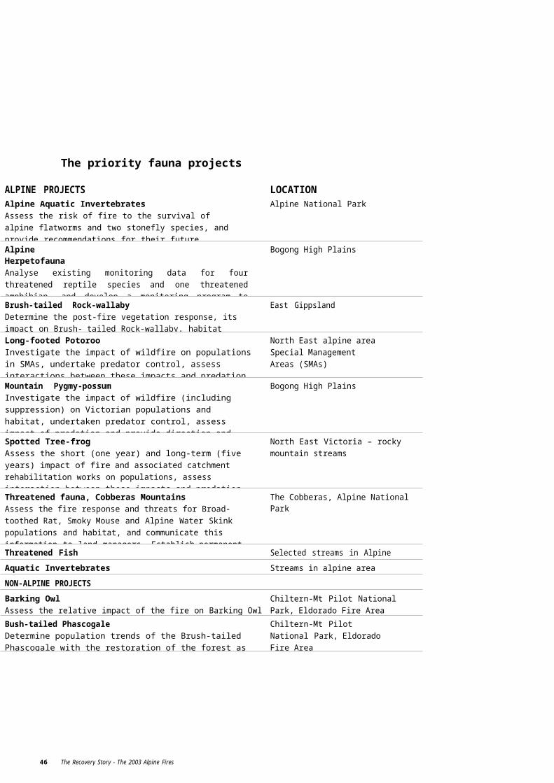
68 The Recovery Story - The 2003 Alpine Fires
Wild Dog Exclusion Fencing GrantsIt was vital that boundary fencing was quickly and efficiently rebuilt after the fire, so that landowners could properly feed, water, protect and manage their stock. Although this is generally the responsibility of the landowner, assistance was provided for clearing Crown land boundaries before the reconstruction of fences, due to complications created by fallen trees and overgrown fencelines.
The project was also initiated to recognise the State Government’s legislative responsibility to control wild dog populations wherever possible. Electric fencing is one of the best ways to inhibit the spread of wild dogs, so the intent was to have Crown land boundary fences replaced with suitable wild dog control fences in as many places as possible as a way of providing a long- term benefit to the wider community.
Immediately after the fires, public meetings were held to: determine the level of the fire’s impact; gauge community concerns and needs; explain the opportunities available through the fencing grants; and give communities an opportunity to discuss any issues related to the fires. At the same time, wild dog controllers made their own assessments of wild dog exclusion fencing needs during their patrols.
The grant rate to be offered to landowners was set at $1.60 per metre for clearing and up to $3.50 per metre for fencing materials.
DSE and DPI worked with the Gippsland Wild Dog Management Group to develop the Hingejoint fence alternative to the standard 7-wire electric fence.The new Hingejoint fence gives better protection in areas where power outages are common.
More than $3 million was spent erecting 306 km of Crown/freehold boundary fencing. Ninety-five individual landowners took part in the project and the final section of fence was completed in May 2005.
The line of wild dog fencing erected as part of this project has made livestock appreciably safer in thefire-affected areas. The new fencing will be a significant aspect of the State Government’s long-term wild dog control program.

Registration of the M44 with the 1080/analgesic combinationThe M44 ejector is a mechanical device developed by Primary Industries Research Victoria (PIRVic) and designed to have a number of advantages over conventional meat baits in terms of target specificity, humaneness, field viability and labour efficiency.
Along with trapping, baits containing 1080 are regularly used for the control of wild dogs and foxes in bushland adjoining grazing land. The baits used generally decompose quickly and require labour-intensive monitoring and replacement, whether target animals take the bait or not.
In contrast, the M44 design houses the toxin in a sealed capsule, preventing the normal decomposition that occurs with 1080 poisoning. That means animal control workers can visit bait sites less frequently and are able to maintain more devices, enabling better control of foxes and wild dogs.
The device is target specific, so only large, carnivorous animals are able to trigger the device. Foxes cannot cache poisoned baits, which reduces the risk posed by poison to native and domestic animals.
The intention is to add Copper Indomethacin (CuI) to the toxin as an analgesic, to help address community concerns regarding the humaneness of 1080.
Once the product has been registered with the Agricultural Products and Veterinary Medicine Authority (APVMA) it could be used extensively in the control of foxes and wild dogs.
When the M44 ejector and 1080 analgesic are registered, farmers will have a safer, more flexible and highly efficient tool for controlling predators.At the same time, by registering the 1080/analgesic combination, DPI will be able to employ more humane animal control techniques.
The project is progressing well. Discussions with manufacturers of the M44 have started and shelf-life trials of the 1080 analgesic are continuing.
Development of a trap alert system for wild dog trapsTrapping is regularly used in programs to control wild dog and fox populations. It is a labour intensive procedure, as DPI operatives are required to check the traps at 48-hour intervals and to euthanase trapped animals. This is a particularly costly investment due to the type of terrain and the distances involved.
Today’s communications technology makes it feasible to employ devices that can alert trappers when a specific trap has been triggered; thereby eliminating time wasted checking empty traps.
If the amount of time trappers spent checking traps could be reduced they would have more time to carry out other aspects of wild dog management. As a result, following the fires, DPI did a comparative review to investigate devices that might be bought off the shelf or modified for use in Victoria. Unfortunately, the review found that the devices currently available would be unsuitable for use in the Victorian wild dog trapping program. This necessitated a review of the program,as it was originally assumed that appropriate technology would be available.
DPI consulted with communications engineers and four prototype devices were developed each using a different technology platform. Due to the range and topography of the trapping area, the prototypes used the CDMA, UHF, VHF and trunking radio networks/bands. Eight dog trappers in the North East and Gippsland evaluated the effectiveness of the various systems as part of their day- to-day activities and the device has worked. The large size of batteries required makes it obvious and theft of the valuable equipment is a concern, so it may be more applicable for use on private land. It will be valuable in the urban fringe, where quick response is required.
The next step will be to determine the suitability of the prototypes for commercial production and, consequently, whether the production and use of the device is financially viable.
The control of the wild dog and fox population is a perennial problem, but a swift response to the immediate problem posed by the bushfires helped to minimise stock losses. Equally, the installation of wild dog exclusion fencing, and the injector bait and trap alert research programs, will help ensure better management over the long term. Consultation with local landowners and interest groups has brought this issue to the fore and ensured strong community support. There is now more wild dog fencing in place to reduce the problems of wild dogs than before the fires.
The Recovery Story - The 2003 Alpine Fires 69

70 The Recovery Story - The 2003 Alpine Fires
Rehabilitating and protecting private land – minimising the effects on catchments
The 2003 Alpine fires burnt nearly 90,000 hectares of private land in the North East and East Gippsland regions, affecting 659 landholders and presenting the potential for serious catchment problems.
The fires severely reduced vegetative cover – both pastures and native vegetation – creating a high risk for destructive soil erosion. The loss of vegetation cover also increased rainfall runoff which, in the short term, posed a high risk of stream contamination and reduced water quality in the affected catchments.
Compounding the potential for erosion was the 1400 km of fire control lines and trails that wereconstructed on private land as part of the suppression activities. These trails left mineral soil exposed and many were located in areas where any surface flows of water would result in major erosion events.
In February 2003, the regions experienced major flooding, which hindered rehabilitation work, affected water quality and increased the risk of long-term erosion.
Incentives for landholders helped to reduce the environmental impact of sediment export from private land into catchments.
Bushfire Recovery staff worked with landholders to identify areas for rehabilitation work that were necessary to reduce the environmental impact of losing sediment and nutrients from private and public land into the waterways.
DPI’s Bushfire Environmental Recovery Project provided incentives based on a schedule of rates to landholders for the following works: perennialpasture establishment; soil erosion control; revegetation of burnt areas; remnant vegetation protection;water quality restoration and protection; and stock containment. The purpose of all these works was to reduce the environmental impact of sediment runoff from freehold.
DPI staff made regular visits to landholders, forming positive relationships and providing a source of support and encouragement. These visits also represented a sense of consistent support from government.
Nearly 240 erosion sites were treated, totalling 514 hectares of land, 1622 hectares of perennial pasture was sown, 63 hectares of land was revegetated and 18 km of streamways were protected or enhanced.
The work that was done in the two years after the fires was considerable and helped to repair a lot of damage, but the impact from these fires will be felt by the environment and affected communities well into the future.

72 The Recovery Story - The 2003 Alpine Fires
Preventing the spread of weeds on private land
Initial emergency support from the State Government to private landowners affected by the 2003 Alpine fires was critical in helping farmers feed stock, rebuild fences and buildings, and limit soil erosion, but in addition, there were also longer-term natural resource management opportunities that could be achieved on farms. For instance, it was a chance for a major weed control program.
The fires cleared a lot of noxious weeds on private land, but this burnt ground, combined with the effects of continued drought on the soil and pastures, meant that weeds could easily take hold.
The containment lines and fire breaks created to help suppress the fires were also sites for new and emerging weeds. The firefighting vehicles and bulldozers and heavy earth moving equipment used to create these control lines had the potential to bring new weeds into areas, as did the emergency relief hay and fodder to feed surviving stock.
DPI developed a weeds monitoring and management project to provide weed control assistance to landowners beyond the programs routinely provided by government.
There were more than 600 fire-affected landholders in the North East and East Gippsland. This included not just landholders whose farms had been burnt to varying extents, but also those who had containment lines put through their properties.
The State Government employed additional staff to visit landholders and provide information and support. Information kits were developed that contained consistent information for landholders in both regions. Weed Control Grants were provided to assist landholders with the control of priority weeds, particularly English Broom in Gippsland.
Weed control initiatives established after the fires helped to minimise the spread of weeds on private land.
The State Government offered new Bushfire Recovery Weed Control Grants on top of existing weed management programs. These grants were contingent on landholders developing and committing to a three- year work plan, rather than the usual one-year plan.
According to Kylie Scanlon, DPI’s Catchment Management Officer in the North East, some farmers were cautious and some embraced the new three-year concept. “The plan gave them direction and confidence that they were meeting the new requirements contained in the Catchment and Land Protection Act to undertake weed work,” she said.
The program provided landholders with a grant of up to 80% of the estimated cost of having a contractor complete the work, plus 80% of the cost of the registered chemical to be used to treat the particular weed species targeted. Landholders could elect to use contractors or be paid to do the work themselves, thus helping to provide a valuable income for those facing financial difficulty after the fires.
Initially, grants of up $5000 were offered on an Expression of Interest basis, but these were quickly over-subscribed, meaning that the maximum grant available was reduced to $3000 per landholder.
The purpose of the three-year work plan agreement was to protect government investment and to encourage landholders to identify and commit to a longer program than usual, reinforcing the principle that weed control is a long-term proposition.

DPI staff followed up by visiting affected landholders and inspecting properties to ensure that the weed control work was being done. Relationships developed between DPI and landholders have been strengthened through the initial and subsequent visits, and the advice and support given by officers. A total of 416 landholders expressed interest in the program and most had weed plans drawn up, with 356 going ahead with the first year of the program. The cost of the program was$2.062 million.
Landholders have appreciated the one-on-one approach, which has given the government a ‘face’ and sense of humanity. A lot of goodwill was built by the extra effort put in by DPI staff.
The 2004/05 summer proved to be a good growing season for weeds, which means the weeds are back in full strength. However, according to Kylie Scanlon, the three-year work plans mean landholders have a strategy for attacking weeds and have become better educated about weeds by carrying out these plans. The majority of landholders now have weed plans and are progressing well with them.
The weed control program developed for tackling weeds on private land was part of an integrated approach to weed management because, concurrently, Parks Victoria and DSE carried out extensive weed control work on public land affected by the bushfires.
The Recovery Story - The 2003 Alpine Fires 73

74 The Recovery Story - The 2003 Alpine Fires
Long-term help for farmers to rebuild – individual advisory services
Beyond immediate help, such as fodder for stock and new fences, fire-affected farmers needed longer-term assistance to rebuild their farming enterprises and get back to where they were before the fires. The State Government identified a number of potential services that could help farmers recover and rebuild.
A letter was sent to 600 fire-affected landholders offering one-to-one assistance with a range of services: whole-farm planning; or agronomic, financial enterprise and succession planning advice. Landholders were asked to nominate their preference for the type of service they wanted to receive. DPI selected relevant contractors after inviting expressions of interest from qualified and experienced consultants in the key areas.
Advice on pasture re-establishment and fertiliser requirementsMore than 90 landholders nominated that they wanted agronomy advice and were visited individually by the contracted agronomists. An average of three soil samples were taken for analysis and landholders received written reports outlining pasture options, including fertiliser and/or seed resowing rates and methods, and current and potential stocking rates. Many landholders now have pasture development plans, which they didn’t have before the fires.
An evaluation form sent to landholders who took up various offers of assistance has provided positive feedback about the services offered and the outcomes of the assistance provided.
Advice to develop or review whole farm plansNinety landholders nominated whole farming planning as either their first or second choice. The purpose of this type of advice was to enhance long-term and short-term planning in a farming system context.
The offer included a photograph of a farmer’s property and, because it was a complex process, it was decided to prepare all 90 property photos in the one step. The grid references of boundaries needed to be determined and base photographs located if they existed and new aerial photographs taken if they did not. The photos then needed rectification to allow them to be joined and accurately measured to provide orthophoto maps.Contractors are now developing whole farm plans that identify land capability and how land may befenced into the same paddock to maximise productivity and sustainability.
Few landholders had done whole-farm planning before the fires, so these plans will help them significantly with their future farming activities.
Advice on enterprise analysis, financial analysis planning and succession planningLandholders showed minimal interest in advice about analysing their farming enterprise, financial analysis planning or succession planning.
Consultants visited the 20 landholders that wanted this advice and will provide written reports outlining the financial health of particular enterprises and suggestions for improving finances.
Group training about nutrition management, grazing management, pasture management and sowingEighteen field days about nutrition, pasture management, grazing management, pasture recovery in burnt pastures and winter feeding strategies were held across the North East and Gippsland in 2003 and 2004.
The 11 field days in the North East involved BeefCheque groups that included in their number about 35 farmers whose properties were burnt in the fires. In Gippsland, the seven field days concentrated on 40 isolated farms that were burnt, with between 15 and 20 people attending each event.
Database for the futureA detailed database that can be accessed by any DPI office across the State has been developed to provide valuable client information in the event of future emergency recovery programs.
The database contains information about landholders whose properties were burnt and the services and advice that they requested and received.
Having this level of information in one easily accessible online source will be particularly important for any future emergency that requires a case management approach for individual clients.
The Recovery Story - The 2003 Alpine Fires 75

5EDUCATION, COMMUNICATION and PARTNERSHIPS

EDUCATION AND COMMUNICATION were another important aspect of the Bushfire Recovery Program. Many communication methods were employed to keep local residents (including school students) and the Victorian community informed about the fires and the recovery activities that were carried out. Many strong partnerships were built between government agencies and local communities and stakeholder groups as they worked together to restore and rebuild after the fires.

78 The Recovery Story - The 2003 Alpine Fires
Fire Recovery Education Program
The bushfires were a frightening experience for local communities and landholders in the North East and East Gippsland. Some people had virtually a wall of fire in their ‘backyard’, 90,000 hectares of private land and farming land were burnt, and some townships were threatened.
The State Government’s Bushfire Recovery Program included an education program for school children in the areas affected by and surrounding the fires. It was an opportunity to teach young people about the relevance of fire in the environment, nature’s regeneration abilities and the work by government agencies to aid recovery.
More than 1300 students from 26 schools participated in classroom-based and field activities. The education program suited all primary school ages from Prep to Grade 6, with some younger secondary school students also involved.
The program’s emphasis was on simple activities that didn’t overwhelm students. Most sessions started with a one-hour classroom lesson that featured a 40-minute Powerpoint presentation and then a common activity, ‘Regeneration after a bushfire’.
Students were also asked to draw and describe their experiences during the fires.
More than 1300 students from 26 schools in fire-affected communities participated in the Fire Recovery Education Program.
Schools were then given the opportunity to head out into the field (the bus trip was funded by DSE) to look at the effect the fire had had on the Australian bush. An education kit was provided to teachers containing a CD with more fire activities, a game, teacher’s notes, a resource list and information that could be found on DSE’s website.
Activities included in the kit were: investigation of a tree; animal picture cards; forest magic; peace and quiet; focus on forests; lovely leaf litter; and causes of fire activity cards.
The education program and the kits were provided as a free service to schools, which was important for small rural community schools with limited resources. A giveaway drink bottle was a big hit with the younger students and ensured the longevity ofthe program’s message.
The feedback from teachers and observations of students’ interaction and participation showed that the program was a great success. Students had the opportunity to learn about fire from someone other than their teachers, as well as what they considered to be some ‘pretty cool’ facts about Elvis the skycrane and other aspects of bushfire recovery.

80 The Recovery Story - The 2003 Alpine Fires
Communication, media and partnerships
Explaining the effects of the fires and the recovery efforts to local communities and the people of Victoria was an another important activity for DSE, Parks Victoria and DPI.
The fires had wide ranging impacts that in many instances significantly changed the landscape and land management practices in the alpine area. The State Government identified the need to communicate these changes and effects to a broad audience and used a variety of methods.
Once the fires were put out, the immediate communication focused on alerting the community to the reopening of National and State Parks. ParksVictoria developed a Park Access Re-Opening Strategy that took a prioritised and sustainable approach to reopening parks that supported the tourism industry through its emergency marketing rebuilding phase.
The Parks Victoria website was regularly updated with details of the reopening of parks and it was promoted to groups and visitors as a critical pre-visit planning tool. Information sheets were produced for the Alpine National Park and Mt Buffalo at the start of the ski season and given to all visitors entering the parks. These sheets included safety information on being in the park surrounded by burnt material; some buried in the snow. People also had to be on the look out for hanging burnt branches heavy with snow, missing snow poles, and to be aware that burnt treated pine gives off toxic chemicals. The information sheets were also distributed during the summer season.
Parks Victoria and DSE developed displays, signs, information and fact sheets to educate both park users and practitioners on how to care for the fire-affected environment and to provide details about the post-fire recovery work.
DSE, Parks Victoria and DPI all regularly prepared media releases about bushfire recovery projects which were distributed to regional and statewide media generating many newspaper articles and radio interviews. Media release topics ranged from promoting the Indigenous cultural heritage survey and the efforts made to save the Mountain Pygmy-possum through to the rebuilding of alpine huts and wild dog fencing.
The effects of the 2003 Alpine fires and the work needed to support recovery were communicated to local communities, the wider Victorian public and to stakeholders through a variety of different and comprehensive ways.
Major newspaper coverage included: a supplement on salvage harvesting and regeneration and a feature on threatened species in the Border Mail and also a series of features in The Age.
The ABC TV Landline program produced an extensive story on the English Broom control work in late 2004, which explained the control program thoroughly and was broadcast Australia-wide.
A series of fact sheets and signs on biodiversity monitoring projects for threatened flora and fauna species were developed. The fact sheets describe the work done to identify any ongoing threats to flora and fauna and the identification of species, sites or areas that required special protection from further disturbance to enable recovery. The signs were erected at Falls Creek Mount Hotham, Mt Beauty and at Mt Pilot.
A Bushfire Recovery Program section was developed on the DSE website as a central point for information on the work being done.
Immediately after the fires, Parks Victoria created a number of banners outlining work with communities which were placed in Visitor Information Centres, Parks Victoria and DSE offices in the North East and Gippsland. Workshops were held after the fires that included presentations about what the fires had revealed froma cultural values perspective.
Banners were produced to promote the rebuilding of Michell and Federation Huts, which are both in isolated locations where there is no vehicle access. These portable banners provide visitors and stakeholders with the information on how the huts look, how they were built and previous history of the sites. They are on display at the Mt Beauty Information Centre but they can be used at various locations.
Community Forums were held in a number of locations to give the community members an opportunity to speak to government land managers about their concerns after the fires. Staff from a number of government agencies attended the forums and were available to discuss many issues.
Film documentaries were shot and produced on three Bushfire Recovery Program projects: threatened species, rebuilding of alpine huts and Indigenous cultural values. A marketing and distribution strategy is being developed for the Indigenous documentary with 1000 copies to be sent to a selected targetaudience. The threatened species documentary explains in everyday language the science and actions being taken to protect precious, vulnerable alpine species. This documentary will also be a useful communication tool for sharing information amongst Australian flora and fauna scientists and researchers.
Because the isolation of the alpine huts means that only intrepid bushwalkers and ski-tourers will actually get to visit the huts, the documentary will help to give a much wider audience an understanding of thedifficulties and logistics of building in remote locations. It will also be a useful tool for internal government project management.
Parks Victoria won a Victorian Tourism Award for its support for regional tourism and was also a finalist in the 2005 Banksia Awards in the ‘Australians Working for a Sustainable Future’ category. DSE, Parks Victoria and DPI together won a Fire Awareness Community Service Award in 2004.
A major outcome of the post-fire communication work was the very positive and strong relationships developed between government agencies and special interest groups. In particular, the working association with the Victorian High Country Huts Association and the Victorian Association of Four Wheel Drive Clubs has led to a greater understanding of the land management needs and priorities for public land in Alpine areas. Parks Victoria worked very closely with Alpine Region Tourism to support the tourism industry and also formed strong relationships with local Indigenous groups through the Indigenous cultural survey project.
The Recovery Story - The 2003 Alpine Fires 81