
The Rapalje Family Notebook - mdah.ms.gov Grade World Geography and Citi-zenship 4, 6e, 7b ......
18
Copyright 2013. Mississippi Department of Archives and History. 1 e Rapalje Family Notebook e Rapalje Family Notebook belonged to a member of a British loyalist family who moved to western Mississippi in the 1780s when the region was ruled by Spain. Written between 1788 and 1796, the entries include personal observations, geographic information, a ledger, and a Choctaw vocabulary. Objectives Using an eighteenth century personal journal, students will learn about the inhabitants of West Florida in general and the Natchez District in particular, how they interacted, and how their lives differ from our own. Students will put the Rapalje family in context with what was going on in the country and the world during the time that they lived in Mississippi. e Rapalje Family Notebook lesson and handouts are adaptable for grades 6-8. Mississippi Department of Education Curricular Connections Common Core Mathematics Grade 6 RP 1, 3d, NS 1 Common Core Language Arts Standards for Literacy in History/Social Studies, Grades 6-8 RH 1, 2, 4, 5, 6, 7, 9, 10 Social Studies Sixth Grade World Geography and Citi- zenship 4, 6e, 7b Eighth Grade United States History from Exploration rough Reconstruction 2a, 2b, 2c, 3a, 3b, 4a, 5a
Transcript of The Rapalje Family Notebook - mdah.ms.gov Grade World Geography and Citi-zenship 4, 6e, 7b ......

Copyright 2013. Mississippi Department of Archives and History.
PB 1
The Rapalje Family NotebookThe Rapalje Family Notebook belonged to a member of a British loyalist family who moved to western Mississippi in the 1780s when the region was ruled by Spain. Written between 1788 and 1796, the entries include personal observations, geographic information, a ledger, and a Choctaw vocabulary.
ObjectivesUsing an eighteenth century personal journal, students will learn about the inhabitants of West Florida in general and the Natchez District in particular, how they interacted, and how their lives differ from our own. Students will put the Rapalje family in context with what was going on in the country and the world during the time that they lived in Mississippi.
The Rapalje Family Notebook lesson and handouts are adaptable for grades 6-8.
Mississippi Department of Education Curricular Connections
Com
mon
C
ore
Mat
hem
atic
s Grade 6 RP 1, 3d, NS 1
Com
mon
Cor
e La
ngua
ge A
rts Standards for Literacy in History/Social
Studies, Grades 6-8RH 1, 2, 4, 5, 6, 7, 9, 10
Soci
al
Stud
ies
Sixth Grade World Geography and Citi-zenship
4, 6e, 7b
Eighth Grade United States History from Exploration Through Reconstruction
2a, 2b, 2c, 3a, 3b, 4a, 5a

Copyright 2013. Mississippi Department of Archives and History.
2
Activity One: Translate the Geographic Description
Objective:Understand the past by translating eighteenth century writing into twenty-first century language.
Materials: Background of the Rapalje Notebook and Early Mississippi History; Rapalje Family Notebook Resources; notebook paper.
Procedures may be adaptable for several grade levels and specific subject matter:
1. Read Background of the Rapalje Notebook and Early Mississippi History with your class.2. Distribute the journal pages and transcriptions included in the Rapalje Family Notebook Resources.3. Have students rewrite the geographic descriptions (all descriptions or a selection) with correct (modern)
spelling and punctuation.4. Read the transcription of page ten and examine the document. Locate the “X” and discuss what a mark is.
Why would someone need to sign with a mark? What does this say about the education level of William Har-kins and education in the eighteenth century?
5. Discuss why it was important for the writer to have a description of the region.
Activity Two: The Rapalje Brothers and Their Distances
Objective:Promote critical thinking skills by using geographic clues within the notebook to determine where the Rapaljes lived and worked. Also gain an understanding of the distance separating them in West Florida and how this might affect their interaction with each other.
Materials: Rapalje Family Notebook Resources; Rapalje’s Mississippi Worksheet; modern road map of Mississippi and Alabama; measuring string or ruler.
Procedures:
1. Distribute all materials. Using the materials provided, have students complete Rapalje’s Mississippi Worksheet.2. In terms of travel, discuss how these distances may have affected the lives of the Rapalje brothers. Consid-
er why they might have needed to travel to other towns and what means they may have used to get to their destination.
Copyright 2013. Mississippi Department of Archives and History.
2 3
Extension Activities
• View the complete Rapalje Family Notebook in MDAH’s Digital Archives at http://www.mdah.ms.gov/arrec/digital_archives/series/rapalji.
• Access the Early Trading and Talking with Choctaws lesson plan, adaptable for grades 4-9, on the MDAH website at http://www.mdah.ms.gov/new/learn/classroom-materials/lesson-plans-and-teaching-units/. Using the Rapalje Notebook, students will learn about the relationship between the family of British traders and their Choctaw clients, be introduced to some basic Choctaw words, and practice their own trading skills.
• Using the Rapalje Notebook as an example, discuss the merits and challenges of using a primary resource.
• Research the Seven Years War and discuss how this world event impacted the Rapalje family.
• Gather information from three sources (print, digital, interview) to determine how ledgers are used today. Include an example if possible. Compare and contrast the importance and role of a ledger during different time periods.
Copyright 2013. Mississippi Department of Archives and History.
4
Activity One: Background of the Rapalje Notebook and Early Mississippi History
The French and Indian War in North America was part of Europe’s Seven Years War that pitted Great Britain against France and Spain. Beginning in 1756, the war stemmed from arguments over colonization and trading opportunities. Before the war ended in 1763 with the Treaty of Paris between Great Britain and France/Spain, the war had spread to colonies around the globe. As a result, the landscape of North America changed, with the winner, Great Britain, gaining the bulk of New France and Spanish Florida. When the British created the province of West Florida the majority of settlers lived in either Mobile or the provincial capital of Pensacola. They were newcomers to a land long inhabited by various Native American cultures including the Natchez, Choctaw, and Chickasaw Nations. At first British Governor Peter Chester had to provide incentives to British settlers to move to the Natchez District at the western edge of the province. Soon, the eastern bank of the Mississippi River had a growing population of settlers (primarily British loyalists) and their slaves.
The Rapaljes were one of the loyalist families that moved to the Natchez District. Garrett Rapalje, an influential merchant from Brooklyn, New York, and his associates received a land grant from Governor Chester for 25,000 acres in 1773. Later, Garrett’s son George, in association with Lewis Charbena, received a land grant of 1,100 acres along the Mississippi River from the Spanish government. Other sons of Garrett, including Garrett, Jr., Jacques, and Isaac, immigrated to the area between 1788 and 1791.
The American Revolution caused unrest in the Natchez District and the old southwest. Spain, who controlled New Orleans and was sympathetic to the American cause, declared war on England in June of 1779. After the war, the 1783 Treaty of Paris between Britain and America officially returned the province of Florida to Spain and set the border between the new country and the Spanish colonies. While the border was in dispute for several years, by 1795 its location at the 31st parallel was agreed upon. It wasn’t until three years later that the Spanish military vacated the forts and the region became a territory of the United States in 1798.
A small notebook, attributed to George Rapalje, is in the collection of the Mississippi Department of Archives and History. Primarily a ledger relating to Rapalje’s trading business, the notebook also contains geographic descriptions, personal observations, and a Choctaw vocabulary. Entries date from 1788 through 1796, placing its creation in the second Spanish colonial period.

Copyright 2013. Mississippi Department of Archives and History.
4 5
Activity One: Translate the Geographic Description Answer Key

Copyright 2013. Mississippi Department of Archives and History.
6
Activity Two: Rapalje’s Mississippi Worksheet
Use the Rapalje Notebook Resources to answer the questions below. Mark all information and locations on the copy of the historic map.
1. List the Rapalje family members mentioned. Where did they settle? When did they live there?
a. _____________________________________________________________
b. _____________________________________________________________
c. ______________________________________________________________
2. What is Walnut Hills and what is its present day equivalent?
3. What is “Big black” and what is its present day equivalent?
4. What other settlements, towns or forts are mentioned on these pages?
5. What rivers are mentioned on these pages?

Copyright 2013. Mississippi Department of Archives and History.
6 7
Chart the locations on the historical map and calculate the distances using the following excerpts from the Rapalje Notebook.
6. Using the conversion of 3 miles equals 1 league, convert miles into leagues from the following excerpt: “The river Mobile is divided into two principal branches about forty miles above the town.”
7. Using the conversion of 3 miles equals 1 league, convert leagues into miles to determine the distance of the source of the Tombecbe River from the town of Mobile using the following excerpt: “The Tombecbe river on the west side of it is about ninety-six leagues from the town of Mobile. The source of the river is reckoned to be about forty leagues higher up in the country of the Chickasaws.”
8. Using a modern highway map, calculate the driving distance in miles and leagues.a. Between Vicksburg (Walnut Hills) and Mobile.
b. Between Vicksburg (Walnut Hills) and Pensacola.
9. Why was it important to describe where the rivers were located?

Copyright 2013. Mississippi Department of Archives and History.
8
Activity Two: Rapalje’s Mississippi Worksheet Answer Key
Use the Rapalje Notebook Resources to answer the questions below. Mark all information and locations on the copy of the historic map.
1. Identify the Rapalje family members written about, where they settled and when they lived there.
a. Jacques Rapalje, 1789 , inhabitant on the Big black
b. Isaac Rapalje, 1791 , inhabitant on the Big black c. Garret Rapalje, 1791, inhabitant on the Big black
2. What is Walnut Hills and what is its present day equivalent?
The Walnut Hills settlement was just below where the Yazoo River joins the Mississippi River; it is now known as Vicksburg.
3. What is “Big black” and what is its present day equivalent?
The “Big black” is the same as the Big Black River that runs through Mississippi and empties into the Mississippi River near Grand Gulf.
4. What other settlements, towns and forts are mentioned on these pages?
Creek Settlement, Chickasaw Settlement, Mobille Town, Fort Alibama, and Fort Tombecbe.
5. What rivers are mentioned on these pages?
Mobille River, Tansas River, Spanish River, Alibama River, Cousa River, Tombecbe River and Talpouse River.
Chart the locations on the historical map and calculate the distances using the following excerpts from the Rapalje Notebook.
6. Using the conversion of 3 miles equals 1 league, convert miles into leagues from the following excerpt: “The river Mobile is divided into two principal branches about forty miles above the town.”
40 Leagues / 3 = 13.3 leagues

Copyright 2013. Mississippi Department of Archives and History.
8 9
7. Using the conversion of 3 miles equals 1 league, convert leagues into miles to determine the distance of the source of the Tombecbe River from the town of Mobile using the following excerpt: “The Tombecbe river on the west side of it is about ninety-six leagues from the town of Mobile. The source of the river is reckoned to be about forty leagues higher up in the country of the Chickasaws.”
96 leagues x 3 miles = 288 miles
40 league x 3 miles = 120 miles
288 +120 = 408 miles from Tombecbe River source to Mobile 8. Using a modern highway map, calculate the driving distance in miles and leagues.
a. Between Vicksburg (Walnut Hills) and Mobile.
approx. 230 miles or 76 leagues (answers vary depending on route taken)
b. Between Vicksburg (Walnut Hills) and Pensacola.
approx. 289 miles or 95 leagues (answers vary depending on route taken)
9. Why was it important to describe where the rivers were located?
Not only were the rivers a source of food and raw materials, they were also the highways by which white settlers, their black slaves, the Native Americans, and news traveled. The Rapalje’s lived in a time when there were few roads and poor road conditions, thus a water route may have been quicker when traveling to Mobile and Pensacola. Water routes may also have been safer than traveling overland where travelers were subject to hostile Native Americans, highway robbers, and wild animals.

Copyright 2013. Mississippi Department of Archives and History.
10
Rapalje Family Notebook Resources
TRANSCRIPT: Loose PagePart of this land will …… very good rice as Part willOver Flow. the sides of the river are covered with largeCanes so thick that they are almost Impenetrable (sic)there is Plenty Large ridge White Ceder cypress elms ashSeveral People have Settled on this river who find the soilto answer beyond expectation On the East Side of the River Mobille, towards the riverAlbama is one entire extended rich Cane Country

Copyright 2013. Mississippi Department of Archives and History.
10 11
TRANSCRIPT: Page 1 Penry (Perry ?) and Campbell went the 16th of March at 12 Drs. Pr. Month to Walnut Hills - - Septr. 1st G. R. andT. R. went to Baton Rouge – 7 buls. 3 pecks. Yalubby hascap.
Copyright 2013. Mississippi Department of Archives and History.
12
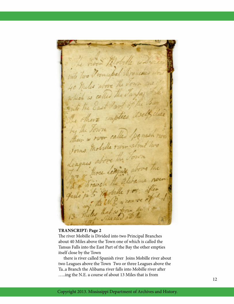
TRANSCRIPT: Page 2The river Mobille is Divided into two Principal Branchesabout 40 Miles above the Town one of which is called theTansas Falls into the East Part of the Bay the other emptiesitself close by the Town there is river called Spanish river Joins Mobille river abouttwo Leagues above the Town Two or three Leagues above theTa..a Branch the Alibama river falls into Mobille river after…..ing the N.E. a course of about 13 Miles that is from
Copyright 2013. Mississippi Department of Archives and History.
12 13
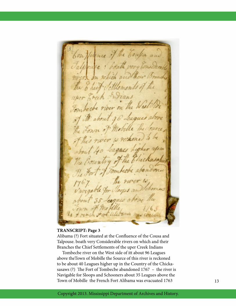
TRANSCRIPT: Page 3Alibama (?) Fort situated at the Confluence of the Cousa andTalpouse. boath very Considerable rivers on which and theirBranches the Chief Settlements of the uper Creek Indians Tombecbe river on the West side of itt about 96 Leaguesabove theTown of Mobille the Source of this river is reckonedto be about 40 Leagues higher up in the Country of the Chicka-sasaws (?) The Fort of Tombecbe abandoned 1767 – the river isNavigable for Sloops and Schooners about 35 Leagues above theTown of Mobille the French Fort Alibama was evacuated 1763

Copyright 2013. Mississippi Department of Archives and History.
14
TRANSCRIPT: Page 10Received att Big Black Feb. 28 1791 of Garret Rapalje
Dollrs.124-5 in full for a Plow Shear & Cotton Corn Some Hogs andFor Sundry Tubs Fowls etc.124-5-0 John Estes (?)
Recd. Of Garret Rapalje Nine Dollars by order John PetersFeb. 28, 1791 his Wm. X Harkins Mark

Copyright 2013. Mississippi Department of Archives and History.
14 15
TRANSCRIPT: Page 19Inhabitants on Big black
1788 John Stowers Settled ….. No 5. Famy.1789 Jaques Rapalje Do. ….. No 5 Do.1789 Tobius Brashers Do. ….. No.19 do.1791 Isaac Rapalji do. ….. No. 1 do.

Copyright 2013. Mississippi Department of Archives and History.
16

Copyright 2013. Mississippi Department of Archives and History.
16 17
MISSISSIPPI DEPARTMENT OF HISTORY LESSON PLANSTEACHER EVALUATION
COMPLETE BOTH SIDES AND PLEASE MAIL OR FAX TO THE ADDRESS ON THE NEXT PAGE. THANK YOU!
TEACHER NAME ___________________________________________________________________________
SCHOOL NAME & ADDRESS _________________________________________________________________
__________________________________________________________________________________________
EMAIL (OPTIONAL) _________________________________________________________________________
TOTAL NUMBER OF STUDENTS_____________ GRADE LEVEL _________________________________
LESSON TITLE ______________________________________________________________________________
1. In your opinion, did this unit elicit better than average student response; if so, how?
2. Which segments of the unit exceeded your students’ attention span?
3. Will this unit be of assistance to you in developing future classroom activities; if so, how?
4. How did this unit add to your earlier teaching on the same subject?
5. Would this teaching unit be handier to use as a:___multi-day unit ___multi-week unit ___other
6. Were the activities and lessons appropriate for your students? How?

Copyright 2013. Mississippi Department of Archives and History.
18
Please rate the following lesson materials and activities by circling the appropriate number.4=excellent, 3=good, 2=average, 1=inadequate
Directions and Notes 4 3 2 1Curricular Connections 4 3 2 1 Student Worksheets 4 3 2 1Interactive Activities 4 3 2 1Historic Images 4 3 2 1References and Resources 4 3 2 1
Activity One 4 3 2 1Activity Two 4 3 2 1Extension Activities 4 3 2 1
Overall unit 4 3 2 1
We would appreciate any additional comments on this teaching unit and any suggestions for improvement. Comments may be entered in the space below.
Museum DivisionMississippi Department of Archives and History
P.O. Box 571, Jackson, MS 39205Phone: 601-576-6800 Fax: 601-576-6815