The Public Land Survey System - c.ymcdn.com · Public Land Survey System ... Thirty states...
120
The Public Land Survey System LSIT & RLS REVIEW SEMINAR
Transcript of The Public Land Survey System - c.ymcdn.com · Public Land Survey System ... Thirty states...

The Public Land Survey System
LSIT & RLS REVIEW SEMINAR
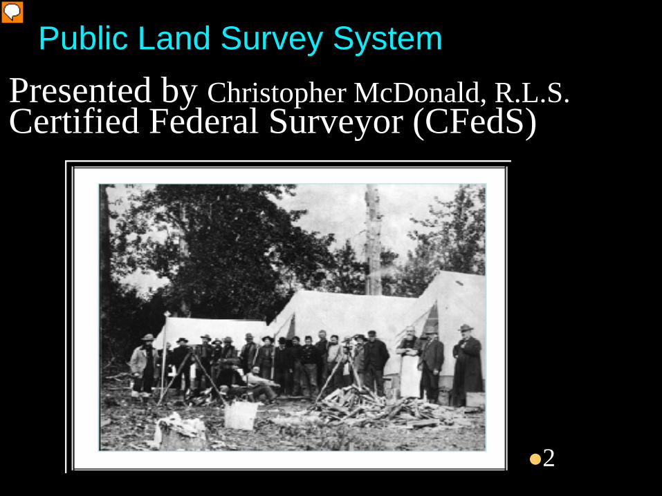
Public Land Survey SystemPresented by Christopher McDonald, R.L.S.Certified Federal Surveyor (CFedS)
2
Presenter
Presentation Notes

Article 33-103 of The Arizona Revised Statutes states: Landmarks or monuments established under the
provisions of this article shall be set at the section corners and quarter section corners established by the United States survey. If there is a clerical error or omission in the government field notes or bearings, trees, mounds, fences or other locating evidences specified therein, or if they are destroyed or lost and there is no evidence by which the corners established by the United States survey can be identified, the land surveyor shall reestablish the corners under rules adopted by the United States for the survey of public lands.
Knowledge of the PLSS is essential to boundary surveyors in Arizona. An understanding of the federal principles of cadastral surveying is the foundation of boundary law in Arizona.
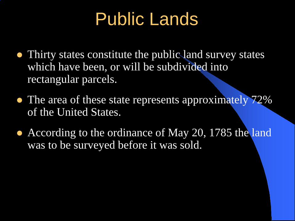
Public Lands
Thirty states constitute the public land survey states which have been, or will be subdivided into rectangular parcels.
The area of these state represents approximately 72% of the United States.
According to the ordinance of May 20, 1785 the land was to be surveyed before it was sold.

Cadastral Surveys creates or reestablishes , marks and defines boundaries of tracts of land. The survey includes: a request for a survey special instructions assignment instructions measurements monuments on the ground as well as the field
notes and the plat representing the official survey.

REVIEW HISTORY LAND TENURE SYSTEMS USED IN THE COLONIES
• Metes and Bounds - sequential conveyances- junior senior situations
• New England Townships- Said to be origin of PLSS- common boundaries- no gaps or gores
6
Presenter
Presentation Notes
So in the metes and bounds system, before the PLSS and even now, you can have a deed for a piece of property without it ever being surveyed. Bounds are limits, like a tree, a road, an adjoiners property, and metes are measurements, bearings. And when you have a deed based on measurements, many times you get into junior senior rights situations

Need for Revenue after the War
Jefferson vs. Hamilton
Jefferson Fights for Small Farmers
Rectangular System or not

Principles of the Land Ordinance of 1785**
Survey before Patent Unique identifiers for each patent Adjoining parcels created simultaneously Small enough parcels to be conveyed to
individuals Evidence on the ground relates to record to
allow entrymen to locate themselves Survey data made part of conveyance
document
8
Presenter
Presentation Notes
Talk about revolutionary war, 1776, 1781 end of war, country broke, needed to pay soldiers, needed to create revenue Talk about m&b overlaps gores, junior and senior rights
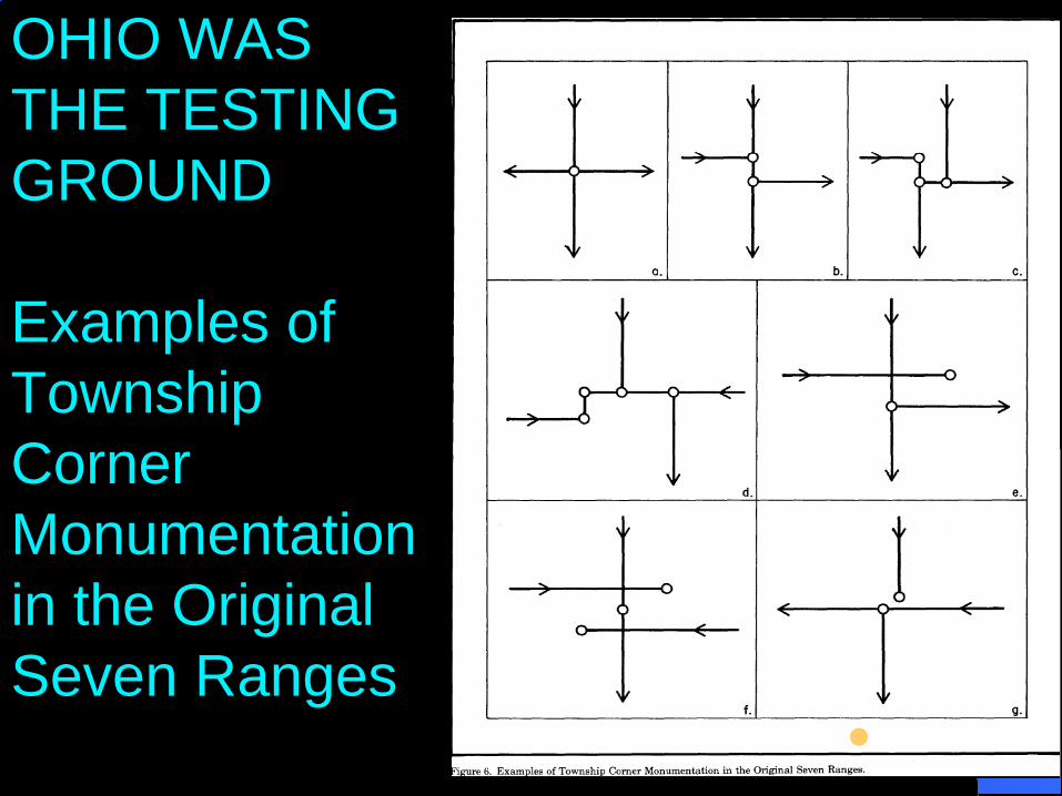
OHIO WAS THE TESTING GROUND
Examples of Township Corner Monumentation in the Original Seven Ranges
9

dates
1812 General Land Office established within the Treasury Department
1849 Department of Interior established – GLO now within new dept.
1863 Congress made the 1855 Manual part of all public land survey contracts
1909 Dependent Resurveys authorized 1910 No more private contracts - Surveyors now employees
of GLO 1894-1910 1894-1910 metal cor monuments introduced 1946 Bureau of Land Management established by
combining the GLO and the Grazing Service
10
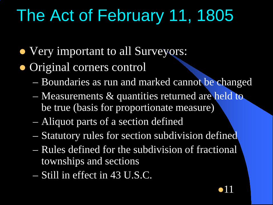
The Act of February 11, 1805
Very important to all Surveyors: Original corners control
– Boundaries as run and marked cannot be changed– Measurements & quantities returned are held to
be true (basis for proportionate measure)– Aliquot parts of a section defined– Statutory rules for section subdivision defined– Rules defined for the subdivision of fractional
townships and sections– Still in effect in 43 U.S.C.
11

You find a GLO monument, can you accept it without checking further?

Instructions for Surveys of the Public Lands
Sets of instructions for surveys began to be issued in 1785. “The Seven Ranges”
The first manual of instructions was issued in 1851 to the Survey General of Oregon and then reprinted in 1855 and distributed to the rest of the country. Later manuals were issued in 1881, 1890, 1894, 1902, 1930, 1947, 1973, and currently the 2009.

BOUNDARIES AND CONTENTS OF LAND ***43 USC 752 Manual 1-27
1. CORS MKD ARE TRUE CORS2. LINES AS RUN ARE TRUE LINES
• LINES NOT RUN SHALL BE RUN AS STRAIGHT LINES BETWEEN ESTABLISHED CORS.
3. ACREAGE SHOWN ON PLAT IS TRUE AREA FOR SALE OF LANDS

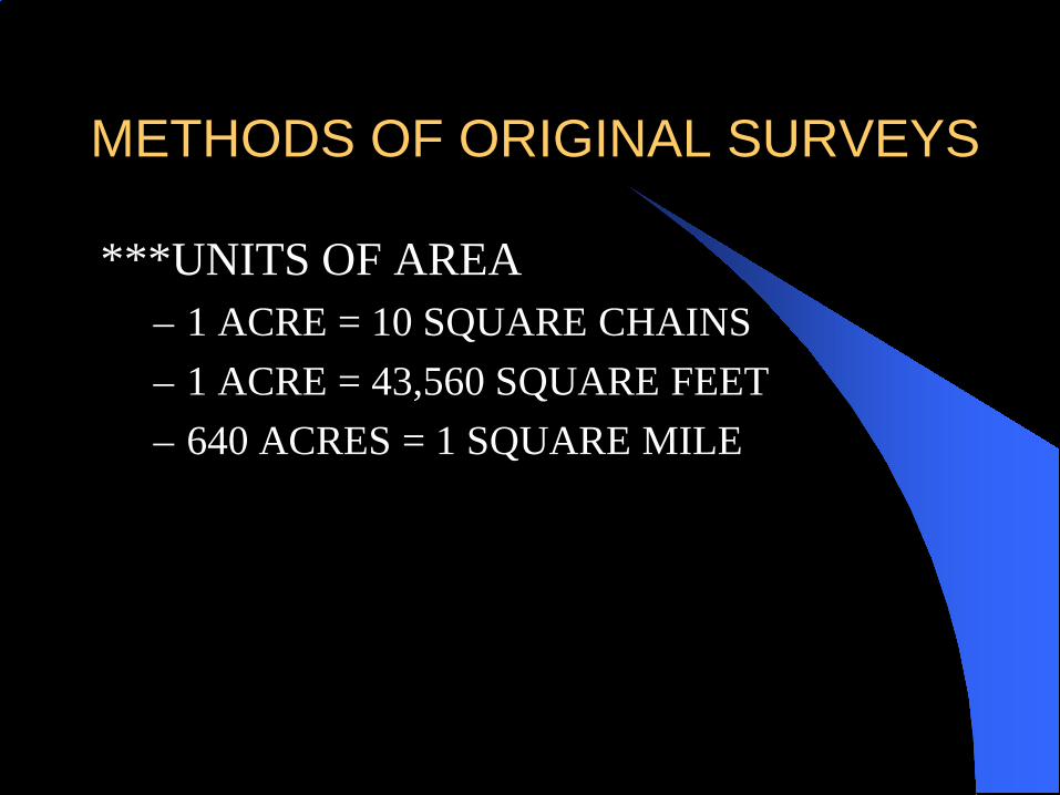
METHODS OF ORIGINAL SURVEYS
***UNITS OF LINEAR MEASUREMENT– 1 CHAIN = 100 LINKS OR 66 FEET– 80 CHAINS = 1 MILE OR 5280 FEET– 1 pole = 1 rod = 1 perch = 25 links = 16.5 ft
*All linear measurements are in horizontal distance at the ground elevation of the measurement.
METHODS OF ORIGINAL SURVEYS
***UNITS OF AREA– 1 ACRE = 10 SQUARE CHAINS– 1 ACRE = 43,560 SQUARE FEET– 640 ACRES = 1 SQUARE MILE
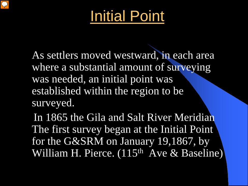
Initial Point
As settlers moved westward, in each area where a substantial amount of surveying was needed, an initial point was established within the region to be surveyed.In 1865 the Gila and Salt River Meridian The first survey began at the Initial Point for the G&SRM on January 19,1867, by William H. Pierce. (115th Ave & Baseline)
Presenter
Presentation Notes
The 1855 manual was in effect in 1865. Thus surveys in Arizona have been done under the direction of all the manuals. The Initial Point for the Gila and Salt River Meridian was established in 1865. It is on the small hill just south of the confluence of the Gila and Salt River. The monument was first established as a point of the US – Mexico border, but after the Gadsden Purchase in 1848 it had no further purpose.

Initial Point
Gila and Salt River Meridian was established in 1865
The Navajo Meridian was established in 1869
The Colorado River Meridian was abandoned and no longer has value.
Presenter
Presentation Notes
The 1855 manual was in effect in 1865. Thus surveys in Arizona have been done under the direction of all the manuals. The Initial Point for the Gila and Salt River Meridian was established in 1865. It is on the small hill just south of the confluence of the Gila and Salt River. The monument was first established as a point of the US – Mexico border, but after the Gadsden Purchase in 1848 it had no further purpose.


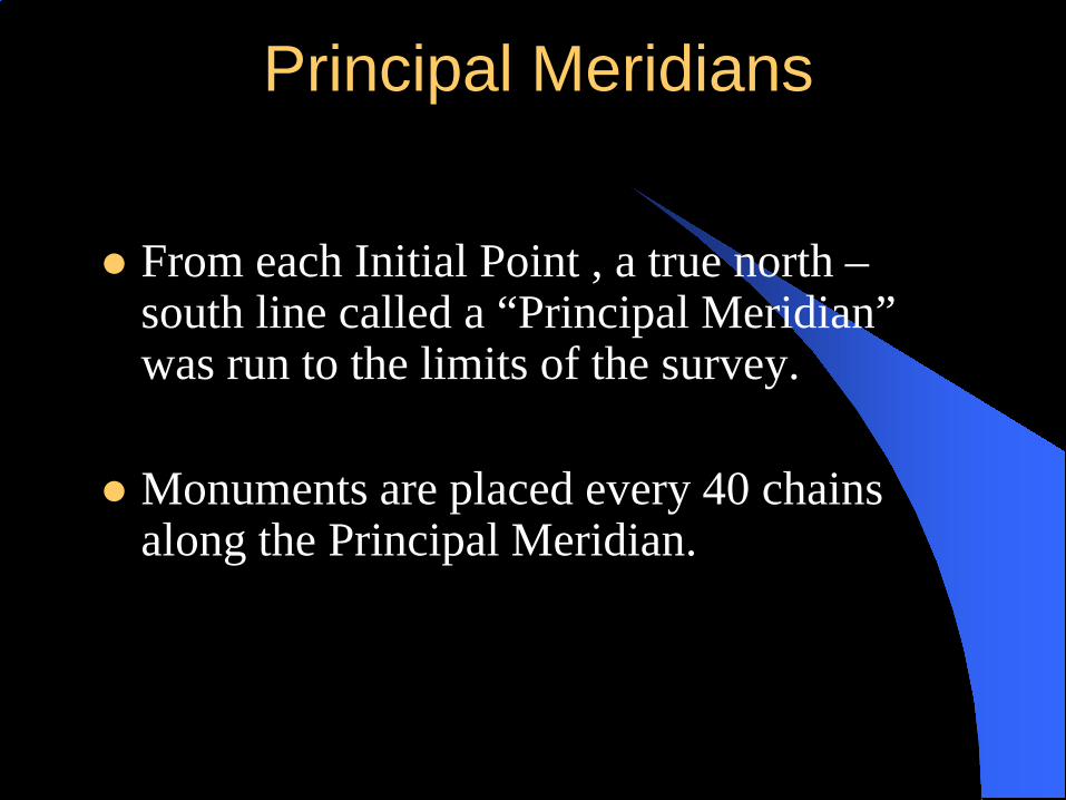
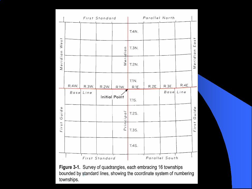
Principal Meridians
From each Initial Point , a true north –south line called a “Principal Meridian” was run to the limits of the survey.
Monuments are placed every 40 chains along the Principal Meridian.

Baselines From the initial point a base line was extended
on a true parallel of latitude, east and west to the limits of the area to be surveyed and monuments placed every 40 chains.
Base lines, being lines of Latitude are curved lines known as “Rhumb Lines” Every point on the line is due east or west.
There are three ways to layout a baseline on a true parallel of latitude, they are– Solar Method– Tangent Method– Secant Method

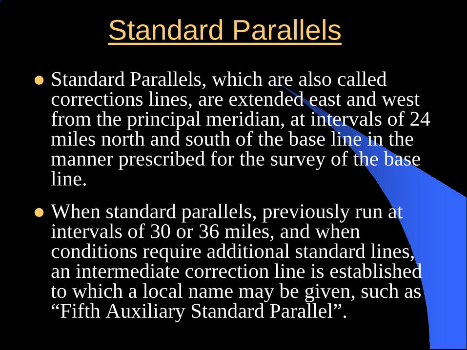
Standard Parallels Standard Parallels, which are also called
corrections lines, are extended east and west from the principal meridian, at intervals of 24 miles north and south of the base line in the manner prescribed for the survey of the base line.
When standard parallels, previously run at intervals of 30 or 36 miles, and when conditions require additional standard lines, an intermediate correction line is established to which a local name may be given, such as “Fifth Auxiliary Standard Parallel”.

Guide Meridians Guide Meridians are extended north from the
baseline, or standard parallels, at intervals of 24 miles east and west from the principal meridian, in the manner prescribed for running the principal meridian.
The guide meridians are terminated at the points of their intersection with the standard parallels.
The guide meridian is projected on the true meridian and the fractional measurements are placed in the last half mile.
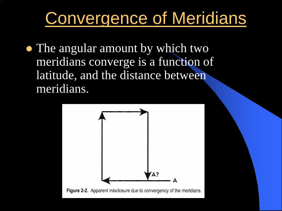
Convergence of Meridians The angular amount by which two
meridians converge is a function of latitude, and the distance between meridians.

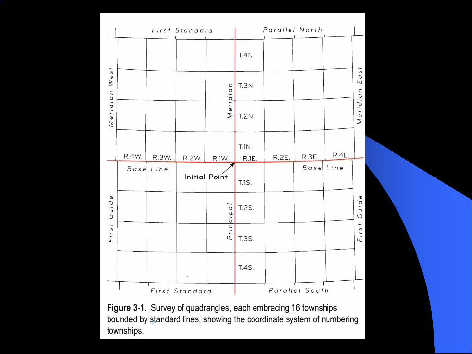
Quadrangles The area between the base line and the first
standard parallel, and the principal meridian and the first guide meridian is known as a quadrangle. The dimensions of a quadrangle are 24 miles x 24 miles.
This is the same area between successive standard parallels and guide meridians.
Once the quadrangle is surveyed into townships. Each township is 480 chains east, west, and 480 chains north, south (6 miles x 6 miles)

REGULAR TOWNSHIPN bdy shorter than S bdy
6 5 4 3 2 1
7 8 9 10 11 12
18 17 16 15 14 13
19 20 21 22 23 24
30 29 28 27 26 25
31 32 33 34 35 36

TOWNSHIP ORDER
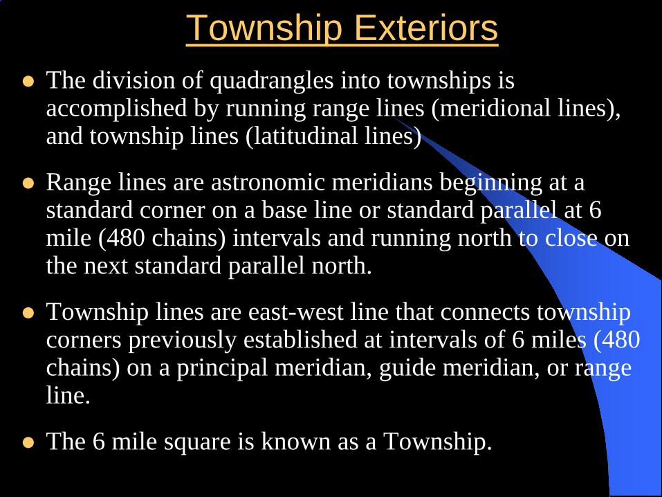
Township Exteriors The division of quadrangles into townships is
accomplished by running range lines (meridional lines), and township lines (latitudinal lines)
Range lines are astronomic meridians beginning at a standard corner on a base line or standard parallel at 6 mile (480 chains) intervals and running north to close on the next standard parallel north.
Township lines are east-west line that connects township corners previously established at intervals of 6 miles (480 chains) on a principal meridian, guide meridian, or range line.
The 6 mile square is known as a Township.

Township Exteriors According to the Manuel of Surveying Instructions
2009 the regular order of Township Exteriors are as follows.
The south and east boundaries of a township are normally the governing lines of the subdivision survey.
Whenever practicable the township exteriors are surveyed successively through a quadrangle in ranges of townships, beginning with the township on the south. The meridional township boundaries have precedence in the order of the survey and are run from south to north on true meridians. Quarter section and section corners are established alternately at a permanent corner in proper position.
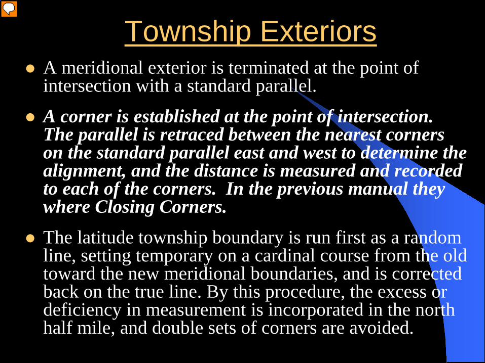
Township Exteriors A meridional exterior is terminated at the point of
intersection with a standard parallel. A corner is established at the point of intersection.
The parallel is retraced between the nearest corners on the standard parallel east and west to determine the alignment, and the distance is measured and recorded to each of the corners. In the previous manual they where Closing Corners.
The latitude township boundary is run first as a random line, setting temporary on a cardinal course from the old toward the new meridional boundaries, and is corrected back on the true line. By this procedure, the excess or deficiency in measurement is incorporated in the north half mile, and double sets of corners are avoided.
Presenter
Presentation Notes
A closing corner is established at the point of intersection with the standard parallel. The standard parallel is retraced between the nearest standard corners to the east and west to find the exact alignment, and the distance to the nearest corned is measured and recorded.

Township Exteriors Where both meridional boundaries are new lines or
where both have been previously established, a latitudinal random line is run from east to west.
Regular quarter-section and section corners are set at 40 chains and fractional measurements is placed in the last half mile on the north and west boundary.
The bearings of the true line are calculated from the falling of the random line. The falling is the distance, perpendicular to the random line (on the normal), by which a line falls to the right or left of an objective corner.
A permanent corner on the true line replaces the temporary points on the random line. The allowable deviation in bearing of a township is 00 14’00” from cardinal.
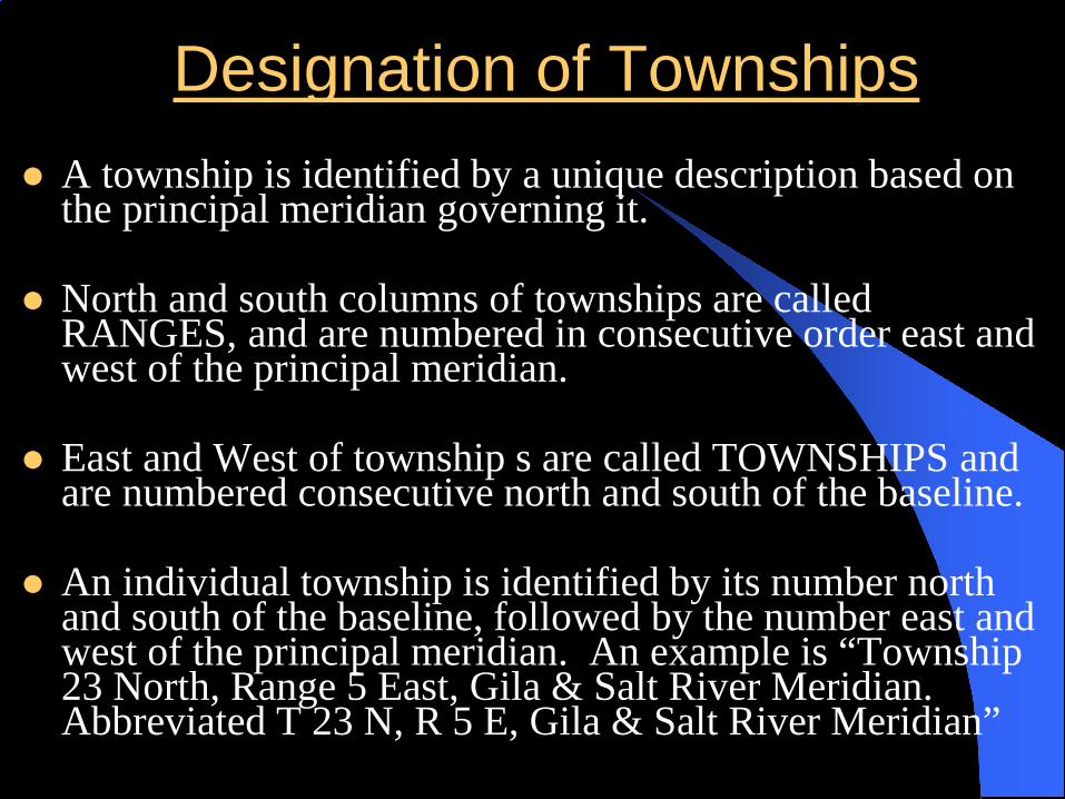
Designation of Townships A township is identified by a unique description based on
the principal meridian governing it.
North and south columns of townships are called RANGES, and are numbered in consecutive order east and west of the principal meridian.
East and West of township s are called TOWNSHIPS and are numbered consecutive north and south of the baseline.
An individual township is identified by its number north and south of the baseline, followed by the number east and west of the principal meridian. An example is “Township 23 North, Range 5 East, Gila & Salt River Meridian. Abbreviated T 23 N, R 5 E, Gila & Salt River Meridian”

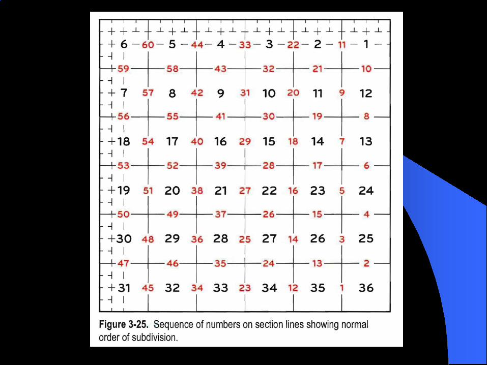
Subdivision of Townships into Sections Sections are numbered from 1 to 36, (Boustrophedonicly)
beginning in the northeast corner of a township with section 1, and ending with section 36 in the southeast corner of the township.
Meridional section lines have precedence in the order of survey. They are initiated at the section corners on the south boundary of the township and are run north parallel with the east boundary of the township.
Meridional section lines are numbered from the east and are surveyed successively in the same order.
If the east boundary of the township is within limits, but has been found by retracement to be imperfect in alignment, the meridional section line will run parallel with the mean course.
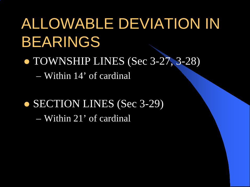
ALLOWABLE DEVIATION IN BEARINGS TOWNSHIP LINES (Sec 3-27, 3-28)
– Within 14’ of cardinal
SECTION LINES (Sec 3-29)– Within 21’ of cardinal
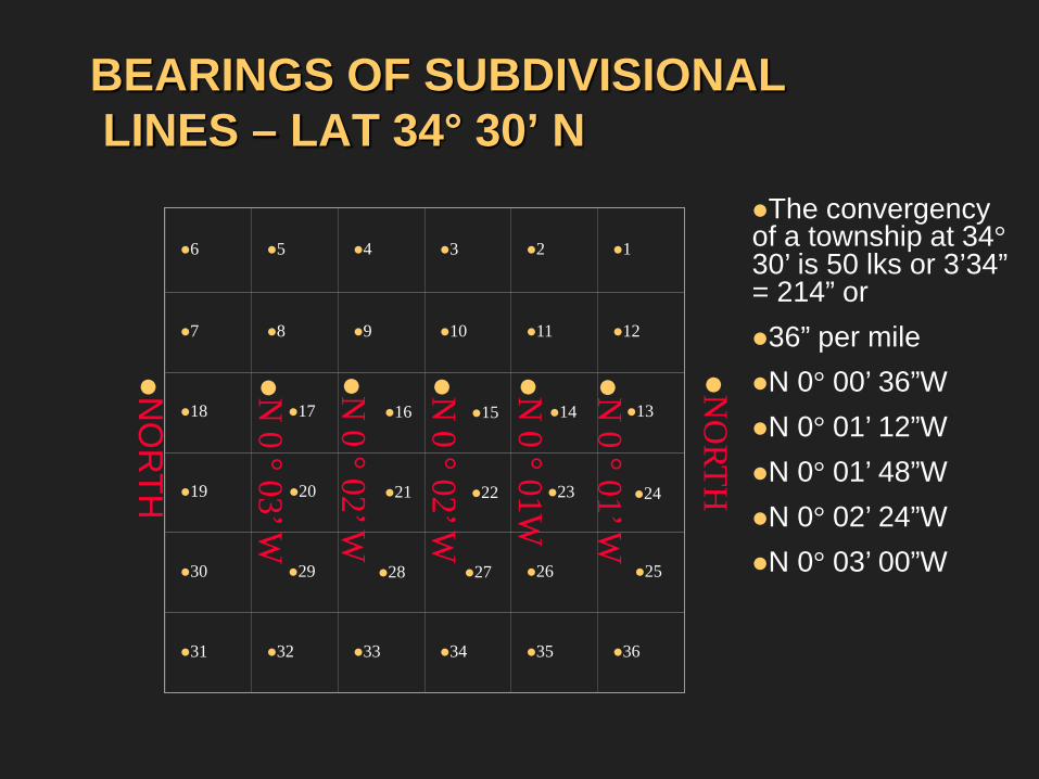
BEARINGS OF SUBDIVISIONALLINES – LAT 34° 30’ N
6 5 4 3 2 1
7 8 9 10 11 12
18 17 16 15 14 13
19 20 21 22 23 24
30 29 28 27 26 25
31 32 33 34 35 36
NO
RTH
NO
RTH
N 0 °01’ W
N 0 °01W
N 0 °02’ W
N 0 °02’ W
N 0 °03’ W
The convergency of a township at 34°30’ is 50 lks or 3’34” = 214” or36” per mileN 0° 00’ 36”WN 0° 01’ 12”WN 0° 01’ 48”WN 0° 02’ 24”WN 0° 03’ 00”W
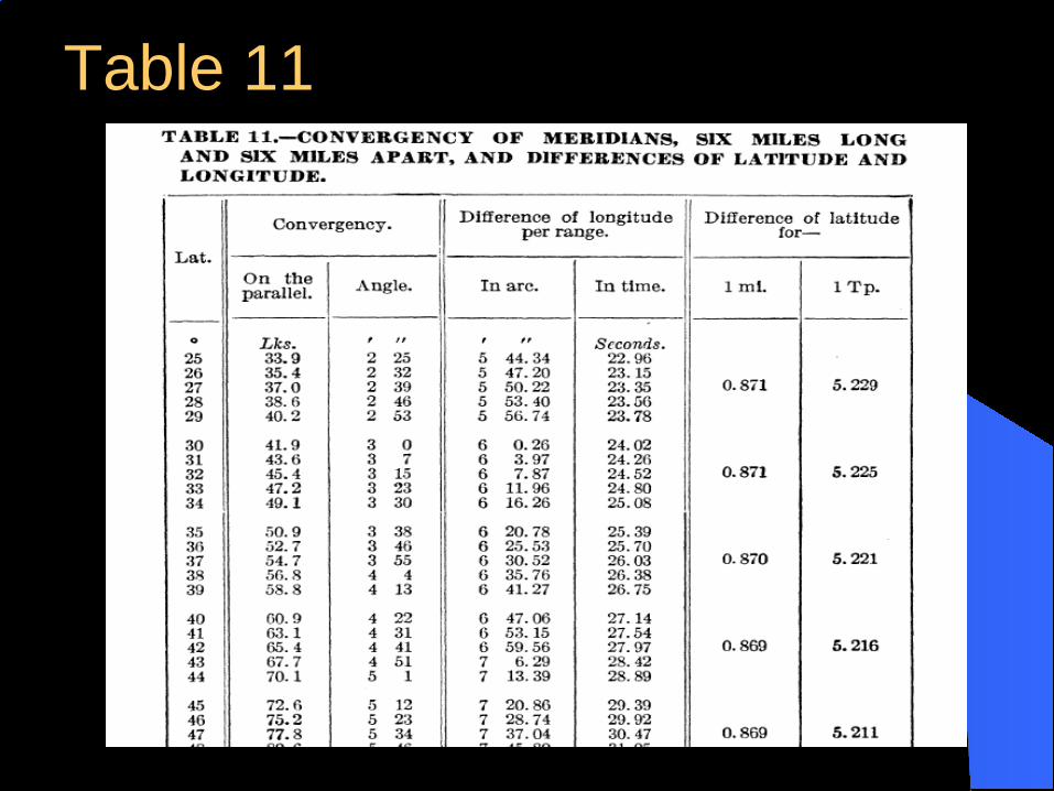
Table 11

REGULAR TOWNSHIP1ST TIER OF SECTIONS
6 5 4 3 2 1
7 8 9 10 11 12
18 17 16 15 14 13
19 20 21 22 23 24
30 29 28 27 26 25
31 32 33 34 35 36
CONTINUE THE
FIRST TIER IN THE SAME MANNER
THE LINE BET SECS. 1&2 IS
RUN RANDOM AND TRUE & ¼
COR SET AT 40
CHS FROM SOUTH
12
345
67
89
1011
R&
T
R&T R&T
R&T R&T
R&T R&T
R&
T

Subdivision of Townships into Sections Regular quarters-section and section corners are set at 40
and 80 chains as far as the northernmost interior section corner.
A meridional section line is not continued north beyond a section corner until after the connecting latitudinal sectional line has been surveyed.
The last mile of a meridional section line is run as a random line with a temporary quarter section corner set at 40 chains. The falling of the random line is corrected and the line is corrected to the true line.
When a meridional section is run to a standard parallel, a corner is set at the standard parallel. The error of the township is placed in the north half mile. In the previous manual they where Closing Corners.

THREE MILE METHOD

Meander Lines
A meander line is a survey of the boundary of a body of water to segregate it from the uplands. It is done to compute the area of the upland lot that will be patented.
The ordinary high water mark (OHWM), or line of mean high tide (line of MHT) of the stream, or other body of water, and not the meander line as actually run on the ground, is the actual boundary.
(2009 manual 3-158 through 3-161) (1973 3-115)

Meander Lines
The 2009 Manual requires all navigable waters Sec. 3-182, 3-185 Non-navigable rivers over
3 chs width Sec 3-182 Non-navigable lakes over 50 ac. 3-185

NAVIGABILITY
***The Daniel Ball, 10 Wall. 557 (1890)The Supreme Court said: “Those rivers must be regarded as public navigable rivers in law which are navigable in fact.
And they are navigable in fact when they are used, or are susceptible of being used, in their ordinary condition, as highways for commerce…
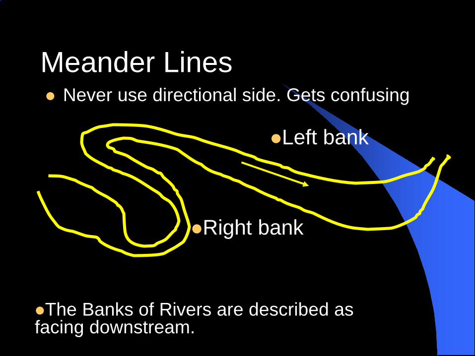
Meander Lines Never use directional side. Gets confusing
Right bank
Left bank
The Banks of Rivers are described as facing downstream.

Ownership of Beds - Navigable
7-47 1973 manual states - Upon the admission of a state into the Union title to the beds of navigable bodies of water inures to the State as an incident of sovereignty.

Ownership of Beds – Non-navigable

Ownership of Beds – Non-navigable

ACCRETION - Derived from the Latin "accrescere" which means to grow or increase, it is the gradual and imperceptible addition of soil or other material by the natural processes of water-borne sedimentation or by the action of currents against shores and banks. Accretion is the washing up of sand, silt or soil so as to form firm ground, called alluvion. In common practice the terms alluvion and accretion have been used almost interchangeably. Usually, however, alluvion means the deposit itself while accretion usually denotes the act. See ALLUVION, RELICTION, EROSION, AVULSION, RIPARIAN RIGHTS.
Definitions

EROSION - In riparian law, the washing away of land by the sea or a river's flow. Usually considered as an imperceptible action, the rate of erosion may be quite rapid in total effect and may be distinguished from avulsion by the absence of identifiable upland between former and new channels. See RIPARIAN LAW.
Definitions

AVULSION - A river's sudden change in flow alignment out from its previous left and right banks to a new channel, leaving an identifiable upland area between the abandoned channel and the new channel. The new flow alignment will generally be a shortcut in channel length because of hydraulic considerations. The U.S. Supreme Court in Iowa v. Nebraska 143 US 359 distinguished avulsion from rapid erosion, but some State courts have established different definitions. See Goins v. Merryman 183 Okla. 155. Frequently the elements of sudden and perceptible changes are included in the definitions. See ACCRETION, AVULSION*.
Definitions
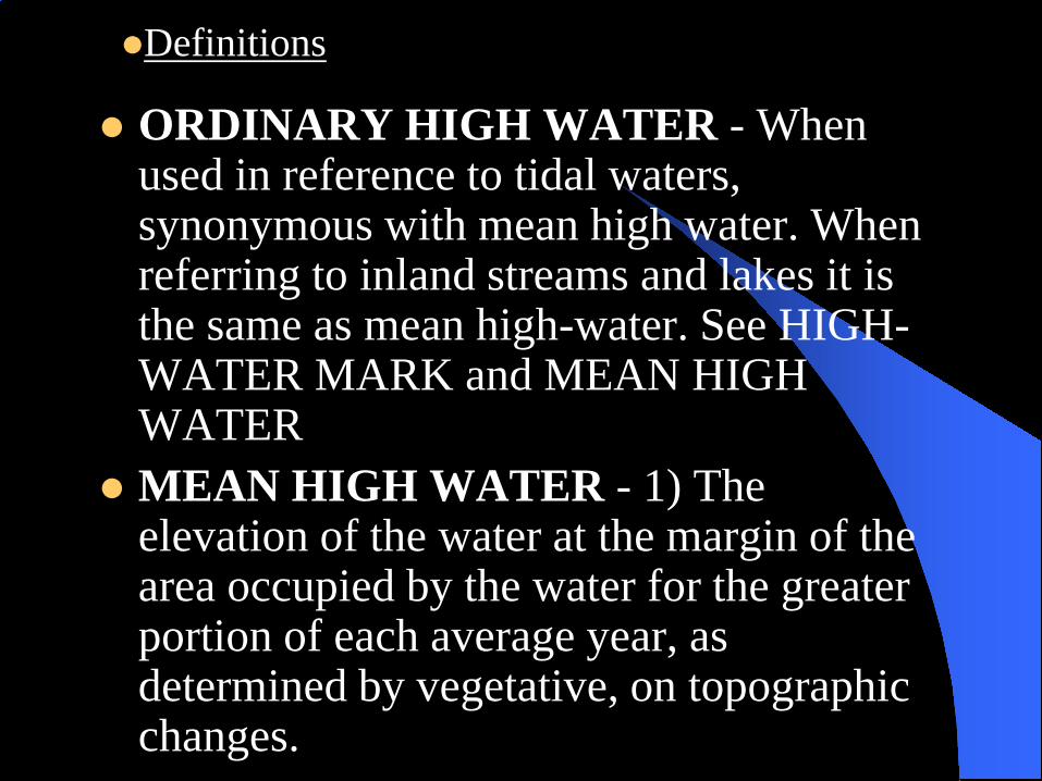
ORDINARY HIGH WATER - When used in reference to tidal waters, synonymous with mean high water. When referring to inland streams and lakes it is the same as mean high-water. See HIGH-WATER MARK and MEAN HIGH WATER
MEAN HIGH WATER - 1) The elevation of the water at the margin of the area occupied by the water for the greater portion of each average year, as determined by vegetative, on topographic changes.
Definitions
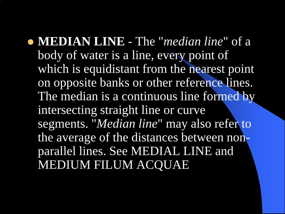
MEDIAN LINE - The "median line" of a body of water is a line, every point of which is equidistant from the nearest point on opposite banks or other reference lines. The median is a continuous line formed by intersecting straight line or curve segments. "Median line" may also refer to the average of the distances between non-parallel lines. See MEDIAL LINE and MEDIUM FILUM ACQUAE

BEDS OF NONNAVIGABLE LAKES AND STREAMS - The areas within the mean high-water lines of a lake, stream or river which are kept practically bare of vegetation from year to year by the wash of the waters; although parts of them are left dry for months at a time. Title to the beds of nonnavigable bodies of water remains in the United States until the shore lands have passed into private ownership. See PROTRACTION, RIPARIAN BOUNDARIES and PARTITION LINES.
Definitions

Definitions Aliquot Part (2009 manual 3-32)
Aliquot part- Aliquot is a French team meeting “equal with no remember.” It is used to refer to any of the normal subdivision of section.
Lot (Government Lot) (2009 manual 10-3 & 10-200)Lot- a non-aliquot subdivision of a section. Based on the previous definition, this Parcel of land would not be equal in the same way an aliquot part would be.
Subdivision of Sections Sections are divided into quarter sections by running
straight lines ("straight lines" implied "lines of constant bearing“) between opposite quarter section corners. This will divide the section into four aliquot parts.
It must be noted that the section is NOT divided evenly by area, but divided by aliquot parts.
If a quarter section is to be divided further, lines are run between quarter-quarter section corners in the same manner the section was divided into quarter sections.
Under the general laws, broadly, the unit of administration is the quarter-quarter section of about 40 acres.
The private surveyor is usually responsible for subdividing sections in the field.

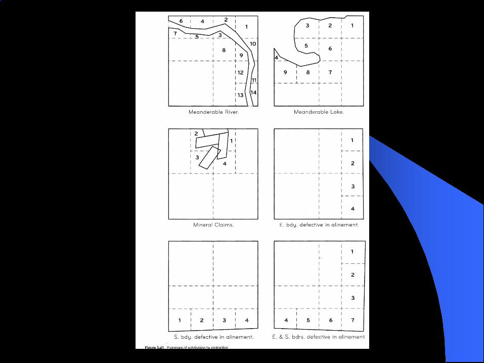
Subdivisions of Sections by Protraction Upon the plat of all regular sections, the boundaries of
the protracted quarter-section are shown by dashed straight lines connections the opposite quarter-sectioncorners.
The sections bordering the north and west boundary of a regular townships, excepting section 6, are further subdivided by protraction into parts containing two regular half quarters and four lots.
Section 6 has regular lots protracted against both the north and west boundaries, and so contains two half-quarter sections, one quarter-quarter section, and seven regular lots.
Sections that are invaded by meanderable bodies of water or by approved claims at variance with the regular legal subdivisions are subdivided by protraction into as many aliquot parts as possible and then Lots.

Government Lots Sections are protracted so as to provide a maximum
number of aliquot parts (160, 80, and 40 acre units) or regular subdivision of section, the remaining areas in these sections is shown as lots, commonly referred to as “Government Lots.”
Lots (Government Lots) are commonly found along the sections at the north tear and the west range of townships.
Lots can also be found in invaded sections in the areas where the land cannot be protracted into aliquot parts.
Boundaries of lots usually follow the quarter section and quarter quarter section lines, but extreme lengths or narrow widths are avoided, as are areas of fewer than 10 acres or more than 50 acres.

Mineral Surveys
Meander lines
Townsite survey
Islands
LAKE
Spanish Land Grant

COMPLETION SURVEY
THE HACHURE MARKS ARE WITHIN THE AREAS PREVIOUSLY RETURNED AS SURVEYED.(9-59)

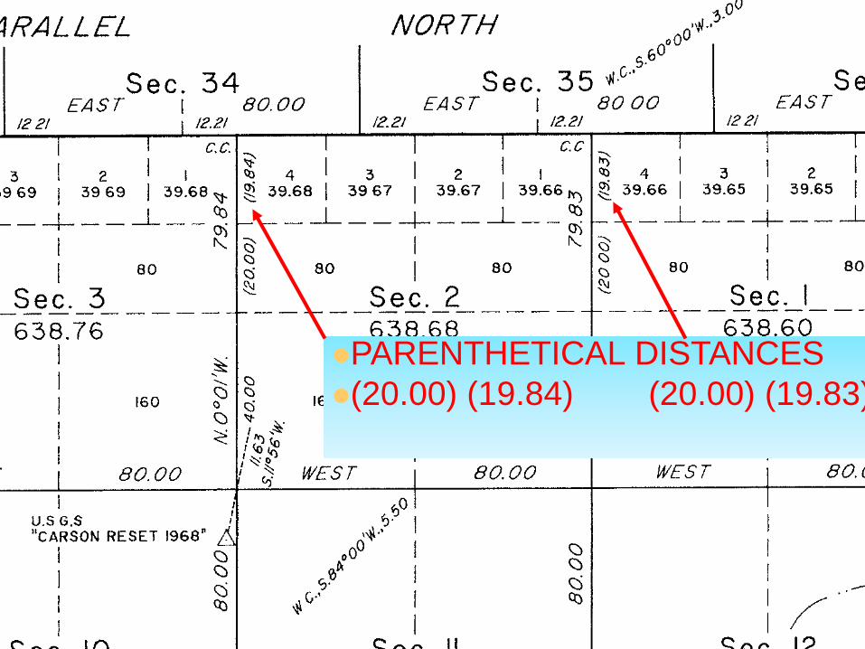
PARENTHETICAL DISTANCES(20.00) (19.84) (20.00) (19.83)

SEC. 2–LOT 1 = 19.83 + 19.832 = 39.66 ACRES–LOT 2 = 19.833 + 19.835 = 39.67 ACRES–LOT 3 = 19.835 + 19.837 = 39.67 ACRES–LOT 4 = 19.837 + 19.84 = 39.68 ACRES
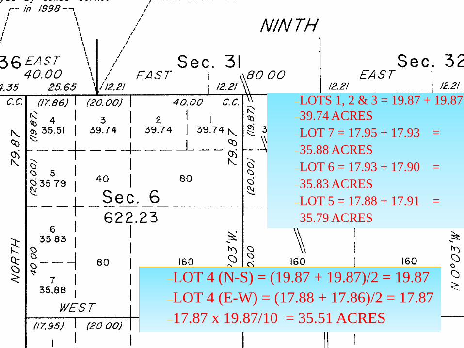
–LOTS 1, 2 & 3 = 19.87 + 19.87 –39.74 ACRES–LOT 7 = 17.95 + 17.93 = –35.88 ACRES–LOT 6 = 17.93 + 17.90 = –35.83 ACRES–LOT 5 = 17.88 + 17.91 = –35.79 ACRES
–LOT 4 (N-S) = (19.87 + 19.87)/2 = 19.87 –LOT 4 (E-W) = (17.88 + 17.86)/2 = 17.87–17.87 x 19.87/10 = 35.51 ACRES

CARDINAL EQUIVILENTS
2.79
5.58
5

Fractional Sections Definition- Fractional Section- A section with one or
more subdivisions of less than 40 acres due to one or more controlling corners never being set. This usually occurs due to incomplete sections, meanderable bodies of water, or invasion of non-rectangular entities.
Regarding fractional sections, the LAW says “The subdivision lines will run in cardinal directions”
The law presumed that the section lines were actually run cardinally. Since a resurvey will almost always find those lines to be other than cardinal, some adjustments must be made to allow you to protect the plat, and patents.
(2009 manual 3-118 through 3-124) (1973 3-81 to 82, 3-88, 3-90)

Fractional Sections
There are three basic methods to perform this process, with specific applications for each one. They are:
– Weighted Mean– Parallel Lines
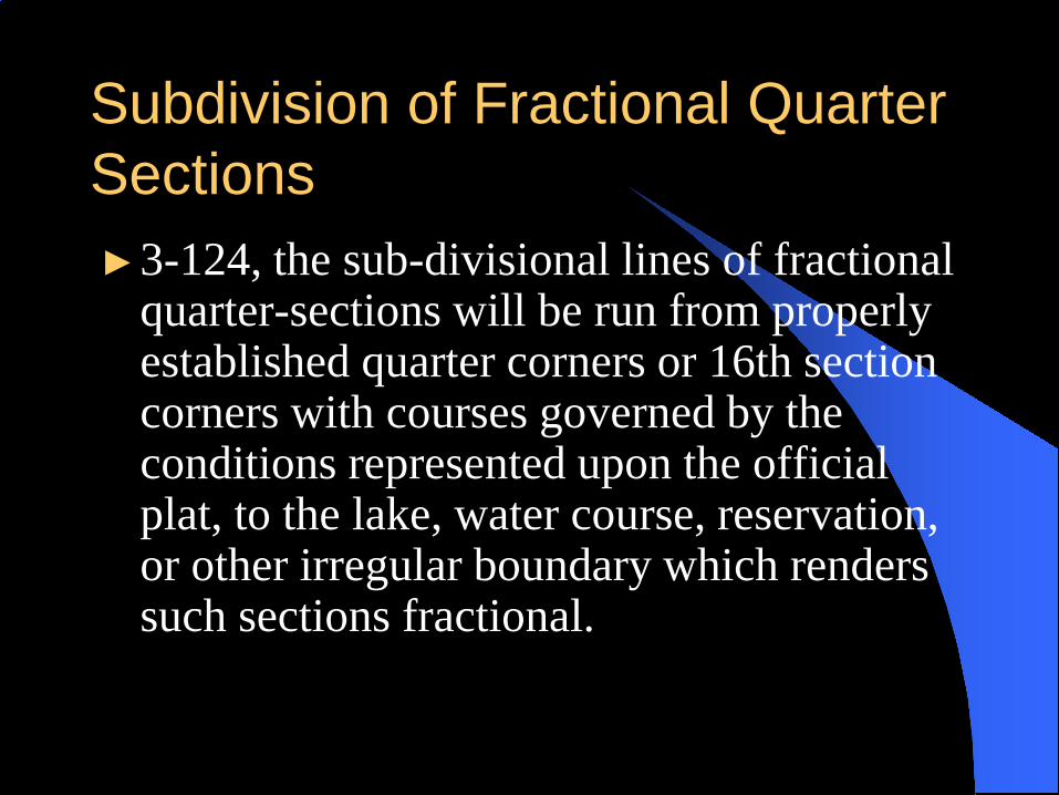
Subdivision of Fractional Quarter Sections►3-124, the sub-divisional lines of fractional
quarter-sections will be run from properly established quarter corners or 16th section corners with courses governed by the conditions represented upon the official plat, to the lake, water course, reservation, or other irregular boundary which renders such sections fractional.

3-124
► In running the centerlines through fractional quarter sections it is necessary to adopt mean courses, as ascertained from opposite corresponding section and subdivision-of-section lines, or run parallel to a boundary of the section or quarter section, as conditions require.

Weighted Mean– In most applications, the weighted mean is a far
better approach. It considers the length of the controlling section lines in the meaning process. Weighted means are especially needed when the controlling section lines vary greatly in length.
Fractional Sections

Weighted Mean Computation Tip– To compute a weighted mean using a COGO
routine, run a traverse in the program using all the controlling lines as if they are connected end to end. Inverse back to the beginning point and the resulting bearing will be a weighted mean of all the bearings used.
Parallel Lines– There are fractional section situations where you do
not have an opposite section line to control a mean. In this case parallel lines are your only equitable solution.
Fractional Sections

MONUMENTS The law provides that the original corners established
during the process of surveying shall forever remain fixed in position, even disregarding technical errors which may have passed undetected before acceptance of the survey.
A knowledge of monumentation employed during the execution of the public land survey is indispensable attribute for the present day surveyor.
To retrace the footsteps of the original surveyors, the present day surveyor must have a good understanding of the monuments and references used in the region concerned.

Corner vs. Monument According to the (2009 Manual 6-8) (1973 5-4)
The terms "corner" and "monument" are not interchangeable.
A "corner" is a point determined by the surveying process.
A "monument" is the object or the physical structure that marks the corner.
MONUMENTS Corner (2009 manual 6-9) (1973 5-4)
– The "corners" of the public land surveys are those points that determine the boundaries of the various subdivisions represented on the official plat-the township corner, the section corner, the quarter-section corner, the subdivision corner, or the meander corner.
Monument (2009 manual 6-10) (1973 5-4)– "Monuments" of the public land surveys have included the
deposit of some durable memorial, a marked wooden stake or post, a marked stone, an iron post having an inscribed cap, a marked tablet set in solid rock or in a concrete block, a marked tree, a rock in place marked with a cross (X) at the exact corner point, and other special types of markers, some of which are more substantial; any of these is termed a "monument."

Quarter Section Corners– Quarter section corners are placed to divide the
section into quarters. They are usually set equidistant from two section corners, except in the northern tier or western range where they are placed 40 chains from the south or east section corners.
Section Corners– Section corners are placed at the four corners of a
section. Interior section corners are placed at 80 chains. Section corners places on the north tier or west range of a township close on the township or range line.
MONUMENTS

Standard Section Corners– Standard corners are measured along standard parallels every 80
chains. Because standard parallels are correction lines the standard corners only govern the sections and townships to the north and are marked “S.C.”
MONUMENTS

Accessory (2009 manual 4-79) (1973 4-83)– The purpose of an accessory is to evidence the
position of the corner monument. Accessories consist of bearing trees; bearing objects such as notable cliffs or boulders, permanent improvements, buried objects, or reference monuments; mounds of stone; memorials; or pits.
Bearing Trees (2009 manual 4-81) (1973 4-85)– Bearing trees (reference trees) should be marked on
the side facing the monument they are referencing and inscribed with the letters and figures appropriate for the corner concerned.
Monument Accessories

Mound of Stone (2009 manual 4-90) (1973 4-92)– A mound of stone erected as a corner accessory should
be built as stable as possible, should consist of not fewer than five stones, and should be not less than 3 feet in diameter at the base and11/2 feet high. The position of the accessory mound is placed with its nearest point with in 6 inches (1 link) from the corner.
Pit (2009 manual 4-92) (1973 4-94)– A pit is a hole, which is specified to be 18 inches square
and 12 inches deep, with the nearest side 3 feet from the monument. Pits are poor accessories and are rarely used in modern official surveys.
Monument Accessories

Monument Accessories Memorial (2009 manual 4-89) (1973 4-91)
– A memorial is any durable object that serves to identify the location of the monument. Articles such as glass, stone with an “X” marked on them, a charred stake, charcoal, metal, can serve as memorials. They are placed below monument
Reference Monument (2009 manual 4-17) (1973 4-16)– A reference monument is an accessory and is
employed in situations where the site of a corner is such that a permanent monument with a cap cannot be established or where the monument would be liable to destruction and bearing trees or a nearby bearing object are not available.

Meander Corners (2009 manual 3-173) (1973 3-117)
– A meander corner is established at every point where a standard, township, or section line or special survey boundary intersects a meanderable body of water.
Witness Corner (2009 manual 4-16) (1973 4-15)– A witness corner is a monumented point near a
corner. It is established only in situations where it is impracticable to occupy the site of a corner with a monument or a mark.
Controlling Intermediate Monuments

Witness Point (2009 manual 4-18) (1973 4-17)
– A witness point is a monumented station on a line of the survey that is used to perpetuate an important location more or less remote from and without special relation to any regular corner.
Line Tree (2009 manual 3-118) (1973 3-125)– A line tree is a tree on a survey line such as a
section line. The line tree is marked with either a blaze, a hack or both to help identify the position of the line. When retracing surveyors find a line tree it is treated as a corner.
Controlling Intermediate Monuments

Closing Corners– Closing corners close on standard parallels from the south.
Because of the convergence of meridians the distance between closing corners are less than 80 chains and only govern the top tier of sections to the south of the standard parallel. Closing corners are marked ‘C.C” North quarter section corners are not set between closing corners. No new Closing Corners to be set.Closing corner can be found any where in a township.
Controlling Intermediate Monuments
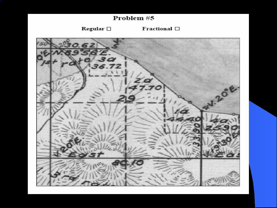
¼ Corners of Minimum Control The classic situation is where the original survey
established closing corners on the exterior boundary of a township. The quarter corners was protracted over the plat but was not established on the ground.
Closing corners were established on that line but the north quarter corner was never set although the position for it is established by the plat.

Time for lunch

RESURVEY OF PUBLIC LANDSSEC 1-20The Act of March 3, 1909 (35 Stat. 845) as
amended June 25, 1910 (36 Stat. 884; 43 U.S.C. 772), provides that: “The Secretary of the Interior may, as of March 3, 1909, in his discretion, cause to be made, as he may deem wise, under the rectangular system on that date provided by law such resurveys or retracements of the surveys of public lands as, after a full investigation, he may deem essential to properly mark the boundaries of the public lands remaining undisposed of:

RESURVEY OF PUBLIC LANDSSEC 1-20
Provided, that no such resurvey or retracement shall be so executed as to impair the bona fide rights or claims of any claimant, entryman, or owner of lands affected by such resurvey or retracement……..”

RESURVEY OF PUBLIC LANDSSEC 1-20MARCH 3, 1909 RESURVEYS AUTHORIZED TO
IDENTIFY PUBLIC LANDS –43 USC 772
PROVIDED THAT BONA FIDE RIGHTS OF CLAIMANTS
ARE PROTECTED

BONA FIDE RIGHTSSEC 5-25
BONA FIDE RIGHTS ARE THOSE ACQUIRED IN GOOD FAITH UNDER THE LAW. A RESURVEY CAN AFFECT THE BONA FIDE RIGHTS ONLY IN THE MATTER OF POSITION OR LOCATION ON THE EARTH’S SURFACE.

CORNERS - EXISTENT, OBLITERATED OR LOST
Existing Corner (6-11) (5-5) - An existent corner is one whose original position can be identified by substantial evidence of the monument or its accessories, by reference to the description in the field notes, or located by an acceptable supplemental survey record, some physical evidence, or reliable testimony.
Obliterated Corner (6-17) (5-9) - An obliterated corner is an existent corner where, at the corner's original position, there are no remaining traces of the monument or its accessories but whose position has been perpetuated, or the point for which may be recovered, by substantial evidence from the acts or reliable testimony of the interested landowners, competent surveyors, other qualified local authorities, or witnesses, or by some acceptable record evidence.
Lost Corner (7-2) (5-20) - A lost corner is one whose original position cannot be determined by substantial evidence, either from traces of the original marks or from acceptable evidence or reliable testimony that bears upon the original position, and whose location can be restored only by reference to one or more interdependent corners.
Restoring Lost Corners
Original and One-Point Control Two Point Control Three Point Control Single Proportions Double Proportions Lost Closing Corners Grant Boundary Meander lines Adjustment
Original and One-Point Control (7-56) (1973 5-45) Where a line terminates with
measurement in one direction only, a lost corner should be restored by record bearing and distance, counting from the nearest identified or restored regular corner. Examples will be found where lines have been discontinued at the intersection with large meanderable bodies of water or at the border of what was classed as impassable ground.
You must be on be on the right Basis of Bearing or you put the corner in the wrong place!

Two Point Control (7-14) Where the intersecting lines have been established
in only two of the directions, "two-point control“ should be used to reestablish the position of the corner. The record distances, reduced to their cardinal equivalents, to the nearest identified corners on the intersecting lines will control the position of the corner. The record latitude on the meridional line will determine the latitudinal position and the record departure on the latitudinal line will determine the meridional position of the corner. What is intended by record distance is the measure established in the original survey.
Used where corner only established from two directions Run record B &D from each to set temp (True Bearing) Make a cardinal move from each to the true point Inverse back to control This is not a B-B or D-D intersection!

180.22N179.40E
X
R= EAST 80.00
100N100EM=
M=
Two Point Control
N 100.22E 180.00
180.22N179.40E
X
R= EAST 80.00
100N100EM=
M=
Three Point Control (7-13) Where the line has not been established in one
direction from the lost township or section corner, "three-point control" should be used to reestablish the position of the corner. The record distance (reduced to its cardinal equivalent) to the nearest identified corner in the direction opposite from the missing line will be used, along with proportionate measurement between the other two corners.
You must be on True Bearing! Do a proportion on the through line, using a cardinal
equivalent Run record B&D on the single line Make cardinal moves from these two results to set
actual point Inverse to controlling corners for final courses
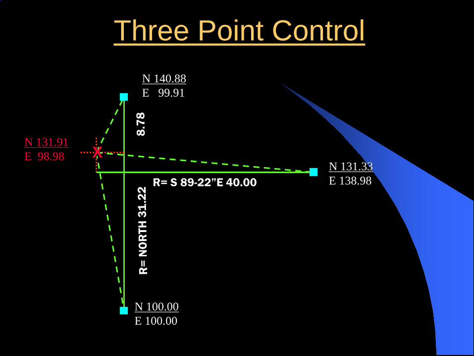
Three Point Control
R= S 89-22”E 40.00
X
N 140.88E 99.91
N 131.33E 138.98
N 100.00E 100.00
N 131.91E 98.98
Single Proportions (7-16) (5-30) The term "single proportionate
measurement" is applied to a new measurement made on a line to determine one or more positions on that line.
Spread excess/deficiency along line at same ratio as the record indicates. (Protect the plat)
Used on: quarter-section corners, all standard corners, all corners on township and range lines, and on straight lines on non-rectangular entities.
Single Proportions Methods - midpoints, non-midpoints, modified with bearing breaks, on the latitudinal curve.

(40.205)
7-51 MANUAL


Double Proportions (7-8) (5-25)The term "double proportionate
measurement“ is applied to a new measurement made between four known corners, two each on intersecting meridional and latitudinal lines, for the purpose of relating the cardinal equivalents intersection to both.
Apply to section corners and township corners
Only corners with true 4-way establishment
Requires the use of “cardinal equivalents” and you must be on True Bearing!

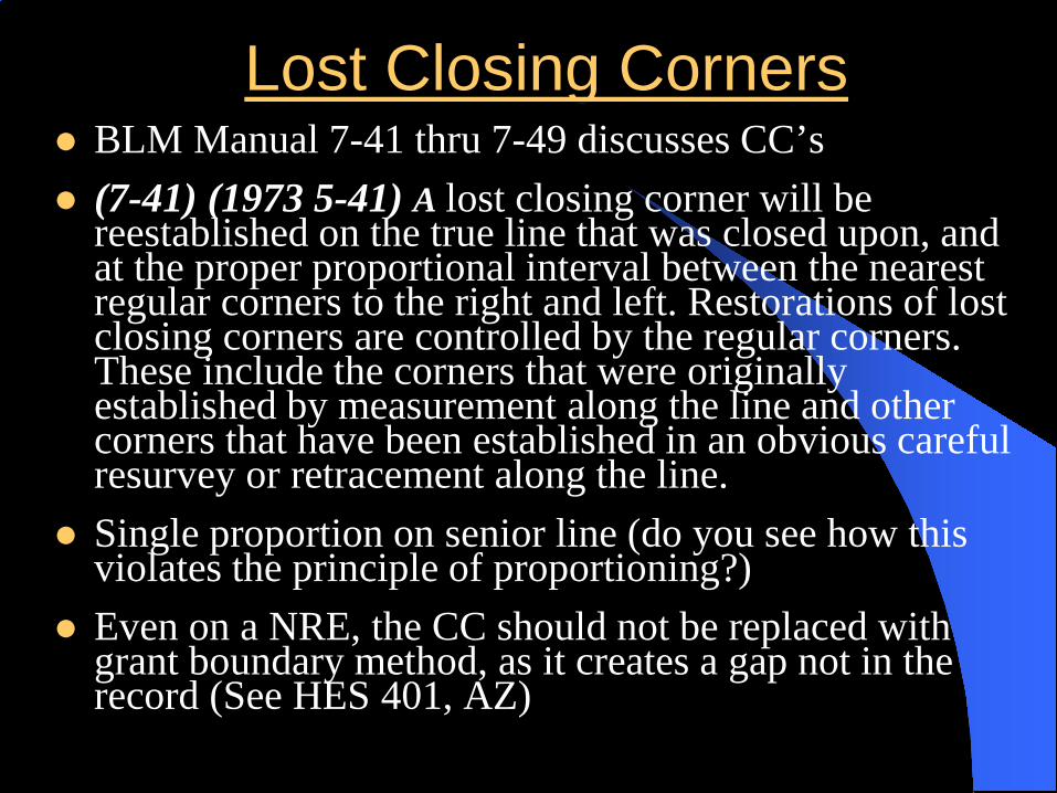
Lost Closing Corners BLM Manual 7-41 thru 7-49 discusses CC’s (7-41) (1973 5-41) A lost closing corner will be
reestablished on the true line that was closed upon, and at the proper proportional interval between the nearest regular corners to the right and left. Restorations of lost closing corners are controlled by the regular corners. These include the corners that were originally established by measurement along the line and other corners that have been established in an obvious careful resurvey or retracement along the line.
Single proportion on senior line (do you see how this violates the principle of proportioning?)
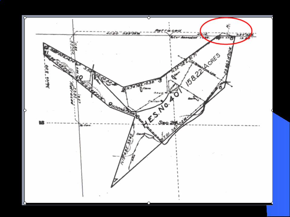
Even on a NRE, the CC should not be replaced with grant boundary method, as it creates a gap not in the record (See HES 401, AZ)

1/4 CornerS4 and S5
C C
R=3.83 R= 40.00
4 312
Standard ParallelM=45.22
Lost Closing Corners
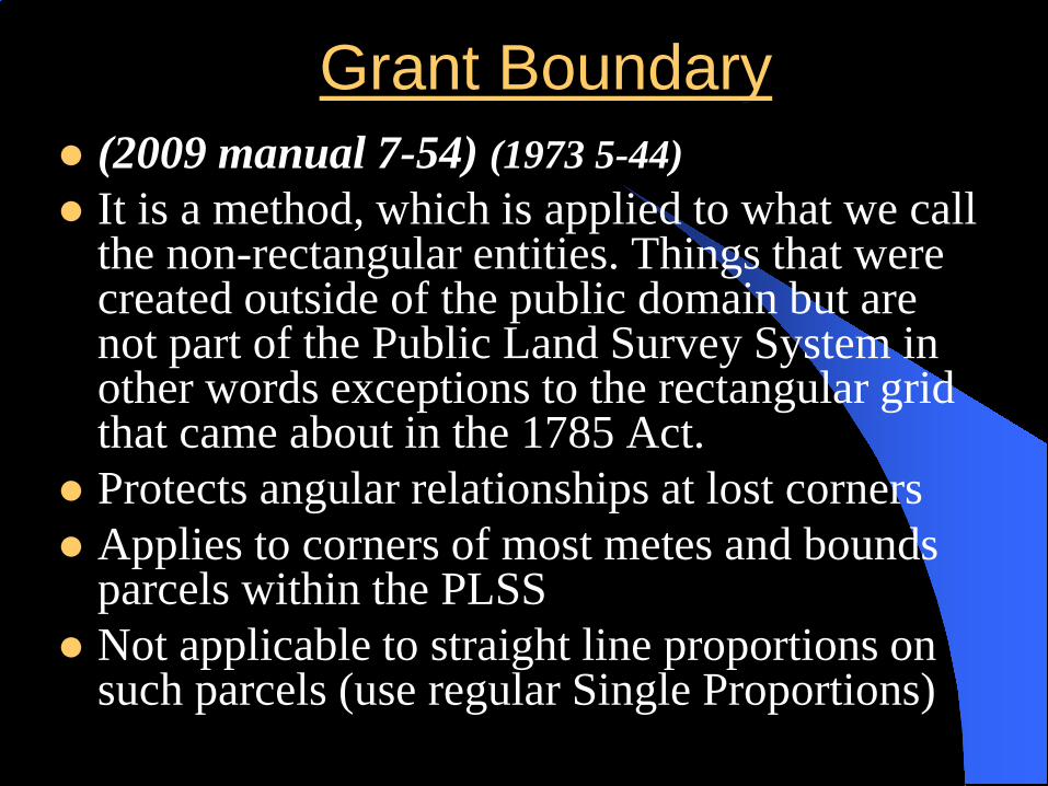
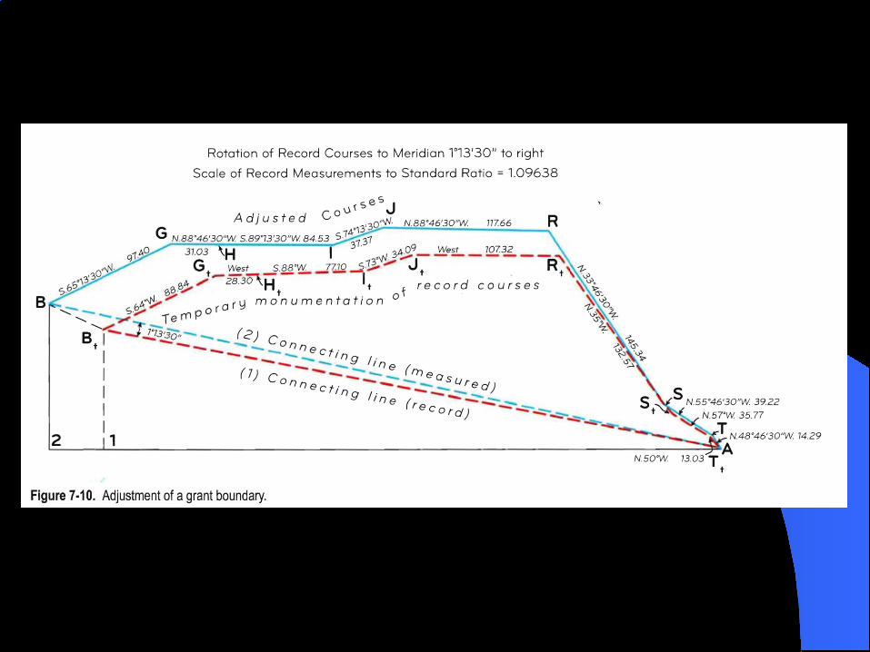
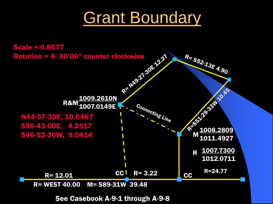
Grant Boundary (2009 manual 7-54) (1973 5-44) It is a method, which is applied to what we call
the non-rectangular entities. Things that were created outside of the public domain but are not part of the Public Land Survey System in other words exceptions to the rectangular grid that came about in the 1785 Act.
Protects angular relationships at lost corners Applies to corners of most metes and bounds
parcels within the PLSS Not applicable to straight line proportions on
such parcels (use regular Single Proportions)
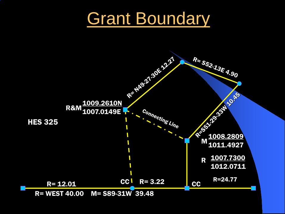
HES 325
CC CC
1009.2610N1007.0149ER&M
1008.28091011.4927
1007.73001012.0711
M
R
R= WEST 40.00 M= S89-31W 39.48R= 12.01 R= 3.22 R=24.77
Grant Boundary
N44-57-30E, 10.6467S56-43-00E, 4.2517S46-52-30W, 9.0414
CC CC
1009.2610N1007.0149ER&M
1008.28091011.4927
1007.73001012.0711
M
R
R= WEST 40.00 M= S89-31W 39.48R= 12.01 R= 3.22 R=24.77
Grant BoundaryScale = 0.8677Rotation = 4- 30’00” counter clockwise
See Casebook A-9-1 through A-9-8

Applications of GBM Indian Reservations Military Reservations Homestead Entry Surveys SHC/DLC Spanish/Mexican land grants (Ranchos) National Park Boundaries Townsite Surveys Lighthouse tracts U.S. Surveys Isolated Mineral Claims Independent Resurvey Tracts

Meander Lines Adjustment
Non-riparian Meander Lines– Never meant to be a boundary– How can you have non-riparian meander lines?
1. Edge of waste lands meandered 2. MHWL has moved away
Found at 7-53 in BLM Manual (1973 5-43) Actually the compass rule, using an “open ended
traverse” approach.


Vocabulary
Chain, Link, and Acre Aliquot Part (2009 manual 3-32)
Lot (Government Lot) (2009 manual 10-3& 10-200)
Corner – Existent, Obliterated, and Lost. Monument Cardinal Equivalent Astronomic Basis of Bearing (True Bearing)

Conclusion
This has been an overview of the Public Land Survey System. To become an expert in this subject one must do much more in-depth sties on the subject.

Where to Get More Information
Phoenix College offers the Public Land Survey System Class
APLS Seminars BLM offers CFedS Dennis Mouland’s – Witness Tree Consulting John Stock’s - Advanced Cadastral Academy
I would like to thank Jerry Knight, Chris Mcdonald,Dennis Mouland and the CFedS program.