The Potential Role of NCAR in the Future Carbon Observing Network Britton B. Stephens Atmospheric...
25
The Potential Role of NCAR in the Future Carbon Observing Network Britton B. Stephens Atmospheric Technology Division, Research Aviation Facility
-
Upload
abigail-stevenson -
Category
Documents
-
view
215 -
download
0
Transcript of The Potential Role of NCAR in the Future Carbon Observing Network Britton B. Stephens Atmospheric...
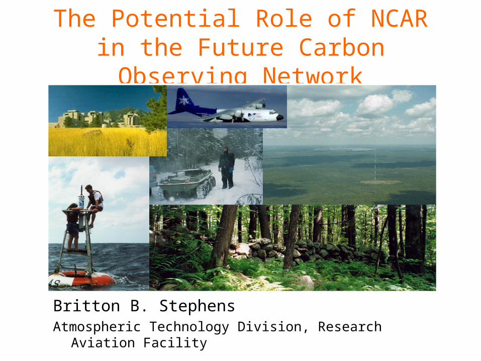
The Potential Role of NCAR in the Future Carbon Observing Network
Britton B. StephensAtmospheric Technology Division, Research Aviation Facility

Necessity of and challenges to measuring regional carbon fluxes
• Nature of the problem– Why does the observing network need to be expanded?– What amount of support can be expected?
• Determining the best approach– Variability in fluxes and concentration fields– Modeling and network design studies
• NCAR’s potential role– New technologies for autonomous instrumentation– Coordination of large-scale measurement programs– Ecological, transport, and data-assimilation modeling

Expected from fossil fuel emissions
Annual-mean CO2 Exchange (GtCyr-1)

IPCC, 2001 Stabilization Scenarios
“…human beings are now carrying out a large scale geophysical experiment of a kind that could not have happened in the past nor be reproduced in the future. Within a few centuries we are returning to the atmosphere and oceans the concentrated organic carbon stored in sedimentary rocks over hundreds of millions of years.”
Roger Revelle and Hans Suess, 1957
Motivations
• Academic
• Climatic
• Political
• Economic
“The United States [will] help lead the way by advancing the science on climate change, advancing the technology to monitor and reduce greenhouse gases. . . .”
President George W. Bush, June, 2001
Kyoto Protocol
Article 3.3 The net changes in greenhouse gas emissions from sources and removals by sinks resulting from direct human-induced land-use change and forestry activities . . . shall be used to meet the commitments . . . .
Article 6.1 For the purpose of meeting its commitments under Article 3, any Party included in Annex I may transfer to, or acquire from, any other such Party emission reduction units . . . .


Predicted gradients due to fossil fuel emissions alone
}Observations
(from TransCom 1, Law et al., 1996)
Modeled and Observed Meridional CO2 Gradients
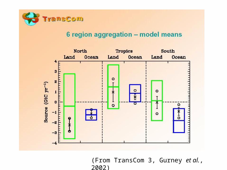
(From TransCom 3, Gurney et al., 2002)
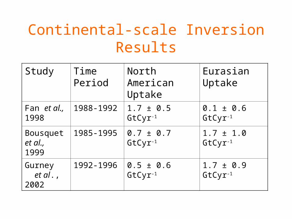
Continental-scale Inversion Results
Study Time Period
North American Uptake
Eurasian Uptake
Fan et al., 1998
1988-1992 1.7 ± 0.5 GtCyr-1 0.1 ± 0.6 GtCyr-1
Bousquet et al., 1999
1985-1995 0.7 ± 0.7 GtCyr-1 1.7 ± 1.0 GtCyr-1
Gurney et al., 2002
1992-1996 0.5 ± 0.6 GtCyr-1 1.7 ± 0.9 GtCyr-1

Need not only more measurements, but also better models

Regional scale is critical for linking to underlying processes
(NRCS/USDA, 1997)
(NRCS/USDA, 1997) (SeaWIFS, 2002)
CHLOROPHYLL
TEMPERATURE (C)
(IPCC, 2001)
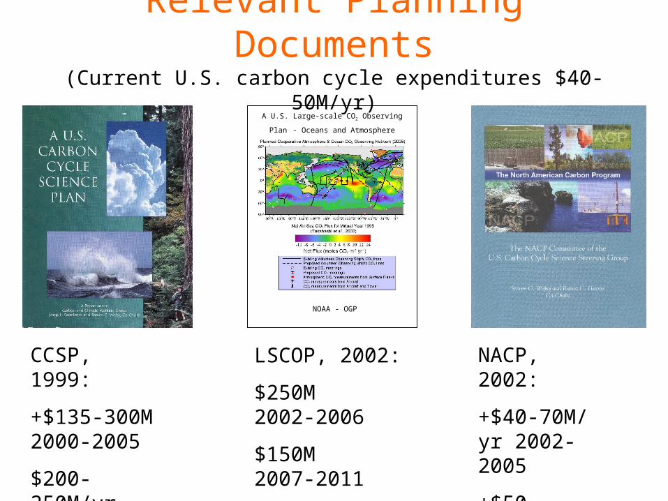
Relevant Planning Documents(Current U.S. carbon cycle expenditures $40-50M/yr)
CCSP, 1999:
+$135-300M 2000-2005
$200-250M/yr 2005-
NACP, 2002:
+$40-70M/yr 2002-2005
+$50-100M/yr 2005-
LSCOP, 2002:
$250M 2002-2006
$150M 2007-2011
A U.S. Large-scale CO2 Observing Plan - Oceans and Atmosphere
NOAA - OGP

(from The Emerging International Greenhouse Gas Market, Pew Center on Global Climate Change, 2002)
At $2 per ton CO2e: 0.1 GtC (~1/10 of current uncertainty on U.S. uptake and ~1/4 of current U.S. emissions above Kyoto obligation) would trade at approximately. . .
$700,000,000.00

Many network design studies1 have been conducted, with similar results:
• Need more data
- continental, (South America, Africa, Siberia)
- Southern Ocean
- airborne
1e.g. Rayner et al., 1996; Gloor et al., 1999; LSCOP, 2002; Patra, subm. 2001; Suntharalingam, subm. 2002

(LSCOP, 2002)

TURC/NDVI Biosphere, Takahashi Ocean, EDGAR Fossil Fuel
(Ute Karstens and Martin Heimann, 2001)
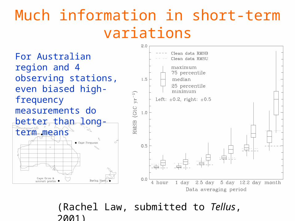
Much information in short-term variations
(Rachel Law, submitted to Tellus, 2001)
For Australian region and 4 observing stations, even biased high-frequency measurements do better than long-term means
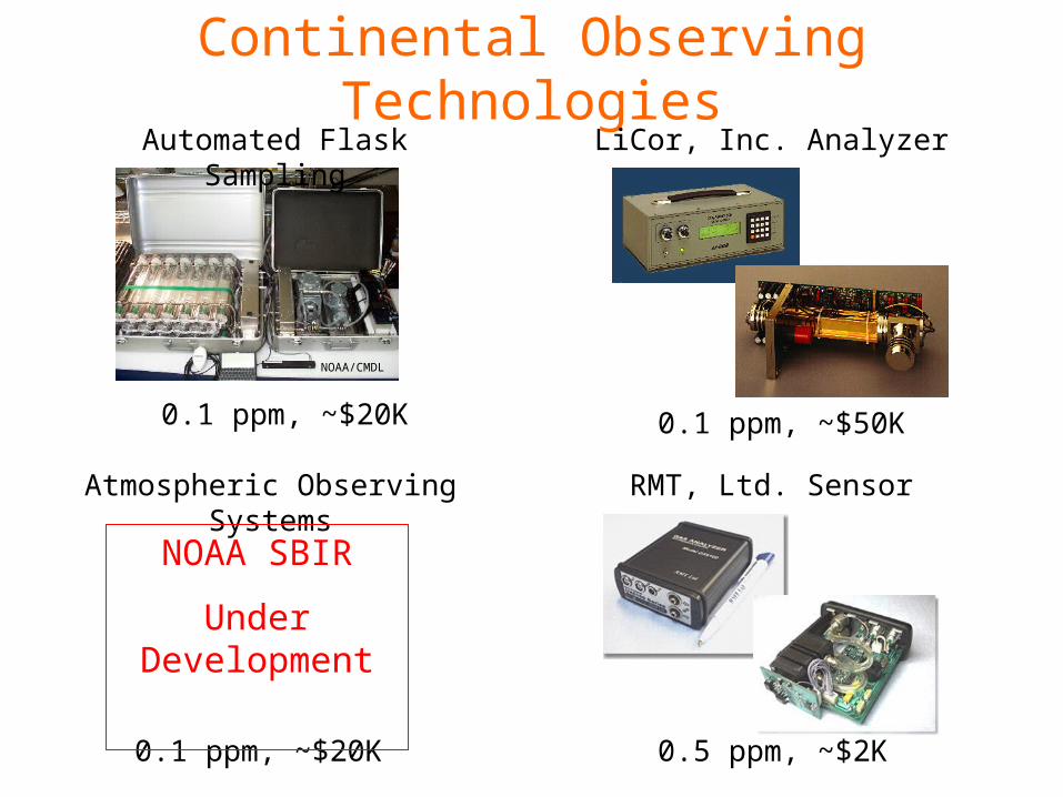
Continental Observing TechnologiesLiCor, Inc. Analyzer
0.1 ppm, ~$50K
Atmospheric Observing Systems
0.1 ppm, ~$20K
NOAA SBIR
Under Development
RMT, Ltd. Sensor
0.5 ppm, ~$2K
Automated Flask Sampling
0.1 ppm, ~$20K
NOAA/CMDL
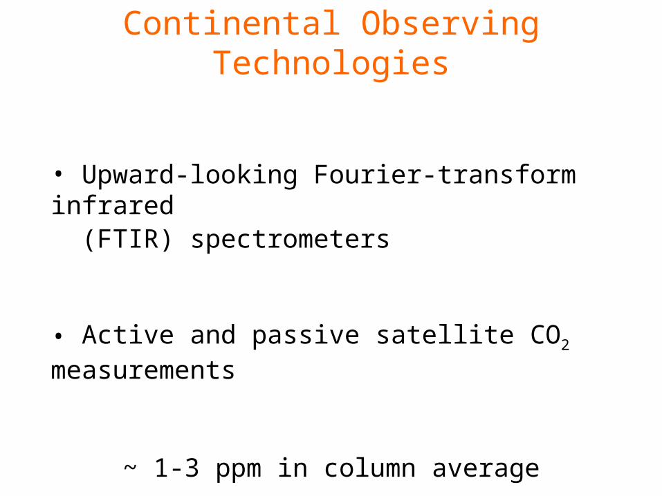
Continental Observing Technologies
• Upward-looking Fourier-transform infrared (FTIR) spectrometers
• Active and passive satellite CO2 measurements
~ 1-3 ppm in column average

Relevant NCAR Expertise• Field measurements of atmospheric trace gases (ATD, ACD)• Autonomous instrumentation networks (ATD)• Atmospheric transport and ecological modeling (MMM, CGD)• Data assimilation and dataset management (ACD, CGD, SCD)• Industrial emissions and land-use characterization (ESIG, CGD)• FTIR measurements and satellite planning (ACD, CGD)
Biogeosciences Initiative (all divisions)
• Inexpensive and robust CO2 sensors
• Data assimilation tools• FTIR measurements
• Long range: CO2 sondes
Potential Applications

Niwot Ridge Pilot Study August 2002
Jeilun Sun, Steve Oncley, Alex Guenther, Dave Schimel, Don Lenschow, Britt Stephens, Russ Monson, and others.

Prototype Inexpensive/Autonomous CO2 System
- RMT Sensor- Aluminum LPG cylinders- Goals:
1-2 year service scheduleTotal installation ~ $2000

Towers over 650 feet AGL
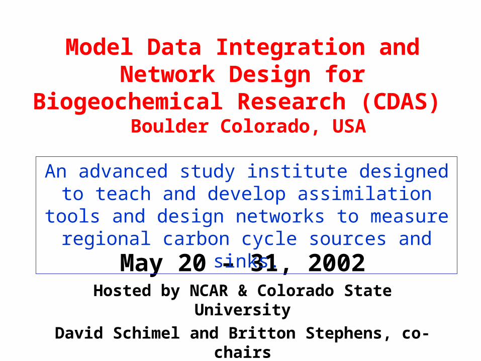
Model Data Integration and Network Design for Biogeochemical Research
(CDAS) Boulder Colorado, USA
May 20 – 31, 2002Hosted by NCAR & Colorado State University
David Schimel and Britton Stephens, co-chairs
An advanced study institute designed to teach and develop assimilation tools and design networks to measure regional carbon cycle sources and sinks.

NCAR CarboNet?

Conclusions• Present observing network and modeling tools
are inadequate to measure continental fluxes• We need information on regional scales• Interest and support are likely to increase• NCAR scientists will play a major role in
developing the future carbon observing network