The Planet Earth We Live 1 - edupub.gov.lk G 7( E)/c1.pdf · The Planet Earth We Live The shape of...
10
For Free Distribution 1 Fig.1.2 -A photograph taken from the space 1 The Earth in which we live can be considered as a marvelous creation of nature. According to the available information, the Earth is the only planet that consists of air and water with a congenial environment for living beings. The Earth revolves round the Sun while spinning around its own axis. The Earth’s movement around its own axis is called rotation and the journey around the Sun is called revolution. The Earth takes 24 hours or one day to rotate around its own axis and 365 days or one year to revolve around the Sun. The main objective of this chapter is to study about the Earth related to information about continents, oceans, longitudes, latitudes and the shape of the Earth. Fig. 1.1 - Rotation of the earth The Planet Earth We Live The shape of the Earth There were different ideas about the shape of the Earth in the past. At present, the Earth has definitely been identified as a spherical object. This is proved by observing the photographs taken from space. (Fi. 1.2) Although the Earth is considered a spherical object, it is not a full sphere. The reasons are the flatness of the Earth in the Polar Regions and the
Transcript of The Planet Earth We Live 1 - edupub.gov.lk G 7( E)/c1.pdf · The Planet Earth We Live The shape of...

For Free Distribution 1
Fig.1.2 -A photograph taken from the space
1 The Earth in which we live can be considered as a marvelous creation of nature. According to the available information, the Earth is the only planet that consists of air and water with a congenial environment for living beings.
The Earth revolves round the Sun while spinning around its own axis. The Earth’s movement around its own axis is called rotation and the journey around the Sun is called revolution. The Earth takes 24 hours or one day to rotate around its own axis and 365 days or one year to revolve around the Sun.
The main objective of this chapter is to study about the Earth related to
information about continents, oceans, longitudes, latitudes and the shape of
the Earth. Fig. 1.1 - Rotation of the earth
The Planet Earth We Live
The shape of the Earth There were different ideas about the shape of the Earth in the past. At present, the Earth has definitely been identified as a spherical object. This is proved by observing the photographs taken from space. (Fi. 1.2) Although the Earth is considered a spherical object, it is not a full sphere. The reasons are the flatness of the Earth in the Polar Regions and the

For Free Distribution 2Fig. 1.4 – Latitudes and Longitudes
Fig. 1.3 - shape of the Earth
12757km 1271
4km
Equatorial diameter = 12757kmPolar diameter = 12714 kmEquatorial circumference = 40077kmPolar circumference = 39943km
The surface area of the Earth is 510 million km2.
Source - http:// www.google.lk/2015/07/10
Activities1. i. Briefly explain what is meant by rotation and revolution. ii. What is the time period taken for rotation and revolution of the
Earth? 2. What are the evidences which help to prove that the Earth is not a
mathematical sphere?
Latitudes and Longitudes When observing a geographical globe, you may see a set of lines drawn from North to South and West to East. Those lines are imaginary lines drawn by us and they are called as longitudes and latitudes.
largeness of the equatorial circumference than the polar circumference. (Fig. 1.3) However, the following data proves that it is only a minor difference.

For Free Distribution 3
Fig. 1.5 – Latitudes
The lines drawn horizontally from the West to the East on the geographical globe are called latitudes and the lines drawn vertically
from the North to the South are called longitudes. (Figure 1.4)
The line drawn horizontally on the middle of the globe is
named 00 latitude or the equator.
The northern part of the equator is called the Northern Hemisphere and the southern part is called the Southern Hemisphere. The lines to the North of the equator are termed North Latitudes and the lines to its South are termed South Latitudes.
There are some main latitudes among them. Observe figure 1.5 and identify them. Latitude 900 is indicated as a point. The North Latitude 900 is the North Pole and the South Latitude 900 is named the South Pole.
Activity1. Observe figure 1.5 and identify the main latitudes and name
them with their values.
The lines drawn on the globe connecting the North Pole and the South Pole are called longitudes.
The 00 longitude which is drawn across the Greenwich City in England is the Greenwich Prime Meridian

For Free Distribution 4
Map 1.1 - A world map indicating latitudes and longitudes
The lines drawn to its West are called the West Longitudes and the lines to the East of it are called the East Longitudes.
From the prime meridian 3600 longitudes are distributed and 1800 run towards Eastwards and 1800 run towards Westwards. Therefore, longitude 1800 is common to both the East and West. The International Fig. 1.4 – LongitudesDate Line follows this line. Sometimes, the International Date Line is not marked as a straight line to prevent the division of a country. Observe map1.1 and identify how latitudes and longitudes you have studied are distributed in a world map.
Latitudes and longitudes are used to indicate the location of any place on the Earth specifically and accurately.
For Free Distribution 5
Activities1. Mark and name the following latitudes and longitudes in a blank
map of the world. Equator (00) Tropic of Cancer (231/20North latitude) Tropic of Capricorn (231/20South latitude) Greenwich line (00) Longitude 800 East Arctic Circle (661/20 North latitude) Antarctic Circle (661/20 South latitude)2. With your teacher’s instructions, mark the main latitudes on a
medium size rigifoam ball.3. Observe the model globe and state the location of the cities of
Colombo, Tokyo, New York, London and Calcutta in relation to latitudes and longitudes.
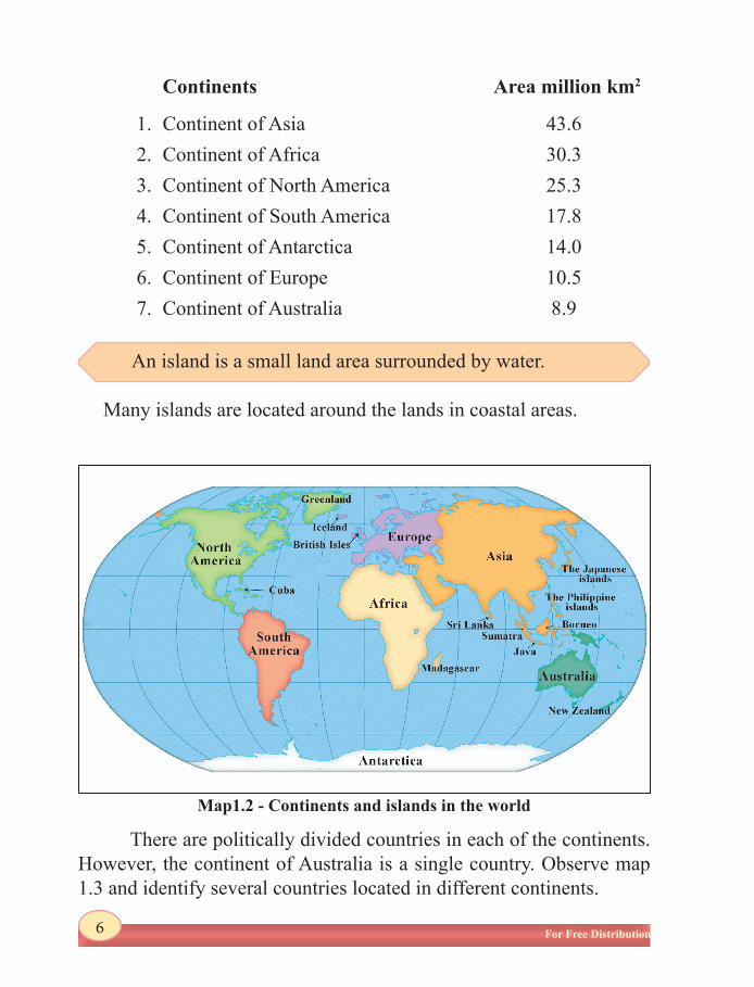
Continent is a large land area surrounded by water.
Continents and Oceans
71% of the surface of the Earth is covered by water and 29% is covered by land. The areas covered by water consists of Oceans and Seas and the land area consists of continents and islands.
Continents
The Earth consists of seven continents.
For Free Distribution 6
Map1.2 - Continents and islands in the world
An island is a small land area surrounded by water.
There are politically divided countries in each of the continents. However, the continent of Australia is a single country. Observe map 1.3 and identify several countries located in different continents.
Continents Area million km2
1. Continent of Asia 43.62. Continent of Africa 30.33. Continent of North America 25.34. Continent of South America 17.8 5. Continent of Antarctica 14.06. Continent of Europe 10.57. Continent of Australia 8.9
Many islands are located around the lands in coastal areas.

For Free Distribution 7
Map 1.3 - Political divisions in the world
The water masses located among continents are called oceans and the small water bodies located close to continents and inland
areas are called seas.
There are five oceans in the world.
Ocean Area million km2
1. Pacific ocean 1562. Indian ocean 773. Atlantic ocean 69 4. Antarctic ocean (Southern) 205. Arctic ocean 14
Japanese Sea, China Sea, North Sea, Red Sea and Mediterranean Sea are several seas located close to lands and Caspian Sea and Aral Sea are located within the continent of Asia.
Oceans

For Free Distribution 8
Activities
1. Shade the oceans in the world in blue.
2. Mark and name three seas connected to the oceans and three seas located inside countries.
3. With the help of an Atlas name three islands located in the Indian Ocean close to Sri Lanka.
4.
Map 1.4 - Oceans and Seas in the world

For Free Distribution 9
Assignment1. Refer to an atlas and select any five cities and mention the latitude
or longitude close to them. 2. Name two countries which are located across the Tropic of Cancer,
Tropic of Capricorn and the Equator.
i. Name the latitudes indicated by letters A, B, C in the above world map and write the value of them, and state the value of the longitudes indicated by letters E, F and G.
ii. Observe the map and name the latitudes located on either sides of Sri Lanka.
iii. Name the island located close to line F in the map.iv Name the five shaded countries in the map.
5. On a blank map of the world,i. Shade the seven continents in different colours and name them.ii. Mark and name two countries from continents other than
Australia and Antarctica.iii. Mark and name the following cities. San Francisco, Rio de Janairo, Cairo, Dacca
References
² https://www.google.lk/?gws_rd=ssl#q=area+in+the+earth
Glossary ² Earth - mDÓúh -¦Â
² Planet - .%yf,dalh - ÷PõÒPÒ
² Axis - wlaIh - Aa_
² Rotation - N%uKh - _ÇØ]
For Free Distribution 10
² Revolution - mßN%uKh - _ØÖøP
² Latitudes - wlaIdxY - AP»õ[S
²² ²Longitudes - foaYdxY - ö|mhõ[S
² Space ` - wNHjldYh² - ÂsöÁÎ
² Observation - ksÍlaIKh² - AÁuõÛ¨¦
² Equatorial - iul mßêh² - ©zv¯÷Põmk _ØÓÍÄ
circumference ² Polar circumference - O%ej mßêh² - x¸Á _ØÓÍÄ
² Diameter - úYalïNh² - Âmh®
² Imaginary lines - uk(l,ams; f¾Ld² - PØ£øÚU ÷PõkPÒ
² Northern hemisphere- W;=re w¾Of.da,h² - Áh AøµU÷PõÍ®
² Southern hemisphere- ol=Kq w¾Of.da,h² - öuß AøµU÷PõÍ®
² Equator - iulh² - ©zv¯ ÷Põk
² Greenwich meridian - .s%ksÉ uOH² - QÕßÂa ©zv¯
foaYdxYh ö|mhõ[S
² International Date - cd;Hka;r Èk² - \ºÁ÷u\
Line f¾Ldj ÷uvU÷Põk
² Tropic of Cancer - l¾lgl ksj¾;kh² - PhPU÷Põk
² Tropic of Capricorn - ulr ksj¾;kh² - ©PµU÷Põk
² East longitudes - kef.kysr foaYdxY² - QÇUS ö|k[÷Põk
² Arctic Circle - wdlaála jD;a;h² - BUiU Ámh®
² Antarctic Circle - wekagdlaála jD;a;h - A¢uõmiU Ámh®
² Continents - uydoaùm² - Psh[PÒ
² Oceans - id.r² - \•zvµ[PÒ ² Seas - uqyqÿ² - PhÀPÒ
² Islands - ¥m;a² - wÄPÒ