The Pemigewasset River Watershed Study Area Co-occurrence ...
1
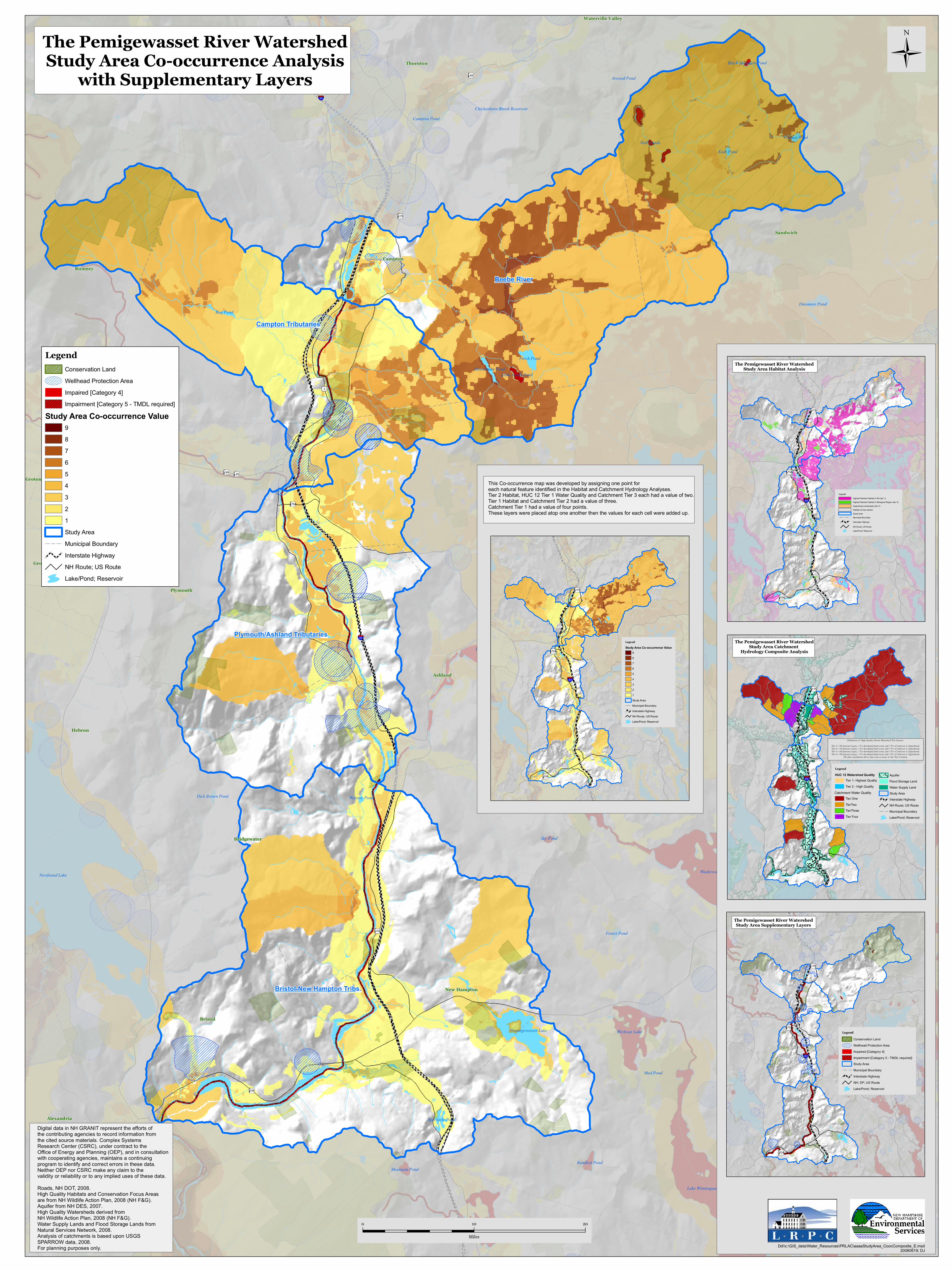
Campton Sandwich Bristol Plymouth New Hampton Bridgewater Rumney Ashland Thornton Hebron Alexandria Groton Groton Waterville Valley Newfound Lake Lake Winnisquam Waukewan, Lake Little Squam Lake Wickwas Lake Pemingewasset Lake Perch Pond Dinsmore Pond Campton Pond Randlett Pond Spectacle Pond Bog Pond Mountain Pond Sky Pond Forest Pond Moosilauke Pond Little Perch Pond Guinea Pond Kiah Pond Dick Brown Pond Webster Pond Hall Ponds Mud Pond Black Mountain Pond Atwood Pond Chickenboro Brook Reservoir § ¨ ¦ 93 § ¨ ¦ 93 I g " 3 ? w " 175 ? w " 3A ? w " 25 ? w " 104 ? w " 132 ? w " 49 ? w " 175A Beebe River Bristol-New Hampton Tribs. Campton Tributaries Plymouth/Ashland Tributaries Ü 0 10 20 Miles Legend Conservation Land Wellhead Protection Area Impaired [Category 4] Impairment [Category 5 - TMDL required] Study Area Co-occurrence Value 9 8 7 6 5 4 3 2 1 Study Area ! ! ! ! Municipal Boundary Interstate Highway NH Route; US Route Lake/Pond; Reservoir The Pemigewasset River Watershed Study Area Co-occurrence Analysis with Supplementary Layers Dd\\c:\GIS_data\Water_Resources\PRLAC\aaaaStudyArea_CoocComposite_E.mxd 20080619; DJ § ¨ ¦ 93 ? w " 175 ? w " 104 ? w " 175A Legend Conservation Land Wellhead Protection Area Impaired [Category 4] Impairment [Category 5 - TMDL required] Study Area ! ! Municipal Boundary Interstate Highway NH; SP; US Route Lake/Pond; Reservoir § ¨ ¦ 93 ? w " 175 ? w " 104 ? w " 175A Legend HUC 12 Watershed Quality Tier 1- Highest Quality Tier 2 - High Quality Tier One TierTwo TierThree Tier Four Aquifer Flood Storage Land Water Supply Land Study Area Interstate Highway NH Route; US Route ! ! Municipal Boundary Lake/Pond; Reservoir The Pemigewasset River Watershed Study Area Catchment Hydrology Composite Analysis Definition of High Quality Stream Watershed Tier System: Tier 1: <20 persons/sq.mi., <1% developed land cover, and <5% of land use is Agricultural Tier 2: <36 persons/sq.mi., <2% developed land cover, and <5% of land use is Agricultural Tier 3: <64 persons/sq.mi., <3% developed land cover, and <5% of land use is Agricultural Tier 4: <90 persons/sq.mi., <5% developed land cover, and <5% of land use is Agricultural All other catchments fail to meet one or more of the Tier 4 criteria. Catchment Water Quality The Pemigewasset River Watershed Study Area Supplementary Layers § ¨ ¦ 93 ? w " 175 ? w " 104 ? w " 175A Legend Highest Ranked Habitat in NH (tier 1) Highest Ranked Habitat in Biological Region (tier 2) Supporting Landscapes (tier 3) Habitat not top ranked Study Area ! ! ! Municipal Boundary Interstate Highway NH Route; US Route Lake/Pond; Reservoir The Pemigewasset River Watershed Study Area Habitat Analysis Digital data in NH GRANIT represent the efforts of the contributing agencies to record information from the cited source materials. Complex Systems Research Center (CSRC), under contract to the Office of Energy and Planning (OEP), and in consultation with cooperating agencies, maintains a continuing program to identify and correct errors in these data. Neither OEP nor CSRC make any claim to the validity or reliability or to any implied uses of these data. Roads, NH DOT, 2008. High Quality Habitats and Conservation Focus Areas are from NH Wildlife Action Plan, 2008 (NH F&G). Aquifer from NH DES, 2007. High Quality Watersheds derived from NH Wildlife Action Plan, 2008 (NH F&G). Water Supply Lands and Flood Storage Lands from Natural Services Network, 2008. Analysis of catchments is based upon USGS SPARROW data, 2008. For planning purposes only. § ¨ ¦ 93 ? w " 175 ? w " 104 ? w " 175A Legend Study Area Co-occurrence Value 9 8 7 6 5 4 3 2 1 Study Area ! ! Municipal Boundary Interstate Highway NH Route; US Route Lake/Pond; Reservoir This Co-occurrence map was developed by assigning one point for each natural feature identified in the Habitat and Catchment Hydrology Analyses. Tier 2 Habitat, HUC 12 Tier 1 Water Quality and Catchment Tier 3 each had a value of two. Tier 1 Habitat and Catchment Tier 2 had a value of three. Catchment Tier 1 had a value of four points. These layers were placed atop one another then the values for each cell were added up.
Transcript of The Pemigewasset River Watershed Study Area Co-occurrence ...
Campton
Sandwich
Meredith
Holderness
Bristol
Plymouth
New Hampton
Laconia
Bridgewater
Rumney
Ashland
Thornton
Center Harbor
Hebron
Moultonborough
Sanbornton
Ellsworth
Hill
Alexandria
Groton
Gilford
Gilford
Groton
Waterville Valley
Squam Lake
Newfound Lake
Winnipesaukee, Lake
Lake Winnisquam
Winnipesaukee, Lake
Waukewan, Lake
Little Squam Lake
Kanasatka, Lake
White Oak Pond
Loon Lake
Wickwas Lake
Hermit Lake
Pemingewasset Lake
Winona Lake
Opechee Bay
Hawkins Pond
Wakondah Pond
Pickerel Pond
Perch Pond
Kusumpe Pond
Jackson Pond
Dinsmore Pond
Ellsworth Pond
Barville PondIntervale Pond
Little Pond
Campton Pond
Randlett Pond
Spectacle Pond
Bog Pond
Mountain Pond
Sky Pond
Forest Pond
Moosilauke Pond
Bear Pond
Little Perch Pond
Otter Pond
Guinea Pond
Kiah Pond
Dick Brown Pond Webster Pond
Hall Ponds
Mud Pond
Black Mountain Pond
Footes Pond
Heath Pond
Atwood Pond
Meredith Reservoir
Chickenboro Brook Reservoir
§̈¦93
§̈¦93
Ig"3
Ig"3BUS
?w"175
?w"3A?w"25
?w"104
?w"113
?w"132
?w"49
?w"25B
?w"106
?w"107
?w"11B
?w"175A
Beebe River
Bristol-New Hampton Tribs.
Campton Tributaries
Plymouth/Ashland Tributaries
Ü
0 10 20
Miles
LegendConservation LandWellhead Protection AreaImpaired [Category 4]Impairment [Category 5 - TMDL required]
Study Area Co-occurrence Value987654321Study Area
! ! ! ! Municipal BoundaryInterstate HighwayNH Route; US RouteLake/Pond; Reservoir
The Pemigewasset River WatershedStudy Area Co-occurrence Analysis
with Supplementary Layers
Dd\\c:\GIS_data\Water_Resources\PRLAC\aaaaStudyArea_CoocComposite_E.mxd20080619; DJ
§̈¦93
?w"175
?w"104
?w"25B
?w"175ALegend
Conservation LandWellhead Protection AreaImpaired [Category 4]Impairment [Category 5 - TMDL required]Study Area
! ! Municipal BoundaryInterstate HighwayNH; SP; US RouteLake/Pond; Reservoir
§̈¦93
?w"175
?w"104
?w"25B
?w"175A
LegendHUC 12 Watershed Quality
Tier 1- Highest QualityTier 2 - High Quality
Tier OneTierTwoTierThreeTier Four
AquiferFlood Storage LandWater Supply LandStudy AreaInterstate HighwayNH Route; US Route
! ! Municipal BoundaryLake/Pond; Reservoir
The Pemigewasset River WatershedStudy Area Catchment
Hydrology Composite Analysis
Definition of High Quality Stream Watershed Tier System:Tier 1: <20 persons/sq.mi., <1% developed land cover, and <5% of land use is AgriculturalTier 2: <36 persons/sq.mi., <2% developed land cover, and <5% of land use is AgriculturalTier 3: <64 persons/sq.mi., <3% developed land cover, and <5% of land use is AgriculturalTier 4: <90 persons/sq.mi., <5% developed land cover, and <5% of land use is Agricultural
All other catchments fail to meet one or more of the Tier 4 criteria.
Catchment Water Quality
The Pemigewasset River WatershedStudy Area Supplementary Layers
§̈¦93
?w"175
?w"104
?w"25B
?w"175A
LegendHighest Ranked Habitat in NH (tier 1)Highest Ranked Habitat in Biological Region (tier 2)Supporting Landscapes (tier 3)Habitat not top rankedStudy Area
! ! ! Municipal BoundaryInterstate HighwayNH Route; US RouteLake/Pond; Reservoir
The Pemigewasset River WatershedStudy Area Habitat Analysis
Digital data in NH GRANIT represent the efforts of the contributing agencies to record information from the cited source materials. Complex Systems Research Center (CSRC), under contract to the Office of Energy and Planning (OEP), and in consultation with cooperating agencies, maintains a continuing program to identify and correct errors in these data. Neither OEP nor CSRC make any claim to the validity or reliability or to any implied uses of these data. Roads, NH DOT, 2008.High Quality Habitats and Conservation Focus Areas are from NH Wildlife Action Plan, 2008 (NH F&G).Aquifer from NH DES, 2007.High Quality Watersheds derived from NH Wildlife Action Plan, 2008 (NH F&G).Water Supply Lands and Flood Storage Lands from Natural Services Network, 2008.Analysis of catchments is based upon USGS SPARROW data, 2008.For planning purposes only.
§̈¦93
?w"175
?w"104
?w"25B
?w"175A
LegendStudy Area Co-occurrence Value
987654321Study Area
! ! Municipal BoundaryInterstate HighwayNH Route; US RouteLake/Pond; Reservoir
The Pemigewasset River WatershedStudy Area Co-occurrence Analysis
This Co-occurrence map was developed by assigning one point for each natural feature identified in the Habitat and Catchment Hydrology Analyses.Tier 2 Habitat, HUC 12 Tier 1 Water Quality and Catchment Tier 3 each had a value of two. Tier 1 Habitat and Catchment Tier 2 had a value of three.Catchment Tier 1 had a value of four points.These layers were placed atop one another then the values for each cell were added up.