The Pelotas Basin oil province revealed – New interpretation … · The Pelotas Basin oil...
6
© 2014 EAGE www.firstbreak.org 67 special topic first break volume 32, October 2014 Reservoir Geoscience and Engineering 1 Spectrum Geo, Inc. 2 Petrodynamics, Inc. * Corresponding author, E-mail: ****** The Pelotas Basin oil province revealed – New interpretation from long offset 2D seismic data Mike Saunders 1 and Scott Bowman 2 present the evidence for a working hydrocarbon system in the deep water basin offshore Brazil utilizing improved PreSDM imaging, and quantitative AVO attributes. T he Pelotas Basin is a relatively unexplored hydrocarbon province comprising a 500,000 km2 passive margin located on the southeast coast of Brazil and north- ern Uruguay (Figure 1). Over much of the area thick Tertiary and Cretaceous clastic deltaic and pro-deltaic sequenc- es are underlain by syn-rift and early-drift seaward dipping reflectors (Abreu, 1998) interpreted as Aptian and pre-Aptian age. The lack of post-Albian volcanics in this basin is markedly different to the more northerly Atlantic marginal basins such as Santos, Campos, Espirito Santo, and Sergipe Basins. Sedimentation on the Pelotas Margin Since the inception of rifting between South America and Africa (at 125 Ma), the position of depocenters of paleo trib- utaries of the Rio de la Plata moved along the margin several times. Indeed the Pelotas Basin can broadly be divided into a dominantly aggradational southern delta and an aggradation and progradational northern delta, comprised of numerous discrete deltaic bodies inter-fingering and coalescing through time. The most recent depocenter in the southern delta forms a bathymetric feature named the Rio Grande Cone, which comprises a 4 km thick Tertiary siliciclastic sequence. This is the location of one of the world’s great gas-hydrate accumulations – discussed in the following section. Of the nine wells drilled in the Brazillian Pelotas Basin, five have encountered porous siliciclastic sands. The present-day coastline is lined with abundant quartz-rich sand grains that are derived from the locally eroding crystalline basement. Earlier seismic data (Pintas, 2011) as well as recent high- quality 2D seismic surveys have imaged multiple potential reservoir intervals in the basin. The Lower Cretaceous, Upper Cretaceous and Tertiary sequences can be subdivided by sequence boundaries generated during 2 nd order regressive cycles. These appear to correlate to global sea-level falls of end Maastrichtian, Ypresian Lower Eocene, Rupelian Lower Oligocene and Serravalian Middle Miocene age. Siliciclastic sediment was delivered as turbidite flows during these cycles (Figure 3 and Figure 4). Although most of the stratal geometries are parallel or concordant, the Cretaceous depositional history for much of the Pelotas Basin recorded very broadly distributed clinoforms Figure 1 Map showing the isochron of Tertiary deposition and Limit of the Rio Grande Cone BSR in the Pelotas Basin.
Transcript of The Pelotas Basin oil province revealed – New interpretation … · The Pelotas Basin oil...

© 2014 EAGE www.firstbreak.org 67
special topicfirst break volume 32, October 2014
Reservoir Geoscience and Engineering
1 Spectrum Geo, Inc.2 Petrodynamics, Inc.* Corresponding author, E-mail: ******
The Pelotas Basin oil province revealed – New interpretation from long offset 2D seismic data
Mike Saunders1 and Scott Bowman2 present the evidence for a working hydrocarbon system in the deep water basin offshore Brazil utilizing improved PreSDM imaging, and quantitative AVO attributes.
T he Pelotas Basin is a relatively unexplored hydrocarbon province comprising a 500,000 km2 passive margin located on the southeast coast of Brazil and north-ern Uruguay (Figure 1). Over much of the area thick
Tertiary and Cretaceous clastic deltaic and pro-deltaic sequenc-es are underlain by syn-rift and early-drift seaward dipping reflectors (Abreu, 1998) interpreted as Aptian and pre-Aptian age. The lack of post-Albian volcanics in this basin is markedly different to the more northerly Atlantic marginal basins such as Santos, Campos, Espirito Santo, and Sergipe Basins.
Sedimentation on the Pelotas MarginSince the inception of rifting between South America and Africa (at 125 Ma), the position of depocenters of paleo trib-utaries of the Rio de la Plata moved along the margin several times. Indeed the Pelotas Basin can broadly be divided into a dominantly aggradational southern delta and an aggradation and progradational northern delta, comprised of numerous discrete deltaic bodies inter-fingering and coalescing through time. The most recent depocenter in the southern delta forms a bathymetric feature named the Rio Grande Cone,
which comprises a 4 km thick Tertiary siliciclastic sequence. This is the location of one of the world’s great gas-hydrate accumulations – discussed in the following section.
Of the nine wells drilled in the Brazillian Pelotas Basin, five have encountered porous siliciclastic sands. The present-day coastline is lined with abundant quartz-rich sand grains that are derived from the locally eroding crystalline basement.
Earlier seismic data (Pintas, 2011) as well as recent high-quality 2D seismic surveys have imaged multiple potential reservoir intervals in the basin. The Lower Cretaceous, Upper Cretaceous and Tertiary sequences can be subdivided by sequence boundaries generated during 2nd order regressive cycles. These appear to correlate to global sea-level falls of end Maastrichtian, Ypresian Lower Eocene, Rupelian Lower Oligocene and Serravalian Middle Miocene age. Siliciclastic sediment was delivered as turbidite flows during these cycles (Figure 3 and Figure 4).
Although most of the stratal geometries are parallel or concordant, the Cretaceous depositional history for much of the Pelotas Basin recorded very broadly distributed clinoforms
Figure 1 Map showing the isochron of Tertiary deposition and Limit of the Rio Grande Cone BSR in the Pelotas Basin.
special topic
Reservoir Geoscience and Engineering
www.firstbreak.org © 2014 EAGE68
first break volume 32, October 2014
deltaic sequence), sandstones of potential reservoir quality were encountered. Numerous examples from the new long offset seismic dataset in the Pelotas suggest that sandstone targets are present in numerous locations, in stratigraphic and structural trapping geometries.
Additional reservoir potential is provided by examples of Tertiary carbonate buildup (Figure 5) of Lower Eocene, Ypresian age. This appears to have developed after a lowstand prograding unit was deposited outboard of this feature, suggesting the clastic systems stepped back signifi-cantly during the ensuing marine transgression.
In a following section we will discuss the source rock potential of the Pelotas and its conjugate margin in Namibia. Although few wells have penetrated the section of either margin, the interpretation of the seismic data suggests deltaic processes have generated numerous potential plays on both margins. The volume of sediment supplied to the basin was unique on either margin, as was locally controlled delta lobe switching processes. However, global sea level change was a common process.
The seismic data in the Pelotas indicates that the potential reservoir was deposited by mechanisms common to many passive margin mixed-source deltaic systems. Lowstand sands are interpreted within prograding silici-clastic wedges, in addition to lowstand slope fan sands. Additionally, during the Lower and Upper Cretaceous and Tertiary, prograding units appear to have suffered shelf
with a wide shelf edge. The stratal terminations are highly oblique. This is suggestive of suspended transportation of sediment interrupted by occasional gravity flow deposits. This may be due to hyperpycnal flow from fluvial systems or storm activity.
A common observation in both the southern and north-ern deltas is the presence of thick mass-transport system units (MTS) sited above the key sequence boundaries mentioned above. We interpret the MTS as resulting from shelf failure due to switching of deltaic lobes, loading and slope gradient variation. At multiple points along the margin these MTS units, which are characteristically chaotic in internal reflec-tivity, display what appear to be entrained sand packages, some of which have significant lateral extent and continuity.
Below the MTS, the underlying sequences frequently display widespread dense swarms of short vertical faults that sole–out within the underlying sequence. These faults are interpreted to be polygonal dewatering structures, suggesting the sequence is mud-rich. However, these underlying units typically display high acoustic impedance contrast at the top and base and are observed pinching out on to the slope. These units are not faulted. These are interpreted as base of slope turbidite sand fans, distributed as fan aprons along the base of slope and represent a major coarse clastic play in this basin.
Even though deep water drilling is very limited (just one well in the Brazillian Pelotas Basin really tested the off-shelf
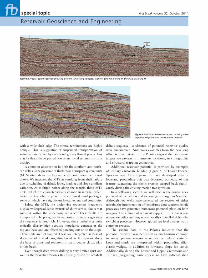
Figure 2 PreSTM seismic section showing Bottom Simulating Reflector (yellow) (shown in blue on the map in Figure 1).
Figure 3 PreSTM strike seismic section showing three depositional pulses and source prone intervals.
special topic
Reservoir Geoscience and Engineering
© 2014 EAGE www.firstbreak.org 69
first break volume 32, October 2014
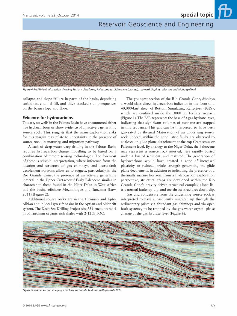
The youngest section of the Rio Grande Cone, displays a world-class direct hydrocarbon indicator in the form of a 40,000-km2 sheet of Bottom Simulating Reflectors (BSRs), which are confined inside the 3000 m Tertiary isopach (Figure 1). The BSR represents the base of a gas hydrate layer, indicating that significant volumes of methane are trapped in this sequence. This gas can be interpreted to have been generated by thermal Maturation of an underlying source rock. Indeed, within the cone listric faults are observed to coalesce on glide-plane detachment at the top Cretaceous or Paleocene level. By analogy to the Niger Delta, the Paleocene may represent a source rock interval, here rapidly buried under 4 km of sediment, and matured. The generation of hydrocarbons would have created a zone of increased plasticity or reduced brittle strength generating the glide plane decolement. In addition to indicating the presence of a thermally mature horizon, from a hydrocarbon exploration perspective, structural traps are developed within the Rio Grande Cone’s gravity-driven structural complex along lis-tric normal faults up-dip, and toe-thrust structures down-dip.
Gas and condensate from the underlying source rock is interpreted to have subsequently migrated up through the sedimentary prism via abundant gas chimneys and via open fault systems, to be trapped by the gas-water crystal phase change at the gas hydrate level (Figure 6).
collapse and slope failure in parts of the basin, depositing turbidites, channel fill, and thick stacked slump sequences on the basin slope and floor.
Evidence for hydrocarbonsTo date, no wells in the Pelotas Basin have encountered either live hydrocarbons or show evidence of an actively generating source rock. This suggests that the main exploration risks for this margin may relate to uncertainty in the presence of source rock, its maturity, and migration pathway.
A lack of deep-water deep drilling in the Pelotas Basin requires hydrocarbon charge modelling to be based on a combination of remote sensing technologies. The foremost of these is seismic interpretation, where inference from the location and structure of gas chimneys, and listric-fault decolement horizons allow us to suggest, particularly in the Rio Grande Cone, the presence of an actively generating interval in the Upper Cretaceous/ Early Paleocene similar in character to those found in the Niger Delta in West Africa and the basins offshore Mozambique and Tanzania (Law, 2011) (Figure 2).
Additional source rocks are in the Turonian and Apto-Albian and in local syn-rift basins in the Aptian and older rift system. The Deep Sea Drilling Project site 359 encountered 4 m of Turonian organic rich shales with 2-12% TOC.
Figure 4 PreSTM seismic section showing Tertiary clinoforms, Paleocene turbidite sand (orange), seaward dipping reflectors and Moho (yellow).
Figure 5 Seismic section imaging a Tertiary carbonate build-up with possible DHI.

special topic
Reservoir Geoscience and Engineering
www.firstbreak.org © 2014 EAGE70
first break volume 32, October 2014
Therefore, despite the abundant gas in the gas hydrate layer, there is evidence for large oil plays that is refocusing the attention of E&P companies in the Pelotas Basin.
The BSR may provide additional information about the heat flow and distribution of hydrocarbon generation in the region. The thickness of the gas hydrate layer can be related to the near-surface geothermal gradient, as increased temperature with depth destabilizes the clathrate molecule, generating the BSR. The thickness in depth, temperature of the seawater at sea bed, and stability of methane clathrates as a function of pressure are all that is required to calculate
Regional mapping of the distribution of the BSR shows a strong correlation with a thick isopach that defines the Rio Grande Cone depocenter. The lack of a demonstrable gas hydrate zone outside of the Rio Grande Cone suggests a causal relationship between the rapid deposition of the cone and generation of gas. Were this gas to be simply from a biogenic source, one might have expected to see the BSR extend over a wider area. Such speculation could perhaps be investigated by examination of isotopes of carbon within the gas hydrate accumulation.
There is also evidence for thermally matured hydrocar-bons in the Pelotas Basin, from the identification of oil seeps detected by Synthetic Aperture Radar and standard satellite optical imagery in the southern Pelotas Basin. These seeps appear to define a linear array, approximately coincident with the 500 and 800 m isobaths. It is hypothesized that oil, generated at depth below the Tertiary prism, is migrating up to the impermeable solid base of the gas hydrate, then migrating laterally up-dip and landward until it reaches the shallowest up-dip stabilization point of the gas hydrate layer.
There is good evidence for the presence of free hydro-carbon (either gas or liquid) trapped by stratigraphy or structure below the gas hydrate layer, creating a shallow gas or oil play within the Tertiary prism itself. Preliminary AVO analysis indicates large accumulations of free hydrocarbons are trapped in porous intervals below the solid hydrate layer (Figure 7). If the Paleocene source interval is matured to gen-erate gas, it is likely that underlying Turonian and/or Aptian sources (which may be more oil prone) are also mature.
Figure 6 A depth profile illustrating the interaction of the hydrate stability boundary with the cold ocean water temperatures and the heat from the earth for a hypothetical section in 1200 metres of water.
picture of low resolution quality,please provide new one
Figure 7 Seismic section showing enhanced gradient AVO anomalies in porous intervals trapping gas or liquids beneath the solid hydrate layer (Ross, 2014).
picture of low resolution quality,please provide new one
Figure 8 A velocity profile through the BSR layer in Cascadia, offshore British Columbia, showing the increase in velocity due to crystalline hydrates. Note the very low velocity beneath the BSR reflecting the concentration of gas and high porosity in that interval (Hyndman, 2002).
picture of low resolution quality,please provide new one

special topic
Reservoir Geoscience and Engineering
© 2014 EAGE www.firstbreak.org 71
first break volume 32, October 2014
the Upper Cretaceous / Paleocene sequence. At a depth of 4 km this has therefore reached 120°C, generating liquid and hydrocarbons.
Conjugate petroleum systemThe conjugate margin rift basins of West Africa and Brazil initially formed by east-west extension initiated during the early Cretaceous as the South American plate began to separate and rotate clockwise from Africa.
When the margins are reconstructed to their respective positions in the Albian it is informative to compare the respective margins for differences and similarities (Figure 10). A reconstruction with today’s sediment thickness, joined where they may have been 125 Ma, shows the asymmetry from the Pelotas Basin to the conjugate Luderitz Basin of
the geothermal gradient (Shankar et al., 2010). Analysis of the thickness of the gas hydrate layer in the Rio Grande Cone suggests a geothermal gradient to the base of the hydrate is 37 to 41 °C (Figure 9). Below this we modify the extrapolated gradient to allow for kinetic factors that result in a reduction in geothermal gradient to between 30 °C at 5000 m SS. This is consistent with the available, albeit limited, well data on the margin that suggests the geothermal gradient is close to 27 to 30 °C.
This suggests that the observation of a BSR can be used to confirm geothermal gradients in either undrilled basins, or to corroborate the regional distribution of geothermal gradients. The utility within the Rio Grande Cone, away from well data, is to suggest that a geothermal gradient of 30°C is an appropriate assumption to model the maturity of
Figure 9 A plate tectonic reconstruction from GPlates at 120.4 Ma illustrating the spatial relation-ship between the Pelotas and Namibe Basin and the total sedimentary accumulation.
Figure 10 Comparison of the Pelotas Basin with equivalently aged Namibe Basin. The Pelotas Basin has a stratigraphic section that is more than twice as thick.

special topic
Reservoir Geoscience and Engineering
www.firstbreak.org © 2014 EAGE72
first break volume 32, October 2014
ReferencesPintas, E. M. [2011] Análise de atributos AVO e Física de Rochas aplicados
na identificação e
caracterização de Hidratos de Gás na Bacia de Pelotas. Universidade
Federal Fluminense, Bachelors Thesis.
Abreu, V. [1998] Geologic evolution of conjugate volcanic passive margins:
Pelotas Basin (Brazil) and offshore Namibia (Africa). Implication for
global sea level changes. PhD Dissertation, Rice University.
Contreras, J., Zühlke, R., Bowman, S., Bechstädt, T. [2010] Seismic
stratigraphy and subsidence analysis of the southern Brazilian margin
(Campos, Santos and Pelotas Basins). Marine and Petroleum Geology,
27, 1952–1980.
Hyndman, R. [2002] Gas Hydrates on the Northern Cascadia Margin.
Methane gas Interagency R&D Conference.
Law, C. [2011] Northern Mozambique: True ‘Wildcat’ Exploration in East
Africa. Houston Geological Society Bulletin, 51 (9), 25–27.
Shankar, U., Riedel, M. and Sathe, A.V. [2010] Geothermal modelling
of the gas hydrate stability zone along the Krishna Godavari Basin.
Marine Geophysical Research, 31, 17–28.
Seton, M, Müller, R.D., Zahirovic, S., Gaina, C., Torsvik, T., Shephard, G.,
Talsma, A., Gurnis, M., Turner, M., Maus, S. and Chandler, M. [2012]
Global continental and ocean basin reconstructions since 200 Ma.
Earth-Science Reviews, 113 (3-4), 212–270.
Marcelle-De Silva, J., Dawe, R. [2011] Towards Commercial gas produc-
tion from hydrate deposits. Energies, 4, 215–238.
Namibia (Figure 11). This may have been influenced by asymmetries in the original rift geometry. However, such subtlety is masked by the dominating difference in the volume of sediment supplied post drift into each basin. Both the Pelotas and Namibian Basins are underlain by thickened high-density volcanic crust with an abundance of seaward dipping reflectors. Basin subsidence is controlled both by long-term post-rift thermal cooling and differential sediment loading.
However, it is possible to correlate an Aptian sequence from Namibia to Pelotas. In mini-basins directly above the break-up unconformity, planar-bedded high amplitude Aptian marine shales are correlated with units in the Namibe conjugate basin. In Namibia these shales are the primary oil source for the light oil recovered from the Wingat-1 well. Additional source intervals on the Namibian margin includes the syn-rift Early Cretaceous lacustrine shale that provides the main source for the Kudu gas condensate field in the Orange River Basin, and the Turonian source that has been encountered in many wells, though is rarely considered buried deep enough to be mature. In the Pelotas Basin all these candidate source rock intervals are present, in addition to Paleocene marine shales, and the increased sediment sup-ply has buried all of these source rocks such that they will generate both oil and gas.
As discussed above, in the Pelotas Basin, the Tertiary wedge prograding over the Paleocene source rock triggered a glide-plane detachment within the source rock. The Orange River Basin in Namibia exhibits a similar, though due to the reduced sediment cover, older feature with detachments on both the Aptian and Turonian source rock intervals.
In common with its conjugate basin in Namibia, early exploration in the Pelotas Basin has been concentrated on shallow water plays on the shelf. Source rock presence and maturity has been a concern to explorers in both basins. Recent wells in Namibia have proven the effectiveness of an Aptian source which has been identified on seismic in the Pelotas. The potential advantage of the Pelotas Basin is that higher sediment supply, has pushed not on the Aptian source into the generative window, but also the Turonian and in places (i.e. the Rio Grande Cone) the Paleocene intervals.
ConclusionsDetailed seismic investigation of the Pelotas Basin is throw-ing new light on the depositional system, identifying the distribution and potential trapping style of numerous exten-sive clastic reservoirs. This, combined with the evidence of hydrocarbons observed from seismic character, structural analysis, hydrateology, seeps and conjugate margin studies indicates that this basin has been not only one of the most underexplored sediment packages on earth, but potentially one of the most attractive.
CC01317-MA015 CSoM.indd 1 04-09-14 09:14