The NORCOWE legacy data and instrumentation
33
uib.no U N I V E R S I T Y O F B E R G E N The NORCOWE legacy - data and instrumentation J. Reuder 1 , M. Flügge 1,2 , M. Bakhoday Pakyabi 1,3 , B. Svardal 2 1 Geophysical Institute, University of Bergen 2 Christian Michelsen Research 3 Nansen Environmental and Remote Sensing Centre Geophysical Institute
Transcript of The NORCOWE legacy data and instrumentation

uib.no
U N I V E R S I T Y O F B E R G E N
The NORCOWE legacy-
data and instrumentation
J. Reuder1, M. Flügge1,2, M. Bakhoday Pakyabi1,3, B. Svardal21Geophysical Institute, University of Bergen
2Christian Michelsen Research3Nansen Environmental and Remote Sensing Centre
Geophysical Institute

uib.no
Overview
• The OBLO infrastructure• Why do we need it?• Overview NORCOWE campaigns• Some selected results• What can we do in the future?
Geophysical Institute

uib.no
OBLO (Offshore Boundary Layer Observatory)
• Advanced mobile equipment for offshore wind relatedmeasurements in the atmospheric and oceanic boundarylayer
• National Norwegian infrastructure project (2010-2020)• Funded by the Norwegian Research Council with ca. 4 M€• Instrumentation owned by the Geophysical Institute,
University of Bergen• Operated in close collaboration with Christian Michelsen
Research, Bergen, Norway• For more info: http://oblo.uib.no/
Geophysical Institute

uib.no
oblo.uib.noGeophysical Institute

uib.no
OBLO instrumentation
Geophysical Institute
Interest in future collaboration?Contact: [email protected]

uib.no
MotivationGeophysical Institute
Source: http://www.ieawind.org/GWEC_PDF/GWEC%20Annex23.pdf
Of interest atmosphere: Average wind speed Wind shear over the rotor
disk Turbulence intensity
Of interest ocean: Average current Wave conditions
(slamming, breaking) Turbulence intensity
The main problem:Massive lack of observational data offshore

uib.no
Turbine atmosphere interaction - wakesGeophysical Institute
Source: http://galathea3.emu.dk/satelliteeye/projekter/wind/back_uk.html
Source:http://www.ict-aeolus.eu/about.html; Photo by Christian Steiness

uib.no
Interaction foundation-ocean-seabed - scourGeophysical Institute
Source: https://blogs.scientificamerican.com/but-not-simpler/scour-why-most-bridges-fail/

uib.no
Overview NORCOWE campaigns• Buoy deployment Sletringen (Nov 2010-Oct. 2011)• Lidar motion test at UiA, Grimstad (August 2011)• Lidar MEasurement Campaign at Sola airport (LIMECS;
March – August 2013)• WINd Turbine Wake Experiment Wieringermeer
(WINTWEX-W; November 2013 – May 2014)• Multi-Lidar measurement campaign at Lysefjorden
Bridge (May 2014)• Marstein field cruise (November 2013)• Karmøy field cruise (November 2014)• Offshore Boundary-Layer Experiment at Fino 1 (OBLEX-
F1; May 2015 – September 2016)
Geophysical Institute

uib.no
Buoy deployment SletringenGeophysical Institute
• Nov.2010- Oct. 2011 • Nearly one year of data for the
detailed characterization of the near coast conditions over the whole water column of 277 m depth
• Temperature, salinity, density, current, turbulence

uib.no
Lidar motion test GrimstadGeophysical Institute
WindCube V1 (CW)
ZephIR300 (pulsed)
Bosch Rexroth Boxtel 6-DOF E-motion 1500 Motion
System
Measurement test of two
moving LiDAR systems
versus their «grounded» counterparts.
Identify a suitable
commercial LiDAR system
for use on floating
platforms.

uib.no
Lidar motion test GrimstadGeophysical Institute

uib.no
WINTWEX-WGeophysical Institute
o 5 Nordex research turbines
80 m hub & rotor diameter (D)
x 6 upstream met masts
lidar profiler upstream at 3.2 Dlidar profiler downstream at 1.7 Dlidar profiler downstream at 3.4 Dscan. lidar downstream at 12.2D
ECN test site Wieringermeer, November 2013-May 2014

uib.no
WINTWEX-WGeophysical Institute

uib.no
WINTWEX-WGeophysical Institute
Surge Heave & Pitch of floater Surge Heave & Pitch of floater

uib.no
WINTWEX-WGeophysical Institute
Geofysisk Institutt
wind speed turbulence intensity
instantaneous
10 min avg.

uib.no
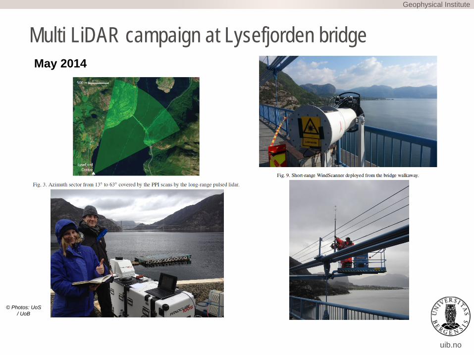
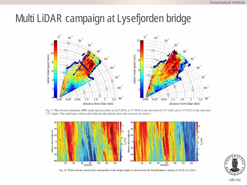
Multi LiDAR campaign at Lysefjorden bridgeGeophysical Institute
• Project managed by UoS and Norwegian Public Road Administration
• Investigate the wind field and associated turbulence structure along long bridge spans. Stimulate new LiDAR based measurement setups and corresponding data interpretation strategies.
• 5 x sonic anemometers mounted at the bridge• 1 x 3D scanning LiDAR (100s)• 2 synchronized continuous-wave short-range • WindScanner LiDAR’s (developed by DTU)
uib.no
Multi LiDAR campaign at Lysefjorden bridgeGeophysical Institute
May 2014
© Photos: UoS / UoB
uib.no
Multi LiDAR campaign at Lysefjorden bridgeGeophysical Institute

uib.no
Marstein and Karmøy cruisesGeophysical Institute

uib.no
Marstein and Karmøy cruisesGeophysical Institute

uib.no
Instrument and method developmentGeophysical Institute

uib.no
Instrument and method developmentGeophysical Institute
Applications: Whitecaps coverage
and air-sea interaction wave breaking Upper ocean
turbulence Surface gravity waves attitude monitoring and
motion correction

uib.no
U N I V E R S I T Y O F B E R G E N
OBLEX-F1: The Offshore Boundary Layer EXperiment at FINO-1
-Experimental setup and first results
J. Reuder1, M. Flügge1, S. Kral1, M. Bakhoday Pakyabi1, B. Svardal2, R. Frühmann3, E. Cheynet4, J. Bugonovic Jacobsen4, J. Bachmann5, B. Witha6, D. Wagner6, A. Fligg6, A. Külpmann6, J. Gottschall7, O. Outzen8, B. Gellately9, J. Shah9, B. Furevik10 , R.
Krishnamurthy11 , H. J. S. Fernando111Geophysical Institute, University of Bergen;
2Christian Michelsen Research; 3UL DEWI; 4University of Stavanger; 5FuE Kiel GmbH; 6University of Oldenburg; 7Fraunhofer Institute for Wind Energy and Energy System Technology IWES Northwest; 8BSH; 9AXYS Technologies
Inc.; 10Norwegian Meteorological Institute; 11University of Notre-Dame;
Geophysical Institute

uib.no
Location: FINO1 and Alpha VentusGeophysical Institute
Trianel
Borkum-Riffgrund 1
Alpha Ventus
Sour
ce: h
ttp://
ww
w.4
coffs
hore
.com
/offs
hore
win
d/
Sour
ce: h
ttps:
//com
mon
s.w
ikim
edia
.org
/wik
i/File
:Win
dpar
k_al
pha_
vent
us_L
agek
arte
.png
FINO1
FINO1, German Bight, May 2015 – September 2016 (atmospheric part); May 2015 – October 2015 (oceanic part)
uib.no
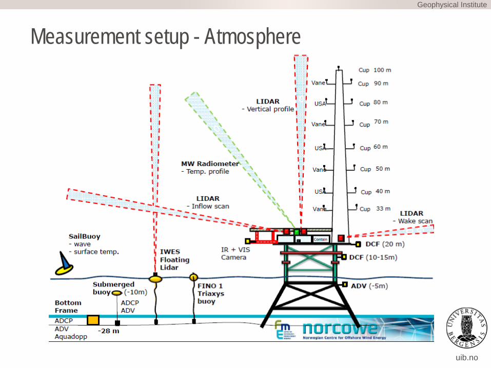
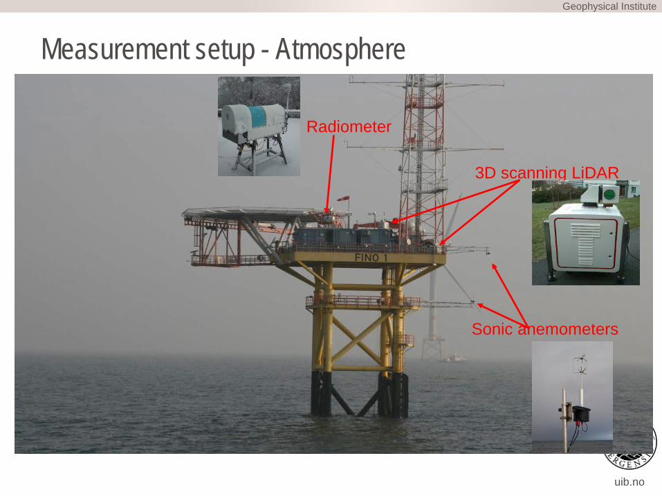
Measurement setup - AtmosphereGeophysical Institute
uib.no
Measurement setup - AtmosphereGeophysical Institute
3D scanning LiDAR
Radiometer
Sonic anemometers

uib.no
Measurement setup - OceanGeophysical Institute
BoUIB/OBLO
Bottom frame - ADCP, Aquadopp, ADV
IWES 2x LIDAR buoys
CMR Sailbuoy
Wave sensor, temperature
UIB/OBLOBottom frame
- ADCP, Aquadopp, ADV
UIB/OBLO MATS Submerged buoy
- Microrider shear probes, Aquadopp
UIB/OBLO Submerged buoy
- ADCP
UIB/OBLO Submerged buoy
- Current meter
BSH Wave buoy
Accelerometers,compass
AxysWindSentinelLIDAR buoy

uib.no
OBLEX-F1 research topics and questions• Stability dependency of offshore wind profiles• Characterization of turbulence (e.g. coherence)• Air-sea interaction and wave effects on wind profiles and
turbulence• Structure and dynamics of wind turbine wakes under
various stability conditions• Effects of adjacent wind farms on wind profiles and
turbulence characteristics• Comparison of instruments and measurement methods
• Oceanic turbulence in different wave regimes• Potential effects of a wind farm on current and
turbulence characteristics
Geophysical Institute

uib.no
Oceanic deploymentsGeophysical Institute

uib.no
Oceanic recoveryGeophysical Institute
Rapid biofouling at water temperatures> 18 ºC

Geophysical Institute


![Business Rule Inclusion and Legacy Modernization through ...binary instrumentation).We choose in this paper dynamic binary instrumentation [9, 10, 11] for obvious reason because they](https://static.fdocuments.in/doc/165x107/5e7936e5b1935918780cbb25/business-rule-inclusion-and-legacy-modernization-through-binary-instrumentationwe.jpg)