The Neogene Depositional History of Lemau and Bintunan...
6
PROCEEDINGS JOINT CONVENTION MALANG 2017, HAGI – IAGI – IAFMI- IATMI (JCM 2017) Ijen Suites Hotel, Malang, September 25 – 28, 2017 The Neogene Depositional History of Lemau and Bintunan Formations in Bengkulu Basin Hazred Umar Fathan 1* , Santa Marchilya Tarigan 1 , Edy Sutriyono 2 , Arthur Tarigan 1 1 Geological Engineering, Sriwijaya University, 2 Lecturer Geological Engineering, Sriwijaya University, 3 PT Firman Ketaun *Corresponding Author: [email protected] Abstract The Neogene sedimentation within the North Bengkulu is the northern part of Bengkulu Basin was occurred transgressive towards regressive phase during Neogene graben system. Sedimentation ended on Plio-Pleistocene increased volcanic activity extend Bukit Barisan Orogeny and influenced by pyroclastic materials. The research area is located in North Bengkulu, Bengkulu Province. The methods are combines laboratory analysis and field observation such as geological mapping, measured section, paleontology, petrography, and make a depositional model to determine depositional environment and correlation between Lemau and Bintunan Formations. The result shown sedimentation of Lemau Formation lies between back barrier–shallow marine system with facies i.e. tidal flat, foreshore, shoreface, lagoon and swamp-marsh with coarsening upwards and locally fining upwards pattern influenced by tide and wave dominated and generated by transgressive owing to shoreface retreat during sea level rise. Paleontology analysis had abundant benthic foraminifera in coastal plain-shallow marine fauna. Bintunan Formation shown fluvial deposits within polymict conglomerate, tuffaceous claystone with fine–medium clastic sediment in grain size and occurrence elongated channel and floodplain with fining upward succession. Lemau and Bintunan Formations have unconformity contact by erosional surface and approximate hiatus during Late Miocene-Pliocene sedimentation on the research area. Lemau Formation mostly has major sand bodies and silty with coal intercalation. The study of depositional in the research area can easily to understanding of subsurface analysis in North Bengkulu and will be useful to implication geological resources. Keywords: facies, bintunan, lemau, shallow marine. Introduction Bengkulu basin is the Tertiary fore-arc basin that located in the southern part of the Sumatra and covered both offshore and onshore. The trending of Bengkulu Basin is NE-SW parallel to Sumatra and bounded by Barisan Mountain to the northeast and Mentawai Ridge to the southwest. The Middle to Late Miocene was expressed the rejuvenation of pre-existing tensional fault (second transtensional) and forming Ipuh Graben (Figure 1) in the northwest. In this time, the regressive sequence of shallow marine to lagoonal was deposited with sand intercalated muds, coal and limestone called Lemau Formation (Yulihanto et. al, 1995). The research area is located in North Bengkulu, Bengkulu Basin (Figure 2) covered Paleogene and Neogene depositional systems. Figure 1. Structural configuration of Paleogene – Eocene graben system which formed Bengkulu Basin (Yulihanto et al.,1996) Figure 2. Index map location in the research area. The Paleogene depositional consist of Hulusimpang and Seblat Formations. Neogene depositional consist of Lemau, Simpangaur and Bintunan Formations. Lemau Formation is similiar in age to Air Benakat, Muara Enim and Parigi
Transcript of The Neogene Depositional History of Lemau and Bintunan...

PROCEEDINGS
JOINT CONVENTION MALANG 2017, HAGI – IAGI – IAFMI- IATMI (JCM 2017)
Ijen Suites Hotel, Malang, September 25 – 28, 2017
The Neogene Depositional History of Lemau and Bintunan Formations in Bengkulu Basin Hazred Umar Fathan1*, Santa Marchilya Tarigan1, Edy Sutriyono2, Arthur Tarigan1 1 Geological Engineering, Sriwijaya University, 2 Lecturer Geological Engineering, Sriwijaya University, 3 PT
Firman Ketaun
*Corresponding Author: [email protected]
Abstract
The Neogene sedimentation within the North Bengkulu is
the northern part of Bengkulu Basin was occurred
transgressive towards regressive phase during Neogene
graben system. Sedimentation ended on Plio-Pleistocene increased volcanic activity extend Bukit Barisan Orogeny
and influenced by pyroclastic materials. The research area
is located in North Bengkulu, Bengkulu Province. The
methods are combines laboratory analysis and field observation such as geological mapping, measured section,
paleontology, petrography, and make a depositional model
to determine depositional environment and correlation
between Lemau and Bintunan Formations. The result shown sedimentation of Lemau Formation lies between
back barrier–shallow marine system with facies i.e. tidal
flat, foreshore, shoreface, lagoon and swamp-marsh with
coarsening upwards and locally fining upwards pattern influenced by tide and wave dominated and generated by
transgressive owing to shoreface retreat during sea level
rise. Paleontology analysis had abundant benthic
foraminifera in coastal plain-shallow marine fauna. Bintunan Formation shown fluvial deposits within polymict
conglomerate, tuffaceous claystone with fine–medium
clastic sediment in grain size and occurrence elongated
channel and floodplain with fining upward succession. Lemau and Bintunan Formations have unconformity
contact by erosional surface and approximate hiatus during
Late Miocene-Pliocene sedimentation on the research area.
Lemau Formation mostly has major sand bodies and silty
with coal intercalation. The study of depositional in the
research area can easily to understanding of subsurface
analysis in North Bengkulu and will be useful to
implication geological resources. Keywords: facies, bintunan, lemau, shallow marine.
Introduction
Bengkulu basin is the Tertiary fore-arc basin that located in
the southern part of the Sumatra and covered both offshore
and onshore. The trending of Bengkulu Basin is NE-SW
parallel to Sumatra and bounded by Barisan Mountain to the northeast and Mentawai Ridge to the southwest. The
Middle to Late Miocene was expressed the rejuvenation of
pre-existing tensional fault (second transtensional) and forming Ipuh Graben (Figure 1) in the northwest. In this
time, the regressive sequence of shallow marine to lagoonal
was deposited with sand intercalated muds, coal and
limestone called Lemau Formation (Yulihanto et. al, 1995). The research area is located in North Bengkulu, Bengkulu
Basin (Figure 2) covered Paleogene and Neogene
depositional systems.
Figure 1. Structural configuration of Paleogene – Eocene
graben system which formed Bengkulu Basin (Yulihanto et al.,1996)
Figure 2. Index map location in the research area.
The Paleogene depositional consist of Hulusimpang and Seblat Formations. Neogene depositional consist of Lemau,
Simpangaur and Bintunan Formations. Lemau Formation is
similiar in age to Air Benakat, Muara Enim and Parigi
PROCEEDINGS
JOINT CONVENTION MALANG 2017, HAGI – IAGI – IAFMI- IATMI (JCM 2017)
Ijen Suites Hotel, Malang, September 25 – 28, 2017
Equivalent Formations on the offshore area. Lemau Formation was the coal-bearing formation in the Bengkulu
Province. From south to the north, some mining company
was produced the coal. Lemau Formation was a good
source rocks for hydrocarbon potential that are immature to early mature (Panggabean and Heryanto, 2009). The
depositional in the research area ended with Bintunan
Formation that shown fluvial deposits and filled by
Pleistocene volcanic. The objective of this paper are to identify facies and depositional environment of Lemau and
Bintunan Formations based on sedimentary structure,
mineral and lithology association, biogenic structure and
fossil content. Facies and depositional study is one of the important things in exploration or exploitation project and
its implication for geological resource in North Bengkulu
such as coal and oil gas.
Methods
The purpose of the research area is to determine facies and
sequence stratigraphy in North Bengkulu. The methods in
this research are based on field observation and laboratory
analysis (paleontology and petrography). Field observation consists of geological mapping, lithology description (grain
size, sediment structure, organic material and trace fossils)
to classify the facies association and measured section in
several outcrops in Tanjungdalam, Pondokbakil, Air Lelangi and Gunung Payung Sub-district as mining area
(Table 1).
Table 1. Coordinate Location of Measured Section
No Location Y Z Thickness
1 Tanjungdalam 808619 9648234 78 m
2 Airlelangi 813544 9643650 15.1 m
3 Pondokbakil 816559 9641206 26,2 m
4 Gunung Payung 819432 9637920 33,4 m
Result and Discussion
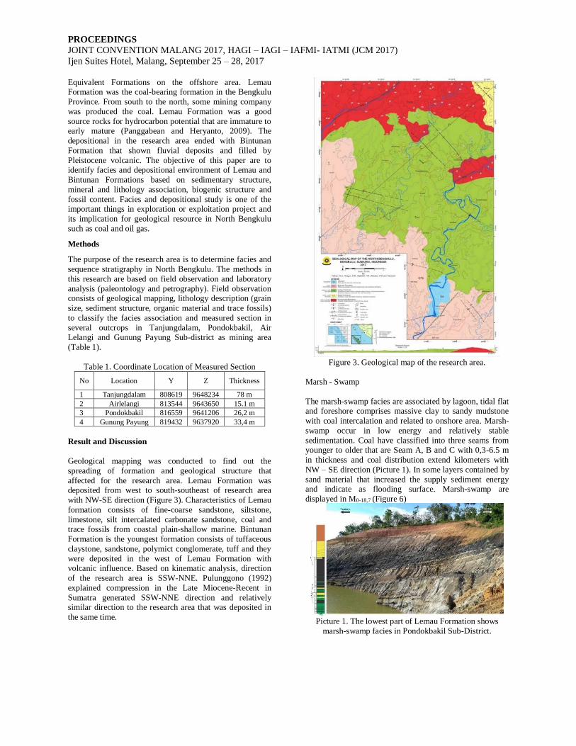
Geological mapping was conducted to find out the
spreading of formation and geological structure that
affected for the research area. Lemau Formation was deposited from west to south-southeast of research area
with NW-SE direction (Figure 3). Characteristics of Lemau
formation consists of fine-coarse sandstone, siltstone,
limestone, silt intercalated carbonate sandstone, coal and trace fossils from coastal plain-shallow marine. Bintunan
Formation is the youngest formation consists of tuffaceous
claystone, sandstone, polymict conglomerate, tuff and they
were deposited in the west of Lemau Formation with volcanic influence. Based on kinematic analysis, direction
of the research area is SSW-NNE. Pulunggono (1992)
explained compression in the Late Miocene-Recent in
Sumatra generated SSW-NNE direction and relatively similar direction to the research area that was deposited in
the same time.
Figure 3. Geological map of the research area.
Marsh - Swamp
The marsh-swamp facies are associated by lagoon, tidal flat and foreshore comprises massive clay to sandy mudstone
with coal intercalation and related to onshore area. Marsh-
swamp occur in low energy and relatively stable
sedimentation. Coal have classified into three seams from younger to older that are Seam A, B and C with 0,3-6.5 m
in thickness and coal distribution extend kilometers with
NW – SE direction (Picture 1). In some layers contained by
sand material that increased the supply sediment energy and indicate as flooding surface. Marsh-swamp are
displayed in M0-18,7 (Figure 6)
Picture 1. The lowest part of Lemau Formation shows
marsh-swamp facies in Pondokbakil Sub-District.

PROCEEDINGS
JOINT CONVENTION MALANG 2017, HAGI – IAGI – IAFMI- IATMI (JCM 2017)
Ijen Suites Hotel, Malang, September 25 – 28, 2017
Foreshore
The foreshore facies spread evenly and associated with
marsh/swamp facies, lagoon and tidal flat up to 8,2 m in thickness (Picture 2). Foreshore characterized by fine and
medium sand and shown sedimentary stucture such as
dominated cross stratification, lamination, and
herringbones. Two directional depostion indicated the barrier zones that separated shallow marine zones and back
barrier land. Lenses carbon, intercalated coarse sand and
siderite bands were found in this facies. Root plain was
found in several outcrops. Foreshore facies are displayed in
M18,7-25 and M57,9-65 (Figure 6).
Picture 2. Upper part Lemau Formation shows foreshore
facies and overlain with channel deposits at Tanjungdalam
Sub-District.
Lagoon
Lagoon facies associated by swamp/marsh and shorface facies and characterized by coarsening upward pattern and
multiple medium-coarse sandstone, dominantly silt up to
7,7 m in thickness (Picture 3). Medium-coarse sand are
found as intercalated cause of the high supply energy from a bay between barrier. The bentonic shows Nonion
depressulum, Nonion of asterizons in neritic environment.
Sedimentary structure that found are wavy lamination and
lamination contact with coal with minor bioturbation (Picture 4). Lagoon deposited in the stable energy with
storm and tide current influence and formed the interbed
coarse detritus sediment. Lagoon facies are displayed in
M25-32,5 (Figure 6).
Picture 3. Lower part of Lemau Formation shows lagoon and shoreface facies at Tanjungdalam Sub-District.
Picture 4. (a) Siltstone lamination contact with coal. (b)
siltstone and sandstone intercalation with minor
bioturbation.
Shoreface
The shoreface facies that extends in the research area was
deposited during N12 - N14. Shoreface divided into 2
facies which are lower and middle shoreface. Lower shoreface is characterized by fine-medium sandstone,
crossbed, wavy, laminae, and the prensent of bioturbation
is abundant in the lower part but decreasing to the upper
part (Picture 5a). The increasing of energy rate affected to
the existance of bioturbation present. Skolithos was found
and identified as medium to high enegy in the intertidal
enviroment (Picture 5b). Shoreface are displayed in M32,5 –
M43 (Figure 6).
Picture 5. The Shoreface Facies (a) Sandstone with
lamination structure and skolithos in vertical and horizontal
(b) Sandstone with lamination structure and verticaly
skolithos with calcareous sandstone as a nodul
In several outcrops were found calcareous sandstone as a
nodule and spread continiously. This is constrained by ben
tonic evidence such as Streblus beccari, Elphidium
craticulatum, Nanionella bradii and Astrononion stelligerun that present in neritic enviroment. Middle
shoreface is characterized by siltstone, shell fossil
abundant, laminae, relatively deep and associated with
offshore transition (Picture 6).
a
..
.
b
..
.
a
..
.
b
..
.
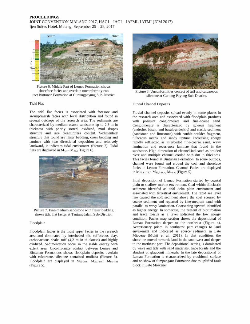
PROCEEDINGS
JOINT CONVENTION MALANG 2017, HAGI – IAGI – IAFMI- IATMI (JCM 2017)
Ijen Suites Hotel, Malang, September 25 – 28, 2017
Picture 6. Middle Part of Lemau Formation shows
shoreface facies and overlain unconformity con
tact Bintunan Formation at Gunungpayung Sub-District
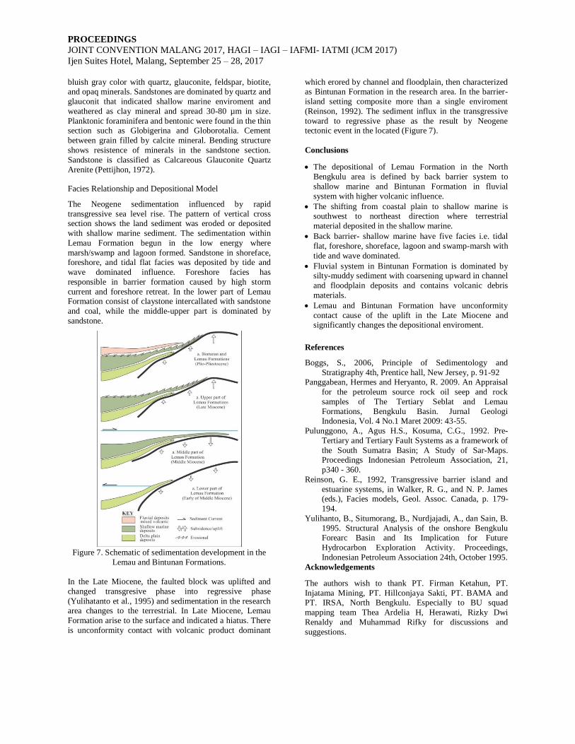
Tidal Flat
The tidal flat facies is associated with foresore and swamp/marsh facies with local distribution and found in
several outcrops of the research area. The sediments are
characterized by medium-coarse sandstone up to 2,3 m in
thickness with poorly sorted, oxidized, mud dropes structure and rare foraminifera content. Sedimentary
structure that found are flaser bedding, cross bedding and
laminae with two directional deposition and relatively
landward, it indicates tidal enviroment (Picture 7). Tidal
flats are displayed in M43 – M45,5 (Figure 6).
Picture 7. Fine-medium sandstone with flaser bedding shows tidal flat facies at Tanjungdalam Sub-District.
Floodplain
Floodplain facies is the most upper facies in the research
area and dominated by interbeded silt, tuffaceous clay,
carbonaceous shale, tuff (4,2 m in thickness) and highly
oxidized. Sedimentation occur in the stable energy with extent area. Unconformity contact between Lemau and
Bintunan Formations shows floodplain deposits overlain
with calcareous siltstone contained molluca (Picture 8).
Floodplain are displayed in M65-70,6, M75,7-80,7, M86,4-88
(Figure 5).
Picture 8. Unconformities contact of tuff and calcareous
siltstone at Gunung Payung Sub-District.
Fluvial Channel Deposits
Fluvial channel deposits spread evenly in some places in
the research area and associated with floodplain products with polimict conglomerate and fine-coarse sand.
Conglomerate is characterized by igneous fragment
(andesite, basalt, and basalt-andesitic) and clastic sediment
(sandstone and limestone) with couble-boulder fragment, tufaceous matrix and sandy texture. Increasing energy
rapidly refflected as interbeded fine-coarse sand, wavy
lamination and recurrence laminae that found in the
sandstone. High dimension of channel indicated as braided river and multiple channel eroded with 8m in thickness.
This facies found at Bintunan Formation. In some outrops,
channel were found and eroded the coal and shoreface
facies in Lemau Formation. Channel Facies are displayed in M70,4 – 75,7, M80,7-86,4, M88-90 (Figure 5).
Intial deposition of Lemau Formation started by coastal
plain to shallow marine enviroment. Coal within siliclastic sediment identifed as tidal delta plain enviroment and
associated with terrestrial enviroment. The rapid sea level
rise caused the soft sediment above the coal scoured by
coarse sediment and replaced by fine-medium sand with parallel to wavy lamination. Coarsening upward identified
as higher energy. In somecase, the present of bioturbation
and trace fossils as a layer indicated the low energy
condition. Facies map section shows the depositional of Lemau Formation deeper to the northeast (Figure 4).
Accretionary prism in southwest part changes to land
enviroment and indicated as source sediment in Late
Miocene (Mukti et al., 2011). In that condition, the
shoreline moved towards land in the southwest and deeper
to the northeast part. The depositional setting is dominated
by wave and tide with sand materials, trace fossils and the abudant of glauconit minerals. In the late depositional of
Lemau Formation is characterized by erositional surface
and no show of Simpangaur Formation due to uplifted fault
block in Late Miocene.

PROCEEDINGS
JOINT CONVENTION MALANG 2017, HAGI – IAGI – IAFMI- IATMI (JCM 2017)
Ijen Suites Hotel, Malang, September 25 – 28, 2017
Figure 4. Facies map reconstruction of North Bengkulu
during Late Miocene in Lemau Formation showing environmental setting.
Figure 5. General stratigraphy column of Bintunan
Formation
Figure 6. General stratigraphy column of Lemau
Formation.
Petrography Analysis
Samples were collected for mineral identification.
Petrographical analysis of sandstone thin section reveals
PROCEEDINGS
JOINT CONVENTION MALANG 2017, HAGI – IAGI – IAFMI- IATMI (JCM 2017)
Ijen Suites Hotel, Malang, September 25 – 28, 2017
bluish gray color with quartz, glauconite, feldspar, biotite, and opaq minerals. Sandstones are dominated by quartz and
glauconit that indicated shallow marine enviroment and
weathered as clay mineral and spread 30-80 µm in size.
Planktonic foraminifera and bentonic were found in the thin section such as Globigerina and Globorotalia. Cement
between grain filled by calcite mineral. Bending structure
shows resistence of minerals in the sandstone section.
Sandstone is classified as Calcareous Glauconite Quartz
Arenite (Pettijhon, 1972).
Facies Relationship and Depositional Model
The Neogene sedimentation influenced by rapid
transgressive sea level rise. The pattern of vertical cross section shows the land sediment was eroded or deposited
with shallow marine sediment. The sedimentation within
Lemau Formation begun in the low energy where
marsh/swamp and lagoon formed. Sandstone in shoreface, foreshore, and tidal flat facies was deposited by tide and
wave dominated influence. Foreshore facies has
responsible in barrier formation caused by high storm
current and foreshore retreat. In the lower part of Lemau Formation consist of claystone intercallated with sandstone
and coal, while the middle-upper part is dominated by
sandstone.
Figure 7. Schematic of sedimentation development in the
Lemau and Bintunan Formations.
In the Late Miocene, the faulted block was uplifted and
changed transgresive phase into regressive phase
(Yulihatanto et al., 1995) and sedimentation in the research area changes to the terrestrial. In Late Miocene, Lemau
Formation arise to the surface and indicated a hiatus. There
is unconformity contact with volcanic product dominant
which erored by channel and floodplain, then characterized as Bintunan Formation in the research area. In the barrier-
island setting composite more than a single enviroment
(Reinson, 1992). The sediment influx in the transgressive
toward to regressive phase as the result by Neogene tectonic event in the located (Figure 7).
Conclusions
• The depositional of Lemau Formation in the North
Bengkulu area is defined by back barrier system to
shallow marine and Bintunan Formation in fluvial
system with higher volcanic influence.
• The shifting from coastal plain to shallow marine is southwest to northeast direction where terrestrial
material deposited in the shallow marine.
• Back barrier- shallow marine have five facies i.e. tidal
flat, foreshore, shoreface, lagoon and swamp-marsh with
tide and wave dominated.
• Fluvial system in Bintunan Formation is dominated by silty-muddy sediment with coarsening upward in channel
and floodplain deposits and contains volcanic debris
materials.
• Lemau and Bintunan Formation have unconformity
contact cause of the uplift in the Late Miocene and significantly changes the depositional enviroment.
References
Boggs, S., 2006, Principle of Sedimentology and
Stratigraphy 4th, Prentice hall, New Jersey, p. 91-92
Panggabean, Hermes and Heryanto, R. 2009. An Appraisal
for the petroleum source rock oil seep and rock
samples of The Tertiary Seblat and Lemau
Formations, Bengkulu Basin. Jurnal Geologi Indonesia, Vol. 4 No.1 Maret 2009: 43-55.
Pulunggono, A., Agus H.S., Kosuma, C.G., 1992. Pre-
Tertiary and Tertiary Fault Systems as a framework of
the South Sumatra Basin; A Study of Sar-Maps. Proceedings Indonesian Petroleum Association, 21,
p340 - 360.
Reinson, G. E., 1992, Transgressive barrier island and
estuarine systems, in Walker, R. G., and N. P. James (eds.), Facies models, Geol. Assoc. Canada, p. 179-
194.
Yulihanto, B., Situmorang, B., Nurdjajadi, A., dan Sain, B.
1995. Structural Analysis of the onshore Bengkulu Forearc Basin and Its Implication for Future
Hydrocarbon Exploration Activity. Proceedings,
Indonesian Petroleum Association 24th, October 1995.
Acknowledgements
The authors wish to thank PT. Firman Ketahun, PT.
Injatama Mining, PT. Hillconjaya Sakti, PT. BAMA and PT. IRSA, North Bengkulu. Especially to BU squad
mapping team Thea Ardelia H, Herawati, Rizky Dwi
Renaldy and Muhammad Rifky for discussions and
suggestions.