THE NATURAL mSTORY OF SOUTHERN HAITI
221
THE NATURAL mSTORY OF SOUTHERN HAITI by Charles A. Woods and Jose Alberto Ottenwalder Department ofNatural Sciences Florida Museum of Natural History University of Florida Gainesville, Florida 1992
Transcript of THE NATURAL mSTORY OF SOUTHERN HAITI

THE NATURAL mSTORY OFSOUTHERN HAITI
byCharles A. Woods
andJose Alberto Ottenwalder
Department of Natural SciencesFlorida Museum of Natural History
University of FloridaGainesville, Florida
1992
jharold
Rectangle

Reserve de10 Biosphere
MACA~
© 1992. Florida Museumof Natural History
Prepared for USAIDlHaiti under contract number521"()191-A-OO-7107
This volume is printed on Recycled Papcr
jharold
Rectangle

MorneLa Visite
ISLANDOF
HISPANIOLA0L,..............--'-..::~~O...............--'-'"""19;:,,:O;,.,.,.....................l~O km
Iff-
jharold
Rectangle
jharold
Rectangle
jharold
Rectangle

DedicationThis volume Is dedicated to Michel Aubry, who lost
his life while following his, and our, dream of a national park at Pic Macaya.
AcknowledgementsWe would like to thank all of our co-workers of the University of Florida Macaya Biosphere Reserve
Project who participated in various aspects of this project, and who contributed so much under verydifficult conditions. Some of our colleagues who contributed valuable ideas and much-needed assistancewere Paul Monaghan, Micki Swisher, Jenness McBride, Paul Paryski and John Hermanson. We acknowledge and appreciate the support of Edmond Magny and Louis Buteau of MARNDR and AlbertMangones of ISPAN. We also acknowledge with appreciation our associates at USAID, particularlyMichelet Fontaine, Larry Harms, Catherine McIntyre, Kevin Mullally, and Charles-Emile Philoctete. Weare very grateful to those many Haitians who assisted us as we did field work. And, we are grateful for theassistance of the following people in producing this volume: Florence Sergile for administration andediting, Beth Ramey for editing and layout, and Laurie Walz and Linda Chandler for artwork. Of course,none of the work would have been possible without the support of Missy Woods.
We would like to thank especially Michael Jenkins and the John and Catherine MacArthur Foundation.The MacArthur Foundation Grant to Charles Woods and the University of Florida is the single brightspot in an otherwise very difficult time in the history of conservation in Haiti. Without this grant, theMacaya Biosphere Reserve Project would have completely floundered. It is difficult to be optimistic aboutthe conservation of natural resources in Haiti, and the preservation of the rare and endemic flora andfauna of the Pic Macaya area. However, with the help of the MacArthur Foundation, and the flexibilitythat this grant provides us, we are optimistic that some important species can be preserved.
jharold
Rectangle
jharold
Rectangle

Table of Contents
Resume (French summary) iii
IntroductionLocation of the MBR Study Area 1Terminology- 5The Literature of Natural History in Haiti 7
Chapter I: The Natural History of Haiti; Is there one?Introduction 9What is Special about Haiti? 12Mammals 13Birds 16Amphibians 17The Orchids 18The Pic Macaya Project 19So, is there a viable natural history in Haiti? 20
Chapter IT: History of the Macaya AreaBrief History of Investigations in La Hotte Region 23Specific Information on Expeditions 28
Chapter ITI: Summary of Boigeophysical Informationon the Macaya AreaIntroduction 49The Geology of Parc National Pic Macaya 50The Soils of the Macaya Region 52Floristic Features of the Macaya Area 53The Orchids of Parc National Pic Macaya 55The Macaya Biosphere Reserve and its Butterflies 56Parc National Pic Macaya and its Land Molluscs 56The Reptiles and Amphibians of the Macaya
Biosphere Reserve Area 57The Birds of the Macaya Biosphere Reserve Area 58The Mammals of the Macaya Biosphere Reserve Area 60Paleobiology of the Macaya Biosphere Reserve Area 61The La Hotte Zagouti, the Unique Mammal of Macaya 62Other Fossil Mammals found in the Macaya Biosphere
Reserve Area 62Origin of Fossils Collected in the Macaya Area 64Dates of Fossils Collected in the Macaya Area 64
1
jharold
Rectangle

Chapter V: The Birds of MacayaIntroduction 77Termoniology 79Bird Census Techniques 79Analysis 80Itinerary 81Individual Species Accounts 82
Chapter VI: Beasts of the Haitian Hills: The Mammals of MacayaIntroduction 107Mammals of Modem Haiti 108Surviving Endemic Mammals 110Bats 123Ghosts of the Past: The Fossil Mammals of Haiti 127The Small Island Shrews: Nesophontidae 128The Giant Island Shrews: Solenodontidae 130Haitian Rodents 130The Spiny Rats 131The Haitian Hutias: Capromyidae 132The Giant Hutia of Haiti 137The Giant Ground Sloths: the ghosts of the Cigouave 138The Monkeys of Haiti: Why so few? 140Patterns and Explanations for the Extinction of Haiti's Mammals 141Concluding Thoughts 151Summary and Conclusion 152
Chapter VI: Species Recovery Plans 157Introduction 157Solenodon Recovery Plan 158Black-capped Petrel Recovery Plan 176White-winged Warbler Recovery Plan 187
Literature Cited and Selected Literature of Natural History of Haiti 195
11
jharold
Rectangle

ResumeIntroduction
Ce document est un resume des recherches effectuees sur la R6serve de laBiosphere de Macaya. destine ainformer les techniciens haitiens sur l'histoirenaturelle d'Haiti en general et de la region de Macaya en particulier. I..:essencede la documentation a ete traduite en fran~ais,cependant Ie lecteur devra etreassez indulgent de se referer au texte anglais et aux fIgures et tableaux pour deplus amples details. Ce livre procure des informations sur l'ecologie, lageologie, la paleontologie, la flore et la faune, un plan de retablissement depopulations animales et des recommandations. Connaitre les ressourcesnaturelles d'Haiti devient imperatif dans la lourde tache de conservation et deprotection des sites naturels et des especes endemiques.
Le monde entier connait Haiti seulement comme Un desastre ecologiquegrace aux mauvaises propagandes des media. En effet, la richesse de la florect de la faune est mal connue puisque la documentation est eparpillee dans lesquatre coins du monde et peu disponible en Haiti. Les chansons populaires,la peinture et les contes illustrent des animaux imaginaires (loup-garrou,sirene, cigouave) ou importes (zebres, tigres, lions) et font rarement allusionsa la faune locale (agouti, nez long ou cale~on rouge). Cependant, ils sontnombreux et les documents sur la nature haatienne sont aussi vieux que notrehistoire.
ExplorationsLe premier explorateur du Massif de la Hotte fut Ie naturaliste Louis-Claude
Richard qui visita la zone vers 1787. Apres plus d'un siec1e Ie pere EugeneChrist en 1908, et Erik Ekman en 1917 et 1924 firent d'importantes collectesde plantes. Beaucoup d'autres hommes de sciences ftrent des recherches dansla region, fmalement depuis 1979, l'Universite de Floride a entrepris de faireles inventaires biophysiques et de developper un programme de conservationsur Ie parc national du Pic Macaya en collaboration avec l'ISPAN et la directiondes ressources naturelles du MARNDR.
La Reserve de fa Biosphere de MacayaEn 1983, afm de proteger Ie caractere unique de l'ensemble des ecosystemes
exceptionnels de cette zone, Ie gouvernement haltien consenti de conferer it laregion Ie statut de "parc national". Grace it une aide financiere accordee parl'Agence pour Ie Developpement International (USAID), l'Universite deFloride a pu entreprendre lesetudes preliminaires permettant d'etablir un plande gestion pour la protection ecologique du parc. I..:objectif du projet visait itproteger et it rehabiliter les ecosystemes de la region du parc et ses environstout en promouvant Ie developpement it court et it long terme, avecla participation active des communautes paysannes de la region, en leur proposant desalternatives remuneratrices.
Le parc situe sur Ie massif de la Hotte, it environ 36 km de la ville des Cayes.On y accede difficilement, en deux heures, en jeep par la route de Ducis-lePretre-les Platons. Le centre du parc est domine par Ie pic Formon (2.219 m)et Ie pic Macaya (2.347 m). Les chemins d'exploration sont ardus, cependantla nature est luxuriante et d'une beaute acouper Ie souffle.
iii
Les programmes d'education environnementaledeviennent imperatifsdans la conservation de laflore et la faune natived'Haili.
jharold
Rectangle

La flore d'Haili comptetrois especes endemiques sur dix.
Geologie et Sols
La geologie de la region de Macaya est complexe et se situe dans Ie ere'
Elle est caracterisee par des roches calcaires, une formation karstique (
conglomerat de roches volcaniques basaltiques, de turbidites calcaire:
cherts, de gres siliceux et une faille importante qui separe Ie morne de POI
de celui de Macaya. Cette faille du miocene traverse une bonne partie
presqu'ile du sud et Ie pare via la Grande Ravine. Les formations geologi
regissent la composition des sols de la region qui varient entre des oxist
des ultisols it pH legerement acide ou neutre.
FloreLa flore du pare comporte plus de 500 especes de piantes vasculaires
102 fougeres (3 endemiques), 99 especes de mousses et 49 eSJ
d'hepatiques, 1 conifere endemique, 141 orchidees (38 endemiques du I
de la Hotte et 58 de l'ile d'HaJti), 367 autres plantes it fleurs (55 enden:
du massif de la Hotte, 18 du Massif de la Hotte et de la Selle, 39 de l'ile)
espece sur dix est endemique de Macaya, un bon nombre de ces espece
sensibles a la deforestation et risquent de disparaJ"tre malgre leur pol
sylvicole, medicinal et ornemental non encore exploite. Ces plante
groupees dans la foret de pins, des forets de feuillus, des bosquets denses
fragmentes, des jardins en jachere it l'interieur des zones ecologiq\
Holdridge.
FauneLa Caune endemique originelle d'Hai'ti comprenait un nombre imporl
gros mammiferes que chassaient les Guanahatabeys et les Thinos (500
ans AC.). Ces animaux occupaient des niches ecologiques qui furent el
par les animaux domestiques introduits en 1492. Les boeufs et les
devinrent rapidement sauvages, et constituerent Ie gibier des boucanieJ
mammiferes de petite et moyenne taille etaient aussi chasses avant et p
la periode coloniale europeenne jusqu'a l'extinction de presque tOl
especes. Les desastres ecologiques se materialiserent vers 1900, et Sl
consequences de la distribution de petites parcelles de terres sous Pt
du mode de partage des terres entres les heritiers, des systemes de proc
dans les montagnes et l'introduction d'especes exotiques depuis 1'1
coloniale.
La faune de la reserve de Macaya compte 11 especes de papiJ
endemique du massif de la HoUe), 57 mollusques (2 nouveaux gel
nouvelles especes, 23 endemiques), 18 d'amphibiens et 14 reptiles (ana
cours),65 especes d'oiseaux dont 21 endemiques,19 especes de chauve
et 2 especes de mammiferes terrestres endemiques.
La faune aviaire d'Hai'ti est riche et comporte 73 especes d'oiseaux
endemiques. Un grand nombre de migrateurs nichent uniquement I
forets montagneuses d'Hai'ti comme Ie "Diablotin ou petrel" (Pte
hasitata). Le pare national Macaya compte 65 especes dont Ie Cale~o;
(1emnotrogan roseigaster), Ie kat Je Sid (Plzaenicopolzilus poliocephalt.
Chit Kat Je (Xenoligea montana) et Ie colibri (Tudus angustrirostn
analyses d'enquetes confument qu'onze especes sont vulnerables it (
la degradation de leur habitat et menaces d'extinction. La dis
d'espeees entraine tout un desequilibre qui affecte grandement les h(
court et it long terme. Des programmes de retablissement et de cons
sont urgents, its seront difficiles mais pas impossibles.
iv
jharold
Rectangle
jharold
Rectangle

Les mammiferes terrestres endemiques du parc ne sont qu'au nombre dedeux. Ce sont l'agouti ou zagouti (P/agiodontia aedium) et Ie nez long ou nenlong (So/enodon paradoxus). Cagouti est un rongeur nocture qui vit dans descrevasses de formation karstique boiste ou se refugie entre les racines de grosarbres particulierement Ie bois tremble (Didymopanax tremu/um) dans lesmontagnes aux environs de 2.200 m d'altitude. II se nourrit d'ecorce de jeunesbranches, de rameaux, de feuiUes et de fruits de bois tremble, d'avocat macron(Penea anoma/a), de lamandier (PTUnus sp.). Cependant, it est considerecomme un fleau, puisqu'il s'attaque aux racines de malanga, d'igname, depatates, aux parties vegetales des pois noirs, au mats quand ces cultures sontetablies pres de ces sites naturels. II boit tres peu d'eau, donc l'obtientprobablement de sa nouriture. Les agoutis sont de passables grimpeurs etutilisent leur queue semi-prehensile pour se mouvoir de branches en branches.lIs ont une vie assez longue, mais un taux de reproduction bas. Les femellesdonnent naissance aun seul petit par portee apres une gestation de plus dequatre mois. La couleuvre endormie (Epicrates striatus), les chiens et les chats"marrons" sont ces plus grands predateurs. II a toujours ete un animal rare, etest encore vivant grace a son comportement secret, cependant si sa nicheecologique est detruite, il a de fortes chances de disparaitre.
Le nez long est un insectivore sylvestre nocturne qui vit dans les crevassesdes formations karstiques de la region de Catiche et Duchity, entre 500 et 1.000m d'altitude. II se nourrit d'escargots, de centipedes, de scorpions, de petitsvertebres et d'oeufs d'anolis, grenouiUes, oiseaux. Le taux de fecondite estraible. La femelle donne naissance a2 petits par an. La gestation est de plusde 90 jours. La couleuvre endormie (Epicrates striatus), la chouette ou frise(ryto alba),Ies chiens et les chats "marrons",la mangouste sont ses predateurs.II est tres vulnerable car mauvais grimpeur et pas aussi alerte que I'agouti. IIest tres rare dans les limites du parc et disparaitra dans les 10 ans avenir si degros efforts de conservation ne sont pas entrepris.
La faune des fantomes du passe est abondante. Elle comptait 25 especes, ilya 20.000 ans. Des fossils trouves dans les depressions (touings) documententla presence de 5 insectivores, 13 rongeurs, 1 sal (singe), 4 als et 1 megatherium(paresseux de l'ordre des edentes).
Resume et ConclusionCile d'Hatti comptait 25 especes de mammiferes terrestres de l'ordre des
Mentes, des primates, des rongeurs et des insectivores avant l'arrivte desindiens it y a 7000 ans, dont 23 ont disparus.
La disparition des gros herbivores avant 1492 est liee ala surexploitation deces mammiferes par 1,000,000 d'indiens.
Le mode de vie des indiens et la presence de leur chien muet a eu peud'impact sur les animaux de taille moyenne et n'a pas affecte ceux de petitestaiUes.
Cimpact Ie plus negatif sur la faune native a ete l'introduction des especesexotiques particulierement du chien, du chat et de la mangouste.
La plupart des petits mammiferes (rongeurs et insectivores de moins de 100g) ont survecu jusqu'au debut du siecle.
La disparition des petits mammiferes en Haiti est lite al'introduction descspeces et ala production agricole:
v
les animaux endemiquesjouent un grand rOle dansla dissemination et lareproduction naturellesdes especes vegetalesnatives.
jharold
Rectangle

(a). Les taux de disparition ont augmente apres l'introduction de la mangouste en 1895 pour combattre les couleuvres dans les champs de cannesasucre.
(b). La competition entre rats et mammiferes natifs joue un role importantdans la disparition de ces derniers.
(c). La predation des chiens et des chats devint plus severe (tout commeles facteurs precedents suite ala fragmentation des forets et l'expansiondes jardins et habitations dans les coins les plus recules, comme Macayaapres la seconde guerre mondiale.
(d). La derniere des niches est une formation karstique rugueuse et pleinede crevasses qui permet aux petits mammiferes de se faufIler al'abri despredateurs et serait l'ultime type de sol acultiver. Cependant, Iedeboisement en vue d'exploiter du bois de feu et d'etablir des jardins surce type d'habitat s'effectue maintenant dans les regions de Catiche etdans Ie maquis en bordure de la plaine de Formon et de Durand.
VI
jharold
Rectangle

Introduction
Location of the Macaya Biosphere Reserve Study AreaThis book is a summary of everything that is known about the natural history of
the area of southwestern Haiti that is known as the TIburon Peninsula. The bookis designed to be used as a source book on natural history information. It willprovide information on the species of plants and animals that occur in the area,as well as ecological data, and information on geology, paleontology and localsoils. For some topics, there is an abundance ofinformation, and we have providedsummaries of life history information as well as detailed "Species Recovery Plans."For other species, we know much less. This book can help point out topics wheremuch more knowledge is needed, and guide future biologists and administratorsinto those areas.
The purpose of writing this book is to bring together in one place as muchinformation as possible on the natural history of Haiti. The average personworking on natural resources in Haiti has an almost impossible job of gainingaccess to the kind of information presented here. Most studies have been published in journals that are unavailable in Haiti, or are in reports that are notavailable outside of Haiti. Some information has never been published. We hopethat the book is complete enough to inspire people to work hard to conserve whatis left of Haiti's magnificent natural patrimony. Without knowing what there is toconserve, or what has happend to some species that have already become extinct,there is little hope of developing wise conservation programs that will be able tosave what remains ofHaiti's natural patrimony. Since any future programs in Haitiwill have to make difficult decisions and choices, we have tried to group speciesby habitats, and to concentrate on regions where conservation of native plantsand animals are compatible with water and soil conservation.
1
jharold
Rectangle

The total recommendedarea for Parc National PicMacaya is 7,500 hectares,including the SolenadonWildlife Management Areawest of Catiche andDuchity.
This book concentrates on the "Macaya area." The specific regions ofthis areaare discussed below, all of which are located on the Tiburon Peninsula. We arenow planning a future book that will expand the present coverage to all of Haiti.That book, The Natural History or Haiti, will be available as part of the MacArthur Foundation Conservation Project now underway in Haiti.
The discussions in this book concentrate on the area of southwestern Haitisurrounding Pic Macaya. This area can be viewed as occupying the followingmain geographical regions.
1). Pic Macaya (the 2,347 meter high peak in the center of the region).
2). Parc National Pic Macaya (the official national park of the region that isdiscussed in detail in Stewardship Plan for the National Parks and Natural AreasofHaiti (Woods et. al., 1992).
3). Macaya Biosphere Reserve (the area of Parc National Pic Macaya and thesurrounding buffer zone which generally includes all areas surrounding PicMacaya at elevations above 1,000 meters, but dips to 500 meters in the Ravine duSud).
4). The Massir de la Hotte (the mountainous area of southwestern Haiti westofthe plateau ofCAsile, and extending all the way to the western tip ofthe TiburonPeninsula).
The area designated as Parc National Pic Macaya is located on the Massif de laHotte at the crest of the mountains where five major rivers originate: the GrandeRavine de Sud, the Port-a-Piment, the CAcu~ the Roseaux (via several smaller,but important rivers), and the Glace. The park and MBR are located at latitude18 21' N and 74 01' W. The crest of the mountains divides the Departement duSud (Arrondissement des Coteaux) in the south from the Departement de laGrande Anse (Arrondissement de Jeremie) in the north. The most characteristicfeature of the park is Pic Macaya with an elevation of 2,347 meters. Pic Macayais located 36 kilometers northwest of the city of Les Cayes and 195 kilometerswest of Port-au-Prince.
The "communique" in the Nouveau Monde (5 May 1981) mentioned the creation of "pares naturels" in the Massif de la Selle and Massif de la Hotte but didnot mention the specific location or boundaries ofthe park in the La Hotte region.The decree of 23 June 1983 creating the national park in the Massif de la Hottedesignated the size of the park at Macaya to be 2,000 hectares. The communiquesigned by Dr. Roger Lafontant and Frantz Flambert on 15 January 1985 declaredthe Macaya area as a "zone protegee" but did not set the specific boundaries ofthe preserve. The size of the park was described as 2,000 hectares with a 10,000hectare buffer zone in an internal document between the Ministere de 1'Agriculture, des Ressources Naturelles et du Developpement Rural (MARNDR)and the United States Agency for International Development (USAID) entitled"Fiche de Projet en Cours." Our original recommendation for the size of anational park around Pic Macaya was 3,000 hectares (Woods and Rosen, 1977).In correspondence between the Florida Museum of Natural History (FLMNH)and USAID, a preliminary boundary for Parc National Pic Macaya was recommended as comprising 5,500 ha. This proposal was accepted by ISPAN andMARNDR, and is being used by MARNDR. We believe that the size of the parkshould be expanded to 7,500 ha. The specific areas to be included and thejustifications for doing so are discussed in volume three of this series (Woods etal.,1992).
The natural boundaries of Parc National Pic Macaya can be defmed based onthe results of the various inventory teams and the final reports of these investiga-
2
jharold
Rectangle

tions. Analyses of the inventories of the most significant geological, botanical,zoological and recreational features of the Pic Macaya region indicate that all ofthe following features should be included within the territorial limits of theMacaya Biosphere Reserve (MBR).
Pic Macaya (2,347 m)
Pic Fonnon (2,219 m)
Pic Le Ciel (2,170 m)
"Bwa Fonnon"
The karst hills between Morne Cavalier (1,570 m) and SousBois below Morne Cavalier and along rim of the Plain of Formon (karst hills) to 1,000 m.
"Gran Ravin" of the Riviere Ravine du Sud
The region from 1,919 meters in the saddle between Pic Macayaand Pic Formon eastward down the Gran Ravin to 500 meterselevation.
Ridge of Pic Macaya
Ridge of Formon
Plain of Mare Cochon 1,200-1,400 meters elevation north east ofMacaya
All of these areas are part of a natural ecosystem that ranges in elevation from500 to 2,347 meters. If Parc Macaya were to be enlarged to include all of theseareas it would be a 5,000 hectare "block" of terrain that would contain Pic Formonand Pic Macaya at their watersheds. Parc Macaya would also include a 500 ha.peninsula of land that streaches southward from Pic Le Ciel and includes theforested karst hills around the western and southwestern boundaries of the plainsof Formon and Deron that are rich in important sinkholes and have several smallponds. The park should also include 2,000 hectares north east of the ridge of PicMacaya in the areas of Diquillon and Mare Cochon. All of this park of 7,500hectares should be protected from environmental degradation ofall kinds including all agriculture and deforestation. The flora and fauna ofParc Macaya containmore endemic species than any other known area of Hispaniola.
Access to Parc National Pic Macaya is difficult. The main access route is viathe city of Les Cayes, where there are several hotels that would be suitable fortourist accomodations. Les Cayes is 196 kilometers by road west of Port-auPrince and the journey takes less than four hours to drive on a paved all-weatherhighway. From Les Cayes the route is a gravel road to the town of Le Duc.Beyond Le Duc, the road becomes rough and crosses the Riviere I'Acul threetimes before passing through the town of Le Pretre. Beyond Le Pretre, the roadis very rough and climbs the escarpment by a series ofswitch backs from the valleyof the Riviere I'Acui up to the southwestern margin ofthe Plain ofFormon at LesPlatons. This is a picturesque area where there is a fortification (Citadelle DesPlatons) and splendid views of the eastern Massif de la Hotte (ridges of PicFormon). The trip from Les Cayes to Les Platons is 33 kilometers and takes abouttwo hours to drive.
From Les Platons, there is a very rough jeep trail to the market town of SousBois. Beyond Sous Bois, the route passes through the extensive karst hills thatare still forest covered and which are known locally as "Bwa Formon." The road
3
The famous ornithologistJohn James Audubonwas born near the city ofLes Cayes on April 26,1785. His father was aFrench naval officer andplanter.
jharold
Rectangle

There is a campsite on thetop of Pic Macaya at 2,335meters elevation in themagnificent pine forest.Many of the rare speciesof birds discussed inChapter IV can be seen inthe surrounding vegetation. Black-eapped Petrelsnest on nearby cliffsduring winter months.
fmally passes out onlo the flat, fertile Plain of Formon at "Portal Formon," acollection of houses and large fields in a region designated on the map (Edition2-AMS, Sheet 5370-1, 1:50,000) as Nan Seille. Nobody in the region currentlyrecognizes the name Nan Seille, and all use the name Formon or Portal Formon.The route from Les Platons is ten kilometers long. At "Portal Formon," the visitorlooks northward to see Morne Cavalier and Pic Le Ciel to the west of the ridgeof Formon orientated in an east-west direction.
The MBR project road extends westward across the plain of Formon and thePlain of Durand to the small cluster ofhouses at the MBR Project Headquartersoverlooking the Plain of Durand adjacent to the rich forest of "Bwa Durand".
From "Portal Formon" or the MBR Project Headquarters, two trails can be usedto pass into the interior of the national park and MBR. The fust trail passesdirectly northward and ascends the ridge ofFormon via a series ofgardens knownas "Kay Ogile" until it passes over the top of the Massifde la Hotte at 1,850 meterselevation. The trail then descends into the "Gran Ravin" to a settlement ofgardens known as "Deglacis." The area at "Deglacis" is 1,030 meters in elevation,and is located beside the Riviere Ravine du Sud in the bottom ofthe "Gran Ravin".
The second trail passes northeast across the upper Plain ofFormon and througha karst zone to the Plain ofDeron. On the Plain ofDeron is a region ofsinkholes,ponds and streams. The karst hills south of the Plain ofDeron are known as "BwaDeron." All of this area should be in the park. The trail then ascends a ridge eastof Morne Cavalier to the crest of the mountain at 2,000 meters elevation. At thispoint, three routes are possible: a) a newly-cut trail that follows the ridge to theeast to intersect the first trail at 1,800 meters elevation; b) the old trail whichpasses northward and descends into the upper "Gran Ravin" where it eventuallyjoins the dry streambed of the Riviere Ravine du Sud at 1,550 meters elevation;c) a newly-cut trail that cuts off to the west of the trail and ascends the ridge ofFormon. The trail to the west passes across one peak (called by local woodsmen"Le Ciel"). The top of Pic Le Ciel is somewhat cleared, and a magnificent viewof Pic Macaya is possible from there by climbing a low pine tree in the clearing.This area serves as an excellent camp site. The trail continues on from this 2,170meter peak across a narrow ridge to 2,219 meter Pic Formon which is coveredwith broadleaved forest capped with a few towering pines. The trail then descends northward along the ridge that connects Pic Formon with Pic Macaya. Thisconnecting ridge is known locally as "Palencont." After passing over a small wellforested peak at 1,919 meters in the center of the ridge which we designate as"Thte Ravine," the trail steeply ascends the south ridge (shoulder) of Pic Macaya.This trail passes near rocky ledges in places and is quite dangerous and steep.The trail eventually levels off at the shoulder below the summit (2,200 meters)before steeply climbing to the summit. A camp has been cleared near the summitof Macaya at 2,335 meters. The summit is 50 meters west of the camp site at 2347meters, and is marked by chunks ofcement (probably part of the old benchmark)wedged into the stump of a fallen pine.
This is the only practical route to take into the park, although it is possible tohike into the park from the east via the towns ofDuchity or Beaumont. However,the route crosses steep ravines, and the trail to the summit of Pic Macaya has notbeen cleared. It is currently possible to travel only as far as "Sapoti," a clearingat 1,216 meters two kilometers north of Pic Macaya. The northern route, therefore, is not suitable as the primary access to the national park even though this isthe historical route ofaccess to Macaya that was followed by Alexander Wetmoreand and P. J. Darlington (see chapter II on the History of the Macaya Area). Thiscould change in the next few years as a new road is completed from the town ofDuchity towards the north side of Pic Macaya. A road also has been completedfrom Port-a-Piment to the western side ofPic Macaya. This road makes it possible
4
jharold
Rectangle

to reach the Riviere Trois Sources. From there a trail follows the river to its sourcenear the saddle between Pic Macaya and Pic Formon. Another trial ascends thewest side of Pic Macaya to just below the summit. These trails and the habitatsof the region are described in great detail in Chapter II.
Terminology used in Natural History ofHaidMany organizations, individuals and terms are used in this book. We are
providing a list of the major terms used. When a name for an institution ororganization is used for the first time in the text it is spelled out completely, butthereafter usually the acronym is used.
COSAR Cooperative de Saint Andre de Rendel
DMRE Departement des Mines et des Ressources Energetiques
FLMNH Florida Museum of Natural History
GOH Government of Haiti
ISPAN Institut de Sauvegarde du Patrimoine National
mCN International Union for the Conservation of Nature andNatural Resources
MBRP Macaya Biosphere Reserve Project of the University ofFlorida
MBR Macaya Biosphere Reserve
MARNDR Ministere de I'Agricuiture, des Ressources Naturelles et du Developpement Rural; sometimes known as Damien.
SPE Service de Protection de l'Environmentf
Pares Haiti Pares Nationaux Naturels d'Haiti
SABPE Societe Audubon d'Haiti pour la Protection de 1'Environnement
USAID Unites States Agency for International Development
UNEP United Nations Environment Program
UNESCO United Nations Educational, Scientific and CulturalOrganizations
WBP World Bank Project
WCS World Conservation Strategy
WWF World Wildlife Fund
5
jharold
Rectangle

Solenodon paradoxus
This "living fossl" Is one of themost endangered species In Haiti.
The following words are used in the text of this report without definition. Weprovide a brief definition of each below.
Biotic diversityThe desired condition of having the greatest number of compatible species
associations in a natural area. The goal of our stewardship plan is to increasespecies diversity in the parks, not just to increase the numbers of a few selectedspecies.
ConservationThe practices and/or customs of man that permit the perpetuation and sus
tained yield ofrenewable resources and the prevention ofwaste ofnon-renewableresources.
Edaphic factorA condition or characteristics of the soil (physical, chemical or biological) which
influences organisms.
Endangered speciesSpecies in danger ofextinction and whose survival is unlikely if the causal factors
continue operating.
Endemic speciesA species confined to the island ofHispaniola, or to a region ofHispaniolawhen
so designated.
Migratory speciesSpecies that regularly move beyond their regularly occupied geographic loca
tion, and in the sense of this study, species that seasonally depart Hispaniola.
PreservationThe practice of totally protecting a species or habitat from any exploitation.
Rare SpeciesSpecies with small populations, usually localized within restricted geographical
areas or habitats, that are at risk.
Resident SpeciesSpecies that do not migrate.
RestorationThe act of putting the ecosystems or a specific unit of the ecosystem (local
habitat) back into prior (more natural) conditions. The activity is one element ofa stewardship plan.
6
jharold
Rectangle

StewardshipThe act of working with all aspects of a natural ecosystem so as to promote and
protect its natural integrity. The word has been chosen to contrast to "termmanagement," which we believe implies an active state of manipulation and"tinkering." Stewardship in its ideal sense can be passive and allow the ecosystemto recover and maintain itself without extensive manipulation. Some restorationactivities are part of the process of stewardship.
Threatened SpeciesSpecies likely to become endangered in the near future it the causal factors
continue operating.
Names in Haitian CreoleWhenever possible the names for regions and conditions have been designated
in Haitian Creole. The standard spelling and usage follows Valdman (1981). Wehave done our best to check the designations and authenticity ofall Creole nameswith local authorities on a particular region or subject.
The Literature of Natural History in HaitiThere is a very sparse literature on the natural history of the Macaya area. The
literature of natural history of Haiti is reviewed by Woods and Sergile in Haiti, AResearch Handbook by Robert Lawless (1990). This book is available in mostlibraries. Another really fine review of the early literature related to the naturalhistory of Haiti can be found in the volumes by David Wetherbee. 1\vo of thesevolumes, ZoologicalExploration ofHaitiforEndemicSpecies (1985) and Contributions to the Early History ofBotany ill Hispaniola andPuerto Rico (1985) are usefulsummaries. The bibliography at the end of this volume lists other publications onHispaniola by David Wetherbee. These volumes are not generally availablebecause they were privately published in very limited numbers via xerox. Acomplete set of David Wetherbee's publications is available at the FLMNH, andseveral other major museums and libraries including theMuseum ofComparativeZoology at Harvard University.
The rust early description of the flora and fauna of the countryside surroundingPic Macaya is in the work of Moreau de Saint-Mery (1797). These three volumesprovide comprehensive descriptions of life in Haiti in the late 18th Century,including discussions of encounters with some animals such as the Haitian Hutiaor "Zagouti." The best early accounts of the natural history of Macaya are thepublished works of Erik Ekman. His two papers "Botanizing in Haiti" (1926) and"Botanical Excursion in La Hotte, Haiti" (1928) are classic descriptions of theearly part of this century in the Macaya region. Ekman was such a famouspersonality of the time that he figures largely in the Haitian classic The MagicIsland bySeabrook (1929). Other fine descriptions of the Macaya area are foundin the book by Alexander Wetmore and Bradshaw Swales (1931) 17le Birds ofHaiti and the Dominican Republic, and its supplemental small publication byWetmore and Frederick Lincoln (1933) "Additional Notes on the Birds of Haitiand the Dominican Republic." The introductions to these volumes includevaluable historical summaries and itineraries oftheir travels in theMacaya region,and include photographs of the habitat and area. Philip Darlington's (1935)account of climbing Pic Macaya is also one of the best early descriptions of thearea and its natural history.
7
There are many booksabout the history and culture of Haiti, but very few onthe natural history of Haiti.One of the best early accounts is by Moreau deSaint-Mary.
jharold
Rectangle

There are few good modern treatments ofthe flora and fauna ofMacaya. WalterJudd's (1987) "Floristic Study of Morne la Visite and Pic Macaya National Parks,Haiti" includes fine descriptions of the botany of the park and surrounding bufferzone (now the MBR), as well as valuable photographs. And the series of reportson the USAID/FLMNH Biogeophysical Surveys are important summaries ofecological conditions in the area as of 1986 (see Franz and Cordier, Gali andSchwartz, Judd, MacFadden, Thompson, Woods, Woods and Harris. and Woodsand Ottenwalder). The groups that are best documented from the Macaya areaare the reptiles and amphibians. References on these two groups, as well as otherpublications on all aspects ofnatural resources in Haiti can be found in the reviewby Woods and Sergile (1990), and in the fourth volume of this series (The NaturalResource Data Base). All available references on the flora and fauna ofHaiti arelisted in the FLMNH data base, which is also available on computer disks at theFLMNH on the library bibliographic system Procite. The compilation of theHaitian Natural Resource Data Base was part of the USAID/MBR project. Aspart of completion of the USAID\ UFMBR project we will make this programand system available in Haiti.
Trail to Summit
Wettest PlaceIn Haiti
(I.e. mostprecipitation)
BroadleavedForest nearPic Le Clel
Pic Formon
Ravine ofR. Trois Sources
Black-cappedPetrels
\
Pic Macaya(Pine Forest)
/
Ravine du
Palankont
Interior View of Pare National Pie Maeaya1986
8
jharold
Rectangle

CHAPTER I
The Natural History of Haiti;Is there one?
Introduction
We all have come to know much about Haiti in the last few decades (Le., 1957on), and of course during the last few months it has been constantly in the news.It all paints a pretty grim picture. And the recent cascade of books and majormagazine pieces on Haiti fall into the same pattern. A review of the literatureover the past decade indicates many books on the politics and political history ofHaiti, but almost nothing on the natural resources ofthe country, or about its richnatural patrimony. A review ofjust a few of the more recent of these books andmagazine articles is presented below.
Edward Barns. 1992. Exodus from Haiti. April 1992 issue of Life Magazine.The article includes the following message.
"It was once a paradise where wild grapefruit swelled so full ofjuice that they split at the touch, and a fisherman could land acatch as large as the canoe he gouged from a log. For almosttwo centuries after the slave revolt that brought independencefrom the French, the isolated village of Petit-Thou-de-Nippesavoided the bloody conflicts that raged in Port-au-Prince, Haiti'scapital city 73 miles away. But with the overthrow of dictatorBaby Doc Duvalier in 1986, all of Haiti was swept into a politicaland economic maelstrom. Even in Petit-Thou paradise was lost."
9
The natural history of Haitias discussed in mostbooks dwells on the fantastic and mysteriousrather than the factual.
jharold
Rectangle

When we first startedworking in Haiti, the message on the license platesof the cars proudlyproclaimed, "Haiti Perledes Antilles. 1I Few peopleinside or outside of Haitifeel that way about thecountry today.
"The trees were cut to make charcoal to seD for cash. Withoutthe trees, rains washed away the soil, and silt emptied into theonce clear Caribbean, killing fISh and leaving fields barren. Onmarket day women tried to seD a few pieces of fruit or a coupleof dried fish. Families could afford only three meals a week;there was no money. Hospital beds were empty; there was nomedicine. The broken church beD lay on the front steps; therewas no faith that a better day was coming."
Kenneth Roth. 1992. Haiti Deserted. A magazine article in the journal, TheNation.
Ian Katz. 1992. Bananas Republic, Haiti's Deadly Struggle with Itself. Amagazine article in GO.
Ian Thomson. 1992. Bonjour Blanc. A scathing book about all that does notwork, and can't be fIXed in Haiti.
Herbert Gold 1991. 17,e Best Nightmare 011 Earth.
Mark Danner. 11 August 1991. New York Times book review of Gold's book(really a review of Haiti).
Amy Wilentz. 1989. 17,e RaillY Seasoll. A long and thoughtful book with a fewcomments on the destruction of natural resources.
Richard HolwiU. 7 August 1989. "Insight" review of Wllentz's book (reviewentitled "A Place That Gets Under Your Skin," and also a review ofconditions inHaiti).
David Gates. 1989. Review (in Newsweek) entitled "Years of LivingDangerously: A report from the heUhole of the hemisphere." It, too, is more areview of Haiti than a simple review of Amy Wllentz's book.
T. D. Allman. 1989. After Baby Doc. A magazine article in Vanity FairMagazine.
Elizabeth Abbott. 1988. Haiti, 17,e Duva/iers and their Legacy.
Bob Shacochis. 1988. An Island Between Seasons, the task of reimaging Haiti.A magazine article in the February issue of Harpers Magazine.
Mark Danner. 1989. Beyond the Mountains. A serialized set ofthree articlesin the New Yorker Magazine on Haiti (Nov. 27, Dec. 4, Dec. 11, 1989).
Charles Cobb. 1987. Haiti: Against AU Odds. An unflattering article inNatural History Magazine.
James Ferguson. 1987. Pappa Doc, Baby Doc, Haiti alld the Duva/iers.
Wade Davis. 1985. 17,e Serpellt and tile Raillbow. A book than inspired apopular (but awful) movie of the same title.
Of the few articles appearing in the last few years that address environmentalconditions in Haiti, or focus on the natural resources of the country, the followingare representative.
Mark Kurlansky. 1988. Haiti's Environment Teeters on the Edge. An articlein the March-April issue of the magazine International Wildlife, suggesting thatdeforestation has plunged Haiti perilously close to ecological collapse.
10
jharold
Rectangle

Richard Pellek and Peter Thlbot. 1988. Misperceptions of deforestation inHaiti: Problems of available data and methodology. An article in the journalAmbio.
and
Bernard Diederich and J. F. O. McAllister. 1992. Bad to Worse. An article inthe February 10th issue of Time Magazine suggesting that the political andeconomic crises are increasing the rate of deforestation and habitat destructionin Haiti, with potentially disastrous consequences for the future of the country.(See sidebar.)
These articles and books portray such a depressing picture of Haiti that manypeople who know and love Haiti are shellshocked. Charles Woods was sitting atthe Jacmelien Hotel in Jacmel in December of 1990, discussing Haiti. When theconversation turned to some of the new books that have been written about Haiti,he mentioned that he was working on a book. The people at the table werestunned and their mannerisms turn cold and abrupt. "Oh no, not another bookon Haiti," one person replied. It was only when he mentioned that his book wason the natural history of Haiti (Pearle ofthe Antilles, the Natural History ofHaiti)that the conversation lightened up and turned friendly again. For his colleaguesat the table, every new book or magazine article about Haiti is somehow dreaded.For those interested in tourism or economic development, such articles areviewed as new nails in Haiti's coffm.
Can Haiti ever recover from the avalanche of bad news, bad times, and bad selfesteem? All of these publications, and many more dating all the way back toSeabrook's 1929 book The Magic Island, and Richard Loederer's famous bookVoodoo Fire in Haiti, paint Haiti out to be the same:
Exotic;
Different from every place else in the Caribbean;
Crawling with people;
Steeped in history, but without any "natural history";
Full of people with no sense of how to govern themselves;
Lacking all institutions;
and the most widespread impression of all,
Haiti is an environmental disaster area.
The extent to which this attitude ofgloom and doom is widely accepted is vividlydemonstrated in a conversation we had with an administrator from an international funding agency. We were describing the importance and uniqueness of thePic Macaya area, and were saying that it appears that a new, living species ofSolenodon many still survive in the area. This species of living fossil would beendemic to the Macaya area. We were stressing the importance of this livingfossil, and explaining why southwestern Haiti has so many endemic species foundnowhere else in the country. One explanation that we mentioned was thatsouthwest Haiti was a separate island for much of its history, and only came to beattached to the rest of Haiti in the last few million years (perhaps nine millionyears ago). This explains the large number of endemic plants and animals foundin the Pic Macaya area, and nowhere else in the world. The administrator'scomment was:
11
liThe environment hastaken such a brutal beating that Haiti may alreadyhave mortgaged its future.To make up for the dearthof propane gas andkerosene, peasants haveslashed away at trees,even mangoes,windbreaks and themahoganies that shadethe coffee crop. Thus,even in the unlikely eventthat Haitians settle theirpolitical differences soon,they will be living in the unrelieved glare of the current crisis for a long time tocome."
Time Magazine.10 February 1992
jharold
Rectangle

The Loup-garou is one"beast" of the Haitian hillsthat is only in the imagination.
"It was it's misfortune to get attached to Haiti: referring to the newly discovered species of Solellodoll.
That comment says everything to us, because:
1). IT IS TRUE. Imagine the difference if the Tiburon Peninsula (includingLes Cayes, the birthplace of Audubon) had remained an independent island, orif it had become attached to Jamaica or Cuba instead). For example, 88% of allknown land mammals in Haiti are now extinct (only three still survive), while inCuba, only 76% of the same kinds of mammals have become extinct (at least ninestill survive).
2). IT SUMMARIZES PERFECTLY THE PERCEPTION, even at the level ofpolicy makers and international grant administrators, that Haiti is a lost cause (atleast ecologically--which we means totally).
3). At the same time, IT IS TOTALLY FALSE, as we hope that this volume willindicate.
So the purpose of this volume, is to try to come to grips with these contrasts by:
1). Describing what is unique and special about Haiti, and especially the PicMacaya area.
2). Concluding with our thoughts on the future of conservation in Haiti, andwhat can be done (if anything) to replace the perception ofan ecological disasterarea with the reality of wise management of fragile renewable natural resources.
What is Special about Haiti?The closest published account of something special about the natural history of
Haiti among the articles and books listed above is Amy Wilentz's melancholybook, which has a chapter entitled "The Beast of the Haitian Hills." But this is atale of destruction and despair, not of endemics. The beast turns out to be, inWilentz's view, a "Cigouave: a beast that lives in a cave, and is "half man, halfferocious, night-prowling devil-dog." (Walentz, 1989:202).
Walentz took her ideas from a famous little 1946 book by Philippe Thoby-Marcelin and Pierre Marcelin entitled La Bete de Musseau (translated into Englishas 17,e Beast of the Haitiall Hills in 1951 by Peter Rhodes). Walentz's analysisepitomizes what is wrong with the body of knowledge about Haiti:
It is wrong;
It is sensational;
It is destructive and ends disastrously;
It is based on misinterpreted facts.
The beast of the Haitian hills is described by Wilentz, and indeed implied bythe Marcelin brothers, to be a Cigouave. In fact it is not. What they are describingis a much better-known mythical, and indeed ferocious, beast that is well knownin the Haitian countryside as the "loup-garou" (= werewolf). The two getconfused and mixed together in both books.
12
jharold
Rectangle

In reality, the Cigouave, known in the Dominican Republic as a "Ciguapa" is avery different creature that may indeed be based on reality. It is a man-like (ormore accurately, woman-like) creature that in mythology is supposed to be anIndian maiden who has long flowing hair over her front, and walks backwards toprotect her modesty and hide her body from view.
The creature in the myth of the Cigouave is not the flame-red, ferociousloup-garou, which is the werewolf of legends. It is the last echo of stories told byIndians of animals seen by their ancestors when they first arrived on Hispaniola(somewhere between two and six thousand years ago, that date is hotly debated).The beasts were sloths; large,lumbering, hairy, ground sloths.
These mammals were found aU though South America, where the group appears to have originated, and then spread to North America across open waterbefore the land bridge connecting North and South America formed. They aregood over-water dispersers, and they got to Cuba, Hispaniola, and Puerto Rico10-30 million years. In Hispaniola they became very diverse, and radiated into atleast six different species.
So did other mammals that got there, as did a variety of birds, reptiles, amphibians, fishes, and orchids. These adaptive radiations, many ofwhich producedspecies that are found only in the Pic Macaya area, are all discussed in a 1989book entitled The Biogeography ofthe West Indies (Woods, 1989).
The story of the endemic plants and animals of the West Indies is a fabulousstory. One of the most interesting things to come out of the story is that "Haiti"is the most taxonomically diverse island of the West Indies. The most diverse partof the island is the area of Haiti itself. And the most taxonomically diverse partin all of Haiti is the Tiburon Peninsula, especially the area immediately surrounding Pic Macaya.
The stories of a few of these groups will be told in some detail in this volume.The stories are being presented to give planners in the areas of conservation andthe management of natural resources data and information to use in the development of wise land use policies. We hope that the information can also be used toeducate people in Haiti as to how important the natural patrimonyof their countryreally is. However, a briefoverview ofsome of this information is presented hereto help answer the question posed above: is there a natural history of Haiti?
Mammals
There are 26 known species of "terrestrial" mammals in Haiti, all of which arenative only to the island of Hispaniola. This number excludes marine mammalssuch as the manatee (Lamatin), the monk seal (probably now extinct anyhow),and porpoises and whales. It also excludes the volant mammals (i.e., bats), ofwhich there are 16 known extant species (we are describing a few new ones basedon fossils collected in the Macaya area). Of these 26 known terrestrial mammals,all but three are now extinct. These facts can be viewed two ways. 1) Why have88% of Haiti's terrestrial mammals become extinct? or perhaps more to thepoint, 2) What has allowed 12% of Haiti's terrestrial mammals to survive (i.e.,what is the 12% solution)? These answers to these questions are discussed indetail in Chapter V.
13
The West Indian manateeis one of the most endangered mammals ofHaiti. It should beprotected by the creationof a new national park atthe delta of the Riviere Artibonite around the Baiede la Tortue and Baie deGrand Pierre.
jharold
Rectangle

The endemic rodents ofHaiti ranged in body sizefrom 300 grams to 15kilograms.
What were the mammals of Haiti?
Taxon # Species % Total # Surviving % Lost
RODENTS 12 46 1 92
INSECflVORES 6 23 2 67
SLOTHS 6 23 0 100
PRIMATES 2 8 0 100
Total 26 100 3 88
What did these creatures look like?
The Native RodentsThe 12 known rodents ofHaiti ranged from the size of a pig (Quemisia with an
estimated body weight of 15 kg) to that of a rat (Brotomys with an estimated bodyweight of3OO gr). These were all closely related to one another, and possibly theresult ofan adaptive radiation from a single invader to Hispaniola 20 to 30 millionyears ago. At most there may have been two invasions. The rodents all appearto have "dispersed" to Hispaniola over the sea, probably via a raft of vegetationthat floated out to sea from the mouth of a large river system south and east ofHispaniola on the mainland ofSouth America. These rafts could have been sweptalong by the prevailingocean currents towards the main island (Proto-Hispaniola,which looked quite different from present-day Hispaniola), or a series ofsmallerislands that might have served as "stepping stones" towards Proto-Hispaniola.
At least one genus and species of native rodent was endemic to only the PicMacaya area of Haiti.
La Hotte "Zagouti"This small mammal was about the same size as the present day "Zagouti." It
probably became extinct within the past 500 years, although it may have survivedinto more recent times. It was a forest-dwelling rodent. No other species ofrodent in the Greater Antilles has such a restricted distribution. The La HolteZagouti was truly an animal of the Macaya area. This rodent is one of the mostimportant mammals of the West Indies, even though it is now extinct. It appearsto be a missing link between several of the subfamilies of West Indian rodents.
The "Island Shrews"The "island shrews" are small mammals with long snouts. They resembled
shrews from North America in size and body shape, but they are members of avery special and ancient group of insectivores. There were three species in Hait~
and all are now extinct. They ranged in size from a small shrew (20 grams), to asmall rat (100 grams). Live examples ofthese creatures have never been capturedanywhere in the Greater Antilles, although we have interviewed people who may
14
jharold
Rectangle

have seen them alive. These modem-day relicts of an ancient group probablybecame extinct in Haiti sometime in the present century (after 1930) based onevidence from decomposed, but recent-looking owl pellets collected in themountains of the Massif la Selle and the nearby Cordillera Central of theDominican Republic. In Haitian Creole there is no local common name for thesesmall mammals, and they are almost unknown in the county.
The "Living Fossils," or SolenodonsThese are similar in shape to island shrews, but are larger. They are called
"Solenodons," and there are three known species in Haiti. They are very primitive,and probably are closely related to a long-extinct family of insectivores fromNorth America. The local name in Haiti for this species is usually the same as forthe native rodent, the "Zagouti." However, some people in the countryside whereSolenodons are especially common, such as the area around Parc National PicMacaya, will call the animals by the name "Nez Long." The common name wehave selected for the new species ofSolenodon that is endemic only to the Macayaarea is:
Nez Long MacayaThjs new species, which is presently being described, is the second mammal
species known to be endemic only to the Macaya area. The Nez Long Macayaand the La Hotte Hutia are remarkable indications ofhow important the Macayaarea is. No place else in the West Indies has so many endemic mammals restrictedto such a limited geographical area.
The Giant Sloths ofHaitiThese large, lumbering sloth-like mammals are related to the large ground
sloths of North America. During the last several million years ofHaitian history,these mammals became quite diverse. Some were small and tree-sloth like. Somewere large and heavy-bodied (bear-sized). This group also appears to have atleast one species that is found only in the Pic Macaya area, but we are still workingon the fossil remains of what might turn out to be the La Hotte Ground Sloth.These fossils were collected in deep sinkholes on the Plain of Formon at the edgeof Parc National Pic Macaya.
The Haitian MonkeyThere was at least one species of native monkey living in Haiti. So far we have
only found the fossil remains of these monkeys from two places in Haiti. Somefossils of monkeys have been collected along the high, well-forested ridge of LaVisitelLaSelle at about 2,000 meters where the forest is (and probablywas) mostlypines. Because monkeys are rare there, which is in the area of Parc National LaVJSite, we believe that they were never very common in the pine forests of Haiti.Monkey fossils have also been collected from around the base of Pic Macaya/PicFormon at about 1,000 meters elevation where there was a dense broadleavedforest. Such broadleaved forests were probably the prime habitat of the HaitianMonkey.
15
The first Amerindians thatarrived on Haiti foundmany giant mammalsliving in the open savannas or toward old growthforests. These speciesevolved in the absence ofcarnovires and were easily hunted.
jharold
Rectangle
jharold
Rectangle

The last 100 years arecharacterized. bylIecological chaos ll
which led to the secondgreat wave of extinctionof native species.
Overview of Mammal History in HaitiThe original endemic terrestrial mammal fauna of Haiti was composed of an
unusually large number of very large mammals, which follows the predictions ofIsland Biology theory. Between 7,000 and 5,00 years ago, Paleoindians(Guanahatabeys) and Thino Indians killed off almost all large mammals of Haitiby overhunting. These large mammals (megamammals) occupied ecologicalniches that were ruled about 500 years ago (1492) by introduced domesticmammals such as cattle, goats, sheep, and pigs. These domestic animals quicklybecame feral, and were used for food by colonists and the early buccanneers. Thepresence of these feral domestic mammals, especially wild pigs and cattle, tookhunting pressure offof the remaining large mammal (a rodent), and the small andmedium-sized mammals of Haiti. Small and medium-sized mammals were moreor less stable in status during the colonial period and the early years of the HaitianRepublic.
"Ecological chaos" began about 100 years ago ( 1900). As a consequence of theland reforms of Petion in the early 19th Century which broke large land holdingsinto small farms, habitat destruction reached critical levels as the average size offarms became smaller and smaller. Ecological chaos was also caused by theintroduction of the mongoose, which was introduced into Haiti to control snakesin sugar cane fields. Rats increased in numbers to finally saturate most habitats,and have recently spread to remote districts as a consequence of continuingfragmentation of the natural forest. Cats and dogs became significant predatorson the remaining small mammals because of the spread of humans into remoteareas as a further consequence ofland fragmentation, and ofpopulation increase.All of the above events and phenomena resulted in the loss of all endemic smallterrestrial mammals of Haiti, with the replacement of the natural mammaliancommunity with rats and mice everywhere. The few surviving native mammals ofHaiti all live in the area of the ancient "South Island" (the Tiburon Peninsula)which became attached to the rest of the country several million years ago. Thisancient island was once a low, coral island like many islands of the Bahamas aretoday. As a result, southern Haiti has an abundance of rock crevices and highlykarstic habitats. These habitats provide places for the Zagouti and Nez Long tohide from predators and people, and are areas where the forest cover has beenless disturbed for gardens and villages.
BirdsA complete list of the resident bird species of Haiti is presented in Chapter IV.
In spite of Haiti being a small country, there are strong regional differences in theHaiti's avifauna. For example, there are fewer resident bird species in the Macayaarea of western Haiti because of the absence of five endemics that do not occurwest of the Jacmel-Fauche depression ("Bond's line," named after the famousAmerican ornithologist James Bond). These "missing" species include the Blackcrowned Palm Tanager, Ground Warbler, Hispaniolan Parakeet, Palm Crow andLa Selle Thrush. The pattern of isolation observed in birds of Parc Macaya maybe the result of ecological conditions rather than the geographical remoteness ofthe area. Indeed, Pic Macaya in the Massif de la Hotte is not very far from theMassif de la Selle, since the mesic broadleaved forest of Morne D'Enfer is only175 kilometers from a similar forest on the ridge of Pic Macaya. But theBlack-crowned Palm Tanager, Ground Warbler and La Selle Thrush, aU three ofwhich are closely associated with mesic broadleaved forest, remain isolated in theMassif de la Selle east of Bond's line.
16
jharold
Rectangle

The White-winged Crossbill and Antillean Siskin, on the other hand, haveshowed up in the Macaya region for the rust time during the course ofthis study,indicating that these species have greater powers of dispersal. These birds areassociated with open areas and mature pines. The expansion of their range intoParc National Pic Macaya may be the result of increased destruction of the mesicforest in the Macaya region. These habitat changes have been documented byCohen (1984). The loss of the mesic forest in upland areas is often followed byrapid regeneration of pines, making the area more suitable for species such asthe crossbill and siskin. Large Oocks ofcrossbills were present from 1982 throughthe last of our bird surveys in November, 1989.
The dispersal of "Haitian" species onto the Tiburon Peninsula is not complete,however, since Hispaniolan Parakeets and Palm Crows, two other species that dowell in the open pine habitats ofLa Visite have not yet spread to Macaya. Shouldthese two species spread into the Macaya region, it would be a further indicationthat Macaya has been isolated by its abundant rainfall and rich, dense mesicforest. Therefore, the appearance of crossbills and siskins in the Macaya area,which at rust thought would seem to be agood sign since the species are importantAntillean endemics, might instead be a consequence of the destruction of the richmesic broadleaved forest that covered the region until the last two decades(Cohen, 1984).
The list of resident birds of Haiti is swelled by the addition of migrant speciesthat arrive in late September and stay until April. This brings the total numberof species found in the Macaya region to 65; two less species than found in ParcNational La Visite. During the winter census period on La Visite, an average of242 birds were seen per day. Some mixed Oocks of north American migrants(mostly Yellow-rumped Warblers, PalmWarblers and Cape May Warblers) number over 300 individual birds. Haiti, and especially the montane forests of thenational parks at PicMacaya and Morne la VlSite, therefore are important refugesfor many species of migratory song birds.
The presence ofbreeding Black-capped Petrels on the south face ofPic Macayais also an important new observation. The small colony of petrels on Macaya wasdiscovered for the rust time in January, 1984, and surveyed in detail in January,1985, and January, 1989. An additional colony may exist on the northwest face ofPic Formon. The only other known breeding colonies ofBlack-capped Petrels inHispaniola are in the area of Parc National La Visite, and just across the borderfrom Haiti in the Dominican Republic. The presence of Black-capped Petrels inParc Macaya adds special significance to the park since the species has beeneliminated from most islands in the Antilles. The birds are nesting in burrows atabout 2,200 meters elevation at the transition zone between wet broadleavedforest and scrubby secondary growth.
AmphibiansAmphibians have sensitive skin, and usually breed in or near water, or in very
mesic situations, such as in patches of sphagnum moss or in the small basinsformed by leaves ofbromeliads (epiphytes). As a consequence, many species arerestricted to areas of higher rainfall, or to well-forested (and frequently highelevation) areas. There are many endemic species in Haiti. Some of the speciesendemic to the Macaya area are listed below.
17
The discovery of thebreeding colony of Blackcapped Petrels on PicMacaya is one of the mostimportant biological discoveries of the MacayaBiosphere ReserveProject.
jharold
Rectangle
jharold
Rectangle

One example is the genus Eleutlzerodactylus. These are small frogs.
ElemlzerodactylllS wetmore; Haiti
Eleutlzerodactyills sem;pal11latus So. Haiti
Elelltlzerodactyills ventrililleatlls Macaya
Ekuffl~odactymsfflored~ Macaya
Eleutlzerodactyills sciagraplzus Macaya
Elelltlzerodactylusparapelat~ Macaya
Eleutlzerodactylus lamprotes Macaya
Eleutherodactyills gialldillifer Macaya
Eleutlzerodactyills ellllaster Macaya
Eleutherodactyills COllllollspells SW Haiti
Eleutlzerodactyills cll/oroplzellQX La Hotte
Eleutlzerodactylus brevirostris La Hotte
EleutlJerodactylus bakeri La Hotte
Elelltlzerodactyills apostates La Hotte
Eleutlzerodactylus amadeus Macaya
Eleutlzerodactyills corOlla Macaya
Eleutlzerodactyills dolo11led~ Macaya
There are 126 know species of ElelltlJerodactylus in West Indies. Of these, 54are known to occur in Hispaniola. So, 43% of species of the genus are endemicto Hispaniola.
There are 15 species ofElelltlJerodactylus that are endemic to the Macaya area.So, 12% of all Elelltlzerodactylus are endemic to the la Holte area of SW Haiti.That is an amazing indication of the importance of Macaya. 1\venty-five percentof Hispaniolan species ofEleutherodactylus are endemic only to the la Hotte areaof southwest Haiti.
The OrchidsOne of the most remarkable examples of the abundant natural history of Haiti
is illustrated by the abundance of orchids, especially in the area of the nationalpark at Pic Macaya. The information on this group has been documented byDonald Dod, who has worked in Hispaniola for many years, and collected orchidsin southwestern Haiti in 1982, 1983, 1984, 1990, and 1992 as part of the UF MBRproject. Few other groups of plants or animals point out more clearly howinteresting the natural history of Haiti is, and how important the special the highmountain areas of the country are. Unlike most animals, which have some abilityto move from one place to another as habitats are disrupted, orchids live verysedentary lives. They are usually found growing on mature trees in old growthforests. Since there are more old growth forests in the Pic Macaya area than most
18
jharold
Rectangle

other regions ofHaiti, we expected that there would be an abundance of orchidsin the region. What Donald Dod found, however, far exceeded all of ourexpectations.
There are at least 133 species in42 genera oforchids in the forests in and aroundParc National Pic Macaya. Of these, at least 29 are endemic to the Massif de laHotte (often to the park area itself) and over 58 are endemic to Hispaniola. Themost important habitats for orchids are the mesic broadleaved forests of the karsthills along the edge of the Plain of Formon between 950-1,150 meters elevation,and the few remaining patches ofold-growth forest east of Pic Macaya. Many ofthe orchids are small and inconspicuous, and some grow high on the branches ofmature forest trees. Sadly, some of the best collecting sites Donald Dod foundwere at locations where the forests were being cut down.
The diversity of orchids in Parc National Pic Macaya is truly phenomenal. Thepresence of over 133 species of 42 genera in an area of less than ten squarekilometers is extraordinary, especially when it is realized that Hispaniola has 337orchids recorded for the entire island. This means that almost 40% of all theorchids of the island occur in Parc Macaya. Almost all of these occur in thebroadleaved forests surrounding the high peaks. These forests are often growingon small hills or exposed blocks ofhard limestone (karst), and in regions that havebeen considered unsuitable in the past for agriculture. It may have been therugged limestone topography that protected these forests, and led to the greatdiversity of orchids. Similar old-growth forests on the high ridges of Pic Macayaand Pic Formon have many fewer orchid species growing in them, possiblybecause they have occasionally been destroyed by the forest fires that sweepacross the mountain ridges.
The Pic Macaya ProjectThe University of Florida has been working with USAID, ISPAN and
MARNDR to promote the conservation of the natural resources ofHaiti for over15 years. This work has resulted in a number ofscientific publications and reportsdocumenting the unique natural patrimony of Haiti, and has pointed out thespecial nature of the Massif de la Hotte. One result of this work has been thecreation of the national park located in the Massif de la Hotte. Parc National PicMacaya is part of the official list of National Parks of Haiti.
The Government of Haiti (GOH) in the past has taken a legislative role toprotect some of the unique aspects of its natural history. The law of 17 August1955 regulated cutting, transporting and sellingwood, protected the environmentand created "Zones sous protection" and "Zones reservees." In 1962, even stricterlegislation was passed concerning the protection offorest resources and activitiesin forest reserves. In 1971, a law was passed regulating hunting and protectingnine categories ofbirds in accordance with the recommendations ofthe "Convention pour la Protection de la Nature et la Preservation de la Faune Sauvage dansl'hemisphere occidentale," which Haiti ratified.
Haiti has also been active in the area of setting aside protected areas. Thedecree of 1968 created "Pares Nationaux" and "Sites Naturels" under the jointadministration ofMARNDR and the Office National du Tourisme. The sites thatwere selected for protection were "Sources Puantes," "Sources Chaudes," "Sources Cerisier et Plaisance," "Fort Mercred~" "Fort Jacques," "Fort Alexandre," "laCitadelle," and "lac de Peligre." The concept of protected lands was expanded in1981 to include natural lands, and the first "Pare Naturel" was created in Haiti inthe Massif de la Selle between Morne La Visite and Morne Kadeneau. Theofficial creation of "Pares Nationaux Naturels" was by decree in June, 1983. This
19
The number of endemicorchids living in the PicMacaya area is trulyphenomenal. Theyprobably occur there because of the abundantrainfall and few remainingold growth forests. Mostareas of Haiti where orchids once occured arenow totally destroyed.
jharold
Rectangle
jharold
Rectangle
jharold
Rectangle

Parc National Pic Macayawas established in 1983.However, about ten yearslater there are still no official well-trained parkguards, and the boundaries are still a matter ofdispute.
decree continued the protection of the eight sites discussed above by declaringthem to be "Pares Nationaux Naturels." In addition, "Pares Nationaux Naturels"were created at "Morne La Visite du Massif de la Selle" (2,000 hectares) which isnow known as Parc National La Visite and "Morne Macaya du Massifde la Hotte"(2,000 hectares), now called Parc National Pic Macaya. The goals of the ParesNationaux Naturels program in Haiti are as follows.
1. The protection of natural ecological conditions and processes.The two most important consequences of these actions are:
A) the preservation of watersheds, thereby improving thequality of life for all inhabitants of Haiti in areas adjacent to orunder the influence of national parks;
B) the preservation of natural species diversity, and thereforethe national natural patrimony.
2. The promotion of the national natural patrimony. The twomost important consequences of this activity are:
A) the education of the citizens of Haiti about the unique features of their country that make Haiti special;
B) the increased possibility that wise decisions of long-range importance can be made concerning the utilization and development of the natural resources of Haiti.
3. The development of a recreation and tourism program thatwill take advantage of the unique physical location and beauty ofthe parks as well as special features of the flora, fauna or geology. We believe that it is possible for the citizens of Haiti tobenefit from the parks at both the local and national levelswithout damaging the quality of the parks if a careful management plan is developed and implemented.
Parc National Pic Macaya has been very successful in protecting the fragilehabitats within the core area of the Massif de la Hotte (areas on Pic Macaya andPic Formon above 1,600 meters elevation). 1\vo important problems remain tobe resolved. One is to find an appropriate organization in Haiti with a GOHmandate and sufficient funding level to take charge of the administration andsupervision of the park. The equally important problem that must be addressedis the complex role of the local communities in the La Hotte region on the naturalecosystem. As the ecologically fragile areas within the park have becomeprotected, the ecosystem surrounding the park has come under increased pressure from people living in the region who are no longer able to exploit theparklands. We did not anticipate the extent to which this would happen. It is nowclear that an integrated plan for the region must be developed that goes far beyondthe concept of a "Buffer Zone" as originally proposed in the Stewardship Plandeveloped by the University of Florida.
So, is there a viable natural history in Haiti?The groups of plants and animals discussed in this chapter only touch on the
scope and uniqueness of the flora and fauna of Haiti. These patterns arediscussed in much greater detail in the following chapters of this book, in theStewardship Plallfor tile Natiollal Parks and NaturalAreasofHaiti (Woods, Sergileand Ottenwalder, 1992), and in the Filial Reporl: Macaya Biosphere Project(Woods, Sergile and Paryski, 1992). We hope that two things are very clear from
20
jharold
Rectangle
jharold
Rectangle

SUMMARY OF NATURAL HISTORY OF HAITI
the above discussion, however. The f1l'st is that Haiti is not an ecological disasterarea. The flora and fauna of the country are among themost unique found in allof the West Indies. And in certain regions of the country, significant parts ofHaiti's natural patrimony are still present. The second important point is thatHaiti does have legislation available to protect its natural resources, and it alreadyhas existing national parks strategically located that can preserve the country'sunique natural history and renewable natural resources. In these ways, Haiti isfar ahead of some of its Antillean neighbors.
The most important point of all is that now is a critical time in the history ofconservation in Haiti. The country is suffering economically, and the pressure onthe environment has never been greater. If the existing programs to protectHaiti's soil, water and forest resources are continued, then there is a future formany of the unique plants and animals that are found in these areas (andfrequently no place else in the world). If educational programs designed toincrease the appreciation of how important forest cover is to the economy andenvironment are successful, then local farmers will continue to be able to farmtheir lands with sufficient soil and water to be "sustainable." And if all of us whoare interested in the future of Haiti will focus on protecting and preserving Haiti'snatural resources, then perhaps there is a future. The environment and naturalhistory of Haiti are at a crossroads. One route leads to a sustainable future thatincludes enough water and soil to support future generations of Haitians, andenough habitat to protect the plants and animals that make Haiti's natural historyso special. The other route leads to complete deforestation, massive soil erosion,progressive desertification, and a non-sustainable future. The decision as towhich future Haiti will have will depend on what decisions are made in the nextfew months and years. But for the moment, the answer to the question posed inthis chapter is yes, Haiti does have a splendid natural history. And no, it is nottoo late to save that natural history for the pleasure and well-being of futuregenerations of Haitians.
Forest Cover:
Ideal Habitat Use:
Rainfall:Topography:
Plants:% Endemic
Birds:21 Endemic
Mammals:% Endemic# Endemic Macaya# Extinct% Extinct# Introduced
National Parks:Wildlife Laws:
1923-60%1974- 7%1982- 3%55% Forest17% Grazing28% Arable (Source MARNDR)3OOmm-over 5000mmBelow sea level to 2674 m (La Selle)Pic Macaya 2347 mPic Formon 2219 m5,000 species36%75 Residents28%28 Thrrestrial (plus 19 bats)100% (ofThrrestrial)1 Genus & species26 of 2893% (of Thrrestrial)5 (non-domestic)2 Natural, 1 Historic107 (1826-1985)
21
Haiti is one of the mostimportant areas for endemic species in the WestIndies and once had morehigher-level biologicaldiversity than any othercountry in the Antilles.
jharold
Rectangle
jharold
Rectangle
jharold
Rectangle
jharold
Rectangle

BASIC INFORMATION ON HAITI
Land Area:Population:
Density:
Rate of Growth:Distribution:
Literacy:Rural to UrbanPer Capita Income:
Total Area Farmed:Farm Size:Slope Factor:Erosion Factor:Erosion Problem:
27,700km2
5,053,792 (1982)6,500,000 (2006 estimate)200 km2 (Thtal)700 km2 (Arable Land)2%1804: 80% Rural; 20% Urban1985: 80% Rural; 20% Urban20-25%10%$320 (1983 Rural and Urban)$150 Rural1,300,000 ha (47% of land area of Haiti)71% 1.3 ha (with 3 or more plots)63% of land 20% slope; 29% 10%6,000 lost to erosion each year33% of land severely eroded
Core Area:Established:Area:Main Features:
Rivers:
MACAYA BIOSPHERE RESERVE
Pare National Pic MacayaApril 1983 by Presidental Decree5500 hectares (Park)Pic Macaya (2347 meters)Pic Formon (2250 m)
Riviere Grande Ravine du SudRiviere I'AculRiviere Port-a-PimentRiviere des RoseauxRiviere Glace
Biogeophysical Survey (USAID)Biosphere Reserve Project (USAID)
Area of MBR (January 1989)Zones of MBR (January 1989)
Core ZoneMultiple Use ZoneAgriforestry ZoneForestry ZoneAgricultural Zone
22
1983-19861987-1990
jharold
Rectangle

CHAPrERll
mSTORY OF THE MACAYAAREA
BriefHistory ofInvestigations in La Hotte RegionThe Massif de la Hotte in southwestern Haiti between Les Cayes and Jeremie
has long been considered one of the most remote and biologically significantregions of Haiti, if not all of Hispaniola. The first explorer to visit La Hotte wasLouis-Claude Richard, a French naturalist and botanist who traveled the fringesof La Hotte in 1787 (Donald Dod, pers. comm.). The next explorer to work therewas Father Eugene Christ, a French Catholic priest who collected plants forProfessor Ignacio Urban ofthe Berlin Museum ofNatural History and BotanicalGarden. Father Christ explored the eastern ridges of the Formon range west ofCamp Perrin in 1908. He must have passed this information on to the famousSwedish botanist Erik Ekman, who also collected plants for Professor Urban.Ekman frrst came to Haiti in 1917, and immediately attempted to climb La Hottefrom the Camp Perrin side of the ridge of Formon. He described "dark greenmountain masses dominated by a double-topped, pine-clad peak" (Ekman1926:486). However, the vegetation was so dense that Ekman was not able toclimb above 1,100 meters elevation along the ridge of Formon. Ekman left Haitito continue his work in Cuba, and did not return again until 1924.
Other explorers who attempted to climb La Hotte during these early years wereRollo Beck and Dr. William L. Abbott. Both of these well-known naturalistsmade their way into the interior of La Hotte from Port-a-Piment. The denseforests of La Hotte began just outside the city, however, and while Beck andAbbott got into the pine forest, they did not penetrate far into Macaya.
23
Dr. Erik Ekman returningfrom collecting plants In thePic Macaya area.
jharold
Rectangle
jharold
Rectangle

Photo of Dr. Henry Barkerwhile climbing in the PicMacaya area with ErikEkman.
Ekman returned to Haiti to stay in 1924, and became one of the most importantand talked about residents of Haiti of the period (1924-1928). Many stories ofEkman's exploits were to be heard, and even today it is possible to find people inPort-au-Prince who remember him. He is mentioned in a major way in \Y.B.Seabrook's book The Magic Is/and (1929). In December of 1925, Ekman againtried to climb La Hotte from the Camp Perrin side without success. In December,1926, he returned to La Hotte, and journeyed to Formon via Les Platons. Hisdescription of the town of Formon, which is the center of our work today, was asfollows;
The place itself is so poor that it scarcely deserves a name, onlyone house fit to live in and the rest nothing but ajoupas.... Thepoor people are not owners of the soil they till, in most casesnothing but squatters, even if they sometimes recognize the lawful owners.... Every white man is at first suspected to be somekind of 'arpenteur', whose object is to deprive them of what theyconsider their property (Ekman 1928:204).
Ekman also noted that
the forest begins immediately above Formon, the soil is rocky,the going trecherous. Both machetes were in steady use. Shrubsand small trees had to be felled, and the ensnaring vines ofArthrosty/idilllz l7Iu/tispicatum and Smilax to be cut and clearedaway" (1928:205).
This is a description that contrasts greatly with the area today, where most ofthe Plain of Formon and adjacent slopes of Morne Formon are deforested, andalmost 1,000 permanent residents live on or near the Plain ofFormon (one ofour"Thrget Areas"). It took Ekman and his colleague Henry Barker three days ofcutting trails to get to a place that we can walk today in a little less than two hours.Ekman and Barker struggled on to Pic Formon, which they climbed on January2, 1928. They were the first people ever to get to the highest peaks of La Hotte.The weather was so awful that they never even saw Pic Macaya, but they leftbehind a valuable description of the natural habitat of the ridges of Formon. Oneof their most important observations was that the Riviere l'Acui was deep andclear when they crossed it, in spite of over one month without any rainfall in thearea. This is clearly the natural state of the watershed that our plans for abiosphere reserve hope to recreate.
Erik Ekman made one last trip into La Hotte in September of1928. He becamethe first naturalist ever to climb Pic Macaya when he collected plants on the topof the mountain on September 13, 1928. His description of his fmdings, and ofthe natural conditions of the area are contained in his field notes, a copy ofwhichis on file at the Florida Museum of Natural History (the originals are in Stockholm).
After the first ascent of Pic Formon 62 years ago, and of Pic Macaya two yearslater, scientists became very interested in the unique flora and fauna ofLa Hotte.In April of 1931, the American ornithologist Alexander Wetmore planned a visitto Macaya to collect birds. As part of his preparation he flew over the Macayaarea in a small plane on April 3, 1931. It is worth quoting his published observations of the natural beauty that he saw from the plane that day.
Beyond Camp Perrin we turned directly toward La Hotte, crossing above a wonderful stand of dense rain forest that coveredthe eastern and southeastern slopes of the mountain, beginningapparently at about 1,000 meters altitude or higher. Obviouslythe section was one of heavy rainfall. To the north of the moun-
24

tain were rolling ridges with considerable human habitation.Crossing over Desbarriere, Thevelyan (the pilot) turned directlytoward the north face of the mountain, flying above the deep intervening valley. The northern slope of the Pic de Macaya wascovered with pine forest of large size, without sign of trails orhuman habitation. A deep valley separated Pic du Formon fromMacaya, the tree growth there being dense and principally rainforest. La Grande Colline, the third peak in the mountain complex, lower in elevation than the other two, was covered principally with pine. Thaveling first at a few hundred feet elevationto get the lay of the land, we later descended so that the airplanetraversed the deep intervening valleys and crossed the highestpoints of all three peaks only a few feet above the trees. On thenorthwest point of Macaya, the highest of the three, was a smallclearing made by Engineur Dejour the year previous. Wecrossed and recrossed over slopes whose wild beauty is difficultto describe, looking down into the dark, wet depths ofjungle,where there was no indication that man had ever set foot, andwhich the imagination peopled with any manner of str.ange andunusual birds. Both Macaya and Formon are along ridges withlittle plateau area at the top, extending east and west with steeppitches on the eastern faces.
We left the mountain fmally from the south face of Formon.From Port a Piment a valley with many habitations leads up to arolling cultivated plateau, apparently the region designated onmaps as Les Platons, which offers easy access to the base of Formon and the rain forest on the southwest face of the mountain.(Wetmore and Lincoln 1933:2-3)
Alexander Wetmore went on to journey to the top of Pic Macaya via the sameroute that Ekman took in 1928, and climbed the northwest side of the mountainin the vicinity of the present-day settlement of Sivette (one of our local communities in the Thois Sources Target Area). Wetmore climbed to the summit ofPic Macaya on the 17th and 20th of April, 1933. Some of his observations of thearea are quoted below:
At 1,275 m at the edge of the rain forest we dug out a level spaceand pitched our tent. Below us the mountain descended steeplyinto a deep valley with slopes cultivated in bananas, sweetpotatoes, coffee--grown without shade because of the almostcontinuously clouded sky--and other crops. Across rose thesteep pitches of La Grande Colline, called locally Changelange,and ahead we had a glimpse of the forested slopes of Pic du Formon, the third of the peaks of La Hotte. La Grande Colline hadan extensive stand of pine, while rain covered Formon. (Wetmore and Lincoln, 1933:6)
This is a good description of the view from 1,300 meters on the west slope of PicMacaya near what we call today the settlement of Sivette. Wetmore mentionedin his journal entry for April 15, 1931, that his camp was on the northwest slopeof Macaya.
Above our camp on Macaya, rain forest extended to 1,800meters elevation, where it was replaced by a stand of tremendous pines 4 to 6 feet in diameter, their lower limbs cloaked inmoss and epiphytes, and the ground beneath covered with densegrowths of dripping bracken. (1933:6)
25
Alexanderclimbed Pic1931.
WetmoreMacaya in
jharold
Rectangle
jharold
Rectangle
jharold
Rectangle
jharold
Rectangle
jharold
Rectangle
jharold
Rectangle

Photo of touring car alongthe mountain roads of Haitiin the early 19308. (Courtesyof Henry Barker.)
The first big University ofFlorida expedition to thetop of Pic Macaya was in1984.
Macaya still is as it was in Wetmore's time in this region. From Caye Godet,they followed a narrow ridge to the summit of the mountain.
The peak extended in a general east west direction, with a verynarrow plateau at the summit. To 1,950 meters elevation the ascent was very stccp and difficult, but beyond was a more gentlysloping shoulder leading to the narrow plateau mentioned at2,120 mcters, rising slightly higher toward the west. Limestonewas exposed at the altitude last mentioned. This upper portionof the trail had been opened by Haitian engineers of the 'IfavauxPublique, but at the time of our visit signs of their passage hadbeen almost obliterated. Since the summit had at some timebeen swept by fire, in some years there must be a reduction inprecipitation. (1933:6)
After Wetmore, Pic Macaya was visited by the American entomologist PJ.Darlington of the Harvard University Museum of Comparative Zoology. Professor Darlington traveled along the same route as Alexander Wetmore to the northside of Pic Macaya, but climbed directly up the mountain from the settlement ofLes Anglais on the Riviere de la Guinaudee. He described several new speciesfrom the mountain, including a new snake, and commented on the unique featuresof the La Hotte area. He also described the natural forests in the area:
Between Bonnet Carre (located between Aquin and CAsile)and the eastern-most rainforest (at about 2,000 ft.) on La Hottethere are 20 miles or more of low, dry ridges. The high ranges ofthe central part of the La Hotte Massif (Pic de Macaya, Pic duFormon, and Pic de la Gde. Colline on the map), and apparentlyalso most of the lower ranges to the west almost to the coast, arevery heavily forested. On La Hotte itself is a completely unbroken tract, without even trails, probably 8 or 10 miles acrossthe narrowest way. The forest is of two kinds: fine pine with unusually thick undergrowth and with thick moss and pine needleson the ground, and lower, denser, very wet cloud forest, withoutpine, fringed with cutting climbing bamboo and other atrociousplants. (1935:173)
It is interesting to note that both Wetmore and Darlington traveled along theroute of the "new" road that was being built between Les Cayes and Jeremie. Theroad was not yet constructed between Poste Avance and Durand (nearBeaumont). Both Wetmore and Darlington commented on the difficulty oftraveling along the route from Camp Perrin to Jeremie at that time. AlexanderWetmore, S.w. Parish, and Frederick Lincoln followed the route of the road toTombe Chevel and on to Geffrard (at the crest of the hill at 740 meters) where onApril 7, 1931 they found that:
A slide had blocked the trail a short distance ahead, makingnecessary a detour through a dense rain forest over steep trails,deep in mud, where our animals slipped and plunged and wewere at times compelled to descend and walk for our own safety.In places mudholes that we could not avoid were belly-deep onour mules. The rain forest extended to Donte, the route leadingthrough the edge of the great expanse of forest that we had seenfrom the air. (1933:3)
Darlington described this same route on October 8, 1934, as being "along thenarrow, new road, impassable for cars in rainyweather,which crosses the foothillstoward Jeremie, then west by vile foot trails, and finally north to Desbarriere(about 4,000 ft.), on a spur which curves down first north, and then west from the
26
jharold
Rectangle

northern slope of La Hotte itself." (1935:169)
From these observations it is clear that in 1934, the original forest extended fromMacayaIFormon east as far as Catiche, and that access to the interior regionssurrounding La Hotte was difficult. The completion of the Les Cayes to Jeremieroad in about 1935 accelerated the rate of deforestation in the Macaya region.The extent of this deforestation is clear from the comparisons of the forest coverof La Hotte described above with the condition of the area today, just fifty yearslater. The rapid increase in the rate of deforestation of the La Hotte area hasalso been documented by Warren B. Cohen in a report to USAIDIHaiti in whichforest cover observable in aerial photographs was digitized and analyzed (Cohen,1984).
The acceleration in the rate of deforestation in the La Hotte region is also theresult of tremendous population growth in the past fifty years. The population ofHaiti in 1934 was 2,550,000. In 1950, the population was 3.1 million, in 1971, 4million, in 1982. 5.054 million, and today it is approaching 6 million.
Darlington concluded with this poignant observation:
It is in the La Hotte region, of all Haiti, that there is to-day thebest chance of fmding novel forms of life, and it is undoubtedlythere that natural conditions will persist longest." (1935:173)
Few scientists worked in the Macaya area after Darlington's journey. PrestonWebster of the Harvard UDiversity Museum of Comparative Zoology visited thearea in the 1960s to collect reptiles.
In 1973, Charles Woods and his students began a series of expeditions into theLa Hotte region to document the unique biologyofthe endemic species occurringthere. After several attempts to get into the central region of La Hotte, CharlesWoods flew over the area in a small plane on December 18 and 30, 1974, to plota route to the interior. This was followed by an expedition into Pic Macaya inMay, 1975, following Darlington's original route through Les Anglais and up thenorth side of the mountain. In January, 1977, Richard Rosen, Margaret Langworthy, and James Bickel, all graduate students of Charles Woods, traveled fromCatiche to the east shoulder of Pic Macaya, down into the Ravine du Sud, up theridge of Formon, and down over the Plain of Formon to Cavalier and on toPort-a-Piment. This remarkable journey marked the first time that both Macayaand Formon had been traversed, although only the lower slopes were climbed (upto an elevation of 1,875 meters).
With the results ofthese expeditions, it became abundantly clear that the naturalresources of La Hotte were being severely exploited, and that a major conservation effort was need to protect the environment of the Macaya region. A reportwas prepared for the Ministere de I'Agriculture (MARNDR) in 1977 by CharlesWoods and Richard Rosen which recommended the establishment of a series ofnational parks in Hait~ with a specific plan for a national park at Pic Macaya(Woods and Rosen, March, 1977). In 1982, with assistance from the InternationalFoundation for the Conservation of Birds and with technical support from theInstitut de Sauvegarde du Patrimoine National (ISPAN), expeditions from theFlorida Museum of Natural History and University of Florida were planned todocument the extent of deforestation of the interior of La Hotte, and to look forrare endemic species. Formon was climbed in December, 1982, and in January,1983. A big expedition from the Florida Museum of Natural HistorylUniversityof Florida, with the assistance of USAIDIHaiti, climbed Pic Formon and PicMacaya in January,1984, and documented the presence of nesting Black-cappedPetrels on the south face of Pic Macaya. These expeditions were part of theBiogeophysical Inventories of the National Parks of Haiti, funded through
27
CHRONOLOGY
1) L C. Richards,17872) E. Cbrist,
1908 (east side of FormanRange)
3) E. L Ekman,1917 (Formon east)1925 (Formon east)1926 (Formon south toPic Formon)1928 (Pic Macaya fromthe north)
4) R. Beck,1917 (Formon southwest)
5) W L Abbott, 19176) A. Wetmore,
1931 (Macaya north andwest to Pic Macaya)
7) P. J. Darlington,1934 (Macaya north to PicMacaya)
8) P. Webster et al., 19639) Jean Sprumont,
Up Ravine du Sud toFormon Ridge
10) C. A. Woods (and associates),1975 (Macaya north)1982-83 (Forman south)1984 (Formon south toPic Macaya from south)1985 (Formon south toPic Forman, Pic Macaya& Ravine du Sud)1985 (Forman south andPic Macaya)1988 (Macaya west)1988 (Ravine Trois Sources west)1989 (Formon south and PicMacaya)
11) R. C. Rosen,1977 (Formon northeastto southwest)
12) Paul Paryski & David Windate,1981 (Forman, Pic Cavalier,Le Ciel)
13) P. Mertens et al.,1984 (Macaya southwest)
14)8. Hedges & R. Thomas, 198615) D. Skean, 1986
jharold
Rectangle
jharold
Rectangle

USAID/Haiti and coordinated by Charles Woods of the University of Florida.Similar expeditions to collect data for the biogeophysical inventory were conducted to Pic Formon and Pic Macaya in August, 1984, May and November, 1985,and January-February, 1989. The results of these expeditions and investigationsare summarized in the series of reports to USAIDlHaiti on file in Haiti at theUSAID Mission and at the Florida Museum of Natural History of the Universityof Florida (Contract number 521-0169-C-OO-3083-(0).
SPECIFIC INFORMATION ON EXPEDmONS
Louis Claude Marie Richard
French Naturalist 1754-1821
Worked in Haiti in 1786-1787
According to Donald Dod, Richard was the first biologist to visit Macaya in1787.
Father Eugene Christ
French Catholic Priest and Explorer 1872
Worked in Hail11897-
Worked for Professor Urban and collected plants. In 1908, he collected atCamp Perrin, Morne Vandefeld, Morne Quinille, and apparently in the RiviereCAcul region. Therefore, while he did not get into the Massifde La Hotte proper,he was one of the early explorers of the region.
Erik Leonard Ekman
Swedish Botanist 1883-1931
Worked in Haitl1917, 1924-1928
Represented Stockholm Museum of Natural History, and collected plants forProfessor Ignacio Urban of the Berlin Museum and Botanical Garden.
May, 1917 (Up the east ridge of Massif Formon)
Ekman appears to be the first scientist to attempt to climb to the top of "LaHotte". His route was via Camp Perrin and liLa Civette" near Camp Perrin.
28
jharold
Rectangle

But north of Les Cayes towered dark green mountain massesdominated by a double-topped, pine-clad peak. (1926:486)
Ekman went to Jardins Coutard on the north slope of Morne Vandervelde. Hegot to 1,100 meters, where pines and palms began. He gave up just below theridge above Mare Blanche.
The same year (May, 1917), he also tried to climb to La Hotte from Port-a-Piment. With three peasants, he climbed up to the ridge of Formon (he did notwrite it asFormon~at 1,600 meters, having to "cut the way along the ridge throughthe everlasting thickets of climbing bamboo, the Art1lrostylidium 1Iaitiellse."(1926:487). There were huge fallen pine trees, many of which had fallen down inthe hurricane of 1915. He had to turn back because of an open revolt by his threepeasant guides, who had not taken enough to eat.
He returned to Cuba in 1917 in frustration.
Ekman returned to Haiti in July, 1924.
December 1925 (Up the easts ridge of Massif Formon)Ekman, accompanied by Dr. H.D. Barker and Mr. W.R. Barbour, auempted to
climb La Hotte from Camp Perrin.
He climbed to 1,750meters on the ridge ofFormon, but weather drove him back.
We had, however, from a vantage point of about 1,750 m abovesea level, been able to ascertain that there were at least two hightops. The one to the north apparently the higher, and the easiestroute up would be over Les Platons, a small mountain settlement between branches of the Acul river. (1928a:201).
December 1926 (Up Pic Formon)Ekman and HD. Barker returned to the La Hotte region. They drove to Le
Duc, and continued on foot beyond.
We passed the Acul river, quite broad and deep despite a monthlong drought. (1928:202).
They commented on how dry the mountains were, and that there was no waterin the bromiliads, so it was extraordinarily dry, which is significant in what it saysabout the watershed at that time (i.e., the river was still flowing deep and clear).
25 December 1926 they were at Les Platons
26 December 1926 they traveled to Formon via the same trail as our presentday route. They noted that forest cover, ferns, and epiphytes
of all kinds are very abundant.... The place itself is so poor that itscarcely deserves a name, only one house fit to live in and therest nothing but "ajoupas".... The poor people are not owners ofthe soil they till, in most cases nothing but squatters, even if theysometimes recognize the lawful owners.... Every white man is atrust suspected to be some kind of "arpenteur", whose object is todeprive them of what they consider their property." (1928:204).
The mountain top which was our goal loomed high above us, itseastern slope apparently bare, elsewhere covered with pines....The forest begins immediately above Formon, the soil is rocky,the going trecherous. Both machetes were in steady use. Shrubsand small trees had to be felled, and the ensnaring vines of
29
Erik Ekman first visitedHaiti in 1917, but wentback to Cuba in disgust.
jharold
Rectangle

Erik Ekman and HenryBarker tried to climb PicMacaya from the south(via Formon) in 1928,but gave up because theforest was impenetrable. They madeit as far as Pic Formon.
An/zrostylidiu11I multispicatum and Smilax to be cut and clearedaway. (1928:205)
The vegetation of these lower slopes of Morne Formon offers little of interest beyond that of the forest near Formon itself.(1928:206)
This comment is further justification for the importance of saving the Rak bwaalong the south side of the Plain ofFormon, which Ekman notes is ofsignificance.
A winding ridge seemed to offer the best route up, and towardsthis we labored the rest of the day. (1928:205)
After 24 hours (two working days until 2:00 P.M. of second day) ofcutting, theyreached a crest at 1,500 meters.
Between us and the steep slopes of Morne Formon, as we hadnow resolved to call the southern of the twin peaks of La Hotte,was a narrow and deep gorge of the headwaters of the Aculriver. (1928:207)
This ravine must be what we now call the Ravine Casse Cou, and on the mapsis called the Ravine Dalest. They were forced to turn west at this point, and tohead towards Morne Cavalier and Pic Le Ciel.
The ridge is covered by a dense thicket of spiny, tough shrubs,woven together by a Smilax even meaner than theAn/zrostylidillm. (1928:207)
It was hard work for them to get through this thicket. There were quite a fewnew plant species here. Water was not available in this region, and so Ekman andBarker each made trips back to Formon to collect water. Ekman commented on"...the waterless, windswept ridges of Formon." (1928:208)
Ekman and Barker spent three days cutting trails with machetes to get to thispoint, which was about a three-hour hike by cleared trail. "Barker had during myabsence reached the pines, at about 1,520 m, and made good progress along theridge, in the partly open pine-forest.... We could see no evidence here for fue everhaving destroyed the vegetation, as so often is the case in other pine forests inCuba and in Haiti. The ground is covered by a very thick, soft carpet of mouldingpine-needles, so that few plants grow on it." (1928:209).
This area must be the ridge of Pic Formon below Pic Le Ciel.
Ekman provides a good description of the habitat and plants (1928:209).
Ekman and Barker continued on until the top of the ridge where the shoulderofPic Le Ciel joins the ridge ofFormon where "some enormous pinesgrew, nearlytwo meters in diameter, and tall in proportion, while other recently fallenobstructed the path, causing us many laborsome detours." (1928:210) The entirenext day they cut through a dense thicket of ferns and cutting bamboo.
30
jharold
Rectangle

It is sometimes possible to crawl out on top of these thickets andcrush them down with the weight of the body. But more oftenthe machete has to be relied upon as the only means of progress,and the path thus cut may resemble a canyon or even a tunnel.(1928:210).
So, after five (5) days of cutting through dense vegetation they arrived at 1,750meters. Their location was at the base of the ridge going up to Pic Le Ciel. Todaythat is in view ofFormon from Madam Robert's house, and is now a 4-5 hour hike.
Day 6 (31 December 1926) they climbed to 2,000 meters along an open steepslope. They fouod numerous pines, some ofwhich were growing close together,and signs of fire (carbonized stumps). They concluded that fire was part of thenatural ecosystem along the ridge of Pic Formon.
Day7 (January1,1927) they reached the top ofwhat they called Morne Formonat 2,225 meters). Current maps indicate the elevation of Pic Formon to be 2,219meters. As we know from his reading on the top of Pic Formon (see below),Ekman's altimeter was reading 81 meters too high. So this location was reallyabout 2,144 meters, which is near Pic Le Ciel above Morne Cavalier.
Close to the top, deciduous forest withAl1ltrostylidillm-thicketsagain sets in. Our progress was slowed up, partly due to a newobstacle, prickly Rubus domingensis, not seen before in LaHotte. (1928:211)
This is a good description of a fire-disturbed area, and resembles the top of PicMacaya today. It is not a good description of the top of Pic Formon, but ratherresembles what we currently call Pic Le Ciel, which has an elevation of 2,170meters. Further evidence that Ekman was not on Pic Formon, but rather Pic LeCiel comes from the following quote:
Between us and that top (Pic Macaya) was the very deep andnarrow gorge of La Ravine, and the opposite slope seemed nearly vertical. Of course, there is a connection somewhere, butmuch farther to the west than we had believed. (1928:214)
Barker climbed a tall pine tree to gain a view of the area; wanting to get to thehighest point of La Hotte, they traveled on.
Consequently, next morning (2 January 1928) we began cuttingour way in a northwesterly direction. We came soon into a lowsaddle, c. 2,150 m, where I had the pleasure of finding a numberof rare and maybe unknown ferns. Still further ahead we cameupon a partly open pine ridge, dived down into another saddle,and fmally arrived at the highest point of the ridge northwest ofMorne Formon, or maybe more correct, at the highest peak ofMorne Formon itself. This top is the one that on the sea chartNo. 948 of the Eagle Expedition is marked as being 7525 f.(2,290 m) high. My barometer showed 2,300 m. (1928:216)
The weather was awful. Nothing could be seen, and so they retreated back totheir camp on Pic Le Ciel just before darkness fell. This is a perfect descriptionof the trip between Pic Le Ciel and Pic Formon. The real height of Pic Formon is2,219, so Ekman's altimeter was 81 meters off.
Because of the awful weather, and in order to save his collection of plants,Ekman and Barker returned to Formon the following day.
31
Ekman and Barker viewedPic Macaya from a pinetree on the ridge of Formono The weather wasawful and the forest toodense to press through toget there.
jharold
Rectangle

Erik Ekman finallyclimbed Pic Macaya in1928.
The path which had taken us a week to open required less than aday on the return. (1928a:218)
September 1928 (Up Pic Macaya from the northwest)In book 7, page 30 of his "Catalogue of Hispaniolan Plants" Ekman wrote
"Grand excursion Western La Hotte", with the next entry being June 24, 1928.The locations of the following entries range all over southwestern Haiti. OnSeptember 12, 1928, under the heading "The final ascent of Morne La Hotte" isthe following account.
I went over Fond-Cochon, Alnette, Nan-Potates, and Laurent toGodet, the last inhabited place. Roads were terrible, as usual inthis part of Haiti. The old lady in Godet, Eximene Jean-Pierre,gave me her two boys, aged 12 and 14 years resp., to help on theascent. We had good luck, the weather proved favorable, andthe woods rather easy to get through. Already the first afternoon we reached the pine region. A fire had destroyed the underbrush recently, and we made good progress towards the top,which was reached at noon, Sept. 13, at an altitude of 2,410 m.The two boys proved to be the best helpers I ever had in Haiti.Their names are worth noting: Pi-Diew-Vle Jean-Pierre, andLaurice Jean-Pierre. On the return we passed another night inthe pine forest. Old Eximene, fearing that we had run out offood, came up to the pines, 2,000 m, bringing boiled "caraibes".(Ekman, unpublished catalog for 1928:78)
The top itself is a narrow ridge, running east and west, all overgrown with pines. It proved quite difficult to find the reallyhighest point. I blazed an enormous pine to commemorate myascent. (1928:80)
Besides the plants already listed (10646-10656) the following occurred on the top: Pinus occid (common); Garrya (common);Rapanea guianensis (common), Weinmannia; FuchsiaPringsheimii; Lobelia assurgens, Lobelia rotundifolia; Peratanthe Ekmanii; Mikania cyanosma; Peperomia nibbasellifolia;Dendrophthora n. 7541 (should have been collected); Alsophilaguadripinnata; Dryopteris paleacea, Dirudis, D. physematoides,plagiogyria semicordata; Blechnum Underwoodianum; Histiopteris incisa; Polypodium moniliformes; P. lasiopus, P. angustifolium var. amphistemon. Thus not a very interesting flora, asrarely is the case in high pine-lands. (Unpublished catalog for1928:81)
On September 14, he descended the mountain from Godet to Laurent at 750meters at Riviere des Roseaux. He then traveled on towards Nan-Potates c.1,loometers. He stayed for several days at Nan-Patates (1,000 meters) "to dry myplantsfrom Morne La Hotte, and to explore the interesting forests here." (lbid:84) Onto Fond-Cochon, Conserve (800 meters), Alnette, Bras Sec, Grande Vincent.
32

Rollo Beck
American Ornithologist
Worked In Haiti 11 June-19 July 1917
Represented American Museum of Natural History
June 1917 (Up Formon-Grande Colline side of La Hotte)
June 18 he proceeded inland up a steep slope where he foundcoffee growing to 1,200 meters, and at noon reached the lastavailable water above the highest native hut. Beyond there wereno trails and progress was impeded by trees blown down by arecent hurricane. On the following day he laboriously cut a trailto the top of a large ridge running toward the highest peak in thevicinity and continued along this to two pines. On returning tohis camp at noon he found that his men had deserted him. OnJune 21 he moved to another site, the following day cutting atrail up to the pines. June 24 he climbed again to the summit ofthe ridge near the base of the peak, returning on June 26 to Porta-Piment. On July 1 he returned again to the interior, and onJuly 4 cut another trail along the ridges towards the peak, OnJuly 6 he returned to Port-a-Piment, and the following day toLes Cayes." (Wetmore and Swales, 1931:19)
Dr. William L. Abbott
American Naturalist and Explorer
Represented the Smithsonian Institution
2 March-12 March 1917
Worked in the region ofPort-a-Piment
There are indications that he worked in the La Hotte area.
Alexander Wetmore
American Ornithologist
Represented the Smithsonian Institution
Worked In Haiti 27 March·3 June, 1927; 22 March-27 May, 1931.
3 April 1931 (Air reconnaissance of "La Hotte Mountain Range")
Beyond Camp Perrin we turned directly toward La Hotte, crossing above a wonderful stand of dense rain forest that coveredthe eastern and southeastern slopes of the mountain, beginningapparently at about 1,000 meters altitude or higher. Obviouslythe section was one of heavy rainfall. To the north of the moun-
33
Dr. Abbott collected manyimportant biologicalspecimens in Haiti and theDominican Republic.
jharold
Rectangle

Alexander Wetmore in1931 followed the sameroute to the tip of PicMacaya as did ErikEkman in 1928.
tain were rolling ridges with considerable human habitation.Crossing over Desbarriere, Trevelyan (the pilot) turned directlytoward the north face of the mountain, flying above the deep intervening vaUey. The northern slope of the Pic de Macaya wascovered with pine forest of large size, without sign of trails orhuman habitation. A deep valley separated Pic du Formon fromMacaya, the tree growth there being dense and principally rainforest. La Grande Colline, the third peak in the mountain complex, lower in elevation than the other two, was covered principally with pine. Traveling first at a few hundred feet elevationto get the lay of the land, we later descended so that the airplanetraversed the deep intervening valleys and crossed the highestpoints of all three peaks only a few feet above the trees. On thenorthwest point of Macaya, the highest of the three, was a smallclearing made by Engineur Dejour the year previous. Wecrossed and recrossed over slopes whose wild beauty is difficultto describe, looking down into the dark, wet depths of jungle,where there was no indication that man had ever set foot, andwhich the imagination peopled with any manner of strange andunusual birds. Both Macaya and Formon are along ridges withlittle plateau area at the top, extending east and west with steeppitches on the eastern faces.
We left the mountain finally from the south face of Formon.From Port-a-Piment a valley with many habitations leads up to arolling cultivated plateau, apparently the region designated onmaps as Les Platons, which offers easy access to the base of Formon and the rain forest on the southwest face of the mountain.(Wetmore and Lincoln 1933:2-3)
April 1931 (Up west ridge of Pic Macaya)Wetmore seems to have obtained information on the route to Pic Macaya from
Erik Ekman, since his destination was the same region of the mountain, andspecifically the house at Caye Godet, which both Ekman and Wetmore refer toas the last and highest human habitation on La Hotte.
They (Wetmore, S.W. Parish, and Frederick C. Lincoln of the U.S.NationalMuseum) traveled by vehicles to Les Cayes, Camp Perrin and on to Poste Avanc)(450 meters) on April 6, 1931. They traveled on from there by pack animalsbeginning at 2:00 P.M. They followed the route of the road to Tombe Chevel andon to Geffrard (at the crest of the hill at 740 meters).
The next morning (7 April) they continued on.
A slide had blocked the trail a short distance ahead, makingnecessary a detour through a dense rain forest over steep trails,deep in mud, where our animals slipped and plunged and wewere at times compelled to descend and walk for our own safety.In places mudholes that we could not avoid were belly-deep onour mules. (1933:3)
This is in the region of Catiche, where we have had similar experiences withdeep mud. The area is now all cut over, but in 1933:
The rain forest extended to Donte, the route leading through theedge of the great expanse of forest that we had seen from theair. (1933:3)
34

So, in 1933, the original forest extended from MacayaIFormon east as far asCatiche.
They continued on to the Riviere Glace, the town of Les Glaces (a settlementof 30-40 houses), and fmallyon to Durand (620 meters) where they met the roadunder construction once again. They spent April 8 in Durand. At 1:15 P.M., April9, they left Durand and turned west towards Macaya via Bois Pin Lacondis(Lacadonie on the present day map) where they encountered an open stand ofpines ("in contrast to the dense jungle growths that we had crossed previously."[1933:4]) They spent that night at 925 meters at a settlement they called BoisLacombe. The following morning at 11:00 A.M. they departed, and crossed theRiviere des Roseaux three times (680 meters) and up to a ridge at 900 meters,where "occasional ridges were grown with pine, but this was not abundant."(1933:5) At 3:15 P.M. they came to the settlement of Desbarriere on a narrowridge at 985 meters overlooking Pic Macaya. They spent the night here, and onApril 11, continued on to the summit of a hill at 1,090 meters, and on to Amielbefore descending to the "Riviere Anglais" (565 meters). They called this settlement La Cour Z'Anglais. This river would be the upper part of the main branchof the Riviere des Roseaux about 1.5 kilometers downstream of the junction ofthe Riviere de la Guinaudee and the Riviere Trois Sources, based on his reportedelevation. However, Les Anglais is a small settlement along the Riviere de laGuinaudee where we camped between May 21-23, 1975. We believe that this wasthe location ofWetmore. Further evidence for this comes from a man we met inLes Anglais named Jean Journal. He claims that his father "guided" a man to thetop of Macaya about 40 years ago. His father was named Celonal Journal, andhe lived in Les Anglais at that time. Our altimeter read 576 meters. Wetmore'sjournal for Wednesday April 22, 1931, reports that "Celona Journal" had takencare of his pack animals that he was forced to leave behind because of the steeptrails beyond "La Cour Z'Anglais." This bit of evidence confirms that Wetmorepassed through Desbarriere and down the steep incline to Les Anglais.
On April 12, they continued on in the rain (it had been raining for several days)via foot. The mules could go no farther, so porters carried all of their equipmentfrom this point on. His description of traveling on April 13 in the rain is "withdifficulty over narrow trails that led up and down through coffee plantations, littlefields, and tracts of forest over a series of ridges whose slopes in places werealmost precipitous." (1933:6) While Wetmore is vague as to his exact route in thisarea, we believe that his group was travelling along the basin of the Riviere ThoisSources in the direction of the settlement of La Hotte, and up over the rollingnorth west flank of Pic Macaya towards the present-day settlement of Sivette.They spent a cold night sitting over a little fire in a small caye, probably near thesettlement of La Hotte at 970 meters elevation.
On April 13, they climbed on up Macaya, and reached their goal in the morningwhen they arrived at "the little group of three huts called Caye Godet, the lasthuman habitation on the higher slopes of the Pic de Macaya." (1933:6) Thesettlement was named after Madam Godet, who wore shoes and seemed to havesome recognition in the region.
Al 1,275 m at the edge of the rain forest we dug out a level spaceand pitched our tent. Below us the mountain descended steeplyinto a deep valley with slopes cultivated in bananas, sweetpotatoes, coffee--grown without shade because of the almostcontinuously clouded sky--and other crops. Across rose thesteep pitches of La Grande Colline, called locally Changelange,and ahead we had a glimpse of the forested slopes of Pic du Formon, the third of the peaks of La Hotte. La Grande Colline hadan extensive stand of pine, while rain covered Formon.
35
In 1975, we found theson of the man whoworked with AlexanderWetmore in 1931. Heremembered his father'sstories about the expedition.
jharold
Rectangle

It rains almost every dayon Pic Macaya.
This is a good description of the view from 1,300 meters on the west slope of PicMacaya near what we call today the settlement of Sivette. Wetmore mentionedin his journal entry for April 15, 1931, that his camp was on the northwest slopeof Macaya.
Above our camp on Macaya, rain forest extended to 1,800meters elevation, where it was replaced by a stand of tremendous pines 4 to 6 feet in diameter, their lower limbs cloaked inmoss and epiphytes, and the ground beneath covered with densegrowths of dripping bracken. (1933:6)
Macaya still is as it was in Wetmore's time in this region.
From Caye Godet they followed a narrow ridge to the summit of the mountain.
The peak extended in a general east west direction, with a verynarrow plateau at the summit. Th 1,950 meters elevation the ascent was very steep and difficult, but beyond was a more gentlysloping shoulder leading to the narrow plateau mentioned at2,120 meters, rising slightly higher toward the west. Limestonewas exposed at the altitude last mentioned. This upper portionof the trail had been opened by Haitian engineers of the TravauxPublique, but at the time of our visit signs of their passage hadbeen almost obliterated. Since the summit had at some timebeen swept by fire, in some years there must be a reduction inprecipitation. (1933:6)
It is not clear if Wetmore climbed Macaya along the west ridge, or went up viaa steeper shoulder just north of the west ridge.
Rain fell daily, and it was often misty.
Because of the dense growth collecting and observation were difficult, and the whole mountain was less interesting than the highridge of La Selle, visited by Wetmore in 1927. (1933:6)
Wetmore climbed to the summit of Macaya on 17 April and 20 April, 1933.
They departed from their camp on Macaya on 22 April. They reached PostAvance on April 25, and Camp Perrin on April 26.
~J. Darlington, Jr.
American Entomologist and Biogeographer
Represented Harvard Museum of Comparative Zoology
Worked in Haiti from 30 August-22 November In 1934
October, 1934 (Up north face of Pic Macaya)
Darlington began his journey to the "Massif de la Hotte" from Camp Perrin onOctober 8. The trip was a 16 day journey on foot. The route was first
along the narrow, new road, impassable for cars in rainyweather, which crosses the foothills toward Jeremie, then westby vile foot trails, and finally north to Desbarriere (about 4,000
36
jharold
Rectangle
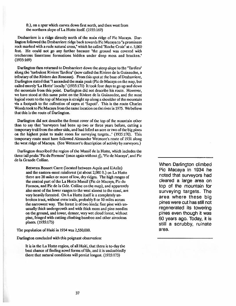
ft.), on a spur which curves down frrst north, and then west fromthe northern slope of La Houe itself. (1935:169)
Desbarriere is a ridge directly north of the main ridge of Pic Macaya. Darlington followed the Desbarriere ridge back towards Pic Macaya to "a prominentrock marked with a rude natural cross," which he called "Roche Croix" at c. 5,000feet. He could not go any further because "the ground was covered withtrecherous limestone formations hidden under deep moss and bracken."(1935:169)
Darlington then returned to Desbarriere down the steep slope to the "Tardieu"along the "turbulent Riviere Thrdieu" (now called the Riviere de la Guinaudee, atributary of the Riviere des Roseaux). From this spot at the base ofDesbarriere,Darlington stated that "I ascended the main peak (Pic de Macaya on the map, butcalled merely 'La Hotte' locally." (1935:170) It took four days to go up and downthe mountain from this point. Darlington did not describe his route. However,we have stood at this same point on the Riviere de la Guinaudee, and the mostlogical route to the top of Macaya is straight up along a shoulder of the mountainvia a footpath to the collection of cayes at "Sapoti". This is the route CharlesWoods took to PicMacaya from the same location on the river in 1975. We believethat this is the route of Darlington.
Darlington did not describe the forest cover of the top of the mountain otherthan to say that "surveyors had been up two or three years before, cutting atemporary trail from the other side, and had felled an acre or two of the big pineson the highest point to make room for surveying targets..." (1935:170). Thistemporary route must have followed Alexander Wetmore's route of 1931 alongthe west ridge of Macaya. (See Wetmore's description of activity by surveyors.)
Darlington described the region of the Massif de la Hotte, which includes thethree tall peaks "Pic du Formon" (once again without ~, "Pic de Macaya", and Picde la Grande Colline.
Between Bonnet Carre (located between Aquin and CAsile)and the eastern-most rainforest (at about 2,000 ft.) on La Hottethere are 20 miles or more oflow, dry ridges. The high ranges ofthe central part of the La Houe Massif (Pic de Macaya, Pic duFormon, and Pic de la Gde. Colline on the map), and apparentlyalso most of the lower ranges to the west almost to the coast, arevery heavily forested. On La Hotte itself is a completely unbroken tract, without even trails, probably 8 or 10 miles acrossthe narrowest way. The forest is of two kinds: fine pine with unusually thick undergrowth and with thick moss and pine needleson the ground, and lower, denser, very wet cloud forest, withoutpine, fringed with cutting climbing bamboo and other atrociousplants. (1935:173)
The population of Haiti in 1934 was 2,550,000.
Darlington concluded with this poignant observation:
It is in the La Hotte region, of all Haiti, that there is to-day thebest chance of fmding novel forms of life, and it is undoubtedlythere that natural conditions will persist longest. (1935:173)
37
When Darlington climbedPic Macaya in 1934 henoted that surveyors hadcleared a large area ontop of the mountain forsurveying targets. Thearea where these bigpines were cut has still notregenerated its toweringpines even though it was60 years ago. Today, it isstill a scrubby, ruinatearea.
jharold
Rectangle
jharold
Rectangle

The famous ecologistleslie Holdridge did hisPh.D. dissertation on thepine forests of Haiti.
Leslie Rensselaer Holdridge
American Ecologist
Did his Doctoral Dissertation on the pine forests of HaitI.
Worked In Haiti 1939-1946
February 1941He got "to near the peak" of Pic Macaya on 9 February 1941 (Judd 1987:6). See
also, Jimenez (1988) for a discussion of Holdridge.
Charles A. Woods
American Professor
Represented the University of Vermont (1972-1979) and the University ofFlorida (1979-present).
Worked in Haiti 1972-present.
18 December 1974Flew over Pic Macaya and western Haiti. It was rainy and cloudy, so the visibility
poor. Many inhabitants and much cutting of the forest were observed. Housesexisted on the mountains right up to the cloud levels.
30 December 1974Flew all around south west Haiti.
Macaya was cut over on the east face. There was a thick stand of pines all alongto top ridge of Pic Macaya. Dense rain forest covered the northeast face of themountains. The Plain east of Pic Macaya towards Duchityand Catiche was thicklysettled. The dense forest along the banks of the Riviere Glace stood out in contrastwith the chopped-up inhabited region surrounding it. The west ridge of Macayawas forested in large pines. The basin of the Riviere des Roseaux was deforestedand thickly settled in the Larrieux and Annette areas. Pic de la Grande Collinewas mostly deforested, with some forest remaining on the east and northeastshoulders. The north face of Pic Macaya was very steep, but also well-forested.Southwest of Pic Macaya the area was very inhabited and cut-over.
January, 1977Flew over Desbarriere and around Macaya, and took numerous photographs.
There were some signs of deforestation on the south west flank of Pic Macaya.The north west face of Macaya was in excellent shape. The basin in between PicMacaya and Pic Formon (ravine ofRiviere Thois Sources) was well-forested withbroadleaf forest on the Formon side and pine forest on the Macaya side. Theupper ridge of Macaya was well-forested in pines. The pines were widely spacedin places where white karst was exposed on the ridge of Macaya. The Plain ofFormon side was very cut-over, and appeared dry. The area east of Formontowards Catiche looked good from the air, with nice pockets of forest, Catiche.Excellent forest cover was observed on the east and north flanks of Pic Macaya.The forest cover of Morne Grande Colline was cut off the east and south faces ofthe mountain towards Macaya, but there was good forest cover on the north westflank of Colline, and on the mountains just west.
38
jharold
Rectangle

May, 1975 (Up north face of Pic Macaya)Charles Woods, Richard Rosen, Betsy Howland, Bill Howland, and David
Barrington of the University of Vermont traveled by Landrover to Les Cayes,Catiche, Duchity, Beaumont, and then via foot to Laconde, Desbarriere (962meters), Les Angles (576 meters), across the river and up to Lorbordlo (787meters; the name means "other side of the water"), and finally to Sapoti (1,136meters) on a ridge on the north face of Macaya.
The route from Beaumont to Desbarriere was rugged. Most of the forest hasbeen cut, but there was much coffee. Many peasants were carrying sacks ofcoffeealong the trail back towards Beaumont. Along the side of the trail were coffeebuyers with scales hanging from tree limbs. There were some pines, many burnedand chopped, in the vicinity of Desbarriere, especially on ridge overlookingMacaya. Below Desbarriere there was a settlement called Les Anglais. The areawas all in gardens. Up the valley of the Riviere de la Guinaudee there were twosettlements: 'Thrdieu and Chevrit. The area was very disturbed. They climbed upto "Sapoti," above Les Anglais and there were gardens all the way up. A settlementwas carved out of the face of the mountain half-way up, called Lotbordlo (787meters). Sapoti was a cluster of four houses, with gardens and sheep. A saddlejust above the little plateau lead on to a trail up the north side of the mountain.The forest began just above the saddle. There was a spring there, and the highestgarden seen was at 1,303 meters. The forest was composed of"Bwa Tremble" and"Bois Sang." The pine forest began about 1,545 meters and extended up to 1,700meters. Above 1,700 meters, the pines mixed with thick underbrush, and becamenearly impassible at 1,850 meters.
December 1982-January 1983Charles Woods, Kevin Jordan, Mara McDonald, Jose Ottenwalder, of the
University of Florida, and Donald Dod of the Jardin Botanico of the DominicanRepublic climbed the south side of the ridge of Formon.
They hiked up the steep face of the Formon ridge to a campsite on shoulder ofFormon at 1,650 meters. The trail from Formon to "Deglacis" passed this spot,which was called "Kay Ogil" (Caye Ogil). They climbed the trail above Kay Ogil,along a ridge until it entered a big pine forest on the top. The trail over the crestof the Formon ridge is at 1,880 meters. Vegetation on the top of the mountainwas dense. At 1,740 meters on the north side, the vegetation became disturbed,and it was possible to look out to the Plaine Martin (NE) and to Pic Macaya (NW).They cut a trail westward along the ridge of Formon from 1,880 meters towardsPic Formon through second-growth scrubby vegetation and climbing bamboo.Almost no big pines are found in this area, but there were some large Bwanomble. Along the ridge of Formon there was evidence of old gardens and fires.Peasants were seen on the trail with sacks of beans on their heads, some comingfrom the ravine going to Formon, and others coming from Formon, and going toCamp Perrin.
Westward, beyond 1,880 meters, the vegetation became more natural withPersea, tree ferns, and fallen trees. It was very rough-going on foot because of thethickets of climbing bamboo and fallen trees.
At their campsite at "Kay Ogil," more peasants were seen going over the maintrail towards Deglacis, where they said they were getting beans. They passed atthe rate of about one group each hour (each group = 5 people, usually boys oryoung men). Big trees were being cut in the area of the camp. There were threesawmills (scieries) in forest around them, and one right at Kay Ogil. They oftenheard the crash of big pines being cut down each day. The woodcutters wereworking on the upper flanks of the basin. The edges were covered with a denseelfin forest, with some towering pines. The floor of the basin was deforested, withan ajoupa and some gardens. Three scieries were on the steep sides of the basin,
39
Charles Woods firstclimbed Pic Macaya in1975.
jharold
Rectangle

Paul Paryski and BryanWoods reported hearingBlack-capped Petrels onPic Macaya for the firsttime on January 31,1984. This was the firsttime Petrels had beenreported in the Massif dela Hotte.
and they could see skid trails where the big logs were slid down. Deforestationwas going on at a rapid pace, and they saw ten trees during the course of the daysjourney that had been recently cut down.
January, 1984This was the largest expedition to La Hotte. It was sponsored by USAID as
part of the Biogeophysical Survey, and also by grants to Charles Woods by theNational Science Foundation, the International Foundation for the Conservationof Birds, and Earthwatch.
Expedition members were Charles Woods, Dan Cordier, Tia Cordier, AdaFowler (all of the NSF grant field crew); one Earthwatch volunteer (RayCleeland); Paul Paryski of ISPAN; Brent Mitchell of the Peace Corps (volunteer);Dick Franz, Bruce MacFadden, Mara Mcdonald, Fred Thompson, Walter Judd,and Scott Yocum of the University of Florida; Bryan Woods and Jeff Franz (asyoung volunteers); and Donald Dod of the Jardin Botanico of the DominicanRepublic. The expedition included 18 people in all, with 3 vehicles plus twomotorcycles.
The expedition traveled by vehicle from Camp Perrin to Les Platons. From LesPlatons it proceded by foot (with 43 porters) to Formon where it settled nearMadam Robert's house. It filled the field north of her house with tents, and usedan ajoupa there as a cook house.
On January 24, we sent Brent Mitchell and three porters off to continue toextend the trail we began on the previous expedition. ByJanuary 25, eight peoplewere up at the Kay Ogil camp on Formon, and ten people were working out ofthe Formon base camp at Madam Robert's. Each day Brent Mitchell continuedto cut trail along the ridge of Formon with a crew of cutters from our base camp.The cutters were sent up early each morning with notes and food for Brent. Theexpedition was also working in the karst hills of Bwa Formon. This area was fullof endemic plants. Dod found new orchids each day. Hispanolian hutias(Plagiodolltia) were present, as were nesting parrots. The forest was being cutdown for gardens at an alarming rate. There were new gardens all over, and eachday we found new clearings, and fires. Whole hillsides were being cut and burned.
ByJanuary 31, the trail was finally pushed into the clearing at Le Ciel (the sky).Trail continued beyond and into a saddle where there was a wet elfm forest. Thisis the spot where Barker and Ekman got to in their climb ofPicFormon onJanuary2,1928 (56 years ago). Paul Paryski and Bryan Woods were in the upper Ravinedu Sud where Paryski heard Black-Capped Petrels on Macaya for the first time.
On February 3, Charles Woods, Dan Cordier, Reginald Ambroise, and two trailcutters climbed the Formon/Durand trail to the crest of the ridge of Formon anddown into the upper Ravine du Sud in a driving rainstorm. The night was spentin an ajoupa at 1,650 meters on the north east shoulder of the mountain below PicLe CieI. Petrels were heard vocalizing after dark. Brent Mitchell continuedcutting the trail over the top of Pic Formon and down the north shoulder of thesaddle connecting Pic Formon and Pic Macaya.
On February 4, Charles Woods and his crew climbed down into the upperRavine du Sud to an ajoupa at 1,500 meters. The area was extremely disturbed,with gardens, sheep, goats. No peasants were seen. They then began to climb upthe head of the ravine towards the saddle, where they arrived at 1530 bes., after a7.5 hour hike. The saddle is 1,900 meters. The vegetation on the east face of thesaddle was very disburbed "rage", with old gardens, some second growth, andpatches of forest (unlike the west face, which was still in original forest). Campwas made at 1,900 meters in the saddle at a site we named"Amba Macaya".
40
jharold
Rectangle

Mitchell completed the Pic Formon trail to just south of their camp, and was lessthan 100 meters away on the far side of Thte 1919.
On February5, the trail cutters began working up the steep shoulder ofMacayain the early morning, and Woods and Cordier broke camp in a misty rain at 1100hr. The climb up Macaya was through good vegetation all the way, but the sidesof the ridge were badly eroded and too steep to hold tall trees, especially to theeast. Fires seemed to be common on the east side of the ridge, and also in a bandabove a caye (later determined to be at "Tombe Crier") on the west side of theridge. Wet forest was present at 2,000 meters. Big pines began at 2,100 meters,where there was a magnificent stand of pines, tree ferns, ferns, and rak bwa. At1500 hrs., they were on the lower shoulder of Macaya in dense pines and a wetforest. The trail cutters were exhausted and frightened. They quit. Woods andCordier took machetes and continued on along a narrow open ridge that was verydisturbed by fue. There were small pines and scrub forest. White-wingedCrossbills were in the pines and feeding in the weeds. At 1700 hrs., they got tothe top of Pic Macaya at 2,335 meters elevation. Huge pines with many fallengiant trees were on the ground. The ground was covered with pine needles andpockets of wet sphagnum moss. They found a smallllat area in the middle of theplateau--about 200 feet from where the shoulder ridge joins the top of the peak(they later found the benchmark 50 feet east of this small clearing). The campwas hidden behind huge fallen pines, and had a narrowwinding entrance. Coolmist blew through the trees, with darkness falling soon after their arrival. Theyheard Petrels at night, which seemed to be nesting in burrows on the steep faceof the south slope of Macaya just west of where the ridge from the saddle joinsthe peak. This was the fust project camp on the top of Pic Macaya.
On February 6, Woods, et aI., worked the top of Macaya. Mitchell, A. Fowler,W. Judd and D. Franz joined the group in mid-morning, having climbed up viaBrent Mitchell's trail which connected to their trail at the saddle. Paul Paryskijoined the group at 1430 hr. having hiked all the way from the base camp atFormon via the Woods/Cordier route, up through the Ravine du Sud. A groupofeight plus porters and cutters spent the night of February 6 on Macaya. Petrelswere very abundant between 1930-2215 hrs. off the south face of Pic Macaya.
The entire group descended Macaya on February 8. They left the peak at 0845,and were down to the saddle by 0945, Pic Formon by 1100, Pic Le Ciel by 1145,base camp at 1345; five hours hike down from Pic Macaya. By dark, all groupswere off the mountain and out of the ravine, and 15 biologists were back in thebase camp. The expedition left Formon on Feburary 9, with 50 porters for the hiketo Les Platons.
January, 1985This expedition included Charles Woods and Bruce MacFadden of the Florida
Museum of Natural History; Lawrence Harris of the Department of Wildlife ofthe University of Florida; Donny May of the University of Florida; GastonGeorge of the Ministere des Mines et du Ressources Energetiques; FlorenceSergile of the Ministere de l'Agriculture (MARNDR); William Oliver of JerseyWildlife Preservation nust, and a group from the University of Vermont FieldNaturalist Program (Nancy Bazilchuk, Chris Fastie, Anne Heise, John Kasmer,'Thmara Naumann, Rose Paul, David Publicover, Carol Savonen, SandyWhidden,and Koren Zimmerman). Also part ofthe expedition were Paul Paryski ofISPAN,and Reginald Ambroise ofCamp Perrin.
Funding was via Jersey Wildlife Preservation Trust, the International Foundation for the ConservationofBirds, and USAID/Haiti as part of the Biogeophysicalsurvey of the national parks of Haiti.
41
On February 5, 1984,Charles Woods and DanCordier set up the MacayaBiosphere Reservecampsite on the top of PicMacaya and located thecrumbly bench mark atthe top of the mountain.
jharold
Rectangle
jharold
Rectangle
In January, 1985, a bigexpedition from theUniversity of Florida, theUniversity of Vermontand the Jersey WildlifePreservation Trust surveyed endangeredspecies in Parc NationalPic Macaya and searched for Il0st" mammalsin the most remote areasof the park.
The area around Plain of Formon looked much changed in one year. All of thesmall limestone hummocks around the Despagne land had been cut. Thereseemed to be much additional deforestation on the south face of the FormonRidge. Madam Robert had built a new caye in the field to the west of the house.There were new gardens all around the house.
The group with 21 porters climbed to Pic Le Ciel on January 22.
Treeline was at 1,840 meters. Five new clearings of .5 hectares each wereobserved near treeline along the trail. Some big pines had recently been cut, anda scierie was beside the trail near the treeline.
On January 24, the entire group started a long trek with porters up across PicFormon, down the ridge to the saddle, up the ridge of Macaya to the upper 2,220meters shoulder and on to camp on top of Macaya.
On January 25, they worked on top of Pic Macaya. Solitaires were singing at0530. There was deep pine duff, huge old pines, and some regeneration ofyoungpines in open spots. A small mammal trap line was set aU along the ridge.
On January 26, they hiked all along the ridge to the west end of the upperMacaya plateau at 2,307 meters. They had to cross two deep swales to get to thewestern point, which was an area of exposed limestone. There were signs of flre,and numerous burned stumps on the western tete. The swales were fIlled withrak bwa (holly, myrtle, ferns) and towering pines, some over five feet in diameter.There was no pine regeneration in this area, suggesting that there had not beenrecent fires.
On January 27, an owl was heard during the night--maybe Stygian Owl. Wedeparted down the mountain into the Ravine du Sud. As we departed the top ofthe mountain with our porters, they broke out into a song Bye bye Macaya Byebye Macaya, etc. (We later had them do it again for us down at Madam Robert'shouse, and have it on tape). There was much deforestation in the upper ravine,and no water in river most of the way (it was underground). Some areas had 6-10foot pines regenerating. It was a devastated area in comparison with the upperRavine Trois Source on the west side. Many rocks here had come down inlandslides from the shoulders of Macaya and Formon above. We arrived at thecamp at the base of lower Formon/Deglacis trail at 1700 hr. There was a basinnear the camp with a50-foot waterfall where Collard Swiftswere nesting. Gardensexisted on shoulders above the waterfall. This must be Deglacis.
On January 29, most members of the expedition hiked out of Ravine du Sud.The trail up the ridge toward Formon was very steep. There was much deforestation, soil erosion, and ruined habitat. The group passed a number of ajoupasand cayes.
At Kaye Ogil, there was more deforestation than the previous year. Thecampsite area was much more open, with a huge garden. A pile of new pine logswas at the campsite, and an operational scieriewas at the edge ofthe forest. Therewas much more deforestation in the ravine just east of Kay OgiJ. The rate ofdeforestation in the area was accelerating.
On January 30, we left Formon, but left a small group behind to continuesstudying the flora and fauna of Macaya for another week.
November, 1985Charles Woods, John Hermansonm, and Reginald Ambroise climbed Pic
Macaya.
42
jharold
Rectangle

On November 3, they biked up FormonlDurand trail and on to Pic Le Ciel.Forest began at 1,780 meters. 1i'ail was open to this point. Beyond the campsiteat Pic Le Ciel, the trail was very rough and overgrown. The climb over Pic Formonand down into the saddle was in hard rain, and the trail wet, steep, dangerous.
On November 5, they worked in saddle in morning, and climbed up to PicMacaya at mid-day. It was a one-hour climb to knoll at 2,200 meters, and another30 minutes to the top of Pic Macaya (so a steep 1.5 hr. climb from the saddle tothe peak). They worked along the ridge. All their marking tape from the previousyear was faded and tattered, so it was difficult to find their way along the ridge,and the ridge trail was overgrown.
February, 1988Charles Woods, Paul Paryski, Catherine Mcintyre, and Charles Emile Philoc
tete climbed up the west ridge of Pic Macaya.
This trip was via Port-a-Piment to Rendel, and then via foot to Gran PIen, andSivette mat (1,445 meters on the west ridge ofPic Macaya). They departed Sivetteat 0745 on 28 February. At 1,650-1,700 meters, there was Bwa Tromble Rak Bwa.At 1,720 meters, there was an old abandoned home site with only flat ground leftand plantains growing in second-growth Rak Bwa. At 1,780 meters, the originalelfm forest began with three layers;
upper = Pines, Bwa 1i'omble, Bois Sang;middle = Tree Ferns and Persea;lower = ferns and bird of paradise plants.
At 1,875 meters, there was a clearing with small pines, large old stumps, signsof fues. At 2,100 meters, they encountered new pines about 12 feet tall, tallbrackens, rough karst topography, and a semi-flat ridge. At 2,140 meters, therewas grass, bracken, small pines, exposed rocks. At 2,160 meters, they found asmall saddle with many 6-12" pines. At 2,200 meters, there were huge pines (fivefeet in diameter) along the ridge. There were also many small 12" pines, and thearea is quite open.
This group made it to just below the steep last cliff of the ridge of the summitof Pic Macaya.
December, 1988Charles, Paul Paryski, and Roy Voss traveled by vehicle from Port-a-Piment to
the end of the road beyond Rendel, and then on to the west shoulder of PicFormon at Gran Plen where COSAR coffee cooperative headquarters is located.They were part of the Sondeo team of the University of florida (also includingMarilyn Swisher, John Lichte, Paul Monaghan, Suz Mathieu, and Michel Aubry).
On Monday December 5th, they traveled by foot eastward up the Ravine of theRiviere 1i'ois Sources. The route is through very disturbed country in the districtofGraine Mouton. The steep slopes of Pic Formon and Pic Macaya rise on eitherside of the river. Beans were planted in cleared fields up to about 1,500 meterselevation. At the east end of the ravine was a small mountain called Morne BoisPin. The trail climbed up and over this pine-covered hill, which marks the end ofCOSAR-owned land. The gardens on the Formon side opposite the hill are onvery steep terrain of Pic Formon, and were eroding badly. Gardens extended upto 1,600 meters and were filled with beans, potats, and grazing sheep (c. 24). Itwas an ecological disaster.
Beyond the hill, the landscape became much more natural, but there were threepermanent houses. One was near the river not far beyond the mountain. Coffeewas growing there, and a very bad landslide descended from a garden on the steep
43
In 1988, a Macaya Biosphere Reserve teamclimbed Pic Macaya fromthe west, the old route ofEkman (1928) and Wetmore (1931). The trail wasalmost completely abandoned and difficult to follow, but signs ofabandoned houses andgardens showed the areawas previously more inhabited.
jharold
Rectangle
jharold
Rectangle

In December, 1988, theMacaya BiosphereReserve Project conducted a Sondeo on thewestern side of the National Park and showedthat the area was beingenvrionmentally devastated.
slope ofFormon. About .5 km beyond this place, there was another house on theMacaya side ofthe river. This area is called ''Tombe Crea" (Tomber Crier), whichshould mean "fall down and cry," but the local peasants insisted meant "rain thatfalls like tears" (for all the rain). Gardens were on the steep slope of Macaya, upto about 1,400 meters. Neither of these permanent houses was inhabited withfamily groups, and may have been "super-ajoupas" or semi-abandonedpermanentsettlements. Both were primitive, but had cooking cayes, and each had fltes goingin the cook house. Beyond this, the trail clings to the Macaya side. Only onegarden was observed on the Formon side. Most of the forest on the Formon sidewas original, dense rain forest dominated by Bwa Thomble and huge pines, withan understory of tree ferns and Persea. It looked nearly impenetrable. TheMacaya side was drier, with pines, grass, and bracken ferns extending down tothe river where there were no gardens.
The last caye in the ravine was perched up on the Macaya side at 1,475 meterselevation, just below the huge burn on the south west face of Macaya (B.C. Petrelside). The compound was called "1Wompe" (La Thomp), and was inhabbited byan old man named Pierre-Edmond Paul and his family. The man had been hereabout 40 years, and said he came here via Beaumont, Desbarriere, La Hotte, andthe ravine. He did not rent the land; "God gave it to me" he said. He had gardensofbeans on the steepest slopes (over 60°) on the Macaya mountainside above theriver. Some of these gardens had recently been washed away (probably as a resultofthe hurricane). A new garden had just been cleared, and the soil slid out fromunder our feet as we walked, and tumbled into the ravine below as we made ourway across the garden. It was a terrible ecological disaster in the making.
Beyond this last garden, the forest became completely natural for one kilometerto the saddle connecting Macaya with Formon, which we could see just above us.The habitat was impenetrable. Water flowed in the river, and a 2OO-foot waterfalltumbled into the ravine from the steep slope of the saddle. Therewere huge pineson the Macaya side, and Bwa Tromble and pines on Formon. We ate lunch on anextremely steep slope at the base ofa five-foot diameter giant pine at 1,560 meterselevation overlooking the ravine and waterfall. A rock dropped from where weate, descended for 7.5 seconds before hitting the bottom of the ravine below. Thiswet, steep head of the ravine of the Riviere Trois Sources was still in a completelynatural state from the spot where we ate lunch east for a distance of onekilomeeter to the saddle and then up to the crest of both Pic Macaya and PicFormon. Such was not the case on the east side of the saddle.
The presence of the local peasant (Pierre-Edmond Paul) clearly was the reasonfor the fires that have swcpt up the south west face ofMacaya, although he deniedknowing anything about the fires.
Pierre-Edmond Paul rcmembered Paul Mertans and his friends as they descendoff of Macaya several years ago. They came down through his garden. He keptpointing up above his garden saying there was a big route to Macaya there, butthat Macaya was far away. He did not know ofthe Zagouti or ofthe Black-cappedPetrel, even though both are nearby.
There was a huge washout next to the peasants' house, where massive amountsofwater came down offthe burned face of Pic Macaya during Hurricane Gilbert.Thewashout includedgiant boulders, and had big pines that had broken in lengthsand smashed. Some rocks were 6' up in trees.
January-February 1989Between January 28 and February 5,1989, a team headed by Charles Woods
spent nine days in the region of Pic Macaya conducting a Sondeo as part of theUFMBR project. The members of this team were (in alphabetical order):
44
jharold
Rectangle

Jenness McBride (UFMBRP), Paul Paryski (UFMBRP), Charles Emile Philoctete (USAID), Denique Philoctete (UFMBRP), Felix Saint Pierre (MARNDR),Roy Voss (UFMBRP), Charles A. Woods (UFMBRP), and Ellen S. Woods(Volunteer).
The team assembled at Formon on January 28,1989, at the MBR field headquarters on the Plain of Formon adjacent to the house of Madam Robert (TilaDespagne). The weather was too rainy to climb on January 29, and so the teamworked in the Plain ofFormon region. OnJanuary 30, the team departed Formon(957 meters) and hiked west to the Plain of Durand (1,200 meters) and then upthe west trail over the ridge Morne Formon (2,000 meters) and down into themost western end of the Ravine du Sud (1,400 meters). The journey took eighthours because of rain and very slippery trail. Camp was made in an open rocky"galet" in a region known by the guides as "Pa Lan Kont". On January 31, the teamhiked up the east wall of the saddle connecting Pic Formon with Pic Macaya tothe camp ground in the saddle at 1,870 meters ("Fraz" according to the guides,sometimes called "Amba Macaya" by biologists working with the UFMBRproject), and then north up the shoulder of Pic Macaya to the top of the mountainat 2,347 meters. The name "Fraz" was applied to the resting place in the saddleby several people, especially Redicule Beljean (who knows the area well). We arenot sure of the meaning of the local name, which may come from the French wordPhrase (a sentence), or more likely from an alternative to the Creole word for"chitchat." Thejourney from Pa Lan Kont to the summit ofPic Macaya took sevenhours. The trail along the way had to be cleared byguides with macheltes becausethere had been so much regeneration of vegetation since our last visit to the topof Macaya in 1986. The Sondeo team split into two sections, with McBride,Paryski, C.E. Philoctete, and D. Philoctete camping at "Fraz" in the saddle; andF. Saint-Pierre, R. Voss, C. Woods, and E. Woods camping at the summit of PicMacaya. All members of the team visited the top of Pic Macaya. Data on thestatus of the forest, flora, and fauna were gathered for two days along the transectfrom the saddle to Pic Macaya.
On February 2, C.E. Philoctete, D. Philoctete, and F. Saint-Pierre began thejourney back to Formon, while Paryski, McBride, Voss, C. Woods, and E. Woodsjourneyed down the Ravine du Sud via Pa Lan Kont to Deglacis. The journeyfrom Pic Macaya to Formon took ten hours, while the journey to Deglacis tookfive hours. The route to Deglacis is along a poorly defined trail to Pa Lan Kont.It then follows the riverbed of the Riviere de la Ravine du Sud, which is difficultto traverse. Much of the water in the river is flowing underground, and it isnecessary to climb around slowly and sometimes over huge boulders. Occasionalsprings enter the river from the steep walls of the ravine, and two major streamsjoin the ravine. The team spent the night of February 2 at the place where thetrail to Formon via "Kay Ogil" joins the ravine, and near where a waterfall entersthe ravine from the Macaya side. The region was referred to by the guides as thebeginning of Deglacis. They stated that the Deglacis region continued ondownstream for another three hours walk. The area above the ravine to the northand west of our camp, which is on a high shoulder of Macaya where the slope isnot too steep to plant, is called "Kay Ropano" by the guides in reference to thehouse with a tall roof that Ropano Despagne built there. The team interviewedinhabitants of Deglacis the evening of February 2, and the morning of February3. The team then hiked out of the Ravine via "Kay Ogil" to the headquarters atFormon on February 3. The journey took seven hours. McBride and Paryskideparted for Camp Perrin on February 3. Voss, C. Woods, and E. Woods workedin the Plain of Formon and Rak Bwa Formon on February 4 and 5, beforedeparting for Camp Perrin on February 5.
45
In 1989, the Macaya Biosphere Reserve team conducted a Sondeo in theRavine du Sud and top ofPic Macaya.
jharold
Rectangle
jharold
Rectangle

The history of exploration in the Pic Macayaarea is closely linked tothe creation of Parc National Pic Macaya.
These expeditions clearly document the changes that have occurredin the natural habitat ofthe region.
Richard Rosen
American Biologist
Represented University of Florida and Charles Woods
January 1977Richard Rosen, Margaret Langworthy, James Bicket, and Andy Wagler
traveled by foot from Catiche to Tombe Cheval down into a branch of the RavineDu Sud, up again and west along a ridge of Pic Macaya to 1,460 meters wherethere were many big gardens of beans, malanga, mazumbelle, yams, potats, butfew people, and back down into the main Ravine du Sud at 855 meters, wherethey made camp at a small settlement (Deglacis). From there they followed thevery steep main trail up to 1,788 meters on the ridge of Formon, which they notedwas covered with huge pines and dense forest beginning at about 1,515 meters.They came down the south side of the ridge of Formon via the trail through CayeOgil to the town of Formon where they slept in the Catholic church (855 meters)on the night of 4 January 1977. They then traveled across the Plain of Durand,down the steep trail of Morne Cavalier, and along the Riviere Port-a-Piment toGrande Plain. On the morning of 6 January, they met Charles Woods in PortSalute Airport. An amazing journey. The porters frequently said that this routewas impossible, and that the only way to go from Catiche to Pic Macaya and PicFormon was via Desbarriere. They kept trying to talk Rosen et al. into theDesbarriere route.
ConclusionsThis chapter documents that a number ofexpeditions have climbed Pic Macaya
and worked in the area of the Macaya Biosphere Reserve during the last 75 years.But, as the quotations from Erik Ekman clearly document, the earliest expeditions to Macaya in the first three decades of this century encountered a nearlyimpenetrable wilderness. These observations have been confirmed by CharlesWoods, who interviewed both Dr. Henry Barker, who journeyed to the top of PicFormon with Erik Ekman in 1926, and Dr. Philip Darlington, who climbed up thenorth face of Pic Macaya in 1934. Both scientists remembered their journeys tothe Macaya area vividly, and both reported a nearly pristine environment of talltrees and well-forested mountain slopes. These conversations are preserved ontape, and are in the archives of the Florida Museum of Natural History.
Other individuals and small groups worked in the Macaya area, and some evenclimbed to the top of Pic Macaya. We have attempted to document some ofthemin the chronology list of this chapter. Paul Paryski, for example, made severalclimbs into the area during the early years that he was associated with ISPAN.The accounts discussed in detail in this chapter, however, have concentrated onexpeditions which left behind field notes or journals that could be referred to forspecific information and original observations. Many quotes from these journalsare included in this chapter in order to document the changes that have occurredin the Macaya area during the past century. It is clear that many changes havetaken place. The environment encountered by Ekman, Barker, Darlington, andWetmore is nearly gone. The changes were occurring slowly, and indeed somewere well underway by the time these great explorers and naturalists worked inthe area. The changes accelerated following the completion of the Cayes toJeremie road in the 193Os. But the most radical changes began in the late 1940sand early 1950s, when peasant farmers began to colonize the remote corners ofthe region, such as Deglacis in the upper Ravine du Sud and Trombe of the upper
46
jharold
Rectangle

Riviere 1i"ois Sources. These early colonists could still be found in the region,and we interviewed several of the first people into the region during the courseof our work on the MBR project reported here. The impacts of these pioneerefforts, such as burning the steep hillside for gardens, and cutting the giganticancient pines for planks, were visible everywhere by the time our expeditions intothe area began in 1975. And on our most recent trip into the Formon/Macayaarea in April of 1992, we observed an even faster rate ofdeforestation and habitatdestruction. The loss of forest cover in some regions was so total that without theoriginal observations reported in this chapter it would be nearly impossible toknow that the area was ever forested or supported a rich flora and fauna. It is asad story that is being made even sadder by the recent political events in Haiti,and the effects of the OAS embargo, which have led to widespread chaos andenvironmental destruction. It is as if the memory of the presence and importanceof the natural patrimony of Haiti has vanished. It is to hold onto this memory thatthis chapter is presented as part of the fmal reports of the USAID MacayaBiosphere Reserve Project.
These observations on the history of the Macaya area clearly document howimportant the USAID/UF MBR project has been. Without the radical interventions associated with this project, and the sense of history and documentation ofthe natural ecosystem of the area provided by naturalists from the University ofFlorida, it is our opinion that the MacayaIFormon area would have been almostcompletely deforested by 1992. This was the prediction of Warren Cohen in hisanalysis of patterns of deforestation in Haiti. If this had been true, the historicalaccounts presented here would be sad and melancholy echoes of an importantecosystem lost forever, instead ofguidelines for an ongoing stewardship plan thatcan save the watersheds of southwestern Haiti as well as preserve a measure ofthe biological diversity of the country. It is not too late. But the changes in theecosystem of Macaya documented here point out how vulnerable the area is, andhow rapid the rate of habitat destruction can be once it gets underway.
University of Florida Macaya Biosphere Reserve crew at Formon
47
jharold
Rectangle

1986View of an extensive area of burned habitat on the southwest shoulder of Pic
Macsya taken In 1988. alack-cappecl Petrels breed on the southern cliffs.
LeClel
1977Central core of Parc National Pic Macsya taken from a small airplane In 19n.
Note the differences In vegetative cover between 1977 and 1988.
jharold
Rectangle

CHAPrERm
Summary of BiogeophysicalInformation on the Macaya Area
IntroductionThis chapter summarizes all of the reports of the biogeophysical inventories of
the University ofFloridaBiogeophysicallnventory (Franz and Cordier, 1986; Galland Schwartz, 1986; Judd, 1986; MacFadden, 1986; Thompson, 1986; Woods,1986; Woods and Ottenwalder, 1986). An attempt has been made to review themost important features of Parc Macaya and the surrounding area of the MacayaBiosphere Reserve, and to provide a synthesis of the information necessary forplanning as weU as understanding the significance of Parc Macaya. Each originalreport stands on its own and should be consulted for detailed informationconcerning Parc Macaya. Some of the reports have been expanded upon in laterpublications. A more complete analysis of the botanical features of the Macayaand La Viste regions was published by Judd (1987), and Judd and Skean (1987),based on their original field work and additional data coUected in the early yearsof the MBR project. A more complete review of the birds of the region has beendone by Woods (1987), and birds are further discussed in a separate chapter inthis book (Chapter IV, Birds of the Macaya Area). The mammals of the regionare discussed in more detail by Woods (198980 1989b, 198ge), and by Woods,Ottenwalder and Oliver (1986). Mammals, because of their importance in theHaitian ecosystem and extreme vulnerability to habitat destruction, are alsodiscussed in greater detail in Chapter V of this volume (Mammals of the MacayaArea). This chapter is designed to give individuals who are interested in floraand fauna of Haiti a quick overview of the major features of the area. It is asup-to-date as we can make it. We hope it clearly documents how important theMacaya region is as one of the last pockets of biological diversity in Haiti.
49
jharold
Rectangle

Hispaniola wasseparated into at leasttwo islands in the past,one being the "South Island, II the present-daysouthern peninsula ofHaiti. It joined the rest ofHaiti about nine millionyears ago.
The Geology of Parc National Pic MacayaThe interpretation of thc structural geology of Parc Macaya is complicated by
the extensive weathering of the outcrops and the dense vegetation cover of mostsections of the park. There are numerous faults, some trending east-west alongthe Grande Ravine du Sud and others north-south in the Macaya Formation.
One of the most significant geological features of Parc Macaya is the extensivekarst topography that occurs along the areas oflow relief east and south ofMorneCavalier. Karst is also exposed along the ridges between 1,800-2,000 meters eastof Pic Formon and along the ridge between Pic Formon and Pic Macaya. Mostexposures of karst in the park are associated with the "karst hills" that cover theedge of the Plain of Formon, which are really cones of karst. Low areas arefrequently doline collapses or sinkholes. Steep-sided solution pipes andsinkholes are often encountered on the Plain of Formon and Plain of Durand.Even though the area receives abundant rainfall, most water quickly enters thesubsurface hydrologic cycle via the extensive joint system and larger-scale solution features (flowing into caves).
The main body of the park is composed of two tall peaks, Pic Formon and PicMacaya. They are separated by an active east-west trending fault system thatforms the "Gran Ravin," and the Ravine du Sud east of the ridge connecting PicFormon and Pic Macaya indicates active vertical uplift in the region. The uppersurfaces ofboth mountains are covered with deep rich soils that support a denseforest. These soils are highly oxidized, reddish laterites. There is a thick layer ofhumus formed by decomposing vegetation.
The long fault that originated in the Miocene passes through much of theSouthern Peninsula and crosses Parc Macaya via the "Gran Ravin." The evidenceof active vertical tectonics in the region is found in the steep slopes of the ravine,the numerous talus deposits that flow out onto the bottom of the ravine and flatareas on the slopes above, and the frequent occurrence of massive landslides.
The rocks of the park are from two formations. Most rocks are limestones ofthe Macaya Formation. These massive limestones are characterized by numerousveins ofcalcite. Most rocks are fine-grained and light grey in color. Occasionally,greyish-brown or even darker rocks are encountered. This rock formation is veryold, probably originating in the late Cretaceous 70 to 80 million years ago. Duringthis time, the western portion ofwhat is now the Southern Peninsula, and the ParcNational Pic Macaya was a back-arc basin that may have been detached fromnorthern Haiti and located hundreds of kilometers to the west of its presentposition.
The second formation found in the park is the "Demisseau Formation." This isthe same formation that is found in Parc National La Vasite north of the La SelleEscarpment. It is a deep-water deposit consisting of basaltic volcanics (lavaflowing under the ocean surface), turbidites, limestones, cherts and siliceoussandstones. Rocks derived from this formation are exposed at 1,150 meters inthe stream basin of the Grande Ravine du Sud. Other outcrops of basalt can beobserved at 1,400-1,600 meters elevation along the southern slope of the ridge ofFormon. Most workers believe that the Demisseau Formation underlies theMacaya Formation, and is therefore older.
Both the Macaya and Demisseau formations were formed in the deep ocean inthe ancient Caribbean Sea. This sea became shallow in the area of what is nowthe peninsula ofHaiti in the earlyThrtiary. During the middle Tertiary (Miocene),a major tectonic left-lateral fault developed. Since this time there have beencontinued lateral and vertical tectonic events that have shaped the land as we seeit today. The late Thrtiary and Quaternary (last nine million years) have been
50
jharold
Rectangle

characterized by the formation of karst landforms and lateritic soils. IfHispaniola was separated into two islands, as some geologists believe, then theSouthern Peninsula would have joined the rest of Haiti about nine million yearsago.
Karst topography predominates east and south of Morne Cavalier and between1,800 and 2,000 meters elevations east ofPic Formon and along the ridge betweenPic Formon and Pic Macaya. Exposure of karst is associated with the karst hillscovering the edge of the plain of Formon and the plain of Durand, the "rak bwa."Solution pipes and sinkholes are common on the plain ofFormon and on the plainof Durand as well. Exposured blocks of limestone stand like monuments on thesurface.
The limestone varies in hardness and fracturing, and may not be able to betreated as a single formation. Water penetration through cracks and fissures andconsequent runoff will be associated with these differences. Below the limestonelies a complex that was formed under the sea in the late Cretatian period.
Basalt exists as pillow lavas, dikes and other thin strata intruded into thebasement rock. This basement rock is composed of deep-water marine limestone, shale and other sedimentary rocks veined with calcite.
When weathered, these rocks are highly erodible. The most notable featurecaused by this erosion in the park area can be seen in the undercutting of the rockunder the limestone of the Demisseau formation, causing the great cliffs of themassif. Differences in topography are reflections of the predominate underlyingmaterial. Those areas underlain with limestone are usually rounded on the ridgesand in the ravines. Soils and rock are usually more stable on these materials. Onthe other hand, where the sedimentarylbasaltic rock is found, ridges are sharp,and "V-shaped" ravines are common, as the material is highly erodible.
Based on the predominantgeological formations in the area, threegeneral typesof topography can be defmed. These correspond to some degree to current landuse patterns and are also an important element in developing a land use plan forthe future.
(1) The fust type consists of very steep, upper slopes. Such lands are in somecases utilized today for agriculture, particularly in the 1fois Sources area. Theyare not, however, generally appropriate for agricultural land use. It is recommended that long-term planning move toward a system in which use of these landsis restricted to conservation purposes and/or very limited use ofnatural resources(e.g., selective exploitation of native vegetation).
(2) The second type consists of moderately sloping to steep hillsides, andcorresponds in large part to the karst outcroppings, known locally as rak bwa.While some farmers are presently almost entirely dependent on these areas foragricultural production, most farmers who utilize the rak bwa also have access tomore productive lands at lower elevations and/or with lower slopes. These rakbwa lands are highly variable. In some cases they are appropriate for limitedagricultural use (particularly agroforestry), but in other cases extreme degradation has already occurred, limiting their utility in the future. In the latter case,rehabilitation is critical--that is, systems must be devised which can improve thequality of these lands.
(3) Finally, much of the area consists of formations which are quite appropriatefor intensive, sustained agricultural production. These lands include the nearlylevel plains (such as Durand) and gently sloping hillsides. Most of these landsare in agricultural production today and should continue to be utilized foragriculture in the future. Conservation agricultural practices should be
51
The steep slopes of theupper Ravine du Sud aregeologically active andcharacterized by frequentlandslides.
jharold
Rectangle

The soils of the Formanregion are extremelyvariable and form amosaic of intermixed soiltypes.
developed which can assist farmers in making the most productive use of suchlands.
The forces that shaped geological conditions in Haiti are still at work in theregion of the Macaya Biosphere Reserve. One of the best places in all Hispaniolato stand and appreciate the forces of geological events in action is in the upperGrande Ravine du Sud at 1,600 meters elevation.
The Soils of the Macaya RegionIn the central portion of the Plain of Formon, the soils are deep oxisols formed
on predominantly limestone parent rock. These soils are dark red and deep, withmoderate fertility levels. Soil pH is nearly neutral. Lower down the slope, thesoil changes to a brown ultisol formed on the non-limestone rock. Because slopesare not severe, the soils are relatively deep and somewhat fertile, with nitrogenand phosphorus being the most commonly deficient nutrients. The pH of thesesoils is slightly acid.
On the slopes of the upper area of Durand, the soils are relatively deep andcoarse-textured ultisols that may be formed on the colluvium and alluvium thathas washed downslope from underneath the Demmissaeu formation. Someexplosive volcanics ofa later geologic era may have also contributed to the parentmaterial of these soils. The soils are less weathered and the coarse texture leavesthem draughty and dryer than surrounding souls.
Toward Kay Ttlus and the ridge of Formon, the steep slopes have been cleared,exposing the ultisols. Severe erosion is in process, but farming continues in spiteof landslide and landslip on nearly all of the deforested slopes.
On areas of rak bwa, a large portion of the soil surface is covered by limestonerock formations and strewn rocks, but the soils are nonetheless deep and fertileoxisols. Production is severely limited by the portion of the soil surface notcovered with rock.
Across the escarpment toward Cavalier, the soils are predominantly brownultisols. On the upper slopes below the market ofSous Bois, the soils are relativelyrecently cleared and hence moderately deep. Because of the nature of the soil,however, they are subject to erosion and may rapidly degrade. Because of thelimestone on the rak bwa above them, they retain a neutral pH. Lower on thevalley floor, the ultisols have been cultivated much longer, and even with lessslopes, are eroded moderately.
To the west of the Park in the areas near the COSAR area, the soils follow thesame pattern of ultisol formation. Cleared land is showing signs of erosion andin some areas the plinthite subsoil is at the surface. High up the Port-a-Pimentriver clearing and flCe during the last ten years has caused a severe avalanchehazard that should be addressed immediately.
The three predominant soil types described above coincide to some degree withthe major topographical features ofthe region. However, it must be stressed thatsoils in the entire region are extremely variable and form a mosaic of intermixedsoil types in some areas which will require extremely careful attention whenagricultural land use is suggested.
In general, the oxisols occupy the nearly flat plains and very lowest slopes in theregion. They are much more prevalent in the Formon area than in the TroisSources area. While they do offer problems offertility, their structure is excellentand they are highly resistant to erosion, in addition to occupying the least erodiblesites. Intensive agricultural production on these soils should be possible.
52

Deep ultisols occupy many of the intermediate slopes, including large portionsof the rak bwa area. These soils are much more susceptible to erosion than theoxisols and must be treated with great care. In many cases, current land use willnot be sustainable on these soils, especially when it occurs on steep slopes. Thesesoils should, over the long term, receive the greatest attention regarding appropriate agricultural and/or non-agricultural land use practices. These soilshave also been highly degraded in many areas and will require rehabilitation ifthey are to prove productive in the future.
The upper slopes are occupied in many cases by thinner ultisols, even moresusceptible to erosion than those occupying the lower slopes and rak bwa. Thesesoils are very prevalent in the Trois Sources zone, and contribute to the very severeerosion problems that are so visible in that area. In the vast majority of cases,prolonged agricultural production will not be possible on these soils. It shouldbe noted that the upper slopes show extreme variability in soil type and thatgeneralization is difficult. Further study of these soils is critical, particularly inareas of intensive utilization.
Floristic Features of the Macaya AreaThe vegetation of Parc National Pic Macaya in the Massif de la Hotte consists
of an extremely diverse, moist broadleaved forest growing on and around areasof exposed limestone at the lower elevations of the park and extending upwardto about 1,250 meters elevation. Above 1,250 meters, a complex mosaic ofhabitats exists, ranging from moist, dense cloud forest to occasional open, savanna-like pine forest (best developed above 1,600 meters). Human-caused disturbance is extensive below 1,600 meters.
Judd (1986:7-10) divides the vegetation in the Macaya region into two majortypes. The first is an extremely diverse wet forest on limestone. This is equivalentto Holdridge's (Sedwitz and Canet, 1972) "foret tres humide de Montagne debasse altitude," and ranges upward to about 1,250 meters elevation. The secondforest type described by Judd is a complex mosaic of pine and cloud forestformations. Local edaphic factors such as soil, exposure, local precipitationamounts, wind patterns as well as historic factors (i.e. fire, cutting, hurricanes),influence what type of forest will grow in a particular locality. Because it isdifficult to speak of the park in specific terms within the general forest typesmentioned above, we have subdivided the forest types with several sub-units.
The lower "wet forest on limestone" is subdivided into four types of habitat.
1) Mature broadleaved forest (Creole name "Rak Bwa Woch").This is a typical forest of the karst hills on the edge of the Plainof Formon. The species composition is described by Judd(1986:9-10).
2) Fragmented broadleaved forest (Creole name "Bwa RajeWoch). This is a small patch of the preceding forest type, or onethat has been dramatically altered by selective cutting.
3) Abandoned gardens or areas of early succession (Creolename "Raje"). Grassy areas on the Plain of Formon or in thefoothills below 1,300 meters.
4) Gardens (Creole name "Jadin"). Gardens planted in clearedareas within the "Rak Bwa Woch" or on the Plain of Formon.
53
The endemic pine ofHispaniola is Pinus occidentalis.
The Hispanolian Whitewinged Crossbill is totallydependent on this pine forits food of mature pineseeds.
jharold
Rectangle

Five major vegetationformations occur withinthe boundaries of theMacaya BiosphereReserve.
The complex of forest types above 1,300 meters elevation have been subdividedinto the following units.
1) Pine forest (Creole name "Bwa pen"). This forest type isdescribed by Judd (1986:7). It is similar to the pine forest in LaVisite except it is much moister and has many more broadleavedplants in the understory.
2) Successional pine forest (Creole name "Bwa pen Raje").Young stands ofPinus occidentalis with blackberries (Rubusspp.) and braken ferns.
3) Mature hardwood forest or "cloud forest" (Creole name "RakBwa"). This forest has few or no overstory pines, and usually haslarge and conspicuous individual Didymopanax tremulum trees(called "Bwa Tramble"). The understory is a diverse array ofsmall trees and shrubs such as Ganya fadyenii, Myrsine coriacea,Bruncllia comocladiifolia and the important wild avocado Perseaanomala. The climbing bamboo Arthrostylidium haitiense ("lianea scie") grows up in sunny spots and makes many areas of thishabitat almost impenetrable.
4) Fragmented hardwood forest (Creole name "Bwa Raje").Small patches of "Rak Bwa," or hillsides where the typical "RakBwa" has been modified by fire or wind damage so that only afew species are present. In these disturbed zones, the climbingbamboo often grows up and over all of the fallen vegetation.
5) Abandoned gardens or areas of early succession (Creolename "Raje").
6) Gardens (Creole name "Jadin").
The above designations in conjunction with the discussion and species listsavailable in Judd (1986) allow us to understand the fine-grain distribution ofvegetation types and associated flora found in various regions of the park. Afurther indication of the importance of Parc Macaya is demonstrated by examining the ecological map of Haiti prepared by L.R. Holdridge for the Organizationof American States (Sedwitz and Canet, 1972). The map shows five vegetationformations occurring within the boundaries of the park and associated bufferzone. These formations are determined on the basis of elevation, precipitation,evaporation, and climate. The five formations are described below. The Frenchname for the formation is given as presented on the map by Holdridge (Sedwitzand Canet, 1972). The English name is taken from Holdridge (1947:138) in thework on the pine forests of Haiti in which he developed his now-famous systemfor classifying vegetation types. The presence of five vegetation formations in onesmall region is an indication of the ecological importance of Parc National PicMacaya. Some of these formations are associated with abundant rainfall, furtherpointing out the significance of the park in water conservation (see plate 6 in Atlasd'Haiti, Lasserre et al., 1985).
1) Foret tres humide de Montagne de basse altitude (Fth-Mb)Tropical lower montane wet forest formation.-Precipitation 2,000-4,000 Mm.
-Plain of Formon, foot hills of massif and karst hills.
54
jharold
Rectangle

2) Foret tres humide de la zone Sous-1ropicale (Fth-S)Subtropical wet forest formation.-Precipitation 2,000-4,000 mm.-Valley of Riviere des Roseaux and north face of Pic Macaya.
3) Foret tres humide de Montagne (Fth-M)1ropical Montane wet forest formation.-Precipitation 1,000-2,000 mm.-Uppt;r ridge and peak of Formon and Macaya.
4) Foret pluvieuse de Montagne de basse altitude (Fp-Mb)1ropicallower montane rain forest formation.-Precipitation over 4,000 mm.-Upper "Gran Ravin" and Ravine du Sud and the plaineast of Macaya towards Catiche and Duchity (Mare Cochon).
5) Foret pluvieuse de la zone Sous-1ropicaleSubtropical rain forest formation.-Precipitation over 4,000 mm.-Lower area of Ravine of Ravine du Sud and along the edge ofthe plateau of Mare Cochon towards Catiche where the roadfrom Cayes to Jeremie crosses over to the top of the plateau.
A total of 463 species of vascular plants (including 359 flowering plants, 1conifer, 102ferns and fern allies) were collected in Macaya National Park. Thesebelong to 263 genera in 109 families. The largest families (excluding the Orchidaceae) include the Melastomataceae (34 species), Asteraceae (30),Polypodiaceaes. sir. (22), Piperaceae (19), Rubiaceae (19), Urticaceaes. lat. (19),Dryopteridaceae (17), Poaceae (15), Solanaceae (13), Bromeliaceae (12), andMyrtaceae (12). The total vascular flora includes 130 species endemic toHispaniola (28% of the flora of the park). Of these, 69 are endemic to the Massifde la Hotte (15% of park flora). The degree of endemism among the floweringplants was slightly greater with 124 endemic species (34%). Of these, 68 (about19%) are endemic to the Massifde la Hotte. Onlysix percent of the fern and fernallies of Macaya are endemic. Families with large numbers of endemic speciesinclude Melastomataceae (26), Urticaceae (12), Asteraceae (15), Solanaceae (7),and Myrtaceae (6). A total of 99 species of mosses and over 49 species ofliverworts were collected in Parc Macaya. Very few of these are endemic.
The species of special concern (endangered species) in Parc National PicMacaya as determined by Dr. Walter Judd of the University of Florida include anumber of endemics with ranges restricted to the Massif de la Hotte.
Species that are especially susceptible to disturbance are listed below:
Myrsine 11UlgnoliifoliaMeliosoma abbreviata
Calycogonium torbecianumTabebuia conferta
BfUnfelsia picardae
The Orchids ofParc National Pic MacayaThere are at least 133 species in 42 genera of orchids in Parc National Pic
Macaya. Of these, 38 are endemic to the Massif de la Hotte (often to the parkarea itselt), and 58 are endemic to Hispaniola. The most important habitats for
55
jharold
Rectangle

One of the endemic orchids ofHaiti
At least 23 endemicspecies of land snails areknown only from the immediate area of Parc National Pic Macaya.
orchids are the mesic broadleaved forests of the karst hills along the edge of thePlain of Formon between 950-1,150 meters elevation. Many of the orchids in thisarea are small and inconspicuous, but none-the-less scientifically important.
The diversity of orchids growing in the upper areas of the park is considerablybelow the incredible diversity found in the forests of the karst hills. Only 40species were found on a flat basin below the ridge of Formon at 1,550 meterselevation, and even fewer orchids were found at higher elevations in the park.
The diversity of orchids in Parc National Pic Macaya is truly phenomenal. Thepresence of 133 species of 42 genera in an area of less than ten square kilometersis extraordinary, especially when it is realized that Hispaniola has fewer than 350orchids recorded for the entire island. This means that almost 40% of all theorchids of the island occur in Parc Macaya. Almost all of these occur in thebroadleaved forests of the Plain of Formon. The region of Parc Macaya, andespecially the region including the karst hills and Morne Cavalier (Bwa Formonand Bwa Durand) is a piece of ecology so valuable that it must be preserved.
The Macaya Biosphere Reserve and its ButterfliesEleven species ofbutterflies are known from Parc Macaya, which is almost half
the number ofspecies known to occur in Parc La VlSite (20, and possibly 21). Thetwo parks have six species in common. One species, Calisto /oxios, is known onlyfrom the Massifde la Hotte. The genus Ca/isto is predominantly an upland group,often restricted to one mountain massif. It is not surprising, therefore, that amember of this genus is apparently endemic to the Parc Macaya region whileanother is endemic to the Parc La Visite.
The reason so many more butterflies occur in the Parc La Visite region than inParc Macaya is unresolved. Several species missing from Parc Macaya arewidespread in Hispaniola, and it is surprising that they are not found in theMacaya area. One explanation is clearly that Parc Macaya is more isolated thanParc La Visite. This appears to be one of the main explanations for why fiveendemic birds which are common in La Visite do not occur in Macaya. A secondpossible explanation may relate to the more complete forest cover in the ParcMacaya region, which may reduce the chance occurrence of lowland forms. Alist of the species of butterflies found in each park is presented in Thble 1.
Pare National Pie Macaya and its Land MollusksFifty-seven species of land snails were reported from Parc Macaya by
Thompson (1986). Of these, 23 are endemic species that are known only fromthe immediate area of the park. 1\venty-seven new species (two of which represent new genera) were collected in Parc Macaya.
The large number ofnew endemic taxa is an indication of the importance of thehabitats included within the boundaries of Parc Macaya. The most importanthabitat for land snails in Parc Macaya is the "Bwa Formon" region along theescarpment at the edge of the Plain of Formon. This middle elevation region(1,000 meters) is one of the few such undisturbed habitats left in Haiti. The higherelevations of the park are more depauperate in the number of species; however,nearly all species occurring in habitats above 1,800 meters are locally endemic.Thble 2 lists all of the land snails known to occur in Parc Macaya.
56
jharold
Rectangle
The Reptiles and Amphibians of the Macaya BiosphereReserve
The Annotated List (Table 3) cites more than 50 amphibians and reptiles in theMassif de la Hotte area. This list and the analysis below do not take intoconsideration those taxa whose distributions are confmed to coastal and lowelevations sites (under 700 meters), and undescribed or unidentified taxa foundduring recent explorations. At least two of the new taxa are unique frogs fromthe ridge of Formon in the vicinity ofPic Le Ciel, Pic Formon and the north slopedown to approximately 1,650 meters. This species is now under study by BlairHedges, Richard Thomas, and Richard Franz and will be described in a separatepublication.
Collections from the study area include 18 frogs, 11 lizards, and five snakes.These represent approximately63% of the taxa presented in the Annotated List.In general, Parc National Pic Macaya includes a mixture ofbothwide-ranging andhighly restrictive species. The wide-ranging amphibians and reptiles are usuallywell-represented in collections from lower elevations, while the restrictive onesare confmed to specific habitats and/or certain altitudes. The greatest speciesrichness occurs at elevations under 1,300 meters. As one ascends in elevation thenumber of species decreases markedly until there are but three species on PicMacaya (elevation 2,347 meters). Within the proposedp~k area (between 1,600and 2,347 meters), eight species were found. Five were restricted to mid and highelevation sites, while three where wide-ranging. Only Eleutherodactylusvelltrililleatus and the two undescribed frogs appear to be endemic to theproposed park itself.
Expansion of the park boundarieswould increase the number ofspecies presentin the park. Inclusion of Morne Cavalier and the south slopes ofPic Formon andPic Macaya add an additional seven taxa (Eleutherodactylus nortoni, Celestuscostatus costatus, Allolis coelestinus coelestinus, Chamaelinorops barbouri,Leiocephalus melallochloTUS melanochloTUs, Antilliophis parvifrons parvifrons,Darlingtonia haetialla haetiana). Inclusion of portions of the upper Plain ofFormon, the karst hills to Sous Bois, and Grande Ravine du Sud add 15 more taxa(Eleutherodactylus ch/orophenax, Eleutherodactylus lamprotes, Eleutherodactyluswetmorei wetmorei, Hyla heilprini, Hyio pulchrilineata, Hyla vasta, Osteopi/usdominicellsis, Celestes stenuTUS stenurus, Anolis cybotes cybotes, Anolisdolichocephalus samlenticola, Anolismonticola quadrisartus, Anolisricordi leberi,Epicratesgracilushapalus, Epicratesstriatus exagistus, Uromacercatesbyi catesbyi).Inclusion of portions of the north slope of Pic Macaya including areas nearCastillon (Mare Cochon) adds at least 16 more taxa (*Eleutherodactylus audantiaudanti, *Eleutherodactylus abbott~ *Eleutherodactylus eunastet; *Eleutherodactylus glaphycompus, *Eleutherodactylus heminota, *Eleutherodactylus hypostenot;*Eleutllerodactylus inoptatus, **Eleutherodactylus pictissimus pictissimus,*Eleutherodactylus sciagraphus, Eleutherodactylus semipaimatus, Sphaeodactyluselasmorhynchus, *Anolis darlingtoni, Anolis distichus suppar, Anolisdolichocephalus dolichocephalus, Anolis monticoia monticola, Anolis ricordiviculus), and probably others (* = those taxa that may eventually be found in oneof the other proposed areas of inclusion, ** = those taxa known to occur at lowerelevations just outside of the park boundaries).
Many of the amphibians and reptiles listed above occur in veryspecific habitats.Those species occurring at elevations above 1,300 meters are found in mesicbroadleaved and wet pine forest. Species found below 1,300 meters are associated with wet forests and limestone. Both of these habitat types provide cooland humid environments for their inhabitants. Data suggest that when conditionsbecome more arid through deforestation and agriculture, many of the speciesdisappear from the surface, with some taking refuge in sinkholes and caves. Other
57
The Massif de la Hotte isrich in endemic species offrogs, especially of thegenus Eleutherodactylus.Fifteen endemic speciesof these frogs arerestricted to the Macayaarea, and 12% of all of theknown species of thislarge and important genusare endemic to the Massifde la Hotte.
jharold
Rectangle

The total number of birdspecies so far reported forthe Macaya BiosphereReserve region is 65.Several of these are veryendangered, such as theWhite-winged Warbler andthe Hispaniolan Whitewinged Crossbill.
species are probably extirpated. It is also apparent that certain species(Eleutherodactylus oyrhynchus, Osteopilus dominicensis, Anolis coelestinus,Anolis distichus, LeiocephalusmelanochlolUs, Celestus costatus, Celestus stenulUs,Darlingtonia haetiana) are apparently able to thrive under those new conditions,and in some cases spread. This has probably enabled certain "weed" species tofollow trails where the forest canopy has been removed into areas that werepreviously uninhabited by them. Franz and Cordier (1986) believe thatEleutherodactylus axyrhynchus and Anolis distichus used these corridors to gainaccess to high altitude sites on Pic Formon, Pic Macaya and the ridge connectingthese two parks. The intrusion of exotic species probably adversely impactsresident species.
The creation of a park within the Massif de la Hotte is absolutely essential forthe survival of the region's herpetofauna. The region is an important center forendemism in southern Hispaniola and contains over 30 restricted species andsubspecies. In addition, there are at least 15 other taxa which are also found inthe Massif de la Selle area but are missing from intervening lowlands.
To preserve portions of the Massif de la Hotte means to provide sanctuary forapproximately 30% of amphibian and reptile species known from Hispaniola(including 17 species which are found nowhere else in the world).
The Birds of the Macaya Biosphere Reserve AreaA complete list of all bird species ofParc National Pic Macaya is presented in
Chapter IV. There are fewer resident bird species in Macaya because of theabsence of five endemics that do not occur west of the Jacmel-Fauche depression("Bond's line"), such as the Black-crowned Palm Thnager, Ground Warbler,Hispaniolan Parakeet, Palm Crow and La Selle Thrush. Thegroup ofyear-roundresidents is an assemblage ofspecies that are found in a variety of habitats, mostlyassociated with the mesic broadleaved forest (lower montane rain forest ofHoldridge). This habitat occurs throughout the higher elevations of the Macayaregion, while in the "Gran Ravin," subtropical rain forest occurs (Holdridge map,1972 in OAS report on Haiti). This habitat does not occur in La Vasite becauseless rain falls in the Massif de La Selle than in the Macaya region (OAS Holdridgemap, Sedwitz and Canet, 1972; Atlas d'Haiti, Lasserre et al., 1985).
The pattern ofisolation observed in Parc Macaya may be the result ofecologicalconditions rather than the geographical remoteness of the area. Indeed, Macayais not very distant from the Massif de la Selle, since the mesic broadleaved forestofMorne D'Enfer is only 175 kilometers distant from a similar forest on the ridgeofPic Macaya. The test of the ecological hypothesis would be if species from LaVisite began to spread into Macaya as the habitat there is altered by humanactivities. This has not occurred in the case ofspecies such as the Black-crownedPalm Tanager, Ground Warbler or La Selle Thrush which are closely associatedwith mesic broadleaved forest, the habitat that is being destroyed in the Macayaregion. However, the Haitian White-winged Crossbill and Antillean Siskinshowed up in the Macaya region for the first time during the course of this study.These birds are associated with open areas and mature pines. The expansion oftheir range into Parc Macaya may be the result of the increased destruction of themesic forest in the Macaya region documented by Cohen (1984). The loss of themesic forest is followed by rapid regeneration of pine, making the area moresuitable for species such as the crossbill and siskin. Large flocks ofcrossbills werepresent from 1982 through the last survey in April, 1992. The transition is notcomplete, however, since Hispaniolan Parakeets and Palm Crows, two otherspecies that do well in the open pine habitats of La Visite have not yet spread toMacaya. Should these two species spread into the Macaya region it would be a
58
jharold
Rectangle

further indication that Macaya has been isolated by its abundant rainfall and rich,dense mesic forest. Therefore, the appearance of crossbills and siskins in theMacaya area, which at first thought seems to be a good sign since the species areimportant Antillean endemics, may be instead a reflection of the distribution ofthe rich mesic broadleaved forest that covered the region until the last twodecades (Cohen, 1984). More research is necessary to clarify this question.
The list of resident birds is swelled by the addition of migrant species that arrivein late September and stay until April. This brings the total number of speciesfound in the Macaya region to 65, two less species than found in Parc NationalLa Visite. The difference in the number of bird species, however, is largely theresult of the fewer number of endemics that occur in western Haiti. The difference in the number of species would be even more dramatic if it were not forthe presence of the lower area of Parc National Pic Macaya in the region of thePlain of Formon at 1,000 meters elevation. The broadleaved forests of the karsthills along the edge of the Plain of Formon have a number ofbird species that arecharacteristic of lower elevations (Broad-billed Tody, Loggerhead Kingbird,Mango Hummingbird) as wen almost all of the species found in high montaneregions (except for the White-winged Crossbill and Antillean Siskin). Thismid-montane forest is the habitat that has been severely deforested in most partsof Haiti. It is the most important and vulnerable ofall the habitats in Parc NationalPic Macaya, as is readily apparent when the number of species found in this smallsubregion (500 hectares) ofthe park is compared with the list ofspecies occurringin the rest of the park (7,000 hectares). On the Plain of Formon and the adjacentkarst hills, 51 species occur; in the montane zone of the park about 1,300 meterselevation, 47 species occur (Table 6).
The total number of individual birds is greater in Parc National La Visite thanin Parc National Pic Macaya. During the winter census period on La Visite, anaverage of 242 birds were seen per day, while in Macaya an average of only 151birds were observed. A reason for this difference may be that in the open ruinate("Raje") areas of La Visite, huge flocks of migrant warblers feed in abandonedcorn fields and gardens during the winter months. Some of these mixed flocks(mostly Yellow-rumped Warblers, Palm Warblers and Cape May Warblers) number over 300 individual birds. These flocks inflate the data on bird numbers, butare not a true reflection ofspecies richness. It is true that the area ofParc NationalPic Macaya above 1,500 meters has fewer species than Parc National La Visite(Table 8). This is in part a reflection of the greater percentage of land area in LaVisite above 1,500 meters, as well as the reduced number of endemics in Macaya(see previous discussion). However, the combination of the very importantmid-montane habitats of the Plain of Formon with the high montane forests ofPic Formon and Pic Macaya create a combined ecosystem in Parc Macaya that isricher in bird species than is the case in Parc La Visite.
The presence ofbreeding Black-capped Petrels on the south face ofPic Macayais an important new observation.
The small colony of petrels on Macaya was discovered for the fust time inJanuary, 1984, and surveyed in detail in January, 1985. An additional colony mayexist on the northwest face of Pic Formon. The presence ofBlack-capped Petrelsin Parc Macaya adds special significance to the park, since the species has beeneliminated from most islands in the Antilles. The birds are nesting in burrows atabout 2,200 meters elevation at the transition zone between wet broadleavedforest and scrubby second growth occurring where fires and erosion have disturbed the steep mountainside. Many rock slides further disturb the habitatbelow 2,200 meters. The zone where the petrels nest is especially vulnerable todamage from below by fire as it sweeps up the mountain and kills the vegetationthat provides cover for the petrels and protects the steep mountainside from
59
The presence of nestingBlack-capped Petrels onsteep cliffs near the summit of Pic Macaya is veryimportant. This nestingcolony is threatened byfires sweeping up theslopes of Macaya from thepeasant settlements in theupper valley of the RiviereTrois Sources.
jharold
Rectangle

There is at least one, andmaybe two species ofSolenodon living in theMacaya area. These "livingfossils" are in critical needof protection.
rurther erosion. The open areas that occur following fues also expose the petrelsto predation by dogs, cats and mongoose. Cats and mongoose nowoceur on thepeak of Macaya where the density of Black and Norway rats is very high. All ofthese real and potential problems mean that the colony ofbreeding Black-cappedPetrels is "threatened." Because the colony is small and the habitat has been badlydamaged by fues that have swept over the area since 1978, the status of the colonywill be changed to "endangered" if any more habitat is lost. The area below thepetrel colony should be totally protected.
No gardens, ajupas, fues or deforestation should be allowed from the base ofthe mountain or on either side of the connecting ridge between Pic Formon andPic Macaya. Since this is in the area of land claimed by the coffee cooperative(UNICORS) and several private individuals, great care must be taken to workwith individuals and institutions in the area to insure that the petrel colony isprotected.
The Mammals ofMacaya Biosphere Reserve AreaThere were originally 18 species of land mammals occurring on the Plain of
Formon and the higher montane areas of Pic Formon and Pic Macaya (seeChapter V). The remains of these species were recorded in sinkholes on theupper Plain of Durand near Morne Cavalier, as well as from a sinkhole on theridge of Pic Macaya. These 18 taxa were distributed between two rodents similarto the zagouti, two hutias of th~ kind kept by Indians as a domestic species, onegiant hutia, one small zagouti-like form and one new genus and species of rodentfound no place else in Hispaniola (for a total of six rodents). In addition therewere five insectivores, one monkey and as many as five ground sloths. Of these18 endemic land mammals, only one survives in abundance within the boundariesof the park today. This is Plagiodontia aedium, the "zagouti." It survives in thekarst hills along the edge of the Plain of Formon and Plain of Durand, but doesnot occur in higher montane areas of the park where there are few areas ofexposed rocks or large trees with cavities where the zagouti can fmd shelter.
The other surviving mammal, Solenodon paradoxus, is very rare within theboundaries of the park. It is most abundant in mid-elevation forested regions(500-1,000 meters). It has been eliminated from most areas ofthe Plain ofFormonby deforestation, and because so many dogs are found in the region. Dogs killlarge numbers of Solenodon, and this species, unlike the zagouti, has a difficulttime surviving in areas where dogs and people are abundant, even when largeblocks of karst are available where the animals can take refuge in rock crevices.Plagiodontia can escape from dogs and people by climbing into trees or runninginto rock crevices, but Solenodon is less wary and more frequently killed.Solenodon continues to survive in the Parc Macaya region only in the mesic foresteast of Pic Macaya and west ofCaliche and Duchity (Mare Cochon area). Ifdogsand cats were controlled within the park, especially in the "GranRavin" area whichis adjacent to the area where Solenodon is still found, then it is possible that thespecies will become more abundant in the region of Parc National Pic Macaya.
Plagiodontia and Solenodon are both abundant in the remote area east of themain ridge of Pic Macaya (designated Diquillon and Mare Cochon on 1:50,000topographic maps). This habitat is similar to the karst hills along the edge of thePlains of Formon and Durand that have been included within the boundaries ofthe park. Based on the results of the mammal survey (as well as the survey of theherpetofauna), we recommend that the park boundaries be expanded an additional2,OOO hectares to the northeast to include the Mare Cochon region, whichis the most important habitat for mammals remaining in the vicinity of eithernatural park. In addition, we recommend that a buffer zone be created beyond
60
jharold
Rectangle

this zone where coffee canbe grown, but from which dogs and cats are eliminated,and where mesic broadleaved forest can return in a large block. An examinationof the ecological maps by Holdridge (Sedwitz and Canet, 1972) and in the Atlasd'Haiti (Lasserre et al., 1985) reveals that this broad rough plateau is at about1,200 meters elevation in the area of Haiti with the most abundant precipitation.Plagiodontia and Solenodon thrive in this zone ofmesic broadleaved forest (muchof which has been cut or burned), karst exposures and abundant rainf~.
The 15 species of bats recorded from area of the Macaya Biosphere Reserverepresent more than twice the number of taxa coUected in Parc La Visite duringthe period of the Biogeophysical Survey. Four bat species were coUected in ParcLa Visite. An examination of cave and sinkhole deposits, however, indicate thateight bat species are known to have occurred in the Pare La VlSite area duringthe past several thousand years. The reason fewer bats now occur in Pare LaVisite than occurred there in the recent past or occur in Parc Macaya cannot beresolved with certainty. Some possible reasons are: 1) the disturbance of bats inthe La Visite region by peasants burning the forest in ravines at the mouth ofcavesin order to plant gardens in the rich, mesic ravine habitats; 2) the generaldeforestation of the La VlSite area; 3) the greater proportion of land area in LaVisite that is above 1,500 meters elevation which makes the habitat less suitablefor frugivorous bat species. It is clear from the above data, however, that ParcMacaya is currently much more important to the preserv!ltion of bat species thanis Parc La Visite. Parc Macaya is also more important for terrestrial mammals.Indeed, in terms of the conservation of aU of the remaining endemic mammals ofHaiti, the area of Parc National Pic Macaya including the Plain of Formon andthe Mare Cochon region to the east of Pic Macaya is the most important regionin all of Haiti. If this region can be protected from further deforestation, and the"quality" of the habitat improved (regeneration of the mesic broadleaved forest,removal of domestic and feral dogs and cats), then Solenodon paradoxus,Plagiodontia aedium and a number of bat species have a good chance ofsurvivingin the country and being part of the natural ecosystem for decades to come.Research on the status of Plagiodontia and SolellOdon including specific studieson their habitat requirements and the impact ofdogs, cats, mongoose, Black Ratsand Norway Rats, is necessary to insure that proper data is available for use inwise management decisions.
Paleobiology of the Macaya Biosphere Reserve AreaBetween February, 1978, and May, 1984, excavations were made in a hillside
rock shelter located at 250 meters elevation two kilometers SSW ofCamp Perrin.Trou Woch Sa Wo is the local Creole name for the location, and translates as, "thehole in the rock that is up there.1I Because the site is a rock shelter, it is called inCreole a "Thou Woch" as opposed to a cave ("Kaven") or a sinkhole (nnouing").This locality is the same site referred to as Caverne SaWo in MacPhee and Woods(1982). The bones occur in dry red paleosols intermixed with medium-sized rocksand speleothems.
Between February and August, 1984, excavations were made in a series ofsinkholes on the Plain of Formon and the Plain of Durand across from theHeadquarters of the Macaya Biosphere Reserve Project. These sinkholes arelocated in the western margin of a plateau that lies at the southern base of theMassif de La Holte at the edge of Parc National Pic Macaya. The sinkholes havesteep sides and served as natural traps for the fauna living in the region. Thebones occur intermixed with large rocks that have accumulated in the center ofthe sinkholes and in the paleosols along the margin of the central rock piles aswe)) as at the outer margins of the sinkholes. The most important sinkhole in thisregion is located in the Jeremie district of the upper plateau, and is designated as
61
IISpecies Recovery Plansll
for endangered species ofHaiti provide importantdata for programs in landstewardship. Such plansare presented in thisvolume for the So/enodonand for the White-wingedWarbler and Black-cappedPetrel.
jharold
Rectangle

The La Hotte Hutia is nowextinct, but it lived only inthe area of the MacayaBiosphere Reserve.
"1fouing Jeremie #5." This sinkhole is 1,275 meters in elevation. The main shaftopening is 2.5 meters in diameter and the sinkhole is 16.5 meters deep. There areno indications of owls or other predators having used this sinkhole, and there isno sign of human use or disturbance. All of the bones in this sinkhole arepresumed to have accumulated there after animals fell through the opening andwere killed on the rocks below or died after having been trapped in the sinkhole.
In July 1984, excavations were made in sinkholes along the northern slopes ofthe ridges east of Pic Macaya in the center of Parc National Pic Macaya. Thisarea of abundant rainfall extends from Pic Macaya (elevation 2,347 meters)eastward as a narrow series of heavily forested ridges. The ridges lie north of thedeep Ravine du Sud that separates Pic Formon from Pic Macaya. There is anextensive karst plateau stretching to the northeast ofthese ridges at approximately1,200 meters, just as the Plateau de Formon stretches southeast of Pic Formon.The most important sinkhole investigated on the ridges ofPic Macaya is "1fouingLan Genti #1," located at 1,365 meters in elevation.
The La Hotte Zagouti, the Unique Mammal of MacayaThe endemic La Hotte Zagouti (Rhizoplagiodolltia lemkei) is known from Thou
Woch Sa Wo, Thouing Jeremie #1, Thouing Jeremie #5 and 1fouing Lan Genti#1. This region ranges in altitude from 300 meters at Sa Wo to 1,365 meters atLan Genti. It is not clear whether the natural distribution ofR. lemkei includedthe lowland drier site at Sa Wo or ifowls carried the remains of the rodent to thecave.
Fossil remains of R. lemkei are abundant on the Plain of Formon, an area ofabundant rainfall (exceeding 3,000 mm annually), dense forests, steep ravines,numerous areas of exposed limestone, and the tributaries of four major rivers(Woods and Harris 1986). The known area of distribution includes the watersheds for the Riviere ~Acul and Ravine du Sud and extends over an area of 120square kilometers. The presence of a few remains of R. lemkei in Trouing LanGenti #1 on the north side of the Ravine du Sud and at the edge of a broad plainnortheast of the Pic Macaya suggests thatR. lemkei may have inhabited this plainalso. The plain is very similar in geology and ecology to the Plain of Formon andis associated with the Riviere Glace. It is located west of the old road thatconnects Les Cayes, Camp Perrin, Duchityand Beaumont toJeremie on the northcoast of the southern peninsula. In the Catiche and Duchity areas of this plain(called "Plaine Martin" near Catiche), Solenodon paradoxus is still present andPlagiodontia aedium is abundant (Woods 1976, 1981, 1983, 1981). Excavations ofseveral caves and sinkholes near Duchity and Beaumont have not indicated thepresenceofRhizoplagiodontialemkei. However, based on the similarity ofhabitatof the region with the Plain of Formon and the presence of R. lemkei in ThouingLan Genti #1 at the western edge of the Plaine Martin and adjacent areas, wepredict that R. lemkei may also have been found in this area.
Other Fossil Mammals found in the MBR AreaThe composition of the mammalian fauna of Thouing Jeremie #5, based on an
analysis of a sample of bones collected at random in the top four centimeters ofthe deposit, is listed in Thble 4. The order of abundance calculated on the basisof the number of left mandibles. The most common mammal is the "Zagout~"
Plagiodontia aedium (20.1%) followed by the Black Rat, Rattus rattus (13.9%);the La Hotte Zagout~ Rhizoplagiodontia lemkei (12.3%); two Small IslandShrews, Nesophontes paramicrus and N. hypomicrus (combined, 11.5%); the
62
jharold
Rectangle

"Quemi", Plagiodontia velozi (9.0%); the "Mohuy" or Haitian SpinyRat, Brotomysvoratus (8.2%); the Even-toothed Hutia, Hexolobodon phenax (7.4%); severalspecies of megalonychid ground sloths (5.7%); Giant Island Shrews, Solenodonparadoxus and S. marcanoi (combined, 4.1%); the Indian Hutias, Isolobodonportoricensis (4.1%), and Isolobodon montanus (1.6%); the House Mouse, Musmusculus (0.8%); and the Haitian Monkey (.08%), preliminarily referred to thesame taxon as "Saimiri" bemensis (see MacPhee and Woods 1982). The commonnames in quotes are based on known names for the species (Woods et al., 1986).No remains of cats or of the mongoose (Herpestes auropunctatus) were found inTrouing Jeremie #5.
The top 4 cm is composed of mucky black soils rich in organic matter. Rats andMice appear to be restricted to this upper zone. Nesophontes, Solenodon,Brotomys, Plagiodontia aedium, and P. velozi occur together with Rats and Micein the upper organic layer. At the bottom of the organic layer Rhizop/agiodontialemkei is very abundant, and remains abundant throughout the deeper layerswhich are composed of very wet reddish-orange clays. The other commonmammals in the deeper layers are Plagiodontia velozi, P. aedium, Hexolobodonphenox, and megalonychid sloths, although all of the endemic mammals discussedabove are found in the clay layer. Plagiodontia velozi is more common in1fouingJeremie #5 than it is in any other sinkhole or cave analyzed in Hispaniola,suggesting either that the region was the center of distribution of this taxon orthat the Plain of Formon represents more optimal habitat for the taxon than theother sites examined, aD of which are in more xeric regions.
The mammalian fauna of Pic Macaya at 1fouing Lan Genti #1 is composed ofPlagiodontia velozi (a nearly perfect cranium with attached mandibles),Hexolobodon phenax, Isolobodon portoricesis, megalonychid sloths, and a fewremains of Rhizoplagiodontia lemkei. Some mammalian remains found in CampPerrin at Trou Woch Sa Wo are distributed in the gray, powdery top 15 cm ofsediment. These remains include weD-preserved specimens of Isolobodon portoricensis, Rattus rattus and Nesophontes paramicrus. There were occasionalpieces of carbon in this layer and a few remains of humans. Below the toppowdery stratum are paleosols of red sand and clay in which bones are unevenlydistributed in several zones extending 200 cm below the surface to the rocky cavefloor. The endemic mammals found in the deeper strata are: 1) Brotomys voratus(extremely common); 2) Plagiodontia aedium; Plagiodontia ipnaeum (or smallindividuals of P. velozi); P. velozi (isolated teeth); Isolobodon portoricensis;Isolobodon montanus; Hexolobodon phenax; magalonychid sloths; Nesophontesparamicrus; N. hypomicrus; N. zamicrus; Solenodon paradoxus; S. marcanoi and"Saimiri" bemensis (see MacPhee and Woods 1982).
'lCouing Jeremie #5 in the western Plain of Formon has more specimens ofRJlizoplagiodontia lemkei in it than does 'lCou Woch Sa Woo In addition, thissinkhole also has more specimens ofPlagiodontia velozi and megalonychid sloths.Brotomys voratus and Isolobodon portoricensis are more common in 'lCou WochSa Wo than in the sinkhole locations. These differences may be the result of theselection of smaller prey by hunting giant barn owls in the 'lCou Woch Sa Woregion, or may be the result of ecological differences such as forest cover,precipitation, or elevation. The long history of human occupation in the valley ofthe Ravine du Sud near Camp Perrin could account for the larger endemicmammals having been hunted out by Indians long before the same mammalsdisappeared from the remote Plain of Formon.
The mammalian fauna of the 'lCou Woch Sa Wo/Plain of Formon/Massif de laHotte area appears to differ from the known mammalian faunas of the Massif dela Selle in several important ways.
63
The most common mammal in the Macaya area7,000 years ago was theIzagoutL" It is the only endemic rodent that still survives.
jharold
Rectangle

Two species of Solenodons still survive in theMBR area. The preservation of these speciesshould be given very highpriority.
1. So/enodon paradoxus and S. marcanoi are more abundant than from anyother known fossil locality in Hispaniola. The only other known locality where S.marcanoi is abundant is Cueva Rancho de la Guardia on the north slope of theSierra Neiba in the Dominican Republic at 850 meters elevation, also an area ofabundant rainfall and heavy forest cover.
2. The large wide-toothed rodents Quemisia gravis and P/agiodontia araeumare not found in western Haiti. An extremely large morph of P. araeum is foundon the flat plateau of the western Massif de la Sene. This area is now a pinesavanna and is drier than the massif de la HoUe. A smaller morph ofP. araeumis found in lowland areas west of Port-au-Prince and on lie de la Gonave, both ofwhich are dry regions. The type locality for P. araeum is Cueva Rancho de laGuardia (Ray 1964). Quemisiagravis also appears to be restricted to drier regionsand is known only from the type locality near Saint Michel de I'Atalaye at the edgeof the broad dry central plateau of northern Haiti.
3. Primates are more common in the 'frou Woch Sa WolPlain ofFormon/Massifde la Houe region than anywhere else in Hispaniola. The only other reportedlocations with primate remains are from a kitchen midden at Rio Naranjo Abajoon the south shore of Samana Bay in the Dominican Republic where Miller(l929b) reported fmding the distal end of a tibia he was able to identify only as"Cercopithecus? sp.?n, and the type locality for Saimiri bemensis at Cueva Bernain the eastern Dominican Republic near the mouth of the Rio Yuma (Rimoli1977). I have found remains of "Saimiri" bernensis in a sinkhole near Morne laVtsite in the western Massif de la Selle. In far western Haiti, however, a dentaryfragment was found at 'frou Woch Sa Wo (MacPhee and Woods 1982) andnumerous remains of primates that appear to be of the same taxon have beenfound in several sinkholes on the Plain of Formon.
4. Rhizop/agiodontia appears to be restricted to the 'frou Woch Sa WolPlain ofFormon/Massif de la HoUe area.
5. A large, apparently extinct diploglossine lizard tentatively identified asDip/og/ossus sp. is restricted to the Plain of Formon region.
Origin ofFossils Collected in the Macaya AreaThe vertebrate fauna of 'frouingJeremie #5 is presumed to have accumulated
in the sinkhole by natural means, most likely by having fallen directly into thesinkhole. The evidence that a number of the sinkholes in the Jeremie area servedas series of pit traps over the last several thousand years comes from the composition and taphonomy of the associated fauna. P/agiodontia aedium, the extantcapromyid rodent known in Haiti as the "Zagouti" or "Rat Cayes," is still commonin adjacent karst areas that are covered with a broadleaved forest composed ofnumerous trees that now rarely exceed 25 cm in diameter. This habitat is foundwithin 100 meters of 'frouing Jeremie #5.
P/agiodontia aedium feeds on bark, leaves, and buds of trees in the areas of karstwhere it is difficult to move around on the ground because of the massive blocksoflimestone, but often feeds on the ground and in gardens along the edge of theserocky areas (pers. obs.). The habitat adjacent to 'frouing Jeremie #5, and theseries of nine other sinkholes that are part of the Jeremie sinkhole system, iscomposed of pockets of soil near rocky exposures. Rodents foraging in theseareas would be exposed to the danger offalling into the openings of the sinkholes.Several of the sinkholes in the Jeremie system had the bones of P/agiodontiaaedium on the surface of the rocks below. The bones were closely associated andin one case still had fur and some flesh attached. In other cases, completely
64

associated skeletons of Plagiodolliia aedium were found in side chambers orpockets above the margin of the sinkholes at floor level. We believe the animalsfell into the sinkholes and crawled into the chambers to die at a later time. Otherevidence that indicates that many. if not all of the fauna in Jeremie #5 feU intothe sinkhole comes from the lack of bones of predators such as barn owls in thedeposit. In addition, the following evidence supports the hypothesis that thissinkhole served as a natural trap: 1) the remains of ground sloths were commonin the sinkhole deposits; 2) a large sample of fossils gathered in the top fewcentimeters of the deposit produced a number of nearly intact crania ofcapromyid rodents and many mandibles where both the left and right rami wereclosely associated; 3) the remains of a large ground lizard (Diploglossus sp.) werecommon (3% ofthe sample ofbones discussed above), and many ofthese remainswere articulated; 4) no owl pellets were found in the sinkhole.
The Camp Perrin area to the east of 'Trouing Jeremie #5 is one of steeplimestone cliffs and rolling hills at an elevation of 250 meters. The current rainfallat Camp Perrin is 2,271 mm per year, with over 5,000 mm falling in some areas ofthe Massif de la Holte five kilometers to the northwest (Sedwitz and Canet 1972).The natural forest cover in the area has been destroyed, but rainfall and evaporation data indicate that the natural forest should be very humid subtropical forest(Fth-S) at Camp Perrin (Sedwitz and Canet 1972).
Few human artifacts are present in Trou Woch Sa Woo and much of the depositis presumed to have been accumulated by raptors. probably barn owls. Barn owlshave been shown to take prey in excess of their immediate needs and to discardsurplus items near the nest site (Wallace 1950). Barn owls can. therefore, accumulate large numbers of animal remains from a wide area around a cave.
The hunting range of the barn owl (1J'lo alba) is unknown. Barred owls (Slrixvaria). however. require 231 hectares in which to live (Fuller et at. 1974). move upto 1.5 kilometers in their normal search for food. and have been shown to moveas far as 2.5 kilometers (Fuller et al. 1974). Barn owls probably have a greaterhunting range than barred owls. because they are restricted in their natural roostsites to hollow trees. rocky crevices. and caves. These sites are limited in numberand distribution in Hispaniola. It is not uncommon to see several barn owls usingthe same cave as a roost in Haiti. Barn owls are probably territorial; however.Smith et al. (1974) have shown that the ranges of barn owls can overlap. Therefore, it is probable that in Hispaniola the two extant species ofbarn owl (1Yto albaand 1Yto glaucops) have ranges that overlap. and that they hunt over areas thattake them farther than 2.5 kilometers from the cave in which they roost duringthe day. The two species can inhabit the same cave in Haiti (pers. obs.).
Zagouties (PlagiodolJtia aedium) are still locally abundant less than twokilometers from Trou Woch Sa Wo in the area of Camp Perrin and in the nearbymountains to the northwest. Remains of this rodent have not been found in recentcave deposits at Trou Woch Sa Wo or in owl pellets found in nearby areas.presumably because T. alba and T. glaucops are not large enough to take rodentsthe size of the Zagouti. which often exceed 1.500grams in body weight. The faunalassemblage is therefore presumed to have been accumulated by a larger raptor.An analysis of the faunal remains indicates that Trou Woch Sa Wo was alsoinhabited by a large barn owl. the now extinct 1Yto osl%ga. The remains of thislarge raptor are common in caves throughout Hispaniola and are often associatedwith deposits containing concentrations of large rodents. some of which were ofindividuals several times the body size ofthe Zagouti (Plagiodo1ltia aedium). Thisgiant barn owl presumably hunted over an even wider area than present day barnowls T. alba and T. g/aucops and. therefore. ranged beyond 2.5 kilometers fromTrou Woch Sa Woo Within four kilometers of Trou Woch Sa Wo are open areasalong rivers. streams. and ponds, as well as forest edges on the nearby steepmountains characterized by abundant rainfall and dense forest cover.
65
The Plain of Durand in themiddle of the Macaya Biosphere Reserve Projectarea is one of the bestplaces to collect fossil vertebrates in Haiti. Thesefossils are found in deepsinkholes in the karsttopography.
jharold
Rectangle

The oldest fossils collected in the Macaya Biosphere Reserve area wereover 10,000 years old.
Dates ofFossils Collected in the MBR AreaThe surface paleosol of'Irou Woch Sa Wo was gray and fluffy with numerous
shells of land snails. The gray, snail-rich layer was deepest at the base of a talllimestone block, along the west wall of the cave, which is the lowest area of thecave. The paleosols in deeper layers of the cave varied from brown mixtures ofsand and clays nearer the surface to red paleosols near the base rock. The redpaleosols were richest in bone, with the largest concentrations of bony materialfound around rocks, where bones appear to have been concentrated duringdeposition or subsequent changes in the position of sediments. The dates obtained via Carbon 14 analysis of broken appendicular elements gathered atspecific levels in the cave indicate ages varying from 3715 +175 years before thepresent (yBP) 100 cm below the surface in the red bone rich sediments to 10,320+ 170 yBP in the deepest bone-bearing layers near the apparent bedrock of thecave, which slants westward at a 45 degree angle. The deepest layers are generallyolder than more superficial zones; however, the deepest layer is slightly younger(9660 .±.14O yBP) than the next most superficial zone (#5 = 10,320.±.170 yBP).This indicates that some reorganization of the material may have occurred afterdeposition, or that a minor discrepancy occurred in the Carbon 14 dates. Theformer is supported by the generally fragmented nature of the larger bones. Themammalian fauna is not divided into distinct stratigraphic zones, and the varioustaxa are randomly associated in all but the most superficial layers.
Dates were obtained on bone samples by pooling samples of damagedpostcranial elements from nearby faunal associations at the same stratigraphiclayers. Dating bone via Carbon 14 analysis is difficult and can lead to anunderestimation of the true age of the material (M.A. Thmers, Beta Analytic Inc.,Coral Gables, Florida, pers. comm.). Dates from bony material from other cavesin Hispaniola using the same technique reveals similar patterns oftotal age, scope,and stratigraphic association. In the southwestern Dominican Republic, bonesfrom Cueva de las Abejas have dates ranging from 5270 to 9565 yBP. In this cave,the bone-bearing zones also lie at the base of a slope, with the sequence of datesbeing 6720 yBP at 25 cm; 9565 yBP at 50 em; 5270 yBP at 100 em. The lack ofsequential dates could indicate even more reorganization of the material afterdeposition than at Trou Woch Sa Wo or could be associated with deposition ofanimal remains on top ofan extremely irregular surface (i.e., one fllied with largerocks of different sizes). The dating technique was double-checked by analyzingtwo separate lots of bone fragments collected at the same location. The resultsindicate ages of 9565 + 495 yBP (reported above at 50 cm) for the first lot and8415 + 390 yBP for the second lot. When the potential error was considered inseeking the closest possible match between the dates, a difference of 265 years(2.8%) remained. Bony material from Kaven Dadier, a cave with a flat floor nearMiragoane in southern Haiti, dated at 1600 yBP 15 em below the surface and19,960 yBP at 100 cm. On lie de la Gonave in Haiti bony material from TrouZombie, a very similar cave to Kaven Dadier near Miragoane, dated at 6405 yBPat 25 cm and 19,800 yBP at 100 cm. Bones collected from near the surface in somecaves can be much older than bones from the surface of the above caves, asindicated by analysis of bone from a large cave on lie de la Tortue off the northcoast of Haiti. In this cave, the bone dates at 17,405 yBP at 25 em and 21,170 yBPat 100 cm. The bony material from 75 em in Kaven San Francisco, the famousbone-rich caves at Saint Michel de l'Atalaye, Haiti, analyzed by Miller (1922,1929a) date at 8120 yBP.
66

Paleo Climates and Environments of the Macaya AreaThe above data indicate that the mammals collected in the Formon area
(nouing Jeremie #5) and at nou Woch Sa Wo near Camp Perrin were living inthis area ofwestern Haiti in latest Pleistocene and early Holocene times. Duringthis time period, environmental conditions in Hispaniola were probably verydifferent from what they are today. The faunal information for Puerto Rico andthe Bahamas (Pregill 1981; PregiU and Olson 1981) and Florida (Woods et aI.1982), as well as paleoecological and palynological data from areas adjacent tothe Antilles (Lynts and Judd 1971, Bonatti and Gartner 1973, Lynts et aI. 1973,Watts 1975, 1980, Watts and Stuiver 1980, Schubert and Medina 1982), indicatethat Florida and the Antilles were cooler and much drier in Wisconsinan times.These more xeric conditions resulted in an avian fauna that was rich in xericadapted species that have since become extinct or restricted to relictual areas ofxeric habitat (PregiU and Olson 1981). In Florida, the climate and associatedmammalian fauna came to resemble current conditions by about 3500 years ago(Webb 1974, Woods et aI. 1982). Hispaniola during the period represented bythe nou Woch Sa Wo fauna (10,300 yBP) therefore was probably cooler and drierthan at present, becoming gradually more moist up until 3000 yBP.
It is tempting to conclude that conditions in the mountains ofwestern Haiti werealso drier and that these factors directly influenced the fauna under consideration. However, it can be extremely hazardous to make such extrapolations. Thearea between Camp Perrin, the western margin of the Plain of Formon, and thehigh mountains to the north is the area of highest rainfall in Haiti (Sedwitz andCanet 1972). This high precipitation is caused by local conditions and not by thedirect influence of prevailing northeast trade winds blowing into the mountains.As a result, it is probable that the area was one ofhigh rainfall during the periodwhen other areas of southern Hispaniola were more xeric. The mammal faunaat nou Woch Sa Wo could have been associated with a montane area of relictualmesic habitat that was confined to this and other mesic montane sites in Haitiduring more xeric Wisconsinan and early Holocene times. Evidence to supportthis possible explanation comes from current distributions of Plagiodontiaaedium and Solenodon paradoxus and several species of endemic birds in Haiti.The animals survive in pockets of mesic and well-wooded habitats in the Massifde la Hotte and Massif de Ia Selle (Woods 1981, Woods and Ottenwalder 1983).Remaining areas of Haiti, where the animals have been extirpated, have beenmade xeric by habitat destruction. It is lilcely, therefore, that the faunal assemblages of the Formon area and at Camp Perrin, which include unusually largenumbers of Giant Island Shrews (Solenodons), as well as primate remains, wereassociated with a moist, well-forested habitat even 10,000 yBP. Our recent fmdof the remains ofa primate in the area ofmesic forest at 1,900 meters in the Massifde la Selle further supports the concept that the Massif de la Holte and someregions of the Massif de la Selle were areas of refugial mesic forest during drierpost-WISconsinan times.
The genus Rhizoplagiodo"tia appears to be restricted to the Massifde la Hotteof far western Hispaniola. Distributions of other plant and animal taxa acrosssouthern Hispaniola are similarly disjunct. The distinctness of the flora of theMassif de la Hotte was noted by Ekman (1928), who worked exhaustivelythroughout Hispaniola and found remarkable differences between the plants ofLa Hotte, which lack any "andine-continental" forms, and the high areas of theMassifde la Selle in Haiti and the Cordillera Central of the Dominican Republic,which are similar to each other and rich in "andine-continental" forms. In hisrecent field work in the La Hotte area of Haiti, Donald Dod (1984a, 1984b) hasnoted an extremely high level of endemism of the orchids and has described sixnew species. A similar pattern is reflected in the distribution ofbirds in southernHaiti (Woods and Ottenwalder 1983). Black-crowned Palm Tanagers
67
The climate in Haiti 10,000years ago was muchcooler and drier.
jharold
Rectangle

The flora and fauna ofsouthern Haiti indicatesthat there are importantdifferences between theMassif de la Selle and theMassif de la Hotte. The lineof separation is the TrouinValley near CarrefourFauche.
(Phaenicophilus pa/marum), White-winged Crossbills (Loxia /eucopteramegap/aga), Antillean Siskins (Cardue/is dominicensis), La Selle Thrushes (Turdus swa/esi), and Ground Warblers (Micro/igea pa/ustris), which are common inthe Massif de la Selle of southern Haiti, have not become established in similarhabitats in the Massif de la HoUe 150 kilometers to the west. The Chat Tanager(Calyptophi/us frugivorus) from the La HoUe area is darker in coloration and hasa more elaborate vocalization than does the form from La Selle.
An apparent important line ofseparation between the avian faunas of southernHaiti is the 'Ilouin Valley, which follows the Riviere Gauche between Jacmel andCarrefour Fauche near Grand Goave. This area in pre-Pleistocene times was asea passage across peninsular Haiti separating the Massif de la Holte and Massifde la Selle. Maurrasse et al. (1982) refer to the boundary area as the JacmelFauche depression, and conclude that it was a deep precipitous trough in themid-Miocene, and that the 1a Selle-Baoruco block to the east must have been anisolated island until at least the early late Pliocene. Emerging land and latePleistocene uplifts (Maurrasse and Pierre-Louis 1981) resulted in the unificationof the southern peninsula to form its present confJguration. Until early tomid-Pleistocene times, however, the land vertebrates of the Massif de la HoUe tothe west would have been separated from those of the La Selle-Baoruco islandto the east by a wide, deep sea channel which was probablycharacterized by rapidtidal currents (Maurrasse pers. comm.). Sea levels 17,000 years ago were estimated to have been between 40 meters (Dodge et al. 1983) and 120 meters(Gascoyne et a1. 1979) below present, and 10,000 yBP sea levels were 30 meterslower than present (Bloom 1977), so nowater boundaryseparated these two areasduring the Holocene. Most endemic rodent taxa, other than the genusRJuzop/agiodolltia, were distributed throughout Hispaniola during the same timeperiod.
The absence of RJrizop/agiodolltia from a large and diverse faunal assemblage(Carbon 14 of dates between 1600 and 19,960 yBP) collected at Kaven Dadier inthe foothills (elevation 300 meters) southwest ofMiragoane, 85 kilometers to theeast of Sa Wo, may be an indication that the isolation ofRhizop/agiodontia to theSa Wo area of La HOUe is governed by ecological factors rather than pastgeological history. RJlizop/agiodontia, like Chat Tanagers, White-wingedCrossbiUs, Antillean Siskins, GroulJd Warblers, and La Selle Thrushes discussedearlier, may have had more limited habitat tolerances than the other morewidespread rodent taxa, and their distributions related to the presence of wetmontane forests. The annual rainfall at Miragoane is 1,413 mm, and even in theweUest areas of the high Massif de la Selle rainfall does not exceed 2,163 mm.Therefore, in southern Haiti the la Houe region is an island of dense wet forest.
Evidence that the Massif de la HoUe was separated from the Massif de la Selleby ecological factors in the past comes from preliminary pollen stratigraphy(Binford and Higuera-Diaz, pers. comm.). These data indicate that the environment in the Etang Miragoane area was dry 7500 years ago. Between 6500 and7500 years ago, the region become more moist and may have resembled presentconditions in the area if the forests were left in their natural state. Sometimebetween 6500 years ago and the present there was another dry cycle. Ifwe assumethat the environment during these dry cycles was much drier than the presentenvironment, it is possible to extrapolate from the pollen data to reconstruct ahabitat with open scrub forest and little understory vegetation. These interglacialwet/dry cycles would produce dry cycles of much less severity than would havecharacterized the region at the glacial maximums, when the lowland areas wouldhave been even more desert-like.
In addition, there might have been other climatic factors at work during the latePleistocene that influenced the distribution of mammals specialized for areas of
68
jharold
Rectangle

wet montane forests. Recent evidence indicates that in the Cordillera Central ofthe Dominican Republic, which rises to an elevation of 3,087 meters, glaciationmay have occurred down to a level of 1,800 meters during the latest Pleistocene(Schubert and Medina 1982). The authors contend, based on evidence fromcirques, aretes, glacial channels, moraines, and bog-filled depressions, that in thelate Pleistocene the snowline in the Cordillera Central extended down to 2,2002,300 meters, and the lower limit of glaciers was between 1,500 meters and 1,800meters. At the present time, frost is common in the Cordillera Central down to1,800 meters (Garcia 1980). While there is no evidence that glaciers existed inother areas of Hispaniola at the same time, it is likely that ice and snow, and someglacier activity, were present in the Massif de la Selle during the late Pleistocene.The highest elevation of the Massif de la Selle, which is the second highestmountain range in Hispaniola and the highest area of Haiti, is Pic la Selle at 2,674meters. This area is a high plateau, mostly above 2,000 meters, and stretches 45kilometers from Pic la Selle in the east to an abrupt termination at Morne d'Enferin the west. There are geological features along this ridge that suggest thepossibility of glaciation, such as a cirque-like hanging basin between MorneCabaio (elevation 2,350 meters) and Morne la VlSite (elevation 2,262 meters). Ifsnow and ice covered the plateau of the Massifde laSelle 20,000 yBP, then it couldhave eliminated certain mountain species from areas of suitable habitat, whichwas not available at lower elevations because of increased aridity (Schubert andMedina 1982).
The areas of the Massif de la Holle near Trou Woch Sa Wo may not have beensubjected to the same severe problems of ice and snow. While Pic Macaya risesto 2,347 meters and Pic Formon to 2,219 meters, these are really two isolated peakssurrounded by much lower ridges and valleys. If snow and glaciers affected thehighest areas of la Hotte in the same way they affected the Cordillera Central, theoverall effect on the flora and fauna would be minimal because of the steepnessof the high peaks. There is very little area in the Massif de la Holte above 1,500meters, and extensive wet ridges and ravines exist at 1,000-1,300 meters. Theseareas are near the south coast, and are subject to local patterns of precipitationthat currently account for some of the heaviest precipitation anywhere inHispaniola, even though the areas are technically in the rain shadow of higherpeaks from the prevailing northeast winds that bring precipitation to the rest ofthe island. As noted above, Ekman (1928) dctected a difference in vegetationbetween the ridges of la Hotte, which contain no plants belonging to the andinecontinental group, while the flora of the ridges of la Selle and the CordilleraCentral is dominated by andine-continental plants. Ekman's observation furthersupports the hypothesis that the wet slopes of the Massif de la Holte served as arefugium for plants and animals adapted to mesic environments during periodsof cold and aridity in the Pleistocene.
Extinctions ofanimals in the Macaya AreaDuring the past 20,000 years, 25 species of endemic land mammals occurred in
Hispaniola (Morgan and Woods, 1986). Of these, all but Plogiodolltia oedium andSolellodoll paradoxus have become extinct (Woods et al., 1986). This extinctionrate of 92% is more extreme than the average for the West Indies as a whole,where 67 of the 76 recognized species of endemic land mammals have becomeextinct since the late Pleistocene (a rate of 88%). Most of the endemic landmammals known to occur in southwestern Haiti (Tables 4 & 5) persisted in theregion until aftcr humans became established in Hispaniola 4500 yBP (Rouse andAllaire, 1978). Several species, especially the smaller forms such as rodents, arelikely to have persisted in Hispaniola in regions such as the Massif de la Hotteinto the last century, and therefore long after the arrival of Europeans and
69
During the Pleistocene inHaiti, Pic Macaya and PicFormon may have beencovered with snow andice.
jharold
Rectangle
jharold
Rectangle

The 12% of the mammalswhich survived did so because of the presence ofkarst topography. If theforest cover in areas ofkarst is cut down, thesemammals will become extinct.
Africans in the region. The extinctions ofmost rodents, insectivores and primateswas not caused by the sudden exploitation of these animals by Amerindians soonafter their arrival on the island (Woods et al., 1986). It is also unlikely that theextinctions resulted from periodic fluctuations of climate (temperature andrainfall) during the last 20,000 years, since all of the mammals known to exist20,000 yBP were also present in deposits that date within the last 3,600 years. Amajor component of the endemic land mammal community of Hispaniola persisted in montane regions of the Massif de la Holte and the high plateau of theMassif de la Selle until the last few centuries when habitat destruction and thepressures associated human-related activities became intense. Thble 4 comparesthe known endemic land mammals of the montane regions of the Massif de laHolte with the Massif de la Selle.
Exactly when RlJizoplagiodontia lemkei became extinct cannot be establishedbased on the work completed on the Plain of Formon other than to say that theanimal survived until the time Rat remains are present in the deposits analyzedfrom Trouing Jeremie #5. Remains of R. lemkei do not occur in deposits fromany other region ofHispaniola in spite of extensive collections made in numerouscaves from throughout the island. Some of these deposits date back over 23,000years. It is most likely, therefore, that the distribution ofR. lemkei was restrictedto the Massif de la Holte region ofwestern Hait~ rather than to conclude that R.lemkei became extinct in all other regions of Haiti before 20,000 yBP.
Thble 1. Butterflies of the National Parks of Haiti
Ubranus proteus domingoWallengrenia druryiParatrytone batesiPanoquina sy/vicola woodruffiPanoquina neroEuremapyroNathalis ioleDismorphia spioStrymon columella cybirusHemiarqlls hanna watsoniHe/ioconius charitonius churclliDryas iulia IIispalliolaJunonia evarete zona/isVanessa cardui carduiVanessa virginiensisCalisto archebatesCalisto loxiasCa/isto chrysaorosCa/isto tragiaCalisto hysiaCalisto clenchiDanous c/eophi/eDanausplexippus megalippeAnetia briarea briareaAnatia jaegeri
Total number of families 7Total number of species 25
Pare La Visiteo++++o++++++++++o++?+o+++
20
70
Pare Macaya+++oo+oooooooo+o++o+o++o+
11

Table 2. Land Mollusks of the National Parks of Haiti
Thxon La Visite Macaya
CamaenideaPo/ydontes ob/iteratus (Ferussae) 0 +P. Undu/atus Ferussae + 0C%nicollcha n. sp. ? + 0
XanthonychidaeCoryda sp. 0 +C.n.sp. 0 +C.cerosa + 0P/agioptycho n. sp. A 0 +P. n.sp.B + 0Cepolis cepa (Miller) 0 +Mc/eania n. sp. + +
SagdidaeHojeda illaguellsis (Weinland) 0 +H. micrompha/a (Pilsbry) + +Odolltesallda n. sp. A 0 +O.n. sp.B 0 +O. n. sp. C 0 +O. n. sp. D 0 +O. n.sp.E + 0O. n. sp. F + 0O.n.sp.G + 0O.n.sp.H + 0Sagidade n. gen., n. sp. 0 +Suavitus taellioraphe (Pfeiffer) + +S. sp. + 0S.sp. 0 +Lacteo/una se/enia 0 +
UrocoptidaeAutocoptis sp. + 0A. juliae (Clench) 0 +Archegocoptis n. sp. A 0 +A. n. sp. B 0 +Brachypode//a obesu/a (Pilsbry) 0 +B.n.sp.A 0 +B.n.sp. B 0 +B. n.sp. C 0 +B.sp. 0 +B. n. sp. E + 0B.n.sp. F + 0
HelicinidaeHelicinidae n. gen. n. sp. A 0 +Helicinidae n. gen. n. sp. B + 0Helicinia n. sp. A 0 +H.n.sp.B 0 +H.n.sp.C 0 +H.n.sp.D 0 +H.n.sp.E + 0H.n.sp.F + 0
71
jharold
Rectangle
jharold
Rectangle
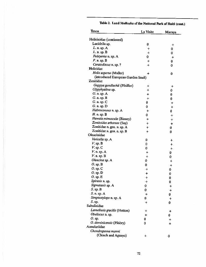
Thble 2. Land Mollusks ofthe National Park or Haiti (cont.)
Taxon La Visite Macaya
Helicinidae (continued)Lucidella sp. 0 +L.n.sp.A + 0L. n. sp. B + 0Fedeyenia n. sp. A 0 +F. n.sp.B + 0Ceratodiseus n. sp. ? + 0
HelicidaeHe/ix aspersa (Muller) + 0
(introduced European Garden Snail)Zonitidae
Guppya gund/aellii (Pfeiffer) + +G/ypyllyolilla sp. + 0G.n.sp.A + 0G.n.sp.B + 0G.n.sp.C 0 +G.n.sp.D 0 +Habrocollous n. sp. A + 0H.n.sp.B 0 +Hawaia milluseu/a (Binney) + +ZOllitoides arboreos (Say) + +Zonitidae n. gen. n. sp. A + 0Zonitidae n. gen. n. sp. B + 0
OleacinidaeVaricella sp. A 0 +V.sp.B 0 +V.sp.C 0 +V.n.sp.A + 0V.n.sp.B + 0O/eacilla sp. A 0 +O.sp.B 0 +O.sp.C + 0O.sp.D + 0O.sp.E + 0Spiraxis n. sp. + 0Sigmataxis sp. A 0 +S.sp.B 0 +S.n.sp.A + 0Streptosty/ops n. sp. A 0 +S.sp. + 0
SubulinidaeLame//axis gracilis (Hutton) + +Obe/iseus n. sp. + 0O.sp. 0 +O. dominieensis (Pilsbry) 0 +
AnnulariidaeCllolldropoma mallni
(Clench and Aguayo) + 0
72
jharold
Rectangle

'Thble 2. Land Mollusks of the National Parks or Haiti (cont.)
Thxon La Visite Macaya
Annulariidae (cont.)Orcuttipoma rolleii (Weinland) 0 +Weinlandipoma sp. 0 +Colobostylus n. sp. 0 +
Cyc1ophoridaeCrocidopoma sp. + 0
ProsperpinidaeProserpina n. sp. + 0
PupillidaeGastrucoptapellucida (Pfeiffer) 0 +
SuccinidaeSuccillea sp. 0 +
ClausiliidaeNenisca n. sp. 0 +
HaplotremaatidaeHaplotrematidae n. gen. n. sp. 0 +
BulimulidaeDrymaeus sallei (Pilsbry) 0 +
TotalsSpecies 45 57Species unique to each park 38 50NewThxa 27 27
'Thble 3. Annotated List of Amphibians and Reptiles knownfrom the Massif de la Hotte and Adjacent Areas.
The following 54 amphibians and reptiles were reported in Schwartz andThomas (1975). Henderson and Schwartz (1984), and/or this report, as occurringin the Massif de la Hotte in the weestern Tiburon Peninsula, Haiti. ... = indicatesthose taxa listed in the literature from the Massif de la Hotte, but not reportedfrom the study area; ...... = includes those taxa represented in collections from thestudy area; 1 = includes those taxa not previously listed from the Massif de lahotte, but are represented in our collections. Those species without notation arereported as occurring in the general area by Henderson and Schwartz (1984) andmay eventually be found within the study area.
OrderANURAFamily Leptodactylidae (22 taxa)
Eleutllerodactylus abbotti Cochran...... Eleutherodactylus apostates Schwartz... Eleutherodactylus audanti audanti Cochran...... Eleutherodactylus bakeri Cochran...... Eleutherodactylus brevirostris Shreve... ... Eleutherodactylus chloroplJenax Schwartz.... Eleutherodactylus counollspes Schwartz... Eleutherodactylus eunaster Schwartz.. Eleut1lerodactylus glandulifer Cochran... Eleutherodactylus glaphycompus Schwartz
73
jharold
Rectangle

Thble 3. Reptiles and Amphibians-Massif de la Hotte (cont.)
...... EleutlJerodactylus IJeminota Shreve and Williams
... EleutlJerodactylus hypostenor SchwartzEleutherodactylus inoptatus Barbour
...... Eleutherodactylus lamprotes SchwartzEleutlJerodactylus nortoni
...... EleutlJerodactylus oxyrhynchus Dumeril and Bibron
...... EleutlJerodactyluspictissimuspictissimus Cochran
... ... EleutlJerodactylus ruthae aporosstegus Schwartz
... Eleutherodactylus sciagraphus Schwartz
... EleutlJerodactylus semipalmatus Shreve
...... EleutlJerodactylus velltrilineatus Shreve
...... Eleutherodactylus wetmorei wetmorei CochranFamily Hylidae (4 taxa)
...... Hyla heilprilli Noble
.. Hyla pllichrililleata Cope
...... Hyla vasta Cope
...... Osteopilus domillicensis 'ISchudiOrder SquamataSuborder SAURIAFamily Gekkonidae (1 taxon)
... Sphaerodactylus elasmorhynchus ThomasFamily Anguidae (3 taxa)
...... Celestus costatus costatus Cope
...... Celestus stellurus stenurus Cope
... Sauresia sepsoides GrayFamily Iguanidae (19 taxa)
1 Allolis anllouri Cochran... ... Allolis coelestillus coelestinus Cope...... Allolis cybotes Cope... Allolis darlillgtoni Cochran...... Allolis distichus aurifer Schwartz... Allolis distichus suppar Schwartz... Allolis distie/lus vinosus Schwartz...... Allolis dolie/locephalus dolichocephalus Williams... Anolis dolichocephalus sannentkola Schwartz... Allolis koopmalli Rand... Allolis mOllticola monticola Shreve...... Allolis mOllticola quadrisartus Thomas and Schwartz...... Allolis ricordi leberi Williams... Allolis ricordi viculus Schwartz... Allolis rupillae Williams and Webster
Allolis semililleatus Cope... Allolis sillgularis Williams...... Chamaelillorops baroouri Schmidt...... Leiocephalus melanochlorus meianoc1J10rus Cope
Family Boidae (2 taxa)... ... Epicrates gracilis hapalus Sheplan and Schwartz...... Epicrates striatus exagistus Sheplan and Schwartz
Family Colubridae (3 taxa)...... AlltilloplJisparvifronsparvifrons Cope.. DarlillgtOllia haetialla haetiana Cochran...... Uromacer catesbyi catesbyi Schlegel
74
jharold
Rectangle

75
Status %ofSpecies Recent Fossil Sample
Plagiodolltia aedium R C 20.1Rattus rattus C C 13.9Rhizoplagiodolltia lemkei C C 12.3NesopllOlItes hypomicms EX C 11.5N. paramicrusPlagiodolltia velozi EX C 9.0Brotomys voratus EX C 8.2Hexolobodoll phellox EX C 7.4Groulld sloths (several species) EX C 5.7Isolobodoll portoricellsis EX U 4.1SolellodolJ paradoxus R U 2.5SolellodOil marcalloi Unknown R 1.6Isolobodoll mOlltallus EX R 1.6Mus musculus U R 0.8Saimiri bemellsis EX R 0.8
'Thble 4. List of fossil and Recent land mammals in order of abundancecollected from Trouing Jeremie #5, the type locality of Rhizoplagiodontialemke~ located the base of Pic Formon in the upper Plain of Formon. (C =common, U = uncommon; R = rare; EX = extinct). The analysis is of thetop 4 cm of sediment.
A modern barn owl (Tyto alba) portrayed on a card we hand out onour search for owls, caves, and fossil mammals. The fossil drawn here
is the Small Island Shrew.
jharold
Rectangle

1lIbie S. Endemic land mammals of montane regions of the Massif de laHolle and Massifde la Sene ofsouthern Haiti. (EX =extinct; PR =present;NP = never present.)
Species LaSeUe La Hotte
Order RodentiaFamily CapromyidaePlogiodontitl oedium PR PRP. velozi EX EXP. tmIeU1n EX NPlsolobodonponoricensis EX EXlmonltlnus EX EXRhizopltlgiodontitllemkei NP EX
Family EchimyidaeBrotomys voTtllus EX EX
Order PrimatesFamily CebidaeStlimiri bemensis EX EX
Order InsectivoraFamily SolenodontidaeSolenodon poradoxus EX PRS. mtueanoi EX PRe?)
Family NesophontidaeNesophonles zomiCTUS EX EXN. hypomicTUS EX EXN. ptlTt1miCfUS EX EX
Order XenarthraFamily MegaJonycbidaeSynocnus comes EX EXPtlTOCnus EX EXNew taxon EX EXNew taxon EX EXNew taxon EX EX
Thtal number of taxa 17 18Number of surviving taxa 1 2Number of endemics not found in
other park 1 1
76

CH.APrERIV
THE BIRDS OF MACAYAIntroduction
Hispaniola has73 species ofresident land birds, the largest number ofany islandin the West Indies (Lack,1976). 1\ventyspecies (28%) are endemic to Hispaniola(Thble 6). 1\vo additional species are resident in high elevation pine forests inHispaniola but are not found elsewhere in the Antilles. Theyare the HispaniolanWhite-winged Crossbill (Loxia leucoptera megaplaga) and the Hispaniolan PineWarbler (Dendroicapinus chrysoleuca), both ofwhich probablybecame restrictedto the island from their natural range in North America during Pleistoceneclimate cycles. Another species, the Rufous-collared Sparrow (Zonotrichiacapensis), is a South American migrant that now breeds in montane forests(including pine forests) above 1,250 meters in Hispaniola, but is not foundelsewhere in the Greater Antilles. Corvus leucognaphalus, the White-neckedCrow, which is now extinct in Puerto Rico, is another species restricted toHispaniola. Of these "endemic" (sensu lato) land birds found onlyon Hispaniola,ten are restricted to habitats occurring above 1,000 meters. Another nine speciesoccur in these same habitats, but also occur in forest habitats below 1,000 meters.Only five endemic species are specifically associated with lowland xeric orsavannah habitats. The ecological importance of broadleaved and pine forestsoccurring above 1,000 meters elevation to the conservation of the avifauna ofHispaniola is very clear.
Hispanolia has more species of resident land birds than any other Antilleanisland. With 73resident land birds, it has five more species than Cuba even thoughCuba is closer to the North American mainland and is 30% larger in area. Thereare 66 resident land birds in Jamaica, which is only 14% the size of Hispaniola.A higher number of these are endemics (27 species, 41%) because of the remoteand isolated location of Jamaica. In his analysis of the birds ofJamaica and the
77
Haiti is especially important inthe development of conservation strategies for birds in theWest Indies.
jharold
Rectangle

One endemic species ofland bird is restricted onlythe the mountains ofsouthern Haiti, the GreyCrowned Palm Tanager, orIIKat Je Sid. II
West Indies, David Lack (1976) noted that 25 species of Hispaniolan land birdsare absent from Jamaica and Cuba. Nine of these have close relatives on one orboth of the other islands. but 16 are without close relatives in either Jamaica orCuba. Hispaniola, therefore, is the West Indian island with the largest and mostunique avifauna.
This chapter concentrates on resident land birds found in montane habitats ofthe Macaya area occurring above 1,000 meters. There are three importantreasons for this emphasis. First, 80% of the endemic species ofHispaniola occurin such habitats; secondly, habitats occurring above 1,000 meters are in a morenatural state because they have been less exploited and usually receive morerainfall; and thirdly, it is possible to justify conservation efforts in these regionsbecause of the importance of high montane regions in watershed conservation.Almost all of the land area within Parc National Pic Macaya are above 1.000meters elevation, as are most of the regions of the proposed Macaya BiosphereReserve.
This chapter concentrates on the status of resident land birds (plus the Blackcapped Petrel) and their critical habitats within the Macaya area. It does notdiscuss the status of migratory species. The mountains of Haiti, and especiallythe Massif de la Hotte provides habitat for a large number of North Americanmigratory song birds, and the destruction of the forests of the region is a majorthreat to the stability of these species. A study of the status of migratory speciesthat are winter residents of the Macaya area should be given high priority in theplans for Macaya Biosphere Reserve. and Parc National Pic Macaya. Suchstudies are planned as part of the MacArthur Foundation conservation Projectin Haiti.
This chapter emphasizes resident species in the Macaya area because of theimmediate need for data in planning the conservation program for the biospherereserve and national park, and because these species are so important to thenatural patrimony of Haiti. Some of the reasons for this importance are:
1). Southern Haiti has a resident land bird that is restricted tothe mountains of the southern peninsula, the Grey-crownedPalm Tcmager (Plraellicoplrilus polioceplralus);
2). One of the most endangered birds of Haiti, the Whitewinged Warbler, still occurs within the boundaries of Parc National Pic Macaya, and it is very important to initiate a SpeciesRecovery Plan for this bird as soon as possible;
3). Three birds are dependent on upland pine forests (PineWarbler, Antillean Siskin, Crossbill), and the management ofthis threatend forest community in the Macaya area is of greaturgency for both the protection of the six watersheds of theregion as well as for the preservation of the area's unique levelof biodiversity;
4). The pending World Bank Project, and USAID andMARNDR will need data and information on the flora andfauna of Macaya in order to make wise decisions on plans forthe land stewardship of the Macaya highlands. Birds are one ofthe best indicators of the state of the environment in an area.Most of the species discussed here are true "indicator species".
78
jharold
Rectangle

Terminology
Names of birds are presented in the Species Accounts section as: 1) Englishname and scientific nomenclature, which follow the current checklist by theAmerican Ornithologist Union (AOU,1983); 2) Haitian Creole name as determined by our own fieldwork and the work of Nelson (1979), and with the spellingas presented in Valdman's Dictionary ofHaitian Creole; 3) French name as statedin Bond (1985); 4) Spanish name as determined from the list of Aves de laRepublica Dominicana prepared by La Sociedad Dominicana de Ornitologia.
The status of each species is defined as a percent figure for each habitat. 1)Common: readily encountered during any week of observations of a particularseason. 2) Uncommon: encountered more than once but less than five timesduring any week ofobservations ofa particular season. 3) Rare: not encounteredon a regular basis but recorded as present. 4) Vulnerable: birds that are commonin certain parts of their natural range but which are in habitats or situations thatare not stable and are declining. 5) Threatened: birds that are in immediatedanger ofbeing severely reduced in numbers or eliminated by current trends eventhough the current status may be common or uncommon. 6) Endangered: birdsthat are uncommon or rare and are likely to be eliminated unless immediate actionis taken to alter current land use practices or affirmative action is taken to protectthe species in some manner. For the latter three categories, the "ConservationIndex" is used as the basis for the determination of status. An index of aabove 80indicates Endangered; 65-80 indicates Threatened; 50-65 indicates Vulnerable.
Bird Census Techniques1. Daily lists. Data were collected daily as to: 1) species observed; 2) individuals seen or heard; 3) habitat associations; 4) noteworthy information on
habits, vocalizations, associations or densities. These data were summarized andanalyzed on a weekly basis and used to make decisions as to where to run transectsand set mist nets, as well as to provide the data set for the study.
2. Mist nets. In selected habitats mist nets were monitored from dawn to darkat the same location for at least a week, and repeated at different seasons and insubsequent years. Nets were set in locations such as ravines or along riparianhabitats where observation of birds was difficult because of the thick vegetationand the secretive habits of certain species. Birds captured were evaluated as tospecies, sex and reproductive status. Photographs were taken of all species.Some species were frequently captured in mist nets but not located in transectsor via regular observations. When unusual birds were encountered in transects,mist nets were used to confirm the identifications (i.e., the possibility that Blackcrowned and Gray-crowned Palm Thnagers hybridize in the Massif de La Selle;the presence of White-winged Warblers in the Massif de La Hotte).
3. Thansects. Transects were run on a daily basis for at least 7 days during twosubsequent seasons to determine habitat associations of each species. Routeswere selected to pass through major habitat types in the approximate percentagethat the habitat occurs in the region. Following the technique of Emlen (1977),one or two observers walked the transect for a four-hour period beginningat 0600hours. Species were identified by visual contact or by song, call or note. Datawere recorded as to: 1) species; 2) number of individuals; 3) time; 4) habitat; 5)type of observation (visual, auditory); 6) distance from observer.
4. Special Counts. Some species are difficult to census via mist nets ortransects. Data on these species were compiled separately and treated on anindividual basis.
79
Black-capped Petrels canonly be located, identifiedand censussed by usingtheir unusual vocalizations.
jharold
Rectangle

The Conservation indexhas been developed to beable to make decisionsabout conservationpriorities of birds in Haiti.The species in this chapterare listed in order of rankon the conservation index.The most endangeredspecies of bird in Haiti isthe White-winged Warbler.
a. Parrots were recorded as numbers of individuals in flocks, andwhere the flocks were feeding or roosting.
b. Hawks, Swallows, and Swifts were recorded as numbers offlying individuals observed. Efforts were made to locate nests ofCollared Swifts in caves.
c. Black-capped Petrels were identified by locating the area oftheir vocalization at night. The number of individual birds wasdetermined by counting the number of distinct vocalizations perminute over a ten minute period and then averaging these data(Thble 7). Where possible, more than one observer was used tocount the vocalizations and several different observers countedPetrels at different locations to establish the areas where nestingburrows were located and the directions the birds were comingfrom as they returned from the sea in the early evening hours.
AnalysisData were compiled into tables, and observations were tallied by habitat to
produce a count and percent figure of the number of times each species wasencountered in each habitat. The data were analyzed as to total number ofindividual birds per sample period, total number of species and average numberof individual birds encountered per day. Table 8 briefly summarizes the data forone collecting period.
Final Ust. All of the data collected over the study period were analyzed todetermine the fifteen species most closely linked to forest habitats in montaneareas. The original list included twenty species, but the Limkin, HispaniolanParakeet, Collared Swift, Black Swift and Hispaniolan Pine Warbler wereeliminated because their status is less specifically linked to montane mesic foresthabitats.
Conservation Index. An index was calculated for all species on the list. Theindex is a measure ofthe priority that should begiven to each species in developinga conservation effort. Five individual factors were considered in calculating theConservation Index.
A. Generic uniqueness (5)Highest :# for monotypic genera.
B. Habitat Specificity (10)Highest :# for a very specific association.
C. Status (10)Highest :# for most endangered status.
D. Endemicism Factor (10)Highest :# for most endemic.
E. Biotic Potential (10)Highest :# for lowest clutch size.
The fmal Conservation Index is the sum of A-E x 2.2 (to produce a maximumscore of 1(0). The species of highest priority have the highest score. An indexfigure above 80 is considered Endangered; between 65-80 is consideredThreatened; between 50-65 is considered Vulnerable.
80
jharold
Rectangle

ItineraryInitial fieldwork was done in the Massif de La Holte area in May of 1975 when
we surveyed the north side of Pic Macaya and west as far as Morne DeuxMammenes. In January, 1977, we expanded the survey to the western portion ofthe La Holte range in the Morne Mansinte, Morne Epine and Morne Grand Boisarea near the southwestern tip of the southern peninsula. In January, 1979, thesurvey also included the Mont Des Cartaches, a separate series of..mountains inthe far tip of the southern peninsula of Haiti north of Riviere de Grande Anse.Fieldwork continued in January, 1983, with support by the International Foundation for the Conservation ofBirds, when we surveyed Pic Formon from the south.Additional fieldwork in January, 1984, established a new trail along the ridge ofFormon westward across 2,200-meter Pic Le Ciel ("Le Syel", the sky, in creole)and along the narrow connecting ridge to the top of Pic Formon. The trail thenfonowed the narrow steep ridge connecting Pic Formon to Pic Macaya. A basecamp was established on the top of Pic Macaya in February, 1984. Ekman (1926,1928) had tried to climb Pic Formon and Pic Macaya from this direction severaltimes between 1917 and 1928 but was unsuccessful because of the rugged terrainand dense vegetation. Nobody has ever penetrated this' region all the way to PicMacaya from the south. Fieldwork continued in the same area in May, 1984,January and February of 1985 and November, 1985. Additional surveys wereconducted as part of the Sondeos in 1988 and 1989. The final survey was done inApril, 1992.
INDIVIDUAL SPECIES ACCOUNTSEighteen (18) resident bird species have been selected as being closely linked
to mesic forests in montane regions in Haiti. These species are listed in Table 9along with an indication of their status and conservation index. The species wereselected from a list ofover 70 species studied over a ten year period (1975-1985).Some of these data have previously been discussed (Woods, 1975; Woods, 1985;Woods and Ottenwalder, 1986) and were the subject of a paper presented at thefust Jean Delacour Conference (Woods and Oltenwalder, 1983). Of the 18species, 16 are found in the Macaya area. The additional two species, the La SeneThrush and the Ground Warbler are included in this chapter because of theirimportance in the avifauna ofHaiti, andbecause they are critical species in Haiti'sother main national park--Parc Nationalla Vasite.
The species discussed below are arranged in order of their conservation index.The most endangered species are discussed first, fonowed in ranked order byspecies less endangered or threatened It should be noted, however, that themethod ofcalculating the conservation index is not perfect, and does not take intoaccount aU of the factors that might lead to the loss of a particular species. AUof the species discussed here are closely associated with the montane habitatsfound in the area of Parc National Pic Macaya. The species accounts also includediscussions of two birds from Parc National La Visite: the La Selle Thrush andthe Green-tailed Ground Warbler. These two species are included in this chapterbecause of their importance in the avifauna of Hait~ and because we hope thatthe conservation efforts presently underway in the Macaya area win be expandedto the La Selle region that includes the zone between the national park at MorneLa Visite and the top of Haiti's highest mountain, Pic La Sene.
81

White-winged Warbler
ENDEMIC
ENDANGERED
WHITE-WINGED WARBLER
Xenoligea montana
Ti Chit Kat Je
Petit Ouatre-yeux
Ciguita Aliblanca
Description: This endemic warbler resembles the Ground Warbler. It isgreenish above with a grey neck and head. However, the tail is slate grey with theouter tail feathers black--edged in white. There is a prominent white streak onthe wing. On the head there is a white stripe in front of the eye, and a white spotbelow the eye--hence the common name in creole "little bird with four eyes" or"little four eyes" in reference to its resemblance ofthe PalmThnager which is called"four eyes".
Habitat and Distribution: This secretive species is most often found in densestands of broadleaved vegetation. It is encountered more frequently in trees andopen areas than is the Ground Warbler. It is larger and has a much heavier billthan the Ground Warbler. According to Wetmore and Swales (1931), the Whitewinged Warbler combines the mannerisms of a warbler and a vireo. It has beenreported by Bond (1928), Wetmore and Swales (1931) and Wetmore and Lincoln(1933) in both the La Selle and La Hotte areas, where they found the Whitewinged Warbler to be fairly common. We did not find it in La Visite, and haddifficulty locating it in Macaya. We most often found it in Disturbed BroadleavedForest (80%) at 1,800 meters elevation on Pic Formon, and in the MatureBroadleaved Forest (20%) habitat along the ridge of Formon at about the sameelevation. Wetmore and Lincoln (1933) also found the White-winged Warbler atintermediate elevations in the Macaya area and observed that they were mostcommon between 1,300 and 1,800 meters elevation in the broadleaved forest.Bond (1928) found this warbler to be common in the Morne Malanga, MorneTranchant and Crete-a-Piquant areas above Port-au-Prince and on the slopes ofthe Massif de La Selle where he noted that they were about as common as theGround Warbler. All of these areas have been severely deforested, and theWhite-winged Warbler has been nearly (if not completely) extirpated. InSouthern Haiti the White-winged Warbler hangs on by a thread, dependent uponthick stands of Mature Broadleaved Forest between 1,300 and 1,800 meterselevation.
Seasonal Status: Year round resident. Nests in April-May. (ENDEMIC).
Status: The most endangered bird of Haiti. Very rare and possibly extirpatedfrom the Massif de La Selle; rare and endangered in the Massif de La Hotte.
Recommendations: This species is dependent on Mature Broadleaved Forestat intermediate elevations (1,200-1,800 meters). These habitats must bepreserved if the White-winged Warbler is to survive. The area west of Morne LaVisite all the way to, and including Morne d'Enfer, must be included in ParcNational La Visite. This region has extensive areas ofMature Broadleaved Forestwhich have been preserved because the Morne d'Enfer area is extremely inaccessible. Morne d'Enfer must be added to Parc National La Visite, and all cuttingofthe Mature BroadleavedForest above the Plain ofFormon within Parc NationalPic Macaya must be stopped if this species is to be prevented from becomingextinct in Haiti in the near future.
Conservation Index = 92.4
82
jharold
Rectangle

CHAT TANAGER
CalyptoplJilus frugivorus
Koniehon
Cornlehon
Chlrrl, Patieo
Description: This~ secretive bird is largely terrestrial in habits. It isolive-brown above and white below with a yellow spot in front of the eye (loris)and on the bend of the wing. It is most frequently identified by its vocalizations,which are loud and very diagnostic. The song is a clear, ringing "chip-chip-swerpswerp-swerp" or a "swerp-swerp-chip-chip-chip". The same bird can give bothsongs. The song can be heard throughout the year, but is most common in spring.The Chat Thnager can also be located in its thick, brushy habitat by its note, adistinctive, loud "tic".
Habitat and Distribution: This species is associated with remote areas, anddense, wet thickets ofMature Broadleaved Forest. Dod (1981) notes that it is notfound below 1,650 meters elevation in the Dominican Republic, but we found itdown to 1,000 meters in the wetter areas of Macaya and La Visite. Wetmore andSwales (1931) did not find the species in the La Visite area, but did encounterone individual at 1,000 meters on Pic Macaya. We found the bird to be muchmore common than did Wetmore. In La Visite we found the bird in MatureBroadleaved Forest (75%) and Disturbed BroadJeaved Forest (25%) areas. Itwas common on the steep face of the massif (Nan Nway) and in dense stands ofMature Broadleaved Forest, such as the forest behind the park headquarters. Itis always in areas that are wet and densely forested. In the Macaya area, weencountered Chat Thnagers in Mature Broadleaved Forest (75%), DisturbedBroadleaved Forest (15%) and Mature Pine Forest (10%). It was most commonin the Mature Broadleaved Forest underneath the towering pines on the peak ofMacaya. On the Plain of Formon we encountered Chat Tanagers in MatureBroadleaved Forest on Karst (75%) and Disturbed Broadleaved Forest (25%)habitats.
Because this species is confmed to areas of mesic broadleaved vegetation (LaHotte, La Selle, Cordillera Central, Sierra de Neiba as well as La Gonave Island)that are surrounded by drier lowland regions where Chat Tanagers do not occur,there are five distinct and widely separated populations. Chat Thnagers in eachof these regions differ from one another, and range from individuals that are palerin coloration and have more basic vocalizations in the east, to larger, darker birdswith long complex vocalizations in the west. Wetmore and Swales (1931) notedfour forms (designated as subspecies) and Bond and Dod (1977) described a fifthone from the Sierra de Neiba. The two populations that apply to the mountainsof southern Haiti are:
CalyptoplJilus frugivorus tertius from the Massif de La Hotte, and therefore ParcNational Pic Macaya.
Calyptophilus frugivorus selleanus from the Massif de La Selle and nearbyMorne Malanga, Morne 'Iranchant, Morne Brouet and Crete a Piquants. Thisform has long been considered a synonym of C. f. tertius (dating from 1936, seeBond and Dod, 1977).
The status of these local populations and the validity of the various subspeciesis in need of review. We believe that the birds from the La Hotte area arenoticeably larger and darker in coloration with more dramatic yellow lores than
83
Chat-Tanager
ENDEMIC
ENDANGERED
The Chat Tanager of PicMacaya is a distinct subspecies, and has a longand beautiful song thatdistinguishes it from allother populations of thisspecies in Hispaniola.
jharold
Rectangle

Hispaniolan White-wingedCrossbill
ENDEMIC
ENDANGERED
the Chat 'Thnagers on La VlSite, and that their vocalizations are more elaborate.It is questionable to lump the La Selle and La Hotte (South Island) populationstogether as C. f. tenius. The La Hotte and La Selle populations should beregarded as distinct subspecies. The Chat 'Thnager from the Sierra de Neiba,Calimete and Cordillera Central of the Dominican Republic is C.f. neibae (Bondand Dod, 19n).
Seasonal Status: Year-round resident. (ENDEMIC)
Status: Restricted to mesic Mature Broadleaved Forest in both the Massif deLa Selle and Massifde La Holte. Because it is only found in these wild wet places,and is restricted in distribution into distinct subspecies, the Chat Tanager isendangered.
Recommendations: Mature Broadleaved Forest habitats must be protected insome areas, most appropriately within the boundaries of the national parks in theMassif de La Selle and Massif de La Holte.
Conservation Index = 90.2
HISPANIOLAN WHITE-WINGED CROSSBILL
Loxia leucoptera megaploga
Bek Kwaze
Bec-Crolse, Gras Bee
Pica Cruzado, Turquesa
Description: This species is distinguished from aU other birds in Hispaniola byits bill, which overlaps above and below. The male is rosy red in coloration withblack wings and tail. The wings have two white wing bars. The female isyellow-green in coloration and streaked with broWD. It also has wing bars. Thespecies spends most of its time on the top of taU pines and is difficult to observeunless one is familiar with the vocalizations: a dry "chif-chif' or "shik-shik" that isrepeated on and on.
Habitat Distribution: The White-winged Crossbill or "Bek Kwaze" is confinedto the pine forests, where it feeds on the cones of mature pines. Wetmore andSwales (1931) found crossbills to be abundant on the Morne La VlSite area, butdid not find it in Macaya. We found crossbiUs in both La Visite and Macaya. InLa VlSite, 100% of the observations were in forests or open areas of mature PineForest. In Macaya, the birds were more widespread (probably because there arefew pure stands of old-growth Pine Forest). We found crossbiUs most often inPine Forest mixed with Broadleaved Deciduous Forest (93%), especially on thetop of Pic Macaya, and in open Successional Broadleaved Forest on the upperslopes of Pic Macaya (7%).
Seasonal Status: Year-round resident. (ENDEMIC)
Status: Frequently observed in suitable high mountain habitats ofMacaya, butvery vulnerable to extirpation. Depends on mature pines producing seeds.Recent sutides indicate there may be as few as 500 individuals surviving onHispaniola. This species is endangered.
Recommendations: This species is dependent upon large areas of maturepines. No pines should be cut in the park, and large areas of pine should be
84
jharold
Rectangle

planted and allowed to reach mature size in the buffer zone (Macaya BiosphereReserve).
Special Comments: The White-winged Crossbill had never previously beenreported from Haiti west of La Selle, and we did not observe the species inMacaya until 1984. We found two flocks of 12-15 birds each on the top of PicMacaya in January of 1984 and 1985, suggesting that the species has beenexpanding its former range. Crossbills were also present on Macaya in November, 1985, and in addition, a flock of 12-15 birds was observed in November onPic Formon and in the saddle between Pic Formon and Pic Macaya. Whether theextent of pines on Macaya is sufficient to support a breeding population of theWhite-winged Crossbill is questionable and unresolved. It is extremely importantto note, however, that the cutting of all mature pine trees in the MacayaIFormonregion must be stopped if there is going to be any chance for erossbiUs to establishthemselves successfully in the Parc National Macaya.
The White-winged Crossbill is a species of the northern conifer forests, andwithin the Antilles is found only in Hispaniola. It is one of the most unusual birdsof the AntiUes, and its presence in Haiti is a relict ofthe last great IceAce in NorthAmerica when the climate was much cooler and drier in Haiti.
Special note: Recent studies indicate that this bird is probably a distinct species.Pine forests in Haiti should be managed to insure the continued presence ofmature con-bearing trees to protect this species.
Conservation Index = 81.4
BLACK-CAPPED PETREL
Pterodroma hasitata
Chanrouan lasel
Chat-huant
Dlablotln
Description: This seabird is about the size ofa crow (38 cms) and is grey-blackon the wings and back above and white below on the body. The neck and base ofthe tail are white and there is a distinct black cap on the head. The beak is darkin color, hooked at the tip and has a pair ofexternal tubular nostrils. They fly veryfast and are observed over land in Haiti only at night when they return to theirbreeding areas in the high mountains. They are best identified by their distinctivevocalizations which can be heard off the cliffs where they breed. The vocalizationresembles a "hum" with a distinct sharp note (tick-ek). Wingate (1964) describedthree distinct vocalizations by courtingbirds, all ofwhich we heard and identified.These vocalizations are: 1) "a long drawn out aaa-aw ending abruptly with eek,repeated several times in succession..."; 2) "a long drawn out ooowendingabruptlyin uk, repeated several times in succession..."; 3) II ...a series of whines and yelpslike a hurt puppy-- week-week-week-cueek cu-u-cek cu-u-eeck".
Habitat and Distribution: The Petrel nests on forested cliffs in mountainousareas, which in Haiti are above 1,500 meters in elevation. They excavate burrowsthat are 1-3 meters deep or utilize rock crevices on the face ofcliffs. In the Massifde La Selle, Petrels have been known to occur since 1963 when Wingate (1964)reported their presence and described their status on the north face of the LaSelle escarpment between 1,500 and 2,000 meters elevation. Wingate reported
85
Drawing of Mome La Visitearea with Pic La Selle in background. The steep cliffs arenesting areas for Blackcapped Petrels.
jharold
Rectangle

A high priority should begiven to protecting thehabitat of the Blackcapped Petrel in the centerof Parc National PicMacaya.
Black-capped Petrel being held by Dr. David Wingate on Morne IsVlslte.
two colonies between Morne La VlSite and Morne Cabaio, two colonies betweenCabaio and Thte Opaque, and one colony on the southwest boundary of ParcNational La Visite. In total, he estimated the existence of 11 colonies along theMassif de La Selle, each colony containing a minimum of 50 pairs (1,100 individuals). Five colonies of 50 pairs of Petrels (500 birds) were estimated byWmgate to be present in the western third of the Massifde La Selle in 1963. Ourcensus in the winter of 1984 indicates that there are now fewer colonies withinthis same area. The colony still exists on Morne La VlSite and there are twocolonies in the Thte Opaque area within the boundaries of the Parc National LaVisite. Using Wmgate's standard of 50 pairs per colony, the park would nowcontain 300 birds (a 40% reduction in 20 years). We are not familiar withWmgate's census technique, which is based on his experiences with knownpopulations of the closely-related Cahow from Bermuda, so we are not able torelate our estimates to Wingate's data. Our estimates are based on the numberof complete vocalizations recorded per minute, and are presented in 'Thble 7.
In the Massif de La Hotte there is comparable habitat (steep cliffs) on upperslopes ofboth Pic Formon and Pic Macaya above 1,500 meters elevation. In 1975,we searched the north slope of Pic Macaya for Petrels without success. In 1982,Wmgate and Paul Paryski searched the south areas ofPic Formon without success.In 1984, Paul Paryski and Charles Woods located and evaluated the status of acolony of Petrels on the south facing cliffs of Pic Macaya. The colony is concentrated above 2,000 meters elevation west of the ridge connecting Pic Formonwith Pic Macaya. A second group ofbirds can be heard vocalizing south and westof the colony on Pic Macaya, and is probably located on the northwest face ofPicFormon. Efforts to document the exact location of a colony on Pic Formon wereunsuccessful because of repeated bad weather (high winds and rain). On nightswith high wind and rain, no vocalizations can be heard even at sites with largecolonies.
Seasonal Status: Black-capped Petrels arrive at their breeding sites in themountains of Haiti (and a few sites in the Dominican Republic) beginning in lateSeptember. Peak breeding occurs in late December, January and February. Eggs
86

(a single egg by each female) are laid during January and February. The youngare fledged in the spring and vocalizations are no longer heard after late April.From May until late September (5 months), the birds are presumably away fromtheir breeding grounds in Haiti.
Status: In both the Massif de La Selle and Massif de La HoUe, the Blackcapped Petrel is common in suitable habitats. These habitats are limited innumber and are rapidly being deforested. Dogs, cats and the mongoose arebecoming more abundant in the nesting areas. The Black-capped Petrel isendangered as a result.
Before 1850, the species was known to occur in the higher mountains ofMartinique, Dominica, Guadeloupe and Jamaica as well as Hispaniola (andpresumed to have occurred in Cuba). They were presumed to have becomeextinct in Dominica by 1881, although they were reported on Diablotin Mountainin 1977 (Bond, pers. comm.). They disappeared from Martinique andGuadeloupe in the 184Os, in Jamaica sometime in the late 1800s. The only knownlocalities where Black-capped Petrels are documented to still breed are Haiti,two small colonies in the nearby Sierra de Baoruco Mountains of the DominicanRepublic, and the Sierra Maestra mountains of Cuba (Bond, 1978).
Recommendations: The Black-capped Petrel is vulnerable to exploitation,predation and habitat destruction. By lighting a fire on a cliff top above a colonyof Petrels on a foggy moonless night, birds can be easily captured as they fly nearthe fires and crash into the fire or nearby vegetation (Wmgate, 1964). Thistechnique, called "sen sel", works only when the species is breeding betweenJanuary and March and when the fITes are set above the colony. No fITes shouldbe allowed on the peaks of the mountains during the winter months, and nopeasants should be allowed to capture Petrels. Furthermore, we have documented dogs digging Petrels from burrows, and Petrels are vulnerable to predation by cats. We recommend that all dogs and cats in the national parks be killedand that no gardens or trails be allowed anywhere near the steep cliffs within theboundaries of the parks. Petrels depend on vegetation to protect the burrows androck crevices. This vegetation is easily destroyed by fires that sweep up themountainside from below. We recommend that no gardens or fITes be allowed ina buffer zone that extends down to an elevation ofat least 1,400 meters elevationbelow the cliffs within each park. This buffer zone should extend all the way tothe base of the mountains and the flat areas below.
The effects of the mongoose and Rattus on the Black-capped Petrel is undocumented. Rats may destroy Petrel eggs and can easily kill young birds. Bell andKeith (1983) concluded that rats could affect the reproduction of Dark-rumpedPetrels in the Galapagos Islands, and that "even though the facts are not c1ear...ratcontrol should be undertaken in Petrel colonies." We do not recommend thecontrol of rats in Parc National La Visite until a way can be found to guaranteethe security of the populations ofHaitian hutias (Plagiodontia aedium) that occurin close proximity to the colonies of Petrels all along the ridge of La Visite.
The mongoose, introduced in Haiti in 1907, is now widespread up to even highelevations of the Massif de La Selle and Massif de La HoUe. It occurs above 2,000meters in both ranges, and therefore is found within the area ofall known breedingcolonies of Petrels. Goats and sheep also occur widely and should be removedfrom both national parks since they are capable ofdestroyingvaluable forest coverand disturbing nesting Petrels.
Conservation Index = 81.4
87
jharold
Rectangle

Antillean Piculet
ENDEMIC
THREATENED
ANTILLEAN PICULET
Nesoctites micromegas
Chapantle Bwa
Charpentier Bois, Pic
Carpintero de Sierra
Description: The Antillean Piculet looks and acts quite unlike a woodpecker.It is greenish in color on the back and whitish (or yellowish) on the belly, streakedwith black. The top of the head is yellow. The bill is short, as is the tail (which issoft and not used as a brace in climbmg). The Antillean Piculet climbs about onthe bark of trees more like a nuthatch than a woodpecker. It is secretive anddifficult to observe. The best field characteristic is its vocalization, a loud, rapid"kuk-ki-ki-ki-ke-ku-kuk" or "tu-tu-tu-lo-feo". The male and female often answereach other (duet singing).
Habitat and Distribution: This is one of the most unusual birds of Hispaniola.The Antillean Piculet, unlike the Hispaniolan Woodpecker, is not an agriculturalpest. The Piculet occurs in a variety of habitats. It is most common in humidMature Broadleaved Forest environments at middle elevations (700-1,700meters). Its characteristic vocalizations were not heard in the Massif de La Sellearea, probably because the Mature Broadleaved Forest habitats in the region areso fragmented. The Piculet is widely distributed and frequently observed in theLa Hotte region. It is common in the Mature Broadleaved Forest on Karst (17%)and Disturbed Broadleaved Forest on Karst (35%) habitats of the karst hills ofthe Plain ofFormon. In the higher mountains, the Piculet is abundant in the basinon the slopes of Formon at 1,700 meters (67%) in Mature Broadleaved Forest,(33%) in Disturbed Broadleaved Forest), but was not observed on the peaks. Itwas observed in the Gran Ravin.
Seasonal Status: Year-round resident. (ENDEMIC)
Status: Common in specific mesic habitats up to 1,700 meters in the Massif deLa Hotte, but not observed in the Massif de La Selle. Threatened by habitatdestruction.
Recommendations: The preservation of this species depends upon the existence of mesic broadleaved forest at middle elevations. The Antillean Piculet isnot able to find refuge in the remaining high mountain forests, and its preferredhabitat in middle elevation areas is frequently deforested. A major effort shouldbe made to preserve patches of mesic forest in the buffer zones surrounding eachpark.
Conservation Index = 74.8
88
jharold
Rectangle

HISPANOLIAN TROGON
Priotelus roseigaster
KalsonWouJ
Calecon Rouge, Dame Anglalse, Pic de Montagne
Papagayo or Cotorrita de Sierra
Description: This is one of the most dramatic and attractive birds in Hispaniola.The head, back and tail are bright green while the throat and chest are grey. Thebelly and rump are bright red and the long flowing tail has white spots on theunderside. The short bill is bright yellow and the eyes are bright orange. Thevocalization, a loud but mellow "krack-kaow" or "cuh-kwao," is very characteristicand can be heard from a great distance.
Habitat and Distribution: The 1I'0gon nests in cavities in trees, often anabandoned nest-hole of a Hispaniolan Woodpecker. It can be found in a varietyof habitats including Mature Pine Forest and Mature Broadleaved Forest, butprefers well-forested regions in the mountains where it feeds on wild fruits. Inupper elevations of Pic Macaya, 85% of the sightings were from Mature Broadleaved Forest habitats with the remaining sightings being in Mature Pine Forest(8%), and Disturbed Broadleaved Forest (8%). On the Plain of Formon, 100%ofthe observations were in Mature Broadleaved Forest on Karst. Wetmore notedthat in 1931, Trogons were common up to the summit of Pic Macaya, and wereespecially numerous among the great pines of higher altitudes. They wereobserved daily in the trees around their camp at 1,275 meters elevation. The1I'0gon is now less abundant in the region because of habitat destruction. In theMassif de La Selle, 100% of the observations were in Mature Broadleaved Foresthabitats in diverse locations from the La Selle escarpment to mesic hollows andravines at lower elevations on the plateau.
Seasonal Status: Year round resident. (ENDEMIC)
Status: The 1I'0gon is more abundant in the Massif de La Hotte than La Sellebecause more Mature Broadleaved Forest remains in that area of high rainfall.It is common in all sections of Parc National Pic Macaya; uncommon in ParkNational La Visite. The 1I'0gon is dependent on mature trees to nest in, anddiverse standsofMature Broadleaved Forest for shelter and food, and this habitatis rapidly disappearing. So much of this habitat has been cut in the past five yearsthat the 1I'0gon is now threatened in all areas of Haiti.
Recommendations: The large stands ofMature Broadleaved Forest that are soimportant to the preservation of this species must be protected, especially in thenational parks. Artificial nest boxes should be placed in forested areas within thenational parks as a method of encouraging breeding.
Special Note: The bird is an excellent candidate for distinction as the Nationalbird of Haiti: it is beautiful, depends on mature broadleaved forest for nestingand refuge, and is vocal, so it is one of the most characteristic species of themountains of Haiti. Its very characteristic song is a true measure of an envrionment in balance with nature.
Conservation Index = 74.8
89
Hispaniolan Trogon
ENDEMIC
THREATENED
jharold
Rectangle

Antillean Euphonla
THREATENED
ANTILLEAN EUPHONIA
Euphon;a musica
Louldo
Louis d'Or or Olseau Grand-pere
Jilguerillo
Description: This tiny species, among the smallest passerine birds of Haiti, issecretive and difficult to observe. The male is very colorful, being deep violet blueon the back, wings and tai~ light blue on the crown of the head and hindneck andyellow on the rump. The underparts are yellow. The female is green above witha light blue crown and neck and yellow underparts. The bird is almost impossibleto observe because of its habit of feeding in the upper limbs of trees, and is mosteasily recognized by its characteristic vocalization--a plaintive whistle followedrapidly by a soft tuk-tuk so it sounds like "ee-oo-tuk-tuk", or "i-i-i-u-u-...tuk, tuk".
Habitat and Distribution: The Antillean Euphonia or "Louido" feeds on thesoft fleshy bones of mistletoe, and is common in well-forested regions, especiallyat higher elevations. Wetmore and Swales (1931) and Wetmore and Lincoln(1933) recorded the species at 1,500 meters on the north slope ofMome Cabaio,and in Macaya from 900 meters to the summit of the mountain. We did notencounter the Euphonia in transects on the ridge and plateau of La Visite,indicating the species may not occur in open pinelands. We found the speciesonly in dense stands of Mature Broadleaved Forest in Macaya on the ridges ofFormon, and in the Mature BroadleavedForest on Karst ofthe karst hills adjacentto the Plain of Formon. The species is dependent upon the presence of MatureBroadleaved Forest. The Euphonia is difficult to census because of its secretivehabits, and so we cannot accurately evaluate its abundance in historical times inHaiti because the bird was observed by few early naturalists.
Seasonal Status: Year-round resident.
Status: Rare in the Massif de La Selle, apparently found only in the denseMature Broadleaved Forest on the north face of the La Selle escarpment (NanNway). Uncommon in the Massif de La Hotte, where it is only found in densestands of Mature Broadleaved Forest. Throughout Haiti the Euphonia isthreatened.
Recommendations: This species is absolutely dependent upon Mature Broadleaved Forest. All cutting or burning of the Mature Broadleaved Forest shouldbe restricted within the areas of the national parks.
Conservation Index = 70.4
90
jharold
Rectangle

HISPANOLIAN PARROT
Amazona ventra/is
Jako
Jacquot
Cotorra
Description: This species is bright green in coloration with a short tail. Thereis a white spot on the forehead above the bill. The abdomen is red. The crown,sides of head and wings are blue. Parrots are very noisy and call while flying aswell as when perched in a tree. The song is a continuous series of screams andscreeches. Anyone of three main series can be heard, but only one series is heardat a time. One series is "keeek, keeek, keeek, keeek", and is often heard fromflying birds. Another series is "che-week, che-week, che-week", and a third seriesis "weeek, weeek, weeek, weeek". Anyone series can be repeated on and on, andcan be very loud.
Habitat and Distribution: The Parrot feeds on wild fruits and nests in cavitiesin large old forest trees. The habitat of the species therefore is Mature Broadleaved Forest. This habitat occurs naturally in both parks, although it is moreabundant in Parc National Pic Macaya. The Parrot should be abundant inmontane areas of both the Massif de La Selle and Massif de La Hotte. Weobserved large numbers of this species in flocks of up to 80 individuals in theMassif de La Hotte in the past (1975), and Wetmore and Swales (1931) noted thatparrots ranged to the top of Pic Macaya. Both Bond and Wetmore recordsignificant numbers of parrots on the ridge ofLa Selle. We observed large flocksof parrots in the Sierra de Baorucos of the Dominican Republic near the Haitianfrontier at the same elevation as Parc National La Visite. However, during thecourse of the study, we found the Parrot to be almost missing from La Visite. Itwas common in the Mature Broadleaved Forest on Karst of the Plain of Formonwhere small flocks are easily observed. No large flocks were seen in the Formonarea during the course of the study except for one flock of 24 birds in November,1985, near Bwa Durand. No Parrots were seen on the upper slopes of either PicFormon or Pic Macaya.
The Parrot is becoming much less abundant. Dod (1981) refers to the speciesas reduced in numbers, and on the way to extinction in the Dominican Republic.Only 50 years ago there were large flocks of Parrots in the mountains of Haiti.Loud screeching calls invariably announced the coming ofa flock amid the forestsclothing the great ridges, or in the broad open valleys in times gone by. An activeconservation program must be initiated if this species is to be saved from extinction. It is important to develop and enforce legislation to prevent exploitation ofthe species as a household pet and item ofcommercial value, as well as to protectits habitat in the region of the national parks. Parrots are more common in themountains than in lowland areas, but can be found in dry lowland habitats. Theyare known to nest on Isla Cabritos in Lago Enriquillo (Ottenwalder, 1978) whichis in the Cul-de-sac Plain of the Dominican Republic.
Seasonal Status: Year-round resident. (ENDEMIC)
Status: The Parrot in the Massif de La Selle is rare and endangered. In theMassif de La Hotte, the species is rare and endangered in the upper mountains,and uncommon but threatened on the Plain of Formon and surrounding midelevation areas. The general status of the Parrot throughout its range isthreatened.
91
Hispaniolan Parrot
ENDEMIC
THREATENED
jharold
Rectangle

Hispaniolan Pine Warbler
ENDEMIC
THREATENED
Recommendations: One problem for the Parrot is that it is a favorite householdpet in Haiti, and young birds are easily taken from their nests. The keeping ofParrots as pets in Haiti must be stopped, and all selling or trading of Parrots inmarket places must be prevented. Parrots found for sale in market places or byprivate individuals should be confiscated, although it would be too controversialand damaging to the public image of the conservation program to confiscate petparrots from households. Forest practices, especially in the parks and surrounding buffer zones should preserve and promote Mature Broadleaved Foresthabitats. We recommend placing artificial nest boxes in the parks to promotebreeding in these cavity-nesting birds.
Conservation Index = 68.2
HISPANIOLAN PINE WARBLER
DelUJroica pillus cllrysoleuca
Ti Chit Bwa Pin
Petit Chitte de Bois Pin, Chardonneret
Ciguita del Pinar
Description: The upper parts of this large warbler are yellowish-green. Theunderparts are yellow on the throat and chest, becoming white in the abdomen.There are two clear white wing-bars. There is a faint stripe above each eye andwhite spots on the tail. This warbler spends most ofits time high in pine trees andis difficuit to observe. It is most easily identified by its characteristic song, amusical trill all in one pitch: "chip, chip, chip, chip, chip, chip, chip, chip...". Itsounds somewhat like a sewing machine.
Habitat Distribution: The Pine Warbler is found in mature Pine Forests, henceis confmed to high montane areas in most parts of Hispaniola. Wetmore andSwales (1931) found the Pine Warbler "fairly common" over the high summit ofthe La Visite area, but did not record them from the Macaya region. Since pineforests are more limited in Haiti than in the Dominican Republic, the PineWarbler is less well known in Haiti; Wetmore's specimens from La Visite seem tobe the first definite report of the species in Haiti. We found the Pine Warbler inthe Macaya area. Eighty percent of the observations were in Pine Forests, 12%on Broadleaved Forests (with mixed pine trees), 6% in small, second-growthpatches of pine trees, and 3% in very disturbed patches of Broadleaved Forest(with nearby pines). On the Piain of Formon, the Pine Warblers were seen (butrarely heard) in Broadleaved Forest in the karst hills. Therefore, Pine Warblersare most closely associated with pines, and one often hears and sees Pine Warblerswhere only a few scattered pines are present. The birds are the most common ingreat stands of mature pine.
Seasonal Status: The subspecies D.p.chrysoleuca is a year-round resident thatbreeds in the pine forests in April and May. During the winter months, migrantPine Warblers from North America are also found in the parks. (ENDEMIC).
Status: Common on the higher ridges of Macaya where there are pines.uncommon to rare on the Plain of Formon. Overall, the species is threatened.
Recommendations: The Pine Warbler, like several other species, is closelyassociated with mature pines, and the Pine Forest areas must be carefullyprotected and managed to insure that large stands of mature pine remain asbreeding sites for this unique subspecies.
92
jharold
Rectangle

Special Comments: Along with the chattering ofcrossbills, the song of the PineWarbler is one of the most characteristic sounds of the pine forests of Hispaniola.
Conservation Index = 64.9
ANTILLEAN SISKIN
Carduelis dominicensis
Ti Serln
Petit Serln
Canarlo
Description: The male of this colorful species is yellow-green on the back andbright yellow on the breast. The head and wings are black, and the bill is yellow.The female is olive green on the back and whitish below. It frequently flies inlarge flocks, and emits a characteristic "e-see-zip" vocalization, often given as thebird flies.
Habitat and Distribution: The Antillean Siskin inhabits high, open pine forestswhere it feeds in the trees and on weeds near the ground. Bond (1928), Wetmoreand Swales (1931) and Wetmore and Lincoln (1933) observed them in the LaVisite area, but not in Macaya. We observed large numbers of the species in LaVlSite. We most frequently encountered Antillean Siskins in open Mature PineForests (37%), and Disturbed Broadleaved Forests near gardens (24%), followedby open Ruinate Areas (17%), Mature Broadleaved Forests (12%), Gardens(8%), and Successional Pine Forests (2%). In May, Antillean Siskins wereencountered more frequently in Mature Pine Forests (50%) and open RuinateAreas (26%). In Macaya, where the pines are mixed in with broadleaved vegetation and there are no open pinelands, the Antillean Siskin does not occur innumbers. There is one record from near Jeremie (in 1917, Wetmore and Swales,1931:440). We heard several Siskins on Pic Macaya, although it is probable thatthese were stray birds from the pine forests of the Massif de La Selle, There areno indications that the Antillean Siskin now nests on Macaya. This speciescontinues to be restricted as a breeding bird to the Massif de La Selle andeastward in the Dominican Republic. It is curious that it has not taken advantageofchance introductions into the Macaya region to establisha breeding populationthere. The only explanation for this is that areas in Macaya where pines occurare not sufficiently "open" for the habitat requirements of the Antillean Siskin.
Seasonal Status: Year-round resident. (ENDEMIC)
Status: Common in the Massif de La Selle and a rare vagrant in the Massif deLa Hotte. The Siskin is vulnerable.
Recommendations: This species is doing well in the La Selle area, but dependsupon stands of Mature Pine Forest to breed, which should be protected fromexploitation. Forestry practices on the plateau of the Massif de La Selle shouldalways be planned to leave blocks of mature pines. Clear-cutting of pines wouldbe destructive to the status of the Antillean Siskin.
Conservation Index =61.6
93
Antillean Siskin
ENDEMIC
VULNERABLE
jharold
Rectangle

Hispaniolan Emerald
ENDEMIC
VULNERABLE
HISPANOLIAN EMERALD
Chlorostilbon swainsonii
Wanga Neges Mon
Ouanga Negresse. Colibri
Zumbador Verde
Description: The Hispaniolan Emerald is the intermediate-sized hummingbirdof Hispaniola. The male is brilliant green with a long forked tail and a velvetyblack patch on the throat and breast. The lower mandible is pinkish. The femaleis similar with a duskier tail and lacking the black patch on the breast.
Habitat and Distribution: This species is most numerous at higher elevationsin well-forested habitats. The Hispaniola Emerald is most abundant in the Massifde La Selle in Disturbed Broadleaved Forest (63%), with other observationsspread equally among various other habitats. In the Massif de La Hotte, 50% ofthe observations were in Mature Broadleaved Forest while 20% were in Disturbed Broadleaved Forest. The Emerald is least common in Ruinate Areas andGardens. Wetmore and Swales (1931) comment that "the emerald hummer isfound mainly in heavy forest in the hills and is most common in regions ofconsiderable rainfall". The species is common above an elevation of1,500 meters.When the Mango Hummingbird, the lowland counterpart of the Emerald Hummingbird, is found in areas above 1,500 meters, as it is on Mome La Visite, it is asign of habitat degradation.
Seasonal Status: Year-round resident. (ENDEMIC)
Status: Common but vulnerable in both the Massif de La Selle and Massif deLa Hotte. The most abundant species in the dense mesic high mountain forests.
Recommendations: The Emerald Hummingbird is dependent on mesic forest,and Mature Broadleaved Forest habitats must be protected to guarantee thepreservation of this endemic species.
Conservation Index = 61.6
HISPANIOLAN GREY-CROWNED PALM-TANAGER
Phaenicophiluspoliocephalus
Kat Je Sid
Olseau Quatre Yeux du Sud
Cuatro Ojos
Description: This well-known bird has an olive (yellowish-green) back, wingsand tail. The hindneck is grey as are the flanks, with the rest of the underpartswhite (including the throat). The white throat is reduced in extent and contrastswith the dark grey of the chest, so that there is a white band under the black mask,boardered below by the grey of the hindthroat. The grey on the hindneck extendsupward onto the top of the head so that the black on the crown is a band acrossthe forehead. There are white spots at the base of the bill (lores) and above andbelow the eyes. This species is quite similar to the Black-crowned Palm-Tanagerin which the black on the head extends to the rear of the head, and there is a broadwhite throat. The Palm-tanager is easy to observe and forages in low trees and in
94
jharold
Rectangle
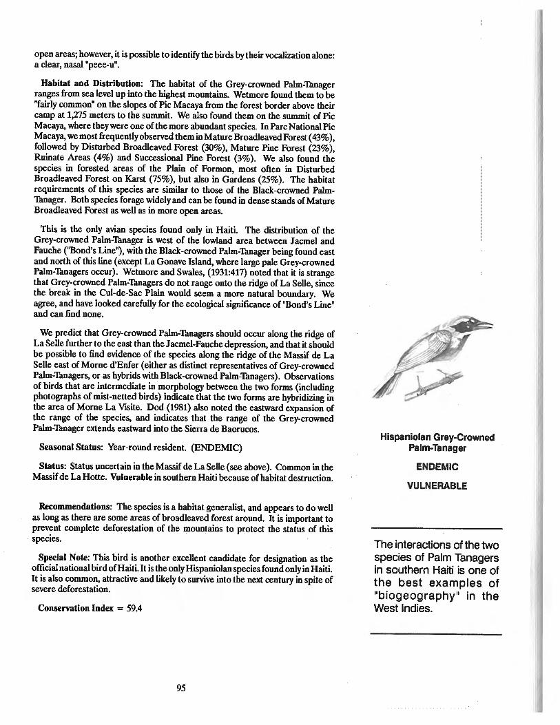
open areas; however, it is possible to identify the birds by their vocalization alone:a clear, nasal"peee-u".
Habitat and Distribution: The habitat of the Grey-crowned Palm-Thnagerranges from sea level up into the highest mountains. Wetmore found them to be"fairly common" on the slopes of Pic Macaya from the forest border above theircamp at 1,275 meters to the summit. We also found them on the summit of PicMacaya, where theywere one of the more abundant species. In Parc National PicMacaya, we most frequently observed them in Mature Broadleaved Forest (43%),followed by Disturbed Broadleaved Forest (30%), Mature Pine Forest (23%),Ruinate Areas (4%) and Successional Pine Forest (3%). We also found thespecies in forested areas of the Plain of Formon, most often in DisturbedBroadleaved Forest on Karst (75%), but also in Gardens (25%). The habitatrequirements of this species are similar to those of the Black-crowned PalmThnager. Both species forage widely and can be found in dense stands of MatureBroadleaved Forest as well as in more open areas.
This is the only avian species found only in Haiti. The distribution of theGrey-crowned Palm-Thnager is west of the lowland area between Jacmel andFauche ("Bond's Line"), with the Black-crowned Palm-Thnager being found eastand north of this line (except La Gonave Island, where large pale Grey-crownedPalm-Tanagers occur). Wetmore and Swales, (1931:417) noted that it is strangethat Grey-crowned Palm-Thnagers do not range onto the ridge of La Selle, sincethe break in the Cul-de-Sac Plain would seem a more natural boundary. Weagree, and have looked carefully for the ecological significance of "Bond's Line"and can find none.
We predict that Grey-crowned Palm-Thnagers should occur along the ridge ofLa Selle further to the east than the Jacmel-Fauche depression, and that it shouldbe possible to find evidence of the species along the ridge of the Massif de LaSelle east of Morne d'Enfer (either as distinct representatives of Grey-crownedPalm-Thnagers, or as hybrids with Black-crowned Palm-Tanagers). Observationsof birds that are intermediate in morphology between the two forms (includingphotographs of mist-nelled birds) indicate that the two forms are hybridizing inthe area of Morne La VlSite. Dod (1981) also noted the eastward expansion ofthe range of the species, and indicates that the range of the Grey-crownedPalm-Thnager extends eastward into the Sierra de Baorucos.
Seasonal Status: Year-round resident. (ENDEMIC)
Status: Status uncertain in the Massif de La Selle (see above). Common in theMassifde La Holle. Vulnerable in southern Haiti because of habitat destruction.
Recommendations: The species is a habitat generalist, and appears to do wellas long as there are some areas of broadleaved forest around. It is important toprevent complete deforestation of the mountains to protect the status of thisspecies.
Special Note: This bird is another excellent candidate for designation as theofficial national bird ofHaiti. It is the only Hispaniolan species found only in Haiti.It is also common, attractive and likely to survive into the next century in spite ofsevere deforestation.
Conservation Index = 59.4
95
Hispaniolan Grey-CrownedPalm-Tanager
ENDEMIC
VULNERABLE
The interactions ofthe twospecies of Palm Tanagersin southern Haiti is one ofthe best examples of"biogeography " in theWest Indies.
jharold
Rectangle

Narrow-Billed Tody
ENDEMIC
VULNERABLE
SCALY-NAPED PIGEON
Columba squamosa
Ranmye Kou Wouj
Ramier Cou-rouge or Ramereau
Paloma Torcaza or Paloma Turca
Description: Dark slate-grey in color with the hindneck chestnut and metallicpurple. In the male, the skin around the eye is reddish (yellow in females). Thefeet and base of the bill are red. The vocalization is a loud "croo-cru-cru-croooll.
Habitat and Distribution: The Scaly-naped Pigeon, or "Ranmyell as it is frequently called, is found in dense stands of Mature BroadIeaved Forest. OnMacaya, 84% of the observations were in Mature Broadleaved Forest and 16%in Disturbed BroadIeaved Forest. On La Visite 50% of the observations were inMature BroadIeaved Forest habitat. Wetmore and Swales (1931) noted that inHaiti the birds were abundant in forested areas, but not found elsewhere. Theyobserved them regularly in the Massif de La Selle. Dod (1981) reports that theirnumbers are very reduced in the Dominican Republic. Quantitative data fromour transects indicate that while the species can occur in Mature Pine Forests(Bwa pen), it is closely associated with very mesic sections of this forest. It is mostfrequently found in mature stands of Mature Broadleaved Forest. This speciesusually was observed singly or in pairs; we never observed large flocks.
Seasonal Status: Year-round resident.
Status: The Scaly-naped Pigeon is common in Mature Broadleaved Foresthabitats, but uncommon otherwise. Because of the great loss ofmontane MatureBroadleaved Forest in recent years, this species is vulnerable.
Recommendations: The mesic Mature Broadleaved Forests must be preservedif this species is to survive.
Conservation Index = 59.4
NARROW-BILLED TODY
Todus allgustirostris
Kolobri Mon
Colibri, Chicorette
Barrancoli, Chi-cui
Description: This tiny, vivid green bird has a bright red throat, pink sides andyellow under the tail. The underside ofthe bill is black at the tip. The vocalizationis very characteristic, and the bird is heard more often than seen. It makes a loud,harsh "tick-cherek" or lIchic-cuill, which is very different from the lIterp-terp-terpterp...l1 of the Broad-billed Tody.
Habitat and Distribution: The Narrow-billed Tody (Kolobri Mon) is a bird ofwet montane areas in Haiti and is occasionally sympatric with the Broad-billedTody (Kolobri) which occurs in lowland areas and more open environments. In
96
jharold
Rectangle
jharold
Rectangle

the Dominican Republic, both species are locally sympatric, and the Narrowbilled Tody has occasionally been recorded from the lowlands (Bond, 1985; JoseOttenwalder, pers.obser.). Wetmore and Swales (1931) reported that the twoTody species are sympatric only on and near the Samana Peninsula of theDominican Republic. Kepler (1977) reported another area ofoverlap (sympatry)in "dry lower montane forest" which occurs in ravines on the north side of theSierra de Baoruco range of the Dominican Republic at about 1,000 meterselevation. It is Kepler's view (1977:19) that sympatry may be more common thanpreviouslybelieved in areaswhere transitional forest dominated bythe sumac-likeBrune//ia comoc/adifolia grades into drier lowland forest and mesic montaneforest. This transition is most often between 900 and 1,100 meters. The Narrowbilled Tody is almost never found below 800 meters, and the Broad-billed Todyrarely occurs above 1,070 meters. This species is found in dense Mature Broadleaved Forest and Disturbed Broadleaved Forest habitats in the higher mountains. It does well in Disturbed Broadleaved Forest habitats, but is rarely foundin Ruinate habitats. Along with the Hispaniolan Emerald, it is one of the mostcommon species ofwet areas and thick cover on the tops of the highest mountains.In the Macaya area, it was most abundant in Mature Broadleaved Forest (43%),followed by Disturbed Broadleaved Forest (36%), Mature Pine Forest (16%).Few individuals were present in Successional Pine Forest or Ruinate Areas. Onthe Plain of Formon, 65% of the observations of the Narrow-billed Tody were inMature Broadleaved Forest on Karst and 35% in Disturbed Broadleaved Foreston Karst. The Narrow-billed Tody is the only Tody present above 1,200 meterselevation in the Massif de La Hotte, but is sympatric with the Broad-billed Todyat 1,000 meters. Narrow-billed Todies do not occur below 900 meters elevationin the Macaya region. Within Parc National La Visite, more Narrow-billed Todieswere observed in Disturbed Broadleaved Forest habitats. Forested areas in theMassif de La Selle are more fragmented and less abundant than in the Massif deLa Hotte. In La Visite, 75% of the observations of Narrow-billed Tody were inDisturbed Broadleaved Forest, 25% in Mature Broadleaved Forest.
Seasonal Status: Year-round resident. (ENDEMIC)
Status: Common in wet forests above 1,000 meters in all areas of Haiti, butvulnerable because of the rapid destruction of this habitat.
Recommendations: The species is closely associated with Mature BroadleavedForest habitats, and would benefit from the conservation of the wet broadleavedforest in the national parks and surrounding buffer zones. The karst hills of thePlain of Formon adjacent to the Massif de La Hotte lie along the edge of a steepescarpment at approximately 1,000 meters elevation. The area is characterizedby karst and is not well suited for gardens. Large areas of natural forest stillremain. It is one of the few areas in Haiti where natural areas of drier lowlandforest come into contact with wet montane forests. The karst hills region adjacentto Parc National Pic Macaya is important because of the large number ofendemicspecies found there. It is also one of the few areas of Haiti where both species ofTody can be found together, which further indicates the need to preserve theforest cover in the region, and to include all of this region into Parc National PicMacaya.
Conservation Index =57.2
97

Rufus-Throated Solitaire
VULNERABLE
RUFOUS~HROATEDSOLITAIRE
Myadestes genibarbis
Mizisyen
Olseau Muslclen
Jilguero
Description: The Solitaire or "Mizisyen" is grey on the back and white on thechest and belly. The throat and under the tail are rufous red. The lower eyelidand chin at the base of the bill are white, as are the outer tail feathers which flashwhen the bird flies, much like the Red-legged Thrush with which it can beconfused in thick brush. The best field characteristic is the beautiful and verydiagnostic song, a flute-like, slow, melodious, often-repeated series of notes. Thesong can be heard during all times of the year, but is most common in May.
Habitat and Distribution: This bird is most frequently found in dense standsofMature Broadleaved Forest in the mountains. Wetmore and Swales (1931) andWetmore and Lincoln (1933) found it in stands of mesic forest up to the summitsof both La VlSite and Macaya. We found it so abundant on the north face of PicMacaya in May that the entire mountain above 1,200 meters elevation echoedwith its flute-like song. The dense mixed pine and broadleaved forest on both PicFormon and Pic Macaya had many individuals, and the Solitaire is one of the mostabundant species there. The species begins to sing half an hour or more beforedawn and is one of the fust birds to sing in the morning. They sang from just overour tents on the summit of Pic Macaya where many were observed together inforaging flocks in January. On La VlSite, the Solitaire is found only in a fewsections of the park because of limited areas of Mature Broadleaved Foresthabitat, and is most frequently heard on the north face of the Massif below theridge of Morne Cabaio. On La Visite, we observed the Solitaire (75%) of thetime in Mature Broadleaved Forest in May and (50%) in December. Theremaining observations were in Disturbed Broadleaved Forest, with one observation in Mature Pine Forest. On Macaya, where there were eight times as manyindividuals counted during the same time of year as the La Selle census period,(69%) of the observations were in Mature Broadleaved Forest habitat, followedby (28%) in Mature Pine Forest (mixed stands with broadleaved vegetation),(6%) in Disturbed Broadleaved Forest and (2%) in Successional Pine Forest. Onthe Plain of Formon, (90%) of all observations were in Mature BroadleavedForest on Karst habitats.
The Solitaire is one of the most beautiful birds in Hait~ and is the most beautifulsongster. It is beloved by peasants. The following quote by Wetmore (Wetmoreand Swales, 1931:343) about the Solitaire in La VlSite brings forth the feeling ofthe bird. "The birds were found principally in the steep-sided ravines below thesummit of the long ridge that forms the top of this range. In early morning theirclear, flute-like notes came with indescribable purity to the listener resting on thebrink of the great precipice that forms the face of Morne La Visite, a marvelouslybeautiful song and one never to be forgotten."
Seasonal Status: Year-round resident. Breeding in May.
Status: Generally uncommon in the Massif de La Selle; Common in the Massifde La Holte. If the cuttingof Mature Broadleaved Forest continues, the Solitairewill soon become threatened. The Solitaire is much reduced in numbers sincethe time of Wetmore's survey in 1927. Today the Solitaire is vulnerable.
98
jharold
Rectangle

Recommendations: The Solitaire is clearly dependent on large stands of Mature Broadleaved Forest habitat if it is going to survive. All cutting of MatureBroadleaved Forest and Disturbed Broadleaved Forest must be prevented in thenational parks and surrounding buffer zones.
Conservation Index = 57.2
COLLARED SWIFT
Streptoprocne zonaris
Zowazo Lapll Kou Blan
Olseau de la Plula
Vencejo de Collar
Description: This large black bird has a white ring around the neck and fliesexceedingly fast. It is usually observed in small flocks of three to five birds. Thebirds make a "whish" noise as they fly rapidly overhead, often right over the treetops. Their vocalization is a loud, shrill "screee-screee".
Habitat Distribution: The habitat of this species is high mountain regions withtowering cliffs and steep-sided precipices, such as the upper Ravine de Sud belowPic Macaya. It flies fast and feeds over a wide area, so it can be seen almostanywhere in the Macaya area. However, it needs caves (often nearwater) in orderto nest. These habitats occur in the upper regions of Parc National Pic Macaya.Collared Swifts were observed and nests were found in caves of Parc Macaya,indicating that breeding populations occur there.
Seasonal Status: The Collared Swift was observed in March, April, May,September, December, January and February, and is a year-round resident.
Status: Collared Swift nests were found in a cave at 1,040 meters in the GrandRavin below Pic Macaya. A large pile of insect parts is often found below thenest.
Recommendations: Cave environments should be protected
Special Comments: This species was known as the Antillean Cloud Swift toWetmore and Swales (1931). They noted that Zowazo Lapli are irregular inoccurance, and that sometimes none were observed for a period ofa week in areaswhere they are known to occur. Wetmore found the species to be especiallyabundant near the Riviere Blanche, and in April, 1927, observed thirty or fortycircling over a valley opposite the tremendous cliffs that mark the north face (NanNway) of Morne La Visite. We rarely saw flocks of more than ten birds in thearea, and the species appears to be less abundant now than in 1927.
Conservation Index = 55.0
99
Collared Swift
jharold
Rectangle

Green-Tailed Ground Warbler
ENDEMIC
THREATENED
GREEN-TAILED GROUND WARBLER
Micro/igea pa/ustris
TI Chitte Lasel
Petit Chitta La Selle
Ciguita Colivarde
Description: This endemic and very special warbler is greenish in colorationon the wings, back and tail. On the hindneck and crown of the head, it is greenishgrey. On the chest and belly it is greyish white, becoming pure white on theabdomen. Ithas a long tail, and a bright red iris in the eye, surrounded by a brokeneye-ring.
Habitat and Distribution: The Ground Warbler usually feeds alone or in smallgroups, and is rarely found mixed with foraging flocks of migrant warblers. Thissecretive little warbler is found in dense thickets of Mature Broadleaved Forestand Disturbed Broadleaved Forest where it feeds close to the ground. GroundWarblers were observed feeding in branches of a large tree, but this was theexception. It is widespread in its distribution in the Dominican Republic. InHaiti, it is most common in the Massif de La Selle and nearby mountains abovePort-au-Prince near Furey. Wetmore and Swales (1931) and Wetmore andLincoln (1933) found them abundant in the La VlSite region of the Massif de LaSelle from below Morne Cabaio across the summit to the great ravine of theRiviere Blanche, but did not find them in La Hotte. Ground Warblers areabundant in the La Visite area at all times of the year. In January, GroundWarblers were found in Disturbed Broadleaved Forest (55%), Mature Broadleaved Forest (25%), Mature Pine Forest (9%), Riparian habitats (6%), inRuinate Areas (3%) and Successional Pine Forest (2%). In May, GroundWarblers were observed in Disturbed Broadleaved Forest (59%), Mature Broadleaved Forest (30%), and in Riparian habitats (12%). In September, all observationswere in Disturbed Broadleaved Forest (80%) or Mature Broadleaved Forest(20%). It is clear, therefore, that the Ground Warbler is a species of densebroadleaved growth and is ideally adjusted to the thick, scrubby stands ofMatureBroadleaved Forest that characterize the steep face (Nan Nway) of the MassifdeLa Selle, and the ravines of the plateau. In Haiti, it is a species that is closely tiedto the Massifde La Selle, including Pare National La Visite. We observed GroundWarblers in northern Haiti near Saint Raphael in xeric scrub areas similar to thehabitats where Ground Warblers occur in the arid southwestern corner of theDominican Republic. Ground Warblers have never been reported in the Massifde La Hotte.
Seasonal Status: Year-round resident. (ENDEMIC). It nests in May andJune.
Status: The Ground Warbler is closely associated with broadleaved vegetationin the central part of its range and is vulnerable to extirpation if this habitat iseliminated by continued deforestation. However, it is able to survive in extremelyarid areas if Scrub-thorn Forest habitat persists. Its status is threatened.
Recommendations: This species is dependent upon the presence of densestands of Mature Broadleaved Forest in the Massif de La Selle, and this habitatin the La Visite region should be protected from fire and deforestation, especiallyalong the La Selle escarpment between Morne La Visite and Thte Opaque. Nogardens, ajupas, domestic aJiimals or additional deforestation should be allowedfrom the base of the ridge to the summits of the escarpment.
Conservation Index = 79.2
100
jharold
Rectangle

LA SELLE THRUSH
Turdus swales;
Kouet kouet Nwa
Ouete Ouate Nolr
Chu-cho
Description: The head and all upperparts are black. OD the underside, thethroat has traces of white, the chest is dusky and the belly and abdomen arechestnut-colored. There is a distinctive median streak ofwhite on the belly fromthe base of the tail to the breast that is variable in size and shape (sometimesdividing into several parts) so that it is possible to ideDtify individual birds. Thebill of this thrush is bright orange, and there is a light orange eye ring. Thevocalization is very unusual and beautifu~ consisting of three or four slightlydiffereDt Dotes delivered slowly, clearly and with decided intervalsbetweeD Dotes,followed by a "zeek". The Dotes sound like "tu-re-oo" and "cho-ho-cho" (fromwhich it receives its local Dame in the Dominican Republic). Hardy and Parker(1985) Dote that the SODg of the La Selle Thrush is "low-pitched, variable Dotes soslowly and deliberately spaced that the song is reminisceDt of that of the Yellowbreasted Chat, [eteria wrens, aWoodwarbler." However both BODd andWetmoreDoted that the SODg is "thrush-like." The alarm Dote of the La Selle Thrush is aloud "wheury-wheury-wheury."
Habitat and Distribution: Wetmore (Wetmore and Swales,1931) discoveredthis species in the dense Mature Broadleaved Forest ofMorne La VlSite on April11,1927, and considered its range to be 1,500-2,100 meters on the high ridge ofLa Selle. He did Dot fmd the bird anywhere else in Haiti or the DominicanRepublic. He saw the bird only in little clearings where the La Selle Thrush or"Kouet Kouet Nwa" speDds ~ime OD the ground "runningwith lowered head acrosslittle OpeD spaces and theD pausing abruptly with head thrown erect" (Wetmoreand Swales: 1931:338). ID subsequent years, the La Selle Thrush has beeDdiscovered in other places in Hispaniola, indicatiDg that it has either expandedits range or that it was originally more widespread than Wetmore realized. TheLa Selle Thrush is DOW known from the Sierra de Baoruco (a coDtinuation of theMassif de La Selle in the Dominican Republic), the Sierra de Neiba (the nextmountain range north ofthe Cul-de-Sacseparating southerD Hispaniola from theDorth), as well as from the Cordillera CeDtral Dear Alto Bandera. The habitat isusually stated to be "dense shrubbery." I observed this thrush most ofteD in areasof Disturbed Broadleaved Forest with nearby gardens (42% in December, 50%in May, 100% in September), followed by dense Mature Broadleaved Forestwhere it was feeding in trees, especially Persea anomaJa (a shrub related to theavocado with small succuleDt fruits), (33% iD December and May). Thrusheswere also observed in Ruinate Areas (5%), Gardens (25% in December, 10% inMay) and in Riparian habitats (3%). The La Selle Thrush is frequeDtly observedfeeding out in the open rather like an American Robin. It does well whereGardens and Mature Broadleaved Forest are adjaceDt to ODe aDother, andappears to have expanded its range in receDt years as a result of agriculturespreading in high mountain areas. It may have originally beeD confmed to the LaSelle area because of the unique natural vegetation patterD of dense wet mesicbroadleaved forests along the La Selle escarpmeDt occurring adjacent to the opeDpine savanna of the plateau.
Seasonal Status: Year-round resideDt. (ENDEMIC)
101
La Selle Thrush
ENDEMIC
THREATENED
The habitat of the La SelleThrush is being rapidlydestroyed in the Pare National La Visite area.
jharold
Rectangle
The population of Haiti isgrowing at a rate of at least2Otb, and will double in thenext 34 years to over 12million.
Status: Common in the Massifde La Selle, but threatened because ofdeforestation pf the Mature Broadleaved Forest.
Recommendations: Even though this species appears to be doing well at thepresent time, it is extremely threatened by continued deforestation, especiallyalong the La Selle escarpment. No fues or woodcutting should be allowed in thisregion of Parc National La VlSite.
Conservation Index = 72.6
CONCLUSIONSThis review ofselected birds of Haiti has concentrated on montane species that
are closely associated with specific habitat types. The rate of deforestation in themountains ofHaiti is increasing at an alarming rate, and there hasbeen a dramaticdecline in forest cover in the last ten years. In the remote wilderness of PicMacaya in the center of the Massif de La Hotte, 100% of the region was in virginbroadleaved and pine forest in 1956. There has been a 97% loss of these virginhabitats in the last 30 years, with a 76% loss occurring in the six-year periodbetween 1978 and 1984. The photographs on page 48 illustrate the extent of thechange in one area of Morne Macaya between 19TI and 1986. The loss ofavailable habitat is influencing the distribution and abundance of Haitian birds.Some species, such as the La Selle Thrush are expanding their range, while otherssuch as the White-winged Warbler are nearing extinction. It is possible thatspecies are changing their habits to compensate for the loss of suitable habitats,which may account for the apparent hybridization now occurring between theGrey-crowned and Black-crowned Palm-Thnagers. Another example ofchangingpatterns of behavior is in the Black-throated Blue Warbler, a winter migrant thatcompetes for the same diminishing resources in mesic montane forests as thesixteen species discussed in this study. Individual winter migrants return to veryspecific areas each year, and it is not uncommon to find the same individual birdin the same patch of forest on subsequent years (Woods, 1975). When the rateof deforestation is as rapid as it is in Haiti, returning warblers are often unable tofind suitable habitat and are forced into increased competition with othermigrants and resident species. The Black-throated Blue Warbler compensatesby differential utilization of available habitats by males and females (Woods,1975). The trends that we reported in the region of the Plateau Rochelrois (1,000meters) in 1975 are now spreading into the Massif de La Hotte, with females andjuveniles feeding in more open ruinate areas, and males concentrating in theremaining patches of Mature Broadleaved Forest.
The species of resident birds studied can be ranked in terms ofa ConservationIndex (CI) to produce a listing of the the species of greatest concern ('Thble 9).All species with a CI greater than 65 should be considered worthy of specialactions in developing a conservation strategy. Eleven species on the list have suchratings: 1) White-winged Warbler; 2) Chat Thnager; 3) White Wmged Crossbill;4) Black-capped Petrel; 5) Green-tailed Ground Warbler; 6) Antillean Piculet;7) Hispaniolan Trogon; 8) La Selle Thrush; 9) Antillean Euphonia; 10)Hispaniolan Parrot; 11) Hispaniolan Pine Warbler. This group contains fourendangered, and seven threatened species. The remaining species that are notin the special group with scores above 65 are all wlnerable with the exception ofthe Scaly-naped Pigeon, which is threatened. The Scaly-naped Pigeon fell belowthe critical scoring threshold because of its wide distribution in the West Indies.We recommend that it be included on the list of sixteen most threatened andendangered birds of Haiti because it is decreasing in numbers rapidly and is
102
jharold
Rectangle

endangered birds of Haiti because it is decreasing in numbers rapidly and isspecifically associated with mesic forest habitats.
The key activity necessary to improve the status of the 16 species of greatestconcern is habitat protection. There are a variety of conditions in Haiti that havea negative impact on birds. Many of these, such as predation on nests andindividual birds by rats, dogs, cats, and the ever-spreading mongoose are difficultto control, as is the need of the increasing human population for space andresources. The population of Haiti is growing at a rate of two percent, and willdouble in the next 34 years to over ten million. The habitat is already badlydegraded, and birds and humans together are already suffering.
However, it is not a hopeless cycle. The key to preserving the species discussedin this study is protecting large blocks of Mature Broadleaved Forest and areasof Mature Pine Forest from deforestatioD. These habitats in mountain areasabove 1,000 meters are still available in some areas of the country, and in manyareas above 1,600 meters, the forests are associated with the watersheds of majorriver systems. The heart ofthe Massifde La Hotte is Pic Macaya, and off its slopesarise four of the most important rivers of Haiti. Three major rivers arise from theMassif de La Selle. ID both of these areas the broadleaved forest serves asprotectioD ofthe soil and helps hold the water to be slowly released into the rivers.The pine forest alODg the peaks and ridges helps comb additioDai moisture fromthe ever-present clouds, increasing the overall amount of precipitatioD andquality of the watershed (Vogelmann et aI., 1968). It is clear, therefore, thatfinding ways to meet the future Deeds of Haiti does Dot have to be at the expeDseof the birds discussed here. It is in the best interest of the future of Haiti thatbroadleaved and pine forests flourish in carefully selected and protected mountain habitats. The future prospect of all of the species discussed here will beimproved by wise management of the forest resources. However, if the curreDtrate of deforestatioD coDtinues, most mesic forests will be gODe from the mountains of Haiti by the year 2000. If this happens, many of the species OD the list in'Thble 9 will fall by the wayside, and the toll of human suffering associated withdeclining water quantity and quality and the coDtinued loss of soil will beeDormous.
The lost horizons of Haiti are the vast areas of forest that ODce made Haiti thePerle des Antilles and the WODdrOUS Isle. These are gODe forever. The Dew hopesare the efforts that are DOW underway to develop a meaningful watershed conservation program in the Massif de La Hotte, and the fledgling DatioDai parksprogram that is struggling with task of managing the newly established ParcNatioDai La VlSite and Parc NatioDai Pic Macaya in the mouDtains of southernHaiti. The other sign of Dew hope lies in the documeDtatioD of the developingdisaster in the Datural systems of Haiti. For the first time, data OD the extent ofthe pattern of deforestatioD are available, and the specific ways necessary toimprove the status of the eDdangered and threatened flora and fauna are uDderstood. With these tools, and an improved awareness in Haiti of the liDk betweeDthe cODservatioD of Datural resources and the quality of life for all, comes aglimmer of hope. The remaining horizons of Haiti may yet survive to be part ofa Dew ceDtury, and with them the endangered and threateDed birds of themountains.
103

SPECIES STAroS SPECIES STAroS
LAND BIRDSCuculidae
Hispaniolan Lizard CuckooSaurothera longirostrisBay-breasted CuckooHyetomis rujigularis
CaprimulgidaeLeast PauraqueSiphonorhis brewsteri
TrochilidaeHispaniolan EmeraldChlorostilbon swansonii
PsittacidaeHispaniolan ParrotAmazona ventralisHispaniolan ParakeetAratinga chloroptera
TrogonidaeHispaniolan TrogonPriotelus roseigaster
TodidaeBroad-billed TodyTodus subulatusNarrow-billed TodyTodus angustirostris
PicidaeHispaniolan WoodpeckerMelanerpes striatus
Antillean PiculetNesoctites micromegas
CorvidaeWhite-necked CrowCorvus leucognaphalus
Muscicapidae (Turdinae)La Selle ThrushTurdus swalesi
DulidaePalm Chat
E Dulus dominicusVireonidae
E Flat-billed VireoVireo nanus
Emberizidae (Parulinae)E Hispaniolan Pine Warbler
Dendroica pinus chysoleucaGreen-tailed Ground Warbler
E Microligea palustrisWhite-winged WarblerXenoligea montana
E Emberizidae (Thraupinae)Black-crowned Palm-tanager
E PhaenicophiluspalmarumGrey-crowned Palm-tanagerPhaenicophiluspaliocephalus
E Chat TanagerCalyptophilus frugivorus
FringillidaeE Antillean Siskin
Carduelis dominicensisE White-winged Warbler
Loxia leucopteraRufous-collared Sparrow
E Zonotrichia capensis
E NON-LAND BIRDSAccipitridae
Ridgway's HawkR-PR Buteo ridgwayi
E Total
E
E
R-NA
E
E
E
E*
E
E
R-NA
R-SA
E
24 Species
TABLE 6. Bird species that are endemic (E) or restricted (R) to Hispaniola. Species endemic only to Haiti (E*); once found in Puerto Rico (extirpated) but nowconfmed to Hispaniola (R-PR); restricted to Hispaniola in the Antilles but also occurring in North America (R-NA) or South America (R-SA).
jharold
Rectangle

Thble 7. Vocalizations of Black-capped Petrels. Recorded asnumber of complete vocalizations/minute over 10 one minut~
intervals (averaged from all observers at a specific site).
LOCATION NUMBER VOCALIZATIONS2000 hrs. 2100 hrs
Massif de La SelleMorne La Visite
Jan.15Jan.16
Morne CabaioJan.15
Tete Opaque (West Head)Jan 16
Tete Opaque (East Head)Jan 15
Massif de La HotteEast of Pic Macaya
Jan 25South of Pic Macaya
(S. ridge)Jan 27
West of Pic Macaya(SO meters)Jan 25Jan 27
West of Peak(300 meters)Jan 25
14.5410.73
3.57
14.07
20.43
10.0
8.8
12.2712.80
9.95
9.0610.60
6.35
14.70
15.60
Table 8. Comparison of summary bird data between LaVisite and Pic Macaya areas based on eight census days in
each season during 1982.
LA VlSITE MACAYA*
2000m 2000m l000m
Dec May December
Total :# observations 1932 897 1397 433Total # species 62 41 47 51Average ofbirdslday 242 112 116 151
*The combined total number of species for both regions of Pare NationalPie Macaya is 65.
jharold
Rectangle

TABLE 9. Status and Conservation Index of 18 Haitian Birds
Species Status Status Habitat Endemic Biotic Generic ConservIndex Index Index Index Index Index
Macaya Area Birds
WWWarbler E 10 10 9 8 5 92.4
CTanager E 9 9 10 8 5 90.2
WW Crossbill E 10 9 9 8 1 81.4
BCPetrel E 10 10 6 10 1 81.4
APiculet T 6 7 8 8 5 74.8
HTrogon T 7 7 8 8 4 74.8
A Euphonia T 7 8 8 8 1 70.4
HParrot T 9 7 8 6 1 68.2
Pine Warbler T 4 8 8.5 8 1 64.9
A Siskin V 4 8 8 7 1 61.6
HEmerald V 5 5 8 8 2 61.6
GCPTanager V 3 4 10 6 4 59.4
SNPigeon T 7 7 4 8 1 59.4
NBTody V 4 5 8 6 3 57.2
Solitaire V 4 5 7 8 2 57.2
C. Swift V 5 8 3 8 1 55.0
Found in La Visite but not Macaya
GTGWarbier
LS Thrush
T
T
7
7
6
8
10
10
8
7
5
1
79.2
72.6
jharold
Rectangle

CHAPTER V
Beasts of the Haitian Hills
The Mammals ofMacayaIntroduction
This chapter reviews the mammals of the Pic Macaya region, both living andextinct. No other work is available that synthesizes this information, and presentsit in enough detail to make it possible to visualize the flow oftime in the mountainssurrounding Pic Macaya, and to document how much the mammal community ofthe region has changed. This change in the composition of both small and largemammals has been profound, even in the last few decades, and the changecontinues as introduced species capitalize on deforestation and increaseddestruction of the last remaining natural forest areas in Haiti. Few other groupsillustrate the consequences of habitat destruction in the Macaya area as well asdo mammals. With two, and perhaps three, native mammals in the area on theverge of extinction, and with habitat destruction in the region accelerating at analarming rate, the lesson to be learned from history of the mammals of Macayais more important than ever. This story is part ofa much larger pattern of habitatdestruction, introduction of exotic species, and waves of extinction of nativemammals that involves all of Haiti. That story will be told in a book on the historyof mammals in Haiti to be published in the next year as part of the overallconservation program in Haiti funded by the MacArthur Foundation. We hopethat the story of Macaya, and of Haiti in general, will make all those who areinterested in the natural resources of Haiti realize what a remarkable naturalpatrimony Haiti has, and how vulnerable that patrimony is to destruction.
107
jharold
Rectangle
jharold
Rectangle

Introduced species suchas the dog, cat, mongoose, rats and micecause ecological chaos inHaiti and led to the extinction of several native smallmammals.
Much of the discussion about the mammals of Macaya will be about creatureswho have never been seen alive. They survive only in our imaginations; they areghosts of the past. The native mammals that do survive are "living fossils." MostHaitians think of the native mammals of their country as creatures that exist faraway in some remote place (the "gran bwa"). There is a tendency to merge thepresent with the past, and the real with the imagined. As a result, there is a greatdeal ofconfusion about the mammals ofHaiti, real or imagined, extant or extinct.There are some astonishing beasts in the hills of Haiti.
In this chapter, only mammals living, or known to have lived in the region of theMassif de la Hotte will be be considered. This area includes the higher peakssurrounding Pic Macaya, and the surrounding hills, plateaus, valleys, and watersheds. The region consists mainly of upland habitats above 200 meters in elevation. It includes some of the most remote and well forested habitats left in Haiti,such as the upper slopes of Pic Formon and Pic Macaya, as well as some of themost altered and agriculturally developed, such as the Plaine of Cayes. It is amicrocosm ofwhat has happened, and is happening to Haiti. However, becausemost species of land mammals have very broad ranges, the discussions in thischapter sometimes include information on the status ofmammals Haiti in general.Since this chapter is designed to provide basic information on the biology of rarespecies that are in danger of becoming extinct, we hope it will be used by peopleinterested in developing conservation programs throughout Haiti. It is for thisreason that we have included some information on Haitian mammals applicablebeyound the boundaries of the Massif de la Hotte.
Mammals ofModem Haiti
Introduced MammalsA list of Haiti's mammals in the 1990s would include a large number of
introduced species. The following eight free-living introduced mammalsdominate the Haitian landscape today, and are the only terrestrial mammals thatmost Haitian people or visitors (including hard-working scientists) will ever seein the Haitian countryside.
Feral Domestic Dog. Dogs stay close to houses, but move about the countrysidein a nearly feral state. They were introduced very early by the Spanish, andaccording to Watts (1987) feral dogs were "major agents of ground fauna disturbance...". Larger Spanish dogs were introduced to Hispaniola by 1494, but thesmaller Barkless dog of the Thinos was introduced in pre-Columbian times. The"dumb dogs" of the Indians were small, and were kept for food as well as used inhunting game. Sauer (1969) believes that Indian dogs were not used in hunting,but rather were ''both family pet and entree served up at festivals." A number ofother accounts indicate that they were used in hunting, however, and the statusof the dog at about the time of the fust European contact can be summarized inthe following quote (Charlevoix in Fewkes, 1907:50). "The goschis were littledogs, which are dumb, and served for the amusement of the ladies, who carriedthem in their arms. They were also used in hunting in starting up other animals,were good to eat, and were a great resource to the Spaniards in the period oftheirfust famine." The barkless dogs became extinct before the Indians did, partly asa result ofbeing eaten up by the Spaniards and Indians during the famine of 1494,and the times of hunger in the early 15OOs. These dogs were probably quicklyreplaced by the Spanish dogs that began to arrive at about the time of the secondvoyage of Columbus in 1493. Reports indicate that these Spanish dogs becameferal very rapidly in Hispaniola.
108
jharold
Rectangle

Feral Domestic Cat. Cats skulk through the countryside, and live in a totallyferal state. It is not known when the first cats were brought to Hispaniola, but weassume it could have been as early as the second voyage ofColumbus in 1493. Asnoted by Watts (1987), cats became naturalized very quickly in areas likeHispaniola, and many ground-nesting birds were "decimated" by cats and rats.The potential threat of cats to the endemic small mammals of Haiti would havebeen very high. Nearly five hundred years of impact throughout every majorhabitat of the island could have been the major factor leading to the extinction ofsmall mammals below 1,500grams in mass. At the current time, cats are commonin the wild in all regions of the country. They are considered a delicacy by somepeople, and are hunted in some rural areas. In the eastern Massif de la Hotteregion near Duchity, as many as 12 have been captured in a single day. Somehouses in the area have cat skins tacked to the outside walls. In towns it is notuncommon for pet cats to disappear, and end up in somebody's cooking pot. Thenegative impact of predation by feral cats would have been especially severe onthe three Island Shrews, and on the Hispaniolan Spiny Rat, all of which becameextinct after the arrival of cats. Cats could also hav~ had a severe impact on theLa Hotte Hutia after the forest cover on the Plaine Formon was removed.
Small Indian Mongoose. The Mongoose was introduced in about 1895 tocontrol rats and snakes in the cane fields. It has now spread to even the highestmountaintops in the most remote districts. Cats and mongooses have become thecarnivores of the countryside. The mongoose was not found on lie de La Tortueas of 1985, and so a close comparison of the vertebrate fauna of that island withthe adjacent mainland ("Gran 'Th," as it is called on Tortue) of Haiti could be veryinformative about the impact of mongooses on the local fauna. The mongoose isfound on lie de La Gonave.
Black Rat. This rat inhabits a wide range of habitats, including the nearlypristine forests on the summits of the highest mountains. However, it is mostcommon in dryareas and in natural forests where there is shallow leaflitter. Blackrats are good climbers, and are commonly found in the thatched roofs of houses(cayes) in the countryside. This animal is less common in semi-aquatic environments, and in the dense rain forest of the high mountains. Black rats occur in fourcolor morphs in Haiti: 1) all brown; 2) brown with white belly: 3) all gray; 4)gray with white belly. Since Black rats are found in so many different habitats,come in four distinct morphs, and are heavily preyed upon by barn owls, whichare also very abundant in many different habitats, it is possible that the color ofthe morph is related to the habitat that the rats live in. Ifthis is true, brown morphswould dominate in habitats with brown soils or substrates, and gray morphswould be more common in more open karst (gray background) habitats. Theresults so far suggest a trend in this pattern, but the data are far from conclusive.The selective pressure ofpredation on coat color might be lessened because barnowls are nocturnal predators, and Black rats are often found in trees or otherabove ground situations.
Norway Rat. This rat is more limited in distribution. It is most frequentlyencountered in the rice fields of the Riviere de I'Artibonite delta, and in the highmontane forests of the Massif la Hotte where the ground is deep pine litter andextensive areas of sphagnum moss. On Pic Macaya, both Black and Norway ratsoccur, but Norway rats are most abundant. In the adjacent, but much drier Ravinedu Sud, the opposite is true. It is unfortunate that Norway rats have dispersed tothe moist, well-forested mountaintops, such as Pic Macaya, since habitats such asPic Macaya may have been refuges for small Island Shrews that depended uponthe deep pine duff and sphagnum substrates.
House Mouse. The house mouse is common around settlements, but unlike therat, has not moved out into remote forest habitats.
109
Small Indian Mongoose
Herpestes javanicus
One of the most destructiveintroduced mammals In HaitI.
jharold
Rectangle

Domestics. Domestic horses, cows, goats, and (once again) pigs dot the hillsides seeland fill the valleys alike, and occur in even the most remote districts. The rugged seveand isolated footpath into the center of Parc National Pic Macaya is often dotted In iJwith goat droppings, and goats and sheep roam the dead end valley of the Grande SOlI
Ravine du Sud in the shadow of Pic Macaya (the closest thing to a wilderness in theall of Haiti). bee
WeasIinf
TABLE 10. Introduced Free-Living Mammals OfHaiti hun
TcouqueuseSO/Iwh.mUI
ablemal
nWl
absdifftim,sa\\onver:
Pre-Columbian
1492
1493
1895
1492Early 1700sBefore 1654
Pre-Columbian
WhenIntroduced
Domestic Dog
Horse
Black RatNorway RatHouse Mouse
Guinea Pig
CommonName
Thxon
RODENTIAMuroidea
Rattus rattusRattus norvegicsMus museu/us
CaviidaeCavia porcel/us
CARNIVORAViverridae
Herpestes javanicus Small Indian Mongoose(= H. auropunctatus)
FelidaeFe/is si/vestris catus Domestic Cat
CanidaeCanis forni/iaris
PERJSSODACTILAEquidae
Equus cabal/us
Only 12% of Haiti's endemic land mammals survive today.
Why?
Surviving Endemic MammalsThere are two, and possibly three, surviving endemic terrestrial mammals in the
Macaya area today. These native mammals are now extremely difficult to see inthe wild, and probably always have been. Even Rabie, who illustrated many rareand unusual animals from Haiti, never portrayed a P/agiodontia or So/enodon.Very few specimens have been collected during the more than 150 years since thefirst specimens were discovered and named. In the few areas in the mountainssurrounding Pic Macaya where these mammals are locally common, mostpeasants do not know the animals. Even peasants who say they know the "zagouti"were not sure which was which. In all our years working in Haiti we have foundonly one peasant who knew So/enodon well enough to accuratley describe how itlooked and what it ate. This lack of awareness is not so much because the animalsare extraordinarily rare, since we have located dozens ofeach species since in theMacaya area since 1972. It is because both species are extraordinarily secretive.Even knowing exactly where a P/agiodontia aedium is living in the rocks does notguarantee that the animal can be seen. Unfortunately, the most common way tosee either mammal is after one has been killed by a dog.
When Charles Woods began searching for mammals in the Macaya area ofHaitiin 1973,P/agiodontia aedium had not been seen alive by a mammalogist for almost25 years, and no So/enodon paradoxus had ever been reported as having been
110
jharold
Rectangle

seen alive in Haiti. We have tried to fmd out more about the animals by followingseveral strategies. One has been to search for specimens in caves and sinkholes.In investigating caves and sinkholes we were hoping that Barn owls would capturesome of the "lost" species for us. Barn owls hunt at night in the region surroundingthe caves in which they roost during the day, so by collecting their pellets we havebeen able to survey the small mammals that they "selected" in a specific region.We hoped that this strategywould be effective in searchingfor small species, suchas Island Shrews, and Indian Hutias. So far this strategy has not been successfulin fmding any "lost" mammals, even though we have collected owl pellets fromhundreds of Barn owls from all over Haiti.
The second strategy we have followed has been to interview peasants in thecountryside and at local markets. With the aid of a carefully worked out series ofquestions, we have interviewed hundreds ofpeasants from all over Haiti. We alsouse cards with drawings of a barn owl, owl pellets, a rat, mongoose, Plagiodontia,Solenodon, and various diagnostic bones to confmn that what a peasant said iswhat he meant. So far this technique has met with mixed results. We have learnedmuch about the habits ofPlagiodontia and Solenodon, for example, and we wereable to discover live Solenodon in southwestern Haiti. So one "lost" Haitianmammal has been found this way. We now know that both species occur in anumber of habitats in southern Haiti, and we are confident that they are rare orabsent from most localities in northern Haiti. But the search strategy has manydifficulties. For example, most people living in rural Haiti have a poor grasp oftime, and so it has been extraordinarily difficult to document when somebody lastsaw a "zagouti." For most people in rural Haiti, time is measured by the passageof hurricanes, or significant political events. So the time line in our interviews isvery fuzzy.
The Iguana of Haiti, Cyc/ura comuta, Is 81so known 8S the ''Zagoutr' bypeasants.
111
jharold
Rectangle
jharold
Rectangle

The famous "lagouti" ofPort-au-Prince wasthought to be a "Baka,"and caused great alarm inthe city on November 5,1977.
The second problem with interviews is that most people in rural Haiti call threedifferent species by the same name. A "zagouti" is Solenodon paradoxus,Plagidontia aedium, and the big iguana Cyclura cornU/a. The problem this cancause is illustrated by the story of the hairless zagouti ofJacmel. In 1977, CharlesWoods and his family were living in Jacmel while he was on sabbatical from theUniversity of Vermont. He had spent many months searching the area forinformation on "zagouties" without much success. One day a group of peoplearrived at his house across from the market place in the center of Jacmel with alive "zagouti". He was very excited, but when the animal was brought to him itturned out to be a large and very abused iguana. They had found it manykilometers to the east near the town of Belle Anse, and had transported it tiedupside down on a long stick born on the shoulders of two men. Woods releasedthe exhausted, but otherwise healthy creature in his courtyard, and sat down todiscuss the "zagouti" with the group (which had grown to be quite a crowd by thattime). "This was not a zagouti," he said, "because all zagouties have hair." dOhyes," the spokesman for the group said, "I know that, but this journey had been solong that all of the hair has fallen offof the animal." Then Woods said, "Zagoutieshave ears, and you can clearly see that this creature does not." "Yes," thespokesman for the group replied, "but the journey was through thick woods, andthe ears broke off." He, and the rest of the members of the group had answersfor every objection Charles Woods raised. Most of tJ'eir efforts and replies weredesigned to make him approve of their gift, and also to convince him that heshould pay them for their fmd. So, the problem was not that they really believedtheir stories. The problem was that they really did not know the zagouti wellenough to recognize one when they saw it, and that they jumped on any largefour-legged creature that generally matched the description.
This particular "zagouti" in time became famous throughout Haiti. CharlesWoods kept it alive and well-fed in his courtyard in Jacmel. When he took a longfield trip to the Dominican Republic in search of lost mammals there, he left theiguana with his friend and colleague Ekke Lemke in Port-au-Prince, who had abig back yard and loved animals. It is Mr. Lemke for whom the La Hotte Hutia(Rhizoplagiodontia lemkei) is named. The iguana was large and strong, however,and on November 5,1977, it escaped from its enclosure and climbed over thegarden wall into a neighbor's yard. It caused a sensation in Port-au-Prince. TheLemke's neighbors called the police and fire department. Nobody could recognize the creature, which they decided was some dreadful beast. The emergencywas broadcast over the radio, and Ekke's son heard an account of the emergencyofthe wild beast in Port-au-Prince over his ear radio as he drove back to the capitalfrom northern Haiti. Eventually the animal was shot, which made all of us verysad (and angry). However, even that was not the end of the story. The accountwas carried in a major newspaper in the city. Day by day the accounts in thenewspaper became more fanciful: "a soldier had shot the animal as it prowled thedowntown streets near the capital;" "the animal was a "baka" (a small demon intowhich a sorcerer deposits his power);" and "it was wearing dark sun glasses andlooked like Francois Duvalier." There are two messages in this amazing fmale tothe story of the hairless zagouti of Jacmel. One is that very few people inPort-au-Prince recognized an iguana, an endemic species that is common inseveral districts not too far from the capital. And the second message is that thereal and the imagined blend so quickly and so completely in Haiti, and that theimagined so quickly becomes some supernatural beast. The Baka, Cigouave, andLoup-garous all make the search for the real beasts of the Haitian hills moredifficult, and more exciting.
112
jharold
Rectangle

Hispaniolan Hntia
Plagiodontia aedium
zagoutl
Rat-Cayes
Description. The pelage can vary in color from yellow-brown to dark chocolatebrown. The fur is slightly darker in coloration on the shoulders and back than itis on the belly and underside of the legs. It has a large head and a short snout,which gives it the appearance of a dark brown guinea pig with a long tail. Theears are short (22 nun), and barely extend beyond the fur, and its eyes are largeand dark. There are many well-developed and long vibrissae around the snoutand eyes. The legs are well-developed, but not too long. The front paw has fourwell-developed digits, which are well clawed, and avery short first digit, or thumb.The hind foot is very large (71 nun), with five well-develpeddigits with longcurvedclaws. The heal of the foot nearly touches the ground when the hutia walks, sothe animal is almost plantigrade. The tail is brown in color, and is long (157 nun;31% of total length) and naked. The animal uses the tip of the tail as an aid inclimbing, and it is slightly prehensile.
Theth. The dental formula is 1/1 % 1/1 3/3. In all West Indian hutias, thepremolar tooth is not replaced as the animal grows older. The cheek teeth areevergrowing from soon after birth, and therefore the pattern of the surface oftheteeth always looks the same, no matter how old the hutia is. This is also true ofPlagiodontia. However, in most other ways the four cheek teeth in each toothroware unique. Most West Indian hutias have a layer of tooth cement on the sides ofeach molar teeth; Plagiodontia do not. Instead, the sides of the teeth are coveredwith hard, shiny ename~ and the cement is restricted to within the folds of theteeth. These enamel folds, which can be seen on the flat surface of each cheektooth, are well-developed and pass almost across the entire surface of the tooth.These folds cross the flat surface of each tooth at about a 45 degree angle to thelong axis of the body. In most hutias (family Capromyidae), the folds are nearlyperpendicular to the body axis. These angled teeth are what gave rise to thegeneric name of this hutia:plagios is the Greek for oblique and odontos for tooth.
Body weight. The body weight is quite variable. Since the molar teeth areevergrowing and do not change with age, it is very difficult to determine the ageof wild caught specimens. For eight specimens captured in southern Haiti, theaverage weight was 1,018 grams. In captivity, a very well-fed older individual canbecome as large as 1400 grams.
Common Names. The Thinos called this small mammal the "hutia" in Arawak.The animal was called"Agouti" by the French, as in Moreau de Saint-Mery(1958:1404) and Descourtilz (1809). In the notes supplied with the specimencollected by Ricord (1826), he used the name "Rat-Cayes" (house rat) for theanimal. This was the root of the species name "aedium," which appears to comefrom the Latin aedem, meaning a house or a hearth. It is still common in certaindistricts of Haiti to hear the animals referred to as the "rat-kay." The mostconunonly-used local name of the animal in Haiti today is "zagouti." This is theCreole pronunciation of the French "les Agoutis".
113
Hlspanlolan Hutls
ENDEMIC
ENDANGERED
The "zagouti" is one of onlythree surviving endemicland mammals in Haiti. It iswell known to thepeasants of the Macayaarea.
jharold
Rectangle

The Zagouti was first mentioned by Moreau deSaint-Mery (1797), whodescribes seeing a mammal in a fallen tree in themountains near Jeremie.
Historical Distribution. Fossils collected in caves and sinkholes indicate thatP/agiodontia aedium once occurred throughout Hait~ and on De de la Gonave.It has never been collected in a cave site in lie de la lbrtue in spite of an intenseeffort, and we believe that it never occurred there. Moreau de Saint-Mery speaksof having seen an animal by the name "d'agoutis" near Roseaux in southwesternHaiti in April, 1788. We tannot be sure this was a P/agiodontia aedium; however,there is little else it could be. The location where the type specimen ofP/agiodontia aedium was collected by Ricord in 1826 is unknown.
Since specimens were not collected by Rabie, it is likely that it became extinctin northern Haiti before the late 18th century. The one exception may be the farnorth west, where we have had reports from a few missionaries ofan animal livingin the mountains south of Mole Saint-Nicolas. This animal is probably themongoose, but it is possible that Plagiodm,tia still occurs there in the roughmountain terrain. All of the specimens that have been collected since the typespecimen in 1.826 have come from the southern part of Haiti. A specimen in theBerlin Museum was collected near Jeremie in 1911 by E. PflZenmayer. Curtisscollected a specimen "near Miragone" in February, 1947. Thte (1948) referred totwo specimens received by the New York Zoological Society that were collectedin the "mountains of southern Haiti" in 1947. We assume that Curtiss collectedthese also. Another specimen was collected by Curtiss in July, 1949, from nearMiragone, and sent to the Academy of Natural Sciences in Philadelphia. 1\vospecimens collected near Paillant above Miragone were mounted and placed ondisplay at the Faculte d'Agronomie at Damien in Haiti. A specimen collected in1971 at Paillant near Miragone is now in the Institut Francais d'Haiti in Port-auPrince.
Present Day Distribution. Since we have not been able to locate any specimens,or fmd anyone with any knowledge of the species in northern Hait~ we assumethat the animal is now extirpated there. All of the recent locations wherespecimens of P/agiodontia aedium have been collected are in southern Haiti.Beginning in 1973, we have collected a number of P/agiodontia aedium, aU ofwhich are now in the collections of the Florida Museum of Natural History. Thelocations of these sites are: Alexandre (near Jeremie), Arnaud (between CAsileand Anse-a-Veau), Beaumont, Bourdon (above Port-au-Prince), Catiche, CampPerrin, Duchity, Fondlbrtue (near Baraderes), Formon, Morne La Visite, MorneCabaio, Mussotte, Morbette, and Paillant (near Miragone).
In the Macaya area, the zagouti is especially common in the broadleaved forestfrom Portal Formon to west of the Park Headquarters. This forest is located inan area of exposed limestone, and rough limestone hills. As the forest cover inthe area of "Bwa Formon" and Bwa Deron" is destroyed, as is now occurring atan alarming rate, the zagouti is disappearing from these areas. The species hasnot been found in the high mountain areas of Pic Formon and Pic Macaya,probably because there are not sufficient areas of exposed limestone blocks withcrevices for the animals to fmd shelter. The zagouti is still abundant in thefoothills of Pic Macaya west of Catiche and west of Duchity and Beaumont.
It is largely terrestrial and lives in limestone crevices. Its distribution appearsto be restricted to areas where extensive blocks of hard limestone (karst) areexposed.
114
jharold
Rectangle

Habitat Preference. The sites at which Haitian Hutias have been collectedrange from near sea level to over 2,200 meters. The common feature of all ofthese sites is the presence ofcrevices in rocks. While the Dominican Hutia spendsmuch of its time in trees, and seeks shelter in holes in trees and openings wherestrangler figs wrap around tree trunks, Haitian Hutias usually seek shelter on theground. The most commonly-used refuges for the Haitian hutia are crevices inrocks, and openings in the roots of big trees, especially Didymopanax tremulum(called "bwa tranble"). There is the reference in Moreau de Saint-Mery of a"agouti" coming out when a tree was cut down, and clearly Haitian hutias willclimb up into trees to feed on bark and leaves. However, the critical factor indetermining if Haitian Hutias are present in an area is the availability of suitablerock crevices. These hutias can survive even on the edges of towns such a CampPerrin, or near thickly settled districts with many cats and dogs if rocky areas withmany crevices are nearby. The ideal habitat is one where large areas of karst(hard limestone blocks) are exposed, and which are covered with forest vegetation. Very rough and pointed karst, sometimes called "dog-toothed limestone"makes the best habitat.
Food Habits. The Haitian Hutia feeds on many different kinds ofplants. Theserange from plants in peasant gardens where zagouties can be quite a pest. Theyare especially fond of beans (stem, leaves, and pods), sweet potato plants,"malanga" (Xantllosoma sagittifolium), and corn. In a natural site, they will feedlargely on the bark of twigs, branches, and the upper trunk ofa many plant species.In fact, one of the most reliable indicators of the presence of Plagiodontia in anarea is a multitude ofbranches and tree trunks that have patches of bark chewedout of them. One of the favorite barks ofPlagiodontia is that of the wild avacado,Persea anomala. They will also eat the leaves, buds, and fruits of this species.Another is the bark of the wild cheeryPnmus occidentalis. At 2,200 meters in theMassifde la Sellewe found many pine trees (Pinus occidentalis) wherePlagiodontia chewed the bark offofsmall branches and even around the trunk oflarge trees.The caecum of Plagiodontia is very large, and this rodent seems well-adapted tofeeding on leaves and other vegetative parts.
When feeding on the bark of trees, hutias will frequently climb out to the tipsofeven small branches, and will chew bark offbranches all the way from the trunkto the tip of a branch. Hutias especially like the bark of young branches.
The teeth of Plagiodontia aedium differ form those of most other hutias, suchas those of the genus Capromys in Cuba. The incisors are very stout, and not veryprocumbent (i.e., do not protrude). The very strong incisors and massive cheekteeth with oblique re-entrant folds are likely an adaptation to gouging out andchewing heavy pieces of bark. Plagiodontia may be an ecomorph of NorthAmerican porcupines (Woods and McKeen, 1989), which feed largely on bark,while the Cuban hutias of the genus Capromys may be ecomorphs of SouthAmerican porcupines, which feed largely on leaves and fruits.
115
The way to know ifIIZagoutjll live in an area isto look for tree branchesthat have been chewed,and fecal pellets that looklike packed sawdust.
jharold
Rectangle

TABLE 11. Plants known to be eaten by Plagjodontiaw:dium
Scientific Name Family Creole Part EatenName
Garden PlantsDioscorea alata Dioscoreaceae Yam stem, leaf, tuberDolie/IOS lablab Leguminosae Pwanwa stem, podsfpomeoa batatas Convolvulaceae Patat stem, leaf, tuberXanthosoma
sagittifolium Araceae Malanga leaf, tuberZeamays Gramineae Mayi
TreesBlUnellia
comocladifolia Brunelliaceae Bwasan barkCecropia peltata Urticaceae Bwatwonp/t barkFicus citrifolia Urticaceae Figye barkflex sp Aquifoliaceae TiKotlet barkPersea anomala Lauraceae Zaboka mawon bark·, buds, fruitPinus occidentalis Pinaceae Bwapin barkPipersp Piperacea barkPlUnus
occidentalis Rosaceae Amandier bark·Pnmus myrtifolia Rosaceae Amandier barkMiconia sp Melastomaceae Macrio barkTree that looks like fern (Ekman mentions) : stem and
branches
Check orchid names
Many Haitian peasantsliving in the mountainsknow of the "Zagouti" andtell stories about all of theplants that they eat.
Other PlantsEpidendlUm
noctumumEpidendlUm
jamaicensePleurothallis spRhytidophyllum
bicolor1illandsia sp
Orchidaceae
OrchidaceaeOrchidaceae
GesnariaceaeBromeliaceae ?
vegetative parts
vegetative partsvegetative parts
stemvegatative parts
Predators. The original predators on the Haitian Hutia were the Giant BarnOwl (7jJto ostologa), and the Hispaniolan Boa (Epicratis striatus). The Giant BarnOwl is now extinct, but the abundance of hutia remains in caves confirms that itpreyed on Plagiodontia aedium. Charles Woods found a man near the town ofArnaud north of I'Asile who said he saw big snake strike, kill, and slowly eat a"zagouti." When they took him to the place where they saw the snake, Woodsfound the remains ofa six foot Hispaniolan Boa with aPlagiodontia aedium inside(the man had killed the snake with rocks after watching it eat the zagouti). Theonly other predator on Plagiodontia aedium that we can confirm is the semi-feral
116

dog. We found bones and teeth of P/agiodontia in dog feces collected at threeseparate locations along the ridge of the Massif de la Selle near Morne la Visite.We suspect that zagouties are killed by cats. Peasants in the Duchity area ofsouthwestern Haiti, where both cats and zagouties are abundant, have reportedseeing a cat kill a zagouti. It is possible that large barn owls (1jJto alba) also preyon young hutias. Miller (1930:2) found the remains of a young Is%bodonportoricensis in "dejecta that appear to be those of a small living barn owl"collected in 1930 near Constanza in the Dominican Republic. We have neverfound the remains of a P/agiodontia aedium in a recent owl pellet, however, eventhough we have examined thousands from all over Haiti.
Vocalizations. Haitian hutias are very vocal in captivity. When alarmed theymake a prolonged, loud nasal whine that sounds like a "hee-haw." An animal willcontinue to make this sound as long as it is alarmed, which can be as long as severalminutes. These hutias also make softer, guttural sounds (mewings and squeaks)when foraging. Haitian hutias are less social than Cuban hutias (Capromys), andJamaican and Bahamian hutias (Geocapromys), and as a consequence are lessvocal than those species.
Behavior. Haitian hutias are secretive and difficult to get close to, even incaptivity. They seek shelter in crevices. They huddle together when two are moreanimals are kept together in the same cage, and three individuals have beencaptured in the same crevice in the wild. However, hutias are very particular asto what individuals they associate with, so we assume that most close interactionsare usually restricted to family groups. If cornered, these hutias will first try toretreat to a dark comer or hiding place. If that is not possible, they will sit backon their haunches, vocalize, and chatter their teeth. While in this position theywill also strike out with their forefeet and attempt to bite anything that comesnear.
Hutias drink very little water, so they must get most of their water from eatingvegetation. They are able to concentrate their urine at a moderate level.
In addition to regular urine, these hutias also produce concentrated urine thatis used to mark rocks and tree trunks. This thick, white substance is often foundon rocks near the opening to their hiding places in rock crevices.
These hutias produce fecal pellets that are very characteristic in shape. Thepellets are firm, oblong and produced at regular intervals. Pellets are good fieldcharacter to use as an indication of the presence of hutias. The pellets ofP/agiodontia aedium are glossy black when first produced, and are approximately3 mm wide and 10 mm long. The more time hutias spend in an area the morefecal pellets there will be. Hutias also produce softer, ochre-brown pellets, whichare usually eaten (caprophagy). Hard pellets can also be eaten. Pellets are eatenby bending over and taking them directly in the mouth as they are produced.
Hutias are very nocturnal, but occasionally can be seen foraging along the edgeof a garden in the very early morning hours before the sun is up. This is the timewhen they are most frequently killed by peasants who have begun work in theirgardens early.
Hutias are good climbers, and use their semi-prehensile tail to crawl along eventhin branches far from the trunk of a tree. However, they are not excellentclimbers, and often appear on the verge of falling.
117
jharold
Rectangle

The zagouti will becomeextinct in the Macaya areaif the "Rak Swa" forest isallowed to be cut down.
Reproduction. The species has a low reproductive rate that is associated withgestation periods in excess of four months and a normal litter size of one. Thepotential longevity of the Hispaniolan Hutia is very long. We know ofone femalethat gave birth when she was at least 16 years old (she was captured in the wildso we do not know her exact age), and lived 18 years. The young is born fullyformed at birth, and is able to move about on its own.
Future. Plagiodontia aedium has been a rare species in Hispaniola since theearly part of the sixteenth century, and our analysis of the relative abundance ofspecies in the fossil record suggests that the species has been uncommon for thelast 10,000 years. It has survived in Hispaniola even though many other closelyrelated native land mammals have become extinct. This secretive and reclusiveanimal has the potential to survive as a native mammal in Haiti in spite of thethreat of predation by dogs, cats, mongoose and various kinds of human disturbances. However, it can only survive in areas where the habitat includes someforest cover and large blocks of limestone. Without this combination ofcover andshelter it is impossible for the hutia to survive, even in remote forested areas suchas Pic Macaya.
While there may be a need to establish viable captive breeding programs for thespecies to insure that some individuals survive in case ecological conditions inHaiti continue to decline to the point that Plagiodontia becomes extinct, it is muchmore important to concentrate on the conservation of the species in the wild. Itis on theground in Haiti and not in some foreign zoo or laboratory that the successor failure of the species will be determined. Suitable habitat must be found andpreserved in Haiti. With a little help, such as the preservation of suitable habitatalong the steep northern escarpment of the national park at Morne la VlSite, andthe jumbled karst hills along the edge of the Plaine Formon in the MacayaBiosphere Reserve, the Haitian Hutia should be able to survive as part of thenatural Haitian ecosystem well into the future.
A Plaglodont/ased/urn from HaitiIn its naturalhabitat amonggiant blocks of exposed limestone.
118
jharold
Rectangle

Hispaniolan Solenodon
Solenodon paradoxus
Nez Longe
Description. The general form of the body is that of a large shrew: round andstout. The long tapering snout is quite extended beyond the nasal bones and bareat the tip, with nostrils opening laterally. The skull is elongated, with a somewhattubular rostrum. The fore claws are well developed. The eyes are small but theears are relatively large and visible above pelage. The tail is long and stout, onlysparsely haired and almost naked. Females have a single pair of inguinal mammae. In males, the penis is retractable and the testes abdominal.
Body hair is long and coarse dorsally, becoming fmer and slightly crinkled onthe sides. The sides of the snout are supplied with about a dozen large vibrissae(measuring up to 70 rom), and shorter, coarser hairs than surrounding ones thatare tactile as well. One to three vibrissae are also present midway between theeye and the mouth, and on the midline of the chin below the angle of the mouth.1\vo types of hair are readily distinguished on the back; shorter and fmer hairsare abundant, while longer and coarse hairs are scattered and arranged in singlerows.
Independent of sex, there is great variation in coloration. The most frequentpattern is black or dark brown on the dorsal surface of the head, the basal halfbeing buff. The black-tipped hairs extend over the mid-dorsal area of the backto the rump and are everywhere intermingled with pale, buff colored hairs, givinga grizzled effect. Ventro-laterally from the median line, there is a transition fromblack to buff hairs on the sides of the body, and on the forearms a clear buff orcream buff. The color of the sides extend ventraUy from the abdominal region tothe upper partof the chest where it becomes a deep ferruginous (almost chestnut)over the ventral surface of the throat, upper chest, bases of the fore limbs anddorsally to the sides of the neck. The inguinal region is also ferruginous. Thereis frequently a whitish nuchal spot. Differences in color patterns are caused byvariations in the intensity of the pigments.
'leeth. The dental formula is 13/3, ClII, P3/3, M313. This pattern differs fromthe primitive placental formula only in the absence of one upper and one lowerpremolar. There is disagreement concerning whether the missing premolar is theP2/2 or the P313. The pattern of cusps on the molars is called a "zalambdodontcondition" (i.e., triangular upper molar teeth with V-shaped cusps and prominentouter styles). The buccal stylar crest of the upper molars is a feature in whichWest Indian Insectivores (Solenodon and Nesophontes) resemble each other anddiffer from all other insectivores. In Solenodon, the deciduous dentition is shedat early age (while Old World zalambdodonts retain the milk teeth until full sizeis attained). The deciduous p4 is replaced after the eruption of all three molars,which is unusual for mammals. Solenodon is also unique, among Old Worldzalambdodonts and most other mammals, in that the permanent p4 is moremolariform than its deciduous predecessor. While the canines are small, thepermanent 11 is greatly enlarged and opposed by an enlarged 12. Thus, theanterior dentition develops into an enlarged pair of upper and lower incisors,opposed in forceps-like fashion, separated from the enlarged p4 and molars byunicuspid teeth, which is decidedly shrew-like. The permanent 12 is remarkablyspecialized in the presence of a deep and rather broad groove. The duct of largesubmaxillary glands lead to this groove at the base of each 12• Its function is toconduct toxic saliva into a wound produced on prey, predators, or adversaries.
119
Hispaniolan Solenodon
ENDEMIC
ENDANGERED
jharold
Rectangle
The HispaniolanSolenodon, the HaitianHutia, and the bigHispaniolan Iguana (alizard) are all known by thesame common name inHaiti, IZagoutL" This indicates that all three speciesare uncommon enough tohave their common namesconfused.
The generic name is derived from solenos = Gr. channel or pipe, and odontos =Gr. tooth, in recognition of its deeply grooved second incisor. The specific nameis derived from parodoxos = Gr. contrary to all expectation.
Body Weight and Measurements. The Hispaniolan Solenodon is one of thelargest members of the Insectivora. In breeding adults, weight ranges between620 and 1166grams for males and females combined. Thtallength ranges between470 and 715 nun. (OUenwalder, 1991). The population from the Massif de LaHoUe is believed to represent a different lineage from the other Hispaniolanpopulations (Ouenwalder 1991). No weights or external measurements areknown from this group of solenodons, but in general they are smaller than mostsolenodons from Haiti, and closer in body size to populations of solenodon fromthe southwestern Dominican Republic. An adult female caught alive in 1982 in"a mountain ridge beyond Camp Perrin," in the Massif de la HoUe, had anestimated total length of 470 nun.
Common Names. Both in Haiti and in the Dominican Republic, this raremammal is generaUy known with same name used for the native rodentPlagiodontia aedium. In addition to "Zagouti," the most commonly used, the species is alsolocally called "Nez Long."
Historical Distribution. Outside ofthe southern Peninsula, very little information is known of the past distribution of the species in Haiti. Its presence innorthern Haiti is only known from limb bone fragments found in Late Pleistocenedeposits of the San Francisco Caves at St. Michel de CAtalaye. Its previousexistence in lie de la Gonave is suggested by a single molar coUected at a cavedeposit. It is in southern Haiti, where most past and recent search efforts havetaken place, where most records are known. A carcass was reportedly found inthe 19305 near Fond Parisien, on the south shore of the Etang Saumatre (Sanderson, 1939). Fossil, subfossil, and post-Columbian remains have been recoveredfrom a number of caves at the Massif de La Houe and in the Massif de La SeUe(at La Visite).
Present Day Distribution. Today, the only known surviving population in Haitiis restricted to the Massif de La Houe. This relictual population is apparentlyconfined to a 8 to 10 km radius from the town of Duchity, a region with densehuman populations and highly disturbed forest patches. Although no solidevidence of living Solenodon has been established within the Park National PicMacaya, the possibility exists that Solenodon, whose present-day populations areelsewhere characterized by a fragmented distribution (Ouenwalder 1985), mightstill persist somewhere in the Formon-Macaya area. Frequently, people inhabiting an area where we know populations of Solenodon exist are unaware of theirpresence. Solenodons can exist even in areas long devoted to agriculture andpastoralism. It is also possible that the range of Solellodon in southwestern Haitiextends as far north as to the coastal area between Corail and Pestel.
120
jharold
Rectangle

Habitat Preference. So far, recorded collecting sites for Solenodon aroundDuchity are not yet well known. Studies conducted in the Dominican Republic(Ottenwalder 1985) indicate that solenodons occur in limestone areas withdifferent life zones and plant communities; at elevations more often between500-1,500 meters, but ranging from sea level up to 2,000 meters; usually on steepterrain; and on fme-textured, well-drained, lithic, moderately-permeable, andnon-flooding soils. Annual average mean temperature in 15 Solellodon localitiesrecorded was 24.8-C. Annual average mean rainfall, for the same locality sample,was 1520.8 mm.
Subtropical moist forest habitats at mid-elevations characterized by hilly terrain, karst topography or rolling plains, with abundant limestone outcrops, anddiscrete soil accumulations are among the most consistent shared features ofSolenodon habitats. Limestone topography, perhaps the most uniform environmental element, though not necessarily the best factor to diagnosis presence ifused alone, appears to represent the single most important feature to predictpersistence ofpopulations. Among other advantages, limestone formations offerabundant solid shelters that provide effective protection against predators, bufferextreme climatic conditions, and contribute a rich mineral source for soil invertebrates.
Food Habits. Solenodons are food generalists and opportunistic predators ofthe forest floor. They feed on leaf litter and soil macrofauna, primarilyarthropods (including groups with chemical defense mechanisms such as scorpions, centipedes, and diplopods), land snails, and small terrestrial vertebrates(lizards, skinks, snakes, frogs, birds) and their eggs.
Predators. Native predators include large Hispaniolan boas (Epicratesstriatus), and perhaps Stygian (Asio stygius) and Barn owls ('JYto alba). Pressurefrom natural predators is presumably low and buffered by the security of theirburrows, though they might be likely exposed to predators in foraging trips atearly age, and during subadult dispersal. In contrast, predation from exoticmammals, particularly dogs, is one of the known major causes of mortality, andtherefore, for their decline. Other introduced carnivores suspected to haveconsiderable negative impact on Solellodoll are cats and mongooses.
Behavior. The behavior of Solenodon has been described in some detail byEisenberg and Gould (1966) using captive animals. Although solenodons arestrictly nocturnal in activity, they might occasionally wander outside of theirburrows for brief periods during daylight hours to defecate, urinate, or scratch.They avoid bright lights, which might explain why they are only observed aboveground during the day when it is rainy or cloudy. Solenodon digs burrows underlimestone boulders, large trees, dead stumps or directly into the ground on slopes.They might also take advantage of existing crevices in large limestone formationsor inside hollow stumps on the floor. Nest chambers and tunnels are interconnected under the ground and leaf·litter, forming in some cases an extensive andcomplex burrow system. They are usually found in family groups of three or justthe adult pair alone. Solenodons huddle together during sleep, one crawlingoverthe other. When alone, a solenodon sleeps on its side curled in a semicircle.
During exploration the animal moves slowly, pausing to assume an elongatedposture with one forepaw raised off the ground, and sometimes, an uprightposture with both forefeet off the ground while the head is moved in all directions.
121
The HispaniolanSolenodon is the most endangered land mammal inHaiti. We recommend thecreation of a SolenodonWildlife Preserve betweenPic Macaya at the town ofOuchity.
jharold
Rectangle

The HispaniolanSolenodon will becomeextinct in Haiti in the next20 years unless a majorconservation effort is undertaken.
They move with a slow walk, using a extension limb synchrony; however, they canrun surprisingly very fast when disturbed, using a quadrupedal ricochet, withforelimbs and hindlimbs alternately striking the ground. They are poor climbers.Cracks and interfaces are sniffed thoroughly, and the long, flexible snout isinserted in all available niches. Known paths are used in a stereotyped fashion.Solenodons generally flee, if disturbed or startled by a sudden motion or sound;the flight response is in the direction of the burrow. They are, however, out-competed by the much faster introduce.d carnivores, such as dogs and cats, againstwhich solenodons have few defenses.
The hind feet are used to scratch almost the entire body, while the tongue andteeth are used to clean the flanks. Their demand for water is quite pronounced.In captivity, animals drink extensively after arousal and also after feeding. Whilesearching and capturing food, the animal moves about with its nose to the ground,sniffmg and poking it into any crack or under any object. If a prey object istouched with the nose, the animals simultaneously extends its forepaws on eitherside of the prey while sliding its head forward, and capturing the prey with itsmouth. The forepaws are also used to dig in the soil and rotten logs. The prey islocated by tactile, olfactory, and auditory stimuli. During foraging, the snout ismoved constantly; its great mobility maximizes the search area as the animalmoves along. Solenodon scent mark with feces and urine. In addition, they havepronounced glandular areas on the ventral, axillar and lateral areas of the body;however, their function in chemical communication is not yet well understood.
Vocalizations. Solenodons produce a diversity of sounds: chewing sounds,digging sounds, walking-runing sounds, puffs (sharp exhalation to clear nasalpassages), piffs (explosive variation of "puff" sound), and coughs, which areproduced with sudden exhalations through the throat. Five distinct vocalizationshave been identified: a) the "twitter," a sound of uncertain significance, isproduced during situations of excitement, b) the "chirp" is a single, forceful notegiven during defensive postures, c) the "soft squeak" is repeated in burst of twoor three notes during encounters between familiar animals, d) the "squeal" is along, high-pitched sound produced during fights, and e) the "click" is a sharp,high-pitched sound produced during exploration of a novel area or when initiallyencountering a strange animal, and resembles the echolocation pulses of shrews.
Reproduction. Solenodon exhibit a pattern ofvery low fecundity. The breedingseason extend throughout the year. The gestation lasts in excess of 90 days and,as a rule, only one young is born. Females probably average two litters and twoyoung per year. Newborns are large, naked, and require extensive parental care.Sexual maturity is attained between 12-18 months of age. Their low reproductiveoutput is matched to a rather long life span of up to 12 years.
Future. The future looks bleak for Massif de la Hotte Solenodon population.Because of its presumed small population size, this isolated population is likelydoomed to extinction within the next 20 years, due to: 1) accelerated destructionof the reduced amount of habitat left; 2) heavy predation from exotic carnivores;3) exploitation for food by Haitian peasants; and 4) intrinsic factors of the speciesbiology (demographic, environmenta~ and genetic stochasticity). No livingpopulations are known inside protected areas; no captive colony is known to existanywhere.
Under the present circumstances, aggravated by the lack of any sort ofongoingprotection or educational campaigns, timely conservation action would be required to prevent their extinction.
122
jharold
Rectangle

BatsThere are 15 extant species of bats that have been confirmed to have lived in
Haiti (and two extinct species). Very little is known about the natural history ofthese bats. They are difficult to study because of their habits (volant, nocturnal,and difficult to capture without specialized equipment). The most completestudies of bats in Haiti are by Klingener et al. (1978) and Woods (1986). Bats areimportant in natural ecosystems because they pollinate flowers and floweringshrubs and trees, and because they are excellent dispersers of seeds. Some of thespecies discussed here are also part ofthe rare natural patrimonyofHaitibecausethey are endemic to Hispaniola. The bats discussed in this chapter include onlythe species known to have been encountered in the Macaya area. This group of13 confrrmed species and one likely species (a total of 14) represents almost allof the known bats from Haiti, which is a good indication of how important thenatural ecosystem of the Macaya area is to this group.
Annotated List of the Bats ofMacaya
Mormoopidae
Sooty Moustached Bat
Pterollotus fulgillOSUS fulginosus
This is a fast flying insect feeding bat. Beetles are its most frequently consumedprey, unlike the following species. It roosts in warm, humid caves, which usuallyhave a single entrance. Koopmall (1989) and Silva Thboada (1979) consider thisspecies to beP.quadridens, and to be found throughout the Greater Antilles. Thisspecies and subspecies occurs in Puerto Rico, Hispaniola and Jamaica. The typespecimen is from Port-au-Prince. The species has been collected on the upperslopes of Pic Macaya at 1,250 mebers.
Parnell's Moustached Bat
Pterollotus pamelliipusillus
Endemic Subspecies to Hispaniola
This bat is a fast-flying insect feeder. It feeds mostly on butterflies and moths.It prefers to roost in hot and humid caves, some ofwhich can have more than oneentrance. We have captured it in a saddle at 1,250 meters elevation on the northslope of Pic Macaya. It probably hunts for insects much higher up on the slopesof the mountain as well. The species is widespread in the Greater Antilles fromPuerto Rico to Cuba, and Mexico, Central America and northern South America.1\\'0 subspecies are endemic to Hispaniola. Pteronotus pamellii pusillus is foundthroughout Hispaniola in suitable well-forested areas. A second subspecies, P. p.gollavensis, the La Gonave Moustached Bat, is endemic to La Gonave Island.Very few specimens of either subspecies have been collected in Haiti.
123
Fifteen species of batshave been collected inHaiti. Because they arenocturnal, they are rarelyseen, but some speciesare very common.
jharold
Rectangle

Leaf-nosed Bat
This Is one of the most beautl·ful bats of Haiti.
Long-Tongued Bat
This is the only bat that occurs in large numbers on thetop of Pic Macaya.
Phyllostomidae
Waterhouse's Leaf-nosed Bat
Macrotus waterhousii waterhousii
This large bat hunts large insects, and its presence in a cave can be easilyestablished by the presence of bright green katydid (Orthoptera) wings on thefloor of a cave. It feeds almost exclusively on grasshoppers, katydids, butterflies,and moths. It is most common at low to mid elevations, and we have rarelyencountered this bat in the high mountains. It usually roosts in the outer areas ofcaves, often in association with Artibeus jamacensis, although it can rarely befound in chambers of deep, warm and humid caves. It will occasionally roost inhouses. In the Macaya area it has been collected in the Rak Bois forest near theNational Park headquarters at 1,000 meters elevation, and on the eastern slopesof Macaya near Duchity. This subspecies occurs in Hispaniola, the southernBahamas, and Puerto Rico. The species is widely distributed in the GreaterAntilles, south west United States, western Mexico, and the Yucatan Peninsula.The type specimen for the species is from "Haiti."
Leach's Long-tongued Bat
Monophy//us redmani c/inedapIJus
This small bat is general enough in food habits that it feeds on pollen and nectarfrom flowers, and on fruit. It has teeth that are still quite tribosectorial, and canalso feed on insects. It can, therefore, live in a wide variety of habitats fromlowland forests to dense cloud forests in the high mountains. This species is verycommon in the towering pine forest on Pic Macaya even in January and February.It is the most common bat of the high mountains ofMacaya, probably because ofits broad food habits. The subspecies occurs in Hispaniola, Cuba, and thesouthern Bahamas.
Jamaican Fruit-eating Bat
Artibeus jamaicensis jamaicensis
This bat eats mostly fruit, which it transports to its roost to eat. They roost nearthe mouths of large caves, and the seeds from the fruit they eat or just transportto the caves often sprout as seedlings on the cave floors. Hundreds of these largebats roost in caves all over Haiti, including large caves near Port-au-Prince. Thesebats are also reported to roost in trees (foliage and cavities in the trunk), and evenin houses. They are probably the most common bats of Haiti. They are rarelyfound in the high mountains, but we have found these fruit-eating bats at elevations as high as 1,000 meters on Plaine Formon in the Massifde la Hotte. In areasof the Dominican Republic, they have been collected at much higher elevations,probably because of the availability ofsuitable sources of fruit trees. This bat hasa wide distribution and occurs on Hispaniola, Jamaica, Puerto Rico, and theLesser Antilles.
124
jharold
Rectangle

Haitian Fruit-eating Bat
Phyllops haitiensis
Endemic to Hispaniola
This species specializes in eating fruit hard fruit, and bas well-developeddentition and strong jaw muscles. It resembles the Jamaican Fruit-Bat, but isbrowner in coloration, and has a white patch on the shoulder. The HaitianFruit-eating Bat is combined withP.fa/catus ofCuba by Koopman (1989). Thesebats are common in the Macaya area, and have been collected in the Rak Boisforest near the National Park headquarters, as well as along the higher ridges ofFormon where it is uncommon. This species is distributed throughout Hispaniola.
Antillean Fruit-eating Bat
Brachyphy//a nana
This species feeds mostly on insects and pollen, and only occasionally on fruit.It usually roosts deep inside warm, humid caves, but occasionally it is nearer tothe mouth along withAnibeus and Macrotus. In the Macaya mountains, it occursat lower elevations. Its distribution includes Hispaniola, Cuba, and the CaicosIslands. The Hispaniolan form may be a distinct species or subspecies from theCuban form.
Haitian Flower Bat
Phy//ollycteris poeyi obtusa
Endemic subspecies to Hispaniola
This bat is a generalist, and is known to feed on fruit, pollen, nectar, and insects.We have found this species in the mountains up to 1,700 meters, but it is not asabundant as Monophy//us at higher elevations. It is especially common in the RakBois forest at 1,000 meters near the National Park headquarters for Parc Macaya.It always roosts in deep, warm, and humid caves. The Haitian Flower Bat isconsidered as P.p. obtusa by Jones and Carter (1976:30), but not bySilva Thboada(1979) who classifies it as P. poeyi, occurring on both Cuba and Hispaniola. Thetype specimen is from near St. Michel de l'Atalaye in northern Haiti.
Hispaniolan Brown Flower Bat
EroplJy//a bombifrons santacristoba/ensis
Endemic subspecies to Hispaniola
This species is also a generalist, and is known to feed on fruit, pollen, nectar,and insects. We have collected it in the Massif de la Hotte up to 1,000 meters,and it is quite common in the Rak Bois forest near the National Park headquarters. The distribution of this subspecies is Hispaniola and Puerto Rico. Thedistribution of this subspecies is Hispaniola and Puerto Rico according to someinvestigators, but Hall considers it a distinct subspecies.
125
Haitian Fruit-Eating Bat
This bat is widely distributedin forested areas of Haiti, andhas a big white patch on Itsshoulder.
Hlspanlolan Brown Flower Bat
This bat also feeds on manykinds of foods, and is common In the Macaya area.
jharold
Rectangle

Because of the greatvariety of habitats, batsare especially common inthe Macaya area.
Natalidae
Hispaniolan Funnel-eared Bat
NaJa/us major
Endemic to Hispaniola
This bat is almost totally insectivorous. It roosts in caves. A single specimen wascollected in December at 1,000 meters in the Rak Bois forests of Bois Fonnonnear the Parc Macaya headquarters. This is the rust recorded specimen fromHaiti. Koopman (1989) combines it with N. stramineus as N. s. major, thus anendemic subspecies.
Vespertilionidae
Hispaniolan Big Brown Bat
Eptesicus fuscus hispanio/ae
This bat feeds on insects, which it captures in the early evening hours. Most ofthe insects it feeds on are beetles, although it will feed on many kinds of flyinginsects. It usually roosts in caves, but about a quarter of the time it will roost inhouses. The caves are usuallywell-ventilated, and it rarely roosts in the warm andhumid interior chambers. It has been found in the high mountains (2,100 meters)in the summer months where many were seen flying over the Riviere Blanche ofthe Massif de la Selle in the rust hour after sunset. Big Brown Bats have neverbeen observed in these mountains during the winter months, however, so theyappear to change elevations depending on the season. About fd'ty individuals ofthis species were observed flying together over the Riviere Ravine du Sud at 1,040meters in the Massif de la Selle in both May and January. Big Brown Bats werealso collected in the saddle between Pic Formon and Pic Macaya (1,900 meters)in early November. So it may only be the highest mountain areas that are avoidedduring the winter months. The distribution of this subspecies is Jamaica andHispaniola. Karl Koopman treats this as a different species, E. serotinus.
Small Hairy Tailed Bat
LasiufUS borea/is
This rare Hispaniolan bat is considered a separate species by Hall (1981). It isusually found roosting on a branch in a tree rather than in a cave like most speciesof bats living in Haiti. This subspecies (or species) is distributed throughoutHispaniola, Puerto Rico and the Bahamas.
126
jharold
Rectangle

Molossidae
Haitian Free-tailed Bat
Tadarida brasiliensis constanzae
Endemic to Hispaniola
Free-tailed bats fly very fast, and feed only on insects. It roosts near the mouthofcaves, or occasionally in houses. Rarely will it roost in cavities in trees. In caves,it can roost in huge numbers (hundreds or even thousands). It feeds mostly onhigh-flying insects such as Diptera and Hymenoptera. We have collected it in themountains of the Massif de la Hotte up to an elevation of 1,250 meters, but thebat probably hunts higher up on the mountain slopes as well.
Haitian Mastiff Bat
Molossus molossus venilli
Endemic Subspecies to Hispaniola
Mastiffbats also fly fast, and feed on insects. We have collected it in the moutainsof the Massif de la Hotte near Beaumont, but the bat probably hunts higher upin the mountains. The type locality is Petionville. The subspecies is distributedthroughout Hispaniola.
Ghosts of the Past: The Fossil Mammals ofHaitiThe little information that we had from Oviedo, and the few specimens of
Plagiodontia (ftrst collected in 1826) and Solenodon (frrst collected in 1832)provided all that was known about the endemic terrestrial mammalsofHispaniolauntil fossil specimens began to be collected from cave and Indian midden depositsin the early part of this century. William M. Gabb collected a few bones ofPlagiodontia aediurn in 1870 (and saw a live "agouti"), but it was not until the fteldwork of William L. Abbott in 1916 that signiftcant numbers of fossil mammalsbegan to be collected. This collection, as well as the bones collected by Teodorede Booy, Arthur Poole, and W.M. Perrygo were described as new species ofHispaniolan mammals by Gerrit Miller. Work on fossil mammals of Hispaniolacontinued in the 1970s and 1980s with Clayton Ray and Renato Rimoli workingin the Dominican Republic. We have been working on the fossil mammals ofbothHaiti and the Dominican Republic since 1975 (see Morgan and Woods, 1986;Woods, 1989a, 1989b).
The extinct mammals discussed here were excavated from depositson the floorsof caves. In most cases, the remains of the mammals were originally deposited inthe caves by Giant Barn Owls (7Yto ostologa), which are now extinct. The owlsreturned to caves during the daywhere theyroosted and regurgitated "owl pellets"under their roosts. Modern barn owls still do the same thing, and regurgitate theremains of their prey (rats, mice, bats, lizards). Over the years, deep depositscontaining the remains of thousands of individual mammals built up in the caves.By carefully excavating these remains it is possible to obtain a record of whatanimals were living in the area around the caves, as well as their relative abun-
127
Haitian Free-tailed Bat
This bat flies very fast andtravels long distances insearch of insects to feed on.
jharold
Rectangle

Fossil remains of Haitianmammals are most oftenfound in caves and deepsinkholes.
dance. By dating the bones (and associated shells of snails and pieces ofcarbon)by radiometric techniques (i.e., carbon14 analysis), it is possible to determinewhen the bones were deposited in the cave.
Additional fossil remains have been collected in deep sink holes. Sinkholesdiffer from caves in that they are deep pit-like holes in limestone deposits,although some are caves in which a section of the roof has fallen in. Thesesinkholes can function like a giant "pit trap," and provide a fossil record of all ofthe mammals that fell into the "pit trap" over a long period of time (in Haiti up to20,000 years, so far). Some of the best sink hole deposits in Haiti are on the Plaineof Formon, and along the Plaine of Durand at 1,000 meters elevation in the centerof the Macaya Biosphere Reserve region. Some caves were found high on theslopes of Pic Macaya, and one of the largest and best cave systems in Haiti occursjust outside Camp Perrin in the Valley of the Riviere Grande Ravine de Sud.Therefore, our knowledge of the fossil and recently-extinct mammals of Haiti isextraordinarily complete. The history of mammals is better known there than forany other region of Haiti.
The Small Island Shrews: NesophontidaeThe insectivores of Haiti superficially resemble shrews in morphology, and are
divided into two families. Individuals in each family are similar in body form, andshow extreme morphological conservatism.
The members of the family Nesophontidae are frequently referred to as the"island shrews," even though they may not be particularly closely related to shrewsof the family Soricidae. The name for this family comes from the Greek lIesos =island, and phollies = a murderer, in recognition of their many sharp teeth. Allknown species are relatively small in body mass, and there is a moderate adaptiveradiation.
In Haiti, the three island shrews are probably extinct, although there is evidencethat they survived until well into this century. This evidence all comes from nearbyareas in the Dominican Republic where the forest cover has been better protectedfrom fragmentation, and the spread of rats may have been slower than in similarmountainous regions ofHaiti where peasants have created small gardens even onthe highest mountainsides. Herbert W. Krieger found owl pellets with recentlooking skeletal remains of all three species of Hispaniolan Nesophollies in themin the spring of 1930. These owl pellets were collected near Constanza (1,212meters) in the high, remote, pine-covered Cordillera Central of the DominicanRepublic. Furthermore, Dr. Clayton Ray of the Smithsonian Institution reportedto me in a letter (dated 4 November 1974) that he had searched for Nesopholltesin the highest and most remote areas of the mountains that he could get to in theDominican Republic, and that he "did get accounts from seemingly knowledgeable primitive naturalists in the mountains of a tiny rat-like animal, but having along nose and many, many sharp teeth." This animal usually went by the name of"Rastra" and the two or three interesting accounts agreed in stating that theseanimals had been seen when the primitive land was being cleared for farming. Itsounded as if they had been replaced by European rats as soon as man had movedin with his environment.
We have found very fresh-looking remains of Nesophollies hypomiclUs on thesurface of rocks at the entrance to a cave at Morne La Visite (2,200 meters) inthe Massif de la Selle in 1982, and OD rocks at the lip to a cave near sea level atCabo Rojo in the Dominican Republic near the southern border with Haiti in1978. So there is strong evidence, and some circumstantial accounts to supportthat all species of NesopilOllles survived in Hispaniola until 1930, and that some
128
jharold
Rectangle

individuals ofat least one species survived into the 1950s or early 1960s. We hopethat a few may still survive in Haiti, and have not yet given up the search.
The one person who has seen these these creatures alive is an old "montero" (ahunter in the woods) from Cuba who reported his observation to Luis Varona ofCuba in 1964. The old man was almost 80 years old, and lived in the mountainsnear Baracoa (Oriente province). Varona reported that the man said "that whenhe was a young man, one day, very early in the morning, walking in a jungle inMonte Iberia thick woods (Baracoa) he saw, crossing the trail, a little animal witha long and pointed snout and a long tail, followed by four or five inunatures, eachone holding in the mouth the tail of the animal before him, and the first one fixedwith the mouth to mother's tail, forming a single line or a chain. This man knowsvery well the "aImiqui" (So/enodon cubanus) and said that the animal he saw thatmorningwas a very little one, smaller and thinner than the latter. He rememberedwell the long, pointed snout, like that of the almiqui's and the chained littleimmatures. The old hunter was a reliable informer, knowing as nobody theregion's biota" (letter to me from Varona dated 22 March 1975). This sighting ofa live NesoplaolJtes in Cuba was made in the 19205.
All three Haitian Island Shrews occur in the same cave deposits, and so theymust have been captured by owls hunting in the same general area. They havebeen recovered in a wide range of habitats, ranging from near sea level in verydry coastal areas (almost desert like), to upland pine forest above 2,100 meterselevation. When the remains are found in a cave they are very abundant (sometimes several feet thick), but many suitable caves with Barn owls roosting in themwill not have any remains of Nesoplaolltes. Of the several possible explanationsfor this inconsistency, we favor an ecological hypothesis. We believe that aU threeHispaniolan species inhabited the leaf litter layer of forest communities wherethey fed on soil invertebrates. Living underground in forested areas, they werenot easily preyed on by Barn owls. At times of natural disasters, however, suchas hurricanes or fires, and in areas where Indians or colonists were cutting downthe forest to make gardens, large areas of habitat would have been opened up,and large numbers oflsland shrews could have been preyed on by Barn owls. Theoriginal natural predator on NesopllolJtes in deep forest habitats may have beenthe Stygian Owl (Asio stygius). This owl is now very rare as the forest has beenreduced in area, and NesopholJtes eliminated.
We have chosen to call these by the common name Haitian Island Shrews, inspite of their broad distribution throughout Hispaniola, because the type localityof all three species is Saint-Michel de l'Atalaye in Haiti.
The three species of Island shrews found in Haiti are easily separable on thebasis of body size.
NesopllOntes zamicnls (Miller 1929:7) is the Small Haitian IslandShrew, and the smallest of the Hispaniolan Island Shrews. Thename is derived from za = Gr. very, mUcros = Gr. small. Itsskeletal remains are very small and delicate. In body size it wasclose to that of a Smoky Shrew (Sorex fumeus) of NorthAmerica, and we estimate that its mass would have been 8-10grams.
NesopllOlJtes hypomicrus (Miller 1929:4) is the Haitian IslandShrew, and is the mid-sized Hispaniolan Island Shrew. Thename is derived from hypo = Gr. less than usual, and milcros =Gr. small. It would have been about the same size as a largeShort-tailed Shrew (BiariIJa brevicauda) form North America,and we estimate that its mass was 25-30 grams. It was the onlyIsland Shrew known to occur on lie de la Gonave.
129
The now-extinct speciesof Small Island Shrewshave only become extinctin the last 50 years, andmay still survive in remoteareas of Pare National PicMaeaya.
jharold
Rectangle

The three species of Small Island Shrews from Haiti
Nesopholltes paramicrus (Miller 1929:3) is the Large Haitian Island Shrew, and is the largest Island Shrew found on Hispaniola.The name is derived from para = Gr. near, and mi/cros = Gr.small. The range of body size of N. paramicrus is almost thesame as N. micrus from Cuba. The Large Haitian Island Shrewwas larger than any shrew from North America, and would havebeen about the same size as a Hairy-tailed Mole (Parasca/opsbreweri) shrew. We estimate that its mass would have been 50-60grams.
The Giant Island Shrews: SolenodontidaeThe family Solenodontidae has only four known species. MacFadden (1980:18)
hypothesized that during- the late Mesozoic and early Cenozoic, soricomorphinsectivores (apternodontids and possibly geolabidids) were distributedthroughout North America, Nuclear Central America, and the "protO-Antilles",and that a vicariance event isolated the ancestral soricomorph on the GreaterAntilles after the "proto-Antilles" drifted eastward relative to the Americas.MacFadden stated that So/enodon and Nesophontes are descendants of theGreater Antillean part of the ancient soricomorph distribution, and as such are"island relicts" of a once more widespread radiation of soricomorph insectivoreswhich became extinct elsewhere in the late Oligocene. This indicates thatsolenodontids are a very ancient group.
So/enodon paradoxus The discussion of this species in the section on recent mammals indicates that this species still survivesin Haiti as a "living fossil."
So/enodon marcanoi (Patterson 1962:3). This unusualSo/enodon was discovered in fossil remains in a cave at RanchoLa Guardia in the Dominican Republic a few kilometers fromthe border with Haiti. This species has shorter, more robustlimbs than S. paradoxus. Dr. Patterson was impressed with howmuch this species, which he designated asAntil/oga/e marcanoi,resembled the ancient insectivores of the family Apternotdontidae of North America. He remarked that "as far as these teethare concerned,Anti//oga/e could only with difficulty be distinguished generically from Aptemodus." His explanation was thatthe solenodontids evolved from relatively unspecialized apternodontids that inhabited the Central American peninsula duringthe early 'Thrtiary (Eocene or Oligocene). A specimenrecovered by a Peace Corps volunteer at a village near the border with Haiti appears to be this species, and thus it is quite likely that S. marcanoi survived into the 19705, and may still beextant. So/enodon marcanoi, therefore, is the closest thing inHispaniola to a living fossil.
Haitian RodentsThe rodents of the West Indies, and of Haiti in particular, have undergone a
remarkable radiation, and are morphologically diverse. Mammalian taxa evolving on isolated oceanic islands without competition or predators may not be ableto adapt to rapidly-changing conditions, such as the extensive climatic fluctuations of the Pleistocene or sudden competition and/or predation from introducedforms. When local conditions change dramatically, mammals that have evolved
130
jharold
Rectangle

in isolation on remote oceanic islands are especially vulnerable to extinction,which appears to have been the case in aU of the map1D1alian radiations of theWest Indies. Even in the Rodentia, where 62 species are known from throughoutthe region, 77% of the species have become extinct. At least one rodent speciesis known to have become extinct on everyWest Indian island where they occurred,with the exception of tiny and remote East Plana Cay in the Bahamas.
The endemic rodents of Haiti are related to the oldest group ofrodents ofSouthAmerica, a group that extends back in time at least 26 million years on thatcontinent (Woods, 1982, 1984). These rodents entered the West Indies at areasonably early date (late Oligocene or early Miocene) and diversified into 14genera and 54 species, all of which are confined to the Greater Antilles. Somewere highly arboreal and clearly occupied niches similar to primates, squirrelsand porcupines, while others were very terrestrial and large (Woods and Mckeen,1989).
In Haiti, at least 13 rodent species from three families and six genera are knownto have been present. All of these taxa existed into the period when humansoccupied the island during the past 7,000 years. Only one taxon continues tosurvive. This animal, Plogiodolltio oedium, is called the "Hutia" in the DominicanRepublic and either the "Zagouti" or "Rat Cayes" in Haiti. After the arrival ofAmerindians on Hispaniola, 93% of the endemic rodents became extinct, anaverage loss of one endemic rodent every 583 years. However, since eight (andmaybe ten) of these rodents are likely to have still been extant 1,000 yBp, the rateof loss of the endemic rodents was not regular. For the first 6,000 years, the rateofloss would have been one species every 1,500 years. However, for the past 1,000years the rate increased almost tenfold to a species every 143 years.
The Spiny Rats: HeteropsomyinaeThese ideas on the origin and relationships of West Indian echimyids (family
Ecbimyidae Miller and Gidley 1918, subfamily Heteropsomyinae Anthony1918:407) are discussed in much greater detail in two of our recent publications(Woods 1989a, 1989b). Our current hypothesis is that there was a direct invasionof eastern Hispaniola or Puerto Rico by an echimyid from South America.Echimyids frequently occur in forests at low elevations and often are found inriparian situations. In general, echimyids are medium-sized and semi-arboreal.Mammals with these characteristics are good candidates to be associated withmats of floating vegetation originating at the mouths of major river systems, andto survive to colonize a distant island. It is reasonable to propose that thefounding stock of the West Indian echimyids landed on eastern Hispaniola orPuerto Rico via a form of oversea dispersal.
Haitian Spiny Rat
Brotomys vorotus
The Spiny rats from Haiti are all in the genus Brotomys. The generic name isderived from broteos =Gr. esculent or eatable, and mys = Gr. mouse. They areabout the same size as Boromys from Cuba, and much smaller than any of theheteropsomyines from Puerto Rico. Unlike any other endemic rodents in Haitithe cheek teeth are always rooted, and lack cement within the re-entrant folds oraround the shafts. They have never been seen alive by a scientist, nor do anycomplete specimens exist in the collections of any of the world's museums.
131
The endemic mammals ofHaiti are all members ofancient groups, and thesurviving forms are truly"living fossils. II
jharold
Rectangle

Haitian Spiny Rat
ENDEMIC
EXTINCT
However, there are descriptions of the animal in the writings ofOviedo, who saidthe Indians called them a "muhoy," and prized their meat above all others.According to Oviedo, they were gray in color and had coarse, spiny fur.
This spiny rat is about the same size as a Norway rat, and may have had similarhabits. The remains of this species are very abundant in fossil deposits in owlcaves, and in some Indian midden deposits, indicating that they must have beenvery common at one time. The specific name is derived from voratus = Gr. thedevouring one. In a collection of owl pellets made by Herbert W. Krieger atConstanza (1,212 meters) in the Cordillera Central of the Dominican Republicin 1930, Gerrit Miller recovered the remains of this species (Miller, 1930:2), sowe believe that Hispanioaln Spiny rats were still extant as of that date. Thisspecies was extremely common in the Macaya area.
The Haitian Hutias: CapromyidaeThe West Indian hutias are all classified together in the Family Capromyidae.
The name for this group is derived from the Greek kopros = a wild boar, and mys= mouse. They are large-rodents, and are part ofan important adaptive radiationof rodents that occurred only in the West Indies.
The hutias that occur in Haiti have been classified into three separate subfamilies because they are so distict from one another. On the much larger islandofCuba, all of the hutias appear to be of the same subfamily, and are fairly similarto one another. How can this be so? The answer appears to be that Hispaniolawas the center for the evolution of this group, and so they have been evolving onHispaniola longer than on any other island in the West Indies. Also, Hispaniolahas a long and complex geologic history, and was separated into two, and perhapsthree geographically distict regions during the past ten million years. So it is nota surprise that there would have been three sub-radiations of hutias on the islandof Hispaniola. As will be seen in the following discussion, the area of Hispaniolawith the greatest number of specialized hutias is the Macaya area.
The three subfamilies of hutias on Hispaniola are:
Subfamily Hexolobodontinae: The Even-toothed hutias
Subfamily Plagiodontinae: The Oblique-toothed Hutias
Subfamily Isolobodontinae: The Ring-toothed Hutias
The fIrst, and perhaps most primitive sub-radiation of hutias on Hispaniola, isgrouped together as the Subfamily Hexolobodontioae (Woods, 1989a:76). Inthese hutias, the cheek teeth are very taU ( = high crowned or hypsodont) in youngindividuals, and the teeth are open-rooted and evergrowing. In mid-age, however, roots form and the cheek teeth stop growing so that they wear down tobecome short and prominently rooted. The upper cheek teeth have two reentrant folds on the inside which lie opposite two re-entrant folds on the outsideso as to produce a six-lobed appearance, hence the name Hexolobodon (hex =six, lobos = a lobe, odontos = tooth). These upper re-entrant folds, unlike anyother hutias in Haiti, are nearly perpendicular to body axis and are covered withmoderate amounts of cement. Therefore, the upper cheek teeth of these largerodents are easily distinguished from all other hutias in Haiti because the reentrant folds are so symmetrical and divide the surface of the teeth up into nearlyequal parts, hence the common name of the groupo-the "Even-toothed hutias".
132
jharold
Rectangle

Even-toothed Hutia
Hexolobodo1J pllellax
The specific name comes from the Greekphenax = a cheat or imposter. Theremains of this large rodent are not as common as those of Isolobodon andPlagiodolltia, indicating that it may have been one of the first hutias to besignificantly reduced in numbers. It survived into the time of the Tainos, however,and may have become extinct about the time of Columbus. These hutias arerestricted to Hispaniola and lie de la Gonave, and are very common in the fossilremains found in sinkholes on the Plaine of Formon in the Pic Macaya area, andin the hills and valleys surrounding Camp Perrin.
La Hotte Even-toothed Hutia
Hexolobodon sp.
This new species of Even-toothed Hutia has several unique features, and so faris know only from nou Woch Sa Wo near Camp Perrin. This area is isolated fromother regions of Haiti, and is the same area where the remains of another nativespecies known to occur only in the Macaya area are found (Rhizoplagiodontialemkei, as described below).
The largest and most diverse group of hutias in Haiti are in the SubfamilyPlagiodontinae (Ellerman 1940:25). These hutias are characterized by cheekteeth that are nearly horizontal (i.e., occlusal surfaces on the same plane). Thereis a moderate amount of tooth cement within re-entrant folds, but unlike all otherknown hutias, no cement surrounds the shafts of the cheek teeth. The enamelsurfaces of the cheek teeth are very thick, and the re-entrant folds are oblique(hence the namePlagiodontia,plagios (Gr.) = oblique, Odo11tOS (Gr.) = tooth).
This subfamily includes the genus Plagiodontia, with four or five species, andthe newly described genusRhizoplagiodolltia (Woods 1989a), which is found onlyin the Macaya area. The morphology of the cheek teeth varies from the conditionin RlJizoplagiodontia in which the roots are open only briefly (in juveniles) andfunctional hypsodonty in adults is maintained by massive deposits of cement atthe base of the alveolus, to the condition in Plagiodolltia araeum which hascompletely open-rooted molariforms but has the occlusal surface of the cheekteeth at nearly the same level as the gum line (i.e., low). The most extrememodification in dental morphology in this group is found in P. velozi where thecompletely open-rooted molariform teeth have the occlusal surface far above thegum line. The members of this species-rich group ranged in body size from 500grams to an estimated 8 kilograms.
133
There were about 14 endemic species of rodentspresent in Haiti when Indians first arrived about7,000 years ago. Only onesurvives today.
jharold
Rectangle

"zagoutl" of Haiti
ENDEMIC
ENDANGERED
LivingFonn
Zagouti
P/agiodolltia aedium
Cuvier's Hutia
This hutia is now very rare in most parts of its original range. Habitat destruction has exposed it to predation by dogs and other introduced predators, andeliminated its natural sources of food and shelter. During the last decade manyareas of remaining natural habitat have been destroyed in both Haiti and theDominican Republic, and zagouties are now becomming very uncommon inpiaces where they were abundant just a few years ago. Only one young is usuallyborn at a time, and a female usually has only one young each year, so thereproductive potential of this species is very limited. The Hispaniolan Hutia wasdesignated as."indeterminate" in status in the IUCN Red Data Book. The conservation status of the species should be raised to "vulnerable." An in-depth reviewof its present distribution in the Macaya area should be undertaken as part of theproduction of a Species Recovery Plan for the Zagouti.
Without protection, and the implementation of recommendations in a SpeciesRecovery Plan, this species could become extirpated in the Macaya area withinthe next decade or two because its present habitat is being rapidly destroyed. Asof June 1992, the "natural" habitat that is being destroyed at the most increasedrate includes the "Rak Bwa" forests of Bwa Formon and Bwa Durand. Ourinvestigations suggest that it is unlikely that zagouties can survive in the area ifthese areas of broadleaved forest are cut down. Like its fellow native speciesdiscussed in the following section, the zagouti will be iost forever.
Extinct Forms
Zagouti Macaya
La Holte Hutia
Rhizop/agiodontia /emkei
The name of the genus is derived from rhizoma (Gr.) = root,p/agios (Gr.) =oblique, odolltOS (Gr.) = tooth. The specific name is in honor ofour friend andassociate Mr. W. E. (Ekke) Lemke of Port-au-Prince, who has assisted in makingthese studies possible. This hutia is now extinct, but its remains are very abundantin sinkhole deposits on the Plaine Formon near Pic Macaya. Some of theseremains are very recent-looking, and the type specimen is a nearly complete skulland both lower jaws (an unusually complete specimen for a fossil). The skull andteeth of this specimen include features that are primitive for capromyids, such asrooted cheek teeth which are not particularly high-crowned, and an extra reentrant fold on the upper premolar teeth. This hutia bridges the gap between thethree subfamilies of hutias on Hispaniola, and provides incontrovertable proofthat they are all part of the same radiation. This hutia is also similar to Spiny ratsin many features, and as such ties the Spiny rats and hutias together as part of thesame radiation of West Indian rodents.
134
jharold
Rectangle

Fossil remains of the endemic La Holte Zagouti have been collected in TrouWoch Sa Wo near Camp Perrin. Fossil remains have also been collected in twodeep sinkholes on the upper Plaine Formon (= Plaine Deron) at sites known asTrouing Jeremie #1 and 1i"ouing Jeremie #5. The La Holte Hutia was alsocollected in a deep sink hole on Pic Macaya known as Trouing Lanj Genti #1.This region of the planned Macaya Biosphere Reserve ranges in altitude from 300meters at Sa Wo to 1,365 meters at Lanj Genti. It is not clear whether the naturaldistribution ofR. lemkei included the lowland drier site at Trach Woch Sa Wo orif Giant Barn Owls carried the remains of the rodent to the cave.
The environment of the area where remains of the La Holte Hutia (or La HolteZagouti) are known is characterized by abundant rainfall (exceeding 3,000 mmannually), dense forests, steep ravines, numerous areas ofexposed limestone, andthe tributaries of four major rivers. The known area of distribution includes thewatersheds for the Riviere ~Acul and Riviere Ravine du Sud and extends overan area of 120 square kilometers. The presence of a few remains of R. lemkei inTrouing Lan Genti # 1 on the north side of the Ravine du Sud and at the edge ofa broad plain northeast of the Pic Macaya suggests that R. lemkei may haveinhabited this plain also. The plain is very similar in geology and ecology to thePlain of Formon and is associated with the Riviere Glace. In the Catiche andDuchity areas of this plain (called "Plaine Martin" near Catiche), Solellodollparadoxus and Plagiodolltia aedium are abundant, and a yet-to-be-described newspecies of Solenodon also occurs there. Excavations of several caves andsinkholes near Duchity and Beaumont have not indicated the presence ofRllizoplagiodolltia lemkei. However, based on the similarity of habitat of theregion with the Plain of Formon and the presence of R. lemkei in Trouing LangGenti # 1 at the western edge of the Plaine Martin and adjacent areas, we predictthat R. lemkei may also have been found in this area.
Narrow-toothed Dutia
Plagiodolltia araeum
The specific name is derived from the Greek araios = thin, narrow. It wasdescribed on the basis of an upper left premolar tooth. We have collected theremains of many individuals of this species in cave and sinkhole deposits. It isnow extinct. This large, heavy-bodied hutia is uncommon in most fossil deposits,and in most parts of the island. It is most common on the high plateau of theMassif de la Selle, where its remains are frequently found in deep sinkholes. Webelieve that it was a large ground-dwelling herbivore that fed on bark and roots.Its cheek teeth are very wide and open-rooted, but do not emerge far above thejaw (unlike all other hutias). The teeth, therefore, appear short and fat. Its limbbones are heavy and have well-developed processes, indicating that the animalmay have been a good digger. This is the same species as described by Rimoli(1976) as Hyperplagiodolltia stellocorollalis. A form with the same features, butsmaller in size occurred on lie de la Gonave. It is likely that this hutia fllied aniche similar to that ofa paca (Agoutipaca). It was an uncommon, but widespreadresident of the Macaya region.
135
La Holte Hutla
ENDEMIC (to Macaya area)
EXTINCT
jharold
Rectangle

Oviedo's Hutia
Plagiodontia velozi
We have named this hutia after Oviedo because we believe that it is the animalOviedo described as the "quemi." This hutia is very different from the Narrowtoothed Hutia discussed above. Its cheek teeth are very high-crowned and standfar above the jaw. The skull is long and strong. Its limb bones are long andnarrow. This animal is common in sinkhole and cave deposits in northern Haiti,but less common in the south, although its remains are found throughoutHispaniola. We believe that this hutia may stiD survive in remote sections ofHispaniola, such as the western Cordillera Central of the Dominican Republic,and the Sierra de Baoruco. Accounts by campesinos living in these areas of a"comadreja" might possible refer to this animal (Woods et aI., 1986). We proposethat this animal filled a niche rather like some of the arboreal hutias from Cuba,and that it was a good climber. It was an uncommon, but widespread resident ofthe Macaya area.
Kitchen Midden Dutia
Plagiodontia ipnaeum
This species is similar in basic morphology to Plagiodontia aedium hylaeum,except that it is 25% larger in body size. It includesP. caletensis (Rimoli 1976:30),from which it is inseparable. It occurs in both cave and Indian kitchen middendeposits, so it was weIl known to the Thinos. The specific name is derived fromthe Greek ipnos = an oven or furnace, in recognition of its presence in Indiankitchen middens. This is a significantly larger animal than the "hutia" ofOviedo,but it is not as large as the "quemi," which Oviedo described as the size of amedium-sized hound. The Large Hutia was an important species in northernHaiti up until about the time of Columbus, and must have been prized game forthe Indians because of its large body size (3 kilograms) and broad distribution.
The most unique sub-radiation of hutias on Hispaniola is grouped together asthe Subfamily Isolobodontinae (Woods 1989a:76). The cheek teeth in thesehutias are very high-crowned and open-rooted. The tooth cement lies within there-entrant folds, but in a condition that separates this group from alI other hutias;it also surrounds each cheek tooth in distinct rings or bands (hence the commonname--the "Ring-toothed Hutias"). The teeth are thus very symmetrical, hencethe origin of the name (derived from the Greek isos = equal, lobos = a lobe,odolltos = tooth). The enamel structure of cheek teeth is very thin and soft,unlike all other known hutias.
136
jharold
Rectangle

Indian Hutia
Isolobodon portoricells;s
The species was still extant in about 1930, because Herbert Krieger collectedrecent-looking owl pellets near Constanza (1,212 meters) in the CordilleraCentral of the Dominican Republic which contained the bones ofone very youngindividual of this species. Very recent-looking remains of this species have beencollected in sinkholes in the Formon area and from a cave near Camp Perrin, butno living specimens are known to have been found in Haiti.
The specific name is in recognition of its presence on Puerto Rico, where wenow know that it was introduced. The Indians apparently were very familiar withthis hutia, since it was probably easy to keep in captivity. The remains ofIsolobodon portoricens;s are very abundant in Indian kitchen midden deposits,and Las Casas reported that Indians had corrals of sticks woven together withvines near their villages where they kept hutias as a ready source of meat. Webelieve that this hutia is the species eaten by Columbus at Guacanacaric's villagein 1492 and by Columbus's crew at Xaragua in 1496.
Mountain Hutia
Isolobodon montanus
This species was originally described under the genus Apllaetrius by Miller(1922). It differs from the above species in being larger in size, and having theopposite re-entrant folds on the upper cheek teeth join to divide the tooth intoseparate front and back sections (i.e., the tooth becomes laminar). In almost allother features, however, this hutia is not separable from Isolobodon portoricens;s,and it is therefore not appropriate to place them in separate genera.
The teeth of both of the above species have much softer enamel, as well as theunusual pattern of bands of cement around the shafts of the cheek teeth.Plagiodontines and isolobodontines must have had very different food habits.The procumbent incisors and soft enamel indicates to us that isolobodontineswere likely to have fed primarily on soft vegetative parts such as leaves, whileplagiodontines may have feed primarily on bark and roots.
The Giant Hutia ofHaiti"Giant" Hutias were once found on Jamaica, Hispaniola, Puerto Rico, and the
St. Martin Bank. They are considered by many authors to be a distinct family withaffinities with either False Pacas (the family Dinomyidae) or Chinchillas (thefamily Chinchillidae) of South America. Patterson and Wood (1982:512) couldnot fmd a close relationship of Giant Hutias with any other known rodent family,however, and assigned them as as ;ncertae sed;s (which means "of unknownaffinity"). Ray (1965) noted many similarities of the Hispaniolan Giant Hutia(Qu;m;s;a gravis) with the HispanioJan Hutia or Zagouti (Plagiodont;a aedium).The main characters separating Giant Hutias from capromyids (hutias) are: 1)the replacement ofthe deciduous premolar in Giant Hutias (capromyids retain
137
jharold
Rectangle

The Indian Hutia was oncethe most common landmammal on Haiti.Thousands are present inthe IIkitchen middensll ofIndians. Columbusprobably ate this smallmammal in 1492. IndianHutias probably survivedin Haiti into this century.
this tooth throughout life); and 2) the tendency for Giant Hutias to have deeplycleft re-entrant folds on the molariform teeth that can form laminae (as indinomyids and chinchillids).
All Giant Hutias are much larger than any known capromyid. Tooth cement ispresent within the re-entrant folds and on the surrounding surfaces of the cheekteeth. The cheek teeth are high-crowned (hypsodont) but not open-rooted(hypselodont) throughout life. Their teeth are easily distinquished from otherhutias. One species of Giant Hutia is known from Haiti.
Hispaniolan Giant Hutia
Quemisia gravis
This species is known from very few specimens. Gerrit Miller believed that thebones he found ofthis species were what Oviedo was referring to as the "quemi."That was the basis for his name Quemisia. However, we believe this species wasfar too rare to have been well known to the Indians. The specific name is derivedfrom the Latin word gravis = heavy. It was about the size of a North AmericanBeaver, and we estimate that its mass would have been about 15 kilograms. It hasa massive jaw that is very compact. The femur is very broad, with well-developedprocesses.
The remains of this species have been recovered from a large cave nearSaint-Michel de I'Atalaye, and Cueva de Boca del Infierno near Samana Bay inthe Dominican Republic. The specimens that we have collected, including a nearperfect jaw, have all come from near the entrances to large caves. We believe thatthis species was hunted by the paleo-indians, who were also living in these bigcaves, such as the massive cave complex near Saint-Michel de I'Atalaye. Themassive proportions of this species suggest to us that it would not have been a fastrunner or good climber, and that it probably would have been easy to locate andkill. The Hispanioian Giant H utia was one of the first of Haiti's endemic rodentsto be driven to extinction by man. It has not yet been found in the Macaya area,but it is likely that it occurred there.
The Giant Ground Sloths: the ghosts of the CigouaveThe West Indian sloths are all members of the family Megalonychidae, and
probably derived directly from South America. Sloths underwent a remarkableradiation in the West Indies into very diverse forms. Sixteen species have beenidentified on Cuba, Hispaniola, and Puerto Rico. Some were quite arboreal,strongly resembling tree sloths in size and morphology, while others were largeand terrestrial. Presumably aU were herbivorous and occupied niches comparable to some of the larger semi-terrestrial lemurs of Madagascar. A simpleanalysis of the number of taxa supports the hypothesis that sloths dispersed fromCuba (nine species) to Hispaniola (six species), and to Puerto Rico (one species).No sloths have been found on any other islands of the Greater or Lesser Antilles,although they did occur on lie de la Tortue off the north coast of Haiti, which isseparated from Hispaniola by a deep water channel eight kilometers wide.
The status of Ground Sloths at the time of Columbus remains a mystery. Theywere not mentioned by Oviedo, suggesting that they were extinct by 1492. Miller(1929) believed that they existed well into the time of the Indians. He observedthat the sloth remains he collected in caves near Saint-Michel de l'Atalaye werefound within two feet of the surface, and that human bones and pottery occurred
138
jharold
Rectangle

at the same level. Miller also observed that sloth bones he collected near theentrance to a cave were mixed with bones of humans and a domestic pig. We havefound many sloth bones near the surface of cave deposits, and in the deepsinkholes on the Plaine Formon near Pic Macaya, several sloths were fQund nearthe surface. The bones of these sloths, including well-preserved skuUs, wereassociated so that it was possible to recover almost all of the bones of particularindividuals. Similar nearly complete sloth skeletons were recovered from deepsinkholes on the plateau of the Massif de la Selle near Morne La Visite.
All of these observations indicate that some sloths in Haiti did not becomeextinct until about the time of Columbus, and that it is possible that a fewindividuals (and perhaps even several species), lingered on after Columbus andinto the period of the decline of the Indians and the introduction of domesticanimals. Another piece of evidence that sloths continued to exist into the time ofhumans on Hispaniola is the story of the Cigouave and Ciguapa in Haiti and theDominican Republic. This mythical beast is described in very similar ways in bothcountries, and appears to resemble a Giant Ground Sloth such as the Big TortueGround Sloth. The modem myths must be descended from stories told by theIndians to the early colonists.
It should be noted, however, that there is another explanation for the myth ofthe Cigouave. The mythical creature also resembles a large owl standing on theground. In our search for "lost mammals of the Greater Antilles" (Woods et al.,1986), we investigated a story ofa Ciguapa in the remote Cordiller Central. Aftera series of interviews and field work in the area, we concluded that the animal wasa Barn owl. In the past, a Giant Bam owl would have looked even more like aCigouave and Ciguapa. So, as always, the search for the "lost mammals" of Haitiis an elusive one.
The following descriptions of the six Ground Sloths of Hispaniola are not ascohesive as the descriptions of the other mammals of Haiti. The problem is thatthe two named sloths were described from fossil leg bones. No skulls or jawswereassociated with these leg bones at the time of description, so it is not possible toknow for certain how these isolated leg bones relate to the numerous skulls thathave been collected since. The problem is compounded because sloths aremarkedly sexually dimorphic, so that male and females can appear to be twoseparate species. We are still trying to make these associations, and to resolvethe question of how many sloths there were on Hispaniola. In the meantime, thefollowing descriptions will give some idea of the scope of the radiation of groundsloths in Haiti.
Large Hispaniolan Ground Sloth
Parocnus selUs
The generic name comes from the Greek para = near, and oknos = sluggishor lazy. The specific name from the Latin selUs = late. It was described on thebasis ofa complete femur collected in a cave in the Saint-Francisque region, northwest of the town of Saint-Michel de I'Atalaye, Haiti. The femur is much largerthan that of the following species, and the anterior (= proximal portion) is muchmore compressed (i.e., antero-posterior flattened). The femur ofParocnus alsolacks a lesser trochanter while this structure is apparent in Synocnus. Millercompared the femur of this species with that of other species, and estimated thatthe mass was probably 68 kilograms or more. We have recovered the remains of
139
jharold
Rectangle

sloths with femurs that are similar to this species from the same caves nearSaint-Michel, and from rock shelters throughout northern Haiti. Its presence inthese rock shelters is likely the result of having been eaten by Indians, perhapspaleo-indians. The remains of this species have not turned up in the deepsinkholes of the Massif de la Selle or Massif de la Hotte. Based on the dataavailable at this time, we are confident that this species became extinct earlierthan the following species. It is likely that this form was a large, heavy-bodied,ground-dwelling sloth.
Small Hispaniolan Ground Sloth.
Synocnus comes
This species also was described from a femur collected in a cave located nearSaint-Michel de l'Atalaye. The sloth was not that much larger than the GiantHutia Quemisia (about 15 grams). In fact, when we excavated the fIrst completeskull of the animal from a small cave near Miragone, we were initially convincedthat it was a rodent. The major features of the skull and the overall body size arevery similar to those of the Small Puerto Rican Ground Sloth Acratocnusodolltrigollus, and Miller's original generic name for the Saint-Michel animal wasAcratocnus. The Small Hispaniolan Ground Sloth was split off into its own genusby Paula Couto in 1967. The remains of what appears to be this species occur incave and sinkhole deposits all over Haiti, and it is the most abundant sloth in cavedeposits. We believe that it is likely that this species survived in remote relictualhabitats such as the Cordillera Central, Massifde la Hotte, and Massif de la Selleuntil after the arrival of Columbus. The form of the limb bones and moderatebody mass indicate that it is probable that this sloth was slightly arboreal.
La Hotte Ground Sloth
Gen. sp A, Band C. New genera and species
This species is a medium-sized ground sloth that appears to be endemic to theLa Hotte region. It was about 25 kilograms in mass.
The Monkeys of Haiti: why so few?Primates in the West Indies underwent a limited radiation. There were two, and
possibly three, separate lineages of primates which occurred on Jamaica,Hispaniola, and Cuba. Each lineage may represent a separate invasion of theAntilles, and no genus has more than one known species. The lack of diversity ofprimates in the Antilles is probably related to the success of sloths and rodentson the islands. Most primate niches appear to have been occupied bysloths, someof which were quite arboreal, and by medium-sized rodents. On Hispaniola,there was at least one species that was similar in mass and many morphologicalfeatures to tree sloths. The diffIculty in establishing the phylogenetic affInities ofthe primate lineages in the Antilles may be the result of an increase in body size
140
jharold
Rectangle

of West Indian primates. In the case ofXenotlJrix from Jamaica, for example, itspossible relationship to callithricids (small-bodied marmosets) may be maskedby the effects of allometric growth as the lineage increased in body size (Ford andMorgan, 1986).
Hispaniolan Monkey.
"Saimiri" bemensis
This monkey was named on the basis of a jaw fragment collected at Cueva deBerna near Boca de Yuma in the Dominican Republic. It was originally believedthat it was was a Squirrel Monkey. Additional material of this species has nowbeen collected in Haiti at Trou Woch Sa WO near Camp Perrin (See MacPheeand Woods, 1982), and from a sinkhole on the plateau of the Massif de la HoUeat 2,000 meters. The analysis by Macphee and Woods indicates that this isprobably not a Squirrel monkey of the genus Saimiri, but rather a monkey muchmore similar to a South American Capuchin of the genus Cebus. It appears as ifthis form is distinct enough to be given a unique generic name.
The Hispaniolan Monkey probably inhabited well-forested regions, such as theMassif de la Holte. The deposit at Cueva de Berna dates at 3,860 135 yBP. Thebone material in Trou Woch Sa Wo at the same level as the Hispaniolan Monkeydates at 9,550 150 yBP. This monkey appears to have been a widely-dispersedmember of the forest ecosystem in Hispaniola. Since no recent-looking materialhas been collected, and since all of the material so far dated is older than 1,500yBp, we believe that the Hispaniolan Monkey was hunted to extinction by thepaleo-indians that colonized Hispaniola from Central America about 7,000 yBP.They would have come from an area where monkeys were abundant, and wereprobably experienced hunters.
Patterns and Explanations for the Extinction of Haiti'sMammals
"...when the last individual of a race of living things breathes nomore, another heaven and another earth must pass before sucha ODe can be again.· (William Beebe)
Why have so many of Haiti's endemic terrestrial mammals become extinct? Wehave been wondering about this for manyyears as we have sought ways to conservethe last two terrestrial endemic mammals. The search for a reason for theextinctions is complicated because there were so many different kinds of mammals living on Hispaniola. These mammals varied markedly in body size and lifehistory strategy. However, they occur together in fossil deposits located in regionswith very diverse climates and vegetation. As with mammals from many islandsituations, a large number of the mammals of Haiti may have been generalistsrather than specialists. The broad distribution of most species throughout allregions and ecological zones of the island make it even more difficult to pin-pointa single factor that played the major role in the extinction Haiti's once impressiverepertoire of terrestrial mammals.
141
Hispaniolan Monkey
ENDEMIC
EXTINCT
jharold
Rectangle

The surviving native landmammals of Haiti are allnow in danger of becoming extinct.
Large species dominate the list of Haitian mammals that were present on theisland before the arrival of humans. The largest species (over 5 kilograms)represented 48% of the original terrestrial endemics, and 80% of these originalmammals were over 1.5 kg (i.e., medium to large mammals). The averageestimated body mass of Haiti's endemic terrestrial mammals at the time ofIndiancontact was 28 kilograms (range .01-320 kg).
The total number, average size, and size class distribution of the endemicterrestrial mammals of Haiti at the time Columbus made contact with Hispaniolain 1492 (5,000-6,000 years after the ftrst Indians) had changed dramatically. Tenendemics survived (60% had become extinct). The average estimated body massof these remaining mammals had declined 94% to just 1.53 kg. Only one of thesurviving endemics was more than 5 kilograms in mass, and 90% of the endemicswere small or medium-sized mammals. The range of body mass was .08-4kilograms, with 40% of the terrestrial mammals being less than 400grams in mass.During the time of the Indians, the characteristics of Haiti's endemic terrestrialmammals fauna changed from one dominated by large herbivores to onedominated by small to medium-sized insectivores and a few rodents.
This group of ten endemic mammals was largely unaltered during colonialtimes, although the overall composition of Haiti's mammal fauna changeddramatically with the introduction of dogs, cats, pigs, cows, rats, and mice, all ofwhich spread rapidly to occupy the available niches. At the height ofcolonial rulein 1775, there would have been 16 free-living mammals (nine of the aboveendemics and seven introduced species). These nine endemics survived until the20th Century. During the early 20th Century, however, there was a new wave ofextinction of endemics, with all but two or three species becoming extinct. Theaverage body mass of the surviving endemics is 1,200 grams (range 1,000-1,500).All are medium-sized mammals. All of the small mammals of Haiti, which hadsurvived 6,000 years ofIndian hunting and habitat alteration, 300 years ofcolonialexploitation, a bloody and destructive revolutionary war, tremendous habitatdestruction as a result of unwise land use practices, and the introduction of morethan a dozen non-native mammals, became extinct in the course of the fust fewdecades of the 20th Century.
Why do only U% of Haiti's original terrestrial mammals survive, and what aresome of the speciftc reasons for the extinction of 88% of the animals present onthe island when humans fust arrived? The following section explores some of thepossible explanations.
Indian-Related CausesIndian Hunting. The earliest Indians of Haiti were the paleo-indians or
"Guanahatabeys" (Rouse, 1989). These Indians were descended from Indiansliving in Central America who used primitive stone tools to kill megaherbivores.Their hunting culture would have been a big threat to the "megaherbivores" ofHaiti. If these Indians were experienced hunters of megaherbivores, then theymust have had a terrible impact on the ground sloths, giant rodents, and monkeysofHaiti. These big creatures had evolved on Hispaniola without carnivores. Theywere probably very vulnerable to any hunting, and especially vulnerable toexperienced hunters with appropriate tools. We believe that paleo-indians wouldhave utilized the megaherbivores as food, and that they would have reduced thenumbers of these animals in Haiti dramatically. These Indians appear to havelived in caves, and to have hunted for their food along the coast and into theinterior river valleys. The impact of these Indians would initially have been ratherslight, because their numbers would have been low, and many habitats in the highmountains of interior areas would have been avoided because of the dense forest
142
cover, cold temperatures during the winter months, and high precipitation.However, we know that early Indians eventually penetrated into the Constanzabasin ofthe Cordillera Central in interior Hispaniola (Watts, 1987:50-51), so fewareas would have been totally spared the hunting pressure of these early Indians.The abundance of sloths in cave and sinkhole deposits decreases rapidly afterabout 2,000 yBP. During this same period, large rodents also become lessabundant. Watts (1987) believes that these early Indians would have also huntedmanatees.
The hunting of endemic mammals by the Thinos that were present on "Hayti"and "Espanola" at the time of Columbus and Oviedo has been well documented.We know from the writings of Oviedo that Indians hunted hutias. Oviedoreported that Indians used dogs to kill hutias, and that hutias had become veryrare by the mid 1500s. He went on to report that Spiny Rats were prized as foodby the Indians. Both species are common in Indian midden deposits. Theremains of several other species of large endemic rodents are also present inIndian midden deposits. Las Casas reported that during the dry season, Indianshunted hutias by driving them out of the open savannas with dogs, groups ofIndians, and even fue. They hunted at night by the light of "cocuyos" (lightedPyrophore "octi/Ilea), for it was at night when the animals were really active(Loven, 1935:434). Loven believed that the Indians hunted mainly with dogs, andby "beating-up" hutias rather than by killing the animals with bow and arrow.These hutias, which surely were not Plagiodontia aedium, "lived and reproducedin herbaceous vegetation (yerba) and not in the woods, not in burrows and caves,but at the surface of the ground and of them there was an infinite number" (LasCasas, Apologetiea Historia, Cap. X). The description must be of Isolobodo"portorice"sis, which we know occurred in large numbers in Indian middendeposits of northern Haiti. The Indians must have killed large numbers of thesehutias.
The tremendous number of Isolobodo" portoricellsis remains found in Indiankitchen midden deposits all around the island suggest that this animal was evenkept in captivity by Tainos, who we also know transported it to Puerto Rico andthe Virgin Islands. The Tainos constructed corrals out of poles bound togetherwith intertwining creepers (Loven, 1935:437), and Las Casas (1963:73) reportedthat these were used to keep hutias in on the Vega Real in Santo Domingo so thatmeat would always be available. So Tainos must have had a significant impact onthe Indian Hutia (Isolobodon portrice"sis), and perhaps the Hispaniolan Spinyrat (Brotomys voratus) and Oviedo's hutia (Plagiodontia velozi). All of thesespecies continued to survive in low numbers after the arrival of the Spanish andthe extinction of the Tainos and their culture in 1540. Therefore, Thinos did notcause the direct extinction ofany of these three species during the 1,000 years thattheir culture dominated "Hayti" (their word for the island). All of the abovespecies may have been significantly reduced in numbers by the presence of1,000,000 to 3,000,000 Indians on the island.
The large rodents Hexolobodo" phenox and Quemisia gravis were extremelyrare during the later years of pre-Columbian Taino culture, and they may haveactually been driven to extinction by the rapidly-increasing hunting pressureassociated with the increasing masses of Tainos, who must have had a verysignificant impact on the island as their population peaked. We know, forexample, that in addition to "ajes" (a tuber), "ca~b1" (cassava bread), and"camarones" (probably Spiny lobsters), that Guacanacaric offered Columbus"ca~ Yotras viandas" (game and other meats). This phrase, as well as Oviedo'sopinion that the meat of the "muhoy" was "the food most valued and esteemed bythe caciques and chiefs of this island...," indicates that the Tainos hunted wildmammals and valued their meat as food. They cooked the meat of hutias andother small mammals by removing the skin (but not evicerating them), and placing
143
The first Indians in Haitiwere the "Guanahatabeys II who probablyhunted most Mega-mammals to extinction.
jharold
Rectangle

At the time Columbus arrived in Haiti, over one million Indians were presenton the island.
them in pepper pots. This roasted meat not only was good to eat, but kept wellfor later occasions (Loven, 1935:438).
Evidence that the Indians had significantly reduced the number of endemicmammals in Haiti by the time the Spanish arrived can be gathered by examiningthe historical writings of the time and the zoological remains of the rust Spanishsettlements. The documents of Columbus indicate that the Spanish weresurprised by the lack of native mammals on the newly-discovered islands. OnNovember 6, 1492, Columbus wrote that they "saw no four-footed beasts, apartfrom dogs that do not bark" on Cuba. Expeditions that were sent into the interiorof both Cuba and Hispaniola were frequently hungry. Game was very scarce.The early Spanish settlement of Puerto Real was established between 1502 and1504 on the north coast of Haiti near the present-day city of Cap-Haitien. Thiscity was abandoned in the 1580s because of problems caused by the French andPortuguese. The remains of animals found at the old site of the city should givea good indication of what kinds of animals these early colonists encountered(Reitz, unpublished manuscript). Zooarchaeological analyses of Spanish townsalong the coast of Florida from the same period indicate that the remains of wildmammals comprise over six percent of the material, and wild birds an equalproportion (total, 13%). However, at Puerto Real, mammals comprise only 0.6percent and wild birds 0.3 percent of the animal remains recovered (total, lessthan 1%).
Clearly, the people living in this Spanish settlement along the north coast ofHaiti in the first decades of the 16th century were not encountering, or at leastnot eating, much wild game. The most likely explanation is that the Indians hadso altered the surrounding area by clearing the lowlands for their conucos(mounds) where they grew manioc, sweet potatoes, ajes, canna, peanuts, corn,beans, squashes, fruits, tobacco, cotton, and other crops (Sauer, 1966), that fewwild mammals still survived. The Indians maintained these open areas with fire,which they also used to drive the endemic mammals out of the savannas. By thetime the Spanish arrived, Indians could have depleted almost all of the nativegame in northern Haiti, and perhaps many other lowland regions of Hispaniolaas well, with the exception of small and secretive species and the Indian Hutia(Is%bodon portoricensis), which Indians probably kept in captivity as a domesticfood source. The impact of Indian hunting would have been especially severe onthe larger endemic terrestrial mammals (i.e., greater than 5 kilograms in mass),which would have been too large to have been killed by introduced predators.
We conclude that hunting pressure by Amerindians had a significant negativeimpact on the endemic terrestrial mammals ofHaiti. At the time the first Indianslanded on Hispaniola there were 25 species of terrestrial mammals from fourdifferent orders (rodents, monkeys, sloths, and insectivores) present in what isnow Haiti. Of these, 12 (48%) were larger than 5 kilograms in body mass andcould be considered "megaherbivores" in the limited sense of island faunas. Theywere not only large in size, but also were easy to hunt and kill. The terrestrialmammals of Hispaniola were ecologically naive in that they had evolved withoutthe presence ofcarnivores or other large terrestrial predators. The paleo-indianswould have had an easy time hunting the large ground sloths and giant rodents ofthe island. These animals decreased dramatically in numbers about 2,000 yBP.Most of the ground sloths appear to have become extinct before the arrival ofTainos in about 600 B.C. A few ground sloths and giant rodents may have survivedinto the time of Taino culture, especially in the high mountain plateaus such asthe Constanza basin of the Cordillera Central of the Dominican Republic and thehigh plateau-like ridge of the Massif Ia Selle in southern Haiti.
Since the numbers of these megaherbivores may have been reduced to very lownumbers by paleo-indians, they would have been isolated in distribution and
144
jharold
Rectangle

already vulnerable to extinction. The few remaining giant ground sloths couldhave been killed by the Tainos, who passed along their memories of the creaturesalong to their ancestors in the myth of the "Cigouave." As Taino numbersincreased to over 1,000,000 (and perhaps as high as 4,000,000), the last of the truemegaherbivores (Plagiodolltia araeum, Quemisiagravis, and perhaps IsolobodollmOlltallus and Hexalobodoll pllellox) would have become extinct, along ~ith theHispaniolan monkey ("Saimiri" bemellsis).
By the time the first colonists arrived on Hispaniola in 1492, only ten endemicterrestrial mammals were still extant. Eleven of the 12 "megaherbivores," andseveral medium-sized rodents had become extinct (92%). Before the Indiansarrived, 80% of the terrestrial mammals of Hispaniola were of large or mediumbody size. At the end of the dominance of Indian culture, 90% of the terrestrialmammals were small or medium size.
Colonial-Related CausesHunting by early colonists. It is well known that the early European colonists
suffered from a shortage of food, and that many of the early Spanish colonislswere on the verge of starvalion in the first two decades after the arrival ofColumbus (Watts, 1987). Oviedo stated in reference to the "Quemi" that, "Thereare many persons in this island and in this city who have seen and eaten theseanimals and who declare that they were good to eat; but in truth, according towhat has been said and known about lhe hardships and deprivations thal the firstcolonists endured in this island it can be presumed that everything that could beeaten must have appeared to them very good and delicious, even when it was not."(Translation ofOviedo by Miller, 1929). So we can assume that the early Spanishcolonists would have hunted and killed any large mammals that they encountered.
There were never many Spanish colonists in the early years of "Espanola"compared with the huge numbers ofTainos. However, the Spaniards would havehad good weapons, and in their search for gold, they penetrated deep into theCordillera Central and other mounlainous regions ofeastern Hispaniola. We aresure that they were excellent and aggressive hunlers. Between 1492 and 1697,they could have been partially responsible for the extinction of any megaherbivores lhat remained. Watts (1987) believes lhat, except near towns, Europeanimpacl on the fauna of Hispaniola was less significant than the impact of Indians.However, "near populalion clusters, the continual shortage of food, and theSpanish predilection for hunting, when put together no doubt meant lhat somenalive land animals, notably lhe hutia and iguana, were removed from selectedhabitats."
The more intense hunling pressure would have come from the buccaneers.These "Proteslant pirates," or as the Spanish called them "los corsarios luteranos"began to make settlements along the north coast of Haili and on lie de la Tortue.The buccaneers ate pre-cured (smoked) meat, and they killed caule, horses, andhogs that ranged throughout Hispaniola and Tortue. They also ate marinemammals and sea turtles. They became very concentrated in northern Haili inthe 15OOs. Watts (1987) believes that their ecological impact before 1570 wouldnot have been very great. After 1570, however, the Spanish became much betterat protecting the treasure fleets, and buccaneers fell on hard times. They turnedcallie into hides, which they sold to traders from Europe. So the buccaneerswould have exploited the mammals of northern Haiti for food and commerce.They would have represented a strong hunting force. Any large endemics thatsurvived, especially on lie de la Tortue, would have probably been eliminated bythe buccaneers.
145
By the time the firstcolonists arrived on Haiti,92% of the large nativeland mammals had become extinct.
jharold
Rectangle

The "niche" of the large native mammals was filled byferal cattle, goats andpigs, which may havesaved several species ofthe remaining native landmammals from becomingextinct from over-hunting.
So, hunting from early colonists and buccaneers would have had a big potentialimpact on the few large mammals that survived the Indians. The impact of theSpanish would have been greatest in the Cibao (central Hispaniola) and alongthe south coast near Santo Domingo. Pressure from the buccaneers would havebeen greatest in northern Haiti and lie de la Tortue. In these regions hunting byEuropeans should have been the fmal blow to any surviving large mammals.However, our data (Woods, in press) indicate that of the species of endemicmammals of Haiti that were extant at the time of the arrival of Columbus, onlyone species (Plagiodontia velozi) may have became extinct during the next 300years (roughly the time of colonial rule). During the early years of the colonialperiod there would still have been pockets of remote habitat in the Massif de laHotte in southwest Haiti, the Massif de la Selle in southern Haiti, and the nearbySierra de Baoruco and Sierra de Neiba in the Dominican Republic. These wouldhave served as the last refugia for some species, but still one would expect thatthe Spanish and French colonists would have had a much larger negative impacton the endemic mammals than they actually did.
Why did the Spanish and French colonists, unlike the Indians, have such alimited negative impact on the endemic mammals? The answer appears to bethat the domestic mammals introduced by the Spanish flourished to the point thatthey rapidly replaced endemic mammals as "game." Introduced cattle, sheep,goats, horses, and pigs were allowed to roam freely by the Spanish. Horses, sheep,and goats had trouble acclimating to the conditions in Hispaniola (Watts, 1987),and did not increase in numbers rapidly. Cattle and pigs did rapidly increase innumbers, however, and could quickly substitute for some of the extinct largeground sloths and large rodents such as Quemisia gravis, Hexolobodon phenax,Plagiodolltia araeum. According to Oviedo (1526), large herds of cattle werecommon on the island in the early 1500s, with an occasional herd of over 8,000head.
An indication that this "megaherbivore niche" was unfilled at the time ofSpanishcolonization is demonstrated by the zooarchaeological analysis of Elizabeth Reitz(unpublished manuscript), who has shown that the introduced Spanish cattle veryquickly became larger in size, and remained larger in size than similar cattleintroduced into Florida at about the same time. The megaherbivore niche wasexploited very successfully by free-ranging cattle. The presence of the free-ranging pigs and cattle would have diverted hunting pressure away from the tenremaining endemic terrestrial mammals of Hait~ and is the primary reason whySpanish and French colonists, and the desperate buccaneers, did not rapidlyeliminate the remaining mammals, especially the larger size class 2 forms thatdocumented by Oviedo to be good to eat.
20th Century CausesRecent bunting. In some areas of the West Indies there is a strong hunting
tradition for native mammals. In Jamaica, for example, a number of people inthe countryside know how to hunt for the Jamaican hutia (Geocapromys brown;;),and hunting platforms have been found in Puerto Rico (Woods et al., 1986).Anthony Curtiss, who collected a specimen of Plagiodontia aedium in theMiragone region of Haiti in 1947, wrote the "agouti" "is well known to the countrypeople in the region, who have dogs trained to catch it." The 13 specimens ofPlagiodontia that were collected near Samana Bay in the Dominican Republic in1923 by Abbott were obtained from an old man who "caught them with dogs inhollow trees down near a lagoon near sea shore." There is no longer a strongtradition of hunting wild mammals in Haiti today, however, with the possibleexception of hunting for feral cats. In all of the years we have been searching forendemic mammals in Haiti we have found only one true hunter. In the traditional
146

manner of the hutia hunters of Jamaica and Cuba, Selem Auguste of Alexandre(west ofJeremie) used two trained dogs ("Blackie and Jaquiso") to run down andlocate "zagouties," and a crow bar to pry open 'crevice in the rocks where theanimals were hiding. Selem was a very efficient hunter, and in two weeks was ableto capture six live hutias from the mountains west of Jeremie. These animalsbecame a captive breeding colony of Plagiodolliia aedium at the University ofVermont. Other experienced hunters such as Selem Auguste were present in thepast. However, we are confident that as of 1975, there was almost no hunting forwild mammals being done by Haitian peasants. The "zagouti" is so secretive anddifficult to catch that few peasants even know it exists.
Predation by Introduced Carnivores. The original mix of endemic mammalsin Hispaniola did not include any mammalian carnivores. The herbivores, therefore, evolved without the threat of predation via another mammal, and developedlife history strategies based on selective pressures that did not include predationon the ground other than from the Hispaniolan Boa (Epicrales slrialUs). Thesemammals, therefore, were very vulnerable to introduced predators. In the caseof the megaherbivores, the introduced predators were skilled hunters in the formof paleo-indians, followed by Thinos, Spaniards, and buccaneers. However, thesehuman predators did not cause the extinction of the small herbivores and insectivores. At the time of the arrival ofColumbus there were ten endemic terrestrialmammals remaining:
Dogs. We know from the account of the "hutia" in Oviedo that dogs hunted andkilled hutias. We have collected dog scat along the ridge of the Massif de la Sellebetween Morne la Visite (2,170 meters) and Morne Tete Opaque (2,269 meters).Three of these collections of dog scat from different regions along the ridgecontained bone fragments from zagouties (Plagiodolltia aedium). Therefore, wecan confirm that dogs living in a semi-feral state along the ridge of Morne la Selledo capture and kill hutias. We have collected the remains of five differentspecimens of Solellodoll paradoxliS that were killed by dogs in the area betweenDuchity and Pic Macaya in southwestern Haiti. These observations confirm thatdogs can easily capture and kill a 1,500 gram hutia. Dogs have been on the islandfor at least 500 years, since Oviedo reports that the Indians had barkless dogswhen the Spanish explorers first arrived. Since Thinos arrived on Hispaniolaabout 1,000 years before Columbus, it is likely that dogs have filled a semi-feralcarnivore niche in the Haitian ecosystem for 1,000 to 1,500 years. Ifestimates arecorrect that there were over 1,000,000 Indians on the island when Columbusarrived (and remember Las Casas estimated 3,000,000), then there could havebeen an enormous number of dogs also.
Cats. Cats have been on the island of Hispaniola since the arrival ofColumbus.Cat remains have been recovered from the probable site of La Navidad (Wing,personal communication) indicating that they were part of the first ill-fatedSpanish settlement in 1492. The cat may be an even more efficient predator thanthe dog. There are many feral cats in Haiti. They are secretive and live in eventhe most remote habitats. We have collected scat from a cat on the summit of PicMacaya (2,347 meters). So far we have not found any remains of hutias in catscat, but cats do prey on lizards, birds, mice, and rats. While it is not possible todocument the effect of feral cats on native birds and mammals in Haiti, a studyhas been done on predation by domestic cats in Britain (Churcher and Lawlon,1989). This study documents that 64% of the wild caught food of domestic catswere small mammals, with the remaining 36% being birds. These British smallmammals range in body size from that of the Small Island Shrew to the size ofIndian and Hispaniolan Hutias.
Based on this study, it is estimated that 140,000,000 birds and mammals arekilled each year in Britain, of which 89,600,000 would be small mammals in the
147
Original endemic mammals in Hispaniola did notinclude carnivores. Theherbivores evolvedwitho ut the threat ofpredation. These mammals, therefore, were veryvulnerable to introducedpredators.
jharold
Rectangle

We have seen zagoutieskilled by dogs in Haiti.
range of body size of the small mammals of Haiti that survived into this century.If we adjust these figures for the differences in size and relative populations ofBritain and Hispaniola, then we estimate that death threat to small mammals inHispaniola from cats could be 8,064,000, and in Haiti alone 2,688,000. Whilethere are many fewer cats in Haiti than in Britain, the impact of Haitian feral catson small animals must be much greater than the impact of the domestic cats usedin the study by Churcher and Lawton, since their cats were also fed normal meals.Cats could have caused the extinction of many small mammals in Haiti. Thenegative effect of heavy predation by cats on small mammals in Haiti is compounded because the endemic small mammals of Hispaniola were evolutionarilyunprepared for predation by any mammalian carnivore, and because thereproductive rates of most endemic mammals were so low. Like the still extantP/agiodoIJtia aemum, which has only one young per year, all of the endemicrodents of Haiti are members of the suborder Hystricognatha which as a grouphave very low reproductive potential (i.e., few young and very long gestationperiods).
An example ofcats having driven a West Indian land mammal to extinction canbe found in the loss of the Swan Island Hutia (Geocapromys thoracatus). Thishutia was about the size ofP/agiodoIJtia aemum, and probably had similar habits.It was last seen on Little Swan Island in the early 19505. A box ofcats was releasedon the island in the late 19505 (Clough, 1970). By the next time the animals werestudied in 1960, no Swan Island Hutias were found alive on the island (Stewart,1%2).
Mongooses. The mongoose was introduced into Haiti in about 1895. Theanimal has spread to all parts of the countryside. My surveys of the mammals ofH:uti indicate that they were not present on the higher ridges of the Massif de laHotte until after 1977. In 1985, we found scat of a mongoose on the top of PicMacaya, and we live trapped one just below the summit of Pic Macaya (at 2,200meters). In 1990, there are many mongooses on the 1,000 meters-high Plain ofFormon adjacent to Parc National Pic Macaya in southwestern Haiti, one of themost remote and natural regions of the country. We also observed and livetrapped mongooses near Morne La VlSite (2,170 meters) along the ridge oftheMassif de la Selle. One commonly sees mongooses in the countryside alloverHaiti. We do not have any direct evidence of a mongoose killing a P/agiodontiaor So/enodon, but mongooses are hyperactive and aggressive carnivores. Theyare diurnal, while P/agiodontia and So/eIJodon are nearly completely nocturnal,which reduces the impact of mongooses on zagouties. The Small Island Shrewsand Hispaniolan Spiny Rat were still extant in Haiti into the 1930s, and probablybecame extinct in the 1940s or 50s. Since their apparent extinction occurred asthe mongoose was expanding its range into the zones where the endemics werelast known to exist, there may be a cause and effect relationship.
The Pic Macaya, and Morne la Visite-Thte Opaque area of the Massif de la Selleillustrate how carnivores have become a dangerous threat to endemic mammals(as well as other creatures such as ground nesting birds and burrow nestingBlack-capped Petrels). Both areas are very high up in the mountains (each above2,200 meters), and until recently were isolated and well-forested. It is probablethat in both areas there were few dogs and no cats or mongooses until after 1955.People moved into these areas in large numbers in the 19505 and 60s in responseto the opening of a sawmill by Societe Haitiano-Americaine de developpementAgricole (SHADA). Some were seeking land to clear for seasonal gardens, andin both areas wood cutters were moving in to cut the giant pines for lumber. Thetypical sequence ofexploitation of these remote areas is: first small openings arecleared in the forest, gardens are planted, ajoupas are built for shelter, domesticanimals (fust dogs and chickens) are kept at the ajoupas, then better built houseswith metal roofs appear.
148
jharold
Rectangle

By the late 1970s, there was regular access to both areas, and along with theaccess and extensive deforestation came rats and mice. The rats and mice are agood food source for cats. Dogs also roam around at night looking for things toeat. As more and more gardens are built, and more land deforested, dogs andcats are brought in closer and closer contact with the habitat of hutias and anyother "lost" mammals that might have still been surviving. It was at this stage ofthe progression that we collected the zagouti remains in the dog scat. During thissame period we would encounter dogs on the steep rocky slope of Morne Cabaio(2,282 meters) near morne la Visite. The dogs were hunting along the edges ofgardens right at the edge of rock crevices used by P/agiodo1Jtia for shelter, andadjacent to steep slopes where Black-capped petrels were nesting in burrows.
We cannot document what impact introduced predators have had on theendemic small mammals of Haiti. We can document that dogs do kill P/agiodo1Jtia, and will eat them. We can prove that they kill So/enodon. Predation is likelyto have been one of the important factors in the extinction of Island Shrews(Nesopllontes) and the Spiny rat (Brotomy voratus), since their numbers droppeddramatically following the introduction of the mongoose in 1895. We can be surethat these species of small mammals still survived in moderate numbers until atleast 1930 because in that year Herbert W. Krieger collected a series of recentpellets from a Barn owl from a shelter under an overhanging ledge on Monte Culode Maco ten kilometers southwest of the town of Constanza in the CordilleraCentral of the Dominican Republic. The recent-looking Barn owl pellets werefilled mostly with the remains of Rattus rattus, but also contained the remains ofall three species of Nesopllontes, Brotomys voratus, and a young Is%bodonportorice1Jsis.
Competition. Because so little is known about the life history of eitherzagouties, and since most of the mammals of Haiti are known from fossil bones,it is difficult to know enough about a species to be able to discuss the possibleconsequences of competition. In the cases of the endemic "megaherbivores" it isa mute point, since Indians hunted to extinction 11 of the 12 large endemics knownto exist in Haiti. The smaller terrestrial endemic mammals appear to havesurvived until well into the 20th Century. One species was about the size of rats(300-400 grams), and it is possible that competition with rats directly caused theextinction of the Hispaniolan Spiny Rat (Brotomys voratus). However, as notedabove, Brotomys was considered a delicacy by the Indians, and was frequentlyhunted with dogs. Hunting and predation from introduced dogs and cats probably took a terrible toll. So it is unlikely that the extinction of the spiny rats in Haitiwas caused by competiton alone. Rats and hutias currently occupy the samehabitat in many areas of Haiti. It is impossible, based on the available data, todetermine if rats are forcing the hutias out of the shared habitat. Over the past15 years, however, populations of Rattus and P/agiodontia that we have beenstudying have coexisted without the extirpation of the hutias. In addition, thereare areas near small villages where 10-20 P/agiodo1Jtia aedium occur, and wherethe colony appears to have been located and stable for decades. Surely rats musthave been found in the same places for decades (even centuries). We do notbelieve at this time that rats are in direct competition with zagouties.
The three small insectivores of the genus Nesopllontes are probably now extinct,but were still extant as recently as 1930 (Miller, 1930:2). They were once veryabundant, since some caves have the remains of thousands of individuals. However, most caves have the remains of only a few individuals. Something wasstrange about the habits of these creatures. We now believe that the most logicalexplanation for this is that they lived in the deep leaf litter under heavy forestcover. Owls had a difficult time catching them except after a rue, or after theclearing of land opened up their habitat, and exposed them to predation. Livingin deep leaf litter, especially under pine trees, would have protected them from
149
Cats are extremelydamaging and kill millionsof small birds, mammalsand lizards in Haiti eachyear.
jharold
Rectangle

By the 1970s, bothspecies of rats occurredon the tops of Haiti's biggest mountains, includingPic Macaya. Thiseliminated the last refugefor small native specieslike Island Shrews.
predation from most forms, and there are still some very remote areas ofthe islandthat have extensive areas of this habitat. They should have been protected enoughfrom predation that they would not have been totally extirpated by predation fromcats, dogs, and mongooses. If predation alone was driving these creaturestowards extinction, we think a few should still survive today. We have not foundthem, and we have looked hard (Woods, et al., 1986). Therefore, we think thatsomething else must be responsible for eliminating Nesopllolltes from even themost remote pine forests on the mountain tops of the Massif la Selle and Massifla Hotte. We believe that factor was the Norway rat (Rattus norvegicus). Norwayrats now occur on the tops of Pic Macaya where they burrow through the deeppine needle covered forest floor. They feed on invertebrates, amphibians, andvegetation. They are very abundant in these high mountain habitats. IfNesopllolltes also depended on this type ofhabitat, then the spread ofNorway ratswould have caused problems for Island shrews if they were forced to compete forfood and shelter in the same limited habitat.
Habitat destruction. When one looks at ecological conditions in Haiti, habitatdestruction immediately comes to mind as the probable cause for the extinctionof many species. The countryside has been largely deforested, and a process ofdesertification has set in all over the country. The destruction of the forest coverof the country would have compounded all of the problems faced by the endemicmammals. Less forest cover would have made the megaherbivores, and themonkey more vulnerable to predation. Less forest cover also brings dogs, cats,mongooses, and rats into closer contact with the habitat of endemic mammals,and can lead to predation. Less habitat increases the problems associated withcompetition. So habitat destruction is a general force that increases the negativeimpact of many other conditions.
One animal that might have become extinct by habitat destruction is the LaHotte Hutia (RhizoplagiodOlllia lemkei). This mammal would have been about800 grams in mass, and occurred in the area between Camp Perrin and the upperplateau to Formon. It is known only from this area. The plateau is now completelydeforested with the exception of a narrow band ofbroadleaf forest growing alongthe edge ofthe plateau where large blocks ofkarst have made agriculture difficult.At the time Erik Ekman first visited the Formon area in 1926, the plateau was stilllargely forested. Many of the specimens of Rllizoplagiodolltia we have collectedcame from sinkholes in the center of the plateau where no forest now occurs. Webelieve the La Hotte Hutia was an arboreal folivore that lived in the tall trees thatgrew in the deep soils of the Plaine Formon. The species became extinct whenthe forest was cut, and introduced predators became abundant. This is only aguess, however, based on the abundance to of the La Hotte Hutia in sinkholes,and the extreme destruction ofthe habitat in the area surrounding these sinkholes.
We do have some examples of habitat loss leading to the local extinction ofendemic mammals. The most noteworthy example is in the case ofPlagiodolltiaaedill17l along the ridge of the Massif la Selle (discussed above in the section onpredation). When we first found Plagiodolltia living in the area in 1977, we wereimpressed with how many there were. They were living in crevices in the limestone along the ridge where the karst cap formed steep cliffs. There were fewgardens along the ridge, and kilometers of suitable habitat. Between 1977 and1985, the area changed drastically. Most of the large pine trees along the ridgeand adjacent plateau were cut down by a government-sanctioned lumber operation. When the logging operation ended and the sawmill closed in 1980, thepeasants who had worked in association with the logging project had to seek othersources of income. Many moved out, but some stayed and made seasonalgardens. Other people moved into the region from the lowlands below the ridge.They came up to the ridge to cut and plant gardens. The forest cover was removedby cutting the larger trees down, and burning the hillsides. The P/agiodolltia
150
jharold
Rectangle

habitat was more and more fractured into small blocks. It was during this phase(1985) that we found the remains ofP/agiodontia in dog scat. We also found adead P/agiodontia at the edge of a new garden near its home in a rock crevice onthe ridge above. We had been studying this animal for a week, and were stunnedto see it dead. It was killed that morning by a peasant clearing brush along theedge of the garden, who had seen the animal in the half light ofdawn and slashedat it with his machette. That dead P/agiodontia was the last live zagouti we sawin the area. An area with more than 20 zagouties in 1980 is now without any. Whathad killed them all? Predation killed some of the animals. Competition withhumans for space killed at least one, since the peasant did not kill it for food butrather to get the pest out of his garden. But, in the end it was habitat destruction.Habitat destruction is the root of the evil that haunts all ofHaiti, and is the drivingforce behind the extinction of many of the endemic mammals discussed above.
The reason that habitat destruction has been tolerated by government officialsand policy makers in Port-au-Prince is not only because ofth~ usual explanations,which are: 1) the government is corrupt, and officials are primarily interested inincreasing their own wealth during the brief time they are in a position to milk thesystem ("pize-suce" or "squeeze and suck"); 2) the elite view a concern for theenvironment as going back to their roots as peasants or slaves, which that areanxious to erase from their memories; 3) policy makers seldom get into theprovinces, which are especially remote because of the bad highway system of thecountry, and are therefore unaware of the extent of the habitat destruction. Thereason also lies in the lack of an understanding or appreciation of the naturalfauna of Haiti. A well-educated person in Haiti would have learned about lions,tigers, and even the duck-billed platypus, in school, but would be almost totallyunaware of the sloths and monkeys that once live in Haiti, much less the zagoutiand nez long that still live there. Culture and education at higher levels in Haiti,have been imported from the Old World and North America. This is evenapparent in the beautiful paintings of wild mammals that are for sale in Port-auPrince. They are spectacular visions of lions, leopards, tigers, elephants, zebras,etc. It is not a surprise that so little effort is being made to conserve the endemicmammals of Haiti when there is such a limited awareness that these mammalseven exist.
Concluding ThoughtsTo end this review of the mammals of Haiti on a sour note would be most
inappropriate, however. The mammals of Haiti have been devastated by theevents of the past 500 years, but they are not all gone. 1\\'0 of the most interestingterrestrial mammals still survive, the "zagouti" and the "nez longe." Manatees stilloccur along the coast of Haiti, and the bats of the countryside are still abundant.And pigs are being reintroduced to the country. Like so many things in Haiti,where there is a will, there is a way. Currently the French government has aproject to breed and distribute "Creole Pigs." These black pigs are bred fromMartinique pigs. They have a few of the attributes (and genes) of high-tech pigs,but are small, black, and easy to care for. They look like the pigs the Haitians"lost" in 1983. These pigs are now being distributed back into the Haitiancountryside as part of the Macaya Biosphere Reserve Project. The high valuethat peasants place on these pigs is best illustrated by the events of HurricaneGilbert which swept through southwestern Haiti in 1988. Many cows, sheep, andgoats were killed by the hurricane, and most chickens in the region were blownaway. But not one of the newly-distributed pigs was lost. The peasants know thatthe new Haitian black pig is their hope for the future, and they protected theirpigs in every way that they could. This mammal, and its role in the Haitian webof life, might just be the best hope for a stable economic and ecological future in
151
Deforestation not onlyeliminates critical habitatfor species, but also leadsto the spread of dogs,cats, mongooses and ratsinto an area.
jharold
Rectangle

The Zagouti may have become extinct in Parc National La Visite during thelast decade.
rural Haiti. The reintroduction of the "Creole Pig" is one of the most importantstrategies around which the Macaya Biosphere Reserve Project is being built.This Beast of the Haitian Hills is the link between the past and the future, thenatural and the supernatural, and conservation and survival for man and beastalike.
Summary and Conclusions1). A large number ofendemic terrestrial species from four orders of terrestrial
mammals were present in the West Indies (92), with 25 ofthese species restrictedto Hispaniola just before Indians immigrated into the region.
2) The large number of Indians (at least 1,000,000 in Hispaniola alone, and asmany as 5,850,000 throughout the West Indies; see Watts, 1987:74) at the time ofthe arrival of Europeans in 1492 had led to the extinction of all but one (94%) ofthe large endemic forms ("megaherbivores").
3). Unlike the "Pleistocene overkill" ofNorth America, the loss of the"megaherbivores" in Haiti appears to have been a long slow process of attrition from overexploitation.
4). Medium-sized native mammals in Haiti were only moderately impacted bythe activities of the Indians.
5). Small native mammals in Haiti were not impacted by the activities of theIndians, or the presence of the barkless dog.
6). Hunting by French and Spanish colonists, and especially by the buccaneers,did lead to the extinction of the one remaining large herbivore in Haiti, buthunting pressure was mainly concentrated on wild pigs and cattle whichprospered in the void left open by the extinction of the native "megaherbivores".
7). The most negative impact on the native mammals of the Haiti was theintroduction of non-native species, especially the dog and the cat (and penultimately, the mongoose).
8). Most small mammals (small insectivores and rodents less than 400 grams inmass) survived in Haiti until at least the last 100 years.
9). The extinction of the small native mammals in Haiti was probably not theresult ofa single factor. The following combination offactors resulted in the rapidloss of the small native Haitian mammals in a brief period of several decades.
(a). The mongoose played a major role in causing extinctions,since the rate of loss of small mammals accelerated after its introduction in the late 1800s.
(b). Competition from introduced Norway and Black rats wasalso a contributing factor in causing the extinction of small native species, especially competition from the burrowing NorwayRat (after 17(0).
(c). Predation from dogs and cats became more severe (as didall of the preceding factors) following the fragmentation ofhabitat and the expansion of gardens and habitations into themost remote areas of the mountains, such as in the Macaya areaafter the Second World War.
152
jharold
Rectangle

(d). The "fmal niche" that was the most resistant to the manydamaging consequences of the human invasion into remoteregions of Haiti was that occupied by medium-sized mammals(1,000 to 1,500 grams) which fmd shelter in rock crevices. Thisis because medium sized mammals are too large for predationby the mongoose and cats, and at the same time too small to beof great food value to humans. Theyn are also able to use rockcrevices for shelter from dogs, and are able to utilize a habitatthat is one of the last to be exploited for gardens and fuelwoodby humans. In the Macaya area, such conditions are met in theRak Bois forest along the edge of Plaine Formon and PlaineDurand, as weD as the eastern foothills of the Massif de la Holtebetween Catiche and Pic Macaya.
The creole pig has been reintroduced into the Macaya area.This strategy may help save habitat and lead to the survival ofthe remaining endemic land mammals.
153
jharold
Rectangle

TABLE 12
Complete List of the Mammals ofHaiti
'Thxon
EDENTATAMegalonychidae
Parocnus serusSynocnus comesGen. spAGen. spBGen.spCGen. spD
INSECTIVORASolenodontidae
Solellodoll paradoxus
Solenodoll marcalloiSolenodon sp.
NesophontidaeNesophontes hypomicfUsNesophontes paramicfUsNesophontes zamicfUs
PRIMATESCebidae
"Saimiri" bemensisCallitrichidae (?)
illcertae sedis
RODENTIACapromyidaePlagiodontinae
Plagiodontia aedium aedium
Plagiodolltia aedium hylaeum
Plagiodontia spelaeumPlagiodontia araeum1
Plagiodontia ipnaeum2
Plagiodontia velozi
Rhizoplagiodontia lemkeiIsolobodontinae
Isolobodon portoricensis3
Isolobodon montanusHexolobodontinae
He.xolobodon phenax4
He.xolobodon sp
Common Name
Large Ground SlothSmall Ground SlothHuge Tortue Ground SlothBig Tortue Ground SlothLa Hotte Ground SlothTree-climbing Ground Sloth
Giant Island Shrew"Nez long"Marcano's SolenodonLa Hotte Solenodon
Haitian Island ShrewBig Haitian Island ShrewSmall Haitian Island Shrew
Hispaniolan Monkey
Miller's Unknown Monkey
Haitian Hutia"Zagouti"Dominican Hutia"Jutia"Small HuliaNarrow-toothed HutiaLarge HuliaOviedo's Hutia"Quemi" or "Comadreja"La Hotte Hutia
Indian HuliaMountain Hutia
Even-toothed HutiaLa Hotte Hexolobodon
154
Status
Extinct EndemicExtinct EndemicExtinct EndemicExtinct EndemicExtinct EndemicExtinct Endemic
Endangered Endemic
Extinct ('1) EndemicUnknown Endemic
Extinct EndemicExtinct EndemicExtinct Endemic
Extinct Endemic
Extinct ('1) Endemic ('1)
Endangered Endemic
Endangered Endemic
Extinct EndemicExtinct EndemicExtinct EndemicExtinct Endemic
Extinct Endemic
Extinct EndemicExtinct Endemic
Extinct EndemicExtinct Endemic
jharold
Rectangle

fuon Common Name Status
Family incertae sedisHeptaxodontinae
Quemisia gravis Hispaniolan Giant Hutia Extinct Endemic"Quemi"(See above)
EchimyidaeHeteropsomyinaeBrotomys voratus Hispaniolan Spiny Rat Extinct Endemic
"Muhoy"Brotomys contractus Saint-Michel Spiny Rat Extinct Endemic
CaviidaeCavia porce/lus Guinea Pig Domestic Introduced
"Kochondenn"Muroidea
Rattus rattus Black Rat Very Common IntroducedRattus norvegicus Norway Rat Common IntroducedMus musculus House Mouse Common Introduced
"Sourit"CARNIVORA
ViverridaeHerpestes javanicusS Small Indian Mongoose Common Introduced
"Woulong"FelidaeFe/is si/vestris catus Feral Cat Common Introduced
"Chat Mawon"Canidae
Canis fanai/iaris Domestic Dog Common Introduced"Chen"
PINNIPEDIAPhocidae
Monachus tropica/is West Indian Monk Seal Endangered or ExtinctWest Indies
SIRENIA1richechidae
Trichechus manaius Manatee RareCaribbean Basin
CETACEADelphinidae
G/obicephala macrorhynchus Short-rmned Pilot Whale Rare1llrsiops tnmcatus Atlantic Bottlenosed Dolphin RareStene/la p/agiodon Atlantic Spotted Dolphin RareDelphinus delphis Common Dolphin RareSteno bredanensis Rough-toothed Dolphin Rare
PhyseteridaePhysetermacrocepha/us Sperm Whale Rare
155
jharold
Rectangle

'Thxon Common Name Status
Uncommon Endemic
Uncommon Endemic
Uncommon H,PR
Endemic
NA,CA,WI
Extinct
Extinct
Uncommon H,Ja,Ba
Uncommon GA,LA,CA,Mx
Uncommon H,Ja,PR
Common H,JaUncommon H,Ba,PR
Common H,sBa,PRCommon H,sBa,CuCommon H,Ja,PR,LACommon EndemicUncommon H,Cu,CaicosUncommon Endemic
Common EndemicUncommon NA,Mx,GAUncommon Endemic
Hispaniolan Brown Flower Bat
Hispaniolan Funnel-eared Bat
Waterhouse's Leaf-nosed BatLeach's Long-tongued BatJamaican Fruit-eating BatHaitian Fruit-eating BatAntillean Fruit-eating BatHaitian flower Bat
Parnell's Moustached Bat
La Gonave Moustached BatAntillean Ghost-faced BatLarge Ghost-faced Bat
Greater Bulldog Bat
Haitian Free-tailed BatBig Free-tailed BatHispaniolan Pallas Mastiff Bat
Sooty Moustached Bat
Hispaniolan Big Brown BatSmall Hairy-tailed Bat
Small-footed Funnel-eared Bat
CHIROPTERANoctilionidae
Noctilio leporinus mastivusMonnoopidae
Pteronotus (Chi/onycteri~
fulginosus fulginosusPteronotus (Phyllodia)
pamel/iipusil/usPteronotus (Phyllodia)
parnellii gonavensisMonnoops blainvilleiMonnoops megalophylla
PhyllostomiclaeMacrotus waterhousii waterhousiiMonophyl/us redmani clinedaphusArtibeus jamaicensis jamaicensisPhyllops haitiensis7
Brachyphylla nanaPhyllonycteris poeyi obtusaErophylla bombifronssantacristoba/ensis
NatalidaeNatalus major8
Natalis (O,ilonatalus)micropuslnicropus
VespertilionidaeEptesicus fuscus hispaniolae9
Lasiwus borealis minor10
MolossidaeTadarida brasiliensis constanzaeTadarida macrotis11
Molossus molossus verrilli
1 Includes Hyperplagiodontia stenocoronalsis2 Includes Plagiodontia caletensis3 Includes Ithyodontia levir4 Includes HexaJobodon poolei5 ( = Herpestes auropunctatus)6 (Koopman, 1989) = Pteronotus quadride"s7 (Koopman, 1989) = Phyl/ops falcatus of Cuba + P. haitiensis8 (Koopman, 1989) = Natalis strami"eus9 (Koopman, 1989) = Eptesicus serotinus
10 (Griffiths & Klingener = LasiU1US minor11 (Koopman, 1989) = Nyctinomops macrotis
156
jharold
Rectangle

CHAPTER VI
SPECIES RECOVERY PLANS
Introduction
This chapter presents "Species Recovery Plans" for three endangered speciesin Haiti. The fIrst and most important recovery plan is for the "living fossil" ofHaiti, the Giant Island Shrew of the genus So/enodon. This genus represents themost endangered, and the most important remaining terrestrial mammal in Haiti,and is one of the most signifIcant parts of the natural patrimony of the country.The extinction of Solenodons in Haiti would not only be a tragedy for Haiti, buta loss of one of the most unusual and important mammals in the world. Theseanimals are well known to scientists and natural resource specialists all over theworld.
The other species recovery plans are for two bird species. The Black-cappedPetrel nests in the high montane forests of the Pic Macaya, and along the highsteep ridge of the Massif de la Selle. The species is extinct almost everywhereelse in its original range in the West Indies, so the two populations in Haiti are ofenormous importance. Since these birds nest in exactly the same habitat that iscritical for the generation of water for the downslope watersheds, and arethreatened by the same phenomena that lead to massive soil erosion and the lossofwater in springs, streams and rivers, their status is a good indication of the statusof steep mountain slopes and nearly vertical cliffs in the mountains of Haiti. Theother bird species for which a recovery plan is presented is the White-wingedWarbler, the rarest and most endangered bird in Haiti. This species is found inmontane forests. In a real sense, the White-winged Warbler is an indicator species
157
jharold
Rectangle

The goal is to improve thestatus of Solenodon insouthern Haiti from Endangered to threatenedwithin 15 years.
for biodiversity in the mountains of Haiti. When and if this species becomesextinct, then it could be argued that the montane community ofplants and animalsis only one step behind, along with the soil and water conservation potential ofthe country as a whole. So, the White-winged Warbler is one of the species wethink should be carefully monitored and protected. As goes the White-wingedWarbler, so goes Haiti.
The three species recovery plans presented in this chapter are the beginning ofa series of species recovery plans that will be written for endangered plants andanimals throughout Haiti, but with an emphasis on areas like Macaya. Theconcept of species recovery plans is discussed in detail in Stewardship Planfor theNatioIJal Parks aIJd Natural Areas of Haiti (Woods, Sergile and Ottenwalder,1992). All species recovery plans follow a standard format, and need to includevery specific information. There may be some overlap of information betweenthe discussions in sections of these recovery plans and the in-depth discussionsof birds and mammals in Chapters IV and V.
Solenodon Recovery Plan
SummaryThe Massif de La Hotte SolcIJodoIJ Recovery Plan outlines steps for recovery
of SoleIJodoIJ paradoms throughout its historical range in the Macaya-Duchityregion. Fossil evidence suggest that SoleIJodoIJ was widely distributed in southwestern Haiti. At present, the future looks bleak for Massif de la Hotte population. This species is likely doomed to extinction within the next few decades dueto: 1) accelerated destruction of the reduced amount of habitat available; 2)heavy predation from exotic carnivores; 3) exploitation for food by Haitianpeasants; 4) increasing reduction of range and isolation; and 5) a small population size, compounding intrinsic factors in the biology of the species(demographic, environmental, and genetic stochasticity). No living populationsare known inside protected areas, nor is a captive colony known to exist anywhere.Under the present circumstances, aggravated by the lack of programs to protectthe species in Haiti and ofeducational campaigns that might call attention in Haitito the plight of the anima~ timely conservation action will be required to preventtheir extinction.
The goals for the Massif de La Hotte SoleIJodoIJ Recovery Plan are to:
(1) Determine the location of existing populations and theirhabitats;
(2) Establish a wildlife reserve to protect and secure a viablepopulation of Massif de La Hotte Solenodons, and a portion oftheir habitat in the Duchity area; and
(3) Reduce mortality due to predation by humans and exoticmammals.
The general objective of this conservation action plan is to reduce the status ofthe Haitian SoleIJodoIJ from "Endangered" to "Threatened" within a IS-yearperiod. Lack of available information on this secretive nocturnal mammalprecludes formulation of a quantitative recovery level. Therefore, it is suggestedthat a comprehensive population survey and ecological study of the species beconducted prior to defining a recovery level for this endemic West Indian insectivore.
158

IntroductionSolenodons (Mammalia: Insectivora: Solenodontidae) are endemic to the
Greater Antilles and are the most ancient representatives among the knownnative mammals of the West Indies. They are true "living fossils." In theirradiation, West Indian insectivores attained two genera and at least 12 species, ofwhich all but two forms are now extinct. The genus So/enodon, restricted to theislands of Cuba and Hispaniola, contains the only extant members of the groupin the region: So/enodon cubonus in Cuba, and S. parodoxus in Haiti and theDominican Republic (Hispaniola). Their surviving populations are relictual indistribution, and have been considered threatened for many years. In fact, theHispaniolan Solenodon was considered extinct at the time Verril (1907) visitedSanto Domingo, where he obtained three specimens after a five-month search.Similarly, the Cuban Solenodon was also believed extinct (Harper, 1945; Crandall, Bridges, 1958) until its rediscovery during the 1970s (Silva Thboada, 1974;Varona, 1974, 1980, 1983).
As early as 1942, the two species were already included in the first inventory ofendangered mammals, Extinct and Vanishing mammals of the Westem Hemisphere, published by the American Committee for International Wild Life Protection (Allen 1942). So/enodon paradoxus and S. cubanus have been consistentlylisted as endangered by IUCN since 1966 (IUCN Mammal Red Data Book,1966-1978; Thornback and Jenkins, 1982). They have been listed for protectionunder the USFWS's Endangered Species Act (ESA) since 1970 (Estes andSessions,1983; USFWS, 1987).
So/modon have been considered the rarest and most endangered of all insectivores (Poduschka, 19TI), and both species were included by Thornback (1983)among the mammal species with higher priorities for needed action to preventextinction. More recently, the Cuban and Hispaniolan Solenodons were selectedamong the 1986 IUCN/Species Survival Commmission's "Top 1\velve" list ofendangered animals of the world (IUCN/SSC Species, 1987; ITSES, 1987). Foran update oftheir conservation status see Ottenwalder (1985, 1991).
The Hispaniolan Solenodon (S. paradoxus) has been recentlyfound to compriseup to three geographic populations throughout the Dominican Republic andHaiti, as a result of geographic isolation due to island fragmentation and furthersubspeciation (Ottenwalder, 1991).
The results of this study suggest that the population from the Massif de la Hottemight represent a separate lineage from the closely-related populations of northern Hispaniola and southwestern Dominican Republic. Furthermore, thepopulation from La Hotte, southwestern Haiti, is also the only known survivingpopulation of So/enodon in Haiti today (Ottenwalder,I991).
DescriptionIn Haiti, So/enodon is generally known by the name "Zagouti" (most commonly
used), but might also be called "Nez Long" (locally). It is important to point outthat the endemic rodent P/agiodontia aedium is also known as the "Zagouti."
The population from the Massif de La Hotte has been distinguished from theother Hispaniolan (and Cuban) populations in cranial, dental, and post-cranialcharacters (Ottenwalder, 1991). According to the measurements analyzed is thisstudy, the southwestern Haiti population is closely related, but not identical, tothe slightly smaller populations from southwestern Dominican Republic, and tothe larger populations from northern Dominican Republic (= NorthHispaniola). A detailed description and comparison of the different Hispaniolan
159
Solenodon is consideredone of the most endangered mammals in theworld by most authorities.
jharold
Rectangle

~:1\ti:"'1' ",-"-. .: ...' . - - ,.. .... ;:.,~t. ~ ~.. \:" " ..j.. 1\)"\' .,... ",
)' ••' ...'\ "':4\" 0'
'. ::~}.:' ',l'C'~ ':-:-----.,%~/'_~trd.:/~
,L. .""....... ~::.J .
The smaller Solenodonfrom the Massif de la Hottemight be a new species,distinct from the largerSo/enodon paradoxus.
populations will be published elsewhere (Ottenwalder, MS). The range ofgenetic distances separating the three geographic populations, which appear tooccur allopatrically, is yet unknown.
Live individuals of the Haitian population have not been available for examination and description of external features. However, overall appearance otherthan size (Le., coloration), is probably similar for all surviving Hispaniolanpopulations. No other Hispaniolan mammal, native or introduced, could beconfused with, or resembles So/enodon. Solenodons are among the largestmembers of the Insectivora. In breeding adults, weights range between 620 and1,166 grams for males and females combined. Total length range between 470and 715 mm. The population from the Massifde La Hotte, which might representa different lineage from the other Hispaniolan populations (Ottenwalder, 1991),and for which no weights or external measurements are known, is expected to bein the lower range of mass and body length, closer in proportions to populationsfrom the southwestern Dominican Republic.
The general form of the body is that of a large shrew--round and stout. Thelong tapering snout is quite extended beyond the nasal bones and bare at the tip,with nostrils opening laterally. The skull is elongated, with a somewhat tubularrostrum. The foreclaws are well developed, and comprise part of the animal'sburrowing adaptations. The eyes are small, the ears are relatively large, but visibleabove the pelage. The tail is long and stout, only sparsely haired and almostnaked. Sexes are not be readily distinguished by the untrained observer. Infemales, the mammae--a single pair--have an inguinal position. In males, thepenis is retractable and the testes abdominal.
While the canines are small, the first upper incisor is greatly enlarged and isopposed by the also enlarged second lower incisor. Thus, the anterior dentitionis composed of an enlarged pair of upper and lower incisors, opposed in forcepslike fashion. These teeth are separated from the enlarged last premolar andmolars by unicuspid teeth, a feature which is decidedly shrew-like. The secondlower incisor is remarkably specialized by the presence ofa deep and rather broadgroove, at the base of which ends the duct of the large submaxillary glands. Thefunction of this groove is to conduct toxic saliva into a wound on prey, predators,or adversaries.
The body hair is long and coarse dorsally, becoming finer and slightly crinkledon the sides. The sides of the snout have about a dozen large vibrissae (measuringup to 70 mm), and and shorter, coarser surrounding hairs that are tactile as well.One to three vibrissae are also present midway between the eye and the mouth,and on the midline of the chin below the angle of the mouth. 1\\'0 types of hairare readily distinguished on the back: shorter and finer hairs are abundant, whilelonger and coarse hairs are scattered and arranged in single rows.
Color varies from buff to blackish or reddish, usually black or dark brown onthe dorsal surface of the head, while the ventral surface is buff colored. A whitishnuchal spot is frequently present. The black-tipped hairs extend over the middorsal area of the back to the rump and are intermingled with pale, buff-coloredhairs, giving a grizzled effect. Ventro-Iaterally from the median line, there is atransition from black to buff hairs on the sides of the body, and on the forearmsthe color varies from a clear buff to a cream buff. The color on the sides extendsventrally from the abdominal region to the upper part of the chest, where it passesinto a deep ferruginous color, almost chestnut, over the ventral surface of thethroat, upper chest, bases of the forelimbs and dorsally to the sides of the neck.The inguinal region is also ferruginous in color. Individual variations in colorpatterns are mainly due to variations in the intensity of the pigments.
160
jharold
Rectangle

Life HistoryActivity patterns. Solenodons are decidedly nocturna~ and only occasionally
crepuscular or diurnal in activity (Ottenwalder, 1991). Peasants have reportedencountering Solenodons at times during daylight hours.
Habitat. There is little information on the habitat of Solenodons in Haiti. Inthe Dominican Republic, they are found in limestone areas with different lifezones and plant communities; at elevations more often between 500-1,500 metersbut ranging from sea level up to 2,000 meters; usually on steep terrain; and onfme-textured, well-drained, lithic, moderately permeable, and non-floodingsoils.
Annual average mean temperature in 15 Solellodoll localities recorded was24.8° C. Annual average mean rainfall, for the same locality sample, was 1520.8mm (Ottenwalder, 1985). Subtropical moist forest habitats at mid elevationscharacterized by hilly terrain, karst topography or rolling plains, with abundantlimestone outcrops, and discrete soil accumulations are among the most consistent shared features ofSolellodon habitats.
Limestone topography, perhaps the most uniform environmental element,though not necessarily the best factor to diagnose presence ifused alone, appearsto represent the single most important feature that can be used to predictpersistence of populations. Among other advantages, limestone formations offerabundant solid shelters that provide effective protection against predators, bufferextreme climatic conditions, and contribute a rich mineral source for soil invertebrates.
Feeding habits. Solenodons are food generalists and opportunistic predatorsof the forest floor. They feed on leaf litter and soil macrofauna, primarilyarthropods (including groups with chemical defense mechanisms such as scorpions, centipedes, and diplopods), land snails, and small terrestrial vertebrates(lizards, skinks, snakes, frogs, birds) and their eggs.
Predation. Native predators include large Hispaniolan boas (Epicratesstriatus), and perhaps Stygian (Asio stygius) and Barn owls (1j.>to alba). Pressurefrom natural predators is presumably low and buffered by the security of theirburrows, though they might be likely exposed to predators in foraging trips atearly age, and during subadult dispersal. In contrast, predation from exoticmammals, particularly dogs, is one of the known major causes of mortality, andtherefore, for their decline. Other introduced carnivores suspected to haveconsiderable negative impact on Solenodoll are cats and mongooses.
Behavior. The behavior of Solenodoll was described in some detail by Eisenberg and Gould (1966) using captive animals. Although Solenodons are strictlynocturnal in activity, they might occasionally wander outside of their burrows forbrief periods during daylight hours to defecate, urinate, or scratch. They avoidbright lights, which might explain whythey are onlyobserved above ground duringthe day when it is rainy or cloudy. Solellodoll digs burrows under limestoneboulders, large trees, dead stumps or directly into the ground on slopes. Theymight also take advantage of existing crevices in large limestone formations orinside hollow stumps on the floor. Nest chambers and tunnels are interconnectedunder the ground and leaf litter, forming in some cases an extensive and complexburrow system. They are usually found in family groups of three, or just the adultpair alone. Solenodons huddle together duringsleep, one crawling over the other.When alone, a Solenodon sleeps on its side curled in a semicircle.
During exploration, the animal moves slowly, pausing to assume an elongatedposture with one forepaw raised off the ground, and sometimes, an uprightposture with both forefeet off the ground while the head is moved in all directions.They move with a slow walk, using a extension limb synchrony, however they can
161
Limestone topography,especially karst, is very important to Solenodons,and is the single most important feature that can beused to predict thepresence of this species.
jharold
Rectangle

Solenodons can live aslong as 12 years. Femaleshave a single young, andcan breed twice each year.
run surprisingly very fast when disturbed, using a quadrupedal ricochet, withforelimbs and hindlimbs alternately striking the ground. They are poor climbers.Known paths are used in a stereotypical fashion. Solenodons generally flee ifdisturbed or startled by a sudden motion or sound; the flight response is in thedirection of the borrow. They are, however, out-competed by the much fasterintroduced carnivores, such as dogs and cats, against which Solenodons have fewdefenses.
The hind feet are used to scratch almost the entire body, while the tongue andteeth are used to clean the flanks. Their demand for water is quite pronounced.In captivity, animals drink extensively after arousal and also after feeding. Whilesearching and capturing food, the animal moves about with its nose to the ground,sniffing and poking it into any crack or under any object. Cracks and interfacesare sniffed thoroughly, and the long, flexible snout is inserted in all availableniches. If a prey object is touched with the nose, the animals simultaneouslyextends its forepaws on either side of the prey while sliding its head forward, andcapturing the prey with its mouth. The forepaws are also used to dig in the soiland rotten logs. The prey is located by tactile, olfactory, and auditory stimuli.During foraging, the snout is moved constantly; its great mobility maximizes thesearch area as the animal moves along. Solenodon scent mark with feces andurine. In addition, they have pronounced glandular areas on the ventral, axillarand lateral areas of the body; however, their function in chemical communicationis not yet well understood.
Vocalizations. Solenodons produce a diversity of sounds: chewing sounds,digging sounds, walking-runing sounds, puffs (sharp exhalation to clear nasalpassages), piffs (explosive variation of "puff' sound), and coughs, which areproduced with sudden exhalations through the throat. Five distinct vocalizationshave been identified: a) the "twitter," a sound of uncertain significance, isproduced during situations of excitement, b) the "chirp" is a single, forceful notegiven during defensive postures, c) the "soft squeak" is repeated in burst of twoor three notes during encounters between familiar animals, d) the "squeal" is along, high-pitched sound produced during fights, and e) the "click" is a sharp,high-pitched sound produced during exploration ofa novel area or when initiallyencountering a strange animal; it resembles the echolocation pulses of shrews.
Reproduction. Solenodon exhibit a pattern ofvery low fecundity. The breedingseason extends throughout the year. The gestation lasts in excess of 90 days and,as a rule, only one young is born. Females probably average two litters and twoyoung per year. Newborns are large, naked, and require extensive parental care.Sexual maturity is attained between 12-18 months of age. The low reproductiveoutput is matched to a rather long life span of up to 12 years.
Status and Distribution
Fossil and HistoricalLittle information is known of the past distribution of Solenodon in Haiti
(Woods, 1975, 1981, 1986; Ottenwalder, 1985, 1991), probably because the animalwas never common or attained high densities. At least some of the museumspecimens collected in the 1800s and early 1900s, labelled as of "Haiti," "SantoDomingo," or "Hispaniola," must have originated from Haitian territory.
Northern Haiti. Its previous presence in northern Haiti is only known from afew limb bone fragments found in a Late Pleistocene caves deposit in SanFrancisco, St. Michel de CAtalaye (FLMNH-VP Collection). In Gonave Island(probably more related zoogeographically to southern than northern Haiti), its
162
jharold
Rectangle

previous existence is suggested by a single lower molar collected at a LateQuaternary cave deposit (FLMNH-VP).
Southern Haiti. It is in southern Haiti where most past and recent search effortshave taken place, and from where most past records are known. Fossil, subfossil,and post-Columbian remains have been recovered from several caves in theMassif de La Holte and in La Visite, Massif de La Selle (Woods, 1986, 1989;Ottenwalder, 1991; FLMNH-VP Collection). A carcass was reportedly found bySanderson (1939) in 1937 near Fonds Parisiens, on the south shore of the EtangSaumatre. Although a rather marginal habitat for S. porodoxus, the locality is atthe foothills of the northern slopes of the Massif de La Selle, where So/ellodollwas known to occur at higher elevations in the recent past.
Present: (1975-1992)After searches in the 1970s covering "all regions" of the country, So/ellodoll was
considered by Woods (1981) "functionally extinct in most of HaitL" There is nodata on So/ellodoll numbers, and no censuses have ever been conducted. Woods(1982) found it "widespread in the mountains of southern Haiti," but later estimated (Woods, 1983) that "fewer than 100 individuals survived" (in the remotemountains of southern Haiti), concluding it was in imminent danger of becomingextinct. Results of these surveys, including the fresh remains of about 35 animalsand reports of observations, indicate that today the only known surviving population in Haiti is restricted to the northeastern portion of the Massif de La Hotte,on the southwestern end of the country.
Massif de La Holte's vestigial population is apparently confined to a 5-10 mileradius around the town of Duchity, a region with dense human populations andhighly disturbed remaining forest patches, including Catiche and Plaine Martinto the south, Raymond and Cadet to the southwest, and Durand to the north.Although no evidence of living populations has been established in Macaya, thepossibility exists that So/ellodolJ, whose present-day populations are elsewherecharacterized by a fragmented distribution (Ottenwalder, 1985) might still persistsomewhere in the Formon-Macaya area. So/ellodolJ is also apparently extirpatedin the Massif de La Selle. More often, people inhabiting an area with persistingSo/ellodoll populations are unaware of their existence, even if the area has longbeen under exploitation for agriculture and pastoralism. It is also possible thattheir range in the Duchity region extends as far north as to the coastal areabetween Corail and Pestel.
Causes for DeclineHabitat destruction, predation by dogs, and presumably other exotic predators
such as cats and mongooses, and indiscriminate killing and exploitation for foodby man are the primary causes for the extirpation and decline of So/ellodollpopulations in Haiti.
The situation of So/ellodoll in the Massif de La Holle, intrinsically aggravatedby its own relictual condition, is not different. Despite the isolation of the Duchityarea, the human population is high, and depends on traditional agriculture andforest harvest methods. Here, Solenodons are killed and eaten when encountered, by both people and by feral dogs. Signs ofcooking and cutting bladesare noticeable in the bones of animals examined from that area. Because of thelow densities ofSolenodons, exploitation for food in the Duchity area is likely onlyopportunistic rather than a sustained hunting activity. Hunting methods used byHaitian peasants include the use of dogs for detecting and capturing animals
163
The Solenodons of theMacaya region may berestricted to a 5-10 mileradius around the town ofDuchity.
jharold
Rectangle

No live Solenodons haveever been found within thepresent boundaries ofParc National Pic Macaya,so it is very important toexpand the park to includethe area whereSolenodons are known tooccur near Ouchity.
during nocturnal activity, the use of smoke in potential burrows during the day,and more commonly, the killing of the animals by peasants with sticks or rocksany time they are seen.
Conservation EffortsLegislation. In Haiti, So/enodon is not protected by any legislation, and native
mammals are not covered by existing wildlife regulations. The manatee(Trichechus manatus), the zagouti (P/agiodolltia oedium), and So/ellodoll werementioned in a list ofabout 50 animal species considered "threatened and in needof protection in Haiti," prepared by the Ministry ofAgriculture (MARNDR), butthis list has not been granted legal consideration. Furthermore, The HaitianMinistry of Agriculture has suffered great institutional instability during the pastadministration. As a result, its role as the government wildlife authority andwildlife enforcement agency appears to be presently in much disarray. Despiteany well-intentioned efforts, effective enforcement by the government wildlifeoffice in Haiti is hampered by insufficient material and human resources, areflection of the poor political support natural resource management policieshave in the country.
Protected Areas. No living populations are known inside protected areas inHaiti, Pic Macaya has been considered one of the strongholds of Solellodon inHaiti (Woods, 1982). However, no extant populations have yet been found insidethe current boundaries of either one of the two existing and/or proposedprotected areas of southern Haiti: National Park Pic Macaya, and National ParkLa Visite (Woods, 1986). In the Macaya region, the most likely So/enodonhabitats have been already devastated (i.e., Les Platons635 meters, Sous Bois 970meters). To a lesser extent, the same is true for the Duchity region (i.e., Caliche,Plaine Martin) (see photograph, page 174).
An imposing number of human disturbances, incompatible with the nationalpark c;iteria, threaten the integrity of existing habitats and wildlife insideprotected areas in Haiti (Table 13) (Ottenwalder, 1991). Some fragments of thehighland (usually pine-dominated) vegetation communities, are still at a stage ofrecovery. However, a great portion of the lower-lying broadleaved forest zones,which are ofgreatest importance to Solenodon, have been destroyed or altered.
Slash and burn, steep-slope crops farming, fuel wood harvesting, and free-ranging livestock ranching have cleared the natural vegetation off mountain slopes.Deliberate burning has damaged an extensive area of pine forest on the northslopes of Pic Macaya; several years after the fire, this area shows little sign ofregeneration. Continued disturbance hinders the recovery and regeneration ofcleared areas. The high elevation habitats left inside the parks had remainedrelatively undisturbed until the early 1960s because of their remoteness and lackof access roads. However, several new roads that lead into the Formon Plateauand Des Barrieres areas are now in use or are under construction from LesPlatons, Duchity and Beaumont.
Problem Analysis and Recovery StrategiesSuccessful recovery ofSo/ellodoll requires resolution of problems at a number
of levels, beginning with their effective detection in the wild. As often happensin conservation biology and wildlife management, uncertainty pervades therecovery process but should not impede it (Soule, 1986). Decision-making canbe improved and uncertainty reduced by modeling the variability surroundingcomplex decisions (risk assessment), designing aclions as experiments (to identify
164
jharold
Rectangle

casual relationships), using available natural history data (including knowledgeable individuals and extensive literature reviews), identifying cumulative effectsof activities (Orians et al., 1986), and considering the cost-effectiveness of alternative recovery options. Strategies which offer the most solid conservation action,sustained stability over time, and lowest future maintenance cost should be giventhe highest priority.
Finding and Monitoring SolenodonsThe difficulties of conducting field work in Haiti have been pointed out by a
number ofresearchers. Adequate planning should be made in advance to preventobstacles to the program. The ongoing Universityof Florida's Macaya BiosphereReserve Project, now continuing with financial assistance from the MacArthurFoundation, offers an excellent infra-structure for the development and implementation of the recovery plan.
Some guidelines for conducting So/elJodolJ searches, developed during surveysconducted in the Dominican Republic between 1973-1982, were described byOttenwalder (1985). These methods should be utilized and refined. Saturationextensive ground-truth surveys are extremely useful during the initial stages of thesearch. The use of interviews in areas suspected (or not) to support populationsof Solenodons, is fundamental for the surveys, and their contribution should notbe underestimated. Reconnaissance of every single site from where specimensand confirmed or unconfirmed reports are known should be carried out. Detailedobservations on vegetation cover, topography, geomorphology, soil characteristics and limestone features are important.
Looking for rare species such as So/elJodolJ is time consuming, and althoughsearch techniques have improved, low-intensity methods for verifying theirpresence have not been developed. The use ofscent attractants and fecal analysismay be useful. Depending on local densities, trapping with live bait could berelatively successful. On the other hand, the use of high frequency detectors(receivers) and recording (vocalizations) playback, might prove feasible. Thelarger the number of So/elJodolJ populations discovered in the Massif de LaHotte, the higher the chances of gathering biological data, and the better thegenetic stock. The latter aspect is especially important if a healthy founderpopulation is eventually needed.
Monitoring of newly discovered So/elJodolJ populations will be extremely important for gathering mortality data. Night censuses, mark-recapture, foragesigns-tracking, and radiotelemetry are some of the alternatives, but are alsomanpower-intensive. Non-invasive models to generate foraging tracks population estimates should be attempted.
HabitatHabitat destruction has had an important influence on So/elJodolJ endanger
ment, and one of the major problems for the long-term conservation ofSolenodons in Haiti would be habitat vulnerability to human disturbance. Forestpatches with Solenodon populations might be burned, exploited for forestproducts, and planted by peasants without warning. This problem has beenobserved for a period of over 15 years in a number of areas in the DominicanRepublic, including two study sites at the early stages of research development(Ottenwalder, unpubl.). Protection, and research investments and efforts shouldbe concentrated in areas where habitat is secure and land use activities can bepredicted.
165
The Macaya area may bethe last area in Haiti whereSolenodons still occur.
jharold
Rectangle

More research is necessary in order to determinehow many Solenodonssurvive in the Macayaarea.
As also shown in these studies, the ecological range of Solenodon habitatsshould not be underestimated. Despite the common belief that Solenodon occurssolely in undisturbed communities, survey efforts should include an adequatesample of the habitat types available in the area.
A regional inventory of available and potential Solenodon habitats is essential.Without a regional inventory, th~ cumulative effects ofcontrol projects cannot beknown and, therefore, rational approaches to protecting appropriate habitatcannot be formulated.
Although the active search for Solenodons in the wild would improve theprospects for finding and maintainingwild populations, the allocation ofavailableresources for Solenodon recovery to locating and protecting suitable habitatshould receive the maximum level of priority.
Diseases and parasitesThere is no information concerning the influence of diseases and parasites on
the population ecology of Solenodon. An effort should be developed to build upour knowledge in this obscure aspect of their biology. With a population alreadyseriously reduced in range and, therefore, presumably also in numbers, thepossibility always exists that catastrophic epizootic diseases could have profoundeffects on isolated wild populations.
Small population sizeAlthough numbers ofSolenodon in the Duchity region are unknown, available
information suggests that their densities are very low. During a 2O-year period,between 1973 and early 1992, a permanent search effort has yielded the remainsof 35 individuals from Duchity and surrounding areas: a rate of about 1.8Solenodons recorded per year. During the same time interval in the same areas,remains ofat least 104 (5.5/year) Hispaniolan Hutias (Plagiodontia aedium) weresecured using identical search methods and efforts. These data suggest a ratio ofalmost three Plagiodontia for each Solenodon record. P. aedium, the only othersurviving terrestrial mammal in Hispaniola, and one of the most endangeredendemic capromyid rodents of the West Indies, is also very rare in the Massif deLa HoUe and elsewhere throughout its range in Haiti and the DominicanRepublic. Used as an index of relative abundance, in view of the lack of otherdata, this information indeed suggests very low densities for Solenodon in theDuchity area.
At very low population numbers, anyone of several intrinsic (part of speciesbiology) or extrinsic (influenced by the external environment) factors can lead toextinction (Soule and Simberloff, 1986). These factors include: 1) demographicstochasticity (changes in fitness or survival of population subgroups); 2) environmental stochasticity (diseases, changes in predator or competitor densities, toomany predators, parasites, or competitors) of which catastrophes (fire, hurricanes) are one extreme case; and 3) the effects of inbreeding and the loss ofgenetic variation through drift (genetic stochasticity) (Shaffer, 1981; Soule, 1987).
Many extinctions occur because species are driven inexorably to lower numbers.Populations that can potentially increase in numbers, or at least have the potentialto remain unchanged, might not seem obvious candidates for extinction. But,under the appropriate circumstances, such as small population size, we mightobserve local extinctions, at least. Available information suggests that in Haiti,Solenodon have gone through a number of local extinctions since the arrival ofwestern man and their dogs, and that it is now restricted to one region in the
166
jharold
Rectangle

Massif de La Hotte, its last stronghold in the whole country. Furthermore, andas shown elsewhere, the chance ofextinction increases as population sizes declineand as populations become increasingly isolated. Considering both that thespecies now occupies only a small fraction of its former range, and MacArthurand Wilson's (1967) implications concerning selective forces acting upon islandcommunities, several important questions concerning the survival ofSolenodonsshould be raised:
a) how much longer (length of time) they will be able to persist?
b) how small a population size would be the minimum viable forthe species below which it would be doomed?
c) which factors make the species more or less prone to extinction?
Species population responses to stochastic events have been summarized asresilience (ability to recover from declines resulting from random variation innormal birth and death events and environmental perturbations measured asreturn time) and fitness (having appropriate sets of genes to maintain normalfecundity and viability under the prevailing environmental circumstances).Beyond this, a population's long-term survival potential is related to its adaptability, or its ability to evolve. The latter two concerns are determined by thepresence of sufficient genetic variation, or heterozygosity. For Pimm (1991),population responses also involve persistence (the degree to which changes in thedensity of one species affects the density ofother species measured as time), andresistance (measure of the demographic consequences when a variable is permanently changed).
According to Gilpin and Soule (1986), populations must be large enough toaccommodate variations in their demography and environment that tend to drawthem toward extinction in the short term, as well as large enough to preserveexisting heterozygosity and provide the potential for species evolution. Population sizes necessary to avoid extinction based on viability analysis of these causesdiffer and, therefore, provide a range of management strategies for So/enodonrecovery. Recovery could be accomplished by managing a single So/enodonpopulation (i.e., Massif de La Hotte, Haiti) or managing many small Solenodonpopulations (i.e., Haiti plus southwestern and northern Dominican Republic) asa single "metapopulation" (Levins, 1970). It is generally agree that populationsrequire an effective size of 500 breeding individuals to retain geneticheterozygosity sufficient for evolution (Franklin, 1980; Frankel and Soule, 1981).Ne is the size of an ideal population that loses genetic diversity at the same rateas a particular real population. The ideal population is one in which all individuals mate randomly, each sex has equal numbers, the number of youngproduced by individuals are Poisson distributed, and there are no overlappinggenerations (Frankel and Soule, 1981). Departures from Ne are multiplicative,and, as a result, the census population (N) usually must be larger to maintain anNe of a given size.
Lack of information concerning population size and genetic variation for anyof the known surviving populations of So/enodon in the wild, however, preventsestimation of NeIN ratios, evaluation of genetic variation, and numbers neededfor persistence over a given period of time or modeling time to extinction.
In undeveloped countries such as Haiti and the Dominican Republic, lawenforcement is poor, and the implementation ofconservation programs is difficultand, at best, achieved only slowly. A metapopulation management approach (notto include outbreeding) would be desirable to maximize retention of geneticdiversity, and to compensate for time lags and ineffective protection.
167
jharold
Rectangle

RECOVERY
Objectives1b ensure immediate survival of the Haitian Solenodon by:
(1) Establishing the location of existing populations and theirhabitats;
(2) Establishment of a wildlife reserve to protect and to securea viable population of Massif de La Holte Solenodons, and aportion of their habitat in the Duchity area; and
(3) Reducing mortality due to predation by humans and by exotic mammals.
The general objective of the conservation action plan is to reduce the status ofthe Haitian Solellodon from Endangered to Threatened within a 15-year period.Lack of available information on this secretive nocturnal mammal precludesformulation of a quantitative recovery level. Therefore, it is suggested that acomprehensive population survey and ecological study of the species be conducted prior to defining a recovery level for this endemic West Indian insectivore.In the meantime, we suggest that recovery be defined in terms of:
a) maintenance of a stable or growing wild population of the LaHolte Solenodoll at selected loca~ions during a 5- to lO-yearperiod (required viable population level to be quantified ordefined later using results from population surveys);
b) acquisition of land containing Solenodon populations for thecreation of a Solellodon protected area;
c) halt the indiscriminate killing and hunting ofSolenodon bypeasants using educational methods and existing protective legislation;
d) effective control or, if possible, eradication of exoticpredators found to be a threat to Solenodon in selected areas;and
e) development of captive breeding and translocation protocols,since such strategies will be likely required and necessary in further stages of the recovery plan.
Stepdown Outline1. Determine the status and distribution of present populations and their
habitats.
1.1. Update and compile all existing data.
1.2. Carry out surveys to determine the presence or absence of extantpopulations.
1.3. Survey known populations to determine distribution and density.
1.4. Conduct periodic surveys to determine population trends and/orseasonality.
1.5. Evaluate habitat extent and status.
168
jharold
Rectangle

1.6. Assess additional management strategies from data.
2. Protect and enhance the existing populations and protect and managehabitats.
2.1. Acquire and protect habitat.
211. Extend the boundaries of existing protected areas and acquire additional habitat.
212. Protect habitat.
2.2. Develop educational programs.
2.3. Develop cohesive protection strategies with local jurisdictions,authorities, influential groups and community leaders.
2.4. Determine the effects of exotic predators on Solenodon populations,and reduce or control their numbers inside the boundaries of protectedareas.
2.5. Develop law enforcement activities whenever feasible.
3. Develop research and management programs for Solenodon populationsand habitats.
3.1. Research protocols.
3.2. Determine habitat structure and requirements.
3.3. Determine feeding ecology.
3.4. Determine movements and behavior.
3.5. Determine reproductive ecology.
3.6. Develop a genetic profUe of the La Holte population.
361. Evaluate the genetic diversity and the prognosis for long-termviability of the La Holte population.
362. Evaluate the phylogenetic relationships of any additionalHispaniolan populations.
4. Determine the need and feasibility for the establishment of captive breedingprograms in Haiti and/or elsewhere.
4.1. Develop protocols and a methodology for captive breeding.
4.2. Evaluate populations for potential sources of "founders."
Recovery Narrative1.Determine status of present population and habitat. It is essential for an ef
fective recovery plan that the status, distribution and abundance of thepopulation and its habitat be determined.
1.1. Update and compile all existing data. Compile aU existing historicaland recent data, including published and unpublished observations, interviews with older peasants, and temporal trends in population/habitatchange.
169
jharold
Rectangle

1.2. Cany out surveys to determine the presence or absence ofextantpopulations. Surveys should be carried out in the Massif de la Hotte todetermine the presence or absence of extant populations. In particular, athorough survey of the remaining areas with vegetation cover within a 20kilometer radius of Duchity should be a priority, and is needed to providemore reliable information on distribution. If possible, surveys should alsobe conducted in the Massif de la Selle, particularly Morne d' Enfer, todetermine whether Solenodoh still survive or if it has been extirpated inthat range.
1.3. Survey known populations to determine distribution and density. Asurvey of known populations is needed to develop an estimate of the totalLa Hotte Solenodon population. Distribution will be determined by extensive day and night searches, examination of likely daytime refugia, foraging tracks, feces, etc., and interviews of peasants living in the surroundingareas. Methods to estimate population density should be developed.Solenodons are not caught in traps easily, so that standard techniquessuch as capture-marking-release-recapture studies are not useful. Combined results of all sources of data can be used to estimate total population, or at least to generate an index of relative abundance.
1.4. Conduct periodic surveys to determine population trends and/orseasonality. Periodic surveys of the same habitat and study sites areneeded to determine population trends. Increasing numbers could yieldanimals for captive breeding and translocation programs. Decreasingnumbers would alert researchers of the need to identify and correct adverse circumstances in the environment.
1.5. Evaluate habitat extent and status. The integrity of the habitat is crucial to the maintenance of viable populations. Inventory of the remaininghabitat and assessment of its status is a priority.
1.6. Assess additional management strategies from data. Analyze availabledata to determine if other management activities that which be beneficialshould be implemented.
2.Protect and enhance existing populations and protect and managehabitats. With only a relictual, isolated population of Solenodons known tosurvive, it is essential that their reduced numbers and habitats are carefullyprotected and managed to secure their continued existence.
2.1. Acquire and protect habitat. Loss of habitat has been identified as amajor factor in the decline of Solenodons. The most important effort inthe recovery of Solenodons must be directed at protecting their habitat.Increasing and maintaining available habitat is essential to their survival.
211. Extend the boundaries ofexisting protected areas and acquire additional habitat.
Establishment of a protected area for the La Hotte Solellodon shouldbe an essential component for any long-term conservation strategyaimed at the survival of the species in Haiti. Acquire only secure siteswhere adequate protection can be maintained.
A major program objective of the Pic Macaya National Park andMacaya Biosphere Reserve should be to expand the current boundariesto include existing areas of relatively undisturbed forests, to assure thatadequate habitat will be available for watershed protection, and for thefuture survival of native plant communities and wildlife.
170
jharold
Rectangle

A corridor of broadleaved forest fragments should be established between Pic Macaya and the Duchity-Plaine Martin-Catiche region, toconnect the known range of extant Solenodon populations in the region,and to include areas with potential for persisting populations.
Acquisition of additional land in the Duchity-Plaine Martin-Catichearea, the only region in Haiti known to support surviving populations,for the purposes of establishing a Solelwdon reserve is a priority of therecovery plan.
The establishment of a "Solenodon Wildlife Reserve" is of critical importance for a) the immediate protection of present-day surviving populations, b) the preservation and restoration of a portion of the lastsamples of natural habitat remaining with existing populations, and c)for the long-term preservation of adequate and suitable habitat whichwould be required for eventual translocation efforts in the future.
The protected area selection should be based on three basic criteria:the confirmed existence of populations, habitat requirements, and thedegree of threat of destruction from development. Detailed information on the habitat in Haiti is lacking. Instead, the best availableknowledge of what represents "optimal Solenodon habitat," should beadopted. Upon selection of potential areas, a list of public and privately owned lands in acquisition priority order should be developed to assure effective utilization of land acquisition funds. Securing largeblocks of land is preferred. Smaller tracts would be of marginal value ifsurrounding areas were developed in the future. To improve habitatquality and to simplify management and enforcement of widely dispersed land, emphasis should be on purchasing, or trading for, smallisolated tracts of land-habitat adjacent to larger parts of the intendedreserve.
Ideally, an autonomous government institution should be responsiblefor the management and administration of the reserve and the otherprotected areas of Haiti. The development of local conservationgroups should be an intrinsic part of the development of the protectedarea itself. Involvement of local community leaders in this role wouldbe highly desirable. The participation of local NGO's in the process ofconservation and management of protected areas in Haiti, along withthe government, should be encouraged and strengthened.
212. Protect habitat.
Human disturbances and degradation of habitat are detrimental toSolenodon and to other wildlife. Habitat must be protected from theseadverse impacts.
A plan emphasizing the preservation of vital habitat and the reductionof damage to resources by development activities must be developedfor the Duchity area. Therefore, its protection would require that allland practices must be considered in light of their effect on Solenodonsand other wildlife. For instance, soil quality (an important factor of thehabitat because of the feeding and burrowing habits ofSolenodon), isbeing reduced by grazing livestock, which cause soil compaction.
The acquired (reserve) land would be the only protected area forSolenodon in Haiti and should be maintained as such. Public accessshould be limited so as to minimize disturbance to habitat and wildlife.Constant supervision should be required to accomplish this task. The
171
jharold
Rectangle

erection of fences along the perimeter would be a critical factor to identify its boundaries and to delimit the extent of the area being protected,as well as to deter trespassing by peasants and livestock. Signs inCreole should be posted extensively along the perimeter to inform thepublic about the function and purposes of the reserve.
A fue management plan should be developed for the core vegetatedzones in anticipation of an emergency due to accidents, vandalism ornatural causes.
2.2. Develop educational programs Within the known range ofSolenodonin the Duchity area, a reflex response to sighting of an animal is to kill andoften eat it. Educational programs are needed among the rural population in selected areas within the range ofSolenodon. The campaignshould include schools, broadcast media, appearances at public servicemeetings, and posters.
The public should be made aware of the harmless nature and endangeredstatus ofSolenodon. A series of information/education efforts acquainting the public with the appearance of the animal, its habits, and endangered status would result in reduced human-induced mortality andincreased reporting of incidental encounters. For instance, the campaignshould illustrate and demonstrate the fact that Solenodons do not eat"malanga" and other "viande" in their gardens, but rather eat the ''bugs''that plague the viande. The campaign should emphasize, promote andproject a positive image ofSolellodoll.
2.3. Develop cohesive protection strategy with local jurisdictions,authorities, influential groups and community leaders.
In the jurisdictions involved, a cohesive recovery plan effort should becoordinated and developed locally with government delegates, church representatives and community leaders.
2.4. Determine the elTects ofexotic predators on Solenodons, and reduceand/or control their threats inside the boundaries of protected areas.
Information concerning Solenodoll-predator interactions is needed.Threats from introduced mammalian predators should be analyzed anddetermined. Populations of exotics should be controlled or eliminated inside protected areas supporting Solenodoll populations.
241. The influence of mongooses, feral dogs and cats on Solenodollpopulations and their habitats should be determined by establishingpredator-free control zones in areas presently occupied by these exotics.
242. Control programs, to reduce or eradicate feral dogs, cats and mon-gooses, as necessary and feasible, should be developed using grids oflive traps and other appropriate, Solenodon-safe methods. These areas
should be fenced and monitored for continued absence of thesepredators.
2.5 Develop law enforcement activities whenever feasible. It is essentialthat known causes of mortality are minimized to prevent further reductionof population size, and therefore, decrease the chances of relatively shortterm extinction. Existing Solenodon populations need to be protectedfrom indiscriminate killing and subsistence hunting. Any form of humandisturbance, to the animal or to the habitat, should be prevented byprotective legislation and active enforcement of these regulations.
172
jharold
Rectangle

Provided with a strong public relations component, enforcement ofprotective legislation inside protected areas should be carried out by wardens of the Haitian park service (Pares Haiti), with the assistance of localauthorities. "Preventive enforcement," might be the best strategy considering the weakness of the local justice infrastructure and a lack of a tradition of wildlife stewardship in the region.
3. Develop research and management programs for SoleIJodon populationsand habitats. Basic natural history information on the Massif de La HotteSolenodon and its habitat is lacking and is needed for effective management.
3.1. Research protocols. The endangered status ofSolenodon imposes con-straints on the choice of research techniques available to gather ecologicaldata. The use of traumatic and invasive methods should not be attemptedunless expertise in its application is available. A protocol should bedeveloped for all procedures requiring the trapping, capture, handling,and tranquilizing of the animals.
Whenever possible, salvaged dog and/or human-kills should be immediately preserved as whole (anatomical) specimens in 100% ethanol for further examination of reproductive condition, analysis of stomach contents,parasites, diseases, and other post-mortem evaluations. Preservation ofbody tissues would also prove useful for genetic studies.
3.2. Determine habitat structure and requirements. Habitat descriptionsand habitat selection and use should be determined by intensive quantitative studies of areas supporting seemingly moderate and "high" (or higher)populations ofSolenodon.
3.3. Determine feeding ecology. Feeding ecology and prey species should bedetermined by several methods, including fecal analysis, quantification ofrelative abundance and seasonal availability of potential prey, inventory ofsoil macrofauna (both vertebrates and invertebrates), and, if feasible,direct observation using night vision devices.
3.4. Determine movements and behavior. Home range, daily movementspatterns, and general activity and behavior should be determined byradiotelemetry and observation of marked animals.
3.5. Determine reproductive ecology. Reproductive ecology should be investigated by examination of free-living animals to determine seasonalpresence and habitat preference of pregnant females in the population.These observations should be supplemented by observations recordedunder captive conditions.
3.6. Develop a genetic profile of the La Holte population. Because of thecrucial implications for conservation biology and management, an investigation of the genetic variability of the Solenodon population in the Massif de la Hotte is a priority.
361. Evaluate genetic diversity and prognosis for long-term viability ofLa Hotte population. Genetic variability of the La Hotte populationshould be assessed using blood, tissue, and saliva electrophoreticevaluations and other techniques.
362. Evaluate phylogenetic relationships of additional Hispaniolanpopulation. Similar analyses of other Hispaniolan populations ofSolenodon should also be carried out for comparative purposes, toevaluate the amount of genetic (and geographic) variation among andbetween the Massif de la Hotte, the Barahona Peninsula and the North-
173
jharold
Rectangle

ern Hispaniola populations. The use of restriction-site variation techniques using high-molecular DNA would be desirable for this assessment.Restriction-site data would be also useful to investigate thephylogenetic relationships of the Solenodontidae within the Insectivora.
4. Determine needs and feasibility for the establishment ofcaptive breedingprograms In Haiti and/or elsewhere. Present numbers in the wild are likelyvery low. Should the population become suddenly affected by stochasticevents, population size might drop to critica11evels. Hurricanes, for instance, are frequent in Hispaniola, and 90% of them occur in the southcoast, where the Massif de La Hotte is located. Considering the low productivity ofSolenodon (under hypothetically ideal conditions, a maximum 18-20offpringlfemale in a lifetime, assuming two young per year during 9-10years), and removing mortality due to parasites, diseases and predators,chances for recovery to viable levels would take a long time. Recoverywould be successful only if it were not aggravated by the effects of the "bottleneck" caused by such low population numbers, or subjected to some environmental catastrophe such as a hurricane or major forest fire. Long-termsuccess would require a successful maintenance program for the resulting"founder" population. Captive breeding programs should be planned carefully in view of the slow growth and poor adaptability of Solenodons to captive conditions. Zoological parks or other institutions with the requiredinfrastructure to develop a successful captive breeding program are lackingin Haiti. Potential recipients of animals for captive propagation should befound elsewhere, at least during the initial stages of the development of thecaptive breeding program.
4.1. Develop protocols and methodology for captive breeding. Until now,all efforts to establish viable populations ofSolenodon in captivity havefailed. Mortality has been high and only one captive-bred young has everbeen recorded. Thchniques and protocols for captive propagation shouldbe developed as soon as possible.
4.2. Evaluate populations and sites for potential sources offounders.Potential sources of the founder population needed for captive propagation should be identified using the information gathered from habitat andpopulation surveys.
Devastated Solenodon habitat in the region of Duchity, Massif de laHolte, southwestern Haiti.
174
jharold
Rectangle

Thble 13.Threats to Solenodon population and their habitats in the Duchity
region, Massif de La Hotte.
RANK ACTMTY
1
2
Habitat lossShifting cultivationPlantation agricultureSoil erosionFireCharcoal productionLivestock grazingUnplanned colonizationUnlawful loggingRiver and dam impoundmentCommercial logging
Exotics
3
PredationCompetition for foodDiseases and parasites (possible)
Human predationUnlawful capture and killingSubsistence hunting
SOUTHWESTERN
HAITI
lie a Vache
~
Les Caves
BeaumontOE LA • e.......Duchity
Pic Macaya. e-Plaine Martin
e Poste Avance
•Camp Perrin
Map showing present range of Solenodon in Haiti.
175
jharold
Rectangle

BLACK-CAPPED PETREL RECOVERY PlAN
IntroductionThe Black-capped petre~ Pterodroma hasitata, is the only gadfly petrel known
to breed in the West Indies. It was formerly widespread in the region, breedingin the mountains of Jamaica, Guadeloupe, and Dominica but is now restricted tothe highlands ofHispaniola and Cuba. The Jamaica Petrel, generallyconsidereda melanistic race ofR hasitata and last known to breed in Jamaica in 1890, is nowthought to be extinct. In Hispaniola breeding colonies are known in Haiti (inMassif de La Selle and Massif de La Holte), and in the Dominican Republic (inLoma de Toro, Sierra de Baoruco; Bond, 1982), whereas in eastern Cuba, abreeding colony has been reported from Monte la Bruja, an inaccessible site,between Uvero and Ocuj~ on the southern coastal slopes of Sierra Maestra(Bond, 1978; Garrido, 1985), where four specimens were collected.
Today, R hasitata is believed extirpated in Jamaica, Guadeloupe, and Dominica(and perhaps also in Martinique). Following its decline in the Lesser Antilles,the Black-capped petrel was once thought to be extinct (Bent, 1922) before thediscovery of yet unknown breeding colonies in Hispaniola. It is listed asthreatened throughout its range by ICBP (King, 1978-79; Collar and Andrew,1988), and is considered locally endangered in Haiti (Wmgate, 1964; Woods andOttenwalder, 1986), the Dominican Republic (Ottenwalder, 1973; Ottenwalderand Vargas, 1978; Stockton de Dod, 1987), and Cuba (Garrido, 1985). Mountfort(1988) included it among the rare bird species of the world. In Haiti, the peasantscall the petrel "ChaUe Huant," a name they also utilize to refer to owls andgoatsuckers.
Like the three Western North Atlantic petrel populations (Hispaniolan-Cubanpetrel, Jamaican petrel, and Bermuda petrel), the two closest petrel populationsfrom the tropical Pacific Ocean have experienced population declines related tohuman activities: the Galapagos Dark-rumped petrel (R phaeopygiaphaeopygia),and the Hawaiian Dark-rumped petrel (R phaeopygia sandwichensis).
The Black-capped petrel, also known as Diablotin and/or West Indian petrel,ranges at sea in the Caribbean and Western North Atlantic from about 36-N(1i'opic ofCancer) south to seas off eastern Brazil, rarely to the Atlantic coast ofNorth America from Maine to Florida, although regular off North Carolina(AOU,1983). The pelagic distribution of the species largely follows the GulfStream off the eastern United States (Haney, 1987), overlapping in range withthe closely related and also endangered Bermuda Petrel (R cahow).
TaxonomyThe extant Black-capped petrel populations from Hispaniola and Cuba are
currently regarded as Pterodroma hasitata hasitata (AOU, 1983; Imber, 1985).The possible extinct, dark form that bred on Jamaica (Pterodroma hasitatacaribbaea) has been regarded by some to represent a distinct species, theJamaican Petrel (Pterodroma caribbaea). R hasitata and R cahow constitute asuperspecies (AOU 1983), but are sometimes considered conspecific (Palmer,1962). In a recent taxonomic review of Pterodroma, Imber (1985) confirmedhasitata and cahow as distinct species.
DescriptionThe black-capped petrel is a medium to large petrel about 35-46 cm (14-18 in)
in length, with a wingspan of approximately 89-102 em (Harrison, 1983). On thehead, the plumage is brownish-black in the cap, eye and nape, with the hindneckand remaining parts white. The upperparts are mostly brownish, shading toblackish on the lower back; with white on the rump and upper tail-covers forming
176
jharold
Rectangle

a prominent broad band over the base of the tail. The tail is brownish-black. Theunderparts are mostly white except for a narrow dark collar on the sides of thebreast (extending from the mantle), and blackish feather tips on thighs. Theupper wing is brownish-black, with the primaries and secondaries being slightlydarker. The underwiog is mainly white, with irregular blackish margins, tip andshort diagonal bar ofvariable width and length extending inwards across coverts.The bill is black, the iris blackish-brown, the legs and feet are whitish-flesh, andthe webs distally black. In its "dark phase," and apart from the white at the baseof the tail, it is entirely dusky. The white upper tail covers are an excellent fieldmark for identification. Sexes alike. Juveoiles and adults alike.
Black-capped petrels can be distinguished from two similar species that occurwithin its range (Harrison, 1983). Individuals ofP. hasitala in typical plumage areeasily separated from Bermuda Petrels (P. cahow) by the white hindcollar and thebroad white band over the rump. Great Shearwaters (Pu/fifJUS gravis) havesuperficial resemblance to P. hasitata, but differ in distinctly different flight andjizz; less white on hiodneck and rump; longer, more slender bill; upper partscoloration; and, if present, a diagnostic dark smudge on belly.
Historical RangeA specimen believed to have beencollected about 1835 in Haiti (specific locality
unknown) represents the earliest confirmed report known of the species fromHispaniola (Wetmore and Swales, 1931). However, an account given by Moreaude Saint-Mery concerning an unknown bird recorded by three frenchmen in Picla Selle on February 1, 1788 ["hollow cries heard from eight in the evening to onein the morning", and "feathers resembling those of a swan"], interpreted byWetmore and Swales (1931) to refer to Tyto ostologa, may actually represent P.hasitata (Bond, 1987). Rabie's painting of the Diablotin, dated 1778 and labelled"Au Cap" [=Cap-Haitien], suggests that the species may have ranged as far asthe north coast during the last century, and perhaps that colonies may have existedin the coastal slopes of the Massif du Nord mountaios. The 100 birds observedplus the 5 captured in 1928 in Moca, Dominican Republic, (Moltooi, 1929;Wetmore and Swales, 1931; Wetmore, 1932, 1939) give additional support to thepossibility that Black-capped petrels occurred in coastal north Hispaniola untilthe recent past.
The first conftrmed record from Haiti consisted of a fledging captured in 1938on the streets of Port-au-Prince (Wetmore, 1939). Between 1951 and 1961,collection offive additional petrels in or nearPort-au-Prince, and one from For + tde Pios near Mont des Commissaires, in the Massif de la Selle, lead to thediscovery of 11 breeding colonies in that mountain range in 1963 (Wmgate,1964).Eight of the colonies discovered by Wmgate were located on the north, inlandslopes ofthe Massif, to the north ofthe peaks La Visite, Cabaio, and Tete Opaque,whereas two were found north of Pic La Selle and Dubois. One colony was onthe south, sea side, southwest of Casse Dent.
Present DistributionLittle is known about sizes, locations, and seasons of petrel breeding colonies.
Only three of the five Black-capped petrel colonies discovered by Wmgate (1964)in La Visite-Tete Opaque ridges were found by Woods and Ottenwalder (1986)to be active during surveys conducted in the winters of 1982 through 1985, one onMorne La Visite, and two on Thte Opaque. They concluded that there may befewer colonies of the species in this particular area, now declared a national park.
177
The Black-capped petrelwas once thought to beextinct before the discovery of breedingcolonies in Hispaniola.
jharold
Rectangle

In 1986, a new breedingcolony of Black-cappedPetrels was discovered onthe south-facing cliffs ofPic Macaya.
In the Massif de la Hotte, where petrel colonies were unknown, Woods andOttenwalder (1986) reported a breeding colony on the south facing cliffs of PicMacaya above 2,000 meters elevation, and a second possible colony on thenorthwest face ofPic Formon. Earlier efforts to locate petrel colonies in La Hottehad failed; C.A. Woods in the norlh slope of Pic Macaya in 1975, and D. Wingateand P. Paryski in the south slopes ofPic Formon in 1982 (Woods and Ottenwalder,1986). The new Haitian colony was located west of the ridge connecting PicFormon with Pic Macaya.
The only other colonies known from elsewhere in Hispaniola were discoveredin 1981 in Loma de Toro, Sierra de Baoruco, in the Dominican Republic, abouthalf a mile from the Haitian border near the eastern end of the Massif de la Selle.At this site, nests were said to be accessible, but none were found (Bond, 1982).
Off southwestern Hispaniola, Wiley and Oltenwalder (1990) recorded a smallgroup of Black-capped petrels off northeast of Isla Beata on 28 July 1977, fivebirds off west of Punta Lanza, I. Beata, on 21 October 1978, and three petrels offnear Alto Velo Island on 22 October 1978. Fishermen interviewed at that timeindicated Black-capped petrels nested in the cliffs of Cabo Falso, DominicanRepublic. The presumed colony at Cabo Falso has not been verified, though itmay not pertain to this species as the highest elevation in the Cabo Falso area isonly 112 meters.
StatusDuring the past two decades, Black-capped petrels have been recorded regular
ly in some offshore areas ofSouth Carolina, Georgia, and Florida (Lee, 1977; Leeand Booth, 1979) apparently the petrels' primary non-breeding grounds (Clappet aI., 1982). These records, with peak numbers observed in spring and fall whenthe species moves from or to breeding colonies, have regarded petrels as rare butregular summer visitors. Nearly all sightings have been along the edge of the GulfStream, and several along the continental slope on days the Stream was fartherto the east than normal (Lee and Booth, 1979). These observations have raisedquestions concerning the population status ofP. llasitata, whether or not it shouldbe considered a threatened species.
In 1936, Wingate (1964) estimated 50 birds at each one of the 11 breedingcolonies discovered in the Massif de la Selle. "On authority of Wetmore (1932)",he assumed in Hispaniola the existence of 40 colonies with a rough total population estimate of 4,000 Black-capped petrels. However, in the areas surveyedinside the boundaries ofLa Visite National Parks, Woods and Ottenwalder (1986)estimated that the number of petrel colonies may have declined from five to two.Allhough the number of birds detected by vocalizations during these searcheswas relatively high, the species is considered under threatened conditions in itsbreeding habitat.
HabitatAvailable information of the breeding habitat of Black-capped petrels in Haiti
have been given primarily by Wingate (1964). More recently, valuable information about the distribution, habitat selection, and ecology of the petrels at sea havebeen known for the first time through studies byLee et aI. (1977, 1979, 1981, 1984)and Haney (1986,1987).
Breeding habitat. The nesting habitat of Black-capped petrels in Haiti isconfined to steep, virtually inaccessible areas (Wingate, 1964). All colonies
178
jharold
Rectangle

located by Wmgate were found on 500 meter-high forested cliffs above 1,300meters altitude; most between 1,500 and 2,000 meters. Proximity to the sea is notessential, and all but one were on the inland side of cliffs, presumably because ofavailability of suitable habitat. Colonies occurred only on vegetated slopes, andwhere sufficient soil cover exists for burrowing; which suggests the need forforested cliffs where the vegetation functions as stabilizer ofboulders, rocks, soil,and humus (Wmgate, 1964). Vegetation cover is abundant but not densly closed,allowing enough space for petrels access to the ground.
Feeding grounds. Recent studies indicate that the pelagic distribution ofBlack-capped petrel is most influenced by the GulfStream and other warm watermasses between 10- and 4O-N latitude (Haney, 1987). The primary marine habitatof the petrel off North Carolina lies seaward of the continental shelf break (200meters isobath), an area including, but not limited to, the GulfStream (Lee, 1984).Off Florida, petrels occur over shallower depths and closer to land than farthernorth off Georgia and South Carolina. This pattern has suggested that GulfStream meandering and topographically-induced current deflection influencepetrel distribution between Florida and North Carolina. Black-capped petrelsreturn to the breeding colonies about November and depart about May, dispersing to adjacent seas along the western edge of the Gulf Stream north of CapeHatteras (Lee and Booth, 1979), Virginia and Maryland, and S to NE Brazil(Clapp et aI., 1982; Harrison, 1983).
Locally, petrel distribution is influenced by the presence ofupwelling associatedwith Gulf Stream eddies and the mesas, ridges, and hills on the Blake Plateau(Haney, 1987). At these locations, petrels have been primarily observed in ornear internal wave crests resulting from topographic turbulence created by thecurrent over steep undersea ridges and peaks. Unstable meanders induce upwellings and cause local increases of marine organisms (Lee et aI., 1981). Offnorthern Georgia and southern South Carolina, petrels were found to be significantly more abundant, where upwelling is more frequent, persistent andextensive. Food prey may be presumably higher in upstream upwelling sites,because of the transport and concentration of marine organisms. Haney (1987)also concluded that sea surface temperature and depth alone do not adequatelycharacterize the petrel's marine habitat.
Life History
Food and Feeding BehaviorThe stomach of one specimen examined by Wmgate (1964) contained remains
of cephalopod beaks and lenses. Haney (1987) found squid beaks, fISh bones andlenses, whole squids (of 25 to 70 mm in length), and a 40 mm planehead fIleflSh(Monocanthus hispidus) in the stomachs of three Black-capped petrels collectedoff Georgia. Other contents included small pieces of petroleum residue, smallfeathers, paper, and, perhaps of incidental ingestion, Sargassum algal blades.Haney (1986) noted that the presence of Monocanthus together with algalmaterial suggest that Black-capped petrels forages on Sargassum-associatedfauna.
Black-capped petrel feeding bouts occur generally in flocks, which usuallyinclude other species. They may scavenge discarded waste only when naturalfoods are not abundant or reliable, and do not rely exclusively on olfaction forlocating food sources (Haney, 1987). They spent little time on the water surfaceand apparently are not adapted for diving (Clapp et aI., 1982). Petrels have beenobserved during aerial "flushing" and chasing of flying fISh, and diving 3-4 metersfrom the air to, but not beneath, the water surface at a angle of 45-60- (Haney,1987), a behavior that resembles surface plunging by gulls.
179
Colonies of Black-cappedPetrels occur only onvegetated slopes, andwhere sufficient soil coverexists for burrowing.
jharold
Rectangle

Nesting takes placeduring the winter months.Eggs are laid mostlydwring January andFebruary. A single whiteegg is laid.
At sea, Black-capped petrels have been recorded active during all daylighthours, with peaks at early morning and evening (Haney, 1987). Limited information is available concerning their activity at night, but petrels have been observedflying, though not feeding after dark. According to Imber (1985), Pterodromaexploit diel vertically-migrating, meso-pelagic nekton, which selects for crepuscular or nocturnal feeding. Birds normally remain well out to sea, occurringinshore or on land only when sick or storm-driven (Clapp et al., 1982).
Petrels appear to be dependent upon wind velocities of 4 knots or higher forforaging and dispersal (Haney, 1987). At winds of6 knots petrels may sometimesspring directly into the air from the water surface (Harrison, 1983), whereas inlower winds they run along the ocean surface for 2-4 meters before taking flight.The low wing loadings of Black-capped petrels allows for efficient gliding (Warham, 1977) but not sustained flapping flight, thus, the species is dependent onwind for long-distance foraging and dispersal within its oligotrophic environment(Haney, 1987). The Black-capped petrel is the only seabird present all year inthe Gulf Stream, a current system with surface waters of very low productivity.As expected for gadfly petrels (Pterodroma sp.) in general (Imber, 1985), itappears that the behavioral and structural adaptations of Black-capped petrelshave enabled effective exploitation of ocean niches where prey are widely dispersed.
ReproductionLittle is known of the breeding biology of the Black-capped petrel (P. hasitata)
in Haiti, where according to Wmgate (1964), "the actual nests of all of them[breeding colonies] were inaccessible to any but professional climbers". However, their breeding schedule, activity, and vocalizations are very similar to thoseof the closely-related Bermuda petrel, P. callow (Wingate, 1964).
Black-capped petrels are nocturnal at breeding sites, and breeders presumablyreturn to the same site each year. Nesting takes place during the winter months,probably between October and May. They may arrive at the colony sites in Haiti(and Dominican Republic) beginning during late September and continuing untilNovember. Wingate (1964) was told by Haitian peasants living nearest to thecolonies that the birds can be heard from early November to mid-May. Peakbreeding occurs in late December, January and February. The nest is located inburrows or crevices on high mountains cliffs (see Nesting Habitat). Eggs are laidmostly during January and February. A single white egg is laid. The young arefledged in the spring and vocalizations are no longer heard after late April.
The breeding of Bermuda petrels (P. cahow) have been summarized in detailby Palmer (1962). Breeders arrive late October and begin burrowing andtransportation of nest plant material until early November, when nest buildingactivity reaches a peak. Activity decreases after mid-November until birds areabsent altogether for two weeks in late December, prior to egg-laying. An aerialdisplay, in which the pair flies close together one behind the other vocalizingnoisily, takes place about December. The female returns to lay a single egg aboutJanuary. Incubation lasts for 51-54 days. Both parents participate equally, takingturns on eggs for 8-14 day periods without visitation or relief. Hatching occurfrom 25 February to 5 March. Eggshells are trampled into nests. Young arebrooded the farst 1-2 days, then are left alone during daylight hours. Duringdevelopment, the chick isvisited byone or occasionally byboth parents on averageof 3 nights out of 4. The feeding pattern is erratic, with parental absence up tofive days. Occasionally during the farst two weeks a parent remains in the burrowall day, usually until 2-3 A.M.
180
jharold
Rectangle

The chicks grow fast during the rust 8 weeks, at which time they attain the roughproportions of adult birds. Feather sheaths appear at 40 days and are shed atabout 60 days, but the body still covered in long flowing down. Head and bodyfeathers develop by 70 days. The young are fully feathered and 80% free ofdownat 90-95 days. Adults abandon chicks during the last days of May, at which timethe young begin excursions outside of burrow after dark to exercise and to peckat loose objects. Young might wander 20 feet from burrow, climbing rock-facesand vegetation. Young usually depart by flying directly to sea from the highestpoint near the burrow, at 90-100 days. The period between last feeding anddeparture is variable, usually 4-10 days. No birds return to the breeding groundsfor about 4-5 months.
Available data suggest a similar cycle and timing for P. hasitata in the mountaintops of Hispaniola (Palmer, 1962). The duration of the fledgling period inprocellariids is dependent in body mass (Imber, 1985). In medium-sized petrels(ca. 270-330g), such as P. cahow, the fledgling is attained after 90-100 days (Imber,1985; Wmgate, 1964). A fledging femaleP. hasitata (with traces of down) foundalive in the northern foothills of Sierra de Baoruco at Cabral weighted 278 g.(Ottenwalder and Vargas, 1979). In Haiti, Wingate (1964) recorded 3 fledglingsof Black-capped petrels on June 1961 (Port-au-Prince), 1 July 1961 (Port-auPrince), and "summer of 1957" (Foret de Pins, Massif de la Selle). Wetmore andSwales (1931) reported one fledgling "not long out of the nest" on 30 June 1938(Port-au-Prince), and Ottenwalder and Vargas (1979) recorded another on 15June 1979 (Cabral, Sierra de Baoruco, Dominican Republic). All five fledglings,probably at the onset of their post-breeding dispersal, appear to have lostorientation during the night due to light attraction frolP cities (Port-au-Prince,Cabral) or from Sen-sel-like fires (at logging camp of Foret de Pins). While intheir breedinggrounds, petrels fly by night and only exceptionallyduring daylight.
During the winter breeding season (Nov.-Feb.), Black-capped petrels presentin waters of the GulfStream off the southeastern coasts of the United States, maynot yet be reproductively mature, or maybe non-breeding adults that fail to returnto their breeding grounds (Clapp et al., 1982; Haney, 1987). However breedingPterodroma may range up to a few thousand kilometers from nesting sitesWarham et al. (19n), and Clapp et al. (1982) noted that breeding birds coulddisperse the 800 miles from Haiti between incubation shifts.
Predation, Diseases, and ParasitesNo information is available concerning parasites and diseases on Black-capped
petrels.
Native predators. There are no data about the native predators ofthe Diablotinon Hispaniola. Wmgate (1964) claimed that the native Hispaniolan Palm crows(C011!US palmarum), would probably attack and kill any petrel caught out duringdaylight. Since they are not fast fliers, but gliders that take advantage offast windscurrents, petrels would certainly be easy prey of any of the common diurnalraptors found in the mountains ofHispaniola unless favorable winds are available.The Red-tailed hawk in quite common in both la Selle and la Hotte. The nativeHispaniolan barn owls (7j1to alba, T. glaucop), Short-eared owl (Asio f/ammeus),and boas (Epicrates striatus) are probably potential predators of both adults andfledglings. 7j1to alba has been identified as one the predators of the endangeredNewell's Manx shearwater on Hawaii (Byrd and 'leIfer, 1980), andAsiof/ammeusof the endangered dark-rumped petrel in the Galapagos Islands (Harris, 1970).
Introduced predators. The effects ofexotic mammals on Black-capped petrelsin Hispaniola is unknown. In Hait~ the mongoose (Herpestes auropunctatus) has
181
Mongooses, ra~, dogsand cats may be limitingPetrel numbers at theirbreeding colonies.
jharold
Rectangle

Clearing of the vegetationby grazing, logging, andfires decreases the valueof remaining nestinghabitat and increases thesusceptibility of petrels topredators.
been considered a potential factor in reducing petrel numbers in la Sene (Bond,1942; Wmgate, 1964). Woods and Ottenwalder (1986) also felt mongooses, rats,dogs, and cats may be limiting petrel numbers at their breeding colonies.
Introduced mammals, both feral and wild, have been repeatedly blamed sincehistorical times for the partial decline of petrel populations elsewhere (seeGreenway, 1967): the mongoose in Jamaica (Palmer, 1962); the mongoose, dogs,and cats in the Lesser Antiiles (Bent, 1922; Greenway, 1967); rats (Rattus raltusand R. norvegicus), and pigs in Bermuda (Murphy and Mowbray 1951); black rats(R. raltus), cats, dogs, and pigs in Galapagos (Harris, 1970; Coulter et al., 1982);and, the mongoose, rats (Rattus spp.), cats, dogs, and pigs, in Hawaii (Munro,1944; King and Gould, 1967; Larson, 1967). Livestock, notably goats, burros, andcattle, were also condemned by Coulter et aI. (1982) as responsible for limitingpetrel numbers by degrading petrel breeding habitat and ground nesting burrowsin Galapagos.
Despite these claims, the impact ofexotics on petrel populations is not yet wenunderstood, in part due to the paucity of studies (see Ben and Keith, 1983).Wmgate (1964) found no evidence that rats represented a serious threat toBermuda petrels, and suggested rats were unlikely to be a significant predator ofBlack-capped petrels in their breeding colonies in the mountains of Haiti. Thenesting habitat of Hispaniolan petrels is usually located on steep, virtually inaccessible cliffs, above 1,500 meters elevation. In contrast, the nesting sites of theBermuda and Galapagos petrel populations are found at low elevations, and theirburrows are build on the ground or close to it. Eggs, chicks, and incubating adultsof ground-nesting populations are, therefore, more vulnerable and accessible topredators.
The mongoose was considered by Wmgate (1964) a potential predator of thepetrel in Hait~ but minimized its predatory role because none was observedduring his surveys in la Sene. However, the mongoose have been found to becommon in both la Sene and la Hotte (Woods, 1985), and although a poor climber,it may be a threat to the petrel in certain colonies. Black rats and cats alsocommon in these areas.
Programs for rat and/or mongoose control have been recommended and implemented to protect petrel and seabird colonies in Bermuda (Murphy andMowbray, 1951), in Galapagos (Coulter et aI., 1982; Ben and Keith, 1983), and inHawaii (Keith et aI., 1985, 1987)
Reasons for Decline and Present ThreatsSince colonial times, original Black-capped petrel populations were severely
exploited for food by man in the Lesser Antillean islands of Guadeloupe,Dominica, and Martinique (Bent, 1922), in Bermuda (Murphy and Mowbray,1951), and probably also in Jamaica. Human consumption and habitat destruction have been major factors in their decline elsewhere. Clearingof the vegetationbygrazing, logging, and fires decreased the value ofremaining nesting habitat andincreased the susceptibility of petrels to predators. Petrel predation has beenincreased with the introduction of exotic mammals. Finally, environmental pollution has also exposed gadfly petrels to potentially hazardous chemicals such asDDT (Wurster and Wmgate, 1968; King and Lancer, 1973), and petroleumresidues (Haney, 1987).
In Haiti, human disturbance, exploitation for food, "Sen-sel" flJ"es, forest flJ"es,and introduced mammals have been considered important factors influencing thereproduction and survival ofthe population at the Morne Ia Sene (Wmgate,I964)and Morne la Hotte (Ottenwalder and Woods, 1986) breeding grounds.
182
jharold
Rectangle

An additional factor that may be limiting population breeding and growth inHispaniolan petrels, may be attraction to artificial lights. Coastal cities, resorts,hotels, stadiums, streets, increasing urbanization, and other sources ofman-madelighting, have resulted in important losses for other seabird species that normallyfly to and from their nests overland only after dark (USFWS, 1983), particularlyif these are fledglings birds. Newell's manx shearwater fledglings appear to beparticularly attracted to lights. It has been suggested that this attraction may berelated to the bioluminiscence of their pelagic food supply or a natural tendencyto fmd the ocean from the reflection of the moon and starlight from the water'ssurface (USFWS, 1983). Artificial lights affect birds in the same way "Sen-sel" orforest fifes would; petrels become confused and may suffer temporary nightblindness. They would fly into obstructions such as trees, utility poles, wires, andbuildings, and fall to the ground.
All five Back-capped petrel fledglings records known from Haiti and theDominican Republic (Wmgate, 1964; Wetmore, 1931; Ottenwalder and Vargas,1978; see Reproduction section) were probably at the onset of their post-breedingdispersal, and appear to have lost orientation during the night due to lightattraction from cities (3 Port-au-Prince, 1 Cabral) or from mountain fires (1 atlogging camp of Foret de Pins). All them were reportedly found or caught duringJune.
Other potential threats to the petrels and their breeding colonies in Haitiinclude soil erosion and subsequent land slides as a result of deforestation due towood harvest and fifes on their actual nesting sites. As fuelwood becomesincreasingly scarce and/or exhausted in traditional areas, exploitation of woodand other forest products in remote, steeper slopes, previously considered inaccessible would eventually happen.
The possibility of natural disasters, such as hurricanes and landslides, in petrelcolonies is not remote. In fact, Noble (1916) related the sudden extirpation of abreeding colony ofBlack-capped petrels in Guadeloupe by a landslide caused bythe great earthquake of 1847 on that island, as a result of which the wholemountain slope of the Soufriere in which the petrels bred had collapsed and falleninto a valley (see also Bent, 1922). Stranded and dead petrels of this species haveoften been reported as a result of hurricanes and storms (Wetmore, 1932; Bond,1968). Hurricanes are frequent in Hispaniola, and more than 90% of them hitand/or enter the island along the south coasts; where the MassifonaHotte, Massifde la Selle, and Sierra de Baoruco, and all known petrel colonies in Hispaniola,are located. Earthquakes in the Greater Antilles, and even volcanic activity inthe Lesser Antilles, are to some extent predictable in ecological time. In additionto habitat suitability, the relatively high frequency of hurricanes that affectHispaniola might be a factor in the site selection of breeding colonies by petrels.Why almost all petrel breeding colonies are found on the north, inland-facingcliffs of mountains, is possibly related to the fact that the majority ofcyclones andtropical storms that touch or pass near Hispaniola, do so along the south coastsof Haiti and the Dominican Republic.
Conservation Measures lakenThe cutting, transport, and selling of wood is regulated by legislation passed by
the Haitian Government in 1955 and 1962. Hunting was regulated and ninecategories of birds were protected by a decree enacted in 1971 (ratifying therecommendations of the Convention for the Protection of Nature and WtldlifePreservation in the Western Hemisphere), but it is unclear whether the Blackcapped petrel is listed or not. Unfortunately, none of this legislation is known tobe effective or enforced. A decree passed in 1983 created the first natural
183
jharold
Rectangle

protected areas in Haiti: Parc National La Visite in the Massif de La Selle, andParc National Pic Macaya in the Massif de La Hotte. A management plan isbeing implemented only for the Pic Macaya National Park (to be eventuallyproposed as a biosphere reserve), with the support ofUSAID and the MacArthurFoundation. Human population pressure inside the parks and continued politicalinstability in Hait~ represent the major challenges for the future of protectedareas in this country.
RECOVERY
Recovery ObjectiveThe primary objective of this recovery plan is to restore the Southern Haiti
Black-capped petrel to a stable, secure and self sustaining status throughout itshistoric range allowing the reclassification of the species from endangered tothreatened. Criteria for fulfilling the objective are:
(1) attainment of a free-living, stable, and self-sustaining standing populationwhich demonstrates stability and self-sustenance for at least 10 continuousyears, and
(2) providing the habitat required to support the petrel population
The natural history and status of the P. hasitata is poorly known. In order toattain the recovery plan objective, data is needed on the ecology and life historyof the Black-capped petrel, particularly on numbers, habitat requirements, mortality, reproductive potential, and population genetics. Until adequate information is available upon which to establish a specific population goal, the speciesshould be considered recovered after attainment of an annual average of 400breeding pairs in la Selle and 200 pairs in la Hotte for a ten-year period, andassurance of long-term protection of the essential habitat needed to sustain thesepopulations. In this recovery plan, emphasis has been placed in obtaining basicdata on the natural history of the species and on habitat protection.
Stepdown Outline1. Determine status of the population
1.1 Survey population abundance.
1.2 Document current distribution.
1.3 Identify possible causes of decline, potential threats, and limiting andmortality factors.
2. Determine status of the habitat and habitat requirements
2.1 Document distribution, situation and amount of remaining habitat
2.2 Determine habitat requirements for the species
3. Protect and enhance the population and its habitat
3.1 Protect habitat from any further human disturbance inside existingprotected areas
3.2 Manage degraded habitat for restoration
3.3 Promote species and habitat preservation through public education
184
jharold
Rectangle

4. Conduct natural history studies
4.1 Investigate the reproductive ecology
4.2 Investigate the feeding habits
5. Monitor recovery of the population and assess additional managementstrategies from available data.
Recovery Narrative1. Determine status of the population. Recovery of the Black-capped petrel
will require quantification of current population levels and trends,geographic distribution, and limiting factors.
1.1 Establish population abundance. Little information concerning population densities of Black-capped petrels has been known since their discovery. Present numbers are unknown, though it is suspected thatnumbers are declining. Information about their abundance is essential todetermine the present status of the species as well as to determine futuregoals and priorities for recovery.
1.2 Document current distribution. An inventory of the past and presentbreeding colonies of Black-capped petrels should be carried out. Thepresent range of the species in the Massifs of la Selle and la Hotte shouldbe determined so that these areas can be managed and protected againsthabitat modification and disturbance. Surveys should also be carried outin La Visite National Park, and Morne La Selle, to determine whether ornot the number of previously known colonies of the species in thisprotected area and mountain range is declining. It is of great concern thata management plan is developed and implemented for Parc National LaVisite.
1.3 Identify possible causes of decline, potential threats, and limiting andmortality factors. Possible causes of decline should be identified. Therole of potential predators, competitors, parasites, and diseases should beanalyzed. The impact of human disturbance on the habitat of Blackcapped petrels should be analyzed as well. Efforts should emphasize theidentification of which particular factors are currently limiting populationsize.
Z. Determine status of the habitat and habitat requirements. Informationconcerning the distribution, extent, and situation of the habitat is fundamental to the recovery plan. Furthermore, the habitat needs to be characterizedin order to determine the areas that are essential to the Black-capped petrelfor breeding that should be preserved.
2.1 Document distribution, situation, and amount of remaining habitat.Information concerning the present situation of the habitat, including disturbance levels, successional stage of plant communities, potential threats,and vulnerability of these cliff communities should be one of the prioritiesof the recovery plan.
2.2 Determine habitat requirements for the species. The structure ofhabitats supporting Black-capped petrels should be investigated so as todevelop a physical and biotic profile. Habitat selection and use shouldthen be determined from both available data on species productivity andhabitat assessments.
185
jharold
Rectangle

3. Protect and enhance the population and its habitat. In Haiti, the singlemost important strategy to the Black-capped petrel recovery plan is to assure protection of adequate portions of habitat for the species. It is unrealistic to expect achievement of recovery plan goals if habitat cannot bepreserved over the long term. Increasing and maintaining habitat is essentialto the survival of the specie'!.
3.1 Protect habitat from any further human disturbance inside existingprotected areas. Existing colonies of Black-capped petrels should beprotected promptly. Habitat destruction or modification within both National Parks should be prevented. Surveillance by park wardens should beincreased in Parc National Pic Macaya, and started in Parc National LaVlSite. Buffer zones around critical nesting and feeding areas should bedelineated and managed accordingly. The most feasible means should beadopted to secure essential habitat outside existing or proposed protectedareas within the historic and presently reduced range of the Black-cappedpetrel. New colonies discovered near the present park boundaries shouldbe incorporated and protected immediately.
Woods and Ottenwalder (1986) made the following recommendations forthe protection of Black-capped petrels inside the boundaries of protectedareas: a) no fIres be allowed on the peaks of the mountains, b) eliminationof all dogs and cats, c) no gardens or trails be allowed anywhere on thenorth face (Nan Nway) of the Massifs, d) no gardens or fIres be allowed ina buffer zone that extends down to an elevation of at least 1,400 meterselevation below the cliffs within each park, e) study the effect of rats andmongooses on the petrels, and f) removal of sheep and goats from bothparks.
3.2 Manage degraded habitat for restoration. Remaining habitats shouldbe immediately managed for restoration and natural regeneration.Methods for how habitat alterations and/or direct human disturbance canbe reversed should be determined.
3.3 Promote species and habitat preservation through public education.Develop educational campaigns concerning the endangered status of theBlack-capped petrel and its habitat in the national parks of Haiti.
4. Conduct natural history studies. Little is known of the natural history ofHispaniolan petrels. Information about their reproduction and ecology isfundamental to the success of the recovery plan.
4.1 Investigate the reproductive ecology. Studies of the breeding season,nesting, incubation, parental care, fledging period, young survivorship, dispersal and attainment of sexual maturity are essential for determininggrowth rates, and critical periods when the species is most vulnerable todisturbance.
4.2 Investigate the feeding habits. Foods habits should be determined.Basic food items need to be known to provide for the possibility of habitatmanagement to maintain and enhance food prey, and to determine if foodavailability is a limiting factor of population growth or dispersal.
S. Monitor recovery of the population and assess additional managementstrategies from available data. Regular monitoring of the population, bothat sea and at nesting areas, is needed to assess general population trendsand the effects of management options. Additional management strategiesshould be implemented from available data generated by fIeld studies.
186
jharold
Rectangle

WIllTE-WINGED WARBLER RECOVERY PLAN
IntroductionThe White-winged warbler,Xenoligea montana, is listed as threatened by ICBP
(King, 1978-1979; Collar and Andrew, 1988), and among the rare bird species ofthe world (Mountfort, 1988). In Haiti, the species has been considered at greatrisk of habitat loss (Woods and Ottenwalder, 1983), and endangered and locallyextirpated (Woods and Ottenwalder, 1986). In Dominican Republic, the specieshas been listed as endangered by Ottenwalder (1973), and vulnerable byStocktonde Dod (1987).
Thxonomyx. montana is endemic to Hispaniola and is one of the few endemic species of
warblers of the West Indies.
It was originally described as Microligea mOlltana by Chapman in 1917 from theCordillera Central of Dominican Republic. Bond (1967, 1968) created thesubgenusXenoligea for the species based on its unique characteristicss among the'Geothlypeae' (sensu Ridgway, 1902; which include the more arboreal,"Dendroica-like" Geothlypis, Microligea, Teretistris, and Leucopeza). Althoughgiven generic status thereafter (In Paynter, 1968),Xenoligea is sometimes mergedwith Microligea, but mOlltana appears to have thraupine affinities while theGround warbler, Microligea palustris (another Hispaniolan endemic warbler),seems to be paruline and possibly close to Dendroica. However, behavioral andgenetic affinities between Microligea and the tanagers have also been suggested(McDonald, 1987). Nevertheless, both Microligea and Xenoligea are currentlyplaced within the Parulidae (AOU, 1983).
DescriptionThe White-winged warbler is about 5.7 inches (14.3 cm) in total length. It
resembles the Ground warbler, M. palustris (also known as Green-tailed groundwarbler and Gray-breasted ground warbler), in overall size and dorsal coloration.In both, the pileum, hindneck, sides of head, and extreme upper back areslate-grey, the remaining upperparts being green. Xenoligea is distinguished fromMicroligea by the following characteristics: the tail is slate-grey, the outer rectricesblackish and tipped with white, the outer margins of the primaries are white(producing a prominent white streak on wing), with a white stripe from bill toabove eye and a white spot below eye (Wetmore and Swales, 1931; Bond, 1957,1985). The underparts are white, turning greyish on the sides and flanks. The billis also thicker, the plumage less fluffy, and the body appears more robust thanthat of M. palustris (Wetmore and Swales, 1931). The white wing marking is
187
The White-winged Warbleris the most endangeredspecies of bird in Haiti.
jharold
Rectangle

Historically, White-wingedwarblers have beenrestricted to the southernpeninsula of Haiti.
strikingand serves as an excellent field mark for identification. Males and femalesare similar in appearance.
The White-winged warbler, sometimes referred in the literature also as Whitewinged Ground warbler and Chapman's Ground warbler, is locallyknown in Haitiwith the names "Ti chit kat je" and "Petit quatre-yeux".
Historical RangeWhite-winged warblers are unknown from most of Haiti. Historically, they
appear to have been restricted to the southern peninsula, were the species wasapparently common and more widely distributed early in the century. In January1928, Bond (1928) reported the species on Morne La Selle "as about as commonas M(J(;ro/igea palustris," and Wetmore and Lincoln (1933) found the Whitewinged warbler to be "fairly common" in the rain forest of Pic Macaya in April,1931.
In the Massif de La Hotte, Xenoligea have been collected or recorded on a fewoccasions in the past: 3 birds in "La Hotte" on June 1917 (Wetmore and Swales,1931), and 6 birds on Pic Macaya in April, 1931 (Wetmore and Lincoln, 1933). InLa Selle, Wetmore and Swales (1931) collected 2 birds and observed a thirdindividual in two days at the Jardins Bois Pin in April, 1927, whereas, in January,1928, Bond (1928) found the species in "small numbers" on Morne Malanga (onemale was collected in the Crete a Piquanls group of mountains), and on MorneTranchant, were one bird was taken.
No additional sight records and localities are known of the species fromelsewhere in Haiti.
Present DistributionRecent sightings of the White-winged warbler in the Massif de La Hotte were
recorded in January, 1973 at Ridge Formon, and in January, 1977 at RidgeMacaya (Woods and Ottenwalder, 1983). Only two birds were positively sightedat Formon, during daily four-hour (6:30-10:30AM) censuses along transectsbetween 2-10 January 1983 (Ottenwalder, field notes). None were observed byOttenwalder at the Formon Plateau on 12-13 April 1992, at two forest patcheschecked close nearby northeast and west of the Macaya park headquarters.
In La Vasite, Massif de La Selle, one bird was netted in May 1975 (Woods andOttenwalder 1983). No White-winged warblers were recorded on La VlSiteduring 18 hours (six-hours/day; 6:ooAM-12:00M) of transect censuses duringthree consecutive days (19-21) December 1982 (Ottenwalder, field notes).
Woods and Ottenwalder (1986) reported Xenoligea to be very rare and endangered in Macaya, and possible extirpated in La Visite National Park. All theknown areas within the historical distribution of de species on the Massif de LaSelle (Morne Malanga, Crete a Piquants, and Morne 1Canchant; see Bond, 1928),are now severely deforested. No records of the species, recent or historica~areknown from anywhere else in Haiti.
Status of the SpeciesToday, the White-winged warbler is the most endangered species of bird in
Haiti. No confirmed observations are known from Morne La Visite since themid-1970s, and the population appears to be very low in La Hotte, where the only
188
jharold
Rectangle

remaining Haitian population is likely isolated. The status of the extant population inside protected areas is probably critically endangered. No current conservation, research or management programs exist for the species in Haiti. Noindividual White-winged warblers is known to exist in captivity anywhere, and noindividuals of the species have ever been known to have been maintained incaptivity.
HabitatSpecific habitat requirements for the White-winged warbler are unclear. The
species occupy the forest undergrowth and adjacent thickets of the higher mountain regions of Hispaniola. In fact, the type locality, Monte Tina, is 2,200 metersin elevation. The species is primarily found at elevations above 1,200 meters(1,300-1,800 meters in Pic Macaya, Wetmore and Lincoln, 1933; ca. 1,800 metersin Formon-Macaya, Woods and Ottenwalder, 1986; 1,200 meters, Stockton deDod, 1981), but it may also occur at lower elevations (350 meters, Stockton deDod, 1987, Ottenwalder, pers. obs.), where favorable habitats may also exist as aresult of gradients in temperature and rainfall created by the physiographicdiversity available in the large mountain ranges of Hispaniola. White-wingedwarblers utilize several plant communities, such as pine and mixed pine-broadleaved forests, but are more often found in broadleaved vegetation, includingdense stands, low trees, open thickets, edges of clearings, or shrubbery eitheralone or as an understory (Wetmore and Lincoln, 1933; Woods and Ottenwalder,1986; Stockton de Dod,1987).
UfeHistoryVery little is known about the natural history of the White-winged warbler.
Among New World warblers, West Indian endemics appear to share severalcommon patterns. The strong tendency toward monomorphy observed in theendemic species does not occur among forms that are conspecific with NorthAmerican warblers. Patterns of monomorphy (endemics) and dimorphy (nonendemics) suggest that monomorphy is associated with permanent residency butit is not quickly attained over evolutionary time. All species have small clutcheswith open nests and protracted seasons, presumably related to concealment as aresponse to predator avoidance (Morse, 1989).
NestingVirtually nothing is known about the reproductive biology of White-winged
warblers. In fact, nests and eggs have not yet been categorically identified anddescribed. Furthermore, the extent of the breeding season is still uncertain.Wetmore and Swales (1931) recorded one young molting into first fall plumageon early June in the Massif de La Hotte. Woods and Ottenwalder (1986)proposed the breeding season to be April-May. Nest maybe expected to be open,and either globular or cup-shaped. Eggs may be greenish or bluish; however,Wetmore and Swales (1931) were shown on La Selle a nest with two "plain,creamy-white eggs without markings" reputed to be ofXeno/igea.
Food and Feeding behaviorX montana is found alone, in pairs or in mixed flocks with other species. Low
chattering calls are the only known vocalizations in White-winged warblers. It
189
White-winged warblersoccupy the forest undergrowth and adjacent thickets of the higher mountainregions of Hispaniola.
jharold
Rectangle

White-winged warblersappear to be a specieswhose population levelsare very sensitive tohabitat disturbance.
appears more active and ranges higher and in more open thickets in the undergrowth than M. palustris (Wetmore and Swales, 1931). It does not forage as nearthe ground as Microligea, which suggest niche partitioning may allow for coexistence. However, it has been observed in mixed feeding flocks with Groundwarblers and Flat-billed vireos, Vireo nanus (In Collar and Madrono, MS).Wetmore and Swales (1931) observed that White-wing warblers forage ratheractively among branches and creepers in a manner that combines the habits ofwarblers and vireos. Little is known about their diet, which includes insects andseeds. Seeds of the Cuba tree (Trema micrantha) reportedly represent an important food source for Xenoligea in Sierra de Baoruco (Dominican Republic)(Stockton de Dod, 1987).
Predation, Diseases and ParasitesNo information is known about mortality due to predation and diseases. Barn
owls (7jlto alba and T. glaucops), diurnal raptors (Buteo and Accipiter), andHispaniolan boas (Epicrates striatus), are potential predators of White-wingedwarblers. It is possible that feral cats, mongooses, and rats may be heavily preyingon ground and near-ground dwelling birds such asXenoligea and other low-nesting species.
Reasons for Decline and Present ThreatsHabitat destruction appears to be the major cause of decline of the White
winged warbler in Haiti. However, White-winged warblers appear also to beabsent in some areas were seeminglyfavorable habitat is still available. Additional factors, though secondary in importance, are possibly involved in their reduction in numbers, but these are unknown. White-winged warblers appear to be aspecies of low resilience, whose population levels are very sensitive to habitatdisturbance.
Conservation Measures TakenThe cutting, transport, and selling of wood is regulated by legislation passed by
the Haitian Government in 1955 and 1962. Hunting was regulated and ninecategories of birds were protected by a decree enacted in 1971 (ratifying therecommendations of the Convention for the Protection of Nature and WildlifePreservation in the Western Hemisphere), but it is unclear whether the Whitewinged warbler is listed or not. Unfortunately, none of this legislation is knownto be effective or enforced.
A decree passed in 1983 created the fIrst natural protected areas in Haiti: LaVisite National Park in the Massif de La Selle, and Pic Macaya National Park inthe Massif de La Hotte. A management plan is being implemented only for thePic Macaya National Park (to be eventually proposed as a biosphere reserve),with the support of USAID and the MacArthur Foundation. Human populationpressure inside the parks and continued political instability in Haiti represent themajor challenges for the future of protected areas in this country.
White-winged warblers appear to be very rare and endangered in the park PicMacaya, and they may have been already extirpated in La Visite National Park.
190
jharold
Rectangle

RECOVERY
Recovery ObjectiveThe primary objective of this recovery plan is to restore the Southern Haitian
White-winged warbler to a stable, secure and selfsustaining status throughout itshistoric range allowing the reclassification of the species from endangered tothreatened. Criteria for fulfilling the objective are:
(1) attainment of a free-living, stable, and self-sustaining standing populationwhich demonstrates stability and self-sustenance for at least 10 continuousyears, and
(2) providing the habitat required to support the population.
The natural history and status of the X. mOlltana is poorly known. In order toattain the recovery plan objectives, data is needed on the ecology and life historyof the White-winged warbler, particularly on numbers, habitat requirements,mortality, reproductive potential, and population genetics. Until adequate information is available upon which to establish a specific population goal, the speciesshould be considered recovered after attainment of an annual average of 600breeding pairs for a ten-year period, and assurance oflong-term protection oftheessential habitat needed to sustain these populations. In this recovery plan,emphasis has been placed on habitat protection and on obtaining basic data onpopulation size and natural history of the species.
Stepdown Outline1. Determine status of the population
1.1 Survey population abundance.
1.2 Document current distribution.
1.3 Identify possible causes of decline, potential threats, and limiting andmortality factors.
2. Determine status of the habitat and habitat requirements
2.1 Document distribution, status, and extent of remaining habitat
2.2 Determine habitat requirements for the species
3. Protect and enhance the population and its habitat
3.1 Protect habitat from any further human disturbance inside existingprotected areas
3.2 Manage degraded habitat for restoration
3.3 Promote species and habitat preservation through public education
4. Conduct natural history studies
4.1 Investigate the reproductive ecology
42 Investigate the feeding habits
4.3 Evaluate the genetic variability of the population
191
jharold
Rectangle

5. Monitor recovery of the population and assess additional managementstrategies from available data.
6. Establish captive breeding if available evidence indicates that the Whitewinged warbler may become extinct in the wild.
Recovery Narrative1. Determine status of the population. Recovery of the White-winged warbler
will require quantification of current population levels and trends,geographic distribution, and limiting factors.
1.1 Establish population abundance. Little information concerning population densities, and even sight records, of White-winged warblers havebeen known since their discovery. Present numbers are unknown, thoughit is suspected that population densities are very low. Information abouttheir abundance is essential to determine the present status of the speciesas well as to determine future goals and priorities for recovery.
1.2 Document current distribution. The present range of the White-wingedwarbler in the Massif de La Hotte should be determined so that this areacan be managed and protected against habitat modification and disturbance. Surveys should also be carried out in La VlSite National Park todetermine if the species has indeed been extirpated in this protected areaand mountain range. It is ofgreat concern that a management plan isdeveloped and implemented for La Visite National Park.
1.3 Identify possible causes or decline, potential threats, and limiting andmortality factors. Possible causes of decline should be identified. Therole of potential predators, competitors, parasites, and diseases should beanalyzed. The impact of human disturbance on the habitat of Whitewinged warblers should be analyzed as well. Efforts should emphasize theidentification of factors which are currently limiting population size.
2. Determine status or the habitat and habitat requirements. Informationconcerning the distribution, extent, and situation of the habitat is fundamental to the recovery plan. Furthermore, the habitat needs to be characterizedin order to determine plant communities which are essential to the Whitewinged warbler and should be preserved.
2.1 Document distribution, situation, and amount of remaining habitat.An inventory of the habitats in areas known to support populations ofWhite-winged warblers should be carried out. Information concerningthe present situation of the habitat, including disturbance levels, successional stage of plant communities, potential threats, and size of forest fragment should be one of the priorities of the recovery plan.
2.2 Determine habitat requirements for the species. The structure ofhabitats supporting White-winged warblers should be investigated so as todevelop a physical and biotic profile. Habitat selection and use shouldthen be determined from both available data on species productivity andhabitat assessments.
3. Protect and enhance the population and its habitat. In Hait~ the singlemost important strategy to the White-winged warbler recovery plan is to assure protection of adequate portions of habitat for the species. It is unrealistic to expect achievement of recovery plan goals if habitat can not bepreserved over the long term. Increasing and maintaining habitat is essentialto the survival of the species.
192
jharold
Rectangle
3.1 Protect habitat from any further human disturbance inside existingprotected areas. The remaining small population of White-wingedwarbler should be protected promptly. Habitat destruction or modification within the National Parks should be prevented. Surveillance by parkwarden should be increased in Pare National Pic Macaya, and started inPare National La Visite. Buffer zones around critical nesting and feedingareas should be delineated and managed accordingly. The most feasiblemeans should be adopted to secure essential habitat outside existing orproposed protected areas within the historic and presently reduced rangeof the White-winged warbler. New areas around the present habitatshould be incorporated and protected immediately.
Woods and Ottenwalder (1986) recommended the habitats on the cliffs ofLa Visite between Morne La Visite and Thte Opaque must be preserved.They stressed that the area west of Morne La Visite connecting this ridgeand Mome d'Enfer (including it), must be incorporated into the park.This area, and that on the plateau of the massif to the south of the park,have extensive areas of the habitat where White-winged warblers arefound, and it is the type of habitat that has been eliminated, negativelyaffecting the parks' endemic wildlife. The broadleaved forest in the Morned'Enfer has been preserved because the area is difficult to reach as aresult of steep cliffs that surround the mountain which can only bereached by a narrow, rocky connecting ridge or by a steep climb frombelow.
30Z Manage degraded habitat for restoration. Remaining habitats shouldbe immediately managed for restoration and natural regeneration.Methods for how habitat alterations and/or direct human disturbance canbe reversed should be determined.
3.3 Promote species and habitat preservation through public education.Develop educational campaigns concerning the endangered status of theWhite-winged warbler and its habitat in the national parks of Haiti.
4. Conduct natural history studies. Vrrtually nothing is known of the naturalhistory ofXeno/igea. Information about their reproduction and ecology isfundamental to the success of the recovery plan.
4.1 Investigate the reproductive ecology. Studies of the breeding season,nesting, clutch size, hatching period, parental care, fledging period, youngsurvivorship, dispersal and attainment of sexual maturity are essential fordetermining growth rates, and critical periods when the species is mostvulnerable to disturbance.
40Z Investigate the feeding habits. Foods habits should be determined.Basic food items need to be known in order to provide for habitat management to maintain and enhance food prey, and to determine if foodavailability a limiting factor to the population growth or dispersal.
4.3 Evaluate the genetic variability of the population. Evaluation of thegenetic diversity ofXenoligea should be one of the priorities of therecovery plan. Should the surveys indicate that very low numbers remainin the wild, the development of population dynamics and minimum viablepopulation models will be essential to guide the recovery of the Whitewinged warbler. At present, the information required for the development of these models, life history and genetic data, is completelynon-existent.
193
jharold
Rectangle

5. Monitor recovery of the population and assess additional managementstrategies from available data. Regular monitoring of the population isneeded to assess general population trends and the effects of managementoptions. Additional management strategies should be implemented fromavailable data generated by field studies.
6. Establish captive breeding if available evidence indicates that the White·winged warbler may become extinct in the wild. It is unknown how manyWhite-winged warblers may survive in the wild, but numbers are presumablylow. If numbers and/or distribution continue to decline in the wild, it is essential that one or more captive breeding populations be established topreserve the genetic stock of the species. Birds should be taken from thewild to establish captive breeding populations only if the species if nearingextinction.
Solenodon paradoxus
194
jharold
Rectangle

LITERATURE CITEDand
SELECfED LITERATIJRE OF NATURAL mSTORYOF HAITI
Abbott, E. 1988. Haiti, The Duvaliers and their Legacy. New York: McGrawHill, 381 pp.
AUmann, T. D. 1989. After Baby Doc. Vanity Fair, pp. 74-81, 107-116.
Anderson, S. 1965. Conspecificity of Plagiodolltia aedium and P. laylaeum(Rodentia). Proceedings Biological Society Washington, 78:95-98.
Anglade, G. 1974. I;Espace Haitien. Les Presses de l'Universite du Quebec,Montreal, 221 pp.
Anonymous. 1977. Haiti, A Study in Environmental Destruction. Conservation Foundation Newsletter (November), pp. 1-6.
AOU.1983. Check-list of North American Birds. The species ofbirds of NorthAmerica from the Arctic through Panama, including the West Indies andHawaiian Islands. 6th Edition. American Ornithologists Union, 877 pp.
Barnes, E. 1992. Exodus from Haiti. Life Magazine, 15(4):53-58.
Bell, B.D. and J.D. Keith. 1983. Effects of feral animals on breeding Darkrumped Petrels, Galapagos Islands. Report, World Waldlife Fund (U.S.),49pp.
Bent, A. C. 1922. Life histories of North American petrels and pelicans andtheir allies. U.S. Natl. Mus. BuU., 121.
Bloom, A.L. 1977. Atlas of Sea-level Curves. IGCP Sea Level Project 61.Cornell University, Ithaca, New York.
Bonatti, E., and S. Gartner Jr. 1973. Caribbean climate during Pleistocene iceages. Nature, 244:563-565.
Bond, J. 1928. The distribution and habits of the birds of the Republic of Haiti.Proc. Acad. Nat. Sci. Philadelphia, 80:483-521.
Bond, J. 1957. The resident wood warblers of the West Indies. Pp. 263-268.In: L. Griscom and A. Sprunt, Jr. (eds.). The warblers ofAmerica. DevinAdair, New York.
Bond, J. 1967. 1\velfth supplement to the check-list of birds of the West Indies(1956). Acad. Nat. Sci. Philadelphia, 22 pp.
Bond, J. 1968. Thirteenth supplement to the check-list of birds of the WestIndies. Acad. Nat. Sci. Philadelphia, 12 pp.
Bond, J.1978. 1\venty-second supplement to the Check-list ofBirds of the WestIndies (1956). Acad. Nat. Sci. Philadelphia, 20 pp.
195
jharold
Rectangle

Bond, J. 1982. 1\venth-fourth supplement to the check-list ofbirds ofthe WestIndies. Acad. Nat. Sci. Philadelphpia, p. 2.
Bond, J. 1982. Comments on Hispaniolan birds. Publ. Parque Zool. Nac.(Zoodom), 1:1-4.
Bond, J. 1984. 1\venty-flfth supplement to the Check-list of Birds of the WestIndies (1956). Acad. Nat. Sci., Philadelphia, 22 pp.
Bond, J.1985. Birds ofthe West Indies. 4th Edition Houghton-Mifflin. Boston,256pp.
Bond, J. 1987. 1\venty-seventh supplement to the check-list ofbirds ofthe WestIndies. Acad. Nat. Sci. Philadelphia, p. 8.
Bond, J. and A. Dod. 19TI. A new race of Chat Thnager (Calyptoplailusfrugivorus) from the Dominican Republic. Notulae Naturae Acad. Nat. Sci.Philadelphia, 451:1-4.
Burns, L.Y. 1954. Report to the government of Haiti on forest policy and itsimplementation. Report 346, United Nations FAO, Rome.
Byrd, G. Y. and T. C. lelfer. 1980. Barn owls prey on birds in Hawaii. 'Elepaio,41(5):35-36.
Chapman, F. M. 1971. Descriptions of new birds from Santo Domingo andremarks on others in the Brewster-Stanford Collection. Bull. Amer. Mus.Nat. His., 37:327-334.
Churcher, P.B. and J. H. Lawton. 1989. Beware of Well-fed Felines. NaturalHistory Magazine, 7/89:40-46.
Clapp, R. B., R. Banks, D. Morgan-jacobs, and W, A. Hoffman. 1982. Marinebirds of the southeastern United States and Gulf of Mexico. Part 1.Gaviiformes through Pelecaniformes. FWS/OBS-82/Ol. Washington, D.C.
Cobb, C. 1987. Haiti: Against All Odds. National Geographic, November,1987, pp. 644-670.
Cohen, w'B. 1984. Environmental degradation in Haiti: an analysis of aerialphotography. Report, USAlDlHaiti. Port-au-Prince, Haiti, 35 pp.
Collar, N. J. and P. Andrew. 1988. Birds to watch: The ICBP world check-listof threatened birds. ICBP lechnical Publ. No.8. Smithsonian InstitutionPress, Washington, D. C.
Coulter, M. C., D. C. Duffy, and F. Koster. 1982. A proposal to the WolrdWildlife Fund-International to protect the endangered Dark-rumpedPetrel, Plerodromophaeopygia on Isla F1oreana, Galapagos. Charles Darwin Research Station, Isla Santa Cruz, 13 pp.
Crowley, T. J. 1983. The geologic record ofclimatic change. Review GeophysicsSpace Physics, 21:828-8TI.
Cuvier, F. 1836. Caracteres du genre Plagiodonte et description du Plagiodontedes habitations, Plagiodontia aedium. Ann. Sci. Nat. ser. 2, 6:347-353.
Danner, M. 11 August 1991. New York Times book review ofGold's book, pp.3,18-19.
196

Danner, M. 1989. Beyond the Mountains. New Yorker, November 27, 1989,pp. 55-100; December 4, 1989, pp. 68-78, 111-141; December 11, pp.100-131.
Darlington, PJ. 1935. West Indian Carabidae II. Itinerary of 1934; forests ofHaiti; new species; and a new key to Colpodes. Psyche, 42:167-215.
Davis, W. 1985. The Serpent and the Rainbow. New York: Simon and Schuster,299pp.
Descourtilz, E. 1809. Voyages d'un naturaliste, et ses observations faites surles trois regnes de la nature, dans plusieurs ports de mer francais, enEspagne, au continent de l'Amerique septentrionale, a Saint-Yago deCuba, et a St. Domingue, ou I'auteur devenu Ie prisonnierde 40,000 noirsrevoltees, et par suite mis en liberte, par un colonne de I'armee francaise,donne des details circonstancies sur I'expedition du general LeClere. 3Volumes, Paris.
Desmaret, M.A.-G. 1822. Memoire sur un nouveau genre de mammiferes deI'ordre des rongeurs, nomme Capromys. Mem. Soc. d'Hist. Nat. Paris,1:43-60.
Diederich, B. and J. F. O. McAllister. 1992. Bad to Worse. Time Magaine138(6):32-35.
Direction d'Amenagement du Territoire et Protection de I'Environement(Ministere du Plan). 1982. Cartographie Thematique d'HaitiINotice explicative.Port-au-Prince, Haiti.
Dod, D. D. 1984a. Massif de la Hotte Isla Peculiar: Orquideas nuevas iluminansu historia. Moscosoa Contribuciones Cientificas del Jardin BotanicoNacional (Moscosoa), Santo Domingo, 3:91-100.
Dod, D.D. 1984b. Orquideas (Orchidaceae) nuevas para la Espanola y otrasnotas. v. Moscosoa, 3:100-120.
Dod, A.S. 1981. Guia de campo para las Aves de la Republica Dominicana.Editora Horizontes de America, Santo Domingo, 254 pp.
Dodge, R.E., R.G. Fairbanks, L.K. Benniger, and F. Maurrasse. 1983. Pleistocene sea levels from raised coral reefs of Haiti. Science, 219:1423-1425.
Ekman, E.L. 1926. Botanizing in Haiti. U.S. Naval Med. Bull., 24(1):483-497.
Ekman, E.L. 1928. A botanical excursion in La Hotte, Haiti. Svensk BotaniskTidskrift, 22(1-2):200-229.
Ekman, E.L. Unpublished field notes in his "Catalogue of Hispaniola plants".On deposit in the Department of Phanerogamic Botany, Swedish Museumof Natural History.
Ellerman 1940. The families and genera of living rodents. I. British Museum(Natural History): London, 689 pp.
Emlen, J.T. 19n. Estimating breeding season bird densities from transectcounts. Auk, 94:455-468.
197
jharold
Rectangle

Estes, C. and K.\v' Sessions (Comp.). 1983. Controlled Wildlife, Volume IT:Federally Controlled Species. Association of Systematic Collections,Lawrence, Kansas, 327pp.
Ewe~ J. 1977. A Report on Soil Erosion and Prospects for Land Restorationin Haiti. Report, USAID Haiti, Port-au-Prince.
Ferguson, J. 1987. Pappa Doc, Baby Doc, Haiti and the Duvaliers. BasilBlackwell,171 pp.
Fewkes, J. \V, 1907. The Aborigines of Porto Rico and Neighboring Islands.Bureau of American Ethnology Annual Report, 25:1-220.
Ford, S. M. and G. S. Morgan. 1986. A new ceboid femur from the latePleistocene of Jamaica. Jounal of Vertebrate Paleontology, 6(3):281-289.
Frankel, O.H. and Soule, M.E. 1981. Conservation and evolution. CambridgeUniversity Press, New York, 327pp.
Franklin, I.R. 1980. Evolutionary changes in small populations. Pp. 135-150 inM.E. Soule and B.A. Wilcox (eds.) Evolutionary Biology, Sinauer Associates, Sunderland, MA, 395 pp.
Franz, R. and D. Cordier. 1986. The herpetofaunas of the proposed NationalParks in southern Haiti. Unpublished Report, U.S. Agency for International Development, Haiti, Port-au-Prince, 73 pp.
Franz, R. and CA. Woods. 1983. A Fossil Thrtoise from Hispaniola. JournalHerpetology,7(1):79-81.
Fuller, M.R., T.o. Nicholls, and J.R. 'lester. 1974. Raptor conservation andmanagement applicatons of bio-telemetry studies from Cedar CreekNatural History Area. Raptor Research Dept. No. 2:33-44.
Gali, F. and A. Schwartz. 1986. The Butterflies (Lepidoptera:Rhopalocera) ofMorne La Vasite and Pic Macaya, Haiti. Published Report. U.S. Agencyfor International Development, Haiti, Port-au-Prince, 16 pp.
Garcia, \V, 1980. La Catedral del bosque. A1tamira SA., Madrid, 239 pp.
Garrido, O. H. 1985. Cuban endangered birds. Pp.992-999. In: P. A. Buckley,M. S. Forster, E. S. Morton, R. S. Ridgely, and F. G:-Buckley (eds.).Neotropical Ornithology. Ornithological Monograph 36. AmericanOrnithologists' Union, Washington, D. C.
Gascoyne, M., G. J. Benjamin, and H. P. Schwarz. 1979. Sea-Ievelloweringduring the Illinoian glaciation: Evidence from a Bahama "Blue hole."Science, 205:806-808.
Gates, D. 1989. Years ofLiving Dangerously: A report from the hellhole of thehemisphere. Newsweek, July 10, 1989, p. 70.
Gilpin, M. E. and M. E. Soule. 1986. Minimum viable populations: the processes of species extinctions. Pp. 13-34 in M. E. Soule (ed.) ConservationBiology: The science ofscarcity and diversity. Sinauer Assoc., Sunderland,MA.
Gold, H. 1991. The Best Nightmare on Earth. New York: Prentice Hall Press,303pp.
198
jharold
Rectangle

Greenway, J. C. 1967. Extinct and vanishing birds of the world. Dover, NewYork.
Haffer, J. 1982. General Aspects of the Refugial Theory. Pp. 6-24 in BiologicalDiversity in the 'ftopics. G.T. Prance (ed.) Columbia Univ. Press. NewYork,714pp.
Hal~ E. R. 1981. The mammals of North America. Second Ed., Vol. 2. WIleyand Sons, New York, pp. 601-1181 + 1-90.
Haney, J. C. 1986. Seabird patchiness in tropical oceanic waters: the influenceofSargassum "reefs." Auk,103:141-151.
Haney, J. C. 1987. Aspects of the pelagic ecology and behavior of the Blackcapped petrel (Pterodroma hasitata). Wilson BulL, 99(2):153-168.
Hardy, J. W. and T. A. Parker III. 1985. Voices of the New World thrushes. ARARecords. Gainesville, Fla., 22 pp.
Harris, M. P. 1970. The biology of an endangered species, the dark-rumpedpetrel (Pterodroma phaeopygia) in the Galapagos Islands. Condor, 72:7684.
Harrison, P. 1983. Seabirds: an identification guide. Houghton-Mifflin, Boston, Massachusetts.
Henderson, R. W. and A. Schwartz. 1984. A Guide to the Identification of theAmphibians and Reptiles of Hispaniola. Special Publication MilwaukeePublic Museum Biology and Geology, 4:1-70.
Hoagland, D. B., G. R. Horst and C. W. Kilpatrick. 1989. Biogeography andPopulation Biology of the Mongoose in the West Indies. Pp 611-634 in CA.Woods (ed.). Biogeography of the West Indies; Past, Present, and Future.Sandhill Crane Press, Gainesville, FL, 856 pp.
Holdridge, L.R. 1947. The pine forest and adjacent mountain vegetation ofHaiti considered from the standpoint of a new climatic classification ofplant formations. Ph.D. Dissertation. Univ. Michigan, Ann Arbor, 186 pp.
Holwill, R. 1989. A Place that gets under your skin. INSIGHT, 5(32):60.
Imber, M. J. 1985. Origins, phylogeny and taxonomy of the gadfly petreslPterodroma spp. Ibis, 127:197-229.
ITSES. 1987. IUCN/SSC Insectivore, 'ftee Shrew, and Elephant ShrewSpecialist Group, Newsletter No.1, April.
IUCN. 1966-1972. Red Data Book, Mammalia Vol. I. International Union forthe Conservation of Nature and Natural Resources, Morges, Switzerland.
Johnson, D. H. 1948. A rediscovered Haitian rodent, Plagiodontia aedium,with a synopsis of related species. Proceedings Biological SocietyWashington, 61:69-74.
Judd, W.S. 1986. Floristic study of La VlSite and Macaya National Parks, Haiti.Published Report, USAID!Hait~Port-au-Prince, 98 pp.
Judd, W.S. 1987. Floristic study of Morne la Visite and Pic Macaya nationalparks, Haiti. Bulletin Florida State Museum, 32(1):1-136.
199
jharold
Rectangle

Judd, WS. and J.D. Skean, Jr. 1987. Three new Angiosperms from ParcNational Pic Macaya, Massif de la Hotte, Haiti. Bulletin Florida StateMuseum, 32(1):137-150.
Katz, I. 1992. Bananas Republic, Haiti's Deadly Struggle with Itself. Amagazine article in GO, March, 1992, pp. 71-73.
Keith, J. 0., D. N. Hirata and D. L. Espy. 1985. Control ofmongoose predationon endangered Hawaiian birds: Progress report. U. S. Fish and WildlifeService, Mauna Loa Field Station, Hawaii Div. Forestry and Wildlife.
Keith, J. 0., D. N. Hirata and D. L. Espy. 1987. Control ofmongoose predationon endangered Hawaiian birds: Progress report 1986. U.S. Fish andWildlife Service, Mauna Loa Field Station, Hawaii Div. Forestry andWildlife.
Kepler, AK. 1977. Comparative study of Todies (Todidae): with emphasis onthe Puerto Rican Tody, Todus mexicanus. Publications Nuttall Ornithological Club, 16:190 pp.
King, W B. 1978-1979. Red data book, 2. Aves. Morges, Switzerland: International Union for Conservation of Nature and Natural Resources.
King, W B. and P. J. Gould. 1967. The status of Newll's race of the manxshearwater. The Living Bird, 6:163-186.
King, W B. and J. L. Lincer. 1973. DDE residues in the endangered HawaiiannDark-rumped Petrel (Pterodroma phaeopygia phaeopygia). Condor,75:460-461.
Klinginer, D., H. H. Genoways and R. J. Baker. 1978. Bats from southernHaiti. Annals Carnegie Mus. Nat. Hist., 47:81-99.
Koopman, K. 1989. A review and analysis of the bats of the West Indies. Pp.635-644 in C. A Woods (ed.) Biogeographyofthe West Indies, past, presentand future. Sandhill Crane Press, Gainesville.
Kur1ansky, M. 1988. Haiti's Environment 'Theters on the Edge. InternationalWildlife, 18(2):34-38.
Kurlansky, M. 1992. A Continent of Islands, searching for the CaribbeanDestiny. Addison-Wesley, Reading, MA, 324 pp.
Lack, D. 1976. Island biology illustrated by the land birds ofJamaica. Blackwell, Oxford, 445 pp.
Lande, R. and G.P. Barrowclough. 1987. Effective population size, geneticvariation, and their use in population management. Pp. 87·123 in M.E.Soule (ed.), Viable Populations for Conservation. Cambridge UniversityPress, Cambridge, 189 pp.
Larson, J. W 1967. The Dark-rumped petrel in Haleakala Crater, Maui,Hawaii. Unpublished Report. U.S. National Park Service.
Las Casas, BB. de 1976. Apologetica historia sumaria. 3 vols. UniversidadNacional Autonoma de Mexico, Instituto de Investigaciones Historicas,Mexico City.
Lasserre, G., P. Moral and P. Usselmann. 1985. Atlas d'Haiti. Centre d'EtudesGeographie 1fopicale (CNRS). Bordeaux (France). No page numbers.
200
jharold
Rectangle

Lawless, R. 1990. Haiti, A Research Handbook. Garland Publishing, NewYork, 354 pp.
Lee, D. S. 1977. Occurrence of the Black-capped petrel in North Carolinawaters. Chat, 41:1-2.
Lee, D. S. 1984. Petrels and storm-petrels in North Carolina's offshore waters:including species previously unrecorded for North America. Am. Birds,38:151-163.
Lee , D. S. and Rowlett. 1979. Additions to the Seabird fauna of NorthCarolina. Chat, 43(1):1-9.
Lee, D. S., D. B. Wmgate and H. W. Hale, II. 1981. Records of tropic birds inthe North Atlantic and upper Gulf of Mexico with comments on fieldidentification. American Birds, 35(6):287-890.
Lee, D. S. and Booth. 1979. Seasonal distribution ofoffshore and pelagic birdsin North Carolina waters. Am. Birds, 33:715-721.
Lee, D. S., L. P. Atkinson, and R. Lagekis. 1981. Observations ofa GulfStreamfrontal eddy on the frontal continental shelf, April 1977. Deep Sea Res.,28:347-378.
Levins, R. 1970. Extinction. In Some mathematical questions in biology, Vol.2 (M. Gerstenhaber, Ed.). American Mathamatical Society, Providence,RI.
Liogier, A.H. 1981. Flora of Hispaniola: Part 1. Phytologia Memoirs, 3:1-218.
Loven, S. 1935. The Origins of the Tainan Culture, West Indies, Guteborg,Elanders Bokfryekeri Akfiebolag.
Lowenstein, F. 1984. I.e deboisement du perimetre "Pic Macaya" et son impactsur la Plaine des Cayes. Unpublished report to Ministre d'Agriculture, desRessources Naturelles et du Developpement Rural. Port-au-Prince, Haiti,22pp.
Lynts, G. w., and J. B. Judd. 1971. Late Pleistocene paleotemperatures atTongue of the Ocean, Bahamas. Science, 171:1143-1144.
Lynts, G. w., J. B. Judd, and C. F. Stehman. 1973. Late Pleistocene history ofTongue of the Ocean, Bahamas. Bulletin Geological Society America,84:2665-26684.
MacArthur, R. H. and B. O. Wilson. 1967. The theory of island biogeography.Princeton University Press, New Jersey.
MacFadden, BJ. 1980. Rafting mammals or drifting islands?: Biogeography ofthe Greater Antillean insectivores Nesophontes and Solenodon. JournalBiogeography, 7:11-22.
MacFadden, B. J. 1985. Drifting continents, mammals, and time scales: currentdevelopments in South America. Journal Vertebrate Paleontology,5(2):169-174.
MacFadden, BJ. 1986. Geological setting of Macaya and La Visite NationalParks, southern peninsula of Haiti. Published Report. U.S. Agency forInternational Development, Haiti, Port-au-Prince, 33 pp.
201
jharold
Rectangle

MacPhee, R. and CA. Woods. 1982. A New Fossil Cebine from Hispaniola.American Journal Physical Anthropology, 58: 419-436.
MacPhee, R., C.A. Woods and G. Morgan. 1983. The Pleistocene rodentAlterodon major and the mammalian biogeography ofJamaica. Paleontology,26(4):831-837.
Magny, E. 1991. Ressources Naturelles,Environnement: Une Nouvelle Approche. Editions Henri Deschamps, Port-au-Prince, 252 pp.
Maurrasse, F., and R. Pierre-Louis. 1981. Relation entre les Grandes Zonesde Faille de la Region Sud d'Haiti et la Production du Sable de Constructiondit "Sable de Laboule." Pp. 126-133 in F. Maurrasse (00.), TransactionsColloque Geologie d'Haiti, Fac. Sci., Univ. d'Etat d'Haiti. Port-au-Prince,286pp.
Maurrasse, F., F. Pierre-Louis, and J.-G. Rigaud. 1982. Cenozoic facies distribution in the southern peninsula of Haiti and the Barahona Peninsula,Dominican Republic, and its relations concerning the tectonic evolution ofthe La Selle-Baoruco block. Carib. Geot. Coli. Contr., 9:1-24.
McDonald, M. 1987. The distribution ofMicroligea palustris in Haiti. WdsonBull., 99:688-690.
Miller, G. S., Jr. 1922. Remains ofmammals from caves in the Republic ofHaiti.Smithsonian Miscellaneous Collection, 74(3):1-8.
Miller, G. S., Jr. 1927. The rodents ofthe genus Plagiodontia. Proceedings U.S.National Museum, 72:1-8.
Miller, G. S., Jr. 1929a. A second collection of mammals from caves near St.Michel, Haiti. Smithsonian Miscellaneous Collection, 81(9):1-30.
Miller, G. S., Jr. 1929b. Mammals eaten by Indians, owls, and Spaniards in thecoast region of the Dominican Republic. Smithsonian Miscellaneous Collection, 82(5):1-16 + 2 fIgures.
Miller, G. S. 1930. Three small collections of mammals from Hispaniola.Smithsonian Misc. Coll., 82(15):1-10.
Ministere du Plan. 1986. Strategie National de Conservation. Port-au-Prince,Haiti.
Moreau de Saint-Mery, L. 1797 (reprint 1958). Description topographique,physique, civile, politique et historique de la parte Francaise de l'lsle deSaint-Domigue. 3 vols. Paris: Societe de I'Histoire des Colonies Francaiseset Librarie Larose.
Molton~ E. 1929. Primo elenco degli uccelli dell'lsola di Haiti. AU. Soc. Ital.Scienz. Nat., 68:306-326.
Morgan, G. and CA. Woods. 1986. Extinction and the zoogeography of WestIndian land mammals. Biological Journal Linnean Society (London),28:167-203.
Morse, D. H. 1989. American Warblers: An Ecological and BehavioralPerspective. Harvard Univ. Press, Cambridge, Massachusetts.
Mountfort, G. 1988. Rare birds of the world. A ColIinsIICBP Handbook. TheStephen Greene Press. Lexington, Massachusetts.
202
jharold
Rectangle

Munro, G. C. 1944. Birds of Hawaii. Tongg PubI. Co., Honolulu.
Murphy, R. C. and L. S. Mowbray. 1951. New light on the cahow, Pterodromacahow. Auk, 68:266-280.
Nelson, R. 1979. Zouazo Ayiti yo. Boukan, Port-au-Prince, 103 pp.
Nobel, G. K. 1916. Resident birds of Guadelupe. Bull. Mus. Compo ZooI.,40(10):358-396.
OAS. 1972. Haiti: Mission d'Assistance Technique Integree. SecretaryGeneral, Organization of American States, Washington, D.C., 656 pp.
Orians, G.H., J. Buckley, W. Clark, M.E. Gilpin, C.F. Jordan, J.T. Lehman, R.M.May, GA. Robilliard, and D.S. Simberloff. 1986. Ecological knowledgeand environmental problem-solving. National Academy Press,Washington, D.C., 388pp.
Ottenwalder, J.A. 1978. Las cotorras del Caribe. Rev. Parque ZooI. Nac.Zoodom, 3(2):20-31.
Ottenwalder. J.A. 1979. Hispaniolan solenodon born at Santo Domingo Zoo.International Zoo News, 26:46-47.
Ottenwalter, J. A. 1983. Propuesta para la modificacion yactualizacion de lasregulaciones para la proteccion de la fauna silvestre de la RepublicaDominicana. Departamento de Caza y Pesca, Secretaria de Estado DeAgricultura, Santo Domingo, 40 pp.
Ottenwalder, J.A. 1985. The Distribution and Habitat of So/enodon in theDominican Republic. M. S. Thesis, University of Florida, Gainesville, FL,128pp.
Ottenwalder, J.A. 1991. Situacion poblacional del Flamenco (Phoenicopterusruber ruber) en la Region del Caribe. Pp. 83-91 in Reunion 'Thcnica sobrela Situacion Problematica del Flamenco Rosa (Phoenicopterus ruberruber)en el Mediterraneo Occidental yAfrica Noroccidental (Anteguera, Mlaga,Espana, 9-11 Noviembre, 1989). Agencia de Medio Ambiente, Junta deAndalucia, Sevilla, Espana.
Ottenwalder, J. A. 1991. The systematics, biology and conservation ofSo/enodon. Ph.D. Thesis, University of Florida, 280 pp.
Ottenwalder, JA. and E. Rupp. 1992. The status and distribution of theHispaniolan solenodon in the Cabrera Promontory: The balance betweeneconomic development vs natural resources. A case study. In E. Bolay(00.) Ecology ofthe Dominican Republic. MargrafScientific Publications,Frankfurt.
Ottenwalder, J. A. and T. Vargas M. 1978. Nueva localidad para el Diablotin(Pterodroma hasitata) en la Republica Dominicana. Univ. Auton. SantoDomingo, Carta Ocas. Herbario UASD, 36(79).
Ottenwalder, JA. and CA. Woods. 1986. The West Indian Flamingo in Haiti:aerial surveys and review status. Flamingo Research Specialist Group,Newsletter, 3:19-23.
Ottenwalder, JA., CA. Woods, G. Rathbun and J. Thorbjarnarson. 1990.Status of the Greater Flamingo in Haiti. Colonial Waterbirds, 13(2):115123.
203
jharold
Rectangle

Oviedo y Valdes, G. F. 1959. historia general y natural de las Indias. 5 vols.Biblioteca de Autores Espanoles, vols.117-121. Graficas Orbe, Madrid.
Palmer, R. S. (00.). 1962. Handbook of North American birds. Vol. I: Loonsthrough flamingos. Yale Univ. Press. New Haven, Connecticut.
Paryski, P.E., CA. Woods and F.E. Sergile. 1989. Conservation strategies andthe preservation ofbiological diversity in Haiti. Pp. 855-878 in CA. Woods(00.). Biogeography of the West Indies; Past, Present, and Future. SandhillCrane Press, Gainesville, FL, 856 pp.
Patterson, B. 1962. An extinct solenodontid insectivore from Hispaniola.Breviora, 165:1-11.
Patterson, B. and A. E. Wood. 1982. Rodents from the Desadan Oligocene ofBollivia and the relationships of the Caviomorpha, Bull. Mus. Compo Zool.harvard University, 149(7):371-543.
Paynter, R. A., Jr. (ed.). 1968. Peters' Check-list of Birds of the World Vol. 14.Museum of Comparative Zoology, Cambridge, Massachusetts.
Pellek, R. and Peter 'Thlbot. 1988. Misperceptions of deforestation in Haiti:Problems of available data and methodology. Ambio,17(3):245-246.
Pimm, S.L. 1991. The Balance of Nature? Ecological Issues in the Conservation of Species and Communities. University Chicago Press, Chicago, 434pp.
Pindell, J., and J.B. Deevey. 1982. Permo-'ICiassic reconstruction of WesternPangea and the evolution of the Gulf of Mexico/Caribbean region. Thctonics, 1:179-211.
Podushcka, W. 1977. Project 1268. Solenodon - Cuba, Hait~ and DominicanRepublic. World Wddlife Fund Yearbook,I976-1977:197-198.
Pregill, G.K. 1981. Late Pleistocene herpetofaunas from Puerto Rico. Miscellaneous Publications University Kansas Museum Natural History, 71:1-72.
Pregill, G.K., and S. L. Olson. 1981. Zoogeography ofWest Indian Vertebratesin relation to Pleistocene climatic cycles. Annual Review Ecology Systematics, 12:75-98.
Rathbun, G., CA. Woods and J.A. Ottenwalder. 1985. The manatee in Haiti.Oryx, 19(4):234-236.
Ray, C.E. 1964. A new capromyid rodent from the Quaternary of Hispaniola.Museum Comparative Zoology, Breviora, 203:1-4.
Ray, C.E. 1965. The relationships of Quemisia gravis (Rodentia: Heptaxodontidae). Smithsonian Miscellaneous Collection, 149(3):1-12.
Reitz, E. and Margaret Scarry. 1985. Reconstructing historic subsistence withan example from XVI Century Spanish Florida. Donna J. Seifert (Ed.),Glassboro, NJ. Society for Historical Archaeology,l50 pp.
Ridgway, R. 1902. The birds of North and Middle America. Bulletin of theUnited States National Museum, 50 (Part 2):1-834.
Rimoli, R.O. 1976. Roedores fosiles de la Hispaniola. Universidad Centraldel Este (Dominican Republic). Ser. Cient., 3:1-93.
204
jharold
Rectangle

Rimoli, RO. 1977. Una nueva especie de monos (Cebidae: Saimirinae:Saimiri) de la Hispaniola. Cuadernos del Cendia (Universidad AutonomiaSanto Domingo), 242(1):1-14 + 2 figs.
Robinson, E. 1971. Observations on the geologyofJamaican bauxite. Proceedings Bauxite-Alumina Symposium, Geological Society Jamaica SpecialIssue, pp. 3-9.
Roth, K. 1992. Haiti Desesrted. The Nation, 254(4):113.
Rouse, I. 1989. Peopling and repeopling the West Indies. Pp. 119-136 in C. A.Woods (ed.). Biogeography of the West Indies: Past, Present, and Future.Sandhill Crane Press, Gainesville, FL, 856 pp.
Rouse, I., and L. Allaire. 1978. Caribbean. Pp. 431-481 in Chronologies in NewWorld Archaeology. R. E. Taylor and C. \v. Meighan (eds.). AcademicPress, New York.
Sanderson, I. T. 1939. Caribbean treature. Vtking Press, New York.
Sale, K. 1990. The Conquest of Paradise: Christopher Columbus and theColumbian Legacy. Knopf, New York, 453 pp.
Sauer, C. O. 1966. The Early Spanish Main. University of California Press,Berkeley, CA.
Schubert, C., and E. Medina. 1982. Evidence of Quaternary glaciation in theDominican Republic: Some impliction for Caribbean Paleoclimatology.Palaeogeography Palaeoclimatology, Palaeoecology, 39:281-294.
Schwartz, A. 1978. Some aspects of the herpetogeography of the West Indies.Pp. 31-51 in Zoogeography in the Caribbean. F. B. Gill (ed.). AcademyNatural Science Philadelphia. Special Publication.
Schwartz, A. and R\v. Henderson. 1991. Amphibians and Reptiles ofthe WestIndies, Descriptions, Distributions and Natural History. University offlorida Press, Gainesville, FL, 7']1) pp.
Schwartz, A., and R Thomas. 1975. A Checklist of West Indian Amphibiansand Reptiles. Carnegie Museum Natural History Special Publication No.1Pittsburgh.
Science and Technology Division. 1979. Draft Environmental Report on Haiti.ubrary of Congress, Washington, D.C., 61 pp.
Seabrook, \v. B. 1929. The Magic Island. New York: Harcourt, Brace andCompany, 336 pp.
Sedwitz, WJ. and G.A. Canet. 1972. Haiti; Mission d'Assistance ThchniqueIntegree. Organisation des Etats Americains. Washington, D. C., 656 pp.+ maps.
Shacochis, B. 1987. An Island Between Seasons, the task of reimaging Haiti.Harpers Magazine, 274(1641):57-66.
Shaffer, M.L. 1981. Minimun population sizes for species conservation. Bioscience, 31:131-134.
Silva'Thboada, G. 1979. Los murielagos de Cuba. Editorial Academia, LaHabana.
205
jharold
Rectangle

Smarth, R. and E. Balutansky. 1991. Hait~ There Delabree, Ecologie et Dictature, Second Edition. Centre de Recherches Sociales et de DiffusionPopulaire (CRESDIP), Port-au-Prince, 156 pp.
Smith, D.G., C.R. Wdson, and H.H. Frost. 1974. History and ecology of acolony of bam owls in Utah. Condor, 76:131-136.
Soule, M.E. 1987. Viable populations for conservation. Cambridge UniversityPress, Cambridge, 189pp.
Soule, M.E. 1986. Conservation biology and the real world. Pp. in M.E. Soule(ed.) Conservation Biology. Sinauer Assoc., Sunderland, MA, 584pp.
Soule, M.E. and D. Simberloff. 1986. What do genetics and ecology tell usabout the design of nature reserves? Biological Conservation, 35:19-40.
Stockton de Dod, A 1981. Guia de campo de las aves de la RepublicaDominicana. Museo Nacional de Historia Natural. Santo Domingo.
Stockton de Dod, A 1987. Las aves de la Republica Dominicana. MuseuNacional de Historia Natural. Santo Domingo.
Street, J .M. 1960. Historical and Economic Geography of the SouthwestPeninsula of Haiti. University of California Department of Geography,Berkeley, CA, 48 pp.
Sykes, L.R., \v.R. McCann, and AL. Kafka. 1982. Motion of Caribbean Plateduring last seven million years and implications for earlier Cenozoic movements. Journal Geophysical Research, 87(B13):10,656-10,676.
Thte, G. H. H. 1948. Notes on the Haitian hutia, P/agiodontia, and extinct andrelated genera. J. Mamm., 29(2):176-178.
Thompson, F.G. 1986. Land Mollusks of the proposed National Parks ofHaiti.Published Report. U.S. Agency for International Development, Haiti, Portau-Prince,19 pp.
Thomson, I. 1992. Bonjour Blanc. London: Hutchinson, 352 pp.
Thornback, J. 1983. Towards a mammal conservation strategy. Report to the59th IUCN's Species Survival Commission Meeting, Harare, Zimbabwe,llpp.
Thornback, J. and M. Jenkins. 1982. The IUCN Mammal Red Data Book, Part1. International Union for the Conservation ofNature and Natural Resources. Gresham Press, Surrey, U.K, 516pp.
USAID. 1987. CountryEnvironmental Profde of Haiti. USAID, Port au Prince,Haiti, 120 pp.
U.S. Fish and Wddlife Service. 1987. Endangered and Threatened Wddlife andPlants. Department of the Interior. U.S. Government Printing Office,32pp.
Valdman, A.1981. Haitian Creole-English-French Dictionary. Creole Institute,Indiana University. Bloomington, voU, pp.1-582; voUI, pp.1-222.
Varona, L. S. 1974. Catalogo de los mamiferos vivientes y extinguidos de lasAntilles. Instituto de Zoologia, Academia de Ciencias de Cuba, 139 pp.
206
jharold
Rectangle

Vogelmann, H.\V" T. Siccama, D. Leedy, and D.C. Ovitt. 1968. Precipitationfrom fog moisture in the Green Mountains of Vermont. Ecology, 49:12051207.
Wallace, GJ. 1950. In support of the barn owl. Quarterly Bulletin MichiganAgricultural Experiment Station, 33(2):96-105.
Warham, J. 1977. Wmg loadings, wing shapes, and flight capabilities ofProcellariformes. N. Zealand J. Zool., 4:73-83.
Watts, D. 1987. The West Indies: Patterns of Development, Culture, andEnvironmental Change Since 1492. Cambridge University Press,Cambridge, 609 pp.
Watts, \V, A 1975. A late Quaternary record of vegetation from Lake Annie,south-central Florida. Geology, 3:344-346.
Watts, \V, A 1980. The late Quaternary vegetation history of the southeasternUnited States. Annual Review Ecology Systematics, 11:387-409.
Watts, \V, A, and M. Stuiver. 1980. Late Wisconsin climate ofnorthern Floridaand the origin of species-·rich deciduous forest. Science, 210:325-327.
Webb, S. D. (ed.). 1974. Pleistocene Mammals of Florida. Univ. Presses ofFlorida, Gainesville, 270 pp.
Weil, T. E. et al. 1973. Area Handbook for Haiti. U.S. Government PrintingOffice, Washington, D.C., 186 pp.
Wetherbee, David K. 1985. Zoological Exploration of Haiti for EndemicSpecies. Printed by Author, Shelburne, Massachusetts, 556 pp.
Wetherbee, David K. 1985. The Historical Development of CamparativeZoology in the West Indies. Printed by Author, Shelburne, Massachusetts,75pp.
Wetherbee, David K. 1985. Contributions to the Early History of Botany inHispaniola and Puerto Rico. Printed by Author, Shelburne, Massachusetts, 216 pp.
Wetherbee, David K. 1985. The 1\\'0 Century Search for Beetles (Coleoptera)in Hispaniola. Printed by Author, Shelburne, Massachusetts, 56 pp.
Wetherbee, David K. 1985. The Spinx Moths of Hispaniola, and the 1n5Paintings of Rabi). Printed by Author, Shelburne, Massachusetts, 69 pp.
Wetherbee, David K. 1986. Les Petits Aras Rouges: Ara tricolor - HispaniolanMacaw, andAra cubensis - Cuban Macaw. Printed by Author, Shelburne,Massachusetts, 119 pp.
Wetherbee, David K. 1987. Further Contributions to the History ofHispaniolan Zoology. Printed by Author, Shelburne, Massachusetts. 114pp.
Wetherbee, David K. 1988. Hispaniolan Geographic Place-names Referringto Fauna and Flora. Printed by Author, Shelburne, Massachusetts, 101 pp.
Wetherbee, David K. 1988. The Hispaniolan versus Cuban Origin of the 1YPeof Ara tricolor Buchstein (Psittacidae). Printed by Author, Shelburne,Massachusetts, 10 pp.
11)7
jharold
Rectangle

Wetherbee, David K. 1989. Contributions on the Decapod Crustacea Fauna ofHispaniola. Printed by Author, Shelburne, Massachusetts, 118 pp.
Wetherbee, David K. 1992. A Geographic Variant of the Hispaniolan Frog,Eleutherodoctylus montanus (Anura, Leptodactylidae). Printed by Author,Shelburne, Massachusetts, 7 pp.
Wetherbee, David K. and William J. Clench. 1987. Catalog of the Thrrestrialand Fluviatile Mollusk Fauna of Hispaniola and an History of EarlyHispaniolan Malacology. Printed by Author, Shelburne, Massachusetts,89pp.
Wetmore, A. 1927 + 1931. Unpublished field notes, Haiti. On me U.S. Nat.Mus., Washington, D.C.
Wetmore, A. 1932. Notes from Dr. Ciferri on the birds of Hispaniola. Auk,49:107-108.
Wetmore, A. 1939. A records of the Black-capped petrel from Haiti. Auk,56:73.
Wetmore, A. and F.C. Lincoln. 1933. Additional notes on the birds of Haiti andthe Dominican Republic. Proc. U.S. Nat. Mus., 82(25):1-68.
Wetmore, A. and B. Swales. 1931. The birds of Haiti and the DominicanRepublic. Bull. U.S. Nat. Mus., 155:483 pp.
Wl1entz, A. 1989. The Rainy Season. New York: Simon & Schuster, 427 pp.
Wiley, J. W. and J. A. Ottenwalder. 1990. Birds of Islas Beata and Alto Velo,Dominican Republic. Studies on Neotropical Fauna and Environment,25(2):65-88.
Williams, E. E. 1976. West Indian Anoles:a taxonomic and evolutionary summary. 1. Introduction and species list. Museum Comparative Zoology,Breviora, 440:1-21.
Williams, E. E. and T. P. Webster. 1974. Anolis rupinae new species: a syntopicsibling ofA. monticola Shreve. Museum Comparative Zoology, Breviora,429:1-22.
Wmgate, D. 1964. Discovery ofbreeding Black-capped Petrels on Hispaniola.Auk,81:147-159.
Woods, CA. 1975. Banding and recapture of wintering warblers in Haiti.Bird-Banding, 46(4):344-346.
Woods, CA. 1975. The Life History of the Haitian Hutia,Plag;odontia aedium.Yearbook Amererican Philosophical Society, 374-375.
Woods, CA. 1976. Solenodon paradoxus in Southern Haiti. Journal Mammalogy,57(3):591-592.
Woods, C.A. 1980. Collecting Fossil Mammals in the Greater Antilles: AnImmense Journey. Plaster Jacket (Florida Museum of Natural History),34:4-13.
Woods, CA. 1980. El Solenodonparadoxus en el Sur de Haiti. DeptartamentoAgricultura, Santo Domingo, pp. 1-5.
Woods, CA. 1981. Last Endemic Mammals in Hispaniola. Oryx, 16(2):146152.
208
jharold
Rectangle

Woods, CA. 1982. The historyand classification ofSouthAmerican Hystricognath rodents: Reflections on the far away and Long ago. Pp. 377-392 in M.Mares and H. Genoways (eds.). Mammalian Biology of South America,Univ. Pittsburgh Press.
Woods, CA. 1982. Erethizontidae; Caviidae; Hydrochaeridae; Dinomyidae;Agoutidae; Dasyproetidae; Chinchillidae; Capromyidae; Myocastoridae;Octodontidae; Ctenomyidae; Abrocomyidae; Echimyidae. Pp. 570-591 inJ.H. Honacki, K.E. Kinman, and J.w. Koeppl (eds.). Mammal Species ofthe World. A Thxonomic and Geographic Reference. Allen Press, 694 pp.
Woods, C.A. 1982. Solenodon paradoxus; Plagiodontia aedium. Pp.99-100,293-294 in J. Thornback and M. Jenkins (eds.). Red Data Book, Mammals.International Union Conservation Nature and Natural Resources, Gland,Switzerland, 516 pp.
Woods, C.A. 1982. Wtldlife Conservation in Haiti. Florida State MuseumNotes, 11(4): 1-3.
Woods, CA. 1983. Bedreigd dierenleven op Hispaniola (Part I). Artis;Zoological Society Netherlands, 28(6):176-179.
Woods, CA. 1983. Bedreigd dierenleven op Hispaniola (Part II). Artis;Zoological Society Netherlands, 29(1): 6-9.
Woods, C.A. 1983. Biological Survey ofHaiti: Status ofEndangered Birds andMammals. National Geographic Society Research Reports, 15: 759-768.
Woods, CA. 1984. Hystricognath Rodents. (Chapter 13, pp. 389-446) in S.Anderson and J.K. Jones (eds.) Orders and Families of Recent Mammalsof the World. Wiley N.Y.
Woods, CA. 1984. Status ofCuvier's Hutia in Hispaniola. World Wtldlife FundYearbook, 1982.
Woods, C.A. 1985. Evolution and Systematics of Endemic Antillean Rodents.Acta Zoologica Fennica, 170:199-200.
Woods, CA. 1985. Searching for lost mammals in the West Indies. On TheEdge (Wtldlife Preservation nust), 28:10-11.
Woods, CA. 1986. The mammals of the National Parks of Haiti. PublishedReport. U.S. Agency for International Development, Haiti, Port-auPrince, 90 pp.
Woods, C.A. 1987. The threatened and endangered birds of Haiti: Losthorizons and new hopes. Proceedings Delacour/lFCB Symposium, 2:385430.
Woods, C.A. 1989a. A new capromyid rodent from Haiti; The origin, evolutionand extinction of West Indian rodents and their bearing on the origin ofNew World hystricognaths. Los Angeles County Museum, Science Series,33:59-89.
Woods, CA. 1989b. The endemic rodents of the West Indies; The end of asplendid isolation. In William Z. Lidicker, Jr. (Ed.). Rodents: A WorldSurvey of Species of Conservation Concern. Occasional Papers of theIUCN Species Survival Commission (SSC), 4: 11-19.
Woods, C.A. (ed.). 1989c. Biogeography of the West Indies: Past Present, andFuture. Sandhill Crane Press, Gainesville, FL, 856 pp.
209
jharold
Rectangle

Woods, CA. 1989d. Introduction to West Indian biogeography. Pp. ix-xviii inC.A. Woods (ed.). Biogeography of the West Indies; Past, Present, andFuture. Sandhill Crane Press, Gainesville, FL, 856 pp.
Woods, CA. 198ge. The biogeography of West Indian rodents. Pp. 741-798 inC.A. Woods (ed.). Biogeography of the West Indies; Past, Present, andFuture. Sandhill Crane Press, Gainesville, FL, 856 pp.
Woods, C.A 1990. The fossil and recent land mammals of the West Indies: ananalysis of the origin, evolution, and extinction of an insular fauna. Pp.641-680 in A. Azzaroli (ed.). Biogeographical Aspects ofInsularity. Atti deiConvegni Lincei (85): (Accademia Nazionale dei Lincei, Rome).
Woods, C.A and J. Eisenberg. 1989. The land mammals of the Greater Antillesand Madagascar: a comparison and analysis. Pp. 799-826 in C.A Woods(ed.). Biogeography ofthe West Indies; Past, Present, and Future. SandhillCrane Press, Gainesville, FL, 856 pp.
Woods, C.A and L. Harris. 1986. Stewardship Plan for the National Parks ofHaiti. Report, USAIDlHaiti. Port-au-Prince, 272 pp.
Woods, CA. and J. Hermanson. 1987. An Investigation of possible sightingsof Caribbean Monk Seals, (Mollachus tropica/is) along the north coast ofHaiti. U.S. Marine Mammal Commission, Washington, D.C., PB87164307:1-10.
Woods, CA. and AE. Howland. 1979. Adaptive Radiation of CapromyidRodents. I. Anatomy of the Masticatory Apparatus. J. Mamm., 60(1):95-116.
Woods, C.A and B. McKeen. 1989. Convergence in New World porcupinesand West Indian hutias: An analysis of tooth wear, jaw movement, and dietin rodents. Pp. 97-124 in K. Redford and J. Eisenberg (eds.). Advances inSouth American Mammalogy. Sandhill Crane Press, Gainesville, FL.
Woods, C.A and JA. Ottenwalder. 1983. The montane avifauna of Haiti.Proceedings Jean Deiacour/lFCB Symp., pp.576-590 + 607-622.
Woods, C.A and J.A Ottenwalder.1986. The Birds ofParc National La Visiteand Parc National Pic Macaya, Haiti. Report, USAIDlHaiti. Port-auPrince,241 pp.
Woods, CA. and J.A. Ottenwalder. In Preparation. The Mammals of Haiti.
Woods, CA., JA. Ottenwalder and W.L. Oliver. 1986. Lost mammals of theGreater Antilles; The summarized findings of a ten weeks field survey ofthe Dominican Republic, Haiti and Puerto Rico. Dodo, Jersey WddlifePreservation nust, 22:23-42.
Woods, CA. and R.C. Rosen. 1977. Evaluation Biologique d'Haiti: Statut duP/agiodontia aedium etSo/ellodoll paradoxus - Recommendations en ce quiconcerne les preservations naturelles et les pares nationaux. UnpublishedReport to Service de Conservation du Sol, des Forets et de la Protection dela Faune, MARNDR, Damien, Haiti, 32 pp. + 4 maps.
Woods, C.A and F. Sergile. 1990. Natural Sciences. Pp. 297-330 in R. Lawless(ed.), Haiti, A Research Handbook. Garland Publishing, New York, 354pp.
Woods, C. A, F. E. Sergile, and J. A Ottenwalder. In Press. Stewardship Planfor the National Parks and Natural Areas of Haiti.
210
jharold
Rectangle

Woods, C. A., F. E. Sergile, and P. Paryski. In Press. Final Report: MacayaBiosphere Project.
Wurster, C. F. and D. B. Wmgate. 1968. DDT residues and declining reproduction in the Bermuda petrel. Science, 159:979-981.
211
jharold
Rectangle