The NASA Earth Observing System Data and Information ... · Data Management, Interoperable Data...
26
The NASA Earth Observing System Data and Information System (EOSDIS) NASA Earth Science Data & Information Systems Project June 04, 2014
Transcript of The NASA Earth Observing System Data and Information ... · Data Management, Interoperable Data...

The NASA Earth Observing System Data and Information System
(EOSDIS)
NASA Earth Science Data & Information Systems Project
June 04, 2014

2 www.nasa.gov
Earth Science Measurements

Data Sources
3
Type Example Missions
Satellite/on-orbit Missions Terra, Aqua, Aura, Suomi-NPP
Airborne missions IceBridge, Earth Ventures (5+ missions)
In Situ Measurement
missions
Field campaigns on land (e.g., LBA-ECO) and in the
ocean (e.g., SPURS)
Applications support Near-real time creation and distribution of selected
products for applications communities
Earth Science Research
support
Research products from ROSES efforts like
MEaSUREs. This also includes data from older,
heritage missions (prior to EOS Program) that the
DAACs rescue – e.g., Nimbus, SeaSat

Role of EOSDIS
“Advance knowledge of Earth as a system to meet the challenges of environmental change, and to improve life on our planet.” -- 2014 NASA Strategic Plan
• NASA’s Earth Science Data Systems directly support this objective by providing end-to-end capabilities to deliver data and information products to users
NASA’s Earth Science Data Policy promotes usage of data by the community • No period of exclusive access
• Data available at no cost to all users on a non-discriminatory basis, except where agreed upon with international partners
EOSDIS provides:
• Interoperable Distributed Data Archives
• Science Data Processing
• Data Management
• On-Line Data Access Services
• Earth Science Discipline-Oriented User Services
• Network Data Transport to distributed System Elements 4
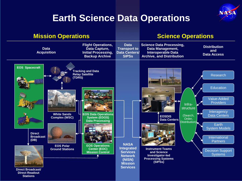
Mission Operations Science Operations
Earth Science Data Operations
Data Acquisition
Flight Operations, Data Capture,
Initial Processing, Backup Archive
Data Transport to
Data Centers/ SIPSs
Science Data Processing, Data Management, Interoperable Data
Archive, and Distribution
Distribution and
Data Access
NASA Integrated Services Network (NISN)
Mission Services
Research
Education
Value-Added Providers
Earth System Models
International Partners
Decision Support Systems
Infra- structure
(Search, Order,
Distribution)
Tracking and Data Relay Satellite (TDRS)
Instrument Teams and Science
Investigator-led Processing Systems
(SIPSs)
White Sands Complex (WSC)
EOS Polar Ground Stations
Direct Broadcast (DB)
Direct Broadcast/ Direct Readout
Stations
EOSDIS Data Centers
EOS Data Operations System (EDOS) Data Processing
EOS Operations Center (EOC)
Mission Control
EOS�Spacecraft
Interagency Data Centers

6

Science Processing Systems for EOSDIS
Microwave Limb Sounder
(MLS) SIPS
Ozone Monitoring Instrument (OMI) SIPS
Atmospheric Infrared
Sounder (AIRS) at GES DISC
Ocean Data Processing System
(OCDPS) SIPS
Active Cavity Radiometer Irradiance Monitor
(ACRIM) SCF
Solar Radiation and Climate Experiment (SORCE) SCF
Lightning Imaging Sensor (LIS) SCF
Clouds and the Earth's Radiant Energy System
(CERES) at ASDC
EOSDIS science processing systems
(SIPSs, SCFs, and DAAC-based)
perform forward processing of standard
products, and reprocess data to
incorporate algorithm improvements.
Production
Data for ECS
DAACs
Tropospheric Emission
Spectrometer (TES) SIPS
Measurements of Pollution in the
Troposphere (MOPITT) SIPS
Advanced Spaceborne Thermal Emission
and Reflection Radiometer (ASTER)
at LP DAAC
MODIS Adaptive Processing System
(MODAPS) SIPS
Multi-angle Imaging Spectro-
Radiometer (MISR)
at ASDC
Advanced Microwave
Scanning Radiometer
for EOS (AMSR2) SIPS
Stratospheric Aerosol and Gas
Experiment (SAGE III) SCF
Discipline-oriented Distributed
Active Archive Centers
(DAACs)
ASF SDC SAR Products,
Sea Ice, Polar Processes,
Geophysics
PO.DAAC Gravity, Sea Surface Temperature, Ocean Winds, Topography,
Circulation & Currents
SEDAC Human Interactions,
Land Use, Environmental Sustainability,
Geospatial Data
GES DISC Global Precipitation,
Solar Irradiance, Atmospheric Composition
and Dynamics, Global Modeling
CDDIS Space Geodesy,
Solid Earth
OBPG Ocean Biology,
Sea Surface Temperature
MODAPS/ LAADS
MODIS Level-1 and Atmosphere Data Products
GHRC DAAC Hydrologic Cycle,
Severe Weather Inter- actions, Lightning,
Atmospheric Convection ORNL DAAC
Biogeochemical Dynamics,
Ecological Data, Environmental
Processes
National Aeronautics and Space Administration
www.nasa.gov ECS
Sites
DAACs ingest, archive, process
and distribute data to users.
LaRC ASDC Radiation Budget, Clouds, Aerosols,
Tropospheric Chemistry
NSIDC DAAC Snow and Ice, Cryosphere,
Climate Inter- actions, Sea Ice
LP DAAC Surface
Reflectance, Land Cover,
Vegetation Indices

National Snow and Ice Data Center (NSIDC)
• The DAAC is located at the University of Colorado in Boulder, CO at the National Snow and Ice Data Center.
• Ingests, archives and distributes spaceborne data from AMSR-E, ICESat/GLAS, MODIS on Terra and Aqua (via ECS)
• Preparing for SMAP launch 2014
• Ingests, archives and distributes airborne data from NASA’s ICEBridge missions
• Provides tools and services for discovery of cryosphere data
• Systems consist of a mix of servers, 465 TB of disk storage, and 157 TB of tape storage (for back-up)
9

Land Processes DAAC (LP DAAC)
• The LP DAAC is located at the U.S. Department of the Interior, U.S. Geological Survey (USGS) Earth Resources Observation and Science (EROS) Center in Sioux Falls, SD.
• Processes ASTER data from Terra including the ASTER Global DEM via “S4PM” (Open source system developed by the GES DISC).
• Archives and distributes ASTER data via ECS
• Archives and distributes MODIS from
Terra and Aqua via ECS.
• Provides tools and services for discovery
and analysis of NASA’s land cover and
land use data.
• Systems consist of a mix of servers, 2.4
PB of disk storage, and 1 PB of tape
storage (for backup)
10

Atmospheric Science Data Center (ASDC)
• The ASDC is in the Science Directorate at NASA
Langley Research Center, in Hampton, VA.
• Processes production science data products for CERES and MISR science teams via “S4PM”
• Archives and distributes data from MISR, SAGE III, MOPITT, and TES via ECS
• Archives and distributes CERES via locally developed ANGe
• Provides sensor-specific
search tools as well as more
general tools and services
such as atmosphere product
subsetting
• Systems consist of a mix of
servers, 1.3 PB of disk storage,
and 931 TB of tape storage (for
backup)
11
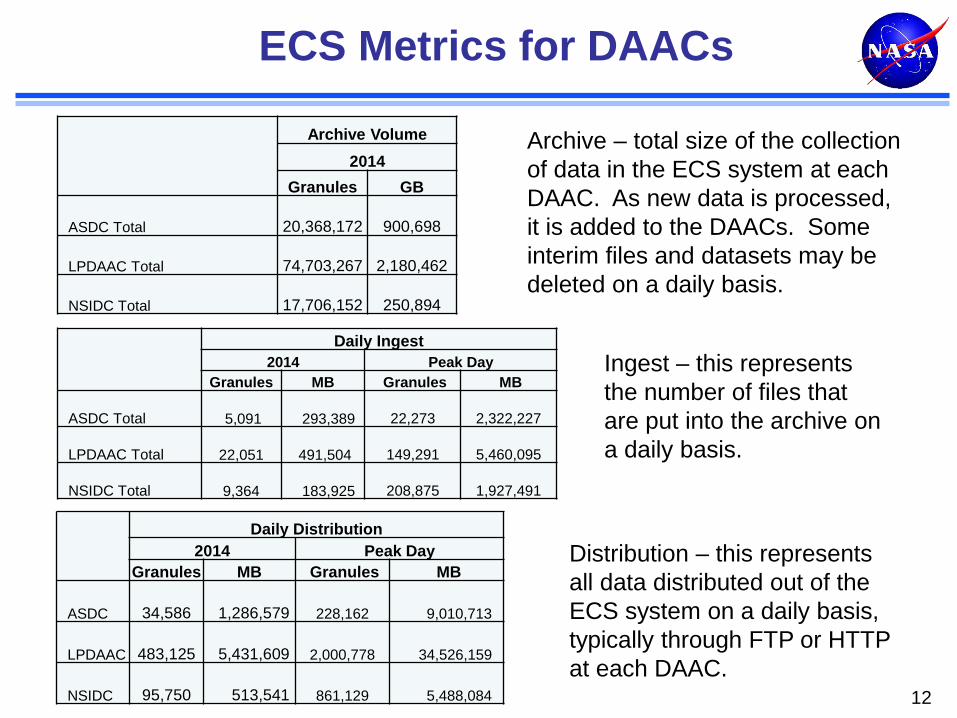
ECS Metrics for DAACs
12
Archive Volume
2014
Granules GB
ASDC Total
20,368,172
900,698
LPDAAC Total
74,703,267
2,180,462
NSIDC Total
17,706,152
250,894
Daily Ingest
2014 Peak Day
Granules MB Granules MB
ASDC Total 5,091 293,389
22,273
2,322,227
LPDAAC Total 22,051 491,504
149,291
5,460,095
NSIDC Total 9,364 183,925
208,875
1,927,491
Daily Distribution
2014 Peak Day
Granules MB Granules MB
ASDC
34,586 1,286,579
228,162 9,010,713
LPDAAC
483,125 5,431,609
2,000,778 34,526,159
NSIDC
95,750 513,541
861,129 5,488,084
Archive – total size of the collection
of data in the ECS system at each
DAAC. As new data is processed,
it is added to the DAACs. Some
interim files and datasets may be
deleted on a daily basis.
Ingest – this represents
the number of files that
are put into the archive on
a daily basis.
Distribution – this represents
all data distributed out of the
ECS system on a daily basis,
typically through FTP or HTTP
at each DAAC.

Elements and Capabilities
Science Data Processing System: The Science Data Processing System is known also known as the EOSDIS Core System (ECS) supporting the ingest, archive and distribution of data at 3 DAACs.
EarthData: the EOSDIS website (Earthdata.nasa.gov) provides a focal point for cross-DAAC and EOSDIS content and news sharing, and access to Earth science data and services
ECHO/Reverb: The EOS ClearingHouse (ECHO) is a metadata catalog of NASA's EOS data and a registry for related data services (e.g. reformatting, pattern recognition). Reverb allows users to search science data holdings, view browse images, and submit orders via ECHO to the appropriate data providers
Common Metadata Repository: The Common Metadata Repository (CMR) builds on the work done by ECHO and the GCMD to provide a unified, authoritative repository for NASA's Earth Science metadata.
User Registration System: provides a centralized and simplified mechanism for user registration and account management for all EOSDIS system components.
13
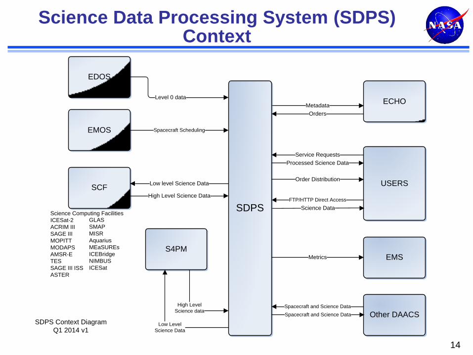
Science Data Processing System (SDPS) Context
14
USERS
EDOS
ECHO
SCF
EMS
Science Data
Metadata
FTP/HTTP Direct AccessHigh Level Science Data
SDPS
Level 0 data
Metrics
EMOS Spacecraft Scheduling
Low level Science Data
Orders
Service Requests
Processed Science Data
S4PM
Other DAACSSpacecraft and Science Data
Spacecraft and Science DataHigh Level
Science data
Low Level
Science Data
SDPS Context Diagram
Q1 2014 v1
Order Distribution
Science Computing Facilities
ICESat-2
ACRIM III
SAGE III
MOPITT
MODAPS
AMSR-E
TES
SAGE III ISS
ASTER
GLAS
SMAP
MISR
Aquarius
MEaSUREs
ICEBridge
NIMBUS
ICESat

Coherent Web Presence Across the ES Data System Earthdata.nasa.gov
Earthdata is aimed at improving EOSDIS web presence and services, as well as representing EOSDIS as an efficient and interoperable program to support NASA’s Earth science research.
Earthdata reorganized the information into an intuitive, logical structure facilitating users’ discovery of the wide array of services and content offered throughout EOSDIS (refer to
http://earthdata.nasa.gov).
15

“ECHO Architecture”
CCDIS GES DAAC LAADS
ECHO Middleware
DATA / SERVICE REGISTRY
API SERVICES
ASF NSIDC ASDC ORNL LP DAAC SEDAC
CATALOG
INGEST
OBPG
PO.DAAC GHRC
Metadata, Browse, Orders
ECHO Clients Reverb
Primary Web Based Client
Search, Browse, Order
ECHO is NASA’s middleware layer between Earth science data and users via a service-oriented architecture. Designed to improve the discovery and access of NASA data.
Acts as an order broker between end users and EOSDIS Data Centers who provide metadata for their data holdings and other Earth science-related data holdings. User-defined specialized “clients” can be easily developed to give science data users of their community access to data and services using ECHO’s open APIs.
16

ECHO Holdings and Availability
ECHO maintains a +98% uptime in all operational systems
As of May 24, 2014
Current Holdings: • Datasets: 3,855 total • Granules: 157 million • Browse: 76 million total
Registered Users: 86,322 total
17

Recent ECHO Improvements
ECHO was re-architected to provide full redundancy of all critical components, virtually eliminating need for preventive maintenance downtime, and increased stability.
• Average operational availability: 99%
ECHO search performance has been significantly improved in the past 5 years: Average query time now 4 seconds (from 30 seconds)
• Will be implementing sub-second performance
Average Ingest performance improved by a factor of 10
ECHO is working to simplify efforts of Client developers:
• Added 2 new API formats last year: OpenSearch and REST
• Benefits: Lightweight architecture and ease-of-use for Client developers
18

REVERB - Data and Service Access Client
• Reverb is the primary web-based client for
discovering and ordering cross-discipline data from all of ECHO’s metadata holdings.
• Reverb allows users, including those without specific knowledge of the data, to search science data holdings, retrieve high-level descriptions of data sets and detailed descriptions of the data inventory, view browse images, and submit orders via ECHO to the appropriate data providers.
• Users are able to submit queries using spatial and temporal criteria and examine search results for relevancy using built-in tools.
http://earthdata/reverb
19

Common Metadata Repository 1 of 2
20

21
End user applications will continue to work
Common Metadata Repository 2 of 2

EOSDIS User Registration System (URS)
Consolidation of Similar Registration Systems into an EOSDIS Wide User Registration System
Improve the User Experience • Simplified and Consistent User Registration & Authentication
• Integrated with Coherent Web (Earthdata.NASA.gov)
• https://urs.eosdis.nasa.gov/
22
Standardized Method of Metrics Collection & Reporting (via EOSDIS Metrics System - EMS) • Understand User Demographics and
Access Patterns
Enable Status Change Notifications to Users
• By access pattern, data product, site, application, etc.
Establish Framework for Future Capabilities
• User Tailoring, Customized Views
• Saved Queries, Order Management
Goal for phase-in by all DAACs is mid 2015
URS Technical Architecture

URS GUI
As of May 24, 2014
Total Users: 107,818 (Increasing 400+ new users per week)
Authentications: Averaging 1.2 million weekly
Operational Systems: ECHO (Reverb), LANCE, Earthdata (including ECE & wiki), EMS, GCMD, LP DAAC, OBPG (MERIS) and ASF (more to come…)
https://urs.eosdis.nasa.gov/
23
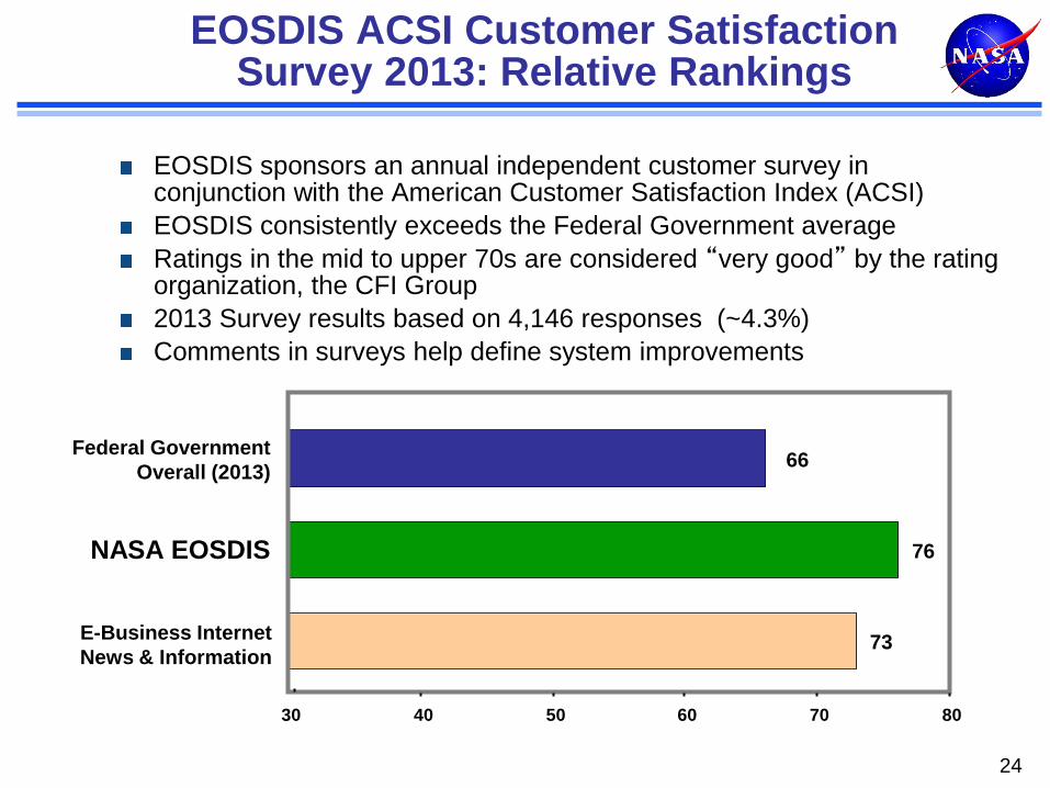
EOSDIS ACSI Customer Satisfaction Survey 2013: Relative Rankings
EOSDIS sponsors an annual independent customer survey in conjunction with the American Customer Satisfaction Index (ACSI)
EOSDIS consistently exceeds the Federal Government average
Ratings in the mid to upper 70s are considered “very good” by the rating organization, the CFI Group
2013 Survey results based on 4,146 responses (~4.3%)
Comments in surveys help define system improvements
24
73
76
66
30 40 50 60 70 80
E-Business Internet
News & Information
NASA EOSDIS
Federal Government
Overall (2013)
0
100
200
300
400
500
600
700
800
900
FY00 FY01 FY02 FY03 FY04 FY05 FY06 FY07 FY08 FY09 FY10 FY11 FY12 FY13
EOSDIS Product Distribution Trend Millions
0.00
2.00
4.00
6.00
8.00
10.00
12.00
FY00 FY01 FY02 FY03 FY04 FY05 FY06 FY07 FY08 FY09 FY10 FY11 FY12 FY13
Vo
lum
e (
PB
s)
Multi-year Total Archive Volume (PBs) Trend
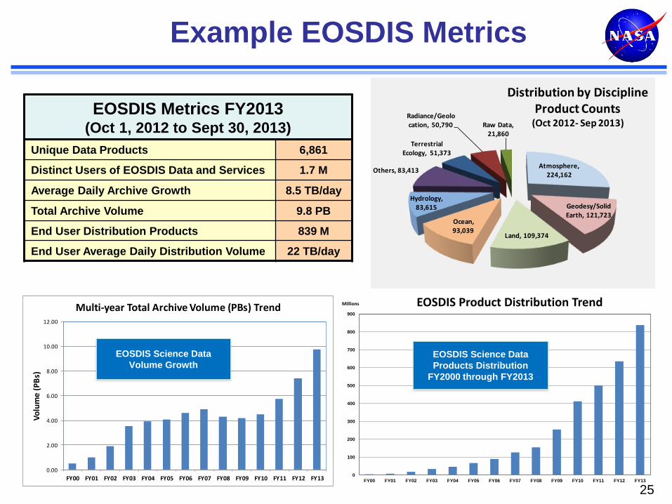
Example EOSDIS Metrics
25
EOSDIS Science Data
Products Distribution
FY2000 through FY2013
EOSDIS Science Data
Volume Growth
Atmosphere, 224,162
Geodesy/Solid Earth, 121,723
Land, 109,374
Ocean, 93,039
Hydrology, 83,615
Others, 83,413
Terrestrial Ecology, 51,373
Radiance/Geolocation, 50,790 Raw Data,
21,860
Distribution by Discipline Product Counts
(Oct 2012- Sep 2013)EOSDIS Metrics FY2013
(Oct 1, 2012 to Sept 30, 2013)
Unique Data Products 6,861
Distinct Users of EOSDIS Data and Services 1.7 M
Average Daily Archive Growth 8.5 TB/day
Total Archive Volume 9.8 PB
End User Distribution Products 839 M
End User Average Daily Distribution Volume 22 TB/day

Summary
EOSDIS is one of the largest science information systems in the
world.
The ECS/SDPS, EarthData, ECHO, Reverb, User Registration are
critical components of the EOSDIS.
• The ECS SDPS archives > 3 petabytes of data across three
DAACs, and distributes an average of ~ 7 terabytes of data per
day from NASA’s EOS and other missions
• ECS is highly tuned to support efficient transfer of high data
volumes
• Earthdata, ECHO, Reverb, User Registration support all EOSDIS
DAACs, and all EOSDIS data holdings.
Continued reliable, responsive, and efficient service by EOSDIS to
NASA’s Earth science data users is essential.
26