Digital Doughnut Meet-up April 2015 - James Leavesley CEO and Founder of CrowdControlHQ

CONTRIBUTORS Jennifer Gabriel (Editor) Jim Specht Mathew Leavesley Matthew Kelly Michael Wood Simon Foale Colin Filer Susan McIntyre-Tamwoy
R Michael Bourke David Gill Jean-Paul Sounier
The Nakanai Mountain Ranges of East New Britain
Papua New Guinea
Published by The Cairns Institute James Cook
University Cairns
ISBN 978-0-9954471-4-1
doi 10259035bac1326e555a
This report is licenced under a Creative Commons
Attribution 40 Australia licence You are free to copy
communicate and adapt this work so long as you
attribute James Cook University [The Cairns Institute]
and the authors
This report should be cited as Gabriel J Specht J
Leavesley M Kelly M Wood M Foale S Filer C
McIntyre-Tamwoy S Bourke R M Gill D amp
Sounier J-P (2018) The Nakanai Ranges of East New
Britain Papua New Guinea Cairns James Cook
University
The views and opinions expressed in this publication
are those of the authors and do not necessarily
reflect those of the Cairns Institute or James Cook
University
This report is available for download from
eprintsjcueduau
September 2018
Cover images
Main image David Gill | Opening to Mageni Caves
Nakanai Mountains East New Britain by 2006
Background image Free-Photos |
pixabaycomphoto-918570
CONTENTS
FIGURES i
ACKNOWLEDGEMENTS ii
THE NAKANAI MOUNTAIN RANGES OF EAST NEW BRITAIN PAPUA NEW GUINEA 1
Nakanai Mountains Pomio District East New Britain Province 2
THE CAVES OF THE NAKANAI MOUNTAINS 3
History of Caving in the Nakanai Mountains 4
Mega-dolines of the Nakanai Mountains 9
History of the Region Early European Encounters 12
Early Commercial and Missionary Activity 12
World War I 13
World War II 14
Post War 15
Archaeology of the Region A Brief Overview 18
UNIQUE FLORA AND FAUNA OF THE REGION 22
UNESCO World Heritage Tentative List The Sublime Karsts of Papua New Guinea 25
Justification for Outstanding Universal Value 26
BIBLIOGRAPHY 29
i
FIGURES Figure 1 Map of East New Britain Province showing Nakanai Mountains 1
Figure 2 Ora Dolines or Uvala Schematic 1972-73 Expedition 5
Figure 3 Ora River Caves schematic by Dave Clucas 6
Figure 4 Muruk underground river 9
Figure 5 Minye underground river 10
Figure 6 Minye Doline from above 11
Figure 7 Nare Doline 11
Figure 8 Nare Doline on the Nakanai Plateau 12
Figure 9 View of Palmalmal plantation house on the small rise showing the house in relation to the
plantation 16
Figure 10 Members of a company HQ Patrol of the 1432nd Infantry Battalion leaving the Mal Mal
Mission church Note the damage to faccedilade of the church probably from RAAF strikes These remain
as patched sections in the current faccedilade 16
Figure 11 Remains of the plantation homestead at Cutarp Plantation Jacquinot Bay 15-December
1944 17
Figure 12 An old copra drying shed on Palmalmal Plantation which had been used as a Japanese
kitchen during the occupation 21st November 1944 17
Figure 13 An ovoid scraper from Yombon 19
Figure 14 Chert from a location inland from Kandrian - probable age is around 6000-3500 years 20
Figure 15 Lapita sherd found at the Liton River mouth Jacquinot Bay 20
Figure 16 Selected bird pestles (left image) Selected mortars (right image) The distribution of the
lsquobirdrsquo pestle from across the region suggests some cultural connectivity in the past 21
Figure 17 Find spot of the stone pestle New Britain Jacquinot Bay 21
Figure 18 Previously undescribed species of montane mouse 22
Figure 19 A shrub-dwelling Platymantis is new to science and known only from the highest elevations
accessed during the 2009 Nakanai Mountains survey 23
Figure 20 The Platymantis species is new to science and known only from the cold wet forests atop
the Galowe Plateau in the Nakanai Mountains 23
Figure 21 The colourful dragonfly Agrionoptera insignis similis was common near small streams in
disturbed forest around Palmalmal Village 24
Figure 22 Rhytidoponera sp an ant collected during the Nakanai RAP expedition 24
Figure 23 World Heritage proposal tentative list 25
ii
ACKNOWLEDGEMENTS This research was supported by the Australian Research Linkage Grant LP140100536 managed by
James Cook University
The assistance of the following people who provided insight and expertise that greatly assisted our
research in the Nakanai Mountains Project is acknowledged with thanks
The Pomio Community and the people of East New Britain
The Australian French and British Caving Teams for generously sharing their stories reports photos
and data with us
We thank our colleagues from James Cook University the University of Sydney the Australian National
University the University of Papua New Guinea Extent Heritage Partners with Melanesians and The
PNG National Museum and Art Gallery
We thank Katrina Keith and The Cairns Institute for assistance with formatting proofing and finessing
which greatly improved the manuscript although any errors are our own
1
THE NAKANAI MOUNTAIN RANGES OF EAST NEW BRITAIN PAPUA NEW
GUINEA Deep beneath the rain forests of New Britain an island off the coast of Papua New Guinea churning
rapids jet through enormous passages some of the largest most remote river caves on the planet To
reach them explorers must first descend into massive dolinesmdashsinkholes where soluble rock
weakened by runoff from an estimated 18 feet of rainfall a year has collapsed From the air they
appear like impact craters as if a volley of meteorites had long ago pummelled the forest (Shea 2006)
Figure 1 Map of East New Britain Province showing Nakanai Mountains Map source Australian National University reproduced with permission
2
This E-Book on the Nakanai Mountains of East New Britain is in four parts The first section provides
an overview of the karst and cave attributes which led to the listing of Nakanai on the Tentative World
Heritage List in a Serial Site known as The Sublime Karsts of Papua New Guinea The next section
provides a brief history of the region involving European encounters This is followed with a brief
overview of the archaeology of East New Britain The fourth section highlights some of the unique
flora and fauna of the Nakanai The final section includes the UNESCO Justification for Significance on
the Tentative World Heritage List
Nakanai Mountains Pomio District East New Britain Province The Nakanai Mountain Range in East New Britain is located in Pomio District in primary rainforest with
an area of over 3000 square kilometres (Gill 2012 p 1) The limestone karst area extends from the
mountain summits to the southern coastline Within the Nakanai mountains are some of the largest
caves in the Southern Hemisphere known collectively as the Nakanai Caves The Nakanai Mountains
contains some of the worldrsquos largest river cave systems with some of the largest and fastest flowing
underground rivers in the world
These mountains are made up of layers of limestone that are about 225 to 105 million years old
covered with fragmentary layers of fine volcanic sediments The heavy rain creates rivers in the
mountain ranges which over time create deep valleys Over the last 200000 years eight giant
canyons have formed in the Nakanai Ranges with depths reaching 600 ndash 1000 metres The upper
reaches of these canyons and their side ravines contain some of the most powerful springs in the
worldmdashtheir sources are located in giant caves deep within the limestone layer
Large underground passages and giant sinkholes (megadolines) have resulted partially from the
erosion of soft limestone by underground streams The deepest cave to date is called Muruk ndash at 17
kilometres in length and 1178 metres in depth it was the deepest cave documented in the Southern
Hemisphere at the time (Audra Lauritzen amp Rochette 2011 Richards amp Gamui 2011)1
In 2007 the Nakanai area was nominated to the PNG Word Heritage Tentative List within the serial
site known as lsquoThe Sublime Karsts of PNGrsquo Four decades of exploration has increased our knowledge
of the caves and brought to light the significant biodiversity value of the area An environmental study
in 2009 identified over 100 new species of animals in the Nakanai mountain range previously unknown
to science In this booklet we outline past and current initiatives to document and protect the natural
and cultural values of the Nakanai Mountains as well as providing a brief overview of the history
archaeology and flora of the region
1 In 2014 Stormy Pot Cave on Mt Arthur in New Zealand with a 10km passage was recorded with a depth of 1200m making it the deepest cave known to date in the southern hemisphere httpwwwstuffconzscience9675130Southern-hemispheres-deepest-cave-found
3
THE CAVES OF THE NAKANAI MOUNTAINS The Nakanai caves are part of a globally unique system of limestone caves They are located within
the Nakanai Range amongst primary rainforest extending from the mountain summits to the southern
coastline (Gill 2012) The Nakanai region comprises a limestone mountain range with an area covering
approximately 4000 square kilometres Cavers rely on aerial images to look for deep caverns to
explore In the images large surface sinkholes characteristic of the rainforest-covered karst
landscape look like enormous black holes of varying sizes Once identified professional cavers
venture into the depths of giant caves Major advances in understanding the Nakanai caves have been
achieved through 45 years of expeditions the first of which was undertaken by Australian cavers
followed by French and British international teams The following expeditions have revealed
significant information about the caves and the expansive underground cave river networks (see
hyperlinks below)
EXPEDITION TIMELINE
1 197273 Pioneering Australian Expedition (Bourke et al) Ora Dolines
2 1978 First French Expedition (Sounier et al) reconnaissance of Nare Doline and Minye Dolines
3 1979 Swiss Expedition Kavakuna
4 1980 French Expedition (Sounier et al) Nare Doline Kavakuna doline Ka 2 Vuvu
5 1985 French Expedition (Sounier et al) Minye Muruk (- 637m)
6 19841985 First British-led Expedition (Gill et al) Nare Pavie and Gamvo caves
7 1988 French-International Expedition (Sounier et al)
8 1995 French-International Expedition (Sounier et al) Muruk Cave Expedition
9 1998 French-International Expedition (Sounier et al)
10 2002 French- International Expedition (Sounier et al) Bairaman River Expedition
11 2003 French-International Expedition (Sounier et al) Papou Expedition
12 2005 French- International Expedition (Sounier et al) Marana Kapate Cave
13 2006 British (Gill et al) Untamed Rivers Expedition
14 2007 French-International Expedition (Sounier et al)
15 2008 British BBC Documentary (Gill et al) Pandi River Expedition
16 2010 French-International Expedition (Sounier et al) Vuvu Cave
17 2012 French-International Expedition (Sounier et al) Wowo Cave system
18 2014 French-International Expedition (Sounier et al) Wara Kalap Source
19 2015 Japanese Expedition Kavakuna Cave
20 2016 French-International Expedition (Sounier et al) Black Hole Expedition
21 2018 French- International Expedition (Sounier et al) Ghost Rivers Expedition
4
History of Caving in the Nakanai Mountains The Nakanai Mountains are up to 2185 metres high in the central-eastern part of the island They are
bounded on the east by the Kol Mountains and to the west the Kapiura-Ania Divide which separates
the Nakanai Range from the Whiteman Range Vast limestone outcrops span over 550000 hectares
North South and West The topography which is known as lsquocock pit karstrsquo is covered in dense tropical
forest An early report on the caves of New Britain noted that lsquostories of great river effluxes and cave
entrances are common for the area inland from Pomiorsquo (Bourke 1973 p 15) An abundance of insects
and multiple species of bats and flying foxes could be found in a single cave in large numbers
The first very preliminary exploration to the Nakanai Mountains was undertaken in 1968 by Chris
Borough and Kevin Reid of the Port Moresby Speleological Society The team sought to explore the
Minye dolines near Tuke Village C J Borough writing in the Niugini Caver (1973) of his experience
locating what he called the lsquoBIG HOLErsquo in 1968 described the Nakanai karst landscape as consisting of
endless sinks with almost vertical sides near the outer edge of each and clothed in dense forest
Borough wrote
It can only be described as impossible country and I never succeeding in pursuing more than
a km into it from one edge Army maps show two remarkable features on one of the limestone
plateaux North of Pomio in Eastern New Britain They are a large hole about 15 km long and
460 m deep and a smaller hole 05 km wide and 380 m deep For the average caver this is
too much and I drooled at the prospect of seeing these immense holes (Borough cited in
Bourke 1973 p 25)
C J Borough and his caving colleague Kevin Reid arrived in Tuke Village by helicopter To locate the
lsquoBIG HOLErsquo local people were recruited as guides but would not accompany Borough and Reid all the
way to the sinkhole as it was regarded as a place of foreboding where devils and ravenous crocodiles
may lay in wait at the bottom Upon descending around 60 metres into the hole the realisation that
a full descent to the 300 metres would require specialist equipment saw Borough and Reid return to
the village
The first official caving expedition to the Nakanai Mountains was undertaken by an Australian team in
1972 when Michael Bourke led an expedition (4 men and 2 women) from the University of Queensland
Speleological Society to the Ora dolines Bourke had previously conducted an 8-day trip to the Oro
dolines in April 1972 entering the northern doline but not reaching the bottom During the 1972-73
expedition the team explored the northern doline following a river at the bottom to a cave chamber
15-27 metres wide and about 27 metres high They charted 168 metres of passage before progress
was halted by a waterfall that occupied the entire cave floor The Australian team noted that it should
be possible to explore further by traversing above the waterfall
Moving upstream from the bottom of the doline they entered a large cave chamber 600 metres long
and 67 metres deep with huge stalagmites hanging from the roof By moving through the chamber in
a southerly direction they emerged out in the bottom of the twin doline Walls as high as 100 metres
rose up from the bottom Re-entering the cave from the southern doline the cavers followed an old
stream passage back to the river Downstream was a spectacular waterfall and upstream they moved
through a beautiful section along the river to a lake ldquoCalcite curtains candle wax stalagmites
flowstone and stalactites lavishly decorate this areardquo (Bourke 1973 p 30)
5
Figure 2 Ora Dolines or Uvala Schematic 1972-73 Expedition Image source Bourke 1973 p 33
6
Figure 3 Ora River Caves schematic by Dave Clucas Image source Gill 2012 p 13
Following the Australian expedition a French caving expedition continued the research in 1978
Numerous expeditions came later The 1979 Swiss expedition to Kavakuna Cave and descent to 320
metres resulted in tragedy when one of the cavers drowned in a caving mishap and the rescue
7
helicopter en-route to Rabaul had engine failure and crashed into the river (Bourke 1982 pp 89-
95)
In 1980 a French-international team led by Jean Paul Sounier explored the three entrances of
Kavakuna Cave and undertook the initial exploration of the Nare river cave near the village of Nutuve
In 1984 and 1985 the British caving team completed the exploration of Nare Cave the Pavie River
Cave and the Gamvo Cave system Towards the end of the expedition a reconnaissance trip looked at
the Ora dolines The British team felt that the cave warranted a further visit but it was to be over
twenty years before they returned (Gill 2012)
The 1985 expedition to Nakanai undertaken by the French international team2 explored Minye Cave
and Muruk Cave A decade later during the 1995 expedition the French team dived the final sump (a
passage in a cave that is submerged under water) and enabled Muruk to become the first 1000-
metre-deep cave documented in the Southern Hemisphere (Audra et al 2011)
In 1998 during a helicopter reconnaissance flight over the area between Galowe Gorge to the east
and the huge Wunung Gorge to the west French caving expedition leader Jean-Paul Sounier was
surprised to see that unlike Galowe Gorge no rivers poured into this 1000-meter-deep Wunung
Gorge canyon This begged the question where was the water flowing into the mouth of the coastal
Wunung River coming from The mysterious ghost rivers of the Wunung Gorge became the subject of
an expedition in 2016 and 2018
The British cavers returned in 2006 with a team of twelve from the UK France and the United States
The UK expedition led by David Gill involved a two-month expedition to complete the Untamed
Rivers Expedition first commenced in 1984 The primary purpose was to complete the exploration
and mapping of the Ora river cave and to search for other caves in the area The secondary objective
was to gather data with the aim of establishing a Nakanai Conservation Area which would be proposed
for World Heritage status to protect the cave area from destruction by logging Funding was obtained
from the National Geographic Society the Royal Geographic Society and the Ghar Parau Foundation
The National Geographic Society sent along a photographic team and published an article about the
River Caves of East New Britain (Shea 2006)
During the British expedition over twelve kilometres of river caves were explored and mapped The
Phantom Pot cave was mapped during the early stages of the expedition at an altitude of 1045
metres Phantom Pot was surveyed for 39 kilometres over a depth of 191 metres (Gill 2012 p 14)
Exploration upstream of the Ora River Cave led to the discovery of the Little Ora River Cave The total
length of the Ora River Cave system was recorded as 1220 metres with a depth of 317 metres from
the lowest point of the doline rim Upstream the British documented a 67-metre-long 58-metre-wide
lake which was named Lake Myo Further upstream from the main river inlet was a ten-metre-high
waterfall Myo Falls On a helicopter flight into Ora Village a large cave entrance was seen emerging
from high up on the cliff face to the south of the village Entry into the cave required a fifty-metre
abseil descent and a climb along the cliff to the 80-metre waterfall named Mageni by the local people
Beyond the waterfall were more than five kilometres of cave tunnels―but the team only explored the
2 The French caving team led by Jean Paul Sounier have continued to explore and extensively document the underground caves and underground passages returning in 1998 2002 2003 2005 2007 2010 2014 2016 and 2018
8
main tunnel The Mageni cave system3 mapped to a total length of 94 kilometres lies parallel to the
underground Ora River cave system Another cave located they called Triosaurus Cave―a small cave
61 metres long and 43 metres deep
To promote conservation of the caves meetings were held with the Department of Environment and
Conservation the National Research Institute the Provincial Government of East New Britain the
Governor of East New Britain the Tourism Authority the Local Level Government Pomio District and
non-government conservation organisations as well as with local villagers and logging company
management A presentation was given to the World Heritage Department in Port Moresby The
expedition eventually led to the area gaining Tentative World Heritage listing status (Gill 2012)
In 2010 a French-Swiss caving team led by Jean Paul Sounier returned to the Nakanai Mountains and
found the junction of two big caves which form the Wowo cave system The expedition in 2012 by
the French-Swiss team went back to the Wowo cave system and with more than 20 kilometres of
charted galleries it is now the most extensive cave system known in New Britain Island The team also
discovered and explored a 423-metre-deep cave known as Khou
The first attempt to understand the underground river network known as the Wara Kalap resurgence
was made by a French-Swiss team comprising 15 cavers in 2014 The Wara Kalap (or lsquoleaping
waterfallrsquo) cascades onto the beach on the western side of Jacquinot Bay at around 5 cubic metres per
second4 from an opening roughly 1 metre wide by 18 to 2 metres high It is one of three waterfalls
along the coastal beach whose source lies deep inside the forested Nakanai Mountains
In January 2016 an international team led by French caver Jean-Paul Sounier explored a gigantic black
sinkhole spotted in aerial images On a plateau along the left bank of Wunung Gorge a black and white
mark indicated a surface sinkhole with a black hole almost 100 meters wide and 100-150 metres deep
During the lsquoBlack Holersquo Expedition in 2016 the team spent four weeks surveying and mapping caves
and galleries One cave was named Wild Dog Cave after a long howl similar to that of a wolf pierced
the previous night In the sinkhole they initially named Dooble the ceiling is magnificently decorated
with white stalactites and streams waterfalls and underground lakes flow through the galleries The
discovery of the 714-metre-deep cave named as Dooble was re-named the Christian Rigaldie Cave to
honour a caver who was part of the first French expedition to the Nakanai Mountains in 1980
Although he never returned to Nakanai Christian Rigaldie contributed to the funding of several
expeditions and died of illness in 2015 At 714 metres deep the Christian Rigaldie cave now ranks as
the second deepest cave in Papua New Guinea after the Casoar (Muruk) cave network (Sounier
2017)5
In 2018 the French-led team returned to explore the underground drainage system of the Christian
Rigaldie Cave network which flows deep beneath the Wunung Gorge The lsquoGhost Riversrsquo expedition
documented sixteen cave chambers beneath the Nakanai Mountains The Ghost Rivers Expedition
was concerned with exploring the source of the Wara Kalap waterfall first commenced in 2014 The
2014 team set up three camps at different elevations (400m 650m and 100m) with the highest camp
3 The Mageni cave featured in the BBC documentary lsquoThe Lost Land of the Volcanorsquo April 2008 4 There are several areas where the water flow is around 20m3second 5 Other named caves included Wild Frank Cave Arche Cave and Surprise Cave after it was discovered while looking for another cave (Sounier 2017 p 45)
9
about 6 to 7 hours trek from the ocean through almost impenetrable primary rainforest After three
weeks exploring blocked cave entrances the team found a collection basin with fast-flowing
underground rivers exploring and charting 6 kilometres of networks with two major cavities more
than 500 metres deep The biggest of these cavities at around 580 metres deep was named Phillipe
Pato Cave (to pay homage to a former porter) the third deepest cave in Papua New Guinea
Figure 4 Muruk underground river Image source Jean Paul Sounier
Mega-dolines of the Nakanai Mountains Four exceptionally large dolines (lsquomegadolinesrsquo) are known from the north of Pomio One is only a few
kilometres north-west of Pomio (Bourke 1973 p 28) A doline or sinkhole is a collapsed cave system
that provides entrances to the underground world Huge limestone cliffs on the plateau are formed
where rivers cut through the limestone Cliffs as tall as 300 metres high are common with some
reaching up to 900 metres high (Bourke 1973 p 28)
Giant sinkholes (lsquomegadolinesrsquo) of the Nakanai Mountains have been surveyed and found to be among
the largest and most impressive in the world Nare Kururu Poipun and Liklik Vuvu are just a few of
the cavernous dolines explored by international teams of cavers The massive Ora dolines are known
as a lsquodouble dolinersquo or uvala with a bridge across the centre From above the Ora dolines look like
giant holes in the dense green jungle visible even in comparatively blurry satellite images They are
situated in thick limestone around 1130 metres above sea level The Ora dolines are the largest in
the limestone plateau Orarsquos twin dolines have been surveyed to be 1400 metres in length 750 metres
across and 200 metres in depth (Gill 2012 p 9)
The Minye doline (coordinates 52432 S 1515049 E) lies on a plateau at an elevation of 1000 metres
close to the village of Tuke located near the Namure resurgence where the Minye River comes out
The area of the Minye sinkhole is around 75000 square metres and water volume is up to 26 million
cubic metres The doline is 350 metres in diameter with a depth of 400 ndash 510 metres Because Minye
is located on a slope the upper rim is 100 metres higher than the lower rim The floor of the sinkhole
10
is crossed by a powerful river―from the upper rim it may look like a narrow stream but the volume
of the stream is 15-25 cubic metres per second increasing significantly after torrential rain The cave
passages at the bottom of Minye have been explored to a length of 5421-metres but this may be just
a small part of the system Powerful subterranean rivers require large passages―and the caves under
Minye are giants Tuke chamber is one of the largest cave chambers in the world It is estimated at
240 metres long 160 metres wide and 180 metres high The floor area of this chamber is around
48000 square metres with total water volume estimated at 624 million cubic metres
The Nare doline (coordinates - 52940 S 1516399 E) is around 150 metres in length and 120 metres
wide The depth is between 240 to 310 metres with water volume estimated around 47 million cubic
metres The walls of the sinkhole are vertical and not covered with jungle All of the limestone which
earlier filled the present hole has been washed down the ranges by the subterranean river named
Nare River (the huge downstream passage has been named the lsquoFlying Dutchman galleryrsquo) flowing
across the bottom of sinkhole The volume of this river flows around 15-20 cubic metres per second
and after heavy rain the discharge can be up to 50 times higher The mighty subterranean river in
Nare Cave is extremely loud and earplugs are required to endure exploration French cavers
descended into this doline in 1978 and 1980 exploring cave passages up to four kilometres in length
British cavers continued exploration in 1985
Figure 5 Minye underground river Image source Jean Paul Sounier in Audra et al 2001
11
Figure 6 Minye Doline from above Image source Jean Paul Sounier (1985) in Audra et al 2001
Figure 7 Nare Doline Image source David Gill 2006
12
Figure 8 Nare Doline on the Nakanai Plateau Image source Jean Paul Sounier (1985) in Audra et al 2001
History of the Region Early European Encounters The first European references to the southern shore of the island of New Britain come from the voyage
of William Dampier when he passed by the island in the late 17th Century In 1699 he sailed in the
Roebuck past the north coast of New Guinea In February 1700 he visited the large island to the east
of New Guinea and determined that it is separate from New Guinea He then sailed along its southern
coast and named it Nova-Britannia (New Britain) He sighted and named Cape Orford after his patron
and Admiral of the Fleet Edward Russell but passed by the study area of Jacquinot Bay with no
mention in the shiprsquos log of any features along this part of the south coast (Dampier 1906 pp 533
543 1939 pp 208-210)
In July 1827 Dumont DUrvilles French ship Astrolabe also sighted the south coast of New Britain
During the course of this voyage DUrville mapped part of the southern coast of New Britain and it
was at this time that Jacquinot Bay is named after the 2nd in command of the exploration fleet Charles-
Hector Jacquinot (1796-1879)
Early Commercial and Missionary Activity Missionary efforts in Oceania had commenced in late 18th Century in Polynesia and had moved to
Micronesia by the early 19th Century Melanesia was the last area in Oceania to be Christianised (Ernst
amp Anisi 2016) The Catholic Church established the Apostolic Vicariate of Melanesia in 1844 with the
first Marist missionaries to Melanesia arriving in the following year They first set up in the Solomonrsquos
13
and later on Woodlark Island This initial effort failed and successful missionary efforts had to wait
until the end of the 19th Century In the 1870s the Rev George Brown established a mission at Port
Hunter Duke of York Island organised by the Australasian Wesleyan Methodist Mission During his
stay on the island he travelled to both New Britain and New Ireland and reported on his observations
of the land and its inhabitants (Brown 1881 1887)
In 1882 Pope Leo XIII appointed the Missionaries of the Sacred Heart (MSC) a French order to
evangelise the vacant vicariates of Melanesia and Micronesia Fr Couppeacute (MSC) from France arrived
at Yule Island British New Guinea in 1886 and three years later was appointed Vicar Apostolic of
Melanesia Christianised (Ernst amp Anisi 2016)6 The establishment of European missions in New Britain
the latter part of the 19th Century was largely focused on the Gazelle peninsula Missionary activity
outside this area was scant but Bishop Couppeacute visited Jacquinot Bay in late November 1899 in the
company of Fr Rascher and the Imperial Administrator Heinrich Schnee (Schneider 1954) It was
probably during the 1899 visit to Jacquinot Bay that the land for the future Mal Mal mission was
purchased or the site chosen7 However no development of this mission was to take place until the
next century
The New Guinea Compagnie (NGC) a mercantile venture that would be closely associated with the
development of the German possessions in New Guinea was a speculative enterprise set up in 1884
It had originally been established to colonise and exploit the resources of the new colony The
exploitation of the colony was to be primarily undertaken through the establishment of plantations
directed by European colonists directing local labour
World War I In 1912 the NGC purchased land at Jacquinot Bay that was to become the plantation of Palmalmal
However WWI intervened and Australia occupied the German possessions including New Britain As
a result of the determinations at Versailles the German colonies in the south Pacific were stripped
from Germany and the former colony of New Guinea was mandated to Australia Land formerly owned
by German companies and individuals was expropriated by the Australian Government and auctioned
off to former Australian Imperial Force (AIF) soldiers The land holding at Palmalmal was expropriated
by the Australian Government auctioned in 1926 to J Chapman Chapman had purchased a number
of other plantations in New Britain at the same time and it would appear he was in fact ldquodummyingrdquo
or acting for a larger company in the purchase That company was WR Carpenter and Co Ltd a large
trading firm based in Sydney Port Moresby and later Solomon Islands By the 1930s the plantation
was managed by Paul lsquoKar Karrsquo Schmidt an experienced plantation manager
The NGC also purchased land on the north coast of Jacquinot Bay that was to eventually become
Cutarp Plantation The original indigenous name for the locality was Malavapun The Custodian of
Expropriated Property submitted the site for auction as lot 145 offered as the third group of
expropriated properties in February 1927 Two Australian ex-soldiers Frank Oakley Cutler and Victor
6 Couppeacute was to remain Vicar Apostolic until 1923 when he resigned He died in 1926 in Douglas Park NSW and was reburied at Vunapope the following year 7 Couppeacute was reportedly refused many areas of land he had chosen for his missions by the Governor He claimed to have interviewed officers at the German Foreign Office during a trip there and ldquotalked them overrdquo into meeting his land requirements without them realising there had been an official refusal see MacKellar 1912 p 77
14
A Pratt bought the 1000 hectares of lsquovirgin landrsquo on the central coast of Jacquinot Bay for pound831 Cutler
was to eventually acquire Prattrsquos interest in Cutarp and run the plantation until the beginning of WW2
The 1930s was a period of change in the Bay On May 12 1931 the Mission motor launch Teresa
accompanied by the cutter Toriu set out from Vunapope carrying the first missionary (Fr William
Culhane MSC) to the Mengen village Malmal in Jacquinot Bay The initial construction at the Malmal
mission on land already owned by the Church consisted of a church 60 feet by 21 feet which the
locals had built out of bush materials on their own initiative (ldquoSouth Sea cannibalsrdquo 1932 p 21) Due
to poor siting of this church it did not remain in use for very long and was replaced by the present
church presbytery and some ancillary buildings and a small motorboat all built from wood sawn at
the sawmill at Ulamona The presbytery was situated on a small hill 200 yards from the water (ldquoSouth
Sea cannibalsrdquo 1932 p 21) Fr Culhanersquos initial presbytery consisted of a small dwelling and a
detached lsquoprayer housersquo both made of bush materials (Fr Clarence Paru ndash Mal Mal Mission personal
communication) Father Edward (Ted) Harris arrived in Rabaul in 1940 and by April 1941 he had
replaced Fr Culhane (who moved to Gasmata) as the missionary at Mal Mal Mission at Jacquinot Bay
(Dawes 1959 p 45)
During the 1930s Wunung plantation was also established In the 1920s and 30s a saw-mill run by
Cecil ldquoCharlierdquo Bowles operated on the land that would later become Wunung plantation (Gwarpoon
1945 Waldersee 1975 p 560) In 1937 the saw-mill was moved to Waterfall Bay and was still
operated by the Bowles family8 (Mackenzie 1942 p 5) This report indicates that it was not until this
time that Wunung Plantation itself was established (Gwarpoon 1945 p 3)
World War II On January 22nd 1942 Japanese Military forces known as the Nankai Shitai (South Seas Detachment)
landed at Rabaul to establish a major base to be served by Simpson Harbour (formerly known as
Simsonhafen under German administration) The defenders were known as Lark Force and consisted
of the 222nd AIF Battalion the local New Guinea Volunteer Rifles artillery and anti-aircraft units and
support services (Wigmore 1957) The defeat and dispersion of Lark Force at Rabaul saw their retreat
through the jungles towards the west The remnants moved away from Rabaul along both the north
and south coasts where movement on foot was easiest Some of those moving to the south were
victims of a massacre by Japanese Forces at Tol Plantation Those able to avoid Japanese forces
moved further west and gradually coalesced at Palmalmal Wunung and Drina Plantations The
exhausted and demoralised troops were assisted by the occupants of the plantations and most
notably by Fr Harris at Mal Mal mission
After several weeks of recuperation at the missions the survivors were picked up by HMAS Laurabada
on April 10 1942 who took 156 back to relative safety at Port Moresby This included many from the
plantations who had assisted the Australian troops However despite many entreaties Fr Harris
refused to leave his parishioners He was subsequently murdered by the Japanese and his body has
never been found Many of the locals left after they had seen the treatment of Fr Harris or were
forced from their homes by the Japanese Some lived in caves nearby for the duration of the war
However some also stayed as collaborators (Korba of Tokai) while others resisted and were able assist
8 see Mackenziersquos reference to Mrs Bowles sawmill at Waterfall Bay 1945 p 5
15
the Allied Forces during the period 1942-44 (Golpak Luluai at Sali) Many no doubt largely continued
with the lives they led prior to the war hoping to maintain a level of normalcy in their lives
The Japanese occupied the area of Jacquinot Bay and there is evidence of an early warning radio
position at Cape Cunningham and anti-aircraft position and headquarters building at Palmalmal along
with use of existing buildings at Palmalmal Mal Mal and Cutarp for storage and accommodation The
Japanese also constructed sections of road around the bay and bridges crossing major water courses
but many of these had become derelict and unusable by 1944
Allied activity between 1942 and 1944 that impinged on the locals around the bay was focussed on
airstrikes at the facilities at Palmalmal Mal Mal Cutarp and the small anchorage at Kalmalgaman near
Cape Jacquinot Some structures were badly damaged while others such as St Patrickrsquos church at Mal
Mal survived the war Friendly locals aided the airmen shot down in these raids as well as supporting
the Coastwatchers and guerrilla forces that gradually took control of the area―so that by mid-1944
Japanese control of Jacquinot Bay was very fragile In April 1944 the Japanese garrison at Palmalmal
was attacked by Australian led local guerrillas (Long 1963) At the time this garrison reportedly
consisted of 17 Japanese naval personnel 14 of whom were killed during the attack and three taken
prisoner
In October units of the Australian Army and Navy landed at Palmalmal and Mal Mal to establish a
base for a push on to the major Japanese garrison at Rabaul Large areas of plantation at Palmalmal
and Wunung were cleared to establish store areas and encampments of the 5th Australian Division
Units of this division quickly pushed out north to contest the approaches to Rabaul while the area
around Jacquinot Bay continued to be built up with military stores troops and facilities This included
the establishment of the airfield at Jacquinot Bay which remains today as the airfield for the region
When a big military offensive on Rabaul was decided against the base at Jacquinot Bay gradually
wound down and by the end of the war many units had left Civil administration was quickly reinstated
and peoplersquos lives gradually returned to normal Those that had fled the coast returned gardens were
reestablished and compensation paid for war damage to villages and gardens Many of the locals took
the opportunity to utilise discarded equipment and materials in their new homes and some villages
took on the aspect of lsquoshanty-townsrsquo to the chagrin of the arearsquos patrol officers
Post War The activities at Mal Mal mission were also resumed quickly with new priests having arrived at
Jacquinot Bay by late 1945 Fr John Askew was installed as the first post-war priest―to replace Fr
Harris The church and presbytery had survived with some superficial damage from Allied air attacks
The plantations had suffered more damage the substantial plantation house at Palmalmal was
completely destroyed as were the copra drying and bagging huts and worker accommodations
Similarly Cutarp and Wunung plantations took some time to recommence operations but Frank
Cutlerrsquos association with Cutarp appears to have ended perhaps a combination of his age and the
16
work resulting from war damage compelled him to sell the concern to the firm of Colyer Watson Ltd
Watsons installed a series of managers at Cutarp through the 1950s and 60s
Figure 9 View of Palmalmal plantation house on the small rise showing the house in relation to the plantation
Image source Baumann amp Dassel 2007
Figure 10 Members of a company HQ Patrol of the 1432nd Infantry Battalion leaving the Mal Mal Mission church Note the damage to faccedilade of the church probably from RAAF strikes These
remain as patched sections in the current faccedilade Image source Australian War Memorial 076664 httpswwwawmgovaucollectionC77133
17
Figure 11 Remains of the plantation homestead at Cutarp Plantation Jacquinot Bay 15-December 1944
Image source Australian War Memorial 084323 httpswwwawmgovaucollectionC82889
Figure 12 An old copra drying shed on Palmalmal Plantation which had been used as a Japanese kitchen during the occupation 21st November 1944
Image source Australian War Memorial 077159 httpswwwawmgovaucollectionC20333
18
Archaeology of the Region A Brief Overview New Britain was first occupied from about 40000 years ago by hunter-gatherers originating from the
island of New Guinea They crossed the Vitiaz Strait from the Huon Peninsula landing in the vicinity of
Cape Gloucester and moving rapidly to the east across the St Georges Channel and into New Ireland
filling up New Britain along the way They made stone tools from locally available stone (including
obsidian see below) and used these tools for hunting the locally available animals such as reptiles
large rats bats and reef fish and in the collection of wild plant foods including nuts After settling-in
to New Britain they dispersed into Bougainville and the Solomon Islands by about 30000 years ago
and Manus soon after
New Britain has a long archaeological record punctuated by an impressive series of volcanic and other
natural environmental events These events have had a major impact on New Britain since the first
arrival of peoples The absence of evidence for people on the south coast of New Britain from that
early time is probably the result of extensive landscape changes caused by rising sea levels after the
last glacial period At the coldest stage of the last glacial period around 20000ndash24000 years ago sea
levels dropped to about 120 metres below its present level and many of the islands along the south
coast were small hills linked to the mainland by narrow coastal plains The land thus exposed would
have provided good opportunities for people to settle the coastline though evidence for this has been
limited by the rise of sea level after the glacial period when the sea rose to its present level flooding
the land between the small hills and the mainland of New Britain to form the present-day off-shore
islands The process of island formation is exemplified by the Arawe Islands in west New Britain
Further landscape change was caused by the deposition of tephras from volcanoes on the north coast
of New Britain Their erosion has contributed to the formation of swamps on the south coast (cf
Torrence Neall amp Boyd 2009) Also around 24000 years ago archaeologists can see the first evidence
of trade in the New Guinea Islands regions in particular obsidian quarriedcollected from sources in
the Mopir and Talasea areas on the north side of New Britain Obsidian was traded into southern and
central New Ireland (Summerhayes amp Allen 1993) This is the earliest evidence for trade in the region
The Pomio area is likely to have experienced a similar geological and human history Geological studies
of the coastline show that it has risen in several stages over the last 10000 years forming a series of
limestone terraces in which we can expect to find caves and shelters suitable for human use (Riker-
Coleman et al 2006) The oldest terrace so far identified is about 10000 years old The earliest
evidence for the presence of people is likely to be located inland from the present-day coastline
Little is currently known about the early human history of the Pomio area but some clues can be
found elsewhere in New Britain and the Bismarck Archipelago The earliest migrants consisted of small
groups of hunter-gatherers who often moved to new camp sites (Pavlides 2004) There is good
evidence of people living in the Willaumez Peninsula region for 40000 years and in the Passismanua
area inland of Kandrian from about 38000 to 35000 years ago Evidence from Talasea and Kandrian
indicates that people dispersed along both the northern and southern sides of the Whiteman Range
occupying both inland and coastal regions People who were visiting the Passismanua area were
attracted to the region by its high-quality chert stone resources that provided raw material for making
the tools that were essential for survival (Pavlides amp Gosden 1994) One such stone tool called an
ovoid scraper is illustrated below
19
Figure 13 An ovoid scraper from Yombon Image Courtesy of Pavlides 2004 p 103
Obsidian was used by people for the production
of stone tools in the Willaumez Peninsula by
35000 to 40000 years ago It is a black or grey
volcanic rock with a high silica content (often
70 or more) giving it the appearance of glass
Obsidian was fashioned into a range of tools and
ceremonial objects and just like glass obsidian
flakes have a very sharp edge It was also traded
from one group to another lsquodown-the-linersquo as
far as southern and central New Ireland by about
24000 years ago (Summerhayes amp Allen 1993)
By 10000 years ago things started to change dramatically Archaeological evidence from across the
Bismarcks suggests that populations started to rise remarkably Potential cultivars such as bananas
(Lentfer Pavlides amp Specht 2010) began to be exploited All this occurred between periodic volcanic
eruptions that forced people move across New Britain only to return once it was safe Obsidian
continued to be used by people across New Britain A stemmed obsidian tool is reported from the
Pomio area (Specht 2005a Fig 287) This is attributed to the KutauBao obsidian source of Willaumez
Peninsula on the north side of New Britain (Torrence Kelloway amp White 2013 p 283) where such
tools are dated to the early-middle Holocene between about 9000 and 3500 years ago (Torrence amp
Swadling 2008) Stemmed tools have been found elsewhere in New Britain and also in New Guinea
and throughout the New Guinea Islands
A new phase of New Britainrsquos history began around 3300 years ago with the arrival of people making
Lapita pottery These people arrived on canoes from the north (Carson Hung Summerhayes amp
Bellwood 2013) They originally landed on selected small off-shore islands within the region namely
at Mussau Emirau and Anir in New Ireland as well as Watom the Duke of York Islands the Talasea
area and Kandrian and the Arawe Islands in New Britain
20
Figure 14 Chert from a location inland from Kandrian - probable age is around 6000-3500
years Image courtesy of Jim Specht
These new arrivals spoke Austronesian
languages produced pottery with highly
distinctive decorations They lived in houses
often on stilts and worked gardens collected
and consumed nuts and brought pigs dogs and
chickens into the Bismarck Archipelago for the
first time Within a few hundred years the Lapita
people moved from the smaller off-shore islands
onto the larger islands One such village existed
at the mouth of the Liton River in Jacquinot Bay
and in the Kandrian area and Arawe Islands
further to the west Soon after settling-in they
integrated with the pre-existing hunter-
gatherers of the region
Some people like the Baining and Sulka kept their old languages while others took on the new
Austronesian languages Soon after we see the first evidence of people moving out of the New Guinea
Islands to the east ultimately to fill-up almost the entire Pacific region For the first few hundred years
they maintained social relations with the New Guinea Islands returning to exchange brides and trade
food and other objects including obsidian tools After a few hundred years these links to the east
subsided and were replaced by more localised coastal trading networks
Figure 15 Lapita sherd found at the Liton River mouth Jacquinot Bay
This site was first reported by Mr Patrick Sarar with assistance from his son Andrew
(see Leavesley amp Sarar 2013)
There are many unusual objects and art works
found in New Britain that to date have not been
dated or identified why they were made The
rock art consists of engravings and red and black
paintings on boulders and rock cliff faces
throughout New Britain The paintings on the
Beehive Rock (Dawapia) in Rabaul harbour were
painted after the massive volcanic eruption of
about 1200 years ago that devastated the
Rabaul area and formed the harbour
The engraved rock art is undated and may be no
older than about 3000 years but that is only a
rough estimate Among the unusual objects
found in New Britain are stone pestles and
mortars of various shapes and sizes These too
are not dated yet but by comparing them with
others in the New Guinea islands and on the
mainland some could be as old as 3000 or more
years
21
Figure 16 Selected bird pestles (left image) Selected mortars (right image) The distribution of the lsquobirdrsquo pestle from across the region suggests some cultural connectivity in the past
Sketches source Torrence amp Swadling 2008 pp 606 608
Figure 17 Find spot of the stone pestle New Britain Jacquinot Bay Image source Felix Speiser 1930 copy (F)Vb 68 Museum der Kulturen Basel
22
UNIQUE FLORA AND FAUNA OF THE REGION The Nakanai region is an extremely bio-diverse ecosystem harbouring large numbers of endemic
species of plants and animals
In April 2009 a team of scientists from Conservation International and the Papua New Guinea Institute
of Biological Research joined with local landowners to survey the biodiversity of East New Britains
rainforest-covered Nakanai Mountains The 2009 Rapid Assessment (RAP) Survey was conducted at
three sites along an elevational gradient between 200 metres and 1590 metres Exceptional results
were obtained
A report entitled Rapid Biological Assessments of the Nakanai Mountains and the upper Strickland
Basin Surveying the biodiversity of Papua New Guinearsquos sublime karst environments outlines the
findings (Richards amp Gamui 2011) The survey documented more than sixty-four species of birds in
the Nakanai Mountains seven of which are endemic to the Island The most significant of these was
a very rare sighting of the slatey-backed goshawk (Accipiter luteoschistaceus) an uncommon species
endemic to New Britain and nearby Umboi Island
More than 100 species of spiders were documented of which at least 50 appear to be undescribed
Given the current knowledge of New Britainrsquos spider fauna and known levels of endemism
over 50 of the spider species are likely to be new to science ie 50+ species This high
diversity and the large number of species new to science some of which are likely to be
endemic to the Nakanai Mountains confirm the significance of World Heritage nomination
for this area as an important step in the conservation of New Britainrsquos rich but poorly known
fauna (Richards amp Gamui 2011 pp 20-21)
Figure 18 Previously undescribed species of montane mouse
Image source Richards amp Gamui 2011 p 44
The survey of mammals around three sites in the Nakanai Mountains ndash Lamas Vouvou and Tompoi -identified 26 species including 10 species of terrestrial mammals It appears that three species of mammals from the high elevation site are undescribed including two rats and a white-tailed mouse that represents a previously unknown genus The long-tailed mouse was located at the high elevation site (1590m above sea level) in the Nakanai Mountains Although it resembles the prehensile-tailed tree mice of PNG this remarkable new species has no close relatives and represents an entirely new genus
The newly documented mouse has narrow feet and forward-directed incisors that may be used for
digging and carrying soil suggesting that it might be a burrower that lives most of its life at or near
the forest floor Its long pure white tail tip distinguishes it from all other mice in the area The results
of the mammal survey confirmed that the island has its own endemic species of mammals
23
A total of 23 frog and 16 reptile species were documented in the Nakanai Mountains Four species of
frogs are new to science with the highest proportion of previously undescribed frog species located
at the site with the highest elevation―Tompoi (1500-1700 metres) Amongst the newly discovered
frogs is a striking yellow-spotted species of the genus Platymantis (Platymantis sp nov) This unique
frog was found only at the highest elevations surveyed in the Nakanai Mountains (Richards amp Gamui
2011)
Figure 19 A shrub-dwelling Platymantis is new to science and known only from the highest elevations accessed during the 2009 Nakanai Mountains survey
Image source Richards amp Gamui 2011 p 42
httpwwwbiooneorgdoipdf1018960540600103
Figure 20 The Platymantis species is new to science and known only from the cold wet forests atop the Galowe Plateau in the Nakanai Mountains
Image source Richards amp Gamui 2011 p 42 httpwwwbiooneorgdoipdf1018960540600103
24
Thirty-two species of dragonflies and damselfies (Odonata) were collected in the Nakanai Mountains
at three different elevations between 200-1700 metres and to a minor extent on the coastal fringe
of Jacquinot Bay Ten species were recorded from New Britain Island for the first time (Richards amp
Gamui 2011)
Figure 21 The colourful dragonfly Agrionoptera insignis similis was common near small streams in disturbed forest around Palmalmal Village Image source Richards amp Gamui 2011 p 41
httpwwwbiooneorgdoipdf1018960540600103
Figure 22 Rhytidoponera sp an ant collected during the Nakanai RAP expedition Image source Richards amp Gamui 2011 p 38
httpwwwbiooneorgdoipdf1018960540600103
25
UNESCO WORLD HERITAGE TENTATIVE LIST THE SUBLIME KARSTS OF
PAPUA NEW GUINEA In 2001 at the World Heritage Conference held at the Gunung Mulu National Park in Sarawak
(Malaysia) the Nakanai Caves and the karst areas of Papua New Guinea were first touted as potential
World Heritage sites (Audra Gill Hamilton-Smith Sounier amp Salas 2005) The three Natural Heritage
Properties that were identified and now comprise the listing lsquoThe Sublime Karsts of PNGrsquo on the
tentative world heritage list include Nakanai Muller Plateau and Hindenburg Wall
A proposal document entitled Conserving the Sublime Karst of Papua New Guinea was prepared under
the Task Force on Cave and Karst Protection (Audra et al 2005) The document outlined plans for the
long-term goal of World Heritage status for the Nakanai Caves and other major karst areas in Papua
New Guinea The international working group included Maureen Ewai representing Conservation
International and Florence Paisarea then East New Britain Provincial Environment Officer Supporting
the long-term objective of creating the lsquoNakanai Mountains Conservation Arearsquo and eventually to
propose the area for World Heritage Status Professor Elery Hamilton Smith from Australia joined the
group for meetings in Rabaul with Provincial Government officials (Gill 2012)
In 2006 the Government of Papua New Guinea nominated seven areas to the World Heritage
Tentative List including The Sublime Karsts of Papua New Guinea Places on the Tentative List are not
necessarily already protected but instead send a signal to the international community that Papua
New Guinea possesses areas of outstanding universal value (World Heritage) and is committed to
protecting these areas
Figure 23 World Heritage proposal tentative list Source Gill 2012 p 27
26
Justification for Outstanding Universal Value The following text is a reprinted in its entirety (unedited) from the report entitled Untamed Rivers of
East New Britain (Gill 2012 p 27-33) While the Sublime Karsts of Papua New Guinea include Nakanai
Range Muller Range and Hindenberg Range only the justification criteria for Nakanai Range are
included below
Nakanai Range
(v) An outstanding example of a traditional human settlement land use and sea-use which is
representative of a culture (or cultures) and human interaction with the environment when it
has become vulnerable under the impact of irreversible change (Gill 2012 p 29)
The cultural significance of the indigenous clans is a vital and integral part of the Nakanai Mountains
Their traditions and beliefs are as important as the biodiversity and caves of this unique part of the
world As in many parts of Papua New Guinea traditional culture and life-style remains relatively
intact in spite of persistent modernism The bond to traditional lands provides a remarkably stable
basis for both community and personal sense of identity It offers a stable cultural basis from which
the people have been able to adapt to and function well within the culture of modernism without
abandoning their traditional culture In the Nakanai this means that the various villages generally
remain true to their cultural traditions pursuing a hunter-gather lifestyle integrated with simple
agriculture
(vii) Contains superlative natural phenomena and areas of exceptional natural beauty and
aesthetic importance (Gill 2012 p 30)
The geological history covers a period of 43 million years and the mountains exhibit rapid uplifting
some of the highest recorded The majority of the mountain range lies within the Yalam limestone and
is a karst limestone up to 15 kilometres in thickness deposited over a period of 17 million years The
limestone regions contain numerous white water rivers situated in spectacular one kilometre deep
gorges Large rivers can be seen issuing from caves as beautiful waterfalls from high above the river
level There are many massive sink-holes with collapsed dolines up to 400 metres deep and 500 metres
in diameter At the base of the dolines some of the worldrsquos largest and most turbulent underground
rivers flow some of them at over 20 tons of water a second in caves of outstanding natural beauty
and immense proportions
The caves are of international importance and are unique as they are considered to be among the
most active river caves in the world and are certainly some of the most technically difficult caves in
the world to explore Muruk Cave is 17 kilometres long and 1178 kilometres deep the deepest cave
in the Southern hemisphere and one of the most beautiful 1000 metre deep caves in the world The
entrance pitch of Nare is one of the most impressive known being 250 metres deep with a massive
river flowing along the base into one of the largest river passages in the world Minye Cave possesses
one of the biggest pitch entrances at 410 metres in depth At the bottom a river carrying 15 cubic
metres of water per second roars into the immense cave
Kavakuna is also a giant doline with its 392 metre deep entrance pitch One side is not vertical so this
cave is suitable for adventure eco-tourism A further newly discovered cave is more difficult to access
but does provide for a journey of only medium difficulty and great beauty so may be appropriate for
27
visitors seeking a degree of challenge The coastal regions are also of exceptional natural beauty and
exhibit raised coral reefs and terraces up to 200 metres above sea level with numerous pure white
coral sand beaches fringed with palms
(viii) An outstanding example representing major stages of earthrsquos history including the
record of life significant ongoing geological processes in the development of land forms and
significant geomorphic physio-geographic features (Gill 2012 p 29)
Although the very real problems of access have constrained research at this stage and the region is
still far from being fully understood the geomorphology of the karst certainly has a multitude of
distinctive features which result from its turbulent history of tectonic movement volcanism heavy
rainfall limestone deposition and intense karstification
(ix) Outstanding examples representing significant ongoing ecological and biological processes
in the evolution and development of terrestrial freshwater coastal and marine ecosystems
and communities of plants and animals (Gill 2012 p 29)
As with so many of the isolated areas of Papua New Guinea the Nakanai is unique in its geological
evolution and its biodiversity In particular it demonstrates high levels of localisation and endemism
with various adaptions to the remarkable karst environment Over 20 new species of troglobitic or
stygiobitic fauna have been collected from the caves although few of these have yet been named and
described
The mountains range in altitude from sea level to 2185 metres and are predominantly covered by
primary tropical rain forest of lowland and montane types but with relatively few large trees Although
the vegetation has not yet been adequately studied it is particularly rich in epiphytic species and is
considered of high biological importance Many species are endemic to New Britain and are found
nowhere else on earth This is only a small proportion of the estimated total and no doubt there will
be thousands more species identified with further research
There are also a number of ecologically important mangrove swamp forests Estuarine crocodiles and
Leather Back Turtles inhabit the coastal waters along with a vast variety of marine species The pristine
and biologically important reefs lie close to shore with a huge diversity of coral forms and marine life
(x) The most important and significance natural habitats for in-situ conservation of biological
diversity including those containing threatened species of outstanding universal value from
the point of view of science or conservation (Gill 2012 p 30)
Although faunal and floral inventories are only at an early stage there are at least eight species of
endemic or near endemic mammals and at least four of these are recognised as endangered
Similarly there are 22 endemic or near endemic species of birds including eight that are recognised
as threatened
Assurances of authenticity or integrity
The ranges and plateau have only a very sparse human population with only small villages generally
on the lower lands Various areas of flat or near flat land are used for cultivation but then once
harvested are left to fallow until secondary forest is re-established Some natural disturbance results
28
from such causes as earthquakes or landslide Thus one can say that the natural forest has remained
very much in its original but nevertheless is in a dynamic and constantly changing state
Comparison with other similar properties
As already emphasised the Papua New Guinea environments must be recognised as distinctive one
can make superficial comparisons with a few World Heritage properties Gunung Mulu (Malaysia)
Thung Yai Hua Kha Kaeng (Thailand) and Phone Nha Ke Bang (Vietnam) each of which have large but
morphologically very distinct cave systems with a rich but structurally distinctive forest on the surface
The underground rivers in these and most other cave systems have relatively gentle flows and
relatively little fluctuation in water levels
None of the other major underground rivers share the continuous volume and turbulence of the
Nakanai Rivers The giant Baliem River system in West Papua (and several other underground rivers)
may be of similar volume only during short periods of massive flooding which may not even occur
every year Aerial reconnaissance suggests that the closest comparison may lie in a totally unexplored
region of Halmahera in Indonesia
Update
In 2015 based upon the known values it has been recommended in a formal review of PNGs Tentative
World Heritage Sites that the PNG World Heritage SecretariatCommittee create a separate Tentative
Listed area for the Nakanai Mountains (Hitchcock amp Gabriel 2015)
29
BIBLIOGRAPHY Allen J Specht J Ambrose W and Yen D (1984) Lapita Homeland Project Report of the 1984
field season Canberra Department of Prehistory Australian National University
Audra P de Coninck P amp Sounier J-P (Eds) (2001) Nakanai 1978 to 1998 20 ans dexploration [20 years of exploration] Antibes Association Hemisphere Sud
Audra P Gill D W Hamilton-Smith E Sounier J-P amp Salas L (2005) Conserving the sublime karst of Papua New Guinea Task Force on Cave and Karst Protection World Commission on Protected Areas International Union of Conservation Unpublished report
Audra P Lauritzen S E amp Rochette P (2011) Speleogenesis in the hyperkarst of the Nakanai Mountains (New Britain Papua New-Guinea) Evolution model of a juvenile system (Muruk Cave) inferred from UTh and paleomagnetic dating Speleogenesis and the Evolution of Karst Aquifers 10 25-30 Retrieved from httpwwwspeleogenesisinfojournalpublicationphpid=9528
Beck H M (2003) Beneath the cloud forests A history of cave exploration in Papua New Guinea Allschwil Switzerland Speleo Projects
Ballard C amp Wilson M (2012) Unseen monuments Managing Melanesian cultural landscapes In K Taylor amp J L Lennon (Eds) Managing cultural landscapes (pp 130-153) London Routledge
Baumann K amp Dassel J (2007) Paul Ignatius Schmidt of Deutsch-Krone Bird of Paradise hunter gold digger and planter in New Guinea 1904-1947 The life of Karkar-Schmidt Germany Fassel
Bourke R M (1973) Caves of New Britain Niugini Caver 1(1) 13-18
Bourke R M (Ed) (1973) Niugini Caver 1(2) 20-52
Bourke R M (1982) The greatest caves of Papua New Guinea Niugini Caver 7(2) 28-95
Bourke R M Allen B J Hide R L Fritsch D Geob T Grau R Poienou M (1996) East New Britain Province Text summaries maps code lists and village identification Canberra Department of Human Geography Australian National University Agricultural Systems of Papua New Guinea Working Paper 14
Brown G (1877) Notes on the Duke of York Group New Britain and New Ireland The Journal of the Royal Geographical Society of London 47 137-150
30
Brown G (1881) A journey along the coasts of New Ireland and neighbouring islands Proceedings of the Royal Geographical Society and Monthly Record of Geography 3(4) 213-220
Carson M T Hung H-C Summerhayes G amp Bellwood P (2013) The pottery trail from Southeast Asia to Remote Oceania The Journal of Island and Coastal Archaeology 8(1) 17-36 doi101080155648942012726941
Dampier W (1906) A continuation of a voyage to New Holland ampc in the Year 1699 In J Masefield (Ed) Dampierrsquos voyages consisting of a new voyage round the world a supplement to the voyage round the world Two voyages to Campeachy a discourse of winds a voyage to New Hollard and a vindication in answer to the chimerical relation of William Funnell by Captain William Dampier (pp 533 543) London E G Richards
Dampier W (1939) A voyage to New Holland London The Argonaut Press
Dawes J (1959) Every man for himself The life of Father Edward Charles Harris ldquomartyrrdquo of Mal Mal the man who would not retreat Sydney Catholic Press Newspaper Co
Ernst M amp Anisi A (2016) The historical development of Christianity in Oceania In L Sanneh amp M J McClymond (Eds) The Wiley Blackwell companion to world Christianity (p594f) London John Wiley amp Sons Ltd
Felgate M W (2003) Reading Lapita in near Oceania Intertidal and shallow water pottery scatters Roviana Lagoon New Georgia Solomon Islands (Unpublished PhD thesis) University of Auckland Auckland New Zealand
Felgate M W (2007) Leap-frogging or limping Recent evidence from the Lapita littoral fringe New Georgia Solomon Islands In S Bedford C Sand amp S Connaughton (Eds) Oceanic explorations Lapita and western Pacific settlement (pp 123-140) Acton ACT ANU E Press
Fredericksen C (2000) Points of discussion Obsidian blade technology in the Admiralty Islands 2100 BP to 50 BP Bulletin of the Indo-Pacific Prehistory Association 20 93ndash106
Friedlaender J S (Ed) (2007) Genes language and culture history in the Southwest Pacific Oxford Oxford University Press
Gill D W (1988) The untamed rivers expedition Nakanai Mountains East New Britain Papua New Guinea Stockport The Untamed Rivers Expedition
Gill D W (2005) Saving the sublime Karst Descent Magazine 186 34-35
Gill D (2012) The untamed rivers of New Britain Expedition 2006 A British caving expedition to the Nakanai Mountains in East New Britain (2nd ed) Miri Sarawak Dave Clucas Retrieved from httpsissuucomdaveclucasdocsuronb_report_v12
31
Gosden C amp Webb J (1994) The creation of a Papua New Guinean landscape Archaeological and geomorphological evidence Journal of Field Archaeology 21 29-51 doi101179009346994791549245
Guillot F (2005) Rapport intermeacutediaire en attente drsquoune datation 14C Grotte de Marana Kepate Expeacutedition Papou 2005 1-28 Retrieved from httpwwwexplosorgpapou2005resultatsArcheo_Papou_2005pdf
Gwarpoon (1945) Jacquinot Bay The West Australian January 20 p 3
Heinsohn T (2010) Marsupials as introduced species Longterm anthropogenic expansion of the marsupial frontier and its implications for zoogeographic interpretation In S Haberle J Stevenson amp M Prebble (Eds) Altered ecologies Fire climate and human influence on terrestrial landscapes (pp 133-176) Canberra ANU E Press
Hitchcock P amp Gabriel J (2015) World Heritage tentative listed sites in Papua New Guinea Report on a review of the sites Unpublished Consultancy Report for PNG Conservation Protection Authority (CEPA)
Johnston L R (1980) Nakanai of New Britain The grammar of an Oceanic language Canberra Australian National University
Kirch P V (2001) Three Lapita villages Excavations at Talepakemalai (ECA) Etakosarai (ECB) and Etapakengaroasa (EHB) Eloaua and Emananus Islands In P V Kirch (Ed) Lapita and its transformations in near Oceania (pp 68-145) Berkeley Archaeological Research Facility University of California at Berkeley
Leavesley M G Bird M I Fifield L K Hausladen P A Santos G M amp di Tada M L (2002) Buang Merabak Early evidence for human occupation in the Bismarck Archipelago Papua New Guinea Australian Archaeology 54(1) 55-57 doi10108003122417200211682070
Leavesley M G amp Chappell J (2004) Buang Merabak Additional early radiocarbon evidence of the colonisation of the Bismarck Archipelago Papua New Guinea Antiquity 78(301) Project Gallery Retrieved from httpantiquityacukProjGallleavesleyindexhtml
Leavesley M G amp Read C (2011) Late-Pleistocene and Holocene obsidian transfer in the Bismarck Archipelago Papua New Guinea Pacific Studies 34(1) 24-34
Leavesley M G amp Sarar A (2013) Diving for pottery Lapita in the Jacquinot Bay East New Britain Papua New Guinea In G R Summerhayes amp H Buckley (Eds) Proceedings of the 2011 Samoa Lapita Conference Dunedin Department of Anthropology University of Otago
Lentfer C Pavlides C amp Specht J (2010) Natural and human impacts in a 35000-year vegetation history in central New Britain Papua New Guinea Quaternary Science Reviews 29(27-28) 3750-3767 doi101016jquascirev201008009
32
Long G (1963) The final campaigns Canberra Australian War Memorial
MacKellar C D (1912) Scented isles and coral gardens Torres Straits German New Guinea and the Dutch East Indies London John Murray
Mackenzie H (1942) Report by Lieut H Mackenzie RAN Retrieved from httpsrecordsearchnaagovauSearchNRetrieveNAAMediaShowImageaspxB=646443ampT=PDF
Parkinson R (2010) Dreiszligig jahre in der Suumldsee Land und leute Braumluche und traditionen im Bismarck-Archipel und auf den deutschen Salomonen [Thirty years in the South Seas Land and people customs and traditions in the Bismarck Archipelago and on the German Solomon Islands] (J Dennison Trans J P White Trans amp Ed) Sydney Sydney University Press Retrieved from httpseslibraryusydeduaubitstream212370331Front_Matterpdf
Panoff M (1969) Inter-tribal relations of the Maenge people of New Britain New Guinea Research Unit Bulletin 30 Retrieved from httppacificinstituteanueduausitesdefaultfilesresources-linksNGRB30pdf
Pavlides C (2004) From Misisil Cave to Eliva Hamlet Rediscovering the Pleistocene in interior West New Britain Records of the Australian Museum Supplement 29 97-108
Pavlides C amp Gosden C (1994) 35000-year-old sites in the rainforests of West New Britain Papua New Guinea Antiquity 68(260) 604ndash610 doi101017S0003598X00047104P
Richards S J amp Gamui B G (Eds) (2011) Rapid biological assessments of the Nakanai Mountains and the upper Strickland Basin Surveying the biodiversity of Papua New Guinearsquos sublime Karst environments RAP Bulletin of Biological Assessment 60 Retrieved from httpwwwbiooneorgdoifull1018960540600101
Riker-Coleman K E Gallup C D Wallace L M Webster J M Cheng H amp Edwards R L (2006) Evidence of Holocene uplift in east New Britain Papua New Guinea Geophysical Research Letters 33(18) 1-4 doi1010292006GL026596
Ross M D (1988) Proto Oceanic and the Austronesian languages of Western Melanesia Canberra Australian National University
Rozzi R Massardo F Anderson C Heidinger K amp Silander J A Jr (2006) Ten principles for biocultural conservation at the southern tip of the Americas The approach of the Omora Ethnobotanical Park Ecology and Society 11(1) art 43 Retrieved from httpwwwecologyandsocietyorgvol11iss1art43
Sand C amp Bedford S (Eds) (2011) Lapita Ancecirctres oceacuteaniens [Lapita Oceanic ancestors] Paris Somogy Eacuteditions drsquoArt
33
Schneider P J (1954) Ueber den Feldbau der Sulka auf Neubritannien Anthropos 49 276-289
Shea N (2006) Raging danger Surviving white water below Papua New Guineas jungle National Geographic 210(3) 94-105
Sounier J-P (2017) Black hole Nakanai Mountains New Britain Papua New Guinea Grenoble Petzl Retrieved from httpsmpetzlcomsfcservletshepherdversiondownload068w0000003xTopAAE
South Sea cannibals and head hunters A sudden turn towards the church (1932) Advocate 21 July p 21
Spaelti P (1997) Dimensions of variation in multi-pattern reduplication (PhD thesis) University of California Santa Cruz USA Retrieved from httproarutgersedufiles311-0499roa-311-spaelti-1pdf
Specht J R (1979) Rock art in the Western Pacific In S M Mead (Ed) Exploring the visual art of Oceania Australia Melanesia Micronesia and Polynesia (pp58-82) Honolulu University Press of Hawaii
Specht J (1991) Kreslo A Lapita site in southwest New Britain Papua New Guinea In J Allen amp C Gosden (Eds) Report of the Lapita Homeland Project (pp 189-204) Canberra Australian National University
Specht J (2005a) Obsidian stemmed tools in New Britain Aspects of their role and value in mid-Holocene Papua New Guinea In I Macfarlane M-J Mountain amp R Paton (Eds) Many exchanges Archaeology history community and the work of Isabel McBryde (pp 373-392) Canberra Aboriginal History Inc
Specht J (2005a) Revisiting the Bismarcks Some alternative views In A Pawley R Attenborough J Golson amp R Hide (Eds) Papuan pasts Cultural linguistic and biological histories of Papuan-speaking peoples (pp 235-288) Canberra Australian National University
Specht J (2007) Small islands in the big picture In S Bedford C Sand amp S Connaughton (Eds) Oceanic explorations Lapita and Western Pacific Settlement (pp 51-70) Canberra Australian National University Retrieved from httpspdfssemanticscholarorg4d2559ea99700ca2e1c79def1842581f8c8e6f31pdf
Specht J (2009) The ceramic to ceramic boundary in the Bismarck Archipelago In P J Sheppard T Thomas amp G R Summerhayes (Eds) Lapita Ancestors and descendants (pp 11-34) Auckland New Zealand Archaeological Association
Specht J (2011) Diversity in lithic raw material sources on New Britain Papua New Guinea Archaeology in Oceania 46(2) 54-66 doi101002j1834-44532011tb00099x
34
Specht J Ford A amp Kariwiga J (2018) Obsidian from the Jacquinot Bay area East New Britain Papua New Guinea Journal of Pacific Archaeology 9(2) 35-43
Specht J Lilley I amp Normu J (1983) More on radiocarbon dates from West New Britain Papua New Guinea Australian Archaeology 16 92-95
Specht J amp Summerhayes G (2007) Archaeological studies of the middle and late Holocene Papua New Guinea Part II The Boduna Island (FEA) Lapita site Papua New Guinea Technical Reports of the Australian Museum 20 51-103 doi103853j1835-42112020071474 Retrieved from httpsaustralianmuseumnetaujournalspecht-and-summerhayes-2007-tech-rep-aust-mus-online-20-51103
Summerhayes G R amp Allen J (1993) The transport of Mopir obsidian to late Pleistocene New Ireland Archaeology in Oceania 28(3) 145ndash148 doi101002j1834-44531993tb00305x
Torrence R Kelloway S amp White P (2013) Stemmed tools social interaction and voyaging in early-mid Holocene Papua New Guinea Journal of Island and Coastal Archaeology 8 287-310 doi101080155648942012761300
Torrence R Neall V amp Boyd W E (2009) Volcanism and historical ecology on the Willaumez Peninsula Papua New Guinea Pacific Science 63(4) 507-535 doi1029840490630404
Torrence R Neall V Doelman T Rhodes E McKee C Davies H Wallace J (2004) C Pleistocene colonisation of the Bismarck Archipelago New evidence from West New Britain Archaeology in Oceania 39(3) 101-130 doi101002j1834-44532004tb00568x
Torrence R amp Swadling P (2008) Social networks and the spread of Lapita Antiquity 82(317) 600-616 doi101017S0003598X00097258
Wahome E W (1997) Continuity and change in Lapita and post-Lapita ceramics A review of evidence from the Admiralty Islands and New Ireland Papua New Guinea Archaeology in Oceania 32(1) 118-123 doi101002j1834-44531997tb00377x
Waldersee J (1995) Neither eagles nor saints MSC missions in Oceania 1881-1975 Sydney Chevalier Press
White J P (2007) Archaeological studies of the Middle and Late Holocene Papua New Guinea Part I Ceramic sites on the Duke of York Islands Technical Reports of the Australian Museum 20 3-50 doi103853j1835-42112020071473 Retrieved from httpsaustralianmuseumnetaujournalwhite-2007-tech-rep-aust-mus-online-20-350
Wickler S (2001) The prehistory of Buka A stepping stone island in the Northern Solomons Canberra Australian National University Retrieved from httppacificinstituteanueduausitesdefaultfilesresources-linksTA_16pdf
35
Wigmore L (1957) The Japanese thrust Australia in the war of 1939ndash1945 Canberra Australian War Memorial
Wilson M (2004) Rethinking regional analyses of Western Pacific rock art Records of the Australian Museum Supplement 29 173-186 Retrieved from httpsaustralianmuseumnetauuploadsjournals179771414_completepdf
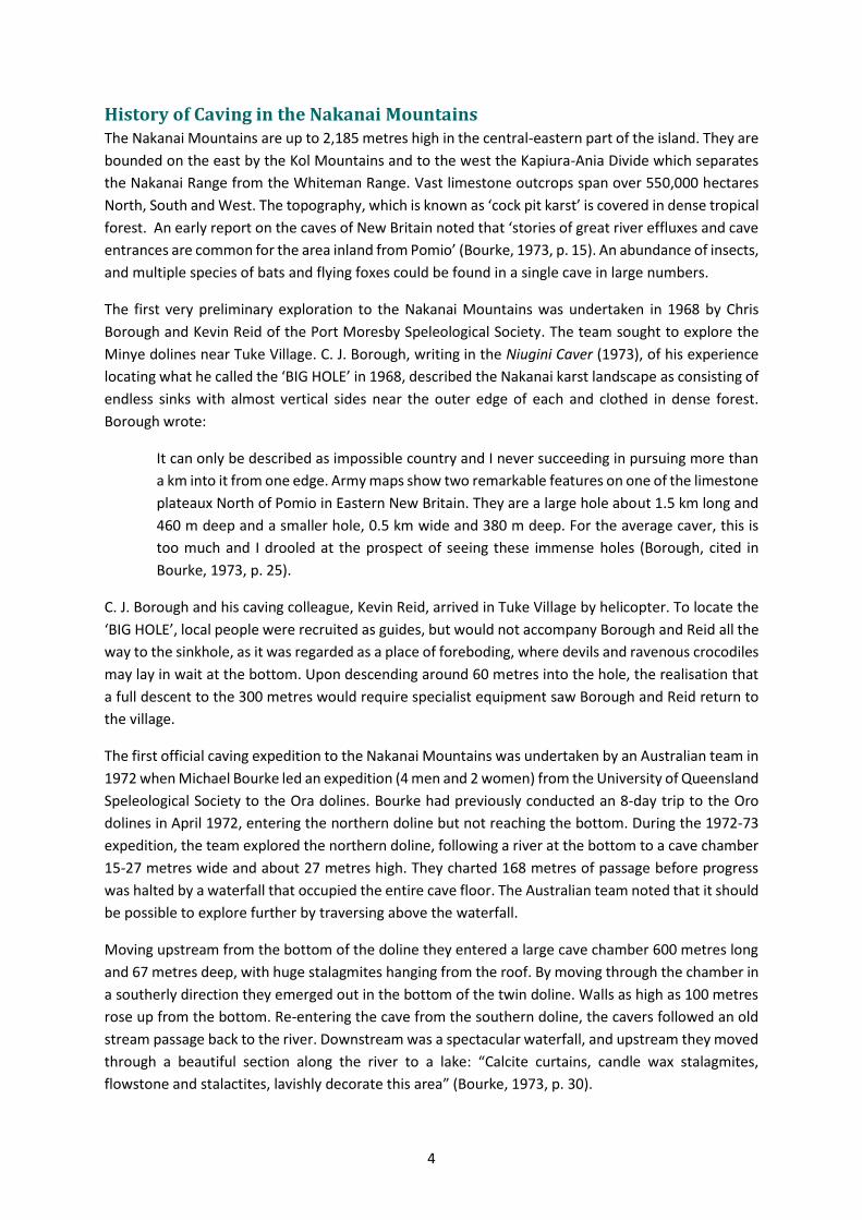
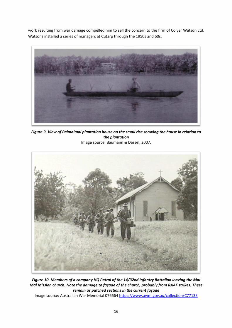