The Mississippi Sound Estuarine Program: A programmatic vision ...
29
Council Member Applicant and Proposal Information Summary Sheet Council Member: Mississippi Point of Contact: Gary Rikard Phone: 601-961-5001 Email: [email protected] Project Identification Project Title: The Mississippi Sound Estuarine Program: A programmatic vision for bridging coastal restoration State(s): AL, LA, MS County/City/Region: Multiple Counties and Parishes MS, AL, LA General Location: Projects must be located within the Gulf Coast Region as defined in RESTORE Act. (attach map or photos, if applicable) Conservation actions will be implemented across the landscapes within the Gulf Coast Region. See embedded map Project Description RESTORE Goals: Identify all RESTORE Act goals this project supports. Place a P for Priority Goal, and S for Secondary Goals. _P_ Restore and Conserve Habitat _S_ Replenish and Protect Living Coastal and Marine Resources _S_ Restore Water Quality _S_ Enhance Community Resilience _S_ Restore and Revitalize the Gulf Economy RESTORE Objectives: Identify all RESTORE Act objectives this project supports. Place a P for Priority Objective, and S for secondary objectives. _P_ Restore, Enhance, and Protect Habitats S Restore, Improve, and Protect Water Resources S Protect and Restore Living Coastal & Marine Resources S Restore and Enhance Natural Processes and Shorelines _S_ Promote Community Resilience S Promote Natural Resource Stewardship and Environmental Education S Improve Science-Based Decision-Making Processes RESTORE Priorities: Identify all RESTORE Act priorities that this project supports. [full text provided in Guidelines: Section A(3)] X Priority 1: Projects that are projected to make the greatest contribution … X Priority 2: Large-scale projects and programs that are projected to substantially contribute to restoring… X Priority 3: Projects contained in existing Gulf Coast State comprehensive plans for the restoration …. X Priority 4: Projects that restore long-term resiliency of the natural resources, ecosystems, fisheries … RESTORE Commitments: Identify all RESTORE Comprehensive Plan commitments that this project supports. X Commitment to Science-based Decision Making X Commitment to Regional Ecosystem-based Approach to Restoration X Commitment to Engagement, Inclusion, and Transparency X Commitment to Leverage Resources and Partnerships X Commitment to Delivering Results and Measuring Impacts RESTORE Proposal Type and Phases: Please identify which type and phase best suits this proposal. Project X Planning X Technical Assistance Implementation X Program Project Cost and Duration Project Cost Estimate: Total : $2,270,000 Project Timing Estimate: Date Anticipated to Start: 10/1/2015 Time to Completion: 3 years Anticipated Project Lifespan: >20 years 1
-
Upload
nguyendiep -
Category
Documents
-
view
214 -
download
0
Transcript of The Mississippi Sound Estuarine Program: A programmatic vision ...

Council Member Applicant and Proposal Information Summary Sheet
Council Member: Mississippi Point of Contact: Gary Rikard Phone: 601-961-5001 Email: [email protected]
Project Identification Project Title: The Mississippi Sound Estuarine Program: A programmatic vision for bridging coastal restoration
State(s): AL, LA, MS County/City/Region: Multiple Counties and Parishes MS, AL, LA
General Location: Projects must be located within the Gulf Coast Region as defined in RESTORE Act. (attach map or photos, if applicable) Conservation actions will be implemented across the landscapes within the Gulf Coast Region. See embedded map
Project Description RESTORE Goals: Identify all RESTORE Act goals this project supports. Place a P for Priority Goal, and S for Secondary Goals.
_P_ Restore and Conserve Habitat _S_ Replenish and Protect Living Coastal and Marine Resources _S_ Restore Water Quality _S_ Enhance Community Resilience _S_ Restore and Revitalize the Gulf Economy
RESTORE Objectives: Identify all RESTORE Act objectives this project supports. Place a P for Priority Objective, and S for secondary objectives.
_P_ Restore, Enhance, and Protect Habitats S Restore, Improve, and Protect Water Resources S Protect and Restore Living Coastal & Marine Resources S Restore and Enhance Natural Processes and Shorelines
_S_ Promote Community Resilience S Promote Natural Resource Stewardship and
Environmental Education S Improve Science-Based Decision-Making Processes
RESTORE Priorities: Identify all RESTORE Act priorities that this project supports. [full text provided in Guidelines: Section A(3)] X Priority 1: Projects that are projected to make the greatest contribution … X Priority 2: Large-scale projects and programs that are projected to substantially contribute to restoring… X Priority 3: Projects contained in existing Gulf Coast State comprehensive plans for the restoration …. X Priority 4: Projects that restore long-term resiliency of the natural resources, ecosystems, fisheries … RESTORE Commitments: Identify all RESTORE Comprehensive Plan commitments that this project supports. X Commitment to Science-based Decision Making X Commitment to Regional Ecosystem-based Approach to Restoration X Commitment to Engagement, Inclusion, and Transparency X Commitment to Leverage Resources and Partnerships X Commitment to Delivering Results and Measuring Impacts RESTORE Proposal Type and Phases: Please identify which type and phase best suits this proposal. Project X Planning X Technical Assistance Implementation X Program
Project Cost and Duration Project Cost Estimate:
Total : $2,270,000
Project Timing Estimate: Date Anticipated to Start: 10/1/2015 Time to Completion: 3 years Anticipated Project Lifespan: >20 years
1

Executive Summary
The Mississippi Sound Estuarine Program: A Programmatic Vision for Bridging Coastal Restoration
Around the Gulf there are several estuarine programs that have been established to safeguard, monitor, and plan for the health of designated coastal ecosystems, as well as serve research, education, and community interests in enhancing future management decisions as it pertains to coastal restoration. Various federal programs currently exist across the Gulf including National Estuarine Programs (NEPs) and National Estuarine Research Reserves (NERRs), as well as several non-profit foundations (i.e., Lake Pontchartrain Basin Foundation). Mississippi is the only Gulf state that currently does not have a NEP nor any other comprehensive estuarine program. In lieu of significant coastal restoration dollars being invested into the Mississippi Gulf Coast, surrounding barrier islands, and neighboring Gulf states, Mississippi is poised to programmatically create an entity that bridges critical upland/terrestrial habitats to open blue water, to connect research priorities with restoration goals, and be able to engage the community of the Mississippi Sound that tailors our conservation needs with community benefits.
This proposal aims to provide funding to establish a Mississippi Sound Estuarine Program (MSEP). The program would geographically encompass the Pearl River on the west to the Escatawpa River in the east. It would include the HUC 8 watersheds of these major river systems as an area of interest. The proposal would initially fund the strategic development of a restoration action plan, and initial coordination efforts that would look across all current funding horizons (National Fish and Wildlife Foundation, Natural Resource Damage Assessment, and RESTORE), leverage existing efforts (Mississippi Comprehensive Ecosystem Restoration Tool) and provide an avenue of strategic coordination of coastal restoration investment. The proposal has the following objectives:
1. Develop a strategic comprehensive restoration action plan for sustainable coastal restoration with input from all the respective state, federal, NGO, and CBO organizations within the Mississippi Gulf Coast, as well as adjacent states.
2. Convene advisory teams that will be charged with respective engagement roles towards sustainable restoration and the finalization and adoption of the MSEP structural framework
3. Initiate a coordinated and collaborative effort to create a coupled river – to Mississippi Sound hydrodynamic model as a foundation for sustainable coastal restoration.
4. Host annual restoration planning discussions that would highlight coastal restoration specific work in the MSEP area of interest and the Mississippi Sound
5. Create and project 10 year funding strategy for MSEP
The establishment of the MSEP will create a single program where by networks of government (both state and federal), scientists and academia, concerned citizens, and community organizations can be integrated into policy discussions, nurture stronger interpersonal ties between individuals, and act as a bridge to address terrestrial, estuarine, and open water concerns. There is a significant need for a coordinating structure to connect restoration and investment efforts of the large
2

Mississippi state agencies, federal agencies, as well as the restoration and ecosystem based research of academic institutions (both community colleges and universities) towards a greater collaborative, cohesive, science-based restoration effort.
There is always uncertainty and risk when attempting to programmatically address environmental protection at such a large scale. Bringing together a disparate group of individuals and organizations that have conflicting and competing interests, as well as variable mandates and objectives can be very challenging. However, if addressed correctly, and engaged in the right manner, the results can be incredible. Results can have meaningful, long range management objectives for the greater good of the system and the community. Funding such a program is not only necessary for systemically guiding the restoration of the Mississippi Gulf Coast, it is vital as a bridge program between Louisiana and Alabama. Ecologically it is a bridge between blue water and upland restoration and will allow better decisions to be made as it relates to coastal restoration in the future long after the oil spill funding and for future unforeseen events.
RESTORE Council likely collaborators and partners:
• Alabama • Louisiana • Environmental Protection Agency • Department of Commerce • United States Department of Agriculture • Department of the Interior • Army
3

The Mississippi Sound Estuarine Program: A Programmatic Vision for Bridging Coastal Restoration
Estuaries are the lifeblood of any coastal system. They are the physical ecotone between freshwater inputs and saltwater communities. They are the connectivity between true upland systems and their downstream coastal receiving waters. They harbor unique habitats that are essential for life history strategies of many fisheries, as well as the livelihoods of many communities. Estuaries are unique in their size, their climates, and their environmental signatures. Some are isolated from anthropogenic influences while others are vital corridors for commerce, navigation, and recreation. To understand how to maintain ecosystem functionality and integrity of estuaries requires a holistic understanding of upstream terrestrial processes, as well as open water dynamics of coastal waters, the significant dynamics and interplay between the two systems, and the ability to transcend disciplines to enhance restoration efforts. No one state or federal agency, or non-governmental organization (NGO) can understand all the processes; however, the establishment of a dedicated estuarine program allows programmatic bridges to be drawn between natural resource agencies and organizations with different mandates and objectives and coordinate the interactions to the benefit of coastal restoration.
Across the Gulf there are several estuarine programs that have been established including National Estuarine Programs, National Estuarine Research Reserves, and Local Basin Foundations. Presently in Mississippi there is not a true coordination structure towards coastal restoration nor an estuarine program that comprehensively captures our understanding of our major priority bays and estuaries. The overall goal of this proposal is to establish a Mississippi Sound Estuarine Program (MSEP) that will programmatically connect and coordinate state, federal, NGO, and community-based organizations (CBO) toward the common goal of sustainable Mississippi coastal restoration. This truly embraces the commitment for engagement, inclusion, and transparency as established in the Initial Comprehensive Plan for engaged coastal restoration in Mississippi. In order to achieve this goal the following objectives will be established:
1. Develop a strategic comprehensive restoration action plan for sustainable coastal restoration with input from respective state, federal, NGO, and CBO organizations within the Mississippi Gulf Coast, as well as adjacent states.
2. Convene advisory teams that will be charged with respective engagement towards sustainable restoration and the finalization and adoption of the MSEP structural framework.
3. Initiate a coordinated and collaborative effort to create a coupled river – to Mississippi Sound hydrodynamic model as a foundation for sustainable coastal restoration.
4. Host annual restoration planning discussions that would highlight coastal restoration specific work in the MSEP area of interest and the Mississippi Sound.
5. Create and project 10 year funding strategy for the MSEP.
4

Why an estuarine program?
The broad level mission of an estuarine program in Mississippi is to connect and coordinate. By doing this well, we can leverage and efficiently utilize coastal restoration dollars to significantly advance coastal restoration. The establishment of the MSEP is foundational to sustainable coastal restoration in the future, and ensures maximizing community benefits through coordinating efforts.
Coordination
In examining the Gulf Coast region holistically, it is imperative to understand how certain habitat types and landscapes connect with one another. Connectivity is the critical foundational keystone to understanding ecosystem functionality. For example, sediment delivery from unmanaged agricultural practices upstream, transports sediment loads downstream into priority bays and estuaries where they could silt over newly created oyster reefs that were constructed as nursery grounds for spat recruitment and benthic habitat enhancement. Thus a coordinated structure could put in place the mechanism to reduce sediment delivery. For example, coordinated funding efforts to leverage easement programs through the United States Department of Agriculture, or the United State Forest Service, as well as other funding sources, would put best management practices in place to decrease sediment delivery. These funds would improve downstream water quality, and leverage research efforts that could show and adaptively manage our understanding that oyster reef sustainability is rooted in management of upland systems. Furthermore, coordinated research outputs of changes in sediment load delivery as well as the hydrodynamics of stream flows, will not only help understand the sediment contribution to newly managed oyster reefs, but will provide additional information on the re-establishment of marsh habitat through beneficial use of dredge sediments.
Connectivity
The establishment of the MSEP will not only create connectivity and engagement of all interested stakeholders within Mississippi, but will also reach across state lines to engage and connect with similar programs in Louisiana and Alabama. These programs include:
Lake Pontchartrain Basin Foundation (LPBF): The LPBF serves as the public’s independent voice to environmental issues associated with restoring and preserving all facets of the environment in the Lake Pontchartrain Basin. The LPBF operates within the Lake Pontchartrain Basin which is a 10,000 square mile watershed covering over 16 Louisiana parishes and 4 Mississippi counties.
Mobile Bay National Estuary Program: The Mobile Bay NEP was established as an estuarine program under the Clean Water Act, Section 320 in 1995. The goal of the program is to protect and restore water quality and resources of estuaries designated by EPA as estuaries of national significance. The Mobile Bay NEP is built on the ideal of connectivity. It recognizes that all parts of the ecological web are connected, and that the watershed, land use within the watershed, as well as all the other components of culture, education, business and economy are all connected to the
5

environment. The Mobile Bay watershed encompasses approximately 65% of the land area of the State of Alabama, and also includes portions of the watershed located in Mississippi.
Grand Bay NERR: The Grand Bay National Estuarine Research Reserve was established in 1999 as a part of the National Oceanic and Atmospheric Administration’s National Estuarine Research Reserve System. It is managed in Mississippi by the Mississippi Department of Marine Resources, and comprises 18,000 acres of diverse habitats that are unique to the coastal zone. The Grand Bay NERR has a very specific mission in the grand scheme of understanding coastal restoration, in that its mission is to “practice and promote informed stewardship of the Grand Bay NERR and Mississippi coastal resources through innovative research, education, and training”.
Additional systems that the MSEP would connect to would be the Gulf Islands National Seashore managed by the National Park Service; DeSoto National Forest managed by the United States Forest Service; and Gulf Coast National Wildlife Refuge Complex which includes Sandhill Crane Refuge, Grand Bay Refuge, and Bon Secour Refuge managed by the US Fish and Wildlife Service. This connectivity underpins the essence of the MSEP and fulfills several commitments in the Initial Comprehensive Plan. The MSEP commits, by engaging and including programs and systems within the coastal zones of Mississippi, Alabama, and Louisiana, towards sustainable coastal restoration. This approach is also a regional ecosystem-based approach to restoration by recognizing that upland, marine and estuarine habitats are intrinsically connected regardless of county or state borders.
The Broader Vision of the MSEP
The spatial footprint of the MSEP will range from the Pearl River on the western border of Mississippi, encompassing its HUC 8 watershed (spanning several parishes in Louisiana), to the Pascagoula/Escatawpa rivers in the east, including two counties in Alabama. The area of interest includes the Mississippi coastal streams HUC 8 watersheds which includes St Louis Bay (Jourdan and Wolf Rivers) and Back Bay Biloxi (Biloxi River, Tchoutchbouffa River). This area of interest includes the following counties in Mississippi: Hancock, Harrison, Jackson, Pearl River, Stone, George, Greene, Perry, Forrest, Lamar, Marion, Jefferson Davis, and Wayne; Mobile and Washington counties in Alabama; and St Tammany, Washington and Walthall parishes in Louisiana (Figure 1).
6

Figure 1. The area of interest in which the MSEP will function. Multiple land use functions include agricultural areas, forestry, as well as urban areas.
The MSEP boundary is not restricted to the borders of the State of Mississippi. This is truly a borderless program where adjacent states of Alabama and Louisiana have a significant role to play in coastal restoration in Mississippi. In turn, Mississippi will play a significant role in both Alabama and Louisiana’s recovery and restoration plans and provide a connection between the two states to increase the scale of impact for restoration.
When examined in a Gulf-wide perspective (Figure 2), one understands how the MSEP will connect across the Gulf and begins to meet the priority criteria associated with the RESTORE Act.
7

Figure 2. Spatial distribution of NEPs and NERRs across the Gulf and their respective spatial footprints. The MSEP spatial footprint encompasses all of the Mississippi Coastal system as
defined by RESTORE, as well as connecting portions of Louisiana and Alabama.
The MSEP, as a coordinating structure fulfills most of the priority criteria associated with the RESTORE Act. The area of interest, encompassing a diversity of habitats that are intrinsically linked across landscapes, regardless of borders, is a regional-based approach to restoration that will create coordinating mechanisms to ensure the greatest contribution is made to restoring and protecting natural resources, at a large spatial extent. Once connected, the individual goals and objectives of projects and programs will collectively begin to restore resiliency of the Mississippi sound ecosystem which is a key strategy identified in several federal, state, and NGO’s strategies, visions, and plans across the Gulf (GCJV 2002; Vermillion et al 2012; USFWS 2011, 2013; USDA-NRCS 2014; DMR 2002; MFC 2007; Peterson et al. 2011; Brown et al. 2011; OC 2011; DU 2012; Audubon 2012; Smith 2014).
The Purpose of the MSEP
The establishment of the MSEP is a unique opportunity to innovatively create a structure that has a distinctive purpose. The purpose of the MSEP is to:
8

• Provide a coordination restoration bridge program between state agencies, as well as between state, federal, local and NGO/CBO partners within Mississippi, and between adjacent Gulf states.
• Form a collaborative function to leverage resources for coastal restoration. • Facilitate the marriage of research, outreach, extension, and policy to ensure the maximum
benefit of coastal restoration. • Have an adaptive management mindset to all activities. • Keep on track Mississippi’s desire of becoming “whole” and remaining “whole”.
Core values of the MSEP are the commitments established in the Initial Comprehensive Plan. The MSEP will be dedicated to using science-based decision making to understand how best to move coastal restoration forward. The MSEP will constantly connect people and programs to deliver results of restoration and measure the impacts environmentally, socially, and economically. The MSEP is committed to regional ecosystem-based restoration by its connectivity to adjacent states and diversity of habitats. The MSEP is only as strong as the engagement and inclusivity of interested stakeholders in maximizing coastal restoration for the future.
PROPOSAL OBJECTIVES
Objective 1: Develop a strategic comprehensive restoration action plan for sustainable coastal restoration with input from respective state, federal, NGO, and CBO organizations within the Mississippi Gulf Coast, as well as adjacent states.
An executive director and science community coordinator would be put in place to lead the development of the strategic comprehensive restoration action plan. Individuals that would be best suited for these positions would be those with excellent communication skills that are able to engage and interact with a diverse audience of stakeholders, translate science and policy between stakeholder groups, and be visionary in understanding the possibilities of collaboration.
Currently, the State of Mississippi has funded a planning project that will create two very unique products. The first product is the Mississippi Comprehensive Ecosystem Restoration Tool (MCERT) which is a robust geospatial tool with multiple modelling components that will synthesize all of the available coastal data to inform restoration priorities and associated programs and projects that could be funded towards those priorities. The tool will inform the writing of a comprehensive restoration plan for the Mississippi Department of Environmental Quality (MDEQ). This tool and restoration plan are funded through the National Fish and Wildlife Foundation’s Gulf Environment Benefit Fund and will be leveraged into the MSEP. The products will help develop and guide the broader action plan and coordinated restoration activities. The adaptive nature of the tool and plan will serve to enhance our understanding of coastal restoration and better inform decisions for sustainability of coastal infrastructure and natural resources.
9

Leveraging of the Mississippi Comprehensive Ecosystem Restoration Tool (MCERT)
Foundation for the MSEP is currently being laid by MDEQ in the development of the Missisisppi’s Comprehensive Restoration Plan. The plan is being developed by utilizing MCERT, a science-based geospatial toolkit, and through stakeholder engagement to formulate, analyze, and prioritize restoration strategies, alternatives, and outcomes for programs and projects. The plan will also provide an analysis of feasibility and benefit provided by each restoration project strategy based on impact, outcome, and cost.
Figure 3. MCERT model framework highlighting baseline data capture, additional data acquisition, and the linear synthesis of tool development.
MCERT is a toolset used to identify and analyze ecological resources and impacts from local to landscape scales using the best available spatial data and geospatially derived products to produce modeled outputs that will aid in targeting areas for restoration and conservation. The ultimate goal of the tool is to enhance decision making for restoration planning of Mississippi’s coastal ecosystems over time. Modeling techniques and outputs from previous studies (e.g., Brown & Vivas 2005; Richardson et al, 2014), along with the most accurate, current, and comprehensive geospatial data available are being integrated into a geodatabase capable of supporting analysis and modeling efforts. New data will continue to be obtained through a combination of field collection efforts, access to standardized public products, and interaction with stakeholders via collaboration forums, teleconferences, and formal requests. Gap analysis associated with this effort will help to indicate where research and data are needed to make better restoration decisions. The tool will be continually updated as new data becomes available. This iterative process will ensure the most accurate and appropriate data are being used for modeling efforts to provide a robust decision support toolset (Figure 3).
Ecological & Stressor
Data
Baseline Data
StakeholderEngagment
Data
Data Synthesis and Model Development
Restoration Goals & Objectives
Data INPUTS
Geospatial Data Analysis
Model Outputs
TOOLSETS to assist DECISION-MAKING
10

MCERT will be used to support the characterization, and action plan development phases of this proposal as much as it is currently being used to develop the Mississippi Comprehensive Restoration Plan. In developing the strategic comprehensive restoration plan, MCERT will be used to further update, compile, and analyze spatial data that characterize both ecological status and trends as well as environmental issues/stressors to model best-fit conservation and management scenarios. The adaptability of this geospatial toolset can be tailored to specific decision-making frameworks that may result from the proposed management conferences. The toolset can apply different conservation objective metrics to provide a list of priority management strategies and actions that align with the restoration plan’s goals and objectives. In other words, by utilizing MCERT to support informed decision making in the development of the restoration plan, Mississippi will be able to maximize benefits for coastal habitats and living resources that will give the greatest return on investment. Furthermore, mapped data generated by MCERT will greatly enhance the value of multiple conservation efforts by prioritizing critical habitat locations and identifying key connectivity hubs and corridors of coastal habitats.
The current efforts of MDEQ to develop MCERT and the resulting restoration plan will be the ground work to support implementation of the objectives outlined in this proposal. The MSEP will help to build on these initial oil spill related planning efforts to keep Mississippi focused on collecting important data on our coastal resources and using these to plan and act on conservation and management projects well into the future. Beyond MCERT, the MSEP will leverage over 120 documented plans, visions, and strategies for the Mississippi Gulf Coast including Go Coast 2020 in providing a foundational understanding of priority themes for restoration in the Mississippi coastal landscape.
Objective 2: Convene advisory teams that will be charged with respective engagement roles towards sustainable restoration and the finalization and adoption of the MSEP structural framework.
The Mississippi Gulf Coast is comprised of a diverse range of organizations, individuals, state and federal agencies, that all have the common vision of improving Mississippi’s environment and way of life. The establishment of the MSEP will allow for sustained coordination of restoration efforts that will seek to leverage and enhance the opportunities that have been presented. In order to ensure that we are achieving our objectives, the MSEP needs to acquire input from a representative body of stakeholders from across the region.
At an executive level the executive advisory team will include representatives from state agencies of Mississippi. Each respective agency will be invited to participate and sit on the executive level team whose primary role is to identify and coordinate leveraging opportunities and common priorities and goals across the Mississippi coast.
Under the executive advisory team, two additional workgroups will be created. The first will represent a science/policy committee that will be made up of representatives from institutes of higher learning, community colleges, and NGOs with a natural resource science/policy focus. The second group will represent local communities and coastal governments, including planning commissioners of the coastal counties. These groups will initially be convened to discuss a path
11

forward for the MSEP and then to coordinate a collective brain trust of coastal activities that are occurring, or will occur, that could start being connected and coordinated.
The MSEP Framework
As a primary function the MSEP will serve a critical collaborative and connectivity function. This function is elucidated below. Figure 4 elucidates the various groups that are represented in the Mississippi coastal landscape and their respective interests.
Figure 4. Overall structural connectivity framework of engagement groups across the Mississippi coastal landscape.
Figure 5 shows the role of the MSEP. The role establishes collaborative partnerships across the Mississippi coastal landscape, and connects typical disparate groups with a common vision toward sustainable and foundational coastal restoration. This highlights the commitment of the MSEP towards engagement, inclusion, leveraging resources, and partnerships.
12

Figure 5. The MSEP role in collaboration and connectivity between various stakeholder groups within the Mississippi coastal landscape.
The potential outcomes of the MSEP can initially divided into three categories:1) natural resource restoration; 2) communication; and 3) environmentally compatible economic development. There could be additional outcomes as yet unidentified. There is clear connectivity between these potential outcomes. It is clear that coastal restoration of natural resources and ecosystems will have tangible benefits to a multitude of ecosystem services across the Mississippi coast. These ecological improvements will have significant economic development returns within Mississippi and adjacent states. Natural resources that are commercially harvested will increase in abundance in Mississippi waters, and in Louisiana and Alabama waters. Upland coastal landscapes will be connected between adjacent states to further enhance water quality and quantity improvement delivery to bays and estuaries. The restoration landscape will put people to work, increase local economies and spur economic development of tourism, eco-tourism as a result of enhanced natural features and ecosystems available to recreate in. Figure 6 outlines the various outcomes associated with the MSEP. It also outlines the various inputs that could be expected to be leveraged into the program. There are also Gulf-wide plugins in which MSEP will coordinate with to engage a Gulf-wide perspective. These plugins could include: Gulf of Mexico Alliance; Sea Grant programs; Gulf-wide strategies and visions; Gulf of Mexico Coastal Ocean Observing System (GCOOS); and the Gulf-wide NGO coalition.
13

Figure 6. Inputs and outputs associated with the MSEP
The MSEP creates an opportunity for group collaboration and connectivity between different sectors of the community; however, there is also a need for within group coordination, connectivity, leveraging, and collaboration. Some good examples of this occurring already would be the Mississippi Environment Focus group – a coalition of NGOs that come to together on a regular basis to help inform coastal restoration. Another great example is the Partnership for Gulf Coast Land Conservation that represents 31 land trusts across the Gulf towards fostering an environment of collaboration and synergy. The MSEP would not replicate these efforts but will model those collective’s within local, industry, state, and federal circles (e.g., connecting cities, ports, boards of supervisors, and county planners across the six coastal counties; communicating between federal agencies; communicating and collaborating between industries).
Objective 3: Initiate a coordinated and collaborative effort to create a coupled river – to Mississippi Sound hydrodynamic model as a foundation for sustainable coastal restoration.
Collaboration and connectivity are key components of the MSEP. Utilizing MCERT, as well as collaborative discussions and conversations with the science community within Mississippi, there are some clear foundational data gaps that if invested in, will help restoration, and the sustainability of restoration efforts in the Mississippi Gulf coast region. Several science strategies point to investing in understanding how coastal ecosystems interact. The Gulf Coast Ecosystem Restoration Task Force Science Assessment (Walker et al., 2012) highlights the basic need for discovery in understanding how ecosystems interact, which must include an assessment of existing capacity, identifying gaps, and integrating systems to provide information to managers and restoration specialists for effective coastal stewardship. Additionally, the PEW report (Peterson et
14

al., 2011) highlights that effective restoration requires an empirical assessment approach to help guide decision making. The Gulf of Mexico Sea Grants Research Plan (Sempier et al., 2009) highlights a Gulf of Mexico research priority of connecting freshwater inflows (both quality and quantity) to living resource restoration in priority bays and estuaries and into the Gulf. Hydrological inflows from major river systems inject sediments and nutrients and fundamentally influence salinity regimes and current pathways within both the Sound and its surrounding bays and estuaries. These processes have major implications to living resource habitat and restoration efforts. This objective will be a collaborative coordinated research effort towards understanding connectivity between our rivers and streams, and how they influence hydrological patterns of our bays, estuaries, and eventually the Mississippi Sound. There have been several excellent, yet disparate, research efforts across the Mississippi Gulf coast of bays and estuaries and the Mississippi Sound. For example, the US Army Corps of Engineers CH3D modeling for the Mississippi Sound for the MsCIP program in 2007; ERDC/NRL conducted a 3D watershed model of the Biloxi Bay Watershed and coupled it to ADCIRC in Biloxi Bay and the Mississippi Sound; the Northern Gulf Institute has conducted an integrated ecosystem assessment for St. Louis Bay around water quality drivers and stressors. There are likely an additional half dozen data sources, that have either had no connectivity to link these research efforts, nor were the efforts not explicitly focused on restoration outcomes, and there are still significant missing pieces that are required to understand the system holistically.
This objective’s effort will be a foundational step in identifying critical observational data gaps needed to support and implement an interdisciplinary modeling framework designed to address Mississippi’s directive towards sustainable coastal restoration. The modeling framework will be designed to directly benefit several restoration efforts such as marsh creation and preservation, artificial reef placement, support of beach re-nourishment, and supporting oyster reef restoration and production. The modeling framework will be developed in phases to provide a coupled hydrologic and hydrodynamic framework within which distributions of suspended sediment, nutrients, dissolved oxygen and other key water quality parameters can be added. Additionally, the framework’s ability to simulate circulation will assist in the design and construction of restoration projects. For example, simulation of circulation will improve the design and likelihood of success of oyster reef restoration by optimizing structure height, avoidance of high siltation, and positioning according to larval transport for spat recruitment to established sites. By exploring various inflow scenarios, model-generated projections will deliver guidance on how best to implement living resource restoration through site selection assessments that offer objective justification of coastal restoration expenditures. Ground-truthing with new and existing data will validate the user- and public-friendly model, and the product will be applied to the adaptive measures for site restoration and management. Moreover, this foundational program will gain added value and potential leverage from other funded and proposed oil-spill research and modeling studies to provide the most effective use of restoration dollars.
15
Objective 4: Host annual restoration planning discussions that would highlight coastal restoration specific work in the MSEP area of interest and the Mississippi Sound
The MSEP would host, on an annual basis, restoration planning discussions that would highlight coastal specific restoration work. It would also be a forum to synthesize collaborative ideas in which stronger, more leveraged proposals would be formed that have tangible outcomes into the respective components of coastal restoration. It is envisioned that the annual discussions would have multiple themes of coastal restoration and showcase, on an annual basis, how coastal restoration successes and failures are reflected in learning about adapting our systems to ensure a more efficient and sustainable coastal restoration effort. There would be several opportunities to coordinate and collaborate with existing conferences that tie to coastal restoration in Mississippi. Bays and Bayous, a bi-annual conference held by the Mississippi Alabama Sea Grant Consortium, would be an existing effort that would complement and be leveraged to understand priorities. One could envision joint technical sessions on restoration topics or a collaborative interactive forum for discussing challenges associated with engaging research, education, and the general public toward sustainable coastal restoration.
Objective 5: Create and project 10 year funding strategy for MSEP.
One of the uncertainties and risks associated with standing up a MSEP would be continued funding in the future. During the development of the restoration action plan, the program will develop a 10 year funding strategy that will involve understanding how to acquire state, federal funds, as well as private dollars to sustain the program. Potential funding opportunities that could be investigated and applied for include:
• The EPA - Gulf of Mexico program office • The Coastal Estuarine Land Conservation Program for land protection and conservation
work • The Mississippi Coastal Improvement Program (MsCIP) with the US Army of Corps of
Engineers • The Coastal Impact Assistance Program with the US Fish and Wildlife Service • Gulf of Mexico Energy and Security Act • Tidelands with the Secretary of the State • Gulf of Mexico Energy Securities Act
Risks and Uncertainties associated with the establishment of the MSEP
There is always uncertainty and risk when attempting to programmatically address environmental protection at such a large scale. Bringing together a disparate group of individuals and organizations that have conflicting and competing interests, as well as variable mandates and objectives, can be very challenging. However, if addressed correctly, and engaged in the right manner, the results can be incredible. Results can have meaningful, long range management objectives for the greater good of the system and the community. There is also the typical retort that there is no need for another institution, another program, another agency. Funding such a program is not only necessary for systemically guiding the restoration of the Mississippi Gulf
16
Coast, it is vital as a bridge program between Louisiana and Alabama. Ecologically, it is a bridge between blue water and upland restoration and will allow better decisions to be made as it relates to coastal restoration in the future long after the oil spill funding and for future unforeseen events. Sustaining funding is also the largest risk associated with such an endeavor. Objective 5 seeks to mitigate that risk and uncertainty by charting a course of project funding sources and avenues.
Location
Defined above (Figure 1 and Figure 2).
High Level Budget Narrative
Objective 1: Develop a strategic comprehensive restoration action plan for sustainable coastal restoration with input from all the respective state, federal, NGO, and CBO partners organizations within the Mississippi Gulf Coast, as well as adjacent states. Budget: Salaries and Fringe: $175,000/yr x 3 yrs = $525,000 Grants Management: $75,000 Assumptions:
• The products from Objective #1 will help develop and guide the broader action plan and coordinated restoration activities. The adaptive nature of the program will only serve to enhance our understanding of coastal restoration, how to get things right, and move the needle on sustainable coastal infrastructure and natural resources.
• An executive director and science community coordinator will need to be hired to oversee the MSEP.
• Funding is for two funded positions for three years. • Funding is to help with grants management within the Office of Oil Spill Restoration.
Objective 2: Convene advisory teams that will be charged with respective engagement roles towards sustainable restoration and the finalization and adoption of the MSEP structural framework Budget: $50,000 / yr x 3 yrs = $150,000 Assumptions:
• Annual travel support budget for MSEP and convening advisory teams. • Support includes operations and maintenance of advisory teams (including executive
committee). • Travel support for advisory team travel. • Meeting venue support.
Objective 3: Objective 3: Initiate a coordinated and collaborative effort to create a coupled river – to Mississippi Sound hydrodynamic model as a foundation for sustainable coastal restoration.
Budget: $1,200,000 Assumptions:
17

• Jointly funded project between USM, MSU, with collaboration with private industry partners for additional leveraging and coordination opportunities.
• Tasks will identify: o Identify modeling framework to couple rivers to Mississippi Sound
hydrodynamics. o Identify priorities and data gaps for model development. o Adaptive field data to fill gaps. o Stand up a public- and user-friendly (e.g., for managers and decision-makers)
River-to-Sound model with data assimilation. • Effort will be fund project for all three years.
Objective 4: Host annual restoration planning conferences that would highlight coastal restoration specific work in the MSEP area of interest and the Mississippi Sound. Budget: $65,000 / meeting x 3 yrs = $195,000 Assumptions:
• Meeting support for annual MSEP meetings. • Funds for logistical support for the Office of Oil Spill Restoration for meeting
coordination. • Meeting venue rental costs. • Meeting logistic costs. • Meeting funds will be leveraged with sponsorship from state, federal agencies, industry,
as well as non-governmental organizations.
Data Management Budget: $65,000 Assumptions:
• Funds to be used for data management, and meeting sharing requirements. • Geoportal maintenance, oversight, and updating. • Metadata construction as applicable.
Program Management, Oversight, and Coordination Budget: $60,000 Assumptions:
• 3% of total cost of program. • Funds used for program management, oversight, and coordination by MDEQ Office of
Oil Spill Restoration.
TOTAL PROGRAM BUDGET: $2,270,000
Leveraged Funding: National Fish and Wildlife Foundation – Gulf Environmental Benefit Fund MCERT Planning Project $3,600,000 Portion of additional funds leveraged through oil-spill research and modeling studies (USM – GOMRI - Consortium for Oil Spill Exposure Pathways in Coastal River-Dominated Ecosystems) $11,000,000
18

Environmental Compliance Checklist
Environmental Compliance Type Yes No Applied For
N/A
Federal*** National Marine Sanctuaries Act (NMSA) x Coastal Zone Management Act (CZMA) x Fish and Wildlife Coordination Act x Farmland Protection Policy Act (FPPA) x NEPA – Categorical Exclusion x NEPA – Environmental Assessment x NEPA – Environmental Impact Statement x Clean Water Act – 404 – Individual Permit (USACOE) x Clean Water Act – 404 – General Permit(USACOE) x Clean Water Act – 404 – Letters of Permission(USACOE) x Clean Water Act – 401 – WQ certification x Clean Water Act – 402 – NPDES x Rivers and Harbors Act – Section 10 (USACOE) x Endangered Species Act – Section 7 – Informal and Formal Consultation (NMFS, USFWS)
x
Endangered Species Act – Section 7 - Biological Assessment (BOEM,USACOE)
x
Endangered Species Act – Section 7 – Biological Opinion (NMFS, USFWS) x Endangered Species Act – Section 7 – Permit for Take (NMFS, USFWS) x Magnuson-Stevens Fishery Conservation and Management Act Essential Fish Habitat (EFH) – Consultation (NMFS)
x
Marine Mammal Protection Act – Incidental Take Permit (106) (NMFS, USFWS)
x
Migratory Bird Treaty Act (USFWS) Bald and Golden Eagle Protection Act – Consultation and Planning (USFWS) x Marine Protection, Research and Sanctuaries Act – Section 103 permit (NMFS)
x
BOEM Outer Continental Shelf Lands Act – Section 8 OCS Lands Sand permit
x
NHPA Section 106 – Consultation and Planning ACHP, SHPO(s), and/or THPO(s)
x
NHPA Section 106 – Memorandum of Agreement/Programmatic Agreement x Tribal Consultation (Government to Government) x Coastal Barriers Resource Act – CBRS (Consultation) x State As Applicable per State
*** It is anticipated that the establishment of the MSEP will not require an environmental compliance, nor will any of the established objectives. If environmental compliance is deemed necessary, appropriate steps will be taken to procure the required permits and compliance requirements.
19

Data / Information Sharing Plan
Though it is envisioned that the MSEP itself will not generate significant data, objective #3 in the proposal, as well as the coordinated leveraging of data into other efforts will require some level of data management. The MSEP as with all other coastal restoration activities will begin to lean on a common data sharing platform to meet all federal requirements. Data will not be centralized and housed in a single location but rather be stored in multiple locations depending on the agency collecting the data. There is a need for data to meet the federal standard for accessibility, discoverability and usability. This follows the White House “Open Data Policy” (OMB M-13-13) of May 9, 2013 which supports the related Executive Order of May 9, 2013 (Making Open and Machine Readable the New Default for Government Information). This policy requires federal agencies to collect or create information in a way that supports downstream information processing and dissemination activities. This includes using machine readable and open formats, data standards, and common core and extensible metadata for all new information creation and collection efforts. Following this guidance, any data generated through the MSEP will engage with NOAA NCDDC to create a comprehensive mechanism to preserve, discover and access this data and information to maximize the investment made by the RESTORE Council and various agencies by allowing multiple uses of the data while minimizing duplication of effort.
As with Mississippi’s other proposals, the proposed infrastructure will provide a publicly available data/information discovery mechanism based upon the geoportal concept, typified by the open-source Esri Geoportal Server, which can efficiently search a variety of metadata standards contained in web catalogs of the various data collectors/providers. This system will provide end users with the ability to go directly to the data providers, often using automated on-line services, to obtain data/information discovered. A nominal infrastructure diagram from the data provider point of view demonstrates how this architecture provides discovery and access to a variety of end users:
20
The key components of this proposed infrastructure include:
• Data producer, data, and information o The diversity of data producers within the MSEP, will result in multiple state, federal,
and resource organization pieces of data and information that will need to be connected. • Data discovery, access, and visualization services (geoportal)
o Metadata discovery is enabled by using data access and discovery services. NOAA is widely using a free, open-source product developed by Esri called Geoportal Server. The Esri Geoportal Server enables discovery and use of geospatial resources including datasets, rasters, and Web services as well as non-geospatial resources such as publications and lab data through the use of metadata. The product allows many various formats of metadata and import options (harvest or CSW to name a few) so that interoperability and a common search can be achieved across several platforms without all inputs adopting the same standards and formats. Esri Geoportal Server is not the only viable geoportal software, but it is widely used both inside and outside of NOAA.
• Supportive metadata for the data/information o A geoportal-based infrastructure is ideal since it supports a variety of metadata profiles
and catalogue services. Most Gulf of Mexico activities already develop and provide some level of metadata.
• Organizational Web Accessible Folders (WAF) or Catalog Service for Web (CSW) o Each activity providing data/information will need to provide either a web accessible
folder (WAF) or Catalog Service for Web (CSW) service. Many activities already have one of these services in place. A WAF is a simple directory of files on a web server that can be accessed by users with a web browser, indexed by Google or other search engine, and harvested by a metadata discovery portal or other freely available utility such as Geoportal Server. A WAF provides a straightforward approach to build and maintain a centralized repository of metadata XML files in any format. Each entity receiving funding under this land protection strategy will create a WAF for data accessibility.
• End users o This initiative provides a data discovery and access mechanism for the government,
academia, NGOs, project managers, coastal zone managers, Councils, Consortia, Alliances, Centers, and the general public.
This approach is attractive for several reasons:
• Very low cost to establish a public Gulf of Mexico Geoportal server • Most providers either already possess or can easily establish a WAF or CSW • Most providers already develop and provide acceptable levels of metadata to facilitate
discovery
Data/information will continue to be accessed from the Authoritative Source via existing infrastructure and data bases.
21

References
Audubon. 2012. Restoring the Gulf for coastal waterbirds: A long-term vision. The National Audubon Society, November 2012. pp. 32. Available online: http://fl.audubon.org/sites/default/files/documents/restoring_the_gulf_for_coastal_waterbirds_nov12lr.pdf Last Accessed November 14th, 2014.
Brown, M.T., Vivas, M.B. 2005. Landscape development intensity index. Environmental Monitoring and Assessment 101:289-309.
Brown, C., Andrews, K., Brenner, J., Tunnell, J.W., Canfield, C, Dorsett, C., Driscoll, M., Johnson, E., Kaderka, S. 2011. Strategy for Restoring the Gulf of Mexico (A cooperative NGO report). Arlington, VA. pp.23. Available online: http://masgc.org/assets/uploads/publications/restorationstrategy.pdf Last Accessed: November 12th, 2014.
DMR. 2002. MS Coastal Preserves Mission, Vision, and Goals; Mississippi Department of Marine Resources. Available online: http://www.dmr.ms.gov/index.php/wildlife-a-plants/coastal-preserves/60-coastal-preserves-mission-vision-and-goals#sthash.Lx8sTeZM.dpuf Last Accessed November 14th, 2014. MFC. 2007. MS Forest Legacy Program Assessment of Need 2007 – 2012; Mississippi Forestry Commission. Available online: http://www.mfc.ms.gov/pdf/Mgt/FL/Forest%20Legacy%20AON-1.pdf Last Accessed November 14th, 2014.
Ducks Unlimited. 2012. Gulf Coast Wetlands Initiatives, Southeast Wetlands Initiative, and America's River Initiative. Available online: http://www.ducks.org/resources/media/Conservation/Conservation%20Initiatives/PDFs/GulfCoast.pdf; Last Accessed November 14th, 2014. http://www.ducks.org/resources/media/Conservation/Conservation%20Initiatives/PDFs/SoutheastWetlands.pdf; Last Accessed November 14th, 2014. http://www.ducks.org/resources/media/Conservation/Conservation%20Initiatives/PDFs/AmericasRiver.pdf Last Accessed November 14th, 2014. GCJV. 2002. Gulf Coast Joint Venture: Coastal Mississippi Wetlands Initiative. Available online: http://gcjv.org/docs/CoastalMSpub.pdf Last Accessed November 14th, 2014. OC. 2011. Restoring the Gulf of Mexico: A Framework for Ecosystem Restoration in the Gulf of Mexico. Ocean Conservancy. Available online: http://www.oceanconservancy.org/places/gulf-of-mexico/restoring-the-gulf-of-mexico.pdf Last Accessed November 14th, 2014.
22

Peterson, C.H., Coleman, F.C., Jackson, J.B.C., Turner, E., Rowe, G.T., Barber, R.T., Bjorndal, K.A., Carney, R.S., Cowen, R.K., Hoekstra, J.M., Hollibaugh, J.T., Laska, S.B., Luettich Jr., R.A., Osenberg, C.W., Roady, S.E., Senner, S., Teal, J.M., Wang, P. 2011. A once and future Gulf of Mexico Ecosystem: Restoration recommendations of an expert working group. Pew Environment Group. Washington D.C. 112 pp. Available online: http://accstr.ufl.edu/files/accstr-resources/publications/Petersonetal-GOM-report_2011.pdf Last Accessed November 14th, 2014. Richardson, J.R., Burns, N. and R. Polinsky. 2014. Draft National Ecological Framework. USEPA Region 4. pp.30.
Sempier, S.H., Havens, K., Stickney, R., Wilson, C., Swann, D.L. 2009. Gulf of Mexico Research Plan. MASGP-09-024. Available online: http://seagrant.noaa.gov/Portals/0/Documents/what_we_do/regional_innitiatives/plans/Gulf%20of%20Mexico.pdf Last Accessed November 14th, 2014.
Smith, R. 2014. Restoring the Mississippi Gulf Coast: A strategic plan for people, wildlife and the economy. Wildlife Mississippi. pp.24. Available online: http://www.wildlifemiss.org/PDF/Wildlife%20MS%20Coast%20Plan%20Final_7.8.14.pdf Last Accessed November 14th, 2014.
USDA –NRCS. 2014. Gulf of Mexico Restoration: A Private Lands Vision for Success. pp16. USFWS 2011. Land protection plan and final EIS for the Expansion of Grand Bay National Wildlife Refuge: Jackson County, Mississippi and Mobile County, Alabama. Southeast Region. 76 pp. Available online: http://www.fws.gov/southeast/grandbayexpansion/pdf/102411_DraftEAandLPP.pdf USFWS 2011. Land protection plan and final EIS for the Expansion of Grand Bay National Wildlife Refuge: Jackson County, Mississippi and Mobile County, Alabama. Southeast Region. pp. 76. Available online: http://www.fws.gov/southeast/grandbayexpansion/pdf/102411_DraftEAandLPP.pdf Last Accessed: November 12th, 2014. USFWS. 2013. Vision for a healthy Gulf of Mexico Watershed. United States Fish and Wildlife Service., Department of the Interior, pp.24 Available online: http://www.fws.gov/gulfrestoration/pdf/VisionDocument.pdf Last Accessed November 14th, 2014. Vermillion, W. G., B. Eley, B. C. Wilson, S. A. Heath, and M. W. Parr. 2012. Gulf Coast Joint Venture Landbird Conservation Plan, Bird Conservation Regions 25, 26, & 27, Gulf Coast Joint Venture Region. 56 pp. Available online: http://gcjv.org/docs/GCJV_BCR25_26_27_landbird_plan_Vers_1.doc Last Accessed November 14th, 2014. Walker, S., Dausman, A., Lavoie, D. 2012. Gulf of Mexico Ecosystem Science Assessment and Needs – A product of the Gulf Coast Ecosystem Restoration Task Force. pp.72. Available
23

online: http://www.epa.gov/gcertf/pdfs/GCERTF-Book-Final-042712.pdf Last Accessed November 14th, 2014.
24

PROPOSAL TITLE PROPOSAL NUMBER
LOCATION
SPONSOR(S)
TYPE OF FUNDING REQUESTED (Planning, Technical Assistance, Implementation)
REVIEWED BY: DATE:
The Mississippi Sound Estuarine Program: A Programmatic Vision for Bridging CoastalRestoration
MS-3
Multiple Counties and Parishes; Mississippi, Alabama, Louisiana
Mississippi
Planning/Technical Assistance
Bethany Carl Kraft/ Ben Scaggs 11-18-14

1. Does the project aim to restore and/or protect natural resources, ecosystems, fisheries, marine and wildlife habitat, beaches, coastal wetlands and economy of the Gulf Coast Region?
YES NO
Notes:
2. Is the proposal a project?
YES NO
If yes, is the proposed activity a discrete project or group of projects where the full scope of the restoration or protection activity has been defined?
YES NO
Notes:
Proposal seeks funding to establish a Mississippi Sound Estuarine Program and the subsequent development of a restorationaction plan.

3. Is the proposal a program?
YES NO
If yes, does the proposed activity establish a program where the program manager will solicit, evaluate, select, and carry out discrete projects that best meet the program's restoration objectives and evaluation criteria?
YES NO
Notes:
4. Is the project within the Gulf Coast Region of the respective Gulf States?
YES NO
If no, do project benefits accrue in the Gulf Coast Region?
YES NO
Notes:
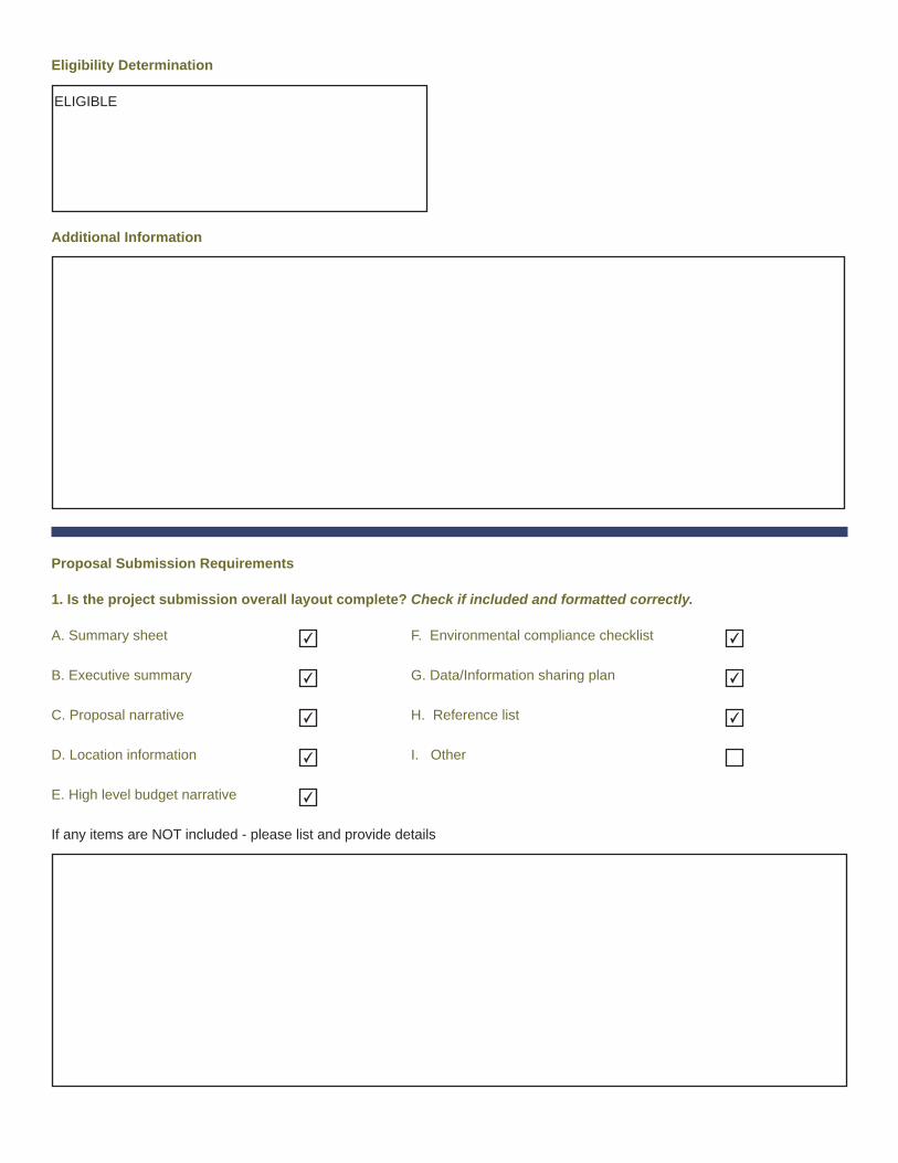
Eligibility Determination
Additional Information
Proposal Submission Requirements
1. Is the project submission overall layout complete? Check if included and formatted correctly.
A. Summary sheet F. Environmental compliance checklist
B. Executive summary G. Data/Information sharing plan
C. Proposal narrative H. Reference list
D. Location information I. Other
E. High level budget narrative
If any items are NOT included - please list and provide details
ELIGIBLE
✔ ✔
✔ ✔
✔ ✔
✔
✔

2. Are all proposal components presented within the specified page limits (if applicable)?
YES NO
Notes: