The Military Capabilities and Implications of China’s ...web.mit.edu/stgs/pdfs/Forden Chinese Nav...
32
Science and Global Security, 12:219–250, 2004 Copyright C Taylor & Francis Inc. ISSN: 0892-9882 print DOI: 10.1080/08929880490518018 The Military Capabilities and Implications of China’s Indigenous Satellite-Based Navigation System Geoffrey Forden China has orbited a three-satellite constellation for space-based navigation known as Beidou. This article uses the constellation geometry, as determined by the NORAD space-surveillance system and publicly available from NASA, to estimate the accuracy available to a user of the Beidou system. Limited in terrestrial coverage to roughly the Asian subcontinent, this system requires a user either to go through an iterative pro- cedure ill-suited to most military applications or to provide his or her own standard of time by carrying a high-precision clock. The iterative method does provide accuracies comparable to NAVSTAR/GPS over a restricted area of the Earth. Carrying an atomic clock, however, allows the system to be used in a mode that can provide sufficient ac- curacy to be used on MIRVed Chinese ICBMs en route to the United States and make a significant improvement in accuracy. Surprisingly, those modes of operation do not provide sufficient accuracy for most conventional military users. INTRODUCTION The world has become familiar with satellite-based navigation systems that have global reach and can be accessed by inexpensive user-terminals. These systems, epitomized by the U.S. NAVSTAR\GPS, have over 20 satellites in medium Earth orbits and inclinations near 54 degrees. 1 It therefore comes as somewhat of a surprise that China would orbit a seemingly regional Received 14 January 2004; accepted 30 April 2004. Address correspondence to Geoffrey Forden, Massachusetts Institute of Technology, Building E28-620, 292 Main St., Cambridge, MA 02139. E-mail: [email protected] Geoffrey Forden, Massachusetts Institute of Technology, Cambridge, MA.
Transcript of The Military Capabilities and Implications of China’s ...web.mit.edu/stgs/pdfs/Forden Chinese Nav...
Science and Global Security, 12:219–250, 2004Copyright C© Taylor & Francis Inc.ISSN: 0892-9882 printDOI: 10.1080/08929880490518018
The Military Capabilitiesand Implications of China’sIndigenous Satellite-BasedNavigation System
Geoffrey FordenChina has orbited a three-satellite constellation for space-based navigation known asBeidou. This article uses the constellation geometry, as determined by the NORADspace-surveillance system and publicly available from NASA, to estimate the accuracyavailable to a user of the Beidou system. Limited in terrestrial coverage to roughly theAsian subcontinent, this system requires a user either to go through an iterative pro-cedure ill-suited to most military applications or to provide his or her own standard oftime by carrying a high-precision clock. The iterative method does provide accuraciescomparable to NAVSTAR/GPS over a restricted area of the Earth. Carrying an atomicclock, however, allows the system to be used in a mode that can provide sufficient ac-curacy to be used on MIRVed Chinese ICBMs en route to the United States and makea significant improvement in accuracy. Surprisingly, those modes of operation do notprovide sufficient accuracy for most conventional military users.
INTRODUCTION
The world has become familiar with satellite-based navigation systems thathave global reach and can be accessed by inexpensive user-terminals. Thesesystems, epitomized by the U.S. NAVSTAR\GPS, have over 20 satellites inmedium Earth orbits and inclinations near 54 degrees.1 It therefore comesas somewhat of a surprise that China would orbit a seemingly regional
Received 14 January 2004; accepted 30 April 2004.
Address correspondence to Geoffrey Forden, Massachusetts Institute of Technology,Building E28-620, 292 Main St., Cambridge, MA 02139. E-mail: [email protected]
Geoffrey Forden, Massachusetts Institute of Technology, Cambridge, MA.

220 Forden
system—the Beidou navigation system—based on two or perhaps three geo-stationary satellites. (China’s declared concept of operations, discussed below,is based on two satellites while the website for China’s space agency2 says thatthe third satellite, launched on 24 May 2003, completed the constellation.)
China has declared3 its space-based system will be used for civilian pur-poses such as supporting “road traffic, rail transport, [and] offshore opera-tion[s].” The analysis presented here shows that the presently orbited system,operated in the mode declared by China, can provide such users with latitudeand longitude estimates comparable to NAVSTAR\GPS but only if the user’s po-sition is calculated through a fairly complex iterative procedure that assumes aknown altitude. However, the user must send a radio signal back to the satelliteand have the central control center calculate his new position. Such radio trans-missions could reveal the user’s position and seems ill-suited to most militaryapplications.4
The accuracy of a navigation system has direct implications for the sys-tem’s applications and can allow the analyst to independently evaluate howthe system might be used. This article analyzes the accuracies a user mightexpect using the Beidou system in various modes, concentrating in particular,on military applications.
In the following sections, the Beidou launch and orbital station-keepinghistory is reviewed followed by a discussion of China’s declared concept of oper-ations. The section following that introduces the mathematics needed to calcu-late the accuracy of systems using fewer than four satellites. (A more completetreatment of the needed mathematics is given in an Appendix at the end of thisarticle.) With that foundation laid, the accuracies that could be expected usingChina’s concept of operations are analyzed in the following section. Sections af-ter that analyze the accuracies associated with alternative modes of operationfor the system.
While these modes of operation are different from the declared mode ofoperation, they could be still be used with the current space-based hard-ware. Furthermore, these modes of operation might be more appropriate formany military applications since the user remains a passive user of thesystem and does not have to send a signal back to the satellite, poten-tially revealing his location. The results show, however, that these modesof operation could not achieve accuracies comparable to NAVSTAR\GPSfor conventional military uses. Surprisingly, the Beidou system could con-tribute to significantly improving China’s ICBM accuracies, especially if Chinamodernizes its ICBM force with MIRVed warheads as some analysts havesuggested.

China’s Satellite-Based Navigation System 221
Table 1: Parameters of the Beidou constellation.
NORADSatellite catalog Launch Longitude Inclination Apogee Perigeename number date (degrees) (degrees) (km) (km)
Beidou 1A 26599 30 October 139.9 0.05 35804 357702000
Beidou 1B 26643 20 December 80.2 0.07 35801 357732000
Beidou 1C 27813 24 May 110.4 0.15 35829 357472003
THE BEIDOU CONSTELLATION
The launch history and current5 operational parameters of the three Beidousatellites are given in Table 1. The first two satellites were orbited in late 2000,the first in October and the second in December of that year. Then China waitedapproximately 2 1/2 years before orbiting the third satellite. During this period,China performed station-keeping operations on each of those satellites. Figure 1shows the history of the longitude of these three satellites and the areas on theEarth’s surface where they are visible. The intersection of all three ovals is the
Figure 1: Longitudinal history of the Beidou constellations. The arrows point to theapproximate position of the satellites on the equator. Ovals on the Mercator projectionshow the areas where each satellite is visible. The intersection of all three is the regionwhere the navigation system can function. (At the beginning of each satellite’s lifetime, it ismaneuvered from the point it is inserted into geostationary orbit to its final station. Thisexplains the few individual points that are far off the standard positions.)

222 Forden
Figure 2: The details of Beidou 1A’s longitudinal history. The sharp spike toward lowerlongitudes at approximately 2001. 2 probably corresponds to a small mismeasurement ofthe satellite’s orbital parameters and not a physical moment of the satellite.
area on the Earth’s surface where a user can employ this system. This regionextends from roughly the eastern tip of the Arabian peninsular to a little eastof the eastern tip of Australia. This is clearly a regional system if used forterrestrial applications.
China has maintained a fairly good record of station-keeping for all threesatellites. Figure 2 shows the details of the longitudinal station-keeping forBeidou 1A. It displays the typical geostationary station-keeping profile; every30 days or so the satellite fires a rocket engine to prevent the satellite fromdrifting off station—an effect caused by the small irregularities in the Earth’sgravitational field. In the graph, these firings correspond to the times of rapidlongitude change, in this case, at the low values of longitude or the cusps inthe longitude plots. After a rocket firing, the satellite “coasts” up a local highin the gravitational potential before starting to slide back down the same slopeafter which the station-keeping process is repeated. China has, for the mostpart, kept the variations in longitude to the ±0.1 degrees recommended bythe International Telecommunications Union. The other two Beidou satellitesdisplay similar station-keeping.
These variations correspond to absolute displacements of 150 km eastand west as the satellite varies in longitude over the month or so between

China’s Satellite-Based Navigation System 223
station-keeping. There is also a daily variation of about ±40 km north-south be-cause of each satellite’s inclination. While these variations are relatively smallcompared to the orbital altitude of more than 35,000 km, they are significantfor navigational purposes. Because of these spatial variations, current orbitalparameters for each satellite must be used when computing a user’s position.Existing space-based navigational systems must do the same thing, only theycontinually broadcast the most up-to-date parameters to the users whose ter-minals then calculate the position estimation. As will be discussed, China’sdeclared mode of operation does not require these parameters to broadcastsince the position is calculated at the central control center. However, becausethe Beidou satellites are known to have transponders onboard and use them inthe declared mode operation, each Beidou satellite could broadcast its orbitalparameters.
CHINA’S CONCEPT OF OPERATIONS6
China, even though it has launched three satellites, says that it is using a twosatellite system based on an iterative determination of a user’s altitude; thethird satellite being an on-orbit spare. This system is reported to work likethis: each of the satellites continuously broadcast signals to all parts of theEarth that are visible to it, a user picks off a certain portion of those signalsand transmits it back to the satellite. The satellite, in turn, forwards the re-ceived signal to the system’s control center. Computers at the system’s controlcenter then determine the distance between the user and the satellite. Thisis accomplished by inferring the time-of-flight difference between satellite anduser from the time the signal was originally broadcast, which must somehow bestamped with the broadcast time,7 and when the relayed user’s signal reachesthe control center.
The control center then combines an initial guess of the user’s altitude (andhence the distance from the Earth’s center), either from the last reported alti-tude or perhaps by using an arbitrary guess such as sea level, with the distancesfrom the two satellites to get three distance estimates for the user’s position.This determines the first estimate of the user’s latitude and longitude. A map ofthe user’s region (presumably stored digitally) is then used to make an improvedestimate of the user’s altitude which can then be feed back into the latitudeand longitude calculation to make an improved estimate of those quantities.The next round of this iterative process could use new timing measurementsor it could use the original time differences but with just an improved estimateof the altitude. It is doubtful that using additional measurements would add

224 Forden
much improvement over the single iterated measurement since a significantfraction of the error is systematic, caused by such things as multiple reflectionsand atmospheric effects.
It has been argued8 that this mode of operation precludes military uses forthe Beidou system. Those who argue this point out two facts. First, in this modeof operation, the user needs to send the satellite a signal and that would revealthe location of whatever weapon system was using the satellites for navigationalpurposes. Second, the system is reported to be not useable by users movingmore than about9 0.28 km/s since fast moving users “might either miss or delaysignals.” The critical factor in understanding this seems to be the time stampassociated with the signal broadcast from the satellite.
Beidou’s time stamp could be accomplished in a variety of ways even thoughthe Beidou satellites reportedly do not have atomic clocks onboard. Since thesignal’s entire trip—from the satellite to the user (and to the control center),back to the satellite from the user, and finally from the satellite to the controlcenter—can be accomplished in less than a quarter of a second (and it is the timedifference that matters), each satellite could have a fairly inaccurate clock onboard. Another, more straightforward way of accomplishing this would involvethe control station beaming the time of an Earth-bound atomic clock to eachBeidou satellite after introducing the proper delays to take into account thedifferent path lengths to each satellite.10 Even this method, which requires sixtransmissions of approximately 36,000 km each (the distance from the groundto the geostationary satellite) when beaming the answer to the user is included,would take less than three quarters of a second travel time.
Both these methods require a user transmission for each distance measure-ment. Hence there would be two user transmissions—one for each satellite—foreach position measurement. There would be approximately half a second delayin getting a position back, assuming that the computational time for itera-tively solving for latitude and longitude as well as any electronic delays arenegligible.
NAVIGATION SYSTEMS USING LESS THAN FOUR SATELLITES
In general, a user must know his position from three different reference pointsin order to fix his position. NAVSTAR/GPS and GLONASS enable the user toinfer these three distances by first allowing him to estimate his local time; thethree distances are then inferred by the difference between the time signal eachsatellite broadcasts and the user’s local time. While this permits the user to becompletely passive, at least electromagnetically, it does require him to use at

China’s Satellite-Based Navigation System 225
least four satellites. (The fourth satellite can be thought of as supplying thetime variable.)
There are, however, several ways that a satellite-based navigational systemcan function with fewer than four satellites. In fact, navigation systems can beset up using either three or two satellites, but at the cost of increasing oper-ational complexity and corresponding reductions in utility. China has statedthat its Beidou system is intended to function with just two satellites plus theconstraint of a “known” altitude.11 In practice, this altitude could be determinedduring an iterative process where an initial guess is made about the altitude andthen is corrected using a topographical map (perhaps stored digitally) as betterestimates of the user’s actual latitude and longitude are made.12 This process,which is treated in this article as a special case of the three satellite system, isdiscussed in more detail and analyzed in the section below, after the machineryfor estimating position errors is introduced. However, since China has orbiteda third satellite, we will first consider how such a system might function.
One method of utilizing three satellites involves the user supplying hisown time standard (used for measuring the time-of-flight of the signals andhence distance to the satellites). While inconvenient, with the requirementfor frequent synchronizations with the system’s master clock, modern atomicclocks weighing just a few kilograms, make this workable. Another methodinvolves having the user beam a signal up to each satellite which responds by“bouncing” the signal back after being amplified by its transponder electronics.The user then infers the distance to the satellite by measuring the time of thesignal’s round trip, adjusted for any delay in the satellite’s transponder and inthe atmosphere.
A third three-satellite method, more applicable for civilian than for militaryusers, is to augment the satellite system with a number of ground stations.These ground stations, sometimes referred to as pseudolites13 when used inconjunction with GPS, must be within line of sight of the user. Pseudolites areused in GPS navigation to great effect when localized precision is required,such as around airports. This seriously restricts the coverage of the satellitesystem and, it could be argued, renders the space-based portion of the systeman extremely expensive adjunct to a land system. Systems with such land-basedcomponents will not be considered in this article since their coverage, limitedto areas internal to the owner’s region of control, makes them unusable to anybut the most defensively oriented military.
Mark Sturza14 has shown that if a user has a precision clock, he can de-termine his position to an accuracy determined in part by the geometry of thesatellite constellation and the user’s clock error. (All satellite-based naviga-tion systems also have error contributions from15 the satellite’s clock bias, the

226 Forden
precision of orbit determination, errors due to noise, and errors due to multi-ple paths (i.e., reflections off the ground and other objects of the signal radiowaves). These errors are multiplied by the factor determined by the constella-tion geometry. Because such a three-satellite navigation system is so unusual,Sturza’s derivation of the error matrices associated with it are reproduced inan Appendix.
For this analysis, the important result from Sturza’s work is representedby the user’s three-dimensional position error:
σ23 sat = σ2
ρ
{(H T
3 H 3)−1 + σ2
b
σ2ρ
H −13
�1 �1T H −T3
},
where H3 is the matrix of cosines for the directions from each satellite to theuser, σρ is the error associated with the electronics, etc., and σb is the errorassociated with the user’s local high precision clock. This article will considerthe case where the user’s clock is essentially errorless: σb = 0. In this case, thesystem’s error is given by
σ23 sat = σ2
ρ
(HT
3 H3)−1
.
It is important to state that this error is proportional to the error derived ex-clusively from the geometry of the satellite constellation. The three-satelliteconstellation geometry that gives the smallest errors has two satellites essen-tially at the user’s horizon and spaced 90◦ apart while the third satellite isdirectly overhead, supplying the bulk of the altitude measurement. As will beseen, the Beidou constellation of three geostationary satellites, which appearalmost in a line as seen from Beijing (see Figure 4), is far from optimum. So-called “differential GPS” methods, other than the addition of any pseudoliteground station, cannot improve on this geometric factor, since we assume thatthe system is not trying to overcome an encryption algorithm.
This is also the error for systems, such as LocStar and GeoStar,16 thateliminate the need for the user to carry a high precision clock and, instead,simply bounce back a signal that originates with the user. In such systems, theuser measures the time difference between the outgoing and returned signals—a different mode of operation from that declared for the Beidou constellation.While there is an advantage in obviating the need for the user clock that remainshighly accurate for extended periods, the user of such systems must risk givinghis position away by radiating the original signal.
China’s Satellite-Based Navigation System 227
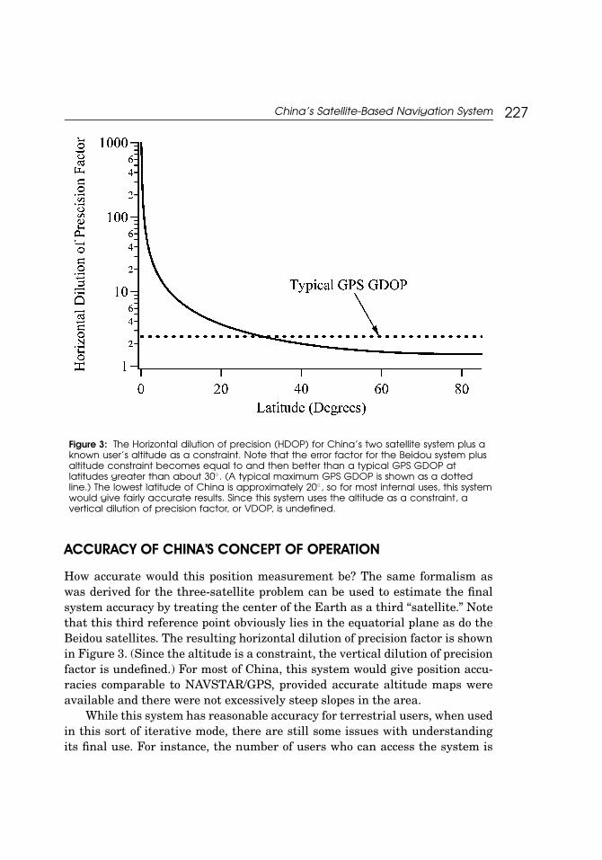
Figure 3: The Horizontal dilution of precision (HDOP) for China’s two satellite system plus aknown user’s altitude as a constraint. Note that the error factor for the Beidou system plusaltitude constraint becomes equal to and then better than a typical GPS GDOP atlatitudes greater than about 30◦. (A typical maximum GPS GDOP is shown as a dottedline.) The lowest latitude of China is approximately 20◦, so for most internal uses, this systemwould give fairly accurate results. Since this system uses the altitude as a constraint, avertical dilution of precision factor, or VDOP, is undefined.
ACCURACY OF CHINA’S CONCEPT OF OPERATION
How accurate would this position measurement be? The same formalism aswas derived for the three-satellite problem can be used to estimate the finalsystem accuracy by treating the center of the Earth as a third “satellite.” Notethat this third reference point obviously lies in the equatorial plane as do theBeidou satellites. The resulting horizontal dilution of precision factor is shownin Figure 3. (Since the altitude is a constraint, the vertical dilution of precisionfactor is undefined.) For most of China, this system would give position accu-racies comparable to NAVSTAR/GPS, provided accurate altitude maps wereavailable and there were not excessively steep slopes in the area.
While this system has reasonable accuracy for terrestrial users, when usedin this sort of iterative mode, there are still some issues with understandingits final use. For instance, the number of users who can access the system is
228 Forden
limited by the Beidou control center calculating each user’s position and thensending it to him. In fact, the system operating in this mode seems much morelike an experimental system than an operational system. If that is the case,why did China find it necessary to orbit a third satellite as an in-orbit spare?What capabilities does this third satellite give the system, and in particular,what military capabilities? Does the current system always have to be used inthis iterative fashion and does the user always have to transmit a signal tothe satellite, thereby giving away his position? In fact, with the launch of thethird Beidou satellite, the user can remain a passive user provided he carrieshis own high-precision clock. This is true even if the current Beidou satellitesdo not have atomic clocks since the ground-based control station can broadcasttime signals to each satellite for retransmission. It is interesting to note thatsome Chinese scientists have already published articles about this mode ofoperation.17
The rest of this article is devoted to studying the potential military appli-cations of the current three-satellite system. It assumes that an accurate timesignal can be broadcast from each satellite, perhaps simply as a retransmissionof timing signals originating on Earth; a capability those satellites appear toalready use. We also assume that each user will carry his own time reference,perhaps in the form of an atomic clock, so that all three coordinates (latitude,longitude, and altitude) can be determined simultaneously. The accuracy of thissystem, which is largely shaped by the geometry of the Beidou constellation,can then be used to assess the system’s application for military purposes.
TERRESTRIAL MILITARY USES OF THE BEIDOU NAVIGATION SYSTEM
It is helpful to note that a four-satellite constellation can achieve a geometricdilution of precision, GDOP, value close to the theoretical optimum18 if threeof the satellites are equally spaced 120◦ apart around the user’s horizon andthe fourth is directly overhead. The Beidou constellation, on the other hand,has a very different geometry. Figure 4 shows the constellation as seen from aterrestrial observer in Beijing.
Using the known positions of the Beidou satellites, the horizontal and ver-tical dilutions of precision factors can be then be calculated according to theprocedures outlined in the section above. These factors will, of course, dependon the observer’s position. We choose to plot the HDOP and VDOP values asa function of latitude for a fixed longitude nearly in the center of the coveredregion; the same longitude as Beijing. The resulting dilutions of precision fac-tors are shown in Figure 5. For convenience of comparison, a typical maximum

China’s Satellite-Based Navigation System 229
Figure 4: The Beidou constellation as seen from Beijing on the left; the actual NAVSTAR/GPSconstellation as seen from Beijing (at one particular moment, since GPS satellites are not ingeostationary orbit). The concentric circles represent constant elevations and the radiallines are lines of azimuth coming from the local zenith. The three Beidou satellites are shownas double triangles with their identities labeled next to them. The other dots represent stars.
acceptable GDOP19 for the NAVSTAR/GPS of 2.5 is shown. This NAVSTAR/GPSquantity, however, folds in the vertical dilution of precision factor and thus ar-tificially improves the comparison.
As might be expected from the fact that all of the Beidou satellites are ingeostationary orbits and, hence, appear to a terrestrial observer to lie nearly in astraight line, the constellation gives very large errors in determining the user’slatitude, or North-South position. At the same time, it gives fairly accuratelongitudinal positions.
To assess how this system could be used for military applications, it is nec-essary to estimate the error factor arising from all the other, nongeometric,sources of error. Without an analysis of a Beidou user’s station and not know-ing the errors associated with their orbital positioning, it is impossible to makean accurate, independent estimate of that error factor. However, it is possibleto place an upper bound on the system’s accuracy by assuming that the elec-tronics, etc., produce an error equal to the NAVSTAR/GPS error. This of courseassumes that China’s electronics infrastructure is not significantly better thanU.S. infrastructure, which seems to be a reasonable assumption.
It has been reported20 that NAVSTAR/GPS’s military mode has an accu-racy somewhat better than 10 meters. Assuming that accuracy and the re-ported 2.5 GDOP factor, we can estimate that all the factors contributing to the

230 Forden
Figure 5: The horizontal dilution of precision factor, or HDOP, is shown for the Beidousatellite constellation. As can be seen from a comparison with a typical maximum GPSdilution factor of 2.5, which includes the vertical factor, the constellation’s geometry resultsin precision considerably worse than GPS over nearly the entire area covered. Theprojection of the HDOP in the East-West direction is also shown.
nongeometric error produce a multiplicative scaling factor of about 3 meters.We will assume this same factor for the Chinese system as a way of placing anupper bound of the spatial error.
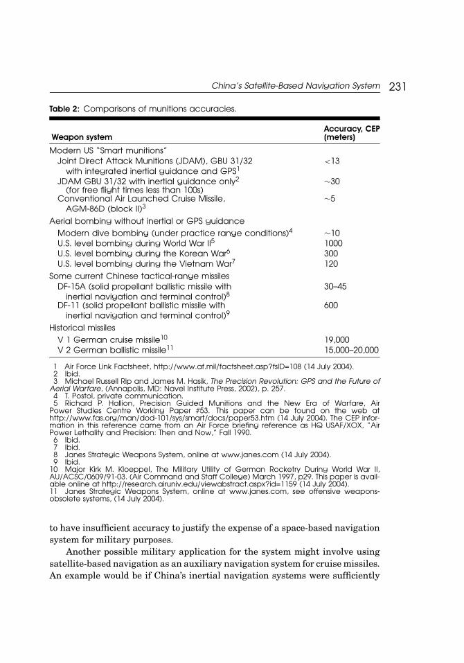
With that assumption, the horizontal error of the system at Taipei (with alatitude of 25◦ North) would have a North-South error of ±84 meters and anEast-West error of ±3.9 meters. This can be compared to accuracies associatedwith level bombing (during the Vietnam War) and modern dive-bombing (onpractice ranges without air defense) of 120 meters and 10 meters respectively.(See Table 2 for a wider range of comparisons.) Of course, those bombing accu-racies are the standard CEP, or circle of error probable, which corresponds tothe radius at which 50% of the bombs fall within and 50% outside while the nav-igational system error corresponds to a more rigorous 68%. However, it is likelythat the positional error of the navigational system would be better than theaccuracy of the bomb. By itself, the Beidou navigational system would appear
China’s Satellite-Based Navigation System 231
Table 2: Comparisons of munitions accuracies.
Accuracy, CEPWeapon system (meters)
Modern US “Smart munitions”Joint Direct Attack Munitions (JDAM), GBU 31/32 <13
with integrated inertial guidance and GPS1
JDAM GBU 31/32 with inertial guidance only2 ∼30(for free flight times less than 100s)
Conventional Air Launched Cruise Missile, ∼5AGM-86D (block II)3
Aerial bombing without inertial or GPS guidanceModern dive bombing (under practice range conditions)4 ∼10U.S. level bombing during World War II5 1000U.S. level bombing during the Korean War6 300U.S. level bombing during the Vietnam War7 120
Some current Chinese tactical-range missilesDF-15A (solid propellant ballistic missile with 30–45
inertial navigation and terminal control)8
DF-11 (solid propellant ballistic missile with 600inertial navigation and terminal control)9
Historical missilesV 1 German cruise missile10 19,000V 2 German ballistic missile11 15,000–20,000
1 Air Force Link Factsheet, http://www.af.mil/factsheet.asp?fsID=108 (14 July 2004).2 Ibid.3 Michael Russell Rip and James M. Hasik, The Precision Revolution: GPS and the Future of
Aerial Warfare, (Annapolis, MD: Navel Institute Press, 2002), p. 257.4 T. Postol, private communication.5 Richard P. Hallion, Precision Guided Munitions and the New Era of Warfare, Air
Power Studies Centre Working Paper #53. This paper can be found on the web athttp://www.fas.org/man/dod-101/sys/smart/docs/paper53.htm (14 July 2004). The CEP infor-mation in this reference came from an Air Force briefing reference as HQ USAF/XOX, “AirPower Lethality and Precision: Then and Now,” Fall 1990.
6 Ibid.7 Ibid.8 Janes Strategic Weapons System, online at www.janes.com (14 July 2004).9 Ibid.
10 Major Kirk M. Kloeppel, The Military Utility of German Rocketry During World War II,AU/ACSC/0609/91-03. (Air Command and Staff College) March 1997, p29. This paper is avail-able online at http://research.airuniv.edu/viewabstract.aspx?id=1159 (14 July 2004).11 Janes Strategic Weapons System, online at www.janes.com, see offensive weapons-obsolete systems, (14 July 2004).
to have insufficient accuracy to justify the expense of a space-based navigationsystem for military purposes.
Another possible military application for the system might involve usingsatellite-based navigation as an auxiliary navigation system for cruise missiles.An example would be if China’s inertial navigation systems were sufficiently

232 Forden
accurate to determine cross-range errors on the order of ±10 meters but wereinsufficiently accurate to determine the range to the same accuracy. (This is ahypothetical situation for which the author does not have any evidence. Instead,it is intended merely to illustrate the technical limitations of using the currentBeidou constellation for terrestrial applications.) If that were the case, Chinacould fly cruise missiles against Taipei along fixed latitude flight paths anduse the Beidou system to terminate the flight. This might give China’s cruisemissiles accuracies comparable to U.S. cruise missiles, but only if their inertialnavigational systems were equal to the cross-range task.
ADJUNCTS TO THE CONSTELLATION?
While China’s current Beidou navigation system definitely cannot provide thesame accuracy to guided munitions that NAVSTAR/GPS system does and mostlikely cannot provide much improvement over dive-bombing, there are space-based components that could be added and still retain an indigenous, regionalsystem that is comparable to GPS. The most straightforward of these is toadd an additional four satellites in so-called Molnyia orbits. Satellites in suchorbits would improve the geometry, and hence reduce the geometric error, ofthe system by having a satellite appear, to a user, far north of the existinggeostationary satellites as well as obviating the need for the user carrying aprecision clock or other schemes required for three-satellite constellations. (Onthe other hand, adding a fourth satellite in geostationary orbit could not producenearly as significant an improvement in geometry as a satellite in a Molnyiaorbit.) This section will consider just how much improvement would be gainedby adding satellites in Molnyia orbits.
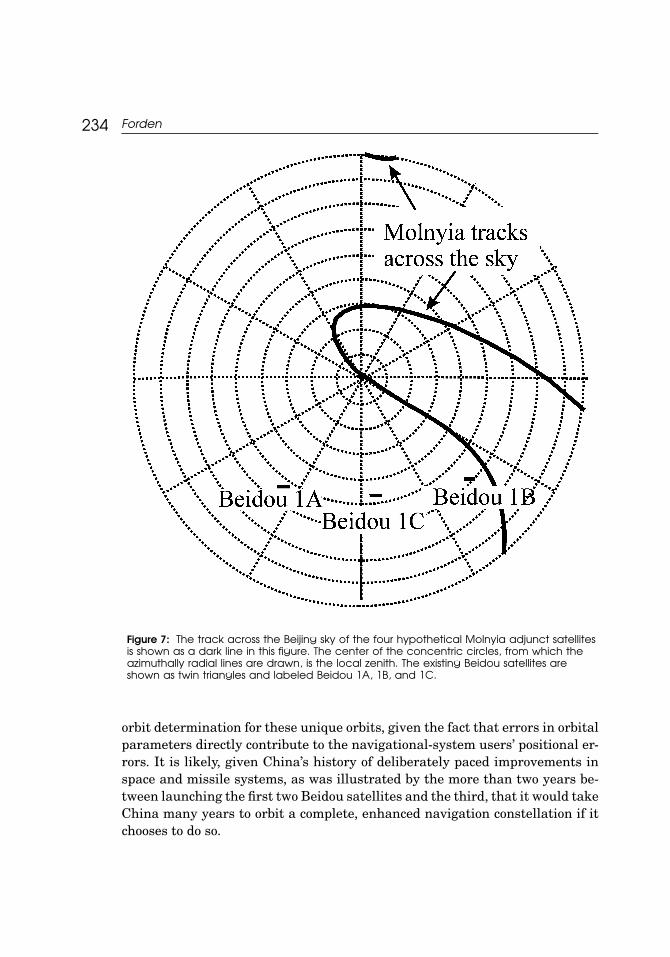
Molnyia orbits are highly elliptical and have an inclination near 63◦. Theadvantage of such orbits is that a single satellite can loiter, for nearly six hours,over a point at latitudes of between 40◦ and 60◦. It would take four such satel-lites to maintain a continuous coverage in Asia. These orbits are illustrated inFigures 6 and 7, which show the orbits relative to the Earth and as seen fromBijing, respectively.
Including the additional four satellites in Molnyia orbits has a significanteffect on the theoretical best performance of the Beidou system, assuming allthree geostationary satellites plus at least one Molnyia satellite can be used atany given time. If that is the case, the addition of the Molnyia satellites freesthe user from carrying a precise clock. It also considerably improves the constel-lation’s geometry. (By the time one satellite in a Molnyia-type orbit moves near

China’s Satellite-Based Navigation System 233
Figure 6: Orbits of the hypothetical augmented Beidou navigation system as viewed froman observer high above the equator (left) and one high above the north pole (right). Theexisting Beidou satellites, in geostationary orbit, are labeled as Beidou 1A, 1B, and 1C.Hypothetical adjunct satellites in Molnyia orbits are labeled “Molnyia 1” through 4.
Beidou 1B, another has appeared north of Beijing.) The resulting geometricdilution of precision factor, calculated using the standard methods for four ormore satellites,21 is shown in Figure 8.
When the four Molnyia satellites are included in the constellation, the ge-ometric dilution of precision (GDOP) and the horizontal dilution of precision(HDOP) factors are significantly reduced; primarily because of the presenceof a satellite at large latitudes. In this case, we could expect the spatial ac-curacies to be consistently better than 30 meters. This would seem to place aBeidou/Molnyia guided munition in the same accuracy category as the JDAMwith inertial guidance only (but with NAVSTAR/GPS quality guidance at thepoint of release).
However, China has no experience with Molnyia orbits, as illustrated bythe plot of apogee vs. perigee for all of China’s satellites22 in Figure 9. (All foursatellites in the highly elliptical orbit region, as indicated in the figure, have in-clinations less than 35◦.) While Molnyia orbits have inclinations chosen so thattheir orbits should not precess,23 there is inevitably some small movement oforbital axis around the earth. This would require China to learn a new station-keeping technique. China would also have to perfect the techniques for precision
234 Forden
Figure 7: The track across the Beijing sky of the four hypothetical Molnyia adjunct satellitesis shown as a dark line in this figure. The center of the concentric circles, from which theazimuthally radial lines are drawn, is the local zenith. The existing Beidou satellites areshown as twin triangles and labeled Beidou 1A, 1B, and 1C.
orbit determination for these unique orbits, given the fact that errors in orbitalparameters directly contribute to the navigational-system users’ positional er-rors. It is likely, given China’s history of deliberately paced improvements inspace and missile systems, as was illustrated by the more than two years be-tween launching the first two Beidou satellites and the third, that it would takeChina many years to orbit a complete, enhanced navigation constellation if itchooses to do so.

China’s Satellite-Based Navigation System 235
Figure 8: The various geometric dilution of precision factors are shown for the hypotheticalcase of the existing Beidou constellation and four additional satellites in Molnyia orbits. Thefour Molnyia orbits were chosen to guarantee at least one Satellite is always in position.However, during most of the time, two Molnyia satellites visible to users can be included inthe position determination.
STRATEGIC USE OF THE CURRENT BEIDOU NAVIGATION SYSTEM
While the Chinese Beidou navigation system does not appear to be capable ofthe precision needed for terrestrial military uses, it does have a potential to as-sist with the navigation of China’s intercontinental ballistic missiles (ICBM).We examined two possible uses of the system for aiding ICBM navigation. First,we looked at possibly using velocity information from Doppler measurementsof the Beidou signals to determine more accurately ICBM thrust termination.Second, we considered using the three dimensional position determination ofa post-boost vehicle provided by the Beidou system to accurately determinethe Keplerian trajectory. This trajectory determination would be followed byorbital corrections. It turns out that the first possibility is impractical sincethe time required for accurate velocity measurements is far too long. Perhapssurprisingly, however, the second method provides China with a real possibility

236 Forden
Figure 9: The apogee (altitude of the satellite at its greatest distance from the Earth) vs.the perigee (the satellite’s altitude at its closest approach to the Earth) for all of China’ssatellites in orbit on or before 25 September 2003. The four satellites in highly elliptical orbits,HEO, are circled. None of them has an inclination greater than 35◦.
of improving ICBM navigation to the point where it could MIRV its ICBM war-heads. Both analyses will be discussed below in the context of China’s existingfleet of ICBMs.
According to published sources, China has only a small arsenal of sevenDF-5A nuclear-tipped ICBMs capable of reaching the United States.24 Whileit is possible that these missiles have already been MIRVed, many analystsbelieve they carry a single, large (3-megaton) nuclear warhead.25 Estimates forthe missile system’s CEP range from 500 to 3,500 meters.26 Many factors con-tribute to the missile’s impact point uncertainty including, thrust terminationtiming, gravitational anomalies near the launch site, and reentry uncertaintiessuch as local weather conditions and small warhead irregularities.27 The effectspresent in the boost portion of the trajectory contribute the most uncertainty to

China’s Satellite-Based Navigation System 237
the impact point and can, to a large extent, be characterized by the uncertaintyin the vehicle’s three-dimensional velocity at burnout.
To quantify these powered-flight uncertainties, a computer simulation wasperformed using a rotating, round Earth, which included realistic atmosphereeffects. While relatively unimportant for this analysis, details of the DF-5Acharacteristics—such as mass ratios, engine burn times, etc.—were obtainedfrom the civilian version28 of this missile, the Chinese space-launch vehicle,the Long March 2C.29 After adjusting the various launch parameters, suchas launch azimuth, loft angle, and loft angle rate of change so that the mis-siles travel from their launch site at Xuanhua, China (40.36◦N, 115.03◦E)30 toWashington D.C., the velocity at burnout was varied both longitudinally andin both transverse directions by small amounts. The unperturbed trajectory isshown in Figure 10. Note that the trajectory passes very close to the North Pole.Trajectories from the other DF-5A launch site, Luoning, China (at 34.23◦N and111.39◦E) also pass very close to the North Pole. This is important given thegeometry of the Beidou constellation. The distribution for impact points for thevarious small velocity perturbations is shown in Figure 11.
Clearly, the largest changes in the impact point are caused by perturba-tions in the missile’s velocity along its direction of flight at burnout. These arequantified in Figure 12, which shows the miss distances as a function of changein velocity for perturbations along and transverse to the nominal trajectory.Thus, a change of 1 m/s parallel to the missile’s nominal velocity (which hasa magnitude of 7.2 km/s) produces a miss distance of 9.7 km while a similartransverse velocity perturbation produces a miss distance of 1.2 km. Statedanother way, the longitudinal velocity must be controlled to better than ±0.05m/s to produce a miss distance of 500 m or less.
If the lowest estimate for the DF-5A’s CEP is correct, then China mustcontrol the missile’s burnout velocity to this accuracy. Assuming an integratingaccelerometer for the DF-5A, this corresponds to an accuracy of seven parts in amillion. However, when thinking about using Doppler measurements from theBeidou satellites to determine engine shutoff, it is helpful to recast this in termsof a timing accuracy. After all, Doppler measurements, as will be discussed, takea certain minimum amount of time that depends solely on the desired accuracyand the carrier wave’s frequency. Other than increasing the carrier frequency,electronics cannot speed up the measurement process.
In that sense, the timing requirements can be estimated from the computermodel’s acceleration profile, shown in Figure 13, assuming that the DF-5A doesnot throttle back its thrust in the last few seconds of flight. Since the DF-5Areaches peak acceleration just before shutdown, again assuming no throttling,of 70.9 m/s2 this corresponds to shutting the engine down in ±0.0007 seconds of

238 Forden
Figure 10: The unperturbed trajectory of a DF-5A from Xuanhua, China, to WashingtonD.C. The Eurasian land mass is on the right side of this gnomic polar projection and theNorth American continent is on the left. The missile’s trajectory is shown as a broad linebetween Xuanhua and Washington D.C.
nominal burnout. Smaller miss distances would require proportionately greatertiming and accelerometer precision. Of course, this timing requirement can bemade somewhat less onerous by throttling down the DF-5A’s liquid propellantengine. However, that method would be less workable for the solid-propellantreplacement China is reportedly working on in its modernization program.31
The three satellites in the Beidou constellation are positioned to makea fairly accurate velocity measurement of a missile flying the Xuanhua (or

China’s Satellite-Based Navigation System 239
Figure 11: Impact points of DF-5A for small changes of burnout velocity. The nominalimpact point is in the center of the distributions of impact points, in Southeast Washington,near the Capital.
Luoning) to Washington D.C. trajectory. Furthermore, because of the long mo-ment arm produced by the geostationary orbit, precise knowledge of the mis-sile’s position is not required for the angular determinations that go into de-termining the missile vector velocity from the scalar Doppler measurements.(For instance, knowledge of the missile’s position to ±1 km, which is certainlypossible given what is known about China’s inertial navigation technology, willproduce angular errors on the order of 30 microradians.) We will therefore as-sume that the Doppler measurement of speed along the three lines of sight tothe three satellites dominates the error. It only remains to obtain an estimateof frequency at which the Beidou satellites broadcast.
These can be estimated from reports32 that the Beidou navigation satellitesare based on the same bus—the physical structure that contains the infrastruc-ture of power, communications, attitude control, etc.—as China’s DFH-3 com-munications satellite, which broadcasts on frequencies between four and sixgigahertz. (These reports also give the DFH-3 satellite’s mass at 2200 kg, whichincludes the apogee insertion/station-keeping engine. This mass is consistent

240 Forden
Figure 12: The distance between impact points with perturbed burnout velocities and thenominal burnout velocity for striking Washington D.C. Velocity perturbations along themissile’s trajectory produce larger miss distances than perturbations transverse to thenominal velocity.
with the lift capabilities of the Long March 3A,33 the Beidou launch vehicle,which can put 2,600 kg into geostationary transfer orbit.)
The Doppler shift is given by
fd = fv
c,
where fd is the Doppler frequency, f is the frequency of the Beidou radio signal,v is the velocity of ICBM with respect to the Beidou satellite and c is the speedof light. The larger the broadcast frequency, the larger the Doppler shift andhence the easier it is to measure. Since the greatest broadcast frequency atwhich the DFH-3 bus is known to broadcast is six gigahertz, we would expect amaximum Doppler shift of 144 kHz at the burnout speed of 7.2 km/s. Of coursethe actual Doppler shifts of the three Beidou signals would be somewhat lessthan that because none have a line-of-sight directly along the missile’s burnoutvelocity.
Assuming the Doppler shift is used as a cutoff signal for the missile’s en-gines, the missile’s guidance and control system must differentiate between

China’s Satellite-Based Navigation System 241
Figure 13: The acceleration (the dashed curve) and velocity (the solid curve) profiles ofthe DF-5A computer simulation used in this study. The sharp drop off in acceleration atroughly 125 seconds corresponds to the change in mass ratio as the first stage in droppedand the second takes over.
Doppler frequencies that correspond to velocities that differ by the desired veloc-ity error limit. From Figure 12, it can be seen that a desired CEP of 500 meterscorresponds to velocity error of ±0.05 m/s. That means that the Doppler-shiftmeasurements must be more accurate than 1.1 Hz out of the 144 kHz total shiftor, more importantly, out of the roughly six gigahertz carrier frequency.
While most Doppler shifts are measured by passing the signal through abank of narrow-pass filters,34 the process can be thought of as comparing thewavelength of the incoming signal with the reference wavelength, in this casethe wavelength corresponding to the desired velocity. To make a good compar-ison, the observer must allow a large number of wavelengths to pass by andthen measure the relative phase of the two. If the incoming signal differs fromthe reference signal by 1.1 Hz, the observer must wait for roughly 2.7 × 10⁹
wavelengths (of the carrier beam) to pass before the relative phase differs byhalf a wavelength. This takes roughly half a second and sets the time scale for

242 Forden
making this comparison. (Of course, it is possible that a smaller fraction of awavelength might suffice to differentiate between the two signals. In that case,a proportionately shorter time is needed.)
On the other hand, the acceleration of the DF-5 missile, about 70 m/s2,at booster burnout means that the missile changes its velocity by 35 m/s inthe half second it takes to make the measurement with the required accuracy.Even after engine shutdown, the Earth’s gravitational field changes the mis-sile’s velocity by about 5 m/s during the measurement. This is roughly 100times greater than the required accuracy. This makes using the Beidou con-stellation for engine cutoff impractical. The Beidou satellite could, of course,shorten the required time for the measurement by broadcasting with a higherfrequency, but it would have to be nearly 1000 gigahertz—far higher than Chinahas demonstrated for space-qualified transmitters—in order for the missile’svelocity to change by only an amount comparable with the required accuracyduring the measurement process.
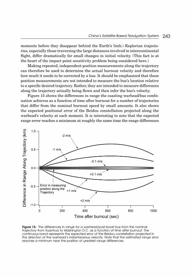
Another possible method China could employ for using the Beidou constel-lation to improve its ICBM fleet uses a post-boost bus to correct any velocityerrors that might have accumulated during powered flight. This makes useof the fact that the warhead/bus combination follows a Keplerian trajectoryfrom burnout35 to the point where it reenters the Earth’s atmosphere, and thefact that the three Beidou satellites are visible to the warhead for the first 27minutes of its trajectory. (See Figure 14 for a view back towards the satellites
Figure 14: This figure shows the view from the warhead just before Beidou 1C disappearsbehind the Earth’s limb. This is 27 minutes after its launch. The warhead is over Canada;Greenland can be seen on the right side of the globe.
China’s Satellite-Based Navigation System 243
moments before they disappear behind the Earth’s limb.) Keplerian trajecto-ries, especially those traversing the large distances involved in intercontinentalflight, differ dramatically for small changes in initial velocity. (This fact is atthe heart of the impact point sensitivity problem being considered here.)
Making repeated, independent position measurements along the trajectorycan therefore be used to determine the actual burnout velocity and thereforehow much it needs to be corrected by a bus. It should be emphasized that theseposition measurements are not intended to measure the bus’s location relativeto a specific desired trajectory. Rather, they are intended to measure differencesalong the trajectory actually being flown and then infer the bus’s velocity.
Figure 15 shows the differences in range the coasting warhead/bus combi-nation achieves as a function of time after burnout for a number of trajectoriesthat differ from the nominal burnout speed by small amounts. It also showsthe expected positional error of the Beidou constellation projected along thewarhead’s velocity at each moment. It is interesting to note that the expectedrange error reaches a minimum at roughly the same time the range differences
Figure 15: The differences in range for a warhead/post-boost bus from the nominaltrajectory from Xuanhua to Washington D.C. as a function of time after burnout. Thecontinuous band represents the expected error of the Beidou constellation projected inthe direction of the warhead’s instantaneous velocity. Note that the estimated range errorreaches a minimum near the position of greatest range differences.

244 Forden
are maximized, about 700 seconds after burnout. Similar plots could be madefor positional differences transverse to the nominal trajectory.
Unfortunately, the factors that contribute to the error associated with apositional measurement are not independent of previous measurements. Forinstance, the errors associated with a satellite’s orbital parameters will notvary between measurements. This means that multiple independent positionalmeasurements cannot be made over the course of the trajectory to improve theoverall absolute trajectory determination. However, the relative position of eachmeasured point can be used to determine a trajectory with respect to a pointwhose absolute position is determined by the most accurate position measure-ment of the series. The trajectory parameters relative to this reference point, onthe other hand, can be improved by making a large number of positional mea-surements. This is sufficient for determining the velocity corrections to a muchhigher precision than any single measurement would allow. Nevertheless, ifChina were willing to wait 500 hundred seconds after burnout (or about 12 min-utes after launch in the 35 minute trajectory) it would take only a few positionalmeasurements to discriminate between trajectories with sufficient accuracy toproduce the 500 meter CEP because the GDOP continues to improve.
How would this information be used? Once an accurate estimate of theburnout velocity has been made, the coasting bus could reset its gyroscopesand accelerometers to the position and velocity determined by the Beidou sys-tem. This would essentially erase any errors that had accumulated during thepowered flight portion of the trajectory. Then the bus would either maneuverto correct the small velocity differences—only a few meters per second changewould be needed—to re-aim the warhead for its intended target. Or the buscould maneuver several times, relying solely on its reset internal guidance sys-tem, and drop off several warheads to different targets long its flight path—achange in targeting facilitated by the close proximity of the Eastern seaboardpopulation centers. It should be noted that China could test this system byusing it to determine the orbital parameters of its satellites in near polar orbit.
Thus, while it may seem counterintuitive, China’s Beidou constellation ofnavigation satellites provides sufficient accuracy for guiding nuclear-tipped in-tercontinental ballistic missiles but is not accurate enough for conventionaltactical weapons.
CHINA’S NUCLEAR DOCTRINE AND THE BEIDOU SATELLITES
This article has tried to determine the military capabilities of China’sBeidou constellation of satellites. However, theoretical capabilities do not
China’s Satellite-Based Navigation System 245
automatically imply actual motivations. It is possible that China has launchedthis system of satellites as part of a civilian research and development pro-gram and does not really care that its terrestrial applications are so restricted.Nevertheless, the system’s utility is limited36 because of the iterative nature ofits two-satellite mode of operation or its accuracy is limited for terrestrial usesin the three-satellite mode. Because of this and the fact that the system, likeany space-based system, is very expensive, we are naturally led to speculatingabout those applications for which it does seem to be well suited, in this caseits strategic uses.
Many analysts have concluded that China has long had a nuclear doc-trine based around a delayed second strike.37 This policy relied on having afew survivable missiles carrying large-yield nuclear warheads aimed at pop-ulation centers. As such, China did not need excessive accuracy for its war-heads. For instance, the reported 3-megaton warhead currently on the DF-5Awould produce a 2 psi overpressure—enough to shatter38 concrete or cinder-block walls as well as produce large numbers of fatalities—at a radius of 19km,39 far greater than even the largest CEP estimates of 3,500 meters for theDF-5A.
Even if China modernizes its nuclear forces, as some Western analystsexpect, to include MIRVed warheads and consequently has to reduce their yieldto save weight, it is doubtful that China would need to improve its missileaccuracy. For instance, if China replaced its large, multimegaton warhead withwarheads in the 150 to 350 kiloton40 range, the equivalent blast range wouldonly shrink to 7 km. This is still twice the largest CEP estimate for the existingmissiles. Therefore, it seems doubtful that China would need this expensivespace-based navigation system for its nuclear modernization program if it weregoing to retain its current counter-value system of deterrence unless it wasresponding to some other change in the strategic environment.
It is even more unlikely that China is switching to a counter-force strat-egy or a command and control decapitation strike. The United States’ nuclearforces are essentially sized to survive a nuclear first strike from the formerSoviet Union, which had many more nuclear weapons than China can hopeto produce in the foreseeable future. A much more likely explanation is thatChina would use a MIRVed system to threaten additional U.S. cities. A limitedspace-based navigation system with the accuracies currently deliverable fromthe Beidou constellation could contribute significantly to such a modernizationprogram. Furthermore, the system could be viewed as a response to the pro-posed U.S. ground-based missile defense system since it is geared to maneuver-ing the bus near the mid-point of the trajectory, after a U.S. interceptor has beenlaunched.

246 Forden
Appendix
DERIVATION OF GEOMETRIC ERRORS ASSOCIATED WITH A THREESATELLITE CONSTELLATION OF NAVIGATION SATELLITES
Sturza41 starts with the definition of pseudorange (given by the time differ-ence between the user’s local time and local time broadcast by the satellite asreceived by the user) residuals, ρ, between each satellite and the user:
�ρ = H3�x + b�1,
where H3 is a matrix containing the direction cosines from the user to eachsatellite. Here
�x =�x
�y�z
is the difference between the user and a hypothetical point whose position isassumed known,
�ρ = �ρ1
�ρ21
�ρ3
is the pseudorange residual vector,
H3 =α1x α1y α1z
α2x α2y α2z
α3x α3y α3z
is the array of the direction cosines (see Appendix Figure 1),
�1 =1
11
and b is the user’s clock bias.The correction to the position of the user is then given by �x = H−1
3 [�ρ − b�1].More importantly for this analysis, the position correction error covariance
is given by
cov(�x) = H−13
[σ 2
ρ I + σ 2b�1 �1T
]H−T
3 = σ 2ρ
{(HT
3 H3)−1 + σ 2
b
σ 2ρ
H−13
�1 �1T H−T3
},
where σ 2b is the user’s clock bias error variance.

China’s Satellite-Based Navigation System 247
Appendix Figure 1: The vectors from the user to each of the three satellites in the Beidouconstellation are shown as are two of the three direction cosine angles for the (arbitrarilynumbered) satellite number 2. The standard coordinate system, with the X-axis going tothe prime meridian and the Z-axis along the north pole, is used. Note that the direction ofthe direction cosines is from the user to the satellite.
For the rest of this article, we will assume that the user’s clock bias errorvariance is negligible compared to the error associated with the pseudorange,i.e., σ 2
b � σ 2ρ . With this simplifying assumption, the position error covariance
associated with the three satellite system and a user with a precise clock isgiven by σ 2
ρ (H T3 H3)−1.
Thus, the error is comprised of the product of two terms; one is determinedsimply by the geometry of the constellation—as viewed by the user—and theother is a combination of all the other factors associated with all space-basednavigation systems as mentioned above. It is helpful to consider the geometricfactor alone, often referred to as the “geometric dilution of precision” factor, andto break it down into a total geometric factor, given by
GDOP3 =√
Trace(HT
3 H3)−1 = √
Vx + Vy + Vz .
Horizontal and vertical dilution of precision factors are given by transformingthe direction cosine matrix into the user’s local coordinate system with the Xand Y coordinates lying in the plane tangent to the Earth’s surface at that point

248 Forden
and the Z axis pointing out radialy. Thus
HDOP3 = √Vx + Vy
and
VDOP3 =√
Vz
for the horizontal and vertical dilution of precision factors, respectively.
NOTES AND REFERENCES
1. J. J. Spilker Jr. and Bradford W. Parkinson, Overview of GPS Operation and Design,in Bradford W., Parkinson and James J. Spilker Jr. (eds.), Global Position System: Theoryand Applications, Volume 1 (Washington D.C.: American Institute of Aeronautics andAstronautics, Inc., 1996).
2. As of 2 January 2004, this website was http://www.cast.ac.cn/en/printpage.asp?ArticleID=36
3. Ibid.
4. Some analysts claim that this mode could be used by the Chinese military in locatingthe launch points for their next generation of mobile ICBMs. (David Wright, privatecommunication.) The mobile launchers could, of course, just go to presurveyed launchpoints.
5. The information in Table 1 and in fact all calculations in this article based on or-bital positions, are derived from information provided by NASA’s Orbital InformationGroup webpage (http://oig1.gsfc.nasa.gov/) and based on an ephemeris of 31 December2003.
6. I would like to thank Prof. Li Bin, Director, Arms Control Program, Tsinghua Uni-versity, Beijing, for summarizing for me the conception of operations for the Beidousystem as presented in Gao Lu, “Double-Star Navigation System,” Contemporary Com-munication (Xiandai Tongxun) (in Chinese), No. 10, 1997, p. 20. “Beidou-1, Navigatingfor China,” Information of Remote Sensing (Yaogan Xinxi) (in Chinese), No. 2, 2003,p. 50. Wei Wucai, “Comparing Beidou Navigation System and GPS,” Marines Naviga-tion Technology (Hanghai Jishu) (in Chinese), No. 6, 2003, pp. 15–16.
7. This time stamp is needed to avoid the equivalent of a radar system’s “range am-biguity” problem. It could be as simple as separating square wave pulses by more thanthe round trip travel time from the satellite to the user, approximately a quarter of asecond, or it could be as complex as encoding a sequence number into a train of squarewaves. It should be noted that since the satellite is acting as a transponder for groundsignals, this time stamp algorithm could be changed at any time without making anyhardware changes on the satellite.
8. Li Bin, Director, Arms Control Program, Tsinghua University, Beijing, privatecommunication.
9. Wang Xiaojin and Wang Xia, “Understanding “Beidou One” Navigation System,”Marines Navigation Technology (Hanghai Jishu) (in Chinese) No. 1, 2004, p. 31., No. 6,

China’s Satellite-Based Navigation System 249
2003. Again, the author would like to thank Li Bin, Director of the Arms Control Programat Tsinghua University, Beijing, for summarizing this paper.
10. Li Bin has stated that the signal goes back and forth “between the ground and thesatellite four or five times,” which seems to indicate that this is the actual method ofoperation.
11. Li Bin, private communication.
12. Ibid.
13. Bryant D. Elrod and A. J. Van Dierendonck, Pseudolites, in Bradford W. Parkinsonand James J. Spilker Jr. (eds.), Global Position System: Theory and Applications,Volume 2, (Washington D.C.: American Institute of Aeronautics and Astronautics, Inc.,1996), pp. 51–79.
14. Mark A. Sturza, “GPS Navigation Using Three Satellites and a Precise Clock,”Navigation: Journal of the Institute of Navigation, vol. 30, (1983), pp. 146–156.
15. J. J. Spilker Jr., Satellite Constellation and Geometric Dilution of Precision, inBradford W. Parkinson and James J. Spilker Jr. (eds.), Global Position System: Theoryand Applications, Volume 1, (Washington D.C.: American Institute of Aeronautics andAstronautics, Inc., 1996), pp. 177–208.
16. I would like to thank Gregory Kulacki of the Union of Concerned Scientists forpointing this system out to me.
17. Lin Xueyuan and Liu Jianye, “The Study on Improvement of “Beidou” Double-StarNavigation System and Its Algorithm,” Chinese Journal of Space Science (KongjianKexue Xuebao) (in Chinese), Vol. 23, No. 2 (2003), pp. 149–154. Again, the author wouldlike to thank Li Bin, Director of the Arms Control Program at Tsinghua University,Beijing, for summarizing this paper.
18. J. J. Spilker Jr., Satellite Constellation and Geometric Dilution of Precision, inBradford W. Parkinson and James J. Spilker Jr. (eds.). Global Position System: Theoryand Applications, Volume 1, (Washington D.C.: American Institute of Aeronautics andAstronautics, Inc. 1996), pp. 197–198.
19. J. J. Spilker Jr. and Bradford W. Parkinson, Overview of GPS Operation and Design,in Bradford W. Parkinson and James J. Spilker Jr. (eds.), Global Position System: Theoryand Applications, Volume 1, (Washington D.C.: American Institute of Aeronautics andAstronautics, Inc., 1996), p. 36.
20. Ibid.
21. See for example Reference 6.
22. From information provided by NASA’s Orbital Information Group webpage(http://oig1.gsfc.nasa.gov/, 14 July 2004) which provides historical orbital elements toall most satellites that have ever been launched, including all of China’s.
23. James R. Wertz, Mission Geometry; Orbit and Constellation Design and Manage-ment (El Segundo, CA: Microcosm Press, 2001), pp. 85–85.
24. William M. Arkin, Robert S. Norris and Joshua Handler, Taking Stock: WorldwideNuclear Deployments 1998 (Washington D.C.: Natural Resources Defense Council, Inc.),p. 89.
25. Jane’s Strategic Weapons System, online at www.janes.com (14 July 2004).

250 Forden
26. This range of DF-5A CEPs is from the FAS website at http://www.fas.org/nuke/guide/china/icbm/df-5.htm. (14 July 2004), Jane’s online, on the other hand, lists theCEP as 800 meters.
27. Mathew Bunn, “Technology of Ballistic Missile Reentry Vehicles,” Report no. 11 ofthe Program in Science and Technology for International Security, MIT, March 1984,p. 12.
28. Jane’s Strategic Weapons System, online at www.janes.com for the DF-5 (14 July2004).
29. China Academy of Launch Vehicle Technology, LM-3A User’s Manual, which isavailable on the web at http://www.calt.com.cn/new/english/# (14 July 2004).
30. William M. Arkin, Robert S. Norris, Joshua Handler, Taking Stock: Worldwide Nu-clear Deployments 1998 (Washington D.C.: Natural Resources Defense Council, Inc.)p. 89
31. Jane’s online service at www.janes.com (14 July 2004) reports that the three-stagesolid-propellant DF-41 is intended to replace the DF-5A around 2005.
32. Mark Wade, Encyclopedia Astronautica at http://www.astronautix.com/craft/beidou.htm
33. China Academy of Launch Vehicle Technology, LM-3A User’s Manual, Chapter 1,page 1, which is available on the web at http://www.calt.com.cn/new/english/# (14 July2004).
34. George W. Stimson, Introduction to Airborne Radar, 1st Edition (El Segundo, CA:Hughes Aircraft Company), pp. 359–360.
35. The computer model for the DF-5 used here shows that the missile burns out atapproximately 160 km altitude, well outside Earth’s effective atmosphere.
36. Some analysts argue that the declared mode of operation is not really limited sincethe central control center is assumed to have a detailed, high precision, digital altitudemap of the entire area of coverage (David Wright, private communication). However,obtaining such a map, while certainly possible, is expensive and China has declaredonly that the system is used for “road traffic, rail transport, [and] offshore operation[s],”hinting that they do not have such a map for the entire area of coverage. Instead, theyseem to have only such maps for their road system or railroad tracks. Offshore operationof course can accurately assume sea level in their altitude constraints. It is in this sensethat the declared mode of operation seems limited.
37. The Nuclear Threat Initiative gives a concise review of China’s nuclear doctrineon their website, including links to a number of Chinese official documents. This can bereached at http://www.nti.org/db/china/doctrine.htm (14 July 2004).
38. Samuel Glasstone, ed., The Effects of Nuclear Weapons, The United States AtomicEnergy Commission, Revised Edition, February 1964, p. 163.
39. This and other nuclear effects were calculated using the Nuclear Bomb EffectsComputer included with Glasstone’s The Effects of Nuclear Weapons.
40. China tested several nuclear designs in this range between 1966 and 1983, accord-ing to Jane’s Online, www.janes.com, see CSS-4 (DF-5), (14 July 2004).
41. Mark A. Sturza, “GPS Navigation Using Three Satellites and a Precise Clock,”Navigation: Journal of the Institute of Navigation, vol. 30 (1983), pp. 146–156.