The Lower Red River Restoration Project After Three Years, Did … · 14 Heat Transport Model...
15
1 The Lower Red River Restoration Project After Three Years, Did Anything Really Happen? Tom Bourque, P.E. Erik Ryan, P.E. TerraGraphics Environmental Engineering Project Location LEWISTON
Transcript of The Lower Red River Restoration Project After Three Years, Did … · 14 Heat Transport Model...

1
The Lower Red River Restoration Project
After Three Years, Did Anything Really Happen?
Tom Bourque, P.E.Erik Ryan, P.E.
TerraGraphics Environmental Engineering
Project Location
LEWISTON

2
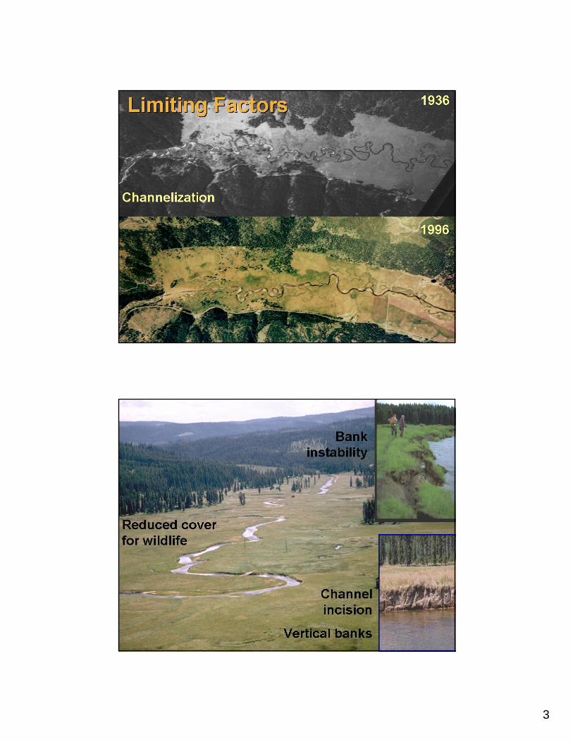
Red River Study Reach
• Lodgepole and ponderosa pine uplands• Elevation = 4200 ft• Annual ppt (mostly snowmelt) = 30 in• Drainage area = 100 mi2• Bankfull discharge = 580 cfs• Alluvial pool-riffle channel; C and E
types• Channel length = 2.5 mi• Slope=0.0016; sinuosity=2.7
Local History• “The fish were so numerous that a
stagecoach could cross the stream without touching the channel bottom.”
• “The vegetation was so dense that cattle rustlers used the meadow to hide stolen cattle.”
• “When Momma asked me to fetch water from the creek, I could not dip the bucket in without getting a bunch of fish too.”
3
4
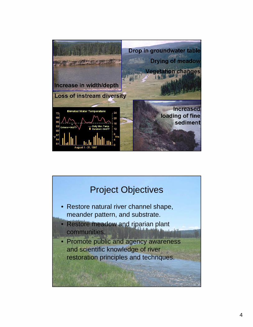
Project Objectives
• Restore natural river channel shape, meander pattern, and substrate.
• Restore meadow and riparian plant communities.
• Promote public and agency awareness and scientific knowledge of river restoration principles and technques.

5
1994 Channel Alignment
Restoration Phases
Pre-Construction Post-Construction
2000(2002 photo)
1996

6
• Constructed 1996• High Bankfull Width• Minimal Deposition
• Constructed 2000• Equilibrium Channel

7
Construction Techniques
• Use of Existing Sod/Depressions• Soil Wraps• Single Piece of Fabric Over Bank

8
Temporary Bank Stabilization
• Building a New Bank– Soil Wraps– Approx 5 Years
• Digging Channel Through Existing– Coir Fabric on Slope– Approx 2 Years
Bank Height/Composition

9
Tributaries/Wetlands
• 66 Creek• Loon Creek
Hydroperiod AnalysisMax Discharge about 2x Bankfull
Comparison of Water Surface Elevations at Cross Section 16
4223
4224
4225
4226
4227
4228
4229
4230
31-M ar-97 20-Apr-97 10-M ay-97 30-M ay-97 19-Jun-97 9-Jul-97 29-Jul-97 18-Aug-97 7-Sep-97 27-Sep-97
1994 Channel Geometry 2001 Channel Geometry Floodplain Inundation Elevation

10
1994 Channel Geometry 2000 Channel Geometry
Floodplain InundationBankfull Flow +15% (660 cfs)
Vegetation

11
2000 2000
2003 2004

12
20032001

13
Increased bird species Increased bird species abundance and diversity abundance and diversity
Heat Transport Model Heat Transport Model (Scenario(Scenario 11))
Longitudinal Temperature Profile 13.08.02 18:00 hScenario 1 and 1a
18
18.5
19
19.5
20
20.5
21
21.5
22
22.5
0 1000 2000 3000 4000 5000 6000 7000 8000 9000 10000 11000 12000 13000
Chainage [m]
Tem
pera
ture
[°C
]
Temperature Calculated
Measured Temperature
Temperature calculated, increasing of Shadingfor Section 6 and 7 of 15 %Temperature calculated, increasing of Shadingfor Section 6 and 7 of 10 %
Upstream Meadow
Chan-nelized
Canyon Project Site
14
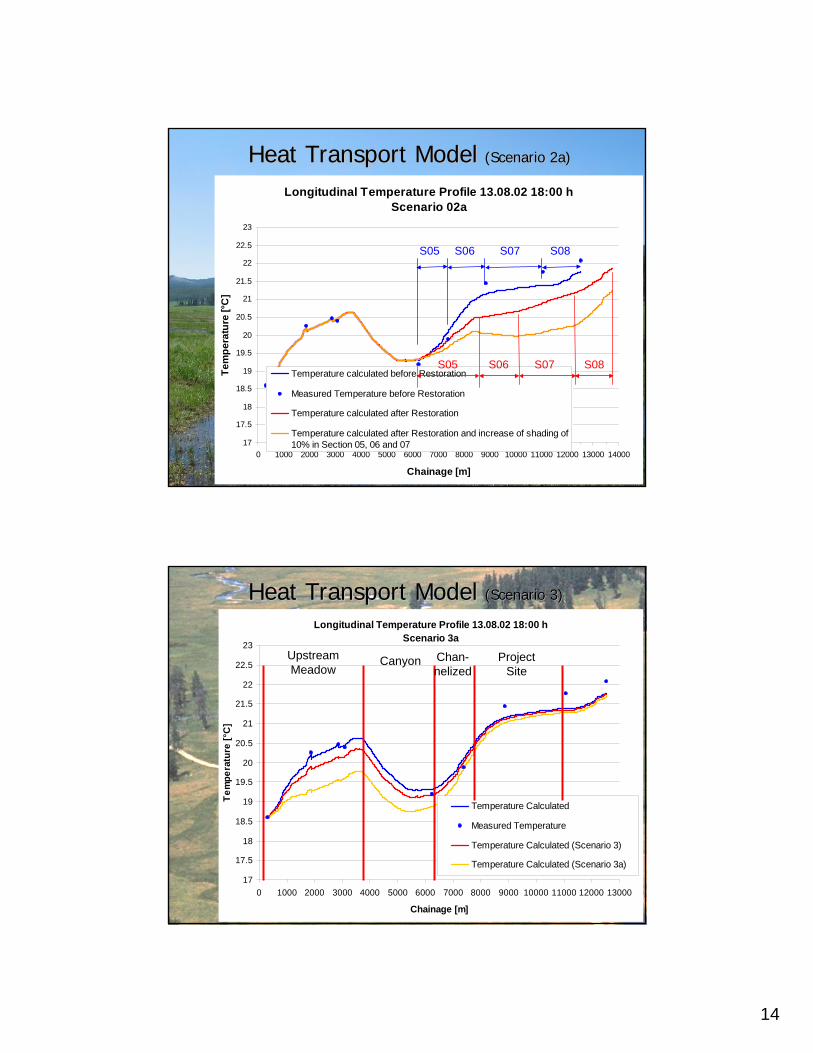
Heat Transport Model Heat Transport Model (Scenario(Scenario 2a2a))
Longitudinal Temperature Profile 13.08.02 18:00 hScenario 02a
17
17.5
18
18.5
19
19.5
20
20.5
21
21.5
22
22.5
23
0 1000 2000 3000 4000 5000 6000 7000 8000 9000 10000 11000 12000 13000 14000
Chainage [m]
Tem
pera
ture
[°C
]
Temperature calculated before Restoration
Measured Temperature before Restoration
Temperature calculated after Restoration
Temperature calculated after Restoration and increase of shading of10% in Section 05, 06 and 07
S05 S06 S07 S08
S05 S06 S07 S08
Heat Transport Model Heat Transport Model (Scenario(Scenario 33))
Longitudinal Temperature Profile 13.08.02 18:00 hScenario 3a
17
17.5
18
18.5
19
19.5
20
20.5
21
21.5
22
22.5
23
0 1000 2000 3000 4000 5000 6000 7000 8000 9000 10000 11000 12000 13000
Chainage [m]
Tem
pera
ture
[°C
]
Temperature Calculated
Measured Temperature
Temperature Calculated (Scenario 3)
Temperature Calculated (Scenario 3a)
Upstream Meadow
Canyon Project Site
Chan-nelized

15
Lessons Learned• Use of Existing Sod• Importance of Vegetation• Equilibrium Channel Design• Bank Height/Composition• Importance of Tributaries• Upstream/Downstream Effects
Acknowledgements• Bonneville Power Adminstration– Funding Agency• Idaho Country Soil and Water Conservation District – Owner• Technical Advisory Committee – Peer Review• Wildlife Habitat Institute – Project Management and Revegetation• TerraGraphics – Final Engineering and Implementation, and
Monitoring• LRK – Monitoring Coordination and Communications• University of Idaho, Ecohydraulics Research Group – Conceptual
Engineering and Monitoring• Professional Operators Company - Construction