
The Living City Policies
204
for Planning and Development in the Watersheds of the Toronto and Region Conservation Authority The Living City ® Policies November 28, 2014
Transcript of The Living City Policies

for Planning and Development in the Watersheds of the Toronto and Region
Conservation Authority
The Living City®
Policies
November 28, 2014

RESOLUTION #A186/14THE LIVING CITY POLICIES FOR PLANNING AND DEVELOPMENT IN THE WATERSHEDS OF THE TORONTO AND REGION CONSERVATION AUTHORITY
Recommending Authority approval of The Living City Polices for Planning and Development in the Watersheds of the Toronto and Region Conservation Authority.
Moved by: Mike MattosSeconded by: Jack Heath
WHEREAS Toronto and Region Conservation Authority (TRCA) staff conducted a second and final round of public and stakeholder consultation on The Living City Policies draft document; AND WHEREAS the document has now been finalized based on staff and stakeholder feedback; AND WHEREAS the Province’s “Policies and Procedures for Conservation Authority Plan Review and Permitting Activities” (2010) states that conservation authority policies be “approved by the conservation authority Board of Directors”; THEREFORE LET IT BE RESOLVED THAT TRCA adopt The Living City Policies for Planning and Development in the Watersheds of the Toronto and Region Conservation Authority to be effective immediately, and to replace the Valley and Stream Corridor Management Program adopted by the Authority in October 1994; AND FURTHER THAT TRCA’s municipal partners, provincial ministries, the Building Industry and Land Development Association, environmental non-governmental agencies, watershed and waterfront interest groups, neighbouring conservation authorities, and aboriginal nations, confederacies and councils be so advised by the CEO’s Office.
i

1Introduction
IIIThe Living City Policies
1
Introduction 6
1.1 Purpose and Scope 6 1.2 Updates/Amendments to the Document 7 1.3 Applicability 7 1.4 Associated Technical Guidelines 7 1.5 How to Read The LCP 8
2
The Toronto Region 10
2.1 TRCA’s Jurisdiction 10 2.2 TRCA’s Watersheds at a Glance 13 2.3 Issues, Challenges and Opportunities 15
3
Legislative Foundation 18
3.1 Conservation Authorities Act 18 3.2 Planning Act and Environmental Assessment Acts 20
4
TRCA History and Evolution to The Living City 28
4.1 Historic Overview 28
5
The Living City 36
5.1 Vision 36 5.2 Mission 36 5.3 Strategic Objectives 36 5.4 Building The Living City: TRCA Strategic Plan 2013 – 2022 37 5.5 Principles 37
6
Paths to Achieving The Living City: Policies for Sustainable Communities 39
6.1 Introduction 39 6.2 Climate Change 39 6.3 Energy 42 6.4 Transportation 43 6.5 Green Buildings 44 6.6 Near-Urban Agriculture 46 6.7 Green Infrastructure 47 6.8 Ecological Design 49 6.9 Cultural Heritage 52 6.10 Environmental Education and Stewardship 55

1 Introduction
4 The Living City Policies
7
Policies for Environmental Planning 60
7.1 Introduction 60 7.2 Landscapes of the Toronto Region 63 7.3 Environmental Protection Policies 72 7.4 Environmental Management Policies 81 7.5 Plan Input and Plan Review (Implementation) 109
8
Policies for the Administration of TRCA’s Development, and Interference with Wetlands and Alterations to Shorelines and Watercourses Regulation 116
8.1 Introduction 116 8.2 Development, Interference with Wetlands and Alterations to Shorelines and Watercourses Regulation 117 8.3 Policy Framework 120 8.4 General Regulation Policies 121 8.5 Valley and Stream Corridors 127 8.6 Development within the Flood, Erosion, and Dynamic Beach Hazards of the Lake Ontario Shoreline 133 8.7 Development and Interference within Wetlands and Development within Other Areas (Area of Interference) 138 8.8 Interference with a Watercourse 141 8.9 Infrastructure Policies 142 8.10 Recreational Use Policies 147 8.11 Dewatering, Dewatering Discharge and Water Taking 149 8.12 Fill Placement, Excavation and/or Grade Modification Policies 149 8.13 Implementation and Compliance 150
Glossary Definitions of terms used in the document 152
References Sources used in the development of the document 167
Appendix A Illustrative Examples of the Natural System A-1
Appendix B Municipal Policies for Approved Special Policy
Areas and Two Zone Areas B-1
Appendix C Defining the Limit of Regulated Areas C-1
Appendix D Illustrative Examples of Additions to Existing Buildings within the Flood Hazard D-1

1Introduction
5The Living City Policies
List of Figures
Figure
2.1a TRCA and Neighbouring Conservation Authorities 112.1b Map of TRCA’s Jurisdiction 123.1 Legislation, Policies, and Processes for TRCA’s roles in Planning and Development 217.1 Watershed Connections 827.2 One Zone Concept, Flooding Hazard Limit 917.3 Two Zone Concept, Flooding Hazard Limit 917.4 Confined System A, Erosion Hazard Limit 977.5 Confined System B, Erosion Hazard Limit 977.6 Unconfined System 977.7 Flood Hazard Limit 997.8 Erosion Hazard Limit 997.9 Dynamic Beach Hazard Limit 99
List of Tables
Table
3.1 Conservation Authority Roles in Planning and Development 223.2 Legislation, regulations, policies, plans and programs affecting TRCA’s jurisdiction 23

1 Introduction
6 The Living City Policies
incorporating its valuable foundation of principles and policy intent. In addition, the LCP reflects and clarifies the current practice of TRCA’s roles as a public commenting body, service provider, resource management agency, a representative of the provincial interest for natural hazards, a regulator, and a landowner in the context of the planning and development process. These roles reflect many new directions that have developed since the VSCMP was first formulated and adopted in 1994.
1.1 Purpose and Scope
In many different capacities, the Toronto and Region Conservation Authority (TRCA) partners in a variety of initiatives with municipal, provincial and federal governments, corporations, academics, grass roots community groups, and others to help achieve our goals in support of a greener, cleaner, healthier place to live. Among TRCA’s various functions is to promote and help implement sustainable community development by advising stakeholders and regulating activities in the planning and development process. The Living City Policies for Planning and Development in the Watersheds of TRCA (LCP) contains the principles, goals, objectives, and policies approved by the TRCA Board for the administration of TRCA’s legislated and delegated roles and responsibilities in the planning and development approvals process.
The Valley and Stream Corridor Management Program (VSCMP) served as TRCA’s main policy documentt for planning and regulation from October 1994 to October 2014. The LCP supersedes the VSCMP while still
11
Introduction
1.1 Purpose and Scope 6 1.2 Updates/Amendments to the Document 7 1.3 Applicability 7 1.4 Associated Technical Guidelines 7 1.5 How to Read The LCP 8

1Introduction
7The Living City Policies
1.3 Applicability
The LCP is issued under the authority of Section 20 of the Conservation Authorities Act and was endorsed by TRCA’s Board on November 28, 2014 (see Authority Resolution on p. i). The LCP document applies to all new applications, matters, or proceedings submitted to TRCA on or after November 28, 2014. Given that the document is largely an expression of current practice and is consistent with the current legislative framework, the LCP also applies to all active applications, matters or proceedings before TRCA as of November 28, 2014.
1.4 Associated Technical Guidelines
Many times in the LCP, readers are directed to TRCA’s Planning and Development Procedural Manual. The Manual identifies the procedural and technical requirements that need to be met when seeking planning, regulatory, or other forms of approvals from TRCA. The Procedural Manual was endorsed by TRCA’s Board in 2008 under resolution #A196/07. At that time, the Board also endorsed that TRCA staff be given the authority to make any necessary updates to the Manual to reflect any procedural issues related to legislative change or technical updates related to current practices. As well, the Procedural Manual contains appendices with
In brief, the LCP serves to:
• Maintain or strengthen the policy foundation from the VSCMP while reflecting new or updated requirements in federal, provincial, and municipal legislation, policies, and agreements affecting conservation authorities, and TRCA in particular;
• Indicate to all stakeholders TRCA’s overall vision, mission and corresponding goals, objectives, principles and policies for planning and development;
• Reflect the latest science revealed through the most recent TRCA integrated watershed plans and other TRCA research, such as: a systems approach to natural heritage protection and enhancement; innovative approaches in water management; promoting adaptive management; the consideration of cumulative impacts; and maximizing ecosystem services in both the natural and built environments;
• Advocate for The Living City in order to complement our mandated regulatory and plan review roles in the planning and development process;
• Implement policies for TRCA’s updated section 28 Regulation (Development, Interference with Wetlands and Alterations to Shorelines and Watercourses);
• Clarify and implement TRCA responsibilities for Lake Ontario shoreline/waterfront management;
• Add policy emphasis to the restoration, remediation, and enhancement of existing water and natural heritage systems in response to provincial planning directions geared to urban redevelopment and intensification.
1.2 Updates/Amendments to the Document
Any updates or amendments to the policies of the LCP will be done with the appropriate public notice, stakeholder consultation, and TRCA Board approval.

1 Introduction
8 The Living City Policies
TRCA technical checklists and guidelines periodically referred to throughout The LCP as TRCA Standards. Some of the larger TRCA technical guidelines are “stand alone” documents but are referred to in the Procedural Manual. For many of these larger, stand-alone documents, there has been an external stakeholder consultation process for commenting on drafts of these documents before they were finalized and approved by TRCA’s Board.
1.5 How to Read The LCP
Except for references to statutes that are italicized, all italicized terms in the LCP are defined in the Glossary. For other terms, the normal meaning of the word applies. Of particular distinction is the term, development, which has a different meaning under the Planning Act than in the Conservation Authorities Act. Therefore, when development is used in the Environmental Planning Section (7.0), the Provincial Policy Statement definition applies. Conversely, when development is used in the Regulation Section (8.0), the Conservation Authorities Act definition applies.
Definition of Development: In the Environmental Planning chapter (Section 7.0) of the LCP, the Provincial Policy Statement definition of development applies, whereas in the Regulation chapter (Section 8.0) the Conservation Authorities Act definition applies. The Provincial Policy Statement (PPS 2014) definition includes lot creation but does not include grading. Development in the Section 7.0 is often mentioned in tandem with site alteration, as in the PPS. As well, the PPS definition of development does not include activities that create or maintain infrastructure authorized under an environmental assessment process. The full definitions of development are in the definitions section of The Living City Policies.
The LCP is organized as follows:
1 Introduction Purpose, scope, updates, applicability,
guidelines, and how to read this document.
2 The Toronto Region A jurisdictional and biophysical overview of
TRCA’s watersheds, and their issues, challenges and opportunities.
3 Legislative Foundation An overview of TRCA’s mandate as outlined in
legislation, regulation, and agreements.
4 TRCA History and Evolution to The Living City
The evolution and adaptation of TRCA’s roles and responsibilities over time and looking ahead.
5 The Living City The Living City vision, mission, strategic
objectives, and the corresponding principles for planning and development.
6 Paths to Achieving The Living City: Policies for Sustainable Communities
Policies for TRCA’s advocacy role in the process of building sustainable communities; recommendations for TRCA’s work with its partners and to approval authorities.
7 Policies for Environmental Planning
Policies for TRCA’s role as a public commenting body, resource management agency, service provider and landowner under the Planning Act and the Environmental Assessment Act; this chapter also includes policies for TRCA’s delegated role under the Planning Act to represent the provincial interest in natural hazards.

1Introduction
9The Living City Policies
8 Policies for the Administration of the Development, Interference with Wetlands and Alterations to Shorelines and Watercourses Regulation
Policies for TRCA’s regulatory review and permit approval process.
Glossary - Definitions of terms used in the document
References - Sources used in the development of the document
Appendix A - Illustrative Examples of the Natural System
Appendix B – Municipal Policies for Approved Special Policy Areas and Two Zone Areas
Appendix C - Defining the Limit of Regulated Areas
Appendix D - Illustrative Examples of Additions to Existing Buildings within the Flood Hazard
The LCP is more than a set of individual policies. It is intended to be read in its entirety and all relevant policies are to be applied to each situation. While specific policies sometimes refer to other policies for ease of use, these cross-references emphasize the need for reading the LCP as a comprehensive and integrated suite of policies. That being said, the policies for advocacy (Section 6), planning (Section 7) and regulation (Section 8) are set out separately, unlike the integrated format of the VSCMP (TRCA’s previous policy document) in order to improve clarity on TRCA’s role in the development approvals process.
Also of note is that sidebars with text, photos and illustrations are provided throughout the document for information only and do not constitute policy; the preambles to policy sections provide an overview of the rationale for the policies. Policies are shaded in blue and are preceded by the phrase, “It is the policy of TRCA.” The principles, goals and objectives in The LCP reflect the intent of the policies, and accordingly, should be considered in any interpretation of the policies.
Finally, it should be stated that other legislation, regulations, and/or approvals may apply to development proposals reviewed under The LCP. Review under this document does not address the approval requirements of other potentially affected agencies.

2 The Toronto Region
10 The Living City Policies
2.1 TRCA’s Jurisdiction
Under the Conservation Authorities Act, TRCA has regulatory jurisdiction over nine watersheds and a portion of the Lake Ontario shoreline. Containing all or parts of eighteen different municipalities, it is one of the largest of the 36 conservation authorities in Ontario and is certainly among the most urbanized with the highest population and population density. Draining from the Oak Ridges Moraine, Peel Plains, South Slope, and Iroquois Sand Plain, TRCA’s watersheds are:
• Etobicoke Creek • Mimico Creek • Humber River • Don River • Highland Creek • Rouge River • Petticoat Creek • Duffins Creek • Carruthers Creek
The jurisdiction also includes small areas that drain directly to Lake Ontario, such as Frenchman’s Bay. The Lake Ontario shoreline portion of TRCA’s jurisdiction spans approximately 60 kilometres from Marie Curtis Park in the west, to the Ajax waterfront in the east, and extends into Lake Ontario to a point defined by the Territorial Division Act. However, it excludes some of the central waterfront that is under the jurisdiction of the Toronto Port Authority.
Figure 2.1a illustrates TRCA’s jurisdiction within Southern Ontario and Figure 2.1b indicates the municipalities located either wholly or partly within the jurisdiction, which are also listed below.
• Township of Adjala-Tosorontio • Town of Mono • Regional Municipality of Peel • Town of Caledon • City of Brampton • City of Mississauga • City of Toronto
22
The Toronto Region
2.1 TRCA’s Jurisdiction 10 2.2 TRCA’s Watersheds at a Glance 13 2.3 Issues, Challenges and Opportunities 15

2The Toronto Region
11The Living City Policies
Fig
ure
2.1
a

2 The Toronto Region
12 The Living City Policies
Fig
ure
2.1
b
2The Toronto Region
13The Living City Policies
• Regional Municipality of York • Town of Aurora • Township of King • City of Vaughan • Town of Richmond Hill • City of Markham • Town of Whitchurch-Stouffville • Regional Municipality of Durham • Township of Uxbridge • City of Pickering • Town of Ajax
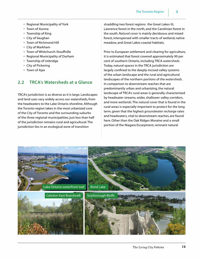
2.2 TRCA’s Watersheds at a Glance
TRCA’s jurisdiction is as diverse as it is large. Landscapes and land uses vary widely across our watersheds, from the headwaters to the Lake Ontario shoreline. Although the Toronto region takes in the most urbanized core of the City of Toronto and the surrounding suburbs of the three regional municipalities, just less than half of the jurisdiction remains rural and agricultural. The jurisdiction lies in an ecological zone of transition
straddling two forest regions: the Great Lakes-St. Lawrence forest in the north, and the Carolinian forest in the south. Natural cover is mainly deciduous and mixed forest, interspersed with smaller tracts of wetland, native meadow, and Great Lakes coastal habitats.
Prior to European settlement and clearing for agriculture, it is estimated that forest covered approximately 90 per cent of southern Ontario, including TRCA watersheds. Today, natural spaces in the TRCA jurisdiction are largely confined to the deeply-incised valley systems of the urban landscape and the rural and agricultural landscapes of the northern portions of the watersheds. In comparison to downstream reaches that are predominantly urban and urbanizing, the natural landscape of TRCA’s rural areas is generally characterized by headwater streams, wider, shallower valley corridors, and more wetlands. The natural cover that is found in the rural areas is especially important to protect for the long term, given that the highest groundwater recharge rates and headwaters, vital to downstream reaches, are found here. Other than the Oak Ridges Moraine and a small portion of the Niagara Escarpment, remnant natural
Lake Ontario waterfront trail
Scarborough Bluffs
Bond Lake
Caledon East Boardwalk

2 The Toronto Region
14 The Living City Policies
habitats and landforms that help shape the character of TRCA’s jurisdiction include:
• The nine rivers and their tributaries, much of whose valleylands function as vital green corridors within the urbanized area, including the Humber River which is a designated Canadian Heritage River;
• Rouge Park, the second largest urban natural heritage park in North America, and now a National Park;
• The shoreline of post-glacial Lake Iroquois, a major rise in elevation that extends from west to east across the region, inland from Lake Ontario. The Lake Iroquois Shoreline delineates the shoreline of ancestral Lake Ontario formed approximately 12,500 years ago when lake levels were up to 60 metres higher than the present lake level. In many areas, urban development occupies both above and below the Shoreline feature. Yet, in its eastern reaches, due to its often sandy nature, significant height and steep slopes, the actual narrow linear feature has not been extensively developed;
• The Scarborough Bluffs, Toronto Islands, the mouth of the Don River (where major flood remediation and restoration of the natural mouth of the River is taking place); and other Lake Ontario beaches and bluffs, and coastal marshes in the Duffins, Carruthers and Humber watersheds;
• Forests and wetlands in the provincially designated Greenbelt lands that are adequate to support flora and fauna species and communities characteristic of the region before European settlement, some of which are now rare or endangered;
• Tallgrass prairie and oak savannah communities, now rare in North America, such as those in High Park in the City of Toronto;
• The urban forest, or urban canopy, consisting of valleyland and tableland trees, street, park, and yard trees all in an urban setting, which make an important contribution to the beauty and ecological function of the urban landscape; the older ravine system, under pressure from increasing population due to intensification targets, is bolstered by this green infrastructure.
Moreover, there is diversity across TRCA’s jurisdiction in terms of geophysical, land use, and policy characteristics, such as:
• Headwater areas, subject to provincial land use plans such as the Greenbelt, Oak Ridges Moraine, and Niagara Escarpment plans (see Figure 2.1b) which contain pockets of urbanized areas, but are mainly natural and rural or agricultural, with that character protected in varying degrees by corresponding provincial legislation;
• Agricultural and rural areas south of the Moraine and Greenbelt, and outside of lands currently designated for urban development—the so-called “whitebelt” lands from the provincial Growth Plan for the Greater Golden Horseshoe;
• Urbanizing areas, consisting of lands that are within designated urban or settlement areas, which are currently being developed or are committed to development; and finally,
• Built out areas including the City of Toronto and the southern portions of the surrounding regional municipalities of York, Peel and Durham, which are subject to the Growth Plan and will experience major redevelopment and intensification in the coming decades.
As one of the most rapidly growing and ethnically diverse city-regions in North America, TRCA’s jurisdiction was home to some 3.4 million people in 2011 (MNRF, 2012), compared to approximately 1.2 million in 1951. The impacts of the urbanization taking place to accommodate this growth are evidenced in historical Ontario Ministry of Natural Resources and Forestry records, settler reports, and other sources, which show that over 120 species, including elk, bobcat, atlantic salmon, yellow bullhead, wood turtle, calypso orchid, and indian paintbrush, are no longer found in the region. This happened primarily through the direct loss of natural cover, due first to the conversion of forest lands to agricultural uses and later to urbanization. The remaining natural cover was affected through changes in water quantity and quality, soil compaction, invasive plants, and recreational use.

2The Toronto Region
15The Living City Policies
2.3 Issues, Challenges and Opportunities
Although greenfield portions of TRCA’s watersheds are still undergoing development, a prevalent trend in land use change affecting the jurisdiction is redevelopment and intensification of existing urban areas. This brings challenges such as constructing housing and upgrading transportation and servicing infrastructure for an additional two or so million people over the next 20 years. Key among these challenges from TRCA’s perspective and mandate are: • growth and urban intensification in the context of
natural heritage protection and managing the risk from natural hazards; and;
• adapting to and mitigating for the potential impacts of climate change.
Provincial legislation has established a regional framework for growth management based on increased urban intensification and ultimately fixed future urban growth boundaries. These “Growth Plan” lands are framed by the agricultural lands and natural areas protected by the Greenbelt Plan 2005, which encompass the headwater areas in TRCA’s jurisdiction. While TRCA is supportive of this regional planning framework, the challenges resulting are two-fold:
1) to ensure that the provincial-scale natural areas protected in the rural lands of the Greenbelt are
connected through the urban landscape to the Lake Ontario shoreline by a locally protected, viable and enhanced Natural System; and
2) to ensure that the increased impervious surfaces resulting from urban intensification and the development of new greenfield lands do not result in increased flooding and erosion hazards to upstream and downstream communities and infrastructure.
TRCA’s Natural System is comprised of water resources, natural features and areas, natural hazards, and restoration areas of potential natural cover and buffers. (Policy 7.3.1 a))
The Natural System is a fundamental component of a complete community and to achieving a high quality of life. The ecosystem services offered by nature are needed particularly in urban and urbanizing areas where natural areas are under the greatest pressure. A robust Natural System is better able to perform ecosystem services but population growth puts additional stresses on the System. In urbanizing city-regions like the Toronto region, a resilient Natural System will be that much more valuable in the future.
What are Ecosystem Services? Natural processes that help “sustain and fulfill human life” are considered ecosystem services. Natural systems perform ecosystem services on which humans depend and that are economically and ecologically impossible to duplicate. There are many ecosystem services that a healthy Natural System can provide. They include:
- Regulating the hydrologic cycle by capturing, storing and cleaning the water we drink and swim in;
- Reducing peak flows and flooding from storm events; - Promoting healthy fish and aquatic communities; - Contributing to cleansing pollutants from the air we
breathe, producing oxygen; - Regulating climate; providing shade; - Providing active and passive recreational opportunities; - Promoting a sense of place from identifying with the
unique character that natural areas bring to a city; and - Promoting healthier lifestyles resulting from clean
air and water and access to open spaces with natural aesthetics.

2 The Toronto Region
16 The Living City Policies
The need for a Natural System originated in 1999 from observations by TRCA and others that showed an alarming reduction in vegetation communities and species populations, and their distribution within TRCA’s jurisdiction. This change was occurring simultaneously with urban expansion despite the best efforts of the time for protection. According to Environment Canada’s “How Much Habitat Is Enough?” (2013), the recommended amount of natural cover needed for reasonably healthy and resilient ecosystems is 30 per cent forest cover and 10 per cent wetland. Natural cover in TRCA’s jurisdiction has been measured at approximately 15 per cent in forests and 1 per cent in wetlands. A reduction in forests, wetlands, meadows and their species is also accompanied by increases in flooding and erosion, and in conflicting recreational uses in protected areas. Changes in land use are often approved site-by-site without understanding how, cumulatively, they affect the region’s Natural System and environmental health. An important premise of a systems approach is that the distribution and quantity of natural cover and species is intricately linked to water, air quality and climate regulation, quality of life, and sustainability for citizens of the Toronto Region.
In addition to dealing with the impacts of urbanization, we must strive to account and plan for the uncertainties of climate change. Climate change modeling predictions show a number of possible scenarios ranging from increased periods of drought; to more frequent and severe rain storm events; to seasonal timing changes such as more rain events in winter, rather than snow. This would result in greater surface runoff and potentially increased flooding and erosion risks. In addition to increasing flood risk, the potential effects of climate change also include a rise in the influx of invasive species, the loss of traditional vegetation and wildlife species and communities, and public health challenges from poorer air and water quality to new vector-borne diseases.
The provincial Places to Grow Growth Plan for the Greater Golden Horseshoe, 2006 directs municipalities to address the impacts of urbanization by developing a “culture of conservation.” Therefore, the issue is not just where to grow (environmental protection) but how to grow (environmental management). This issue could be viewed as an opportunity to develop and redevelop new
sustainable communities. As urbanization moves to the upper extents of TRCA’s watersheds, sensitive headwater areas will be affected. It is especially these areas that require attention to natural heritage protection and enhancement along with innovative technologies for water management that will maintain the function of headwaters critical to the health of downstream reaches.
Sustainable development requires capitalizing on the linkages between humans and the environment – striving to balance economic, social, cultural, and environmental values. In this sense, TRCA’s integrated approach to watershed management serves TRCA and its partners well. As described in the history and evolution to The Living City in Section 4.0, TRCA has been studying its changing watersheds for almost 60 years. Our understanding of the impacts of urbanization and the effectiveness of mitigation measures are constantly evolving. This scientific expertise is fully integrated with our planning and regulatory review functions. Known as Integrated Watershed Management (IWM), this holistic approach recognizes and operates based on the inter-connectedness of ecology, economy, and society – in short, a sustainability-based model.
Source: Conservation Ontario, Integrated Watershed Management, Navigating Ontario’s Future, Summary Report, 2010

2The Toronto Region
17The Living City Policies
IWM is an evolving, continuous and adaptive process through which decisions are made for the sustainable use, development, restoration, and protection of ecosystem features, functions, and linkages.
TRCA’s employment of IWM recognizes that paths to achieving The Living City are not only those of TRCA’s core mandate of water, natural hazard, and natural heritage management, but also of other urban growth, natural resource, and quality of life pursuits such as cultural heritage, active transportation, community-based agriculture, and greening neighbourhoods. The integration of these paths can represent a “solution multiplier”, whereby one feature strengthens the effectiveness of another. For example, higher density development is more supportive of public transit and active transportation, and this in turn helps to conserve green space and reduce auto-related environmental and human health impacts.
TRCA’s long practice in IWM, allows for addressing such wide ranging issues and objectives, and enables us to find synergies and plan effectively within a complex environment and uncertain future. With this in mind, TRCA will work towards supporting our municipal partners to conform to the province’s Growth Plan by creating a “culture of conservation,” seizing the opportunity to help plan and build sustainable communities within TRCA watersheds.
3 Legislative Foundation
18 The Living City Policies
The following section is a summary of the legislative and policy framework that establishes TRCA’s responsibilities in the planning and development process. For a more detailed description of the legislative foundation, TRCA’s Planning and Development Procedural Manual should be consulted.
3.1 Conservation Authorities Act
The Conservation Authorities Act provides the legal basis for TRCA’s mandate to undertake watershed planning and management programs that prevent, eliminate, or reduce the risk to life and property from flood hazards and erosion hazards, as well as encourage the conservation and restoration of natural resources.
3.1.1 Objects of a Conservation Authority Section 20 of the Conservation Authorities Act sets
out the objects of a conservation authority (CA):
20. The objects of an authority are to establish and undertake, in the area over which it has
jurisdiction, a program designed to further the conservation, restoration, development and management of natural resources other than gas, oil, coal and minerals. R.S.O. 1990, c. C.27, s. 20.
3.1.2 Powers of a Conservation Authority For the purposes of accomplishing these objects,
section 21 of the Conservation Authorities Act assigns numerous powers to a conservation authority (CA) as follows:
(a) to study and investigate the watershed and to determine a program whereby the natural resources of the watershed may be conserved, restored, developed and managed;
(b) for any purpose necessary to any project under consideration or undertaken by the authority, to enter into and upon any land and survey and take levels of it and make such borings or sink such trial pits as the authority considers necessary;
33
Legislative Foundation
3.1 Conservation Authorities Act 18 3.1.1 Objects of a Conservation Authority 18 3.1.2 Powers of a Conservation Authority 18 3.1.3 Regulations of a Conservation Authority 19 3.2 Planning Act and Environmental Assessment Acts 20 3.2.1 TRCA’s Commenting Roles 21

3Legislative Foundation
19The Living City Policies
(c) to acquire by purchase, lease or otherwise and to expropriate any land that it may require, and, subject to subsection (2), to sell, lease or otherwise dispose of land so acquired;
(d) despite subsection (2), to lease for a term of five years or less land acquired by the authority;
(e) to purchase or acquire any personal property that it may require and sell or otherwise deal therewith;
(f ) to enter into agreements for the purchase of materials, employment of labour and other purposes as may be necessary for the due carrying out of any project;
(g) to enter into agreements with owners of private lands to facilitate the due carrying out of any project;
(h) to determine the proportion of the total benefit afforded to all the participating municipalities that is afforded to each of them;
(i) to erect works and structures and create reservoirs by the construction of dams or otherwise;
(j) to control the flow of surface waters in order to prevent floods or pollution or to reduce the adverse effects thereof;
(k) to alter the course of any river, canal, brook, stream or watercourse, and divert or alter, as well temporarily as permanently, the course of any river, stream, road, street or way, or raise or sink its level in order to carry it over or under, on the level of or by the side of any work built or to be built by the authority, and to divert or alter the position of any water-pipe, gas-pipe, sewer, drain or any telegraph, telephone or electric wire or pole;
(l) to use lands that are owned or controlled by the authority for purposes, not inconsistent with its objects, as it considers proper;
(m) to use lands owned or controlled by the authority for park or other recreational purposes, and to erect, or permit to be erected, buildings, booths and facilities for such purposes and to make charges for admission thereto and the use thereof;
(m.1) to charge fees for services approved by the Minister;
(n) to collaborate and enter into agreements with ministries and agencies of government, municipal councils and local boards and other organizations;
(o) to plant and produce trees on Crown lands with the consent of the Minister, and on other lands with the consent of the owner, for any purpose;
(p) to cause research to be done;
(q) generally to do all such acts as are necessary for the due carrying out of any project. R.S.O. 1990, c. C.27, s. 21; 1996, c. 1, Sched. M, s. 44 (1, 2); 1998, c. 18, Sched. I, s. 11.
Section 20 of the Conservation Authorities Act provides the mandate for a CA to offer a broad resource management program, while section 21 provides the mandate to have watershed-based resource management programs and/or policies that are approved by the Board of Directors. All of TRCA’s watershed research programs inform policy development and application in the planning and development process.
3.1.3 Regulations of a Conservation AuthorityUnder the provisions of section 28 of the Conservation Authorities Act, TRCA administers a Development, Interference with Wetlands and Alterations to Shorelines and Watercourses regulation (http://www.trca.on.ca/dotAsset/15293.pdf ). Through this regulation, TRCA has the ability to:
(a) prohibit, regulate or require the permission of the authority for straightening, changing, diverting or interfering in any way with the existing channel of a river, creek, stream or watercourse, or for changing or interfering in any way with a wetland;

3 Legislative Foundation
20 The Living City Policies
(b) prohibit, regulate or require the permission of the authority for development, if in the opinion of the authority, the control of flooding, erosion, dynamic beaches or pollution or the conservation of land may be affected by the development.
The policies for the implementation of TRCA’s regulation are contained in Section 8.0 of The Living City Policies.
3.2 Planning Act and Environmental Assessment Acts
Under the Planning Act and the environmental assessment acts (federal and provincial), TRCA is a commenting agency and provides input on planning matters in various capacities.
Section 2 of the Planning Act is of particular relevance to CAs since it outlines matters of provincial interest, such as:
(a) the protection of ecological systems, including natural areas, features and functions;
(c) the conservation and management of natural resources and the mineral resource base;
(o) the protection of public health and safety;
(p) the appropriate location of growth and development.
These matters, for which all approval authorities shall have regard to, in carrying out their responsibilities under the Planning Act, directly support the mandate of CAs.
Section 3 of the Planning Act enables the Province to issue policy statements on matters related to municipal planning that are of provincial interest. Among the provincial interests detailed in the Provincial Policy Statement, 2014 (PPS) are Natural Heritage (Section 2.1), Water (Section 2.2), and Natural Hazards (Section 3.1). The PPS states that all comments and decisions affecting planning matters “shall be consistent with” these policy statements, as well as provincial plans,
these would include the Niagara Escarpment Plan (1990), the Oak Ridges Moraine Conservation Plan (2002), the Greenbelt Plan (2005), and the Growth Plan for the Greater Golden Horseshoe (2006).
For infrastructure reviewed under the Ontario or Canadian environmental assessment acts, the PPS defers all review to the environmental assessment process. For public infrastructure and large private infrastructure projects, Ontario’s Environmental Assessment Act is the principal review mechanism. When the provincial Environmental Assessment Act was approved in 1975, CAs were directed to provide technical clearance for natural resources management on applications made under the Act. Technical advice is also sought from TRCA for applications made under the Canadian Environmental Assessment Act. The majority of TRCA’s environmental assessment review falls under the provincial process.

3Legislative Foundation
21The Living City Policies
Figure 3.1: Legislation, Policies, and Processes for TRCA’s roles in Planning and Development
Figure 3.1 is a depiction of TRCA’s various interactions in the planning and development process through legislation, regulations, programs, policies, and agreements.
3.2.1 TRCA’s Commenting Roles The Ministry of Natural Resources and Forestry (MNRF), Ministry of Municipal Affairs and Housing, and Conservation Ontario have a memorandum of understanding (MOU) defining the roles and relationships for implementing delegated responsibilities under the Provincial One Window Planning System (http://www.mah.gov.on.ca/Page169.aspx). In 2010, the Province approved the “Policies and Procedures for Conservation Authority Plan Review and Permitting Activities” for inclusion in MNRF’s Policies and Procedures for Conservation Authorities Manual, which also provides clarity about the roles and responsibilities of CAs in the planning and regulatory permitting process. In keeping with the Provincial MOU and policies and procedures, TRCA undertakes the following roles and activities (summarized in Table 3.1):
• Regulatory Authority - In administering TRCA’s Section 28 regulation, as referred to in Section 3.1.3 above, TRCA is the approval authority for permits under this regulation. In TRCA’s review of applications under the Planning Act and environmental assessment acts, TRCA staff ensure that proponents and the
Environmental Assessment
Act
Conservation Authorities
Act
MNRF/MOECC/MMAHTechnical Manuals
and Guidelines
Individual EAs
Municipal Class EAs
Memorandums of Understanding
Planning Act
Provincial Policy Statement,
Provincial Plans
Official Plans & Zoning By-laws
Hazard, Water & Heritage Policies
Building Code and Design Standards
Master Plans
Schedules A. B, C
Service Delivery Agreements
The Living CityPolicies
1
Watershed Plans, Section 28 Regulation
Procedural Manual & Technical Guidelines
provincial or municipal planning authority(ies) are aware of the Section 28 regulation and requirements under the Conservation Authorities Act, and assist in the coordination of these applications to eliminate unnecessary delay, duplication, or conflict in the process.
• Delegated Provincial Interest - As outlined in the Conservation Ontario/Ministry of Natural Resources and Forestry/Ministry of Municipal Affairs and Housing Memorandum of Understanding on CA Delegated Responsibilities, CAs have been delegated the responsibility of representing the provincial interest on natural hazards encompassed by Section 3.1 of the PPS 2014. This delegation requires CAs to review and provide comments on municipal policy documents (Official Plans and comprehensive zoning by-laws) and applications submitted pursuant to the Planning Act as part of the Provincial One-Window Plan Review Service.
• Public Commenting Body (Planning) - Pursuant to the Planning Act, TRCA is a “public commenting body,” and therefore must be notified of municipal

3 Legislative Foundation
22 The Living City Policies
policy documents and planning and development applications under the Planning Act. TRCA comments according to its Board-approved policies as a local resource management agency to the municipality/planning approval authority on these documents and applications.
• Public Commenting Body (Environmental Assessment) – Pursuant to the federal and provincial environmental assessment (EA) Acts, TRCA is also identified as a commenting body. TRCA reviews and comments on Individual and Class EAs that occur within TRCA’s jurisdiction under the Acts. Proponents of an EA are required to identify and consult with government agencies, including CAs if the proposed project has the potential to affect an item related to a CA’s areas of interest. The Canadian Environmental Assessment Agency and the Ontario Ministry of the Environment and Climate Change are responsible for the administration of the Canadian and Ontario EA Acts respectively, and for ensuring that proponents meet the requirements of the applicable act.
• Resource Management Agency – In accordance with Section 20 and 21 of the Conservation Authorities Act, CAs are local watershed-based natural resource management agencies that develop programs that reflect local resource management needs within their jurisdiction. Such programs
and/or policies (e.g.s, watershed plans, fisheries management plans, The Living City Policies) are approved by the CA Board and may be funded from a variety of sources including municipal levies, fees for services, provincial and/or federal grants and self-generated revenue.
• Service Provider - The provision of planning and environmental assessment advisory services to municipalities is implemented through service agreements or MOUs with participating municipalities or as part of a CA’s approved program activity. In this respect, the CA is essentially acting as a technical advisor to municipalities. The agreements cover the CA’s areas of technical expertise such as water management, natural hazards, and natural heritage.
• Landowner – Occasionally, CAs become involved in the planning process as a proponent or landowner. Where there is a real or perceived conflict of interest between the role as a proponent or landowner and the role as a commenting agency, a CA may request the planning authority to implement alternate review mechanisms to address the CA’s commenting responsibilities. Additionally, CAs ensure that any comments provided as a landowner are separate from comments provided under a technical, advisory, and/or regulatory role. TRCA is a major landowner in the GTA, owning close to 18,000 hectares of land.
Table 3.1: Conservation Authority Roles in Planning and Development
CA Role Type Of RoleRequired Or Voluntary Representing Result
Regulatory Agency Decision making Required Provincial interests CA decision required
Delegated “Provincial Interest”
Reviewing/Commenting
Required Provincial interests CA comments must be considered
Public Commenting Bodies
Reviewing/Commenting
Depends on how role is defined
CA Board interests CA comments should be considered
Resource Management Agencies
Reviewing/Commenting
Voluntary CA Board interests CA comments may be considered
Service Providers Service Terms of the agreement
Terms of the agreement
Depends on terms of service agreement
Landowners Review/ Commenting
Voluntary CA Board interests CA comments may be considered
Source: (adapted from) MNRF Procedural Manual: Policies and Procedures for Conservation Authority Plan Review and Permitting Activities, May 2010
Table 3.1 provides a summary of these roles and activities and the nature of the comments associated with each role.

3Legislative Foundation
23The Living City Policies
Table 3.2: Legislation, regulations, policies, plans, and programs affecting TRCA’s jurisdiction
Primary Purpose Lead & Assisting RolesFederal
Fisheries Act (R.S.C., 1985, c. F-14) (last amended Nov 25, 2013)
An Act respecting fisheries to manage threats to the sustainability and productivity of Canada’s commercial, recreational and Aboriginal fisheries.
Fisheries and Oceans Canada (DFO);
Navigation Protection Act (R.S.C., 1985, c.N-22)
An Act respecting the protection of navigable waters.
Transport Canada; TRCA directs proponent to Transport Canada when reviewing a watercourse crossing in navigable waters.
Migratory Birds Convention Act (1994), consolidated January 12, 2010
To implement a convention for the protection and conservation of migratory birds, as populations and individual birds, in Canada and the U.S.A.; main prohibition is the destruction of wildlife habitat during nesting season.
Environment Canada; TRCA staff provide advice that the removal or pruning of trees should take place outside of the nesting season, however, it is the responsibility of the proponent to ensure compliance with the Act.
Species at Risk Act (2002) To protect wildlife species at risk in Canada.
Environment Canada, Parks Canada, and Fisheries and Oceans Canada; TRCA may direct proponent to applicable federal authority as a courtesy (TRCA does not screen under SARA but may provide data to the federal government if available).
Canadian Environmental Assessment Act (2012)
To establish a federal environmental assessment process; applies to projects for which the federal government holds decision-making authority, as proponent, land administrator, a source of funding, or regulator.
Canadian Environmental Assessment Agency or the lead regulatory agency; TRCA provides technical clearance.
Toronto and Region Remedial Action Plan (RAP) (1987)
To clean up the waterfront, rivers, habitats and waters of the Toronto region. RAPs are also being implemented in 42 other areas around the Great Lakes.
Environment Canada, Ontario Ministry of the Environment and Climate Change, Ontario Ministry of Natural Resources and Forestry, and TRCA.
Continued on next page >
Table 3.2 is a listing of various pieces of legislation, programs, policies and guidelines that TRCA may use to inform their comments on applications from the planning and development process. This table is
a simplistic summary of various statutes, plans, and programs, may not be exhaustive, and should not be relied upon for legal or professional advice in connection with any particular matter.

3 Legislative Foundation
24 The Living City Policies
Primary Purpose Lead & Assisting RolesProvincial
Planning Act (1990) To provide for a land use planning system led by provincial policy.
Municipalities are approval authorities; TRCA is a commenting agency.
Provincial Policy Statement (2014)
Municipal land use planning decisions must be consistent with matters of Provincial interest outlined in the PPS; advice, comments, or submissions provided by an agency of the government, that affect a planning matter, must be consistent with the PPS.
Ministry of Municipal Affairs and Housing/municipalities; TRCA provides technical clearance on Natural Heritage, Natural Hazard, and Water components of the PPS.
MNRF/MMAH/CO Memorandum of Understanding (2001)
To delegate responsibility to CAs for upholding the natural hazards section of the PPS, under the provincial “one window” planning system; to outline roles in the review of Special Policy Areas (SPAs) under Section 3.1 of the PPS.
Conservation authorities where the Province is not involved; for SPAs, MNRF and MMAH; conservation authorities participate in SPA review.
Environmental Assessment Act (1990)
To provide for the protection, conservation, and wise management of the environment; applies to public sector projects and major private sector projects.
Ministry of the Environment and Climate Change; TRCA provides technical clearance.
Greenbelt Act and Plan (2005) To designate a Greenbelt Area and establish a Greenbelt Plan; to protect about 1.8 million acres of environmentally sensitive and agricultural land in the Golden Horseshoe from urban development and sprawl.
Municipalities; TRCA provides technical clearance.
Oak Ridges Moraine Conservation Act and Plan (2001)
To provide land use and resource management planning direction to decision makers, landowners and other stakeholders on how to protect the Moraine’s ecological and hydrological features and functions.
Municipalities; TRCA provides technical clearance.
Niagara Escarpment Planning and Development Act and Plan (1990, rev. 2005)
To provide for the maintenance of the Niagara Escarpment and land in its vicinity substantially as a continuous natural environment and to ensure only such development occurs as is compatible with that natural environment.
Niagara Escarpment Commission; municipalities; TRCA provides technical clearance.
Places to Grow Act, 2005 and Growth Plan for the Greater Golden Horseshoe (2006)
To enable decisions about growth to be made in ways that sustain a robust economy, build strong communities, promote a healthy environment, and a culture of conservation.
Municipalities; TRCA provides technical advice where applicable.
Lakes and Rivers Improvement Act (1990)
To provide for the management, protection, preservation, and use of the waters of the lakes and rivers of Ontario and the land under them.
Conservation Authorities on behalf of Ministry of Natural Resources and Forestry, except for works involving a dam.

3Legislative Foundation
25The Living City Policies
Primary Purpose Lead & Assisting RolesProvincial
Ontario Water Resources Act (1990) – Section 34 Permits to Take Water – Section 53 Certificates of Approval for SWM facilities
To provide for the conservation, protection and wise use and management of Ontario’s waters; an MOECC Permit is required for water takings (ground and/or surface) of over 50,000 litres per day; an MOECC Certificate of Approval is required for stormwater management facilities.
Ministry of the Environment and Climate Change; TRCA provides technical clearance.
Endangered Species Act (2007)
To identify species at risk based on the best available scientific information, including information obtained from community knowledge and aboriginal traditional knowledge. To protect species that are at risk and their habitats, and to promote the recovery of species that are at risk. To promote stewardship activities to assist in the protection and recovery of species that are at risk.
Ministry of Natural Resources and Forestry; TRCA may direct proponents to MNRF (TRCA does not screen under ESA but may provide data to the Province if available).
Clean Water Act (2006) To protect existing and future sources of drinking water. Specifically, to protect the quality and quantity of drinking water at its source.
Ministry of the Environment and Climate Change; Ministry of Natural Resources and Forestry: municipalities and conservation authorities.
Ontario Heritage Act (1990) To give municipalities and the provincial government powers to preserve the heritage of Ontario, with its primary focus being to protect heritage properties and archaeological sites.
Ministry of Tourism, Culture and Sport; TRCA for TRCA-owned lands and TRCA-managed lands.
Green Energy Act (2009) To boost investment in renewable energy projects and increase conservation, creating green jobs and economic growth to Ontario; applications under the Act are not exempt from permits under conservation authority regulations, but permit applications can only be assessed using 4 of the 5 tests of a CA regulation (i.e., the “conservation of land” test cannot be used).
Ministry of Energy; TRCA processes Green Energy Act applications for energy infrastructure under TRCA’s Regulation, as required.
Public Lands Act (1990) Outlines the use, management, sale and disposition of public lands and forests; also empowers the Province to construct and operate dams on waterways throughout the Province; public lands are crown lands, school lands, and clergy lands.
MNRF; TRCA provides technical clearance where applicable.
Building Code Act (1992) Governs standards for the construction and demolition of buildings.
Municipalities; TRCA processes applications for development under Ontario Regulation 166/06, where applicable.
Continued on next page >

3 Legislative Foundation
26 The Living City Policies
Primary Purpose Lead & Assisting RolesMunicipal
Regional and Municipal Official Plans, Zoning By-laws, Site Plan Control (requirements of Planning Act) including fill, tree and ravine and natural feature protection by-laws, growth management & sustainability plans, natural heritage system policies and significant area designations in official plans, as well as municipal standards and guidelines
To allow for the orderly development of a municipality, while incorporating and implementing provincial planning direction (PPS, ORM and Greenbelt Plans, etc.).
Regional Municipalities; Local Municipalities; TRCA provides input to the development of these municipal policies, plans and by-laws, and provides advice to municipalities in their application.
Conservation Authorities
Conservation Authorities Act (1990)
The objects of an authority are to establish and undertake, in the area over which it has jurisdiction, a program designed to further the conservation, restoration, development, and management of natural resources other than gas, oil, coal, and minerals.
Conservation authorities; many watershed partners.
TRCA
TRCA Watershed Plans, Fish Management Plans, Stormwater Management Criteria Document, LID SWM Planning and Design Guide, Erosion and Sediment Control Guideline for Urban Construction, Headwater Drainage Features Guidelines, and other TRCA Standards found in the Planning and Development Procedural Manual
(The Province encourages CAs to develop watershed and subwatershed management plans) to inform municipalities in their creation and updating of official plan policies. Watershed plans may also provide technical information and recommendations for municipalities when making decisions on planning and environmental assessment applications. In the case of other TRCA guidelines and studies are carried out under Section 21 of the Conservation Authorities Act: To study and investigate the watershed…; and to cause research to be done; and to further the science that helps TRCA and its municipal partners plan for more sustainable development.
TRCA; municipalities; other watershed partners
Ontario Regulation 166/06 (Development, Interference with Wetlands, and Alterations to Shorelines and Watercourses) (2006)
To prohibit, regulate, or require the permission of the Authority for development if in the opinion of the Authority, the control of flooding, erosion, dynamic beaches, pollution, or the conservation of land may be affected by the development; and, To prohibit, regulate, or require the permission of the Authority for straightening, changing, diverting, or interfering in any way with the existing channel of a river, creek, stream or watercourse, or for changing or interfering in any way with a wetland.
TRCA

3Legislative Foundation
27The Living City Policies
Primary Purpose Lead & Assisting RolesTRCA
The Living City Policies for Planning and Development in the Watersheds of TRCA (2014)
A program to further the conservation, restoration, development, and management of natural resources, as per Section 21 of the Conservation Authorities Act, that guides TRCA’s role in planning and in environmental assessments, and in the application of Ontario Regulation 166/06.
TRCA; municipalities, to the extent the program is incorporated into their official plans (OPs).
Environmentally Significant Areas Study (1982, 1994)
Identifies areas of environmental significance based on specific criteria and suggests direction for their recognition and management.
Municipalities, to the extent the program is incorporated into their OPs; (no longer in use by TRCA).
Terrestrial Natural Heritage System Strategy (2007)
To identify the natural heritage system and to set targets for increasing natural cover within TRCA’s jurisdiction; implemented in The Living City Policies.
TRCA; municipalities, to the extent the Strategy is incorporated into OPs.
Toronto Waterfront Aquatic Habitat Restoration Strategy (TWAHRS) (2003)
To maximize the ecological integrity of the Toronto waterfront by ensuring that waterfront revitalization incorporates improvements to aquatic habitats.
TRCA; City of Toronto.
Other
Rouge Park Management Plan (1994)
To guide development of the Rouge Park south of Steeles Avenue East.
City of Toronto; TRCA.
Rouge North Management Plan (2001)
To guide development of the Rouge Park north of Steeles Avenue East.
City of Markham, Towns of Richmond Hill, and Whitchurch-Stouffville; York Region; TRCA.
Notes: “TRCA technical clearance” is as it relates to natural hazards and natural heritage, including water management. There are many technical guidelines associated with the above listed pieces of legislation and programs, e.g., MNRF Technical Guidelines, Natural Heritage Reference Manual.

4 TRCA History and Evolution to The Living City
28 The Living City Policies
4.1 Historic Overview
In the early part of the 20th Century, naturalists, farmers, hunters and anglers formed grass roots organizations to lead the conservation movement. The movement brought attention to the poor land, water and forestry practices of the 1930s and ‘40s. When combined with the impacts of drought and deforestation, extensive soil loss and flooding occurred. The work of these groups and others like them set in motion the coordinated effort between citizens, academics, and the government that culminated in the formation of conservation authorities in 1946. When the Conservation Authorities Act was passed in the Ontario legislature, it enabled municipalities to apply for the establishment of conservation authorities in their areas. For the first time, a municipality that wished to manage their natural resources could do so without being hampered by their political boundaries. Granting this responsibility to conservation authorities was a clear indication that watershed boundaries were the ideal jurisdictional unit for managing the natural environment, and especially water.
As an amalgamation of four smaller conservation authorities, the Metropolitan Toronto and Region Conservation Authority (MTRCA) was established in
response to a natural disaster that struck the Toronto region in October 1954. Hurricane Hazel delivered almost 300 millimetres of rain to Southern Ontario, with the majority falling within the last twelve hours of the storm. Flooding was inevitable: steep river slopes saturated by previous rainfall, funneled ninety per cent of the rain directly into rivers and streams. Flows in the Humber River were four times greater than previously recorded. Eighty-one people died and thousands of people were left homeless. Most of the bridges on the west side of Toronto were destroyed or badly damaged, as were many on the Don River. Several roads, parks, public utilities - even an entire street of houses - were washed out and destroyed.
44
TRCA History and Evolution to The Living City
4.1 Historic Overview 28

4TRCA History and Evolution to The Living City
29The Living City Policies
A former (M)TRCA Chief Administrative Officer recounts the response to the disaster in his book, Paths to The Living City: The aftermath of Hurricane Hazel was an
unprecedented effort of cooperative planning and regeneration for the Toronto area river valleys. All levels of government pitched in and for a period of almost 30 years, worked together and equitably shared the costs of the massive undertaking. Of all the plans and projects that have shaped the Toronto region, it is unlikely that any have been as far reaching and beneficial. It has meant, among other things, that one can stand alongside the Humber, a few yards north of the Bloor Street viaduct, surrounded by a network of more than 30,000 acres of green space, and gaze at a simple reminder of a long-ago tragedy, secure in the knowledge that a similar storm today would not carry with it the same devastation. The organization created to achieve these results was the MTRCA (McLean, 2004).
Since its precipitous beginning, the story of TRCA has been one of continuous evolution and adaptation in responding to changes in science, community demands, and public policy. In the early years of TRCA, Hurricane Hazel’s influence focused efforts on flood control.
Structural Approach to Flood Control
The prevailing ideology coming through provincial direction was largely engineering-based. MTRCA’s 1959 Plan for Flood Control and Water Conservation called for the construction of multi-purpose dams and reservoirs, engineered river channel improvements, the acquisition of flood plain lands, and the creation of a flood warning system. The flood warning and forecasting program was designed to monitor watershed conditions including
snow, precipitation and flows, as well as to issue flood warning messages to municipalities when conditions warranted, (which still exists today). But as the costs of land acquisition and major engineering works escalated throughout the 1960s and 1970s, it became clear that these aspects of the approach were not financially viable and not always environmentally desirable.
Waterfront Plans and Integrated Shoreline Management
Also at this time, plans and jurisdictional roles were being discussed for managing the Lake Ontario shoreline, when the 1967 Waterfront Plan for the Metropolitan Toronto Planning Area was produced. The waterfront planning area was divided into a number of sectors, based on both physical criteria and recognition of jurisdictional areas. In 1970, the Province designated MTRCA as the lead implementing agency for the Etobicoke to Ajax-Pickering shoreline, except for the central downtown waterfront area. MTRCA fulfilled its shoreline mandate based on a new concept of “integrated shoreline management” to limit high rates of shoreline erosion while enabling safe public access and regional scale recreation opportunities. Two major legacies of this work are evident along the
Clairville Dam
G. Ross Lord Dam

4 TRCA History and Evolution to The Living City
30 The Living City Policies
on the Oak Ridges Moraine. Further, the previous two decades’ success in public acquisition of flood plain lands enabled staff to address impacts on the environment within valleylands and along the shoreline.
The 1982 Environmentally Significant Areas (ESAs) program began in the late 1970s focusing on major river valleys and the Lake Ontario waterfront. This resulted in the 1982 ESA study that identified 126 ESAs throughout the jurisdiction. In the early 1990s, the 1982 ESA study was updated by revisiting the ESA criteria and assessing natural areas of tableland that had not been included in the original study. In 1994, to assess development proposed in or adjacent to valleylands, watercourses, and ESAs, the Valley and Stream Corridor Management Program (VSCMP) was published to serve as TRCA’s planning and regulatory policies. Aspects of the VSCMP, including the delineation of ESAs and valley and stream corridors, were subsequently incorporated into the official plan policies of many of TRCA’s member municipalities.
Public Involvement in Watershed Management
The decade of the 1990s saw TRCA take its ecological approach to watershed management out to the community, evidenced in the creation of the Don Watershed Task Force. The task force was comprised of watershed residents, non-governmental organizations, municipalities, and other government agencies, with a mandate to develop an ecosystem regeneration plan for the entire Don River watershed. Its landmark strategy, 40 Steps to a New Don, was completed in 1994. Watershed advisory council and general community participation on the Don and in most other TRCA watersheds, take place to this day in projects such as river and shoreline clean-ups, tree plantings, wetland creation, and the development of trails and management plans. This community-based, ecologically-focused model was adopted by other community groups and repeated
Lake Ontario shoreline and in the way TRCA conducts its business today: 1) the creation of a number of large, open space/parkland areas connected by a waterfront trail system, including several public marinas; and, 2) a planning process that is integrated with the municipal planning process to include a variety of opportunities for public participation in the planning for waterfront revitalization.
Ecological Approach to Watershed Management
MTRCA’s 1980 Watershed Plan (and 1986 update) reflected the change in provincial policy direction promoted by the new Ontario Ministry of Natural Resources, by moving away from the structural engineering approach of the 1960s and 70s in favour of a more ecological approach to watershed management. Not just peak
flood flows, but also water quality and healthy aquatic life took on new importance. MTRCA’s 1989 Greenspace Strategy asserted that natural lands played a vital role in flood and erosion control, groundwater recharge and discharge, and in the health and well-being of urban dwellers. The Strategy went on to describe TRCA’s ongoing work in land acquisition, archaeology, conservation education, land use planning, waterfront planning, recreation, and the importance of headwaters

4TRCA History and Evolution to The Living City
31The Living City Policies
by TRCA in the development of watershed plans for the Humber and Rouge Rivers as well as the Duffins, Carruthers, Etobicoke and Mimico Creeks.
Scientific Advances in Watershed Management
While the community-based, participatory approach to watershed planning has been refined over the years, more recently, the most dramatic improvements in watershed planning have been to the science employed in assessing, monitoring, and predicting the health of watershed features and functions. The early days of hand calculations and paper-based mapping of flood plains were replaced with computerized GIS (geographic information systems) and digital models that simulate storm events of various magnitudes and frequencies to produce digital flood line maps. Since the late 1990s, real time, in-stream monitoring technology made for a more timely system of broadcasting flood warnings. These data, in conjunction with land cover and impervious surface data based on air photo or satellite imagery, have also been used to model the potential impacts of more severe and frequent storm events that may occur under various climate change scenarios.
New technology in watershed monitoring also helped to advance TRCA’s stormwater management program, first initiated in 1980 in response to urbanization’s effect on flooding and erosion. The multi-agency Stormwater Assessment Monitoring and Performance (SWAMP) Program operated from 1995 to 2003. The program was an initiative of the Government of Canada’s Great Lakes Sustainability Fund, the Ontario Ministry of Environment and Energy, TRCA, and the Municipal Engineer’s Association. A number of individual municipalities and other owner/operator agencies have also participated in SWAMP studies. The SWAMP Program’s objectives were to: monitor and evaluate the effectiveness of new or innovative stormwater management (SWM) technologies and disseminate study results and recommendations.
The SWM program at TRCA evolved to include research in water quality and temperature impacts, source controls, and retrofitting facilities that do not meet current design standards. TRCA now leads a multi-agency initiative, the Sustainable Technologies Evaluation Program (STEP) to monitor and evaluate clean water, air, and energy technologies, such as low impact development (LID) measures for SWM. The program continues the work that the SWAMP program began but with a broader focus (see sidebar).
Technology has also been critical in mapping the extent of natural cover throughout TRCA watersheds. In 2001, with digital aerial photography, and field inventories using the provincial
TRCA initiated STEP in 2005 to provide the data and analytical tools necessary to support broader implementation of sustainable technologies and practices within a Canadian context. STEP’s main objectives are to: - monitor and evaluate
clean water, air and energy technologies;
- assess barriers and opportunities to implementing technologies;
- develop tools, guidelines and policies; and
- promote broader use of effective technologies through research, education and advocacy.

4 TRCA History and Evolution to The Living City
32 The Living City Policies
ecological land classification system, TRCA documented the losses of natural areas and local biodiversity. Through TRCA’s Terrestrial Natural Heritage System Strategy (TNHSS) released in 2007, this information was used to develop computer models to show where and how much land needs to be restored to natural cover to stop biodiversity losses, and was also used in TRCA watershed plans to demonstrate that expanding natural cover improves hydrology (less flooding and erosion).
Provincial Sustainability Agenda to Create a “Culture of Conservation”
TRCA initiated The Living City® Strategic Plan in 1999 with the goal to engage agencies, industries and communities in collaborating for the sustainability of all life within TRCA’s nine river watersheds and Lake Ontario waterfront. Creating a context for the advancement of
TRCA’s programs of The Living City in the last 15 years through to present day, has been provincial legislation such as the Oak Ridges Moraine Conservation Act, the Greenbelt Act, the Clean Water Act, The Places to Grow Act and the Green Energy Act. The Growth Plan for the Greater Golden Horseshoe, Provincial Policy Statement (PPS) 2014 and the Green Energy Act are intended to move society towards a “Culture of Conservation” that must adapt to climate change and promote renewable and alternative sources of energy, and apply a sustainability lens to growth management through intensification, public transit, water, energy, and cultural heritage conservation. In particular, the Province’s Growth Plan is aligned with The Living City vision, in that it contains policies for natural heritage, agriculture, water, energy, air, waste management, and cultural heritage. Many of these themes are present in some of TRCA’s most recent programs of The Living City (see sidebar).
Some TRCA Programs of The Living City: • Encouraging the transformation to a “green” economy
by developing partnerships and implementing programs for energy conservation, environmental education, and waste management, including the Mayor’s Megawatt Challenge, Sustainable Schools, and Greening Retail and Health Care.
• Social equity projects to hire under-served youth to grow and sell food at community gardens on TRCA lands; and to hire or mentor new Canadians who are foreign-trained professionals, so they are able to gain “Canadian” experience and secure gainful employment in their chosen professions.
• Preserving and celebrating cultural heritage at TRCA’s Black Creek Pioneer Village, through our ongoing Archaeological Heritage Resource Management Program for TRCA-owned lands; and providing educational recreation opportunities at TRCA’s conservation areas, including The Living City Campus at Kortright Conservation Area.
Trends to the Future: Green Infrastructure, Ecosystem Services and Ecological Design
Just as the 1994 Valley and Stream Corridor Management Program (VSCMP) described valley and stream corridors as the foundation of the greenspace system, TRCA recognizes the Natural System as the natural green infrastructure of the Toronto region. Both natural and built green infrastructure can perform many of the functions of traditional “grey infrastructure” such as reducing flooding and erosion and filtering water and air pollutants, but also

4TRCA History and Evolution to The Living City
33The Living City Policies
provides additional ecosystem services like moderating the urban heat island effect, and providing opportunities for recreation and community aesthetics. As well, green infrastructure is less costly then grey infrastructure, especially considering its longer life cycle.
Another one of the VSCMP’s principles was that the successful management of valley and stream corridors is dependent on good tableland management. Today, The Living City Policies are premised on the scientifically-derived conclusion that the ecosystem services on which human health depend, can be produced from the entire landscape, and not just protected natural areas, especially considering their diminished and impaired state in heavily urbanized areas. Therefore, in addition to protecting and restoring the Natural System, TRCA promotes sustainable design of the lands to be developed or redeveloped. To this end, TRCA, with its partners, endeavours to undertake an ecological design approach to city-building, in which the urban and natural are integrated (while keeping the Natural System in tact) rather than being strictly segmented from each other.
Current trends in site redevelopment and urban design promote a standard that incorporates green infrastructure and technologies for water management and landscape restoration proposals. Over the last decade or so, design professions - architects, landscape architects, planners, engineers - have been advancing integrated site design into the best site planning and building practices. Not
only does this design approach build more sustainable site plans for the future, but serves to reduce construction and maintenance costs compared to traditional forms of site development. Conceptual attention to green infrastructure and technologies also builds a more attractive landscape from an urban design perspective, and many projects are winning awards for their innovative results within the city-region.
Since the days of Hurricane Hazel, TRCA has a 60-year history of researching, regulating, advising, and collaborating with our partners to manage the health of our watersheds and waterfront for environmental and public benefit. TRCA is now experiencing the most significant turning point in the history of the organization. We are building on our expertise in watershed management and land conservation, and moving beyond those traditional mandates, to achieve a broad, ambitious, positive vision for the Toronto region in the coming decades. TRCA is working to incorporate sustainability elements into all aspects of its traditional mandate (environment) as well as its own operational programs and practices, to address the social, economic and cultural heritage components of sustainability.
In collaboration with its partners, TRCA will continue to respond to changes in environmental conditions and public policy in carrying out the proper management of our watersheds and waterfront, necessary for sustaining the health of our city-region in the years to come.
Mouth of the Humber River
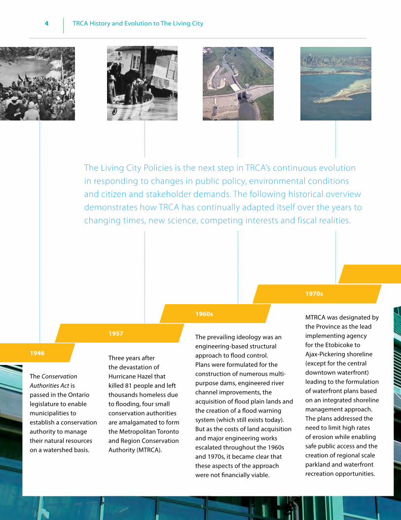
4 TRCA History and Evolution to The Living City
34 The Living City Policies
1946
1957
Three years after the devastation of Hurricane Hazel that killed 81 people and left thousands homeless due to flooding, four small conservation authorities are amalgamated to form the Metropolitan Toronto and Region Conservation Authority (MTRCA).
1960s
The Conservation Authorities Act is passed in the Ontario legislature to enable municipalities to establish a conservation authority to manage their natural resources on a watershed basis.
The prevailing ideology was an engineering-based structural approach to flood control. Plans were formulated for the construction of numerous multi-purpose dams, engineered river channel improvements, the acquisition of flood plain lands and the creation of a flood warning system (which still exists today). But as the costs of land acquisition and major engineering works escalated throughout the 1960s and 1970s, it became clear that these aspects of the approach were not financially viable.
MTRCA was designated by the Province as the lead implementing agency for the Etobicoke to Ajax-Pickering shoreline (except for the central downtown waterfront) leading to the formulation of waterfront plans based on an integrated shoreline management approach. The plans addressed the need to limit high rates of erosion while enabling safe public access and the creation of regional scale parkland and waterfront recreation opportunities.
1970s
The Living City Policies is the next step in TRCA’s continuous evolution in responding to changes in public policy, environmental conditions and citizen and stakeholder demands. The following historical overview demonstrates how TRCA has continually adapted itself over the years to changing times, new science, competing interests and fiscal realities.
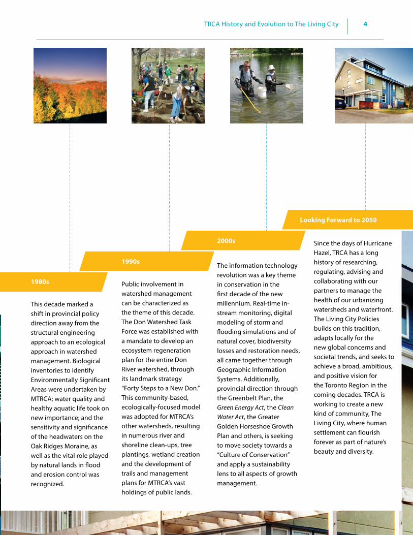
4TRCA History and Evolution to The Living City
35The Living City Policies
1980s
1990s
This decade marked a shift in provincial policy direction away from the structural engineering approach to an ecological approach in watershed management. Biological inventories to identify Environmentally Significant Areas were undertaken by MTRCA; water quality and healthy aquatic life took on new importance; and the sensitivity and significance of the headwaters on the Oak Ridges Moraine, as well as the vital role played by natural lands in flood and erosion control was recognized.
Public involvement in watershed management can be characterized as the theme of this decade. The Don Watershed Task Force was established with a mandate to develop an ecosystem regeneration plan for the entire Don River watershed, through its landmark strategy “Forty Steps to a New Don.” This community-based, ecologically-focused model was adopted for MTRCA’s other watersheds, resulting in numerous river and shoreline clean-ups, tree plantings, wetland creation and the development of trails and management plans for MTRCA’s vast holdings of public lands.
The information technology revolution was a key theme in conservation in the first decade of the new millennium. Real-time in-stream monitoring, digital modeling of storm and flooding simulations and of natural cover, biodiversity losses and restoration needs, all came together through Geographic Information Systems. Additionally, provincial direction through the Greenbelt Plan, the Green Energy Act, the Clean Water Act, the Greater Golden Horseshoe Growth Plan and others, is seeking to move society towards a “Culture of Conservation” and apply a sustainability lens to all aspects of growth management.
Since the days of Hurricane Hazel, TRCA has a long history of researching, regulating, advising and collaborating with our partners to manage the health of our urbanizing watersheds and waterfront. The Living City Policies builds on this tradition, adapts locally for the new global concerns and societal trends, and seeks to achieve a broad, ambitious, and positive vision for the Toronto Region in the coming decades. TRCA is working to create a new kind of community, The Living City, where human settlement can flourish forever as part of nature’s beauty and diversity.
2000s
Looking Forward to 2050

5 The Living City
36 The Living City Policies
5.1 Vision
TRCA’s evolution to The Living City reached a milestone in 2003, when our Board endorsed The Living City vision. The vision reflects the assertion of the United Nations that the future of the planet will be determined in rapidly expanding city-regions, such as our own Greater Toronto Area. Therefore:
Our vision is for a new kind of community, The Living City, where human settlement can flourish forever as part of nature’s beauty and diversity.
5.2 Mission
TRCA’s mission is to work with our partners to ensure that The Living City is built on a natural foundation of healthy rivers and shorelines, greenspace and biodiversity, and sustainable communities.
5.3 Strategic Objectives
The Living City is a broad vision that can only be achieved with the help of our partners and the community, as we aim to fulfill our four strategic objectives:
Healthy Rivers and Shorelines - To restore the integrity and health of the region’s rivers and waters from the headwaters in the Oak Ridges Moraine to the Lake Ontario waterfront.
Greenspace and Biodiversity - To protect and restore a regional system of natural areas that provides habitat for plants and animal species, improves air quality, and provides opportunities for the enjoyment of nature and outdoor recreation.
Sustainable Communities - To facilitate broad community understanding, dialogue, and action toward integrated approaches to sustainable living and city building that improves the quality of life for residents, businesses, and nature.
55
The Living City
5.1 Vision 36 5.2 Mission 36 5.3 Strategic Objectives 36 5.4 Building the Living City: TRCA Strategic Plan 2013 – 2022 37 5.5 Principles 37

5The Living City
37The Living City Policies
Business Excellence - To pursue continuous improvement in the development and delivery of all programs through creative partnerships, diverse funding sources, and careful auditing of outcomes and effectiveness.
5.4 Building the Living City: TRCA Strategic Plan 2013 – 2022
In 2013, TRCA’s Board approved the 10-Year Strategic Plan: Building The Living City, whose central theme remains The Living City vision: a new kind of community…where human settlement can flourish forever as part of nature’s beauty and diversity. The Plan states that the vision is firmly based on the four pillars of TRCA’s ongoing commitment to healthy rivers and shorelines, greenspace and biodiversity, sustainable communities, and business excellence.
5.5 Principles
Grounded in TRCA’s Vision and Strategic Objectives, the following principles represent the fundamental basis for TRCA’s roles in the planning and development of The Living City, and should be used in any interpretation of the policies in this document.
Principle 1A healthy natural heritage and water resource system is the foundation of a sustainable community.
Principle 2The design of communities should foster the inter-dependent relationship between humans and the environment to promote a culture of conservation.
Principle 3
The long term ecological function, integrity and resilience of natural systems is best achieved through a science-based, integrated watershed management approach.
Principle 4Protection of life and property from flooding and erosion hazards is dependent on natural system protection, restoration and remediation, inclusive of valley landforms, stream corridors, wetlands, watercourses and shorelines.
Principle 5Sound development and resource management decisions in an urbanizing region are best made in a watershed context that considers both incremental change and cumulative impacts over time.
Principle 6 Development and redevelopment should contribute to the prevention, elimination, and reduction in risk from flooding, erosion, and slope instability.
Principle 7The planning and development of sustainable communities requires a collaborative approach among TRCA and its partners to incorporate innovative community design that optimizes long term economic, social, cultural, human health and environmental benefits.
Principle 8Adaptive watershed management requires a preventative and proactive approach to address the potential impacts of urbanization and climate change.
Principle 9A robust and connected greenlands system made up of natural habitats and scenic public places is essential for the long term recreational enjoyment and health of The Living City.

6 Paths to Achieving The Living City: Policies for Sustainable Communities
38 The Living City Policies
66
Paths to Achieving The Living City: Policies for Sustainable Communities 39
6.1 Introduction 39 6.2 Climate Change 39 6.2.1 Policies for Climate Change 41
6.3 Energy 42 6.3.1 Policies for Energy 42
6.4 Transportation 43 6.4.1 Policies for Sustainable Transportation 44
6.5 Green Buildings 44 6.5.1 Policies for Green Buildings 46
6.6 Near-Urban Agriculture 46 6.6.1 Policies for Near-Urban Agriculture 47
6.7 Green Infrastructure 47 6.7.1 Policies for Green Infrastructure 49
6.8 Ecological Design 49 6.8.1 Policies for Ecological Design 52
6.9 Cultural Heritage 52 6.9.1 Policies for Cultural Heritage 54
6.10 Environmental Education and Stewardship 55 6.10.1 Policies for Environmental Education and Stewardship 56

6
39
Paths to Achieving The Living City: Policies for Sustainable Communities
The Living City Policies
a network of intricate connections, rather than in discrete and separate fragments. Understanding this connection leads to the fostering of values, behaviours, and lifestyles required to contribute to a sustainable future. No single organization has the mandate, resources or expertise to address sustainability at a local, regional or larger scale, and therefore a fundamental shift in the way we live today will only be successful when we all recognize and work together towards a shared vision for The Living City.
Elements of TRCA’s vision and objectives are common to many of our partners, including provincial ministries, municipalities, and environmental interest groups. The provincial government and municipalities have an important role to play in achieving sustainable communities as the primary implementers with statutory authority. TRCA functions as a scientific resource, a collaborator and supportive implementer in the planning and development of sustainable communities.
How Chapter 6 Policies Will Be UsedSection 6 is comprised of policies for TRCA’s advocacy role in the planning, environmental assessment, and regulatory review processes. These policies will be used as recommendations to approval authorities in TRCA’s roles as a public commenting body, watershed resource management agency, service provider and landowner. Section 6 also contains policies directing TRCA’s operations for its own lands. TRCA leads and partners in many research and community initiatives that inform and complement our plan review roles with respect to the planning and development of sustainable communities. The policies in this section are also meant to speak to efforts TRCA and its partners are making to deal with some of the issues and challenges described in Section 2.3 of The Living City Policies.
6.2 Climate Change
Climate change is expected to have a significant effect on temperature, precipitation and weather patterns in southern Ontario and the Greater Toronto Area. Predicted changes include:
• hotter summers with more heat waves and droughts • warmer winters with less snow and more rain and
freezing rain • disappearance of the spring melt or freshet
6.0 Paths to Achieving The Living City: Policies for Sustainable Communities
Policies for TRCA’s advocacy role in the process of building sustainable communities; recommendations for TRCA’s work with its partners and to approval authorities.
6.1 Introduction
The Living City vision is based on a foundation of Healthy Rivers and Shorelines, Regional Biodiversity, Sustainable Communities and Business Excellence. This section introduces some of the “paths” TRCA is following to realize the sustainable communities objective while indirectly meeting the other strategic objectives. These paths include: combatting the potential impacts of climate change through the promotion of an ecological design approach to development that uses green infrastructure, green buildings, near-urban agriculture, energy, and sustainable transportation to plan and build sustainable communities. These are further enhanced and supported by celebrating cultural heritage and fostering environmental education and stewardship. As a resource management agency, TRCA works in all of these areas in partnership with business, citizens, and all levels of government in science, research, education, public health, and community involvement. Through this work, TRCA helps to identify issues, synergies and solutions for building sustainable communities. TRCA then advocates for the knowledge and understanding acquired through this work to be incorporated into ours and our partners’ policies and projects. The policies in this section are meant to facilitate the advocacy of these “other paths” in the planning and development process, building upon the foundation of TRCA’s mandated responsibilities of natural heritage and natural hazard management.
A Collaborative Approach
In moving towards sustainability and achieving the vision of The Living City, TRCA’s programs operate on the premise that cities are living systems where city building works with nature and these natural and human elements interact and thrive. The promotion of systems thinking in TRCA programs teaches us to view the world as working in

6 Paths to Achieving The Living City: Policies for Sustainable Communities
40 The Living City Policies
• increase in extreme weather including thunderstorms, tornados and high wind events
These changes to the local climate are expected to precipitate other environmental and socio-economic impacts such as: poorer air quality; damage to crops; healthrelated impacts such as new insect-borne diseases, mould growth and well-water contamination; a loss of native plants and animals and the proliferation of invasive species; increased erosion and water damage to property and infrastructure; and reduced viability of weather-based recreation businesses (ski hill operators, etc.).
TRCA understands that climate change is a global crisis that demands the reduction of greenhouse gas emissions. However, it is likely that the greenhouse gases that have already been emitted will dramatically change the global and local climate even if emissions were ended immediately (IPCC, 2013). Climate change is expected to exacerbate many of the stresses and challenges that already exist due to the extent of development in TRCA watersheds. For example, the spread of invasive species resulting from habitat fragmentation and biodiversity losses will be further increased, and flooding and erosion caused by the paving of watershed surfaces will be more frequent and dramatic. Further, TRCA’s Rouge and Humber watershed plans revealed that climate change in our developed watersheds is likely to have a negative impact on water resources and ecosystems at least as severe as those that have been caused by human activity alone.
The Climate Consortium for Research Action and Integration (CC-RAI) was founded in 2008 by York University and TRCA. CC-RAI aims to accelerate regional action on climate change by fostering high-quality climate research, building capacity through training, and acting as a catalyst for collaborative action. Through CC-RAI, researchers along with government, NGOs, and business and industry, can create and share integrated, regional climate research and knowledge produced through interdisciplinary, multi-sector collaborations that support mitigation and adaptation strategies. The Consortium believes that together, researchers, policy makers, decision makers and users of research can share information and conduct projects to provide the region with solutions for emerging climate change issues.
TRCA believes that a comprehensive approach to addressing climate change is required which includes both mitigation - actions to reduce greenhouse gas emissions – and, adaptation - actions to cope with the potential effects of climate change. In many cases, actions to address climate change can be taken that have both adaptation and mitigation benefits, such as reforestation. Overall, the compounding potential effects of climate change with those of urbanization, make it more important than ever for TRCA and its partners to take a precautionary and adaptive approach to the management of our watersheds. This is in order to protect and enhance remaining natural areas in both the natural and built environments and to protect the health and safety of our communities. The 2014 Provincial Policy Statement includes a policy that, “planning authorities shall consider the potential impacts of climate change that may increase the risk associated with natural hazards.” In this regard, it is critical for TRCA and its partners to monitor watershed conditions
Black Creek at Finch Avenue West
Don River - Dufferin Road & Steeles Avenue West

6
41
Paths to Achieving The Living City: Policies for Sustainable Communities
The Living City Policies
in order to understand the local impacts of climate change and operate on the basis of the best possible information. To this end, TRCA is committed to advancing both mitigation and adaptation in its jurisdiction, and demonstrating leadership to support our communities and partners in dealing with climate change.
In 2008, TRCA developed a corporate strategy entitled Meeting the Challenge of Climate Change: TRCA Action Plan for the Living City (http://www.trca.on.ca/dotAsset/16642.pdf) that highlights the potential impacts of climate change within our jurisdiction and provides a business planning framework that builds on the TRCA’s strengths in adaptive watershed and ecosystem management, natural hazard management, and leadership in the application of sustainability at the local level. The document identifies six key priorities for TRCA in order to contribute to both adaptation and mitigation. Priorities for contributing to adaptation include: • Improving knowledge and understanding of climate
change and its impacts to TRCA watersheds and communities, as current research focuses primarily on global- and national-scale impacts;
• Reducing risk to communities from the impacts of climate change and extreme weather, building on our experience in flood risk management; and
• Building a natural system that is resilient to climate change by protecting and enhancing the extent and diversity of terrestrial and aquatic ecosystems in our watersheds.
Priorities for mitigation include: • Promoting a culture of conservation through
market transformation, expanding on TRCA’s experience in stewardship, education, and green building design;
• Greening our own operations and demonstrating
leadership by minimizing the carbon footprint of the TRCA; and
• Developing partnerships with organizations within
and outside of Canada to bring the best knowledge to the Greater Toronto Area on energy efficiency and emissions reduction.
This strategy is updated regularly to reflect the most current understanding of the impacts of climate change to TRCA watersheds based on ongoing work as well as new developments in science and practice related to climate change adaptation and mitigation. (http://trca.on.ca/the-living-city/climate-change/)
6.2.1 Policies for Climate ChangeGoal: To strive to meet the challenge of climate change through supporting and undertaking research, mitigation and adaptation.
6.2.1 It is the policy of TRCA:
a) To continue to advance the understanding of climate change, its effects, and how to reduce and manage these effects, through TRCA partnerships, programs, and ongoing science and research.
b) To take a precautionary and adaptive approach to watershed management that considers the compounding effect of climate change on current stresses, and to endeavour to protect and restore natural heritage and water resources for the communities within TRCA watersheds to make them as resilient as possible to climate change.
c) To consider climate change impacts and to promote mitigation and adaptation in all TRCA policies, programs and projects, as well as the policies, programs, and projects to which TRCA contributes.
d) To continue to work with municipalities and the development industry in incorporating climate change mitigation and adaptation in their policies, operations, developments, and business planning.

6 Paths to Achieving The Living City: Policies for Sustainable Communities
42 The Living City Policies
e) To support the climate change initiatives of academics, businesses, community groups, institutions, governments, and non-profit organizations, through our expertise in climate change science, impact assessment, adaptation, and mitigation.
6.3 Energy
The production and use of energy is one of the most significant factors affecting climate change, the ecological footprint of our communities, and ultimately our ability to create sustainable communities. Adoption of technologies and practices that reduce our use of energy as well as moving to sources of renewable energy and fuels have been identified as sustainable energy measures that would substantially reduce greenhouse gas emissions, begin to mitigate climate change, and lower operating costs. Such measures include renewable energy sources like hydroelectricity, solar energy (photovoltaic and heat), wind energy, wave power, geoexchange, bio-fuels, distributed generation and district energy systems.
An ecological footprint is a measure of the demands that people place on nature. It assesses this by measuring the area of land and water required to produce the natural resources consumed by the human population. By looking at human consumption and comparing it to nature’s productivity, the ecological footprint provides a means of estimating the impact individuals, organizations, cities, regions or nations have on nature.
Sections of the 2014 Provincial Policy Statement under the Planning Act direct planning authorities to support energy conservation and efficiency through their land use and development patterns. This includes development design and orientation that: maximizes energy efficiency and conservation and considers the mitigating effects of vegetation; maximizes opportunities for the use of renewable energy; and takes into account the impacts of climate change. These policies represented amendments to the previous section on energy and air quality in the 2005 Provincial Policy Statement, with a new focus on energy conservation, efficiency and energy’s relationship to climate change. Examples of energy conscious development design are passive solar alignment of houses and the use of trees in appropriate locations to naturally cool dwellings and neighbourhoods; the
example of trees could even be applied to existing neighbourhoods. TRCA’s Sustainable Neighbourhood Retrofit Action Plan (see 6.8 text box) carries out such measures at its subject sites in cooperation with residents, businesses, community groups and municipalities.
The Living City Campus (LCC) at TRCA’s Kortright Centre for Conservation strives to be a net producer of renewable electricity. An energy plan for the campus has been developed and all new buildings being constructed will be designed with the most up-to-date sustainability technology. The Earth Ranger building located in the Southern Gateway of the LCC is already an energy efficient building. The Kortright Centre is supplied with 100% green electricity purchased from Bullfrog Power. Passive solar, geo-exchange and solar photovoltaic energy sources will heat, cool and power the buildings as much as possible. The large windmill in the centre of the energy trail will be another means of supplying the campus with power in addition to biomass and biofuels that will be produced in the agricultural zone.
6.3.1 Policies for EnergyGoal: To support the use of sustainable energy measures for their role in the planning and development of sustainable communities.
6.3.1 It is the policy of TRCA:
a) To incorporate sustainable energy measures into all new and retrofitted buildings on TRCA-owned lands.
b) To continue to advance the understanding of sustainable energy through TRCA partnerships, programs, and operations.
c) To work with municipalities to develop, or continue to develop, policies to facilitate sustainable energy measures into their Master Plans, planning documents, and operations.

6
43
Paths to Achieving The Living City: Policies for Sustainable Communities
The Living City Policies
d) To work with the development industry and other stakeholders to incorporate sustainable energy measures into new development and redevelopment projects.
6.4 Transportation
Sustainable transportation allows the basic mobility needs of individuals and communities to be met safely, while minimizing the ecological footprint. This is accomplished by limiting emissions, wastes, and the consumption of renewable and non-renewable resources. Sustainable transportation is ideally affordable, operates efficiently, and serves a compact, land-efficient community. A choice of transportation modes is offered by sustainable transportation such as public transit and private vehicles (electric, hybrids), in addition to active forms such as walking and cycling. Various programs in sustainable transportation encourage the use of green vehicles, auto-sharing, carpooling, High Occupancy Vehicle lanes, and time-of-use road pricing. Examples of measures that can be taken in the planning and development process to promote active transportation or to make active transportation more attractive, desirable and comfortable are providing pedestrian amenities and street furniture along active transportation paths, and the promotion for new commercial buildings to provide bike parking, shower and change facilities for employees wishing to cycle to work.
The Planning Act, the Provincial Policy Statement (PPS), and the Growth Plan for the Greater Golden Horseshoe provide strong language and direction in support of transportation systems that are designed to be sustainable and offer a choice of transportation modes. For example, the PPS encourages land use patterns, densities, and a mix of uses that minimize the length and number of vehicle trips, facilitate public transit, and encourage cycling and walking. In addition, the promotion of streets that facilitate active transportation and foster social interaction is included in the policies of the PPS. The Planning Act includes as a matter of provincial interest: “The promotion of development that is designed to be sustainable, to support public transit, and to be oriented to pedestrians.” Similarly, the Growth Plan directs that population and employment growth be accommodated by compact, transit-supportive, and pedestrian-friendly communities that reduce reliance on the automobile.
Municipalities in TRCA’s jurisdiction have followed provincial policy direction on transportation through a variety of measures in order to reduce greenhouse gas emissions, improve air quality, and ease congestion. In addition to official plan policies that conform to the Growth Plan and the PPS, municipalities are partnering with Metrolinx to establish sustainable transportation programs. Metrolinx is an agency created by the provincial government to improve the coordination and integration of all modes of transportation in the Greater Toronto and Hamilton Area; its mandate

6 Paths to Achieving The Living City: Policies for Sustainable Communities
44 The Living City Policies
is to provide seamless, coordinated transportation throughout these areas.
Smart Commute, as one example, is an initiative of Metrolinx and the municipalities in the Greater Toronto and Hamilton Area. TRCA is one of the founding members of the Smart Commute North Toronto – Vaughan (SMCNTV). The SMCNTV mission is to advance sustainable transportation in the northwest part of Toronto and Vaughan to reduce traffic congestion and its associated negative impacts. SMCNTV also advocates for improved transit service, transportation demand management programs, and recruits local employers to implement green commuter programs within the workplace.
At The Living City Campus, Kortright Centre for Conservation, TRCA is showcasing fuel cell technology as one type of sustainable transportation innovation. Fuel cells are extremely attractive from an environmental perspective because they are able to convert hydrogen into energy to power a vehicle producing a by-product of only air and water vapour.
TRCA’s extensive trail network that winds through conservation areas and parks offers an ideal opportunity for active transportation and public enjoyment that is compatible with the natural and cultural heritage of our watersheds. TRCA is supportive of working with our municipal partners to encourage connections from trails to streets, sidewalks and bicycle lanes. This may facilitate opportunities for destination-driven use of trails (e.g., bike to work, to shops, etc.), increasing the choice of transportation modes – an important component of sustainable transportation.
6.4.1 Policies for Sustainable TransportationGoal: To support the uses of sustainable transportation in the planning and development of sustainable communities.
6.4.1 It is the policy of TRCA:
a) To continue to advocate for sustainable transportation through TRCA partnerships, programs, and operations.
b) To support municipalities in developing policies for implementing sustainable
transportation into their Master Plans, planning documents and operations.
c) To encourage municipalities to explore opportunities for integrating TRCA trail systems into their active transportation plans.
The concept of “complete streets” has been discussed as one way for transportation planners and engineers to encourage sustainable transportation through street design. A complete street is designed for all ages, abilities, and modes of travel. On complete streets, safe and comfortable access for pedestrians, bicycles, transit users and the mobility-impaired is not an afterthought, but an integral planning feature. Similarly, a complete streets policy ensures that transportation planners and engineers consistently design and operate the entire street network for all road users, not only motorists. (www.completestreetsforcanada.ca)
6.5 Green Buildings
Source: Shim-Sutcliffe Architects
Green building brings together best practices and technologies from a wide array of disciplines to reduce, the impacts of buildings on the environment and human health. Green buildings address issues of site selection, choice of building materials and resources, construction, and maintenance methods among others. Rather than producing excess waste and harmful emissions, green buildings contribute to a healthy environment; they cost less to operate, are more durable and adaptable in the long term, and are a benefit to the community both aesthetically and environmentally.

6
45
Paths to Achieving The Living City: Policies for Sustainable Communities
The Living City Policies
There are elements of green infrastructure (e.g., trees, rain gardens) that can be used to help improve the efficiency of green buildings; in this sense, green buildings are most beneficial when implemented within a larger planning framework based on ecological design (see Section 6.8 Ecological Design).
Green buildings are encouraged through the Ontario Building Code, which was amended in 2006 to include a variety of measures to promote the use of green technologies such as solar panels, green roofs and grey-water systems. Also under the 2006 Building Code, houses are required to meet the performance level that is equal to a rating of 80 or more (based on the “EnerGuide Rating System” out of 100), when evaluated in accordance with Natural Resource Canada’s Energy Guide for New Houses. In 2012, the Building Code was amended again to incorporate further measures that promote energy and water efficiency through building design and construction.
TRCA has formed partnerships with two green building councils: the Canada Green Building Council - Greater Toronto Chapter, and the World Green Building Council (WGBC). In both cases, TRCA has assisted in programming and operations. In May 2007, TRCA won the bid to host the World Green Building Council Secretariat. The WGBC is an umbrella organization of national green building councils, whose common goal is the sustainable transformation of the global property industry by working together to share knowledge, resources, and common principles to advance the development of green buildings.
• The Canada Green Building Council (CaGBC) and TRCA collaborated to produce
a tool kit targeted specifically at municipal governments that provides a step-by-step approach on how local government can develop green building policies and programs for their own building projects. In 2012, the Ontario Green Policy Hub was developed as the one stop, searchable on-line resource for sustainability policies by Ontario municipalities. The www.ogph.ca portal is made possible through the support of the founding sponsor of the Greater Toronto Chapter of the CaGBC, TRCA, and funding from the Ontario Power Authority’s Conservation Fund. In 2004, the Canada Green Building Council – Greater Toronto Chapter partnered with TRCA to engage local leaders to promote sustainable community development and community transformation within the GTA.
• TRCA’s Restoration Services Centre is a green building (above). Completed in 2007, it was Ontario’s first LEED® (Leadership in Energy and Environmental Design) Platinum building.
• The Kortright Centre for Conservation is the location of the Archetype Sustainable House (opposite) Project (part of The Living City Campus), an energy conservation education facility for workshop participants and a model to help monitor and verify the effectiveness of materials, systems and technologies. TRCA partnered with BILD (Building Industry and Land Development association) in the construction of the LEED® Platinum-certified Archetype houses. The first home is designed to provide affordable green options that can be adopted by home builders and buyers in today’s marketplace. The second home showcases alternative and future materials and technologies that will demonstrate the best in sustainable design, resource efficiency and energy management systems for the longer term.

6 Paths to Achieving The Living City: Policies for Sustainable Communities
46 The Living City Policies
6.5.1 Policies for Green BuildingsGoal: To support and promote the use of green buildings in the planning and development of sustainable communities.
6.5.1 It is the policy of TRCA:
a) To incorporate green building design into all new and retrofitted buildings on TRCA-owned lands.
b) To continue to advance the research and understanding of green buildings and their role in reducing our ecological footprint, and mitigating the impacts of urbanization and climate change, through TRCA partnerships, programs, and operations.
c) To continue to work with municipalities to incorporate policies and strategies for green buildings in their planning documents and operations and municipal standards.
d) To work with the development industry and other stakeholders to incorporate green buildings into development and redevelopment projects.
Source: County Court SNAP, Brampton
6.6 Near-Urban Agriculture
A truly sustainable city-region needs to make provision for local food at many levels, from neighbourhood design to assuring the elements of the agri-food industry are accessible and viable. Near-urban agriculture promotes the basic activity of growing food in or around urban areas, such as community gardens, rooftop gardens, allotment plots, and on rural lands in proximity to towns and cities. Urban gardening and nearby rural agricultural production provide consumers with a local, healthy source of food that requires minimal transportation and fewer greenhouse gas emissions. It engenders a connection to the people’s source of food - learning to value the land and the livelihood of the farmers who work the land.
TRCA’s vision for sustainable near-urban agriculture on its own land includes the use of diverse crops, innovative and sustainable agricultural production methods, beneficial management practices, and working with new partners who have the knowledge to make small acreage productive and economical. Agricultural production on TRCA lands, in most cases, is on a smaller scale than the typical agri-food industry approach. All TRCA agricultural land holdings are considered “near-urban” based on their location in the Greater Toronto Area.
The use of TRCA land for agriculture, supports the local food system, is often community-based, and promotes environmental sustainability. TRCA permits both organic and conventional forms of agriculture production on its land subject to all best management practices being implemented, e.g., Environmental Farm Plans are mandatory for TRCA agricultural land use.
Currently, almost 1,215 hectares (3,000 acres) of TRCA-owned lands are used for agriculture: 810 hectares (2,000 acres) in the Rouge River watershed, 381 hectares (900 acres) in the Humber River watershed, and 24 hectares (60 acres) in the Duffins Creek watershed. TRCA is involved in a number of agriculture-related partnerships such as the Black Creek Community Farm in one of Toronto’s priority neighbourhoods, Albion Hills Community Farm in Caledon, The Living City Farm at Kortright Centre in Vaughan, and the FarmStart program in the City of Brampton aimed at training and mentoring new farmers.

6
47
Paths to Achieving The Living City: Policies for Sustainable Communities
The Living City Policies
Developed in 2005, the Black Creek Community Farm (formerly the Toronto Urban Farm) is a partnership between TRCA and several community groups. This 3.2-hectare urban farm is located on TRCA-
owned land near Black Creek Pioneer Village in Toronto. The project focuses on food production, education and contributing food security options in the local community.
The Provincial Policy Statement, the Growth Plan and the Greenbelt Plan all legislate the protection of prime agricultural land in southern Ontario and the Greater Golden Horseshoe, thereby signifying the importance of local food sources to urban areas. Across TRCA’s jurisdiction, many municipalities are implementing policies and practices regarding near-urban agriculture. The City of Markham is the first Canadian municipality to adopt Local Food Plus procurement practices for its municipal food services, an initiative to help support Ontario’s farm economy, reduce greenhouse gases, lower pesticide use, and to promote environmentally-friendly purchasing. The Town of Richmond Hill’s Official Plan has a policy that encourages the growing of produce through urban agriculture, including communal gardens.
In 2008, TRCA and FarmStart (http://www.farmstart.ca) signed a lease agreement for an urban agricultural project at the Claireville Conservation Area in Brampton. Farm Start is a not-for profit organization that receives provincial and federal government support to coordinate farm facilities, resources, and linkages important to new and immigrant farmers. FarmStart supports and encourages new farmers to establish locally based, ecologically sound and economically viable agricultural enterprises to supply local markets, conduct agricultural research and demonstration facilities, and offer new farmer training programs.
6.6.1 Policies for Near-Urban AgricultureGoal: To promote the benefits of near-urban agriculture to the planning and development of sustainable communities.
6.6.1 It is the policy of TRCA:
a) To continue TRCA partnerships and programs in near-urban agriculture on TRCA-owned lands, in compliance with TRCA’s Sustainable Near-Urban Agriculture Policy for lands owned and managed by TRCA.
b) To adopt and implement Environmental Farm Plans on TRCA-owned lands leased or used for agricultural purposes.
c) To support municipalities developing policies
for the provision of agricultural uses within urban boundaries and on rural land into their planning documents and operations.
6.7 Green Infrastructure
Green infrastructure is a concept that has been under discussion in the technical and scientific fields for quite some time, but only beginning to be explored in the land use planning regime. It is rooted in science and based on the philosophy that water sustains life and green infrastructure sustains water. Green infrastructure refers to natural green elements (street trees, wetlands, meadows, soil (gardens and cropland), etc.) and built green elements (green roofs, bioswales, permeable pavement, etc.) that are present in both urban and rural settings.
Green infrastructure can complement and extend the life of many types of traditional infrastructure. TRCA promotes incorporating green infrastructure into both

6 Paths to Achieving The Living City: Policies for Sustainable Communities
48 The Living City Policies
proposed and existing communities, particularly for water management in areas that are undergoing intensification, redevelopment, or urban renewal. Green infrastructure can be implemented at multiple scales, ranging from regional networks of open spaces and natural areas to site-specific practices such as green roadways and streetscapes, green roofs, porous pavements and rain gardens. And, there is flexibility as to when and how it is integrated into developed areas. Green infrastructure provides a wealth of ecosystem services, such as improved air and water quality, erosion control, stormwater retention, shading and urban heat island mitigation.
Overall, green infrastructure enhances quality of life and neighbourhood desirability while managing the effects of, and providing a greater resilience to the impacts of urbanization and the potential impacts of climate change. As such, it should be valued and supported in the planning and development process. The 2014 Provincial Policy Statement states that planning authorities should promote green infrastructure to complement infrastructure.
In 2009, individuals representing municipal and provincial governments, conservation authorities, the landscape trades and environmental organizations came together to discuss shared interests, concerns and ideas related to green infrastructure. The Green Infrastructure Ontario Coalition (http://www.greeninfrastructureontario.org) is led by a seven-member steering committee with representatives from TRCA, Conservation Ontario, Local Enhancement and Appreciation of Forests (LEAF), Landscape Ontario, Ontario Parks Association, Green Roofs for Healthy Cities - North America Inc., Evergreen, and the Ontario Association of Landscape Architects (OALA). With funding from the Ontario Trillium Foundation, the Coalition released a report in Spring 2012 (co-authored with Ecojustice) which recommend actions the Government of Ontario can take to better support green infrastructure across the Province. The Green Infrastructure Ontario Coalition is building a strong and convincing case for a shift in public and private policies and investment towards green infrastructure protection, enhancement and development. Currently an alliance of almost 100 organizations, they share a common vision for a healthy, green Ontario where the economic, social, environmental and health benefits of green infrastructure are fully realized.
Natural System
Waterfront
Wetlands
Rivers & streams
Urban forest Constructed wetlands, newly restored natural landscapes
Conservation Areas, recreation/ open space & trails
Green roadways and streetscapes, permeable pavements, LID features & green technologies
Diversity of Green Infrastructure Elements
Natural Green Elements Built Green ElementsSource: adapted from Plan Canada Spring 2009, Vol. 49, No.1
Before After
Restored habitat by TRCA’s Restoration Services Division

6
49
Paths to Achieving The Living City: Policies for Sustainable Communities
The Living City Policies
Source: Health, Prosperity and Sustainability: The Case for Green Infrastructure in Ontario, 2011
6.7.1 Policies for Green InfrastructureGoal: To support and promote the use of green infrastructure in the planning and development of sustainable communities.
6.7.1 It is the policy of TRCA:
a) To continue to advance the research and understanding of the uses and benefits of natural and engineered elements of green infrastructure in urban design, to maximize ecosystem services, and mitigate the impacts of urbanization and the potential impacts of climate change through TRCA partnerships, programs, and operations.
b) To work with municipalities to protect, enhance and expand the urban forest for the benefits that trees contribute to neighbourhoods and the Natural System.
c) To work with municipalities, the building industry and other stakeholders to implement green infrastructure through land use planning for development patterns, municipal standards, and site and building design.
6.8 Ecological Design
Ecological design is development design that seeks integration of built form with nature’s processes. TRCA advocates for an ecological design approach that uses green infrastructure and green buildings to integrate natural and engineered green elements into development. The application of ecological design demonstrates how natural and built areas of green infrastructure add value to a community for the ecosystem services they provide.
Ecological design is an emerging interdisciplinary field influenced largely by environmental planning and engineering, architecture, and landscape architecture studies. By placing ecology in the foreground of

6 Paths to Achieving The Living City: Policies for Sustainable Communities
50 The Living City Policies
urban design, ecological design enables a strong sense of connection between the built and natural environments. This is counter to traditional design approaches in which an artificial boundary seems to exist between “city” and “nature”, making it easy for urban dwellers to be unaware of their impact on nature. For example, typical urban design of new subdivisions involves private rear yards backing onto natural areas with no common area, which can limit stewardship opportunities. The establishment of public common areas along the edge (but outside) of natural areas would make natural areas destinations for residents as well as gateways (e.g., trailheads) into the open space system. Similarly, in redevelopment or intensification scenarios, multi-residential and/or commercial buildings’ common areas could be situated so that the natural elements in and around the building are easily seen. Opportunities for visibility and passive enjoyment of natural spaces from the built environment are keys to inspiring stewardship of these spaces; essentially, what we enjoy, we are more likely to help protect.
Source: Shim-Sutcliffe Architects
Cities around the world are applying ecological design, incorporating new thinking for their urban renewal. This approach looks to integrate redevelopment and urban design with opportunities to make ecological improvements at the site level. In many situations, the growing need to restore important natural elements in cities, such as streams and flood plains, remnant forests and wetlands, can often be the driver to re-examine community planning and open up opportunities for urban redevelopment in an exciting, non-traditional form. These design efforts enhance the public and private realm, not just improving ecological benefits
but creatively building beautiful spaces for residents and visitors to enjoy.
Leading-edge design professionals and academic directions are rapidly moving to set new standards for urban design incorporating fresh ideas around urban ecology, water management and outdoor built spaces. The scale of these projects can range from major urban riverway revitalization, through to urban parks, downtown and neighbourhood streetscapes, greenways, signature urban places and private landscapes and rooftops. The perspective on the value of “green” is changing to become one of a key contributor to interconnected multi-functional landscapes providing benefits for urban biodiversity and improved urban spaces for beauty and social activities.
Cities such as Portland, Oregon, have transformed their downtown with a major change to the management of urban water: water is used in the design of city landscapes and streets as an element to be celebrated, and at the same time, is engineered to function for volume control and water quality improvements. The public and private investment into these multi-functional urban landscapes reduces costs at many levels and produces multiple benefits for rejuvenating a healthy,

6
51
Paths to Achieving The Living City: Policies for Sustainable Communities
The Living City Policies
TRCA leads a number of partnership initiatives or programs that promote the use and benefits of an ecological design approach. Some of these include:
• The Sustainable Neighbourhood Retrofit Action Plan (SNAP) (http://sustainableneighbourhoods.ca) program to help established communities become more environmentally friendly and prepare for climate change at the local neighbourhood scale by improving rain water management, making provision for food production, increasing the urban tree canopy, creating wildlife habitat, and conserving both energy and water across both public and private lands.
• The Low Impact Development Stormwater Management Planning and Design Guide
(http://www.sustainabletechnologies.ca/Portals/_Rainbow/Documents/LID%20SWM%20Guide%20-%20v1.0_2010_1_no%20appendices.pdf), developed by TRCA and Credit Valley Conservation, it provides engineers, ecologists, planners and landowners with up-to-date information and direction on landscape-based stormwater management planning and low impact development stormwater management practices. Examples of LID include green roofs, rainwater harvesting, rain gardens, permeable pavement, grass swales and constructed wetlands, and an enhanced urban tree canopy.
• The Sustainable Technologies Evaluation Program (STEP) (www.sustainabletechnologies.ca) is a multi-agency program designed to provide the data and analytical tools necessary to support broader implementation of sustainable technologies and practices within a Canadian context. Technologies evaluated under the STEP program include physical structures, preventative measures, implementation protocols, alternative urban site design and other practices which promote more sustainable ways of living. Technologies such as green roofs, bio-retention swales, and erosion and sediment control ponds are being evaluated under the program.
• Partners in Project Green (PPG) (http://www.partnersinprojectgreen.com) is a growing
community of businesses working together to green their bottom line by creating an internationally-recognized “eco-business zone’” that includes four municipal jurisdictions – the Region of Peel, City of Toronto, City of Mississauga and City of Brampton. Given that PPG operates under four different official plans and three zoning by-laws, municipal land-use policies and regulations in the Pearson Eco-Business Zone have inadvertently been a barrier to eco-business development projects. In order to overcome these barriers and encourage green business development, the PPG Policy Toolkit was developed. Working in partnership with its municipal partners and funding from the Federation of Canadian Municipalities Green Municipal Fund, PPG developed the Toolkit, which consists of 11 tools for municipal use. These include communications tools, primers and policy templates that each municipality can use to encourage green business development and a more consistent approach to eco-economic development across the Pearson Eco-Business Zone. Moving forward, the municipalities that govern the Pearson Eco-Business Zone will apply the toolkit to aid in the sustainable development of the region. And, just as important, all of the tools can be used by other municipalities looking to emulate a progressive land-use framework that encourages green business.
• Some municipal progams relating to ecological design include Toronto’s Bird Friendly Development Guidelines and the Toronto Green Standard. Many other municipalities in TRCA’s jurisdiction, including Ajax, Pickering, Mississauga, Brampton, Vaughan and Richmond Hill, have, or are developing similar standards for “green” or ecological design.
attractive urban realm. Countries including Germany, Holland, Sweden and Denmark have been working towards this site planning shift for decades in their use of green infrastructure in community plans and high profile urban centres; the design imperative is embodied in public and private redevelopment projects alike.

6 Paths to Achieving The Living City: Policies for Sustainable Communities
52 The Living City Policies
Source: Waterfront Toronto
6.8.1 Policies for Ecological DesignGoal: To support the use of ecological design in the planning and development of sustainable communities.
6.8.1 It is the policy of TRCA:
a) To continue research into the use and benefits of ecological design in new development and redevelopment scenarios to maximize ecosystem services through TRCA partnerships, programs, and operations.
b) To continue to work with municipalities, the
building industry and other stakeholders to encourage ecological design through land use planning, site planning and urban design, as well as building design.
6.9 Cultural Heritage
Cultural heritage plays a key role in building sustainable communities where residents enjoy a satisfying quality of life and sense of place. Tree-lined country roads, farm fields and rolling hills of green, dotted with historic barns and farm houses, can create a lasting visual image of landscape beauty for the viewer. Working to preserve and celebrate the cultural heritage of our watersheds can also provide a connection to the past that increases our understanding of human relationships with the environment.
Various mechanisms exist to facilitate conservation of heritage features. The Ontario Heritage Trust receives heritage information and investigates properties with both cultural and natural heritage values for their Natural
Spaces Land Acquisition and Stewardship Program. Moreover, the Ontario Heritage Act requires that the investigation and conservation of cultural heritage be undertaken prior to changes in land use, including development, trail creation, and reforestation. The revised Ontario Heritage Act includes conservation measures such as property listing and designation on municipal and provincial heritage registers, easements, architectural design guidelines and grants for heritage conservation. As well, the Ministry of Tourism, Culture and Sport has published an on-line guide to “Heritage Resources in the Land Use Planning Process,” that explains how the Planning Act and the Provincial Policy Statement direct municipalities to conserve cultural heritage. In response, municipalities have adopted official plan objectives and conservation policies and procedures to protect cultural heritage, such as demolition control by-laws and requirements for heritage impact assessments and conservation plans.
Cultural heritage resources in TRCA’s watersheds consist of cultural heritage landscapes (e.g. countryside roads, agricultural communities, clusters of century homes and 20th century ethnic architecture), built heritage resources (heritage buildings and structures), and archaeological resources. Watershed groups on the Rouge and the Don have developed cultural heritage master plans to help identify opportunities to integrate heritage features, landscapes, and stories into new developments and community-based initiatives. Retention and conservation of heritage buildings on their original site is encouraged, as well as the integration of these resources into new development proposals and community projects in their original use, or an appropriate adaptive re-use.

6
53
Paths to Achieving The Living City: Policies for Sustainable Communities
The Living City Policies
For example, heritage buildings can be incorporated into proposals rather than being demolished. New development in the vicinity of cultural heritage landscapes should maintain the integrity of these landscapes. Where possible, Aboriginal archaeological sites are incorporated into the Natural System and preserved for the future, with limited investigative excavations.
In TRCA watersheds, cultural heritage programs enhance interpretive and tourism opportunities. They draw upon the databases and inventories of cultural heritage including built structures and landscapes and identify architectural assets in need of restoration. As well, heritage properties are revitalized, often through partnerships, to increase revenue and find adaptive re-use as community centres, art centres, pubs, restaurants, and other businesses. TRCA’s major cultural heritage programs include Black Creek Pioneer Village and the Archaeology Resource Management Services program.
The unique riverine association of TRCA lands provides an unlimited potential for holding archaeological resources. Recognizing the heritage value of these resources, TRCA worked with the Province to prepare an Archaeological Master Plan
TRCA leads a number of partnership initiatives or programs that identify, conserve and promote Aboriginal and non-Aboriginal/Settlement Period cultural heritage landscapes and resources, including:
• The Boyd Archaeological Field School, a summer credit course for high school students established in 1975 with more than 1,100 graduates to-date.
• Black Creek Pioneer Village, a TRCA facility in the City of Toronto set in the 19th century with more than 35 historic buildings and extensive programming to educate students on the lifeways of settlers in the 1800s.
• Humber River’s Canadian Heritage River System (CHRS) designation, illustrating the 10,000+ year history of Aboriginal and early European reliance on the Toronto Carrying Place Trail.
• Conservation Area and Resource Management Tract Management Plans, which identify best management practices for cultural heritage resources on specific TRCA properties.
• Watershed Strategies that integrate the obligations and benefits of identifying, protecting and promoting cultural heritage (the tangible and the intangible resources) for watershed communities by all forms of public agencies.
• TRCA’s Engagement Guidelines outline and provide guidance on TRCA’s commitment to growing our relationships with Anishinaabe, Huron-Wendat, Haudenosaunee and Métis communities, whether that be relatively informal partnerships in various initiatives or formal engagement for TRCA projects subject to legislation requiring engagement. TRCA’s overall aim is to develop a positive relationship with Aboriginal communities whose interests may be impacted by TRCA projects, through a process of meaningful, mutually respectful engagement.

6 Paths to Achieving The Living City: Policies for Sustainable Communities
54 The Living City Policies
that documented archaeological sites and made recommendations for the proper management of these resources. The Master Plan’s goal for resource management is to manage the archaeological resources found on TRCA-owned or managed land, consistent with legislative requirements and approved technical practices.
In the 2014 Provincial Policy Statement, the Province recognizes the importance of consulting with Aboriginal communities on planning matters that may affect their rights and interests. TRCA’s jurisdiction contains many overlapping traditional territories and Treaty areas relating to Anishinaabe, Haudenosaunee, Huron-Wendat and Métis nations, thus TRCA lands contain hundreds of known ancestral archaeological sites as well as high potential for many hundreds more. TRCA’s in-house licensed archaeologists regularly communicate two-way information with the modern descendant communities of the people who occupied these past site locations, particularly when there is the need to investigate a site during an archaeological assessment. For the archaeological resources on TRCA-owned or managed lands, TRCA archaeologists follow the protocols for Aboriginal engagement set out in Ontario’s Standards and Guidelines for Consultant Archaeologists (2011). TRCA has also formulated its own Engagement Guidelines to obtain guidance on stewardship and management decisions within the archaeological assessment process and other land management processes.
Through the planning and development process, TRCA ensures that an archaeological assessment is conducted on any TRCA-owned or managed property
that is proposed for ground disturbance. Policy 7.3.2 f ) in Section 7.0 makes reference to this requirement; further details on this process can be found in TRCA’s Planning and Development Procedural Manual.
6.9.1 Policies for Cultural HeritageGoal: To promote the importance of cultural heritage to the planning and development of sustainable communities.
6.9.1 It is the policy of TRCA:
a) To encourage the protection and enjoyment of cultural heritage resources, including built heritage, cultural heritage landscapes, and archaeological resources throughout our watersheds’ urban and rural landscapes.
b) To support municipalities in updating planning documents and stakeholders in implementing community projects that recognize, preserve and celebrate cultural heritage.
c) To promote the continuing public and private awareness, appreciation and enjoyment of cultural heritage resources through education and guidance on sound conservation practices.
d) To continue TRCA partnerships and programs in cultural heritage through land management

6
55
Paths to Achieving The Living City: Policies for Sustainable Communities
The Living City Policies
planning on TRCA-owned lands and TRCA-managed lands.
e) To continue to celebrate the interpretive value of cultural heritage resources through adaptive re-use, restoration, and education programs on TRCA-owned lands and TRCA-managed lands.
f ) To ensure appropriate levels of engagement with Aboriginal communities and heritage stakeholders for the management of archaeological resources on TRCA-owned lands and TRCA-managed lands, in accordance with Provincial and TRCA standards.
6.10 Environmental Education And Stewardship
Environmental education increases the general public’s knowledge and awareness about the environment and associated challenges to building sustainable communities. If we are inspired to value the environment through investigating and experiencing its many systems first-hand, then we are more likely to change our behaviour toward sustainability. Providing this inspiration, investigation and experience, is the work of TRCA’s Education and Stewardship programs. With roots in the conservation education movement and TRCA’s long history of partnership building, TRCA is well positioned to be a champion of education for stewardship and sustainable living.
As one of Canada’s largest providers of outdoor and experiential education, TRCA offers a wide range of programs that encourage the growth and development of life-long learning, creative problem solving skills, ecological literacy, and fostering commitment to action. TRCA operates a number of education programs designed to connect learners to their environment through fun and meaningful hands-on exploration of local natural systems and sustainable technologies. These include environmental and cultural heritage education programs offered through Black Creek Pioneer Village, Kortright Centre for Conservation, three residential field
centres (Albion Hills, Lake St. George and Claremont); Watershed on Wheels and Yellow Fish Road outreach programs; and various seasonal initiatives offered in TRCA parks and other conservation lands. A number of popular hands-on heritage-centred programs are also offered including an annual archaeological field school for high school students, public archaeology events, sight-seeing events, in-class programs, presentations and artifact displays.
TRCA also educates and engages new Canadians in stewardship activities by reducing language, cultural and economic barriers. Developed by and delivered regularly by TRCA education staff, are curriculum-linked adult English as a Second Language lessons on climate change, water conservation, the Great Lakes, land use, transportation and solid waste management.
Residents of rural areas can benefit from TRCA’s Rural Clean Water Program, which provides financial and technical assistance to implement environmental and agricultural Beneficial Management Practices on private lands. Since the 1990s, the Rural Clean Water Program has been improving water quality by partnering with agricultural and rural communities to reduce water contamination on agricultural and rural lands.
In the development approvals process, education of residents and businesses occupying developments adjacent to natural areas is also an important step in fostering stewardship of nature. Established as a condition of approval for residential subdivisions abutting natural spaces, simple educational materials are distributed to residents and posted at trail heads. These materials describe appropriate treatment of natural areas that will benefit them and generations to come; this is often a joint project

6 Paths to Achieving The Living City: Policies for Sustainable Communities
56 The Living City Policies
of the municipality, developer and TRCA. Similarly, education of the public about municipal tree by-laws or other environmental protection by-laws is key to their success; because public resources to enforce compliance are often low, using proactive measures such as environmental education would be a prudent approach for municipalities that have such laws. Finally, TRCA’s Sustainable Technologies Evaluation Program (STEP) disseminates the results and recommendations of its research, and promotes the use of effective technologies through education and advocacy to the building industry, municipalities, and the public.
TRCA’s Healthy Yards (http://www.trca.on.ca/yards) program is a web-based tool that provides watershed residents with the local resources, information, and direction to create naturally beautiful lawns and gardens. Healthy Yards encourages sustainable behaviours in private yards including:
• gardening with native plants• removing invasive exotic plants• landscaping for energy conservation • creating wildlife habitat• composting• conserving water• reducing the use of polluting equipment• reducing the use of chemical fertilizer and pesticides
Yellow Fish Road (http:www.yellowfishroad.org) is a nation-wide environmental education program designed and managed by Trout Unlimited Canada (TUC) since 1991. TRCA has partnered with the Yellow Fish Road program to educate the public about the impacts of pollution entering
urban storm drains with painted yellow fish symbols beside the drains. The goal of the program is to help Canadians understand that storm drains are doorways to our rivers, lakes and streams. Preventing pollutants from entering our storm drains is critical to protecting and improving water quality and aquatic habitat.
Watershed on Wheels (WOW) (http://www.trca.on.ca/school-programs/facilities-and-programs/watershed-on-wheels) is a TRCA-led environmental educational program that brings exciting and unique outdoor conservation experiences into the classroom. WOW is designed to meet Ontario Science and Technology Curriculum expectations for grades 1 to 8.
6.10.1 Policies for Environmental Education and Stewardship
Goal: To promote the benefits of environmental education and stewardship in the planning and development of sustainable communities.
6.10.1 It is the policy of TRCA:
a) To continue TRCA partnerships and programs in environmental education and stewardship that increase watershed awareness and encourage sustainable behaviours and stewardship among residents and neighbourhoods.
b) To continue to implement TRCA programs (and to seek funding for them), that provide grants or other mechanisms offering options to farmers for the provision of ecosystem services, and the protection and improvement of water quality and natural habitats.
c) To continue to provide environmental learning opportunities on TRCA lands in conjunction with school boards and other partners in education.
d) To recommend to municipalities that they develop policies to encourage and support opportunities for environmental education and stewardship in their planning documents and operations.
e) To recommend, through the planning process, where appropriate and in cooperation with the municipality, that a brochure with information and advice on environmental

6
57
Paths to Achieving The Living City: Policies for Sustainable Communities
The Living City Policies
stewardship be provided to (future) residents, particularly those adjacent to natural areas.
f ) To promote the use of sustainable environmental technologies through education, training and advocacy to the building industry, municipalities, the public, and other stakeholders.

58
7 Policies for Environmental Planning
The Living City Policies
77
Policies for Environmental Planning 60
7.1 Introduction 60 7.2 Landscapes of the Toronto Region 63 7.2.1 The Provincial Greenbelt 63 7.2.2 The Agriculture Landscape 66 7.2.3 The Urban Landscape 66 7.2.4 Lake Ontario Shoreline 68 7.2.5 Watersheds 70
7.3 Environmental Protection Policies 72 7.3.1 The Natural System 72 7.3.1.1 Water Resources 74 7.3.1.2 Natural Features and Areas 76 7.3.1.3 Natural Hazards 76 7.3.1.4 Potential Natural Cover and Buffers 78 7.3.2 Conveyance of the Natural System into Public Ownership 80
7.4 Environmental Management Policies 81 7.4.1 Water Resources Management 81 7.4.1.1 Stormwater Management 82 7.4.1.1.1 Policies for Stormwater Management 85 7.4.1.2 Source Water Protection 86 7.4.1.2.1 Source Water Protection Policies 87 7.4.2 Natural Features and Areas Management 88 7.4.2.1 Natural Features and Areas Management Policies 88 7.4.3 Natural Hazard Management 89 7.4.3.1 General Natural Hazard Management Policies 90 7.4.3.2 Valley and Stream Flood Hazard 91 7.4.3.2.1 General Policies 92 7.4.3.2.2 One Zone Policy Areas 92 7.4.3.2.3 Two Zone Policy Areas 93 7.4.3.2.4 Special Policy Areas 94 7.4.3.2.5 Flood Plain Spill Areas 95 7.4.3.3 Valley and Stream Erosion Hazard 95 7.4.3.3.1 General Policies 98 7.4.3.4 Lake Ontario Shoreline Hazards 98 7.4.3.4.1 Lake Ontario Shoreline Flood, Erosion and Dynamic Beach Hazard Policies 100 7.4.3.5 Hazardous Sites – Unstable Soils and Unstable Bedrock 100 7.4.3.5.1 Hazardous Sites Policies 101

59
7Policies for Environmental Planning
The Living City Policies
7.4.4 Infrastructure 101 7.4.4.1 General Policies for Infrastructure 102 7.4.4.1.1 Underground Infrastructure Policies 103 7.4.4.1.2 Transportation Infrastructure Policies 103 7.4.4.1.3 Stormwater Management (SWM) Facilities Infrastructure Policies 104 7.4.5 Recreational Use 105 7.4.5.1 Policies for Recreational Use 106
7.4.6 Conservation Use 108 7.5 Plan Input and Plan Review (Implementation) 109 7.5.1 Introduction 109 7.5.2 General Policies for Plan Input and Review 109 7.5.2.1 Master Plans and Environmental Assessments 111 7.5.2.2 Official Plans, Official Plan Amendments, Secondary Plans 111 7.5.2.3 Master Environmental Servicing Plans (MESPs) 112 7.5.2.4 Zoning By-law Amendments, Draft Plans of Subdivision and Condominium, Severances/Consents 112 7.5.2.5 Existing and Vacant Lots of Record 113 7.5.2.6 Site Plans 113 7.5.2.7 Minor Variances 114

60
7 Policies for Environmental Planning
The Living City Policies
Relationship to Chapter 6 Policies (Advocacy)In participating in the review of applications under the Planning Act and Environmental Assessment Act(s), and where appropriate, TRCA will complement its mandated regulatory and plan review roles with the policies of Chapter 6. In this regard, such comments will reflect TRCA’s advocacy role that promotes and encourages the planning and development of complete and sustainable communities.
Relationship to Chapter 8 Policies (Regulation)In participating in the review of applications under the Planning Act and Environmental Assessment Act(s), TRCA ensures that applicants and approval authorities are aware of any Section 28 Regulation requirements under the Conservation Authorities Act, where applicable (see Chapter 8 for Regulation policies). Further, TRCA assists in the coordination of these applications to avoid ambiguity, conflict and unnecessary delay or duplication in the process. Although permission under Section 28 may not be sought or issued for many years after approval of a planning application or environmental assessment, in order to support a proposal under the planning or environmental assessment process, TRCA needs to ensure that the requirements under the Regulation can likely be fulfilled at the time a permit application is received.
7.1 Introduction
The following policies guide TRCA in its commenting roles under the Planning Act and the Environmental Assessment Act(s). In these roles, TRCA fulfills its responsibilities as a public commenting body, a service provider, and occasionally as a landowner, to approval authorities in the planning and development process. In addition, TRCA’s role as a resource management agency helps inform the comments and technical service that staff provide to approval authorities. TRCA’s four strategic objectives are also being pursued through this process: Healthy Rivers and Shorelines, Greenspace and Biodiversity, Sustainable Communities, and Business Excellence. This is accomplished by engaging with our municipal partners, the development industry, the public, and other stakeholders, to achieve the shared goal of building a sustainable city-region.
The Provincial Policy Statement (PPS) dictates that any government agency’s advice that affects a
7.0 Policies for Environmental Planning
Policies for TRCA’s role as a public commenting body, resource management agency, service provider, and landowner under the Planning Act and the Environmental Assessment Act; this chapter also includes policies for TRCA’s delegated role under the Planning Act for the provincial interest in natural hazards.
How Chapter 7 Policies Will Be Used:The policies in Chapter 7 apply to applications circulated to TRCA for comment under the Planning Act and the environmental assessment process. Comments based on the policies of Chapter 7 constitute recommendations to approval authorities based on TRCA roles as: a public commenting body (comments should be considered), “delegated provincial interest” (comments must be considered), service provider (based on TRCA-municipal agreements), landowner (comments may be considered) and resource management agency (comments may be considered).
In each of these roles, comments represent TRCA’s most current science-based advice on protecting and managing the Natural System within the context of the planning and development of sustainable communities. Comments based on the policies of Chapter 7 pertaining to natural hazards also constitute recommendations to approval authorities; however, they are comments that must be considered in accordance with the MMAH/MNRF/CO MOU. Both of these commenting roles are distinct from (albeit related to) TRCA’s Regulatory role implemented through the TRCA permitting policies in Chapter 8.
However, as noted in TRCA’s municipal planning advisory service agreements, TRCA is in no way limited in exercising its rights under the Planning Act, the Conservation Authorities Act, or any other applicable legislation to independently appeal or advocate any position on a planning decision to the Ontario Municipal Board. This is also applicable to TRCA’s delegated responsibilities from the Ministry of Municipal Affairs and Housing and the Ministry of Natural Resources and Forestry as part of the Provincial One-Window Plan Review Service to represent the provincial interest on natural hazards encompassed by Section 3.1 of the PPS.
The commenting roles for Chapter 7 are in Table 3.1 of the LCP that was taken from the “Policies and Procedures for Conservation Authority Plan Review and Permitting Activities” (May 2010). For further details on the role of conservation authorities in the planning and development process, the May 2010 document should be consulted.

61
7Policies for Environmental Planning
The Living City Policies
planning matter “shall be consistent with” the PPS. As a public commenting body, and in accordance with our provincial and municipal memorandums of understanding and municipal service agreements, TRCA’s comments typically relate to the PPS sections on natural heritage, natural hazards, and water. For natural hazards, TRCA must also implement its delegated responsibility to represent the Provincial Interest on natural hazards (section 3.1 of the PPS) through review of Planning Act applications.
The environmental planning component of many provincial, municipal, and conservation authority policy documents is modelled after the PPS, aiming first to protect natural features and areas, and second, to manage developable lands for minimizing impacts to the function of natural features. The PPS also states that natural heritage systems shall be identified, recognizing linkages between and among features. As a reflection of the planning and development process in Ontario, Section 7 of The Living City Policies is structured with protection policies (7.3) that seek to set aside lands from development (The Natural System made up of natural features, natural hazards and water resources, and restoration areas), followed by a set of policies for management (7.4) of developable lands (Water, Natural Features and Hazards Management, Infrastructure, and Recreational Uses). These are followed by a section (7.5) on implementation of all Section 7 policies (Plan Input and Plan Review).
The planning process’s typical separation of the natural and built environments, and its emphasis on the protection side of the environmental policy regime, may stem from the perception that ecosystem services such as climate regulation and water and air purification, can only come from natural areas. And that further, the built-out tableland portions of the landscape are devoid of any potential for ecosystem benefit. In this regard, TRCA’s watershed science tells us that the management side of the existing policy regime is becoming increasingly important. This is because its focus is on the lands to be developed, or redeveloped, and how their design can help maintain, restore and enhance the features and functions of the Natural System as well as contribute their own share of ecosystem services.
Evergreen Brick Works, Don River Watershed

62
7 Policies for Environmental Planning
The Living City Policies
Natural processes that help “sustain and fulfill human life” are considered ecosystem services. Natural systems perform ecosystem services on which humans depend and that are economically and ecologically impossible to duplicate. There are many ecosystem services that a healthy Natural System can provide.
They include: • Regulation of the hydrologic cycle by capturing,
storing and cleaning the water we drink and swim in; • Reduces peak flows and flooding from storm events; • Promotes healthy fish and aquatic communities; • Contributes to cleansing pollutants from the air we
breathe, producing oxygen; • Regulates climate; provides shade;
• Promotes a sense of place from identifying with the unique character that natural areas bring to a city;
• Promotes healthier lifestyles resulting from clean air and water and access to open spaces with natural aesthetics.
The protection and management policies in Section 7 are preceded by “Landscapes of the Toronto Region” that describes the different landscapes across the jurisdiction, providing varying levels of ecosystem services. For example, for many of the heavily urbanized parts of the TRCA jurisdiction, the degree of ecosystem services provided by the Natural System can be diminished as a result of urban impacts. The
management policies in section 7.4 aim to offset this imbalance by recommending the restoration of natural heritage and the remediation of natural hazards that also integrate natural elements into the built-up area. This approach can serve multiple functions, such as environmental regeneration, stormwater management and urban beautification, thereby boosting the level of ecosystem services across the entire landscape.
Section 7 policies also recommend consideration of cumulative impacts and an adaptive management approach to planning. As a regional, watershed-based agency, TRCA is in a unique position to be able to consider the cumulative impact of many different projects on a particular subwatershed or shoreline reach, especially given the range of development applications circulated to TRCA from multiple municipalities. Further, review is informed by watershed plan recommendations and the regional watershed and waterfront monitoring programs that indicate trends in watershed conditions, to which development must adapt in order to avoid or mitigate impacts.
Overall, the policies in Section 7 respect the legislative framework for environmental planning, seeking to align with the objectives of municipalities and other partners for building sustainable communities. The policies also reflect the unique characteristics of TRCA’s watersheds, and are informed by an integrated watershed management approach.
Humber Bay Shores, Humber River Watershed

63
7Policies for Environmental Planning
The Living City Policies
Goal: To implement an integrated watershed-based approach to improving watershed health while respecting and adding value to the existing planning policy framework.
Definition of Development: In this Environmental Planning chapter (Section 7.0), the Provincial Policy Statement definition of development applies, whereas in the Regulation chapter (Section 8.0) the Conservation Authorities Act definition applies. The PPS definition includes lot creation but does not include grading. Development in the Section 7.0 is often mentioned in tandem with site alteration, as in the PPS. As well, the PPS definition of development does not include activities that create or maintain infrastructure authorized under an environmental assessment process. The full definitions of development are in the definitions section of The Living City Policies.
7.2 Landscapes of the Toronto Region Many unique landscapes make up the natural and built environments of TRCA’s watersheds. These landscapes form the broad canvas upon which the communities of southern Ontario have been built and have thrived. Landscapes within the nine watersheds forming TRCA’s jurisdiction provide definition to the biophysical and cultural character of the region from the headwaters of the Oak Ridges Moraine to the shoreline of Lake Ontario. For some landscapes, their attributes are protected in varying degrees by federal or provincial legislation. This legislation is a helpful tool for TRCA and its partners to ensure that landscapes continue their valuable functions in our watersheds for the long term.
Goal: To ensure that the landscapes of the Toronto region continue to function as the foundation of natural green infrastructure and sustainable communities.
7.2.1 The Provincial GreenbeltThe Greenbelt is described by the Province as a broad band of protected countryside where urbanization should not occur, in order to provide permanent protection to the agricultural land base and ecological features and functions. The Province’s Greenbelt Plan (2005) is implemented through municipal official plan policies and maps. The Greenbelt Plan acknowledges that the federal government, conservation authorities, and other agencies also have regulations and standards that apply in the Greenbelt. This includes TRCA’s Regulation under the
Conservation Authorities Act. The Plan states that where these regulations or standards are more restrictive than those found in the Greenbelt Plan, the more restrictive provision prevails. In this way, various agencies and different levels of government can work collectively to manage and guide land use within the Greenbelt.
Additionally, Greenbelt Plan Amendment No. 1 introduced a new Urban River Valley designation to protect natural and public open space lands along river valleys in urban areas to connect the rest of the Greenbelt Area to the Great Lakes and other inland lakes. Where implemented, the designation confers a provincial “interest” on urban river valleys already protected through municipal official plan policies and TRCA’s Regulation and policies.
Oak Ridges Moraine
The Oak Ridges Moraine (ORM) is a geologic feature that encompasses 190,000 hectares of land and water. It is 160 kilometres in total length and located north of and parallel to the Lake Ontario shoreline. The ORM is an irregular ridge of sands, gravels, and tills towering up to 300 metres higher than Lake Ontario and was deposited by the melt-waters between two receding glacier lobes some 13,000 years ago.
Within TRCA’s jurisdiction, the ORM serves as the headwaters for the Duffins Creek and Rouge, Don, and Humber River watersheds. The Oak Ridges Moraine Conservation Plan requires that watershed plans, water budgets, and conservation plans be undertaken for the ORM portions of watersheds, and that the objectives and requirements of those watershed plans be incorporated into municipal official plans. In partnership with its municipalities, TRCA completed watershed plans for its four watersheds with headwaters on the ORM to help understand its functions and how best to protect them. The Plan also requires the protection of lands it designates as Natural Core Areas, Natural Linkage Areas and Countryside Areas with restrictions on permitted uses. Settlement Areas as designated under the Plan are for the purpose of focusing and containing urban growth on the ORM. Policies in the Plan are divided into four parts that transition from protection to management-type policies. Within Natural Core, Natural Linkage Areas, and Countryside Areas key natural and hydrological features must be buffered by “minimum vegetative protection zones” of 30 metres. The Plan has the overall purpose of

64
7 Policies for Environmental Planning
The Living City Policies
maintaining, and where possible, improving or restoring the ecological integrity of the Oak Ridges Moraine.
TRCA has been delivering numerous conservation programs on the ORM for several years including: operating conservation areas and educational field centres; private landowner stewardship; agricultural lands environmental enhancement; land securement into public ownership; and the development of trails systems. In 2000, TRCA joined eight other conservation authorities with watersheds on the ORM to form the Conservation Authorities Moraine Coalition. Their mandate is to advocate for strong policy protection for the ORM, plus expanded and coordinated efforts in the study and management of groundwater resources and natural heritage systems, stewardship, land securement, and trails development.
Niagara Escarpment
The Niagara Escarpment is a UNESCO World Biosphere Reserve, designated for its unique characteristics and the presence of a provincial land use plan to guide development in its area. The landform is a largely forested ridge of fossil-rich sedimentary rock that extends through the northwest portion of TRCA’s jurisdiction, where it is largely overlain by glacial drift of the ORM. The Escarpment is an important area for groundwater recharge as well as forming the headwaters of the main branch of the Humber River. The Escarpment encompasses wildlife habitats, farms, scenic views, mineral resources, and historic sites and towns. In 1985, the Niagara Escarpment Plan (NEP) was Canada’s
first large-scale environmental land use plan. The NEP strikes a balance between protection, conservation, and sustainable development to ensure that the escarpment will remain substantially as a continuous natural environment for future generations (MNRF website). The 2005 NEP with recent amendments is now in force.
To achieve this balance, the NEP sets out seven distinct land use designations, each with a set of policies and permitted uses. The designations that occur within TRCA’s jurisdiction include: Escarpment Natural Area, Escarpment Protection Area, Escarpment Rural Area and Mineral Resource Extraction Area. Lands designated as Escarpment Natural Area provide the highest level of protection for the most significant natural features. Escarpment Protection Areas and Escarpment Rural Areas are also protected because they provide a buffer for the most significant features while still encouraging compatible uses. Mineral Resource Extraction Areas include pits and quarries licensed pursuant to the Aggregate Resources Act as well as other areas where mineral resource extraction may be permitted. The Niagara Escarpment Commission interprets the NEP and assesses development proposals on lands within the NEP Area to ensure that it is in accordance with NEP policies.
Protected Countryside
The Greenbelt Plan includes policies for three types of lands found within its Protected Countryside designation: the Agricultural System, the Natural System and Settlement Areas.
The Agricultural System policies protect the predominance of agricultural uses in lands designated as specialty crop areas and prime agricultural areas and support mixed uses in lands designated as rural areas within the Protected Countryside. The Agricultural System is integral to the long term sustainability of the Natural System because many farms contain important

65
7Policies for Environmental Planning
The Living City Policies
natural features and the stewardship of these farms has facilitated both environmental and agricultural protection.
The Natural System within the Protected Countryside is made up of a Natural Heritage System and a Water Resource System. The Natural System policies protect natural heritage areas and hydrologic/landform features (i.e. wetlands, significant woodlands) that are often functionally interrelated and that collectively support overall ecological integrity in the Protected Countryside.
Rural Settlement Areas provide significant economic, social and commercial functions to the prime agricultural areas and rural areas that form the Agricultural System. The Greenbelt Plan’s Settlement policies are intended to ensure that as these areas evolve, they remain compatible with the other elements of the Protected Countryside (Agricultural and Natural Systems).
The Rouge River Watershed is of particular significance within the Protected Countryside of the Greenbelt because of the extensive public investment in establishing the Rouge Park and the efforts of all levels of government in preparing the Rouge Park Management Plan (1994) and the Rouge North Management Plan (2001). The Rouge Watershed and the Little Rouge River serve as a vital ecological corridor linking the environmental systems of Lake Ontario to the Oak Ridges Moraine. Section 3.2.6 of the Greenbelt Plan states that land use planning and resource management for the Protected Countryside portion of the Rouge watershed shall comply with the Plan as well as the 1994 and 2001
Rouge Management Plans. For Rouge watershed lands outside of the Protected Countryside, the section goes on to state that the Rouge Management Plans (and any supporting plans/initiatives from municipalities or conservation authorities) should be considered as guiding documents. Parks Canada is establishing a Rouge National Urban Park and is working to convert Park management responsibilities from the various agency landowners.
The Lake Iroquois Shoreline is an escarpment that delineates the shoreline of ancient Lake Ontario formed approximately 12,500 years ago when lake levels were up to 60 metres higher than the present lake level. In many areas, urban development occupies lands both above and below the Shoreline feature. Yet, due to its often sandy nature, significant height and steep slopes, the actual narrow linear feature has not been extensively developed in its eastern segment. The Lake Iroquois Shoreline has been identified in the Watershed Plan for the Duffins and Carruthers Creeks as an area of significant groundwater discharge (at the base) and/or recharge (at the brow) and is often associated with wetland and woodland features where the Shoreline remains undeveloped. The Greenbelt Plan includes the Lake Iroquois Shoreline in Durham Region as an area of hydrological significance.
7.2.1 It is the policy of TRCA:
a) To provide environmental technical and policy advice to municipalities related to planning and environmental assessment applications in the Provincial Greenbelt to achieve land use planning decisions that conform to the Greenbelt Plan, the Oak Ridges Moraine Conservation Plan, and the Niagara Escarpment Plan.

66
7 Policies for Environmental Planning
The Living City Policies
b) That Watershed Plans, Implementation Guides, and technical background documents, as amended from time to time, for TRCA watersheds in the Greenbelt Plan Area, be used in the review of development proposals in the Provincial Greenbelt and as reference documents to inform and guide ongoing TRCA programs and their long term planning and budget preparation.
c) To support the legislated protection and management of the Greenbelt, Oak Ridges Moraine, and Niagara Escarpment, and continue to participate as a partner in coordinated programs to secure lands, provide stewardship services, and advance the science and understanding of the Provincial Greenbelt lands through watershed, groundwater, and natural heritage studies and monitoring programs.
d) To recommend, where appropriate as determined by TRCA staff, that development or site alteration of existing developed lands on or adjacent to the Lake Iroquois Shoreline (on or off the Greenbelt) employ planning, design, and construction practices that minimize impervious surfaces and maintain or enhance the visual landscape character and size, diversity, and connectivity of adjacent natural features, in accordance with the policies in Sections 7 and 8 of this document.
7.2.2 The Agricultural LandscapeAgricultural and rural lands provide a pastoral landscape of long viewsheds comprised of hedgerows, barns and livestock, equine facilities, farm fields containing crops, remnant woodlots, wetlands and headwaters. The open fields of the agricultural and rural areas, allow for water infiltration, wildlife movement and linkages among local natural features and to natural features extending into the landscapes to the north and south. Agricultural land also provides a source of locally grown food and has a generally high potential for containing archaeological sites. TRCA is Secretariat for, and has a memorandum of understanding with, the Greater Toronto Area Agricultural Action Committee and Golden Horseshoe Food and Farming Alliance, helping to identify pathways for a more integrated and coordinated approach to food and
farming viability. These endeavours aim to ensure that the Golden Horseshoe retains, enhances and expands its role as a leading food and farming cluster.
7.2.2 It is the policy of TRCA: a) To support and encourage the protection of
agricultural land as an important landscape component within watersheds for its values as:
• a source of local food production and employment;
• a cultural heritage landscape; • areas with a high potential for containing
archaeological sites; • connecting lands to support native flora and
fauna populations; and, • pervious surfaces that permit infiltration of
water to help maintain aquifer water levels and minimize runoff.
b) To support and encourage the implementation of best management practices for agricultural operations such as environmental farm plans and nutrient management plans to protect water quality.
7.2.3 The Urban Landscape TRCA watersheds are dominated by existing urban and urbanizing areas that can be described as the “built” or “urban” landscape in contrast to the Greenbelt Plan Area, which constitutes much of the ecologically valuable natural and rural landscapes of our Toronto Region. Remnant and degraded habitats are typical in the context of the urban landscape. Generally, the more urbanized an area, the less likely it is for sensitive species to be present. This is frequently a result of past practices of manipulating, hardening, or enclosing natural areas in favour of development. Although TRCA continues to strive for protection, expansion, and restoration of the terrestrial and aquatic resources of the existing Natural System, on its own, the System may not be able to provide an adequate level of ecosystem services.
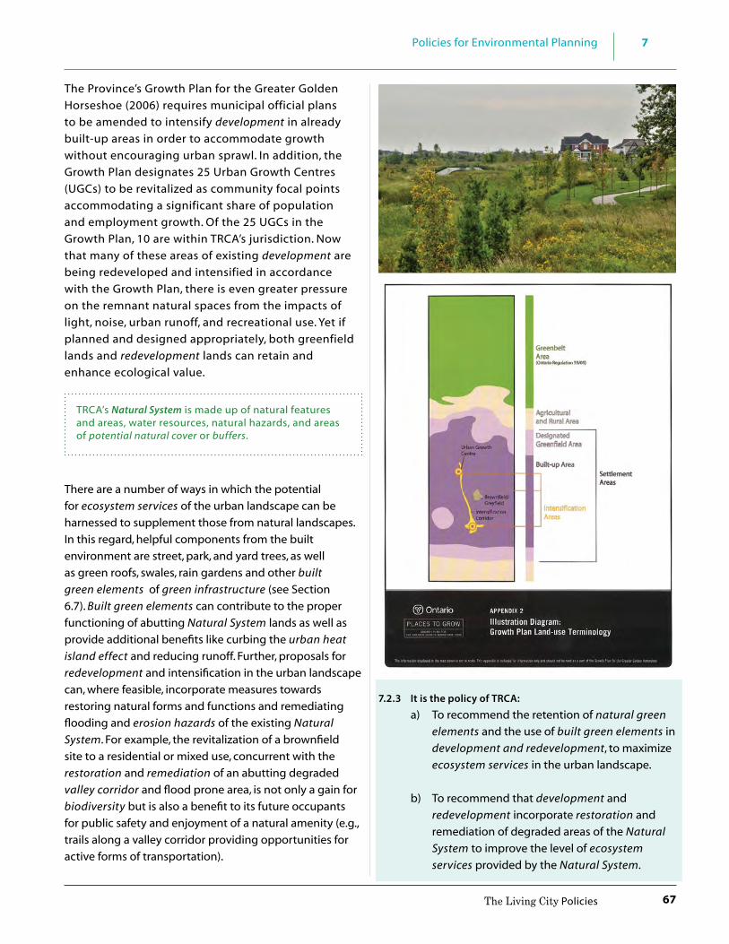
67
7Policies for Environmental Planning
The Living City Policies
The Province’s Growth Plan for the Greater Golden Horseshoe (2006) requires municipal official plans to be amended to intensify development in already built-up areas in order to accommodate growth without encouraging urban sprawl. In addition, the Growth Plan designates 25 Urban Growth Centres (UGCs) to be revitalized as community focal points accommodating a significant share of population and employment growth. Of the 25 UGCs in the Growth Plan, 10 are within TRCA’s jurisdiction. Now that many of these areas of existing development are being redeveloped and intensified in accordance with the Growth Plan, there is even greater pressure on the remnant natural spaces from the impacts of light, noise, urban runoff, and recreational use. Yet if planned and designed appropriately, both greenfield lands and redevelopment lands can retain and enhance ecological value.
TRCA’s Natural System is made up of natural features and areas, water resources, natural hazards, and areas of potential natural cover or buffers.
There are a number of ways in which the potential for ecosystem services of the urban landscape can be harnessed to supplement those from natural landscapes. In this regard, helpful components from the built environment are street, park, and yard trees, as well as green roofs, swales, rain gardens and other built green elements of green infrastructure (see Section 6.7). Built green elements can contribute to the proper functioning of abutting Natural System lands as well as provide additional benefits like curbing the urban heat island effect and reducing runoff. Further, proposals for redevelopment and intensification in the urban landscape can, where feasible, incorporate measures towards restoring natural forms and functions and remediating flooding and erosion hazards of the existing Natural System. For example, the revitalization of a brownfield site to a residential or mixed use, concurrent with the restoration and remediation of an abutting degraded valley corridor and flood prone area, is not only a gain for biodiversity but is also a benefit to its future occupants for public safety and enjoyment of a natural amenity (e.g., trails along a valley corridor providing opportunities for active forms of transportation).
7.2.3 It is the policy of TRCA:
a) To recommend the retention of natural green elements and the use of built green elements in development and redevelopment, to maximize ecosystem services in the urban landscape.
b) To recommend that development and redevelopment incorporate restoration and remediation of degraded areas of the Natural System to improve the level of ecosystem services provided by the Natural System.
68
7 Policies for Environmental Planning
The Living City Policies
Restored habitat by TRCA’s Restoration Services Division
7.2.4 Lake Ontario ShorelineThe Lake Ontario shoreline spans nearly 60 kilometres across the bottom of TRCA watersheds and likely has the most complex geological, cultural, and planning history of any landscape in TRCA’s jurisdiction. The current shoreline (and water level) of Lake Ontario is just one of five shorelines known to exist over the past 135,000 years and may be the ultimate example of the physical expression of geologic processes, climate change, and the hydrologic cycle.
TRCA’s Lake Ontario Waterfront Development Program (1980) classified the shoreline into four sectors; the Etobicoke Sector, the City of Toronto Sector, the Scarborough Sector and the Pickering/Ajax Sector. The Etobicoke Sector is characterized by a relatively uniform shore cliff, with variations from sandy sloping beaches to 6-metre bluffs. The City of Toronto shoreline is largely altered due to development, however, some sandy beaches, such as Cherry Beach, remain. The Scarborough Sector is dominated by the Scarborough Bluffs which extend 15 kilometres from Victoria Park Avenue to the mouth of the Highland Creek and reach heights of up to 65 metres. The Pickering/Ajax sector consists of smaller bluffs interspersed amongst sandy beach areas. The sediment comprising the Toronto Region shoreline is generally a mixture of sands, silts, clays, tills, and gravels, which are highly erodible. As a result, the shoreline has been, and continues to be, modified by wave attack, the wave climate, groundwater conditions, wind erosion and numerous other factors in addition to adjacent development.
TRCA’s role in managing the waterfront has also evolved over time. The main focus of the initial Shoreline Management Program and Lake Ontario Waterfront Development Program (both 1980) was to prevent, eliminate, or reduce the risk of flooding and erosion hazards to life and property. However, those documents also promoted a comprehensive approach to shoreline management that balanced the natural coastal processes and attributes of the Lake Ontario waterfront with development pressures and the public demand for open space. This is a reflection of TRCA’s Provincially-designated role as the lead implementing agency for the Etobicoke to Ajax-Pickering shoreline (except for the
Before
After

69
7Policies for Environmental Planning
The Living City Policies
central downtown waterfront area), to enable safe public access and regional scale recreation opportunities. The Integrated Shoreline Management Plan of 1996 set out an ecosystem-based framework that added to the original 1980 Program, new recommendations for shoreline regeneration, natural heritage targets and adoption of the Crombie Commission’s vision for a waterfront that is clean, green, accessible, diverse, connected, open, affordable, attractive, and useable.
Crombie Commission Royal Commission on the Future of the Toronto Waterfront
In 1988, the Federal government appointed the Honourable David Crombie to act as a one-person Royal Commission to Study the Toronto Waterfront.
The Royal Commission on the Future of the Toronto Waterfront, also known as the Crombie Commission had a mandate to “make recommendations regarding the future of the Toronto Waterfront, and to seek concurrence of affected authorities in such recommendations, in order to ensure that, in the public interest, federal lands and jurisdiction service to enhance the physical, environmental, legislative and administrative context governing the use, enjoyment and development of the Toronto Waterfront and related lands.”
The work of the Commission highlights the links that exist between the city and nature – among people, the economy, health and environmental sustainability. It promotes the ecosystem approach to achieve both environmental regeneration and economic recovery.
In 2003, TRCA adopted the Toronto Waterfront Aquatic Habitat Restoration Strategy (TWAHRS) with a goal of maximizing the ecological integrity of the Toronto waterfront by ensuring that waterfront revitalization incorporates aquatic habitat improvement. Aquatic Habitat Toronto (AHT) is a consensus-based group involving Fisheries and Oceans Canada (DFO), Ministry of Natural Resources and Forestry, TRCA, and in consultation with the City of Toronto. AHT is responsible for the implementation of the TWAHRS. AHT facilitates the approvals process for Waterfront Toronto and other proponents working on the Toronto waterfront. At the same time, TRCA’s waterfront monitoring program advances the science and understanding of aquatic habitats helping to inform RAP projects (see sidebar), TWAHRS projects, and TRCA waterfront works in general. Implementation of these programs and strategies occurs in a number of ways. For example, TWAHRS may inform compensation projects required under the federal Fisheries Act.
In reviewing planning and environmental assessment applications affecting the waterfront, TRCA recognizes the need to balance waterfront revitalization/redevelopment, public access, and an open space “aesthetic” with natural heritage and natural hazard protection and management.
The Remedial Action Plan (RAP) is a process to clean up the waterfront, rivers, habitats and waters of the Toronto region. RAPs are also being implemented in 42 other areas around the Great Lakes. Initiated in 1987, the Toronto and Region RAP area includes six major watersheds (Etobicoke Creek, Mimico Creek, Humber River, Don River, Highland Creek, Rouge River) 45 kilometres of waterfront, and Toronto Bay. The Toronto and Region RAP is managed by representatives from Environment Canada, Ontario Ministry of the Environment and Climate Change, Ontario Ministry of Natural Resources and Forestry, and TRCA. The Toronto and Region RAP tracks environmental conditions, activities, and outcomes relevant to the RAP. (http://www.torontorap.ca)

70
7 Policies for Environmental Planning
The Living City Policies
Public ownership of waterfront lands is a key means to managing natural hazards, while providing accessible open space integrated with opportunities for public enjoyment and aquatic and natural heritage restoration.
Ontario’s Great Lakes Strategy In the Province’s Great Lakes Strategy (2012), conservation authorities are named as essential partners in the implementation of programs and project initiatives to improve the health of the Great Lakes. For example, with
CAs as partners, the Province has initiated outreach and guidance on integrated stormwater practices, environmental farm plans, habitat restoration, and environmental monitoring. Federal, provincial, municipal and private restoration projects for the Toronto region’s rivers and lakes alike serve to improve the health of the Great Lakes.
7.2.4 It is the policy of TRCA:
a) To prevent, eliminate or reduce the risk of flood and erosion hazards to life and property through:
i. appropriately planned development, site alteration, recreational use, and infrastructure;
ii. shoreline protection works that are undertaken on a comprehensive reach basis and naturalized to the extent possible; and
iii. the conveyance of hazard lands into public ownership, where feasible.
b) To promote an integrated approach to revitalization of the waterfront that:
i. provides for increased public access, recreational opportunities and a continuous trail system;
ii. preserves and enhances public views of the Lake and its shoreline features;
iii. improves or restores the quality of water, beaches and terrestrial and aquatic natural habitats of the shoreline; and
iv. connects and links waterfront habitats and amenities to valley and stream corridors.
c) To continue TRCA’s waterfront monitoring
program that entails long-term monitoring of waterfront habitat implementation works completed through TWHARS and the Toronto and Region Remedial Action Plan (RAP).
d) To assess site-specific development and site alteration applications on the Lake Ontario Shoreline in accordance with all relevant policies in Sections 7 and 8.
7.2.5 WatershedsPlanning on a watershed basis is an effective means to implementing a locally-based ecosystem approach because it considers hydrologic and ecologic connections and inter-relationships to human communities in a broad context that enables consideration of the cumulative impacts of development. Indeed, TRCA’s watersheds integrate all of the jurisdiction’s landscapes with their diverse physical and human characteristics. For example, watershed planning is an ideal mechanism to integrate the inter-relationship between the Lake Ontario shoreline and the riverine systems of the watersheds. This is important given that healthy watersheds contribute to healthy Great Lakes (see Conservation Ontario’s Paper – Integrated Watershed Management Approach to Great Lakes Protection, April 2012). Watershed planning is also promoted in provincial planning documents (Oak Ridges Moraine Conservation Plan; Provincial Policy Statement 2005; Greenbelt Plan; Growth Plan for the Greater Golden Horseshoe; Clean Water Act) and in regional municipal official plans.
In general, watersheds are biophysical units that form the geographic basis for conservation authorities. The Conservation Authorities Act defines the watershed as “an area drained by a river and its tributaries.” Within a watershed, the hydrologic cycle provides

71
7Policies for Environmental Planning
The Living City Policies
the pathways that integrate physical, chemical, and biological processes among hydrologic features such as watercourses and wetlands, and to terrestrial features like woodlands and valley and stream corridors.
Often described as their backbone, valley and stream corridors are the natural drainage system for watersheds, conveying groundwater and surface water flows from all lands to a downstream outlet. Valley and stream corridors often reflect the condition of a watershed, provide linkages through the landscape, and offer a diverse array of habitats. They also provide important social, economic, and cultural functions. Aboriginals settled in and adjacent to valleylands, while many early European settlements established in valleylands to take advantage of water resources. Agricultural lands are still farmed in some valleylands today, taking advantage of the flat lands and fertile soils of the flood plain. Recent and current generations in the Toronto region enjoy the scenic value of valley and stream corridors lands as an urban open space system and recreational amenity. But like all other natural features, the ecological integrity of valley and stream corridors cannot be maintained without effective management of the surrounding landscape in the rest of the watershed.
In cooperation with municipal partners and watershed communities, TRCA undertakes watershed plans. The plans describe current conditions in the watersheds such as terrestrial and aquatic resources, surface water and groundwater quantity and quality, cultural heritage, and land use, and make recommendations for improving watershed health. In addition, the most recent TRCA watershed plans modelled future urban growth scenarios to predict the watershed’s response for a
range of ecosystem indicators, to scenarios of potential future watershed land use, climate changes, and best management practice strategies.
Urbanizing the natural and rural portions of a sub-watershed not only changes the lands to be developed, but can also affect lands up and downstream. This necessitates careful study and assessment of watershed conditions, and identification of potential singular or cumulative impacts of the proposal on the broader watershed. This, along with corresponding watershed management strategies, is important to address prior to the establishment of an expanded urban boundary and preliminary land use and servicing schemes.
The Watershed Report Card allows watershed alliance groups to assess the health of a watershed and provide recommendations on short- and long-term targets for improving the health of a watershed. Report cards assess the state of a watershed against generally accepted standards and guidelines, and uses methods that can be repeated at regular intervals. Each watershed report card uses a suite of indicators of health, reports on major accomplishments, and identifies key actions that are needed to meet the targets for each indicator. TRCA report cards have been completed for the Humber, Don, and Etobicoke/Mimico watersheds.
7.2.5 It is the policy of TRCA:
a) To recommend that the watershed is the most ecologically-meaningful scale for integrated and long-term planning, which can be a foundation for considering the cumulative impacts of development.
b) To advocate for, participate in, and facilitate, or lead as appropriate, the preparation and updating of watershed strategies, watershed and sub-watershed plans, and watershed report cards.
c) To assess cumulative impacts through
TRCA’s regional watershed and waterfront monitoring programs, watershed plans, and watershed report cards.
d) To recommend that watershed or sub-watershed plans be completed or updated prior to or concurrent with municipal approval of urban boundary expansions.

72
7 Policies for Environmental Planning
The Living City Policies
e) That TRCA watershed and or sub-watershed plans and their associated Implementation Guides and technical background documents, as amended from time to time, be used by TRCA and its partners as reference documents to inform and guide ongoing work and long-term planning and budget preparation.
f ) That valley and stream corridors be protected as a key component of the Natural System, in recognition of their ecological, social, and cultural landscape values.
7.3 Environmental Protection Policies
This section contains TRCA’s policies for how to define, protect, enhance, and secure a resilient, integrated Natural System in an urbanizing and diverse jurisdiction.
TRCA’s Natural System is comprised of the following four components: • Water Resources • Natural Features and Areas • Natural Hazards • Potential Natural Cover and/or Buffers
7.3.1 The Natural SystemNatural heritage protection has evolved from an approach that relied upon the identification of special features, preserving them as discrete entities – the so-called “Islands of Green” approach of the 1970s and 80s. The current approach is one in which all natural heritage features and water resources are considered in relation to each other and the broader landscape in which they occur. This “systems approach”, advocated by TRCA and directed by the PPS, also takes into account the natural functions and processes occurring on the landscape. These processes include natural hazards (e.g., flooding and erosion). The system’s natural functions and processes are often modified by human activities. Encompassing all of these elements to define an integrated Natural System recognizes the importance of: protecting life, infrastructure and property from natural hazards; maintaining and restoring native biodiversity; and, creating a more robust Natural System to improve its resiliency to the projected impacts of urbanization and potential climate change conditions.
Terrestrial Natural Heritage System Strategy
To understand the terrestrial component of the Natural System, TRCA has collected natural heritage inventory and monitoring data on an ongoing basis since the mid-1990s. Data clearly show the declines in native biodiversity in the jurisdiction. In an effort to address this decline, TRCA developed the Terrestrial Natural Heritage System Strategy (TNHSS) in 2007. The TNHSS identifies the need to not only protect natural features and areas, but to expand on them through restoration and connect them within the landscape. The “target” system that is identified in the TNHSS was developed by evaluating the quality, distribution and quantity of the terrestrial natural cover in the landscape as a single functional unit, rather than as separate natural areas. Central to the system are valley and stream corridors as well as other existing features outside the valleys such as wetlands, woodlands

73
7Policies for Environmental Planning
The Living City Policies
and meadows. The TNHSS also determines targets for improving the quality, distribution and quantity of terrestrial natural cover needed in the landscape in order to promote biodiversity as one of the requirements for a sustainable city-region. TRCA continues to evaluate and monitor the ecological functions and biodiversity of the natural system as well as the connection between the health of the system and human health.
Consistency with Provincial Direction
TRCA’s natural systems approach uses a broad landscape and landform conservation perspective, as found in the Oak Ridges Moraine Conservation Plan. It incorporates both a natural heritage system and a water resources system as in the Greenbelt Plan. A natural systems approach also identifies for protection a number of discrete terrestrial and aquatic features, as found in provincial plans. And similar to the PPS and Growth Plan, TRCA’s natural systems approach promotes the linkage of natural features and areas into a Natural System that can include “lands with the potential to be restored to a natural state.” (PPS, 2014) Lastly, TRCA’s Natural System synthesizes these three components – natural heritage, water resources, and natural hazards – through an integrated watershed management approach to also address, through a PPS lens, the protection of public health and safety from natural hazards.
Natural System Refinement and Implementation
The TNHSS focused on the terrestrial system of forests, wetlands and meadows. Further, the TNHSS was developed and modelled on a jurisdictional scale, based on all nine TRCA watersheds. Through the preparation of watershed plans for the individual watersheds, the
relationship of the TNHS with water resources was further refined. Implementation of the TNHSS, however, is not meant to be strictly prescribed based on this scale, but rather refined through further work such as individual watershed or sub-watershed plans, municipal official plan studies and policy updates, and the more detailed studies conducted through environmental assessments, block plans and/or master environmental servicing plans. TRCA’s current approach to protecting and enhancing a Natural System recommends further refinement of the TNHS, through the planning and development process, with the integration of water resources and natural hazard components, including the provision of potential natural cover, or buffers and erosion access allowances, where appropriate. For example, many municipal official plans are using the natural systems approach in their environmental protection policies, establishing schedules with their own natural heritage systems. Some municipal natural heritage systems are based on the regional system that TRCA modelled through the TNHSS and then refined at the watershed scale.
Ultimately, the limits of the Natural System adjacent to development are finalized by the municipality through the planning approval process. However, as noted in TRCA’s municipal planning advisory service agreements (MoUs), TRCA is in no way limited in exercising its rights under the Planning Act, the Conservation Authorities Act, or any other applicable legislation to independently appeal or advocate any position on a planning decision to the Ontario Municipal Board. This is also applicable to TRCA’s delegated responsibilities from the Ministry of Municipal Affairs and Housing and the Ministry of Natural Resources and Forestry as part of the Provincial One-Window Plan Review Service to represent the provincial interest on natural hazards encompassed by Section 3.1 of the PPS.
Given the complementary nature of TRCA’s natural systems approach to the provincial and municipal planning framework, the following policies are the basis for TRCA’s recommendations to approval authorities.
Goal: To protect, restore, and enhance the Natural System for the long term.

74
7 Policies for Environmental Planning
The Living City Policies
7.3.1 It is the policy of TRCA:
a) That the Natural System be comprised of the following components: Water Resources, Natural Features and Areas, Natural Hazards, and any associated potential natural cover and/or buffers.
b) That development and site alteration not be permitted in the Natural System, except in accordance with the policies in Sections 7.4 and 7.5 and 8.4 to 8.13.
c) That infrastructure be located outside of the Natural System except in accordance with the policies in Sections 7.4 and 7.5 and 8.4 to 8.13.
d) That notwithstanding policies 7.3.1 a) through c), the following may be permitted within the Natural System, subject to the policies in Sections 7.4 and 7.5 and 8.4 to 8.13:
• alterations to existing buildings and structures, including those for agricultural use,
• infrastructure, • recreational uses, and • conservation projects and conservation-
related accessory uses.
e) That the limit/boundary of the Natural System be determined in consultation with the municipality and, where required, the Ministry of Natural Resources and Forestry, based on the outermost limits of the components of the Natural System identified through:
i. natural heritage system policies and schedules in municipal official plans;
ii. TRCA Terrestrial Natural Heritage System Strategy mapping;
iii. technical reports prepared by the proponent in accordance with municipal requirements, TRCA Standards and Provincial Standards; and
iv. site staking and mapping (also see natural hazard policies 7.3.1.3 a) to e).
f ) That the scope of required technical reports in policy 7.3.1 e) be dependent on the scale of the proposal and the proximity of the components of the Natural System. This will be determined through pre-consultation meetings, site visits as necessary, and based on the availability of data, the policies in this document, municipal requirements, TRCA Standards and Provincial Standards.
g) To work with municipalities, and where appropriate, neighbouring conservation authorities, to continue to establish mapping for the components of the Natural System in municipal official plans in accordance with provincial direction.
Technical Reports are reports, studies or plans, typically prepared to support and implement the recommendations of a comprehensive environmental study, that provide detailed information regarding one or more aspects of the natural or physical sciences. For the purposes of this document, technical reports may include, but are not limited to, hydraulic analyses, stormwater management reports, functional servicing reports, hydrogeology reports, geomorphology studies, geotechnical reports and environmental impact studies, or similar documents. Technical reports must be prepared by a qualified professional in the relevant field.
TRCA Standards are the most recently approved technical guidelines and checklists in TRCA’s Planning and Development Procedural Manual, as amended from time to time.Provincial Standards are the most recently approved policies, manuals and technical guidelines administered or prepared by the Province, as amended from time to time.
7.3.1.1 Water Resources
Water resources are an underlying and fundamental component of the Natural System. The movement of surface and groundwater, as well as the energy and chemicals within it, affect the size, shape, and habitat of watercourses, and kettle lakes, among other water resource features. While people depend on water resources, their activities result in changes to various aspects of the system, such as aquatic ecosystems and groundwater resources.

75
7Policies for Environmental Planning
The Living City Policies
Aquatic ecosystems are comprised of lakes, rivers, streams, ponds, wetlands, seasonally flooded areas, riparian lands and the plants, animals and other organisms that live in those habitats. Aquatic ecosystems include not only the living organisms such as fish, benthic (bottom dwelling) invertebrates, and in-stream and shoreline vegetation but also all the physical and chemical components of the hydrologic regime such as water quality, quantity, temperatures, sediment loads, and seasonal and daily flow variations. There are three broad categories of riverine aquatic ecosystems in TRCA watersheds: cold-water systems in the headwaters largely reliant on local groundwater sources; cool to warm-water systems in the middle sections; and warm-water systems in the lower reaches. Along the Lake Ontario shoreline and extending out into the lake are near-shore (lacustrine) and deep-lake aquatic (pelagic) systems.
Groundwater resources are found in aquifers resulting largely from erosion and depositional processes that have occurred over hundreds of thousands of years. Aquifers are inter-layered with lower permeability units called aquitards. These subsurface landscape features are generally comprised of layers of earth, soil and rock materials. Aquifers are comprised of coarse-grained materials like sand, gravel and fractured bedrock that allow for surface water to easily sink down or infiltrate into the ground to replenish these large reservoirs. In contrast, aquitards are made up of layers of clay or non-porous rock which restrict the movement of groundwater between aquifers. The fine-grained aquitards separating the coarse aquifer layers play an important role in filtering out impurities from surface water as it slowly percolates downward to recharge the aquifers. Both shallow and intermediate aquifers can intersect the land surface and express themselves in wetlands and watercourses, seepage areas and springs, providing and supporting sensitive and high quality aquatic habitats and species.
Main Aquifers and Aquitards in TRCA’s jurisdiction
Source: modified from Eyles, N. 2002
Goal: To protect, improve, and/or restore water resources in order to sustain their form and/or function, as fundamental components of a healthy Natural System.
7.3.1.1 It is the policy of TRCA:
a) That Water Resources include: watercourses, headwater drainage features, lakes, hydrologic features as per Provincial plans, groundwater features, wetlands, and other surface water features.
b) To protect, improve, and/or restore the health and diversity of native aquatic habitat, communities, and species.
c) To undertake a watershed-based, comprehensive, integrated and long-term approach for the protection, improvement, and/or restoration of the quality and quantity of water within TRCA’s watersheds and Lake Ontario.
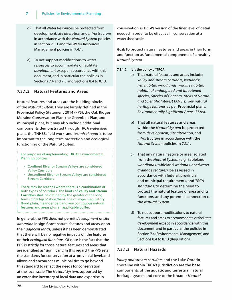
76
7 Policies for Environmental Planning
The Living City Policies
d) That all Water Resources be protected from development, site alteration and infrastructure in accordance with the Natural System policies in section 7.3.1 and the Water Resources Management policies in 7.4.1.
e) To not support modifications to water resources to accommodate or facilitate development except in accordance with this document, and in particular the policies in Sections 7.4 and 7.5 and Sections 8.4 to 8.13.
7.3.1.2 Natural Features and Areas Natural features and areas are the building blocks of the Natural System. They are largely defined in the Provincial Policy Statement 2014 (PPS), the Oak Ridges Moraine Conservation Plan, the Greenbelt Plan, and municipal plans, but may also include additional components demonstrated through TRCA watershed plans, the TNHSS, field work, and technical reports, to be important to the long term protection and ecological functioning of the Natural System.
For purposes of implementing TRCA’s Environmental Planning policies: • Confined River or Stream Valleys are considered
Valley Corridors • Unconfined River or Stream Valleys are considered
Stream Corridors
There may be reaches where there is a combination of both types of corridors. The limits of Valley and Stream Corridors shall be defined by the greater of the long term stable top of slope/bank, toe of slope, Regulatory flood plain, meander belt and any contiguous natural features and areas plus an applicable buffer.
In general, the PPS does not permit development or site alteration in significant natural features and areas, or on their adjacent lands, unless it has been demonstrated that there will be no negative impacts on the features or their ecological functions. Of note is the fact that the PPS is strictly for those natural features and areas that are identified as “significant”. In this regard, the PPS sets the standards for conservation at a provincial level, and allows and encourages municipalities to go beyond this standard to reflect the needs for conservation at the local scale. The Natural System, supported by an extensive inventory of local data and expertise in
conservation, is TRCA’s version of the finer level of detail needed in order to be effective in conservation at a watershed scale.
Goal: To protect natural features and areas in their form and function as fundamental components of a healthy Natural System.
7.3.1.2 It is the policy of TRCA:
a) That natural features and areas include: valley and stream corridors; wetlands; fish habitat, woodlands, wildlife habitat, habitat of endangered and threatened species, Species of Concern, Areas of Natural and Scientific Interest (ANSIs), key natural heritage features as per Provincial plans, Environmentally Significant Areas (ESAs).
b) That all natural features and areas within the Natural System be protected from development, site alteration, and infrastructure in accordance with the Natural System policies in 7.3.1.
c) That any natural feature or area isolated from the Natural System (e.g., tableland woodlands, tableland wetlands, headwater drainage features), be assessed in accordance with federal, provincial and municipal requirements, and TRCA standards, to determine the need to protect the natural feature or area and its functions, and any potential connection to the Natural System.
d) To not support modifications to natural features and areas to accommodate or facilitate development except in accordance with this document, and in particular the policies in Section 7.4 (Environmental Management) and Sections 8.4 to 8.13 (Regulation).
7.3.1.3 Natural Hazards
Valley and stream corridors and the Lake Ontario shoreline within TRCA’s jurisdiction are the base components of the aquatic and terrestrial natural heritage system and core to the broader Natural

77
7Policies for Environmental Planning
The Living City Policies
System. As such, natural hazards associated with these areas are another component of TRCA’s Natural System. Risks associated with natural hazards such as flooding and erosion include the potential for loss of life, property damage, social disruption, and environmental impacts. It is imperative to consider natural hazards using a systems approach, taking into account cumulative impacts, rather than on a piecemeal basis, since natural hazards often extend across wide geographic areas.
Occurrences of natural, physical environmental processes at the earth’s surface that can produce unexpected events of unusual magnitude or severity are generally regarded as natural hazards (Ministry of Natural Resources and Forestry, 2001). Natural Hazards include:
• Lands subject to flooding and erosion within valley and stream corridors and along the Lake Ontario Shoreline
• Unstable Soils, Unstable Bedrock
The following policies apply to all natural hazards as defined in the PPS as hazardous lands and hazardous sites. Hazardous lands are lands that could be unsafe for development due to flooding hazards, erosion hazards, or dynamic beach hazards. Hazardous sites are lands that could be unsafe for development due to unstable soil or unstable bedrock.
Goal: To protect the public and reduce property damage from the risks associated with natural hazards within TRCA’s watersheds and shorelines.
Conservation Authorities have a delegated responsibility to represent the “Provincial Interest” on Natural Hazards as part of the Provincial One-Window Plan Review Service. (see Section 3 for further description)
7.3.1.3 It is the policy of TRCA:
a) To implement the delegated responsibility to represent the “Provincial Interest” on natural hazards in the review of policy documents and development proposals processed under the Planning Act to ensure consistency with Section 3.1, Natural Hazards, of the Provincial Policy Statement.
b) That development and site alteration be directed to areas outside hazardous lands (flood hazard, erosion hazard, dynamic beach hazard) and hazardous sites (unstable soils, unstable bedrock), except as may be permitted by the policies in sections 7.4 and 7.5 and 8.4 to 8.13.
c) That the limit and extent of hazardous lands and hazardous sites be determined in a manner consistent with Provincial standards and TRCA standards and in accordance with the policies in Section 7.4.3 of this document. Such limits will be based on the natural state of the area without the use of mitigation or remediation works, unless the proposed works are consistent with the recommendations of an approved environmental assessment or comprehensive environmental study for the area, approved by TRCA.
d) That as components of the Natural System, a buffer be applied to the limit of hazardous lands and hazardous sites, in accordance with Section 7.3.1.4. This buffer shall include the applicable erosion access allowances.
e) That TRCA will work with member municipalities to provide and update mapping of hazardous lands and hazardous sites and recommend to municipalities that these lands be designated and zoned appropriately in municipal planning documents.

78
7 Policies for Environmental Planning
The Living City Policies
f ) That no new lots be created within hazardous lands and hazardous sites, except for dedication to a public agency for protection purposes;
g) That development, and site alteration not be permitted in areas that would be rendered inaccessible to people and vehicles due to hazardous lands and hazardous sites, unless the site has safe access appropriate for the nature of the development and the natural hazard.
h) That development, and site alteration not be permitted in hazardous lands and hazardous sites where the use is:
i. an institutional use including hospitals, long-term care homes, retirement homes, pre-schools, school nurseries, day cares and schools;
ii. an essential emergency service such as that provided by fire, police, and ambulance stations, and electrical substations; or
iii. uses associated with the disposal, manufacture, treatment, or storage of hazardous substances.
Comprehensive Environmental Studies: studies or plans undertaken by or under the direction of a public agency at a landscape scale including watershed plans, subwatershed studies, environmental implementation reports, environmental management plans, or similar documents, that have been prepared to address and document various alternatives and are part of a joint and harmonized planning process, or community plans that include comprehensive environmental impact studies.
7.3.1.4 Potential Natural Cover and Buffers The TNHSS’s evaluation resulted in the production of a “target” system that includes much of the existing natural cover of forests, wetlands and meadows (about 25 per cent of the region) plus additional areas to be restored, or potential natural cover. Therefore, among the PPS “areas with the potential to be restored to a natural state” in TRCA’s jurisdiction, is potential natural cover. Potential natural cover is land within the target
natural heritage system that is not existing natural cover, but is needed to achieve TRCA’s targets for regional biodiversity and the long term health of the Natural System. Potential natural cover can improve the resilience of the Natural System to impacts from urbanization and the potential impacts of climate change. It is anticipated that potential natural cover lands will become a vegetation community of meadows, woodlands or wetlands, after being restored from their existing state. Some municipal official plans contain natural heritage policies and schedules that include restoration or enhancement areas similar to potential natural cover. Realizing the securement and restoration of potential natural cover through the planning and development process must be a cooperative endeavour among stakeholders (e.g., landowners/proponents, municipalities, TRCA) toward improving both watershed and human health. Because potential natural cover affects development limits its extent in a development application is ultimately determined by the municipality as the planning approval authority.
Existing Natural Cover and Potential Natural Cover
It should be noted that some natural heritage features, terrestrial, aquatic, or otherwise, may not have been captured by the TNHSS, and yet may still be ecologically important (for providing small scale/local ecosystem services) and/or require protection under other federal or provincial legislation and/or municipal official plans. These features are often “isolated” in that they have no apparent connection to the Natural System, (see policy 7.3.1.2 c)) but may warrant protection by placing buffers on their outer limits and establishing a connection to the System. A

79
7Policies for Environmental Planning
The Living City Policies
buffer is a natural strip of land contiguous and parallel to natural features, that helps alleviate the negative impacts of development on natural features and functions. In order to best serve this function, buffers should be planted with native species, and should not be stripped, filled or graded. The size of a buffer may vary depending on the feature and on municipal or provincial requirements.
Within the context of natural hazards, a buffer may include a non-vegetated erosion access allowance required to manage a natural hazard. An erosion access allowance is the setback needed to ensure there is a large enough safety zone for people and vehicles to enter and exit an area during an emergency, such as a slope failure, flooding, or a forest fire. Section 7.3.1.3 contains a policy on erosion access allowances as part of a buffer; the size of an erosion access allowance will vary depending on the hazard type, location, and municipal or provincial requirements. In addition, municipal zoning by-laws often stipulate structural setbacks from property lines in order to access buildings and other structures for maintenance, etc.; the area required for these setbacks should not encroach into potential natural cover or buffers.
Example of a Buffer
As well, it may be that through site-specific analysis, a feature is identified that does have an above or below ground connection to the Natural System and therefore may be able to be incorporated into the System. This should be determined in consultation with TRCA and the municipality.
Goal: To protect lands with the potential to be restored in order to enhance existing natural cover and manage natural hazards.
7.3.1.4 It is the policy of TRCA:
a) That all areas of potential natural cover be protected for restoration and enhancement, in accordance with the Natural System policies in 7.3.1.
b) That when any of the following apply: i. potential natural cover cannot be
protected as described in policy 7.3.1.4 a); or
ii. there exists an isolated natural feature and/or a natural hazard that warrants protection but it is not captured, or not entirely captured, by 7.3.1 e) i) and ii),
the limit of the Natural System be determined by the greater of the outer limits of the natural feature and/or natural hazard to development or site alteration, as follows:
Valley or Stream Corridors – a 10-metre buffer from the greater of the long term stable top of slope/bank, stable toe of slope, Regulatory flood plain, meander belt, and any contiguous natural features or areas;
Woodlands - a 10-metre buffer from the dripline and any contiguous natural features or areas;
Wetlands – a 30-metre buffer from
provincially significant wetlands and a 10-metre buffer for all other wetlands and any contiguous natural features or areas;
Lake Ontario Shoreline – a 10-metre
buffer from the greater limit of the flood hazard, erosion hazard and/or dynamic beach hazard and any contiguous natural features or areas;

80
7 Policies for Environmental Planning
The Living City Policies
Any additional distances prescribed by federal, provincial, or municipal requirements or standards (e.g., Greenbelt).
And, any additional distances
demonstrated as necessary through technical reports.
Contiguous Natural Features
c) That all buffers be protected from stripping, filling or grading, for restoration and enhancement, in accordance with the Natural System policies in 7.3.1.
e) That municipal structural setbacks on buildings and structures that may be required for maintenance be outside of buffers and areas of potential natural cover.
Appendix A, Illustrative Examples of the Natural System, contains depictions of the Natural System through labelled aerial photos and cross sections. The photos include greenfield, urban, and Lake Ontario shoreline scenarios, where some, or all, of the components of the Natural System are layered to comprise the limits of the System, i.e., water resources, natural features and areas, natural hazards, and potential natural cover and/or buffers.
7.3.2 Conveyance of the Natural System into Public Ownership
As a “last step” in setting aside lands for environmental protection through the planning process, TRCA typically recommends that the Natural System blocks within a development area, be conveyed (gratuitously dedicated) into public ownership (either to TRCA or the municipality) by the landowner/developer. Most
TRCA land acquisition is achieved through the planning process, but it is just one of the tools used to secure land. Other tools for acquisition are listed in TRCA’s Greenlands acquisition Program (GAP) as updated from time to time.
Under the provisions of the Conservation Authorities Act, the GAP is TRCA’s land acquisition program. The GAP is updated every five years by TRCA’s Property Division and is approved by the Minister of Natural Resources and Forestry. The GAP’s aim is to acquire property, whether by fee simple, leasehold, easement, covenant, or stewardship agreements in hazard, conservation and environmentally sensitive lands. This is in order to protect against use that would affect the lands’ ability to perform its natural functions and to conserve the lands for the benefit of the people within TRCA’s watersheds (TRCA, 2010). The fee simple form of ownership is preferred for these purposes given that full property rights are assigned to the owner.
Goal: To secure the Natural System in public ownership for its long term protection and maintenance.
7.3.2 It is the policy of TRCA:
a) That as a recommended condition of planning approvals, TRCA may request that all lands that are identified as part of the Natural System, be conveyed into public ownership.
b) To proceed with acquisition of Natural System lands through the planning process in partnership with the landowner(s), his/her agent(s), and the municipality.
c) To advocate that fee simple public ownership, free of encumbrances, provides the best protection of the Natural System for the long term, and is therefore the most preferred form of ownership.

81
7Policies for Environmental Planning
The Living City Policies
d) That where it is determined that fee simple public ownership is not feasible, TRCA will rely on the Greenlands Acquisition Project
(http://trca.on.ca/dotAsset/93418.pdf ) in considering other mechanisms (e.g., conservation easements, stewardship agreements) to protect the Natural System for the long term.
e) To generally require fencing at the boundary
of development lands abutting the Natural System, in consultation with TRCA’s municipal partners, or other public agencies taking ownership of Natural System lands.
f ) That archaeological assessment of lands to be dedicated to TRCA may be required where the lands are to be disturbed, e.g. for a trail or infrastructure, in accordance with the procedures for archaeological assessment in the TRCA Planning and Development Procedural Manual.
g) That prior to the close of a transfer of lands to TRCA, Authority Board approval be required.
h) That prior to the close of a transfer of lands to TRCA, TRCA will potentially require a number of legal and/or administrative items to be completed, as outlined in the TRCA Planning and Development Procedural Manual.
i) To take every opportunity through the planning and development process to report on encroachments onto TRCA lands, e.g.s, site visits, notification to TRCA through Environmental Impact Studies, baseline condition surveys, or ecological monitoring reports.
7.4 Environmental Management Policies
Meeting TRCA’s strategic objectives for healthy rivers and shorelines, greenspace and biodiversity, and sustainable communities, is not only about setting aside lands from development and for public acquisition, it
is also about sustainable design for the lands that are developed. The following policies are for developing adjacent to, and in, the Natural System (where permitted), while minimizing impacts to, maintaining, and enhancing the functions of the protected Natural System. At the same time, these policies seek to integrate the natural and built environments, maximizing opportunities for ecosystem services from across the entire landscape. Taking this integrated view is important for assessing and addressing the impacts of development on a cumulative as well as an incremental basis and for adapting development design to changing watershed conditions over time.
7.4.1 Water Resources ManagementThis water resources management section contains sub-sections on stormwater management and source water protection. Both sections’ policies aim to manage water at its source: stormwater management for the health of streams, rivers, lakes, fisheries and terrestrial habitats, and source water protection for managing the quality and quantity of drinking water at its source. And ultimately, both sets of policies are important for human health and safety.
Readers should take note that some of these policies reference other sections in The Living City Policies such as the water resource policies (sub-section 7.3.1.1), stormwater management infrastructure policies (sub-section 7.5.1.3), and Regulation policies (Section 8.0). It should also be noted that some water management policies refer to separate TRCA technical guideline documents for more detailed requirements.
The Hydrologic Cycle
The hydrologic cycle, or water cycle, refers to the pathways and storage of water in various parts of the ecosystem, as illustrated in Figure 7.1 below. The natural water cycle begins with precipitation that infiltrates into the ground, evapotranspirates from plants into the air, and runs off onto the surface of the ground and into watercourses. The Natural System that TRCA is striving to protect through this policy document is dependent upon this natural cycling of water. In turn, the Natural System provides a water management function; natural areas can reduce erosion and offset water volume increases, among other ecosystem services.

82
7 Policies for Environmental Planning
The Living City Policies
Figure 7.1
7.4.1.1 Stormwater Management
Managing the hydrologic cycle, or the water balance, through stormwater management (SWM) is a vital practice in planning and designing more robust and more resilient sustainable communities. Once a previously permeable surface (e.g., agricultural field) is converted to impermeable surface through urban development (including roads, driveways, sidewalks, roofs, etc.), the hydrologic cycle is altered. SWM attempts to address the altered condition in which, generally, infiltration and evapotranspiration decline and surface runoff increases in both volume and flow. Large portions of some of TRCA’s watersheds (e.g., the Don River watershed), were developed prior to stormwater management. These areas are generally characterized by higher levels of flooding and erosion, and poor water quality (and poorer fish habitat) as a result. When undergoing redevelopment, these areas could benefit from SWM retrofit wherein SWM controls are introduced, or any existing but inadequate SWM controls are updated.
In order for SWM to effectively mitigate the impacts of development and site alteration to the extent possible, TRCA requires that a number of criteria be met:
i. Water Quantity, ii. Water Quality, iii. Erosion control, and iv. Water balance for groundwater recharge and
natural features.
Prior to the policies for stormwater management in this section, each stormwater management criterion is described in summary, while their corresponding technical details are found in the TRCA Stormwater Management Criteria Document, 2012 (the SWM criteria document). The SWM criteria document is based on TRCA watershed plans and hydrology studies, therefore the criteria are subject to change based on the approval and adoption of updated studies.
Water Quantity
(Flood Control)
Water quantity in stormwater management, refers to the control of flood flows created by stormwater. Development is required to address water quantity in order to protect downstream properties from flood increases due to upstream development. Typically, watercourses in urban watersheds are characterized by fast or “flashy” responses to rainfall events due to higher amounts of impervious area that increase the volume and frequency of stormwater surface flows. Controlling flood flows, as outlined in the SWM criteria document, seeks to ensure that development manages the flood flows it affects so that it does not increase risk to life, property and infrastructure.

83
7Policies for Environmental Planning
The Living City Policies
It should be noted that the SWM criterion for quantity has traditionally focused on the 100-year storm level of control, but the SWM criteria document identifies the need to analyze and potentially mitigate the impacts of urbanization on Regional flood flows (Hurricane Hazel). Stormwater flows are routinely managed to the 100-year level, as impacts on Regional Storm flows are normally considered minor due to soil saturation and watershed hydrological timing. However, TRCA’s recent hydrological modelling has found that as urbanization continues further from Lake Ontario, into the headwater areas, there is a potential that flood risks downstream can increase for the Regional Storm event.
Water Quality
In addition to affecting the distribution of water quantity in the different components of the water budget, urbanization adversely impacts the quality of the rainfall once it comes into contact with the ground surface and associated features. As storm runoff travels across roofs, parking lots, and other hardened surfaces, a variety of contaminants and pollutants accumulate, which are ultimately conveyed to receiving watercourses. Soluble contaminants may also infiltrate into the ground and reach groundwater systems. The loss of the original vegetation and topsoil eliminates an invaluable filtering mechanism for storm runoff. Therefore, meeting the water quality criterion outlined in the SWM criteria document is critical for limiting the levels of contaminants in stormwater and their impacts.
Meeting the water quality criterion is also important for the operations and maintenance requirements of flood control infrastructure. For example, the Yonge and York Mills and Stouffville flood control channels are particularly affected by sediment loading due to upstream development. Sedimentation leads to a
decreased storage capacity and subsequent decrease in the channels’ ability to convey flood flows. This may result in the need for increased maintenance requirements for sediment removal.
Erosion Control
The urbanization of a watershed has a direct impact on the morphology, or physical shape and character, of the local receiving watercourses. For example, in order to accommodate the increased volume and velocity of surface runoff, widening and undercutting of the receiving watercourse can occur, in turn causing steep banks to slump and fail during severe storms. In addition, the bed of the watercourse may change due to sediment covering the natural substrate with shifting deposits of mud, silt, and sand, thereby affecting aquatic habitat; downcutting of the channel bed creates instability which can lead to increases in the velocity of stream flow and erosion both upstream and downstream. Finally, loss of riparian tree canopy cover results from the constant undercutting and failure of the stream banks, exposing tree roots and other woody vegetation that would otherwise serve to stabilize the banks of the watercourse. TRCA’s erosion control criterion, as outlined in the SWM criteria document, details how erosion must be mitigated based on development area, size, and character of the receiving watercourse.
Water Balance (for Groundwater Recharge and Natural Features)
Alteration of the hydrologic cycle or water balance due to urbanization (and associated activities to facilitate urbanization, such as dewatering) can impact natural features, such as watercourses, wetlands, and woodlands. For example, these features may experience altered hyrdroperiods and surface and groundwater inputs resulting in changes to the water available for ecological processes necessary for natural features’ proper functioning and survival. Urbanization can also reduce the amount of rainfall available to recharge groundwater and sustain aquifers needed for human use.
Designing a stormwater management system that controls the volume of stormwater flows through encouraging water to infiltrate into the ground, to evapotranspirate, and/or to be re-used, is critical to sustaining groundwater resources, and to managing flow to natural features that rely on the surface

84
7 Policies for Environmental Planning
The Living City Policies
and groundwater flow regime. This volume control works towards replicating the volume pattern and distribution of water to natural features, to maintain hydroperiods, moisture regimes, and seasonal fluctuations. Managing the water balance for groundwater and natural features also realizes benefits for other stormwater management criteria, namely water quality and erosion control. TRCA’s SWM Criteria Document requires an assessment of site-specific characteristics to determine which stormwater management practices are best suited to meeting the water balance criterion for groundwater recharge and/or natural features.
TRCA’s Stormwater Management Criteria and Low Impact Development documents promote measures that address flooding and erosion hazards that occur when a watercourse overtops its banks. However, these same measures can also help address urban flooding. Urban flooding refers to municipal infrastructure (sewers and streets) exceeding its capacity to convey stormwater runoff. Given the complex interactions among stormwater, watercourses and infrastructure, TRCA and municipalities must work together to address the different types of flooding typical to an urban setting.
Low Impact Development and Resiliency
Some of the SWM criteria can be met through the use of low impact development measures (LID) to complement other conventional SWM measures; LID can include source and conveyance controls that infiltrate, re-use, or evapotranspirate runoff. LID’s distributed form, or treatment train approach to SWM infrastructure and lot level measures, offers an important consideration for SWM given that distributed systems provide more resiliency than exclusively implementing conventional, larger end-of-pipe facilities. Resilient infrastructure can be defined as infrastructure with the ability to reduce the magnitude and/or duration of disruptive events. Resilience depends upon infrastructure’s ability to anticipate, absorb, adapt to, and/or rapidly recover from a potentially disruptive event. The importance of having resilient infrastructure will continue to rise as the potential impacts of climate change increasingly affect water and weather patterns and test communities’ ability to adapt to changing conditions. The TRCA/CVC Low Impact Development Stormwater Management Planning and Design Guide, 2010, outlines a host of
best management practices, which can be used in combination with traditional SWM measures, to: manage stormwater volumes innovatively; help protect the Natural System over the long term; improve infrastructure resilience; and thereby provide a higher level of ecosystem services within the built environment.
Example of Low Impact Development Measures
Example of Low Impact Development Measures
Goal: That stormwater management effectively mitigate the impacts of urbanization and the potential impacts of climate change on the hydrologic cycle, and to provide additional ecosystem services within the developed portion of the landscape.
Objectives:
• To prevent increases in flood and erosion risks to life, property and infrastructure;
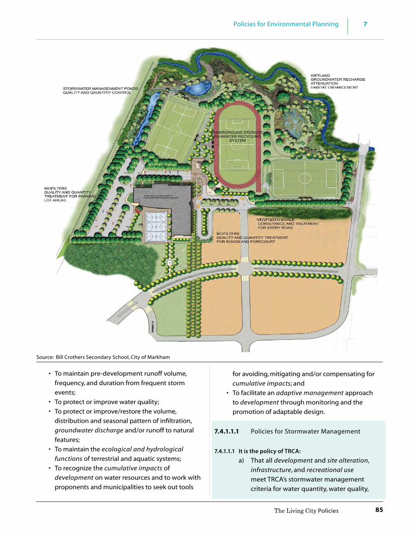
85
7Policies for Environmental Planning
The Living City Policies
• To maintain pre-development runoff volume, frequency, and duration from frequent storm events;
• To protect or improve water quality; • To protect or improve/restore the volume,
distribution and seasonal pattern of infiltration, groundwater discharge and/or runoff to natural features;
• To maintain the ecological and hydrological functions of terrestrial and aquatic systems;
• To recognize the cumulative impacts of development on water resources and to work with proponents and municipalities to seek out tools
for avoiding, mitigating and/or compensating for cumulative impacts; and
• To facilitate an adaptive management approach to development through monitoring and the promotion of adaptable design.
7.4.1.1.1 Policies for Stormwater Management
7.4.1.1.1 It is the policy of TRCA:
a) That all development and site alteration, infrastructure, and recreational use meet TRCA’s stormwater management criteria for water quantity, water quality,
Source: Bill Crothers Secondary School, City of Markham

86
7 Policies for Environmental Planning
The Living City Policies
erosion control, and water balance for groundwater recharge and natural features, as demonstrated through technical reports, and as more specifically described in TRCA’s Stormwater Management Criteria Document.
b) That policy a) apply to all stages of the planning and development process, including: Master Plans, environmental assessments, official plan amendments, zoning by-law amendments, community/block plans, Master Environmental Servicing Plans (MESPs), draft plans of subdivision, and site plans, and that proponents submit technical reports in accordance with TRCA’s Stormwater Management Criteria Document to the satisfaction of TRCA and the municipality.
c) That where existing development or
infrastructure has stormwater management controls that do not meet current SWM criteria, redevelopment, intensification or expansion of these areas be accompanied by a stormwater management retrofit plan. And furthermore, that the retrofit plan be developed in consultation with TRCA and the municipality with the goal of meeting TRCA’s stormwater management criteria for the existing and new portions of development or infrastructure.
d) That the scope of the technical reports referred to in policies 7.4.1.1.1 a) through c) be determined by TRCA in consultation with the municipality, and be incorporated into a Terms of Reference, prior to commencement of the studies, where applicable.
e) That the technical reports referred to in policies 7.4.1.1.1 a) to c), demonstrate how TRCA SWM criteria can be met through the use of a treatment train approach, in accordance with the TRCA SWM Criteria Document and the Ministry of the
Environment’s and Climate Change’s SWM Planning and Design Manual. Potential SWM practices to be considered in this analysis are identified in TRCA’s Low Impact Development Planning and Design Guide.
f ) That the technical reports referred to in policies 7.4.1.1.1 a) and c) meet provincial natural hazard standards in accordance with the natural hazard and regulation policies of Section 8.
g) To encourage coordination among municipalities and between the public and private sectors in the planning of stormwater management facilities for development and infrastructure within the same drainage area.
h) To work with municipalities to develop a groundwater conditions screening tool for underground development (e.g., building foundations, underground parking) and infrastructure in order to avoid continuous and extensive dewatering (also see 7.4.4.1.1 Underground Infrastructure).
i) To work with municipalities and proponents to monitor pre-development (existing) and post-development conditions for receiving watercourses, including stream flow, channel form, surface and groundwater levels, water quality, and aquatic and terrestrial habitat and species, to inform future development.
j) To work with municipalities and proponents
to promote development design that can adapt for the impacts identified through monitoring referred to in policy 7.4.1.1.1 i).
7.4.1.2 Source Water Protection
Various provincial legislation, plans, and policies are in place to protect clean and safe sources of drinking water. This includes the Provincial Policy Statment, the Clean Water Act and the Oak Ridges Moraine Conservation Plan. The Clean Water Act requires the preparation of Source Protection Plans. The Oak Ridges
87
7Policies for Environmental Planning
The Living City Policies
Moraine Conservation Plan has policies for land use restrictions in areas of wellhead protection and aquifer vulnerability. The PPS requires the protection of the quality and quantity of water by identifying water resource systems, including groundwater features, to maintain linkages and related functions necessary for ecological and hydrological integrity and drinking water supplies.
Through the regulatory process of the Clean Water Act, TRCA leads the Credit Valley-Toronto and Region-Central Lake Ontario (CTC) Source Protection Committee in preparing and updating assessment reports and source protection plans. The overall intent of source water protection planning is to establish policies and actions to protect both the quality and quantity of sources of drinking water within a watershed. The legislation is designed to protect existing and future sources of drinking water from activities that are determined to be significant drinking water threats. This is accomplished through the preparation of an assessment report where both existing and future significant drinking water threats are identified. A source protection plan contains policies and actions intended to ensure that existing significant drinking water threats cease to be significant threats and prevent future significant drinking water threats. TRCA, as part of the CTC Source Protection Region, has prepared the Source Protection Plan and accompanying technical documents, which may be updated from time to time. Once the Plan has been approved by the Province, municipal official plans will be amended to conform with the Plan.
The aquifer system of the Oak Ridges Moraine is vitally important in providing a source of drinking water for several hundred thousand people within TRCA’s jurisdiction and beyond. It is generally accepted that there are three major aquifer systems under the ORM: a shallow system from which most private wells take their water supply; an intermediate aquifer; and a deep aquifer system that is the source for most municipal well water supplies serving town and village populations. The ORM also feeds the headwaters of rivers that eventually make their way to Lake Ontario, the source of drinking water for the majority of people within TRCA watersheds.
Goal: To support our municipal partners in protecting the quality and quantity of sources of drinking water for human health.
Objectives:
• To sustain water supplies available for human use; and
• To protect existing and future drinking water sources in the source protection area.
7.4.1.2.1 Source Water Protection Policies
7.4.1.2.1 It is the policy of TRCA:
a) To support the legislated protection of municipal drinking water sources through the Clean Water Act and to continue to participate as a partner in:
i. the formulation and updating of Source Protection Plans and Assessment Reports, and monitoring the implementation of such plans;
ii. undertaking stewardship, education and outreach to landowners in designated vulnerable areas.
b) To support the Clean Water Act and the Oak Ridges Moraine Conservation Plan in the protection of drinking water sources, and continue to participate as a partner in the implementation of the York-Peel–Durham- Toronto Groundwater Management Program and other watershed, groundwater, and monitoring programs that advance the science and understanding of drinking water sources.
The York- Peel- Durham-Toronto (YPDT) and Conservation Authorities Moraine Coalition (CAMC) Groundwater Management Program - Established in 2001, the YPDT - CAMC program is focused on compiling and managing groundwater resource information, including the long-term management of groundwater-related data, maps, reports and resource knowledge for the purposes of effective resource stewardship and management. The program builds, maintains and provides partner agencies with the regional geological and hydrogeological context for ongoing groundwater studies and management initiatives within the partnership area.

88
7 Policies for Environmental Planning
The Living City Policies
7.4.2 Natural Features and Areas ManagementThe Environmental Protection Policies of Chapter 7 identify and describe the need for a Natural System made up of protected components of water resources, natural features and areas and natural hazards, and potential natural cover, and buffers where applicable. However, if during the early stages of the planning and development process, it is determined that it is not feasible to protect the full Natural System from development, management tools may be appropriate. For example, where existing development precludes the protection of an area of potential natural cover or the minimum buffer, TRCA, in consultation with the municipality, may support a reduced buffer, on the condition that the feature and the buffer are enhanced with plantings of trees and shrubs as appropriate. In general, the use of these tools is subject to federal, provincial or municipal requirements applicable in the planning process.
Further, if a natural feature itself cannot be protected, TRCA may recommend compensation. However, compensation is a management tool that should only be used as a “last resort”, being an option only where federal, provincial and municipal requirements do not protect the feature, and only after all other options for protecting the feature have been evaluated.
TRCA will always advocate first for the protection of natural features and the full Natural System. However, when the planning or environmental assessment approval processes permit losses to the Natural System, compensation can be a mechanism for replicating ecosystem services.
Compensation should: - Only be considered once the protection hierarchy
has been applied – avoid/minimize/mitigate first; - Where feasible, take place in proximity to where
the loss occurs; - Be informed by current knowledge of TRCA’s
ecosystems and watershed strategies and any applicable municipal strategies;
- Strive for no loss of ecosystem services; - Be carried out in a transparent and timely manner; - Be based on an adaptive management approach
incorporating monitoring and evaluation, where appropriate.
Goal: To manage natural features and areas and adjacent lands consistent with protecting, restoring and enhancing the Natural System for the long term.
Objectives:
• To advocate first that natural features and areas be protected insitu;
• To achieve an improvement to the Natural System through natural features and areas management; and
• To enhance ecosystem services from both non-developable (the Natural System) and developable lands through natural features and areas management.
7.4.2.1 Natural Features and Areas Management Policies
7.4.2.1 It is the policy of TRCA:
a) That notwithstanding policies 7.3.1.4 a) and b), for properties undergoing redevelopment, a buffer of less than 10 metres (or less than 30 metres from a provincially significant wetland) may be considered, subject to all of the following:
i. federal, provincial, or municipal requirements for buffers;
ii. the natural hazard policies in section 7.4.3; iii. no further loss of buffer than what
currently exists; iv. consistency with buffers in the same
corridor reach; and may be subject to: v. the proponent submitting an
Environmental Impact Study (EIS) that meets Provincial standards, TRCA standards, and any applicable municipal standards. The EIS should contain recommendations for the enhancement and management of both the feature and the buffer.
b) That in general, the distance of adjacent
lands for the purpose of conducting studies to demonstrate no negative impacts will be 120 meters from natural features and areas, in keeping with provincial directions. This distance may vary depending on the scale and scope of an application
89
7Policies for Environmental Planning
The Living City Policies
for development or site alteration, the anticipated sensitivity of the natural features and areas, and any intervening lands uses, as determined through pre-consultation meetings, municipal requirements and site visits.
c) To recommend that when development or infrastructure cannot fully protect a natural feature or any other component of the Natural System, compensation for lost ecosystem services be provided.
d) To recommend that the decision to pursue compensation referred to in policy 7.4.2.1 c) be subject to:
i. the Natural System not being protected by any other applicable federal, provincial, or municipal requirement(s);
ii. all other efforts to protect the Natural System being exhausted first;
iii. it taking place in consultation with the municipality and the landowner;
iv. it taking take place at the appropriate level of the planning and development process for maximizing options for enhancement to the Natural System, e.g., MESP, Environmental Assessment.
e) To recommend that development and
infrastructure adjacent to the Natural System maintain existing topography to the maximum extent possible, therefore reducing or eliminating the need for the use of structural measures such as retaining walls to meet or maintain existing grades.
f ) To recommend a natural approach to the landscaping of adjacent lands through the use of native, non-invasive and locally appropriate species.
g) To not support a boundary adjustment to recognize any component of the Natural System that has been altered, damaged, or destroyed by unauthorized activities; such activities will require replacement or rehabilitation of the feature(s) and its functions.
h) That where fish habitat is deemed to be lost as a result of development or site alteration, that fish habitat be mitigated and compensated for in accordance with provincial and federal requirements, and applicable municipal requirements or TRCA standards.
i) To recommend, with respect to policy 7.4.2.1 h), that fisheries management plans and/or watershed management plans for TRCA watersheds (and for the Toronto Waterfront, the Toronto Waterfront Aquatic Habitat Restoration Strategy (TWAHRS)) be used as guidance documents in the process of mitigation and compensation.
7.4.3 Natural Hazard Management Historically, due to resource needs and aesthetic appeal, valley and stream corridors and the Lake Ontario shoreline are among the most attractive locales in which to live or work, despite their being prone to natural hazards. Since it is impossible to completely eliminate the threat of natural hazards, a risk management approach is taken through planning to contend with development in or near these naturally occurring processes. Managing the risks associated with natural hazards is a long-term development issue. This approach recognizes that there is always risk associated with natural hazards and establishes an appropriate level of risk to which the general public may be exposed. The minimum standards for acceptable levels of risk are set by the Province through the Ministry of Natural Resources and Forestry.
Goal: To prevent, eliminate or minimize the risk to life and property from the risks associated with natural hazards (hazardous lands and hazardous sites).
Objectives:
• To ensure that no new hazards are created or that existing natural hazards are not aggravated through development and site alteration;
• To assess the impacts of development on natural hazards on an incremental and cumulative basis;
• To manage development and site alteration in order to prevent negative impacts to natural features, areas and landforms within the Natural System, including their ecological functions and

90
7 Policies for Environmental Planning
The Living City Policies
hydrological functions; and • To promote the integration of municipal and
environmental assessment planning, remediation, risk management and emergency services planning.
7.4.3.1 General Natural Hazard Management Policies
These general policies apply to all hazardous lands and hazardous sites. While all policies in Section 7 should be read comprehensively, the policies for Natural Hazard Management – Section 7.4.3 have a distinct connection with the other policies in Section 7 (Natural Features and Areas, Water Resources, etc.) and Section 8 (Regulation Policies).
7.4.3.1 It is the policy of TRCA: a) That natural hazards within TRCA’s watersheds
and along the Lake Ontario Shoreline be managed using a comprehensive risk-based approach that considers, but is not limited to, the following factors:
i. risk to life and property; ii. upstream and downstream flood and
erosion impacts; iii. impacts to coastal processes on a
shoreline reach basis; iv. cumulative impacts; v. impacts to water resources, natural
features and areas, and natural systems, including their ecological functions and hydrological functions;
vi. impacts to the control of flooding, erosion, dynamic beaches, pollution or the conservation of land;
vii. climate change; viii. economic feasibility; ix. social impacts; x. mitigation and remediation opportunities;
and xi. acquisition.
b) To promote mitigation and remediation works for existing development and infrastructure within hazardous lands and hazardous sites through the preparation and review of an environmental assessment or comprehensive environmental study or technical study, to the satisfaction of TRCA.
c) To not support modifications to hazardous lands and hazardous sites, such as filling, enclosure or channelization, to create additional area to accommodate or facilitate new development or intensification.
d) That notwithstanding 7.4.3.1 c), in circumstances where TRCA agrees that the modifications to hazardous lands and hazardous sites will result in permanent remediation and reduction of risk to existing development, serve to improve public safety or significantly improve existing hydrological or ecological conditions, such modifications may be considered where it can be demonstrated to the satisfaction of TRCA that:
i. the modifications have been be evaluated on a valley or stream corridor or shoreline reach basis;
ii. acceptable justification has been provided through a subwatershed plan, an environmental assessment or comprehensive environmental study; and
iii. all applicable policies in Section 7 and 8 (Regulation Policies) have been satisfied.
e) To recognize that certain types of development and site alteration by their nature must locate within hazardous lands and hazardous sites, and the associated buffer. TRCA may support such works where they have been addressed through an environmental assessment, comprehensive environmental study or technical report, completed to the satisfaction of TRCA in accordance with the policies of this section and Section 8.0 (Regulation). This may include, but is not limited to, infrastructure, passive or low intensity outdoor recreation and education, conservation or restoration projects and remediation or mitigation works to protect existing development.
f ) To work with member municipalities and other partners to advance climate change science and research to better understand potential impacts on natural hazard management.

91
7Policies for Environmental Planning
The Living City Policies
7.4.3.2 Valley and Stream Flood Hazard As directed by the Province, the flood event standard adopted by TRCA is the greater of the Hurricane Hazel storm event (the Regional Storm) or the 100-year storm event. The flood produced through these calculations is referred to as the Regulatory Flood. Under Regulatory Flood conditions, the flood plain may be divided into two sections – the floodway and the flood fringe. The floodway is the area of the flood plain that passes the flows of greatest depth and velocity. The flood fringe lies between the floodway and the outer edge of the flood plain. Depths and velocities in the flood fringe are less severe than those in the floodway. Based on this division, TRCA implements three approaches, in accordance with Provincial policies and standards, for managing river or stream valley flood hazards: One Zone Concept, Two Zone Concept, and Special Policy Areas.
One Zone Concept (Figure 7.2)The majority of valley and stream corridors within TRCA’s jurisdiction are subject to the One Zone Concept to flood plain management. In this approach, the entire area within the flood hazard limit, (i.e., the Regulatory Flood Plain), is considered to be one management unit (i.e., “one zone”) and is referred to as the floodway. The One Zone Concept is the most restrictive and effective way to manage flood hazards from a risk management perspective.
(One Zone Concept, Flooding Hazard Limit – See also Understanding Natural Hazards – Greak Lakes – St. Lawrence River System and large inland lakes, rivers and stream system and hazardous sites (MNRF, 2001))
Two Zone Concept (Figure 7.3)Exceptions to the One Zone Concept exist where the Two Zone Concept has been applied in accordance
with Provincial standards and approval by the relevant agencies. The Two Zone Concept is only considered where TRCA, in cooperation with the member municipality and the Province, after due consideration of local circumstances, agrees that the adoption of the concept is suitable. The application of this approach is on a subwatershed or major reach basis, not a lot-by-lot basis. The Two Zone Concept separates the flood plain into the floodway and flood fringe. Development and site alteration in the flood fringe may be permitted, subject to specific conditions, including floodproofing to the Regulatory Flood. The feasibility of a Two Zone Area requires the examination of a number of factors and implementation necessitates the assurance that various conditions will be adhered to. Where TRCA and the member municipality agree to adopt a Two Zone Area, appropriate official plan designations and zoning must be put into place. Within TRCA’s jurisdiction, the Two Zone Concept has been applied to existing floodprone communities or portions thereof as illustrated in the maps in Appendix B: Municipal Policies for Approved Special Policy Areas and Two Zone Area illustrate the location of Special Policy Areas within TRCA’s jurisdiction.
(Two Zone Concept, Flooding Hazard Limit – See also Understanding Natural Hazards – Great Lakes – St. Lawrence River System and large inland lakes, rivers and stream system and hazardous sites (MNRF, 2001))
Special Policy Areas:Exceptions to the One Zone and Two Zone approaches exist where Special Policy Areas have been applied. The Special Policy Area approach is employed by the Province in appropriate cases where it has been demonstrated that the One Zone or Two Zone approaches are too restrictive and would not allow for the continued social and economic
Figure 7.2
Figure 7.3

92
7 Policies for Environmental Planning
The Living City Policies
viability and revitalization of historical communities located within the flood plain. Where a Special Policy Area is adopted, TRCA, the member municipality, and the Province agree to relax provincial flood proofing and technical standards and accept a higher level of risk. Area-specific policies in the municipal official plan are intended to provide for the continued viability of existing land uses while being sufficiently protective against flood hazards. As stated in the Provincial Policy Statement, Special Policy Areas are not intended to allow for new or intensified development and site alteration, if a community has feasible opportunities outside the flood plain. Application of a Special Policy Area requires the approval of the Province (Minister of Natural Resources and Forestry and Minister of Municipal Affairs and Housing) and suitable policies and standards must be incorporated into the member municipality’s official plan and zoning regulations. Approval of new Special Policy Areas and modifications to the boundaries or policies of existing Special Policy Areas must be in accordance with the procedures established by the Province.
The maps in Appendix B: Municipal Policies for Approved Special Policy Areas and Two Zone Areas illustrate the location of Special Policy Areas and Two Zone Areas within TRCA’s jurisdiction.
Flood Plain Spill Areas:A flood plain spill area exists where flood waters are not physically contained within the valley or stream corridor and exit into surrounding lands. As a consequence, the limit and depth of flooding are difficult to determine. Flood spill areas occur naturally or can occur as a result of downstream barriers to the passage of flood flows such as undersized bridges or culverts. TRCA will determine on a technical basis where flood spill zone policies are applicable in consultation with the affected municipality.
7.4.3.2.1 General Policies
7.4.3.2.1 It is the policy of TRCA:
a) That the limits of the flood hazard will be determined through TRCA’s flood plain mapping program in accordance with Provincial and TRCA standards. Where flood plain limits are required and not available, or where existing flood plain information
does not meet current Provincial or TRCA standards, TRCA may require the Regulatory flood plain to be mapped by a qualified professional, at the expense of the proponent, to the satisfaction of TRCA.
b) To work with member municipalities to comprehensively review Flood Vulnerable Areas through an environmental assessment, flood risk management assessment or comprehensive environmental study which is harmonized as part of planning process, and seek flood mitigation and remediation opportunities to protect existing development. This review shall include but not be limited to:
i. upstream and downstream impacts: ii. cumulative impacts; iii. impacts to natural features and
areas, including their ecological and hydrologic functions;
iv. restoration and enhancement of terrestrial and aquatic habitat;
v. integration with community planning and site design; and
vi. municipal long range planning for the area.
c) To encourage member municipalities to update their Flood Emergency Management and Response Plans, or equivalent component of their overall Municipal Emergency Plan, on a regular basis and reflect best practices for disaster response. TRCA will provide technical information and flood forecasting and warning expertise to assist municipalities with this process.
7.4.3.2.2 One Zone Policy Areas
7.4.3.2.2 It is the policy of TRCA:
a) That the One Zone Concept to flood plain management, based on the Regulatory Flood in accordance with Provincial standards and policies, will be implemented as the primary method of flood hazard management within TRCA’s

93
7Policies for Environmental Planning
The Living City Policies
jurisdiction, except in circumstances where a Two Zone Concept or Special Policy Area have been designated and approved by the relevant agencies and planning authority.
b) That development and site alteration not be permitted within the floodway (i.e., the floodway hazard) regardless of whether the area of inundation contains high points of land not subject to flooding.
c) Despite 7.4.3.2.2 b), and subject to the policies in section 7.3.1(Natural System), section 7.4.3.1(General Natural Hazard Policies) and Section 8.0 (Regulation), development and site alteration may be permitted in those portions of the flood hazard (i.e., the flood hazard) where the development and site alteration is limited to uses which by their nature must locate in the floodway, including flood and/or erosion control works or minor additions, reconstruction/replacements, or passive non-structural uses which do not affect flood flows.
7.4.3.2.3 Two Zone Policy Areas
7.4.3.2.3 It is the policy of TRCA:
a) That within TRCA’s jurisdiction, the Two Zone Concept to flood plain management will be applied to existing floodprone communities, or portions thereof, where approved and designated by the relevant agencies and affected planning authorities, pursuant to Provincial procedures, standards and requirements.
b) That municipal requests for any new Two Zone Policy Area within existing floodprone communities of TRCA’s jurisdiction, or portions thereof, shall be evaluated in accordance with Provincial procedures, standards and requirements.
c) That the need for and the boundaries of a Two Zone Policy Area be determined
by the municipality and TRCA through a comprehensive study undertaken on a subwatershed or on a major reach basis, in accordance with Provincial standards and requirements.
d) That municipal requests for final approval of a Two Zone Policy Area designation must be supported by:
i. Official Plan policies specific to the review and approval of development and site alteration applications within the proposed Two Zone Policy Area, including development control criteria and, if applicable, the implementation program for any remedial works in relation to the timing and phasing of development;
ii. a Zoning By-law that will implement the Official Plan policies; and
iii. a Flood Emergency Management and Response Plan.
e) That development and site alteration not be permitted within the floodway, except as may be permitted under approved site-specific Two Zone policies (Appendix B).
f ) That development and site alteration may be permitted within the flood fringe in accordance with the approved site specific policies for the Two Zone Policy Area (Appendix B) addressing but not limited to floodproofing, vehicular and pedestrian access, land use permissions, flood emergency management plans; the policies in Sections 7.3.1 (Natural System), 7.4.3.1 (General Natural Hazard policies), and Section 8 (Regulation).
g) That notwithstanding the above, the preparation and implementation of a flood remediation strategy, an erosion control and/or slope stabilization strategy may be required to support large scale urban renewal development projects within approved Two Zone Policy Areas,

94
7 Policies for Environmental Planning
The Living City Policies
prior to TRCA’s technical clearance of the proposed development project.
h) To recommend to municipalities that as part of any comprehensive update or review of municipal planning documents, the boundaries and policies of approved Two Zone Policy Areas be assessed in the context of current technical information and legislative requirements and updated accordingly. This process may warrant a comprehensive update to studies undertaken in the support of this designation.
7.4.3.2.4 Special Policy Areas
7.4.3.2.4 It is the policy of TRCA:
a) That within TRCA’s jurisdiction, the Special Policy Area approach to flood plain management will be applied to existing flood prone communities, or portions thereof, where approved by the Ministers of Municipal Affairs and Housing and Natural Resources and Forestry. A Special Policy Area is not intended to allow for new or intensified development and site alteration if a community has feasible opportunities for development outside the flood plain.
b) That any change or modification to the Official Plan policies, land use designations or boundaries applying to a Special Policy Area, must be approved by the Ministers of Municipal Affairs and Housing and Natural Resources and Forestry prior to the approval authority approving such changes or modifications.
c) That municipal requests for any new Special Policy Areas within existing flood prone communities of TRCA’s jurisdiction, or portions thereof, or any change or modification to Official Plan policies, land use designations or boundaries of provincially approved Special Policy Areas shall be evaluated in accordance
with Provincial procedures, standards and requirements.
d) That new or intensified development that exceeds the provincially approved Official Plan policies and land use designations of the Special Policy Area must be approved by the Ministers of Municipal Affairs and Housing and Natural Resources and Forestry prior to the approval authority approving such works.
e) That development and site alteration may be permitted within the flood plain in accordance with the provincially approved site specific Special Policy Area policies (Appendix B) addressing but not limited to floodproofing, vehicular and pedestrian access, land use permissions and flood emergency management plans; the policies in Section 7.3.1 (Natural System), Section 7.4.3.1 (General Natural Hazard Policies), and Section 8 (Regulation).
f ) Notwithstanding the above, the preparation and implementation of a flood remediation strategy, erosion control and/or slope stabilization strategy may be required to support large scale urban renewal development projects within approved Special Policy Areas, prior to TRCA’s technical clearance of the proposed development project.
g) To recommend to municipalities that as part of any comprehensive update or review of municipal planning documents, the boundaries,policies and land use designations of approved Special Policy Areas be assessed in the context of current technical information and legislative requirements and updated accordingly. This process may warrant a comprehensive update to studies undertaken in the support of this designation.

95
7Policies for Environmental Planning
The Living City Policies
Provincially Designated Special Policy Areas in TRCA’s Jurisdiction: • Notion Road/Pickering Village, Town of Ajax • Avondale, City of Brampton • Brampton East, City of Brampton • Central Core, City of Brampton • Bolton Core Area, Town of Caledon • Unionville, City of Markham • Applewood/Dixie, City of Mississauga • Etobicoke Creek, City of Mississauga • Pickering (Village East), City of Pickering • Lake Wilcox, Town of Richmond Hill • Black Creek (Jane-Wilson), City of Toronto • Hoggs Hollow, City of Toronto • Lower Don, City of Toronto • Rockcliffe, City of Toronto • Woodbridge, City of VaughanThe maps in Appendix B: Municipal Policies for Approved Special Policy Areas and Two Zone Areas illustrate the location of these Areas within TRCA’s jurisdiction.
7.4.3.2.5 Flood Plain Spill Areas
7.4.3.2.5 It is the policy of TRCA:
a) That within TRCA’s jurisdiction, TRCA will determine where flood plain spill area policies apply in consultation with the affected municipality.
b) That subject to the policies in Section 7.3.1 (The Natural System) and Section 8 (Regulation), development and site alteration may be permitted within flood plain spill areas where it can be demonstrated on a reach basis, through a comprehensive environmental study to the satisfaction of TRCA, that:
i. measures to remediate the flood plain spill area to the Regulatory Flood, either through a revised valley or stream corridor or through remedial measures that are permanent as determined by TRCA, can be implemented with no upstream or downstream impacts or impacts to natural features, areas and natural systems, including their ecological functions and hydrological functions;
ii. remediation to eliminate the flood plain spill area is completed prior to any new development
ii. alternatives to 7.4.3.2.5 b) i., (e.g., floodproofing of site specific developments) may only be permitted where complete remediation is not feasible. Specific criteria shall be determined on a site by site basis but shall provide Regulatory Flood protection and be in accordance with policy 7.4.3.2.2; and
iii. safe ingress/egress are available.
Lower Don Flood Remediation
7.4.3.3 Valley and Stream Erosion Hazard
Erosion hazards within River or Stream Valleys include both the erosion potential of the actual river or stream bank, as well as the potential for erosion or slope stability issues associated with the valley walls. The risks associated with River or Stream Valley Erosion Hazards are managed by planning for the 100-year erosion rate (the average annual rate of recession extended over a one hundred year time span). Ultimately, the identification of the hazard depends on whether there is well defined valley corridor that is part of a confined system or a relatively flat landscape that is not bounded by valley walls and is part of an unconfined system.

96
7 Policies for Environmental Planning
The Living City Policies
For purposes of implementing TRCA’s Environmental Management Policies: • Confined River or Stream Valleys are considered
Valley Corridors • Unconfined River or Stream Valleys are considered
Stream Corridors
There may be reaches where there is a combination of both types of corridors.
Valley Corridors (Confined River or Stream Valleys):
Example of a Valley Corridor also referred to as Confined River or Stream Valley
Example of a Valley Corridor also referred to as “Confined River or Stream Valley”
Example of a Valley Corridor also referred to as Confined River or Stream Valley
Confined systems (Figures 7.4 and 7.5), regardless of whether or not they contain a watercourse, are those depressional features associated with a river or stream that are well defined by valley walls. Confined River or Stream Valleys can exhibit three different conditions within which erosion hazards exist or may develop: valley slopes that are steep but stable, valley slopes that are over steepened and potentially unstable, and valley slopes that are subject to active toe erosion. Accordingly, the extent of the erosion hazard within a confined system includes the combined effect of the toe erosion allowance, stable slope allowance, stable top of slope and erosion access allowance.
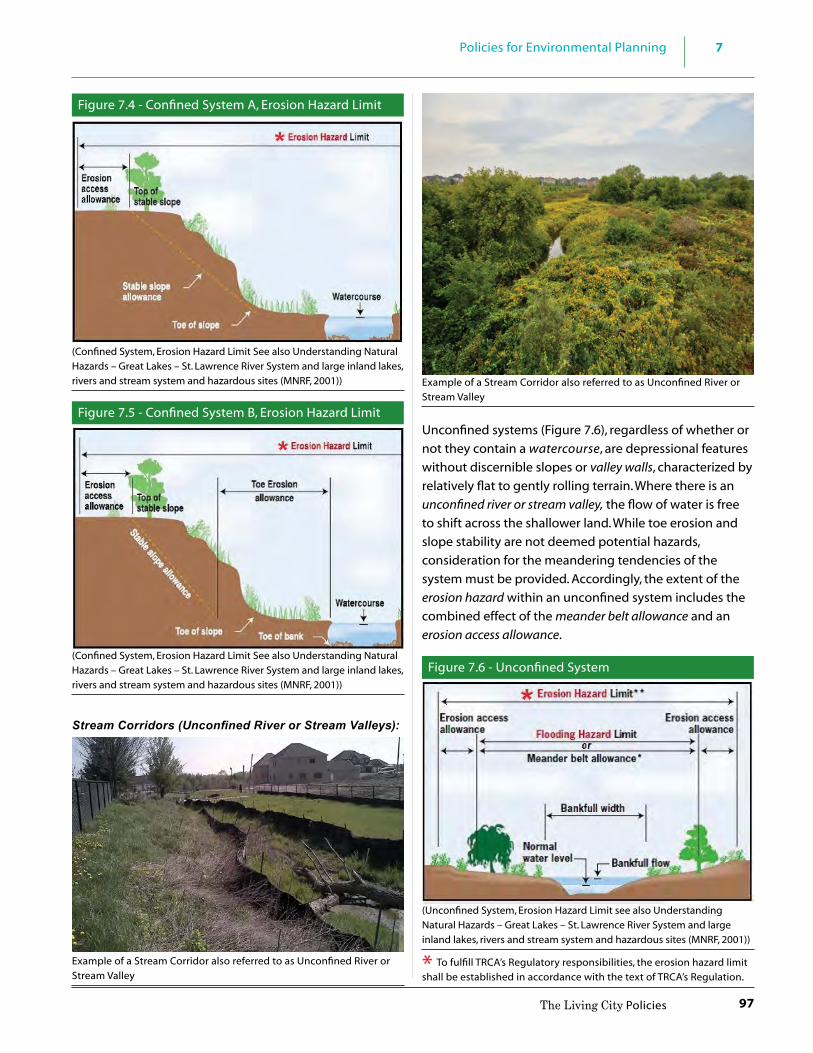
97
7Policies for Environmental Planning
The Living City Policies
Figure 7.4 - Confined System A, Erosion Hazard Limit
(Confined System, Erosion Hazard Limit See also Understanding Natural Hazards – Great Lakes – St. Lawrence River System and large inland lakes, rivers and stream system and hazardous sites (MNRF, 2001))
Figure 7.5 - Confined System B, Erosion Hazard Limit
(Confined System, Erosion Hazard Limit See also Understanding Natural Hazards – Great Lakes – St. Lawrence River System and large inland lakes, rivers and stream system and hazardous sites (MNRF, 2001))
Stream Corridors (Unconfined River or Stream Valleys):
Example of a Stream Corridor also referred to as Unconfined River or Stream Valley
Example of a Stream Corridor also referred to as Unconfined River or Stream Valley
Unconfined systems (Figure 7.6), regardless of whether or not they contain a watercourse, are depressional features without discernible slopes or valley walls, characterized by relatively flat to gently rolling terrain. Where there is an unconfined river or stream valley, the flow of water is free to shift across the shallower land. While toe erosion and slope stability are not deemed potential hazards, consideration for the meandering tendencies of the system must be provided. Accordingly, the extent of the erosion hazard within an unconfined system includes the combined effect of the meander belt allowance and an erosion access allowance.
Figure 7.6 - Unconfined System
(Unconfined System, Erosion Hazard Limit see also Understanding Natural Hazards – Great Lakes – St. Lawrence River System and large inland lakes, rivers and stream system and hazardous sites (MNRF, 2001))
* To fulfill TRCA’s Regulatory responsibilities, the erosion hazard limit shall be established in accordance with the text of TRCA’s Regulation.

98
7 Policies for Environmental Planning
The Living City Policies
7.4.3.3.1 General Policies
7.4.3.3.1 It is the policy of TRCA:
a) To work with member municipalities to comprehensively review existing developed areas along valley and stream corridors that are vulnerable to erosion through an environmental assessment (EA) or comprehensive environmental study. The EA or study should be harmonized as part of the planning process, and seek mitigation and remediation opportunities to protect existing development and infrastructure. This review shall include but not be limited to:
i. upstream and downstream impacts along the corridor reach;
ii. natural stream forming processes on a reach basis;
iii. cumulative impacts; iv. impacts to natural features and
areas, including their ecological and hydrologic functions;
v. restoration and enhancement of terrestrial and aquatic habitats;
vi. integration with community and site design; and
vii. municipal long range planning for the area.
b) That erosion hazard limits will be determined through site specific field investigations and technical reports where required, in accordance with the text of TRCA’s Regulation and Provincial and TRCA standards. Where erosion hazard limits are required and not available, or where existing erosion hazard information does not meet current Provincial or TRCA standards, TRCA may require the erosion hazard to be determined by a qualified professional, at the expense of the proponent, to the satisfaction of TRCA.
c) That the limit of the erosion hazard be based on the natural state of the area without the use of mitigation or remediation works, unless the
proposed works are consistent with the recommendations of an approved environmental assessment or comprehensive environmental study for the area, completed to the satisfaction of TRCA.
d) That erosion protection works be designed to protect existing development on a comprehensive basis and not to facilitate the creation of additional area to accommodate or facilitate development, intensification, or site alteration.
e) That development and site alteration not be permitted within the erosion hazard or erosion access allowance, except in accordance with this document and in particular the policies in Section 7.3.1 (The Natural System) and Section 8 (Regulation).
7.4.3.4 Lake Ontario Shoreline Hazards
Hazardous lands along the Lake Ontario shoreline are defined by delineating the farthest combined landward extent of three key shoreline hazards: flooding hazard, erosion hazard and dynamic beach hazard.
Lake Ontario Flood Hazard:
The extent of the flood hazard (Figure 7.7) for the Lake Ontario shoreline includes the combined effect of the following:
(a) the 100-year Flood level; (b) the appropriate wave uprush allowance; and (c) the appropriate allowance for other water
related hazards.

99
7Policies for Environmental Planning
The Living City Policies
Figure 7.7 - Flood Hazard Limit
(Flood Hazard Limit see also Understanding Natural Hazards – Great Lakes – St. Lawrence River System and large inland lakes, rivers and stream system and hazardous sites (MNRF, 2001))
Lake Ontario Shoreline Erosion Hazard:
The extent of the erosion hazard (Figure 7.8) along the Lake Ontario Shoreline includes the combined effect of the following:
(a) a stable slope allowance projected from the stable toe of slope; and
(b) the 100 year recession rate or an erosion allowance of 30 metres.
Figure 7.8 - Erosion Hazard Limit
(Erosion Hazard Limit see also Understanding Natural Hazards – Great Lakes – St. Lawrence River System and large inland lakes, rivers and stream system and hazardous sites (MNRF, 2001))
* To fulfill TRCA’s Regulatory responsibilities, the erosion hazard limit shall be established in accordance with the text of TRCA’s Regulation (Refer to Figure C.7 in Appendix C).
Lake Ontario Shoreline Dynamic Beach Hazard: When beaches have the potential to be shaped and reshaped on a range of timescales that extend from either hours or days to years and decades in response to changing wave, wind, water level, and sediment supply conditions, they are aptly named dynamic beaches. Since the elevation at any point on these beaches changes, it is impossible to define the hazard associated with dynamic beaches in terms of a single elevation, as would be possible on a stable shoreline. Instead, the extent of a dynamic beach hazard (Figure 7.9) along the Lake Ontario shoreline includes the combined effect of the following:
(a) the Lake Ontario Shoreline Flood Hazard; and (b) a dynamic beach allowance of 30 metres.
Figure 7.9 - Dynamic Beach Hazard Limit
(Dynamic Beach Hazard Limit see also Understanding Natural Hazards – Great Lakes – St. Lawrence River System and large inland lakes, rivers and stream system and hazardous sites (MNRF, 2001))

100
7 Policies for Environmental Planning
The Living City Policies
7.4.3.4.1 Lake Ontario Shoreline Flood, Erosion and Dynamic Beach Hazard Policies
7.4.3.4.1 It is the policy of TRCA: a) That the limits of the Lake Ontario
Shoreline flood hazard, erosion hazard and dynamic beach hazard be determined through site specific field investigations and technical reports, where required, in accordance with text of TRCA’s Regulation and Provincial and TRCA standards. Where hazard limits are required and not available, or where existing hazard information is does not meet current Provincial or TRCA standards, TRCA may require the flood hazard, erosion hazard, and dynamic beach hazard be determined by a qualified professional, at the expense of the proponent, to the satisfaction of TRCA.
b) To work with member municipalities to comprehensively review existing developed reaches along the Lake Ontario shoreline that are vulnerable to flooding and erosion through an environmental assessment, risk management assessment or comprehensive environmental study which is harmonized as part of planning process, and seek mitigation and remediation opportunities to protect existing development and infrastructure. This review shall include but not be limited to:
i. impacts to coastal processes on a shoreline reach basis;
ii. cumulative impacts; iii. impacts to natural features and
areas, including their ecological and hydrologic functions;
iv. restoration and enhancement of terrestrial and aquatic habitats;
v. integration with community and site design; and
vi. municipal long range planning for the area.
c) That the limit of the erosion hazard be based on the natural state of the area without the use of shoreline protection works, unless the proposed works are consistent with the recommendations of an approved environmental assessment or comprehensive environmental study for the area, completed to satisfaction of TRCA.
d) That shoreline protection works be designed to protect existing development on a reach basis consistent with TRCA’s Lake Ontario Waterfront program and not to facilitate the creation of additional area to accommodate or facilitate development and site alteration.
e) That development and site alteration not be permitted within the dynamic beach hazard.
f ) That development and site alteration not be permitted within the Lake Ontario flood hazard and erosion hazard, except in accordance with this document and in particular the policies in Section 7.3.1 (The Natural System) and section 8 (Regulation).
7.4.3.5 Hazardous Sites – Unstable Soils and Unstable Bedrock
Hazardous sites are lands that could be unsafe for development and site alteration due to naturally occurring hazards including unstable soils (e.g. organic soils) or

101
7Policies for Environmental Planning
The Living City Policies
unstable bedrock (e.g. karst topography). Due to the specific nature of organic soils and karst topography, specific technical studies are required to determine the existence, extent and limit of these hazards.
7.4.3.5.1 Hazardous Sites Policies
7.4.3.5.1 It is the policy of TRCA:
a) That the limit of the hazardous sites (unstable soils and unstable bedrock) be determined through site specific field investigations and technical reports, where required, in accordance with Provincial standards. Where the hazardous site limit is required and not available, or where existing information does not meet current Provincial or TRCA standards, TRCA may require the limit of hazardous site to be determined by a qualified professional, at the expense of the proponent, to the satisfaction of TRCA.
b) That development and site alteration not be permitted within hazardous sites, except in accordance with this document and in particular the policies in Section 7.3.1 (The Natural System) and Section 8 (Regulation).
7.4.4 InfrastructureWhile crossings of the Natural System can be disruptive to TRCA watersheds, connections for roads, public transit, water, storm and sanitary sewers, utilities, and other types of infrastructure are a necessity in an urbanizing region. TRCA’s infrastructure policies seek to first avoid, then mitigate, remediate natural hazards where possible, and where appropriate, compensate for the impacts of infrastructure on the Natural System.
The Provincial Policy Statement’s (PPS) Section 1.6 on Infrastructure and Public Service Facilities states that infrastructure should be efficient, integrated with growth planning, and (for corridors and rights-of-way for significant transportation and infrastructure facilities) should consider the significant resources in Section 2 of the PPS. However, when infrastructure is reviewed under the Canadian or Ontario Environmental Assessment Acts, the PPS defers all review to the environmental assessment (EA) process (see the PPS definition of development). For public
infrastructure and large private infrastructure projects, Ontario’s Environmental Assessment Act is the principal review mechanism. Given that TRCA is a commenting body under both the planning and EA processes and an advisor to our municipal partners on their Master Plans, the Authority has the opportunity to review many types of infrastructure proposals from both public and private proponents. This is important for consideration of the cumulative impacts that come from multiple infrastructure projects being proposed in TRCA watersheds. Further, aging infrastructure in need of renewal is prevalent in the heavily urbanized parts of TRCA’s jurisdiction; where exposed, at-risk infrastructure is proposed for replacement, repair, or expansion, TRCA works with proponents to improve conditions. This is often accomplished through adapting and retrofitting infrastructure and remediating hazards, that reduces the risk to public safety and enhances the long term functioning of infrastructure.
Goal: That infrastructure avoids, mitigates, and/or compensates for impacts to the Natural System.
Objectives:
• To coordinate with municipalities and proponents to find mechanisms for avoiding, mitigating, remediating, and compensating for the cumulative impacts of infrastructure;
• To assist in the coordination of various infrastructure projects by different proponents for consideration of cumulative impacts;
• To coordinate with municipalities and proponents to identify opportunities for implementing adaptive management in infrastructure projects; and
• To work with municipalities and proponents to

102
7 Policies for Environmental Planning
The Living City Policies
achieve natural heritage restoration and natural hazard remediation through the planning and design of new, replacement, or expanded infrastructure.
7.4.4.1 General Policies for Infrastructure
The policies in Section 7.4.4 must be considered in their entirety. The general policies that apply to all infrastructure projects are followed by policies tailored to different types of infrastructure: Underground, Transportation and Stormwater Management Facilities. All of the infrastructure policies apply to infrastructure projects proposed under a Master Plan and/or an environmental assessment (EA), and to infrastructure projects proposed through the planning process where an EA is not required, e.g., private servicing installations for subdivision development such as road crossings and stormwater management facilities. The policies are for infrastructure that is new, a replacement, repair, or an expansion. Further detailed design-related policies for infrastructure in Section 8.0 should also be referenced.
7.4.4.1 It is the policy of TRCA:
a) To recommend the coordination of Planning Act, Environmental Assessment Act, Master Plans and Master Environmental Servicing Plans (MESPs) planning processes take place to facilitate strategic infrastructure placement and design that avoids cumulative impacts and seeks opportunities for improvements to the Natural System.
b) That infrastructure avoid locating within the Natural System.
c) That generally, linear infrastructure cross perpendicular to the Natural System and at its most narrow point.
d) That baseline environmental conditions be established early in the planning stages of municipal Master Plans (Transportation and Servicing), the environmental assessment process, or equivalent planning process.
e) That the conditions established through policy 7.4.4.1 d) be used to make informed decisions among alternatives, with preference given to alternative(s) using
siting, design, and construction technologies that avoid or minimize impacts to the Natural System.
f ) That infrastructure not create new natural hazards or aggravate existing natural hazards.
g) That where natural hazards exist, infrastructure consider options for remediation.
h) That the area of the Natural System to be occupied and/or traversed by infrastructure be minimized (including for access, construction, operations and maintenance).
i) That where infrastructure is permitted within valley or stream corridors, wetlands, woodlands, and/or hazardous lands or hazardous sites, an environmental monitoring and contingency plan in accordance with TRCA Standards, may be required to address potential emergencies during construction and operation.
j) That the aggregate number of infrastructure
projects within or crossing the Natural System (within the context of a subwatershed or Lake Ontario shoreline reach) be minimized.
k) That the co-location of utilities, or common utility corridors, be considered, where they can facilitate the safe integration of utilities to minimize disturbance from multiple infrastructure projects in the same area.
l) To recommend that when infrastructure cannot protect a natural feature, or part of a natural feature, compensation for loss of ecosystem services be provided.
m) To recommend that the decision to pursue compensation referred to in policy 7.4.4.1 l) be subject to:
i. all efforts to protect the feature being exhausted first;
ii. the feature is not protected by any other applicable federal, provincial or municipal requirement(s);
103
7Policies for Environmental Planning
The Living City Policies
iii. it taking place in consultation with the municipality or the proponent;
iv. it taking place at the appropriate level of the planning and development process for maximizing options for enhancement to the Natural System, e.g., MESP, Environmental Assessment.
Compensation should: - Only be considered once the protection hierarchy
has been applied – avoid/minimize/mitigate first; - Where feasible, take place in proximity to where
the loss occurs; - Be informed by current knowledge of TRCA’s
ecosystems and watershed strategies and any applicable municipal strategies;
- Strive for no loss of ecosystem services; - Be carried out in a transparent and timely manner; - Be based on an adaptive management approach
incorporating monitoring and evaluation, where appropriate.
n) That infrastructure projects meet all of TRCA’s stormwater management criteria, (water quantity, water quality, erosion control, and water balance – for groundwater and natural features), as outlined in Section 7.4.1 (Water Management) and TRCA’s Stormwater Management Criteria Document.
o) That infrastructure projects on TRCA-owned lands be avoided, unless it is the only location technically compliant with the Infrastructure policies of Section 7.4.4.
p) That notwithstanding policy 7.4.4.1 o), where infrastructure projects are permitted to occur on TRCA-owned land, they take place in accordance with the requirements in TRCA’s Planning and Development Procedural Manual for working on TRCA-owned lands dealing with archaeology, permission to enter, and registered property interests.
In addition to the general policies for all infrastructure provided above, the following infrastructure policies are applicable by servicing type: Underground Infrastructure, Transportation Infrastructure, and Stormwater Management Facilities.
7.4.4.1.1 Underground Infrastructure Policies
Infrastructure installed underground includes, but is not limited to: subways, sanitary sewers, septic systems, watermains, gas and oil pipelines, geothermal energy systems, and cable, electricity and telecommunication lines. For the tunneling of roads or public transit rights-of-way (e.g., subways), the policies for transportation infrastructure (7.4.4.1.2) also apply.
7.4.4.1.1 It is the policy of TRCA:
a) That the location, design and installation of underground infrastructure, including new, replacements, or upgrades, consider the following through applicable field and technical assessments in accordance with TRCA Standards:
i. installation method(s) that create the least impact (short and long term) to the Natural System;
ii. installation placement(s) that avoid impacts to watercourses;
iii. all options for horizontal and vertical alignments to avoid, minimize and/or mitigate impacts on aquifers and surface water receptors (e.g., watercourses, wetlands, and woodlands);
iv. minimizing and mitigating impacts on groundwater flow and discharge; and,
v. managing dewatering and/or dewatering discharge during construction and post-construction in accordance with the policies in sub-section 8.11.
7.4.4.1.2 Transportation Infrastructure Policies
Transportation infrastructure includes, but is not limited to: new road crossings, new crossings for trails, railway lines, subways and other transit rights-of-way, their associated facilities, or alterations to existing transportation infrastructure such as extension, widening, repair to, upgrades of, or replacements. For the tunneling of roads or public transit rights-of-way (e.g., subways), the policies for underground infrastructure (7.4.4.1.1) also apply.

104
7 Policies for Environmental Planning
The Living City Policies
7.4.4.1.2 It is the policy of TRCA:
a) That the location and design of transportation infrastructure crossing valley and stream corridors, including new, replacements or upgrades:
i. cause no upstream or downstream impacts to flooding and erosion;
ii. ensure safe conveyance of flood flows; iii. be situated at appropriate locations to
avoid natural hazards; iv. maintain the ecological and
hydrological functions of the valley or stream corridor by considering the following in accordance with TRCA Standards:
• physical characteristics of the watercourse;
• geomorphic processes of the watercourse;
• aquatic and terrestrial habitat; • valley or stream corridor form; • aquatic and terrestrial wildlife
passage; and • pedestrian passage (e.g. trails). b) That for road widenings, the surface area
of both the adjacent, existing road and the new road portion meet TRCA stormwater management criteria, in accordance with the policies in 7.4.1.1.1 for stormwater management.
7.4.4.1.3 Stormwater Management (SWM) Facilities Infrastructure Policies
SWM facilities infrastructure includes new facilities and alterations to existing facilities designed to manage stormwater, and include but are not limited to: SWM ponds, infiltration trenches, bioretention facilities, enhanced swales, and oil and grit separators.
7.4.4.1.3 It is the policy of TRCA:
a) That the general location and function of SWM facilities be described and assessed in a subwatershed study, a Master Environmental Servicing Plan (MESP), an environmental assessment process, or equivalent. The specific location, sizing and preliminary design of each facility shall be addressed in a Stormwater Management Report, or equivalent, completed prior to approval of the development or site alteration for which the facilities serve; and that the report also demonstrates how the TRCA SWM Criteria can be met in accordance with policies 7.4.1.1.1 a) through j).
b) Where a subwatershed study, an MESP, an environmental assessment process, or equivalent, determines that a Regional Flood control facility is required, the facility be designed to ensure public safety and to reduce risk associated with failure.
c) That SWM facilities be sited and designed so that they ensure public safety, and where appropriate and in consultation with the municipality, integrated into the developing or redeveloping community, as attractive amenities for safe, passive use and enjoyment.
d) That subwatershed drainage diversion be
avoided in order to maintain existing watershed boundaries and drainage patterns.

105
7Policies for Environmental Planning
The Living City Policies
e) That notwithstanding policy 7.4.4.1 b), which states that infrastructure avoid locating within the Natural System, for SWM facilities permitted to be located within the Natural System:
i. they generally be located outside of valley and stream corridors;
ii. they generally be located outside of the regional storm flood plain;
iii. they not be permitted on a valley wall subject to erosion, within the meander belt, the 100-year erosion limit, or the 100-year flood plain of a watercourse, whichever is greater;
iv. they not be permitted within the stable slope allowance or dynamic beach hazard along the Lake Ontario shoreline;
v. they not be permitted within watercourses (on-line), wetlands, or woodlands;
vi. they be situated in areas where vegetation removal, grading and soil compaction, sediment erosion, and impervious surfaces are avoided or minimized; and,
vii. they be naturalized/planted to complement adjacent natural areas.
f ) That notwithstanding policy 7.4.4.1.3 e), where it has been demonstrated to the satisfaction of the Ministry of Natural Resources and Forestry, TRCA and the municipality, a Regional Flood Control Facility may be permitted within a valley or stream corridor.
g) That SWM outfalls, or other supporting SWM infrastructure, be sited and designed in accordance with the policies in policy 8.9.8 in Section 8.0.
h) That maintenance plans for SWM facilities be developed and implemented to ensure their long term performance, in accordance with municipal and provincial requirements.
7.4.5 Recreational UsePerhaps “receiving” ecosystem services from nature is most obvious when the services are associated with recreational use. Many can appreciate the calmness that comes with walking or cycling through a quiet forest or ravine in contrast to fighting traffic on a noisy street. Access to a natural setting can bring a calmer, less stressful lifestyle; wooded areas offer shade and temper urban noise, making heavily populated areas feel less overpowering. Natural areas also provide an excellent environment for physical activity and exercise – usually free to visit, they are an accessible and vital health resource. Studies from the medical profession have verified these linkages, reporting that close contact with nature, and the more active lifestyle that it can encourage, reduces stress levels and helps prevent obesity and heart disease (Frumkin, 2011).
But while providing opportunities for nature-based recreation experiences is key to building healthy communities, over-use and subsequent degradation of an urban open space system is a risk inherent in rapidly urbanizing centres. There is a need to manage recreational use so that natural areas can be enjoyed without exacerbating natural hazards or threatening the integrity of natural features and functions. To this end, provincial plans such as the Greenbelt Plan and Oak Ridges Moraine Conservation Plan, distinguish between the intensity and impacts of various types of recreational activities to determine appropriate locations where different activities should occur. This can be generally identified as major or minor recreational uses, with major use being the most intrusive.

106
7 Policies for Environmental Planning
The Living City Policies
TRCA Watershed Plans contain a vision for an integrated system of nature-based recreation areas and experiences, taking advantage of, and caring for, the unique landscapes throughout the watersheds. TRCA and its municipal partners own and manage trails and conservation areas and parks within communities, continuously linked along the river/ravine system, and ultimately linked with trails on the Lake Ontario shoreline. Large “urban wilderness” parks like Rouge Park or Tommy Thompson Park offer outdoor activities such as hiking, cross country skiing, bird-watching and nature appreciation. While TRCA-owned and -managed lands provide many opportunities for minor recreational use or passive non-intrusive uses, there are some areas with major recreational uses such as campgrounds, educational facilities, sustainable community demonstration sites (Kortright Centre), and a (tableland) golf course (Bathurst Glen). TRCA employs best management practices and environmental stewardship in order to mitigate for the impacts of major recreational use and encourages other managers of large public recreational facilities within or adjacent to the Natural System to employ the same.
Major Recreational Uses are recreational facilities that require large scale modification of terrain, vegetation or both, and usually also require large scale buildings or structures and extensive parking areas. Examples include but are not limited to: golf courses, serviced sports/playing fields, serviced campgrounds and ski hills. Extensive planning, environmental studies, mitigation measures, restoration efforts and ongoing best management practices will be required to minimize impacts to the ecological and hydrological integrity and functions of the Natural System.
Minor Recreational Uses are recreational facilities that require very little modification of terrain or vegetation and few if any, buildings, structures and limited parking. They are of low intensity and a non-intrusive nature. Examples include but are not limited to: non-motorized trails, boardwalks, small scale picnic facilities, natural heritage appreciation. Proper site planning, scoped environmental studies and the incorporation of best management practices for site construction and future maintenance can generally minimize impacts to negligible levels.
Goal: That the siting design and operation of recreational use avoid, mitigate, and/or compensate for impacts to the Natural System.
Objectives:
• To coordinate with municipalities and proponents through the planning and development process to develop location and design strategies for avoiding, mitigating, and compensating for the cumulative impacts of recreational uses;
• To promote and monitor the use and enjoyment of the Natural System for recreational use that minimizes impact to the natural environment by striving for a balance between conservation and appropriate public uses;
• To develop awareness and form partnerships among all stakeholders that will enhance stewardship of recreational use lands in or adjacent to the Natural System; and
• To promote the recognition and linkages between natural heritage and cultural heritage on recreational use lands in or adjacent to the Natural System.
7.4.5.1 Policies for Recreational Use
7.4.5.1 It is the policy of TRCA:
a) To collaborate with municipal partners, private interests, community groups and the general public to realize a linked regional open space system, as identified in TRCA board-approved plans and strategies, which provides the basis for:
i. a coordinated network of landscape and nature-based accessible recreation areas;
ii. experiencing the distinctive natural and cultural heritage attributes of the watersheds;
iii. compatible employment opportunities for small scale home-based businesses and local residents;
iv. the consideration of cumulative impacts and how to avoid them;
v. undertaking comprehensive management plans to restore and enhance the Natural System;
vi. trail networks that connect communities, parks and greenspace through landscapes and landforms like the river valleys, the Lake Ontario waterfront and the Oak Ridges Moraine.

107
7Policies for Environmental Planning
The Living City Policies
b) To recommend that lands within the Natural System not be considered for municipal parkland dedication.
c) That minor recreational uses may be permitted in the Natural System, in accordance with the policies in this document.
d) That major recreational uses not be permitted in the Natural System, except as permitted by provincial plans.
Minor Expansions require very little modification of terrain or vegetation and few if any, buildings, structures and limited parking. Proper site planning, comprehensive environmental studies, or equivalent technical reports, to the satisfaction of TRCA, and the incorporation of best management practices for site construction and future maintenance can generally minimize impacts to negligible levels.
e) That minor expansions to existing major recreational uses may be permitted within the Natural System in accordance with the policies of this document.
f ) That when minor recreational uses or minor
expansions to existing major recreational uses remove a natural feature, or part of a natural feature, that compensation be provided in accordance with policies 7.4.2.1 c) and d) of this document.
g) To adopt and implement best management practices and TRCA Standards for recreational uses on TRCA-owned lands and to recommend their use on recreational lands owned by others, including but not limited to such practices and standards as:
i. integrated Pest Management and Audubon certification for golf courses;
ii. landform conservation plans and the minimizing of disturbed area and impervious surface of a site in accordance with directions contained in Provincial Plans;
iii. conservation plans for water, nutrients, pesticides and similar products in
accordance with directions contained in Provincial Plans;
iv. safety and accessibility of trails in accordance with TRCA Standards;
v. planning, design and construction practices that minimize impervious surfaces, implement erosion and sediment control guidelines, employ native plant species, maintain or enhance visual landscape character and the size, diversity and connectivity of adjacent components of the Natural System;
vi. monitoring for negative impacts and remediation as necessary (adaptive management).
h) To recommend that trail alignments and other minor recreational uses as applicable:
i. be established conceptually as early in the planning and development process as possible in order for future residents to be aware of where public trails will be situated;
ii. follow existing linear disturbances (where ecologically appropriate) such as existing informal trails, sanitary easements, gas pipelines, and other infrastructure, rather than through undisturbed areas;
iii. avoid sensitive habitats, floral and/or faunal species;
iv. avoid the riparian zone of watercourses; v. not increase risk to public safety from
natural hazards by avoiding active erosion zones, such as outside meander bends and valley walls where banks are eroding; and
vi. avoid incompatible topography, so that grading or filling is avoided or minimized.
i) To recommend that trails be connected and
accessible to the community or communities which they serve.
j) To recommend that the number of watercourse crossings for trails be minimized.

108
7 Policies for Environmental Planning
The Living City Policies
k) To recommend that all major and minor recreational use projects, where applicable, meet all of TRCA’s stormwater management criteria as outlined in Section 7.4.1 (Water Resources Management) and TRCA’s Stormwater Management Criteria Document.
l) To require archaeological assessments on any ground disturbance for any minor or major recreational uses proposed for TRCA-owned lands, in accordance with the procedures for archaeological assessment in accordance with TRCA Standards.
7.4.6 Conservation UseAs of 2014, TRCA held approximately 44,347 acres (17,947 ha) of land in public ownership. Many of these properties are actively managed for conservation projects for purposes such as flood control reservoirs and channels, riverside erosion control, shoreline protection on the Lake Ontario waterfront, habitat creation and enhancement projects and the planting of millions of trees and shrubs. Additionally, TRCA lands form large portions of the parks and open space systems of our municipal partners, and support more than 700 kilometres of recreational trails. TRCA also operates many conservation parks such as the Glen Haffy and Bruce’s Mill Conservation Areas, Kortright Centre for Conservation and Black Creek Pioneer Village, and education field centres such as Lake St. George, Albion Hills and Claremont.
Conservation Project: activities, buildings or structures for conservation and hazard management purposes such as, but not limited to: flood and erosion control works, land securement, habitat creation and enhancement, tree and shrub planting, environmental education, trails and low intensity recreation activities, cultural heritage and archaeological preservation and interpretation and conservation parks.
Conservation-related Accessory Uses: a use of land, buildings or structures and associated activities that is incidental or subordinate to the principal conservation project use, building, structure or activity located on the same lot, and may include activities such as, but not limited to: farmers markets, demonstration or pilot projects and facility rentals for environmentally-themed recreational activities, meetings, conferences and social events.
Many operations on TRCA lands serve the community while generating revenue to offset their costs or to support additional programs. However, the cost of caring for its lands is greater than the funds TRCA generates from its current revenue sources such as park admission fees, permit fees, rental and lease revenues and management agreements. This has required much innovative thinking on the part of TRCA staff to generate additional revenues to support the care and management of these lands. Examples include the addition of a historic brewery at Black Creek Pioneer Village to increase visitation and sales revenues; working with school boards to deliver hands-on training for the new provincially required environmental literacy curriculum at a renovated and repurposed building on a newly acquired environmentally significant property; and partnering with the building and development industry to showcase and monitor the latest energy-saving devices and sustainable construction techniques for new homes. TRCA needs to continue to innovate to raise revenues for the management of conservation lands and requires flexibility in the conservation-related accessory uses it can undertake on its properties.
Goal: To support the long term maintenance, enhancement and financial viability of public conservation lands and projects by allowing for compatible on-site revenue-generating accessory uses and activities.
Objectives: • To allow a variety of conservation-related
accessory uses and activities on publicly

109
7Policies for Environmental Planning
The Living City Policies
owned lands in order to generate revenues for the operations, maintenance, restoration and enhancement of conservation lands and projects.
7.4.6 It is the policy of TRCA:
a) To advocate for the inclusion in municipal official plans and zoning by-laws of appropriate policies, permitted uses, activities and standards with sufficient flexibility to allow for the undertaking of a variety of compatible conservation-related accessory uses on public conservation lands.
b) That the development of new facilities and conservation-related accessory uses on publicly-owned conservation lands be undertaken through a comprehensive management plan process, integrated with the broader social needs of the community and based on appropriate environmental studies, provincial and municipal requirements, and opportunities for public consultation.
7.5 Plan Input and Plan Review (Implementation)
7.5.1 IntroductionAs outlined in Section 3 of this document, Legislative Framework, TRCA provides review and comments from a number of perspectives – a watershed-based resource management agency, a watershed planning advisor, a proponent and landowner, or a regulator. TRCA provides technical advice and/or clearance related to legislative requirements that fall under the Conservation Authorities Act, the Planning Act, the (Ontario) Environmental Assessment Act, the Niagara Escarpment Planning and Development Act, the Oak Ridges Moraine Conservation Act, the Greenbelt Act, and others. For details on any of TRCA’s responsibilities under legislation and agreements, TRCA’s Planning and Development Procedural Manual should be referenced.
Plan input refers to TRCA’s review or “input” into municipal official plan reviews and updates and municipal Master Plans. Plan review refers to TRCA’s review of development proposals under various pieces of legislation as described above. Typically, municipalities circulate the following
types of Planning Act applications to TRCA for review: official plan and zoning by-law amendments, secondary plans (block plans/MESPs), draft plans of subdivision and condominium, site plans, and committee of adjustment applications; municipal building departments also refer applicants to TRCA for clearance. In addition, under provincial and federal environmental assessment legislation, proponents are required to seek comments from conservation authorities on environmental assessments, including individual and class environmental assessments and any associated master plans that occur within a CA’s jurisdiction.
Goal: To fulfill the responsibilities of our legislative mandate and strive to meet TRCA’s strategic objectives for The Living City in plan input and plan review
7.5.2 General Policies for Plan Input and Review
7.5.2 It is the policy of TRCA:
a) That TRCA comments and recommendations in plan input and plan review be in accordance with the policies in this document.
b) To promote the coordination of Planning Act and Environmental Assessment Act planning processes to facilitate strategic and sustainable design, including the consideration of cumulative impacts.
c) To recommend that applications received through plan input and plan review include the appropriate technical reports to assess consistency with the policies in this document.
d) That TRCA comments and recommendations in plan input and plan review be consistent with the Provincial Policy Statement and conform with provincial plans where applicable.
e) That TRCA comments and recommendations in plan input and plan review fulfill our delegated responsibility for representing the provincial interest on natural hazards.
f ) To be consistent with MNRF’s “Policies and Procedures for Conservation Authority Plan Review and Permitting Activities” and

110
7 Policies for Environmental Planning
The Living City Policies
to make clear in our comments in plan input and plan review, which role TRCA is representing (e.g., service provider, resource manager, regulator, landowner).
g) That TRCA comments and recommendations in plan input and plan review fulfill the requested services outlined in memorandums of understanding and service delivery agreements with municipalities, and other partnership agreements (e.g., with Ministry of Natural Resources and Forestry, etc.).
h) That TRCA watershed plans and implementation guides, as well as fisheries management plans, conservation land management plans, and other TRCA technical documents be used, as appropriate, to guide and inform plan input and plan review.
i) That where appropriate, TRCA will complement the comments related to its mandated plan input, plan review and regulatory responsibilities with additional comments reflecting the sustainable communities policies in Section 6. In this regard, such comments and recommendations will clearly reflect TRCA’s advocacy role that promotes and encourages the planning and development of complete and sustainable communities.
j) That baseline environmental conditions be established early in the planning stages of municipal Master Plans (Transportation and Servicing), the environmental assessment process, or equivalent planning process.
k) To promote, where appropriate, adaptive management through performance monitoring and evaluation of measures to avoid, mitigate, and compensate for the impacts of development and infrastructure on the Natural System. And further that this process inform the subsequent improvement of these measures on future projects and past projects where feasible.
l) That TRCA comments in plan input and plan review recommend a Natural System that incorporates natural heritage, natural hazards, and supporting lands necessary for biodiversity and appropriate water management and hazard land management.
m) That TRCA comments and recommendations in plan input and plan review recognize that the components of the Natural System are:
i. identified and protected through appropriate official plan designations, policies, and zoning; and
ii. gratuitously dedicated to an appropriate public agency for conservation and risk management purposes as appropriate.
n) To recommend that planning authorities adopt plans and policies for the protection, restoration, enhancement, and potential acquisition of the Natural System.
o) To recommend to approval authorities that proposals for development and infrastructure be considered for their cumulative impacts on the Natural System as early in the planning and development process as possible.
p) That TRCA staff obtain authorization from TRCA’s Authority Board/Executive Committee to appear before tribunals on planning and development matters.
q) To streamline administrative processes and improve service delivery in the implementation of TRCA’s planning and regulatory programs, in accordance with TRCA’s Business Excellence objective, for the benefit of all municipal partners, the development community and other stakeholders.
r) To strive for 100% cost recovery for planning, environmental assessment, and permit review services through the charging of fees, in accordance with MNRF’s Policies and Procedures for Charging of Conservation

111
7Policies for Environmental Planning
The Living City Policies
Authority Fees, and TRCA’s Board-approved fee schedules (Authority Resolution A237/13).
s) To continue to build and strengthen partnerships with municipal, provincial and federal governments, and other funding partners, to ensure sustainable financing for TRCA resource management agency programs that support TRCA planning and regulatory programs.
7.5.2.1 Master Plans and Environmental Assessments
A master plan is a long range plan that ties together the various servicing needs of an overall system, such as a water distribution system or road network. Typically, a master plan is comprised of many separate projects that are dispersed geographically over a broad study area and are to be implemented separately through the environmental assessment process over an extended period of time. There are multiple types of infrastructure projects that go through the Master Plan process at the provincial and municipal levels that are circulated to TRCA, including public transit systems, roads networks, sewer and water networks, hydroelectricity projects, telecommunication lines and other pipelines.
Master plans allow for the individual needs of a system to be defined in the broader context. Detailing the overall strategy for implementing all of these requirements, a master plan is likely to entail a number of individual, yet related, projects. For example, a water distribution system may require a treatment plant expansion at one location, a reservoir expansion at another location, and the construction of a watermain at yet another location.
Municipal master plans are generally prepared as part of the growth management and long range planning process undertaken by a municipality. Municipalities have the option to subject their master plans to the rigors of the Municipal Class Environmental Assessment process (phases 1 and 2, at a minimum). If this is done, the work of the master plan can be applied when the municipality conducts the environmental assessment for a specific project that is included within the master plan. Typically, master plans are approved by the municipality following
a public and agency consultation process that is outlined in the Ontario Environmental Assessment Act.
7.5.2.1 It is the policy of TRCA:
a) That TRCA comments on Master Plans and environmental assessments are in accordance with the policies in this document, specifically Section 7.4.4, Infrastructure and Section 7.4.5, Recreational Use.
b) That TRCA Watershed Plans and their associated Implementation Guides, and other TRCA technical background documents, as amended from time to time, be used to inform and guide TRCA comments on Master Plans and environmental assessments.
c) To recommend that the aggregate number
of projects proposed under a Master Plan or environmental assessment within or crossing the Natural System (within the context of a subwatershed or Lake Ontario shoreline reach) be minimized.
7.5.2.2 Official Plans, Official Plan Amendments, Secondary Plans
As a public commenting body, TRCA reviews official plans, official plan amendments and secondary plans in relation to matters that affect policy, program or regulatory interests. These planning documents range in scale and complexity and may address a single small individual parcel of land to entire neighbourhoods or new communities.
Expanding the urban boundary of a municipality through a municipal comprehensive review and official plan amendment is one of the most significant undertakings in the planning and development process. Urbanizing the natural and rural portions of a sub-watershed not only changes the lands to be developed, but can also affect lands up and downstream. This necessitates careful study and assessment of watershed conditions, and identification of potential singular or cumulative impacts of the proposal on the broader watershed. This, along with corresponding watershed management strategies, is important to address prior to

112
7 Policies for Environmental Planning
The Living City Policies
the establishment of an expanded urban boundary and preliminary land use and servicing schemes.
7.5.2.2 It is the policy of TRCA:
a) That TRCA watershed and/or sub-watershed plans and their associated Implementation Guides, and other relevant TRCA programs, policies, plans, and technical documents, as amended from time to time, be used to inform and guide TRCA comments on Official Plans, Official Plan Amendments, and Secondary Plans, including urban boundary expansions.
b) That lands containing the Natural System (natural features, natural hazards, buffers, and any potential natural cover) not form part of the area to be designated for development, under a Planning Act application, but rather, be designated in an appropriate environmental protection category.
7.5.2.3 Master Environmental Servicing Plans (MESPs)
Traditionally in the Toronto region, large scale urban development has included the preparation of Master Environmental Servicing Plans (MESPs), or an equivalent document, that defines how a new or redeveloping community will affect the natural environment, including natural hazards, and what specific servicing needs and constraints exist. A watershed management perspective should be considered at this level as well. TRCA routinely reviews MESPs for new urban development from natural heritage, natural hazard and water management perspectives critical to creating sustainable new communities. Given provincial direction for intensification, TRCA sees advantage to also applying the MESP concept to large redevelopment or “urban MESP” areas. The secondary planning process for large areas of existing development undergoing urban revitalization is often challenged by disparate land ownership and timing of development and site alteration, the need to remediate flooding and erosion hazards, and to restore degraded natural areas. These lands could especially benefit from a municipally-led MESP process that advances ecological design and a systems approach to natural heritage restoration and natural hazard remediation on a comprehensive (sub)watershed basis.
7.5.2.3 It is the policy of TRCA:
a) That TRCA Standards for Master Environmental Servicing Plans from the Planning and Development Procedural Manual, be used as the foundation for preparing a site-specific MESP Terms of Reference with the municipality to TRCA’s satisfaction, prior to the municipality’s approval of the Terms of Reference.
b) That the MESP items relating to TRCA’s requirements from policy 7.5.2.3 a), be completed by the proponent to TRCA’s satisfaction, in advance of municipal conditional approval of any zoning by-law amendments, draft plans of subdivision, or site plan control applications within the MESP area.
c) That lands within the MESP study area containing the Natural System not form part of the blocks to be developed, but rather, be identified for environmental protection, enhancement and conveyance into public ownership.
d) That MESPs be undertaken with a focus on restoration and enhancement of the Natural System, including remediation of natural hazards, especially MESPs for redevelopment areas.
7.5.2.4 Zoning By-law Amendments, Draft Plans of Subdivision and Condominium, Severances/Consents
7.5.2.4 It is the policy of TRCA:
a) That lands containing the Natural System (natural features, natural hazards, buffers, and any potential natural cover) not be zoned for development, and not form part of the lots to be created or developed, but rather, be zoned for environmental protection and be set aside for dedication into public ownership in accordance with Section 7.3.2 Conveyance of the Natural System into Public Ownership.

113
7Policies for Environmental Planning
The Living City Policies
b) That the creation of a new lot(s) not be supported unless a suitable building envelope exists outside the Natural System in accordance with the policies in Sections 7 and 8 and municipal requirements. This would include sufficient space within the building envelope for required municipal setbacks and infrastructure including, but not limited to, private septic systems, wells, driveways, and parking and outdoor amenity areas.
c) That draft plans of subdivision and condominium be constructed in accordance with the checklists and guidelines in TRCA’s Planning and Development Procedural Manual.
d) That draft plans of subdivision and condominium affecting the Natural System provide erosion and sediment control plans in accordance with the Erosion and Sediment Control Guideline for Urban Construction (December 2006).
7.5.2.5 Existing Vacant Lots of RecordHistoric planning approval decisions may result in the existence of vacant lots “of record”, which refer to undeveloped lots with zoning rights for some form of development (e.g., a single family dwelling, a single commercial use). When a Planning Act application is submitted to a municipality for building on a lot of record (e.g., rezoning or minor variance), and the lot lies wholly or partially within the Natural System, municipalities typically circulate these applications to TRCA for review. TRCA’s planning and regulation policies do not support development and site alteration within the Natural System, regardless of the zoning rights ascribed to these lots under the Planning Act. However, when these applications are circulated, TRCA endeavours to work with applicants to meet TRCA policies while recognizing that if any part of the application falls within a TRCA Regulated Area, the proposed development would also have to meet the five tests of TRCA’s regulation. Section 8.1 of the LCP describes these scenarios further in the paragraphs entitled “Relationship to Section 7.”
7.5.2.5 It is the policy of TRCA:
a) That where there is an existing vacant lot of record (including an infill lot) located within the Natural System, to not support the designation, rezoning, or development of the lot, where the lot has no safe access, or is located entirely within:
i. the flood hazard (One Zone Policy Area) or erosion hazard of a valley and stream corridor; or
ii. the flood, erosion or dynamic beach hazards of the Lake Ontario; or
iii. a provincially significant wetland or wetland on the Oak Ridges Moraine or other wetlands greater than 0.5 ha; or
iv. any natural features and areas, hydrologic functions or ecological functions where the development would adversely affect the conservation of land.
b) That where an existing vacant lot of record (including an infill lot) has safe access and is only partially located within i., ii., iii., or iv. above, TRCA may support the development of the lot, subject to the policies in Sections 7 and 8.
7.5.2.6 Site Plans
7.5.2.6 It is the policy of TRCA:
a) That lands containing the Natural System not comprise the developed portions of the subject property, but rather, be set aside for environmental protection.
b) That site plan applications required for infrastructure projects that may need to be located within the Natural System be reviewed under the policies in Sections 7 and 8 of this document.
c) The development or site alteration approved under a site plan be constructed in accordance with the checklists and guidelines in TRCA’s Planning and Development Procedural Manual.

114
7 Policies for Environmental Planning
The Living City Policies
d) That site plan applications affecting the Natural System provide erosion and sediment control plans in accordance with the Erosion and Sediment Control Guideline for Urban Construction (December 2006).
7.5.2.7 Minor Variances
7.5.2.7 It is the policy of TRCA:
a) That development or site alteration proposed under a minor variance remain outside of the Natural System.
b) That where alterations to existing development are proposed under a minor variance, and the existing development is located within the Natural System, that the alterations minimize impacts to the Natural System and be in accordance with the policies in Sections 7 and 8 of this document.
c) The development or site alteration approved under a minor variance be constructed in accordance with the checklists and guidelines in TRCA’s Planning and Development Procedural Manual.
d) That minor variances entailing construction affecting the Natural System provide erosion and sediment control plans in accordance with the Erosion and Sediment Control Guideline for Urban Construction (December 2006).

8
115
Policies for the Administration of TRCA’s Development, Interference with Wetlands and Alterations to Shorelines and Watercourses Regulation
The Living City Policies
88
Policies for the Administration of TRCA’s Development, Interference with Wetlands and Alterations to Shorelines and Watercourses Regulation 116
8.1 Introduction 116 8.2 Development, Interference with Wetlands and Alterations to Shorelines
and Watercourses Regulation 117 8.2.1 Regulated Areas 118 8.2.2 Regulated Activities 118 8.2.3 Regulation Tests 119
8.3 Policy Framework 120 8.3.1 Policy Objectives 120 8.3.2 Policy Structure 120
8.4 General Regulation Policies 121 8.5 Valley and Stream Corridors 127 8.5.1 Development within the Flood Hazard and Erosion Hazard of Valley and Stream Corridors 127 8.5.2 Development within Two Zone Policy Areas (Flood Hazard) 132 8.5.3 Development within Special Policy Areas (Flood Hazard) 132 8.6 Development within the Flood, Erosion, and Dynamic Beach Hazards
of the Lake Ontario Shoreline 133 8.7 Development and Interference within Wetlands and
Development within Other Areas (Area of Interference) 138 8.8 Interference with a Watercourse 141 8.9 Infrastructure Policies 142 8.10 Recreational Use Policies 147 8.11 Dewatering, Dewatering Discharge and Water Taking 149 8.12 Fill Placement, Excavation and/or Grade Modification Policies 149 8.13 Implementation and Compliance 150
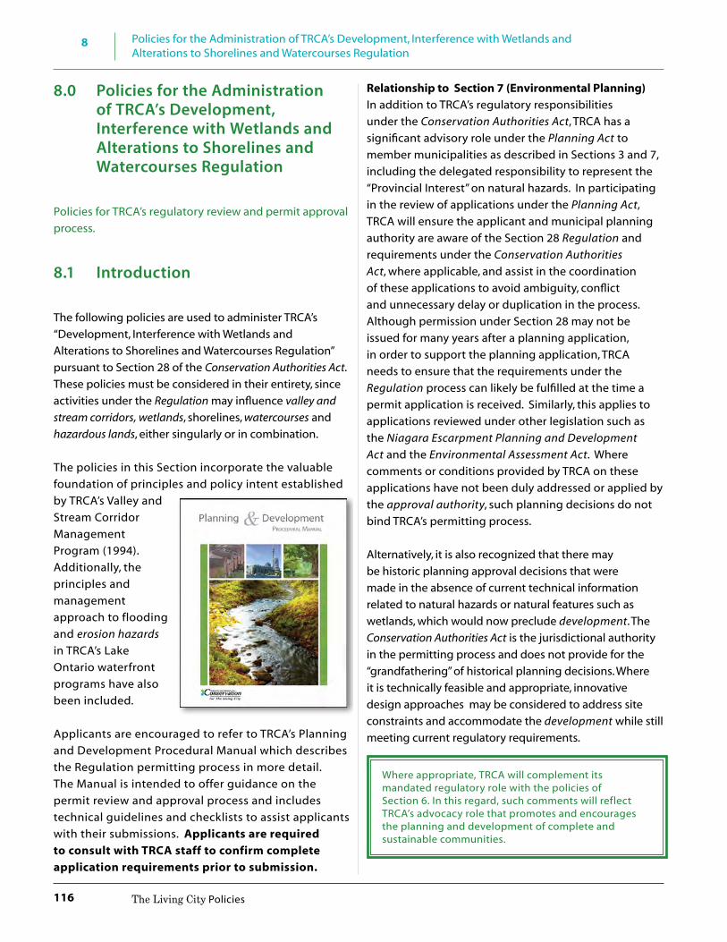
8 Policies for the Administration of TRCA’s Development, Interference with Wetlands and Alterations to Shorelines and Watercourses Regulation
116 The Living City Policies
8.0 Policies for the Administration of TRCA’s Development, Interference with Wetlands and Alterations to Shorelines and Watercourses Regulation
Policies for TRCA’s regulatory review and permit approval process.
8.1 Introduction
The following policies are used to administer TRCA’s “Development, Interference with Wetlands and Alterations to Shorelines and Watercourses Regulation” pursuant to Section 28 of the Conservation Authorities Act. These policies must be considered in their entirety, since activities under the Regulation may influence valley and stream corridors, wetlands, shorelines, watercourses and hazardous lands, either singularly or in combination.
The policies in this Section incorporate the valuable foundation of principles and policy intent established by TRCA’s Valley and Stream Corridor Management Program (1994). Additionally, the principles and management approach to flooding and erosion hazards in TRCA’s Lake Ontario waterfront programs have also been included.
Applicants are encouraged to refer to TRCA’s Planning and Development Procedural Manual which describes the Regulation permitting process in more detail. The Manual is intended to offer guidance on the permit review and approval process and includes technical guidelines and checklists to assist applicants with their submissions. Applicants are required to consult with TRCA staff to confirm complete application requirements prior to submission.
Relationship to Section 7 (Environmental Planning)In addition to TRCA’s regulatory responsibilities under the Conservation Authorities Act, TRCA has a significant advisory role under the Planning Act to member municipalities as described in Sections 3 and 7, including the delegated responsibility to represent the “Provincial Interest” on natural hazards. In participating in the review of applications under the Planning Act, TRCA will ensure the applicant and municipal planning authority are aware of the Section 28 Regulation and requirements under the Conservation Authorities Act, where applicable, and assist in the coordination of these applications to avoid ambiguity, conflict and unnecessary delay or duplication in the process. Although permission under Section 28 may not be issued for many years after a planning application, in order to support the planning application, TRCA needs to ensure that the requirements under the Regulation process can likely be fulfilled at the time a permit application is received. Similarly, this applies to applications reviewed under other legislation such as the Niagara Escarpment Planning and Development Act and the Environmental Assessment Act. Where comments or conditions provided by TRCA on these applications have not been duly addressed or applied by the approval authority, such planning decisions do not bind TRCA’s permitting process.
Alternatively, it is also recognized that there may be historic planning approval decisions that were made in the absence of current technical information related to natural hazards or natural features such as wetlands, which would now preclude development. The Conservation Authorities Act is the jurisdictional authority in the permitting process and does not provide for the “grandfathering” of historical planning decisions. Where it is technically feasible and appropriate, innovative design approaches may be considered to address site constraints and accommodate the development while still meeting current regulatory requirements.
Where appropriate, TRCA will complement its mandated regulatory role with the policies of Section 6. In this regard, such comments will reflect TRCA’s advocacy role that promotes and encourages the planning and development of complete and sustainable communities.

8
117
Policies for the Administration of TRCA’s Development, Interference with Wetlands and Alterations to Shorelines and Watercourses Regulation
The Living City Policies
8.2 Development, Interference with Wetlands and Alterations to Shorelines and Watercourses Regulation
TRCA administers a “Development, Interference with Wetlands and Alteration to Shorelines and Watercourses Regulation”, (hereinafter referred to as the Regulation), approved by the Minister of Natural Resources and Forestry and known as Ontario Regulation 166/06, as amended. Under this Regulation, TRCA regulates:
• development in river or stream valleys, wetlands, shorelines, hazardous lands and associated allowances;
• the straightening, changing, diverting or interfering in any way with the existing channel of a river, creek, stream, watercourse or the changing or interfering in any way with a wetland; and
• other areas where, in the opinion of the Minister, development should be prohibited or regulated or should require the permission of the Authority.
For purposes of implementing TRCA’s Regulation: • Apparent river or stream valleys are considered
Valley Corridors • Not Apparent river or stream valleys are considered
Stream Corridors.
Example of a Valley Corridor also referred to as Apparent River or Stream Valley
Example of a Valley Corridor also referred to as Apparent River or Stream Valley
Example of a Valley Corridor also referred to as Apparent River or Stream Valley

8 Policies for the Administration of TRCA’s Development, Interference with Wetlands and Alterations to Shorelines and Watercourses Regulation
118 The Living City Policies
Example of a Stream Corridor also referred to as Not Apparent River or Stream Valley
Example of a Stream Corridor also referred to as Not Apparent River or Stream Valley
8.2.1 Regulated AreasThe Regulation applies to: • valley and stream corridors; • the Lake Ontario shoreline; • hazardous lands; • watercourses; • wetlands; and • other areas where development could interfere
with the hydrologic function of a wetland.
Hazardous Lands: means lands that could be unsafe for development because of naturally occurring processes associated with flooding, erosion, dynamic beaches, or unstable soil or bedrock. Conservation Authorities Act, Section 28 (25).
The regulated area represents the greatest physical extent of the combined hazards plus a prescribed allowance as set out in the Regulation. Although the policies in Section 7 direct how TRCA determines the limits of the Natural System, natural features and areas, hazardous lands and hazardous sites, the boundaries of regulated areas are determined in accordance with the Regulation. This process is further described in Appendix C: Defining the Limit of Regulated Areas.
Allowance: setback distance prescribed in TRCA’s Regulation to delineate the Regulated AreaRegulation Limit: greatest extent of all regulated areas to define an area of interest; does not represent a development limit.
It is not necessary to map a feature before it can be regulated. The legal basis for delineating regulated areas is defined in the text of the Regulation. While the Regulation makes reference to the maps prepared by TRCA to provide a visual representation of the approximate regulation limits, and may be updated from time to time to reflect new technical information, the text of the Regulation prevails over the illustrative mapping. The mapping serves as a screening tool for the administration of the Regulation. Site investigations and detailed studies requested at the time of an application may further refine or delineate the regulated areas.
Most municipalities within TRCA’s jurisdiction implement a Fill or Site Alteration By-law under the provisions of the Municipal Act. As per Section 142(8) of the Municipal Act, a municipal fill or site alteration by-law cannot overlap with an area regulated by a conservation authority under Section 28 of the Conservation Authorities Act. Coordination between the municipality and TRCA is recommended for those applications that involve both municipal and CA regulated areas.
8.2.2 Regulated ActivitiesThe Regulation allows TRCA to prohibit or regulate development in regulated areas within its jurisdiction where the control of flooding, erosion, dynamic beaches, pollution or the conservation of land could be impacted by development and in other areas where development could interfere with the hydrologic function of a wetland. As per Section 28 (25) of the Conservation Authorities Act, development means:
8
119
Policies for the Administration of TRCA’s Development, Interference with Wetlands and Alterations to Shorelines and Watercourses Regulation
The Living City Policies
(a) the construction, reconstruction, erection or placing of a building or structure of any kind,
(b) any change to a building or structure that would have the effect of altering the use or potential use of the building or structure, increasing the size of the building or structure or increasing the number of dwelling units in the building or structure,
(c) site grading, or (d) the temporary or permanent placing, dumping
or removal of any material, originating on the site or elsewhere.
The definition of development under the Provincial Policy Statement is distinctly different from the definition of development under the Conservation Authorities Act. Please refer to the Glossary.
The Regulation also allows TRCA to prohibit or regulate activities that would result in the straightening, changing, diverting or interfering in any way with the existing channel of a river, creek, stream, watercourse or the changing or interfering in any way with a wetland.
Section 8 Ontario’s Building Code Act requires compliance with all applicable law prior to the issuance of a municipal building or demolition permit. Regulations made under the Conservation Authorities Act are defined as applicable law. Within TRCA’s regulated areas, municipal building officials must receive a copy of a TRCA permit for those regulated activities under the realm of the Building Code Act prior to the issuance of a municipal building permit.
Existing “normal farm practices” such as plowing/tillage, fencing, manure/fertilizer spreading and animal pasturing are not subject to the Regulation. Activities that meet the definition of development or constitute an alteration or interference as described in Section 8.2.2, within regulated areas described in 8.2.1, are subject to the Regulation.
8.2.3 Regulation TestsPermission for development may be granted if it can be demonstrated to the satisfaction of TRCA that the control of flooding, erosion, dynamic beaches, pollution or the conservation of land (i.e. five tests of the Regulation) will not be affected by the development. The tests of flooding
and erosion apply to development within and adjacent to valley and stream corridors, the Lake Ontario shoreline, and hazardous lands, while the dynamic beaches test is applicable only to the Lake Ontario shoreline. Pollution as defined in Section 28 (25) of the Conservation Authorities Act, means any deleterious physical substance or other contaminant that has the potential to be generated by development in an area to which the Regulation applies.
While not defined in the Conservation Authorities Act, TRCA’s application of the “conservation of land” test in The Living City Policies (LCP) is built upon the foundation of principles and objectives established by TRCA’s Valley and Stream Corridor Management Program (VSCMP), 1994. The holistic ecosystem approach in the VSCMP was premised on the need to recognize the relationship between landforms, features and functions in order to protect, manage and restore natural resources within the watershed. Since 1994, these principles have been furthered in other TRCA projects including watershed plans, the Terrestrial Natural Heritage System Strategy and the Natural System policies in Section 7 of the LCP. The Mining and Lands Commissioner (MLC) and the courts have accepted a broad interpretation of the meaning of conservation of land to include “all aspects of the physical environment, be it terrestrial, aquatic, biological, botanic or air and the relationship between them” (611428 Ontario Limited vs. Metropolitan Toronto and Region Conservation Authority, CA 007-92, February 11, 1994 p. 38). Conservation Ontario has considered this and other MLC decisions to provide its own interpretation: the protection, management or restoration of lands within the watershed ecosystem for the purpose of maintaining or enhancing the natural features and ecological functions and hydrological functions within the watershed (Conservation Ontario, 2008). These interpretations reflect the importance of assessing impacts to the conservation of land for both form and function of natural features, at both the local and regional scales of the watershed.
In addition to the conservation of land, it is important to note that the Natural System also provides ecological and hydrologic functions related to the control of flooding, erosion, dynamic beaches and pollution. Within TRCA’s watersheds, development impacts on the five tests shall be considered both incrementally

8 Policies for the Administration of TRCA’s Development, Interference with Wetlands and Alterations to Shorelines and Watercourses Regulation
120 The Living City Policies
and cumulatively in order to manage the risks to life and property, and to maintain, restore and enhance the ecological and hydrological functions of the systems contributing to the conservation of land.
Permission to straighten, change, divert or interfere in any way with the existing channel of a river, creek, stream, watercourse or wetland may be permitted if it is acceptable to TRCA. The acceptability of such permissions will be based on the policies of Section 8 and meeting the five tests described above.
The Mining and Lands Commissioner has been assigned the authority, duties and powers of the Minister of Natural Resources and Forestry under the Ministry of Natural Resources Act to hear appeals from the decisions of conservation authorities made under the Conservation Authorities Act.
8.3 Policy Framework
8.3.1 Policy Objectives The administration of TRCA’s Regulation is based on, but not limited to, the following objectives:
• to prevent loss of life, to minimize property damage and social disruption, and to avoid public and private expenditure for emergency operations, evacuation and restoration due to natural hazards and associated processes;
• to prevent development, interference or alterations that negatively impacts on natural landform features, functions, and systems;
• to manage watersheds on a comprehensive basis and prohibit development, interference and alteration which singularly or cumulatively creates new hazards or aggravates existing hazards;
• to manage the Lake Ontario shoreline on a comprehensive reach/sector basis to prevent, eliminate or reduce the hazard risk, (flooding, erosion, and dynamic beach), to life and property;
• to protect, manage, or restore lands within the watershed and Lake Ontario ecosystems for the
purpose of maintaining or enhancing the natural features, Natural System and hydrologic and ecological functions within valley and stream corridors, wetlands, watercourses, shorelines and hazardous lands and the relationship between them;
• to prevent interference with the hydrologic functions of wetlands; to prevent the pollution of surface and groundwater associated with development in valley and stream corridors, wetlands, shorelines, and hazardous lands; and
• to prevent development, interference and alterations that affect the control of flooding, pollution, erosion, dynamic beaches or conservation of land within valley and stream corridors, wetlands, watercourses, hazardous lands, and along the Lake Ontario shoreline.
These objectives are the foundation of TRCA’s Regulatory program. Their application in policy reflects the diversity of landscapes, land uses and urbanizing nature of TRCA’s watersheds and Lake Ontario shoreline.
“The TRCA is faced with the problem of addressing very specialized and very real environmental concerns affecting the most highly urbanized area of the province. The natural environment, especially in the geographic area of the City of Toronto, has been and continues to be subject to clear, present and ongoing threats of degradation. As a result, the tribunal accepts that the policies followed by the TRCA need to reflect the reality of the existing situation and to provide the guidelines for protecting the Authority’s core values and strategies.” (MLC Decision, Russell versus the Toronto and Region Conservation Authority (CA 003-05), May 27, 2009)
8.3.2 Policy StructureThe Regulation policies in this Section must be considered in their entirety since development, interference and alteration activities prescribed under the Regulation may influence valley and stream corridors, wetlands, shorelines, watercourses and hazardous lands, either singularly or in combination. These policies will be followed by TRCA in making decisions regarding the outcome of all applications made under the Regulation.
8
121
Policies for the Administration of TRCA’s Development, Interference with Wetlands and Alterations to Shorelines and Watercourses Regulation
The Living City Policies
The policies in Section 8.4 – General Regulation Policies apply to all regulated areas and regulated activities, as defined by the Regulation. These policies address development setbacks and the technical requirements for information, studies, and where applicable requirements for floodproofing, and safe access (ingress/egress) and parking requirements. Prohibited development, interference and alterations are also identified.
Following the General Regulation Policies, are the policies for development, interference and alterations within hazardous lands including: within flood and erosion hazards of valley and stream corridors (Section 8.5); within the flood, erosion and dynamic beach hazards of the Lake Ontario Shoreline (Section 8.6); within wetlands and areas of interference (Section 8.7); and interference with watercourses (Section 8.8).
Special activity-based policies within all regulated areas follow the hazardous lands policies. Development, interference and alterations associated with infrastructure (Section 8.9); recreational use (Section 8.10); dewatering, dewatering discharge and water taking (Section 8.11); and fill placement, excavation, grade modifications (Section 8.12).
The chapter concludes with Implementation and Compliance (Section 8.13).
8.4 General Regulation Policies
These general policies apply to all activities (regulated activities) and all areas defined by the Regulation (regulated areas).
8.4 It is the policy of TRCA
8.4.1 That development, interference or alteration will not be permitted within a regulated area, except in accordance with the policies in Sections 8.4 through to 8.13. In the event of a conflict between the policies applicable to the development, interference or alteration, the most restrictive policy shall apply.
Prohibited Development, Interference and Alterations 8.4.2 That development will not be permitted
within the flood or erosion hazard of valley
and stream corridors, the Lake Ontario flood, erosion or dynamic beach hazard, a wetland, or hazardous lands, where the use is:
a) an institutional use including hospitals, long-term care homes, retirement homes, pre-schools, school nurseries, day cares and schools;
b) an essential emergency service such as that provided by fire, police, and ambulance stations, and electrical substations; or
c) associated with the disposal, manufacture, treatment, or storage of hazardous substances.
8.4.3 That where there is an existing vacant lot of record, (including an infill lot), no new development will be permitted where the lot has no safe access, or is entirely within one or more of the following:
a) the flood hazard (One Zone Policy Area)
or erosion hazard of valley and stream corridors;
b) the flood, erosion or dynamic beach hazards of the Lake Ontario shoreline;
c) a provincially significant wetland, or a wetland on the Oak Ridges Moraine, or other wetlands greater than 0.5 ha; or
d) any natural features, areas and systems contributing to the conservation of land, including areas providing hydrologic functions or ecological functions.
8.4.4 That TRCA will not permit development, interference, and alteration within a regulated area that proposes to modify watercourses, wetlands, hazardous lands, including such lands within valley and stream corridors and along the Lake Ontario shoreline, and natural features, areas and systems contributing to the conservation of land to create additional area to accommodate or facilitate new development or intensification.
Permission for Development, Interference and Alterations
8.4.5 That development, interference or alteration within a regulated area may be permitted

8 Policies for the Administration of TRCA’s Development, Interference with Wetlands and Alterations to Shorelines and Watercourses Regulation
122 The Living City Policies
where it can be demonstrated to the satisfaction of TRCA, through appropriate technical reports, assessments, site plans and/or other documents as required by TRCA, that:
a) the control of flooding, erosion, dynamic beaches, pollution or the conservation of land will not be affected;
b) the risk to public safety is not increased; c) susceptibility to natural hazards is not
increased and no new hazards are created; d) there are no adverse hydraulic or fluvial
impacts on rivers, creeks, streams, or watercourses;
e) there are no adverse impacts on the natural coastal processes of the Lake Ontario shoreline;
f ) negative or adverse hydrological or ecological impacts on natural features and functions, including wetlands, are avoided or mitigated;
g) intrusions on natural features, areas and systems contributing to the conservation of land, including areas providing ecological functions and hydrologic functions, are avoided or mitigated;
h) groundwater discharge which supports natural features and areas or hydrologic or ecological functions on-site and other sites hydrologically connected to the site are maintained;
i) groundwater recharge which supports natural features and areas or hydrologic or ecological functions on-site and other sites hydrologically connected to the site will be maintained;
j) access for emergency works and maintenance of flood or erosion control works is available;
k) TRCA’s stormwater management criteria (water quantity, water quality, erosion control and water balance for groundwater and natural features) have been met, where applicable, based on the scale and scope of the project;
l) pollution, sedimentation and erosion during construction and post-
construction is minimized using best management practices including site, landscape, infrastructure and/or facility design (whichever is applicable based on the scale and scope of the project), construction controls, and appropriate remedial measures;
m) appropriate restoration works of sufficient scale and scope in accordance with TRCA standards will be implemented; and
n) works are constructed, repaired and/or maintained according to accepted engineering principles and approved engineering standards or to the satisfaction of TRCA, whichever is applicable based on the scale and scope of the project in accordance with TRCA standards.
Existing development at risk from erosion
Existing development at risk from flooding and erosion

8
123
Policies for the Administration of TRCA’s Development, Interference with Wetlands and Alterations to Shorelines and Watercourses Regulation
The Living City Policies
Existing development at risk from erosion
Natural channel design
8.4.6 That where an existing vacant lot of record, (including an infill lot), has safe access and is only partially located within the areas and features identified in 8.4.3 a), b), c) or d), TRCA may support development of the lot subject to the policies in Sections 8.4 through to 8.13.
8.4.7 Notwithstanding Section 8.4.4, in
circumstances where TRCA agrees that modifications will result in permanent remediation and reduction of risk to existing development, serve to improve public safety or significantly improve existing hydrological or ecological conditions, such modifications may be considered where it can be demonstrated to the satisfaction of TRCA that:
a) the modifications have been evaluated on a valley or stream corridor or shoreline reach basis;
b) acceptable justification has been provided through a subwatershed plan, an environmental assessment or comprehensive environmental study;
c) all applicable policies in Section 8 have been satisfied; and
d) that the interference is acceptable and the control of flooding, erosion, dynamic beaches, pollution or conservation of land will not be affected.
Comprehensive Environmental Studies: means studies or plans undertaken by or under the direction of a public agency at a landscape scale including watershed plans, subwatershed studies, environmental implementation reports, environmental management plans, or similar documents, that have been prepared to address and document various alternatives and are part of a joint and harmonized planning process, or community plans that include comprehensive environmental impact studies.
Development Setbacks
8.4.8 That notwithstanding supplementary policies or stand-alone policies as specified in Sections 8.5 through to 8.12, development within a regulated area shall be set back from the greater of the following:
a) Valley and Stream Corridors: 10 metres from the long term stable top of slope, stable toe of slope, Regulatory flood plain, meander belt and any contiguous natural features and areas that contribute to the conservation of land;

8 Policies for the Administration of TRCA’s Development, Interference with Wetlands and Alterations to Shorelines and Watercourses Regulation
124 The Living City Policies
Examples of Setback Scenarios
b) Wetlands: 30 metres from provincially significant wetlands and wetlands on the Oak Ridges Moraine or wetlands within the Niagara Escarpment Plan Area, and 10 metres for all other wetlands and any contiguous natural features and areas that contribute to the conservation of land;
Example of Wetland Setback
c) Lake Ontario Shoreline: 10 metres from the
greater of the flood hazard, erosion hazard and/or dynamic beach hazard limit and any contiguous natural features and areas that contribute to the conservation of land and;
Example of Shoreline Setback
d) Development limits established and agreed to by TRCA during a Planning Act or environmental assessment process, including any distances prescribed by federal, provincial, or municipal requirements.
8.4.9 That in recognition of the redevelopment
and intensification trends within existing urbanized areas of TRCA’s watersheds and Lake Ontario shoreline, development may be

8
125
Policies for the Administration of TRCA’s Development, Interference with Wetlands and Alterations to Shorelines and Watercourses Regulation
The Living City Policies
set back distances other than those listed in Section 8.4.8 where TRCA determines it to be appropriate and where the following have been demonstrated to the satisfaction of TRCA:
a) the development has regard for the existing development setbacks on the subject property and within the context of existing development patterns and characteristics within the valley and stream corridor reach, the Lake Ontario shoreline reach or adjacent to a wetland;
b) there is no increase in risk to life or property; and
c) there is no impact to the control of flooding, erosion, dynamic beaches, pollution or the conservation of land, which may need to be demonstrated through a comprehensive environmental study or technical report.
Technical Reports
The following policies identify in general, the technical requirements and reports that may be required to accompany an application for permission to undertake development, interference or alteration in a regulated area. The legal basis for delineating regulated areas is defined in the text of the Regulation. This process is further described in Appendix C: Defining the Limits of Regulated Areas. Pre-consultation with TRCA staff prior to submission of an application is required to determine the scope and nature of the applicable technical requirements in Section 8.
8.4.10 That where technical information to delineate the hazard or features is not available or where existing information does not meet current Provincial or TRCA standards, TRCA may require the limits of the flood and erosion hazards of valley and stream corridors, the Lake Ontario Shoreline flood, erosion and dynamic beach hazards, wetlands and watercourses be determined through site-specific field investigations and technical reports by a qualified professional, at the expense of the proponent in accordance with Provincial and TRCA standards, to the
satisfaction of TRCA. The limit of hazardous lands will be based on the natural state of the area without the use of mitigation or remediation works unless the works are consistent with an environmental assessment or comprehensive environmental study for the area, supported by TRCA.
8.4.11 That applications for permission to undertake development, interference or alteration in regulated areas must be accompanied by appropriate technical studies and/or assessments, site plans and/or other plans as required by TRCA. These studies/plans must be completed by a qualified professional, at the expense of the proponent, in accordance with Provincial and TRCA standards and demonstrate to the satisfaction of TRCA, how the applicable policies in Sections 8.4 through to 8.12 will be met.
TRCA’s Planning and Development Procedural Manual (http://trca.on.ca/planning-services-permits/developers-and-consultants-information/planning-and-development-procedural-manual.dot) includes checklists and technical guidelines intended to assist applicants with their submissions in accordance with TRCA standards.
TRCA Standards are the most recently approved technical guidelines and checklists in TRCA’s Planning and Development Procedural Manual, as amended from time to time.
Provincial Standards are the most recently approved policies, manuals and technical guidelines administered or prepared by the Province, as amended from time to time.
Floodproofing Standards
8.4.12 All development proposed within the flood hazard limit must meet the minimum floodproofing requirements as outlined in Section 8, plus a freeboard as determined by TRCA. Recognizing the required floodproofing measures are the minimum standard, where feasible TRCA will continue to encourage the most effective flood damage reduction measures in an effort to reach the

8 Policies for the Administration of TRCA’s Development, Interference with Wetlands and Alterations to Shorelines and Watercourses Regulation
126 The Living City Policies
maximum protection standards possible based on the following alternatives consistent with TRCA standards, listed in order of priority:
a) flood control remedial works; b) dry passive floodproofing measures; c) wet floodproofing measures; and d) dry active floodproofing measures,
which may be implemented to further minimize flood risk in combination with any of the above.
Floodproofing: the combination of measures incorporated into the basic design and/or construction of buildings and structures or properties to reduce or eliminate flood hazards, wave uprush and other water-related hazards along the shoreline of Lake Ontario, and flood hazards along the watercourses.
Safe Access (Ingress/Egress) and Parking
8.4.13 All development, including new parking facilities (above ground and underground structures and at-grade parking lots), must meet the minimum requirements for safe access for the nature of the development as outlined in the policies in Section 8 in accordance with Provincial and TRCA Standards, and demonstrate to the satisfaction of TRCA that:
a) risks due to both flooding and erosion have been addressed;
b) within the flood hazard, flood depth and velocity criteria for pedestrian access, vehicular access and emergency services have been met;
c) within the flood hazard, filling or re-grading to achieve compliance with flood depth and velocity criteria shall not be permitted unless such works are associated with an environmental assessment process, comprehensive environmental study or technical report supported by TRCA;
d) where applicable, confirmation from the affected municipal emergency services that flood emergency response procedures have been
developed and can be implemented to the satisfaction of the municipality;
e) intrusions on natural features, areas, and systems contributing to the conservation of land, including areas providing ecological functions and hydrologic functions, are avoided or mitigated;
f ) negative or adverse hydrological or ecological impacts on natural features and functions are avoided and mitigated; and
g) the level of ingress/egress available is appropriate to effectively manage the risks associated with the use.

8
127
Policies for the Administration of TRCA’s Development, Interference with Wetlands and Alterations to Shorelines and Watercourses Regulation
The Living City Policies
8.5 Valley and Stream Corridors
As described in the Policies for Environmental Planning, Section 7.4.3.2 Valley and Stream Flood Hazard policies of this document, TRCA implements three approaches to managing valley and stream flood hazards, in accordance with Provincial policies and standards: One Zone Concept, Two Zone Concept and Special Policy Areas. Valley and stream corridors within TRCA’s jurisdiction are subject to the One Zone Concept wherein the entire flood hazard limit (i.e. the Regulatory flood plain) is considered the floodway. Exceptions to the One Zone Concept exist where the Two Zone Concept or Special Policy Area have been applied in accordance with Provincial Standards and approved by the relevant agencies and planning authorities.
Erosion hazards within valley and stream corridors include both the erosion potential of the actual river or stream bank, as well as the potential for erosion or slope stability issues associated with the river valley walls. The extent of the erosion hazard is based on whether or not a valley is apparent (valley corridor) or not apparent (stream corridor).
8.5.1 Development within the Flood Hazard and Erosion Hazard of Valley and Stream Corridors
8.5 It is the policy of TRCA:
8.5.1.1 That development will not be permitted within the flood hazard (One Zone Concept) or erosion hazard of valley and stream corridors except in accordance with the policies in Section 8 and in particular Section 8.4 (General Regulation Policies) and Section 8.5.1.
Additions to Existing Buildings or Structures
8.5.1.2 That additions to existing buildings or structures within the erosion hazard will not be permitted.
8.5.1.3 That additions to existing buildings and structures may be permitted within the flood hazard, provided that the addition, its construction and any new associated private servicing requirements comply with the following and demonstrate to the satisfaction of TRCA that:
a) in the event that there is no feasible alternative site, the addition is located in an area of least (and acceptable) risk;
b) the addition is not located within the hydraulic floodway;
c) no new hazards are created, flooding on adjacent or other properties is not aggravated and there are no negative upstream and downstream hydraulic impacts;
d) the addition does not include a basement, regardless if the existing building or structure has a basement;
e) the addition is floodproofed to the Regulatory flood elevation, plus a freeboard determined by TRCA. If Regulatory flood protection is not technically feasible, TRCA may permit a lower level of flood protection but not less than the 350-year flood level (a 25 percent risk of flooding over an assumed life of 100 years). All effort must be made to achieve the highest level of flood protection;
f ) the addition is structurally designed to withstand the depths and velocities of the Regulatory flood;
g) the addition does not increase the number of dwelling units in the existing building or structure;
h) the proposed development will not prevent access for emergency works, maintenance, and evacuation;
i) the potential for surficial erosion has been addressed through the submission of proper drainage, stormwater management, erosion and sediment control and site stabilization/restoration plans;
j) natural features, areas and systems contributing to the conservation of land, including areas providing hydrologic functions and ecological functions are avoided or mitigated, pollution is prevented and erosion hazards have been adequately addressed;

8 Policies for the Administration of TRCA’s Development, Interference with Wetlands and Alterations to Shorelines and Watercourses Regulation
128 The Living City Policies
k) For existing residential buildings:
i. the residential building must have legally existed as of May 4, 2006;
ii. an inventory of all modifications or additions permitted by TRCA under its Regulation to the original building since 1987 has been documented and deducted from the maximum permissions for ground floor additions and one additional storey permitted under Policy 8.5.1.3; and
iii. subsequent requests for additions that will result in the cumulative exceedance of the maximum permissions for ground floor additions and one additional storey under Policy 8.5.1.3 will not be permitted.
Ground floor additions:
iv. in order to limit the risk to public safety and property damage, the ground floor addition is not more than 50 percent of the original habitable ground floor area, or in the case of multiple additions, all additions combined are equal to or less than 50 percent of the original habitable ground floor area;
v. the addition meets dry, passive floodproofing measures; and
vi. access is safe pursuant to Provincial and TRCA Standards or achieves the maximum level of flood protection determined by TRCA to be feasible and practical based on existing infrastructure (e.g. road platform).
In the administration of TRCA’s Section 28 Regulation under the Valley and Stream Corridor Management Program, 1994, the footprint/area of an existing building or structure as of January 1, 1987 was used as the basis from which to calculate the size of a minor addition (up to 50%) within the flood hazard. For consistency, and to manage the risk to public safety and property within TRCA’s jurisdiction, additions within the flood hazard permitted by TRCA under its Regulations and the Valley and Stream Corridor Management Program will be taken into account in The Living City Policies.
TRCA’s Section 28 Regulation was updated in 2006 through the approval of Ontario Regulation 166/06 by the Minister of Natural Resources on May 4, 2006.
To account for areas within TRCA’s jurisdiction that were not regulated prior to the 2006 Regulation update, calculations for additions within the flood hazard will be based upon existing conditions of buildings and structures that legally existed as of May 4, 2006.
Appendix D contains illustrative examples of calculating the area of additions to existing buildings within the flood hazard (one zone concept) of valley and stream corridors and the flood hazard of Lake Ontario.
An additional storey:
vii. to limit the risk to public safety and property damage, the additional storey does not exceed the original habitable ground floor area, (or the original habitable ground floor area plus ground floor addition as per 8.5.1.3 i) iv. where applicable);
viii. the existing building meets wet floodproofing standards; and
ix. access is safe pursuant to Provincial and TRCA Standards or achieves the maximum level of flood protection determined by TRCA to be feasible and practical based on existing infrastructure (e.g. road platform).
l) For existing commercial, industrial and
agricultural buildings or structures:
i. the building or structure must have legally existed as of May 4, 2006;
ii. an inventory of all modifications or additions permitted by TRCA under

8
129
Policies for the Administration of TRCA’s Development, Interference with Wetlands and Alterations to Shorelines and Watercourses Regulation
The Living City Policies
its Regulation since 1987 has been documented and deducted from the maximum permissions for ground floor additions and one additional storey under Policy 8.5.1.3; and
iii. subsequent requests for additions that will result in the cumulative exceedance of the maximum permissions for ground floor additions and one additional storey under Policy 8.5.1.3 will not be permitted;
Ground floor additions:
iv. in order to limit the risk to property damage, the ground floor addition is 50 percent or less than that of the original ground floor area, or in the case of multiple additions, all additions combined are equal to or less than 50 percent of the original ground floor area;
v. the use is not intensified; vi. the addition meets dry, passive
floodproofing measures. Where technical reports have demonstrated it is not possible to meet this criterion, the addition must meet wet floodproofing standards. Where wet floodproofing cannot be achieved, dry active floodproofing may also be implemented to further minimize flood risk in combination with either of the above.
vii. access is safe pursuant to Provincial and TRCA Standards and/or achieves the maximum level of flood protection deemed by TRCA to be feasible and practical based on existing infrastructure (e.g. road platform);
An additional storey:
viii. the additional storey does not exceed the original ground floor area or the original ground floor area plus ground floor addition as per 8.5.1.3 j) iv. where applicable;
ix. the existing building meets wet floodproofing requirements; and
x. access is safe pursuant to Provincial and TRCA standards and/or achieves the maximum level of flood protection deemed by TRCA to be feasible and practical based on existing infrastructure (e.g. road platform);
Replacement or Reconstruction of Existing Buildings or
Structures
8.5.1.4 Replacement or reconstruction of existing buildings or structures, other than those destroyed by flooding or erosion, and any new associated private servicing requirements may be permitted in the flood hazard or erosion hazard where it can be demonstrated to the satisfaction of TRCA that:
a) in the event that there is no feasible alternative site outside of the Regulatory flood plain or erosion hazard, the location of the replacement building or structure is in an area where the risk of flooding, erosion and property damage is reduced to the greatest extent possible and does not exceed the flood or erosion risk associated with the previous/existing building or structure;
b) the building or structures to be replaced legally existed within two years of TRCA receiving the appropriate application for the development;
c) the number of dwelling units is the same or less;
d) the use within the replacement structure and/or property as a whole is not intensified nor increases the risk to property damage or public safety;
e) the replacement building or structure is the same size and footprint if within the erosion hazard;
f ) any increase in the size and footprint within the flood hazard complies with the requirements for additions in Section 8.5.1.3;

8 Policies for the Administration of TRCA’s Development, Interference with Wetlands and Alterations to Shorelines and Watercourses Regulation
130 The Living City Policies
g) the replacement building or structure is floodproofed to the Regulatory flood, plus a freeboard determined by TRCA. If Regulatory flood protection is not technically feasible, TRCA may permit a lower level of flood protection but not less than the 350-year flood level (a 25 per cent risk of flooding over an assumed life of 100 years). All effort must be made to achieve the highest level of flood protection;
h) the replacement building or structure meets dry, passive floodproofing measures. Where technical reports have demonstrated it is not possible to meet this criterion, the addition must meet wet floodproofing standards. Where wet floodproofing cannot be achieved, dry active floodproofing may also be implemented to further minimize flood risk in combination with the above;
i) the location of the replacement structure is not within the active erosion zone adjacent to the top of the valley slope or toe of valley slope if alternative options exist; or, as a minimum, the risk from slope instability and erosion can be eliminated through remedial works consistent with TRCA policies and standards;
j) the replacement structure is not located on the valley slope;
k) the replacement structure does not aggravate erosion or slope instability on adjacent properties;
l) the replacement building or structure is designed to be safe from erosion for the assumed life of 100 years;
m) access is safe pursuant to Provincial standards and/or achieve the maximum level of flood protection deemed by TRCA to be feasible and practical based on existing infrastructure (e.g. road platform);
n) the potential for surficial erosion has been addressed through the submission of proper drainage, stormwater management, erosion and sediment control and site stabilization/restoration plans; and
o) natural features and areas contributing to the conservation of land, including areas providing ecological functions and hydrologic functions are avoided or mitigated, pollution is prevented and erosion hazards have been adequately addressed.
Relocation of Existing Buildings or Structures
8.5.1.5 Relocation of existing buildings or structures and any new associated private servicing requirements within the flood hazard or erosion hazard may be permitted in accordance with the provisions of Section 8.5.1.4, provided that the risk of flooding, erosion and property damage is reduced to the greatest extent possible, through relocation.
Internal Renovations
8.5.1.6 Internal renovations to existing buildings or structures within the flood or erosion hazard which change the use or potential use or structure but provide no new or additional dwelling units may be permitted provided that:
a) the risks associated with flooding and erosion are not increased;
b) the internal renovation does not result in a new use prohibited by Section 8.4.3 – General Policies – Prohibited Development;
c) electrical, mechanical and heating services are located above the level of the Regulatory flood, wherever possible; and
d) there is no risk of structural failure due to potential hydrostatic/dynamic pressures; and
e) there is no risk of structural failure due to increased loading forces on the top of the slope.
Property Improvements and Non-habitable Accessory
Structures
8.5.1.7 Property improvements and non-habitable accessory structures associated with existing

8
131
Policies for the Administration of TRCA’s Development, Interference with Wetlands and Alterations to Shorelines and Watercourses Regulation
The Living City Policies
residential use such as decks, garages, minor alterations to grade/landscaping and swimming pools may be permitted within the flood hazard of valley and stream corridors where it can be demonstrated to the satisfaction of TRCA that:
a) there is no feasible alternative site outside the flood hazard;
b) the proposed works are not within the hydraulic floodway;
c) the placing and removing of fill for landscaping purposes is minimized so as to maintain the valley landform and does not interfere with the drainage pattern of adjoining properties;
d) the works will not result in unacceptable impacts to flood storage and conveyance, as determined by TRCA;
e) the works will not create or aggravate flooding or erosion on adjacent, upstream or downstream properties;
f ) natural features, areas and systems contributing to the conservation of land, including areas providing ecological functions and hydrologic functions, are avoided or mitigated, pollution is prevented and erosion hazards have been adequately addressed; and
g) floodproofing to the Regulatory Flood, or to the extent technically feasible as determined by TRCA.
8.5.1.8 Property improvements and non-habitable accessory structures associated with existing residential use such as decks, minor alterations to grade/landscaping, and swimming pools will not be permitted within the erosion hazard of valley and stream corridors but may be considered adjacent to the erosion hazard, where it can be demonstrated to the satisfaction of TRCA that:
a) the location of the structure does not obstruct the access to and along valley and stream corridors for maintenance of protection works;
b) the placing and removing of fill for landscaping purposes is minimized so as to maintain the valley landform and does not interfere with the drainage pattern of adjoining properties and does not cause shear stress on the valley slope;
c) the works will not create or aggravate flooding or erosion on adjacent, upstream or downstream properties;
d) natural features and areas contributing to the conservation of land, including areas providing ecological functions and hydrologic functions are avoided or mitigated, pollution is prevented and erosion hazards have been adequately addressed; and
e) the structure is set back a minimum of 6 metres from the stable top of slope, stable toe of slope or meander belt.
8.5.1.9 Retaining walls will not be permitted within the flood hazard or erosion hazard of valley and stream corridors unless such works have been approved through TRCA’s flood and erosion control remedial works program and/or designed to protect existing development determined by TRCA to be at risk from flooding and erosion.
Flood Plain Spill Areas
8.5.1.10 That where TRCA determines flood plain spill areas are applicable, development, alteration and interference may be permitted where it can be demonstrated on a reach basis through a comprehensive environmental study to the satisfaction of TRCA that:
a) measures to remediate the flood plain spill area to the Regulatory Flood, either through a revised stream corridor or through remedial measures that are permanent as determined by TRCA, can be implemented with no upstream or downstream impacts or impacts to natural features, areas and systems contributing to the conservation of land, including areas providing

8 Policies for the Administration of TRCA’s Development, Interference with Wetlands and Alterations to Shorelines and Watercourses Regulation
132 The Living City Policies
ecological functions and hydrological functions;
b) all policies and procedures for watercourse alterations as set out in this document are met;
c) alternatives to 8.5.1.10 a) (e.g. floodproofing of site specific developments) may only be permitted where complete remediation is not feasible. Specific criteria shall be determined on a site-by-site basis but shall provide Regulatory Flood protection and be in accordance with policy 8.5.1.1; and
d) access is safe pursuant to Provincial and TRCA standards.
Flood Plain Spill Area: exists where flood waters are not physically contained within the valley and stream corridor and exit to surrounding lands. As a consequence, the limit and depth of flooding are difficult to determine. Flood spill areas occur naturally or can occur as a result of downstream barriers to the passage of flood flows such as undersized bridges or culverts. TRCA will determine where flood plain spill zone policies are applicable.
8.5.2 Development within Two Zone Policy Areas (Flood Hazard)
It is the policy of TRCA:
8.5.2.1 In accordance with the policies of Section 7.4.3.2.3 – Two Zone Policy Areas, the Two Zone Concept to flood plain management within TRCA’s jurisdiction will be applied to existing floodprone communities, or portions thereof, where approved and designated by the relevant agencies and affected planning authorities pursuant to Provincial standards, procedures and requirements.
8.5.2.2 That development will not be permitted in the floodway, except as may be permitted under approved site-specific Two Zone policies (Appendix B).
8.5.2.3 That development may be permitted within the flood fringe in accordance with the approved site specific policies for
the Two Zone policy area (Appendix B) addressing but not limited to floodproofing to the Regulatory Flood, safe vehicular and pedestrian access, land use permissions, and flood emergency management plans.
8.5.2.4 That notwithstanding the above, the preparation and implementation of a flood remediation, an erosion control and/or slope stabilization strategy may be required to support large scale urban renewal and development projects within approved Two Zone policy areas prior to the Authority’s technical clearance of the proposed development project.
8.5.3 Development within Special Policy Areas (Flood Hazard)
It is the policy of TRCA:
8.5.3.1 In accordance with the policies of Section 7.4.3.2.4 – Special Policy Areas, the Special Policy Area approach to flood plain management within TRCA’s jurisdiction will be applied to existing floodprone communities, or portions thereof, where approved by the Ministers of Municipal Affairs and Housing and Natural Resources and Forestry.
8.5.3.2 That development may be permitted within the flood plain in accordance with the provincially approved site-specific Special Policy Area policies (Appendix B) addressing but not limited to floodproofing, vehicular and pedestrian access, land use permissions, and flood emergency management plans.
8.5.3.3 That notwithstanding the above, the preparation and implementation of a flood remediation, an erosion control and/or slope stabilization strategy may be required to support large scale urban renewal and development projects within approved Special Policy Areas prior to the Authority’s technical clearance of the proposed development project.
8.5.3.4 That new or intensified development that exceeds the provincially approved Official

8
133
Policies for the Administration of TRCA’s Development, Interference with Wetlands and Alterations to Shorelines and Watercourses Regulation
The Living City Policies
Plan policies and land use designations of the Special Policy Area, must be approved by the Ministers of Municipal Affairs and Housing and Natural Resources and Forestry prior to TRCA considering such works for approval under the Regulation.
Provincially Designated Special Policy Areas in TRCA’s Jurisdiction: • Notion Road/Pickering Village, Town of Ajax • Avondale, City of Brampton • Brampton East, City of Brampton • Central Core, City of Brampton • Bolton Core Area, Town of Caledon • Unionville, City of Markham • Applewood/Dixie, City of Mississauga • Etobicoke Creek, City of Mississauga • Pickering (Village East), City of Pickering • Lake Wilcox, Town of Richmond Hill • Black Creek (Jane-Wilson), City of Toronto • Hoggs Hollow, City of Toronto • Lower Don, City of Toronto • Rockcliffe, City of Toronto • Woodbridge, City of VaughanThe maps in Appendix B: Municipal Policies for Approved Special Policy Areas and Two Zone Areas illustrate the location of these Areas within TRCA’s jurisdiction.
8.6 Development within the Flood, Erosion, and Dynamic Beach Hazards of the Lake Ontario Shoreline
It is the policy of TRCA:
8.6.1 That development will not be permitted within the flood hazard, erosion hazard or dynamic beach hazard associated with the Lake Ontario Shoreline, as defined in the text of the Regulation, except in accordance with the policies in Section 8 and in particular Section 8.4 (General Regulation Policies) and Section 8.6.
8.6.2 That development will not be permitted in the stable slope allowance or the dynamic beach hazard.
Individual Shoreline Protection Works

8 Policies for the Administration of TRCA’s Development, Interference with Wetlands and Alterations to Shorelines and Watercourses Regulation
134 The Living City Policies
Comprehensive Shoreline Protection Design
Shoreline Protection Works
8.6.3 That the limit of the Lake Ontario Shoreline erosion hazard be determined based on the natural state of a site without the use of shoreline protection works, unless the protection works were undertaken by TRCA as part of the Lake Ontario waterfront program or where it can be demonstrated by a qualified professional, at the expense of the proponent, to the satisfaction of TRCA that the protection works are consistent with the criteria in Section 8.6.5.
8.6.4 That shoreline protection works be designed to protect existing development in a manner consistent with TRCA’s Lake Ontario Waterfront program and Section 8.6.5. Shoreline protection works to create additional area to accommodate or facilitate new development or intensification will not be permitted. In circumstances where such works may be considered, justification shall be provided through an environmental assessment or
comprehensive environmental study and demonstrate to the satisfaction of TRCA that the interference is acceptable and the control of flooding, erosion, dynamic beaches, pollution or conservation of land will not be affected.
8.6.5 That shoreline protection works may be permitted to protect existing development and other uses deemed appropriate by TRCA to protect against shoreline flood hazards and erosion hazards where it can be demonstrated to the satisfaction of TRCA that:
a) all feasible alignments have been considered through an environmental assessment, a comprehensive environmental study or a site specific technical study, whichever is applicable based on the scale and scope of the project;
b) the proposed works do not create new hazards or aggravate existing hazards on the subject properties or adjacent/flanking properties within the shoreline reach/sector;
c) the works do not result in a measurable and unacceptable impact or cumulative impacts on the control of flooding, erosion, dynamic beaches, pollution or the conservation of land;
d) the shoreline works have been designed to Provincial and TRCA Standards with respect to floodproofing, protection works, and access, and that they appropriately consider natural coastal processes and are effective against long term erosion;
e) the works have been designed by a professional engineer with experience and qualifications in coastal engineering;
f ) slope stability has been assessed by a professional engineer with experience and qualifications in geotechnical engineering;
g) the ownership of land where the protection works are proposed has been clearly established by the applicant;
h) the design and installation of protection works allows for an access of at least 5 metres to and along the protection works

8
135
Policies for the Administration of TRCA’s Development, Interference with Wetlands and Alterations to Shorelines and Watercourses Regulation
The Living City Policies
for appropriate equipment and machinery for regular maintenance purposes and repair should failure occur;
i) the works protect or regenerate natural features, ecological functions and hydrologic functions contributing to the conservation of land; and
j) protection works are designed to protect, create and/or restore aquatic habitats to the extent possible.
8.6.6 Where shoreline protection works already exist, the integrity of the protection works may be required to be assessed by a professional engineer with experience and qualifications in coastal engineering, at the expense of the proponent. Any recommendations for improvements incorporated into the development to improve the effectiveness and integrity of the existing shoreline protection works shall be consistent with Section 8.6.5.
8.6.7 That further to Sections 8.6.5 and 8.6.6, and regardless if the proposed shoreline protection works have been designed to a greater life span, the maximum life span for shoreline protection works that may be accepted on private property shall be:
a) 35 year life span for protection works with a 5 metre erosion access allowance to, and along, the protection works; or
b) 20 year life span for protection works without an erosion access allowance.
Scarborough Bluffs – erosion
Additions to Existing Buildings or Structures
8.6.8 That additions to existing building and structures within the Lake Ontario Shoreline erosion hazard will not be permitted.
8.6.9 That ground floor additions to existing buildings and structures may be permitted within the Lake Ontario Shoreline flood hazard provided that the addition, its construction and any new associated private servicing requirements comply with the following and demonstrate to the satisfaction of TRCA that:
a) in the event that there is no feasible alternative site outside of the Lake Ontario Shoreline flood, the addition is located in an area of least (and acceptable) risk, utilizing maximum lot depth and width to maximize the landward site of the development;
b) no new hazards are created, flooding and erosion on adjacent and flanking properties is not aggravated and there are no negative impacts to the Lake Ontario shoreline reach;
c) the addition is floodproofed to TRCA standards;
d) the addition does not include a basement, regardless if the existing building or structure has a basement;
e) the addition does not increase the number of dwelling units in the existing building or structure;
f ) the proposed development will not prevent access for emergency works, maintenance, and evacuation;
g) the potential for surficial erosion has been addressed through the submission of proper drainage, stormwater management, erosion and sediment control and site-stabilization/restoration plans;
h) natural features, areas and systems contributing to the conservation of land, including areas providing ecological functions and hydrologic functions are avoided or mitigated and pollution is prevented;

8 Policies for the Administration of TRCA’s Development, Interference with Wetlands and Alterations to Shorelines and Watercourses Regulation
136 The Living City Policies
i) For existing residential buildings: i. the residential building or structure must
have legally existed as of May 4, 2006; ii. an inventory of all modifications or
additions permitted by TRCA under its Regulation to the orginal structure since 1987 has been documented and deducted from the maximum permissions for ground floor additions and one additional storey permitted under Policy 8.6.9; and
iii. subsequent requests for additions that will result in the cumulative exceedance of permissions for ground floor additions and one additional storey under Policy 8.6.9 will not be permitted.
Ground floor additions: iv. in order to limit the risk to public
safety and property damage, the ground floor addition is not more than 50 percent of the original habitable ground floor area, or in the case of multiple additions, all additions combined are equal to or less than 50 percent of the original habitable ground floor area;
v. the addition meets dry, passive floodproofing measures; and
vi. access is safe pursuant to Provincial and TRCA Standards; and/or achieves the maximum level of flood protection deemed to be feasible and practical based on existing infrastructure (e.g. road platform);
An additional storey: vii. in order to limit the risk to public
safety and property damage, the additional storey does not exceed the original habitable ground floor area, or the original ground floor area plus ground floor addition as per 8.6.9 (h) iii. where applicable;
viii. the existing building meets wet floodproofing standards; and
ix. access is safe pursuant to Provincial and TRCA Standards; and/or achieves the maximum level of flood protection deemed by TRCA
to be feasible and practical based on existing infrastructure (e.g. road platform);
j) For existing commercial and industrial and agricultural buildings or structures:
i. the building or structure must have legally existed as of May 4, 2006;
ii. an inventory of all modifications or additions permitted by TRCA under its Regulation to the orginal structure since 1987 has been documented and deducted from the maximum permissions for ground floor additions and one additional storey permitted under Policy 8.6.9; and
iii. subsequent requests for additions that will result in the cumulative exceedance of permissions for ground floor additions and one additional storey under Policy 8.6.9 will not be permitted;
Ground floor additions: iv. in order to limit the risk for property
damage, the ground floor addition is 50 percent or less than that of the original ground floor area, or in the case of multiple additions, all additions combined are equal to or less than 50 percent of the original habitable ground floor area, (based on existing conditions as of January 1, 1987);
v. the addition meets dry, passive floodproofing measures. Where technical reports have demonstrated it is not possible to meet this criterion, the addition must meet wet floodproofing standards. Where wet floodproofing cannot be achieved, dry active floodproofing may also be implemented to further minimize flood risk in combination with either of the above;
vi. access is safe pursuant to Provincial standards and/or achieves the maximum level of flood protection deemed to be feasible and practical based on existing infrastructure; and/or achieves the maximum level of flood protection deemed by TRCA to be feasible and practical based on existing infrastructure (e.g. road platform);

8
137
Policies for the Administration of TRCA’s Development, Interference with Wetlands and Alterations to Shorelines and Watercourses Regulation
The Living City Policies
An additional storey: vii. the additional storey does not exceed
the original ground floor area (based on existing conditions as of January 1, 1987) or the original ground floor area plus ground floor addition as per 8.6.9 (i)(iii) where applicable;
viii. the existing building meets wet floodproofing requirements; and
ix. access is safe pursuant to Provincial and TRCA Standards and/or achieves the maximum level of flood protection deemed by TRCA to be feasible and practical based on existing infrastructure (e.g. road platform).
Replacement or Reconstruction of Existing Buildings or Structures
8.6.10 Replacement or reconstruction of existing buildings or structures destroyed by causes other than flooding or erosion, and any new associated private servicing requirements may be permitted in the Lake Ontario Shoreline flood hazard or erosion hazard where it can be demonstrated to the satisfaction of TRCA that:
a) in the event that there is no feasible alternative site outside of the Lake Ontario Shoreline flood or erosion hazard, the building or structure is located, utilizing maximum lot depth and width, in an area where the risk of flooding, erosion and property damage is reduced to the greatest extent possible and no closer to the shoreline than existing conditions;
b) the building or structures to be replaced legally existed within two years of TRCA receiving the appropriate application for the development;
c) the number of dwelling units is the same or less;
d) the use within the replacement structure and/or property as a whole is not intensified nor increases the risk to property damage or public safety;
e) the replacement building or structure is the same size and footprint or if added to, complies with the requirements for additions in Section 8.6.9;
f ) the replacement building or structure is floodproofed to the TRCA standards;
g) access is safe pursuant to Provincial and TRCA Standards and/or achieve the maximum level of flood protection deemed by TRCA to be feasible and practical based on existing infrastructure;
h) the potential for surficial erosion has been addressed through the submission of proper drainage, stormwater management, erosion and sediment control and site stabilization/restoration plans; and
i) natural features and areas contributing to the conservation of land, including areas providing ecological functions and hydrologic functions are protected, pollution is prevented and erosion hazards have been adequately addressed.
Relocation of Existing Buildings or Structures 8.6.11 Relocation of existing buildings or
structures and any new associated private servicing requirements within the Lake Ontario Shoreline flood or erosion hazard may be permitted in accordance with the provisions of Section 8.6.10 provided that the risk of flooding, erosion and property damage is reduced to the greatest extent possible through relocation.
Internal Renovations 8.6.12 Internal renovations to existing buildings
or structures which change the use or potential use or structure but provide no additional dwelling units may be permitted provided that:
a) the risks associated with flooding and erosion are low;
b) the internal renovation does not result in a new use prohibited by Section 8.4.3 – General Policies – Prohibited Development;
c) electrical, mechanical and heating services are located above the level of the Regulatory flood, wherever possible; and
d) there is no risk of structural failure.

8 Policies for the Administration of TRCA’s Development, Interference with Wetlands and Alterations to Shorelines and Watercourses Regulation
138 The Living City Policies
Property Improvements and Accessory Structures
8.6.13 Property improvements and accessory structures associated with existing residential use such as decks, minor alterations to grade/landscaping and swimming pools may be permitted where it can be demonstrated to the satisfaction of TRCA that:
a) the development will not create or aggravate flooding or erosion on adjacent properties within the shoreline reach/sector;
b) natural features, areas and systems contributing to the conservation of land, including areas providing ecological functions and hydrologic functions are avoided or mitigated, pollution is prevented and erosion hazards have been adequately addressed;
c) safety concerns related to flooding and erosion have been addressed;
d) the location of the development does not obstruct the maintenance and access to and along existing shoreline protection works;
e) the development is setback 5 metres from the stable slope allowance;
f ) at a minimum, in-ground swimming pools and non-habitable accessory buildings greater than 14 m2 will not be at risk to erosion hazards based on an erosion allowance utilizing a 30 year planning horizon and stable slope allowance;
g) at a minimum, above-ground pools, non-habitable accessory buildings or structures (sheds, gazebos,etc.) will not be at risk to erosion hazards based on an erosion allowance utilizing a 10 year planning horizon and stable slope allowance; and
h) the placing and removing of fill for landscaping purposes is minimized and does not interfere with the drainage pattern of adjoining properties.
Other Areas
(30 or 120 metres)
Wetland
Development (as defined in the Act), assessed with respect to the control of flooding, erosion, pollution, dynamic beaches and conservation of land.
Development (as defined in the Act), assessed with respect to impacts to the hydrologic function of the wetland. If there are impacts, development is assessed with respect to the control of flooding, erosion, pollution, dynamic beaches, and conservation of land.
Interference in any way with the wetland, assessed with respect to the natural features and hydrologic and ecological functions of the wetland.
8.7 Development and Interference within Wetlands and Development within Other Areas (Area of Interference)

8
139
Policies for the Administration of TRCA’s Development, Interference with Wetlands and Alterations to Shorelines and Watercourses Regulation
The Living City Policies
It is the policy of TRCA:
8.7.1 That development and interference will not be permitted within the Regulated Area associated with wetlands except in accordance with the policies in Section 8 and in particular the policies in Section 8.4 (General Policies) and Section 8.7.
Development and Interference within Wetlands
8.7.2 That development and interference will not be permitted within provincially significant wetlands, a wetland on the Oak Ridges Moraine, a wetland within the Niagara Escarpment Plan Area, or other wetlands greater than 0.5 ha in size.
8.7.3 That development and interference may be permitted within other wetlands less than 0.5 ha in size where it can be demonstrated to the satisfaction of TRCA that:
a) the wetland is not part of a provincially significant wetland, a wetland on the Oak Ridges Moraine or a wetland within the Niagara Escarpment Plan Area;
b) the interference on the natural features, ecological functions and hydrological functions of the wetland are acceptable and the ecological functions and hydrological functions of the wetland can be maintained or enhanced within the subwatershed or planning area through compensatory restoration works of sufficient scale and scope in accordance with TRCA standards;
c) the wetland is not part of an ecologically functional corridor or linkage between larger wetlands or other habitats;
d) the wetland is not part of a Provincially or municipally designated and protected natural feature or system, a significant woodland or hazardous land;
e) the wetland is not significant wildlife habitat, or habitat for Provincially or regionally significant species; and
f ) the wetland is not part of a significant groundwater recharge or discharge area.
8.7.4 Notwithstanding Section 8.7.2, where it can be demonstrated to the satisfaction of TRCA, in accordance with all relevant policies in Section 8, that the interference is acceptable and the control of flooding, erosion, dynamic beaches, pollution or the conservation of land will not be affected, development and interference associated with the following activities may be permitted within wetlands:
a) public or essential infrastructure where acceptable justification has been provided through an environmental assessment process or comprehensive environmental study;
b) conservation or restoration projects or management activities;
c) hazardous land remediation or mitigation works to protect existing development; and
d) low intensity and non-intrusive minor recreational uses (e.g., outdoor education).
8.7.5 That existing buildings and structures within a wetland that are damaged or destroyed by causes beyond the owner’s control may be replaced or reconstructed if there is no feasible alternative site outside the wetland. The replacement or reconstructed building shall be not exceed the size or footprint of the existing building or structure, nor intensify the existing use.

8 Policies for the Administration of TRCA’s Development, Interference with Wetlands and Alterations to Shorelines and Watercourses Regulation
140 The Living City Policies
Development within Other Areas – Area of Interference
New Development
8.7.6 That no new development is permitted within the greater of:
a) 30 metres of a provincially significant wetland or wetland on the Oak Ridges Moraine, or wetland within the Niagara Escarpment Plan Area and any contiguous natural features and areas that contribute to the conservation of land; or
b) 10 metres of other wetlands and any contiguous natural features and areas that contribute to the conservation of land; or
c) the setback based upon the results of a comprehensive environmental study or technical report completed to the satisfaction of the TRCA; or
d) development limits established and agreed to by TRCA during a Planning Act or environmental assessment process, including any distances prescribed by federal, provincial, or municipal requirements.
8.7.7 That new development within an area of interference between 30 metres and 120 metres of a provincially significant wetland or wetland on the Oak Ridges Moraine and new development within an area of interference between 10 metres and 30 metres of other wetlands, which in the opinion of TRCA may result in the interference on the hydrologic function of the wetland, may be permitted where it can be demonstrated to the satisfaction of TRCA, through appropriate technical reports as required, that the policies in Section 8.4 General Policies, can be met.
Existing Development
8.7.8 That where buildings or structures exist within 30 metres of a provincially significant wetland or wetland on the Oak Ridges Moraine, reconstruction, alterations or additions may be permitted in accordance with the policies in Section 8.4 General Policies and where it can be demonstrated to the satisfaction of TRCA, through a technical report if required, that:
a) there are no negative or adverse impacts to the hydrologic function of the wetland;
b) the overall existing drainage patterns will be maintained;
c) disturbances to natural vegetation communities contributing to the ecological function and hydrologic function of the wetland are avoided;
d) disturbed area, soil compaction and impervious areas are minimized;
e) development is located above the high water table;
f ) best management practices are used to maintain water balance and control erosion and sediment; and
g) the development is setback 10 metres from the wetland or maintains as much setback from the wetland as possible but is no closer than the existing development.
8.7.9 That where buildings or structures already exist within 10 metres of other wetlands, reconstruction, alterations or additions may be permitted in accordance with the policies in Section 8.4 General Policies and where it can be demonstrated to the satisfaction of TRCA, through a technical report if required, that:

8
141
Policies for the Administration of TRCA’s Development, Interference with Wetlands and Alterations to Shorelines and Watercourses Regulation
The Living City Policies
a) the criteria in Section 8.7.8 a) to f ) have been met; and
b) the development maintains as much setback from the wetland as possible but is no closer than the existing development.
8.7.10 Property improvements and accessory structures associated with existing residential use within 30 metres of a wetland, such as decks, minor alterations to grade/landscaping and swimming pools may be permitted where it can be demonstrated to the satisfaction of TRCA that the criteria in Sections 8.7.8 and 8.7.9 have been met.
8.8 Interference with a Watercourse
8.8 It is the policy of TRCA:
8.8.1 That straightening, changing, diverting or interfering with a watercourse will not be permitted except in accordance with the policies in Section 8 and in particular Section 8.4 (General Regulation Policies) and Section 8.8.
8.8.2 That watercourses may need to be confirmed by TRCA through field investigation. Headwater drainage features (HDFs) within TRCA’s watersheds shall be identified and managed in accordance with TRCA’s “Evaluation, Classification and Management of Headwater Drainage Features Guideline”, as may be updated.
8.8.3 Alterations to watercourses through such activities as realignment, channelization, filling and enclosure shall not be permitted to create additional area to accommodate or facilitate new development and intensification, other than in the following circumstances:
a) where such works would result in permanent remediation and reduction of risk and serve to improve public safety and alternative protection measures are not viable; or
b) where such works would significantly improve existing hydrological or ecological conditions; or
c) where acceptable justification has been provided through a subwatershed plan, a corridor plan, an environmental assessment or comprehensive environmental study which has been undertaken by, or under the direction of, a public agency and harmonized as part of the planning process.
8.8.4 Watercourse alterations, pursuant to Section 8.8.3 a) above, may be permitted where it has been demonstrated to the satisfaction of TRCA that:
a) all feasible options and methods have been explored to address the hazard;
b) the risk to public safety is reduced; c) there will be no impacts on flooding,
erosion or slope instability to upstream, downstream or adjacent properties;
d) there are no negative or adverse hydrologic impacts on wetlands;
e) there is no impact on the downstream thermal regime;
f ) there are no adverse impacts on groundwater recharge/discharge;
g) best management practices including site design, construction and remedial measures will adequately restore and enhance natural features ecological functions and hydrologic functions of the watercourse;
h) pollution, sedimentation and erosion, both in-stream and off-stream, will be controlled during and after construction; and
i) works will be constructed, repaired and/or maintained according to accepted engineering standards or the satisfaction of TRCA, whichever is applicable based on the scale and scope of the project.

8 Policies for the Administration of TRCA’s Development, Interference with Wetlands and Alterations to Shorelines and Watercourses Regulation
142 The Living City Policies
8.8.5 Watercourse alterations, pursuant to 8.8.3 b) and c) above, may be permitted where it has been demonstrated to the satisfaction of TRCA that:
a) the appropriate studies address incremental and cumulative impacts;
b) channel design techniques appropriate for site conditions and flow regime are implemented in accordance with TRCA standards;
c) natural features, areas and systems contributing to the conservation of land are avoided;
d) there is no reduction/fragmentation of wildlife habitat, reduction of wildlife diversity or restriction of wildlife movement;
e) the ecological integrity and hydrologic function of the valley or stream corridor is maintained, restored or enhanced; and
f ) the criteria in Section 8.8.4 c) to h) have been met.
8.8.6 Conservation projects such as stream
rehabilitation works, realignments which restore or enhance watercourse morphology or aquatic health and habitat may be permitted provided that:
a) the hydrologic and ecological benefits of the project are demonstrated to the satisfaction of TRCA;
b) stream bank stability is enhanced; c) natural features, ecological functions and
hydrologic functions are restored and enhanced using best management practices;
d) channel design techniques appropriate for site conditions and flow regime are implemented in accordance with TRCA standards; and
e) any maintenance requirements are minimized.
8.8.7 On-line ponds in a river, creek, stream or watercourse are not permitted. Where such ponds currently exist, TRCA will encourage their removal.
Headwater Drainage Feature
Stream Rehabilitation
8.9 Infrastructure Policies
It is recognized that certain development, interference and alterations associated with infrastructure by their nature may need to be located within or cross valley and stream corridors, wetlands, watercourses, hazardous lands, lands adjacent to the Lake Ontario shoreline, and natural features, areas and systems contributing to the conservation of land. Infrastructure servicing, including new, replacement or expanded infrastructure, should be carefully sited and designed to:
• avoid, mitigate and remediate risks associated with flooding, erosion or slope instability
• protect, rehabilitate and restore existing landforms, features, and functions; and
• provide for aquatic, terrestrial and human access

8
143
Policies for the Administration of TRCA’s Development, Interference with Wetlands and Alterations to Shorelines and Watercourses Regulation
The Living City Policies
8.9 It is the policy of TRCA:
8.9.1 That development, interference and alterations associated with infrastructure will not be permitted within a Regulated Area except in accordance with the policies in Section 8 and in particular Section 8.4 (General Regulation Policies) and Section 8.9.
8.9.2 That development, interference and alterations associated with new, replacement or expanded infrastructure may be permitted where it has been demonstrated that all feasible alternative sites and alignments have been explored through an environmental assessment process, comprehensive environmental study or equivalent technical report, whichever is applicable based on the scale and scope of the project, and where it can be demonstrated to the satisfaction of TRCA that:
a) there is no increase in risk associated with flood hazards and erosion hazards to upstream or downstream properties within valley and stream corridors;
b) there is no impediment to the safe passage of flood flows;
c) along Lake Ontario, infrastructure is designed in a manner that considers coastal processes such that there is no increase in risk associated with flood hazards, erosion hazards or dynamic beach hazards to adjacent properties within the shoreline reach;
d) all alternatives to avoid wetland loss or interference have been considered and where unavoidable, the proposed alignment minimizes wetland loss or interference to the greatest extent feasible;
e) where unavoidable, intrusions into natural features, areas and systems contributing to the conservation of land and areas providing ecological functions and hydrologic functions contributing to the conservation of land are minimized and appropriate remedial works of sufficient scale and scope to restore and enhance features and functions will be implemented in accordance with TRCA Standards;
f ) infrastructure has been designed in a manner that:
i. does not decrease the base flow characteristics of watercourses;
ii. minimizes the number of crossings and areas to be disturbed by infrastructure within valley and stream corridors or Lake Ontario shoreline reach and potential cumulative impacts;
iii. considers options for remediation of existing natural hazards;
iv. minimizes the area of construction disturbance and vegetation removal;
v. maintains the predevelopment configuration of the flood plain, valley or stream corridors and the topography along the Lake Ontario shoreline;
vi. does not impair surface water and groundwater quality through the introduction of pollutants such as sediments or contaminants;
vii. does not prevent access for maintenance, evacuation, or during an emergency;
viii. when applicable, is in accordance with the requirements of TRCA Standards for working on TRCA –owned lands dealing with archaeology, permission to enter and registered property interests; and
ix. is consistent with current TRCA Standards for mitigation measures, sediment and erosion control, construction access routes, restoration plans and maintenance management plans for infrastructure projects;
g) that TRCA’s stormwater management criteria, (water quantity, water quality, erosion control and water balance for groundwater and natural features), are met in accordance with TRCA’s Stormwater Management Criteria Document; and
h) that the interference is acceptable and/or it has been demonstrated that, in the

8 Policies for the Administration of TRCA’s Development, Interference with Wetlands and Alterations to Shorelines and Watercourses Regulation
144 The Living City Policies
opinion of TRCA, the control of flooding, erosion, dynamic beach, pollution or the conservation of land will not be affected.
8.9.3 That archaeological assessments are required for any infrastructure proposed for TRCA-owned lands, in accordance with the procedures for archaeological assessment in the TRCA Planning and Development Procedural Manual.
8.9.4 That where infrastructure is permitted within hazardous lands or hazardous sites, an environmental monitoring and contingency plan, in accordance with TRCA Standards, may be required to address potential emergencies during construction and operation.
Underground Infrastructure
Infrastructure installed underground includes, but is not limited to: sanitary sewers, septic systems, watermains, gas and oil pipelines, geothermal energy systems, cable, electricity, and telecommunication lines. For tunnels for roads or public transit rights-of-way (e.g. subways), the policies for transportation (Section 8.9.4) also apply.
8.9.5 That development, interference and alterations associated with new, replacement or expanded underground infrastructure may be permitted where it has been demonstrated that all feasible alternative sites and alignments have been considered through an environmental assessment, comprehensive environmental study or equivalent technical report, whichever is applicable based on the
scale and scope of the project, and where it can be demonstrated to the satisfaction of TRCA that:
a) there are no negative impacts to the
quality and quantity of groundwater and surface water, including stream baseflow;
b) impacts on groundwater flow and discharge are minimized and mitigated;
c) erosion hazards of valley and stream corridors and the Lake Ontario shoreline are avoided;
d) all options for horizontal and vertical alignments to avoid, minimize and/or mitigate impacts on aquifers and surface water receptors have been considered;
e) dewatering and/or dewatering discharge during and post construction will be managed; and
f ) design and construction technologies are used to reduce the risk of hydrological and ecological impacts and minimize grade alterations to existing topography.
Transportation Infrastructure
Transportation infrastructure includes, but is not limited to: new road crossings, railway lines subways, and other transit rights-of-way, their associated facilities, or alterations to existing transportation infrastructure such as extension, widening, repair to, upgrades of, or replacements. For the tunneling of roads or public transit right-of-way (e.g., subways), the policies for underground infrastructure (Section 8.9.3) also apply.

8
145
Policies for the Administration of TRCA’s Development, Interference with Wetlands and Alterations to Shorelines and Watercourses Regulation
The Living City Policies
8.9.6 That development, interference and alterations associated with new, replacement or expanded transportation infrastructure crossing valley and stream corridors may be permitted where it can be demonstrated to the satisfaction of TRCA that:
a) there are no upstream or downstream impacts to flooding and erosion;
b) flood flows can be safely conveyed; c) the crossing is situated at appropriate
locations to avoid hazardous lands; d) the ecological and hydrological functions
of the valley or stream corridor are maintained by considering the following in accordance with TRCA Standards:
i. the physical characteristics and geomorphic processes of the watercourse;
ii. aquatic and terrestrial habitat; iii. valley or stream corridor form; iv. aquatic and terrestrial wildlife
passage; and v. pedestrian passage (e.g. trails). e) for road widenings, the surface area of
both the adjacent existing road and the new section of road meet TRCA stormwater management criteria, in accordance with the policies in Section 8.9 for stormwater management.
Stormwater Management (SWM) Facilities Infrastructure
SWM facility infrastructure projects include new facilities and alterations to existing facilities designed to manage stormwater and the infrastructure necessary to support the function of the facility. Examples of SWM facilities include but are not limited to: SWM ponds, infiltration trenches, bioretention facilities, enhanced swales, and oil and grit separators. Examples of supporting infrastructure include but are not limited to outfall structures, plunge pools, outfall channels and maintenance access roads.
Stormwater Management Pond
Examples of Low Impact Development Stormwater Facilities

8 Policies for the Administration of TRCA’s Development, Interference with Wetlands and Alterations to Shorelines and Watercourses Regulation
146 The Living City Policies
8.9.7 That development, interference and alterations associated with stormwater management (SWM) facilities shall not be permitted:
a) within watercourses (on-line), wetlands
or natural features, areas or systems contributing to the conservation of land;
b) within the meander belt, the 100-year erosion limit or the 100-year flood plain of a watercourse, whichever is greater;
c) on a valley wall subject to erosion; or d) within the stable slope allowance or
dynamic beach hazard along the Lake Ontario shoreline.
8.9.8 That development, interference and alterations associated with infrastructure that supports stormwater management (SWM) facilities (e.g. outfall structures, etc.) shall generally be:
a) located outside of the meander belt wherever possible;
b) placed as close to the base of slope as possible, and at a grade above the 25-year floodline where feasible;
c) avoid disturbance to natural features, areas and systems contributing to the conservation of land to the extent possible; and
d) designed to reduce erosive velocities and mitigate thermal impacts (in the case of outfalls and outfall channels).
8.9.9 That subwatershed drainage diversion be avoided in order to maintain existing watershed boundaries and drainage patterns.
8.9.10 That development, interference and alterations associated with SWM facility infrastructure may be permitted where it has been demonstrated to the satisfaction of TRCA that:
a) the location and function of SWM facilities and supporting infrastructure are consistent with a subwatershed study, a Master Environmental Servicing Plan (MESP), an environmental assessment process or equivalent supported by TRCA;
b) the specific location, sizing and design of the SWM facility infrastructure has been addressed in a Stormwater Management Report, or equivalent, in accordance with TRCA’s Stormwater Management Criteria Document;
c) where unavoidable, intrusions into natural features, areas and systems contributing to the conservation of land and areas providing ecological functions and hydrologic functions contributing to the conservation of land are minimized and appropriate remedial works of sufficient scale and scope to restore and enhance features and functions will be implemented in accordance with TRCA Standards;
d) the SWM facilities and supporting infrastructure will be naturalized using native species except where combined with recreation or other facilities;
e) an operation and maintenance plan has been developed and will be implemented to ensure long term performance of the facility; and
f ) the SWM facilities are sited and designed to ensure public safety and, where appropriate, integrated into the developing or redeveloping community, as attractive amenities for safe, passive use and enjoyment.
8.9.11 That where a subwatershed study, an MESP, an environmental assessment process or comprehensive environmental study, determines that SWM facilities designed to control to the regional storm are required, the facility be designed to ensure public safety and to reduce risk associated with failure. Furthermore, notwithstanding Section 8.9.7, and where it has been demonstrated to the satisfaction of the Ministry of Natural Resources and Forestry, TRCA and the municipality, a Regional Flood Control Facility may be permitted within a valley or stream corridor.

8
147
Policies for the Administration of TRCA’s Development, Interference with Wetlands and Alterations to Shorelines and Watercourses Regulation
The Living City Policies
Renewable Energy Projects
8.9.12 Infrastructure related to Renewable Energy Projects under the Green Energy Act shall be subject to the policies of Section 8 and in particular Section 8.4 (General Regulation Policies) and Section 8.9 (Infrastructure) , and must demonstrate to the satisfaction of TRCA that there will be no impacts to the control of flooding, erosion, pollution, or dynamic beaches. The test of conservation of land is not applicable under the Green Energy Act.
8.10 Recreational Use Policies
It is recognized that certain development, interference and alterations associated with recreational uses by their nature may need to be located within or cross over valley or stream corridors, wetlands, watercourses, hazardous lands, lands adjacent to the Lake Ontario shoreline and natural features, areas and systems contributing to the conservation of land.
Major Recreational Uses are recreational facilities that require large scale modification of terrain, vegetation or both, and usually also require large scale buildings or structures and extensive parking areas. Examples include but are not limited to: golf courses, serviced sports/playing fields, serviced campgrounds and ski hills. Extensive planning, environmental studies, mitigation measures, restoration efforts and ongoing best management practices will be required to minimize impacts to the ecological and hydrological integrity and functions of the Natural System.
Minor Recreational Uses are recreational facilities that require very little modification of terrain or vegetation and few if any, buildings, structures and limited parking. They are generally of low intensity and a non-intrusive nature. Examples include but are not limited to: non-motorized trails for walking or cycling, boardwalks, small scale picnic facilities, natural heritage appreciation. Proper site planning, scoped environmental studies and the incorporation of best management practices for site construction and future maintenance can generally minimize impacts to negligible levels.
8.10 It is the policy of TRCA: 8.10.1 That development, interference and
alterations associated with recreational uses will not be permitted within a Regulated Area except in accordance with the policies in Section 8 and in particular Section 8.4 (General Regulation Policies) and Section 8.10 (Recreational Use).
8.10.2 That development, interference and alterations associated with new major recreational uses will not be permitted within hazardous lands, watercourses, wetlands or natural features, areas and systems contributing to the conservation of land.
8.10.3 That development, interference and
alterations associated with minor modifications, environmentally compatible changes of use or configuration, and minor expansions to existing major recreational uses may be permitted within a regulated area where it has been demonstrated through a comprehensive environmental study or equivalent technical reports to the satisfaction of TRCA that:
a) wetlands, watercourses and dynamic beach hazards are avoided;
b) the existing topography is maintained to the extent feasible to protect landform and function;
c) there is no increase in risk associated with flood hazards and erosion hazards to adjacent, upstream or downstream properties;

8 Policies for the Administration of TRCA’s Development, Interference with Wetlands and Alterations to Shorelines and Watercourses Regulation
148 The Living City Policies
d) the proposed works are designed in a manner that considers coastal processes such that no new hazards are created and existing hazards are not aggravated on adjacent properties within the Lake Ontario shoreline reach;
e) the area of construction disturbance is minimized to the extent feasible;
f ) all primary buildings or structures are located outside the flood hazard and erosion hazard associated with the Lake Ontario shoreline and valley and stream corridors;
g) the number of watercourse crossings is minimized and designed in accordance with TRCA standards and the policies in Section 8.9.4;
h) where unavoidable, intrusions into natural features, areas and systems contributing to the conservation of land, including areas providing ecological functions and hydrologic functions are minimized to the extent feasible and best management practices including site design and appropriate remedial measures will adequately restore and enhance features and functions;
i) where pervious surface is being converted to impervious, that TRCA’s stormwater management criteria, (water quantity, water quality, erosion control and water balance for groundwater and natural features), are met in accordance with TRCA’s Stormwater Management Criteria Document; and
j) the development, interference and alteration is consistent with current TRCA standards, checklists and guidelines for design, construction methods, construction access routes, restoration plans, trail design, and maintenance management plans for recreational use projects; and the interference is acceptable and/or it has been demonstrated that, in the opinion of TRCA, the control of flooding, erosion, dynamic beach,
pollution, or the conservation of land will not be affected.
8.10.4 That development, interference and alterations associated with minor recreational uses may be permitted within a regulated area where it has been demonstrated through appropriate technical reports to the satisfaction of TRCA that the criteria in Section 8.10.3 a) to j) have been addressed.
8.10.5 That development, interference and alterations associated with trails may be permitted within a regulated area where it has been demonstrated through appropriate technical reports to the satisfaction of TRCA that:
a) the relevant criteria in Section 8.10.3 a) to j) have been addressed;
b) generally, the trails be made of pervious surface material;
c) the riparian zone of watercourses is avoided;
d) the risk to public safety from natural hazards is not increased by avoiding active erosion zones, such as outside meander bends and valley walls where banks are eroding;
e) watercourse crossings have their approaches at grade and allow for conveyance of high flows; and
f ) the risk to public safety is not increased.
8.10.6 That at-grade parking facilities for existing or approved recreational uses may be permitted subject to meeting the criteria in Section 8.10.5.
8.10.7 That archaeological assessments
are required for any minor or major recreational uses proposed for TRCA-owned lands, in accordance with the procedures for archaeological assessment in the TRCA Planning and Development Procedural Manual.
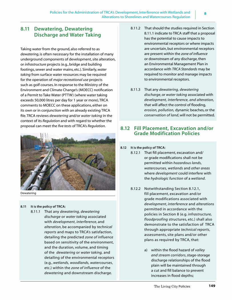
8
149
Policies for the Administration of TRCA’s Development, Interference with Wetlands and Alterations to Shorelines and Watercourses Regulation
The Living City Policies
8.11 Dewatering, Dewatering Discharge and Water Taking
Taking water from the ground, also referred to as dewatering, is often necessary for the installation of many underground components of development, site alteration, or infrastructure projects (e.g., bridge and building footings, sewer and water mains, etc.). Similarly, water taking from surface water resources may be required for the operation of major recreational use projects such as golf courses. In response to the Ministry of the Environment and Climate Change’s (MOECC) notification of a Permit to Take Water (PTTW) (where water taking exceeds 50,000 litres per day for 1 year or more), TRCA comments to MOECC on these applications, either on its own or in conjunction with an already existing TRCA file. TRCA reviews dewatering and/or water taking in the context of its Regulation and with regard to whether the proposal can meet the five tests of TRCA’s Regulation.
Dewatering
8.11 It is the policy of TRCA: 8.11.1 That any dewatering, dewatering
discharge or water taking associated with development, interference, and alteration, be accompanied by technical reports and maps to TRCA’s satisfaction, detailing the predicted zone of influence based on sensitivity of the environment, and the duration, volume, and timing of the dewatering or water taking, and detailing of the environmental receptors (e.g., wetlands, woodlands, watercourses, etc.) within the zone of influence of the dewatering and downstream discharge.
8.11.2 That should the studies required in Section 8.11.1 indicate to TRCA staff that a proposal has the potential to cause impacts to environmental receptors or where impacts are uncertain, but environmental receptors are present within the zone of influence or downstream of any discharge, then an Environmental Management Plan in accordance with TRCA Standards may be required to monitor and manage impacts to environmental receptors.
8.11.3 That any dewatering, dewatering
discharge, or water taking associated with development, interference, and alteration, that will affect the control of flooding, erosion, pollution, dynamic beaches, or the conservation of land, will not be permitted.
8.12 Fill Placement, Excavation and/or Grade Modification Policies
8.12 It is the policy of TRCA: 8.12.1 That fill placement, excavation and/
or grade modifications shall not be permitted within hazardous lands, watercourses, wetlands and other areas where development could interfere with the hydrologic function of a wetland.
8.12.2 Notwithstanding Section 8.12.1, fill placement, excavation and/or grade modifications associated with development, interference and alterations permitted in accordance with the policies in Section 8 (e.g. infrastructure, floodproofing structures, etc.) shall also demonstrate to the satisfaction of TRCA through appropriate technical reports, assessments, site plans and/or other plans as required by TRCA, that:
a) within the flood hazard of valley
and stream corridors, stage-storage discharge relationships of the flood plain will be maintained through a cut and fill balance to prevent increases in flood depths;

8 Policies for the Administration of TRCA’s Development, Interference with Wetlands and Alterations to Shorelines and Watercourses Regulation
150 The Living City Policies
b) the available volume at each type of floodplain storage (active and passive) be maintained at flood frequencies for all storm events up to and including the Regulatory flood;
c) for cut and fill operations: i. demonstrate no adverse
upstream or downstream hydraulic or fluvial impacts;
ii. avoid natural features, areas and systems contributing to the conservation of land;
iii. not extend into the meander belt; and
iv. satisfy the criteria for a stable slope, preferably 3:1 or flatter.
d) within hazardous lands associated with the Lake Ontario shoreline, coastal processes are not aggravated on the site or adjacent/flanking properties within the shoreline reach/sector; and
e) the quality of the fill material shall not impact the control of pollution and the conservation of land.
8.12.3 That for large-scale fill placement proposals, applicants are required to pre-consult with TRCA staff to confirm the scope of required studies and supporting documentation for a complete application prior to submission. Pre-consultation shall include coordination and consultation with the municipality, and any other applicable agencies that may have an interest in the application.
8.13 Implementation and Compliance
The implementation of TRCA’s regulatory program pursuant to Section 28 of the Conservation Authorities Act shall be subject to the following:
Review and Approval Process:
8.13 It is the policy of TRCA: 8.13.1 To require pre-consultation with applicants
to provide clarity and direction in order to
facilitate receipt of complete applications and to streamline the permit application review and decision-making process.
8.13.2 That complete applications for permission for development, interference, or alteration under TRCA’s Section 28 Regulation shall be processed in accordance with review procedures outlined in TRCA’s Planning and Development Procedural Manual and in accordance with the policies in Section 8 of this document.
8.13.3 That TRCA may permit development, interference, or alteration within a Regulated Area, if in the opinion of TRCA, the control of flooding, erosion, dynamic beaches, pollution or the conservation of land is not affected.
8.13.4 That permissions pursuant to Section 8.13.3 may be issued with or without conditions.
8.13.5 That further to Sections 8.13.3 to 8.13.4, permissions may be issued, with or without conditions, for development, interference or alteration under TRCA’s Section 28 Regulation, in accordance with Streamlining Protocols delegated by TRCA’s Authority to designated TRCA staff (e.g. Standard Permits, Minor Works, Routine Infrastructure Works, etc.) outlined in TRCA’s Planning and Development Procedural Manual.
8.13.6 To be consistent with MNRF’s “Policies and Procedures for Conservation Authority Plan Review and Permitting Activities”.
8.13.7 That TRCA will adhere to the MNRF/CO Hearing Guidelines (2005). Where TRCA staff can not recommend approval of an application or where an applicant does not agree to the conditions of a permission, the applicant will be afforded the opportunity to appear before TRCA’s Hearing Board, in accordance with the Guidelines.

8
151
Policies for the Administration of TRCA’s Development, Interference with Wetlands and Alterations to Shorelines and Watercourses Regulation
The Living City Policies
8.13.8 That in undertaking its regulatory responsibilities under Section 28 of the Conservation Authorities Act, TRCA will coordinate with other applicable agreements, relevant federal and provincial legislation, to the extent possible.
8.13.9 That through the review of applications under the Planning Act, Environmental Assessment Act and any other related legislation, TRCA will ensure the applicant and municipal planning authority are aware of the requirements of TRCA’s Regulation under Section 28 of the Conservation Authorities Act, where applicable, and to assist in the coordination of the planning and Regulation approvals process to avoid ambiguity, conflict and unnecessary delay or duplication to the extent possible.
Compliance: 8.13.10 To ensure compliance with TRCA’s Section
28 Regulation and policies, TRCA will undertake the following approach to compliance:
Preventative Approach: • Provide information to stakeholders • Liaise with proponents, contractors,
municipal partners on approved permits sites
• Regularly inspect construction sites for compliance with approved permits and conditions
Responsive Approach: • Resolve minor infractions through
landowner cooperation • Resolve violations by notice through
discussions and negotiations for removal, and restoration where possible
• Pursue legal proceedings when necessary to ensure compliance
8.13.11 Where TRCA staff recommend that an approved permission be canceled, the applicant will be afforded the opportunity to appear before TRCA’s Hearing Board.

152
Glossary Definitions of terms used in the document
The Living City Policies
impact on the feature or areas. The extent of the adjacent lands may be recommended by the Province or based on municipal approaches which achieve the same objectives. (Provincial Policy Statement, 2014)
Allowance – the distance from a hazard/feature prescribed in TRCA’s Regulation to delineate the regulated area.
Alteration – within the context of Section 8.0 of the LCP, straightening, changing, diverting an existing channel of a river, creek, stream or watercourse or changes to the Lake Ontario shoreline.
Approval Authority – in the land use and development context, this includes any public body (e.g., municipality, conservation authority, provincial ministry) that has the authority to regulate and approve development projects that fall under its mandate and jurisdiction (e.g., Planning Act, Environmental Assessment Act, Aggregate Resources Act, Conservation Authorities Act).
Aquitards – a geologic formation that is permeable enough to transmit groundwater in quantities that are significant in the study of regional groundwater flow, but not permeable enough to allow the completion of production wells within them. In southern Ontario, they are typically formed as the result of depositional processes from ancient shallow seas and lakes, and comprise silt, clay, and lower permeability limestone and shale.
A
Accessory building or structure – a non-habitable building or structure that is subordinate and exclusively devoted to a main use, building, or structure, and is located on the same lot as the main use, building or structure to which it is subordinate.
Adaptation – any action taken to minimise the adverse effects of climate change, or to take advantage of any beneficial effects of climate change. If mitigation measures are able to reduce the scale of change or extend the length of time over which it occurs, adaptation becomes much easier.
Adaptive management – an iterative approach to policy, planning, design, construction and monitoring that facilitates adaptation to changing environmental conditions over time.
Addition – any works occurring on an existing building or structure that serve to increase the total area of that building or structure. Adjacent lands - those lands contiguous to a specific natural heritage feature or area where it is likely that development or site alteration would have a negative
GlossaryGlossary Definitions of terms used in the document

153
GlossaryDefinitions of terms used in the document
The Living City Policies
Aquifer – a saturated permeable geologic unit that can transmit significant quantities of groundwater under ordinary hydraulic gradients. They can be classified as confined or unconfined. In southern Ontario, aquifers are typically comprised of sand and/or gravel, or fractured limestone.
Archaeological Assessment – for a defined project area or property, a survey undertaken by a licensed archaeologist within those areas determined to have archaeological potential in order to identify archaeological sites, followed by evaluation of their cultural heritage value or interest, and determination of their characteristics. Based on this information, recommendations are made regarding the need for mitigation of impacts (including long-term protection planning) and the appropriate means for mitigating those impacts.
Archaeological Resources – includes artifacts, archaeological sites and marine archaeological sites as defined under the Ontario Heritage Act. The identification and evaluation of such resources are based upon archaeological fieldwork undertaken in accordance with the Ontario Heritage Act. (Provincial Policy Statement, 2014)
Archaeological Site – defined in Ontario Regulation 170/04 as “any property that contains an artifact or any other physical evidence of past human use or activity that is of cultural heritage value or interest.”
Area of Interference – see Other Areas/Areas of Interference
Areas of Natural and Scientific Interest (ANSIs) – areas of land and water containing natural landscapes or features that have been identified (by the Province) as having science or earth science values related to protection, scientific study or education. (Provincial Policy Statement , 2014)
B
Bankfull Discharge – the formative flow of water that characterizes the morphology (shape) of a fluvial channel. In a single channel stream, bankfull is the discharge which just fills the channel without flowing onto the flood plain.
Baseflow – that portion of stream flow derived from groundwater storage to surface streams.
Biodiversity – the variability among organisms from all sources including terrestrial, marine and other aquatic ecosystems and the ecological complexes of which they are part; this includes diversity within species and ecosystems.
Buffer – a strip of permanent vegetation that helps alleviate the negative impacts of development on natural features and functions and can include a non-vegetated erosion access allowance (also see definition for erosion access allowance) required to manage a natural hazard.
Built Heritage Resources – means a building, structure, monument, installation or any manufactured remnant that contributes to a property’s cultural heritage value or interest as identified by a community, including an Aboriginal community. (Provincial Policy Statement, 2014)
Built Green Elements – in the context of green infrastructure, they are human-created systems and technologies that are designed to mimic ecological functions to reduce environmental impacts from human activities, such as stormwater management ponds, green roofs, green walls, permeable pavement, and rainwater harvesting.
C
Class Environmental Assessment – is an environmental assessment done for a group, or “class” of projects that are carried out routinely and have predictable and mitigable environmental effects.
Compensation – in the context of conservation and land use planning, compensation is defined as the replacement of lost/altered ecosystem services or ecological function. Comprehensive Environmental Study – a study or plan undertaken by, or under the direction of, a public agency at a landscape scale including watershed plans, subwatershed studies, environmental implementation reports, environmental management plans, or similar documents, that have been prepared to address and
Glossary

154
Glossary Definitions of terms used in the document
The Living City Policies
document various alternatives and are part of a joint and harmonized planning process, or community plans that include comprehensive environmental impact studies.
Conservation Easement – legally binding instruments whereby the landowner transfers/relinquishes specific rights, such as the ability to create building lots or cut trees, to an easement holder (usually a nature conservation organization or agency). Depending on the terms of the conservation easement agreement, the easement holder has the right and responsibility to inspect the property and ensure the terms of the conservation easement are being respected.
Conservation of Land – the protection, management or restoration of lands within the watershed ecosystem for the purpose of maintaining or enhancing the natural features and ecological functions and hydrological functions, within the watershed. (Conservation Ontario, 2008) Conservation of land includes all aspects of the physical environment, be it terrestrial, aquatic, biological, botanic or air and the relationship between them (611428 Ontario Ltd. vs. Metropolitan Toronto and Region Conservation Authority).
Conservation Project – activities, buildings or structures for conservation and hazard management purposes on publicly-owned lands such as, but not limited to: flood and erosion control works, habitat creation and enhancement, tree and shrub planting, environmental education, trails and low intensity recreation activities, cultural heritage and archaeological preservation and interpretation and conservation parks.
Conservation-Related Accessory Uses – a use of land, buildings or structures and associated activities that is incidental or subordinate to the principal conservation project use, building, structure or activity located on the same lot, and may include activities such as, but not limited to: farmers markets, demonstration or pilot projects and facility rentals for environmentally-themed meetings, conferences and social events.
Cultural Heritage Landscapes - a defined geographical area that may have been modified by human activity and is identified as having cultural heritage value or interest by a community, including an Aboriginal community. The area may involve features such as structures, spaces, archaeological sites or natural elements that are
valued together for their interrelationship, meaning or association. (Provincial Policy Statement, 2014)
Cultural Heritage Value or Interest - For the purposes of the Ontario Heritage Act and its regulations, archaeological resources that possess cultural heritage value or interest are protected as archaeological sites under Section 48 of the act. Where analysis of documented artifacts and physical features at a given location meets the criteria stated in the Standards and Guidelines, that location is protected as an archaeological site and further archaeological assessment may be required.
Cumulative Impacts – a number of individual impacts viewed in combination on a regional, watershed, subwatershed or reach basis.
D
Designated Greenfield Area – the area within a settlement area that is not built up area. Where a settlement area does not have a built boundary, the entire settlement area is considered designated greenfield area. (Growth Plan for the Greater Golden Horseshoe, 2006)
Designated Vulnerable Areas – areas defined as vulnerable, in accordance with provincial standards, by virtue of their importance as a drinking water source. (Provincial Policy Statement, 2014) Iin the context of source water protection pursuant to the Clean Water Act, they arevulnerable areas are areas containing a significant groundwater recharge area, a highly vulnerable aquifer, a surface water intake protection zone, or a wellhead protection area. (Clean Water Act, 2006 - O. Reg 28/07)
Development (in Section 8.0 – permitting) – as defined in the Conservation Authorities Act - (a) the construction, reconstruction, erection or placing of a building or structure of any kind, (b) any change to a building or structure that would have the effect of altering the use or potential use of the building or structure, increasing the size of the building or structure or increasing the number of dwelling units in the building or structure, (c) site grading, or (d) the temporary or permanent placing, dumping or removal of any material, originating on the site or elsewhere.

155
GlossaryDefinitions of terms used in the document
The Living City Policies
Development (in Section 7.0 – planning) - as defined in the Provincial Policy Statement, 2014 - The creation of a new lot, a change in land use, or the construction of buildings and structures, requiring approval under the Planning Act, but does not include: a) activities that create or maintain infrastructure authorized under an environmental assessment process; b) works subject to the Drainage Act; or c) for the purposes of policy 2.1.3(b), underground or surface mining of minerals or advanced exploration on mining lands in significant areas of mineral potential in Ecoregion 5E, where advanced exploration has the same meaning as under the Mining Act. Instead, those matters shall be subject to policy 2.1.4(a). (Also see the definitions of site alteration and infrastructure)
Development Limit – the point to which development can extend, defined by the greater extent of natural hazards and natural features plus any applicable potential natural cover, buffer, freeboard, or erosion access allowance.
Dewatering and Dewatering Discharge – extraction of water from the ground, for the purposes of controlling groundwater, and expelling that water after it is extracted.
Dripline - the downward vertical projection of the outer most extent of tree branches.
Dynamic Beach Hazard - areas of inherently unstable accumulations of shoreline sediments along Lake Ontario, as identified by provincial standards. The dynamic beach hazard limit consists of the flood hazard limit plus a dynamic beach allowance. (Provincial Policy Statement, 2014)
E
Ecological Function – the natural processes, products or services that living and non-living environments provide or perform within or between species, ecosystems, and landscapes. These may include biological, physical, and socio-economic interactions (Provincial Policy Statement)
Ecological Integrity – in the context of the Oak Ridges Moraine Conservation Plan, including hydrological integrity, the condition of ecosystems in which, (a) the structure, composition and function of the ecosystems
are unimpaired by stresses from human activity, (b) natural ecological processes are intact and self-sustaining, and (c) the ecosystems evolve naturally.
Ecological Land Classification - the Canadian classification of lands from an ecological perspective; an approach that attempts to identify ecologically similar areas.
Ecosystem Services - the benefits provided by ecosystems that are critical to the environment’s life support systems and that contribute to human welfare both directly and indirectly and therefore represent social and economic value.
Encumbrance - a right to, interest in, or legal liability on real property that does not prohibit passing title to the property but that diminishes its value.
Endangered Species - means a species that is listed or categorized as an “Endangered Species” on the Ontario Ministry of Natural Resources and Forestry official species at risk list, as updated and amended from time to time. (Provincial Policy Statement, 2014)
Environmental Assessment - a study that is completed by the proponent to assess the potential environmental effects (positive or negative) of an individual project, pursuant to the Environmental Assessment Act. Key components of an environmental assessment include: consultation with government agencies and the public; consideration and evaluation of alternatives; the management of potential environmental effects. Proponents can include the provincial government, municipal governments, and public organizations such as conservation authorities. The environmental assessment program generally does not apply to the private sector. However, sometimes private firms are required by a regulation or may voluntarily go through an environmental assessment process.
Environmental Flow Threshold – the minimum in-stream flow necessary to maintain the ecological function of a watercourse.
Environmentally Significant Areas –areas identified by a municipality or by a (previous) TRCA program based on specific criteria.

156
Glossary Definitions of terms used in the document
The Living City Policies
Erosion (as a natural process) - the process of gradual washing away of soil by water movement or seepage (at the ground surface), commonly occurring in one of the following manners:
a) rainfall or snowmelt and surface runoff (sheet, rill, or gully erosion);
b) internal seepage and piping; c) water flow (banks or base of river, creek,
channel); and d) wave action (shorelines of ponds, lakes, bays)
The erosion process affects the soil at the particle level by dislodging and removing (transporting) the soil particles from the parent mass (with water movement as the agent). Other processes such as wind and frost may assist in the weathering or dislodging and transport of soil particles.
Erosion Access Allowance – the setback needed to ensure there is a large enough safety zone for people and vehicles to enter and exit an area during an emergency, such as a slope failure or flooding, and to provide sufficient area to access and maintain protection works along valley and stream corridors and the Lake Ontario shoreline.
Erosion Allowance - where there is no reliable recession information, the province recommends a setback distance (30 metres) to allow for erosion along the Great Lakes-St. Lawrence River system (including the Lake Ontario Shoreline). Along the Lake Ontario Shoreline, TRCA requires a 30-metre erosion allowance based on 0.3 metres average erosion rate per year extended over a 100-year time period.
Erosion Hazard – the loss of land, due to human or natural processes, that poses a threat to life and property. The erosion hazard limit is determined using considerations that include the 100-year erosion rate (the average annual rate of recession extended over a one hundred year time span), an allowance for slope stability, and an erosion/erosion access allowance. (Provincial Policy Statement, 2014)
To fulfill TRCA’s Regulatory responsibilities, the erosion hazard limit shall be established in accordance with the text of TRCA’s Regulation (refer to Appendix C).
Essential Emergency Service – services which would be impaired during an emergency as a result of flooding, the failure of floodproofing measures and/or protection works, and/or erosion.
Evapotranspiration – The combined loss of water to the atmosphere from land and water surfaces by evaporation and from plants by transpiration.
Existing natural cover – that portion of natural cover of the target terrestrial natural heritage system that is existing.
Existing Vacant Lot of Record – A parcel or tract of land described in a deed or other legal document that is capable of being legally conveyed, containing no pre-existing buildings or structures.
F F
Fee Simple (ownership) – ownership of a property that entails the full bundle of rights associated with owning a property.
Fish – includes (a) parts of fish, (b) shellfish, crustaceans, marine animals and any parts of shellfish, crustaceans or marine animals and (c) the eggs, sperm, spawn, larvae, spat and juvenile stages of fish, shellfish, crustaceans and marine animals (Fisheries Act, section 2).
Fish Habitat – spawning grounds and any other areas, including nursery, rearing, food supply and migration areas on which fish depend directly or indirectly in order to carry out their life processes (Fisheries Act, section 2(1).
Fisheries Timing Window – as established by the Ministry of Natural Resources and Forestry and applied by TRCA staff, that window of time when construction around or in-water is permitted, given that critical life stages of fish take place outside of this window; there are both cold water and warm water fisheries timing windows.
Five Tests (of a permit application under TRCA’s section 28 Regulation) – the control of flooding, erosion, dynamic beaches, pollution, and conservation of land.
Flood Fringe – for river, stream and small inland lake systems, means the outer portion of the flood plain between the floodway and the flooding hazard limit. Depths and velocities of flooding are generally less severe in the flood fringe than those experienced in the floodway. (Provincial Policy Statement, 2014)

157
GlossaryDefinitions of terms used in the document
The Living City Policies
Flood Hazard – means the inundation, under the conditions specified below, of areas adjacent to a shoreline or a watercourse and not ordinarily covered by water (note: high points of land not subject to flooding but surrounded by floodplain or flooded land are considered to be within the flood hazard):
Lake Ontario Flood Hazard Limit - the one hundred year flood, plus an allowance for wave uprush and other water-related hazards.
Riverine Flood Hazard Limit – the flood produced by the Hurricane Hazel storm event or the one hundred year flood, whichever is greater.
Flood Plain – The area, usually low lands adjoining a watercourse, which has been or may be subject to flood hazards. (Provincial Policy Statement, 2014)
Flood Plain Spill Area – where flood waters are not physically contained within the valley or stream corridor and exit to surrounding lands. As a consequence, the limit and depth of flooding are difficult to determine. Flood spill areas occur naturally, or can occur as a result of downstream barriers to the passage of flood flows, such as undersized bridges or culverts.
Floodproofing – the combination of measures incorporated into the basic design and/or construction of buildings and structures or properties to reduce or eliminate flood hazards, wave uprush and other water-related hazards along the shoreline of Lake Ontario, and flood hazards along watercourses. (Provincial Policy Statement, 2014) There are three different types of floodproofing:
• Dry Passive floodproofing – includes the use of fill, columns, or design modifications to elevate openings in the building or structure at, or above, the level of the flood hazard. These measures do not require flood warning or any other action to put the flood protection into effect.
• Dry Active floodproofing – includes techniques such as installing water tight doors, seals or floodwalls to prevent water from entering openings below the level of the flood hazard. Advance warning is almost always required to make the flood protection operational (i.e. closing of water tight doors, installation of waterproof protective coverings or windows etc.).
• Wet floodproofing – involves designing a building or structure using materials, methods and design measures that maintain structural integrity by avoiding external unbalanced forces from acting on buildings or structures during and after a flood, to reduce flood damage to contents, and to reduce the cost of post flood clean up. Buildings and structures are designed so as to intentionally allow flood waters to enter and exit, ensuring the interior space below the level of the flood hazard remains unfinished, non-habitable, and free of service units and panels.
Flood Vulnerable Area – sub-area within the Regulatory Storm Flood Plain containing multiple existing structures and/or roads for which a single, comprehensive flood remediation approach may be viable.
Floodway – for river, stream and small inland lake systems, the portion of the flood plain where development and site alteration would cause a danger to public health and safety or property damage. Where the One-Zone concept is applied, the floodway is the entire contiguous flood plain. Where the Two-Zone concept is applied, the floodway is the contiguous inner portion of the flood plain, representing that area required for the safe passage of flood flow and/or that area where flood depths and/or velocities are considered to be such that they pose a potential threat to life and/or property damage. Where the two zone concept applies, the outer portion of the flood plain is called the flood fringe. (Provincial Policy Statement, 2014)
Freeboard – a safeguard of separation in either length (linear - a specified distance) or height (vertical - a specified elevation) from the Regulatory Flood Plain or other specified flood level.
G
Green Infrastructure – natural vegetation, vegetative systems, soil in volumes and qualities adequate to sustain vegetation and absorb water, and supportive green technologies that replicate ecosystem functions. (Also see natural green elements and built green elements)
Greenfield Development – development taking place on formerly vacant/agricultural land usually situated within the outer reaches of an urban envelope, usually on a block-wide scale.
158
Glossary Definitions of terms used in the document
The Living City Policies
Groundwater Discharge – The removal of water from the saturated zone across the water-table surface, together with the associated flow toward the water table within the saturated zone.
Groundwater Feature – water related features in the earth’s subsurface, including recharge/discharge areas, water tables, aquifers and unsaturated zones that can be defined by surface and subsurface hydrogeological investigations. (Provincial Policy Statement, 2014)
Groundwater Recharge – The entry into the saturated zone of water made available at the water-table surface, together with the associated flow away from the water table within the saturated zone.
Groundwater Reservoir – An aquifer or aquifer system in which groundwater is stored. The water may be placed in the aquifer by artificial or natural means.
H
Habitable – that portion of a building or structure containing rooms or spaces required and intended for overnight occupancy and associated living space, and includes those portions which contain facilities for storage (not including garages), heating, air-conditioning, electrical, hot water supplies, etc., which are necessary to maintain the habitable condition.
Habitat of Endangered and Threatened Species –Habitat of endangered species and threatenedspecies: means a) with respect to a species listed on the Species at Risk in Ontario List as an endangered or threatened species for which a regulation made under clause 55(1)(a) of the Endangered Species Act, 2007 is in force, the area prescribed by that regulation as the habitat of the species; or b) with respect to any other species listed on the Species at Risk in Ontario List as an endangered or threatened species, an area on which the species depends, directly or indirectly, to carry on its life processes, including life processes such as reproduction, rearing, hibernation, migration or feeding, as approved by the Ontario Ministry of Natural Resources and Forestry; and places in the areas described in clause (a) or (b), whichever is applicable, that are used by members of the species as dens, nests, hibernacula or other residences. (Provincial Policy Statement, 2014)
Hazardous Lands (in Section 8 – permitting) - land that could be unsafe for development because of naturally occurring processes associated with flooding, erosion, dynamic beaches or unstable soil or bedrock. (Conservation Authorities Act, 1990)
Hazardous Lands (in Section 7 – planning) - property or lands that could be unsafe for development due to naturally occurring processes. Along the shorelines of the Great Lakes - St. Lawrence River System, this means the land, including that covered by water, between the international boundary, where applicable, and the furthest landward limit of the flooding hazard, erosion hazard or dynamic beach hazard limits. Along the shorelines of large inland lakes, this means the land, including that covered by water, between a defined offshore distance or depth and the furthest landward limit of the flooding hazard, erosion hazard or dynamic beach hazard limits. Along river, stream and small inland lake systems, this means the land, including that covered by water, to the furthest landward limit of the flooding hazard or erosion hazard limits. (Provincial Policiy Statement, 2014)
Hazardous Sites - property or lands that could be unsafe for development and site alteration due to naturally occurring hazards. These may include unstable soils (sensitive marine clays [leda], organic soils) or unstable bedrock (karst topography). (Provincial Policy Statement, 2014)
Headwater Drainage Feature (HDFs) – ill-defined, non-permanently flowing drainage features that may not have defined bed or banks; they are zero-order intermittent and ephemeral channels, swales and rivulets, but do not include rills or furrows (also see watercourse). HDFs that have been assessed through TRCA’s Evaluation, Classification and Management of Headwater Drainage Features Guideline, as “protection” and “conservation” are subject to TRCA’s Regulation; those assessed as “mitigation” may be subject to TRCA’s Regulation.
Highly Vulnerable Aquifer - an aquifer on which external sources have or are likely to have a significant adverse effect, and includes the land above the aquifer. (Clean Water Act, 2006 – O. Reg. 28/07)
Hydraulic Floodway - In Section 8.0 of The Living City Policies, the inner portion of the flood plain where flood depths and velocities are generally higher and faster

159
GlossaryDefinitions of terms used in the document
The Living City Policies
flowing than those experienced in the outer or fringe portion of the overall flood plain. The hydraulic floodway represents that area required for the safe passage of flood flow and/or that area where flood depths and/or velocities are considered to be such that they pose a significant threat to life and/or property damages.
Hydraulics – is the study of how surface water moves through various pathways in terms of water depth, velocity, and pressures acting on hydraulic structures and systems.
Hydrogeology – a science that describes the movement of groundwater (water beneath the ground surface), and its interaction with water that moves on the ground surface in rivers, lakes, streams, and over land. Groundwater seeps into the ground to varying depths and collects in aquifers. Groundwater can remain stored underground for periods ranging from a few days to thousands of years.
Hydroperiod - the seasonal pattern of surface and groundwater level fluctuations within a natural feature.
Hydrologic Cycle – see water balance and water budget.
Hydrologic Function - the functions of the hydrological cycle that include the occurrence, circulation, distribution, and chemical and physical properties of water on the surface of the land, in the soil and underlying rocks, and in the atmosphere, and water’s interaction with the environment including its relation to living things. (Provincial Policy Statement, 2014)
Hydrologic Features – in the Greenbelt, as designated under the Greenbelt Plan, and on the Oak Ridges Moraine (hydrologically sensitive features), as designated under the Oak Ridges Moraine Conservation Plan.
Hydrology - is the engineering science that analyzes the different components of the hydrologic cycle, and takes into account that the natural cycle can be altered by human and natural activities.
I
Infill Lot – an existing vacant lot of record and situated between existing urbanized/developed lots fronting onto a public road.
Infiltration – The downward entry of water through the soil surface into the soil. (MNR Water Resources Glossary)
Infrastructure – means physical structures (facilities and corridors) that form the foundation for development. Infrastructure includes: sewage and water systems, septage treatment systems, stormwater management systems, waste management systems, electricity generation facilities, electricity transmission and distribution systems transportation corridors and facilities, oil and gas pipelines and associated facilities. (Provincial Policy Statement, 2014)
Intensification - the development of a property, site, or area at a higher density than currently exists through: a) redevelopment, including the reuse of brownfield sites; b) the development of vacant and/or underutilized lots within previously developed areas; c) infill development; and, d) the expansion or conversion of existing buildings. (PPS, 2014)
Interference (or Interfering in any way) - any anthropogenic act or instance which hinders, disrupts, degrades or impedes in any way the natural features or hydrologic and ecologic functions of a wetland or watercourse. (Conservation Ontario, 2008)
K
Kettle Lakes – depressions created by partially-buried glacial ice blocks as they melted. The depressions that filled with water became kettle lakes. Kettle lakes are not connected to a watercourse. An example of a Kettle Lake in TRCA’s jurisdiction is Preston Lake in Whitchurch-Stouffville.
Key Natural Heritage Features – in the Greenbelt, as designated under the Greenbelt Plan, and on the Oak Ridges Moraine, as designated under the Oak Ridges Moraine Conservation Plan.
L
Lake Iroquois Shoreline – a post-glacial landform that represents a major rise in elevation extending from west to east across TRCA’s jurisdiction, inland from Lake Ontario.

160
Glossary Definitions of terms used in the document
The Living City Policies
Lake Ontario Shoreline Sector – there are four sectors of Lake Ontario shoreline in TRCA’s jurisdiction: Etobicoke, Central, Scarborough, Pickering/Ajax.
Lake Ontario Shoreline Reach – segments of shoreline usually having relatively uniform physical characteristics. The extent/length of shoreline reach to be considered in the application of The Living City Policies to be determined by TRCA.
Low Impact Development – a storm water management strategy that seeks to mitigate the impacts of increased runoff and stormwater pollution by managing runoff as close to its source as possible. It comprises a set of site design approaches and small scale stormwater management practices that promote the use of natural systems for infiltration, evapotranspiration, and reuse of rainwater.
M
Major Recreational Use – recreational facilities that require large scale modification of terrain, vegetation or both and usually also require large scale buildings or structures, and extensive parking areas, including but not limited to: golf courses, serviced playing fields, serviced campgrounds and ski hills.
Matrix Influence - the surrounding land-use of a habitat patch is known as “matrix”; In TRCA’s Terrestrial Natural Heritage System Strategy (2007), the influence the surrounding land-use has on a habitat patch is scored based on whether the area (2 km from a patch’s edge) is urban, agricultural or natural, and the score is known as the matrix influence.
Meander Belt Allowance – the area of land in which a watercourse channel moves or is likely to move over a period of time. The extent of the meander belt allowance is determined by a technical report using accepted scientific and engineering principles and includes considerations for meander amplitudes, erosion setbacks and factors of safety.
Minor Expansions (to major or minor recreational uses) – require very little modification of terrain or vegetation and few if any, buildings, structures and limited parking. Proper site planning, scoped environmental studies and
the incorporation of best management practices for site construction and future maintenance can generally minimize impacts to negligible levels.
Minor Recreational Use – are recreational facilities that require very little modification of terrain or vegetation and few if any, buildings, structures and limited parking or other impervious surfaces. They are of low intensity and a non-intrusive nature. They can include but are not limited to: non-motorized trails, boardwalks, picnic facilities, unserviced playing fields, natural heritage appreciation, unserviced camping on public and institutional land and accessory uses.
Mitigate - the prevention, modification or alleviation of impacts on the environment. It also includes any action with the intent to enhance beneficial effects.
Mitigation - the use of measures that seek to avoid, reduce or delay detrimental effects to the environment. In the context of climate change, it is actions to reduce greenhouse gas emissions.
N
Natural Cover - land occupied by naturally and culturally occurring native or non-native vegetation that is not characterized as agricultural or urban land uses.
Natural Green Elements – in the context of green infrastructure, they are traditional natural features such as trees, wetlands, riparian areas, and buffers that should be protected and restored in a natural heritage system, as well as open space agricultural lands and soils that provide water retention benefits.
Natural System - comprised of water resources, natural features and areas, natural hazards, and restoration areas of potential natural cover and buffers.
Navigable Water - includes a canal and any other body of water created or altered as a result of the construction of any work. (Navigation Protection Act, 1985)

161
GlossaryDefinitions of terms used in the document
The Living City Policies
O
One Hundred Year Erosion Rate – the average annual rate of recession over a hundred year time span.
One Hundred Year Flood – that flood, based on an analysis of precipitation, snow melt, or a combination thereof, having a return period of 100 years on average, or having a 1% chance of occurring or being exceeded in any given year. (Provincial Policy Statement, 2014)
One Hundred Year Flood (Lake Ontario) – the peak instantaneous still water level, plus an allowance for wave uprush and other water-related hazards for Lake Ontario in the Great Lakes-St. Lawrence River System that has a probability of occurrence of one per cent during any given year.
One Zone Concept – see Floodway
Original Ground Floor Area – the total area of the main floor of a building, (excluding decks, patios, garages and other accessory structures), as existed as existed at the time of the original construction date of the building.
Original Habitable Ground Floor Area – the total area of the main floor of a building containing rooms or spaces required and intended for overnight occupancy and associated living space, and includes those portions which contain facilities for storage (not including garages), heating, air-conditioning, electrical, hot water supplies, etc., which are necessary to maintain the habitable condition, as existed at the time of the original construction date of the building.
Other Areas/Area of Interference - areas where development could interfere with the hydrologic function of a wetland including areas within 120 metres of all provincially significant wetlands or wetlands on the Oak Ridges Moraine and areas within 30 metres of all other wetlands.
Other Inland Lakes – lakes that are not kettle lakes and are not connected a watercourse.
Other Wetlands – in the context of TRCA’s Regulation, any wetland that is not a provincially significant wetland and not on the Oak Ridges Moraine.
P
Pollution - any deleterious physical substance or other contaminant that has the potential to be generated by development in an area to which a regulation made under clause (1) (c) applies (Conservation Authorities Act, section 28(25))
Potential Natural Cover – land that is not existing natural cover, but has the potential to be restored.
Provincial Standards – the most recently approved legislation, regulations, policies, manuals and technical guidelines administered or prepared by the Province, as amended from time to time.
R
Reconstruction - the restoration, repair, or replacement of a building or structure within its original footprint, not to exceed its original ground floor area, gross floor area or height, and without any change to its original use.
Recreational Use – see definitions for major and minor recreational use.
Redevelopment – the creation of new units, uses or lots on previously developed land in existing communities, including brownfield sites. (Provincial Policy Statement, 2014)
Regional Flood Control – stormwater management control of flood flows from the regional storm event (Hurricane Hazel) to mitigate increases in flood risk associated with development (urbanization).
Regional Flood Control Facility – a flood control facility designed to control the Regional Storm.
Regional Storm – the rainfall event and soil conditions existing during Hurricane Hazel that occurred within the Humber River watershed in Toronto in 1954, transposed over a specific watershed and combined with local conditions.
162
Glossary Definitions of terms used in the document
The Living City Policies
Regional Storm Flood Line – measured in metres above sea level, the level to which the Regional Storm Flood Plain rises.
Regulated Area – the land described in, and subject to, TRCA’s Section 28 Regulation under the Conservation Authorities Act.
Regulation – TRCA’s Regulation under Section 28 of the Conservation Authorities Act for Development, Interference with Wetlands, and Alterations to Shorelines and Watercourses.
Regulation Limit – the greatest extent of all regulated areas that defines an area of interest; the regulation limit does not represent a development limit.
Regulatory Flood – the more severe of the Regional Storm and the 100-Year Storm.
Regulatory Flood Plain – the area adjacent to a watercourse that would be inundated by a flood resulting from the most severe of the Hurricane Hazel Flood Event Standard (Regional Storm) or the 100 Year Flood Event Standard, whichever is greater.
Rehabilitation - to restore the ecosystem to a higher functioning condition.
Remediation – the construction or modification of infrastructure for the purpose of reducing or eliminating risk due to natural hazards.
Renewable Energy - Energy obtained from sources that are essentially inexhaustible (unlike, for example, fossil fuels, of which there is a finite supply). Renewable sources of energy include conventional hydroelectric power, wood, waste, geothermal, wind, photovoltaic, and solar thermal energy.
Replacement – see reconstruction.
Restoration - to repair or re-establish functioning ecosystems; the process of altering a site to establish a defined, native, historic ecosystem; the goal is to emulate the structure, function, diversity and dynamics of a specified ecosystem.
River or Stream Valley (Apparent or Confined)/Valley Corridor - depressional features associated with a river or stream, whether or not they contain a watercourse, with defined slopes extending from the long term stable slope projected from the predicted stable toe of slope, plus a 15-metre allowance (in the context of defining the Regulated Area), or, an applicable buffer (in the context of defining the Natural System).
River or Stream Valley(Not Apparent or Unconfined)/Stream Corridor - depressional features associated with a river or stream, whether or not they contain a watercourse, with ill-defined slopes extending from the maximum extent of the predicted meander belt allowance of the river or stream; plus a 15-metre allowance (in the context of defining the Regulated Area), or, an applicable buffer (in the context of defining the Natural System).
S
Safe Access (Safe Ingress/Egress) – vehicular and pedestrian access to and from a site is safe, for the nature of the development, from the risks due to flooding or erosion hazards consistent with Provincial and TRCA standards.
Sediment - soils or other surface materials transported by wind or water as a result of erosion.
Sedimentation (water) - sedimentation is an increase in the amount of solid particles suspended in water, caused primarily by soil erosion. The main human causes of sedimentation are forestry, farming, and construction. When sediment settles, it can smother the feeding and spawning grounds of fish and kill aquatic organisms.
Shoreline Protection Works – engineered methods for shorelines located within hazards that reduce hazard losses by modifying the hazards at the shoreline. Protection approaches can be classified as either structural or non-structural.
(Provincially) Significant - a) in regard to wetlands, coastal wetlands and areas of natural and scientific interest, an area identified as provincially significant by the Ontario Ministry of Natural Resources and Forestry using evaluation procedures established by the Province, as amended from time to time;

163
GlossaryDefinitions of terms used in the document
The Living City Policies
b) in regard to woodlands; an area which is ecologically important in terms of features such as species composition to the broader landscape because of its location, size or due to the amount of forest cover in the planning area; or economically important due to site quality, species composition, or past management history. These are to be identified using criteria established by the Ontario Ministry of Natural Resources and Forestry; and
c) in regard to other features and areas in policy 2.1 (of the PPS), ecologically important in terms of features, functions, representation or amount, and contributing to the quality and diversity of an identifiable geographic area or natural heritage system.
d) in regard to mineral potential, an area identified as provincially significant through evaluation procedures developed by the Province, as amended from time to time, such as the Provincially Significant Mineral Potential Index; and
e) in regard to cultural heritage and archaeology, resources that have been determined to have cultural heritage value or interest for the important contribution they make to our understanding of the history of a place, an event, or a people.
Criteria for determining significance for the resources identified in sections (c)-(e) are recommended by the Province, but municipal approaches that achieve or exceed the same objective may also be used.
While some significant resources may already be identified and inventoried by official sources, the significance of others can only be determined after evaluation. (Provincial Policy Statement, 2014)
Significant Groundwater Recharge Area – in the context of source water protection pursuant to the Clean Water Act, it is an area within which it is desirable to regulate or monitor drinking water threats that may affect the recharge of an aquifer. (Clean Water Act, 2006 – O. Reg. 28/07) Site Alteration - means activities such as grading, excavation, and the placement of fill that would change the landform and natural vegetative characteristics of a site. (Provincial Policy Statement, 2014)
Special Policy Area - means an area within a community that has historically existed in the flood plain and where site-specific policies, approved by both the the Ministers of Natural Resources and Forestry and Municipal Affairs and Housing, are intended to provide for the continued viability of existing uses (which are generally on a small scale) and address the significant social and economic hardships to the community that would result from strict adherence to provincial policies concerning development. The criteria and procedures for approval are established by the Province. A Special Policy Area is not intended to allow for new or intensified development and site alteration, if a community has feasible opportunities for development outside the flood plain. (Provincial Policy Statement, 2014)
Species of (Conservation) Concern – according to the TRCA methodology, any species with a local rank of L1 to L3, and those L4 species found within the Built-up Area. Generally species that are disappearing in the regional landscape, primarily as a result of land use changes. Species of Concern can also be used as indicators – a surrogate measure - of ecosystem function. Improvements in their distribution may indicate an improving trend in ecosystem or regional health.
Stable Slope Allowance - Defined Valleylands - the setback that ensures safety if the slumping or slope failure occur. It refers to a horizontal allowance measured landward from the toe erosion allowance equivalent to three times the height of the slope or through valid study; and - Lake Ontario Shoreline - the predicted long term stable slope projected from the stable toe of slope as may be shifted as a result of erosion over a hundred year period.
Stable Toe of Slope – as determined through a geotechnical study:
a) the physical toe of slope where the existing toe is stable and not impacted by erosion; or
b) the landward limit of the toe erosion allowance where the existing slope is unstable and/or impacted by erosion.
Stable Top of Slope/Bank (long term stable slope line) – as determined through a geotechnical study: a) the physical top of slope where the existing slope is stable and not impacted by toe erosion; or b) the landward limit of the toe erosion allowance plus the

164
Glossary Definitions of terms used in the document
The Living City Policies
stable slope allowance where the existing slope is unstable and/or impacted by erosion.
Stormwater – Precipitation that accumulates in natural and/or constructed storage and stormwater systems during and immediately following a storm.
Stormwater Management - Functions associated with planning, designing, constructing, maintaining, financing and regulating the facilities (both constructed and natural) that collect, store, control and/or convey stormwater.
Stream Corridor – see River or Stream Valley (Not Apparent or Unconfined)
Subwatershed - A subdivision of a watershed based on hydrology, generally corresponding to the area drained by a small tributary, as opposed to a major river.
Subwatershed Drainage Diversion – diverting stormwater from one subwatershed to another.
Surface water feature - water-related features on the earth’s surface, including headwaters, rivers, stream channels, inland lakes, seepage areas, recharge/discharge areas, springs, wetlands, and associated riparian lands that can be defined by their soil moisture, soil type, vegetation or topographic characteristics. (Provincial Policy Statement, 2014)
Surface water intake protection zone – in the context of source water protection pursuant to the Clean Water Act, it is an area that is related to a surface water intake and within which it is desirable to regulate or monitor drinking water threats. (Clean Water Act, 2006 – O. Reg. 28/07)
Sustainable Energy – includes but is not limited to renewable energy sources such as hydroelectricity, solar energy (photovoltaic and heat), wind energy, wave power, geoexchange, bio-fuels and improvements in energy efficiency, distributed generation and district energy systems.
Sustainable Near-Urban Agriculture - The practice of growing food and production of livestock in a way that preserves and enhances the environment, provides economic opportunity and good health for individuals and communities, and connects people to the land around them. It generally avoids long-distance travel,
striving instead to create fresh, healthy produce for local consumption. It focuses on both processes and produce. It is as much about the systems that create our food (i.e., who grows it, where, and how much) as it is about the food itself.
T
Target Terrestrial Natural Heritage System – the existing terrestrial natural heritage system and potential natural cover, as identified in TRCA’s Terrestrial Natural Heritage System Strategy, 2007.
Technical Reports - means reports, studies or plans, typically prepared to support and implement the recommendations of a comprehensive environmental study, that provide detailed information regarding one or more aspects of the natural or physical sciences. For the purposes of this document, technical reports may include, but are not limited to, hydraulic analyses, stormwater management reports, functional servicing reports, hydrogeology reports, geomorphology studies, geotechnical reports and environmental impact studies, or similar documents. Technical reports must be prepared by a qualified professional in the relevant field.
Threatened Species - means a species that is listed or categorized as a “Threatened Species” on the Ontario Ministry of Natural Resources and Forestry’s official species at risk list, as updated and amended from time to time. (Provincial Policy Statement, 2014)
Three-Hundred and Fifty (350-Year) Storm Flood Plain – the area adjacent to a watercourse that would be inundated by a flood resulting from a 350-Year Storm.
Toe erosion allowance - the setback that ensures safety if the toe of the slope adjacent to the river or stream erodes and weakens the bank, increasing the risk of slumping.
Top of (valley) Bank (staked or physical) – the physical top of the valley bank is that point where there is a break in slope or grade which distinguishes the valley corridor landform from its surrounding landscape.
Treatment Train Approach – providing stormwater treatment first, at the lot level, then in conveyance, followed by “end-of-pipe” (where stormwater gets

165
GlossaryDefinitions of terms used in the document
The Living City Policies
discharged). A treatment train is required to meet the multiple objectives of water balance, water quality, erosion control and flood control in an overall stormwater management strategy.
TRCA Standards - the most recently approved technical guidelines and checklists in TRCA’s Planning and Development Procedural Manual, as amended from time to time.
Two Zone Concept – see Floodway
U
Urban Forest - All trees, shrubs and understorey plants, as well as the soils that sustain them, on public and private property within an urban setting.
Urban heat island effect - a “dome” of elevated temperatures over an urban area caused by structural and pavement heat fluxes, and pollutant emissions.
V
Valley Corridor – see River or Stream Valley (Apparent or Confined)
Valleyland – land that has depressional features associated with a river or stream whether or not it contains a watercourse (Ontario Regulation 166/06 as amended) or a natural area that occurs in a valley or other landform depression that has water flowing through or standing for some period of the year (Provincial Policy Statement, 2014) (also see Valley Corridor)
Valley Wall – the valley slope, from the stable toe of slope to its stable top of bank.
W
Water Balance – the hydrologic cycle of precipitation, groundwater infiltration, evapotranspiration (into the atmosphere and by plant interception), and surface runoff.
Water Budget – the mathematical expression of the water balance.
Watercourse – an identifiable depression in the ground in which a flow of water regularly or continuously occurs (Conservation Authorities Act) - also see headwater drainage feature.
Watershed – the entire area of land whose runoff water, sediments and dissolved materials (nutrients and contaminants) drain into a lake, river, creek, or estuary. Its boundary can be located on the ground by connecting all the highest points of the area around the river, stream or creek, where water starts to flow when there is rain. It is not man-made and it does not respect political boundaries.
Water Taking – extracting water, either from the ground, or from the surface of a water body.
Wellhead Protection Area - an area that is related to a wellhead and within which it is desirable to regulate or monitor drinking water threats. (Clean Water Act, 2006 – O. Reg. 28/07)
Wave Uprush – the rush of water up onto a shoreline or structure following the breaking of a wave; the limit of wave uprush is the point of furthest landward rush of water onto the shoreline.
Wetlands - as it pertains to the Planning Act and the Provincial Policy Statement, wetland means lands that are seasonally or permanently covered by shallow water, as well as lands where the water table is close to or at the surface. In either case the presence of abundant water has caused the formation of hydric soils and has favoured the dominance of either hydrophytic plants or water tolerant plants (Provincial Policy Statement, 2014)
– as it pertains to the Conservation Authorities Act, wetland means land that,
(a) is seasonally or permanently covered by shallow water or has a water table close to or at its surface,
(b) directly contributes to the hydrological function of a watershed through connection with a surface watercourse,
(c) has hydric soils, the formation of which has been caused by the presence of abundant water, and
(d) has vegetation dominated by hydrophytic plants or water tolerant plants, the dominance of which has been favoured by

166
Glossary Definitions of terms used in the document
The Living City Policies
the presence of abundant water, but does not include periodically soaked or wet land that is used for agricultural purposes and no longer exhibits a wetland characteristic referred to in clause (c) or (d) (source: Conservation Authorities Act)
– an area of land that is saturated with water long enough to promote hydric soils or aquatic processes as indicated by poorly drained soils, hydrophytic vegetation and various kinds of biological activity that are adapted to wet environments. This includes shallow waters generally < 2 metres deep (source: ELC for Southern Ontario – First Approximation and Its Application, Sept. 1998)
– wetland hydrological functions may include flood attenuation, groundwater recharge, and baseflow maintenance during dry periods (by storing precipitation and/or floodwater and releasing it slowly over time). Water purification and erosion control are other broader examples of wetland functions.
Wildlife habitat - where plants, animals and other organisms live, and find adequate amounts of food, water, shelter and space needed to sustain their populations. Specific wildlife habitats of concern may include areas where species concentrate at a vulnerable point in their annual or life cycle; and areas which are important to migratory or non- migratory species. (Provincial Policy Statement, 2014)
Woodlands – treed areas that provide environmental and economic benefits to both the private landowner and the general public, such as erosion prevention, hydrological and nutrient cycling, provision of clean air and the long-term storage of carbon, provision of wildlife habitat, outdoor recreational opportunities, and the sustainable harvest of a wide range of woodland products. Woodlands include treed areas, woodlots or forested areas and vary in their level of significance at the local, regional, and provincial levels. (Provincial Policy Statement, 2014)
Z
Zone of Influence (ZOI) - the geographic area affected by a particular groundwater withdrawal; where groundwater is being withdrawn, the water level in the aquifer being pumped decreases, with the greatest effect closest to the well. In three dimensions, this area of effect is shaped like an inverted cone, with the well in the centre. The shape of this cone is dependent on the nature of the aquifer being pumped, and the rate at which groundwater is being withdrawn.
References

167
ReferencesSources used in the development of the document
The Living City Policies
A A
Aquafor Beech Limited, Stormwater Management and Watercourse Impacts: The Need for a Water Balance Approach, prepared for Toronto and Region Conservation Authority, 2006
Ascroft, Cathy and Wilkie, Karen, “From Grey to Green: The Transformation of Canada’s Infrastructure,” Plan Canada, Canadian Institute of Planners, Spring 2009
Auld, Heather (Environment Canada) and Haley, Don (TRCA), Integration of Climate Change into Watershed Management, presented at the Ontario Water Conference - Challenges and Solutions, Richmond Hill, April 2000
B B
Building Code Act, S.O. 1992, chapter 3
C C
Canadian Urban Institute and Natural Spaces Leadership Alliance, Nature Counts – Health, Wealth & Southern Ontario’s Greenspace, prepared for the Ontario Ministry of Natural Resources, March 2006
Canadian Environmental Assessment Act, S.C. 1992, c.37
Cherry, John A. and R. Allan Freeze, Groundwater, New Jersey: Prentice-Hall, Inc., 1979 City of Toronto, Wet Weather Flow Management Master Plan: Final Summary Report 2003
Clean Water Act, S.O. 2006, chapter 22
Complete Streets for Canada, (http://completestreetsforcanada.ca) accessed October 22, 2012
ReferencesReferences Sources used in the development of the document

168
References Sources used in the development of the document
The Living City Policies
Conservation Authorities Act, R.S.O. 1990, chapter C. 27
Conservation Authorities Act, Ontario Regulation 166/06 (2006), Toronto and Region Conservation Authority: Regulation of Development, Interference with Wetlands, Alterations to Shorelines and Watercourses
Conservation Authorities Liaison Committee, Policies and Procedures for Conservation Authority Plan Review and Permitting Activities, May 2010
Conservation Ontario, Integrated Watershed Management, Navigating Ontario’s Future, Summary Report, 2010
D D
David Suzuki Foundation, Ontario’s Wealth Canada’s Future: Appreciating the Value of the Greenbelt’s Eco-services, 2008
E
Endangered Species Act, S.O. 2007, chapter 6
Environment Canada, How Much Habitat is Enough? A Framework for Guiding Habitat Rehabilitation in Great Lakes Areas of Concern (Third Edition), 2013
Environmental Assessment Act R.S.O. 1990, chapter E. 18
F
Fisheries Act, R.S.C. 1985, c. F-14
Fisheries and Oceans Canada, The Department of Fisheries and Oceans Policy for the Management of Fish Habitat, Ottawa: Communications Directorate, 1986
Frumkin, H., “Beyond toxicity human: health and the natural environment,” American Journal of Preventative Medicine, volume 20, issue 3, April 2001, 234-240.
G
Gartner Lee Limited, Water Budget Discussion Paper, prepared for Toronto and Region Conservation Authority, 2006

169
ReferencesSources used in the development of the document
The Living City Policies
Greater Golden Horseshoe Conservation Authorities, Policies in Transition: Comparative Review Working Paper, Prepared by the Greater Golden Horseshoe Conservation Authorities from a draft report by Anthony Usher Planning Consultant, Toronto, April 2008
Greenbelt Act, S.O. 2005, chapter 1
Green Energy Act, S.O 2009, chapter 12 Schedule A
I
Intergovernmental Panel on Climate Change (IPCC), Fifth Assessment Report: The Physical Science Basis, 2013
L
Lakes and Rivers Improvement Act, R.S.O., 1990, chapter L.3
M M
McLean, Bill (2004), Paths to The Living City, The Story of the Toronto and Region Conservation Authority, Toronto: Swiss Print International
Metropolitan Toronto and Region Conservation Authority (1982 and 1993), Environmentally Significant Areas Study
Migratory Birds Convention Act, S.C. 1994, c. 22
Ministry of Municipal Affairs and Housing (2005a), Greenbelt Plan, Toronto: Queen’s Printer for Ontario
Ministry of Municipal Affairs and Housing (2002), Oak Ridges Moraine Conservation Plan, Toronto: Queen’s Printer for Ontario
Ministry of Municipal Affairs and Housing (2005b), Provincial Policy Statement, Toronto: Queen’s Printer for Ontario
Ministry of Natural Resources and Forestry (2012), Conservation Authority Statistical Surveys, General Information Report
Ministry of Natural Resources and Forestry (2002), Technical Guides: River and Stream Systems, Great Lakes, and Hazardous Sites
Ministry of Natural Resources and Forestry (2001), Understanding Natural Hazards, Toronto: Queen’s Printer for Ontario

170
References Sources used in the development of the document
The Living City Policies
Ministry of Natural Resources and Forestry (2010), Natural Heritage Reference Manual for Natural Heritage Policies of the Provincial Policy Statement, 2005, Second Edition, Toronto: Queen’s Printer for Ontario
Ministry of Public Infrastructure Renewal (2006), Growth Plan for the Greater Golden Horseshoe, Toronto: Queen’s Printer for Ontario
Ministry of the Environment and Climate Change, Stormwater Management Planning and Design Manual, March 2003, Toronto: Queen’s Printer for Ontario
Ministry of Tourism, Culture and Sport (2011), Standards and Guidelines for Consultant Archaeologists
N
National Round Table on the Environment and Economy, (http://www.nrtee-trnee.ca/eng/programs/Current_Programs/Energy-Climate-Change/ECC-glossary_e.htm), accessed January 2010.
Navigation Protection Act, R.S.C 1985 c. N-22
Niagara Escarpment Planning and Development Act, R.S.O. 1990, Chapter N.2
O
Oak Ridges Moraine Conservation Act S.O. 2001, Chapter 31
Olewiler, Nancy (2008), Securing Natural Capital and Ecological Goods and Services for Canada, Institute for Research on Public Policy, September 2008
Ontario Heritage Act, R.S.O. 1990, chapter O.18
Ontario Water Resources Act, R.S.O. 1990, chapter O.40
P
Palassio, Christina and Reeves, Wayne, ed., HTO - Toronto’s Water from Lake Iroquois to
Lost Rivers to Low-Flow Toilets, Toronto: Coach House Books, 2008
Places to Grow Act, S.O 2005, chapter 13
Planning Act, R.S.O. 1990, chapter P.13

171
ReferencesSources used in the development of the document
The Living City Policies
Province of Ontario, Rouge Park Management Plan, Toronto: Queen’s Printer for Ontario, May 1994
Province of Ontario, June 1, 2005, The Niagara Escarpment Plan, Toronto: Queen’s Printer for Ontario
Provincial Policy Statement, Toronto: Queen’s Printer for Ontario, 2014
Public Lands Act, R.S.O 1990, chapter P.43
R
Rouge Park Alliance, Rouge North Management Plan, 2001
S
Schollen & Company Inc., North South Environmental, Archaeological Services Inc.,Lura Consulting, Unterman McPhail Associates, Seaton Natural Heritage System Management Plan and Master Trails Plan, October 2008
Species at Risk Act, S.C. 2002, c.29
T
Territorial Division Act, S.O., 2002 chapter 17 schedule E
The Food Project, (http://www.thefoodproject.org/agriculture/index.asp), accessed December 2011
Toronto and Region Conservation Authority (2013), Building The Living City: 10-Year Strategic Plan 2013-2022, April 26, 2013 Toronto and Region Conservation Authority, Greening Our Watersheds: Revitalization Strategies for Etobicoke and Mimico Creeks, Prepared by the Etobicoke and Mimico Creek Watershed Task Force, May 2002
Toronto and Region Conservation Authority (2005), Greenlands Acquisition Project for 2010-2015
Toronto and Region Conservation Authority (2007), Making Connections: The Lake Ontario Waterfront Strategic Plan (unpublished draft), February 16, 2007
172
References
The Living City Policies
Sources used in the development of the document
Toronto and Region Conservation Authority (2007), Meeting the Challenge of Climate Change – TRCA Action Plan for The Living City, January 2007
Toronto and Region Conservation Authority (2006), Moving Toward The Living City, Strategic Plan Summary, February 2006
Toronto and Region Conservation Authority (2007), Planning & Development Procedural Manual, September 2007
Toronto and Region Conservation Authority (2007), Report of the Rouge Watershed Task Force 2007, Rouge River Watershed Plan: Towards a Healthy and Sustainable Future
Toronto and Region Conservation Authority (2007), Terrestrial Natural Heritage System Strategy, January 2007
Toronto and Region Conservation Authority (2003), Toronto Waterfront Aquatic Habitat Restoration Strategy
Toronto and Region Conservation Authority (1994), Valley and Stream Corridor Management Program, Toronto, October 1994
Toronto and Region Conservation Authority www.hurricanehazel.ca, (accessed September 2012)
U
U.S. National Infrastructure Advisory Council, Critical Infrastructure Resilience: Final Report and Recommendations, 2009

A-1
Illustrative Examples of the Natural System Appendix A
The Living City Policies
described in Sections 7.3.1.1 (Water Resources) and 7.3.1.2 (Natural Features and Areas).
Step 2 - Add flood and erosion hazards associated with valley and stream corridors and the Lake Ontario shoreline as described in Section 7.3.1.3 – Natural Hazards.
Step 3 - Define the buffers and/or potential natural cover necessary as described in Section 7.3.1.4 to maintain or enhance ecological integrity, minimize negative impacts from adjacent development, and/or allow access to hazardous land for maintenance purposes. Defining these areas will depend on which components (natural features, natural hazards, etc.) of the Natural System are at hand and the applicable policies from Sections 7 and 8, as well as any federal, provincial or municipal requirements.
* TRCA’s potential natural cover layer may be refined or superseded by the natural heritage system in municipal official plans.
These examples are for illustrative and explanatory purposes only and do not constitute policy.
This appendix contains sample depictions of the Natural System illustrated through labelled aerial photos and cross sections. The examples include greenfield, urban, and Lake Ontario shoreline scenarios, where some or all of the components of the Natural System are layered (i.e., water resources, natural features and areas, natural hazards, and potential natural cover and/or buffers) to comprise the limits of the System. Policy 7.3.1 e) states:
a) That the limit/boundary of the Natural System be determined in consultation with the municipality and, where required, the Ministry of Natural Resources and Forestry, based on the outermost limits of the components of the Natural System identified through:
i. Natural heritage system policies and schedules in municipal official plans;
ii. TRCA Terrestrial Natural Heritage System Strategy mapping;
iii. Technical reports prepared by the proponent in accordance with municipal requirements, TRCA Standards and Provincial Standards; and,
iv. Site staking and mapping (also see natural hazard policies 7.3.1.3 a) to e).
There are three steps in defining the limits of the Natural System:
Step 1 - Integrate the individual water resources natural heritage features and areas, as
AAppendix A Illustrative Examples of the Natural System

A-2
Appendix A Illustrative Examples of the Natural System
The Living City Policies

A-3
Illustrative Examples of the Natural System Illustrative Examples of the Natural System Appendix A
The Living City Policies

A-4
Appendix A Illustrative Examples of the Natural System
The Living City Policies

B-1
Appendix BMunicipal Policies for Approved Special Policy Areas and Two Zone Areas
The Living City Policies
Illustrative Examples of the Natural System
Provincially Designated Special Policy Areas in TRCA’s Jurisdiction: • Notion Road/Pickering Village, Town of Ajax • Avondale, City of Brampton • Brampton East, City of Brampton • Central Core, City of Brampton • Bolton Core Area, Town of Caledon • Unionville, City of Markham • Applewood/Dixie, City of Mississauga • Etobicoke Creek, City of Mississauga • Pickering (Village East), City of Pickering • Lake Wilcox, Town of Richmond Hill • Black Creek (Jane-Wilson), City of Toronto • Hoggs Hollow, City of Toronto • Lower Don, City of Toronto • Rockcliffe, City of Toronto • Woodbridge, City of Vaughan
Designated Two Zone Areas in TRCA’s Jurisdiction
Malton, City of Mississauga
** For the most up-to-date provincially-approved policies, land use designations, and boundaries applying to Special Policy Area lands, please refer to municipal planning documents (e.g., official plans, secondary plans)**
BMunicipal Policies for Approved Special Policy Areas and Two Zone Areas Appendix B

B-2
Appendix B Municipal Policies for Approved Special Policy Areas and Two Zone Areas
The Living City Policies
HW
Y 400
YON
GE
ST
HWY 7
HWY 407
YON
GE
ST
HW
Y 27
KING RD
MAJOR MACKENZIE DR
EGLINTON AVE
BLOOR ST
QUEEN ST
HW
Y 427 DUNDAS ST
HW
Y 400
FINCH AVE
SHEPPARD AVE
STEELES AVE
HWY 409
HWY 40
1
THE GO
RE RD
REG RD 50
KING ST
OLD SCHOOL RD
MAYFIELD RD
HURONTARIO ST
HWY 9
HWY 401
HWY 407
STEELES AVE
AIRPORT RD
HWY 410
HWY 403
HEART LAKE RD
DERRY RD
QEW
DIXIE RD
DUNDAS ST
Mimico CreekWatershed
Humber River Watershed
Etobicoke CreekWatershed
P E E L
Caledon
Brampton
Mississauga
TRCA Jurisdictional Boundary
Municipal Boundary
River / Stream
Watershed Boundary
Special Policy Area (SPA)
Two Zone Area
0 2 4 6 8 10Kms
RE GI O N of P EE L-S pec i a l Po l ic y Areas
and Tw o Zon e A rea -
F
Applewood/Dixie
Bolton Core Area
Brampton Central Core
Avondale
Legend:
Brampton East
EtobicokeCreek
Malton

B-3
Appendix BMunicipal Policies for Approved Special Policy Areas and Two Zone Areas
The Living City Policies
Provincially Designated SPAs in TRCA’s Jurisdiction(Peel Region)
Special Policy Area (SPA) Policies
Central Core, City of Brampton
See Secondary Plan Section: 5.6.3 - Special Policy Area Number 3 (p.19, July, 2014 Consolidation) * Also see website for information on 2014 update.*
Avondale, City of Brampton See Secondary Plan Section 4.0 Chapter C40 - Special Policy Areas (p.2, August, 2011 Consolidation)
Brampton East, City of Brampton
See Secondary Plan Section 9.0- Special Policy Areas (p.6, February 2010 Consolidation)
Bolton Core Area, Town of Caledon
See Official Plan Chapter 5 (p.5-112 to 5-116) and Section 7.3.3.1 i),j) & k) (p 7-47 & 7-48)
Dixie/Applewood, City of Mississauga
See Official Plan Section 17.4.4.1.1 Employment Areas (p. 17-9)(September 26, 2013, Consolidation)
Etobicoke Creek, City of Mississauga
See Official Plan Section 17.4.4.1.1 Employment Areas (p. 17-9) (September 26, 2013, Consolidation)
Designated Two Zone Areas in TRCA’s Jurisdiction (Peel Region)
Two Zone Area Policies
Malton, City of Mississauga See Official Plan Section 16.15.3 Environmental Planning Area (p. 15-76, March 14, 2013 Consolidation)
** For the most up-to-date provincially-approved policies, land use designations, and boundaries applying to Special Policy Area lands, please refer to municipal planning documents (e.g., official plans, secondary plans)**

B-4
Appendix B Municipal Policies for Approved Special Policy Areas and Two Zone Areas
The Living City Policies
HWY 400
HW
Y 7
HW
Y 40
7
HW
Y 40
7
YONGE ST
HW
Y 7
HWY 27
KENNEDY RD
MA
JOR
MA
CK
EN
ZIE
DR
HWY 404
HW
Y 40
1
LAW
RE
NC
E AV
E E
EGLI
NTO
N A
VE
BLO
OR
ST
QU
EEN
ST
KING
STON
RD
MARKHAM RD
FIN
CH
AVE
HWY 427
KIPLING AVE
DUNDAS ST
HWY 400
DVP
YONGE ST
DA
NFO
RTH
AVE
FIN
CH
AVE
SHEP
PAR
D A
VE
STE
ELES
AV
E
HWY 404
HW
Y 40
9 HWY 401
Mim
ico
Cre
ekW
ater
shed
Hig
hlan
d C
reek
Wat
ersh
edH
umbe
r R
iver
W
ater
shed
Don
Riv
er
Wat
ersh
ed
Rou
ge R
iver
W
ater
shed
Pett
icoa
t C
reek
Wat
ersh
ed
Etob
icok
e C
reek
Wat
ersh
ed
T O
R O
N T
O
TRC
A Ju
risdi
ctio
nal B
ound
ary
Mun
icip
al B
ound
ary
Riv
er /
Stre
am
Wat
ersh
ed B
ound
ary
Spec
ial P
olic
y Ar
ea (S
PA)
kBo
unda
ry to
be
Upd
ated
201
5
02
46
810
Kms
CIT
Y o
f TO
RO
NTO
-Sp
ecia
l P
oli
cy A
reas
-
F
Hog
gs H
ollo
wB
lack
Cre
ek
Roc
kclif
fe
Low
er D
on
Lege
nd:
LA
KE
ON
TA
RI
O
k
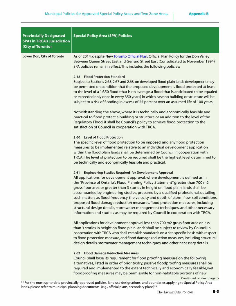
B-5
Appendix BMunicipal Policies for Approved Special Policy Areas and Two Zone Areas
The Living City Policies
As of 2014, despite New Toronto Official Plan, Official Plan Policy for the Don Valley Between Queen Street East and Gerrard Street East (Consolidated to November 1994) SPA policies remain in effect. This includes the following policies:
2.58 Flood Protection StandardSubject to Sections 2.65, 2.67 and 2.68, on developed flood plain lands development may be permitted on condition that the proposed development is flood protected at least to the level of a 1:350 flood (that is on average, a flood that is anticipated to be equaled or exceeded only once in every 350 years) in which case no building or structure will be subject to a risk of flooding in excess of 25 percent over an assumed life of 100 years.
Notwithstanding the above, where it is technically and economically feasible and practical to flood protect a building or structure or an addition to the level of the Regulatory Flood, it shall be Council’s policy to achieve flood protection to the satisfaction of Council in cooperation with TRCA.
2.60 Level of Flood ProtectionThe specific level of flood protection to be imposed, and any flood protection measures to be implemented relative to an individual development application within the flood plain lands shall be determined by Council in cooperation with TRCA. The level of protection to be required shall be the highest level determined to be technically and economically feasible and practical.
2.61 Engineering Studies Required for Development ApprovalAll applications for development approval, where development is defined as in the “Province of Ontario’s Flood Planning Policy Statement”, greater than 700 m2 gross floor area or greater than 3 stories in height on flood plain lands shall be accompanied by engineering studies, prepared by a qualified professional, detailing such matters as flood frequency, the velocity and depth of storm flow, soil conditions, proposed flood damage reduction measures, flood protection measures, including structural design details, stormwater management techniques, and other necessary information and studies as may be required by Council in cooperation with TRCA.
All applications for development approval less than 700 m2 gross floor area or less than 3 stories in height on flood plain lands shall be subject to review by Council in cooperation with TRCA who shall establish standards on a site specific basis with respect to flood protection measure, and flood damage reduction measures, including structural design details, stormwater management techniques, and other necessary details.
2.62 Flood Damage Reduction MeasuresCouncil shall base its requirement for flood proofing measure on the following alternatives, listed in order of priority:dry, passive floodproofing measures shall be required and implemented to the extent technically and economically feasible;wet floodproofing measures may be permissible for non-habitable portions of new
Provincially Designated SPAs in TRCA’s Jurisdiction(City of Toronto)
Special Policy Area (SPA) Policies
Lower Don, City of Toronto
Continued on next page >
** For the most up-to-date provincially-approved policies, land use designations, and boundaries applying to Special Policy Area lands, please refer to municipal planning documents (e.g., official plans, secondary plans)**

B-6
Appendix B Municipal Policies for Approved Special Policy Areas and Two Zone Areas
The Living City Policies
Lower Don, City of Toronto development in order to minimize flood risk and/or to meet the required level of flood protection; and where (a) and (b) as above cannot be achieved, dry, active floodproofing measures may also be recommended to minimize flood risk in combination with (a) and (b).
2.64 Ingress and Egress
Ingress and egress for all buildings within the flood plain lands shall be “safe”, pursuant to provincial floodproofing standards, and/or achieve the maximum level of flood protection determined to be feasible and economically viable such as at grade with street related access points.
2.65 Off Site Impacts and Public Safety
Notwithstanding the provisions of Sections 2.58 and 2.59 but subject to the provisions of Sections 2.66, 2.67 and 2.68, no new development shall be permitted on any parcel of land which is wholly or partly within the flood plain lands if:
(a) the necessary flood protection measures would have a negative off-site impact on adjacent properties;
(b) the use is associated with the storage, handling, production or use of a hazardous substance which is flammable, explosive, toxic, corrosive, or any other dangerous material and the treatment, collection or disposal of sewage, which would pose a threat to public safety if it were to escape its normal containment as a consequence of flooding;
(c) the use is associated with institutional overnight residential accommodation including in part or in whole, any of the following: health care or residential care or crisis care facilities specifically designed to accommodate people who would be incapable of self-evacuation or whose safety would be threatened in the event of flooding and a possible emergency evacuation; and
(d) the buildings or structures directly relate to the distribution and delivery of an essential or emergency public services including police, fire, and ambulance, where such service would be impaired by flooding.
Where new development identified in (b), (c) and (d) above is not considered to pose an unacceptable risk to public safety, a higher level of flood protection and/or additional floodproofing requirements above the regulatory flood level, may still be required due to the sensitive nature of the development.
2.68 Lower Don SPA
On lands designated SPA as shown in Appendix B development may be permitted on condition that the proposed development is flood protected at least to the level of a 1:350 flood (as identified in Section 2.58). Council shall regulate development in accordance with SPA concept identified in Section 2.57 (c) as follows:
Provincially Designated SPAs in TRCA’s Jurisdiction(City of Toronto)
Special Policy Area (SPA) Policies
** For the most up-to-date provincially-approved policies, land use designations, and boundaries applying to Special Policy Area lands, please refer to municipal planning documents (e.g., official plans, secondary plans)**

B-7
Appendix BMunicipal Policies for Approved Special Policy Areas and Two Zone Areas
The Living City Policies
new multi-lot and large-lot development, including all buildings and structures and associated uses, and comparable redevelopment may be permitted where adequate flood proofing is provided subject to the approval of Council in cooperation with the TRCA; and additions, replacement structures, and accessory structures may be permitted, where adequate floodproofing is provided, subject to the approval of Council in cooperation with TRCA
2.69 Flood Control Works in the SPA
A flood control remedial works plan may be required to support large scale urban renewal projects within the SPA to the satisfaction of TRCA and Council prior to approval of the urban renewal project; flood control remedial works shall be completed in accordance with the SPA concept of the “Province of Ontario’s Flood Plain Planning Policy Statement.
2.70 Dredging of the Keating Channel within the SPA
It is the policy of Council to participate with TRCA and other appropriate agencies and governments to continue, as required, maintenance dredging of the Keating Channel for flood control purposes.Council agrees to share in any financing arrangements that recognize the incidence of dredging benefits, upstream responsibilities, and the historical role and current responsibilities of regional agencies and other governments.
2.71 Flood Warning and Emergency Measures within the SPA
It is the policy of Council to cooperate with TRCA in the establishment and operation of a flood warning and evaluation system and encourage in consultation with the Metropolitan Toronto Emergency Planning Advisory Committee, the preparation and maintenance of an emergency measures plan for the Lower Don River to ensure a prompt response and the co-ordination of all required services in the event of a flood emergency.
2.72 Land use in the SPA
In determining the appropriate land use for a property which is wholly or partly within the designated SPA Council shall take into account all relevant policies of the OP as well as the following factors:the existing use and existing zoning of the subject property and adjacent lands;the compatibility of the land luse designations of th lands adjoining the hose designated SPA as shown in Appendix B or as further detailed in a Part II Plan; and,the type and character of existing development within and adjoining lands designated SPA and the long term viability of the existing development.
2.73 Implementation of the SPA Criteria
The Lower Don Flood Plain SPA Criteria are to be implemented in two or more phases. The policies contained in Section 2.68 to 2.72 shall apply to that portion of the SPA shown in general on Map 3 and with greater detail in Appendix B as SPA Phase 1 lands. Determination of the policies and possible remedial flood control works to be required within the lands indicated as SPA Phase II lands is pending Provincial resolution, and are not covered by the SPA policies of this Plan.Modifications to the boundaries of the SPA designation as shown in Appendix B
Continued on next page >
Lower Don, City of Toronto
** For the most up-to-date provincially-approved policies, land use designations, and boundaries applying to Special Policy Area lands, please refer to municipal planning documents (e.g., official plans, secondary plans)**

B-8
Appendix B Municipal Policies for Approved Special Policy Areas and Two Zone Areas
The Living City Policies
Lower Don, City of Toronto
may be considered, based on improvements made to the flood or erosion
control remedial measures, or other relevant changes, as approved by Council in cooperation with TRCA. Such boundary modifications, where approved by Council, shall be adopted as part of the Plan.The appropriate Zoning By-laws shall be amended forthwith to show lands designated SPA in Appendix B and to include the necessary provisions to implement the policies of Section 2.68 to 2.72 of this Plan.Prior to the issuance of a building permit, all proposals for development on a parcel of land, wholly or partly designated SPA shall require the approval of TRCA pursuant to the “Fill, Construction and Alteration to Waterways Regulations” made under the CA Act 1980.Any ZBA on any parcel of land wholly or partly designated SPA shall contain provisions, where appropriate, relating to minimum building or structure setbacks, maximum lot coverage, minimum height of any building or structure opening, and other such matters as may be determined to be necessary by Council in cooperation with TRCA.The implementation of flood proofing and the fulfillment of the regulations of the TRCA shall be a condition of development approval by Council within the SPA.
22.5 a) The placing or dumping of fill of any kind or the construction of any structure, or the alteration of any water course shall not be permitted without the approval of Council in consultation with TRCA.
22.5 b) Prior to the issuance of a building permit, the City shall consult with TRCA regarding the administration of the Conservation Authority’s Fill, Construction, and Alteration to Waterways Regulation to address any proposed flood damage reduction measures which may include such matters as setbacks, basement elevations, the strength of foundation walls, the placement of fill, and the elimination of building openings.
Where required by the Authority, plans will be reviewed, an no building permit will be issued without approval by Council in conjunction with the Authority permission pursuant to Ontario Regulation 293/86 or amendment thereto, made under the CA Act. Furthermore, if requested by the Authority, such permission shall be made a condition of any site plan approval granted under Section 40 of the Planning Act, 1983.
22.5 c) All new structures or additions to existing buildings or structures in SPA should be protected from flooding to the level of the Regulatory Flood
Provincially Designated SPAs in TRCA’s Jurisdiction(City of Toronto)
Special Policy Area (SPA) Policies
Rockcliffe, City of Toronto As of 2014, despite New Toronto Official Plan, former City of York Official Plan (Consolidated to ~1995) SPA policies remain in effect. These include the following policies:
** For the most up-to-date provincially-approved policies, land use designations, and boundaries applying to Special Policy Area lands, please refer to municipal planning documents (e.g., official plans, secondary plans)**

B-9
Appendix BMunicipal Policies for Approved Special Policy Areas and Two Zone Areas
The Living City Policies
in manner acceptable to the City of York and the Conservation Authority. However, if it is demonstrated that this level of protection is not achievable, then a lesser level of protection may be acceptable in conjunction with the Conservation Authority. New buildings or structures, including new additions, shall not be subjected to a risk of flooding in excess of 25% over an assumed life of 100 years (approx. the 1:350 year flood) as a minimum;
22.5 d) Notwithstanding Section 22.5 (c) new residential structures involving new multi-lot or large lot development consisting of more than three residential units may be permitted provided that the habitable living space is built above the level of the regulatory flood. For the purpose of this policy overnight accommodation provided by such facilities as hotels and motels are considered habitable living space.
22.5 e) Underground parking facilities will be floodproofed to the level of the Regulatory Flood and will ensure that vehicles can safely be removed during a regulatory flood event.
22.5 f ) Notwithstanding clauses (b) and (c) above, no new buildings or structures, including additions, shall be permitted within the SPA where they will be subject to flows which, due to their velocity and/or depth, would be a hazard to life or susceptible to major structural damage as a result of a flood less than or equal to the Regulatory Flood;
22.5 g) Within the SPA, it is the intention of Council that the following uses shall not be permitted; new schools, hospitals, group homes for the mentally or physically handicapped, or similar residential care or institutional facilities and any major additions thereto, where an emergency evacuation situation as a result of a flooding or failure of floodproofing measures would pose a significant threat to the safety of the inhabitants. Where existing facilities are not constrained by this condition, additions may be permitted provided that adequate emergency evacuation can be maintained.
22.5 h) Development associated with essential services, such as police, fire and ambulance stations and electrical stations, which must continue to function during a flood emergency, shall not be permitted if as a result of flooding or failure of floodproofing measures, delivery of these services would be impaired.
22.5 i) Development associated with the manufacture, storage, disposal and/or consumption of hazardous substances or the treatment, collection and disposal of sewage, which would pose an unacceptable threat to public safety if they were to escape their normal containment or use as a result of flooding or failure of floodproofing measures, shall not be permitted.
22.5 j) Where development or redevelopment within the SPA requires a ZBA and/or OPA, the Municipality, in consultation with TRCA may determine that
Rockcliffe, City of Toronto
Continued on next page >
** For the most up-to-date provincially-approved policies, land use designations, and boundaries applying to Special Policy Area lands, please refer to municipal planning documents (e.g., official plans, secondary plans)**

B-10
Appendix B Municipal Policies for Approved Special Policy Areas and Two Zone Areas
The Living City Policies
Rockcliffe, City of Toronto an engineering study may be required detailing such matters as flood frequency, the velocity and depth of storm flows, proposed flood damage reduction measures and storm water management;
22.5 k) Any ZBAs within the SPA shall contain provisions, where appropriate, relating to minimum building setbacks, maximum lot coverage, minimum elevation of any opening, and other such matters as may be determined by TRCA and the City of York;
22.5 l) Any lands located in whole or in part of an area designated as a SPA as shown on Schedule “F” hereto, shall be subject to approval under site plan control pursuant to the provisions of Section 40 of the Planning Act, 1983.
4.4.1 Within the limits of the SPA, new buildings or structures, including new additions as permitted within each land use district, shall only be permitted subject to the following policies:
a) The construction of any building or structures, including any additions to an existing building, and the placing or dumping of fill of any kind, or the alteration of any watercourse, shall not be permitted within the SPA without the approval of TRCA;
b) Prior to the issuance of a building permit, the City of North York shall consult with TRCA regarding the administration of the Conservation Authority’s fill and construction regulations to address any proposed flood damage reduction measures which may include such matters as setbacks, basement elevations, the strength of foundation walls, the placement of fill, and the elimination of building openings;
c) All proposed development is to be protected to the level of the Regulatory Flood. Where technically not feasible or it is impractical to do this, then a lower level of flood protection may be permitted. Within the SPA new buildings or structures, including new additions, shall not be subjected to a risk of flooding in excess of 25% over an assumed life of 100 years (approx. the 1:350 year flood) as a minimum;
d) Notwithstanding clauses (b) and (c) above, no new buildings or structures, including additions, shall be permitted within the SPA where they will be subjected to flows which, due to their velocity and/or depth, would be a
Provincially Designated SPAs in TRCA’s Jurisdiction(City of Toronto)
Special Policy Area (SPA) Policies
Hoggs Hollow, City of Toronto
As of 2014, despite New Toronto Official Plan, former North York Official Plan (Consolidated to June 1998) SPA policies remain in effect. These include the following policies:
** For the most up-to-date provincially-approved policies, land use designations, and boundaries applying to Special Policy Area lands, please refer to municipal planning documents (e.g., official plans, secondary plans)**

B-11
Appendix BMunicipal Policies for Approved Special Policy Areas and Two Zone Areas
The Living City Policies
Hoggs Hollow, City of Toronto hazard to life or susceptible to major structural damage as a result of a flood less than or equal to the Regulatory Flood;
e) Where development or redevelopment within the SPA requires a by-law amendment and/or OPA, the municipality, in consultation with TRCA, may determine that an engineering study may be required detailing such matters as flood frequency, the velocity and depth of storm flows, proposed flood damage reduction measures and storm water management;
f ) Any new zoning by-laws within the SPA shall contain provisions, where appropriate, relating to minimum building setbacks, maximum lot coverage, minimum height of any opening, and other such matters as may be determined by TRCA and the City of North York;
g) Ingress and egress for new buildings should ensure that vehicular and pedestrian movement is not prevented during times of flooding.
4.4.2 The following new uses shall be prohibited on any parcel of land which is wholly or partly designated Hoggs Hollow SPA:
i. the manufacture of hazardous substances, including their storage and disposal’;
ii. plants for sewage treatment, collection or disposal; iii. institutional uses, such as hospitals, nursing homes, day nurseries, and
schools; iv. emergency services uses, such as fire, police and ambulance services; and
electrical sub-stations
4.4.1 Within the limits of the SPA, new buildings or structures, including new additions as permitted within each land use district, shall only be permitted subject to the following policies:
a) The construction of any building or structures, including any additions to an existing building, and the placing or dumping of fill of any kind, or the alteration of any watercourse, shall not be permitted within the SPA without the approval of TRCA;
b) Prior to the issuance of a building permit, the City of North York shall consult with TRCA regarding the administration of the Conservation Authority’s fill and construction regulations to address any proposed flood damage reduction measures which may include such matters as setbacks, basement elevations, the strength of foundation walls, the placement of fill, and the elimination of building openings;
Black Creek (Jane-Wilson), City of Toronto
As of 2014, despite New Toronto Official Plan, former North York Official Plan(Consolidated to June 1998) SPA policies remain in effect. These include thefollowing policies:
Continued on next page >
** For the most up-to-date provincially-approved policies, land use designations, and boundaries applying to Special Policy Area lands, please refer to municipal planning documents (e.g., official plans, secondary plans)**

B-12
Appendix B Municipal Policies for Approved Special Policy Areas and Two Zone Areas
The Living City Policies
c) All proposed development is to be protected to the level of the Regulatory Flood. Where technically not feasible or it is impractical to do this, then a lower level of flood protection may be permitted. Within the SPA new buildings or structures, including new additions, shall not be subjected to a risk of flooding in excess of 25% over an assumed life of 100 years (approx. the 1:350 year flood) as a minimum;
d) Notwithstanding clauses (b) and (c) above, no new buildings or structures, including additions, shall be permitted within the SPA where they will be subjected to flows which, due to their velocity and/or depth, would be a hazard to life or susceptible to major structural damage as a result of a flood less than or equal to the Regulatory Flood;
e) Where development or redevelopment within the SPA requires a by-law amendment and/or OPA, the municipality, in consultation with TRCA, may determine that an engineering study may be required detailing such matters as flood frequency, the velocity and depth of storm flows, proposed flood damage reduction measures and storm water management;
f ) Any new zoning by-laws within the SPA shall contain provisions, where appropriate, relating to minimum building setbacks, maximum lot coverage, minimum height of any opening, and other such matters as may be determined by TRCA and the City of North York;
g) Ingress and egress for new buildings should ensure that vehicular and pedestrian movement is not prevented during times of flooding.
Provincially Designated SPAs in TRCA’s Jurisdiction(City of Toronto)
Special Policy Area (SPA) Policies
Black Creek (Jane-Wilson), City of Toronto
** For the most up-to-date provincially-approved policies, land use designations, and boundaries applying to Special Policy Area lands, please refer to municipal planning documents (e.g., official plans, secondary plans)**

B-13
Appendix BMunicipal Policies for Approved Special Policy Areas and Two Zone Areas
The Living City Policies
HWY 400
HWY 48
YONGE ST
HW
Y7
HW
Y40
7
HW
Y40
7YONGE ST
HW
Y7
HWY 27
KENNEDY RD
BET
HES
DA
SID
ERD
KIN
GR
D
MA
JOR
MA
CK
E NZI
ED
RHWY 404
FIN
CH
AVE
HWY 400
FIN
CH
AVE
STEE
LES
AVE
HWY 404
PINE VALLEY DR
Hig
hlan
d C
reek
Wat
ersh
ed
Hum
ber
Riv
er
Wat
ersh
ed
Don
Riv
er
Wat
ersh
ed
Rou
ge R
iver
W
ater
shed
Pett
icoa
t C
reek
Wat
ersh
ed
Duf
fins
Cre
ek
Wat
ersh
ed
Y O
R KAur
ora
Kin
g
Whi
tchu
rch-
Stou
ffvi
lleR
ichm
ond
Hill
Mar
kham
Vau
ghan
Uni
onvi
lleW
oodb
ridg
e
Lak
e W
ilcox
TRC
A Ju
risdi
ctio
nal B
ound
ary
Mun
icip
al B
ound
ary
Riv
er /
Stre
am
Wat
ersh
ed B
ound
ary
Spec
ial P
olic
y A
rea
(SPA
)
02
46
810
Kms
RE
GIO
N o
f Y
OR
K-S
pec
ial
Po
licy
Are
as-
F
Lege
nd:

B-14
Appendix B Municipal Policies for Approved Special Policy Areas and Two Zone Areas
The Living City Policies
Provincially Designated SPAs in TRCA’s Jurisdiction (York Region)
Special Policy Area (SPA) Policies
Lake Wilcox, Town of Richmond Hill
See Official Plan Section 3.2.2.4 –Special Policy Areas (p. 3-47, July,2010 Consolidation)
Woodbridge, City of Vaughan
See Official Plan Section 3.6.5 Special Policy Areas (p. 105, Volume 1, 2010 Consolidation)
Unionville, City of Markham Approval of the SPA policies in the 2014 Official Plan has been deferred until approval is granted by the province, please refer to the SPA policies outlined in the 2005 Official Plan, Section 3.10.2 – Special Policy Area (p. 3-68, July 2005, Consolidation).
** For the most up-to-date provincially-approved policies, land use designations, and boundaries applying to Special Policy Area lands, please refer to municipal planning documents (e.g., official plans, secondary plans)**

B-15
Appendix BMunicipal Policies for Approved Special Policy Areas and Two Zone Areas
The Living City Policies
HWY
48
HWY 407
HWY 7
REG
ION
AL
1R
D
47 HWY
BR
OC
KR
D
KINGSTON RD
WESTN
EYR
D
BAYLY ST401 HWY
REGIONAL 5 RD
FINCH AVE
Duffins Creek Watershed
CarruthersCreek
Watershed
D U R H A M
Pickering
Uxbridge
Ajax
TRCA Jurisdictional Boundary
Municipal Boundary
River / Stream
Watershed Boundary
Special Policy Area (SPA)
0 1 2 3 4 5Kms
REGION of D URHAM-Spec ia l Pol i cy Areas-
F
Legend:
Pickering (Village East)
Notion Road /Pickering Village
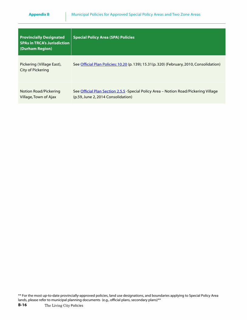
B-16
Appendix B Municipal Policies for Approved Special Policy Areas and Two Zone Areas
The Living City Policies
Provincially Designated SPAs in TRCA’s Jurisdiction (Durham Region)
Special Policy Area (SPA) Policies
Pickering (Village East), City of Pickering
See Official Plan Policies: 10.20 (p. 139); 15.31(p. 320) (February, 2010, Consolidation)
Notion Road/PickeringVillage, Town of Ajax
See Official Plan Section 2.5.5 -Special Policy Area – Notion Road/Pickering Village (p.59, June 2, 2014 Consolidation)
** For the most up-to-date provincially-approved policies, land use designations, and boundaries applying to Special Policy Area lands, please refer to municipal planning documents (e.g., official plans, secondary plans)**

C-1
Appendix CDefining the Limit of Regulated Areas
The Living City Policies
The Regulation Limit is determined to be the greatest combined extent of all the regulated area and features described in Appendix A, plus the prescribed allowance as set out in TRCA’s Regulation.
C.1 Defining the River or Stream Flood Hazard
Within TRCA’s jurisdiction, the River or Stream Flood Hazard is based on the greater of the Hurricane Hazel storm event (the Regional Storm) or the 100-Year return period flood. In accordance with provincial standards, the flood produced through these calculations is called the Regulatory Flood, the limits of which define the extent of the River or Stream Flood Hazard.
The Regulated Area includes the River or Stream Flood Hazard, (also referred to as the Regulatory Flood Plain), and an allowance of 15 metres.
Figure C.1
Regulatory Flood Plain
CAppendix C Defining the Limit of Regulated Areas
C.1 Defining the River or Stream Flood Hazard C-1
C.2 Defining the River or Stream Erosion Hazard C-2
C.3 Defining Watercourses C-4
C.4 Defining the Lake Ontario Shoreline Flood, Erosion and Dynamic Beach Hazards C-4
C.5 Defining Wetlands C-5
C.6 Defining Other Areas - Areas of Interference C-5

C-2
Appendix C Defining the Limit of Regulated Areas
The Living City Policies
Apparent River or Stream Valley
C.2 Defining the River or Stream Erosion Hazard
Erosion hazards within River or Stream Valleys include both the erosion potential of the actual river or stream bank, as well as the potential for erosion or slope stability issues associated with the river valley walls. The risks associated with the River or Stream erosion hazards are managed by planning for the 100-year erosion rate. For the purpose of defining the Regulated Area, the extent of the erosion hazard is based on whether or not a valley is apparent (confined) or not apparent (unconfined) and whether or not the valley slopes are stable, unstable, and/or subject to toe erosion.
Valley CorridorsApparent River or Stream Valley where the valley slopes are stable
The Regulated Area associated with the erosion hazard consists of: • the river or stream valley extending to the stable top of slope; and • an allowance of 15 metres from the stable top of slope.
Apparent River or Stream Valley associated with unstable slopes and stable toe
The Regulated Area associated with the erosion hazard consists of: • the river or stream valley including the predicted long term stable slope
projected from the existing stable toe of slope; and • an allowance of 15 metres from the stable top of slope.
Figure C.2Apparent River or Stream Valley where the valley slopes are stable
Figure C.3Apparent River or Stream Valley associated with unstable slopes

C-3
Appendix CDefining the Limit of Regulated Areas
The Living City Policies
Apparent River or Stream Valley with unstable slopes and active toe erosion:
The Regulated Area associated with the erosion hazard consists of: • the river or stream valley including the long term stable slope projected from
the predicted stable toe of slope; and • an allowance of 15 metres from the stable top of slope.
Stream CorridorsNot Apparent River or Stream Valley:
The Regulated Area associated with the erosion hazard consists of: • the maximum extent of the predicted meander belt allowance of the river or
stream; and • an allowance of 15 metres from the edge of the predicted meander belt. • In river or stream valleys that are not apparent (unconfined), the regulated
area is the greater of the maximum extent of the Regulatory flood plain or the maximum extent of the predicted meander belt plus an allowance of 15 metres.
Figure C.4Apparent River or Stream Valley with unstable slopes and active toe erosion
Figure C.5Not Apparent River Valley
Not Apparent River Valley
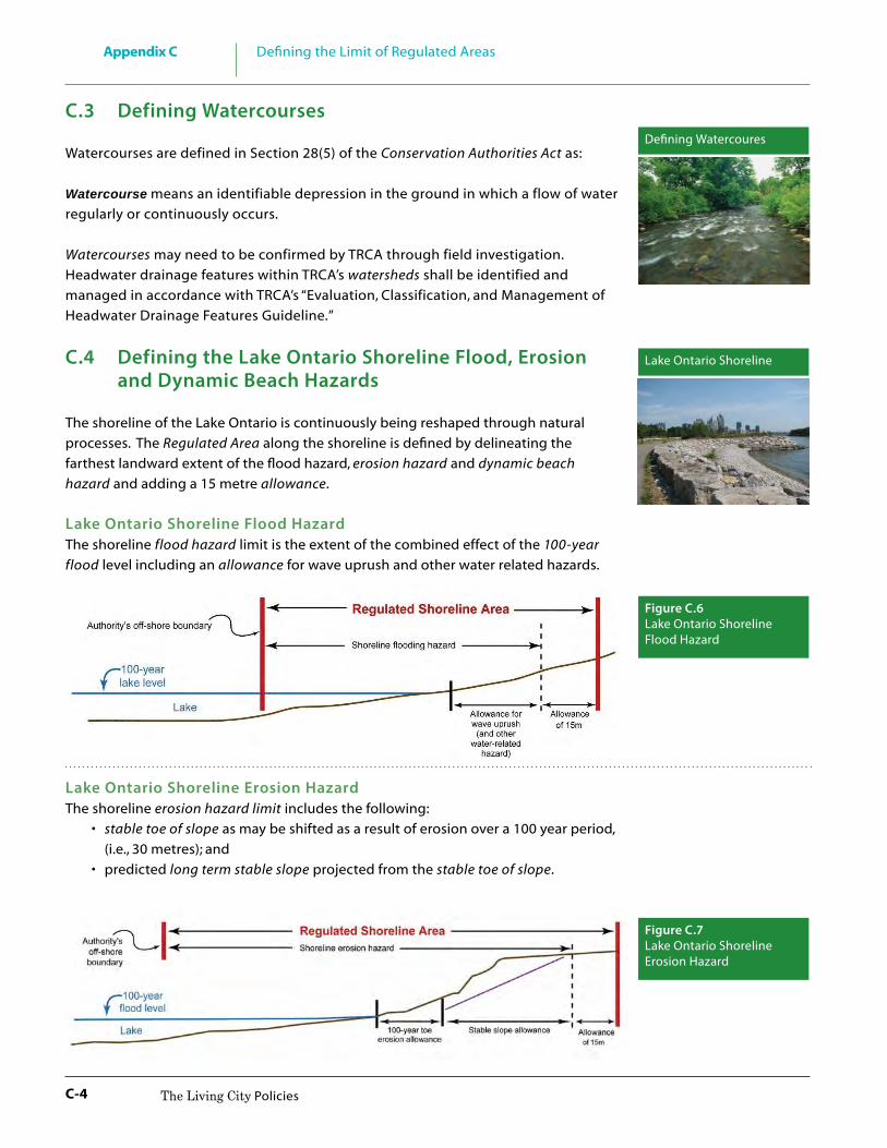
C-4
Appendix C Defining the Limit of Regulated Areas
The Living City Policies
C.3 Defining Watercourses
Watercourses are defined in Section 28(5) of the Conservation Authorities Act as:
Watercourse means an identifiable depression in the ground in which a flow of water regularly or continuously occurs.
Watercourses may need to be confirmed by TRCA through field investigation. Headwater drainage features within TRCA’s watersheds shall be identified and managed in accordance with TRCA’s “Evaluation, Classification, and Management of Headwater Drainage Features Guideline.”
C.4 Defining the Lake Ontario Shoreline Flood, Erosion and Dynamic Beach Hazards
The shoreline of the Lake Ontario is continuously being reshaped through natural processes. The Regulated Area along the shoreline is defined by delineating the farthest landward extent of the flood hazard, erosion hazard and dynamic beach hazard and adding a 15 metre allowance.
Lake Ontario Shoreline Flood HazardThe shoreline flood hazard limit is the extent of the combined effect of the 100-year flood level including an allowance for wave uprush and other water related hazards.
Lake Ontario Shoreline Erosion HazardThe shoreline erosion hazard limit includes the following: • stable toe of slope as may be shifted as a result of erosion over a 100 year period,
(i.e., 30 metres); and • predicted long term stable slope projected from the stable toe of slope.
Defining Watercoures
Figure C.6Lake Ontario Shoreline Flood Hazard
Figure C.7Lake Ontario Shoreline Erosion Hazard
Lake Ontario Shoreline

C-5
Appendix CDefining the Limit of Regulated Areas
The Living City Policies
Lake Ontario Shoreline Dynamic Beach HazardThe Lake Ontario dynamic beach hazard is that portion of the shoreline where accumulated unconsolidated sediment continuously moves as a result of naturally occurring processes associated with wind and water and changes in the rate of sediment supply. The extent of the dynamic beach hazard is defined as the extent of the flood hazard, plus a dynamic beach allowance of 30 metres.
C.5 Defining Wetlands Wetlands are defined in Section 28(5) of the Conservation Authorities Act as:
Wetland means: (a) is seasonally or permanently covered by shallow water or has a water table
close to or at its surface, (b) directly contributes to the hydrological function of a watershed through
connection with a surface watercourse, (c) has hydric soils, the formation of which has been caused by the presence of
abundant water, and (d) has vegetation dominated by hydrophytic plants or water tolerant plants,
the dominance of which has been favoured by the presence of abundant water, but does not include periodically soaked or wet land that is used for agricultural purposes and no longer exhibits a wetland characteristic referred to in clause (c) or (d).
Wetlands that meet this definition are subject to the Regulation.
C.6 Defining Other Areas - Areas of Interference
The areas surrounding wetlands are regulated under the other areas provision of Section 28 (5)(e) of the Conservation Authorities Act. The areas surrounding wetlands where development (1) could interfere with the hydrologic function of the wetland are referred to as areas of interference. In accordance with TRCA’s Regulation, these areas include 120 metres within all provincially significant wetlands and wetlands on the Oak Ridges Moraine, and within 30 metres of all other wetlands. These areas may be adjusted where detailed hydrologic studies define a more accurate area of interference.
Figure C.8Lake Ontario Shoreline Dynamic Beach Hazard
Defining Wetland

C-6
Appendix C Defining the Limit of Regulated Areas
The Living City Policies
Other Areas
(30 or 120 metres)
Development (as defined in the Act), assessed with respect to impacts to the hydrologic function of the wetland. If there are impacts, development is assessed with respect to the control of flooding, erosion, pollution, dynamic beaches and conservation of land.
Development (as defined in the Act), assessed with respect to the control of flooding, erosion, pollution, dynamic beaches and conservation of land.
Interference in any way with the wetland, assessed with respect to the natural features and hydrologic and ecological functions of the wetland.
Wetland
Figure C.9
Figure C.10Regulation Limit (area of interest)

D-1
Appendix DIllustrative Examples of Additions to Existing Buildings within the Flood Hazard
The Living City Policies
DThis appendix contains sample depictions of calculating the area of additions to existing buildings within the flood hazard (one zone concept) of valley and stream corridors and the flood hazard of Lake Ontario. Additions must meet all other applicable criteria, such as but not limited to the following: • the existing building must have legally existed
as of May 4, 2006 • an inventory of all modifications or additions
to the original building permitted by TRCA under its Regulation since 1987; cumulative exceedance of the maximum permissions for additions will not be permitted
• the addition is not located within the hydraulic floodway
• does not increase the number or dwelling units • does not include a basement • floodproofing and access (ingress/egress)
requirements • structurally designed to withstand Regulatory
flood depths and velocities
These examples are for illustrative and explanatory purposes only and do not constitute policy.Permission for an addition to an existing building within the flood hazard is subject to satisfying all applicable policies within Section 8 and in particular Section 8.4 (General Policies), Section 8.5.1 (Development within the Flood Hazard and Erosion Hazard of Valley and Stream Corridors) and 8.6 (Development within the Flood, Erosion and Dynamic Beach Hazards of the Lake Ontario Shoreline).
Appendix D Illustrative Examples of Additions to Existing Buildings within the Flood Hazard

D-2
Appendix D Illustrative Examples of Additions to Existing Buildings within the Flood Hazard
The Living City Policies
Basement
Garage Original HabitableGround Floor Area
Basement
Garage Original HabitableGround Floor Area
Basement
Garage Original HabitableGround Floor Area
Basement
Garage Original HabitableGround Floor Area
Basement
Garage Original HabitableGround Floor Area
OriginalGround Floor
Area
OriginalGround Floor
Area
2 3
1
2 3
1
1
2
3
Additions to Existing Residential Buildings Within the Flood Hazard of Valley and Stream Corridors (One Zone Concept) and Lake Ontario
Basement
Garage Original HabitableGround Floor Area
Basement
Garage Original HabitableGround Floor Area
Basement
Garage Original HabitableGround Floor Area
Basement
Garage Original HabitableGround Floor Area
Basement
Garage Original HabitableGround Floor Area
OriginalGround Floor
Area
OriginalGround Floor
Area
2 3
1
2 3
1
1
2
3
Ground Floor Addition
(Up to 50% of Original Habitable Ground Floor Area)*No Basement
Basement
Garage Original HabitableGround Floor Area
Basement
Garage Original HabitableGround Floor Area
Basement
Garage Original HabitableGround Floor Area
Basement
Garage Original HabitableGround Floor Area
Basement
Garage Original HabitableGround Floor Area
OriginalGround Floor
Area
OriginalGround Floor
Area
2 3
1
2 3
1
1
2
3
Additional Storey
Existing Residential Building

D-3
Appendix DIllustrative Examples of Additions to Existing Buildings within the Flood Hazard
The Living City Policies
Basement
Garage Original HabitableGround Floor Area
Basement
Garage Original HabitableGround Floor Area
Basement
Garage Original HabitableGround Floor Area
Basement
Garage Original HabitableGround Floor Area
Basement
Garage Original HabitableGround Floor Area
OriginalGround Floor
Area
OriginalGround Floor
Area
2 3
1
2 3
1
1
2
3
Additional Storey Above Ground Floor Addition
Basement
Garage Original HabitableGround Floor Area
Basement
Garage Original HabitableGround Floor Area
Basement
Garage Original HabitableGround Floor Area
Basement
Garage Original HabitableGround Floor Area
Basement
Garage Original HabitableGround Floor Area
OriginalGround Floor
Area
OriginalGround Floor
Area
2 3
1
2 3
1
1
2
3
Additions to Existing Commercial, Industrial and Agricultural Buildings or Structures Within the Flood Hazard of Valley and Stream Corridors (One Zone Concept) and Lake Ontario
Basement
Garage Original HabitableGround Floor Area
Basement
Garage Original HabitableGround Floor Area
Basement
Garage Original HabitableGround Floor Area
Basement
Garage Original HabitableGround Floor Area
Basement
Garage Original HabitableGround Floor Area
OriginalGround Floor
Area
OriginalGround Floor
Area
2 3
1
2 3
1
1
2
3
Existing Building or Structure
Basement
Garage Original HabitableGround Floor Area
Basement
Garage Original HabitableGround Floor Area
Basement
Garage Original HabitableGround Floor Area
Basement
Garage Original HabitableGround Floor Area
Basement
Garage Original HabitableGround Floor Area
OriginalGround Floor
Area
OriginalGround Floor
Area
2 3
1
2 3
1
1
2
3
Additional Storey and Ground Floor Addition
1 Ground Floor Addition (Up to 50% of Original Ground Floor Area)
2 Additional Storey
3 Additional Storey Above Ground Floor Addition
Maximum Scenario Additional Storey
Ground Floor Addition
(Up to 50% of Original Habitable Ground Floor Area)*No Basement
Maximum Scenario


For further information, go to
www.trca.on.ca/planning-services-permits