
THE IRIDIUM 33 – COSMOS 2251 COLLISION -...
42
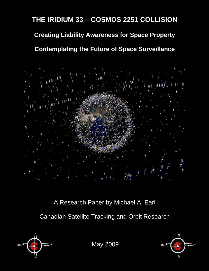
i THE IRIDIUM 33 – COSMOS 2251 COLLISION Creating Liability Awareness for Space Property Contemplating the Future of Space Surveillance A Research Paper by Michael A. Earl Canadian Satellite Tracking and Orbit Research May 2009
Transcript of THE IRIDIUM 33 – COSMOS 2251 COLLISION -...
i
THE IRIDIUM 33 – COSMOS 2251 COLLISION
Creating Liability Awareness for Space Property
Contemplating the Future of Space Surveillance
A Research Paper by Michael A. Earl
Canadian Satellite Tracking and Orbit Research
May 2009
Copyright Notice All original contents contained within this document are copyright ©2009 Michael A. Earl: Canadian Satellite Tracking and Orbit Research. The reproduction or transmission of any portion of this document, in whole or in part, is strictly prohibited without prior written consent by the author.
Cover Image
The cover image was courtesy of the European Space Agency (ESA): Space Debris - Evolution in Pictures: http://esamultimedia.esa.int/images/spacecraft-operations/space_debris/Bee-Hive-1_H1.jpg
Acknowledgments
A special note of gratitude goes to Ms. Jane E. Yaeger for taking the time to read and edit this paper over the past several weeks. Thanks to Lt. Col (Retd.) Philip W. Somers who introduced me to the exciting and multi-faceted world of satellite tracking. A special thanks to everyone diligently working in the Space Surveillance Network, the 1st Space Command Squadron, the Joint Space Operations Center, North American Air Defense and all others doing their best to keep the satellite population safe.
i
TABLE OF CONTENTS
INTRODUCTION ..................................................................................................................1
THE IRIDIUM 33 – COSMOS 2251 COLLISION ..................................................................2
DEFINING AND REDEFINING TERMS................................................................................5
DEFINING LIABILITY OF LAUNCH, ROCKET AND PAYLOAD...........................................6
THE “ACTIVE – ACTIVE” COLLISION .................................................................................7
THE “ACTIVE – INACTIVE” COLLISION..............................................................................9
THE “INACTIVE – INACTIVE” COLLISION ........................................................................11
REDEFINING “LIABILITY” ..................................................................................................15
REDEFINING “RESPONSIBILITY” .....................................................................................17
PRIVATE SATELLITE TRACKING .....................................................................................19
CLASSIFIED SATELLITES.................................................................................................21
CONJUNCTION REPORT ACCURACY.............................................................................22
POLAR ORBITS .................................................................................................................22
GPS ORBITS......................................................................................................................26
GEOSYNCHRONOUS ORBITS .........................................................................................28
PRIVATE OPTICAL SATELLITE TRACKING FACILITY RESEARCH AND DEVELOPMENT.................................................................................................................29
EMERGENCY SATELLITE SEARCH AND TRACKING .....................................................31
ABOUT CASTOR................................................................................................................32
FOOTNOTES......................................................................................................................33
GLOSSARY OF ABBREVIATED TERMS...........................................................................38
ii
INTRODUCTION
The recent collision between Iridium 33 and Cosmos 2251 has shed some doubt on the space surveillance community’s ability to predict and/or report potential collisions between satellites currently orbiting the Earth.
Press releases issued by the parties directly involved have been especially informative as to the current ability of space surveillance institutions to effectively warn the satellite industry of impending collisions. In some cases, these press releases have suggested who might be liable for the collision.
Before attempting to determine responsibility, liability and fault for satellite
collisions, specific collision scenarios should first be defined. The satellite industry could spearhead research and development into a
private satellite tracking infrastructure that could be used for studying tracking inactive payloads, satellite conjunctions and, most importantly, conjunction reporting.
Canadian Satellite Tracking and Orbit Research (CASTOR) has designed
and implemented its own research project to determine the number of satellites that can be optically detected using retail telescopes and CCD cameras. CASTOR has successfully detected over 2,500 individual satellites from all orbit types, including most of the fully intact payloads such as (pre-collision) Iridium 33 and Cosmos 2251.
Throughout this paper, unless otherwise noted, the term “NORAD” will be
used to represent U.S. space surveillance. This paper is based on the author’s experience since May 1997 with
respect to optical satellite tracking as well as his direct experience with the American space surveillance community. This paper does not accuse any of the parties mentioned herein of any wrongdoing with respect to the Iridium 33 – Cosmos 2251 collision. This paper does not presume to know the intricacies of space law or any internal legal matters with respect to any member of the satellite industry.
1
THE IRIDIUM 33 – COSMOS 2251 COLLISION The Iridium 33 – Cosmos 2251 collision was the first major satellite collision to involve two fully intact payloads. The collision resulted in the destruction of the fully functional Iridium 33 communications satellite and the creation of at least one thousand pieces of new debris. The collision and its possible legal consequences are unprecedented in the history of human space endeavors. Immediately after the collision, Iridium LLC, the U.S. Pentagon and Russian space experts each issued press releases.
Iridium LLC stated:
“…it had no advance warning of the impending collision”1
“If the organisations that monitor space had that information available, we are confident they would have shared it with us."2
Several meanings could be inferred from these statements:
i) Iridium LLC did not receive any conjunction reports from any space
surveillance organization.
ii) Iridium LLC did receive conjunction reports from one or several space surveillance organizations. However, none of these reports mentioned the possibility of Iridium 33 and Cosmos 2251 colliding.
iii) Iridium LLC received conjunction reports, some of which contained
warnings about this collision, but it either chose not to read them or did not notice the conjunction reports pertaining to Iridium 33 and Cosmos 2251.
iv) Iridium LLC received conjunction reports containing warnings about
the possibility of this specific collision, read them, and decided not to act on them.
2
A Pentagon spokesman stated: "We did not predict this collision."3 "There are limits on your ability to track and compute [conjunctions between] every piece of orbiting man made object[s]."4 Several meanings can be inferred from these statements:
i) Tracking data for Iridium 33 and/or Cosmos 2251 were not accurate
enough to generate the required orbit element accuracy to accurately predict this collision.
ii) Tracking data for Iridium 33 and Cosmos 2251 were accurate
enough to predict this collision, but the resources required to isolate and report the potential for collision were not adequate enough to provide any warning to Iridium LLC in time to prevent the collision.
iii) The Space Surveillance Network can no longer reliably track all
known Earth-orbiting satellites.
iv) The Space Surveillance Network can no longer track all known Earth-orbiting satellites with the frequencies required to produce accurate and/or timely conjunction reports.
A Russian technology expert stated:
“The U.S. side might have been unaware of, or had ignored, the possibility of the two satellites smashing into each other.”5
If taken at face value, this statement seems a little too simplistic. Although the inferences made from the Pentagon statements were somewhat similar to the Russian statement, the Pentagon statements did not accuse NORAD of ignoring the possibility of collision. However, it is understandable that soon after such an unprecedented and catastrophic event, press releases from the affected parties might appear terse, reactionary and/or accusatory. Few of the press releases addressed the satellite population’s existing problems that had already existed before the collision. How can collisions be avoided? How accurate do the conjunction reports need to be to minimize the
3
probability of collision? How is liability determined after a collision? How is fault proven after liability is established? Who is liable if a collision has not been predicted before the fact? Who is liable if a collision warning was issued but not acted upon? According to Article III of the United Nations’ “Convention on International Liability for Damage Caused by Space Objects” of 1972 (henceforth called the UN Convention of 1972): “In the event of damage being caused elsewhere than on the surface of the earth to a space object of one launching State or to persons or property on board such a space object by a space object of another launching State, the latter shall be liable only if the damage is due to its fault or the fault of persons for whom it is responsible.”6
Upon further analysis of Article III, it is clear that the term “fault” has not been defined. It is also clear that the means by which fault is determined has not been defined. The Iridium 33 – Cosmos 2251 collision most likely damaged both satellites at the same time, therefore it is not entirely clear which satellite damaged which. According to Article I, section (a) of the UN Convention of 1972, the term “damage” is defined as: “…loss of life, personal injury or other impairment of health; or loss of or damage to property of States or of persons, natural or juridical, or property of international intergovernmental organizations;”7
Article I (a) does not specify if “damage” is applicable to both satellites at the same time. Article I (a) also has the unfortunate flaw of attempting to define a term by using the same term within the definition (damage).
In light of the legal ambiguity concerning the Iridium – Cosmos 2251 collision, perhaps more emphasis should be placed on preventing the next collision rather than determining liability for the Iridium 33 – Cosmos 2251 collision. When a more detailed collision liability infrastructure is created, the liability for the Iridium 33 – Cosmos 2252 collision might then be retroactively determined.
4
DEFINING AND REDEFINING TERMS In order to relieve the current ambiguity of terms such as “damage”, “liability” and “fault”, two new terms dealing with satellite status must first be defined: Active Satellite: A satellite that can be communicated with and manoeuvred from the Earth’s surface such that it can avoid potential collisions with other satellites. Inactive Satellite: A satellite that cannot be communicated with and manoeuvred from the Earth’s surface such that it cannot avoid potential collisions with other satellites.
When the Telstar 401 satellite suddenly failed on January 11, 1997 its status immediately changed from “active” to “inactive” because it could no longer be manoeuvred from the Earth’s surface. Although these definitions appear obvious, they have not been legally defined as such. This is a significant oversight, especially when attempting to determine liability for damages to Iridium 33. In order to begin thinking about satellite collision repercussions, one must first determine how many collision scenarios are possible, define each of them and determine the plausible ramifications of each: “Active – Active” collision: In this scenario, two active satellites collide, resulting in damage to either or both satellites. A debris field is assumed to be created by both satellites.
“Active – Inactive” collision: In this scenario, an active and an inactive satellite collide, resulting in damage to the active satellite. A debris field is assumed to be created by both satellites. This is the scenario that became reality on February 10, 2009 when Iridium 33 (active) and Cosmos 2251 (inactive) collided. “Inactive – Inactive” collision: In this scenario, two inactive satellites collide. It is assumed that a debris field is created by both satellites involved.
5
The term “damage” should be redefined as follows:
“Partial Damage” refers to the temporary incapacitation of any system(s) of the pre-collision active satellite for any length of time and/or the permanent incapacitation of any system that does not render the satellite inactive.
“Total Damage” refers to the permanent incapacitation of the pre-collision active satellite, resulting in the satellite becoming inactive; due to the collision itself or due to the satellite owner(s) deciding that the satellite cannot be salvaged.
DEFINING LIABILITY OF LAUNCH, ROCKET AND PAYLOAD
Article I, section (c) of the UN Convention of 1972 defines “launching State” as:
“(i) a State which launches or procures the launching of a space object; (ii) a State from whose territory or facility a space object is launched;”8
Russia was clearly the “launching State” for Cosmos 2251, since it both procured and launched the satellite with its own rocket from within its own territory.9
Based on the UN criteria alone, the “launching State” of Iridium 33 is more
difficult to determine. The United States procured the satellite, but it was launched in Russia using a Russian Proton rocket.10
According to Article V, section 1 of the UN Convention of 1972:
“Whenever two or more States jointly launch a space object, they shall be jointly and severally liable for any damage caused.”11
Can the U.S. and Russia be considered to be the joint launchers for Iridium 33? Could the procurement of a satellite be construed as launching, since procurement brings the payload into being and makes launching necessary? It is clear that a new definition of “joint launch” should be discussed.
In 1972, satellites were mainly procured and launched by governments and rarely by private companies. Today, private companies procure (and in some cases launch) a significant portion of our satellite population. The vagueness of
6
the term “launching State” is further intensified when knowing that many satellites are procured by one nation (or company) and launched by another nation (or company) on a regular basis.
Ideally, the ambiguous term “launching State” should be scrapped
because it no longer fits the current situation in space. A clearer distinction between the responsibility for the launch, rocket and payload(s) is now necessary and are offered here:
Launch Liability: During launch, the rocket, boosters and all payloads are the absolute responsibility of the launching company(s) and/or nation(s). If the rocket collides with any active satellite in orbit before it delivers its payload(s), the launching company (or nation) is liable for all damages to the active satellite and all payloads it is carrying.
Rocket Liability: The launching company(s) and/or nation(s) are liable for all damages arising from the collision of any piece of the original rocket (from launch to orbit decay) with any active satellites.
Payload Liability: In the event of collision, the payload owner assumes liability for any damages that occur to other active satellites, beginning at the moment that the payload owner assumes control of the launched payload(s), and ending at the payload’s orbit decay. If the payload is not delivered into its intended orbit and/or the payload owner cannot maneuver the payload at deployment, the launching company (or nation) is liable for damages due to collision between the (inactive) payload and active satellites.
THE “ACTIVE – ACTIVE” COLLISION An “Active - Active” collision would most likely result in an investigation initiated and conducted by all of the satellite owners involved. If the two satellites in question are owned by the same company, an internal investigation would be more likely. Within this scenario, it is assumed that the companies involved would have been tracking and monitoring their respective satellites right up to the time the collision occurred. The investigations would include any or all conjunction analyses reports and/or communiqués between the companies concerning these reports. NORAD would ultimately have some input if neither company was performing conjunction analyses prior to the collision. It is unclear whether satellite companies currently supply their own TT&C tracking data to NORAD to assist with its conjunction analyses.
7

All satellite owners directly involved should be liable for all the debris created by such a collision, since they would be responsible for maneuvering their own (active) satellites to avoid collisions with other active satellites.
A problem arises when trying to determine which satellite damages which
during a collision. If, for some reason, one satellite company maneuvers its satellite into another (active) satellite, the liability seems obvious.
There is a possibility that one or both of the active satellites can be
maneuvered into a collision with each other. In this case, which satellite company (if not both) is liable for the collision? If neither company generates its own conjunction reports, is NORAD liable for such a collision? The UN Convention of 1972 does not mention such a scenario.12
Proving liability would most likely be the most difficult endeavor in this
scenario, especially if the satellites are owned by competing satellite companies. Since a satellite collision occurs in space, the only likely eyewitnesses to the actual event are those using Earth-based detectors.
There would be few ways to prove, without a doubt, that one or both
companies intentionally (or unintentionally) maneuvered an active satellite into a collision with the other. If maneuvers that were conducted several days ago resulted in a collision with another satellite that was maneuvered several hours ago, which company is liable for the collision? Did both companies maneuver their satellites into a collision with each other? Did one maneuver its satellite into the other’s path or vice-versa?
The liability issue could only be resolved through honest disclosure from
the satellite owners. They would most likely be required to surrender all records pertaining to the tracking and maneuvering of their respective satellites up to the time of the collision. Testimonials and reports from all satellite operators who were on duty at the time of the collision would also be required. If NORAD had predicted a conjunction and/or released a conjunction report to either or both satellite companies, it might also be invited to offer its evidence.
8

THE “ACTIVE – INACTIVE” COLLISION The Iridium 33 – Cosmos 2251 collision could be considered the precedent for this collision scenario. Since Cosmos 2251 was inactive, the ambiguities that arise from this scenario might be much more difficult to resolve than the aforementioned “Active-Active” collision scenario. Unfortunately, a collision had to occur before this particular scenario could be thoroughly addressed.
As an inactive satellite, Cosmos 2251 could not be maneuvered before the collision occurred. This meant that Iridium LLC alone was responsible for maneuvering its satellite out of harm’s way. Although Iridium LLC was responsible for maneuvering Iridium 33, it was apparently not responsible for predicting potential collisions between its satellites and inactive payloads.
Iridium LLC did not perform any of its own conjunction analyses for the
Iridium 33 payload prior to the collision.13 However, Iridium LLC did receive approximately 400 conjunction reports from NORAD every week.14 Iridium LLC might have assumed that NORAD was responsible for producing and delivering (accurate) conjunction reports for all active Iridium payloads. On the other hand, Iridium LLC could not have possibly acted on such a large amount of conjunction reports every week, even if they had produced their own. If they had, they would have severely deprived each of their satellites of maneuvering fuel in a very short time, thus significantly shortening their lifetimes.
Iridium LLC has alleged that the NORAD conjunction reports were inaccurate such that if they had maneuvered their satellites based on these reports, they might have caused the very collision they were attempting to avoid.15 The accuracy of the NORAD conjunction reports pertaining to the Iridium satellites is indeed at the very heart of this matter and should be thoroughly researched now that a collision has occurred. Did Iridium LLC make a concerted effort to determine which of the aforementioned conjunction reports to definitively act upon? How did Iridium LLC know of the alleged “inaccuracy” of the NORAD conjunction reports? Did Iridium LLC know the accuracies of the tracking data, orbit elements and propagation methods utilized to create the NORAD conjunction reports? How do satellite companies know which conjunction reports to act upon, especially those companies who do not produce any independent conjunction reports to verify the NORAD reports? Was NORAD wasting its time by producing conjunction reports that apparently were inaccurate?
9
Although liability for the “Active-Inactive” collision scenario is implied in the UN Convention of 197216, it does not elaborate as to which party would be at fault in such a specific case17.
There are two more real-life cases of the “Active-Inactive” collision scenario:
Fengyun-1C: On January 11, 2007, the Chinese government carried out the destruction of the inactive Fengyun-1C weather satellite using an anti-satellite missile launched from the Earth’s surface. Over 3,000 pieces of (inactive) detectable debris were generated by this collision18, many of which are still threatening active satellites to this day. USA-193: On February 20, 2008, the United States government carried out the destruction of the inactive USA-193 military satellite using an anti-satellite missile launched from the Earth’s surface. Although many pieces of debris were created by the destruction, they all were in a very low altitude orbit such that they decayed within several months19. These two collisions could be used to define another term called “Deliberate Active-Inactive collision”. The fact that one of the objects involved was not a satellite but a guided (active) missile should also be discussed.
It is presently unclear whether it was absolutely necessary to destroy Fengyun-1C or USA-193 in such a manner. In both cases, such destructive measures might be construed as irresponsible, especially in the case of Fengyun-1C. Allowing Fengyun-1C’s orbit to decay naturally, rather than splintering it into several thousand pieces of (inactive) debris, might have been a better option. Within the “Active-Inactive” collision scenario, China and the USA could have been liable for damages to any 3rd party active satellite caused by a collision with debris from Fengyun-1C or USA-193 respectively. If such a consequence had been considered beforehand, both nations (especially China) might have reconsidered the deliberate destruction of their respective satellites in such a manner. The UN Convention of 1972 does not address the satellites’ pre-collision status (active or inactive).20 This is a significant oversight, most likely stemming from the negligible probability of a satellite collision in the early 1970’s. The belief in a negligible collision probability (also known as “Big Sky”21) ended abruptly on February 10, 2009, when Iridium 33 and Cosmos 2251 collided.
10
Who is liable for damages to an active satellite caused by a collision with an undetectable inactive satellite? Presently, it would be unfair to deem the owner of the inactive satellite liable because the owner has no control over what happens to the satellite once it becomes inactive, especially if it involves a debris field containing many undetectable pieces. Deeming NORAD liable would be equally unfair, since NORAD will always have technical limitations with respect to detecting every piece of orbiting debris. When taken in this context, the statement released by the Pentagon was the correct one.
THE “INACTIVE – INACTIVE” COLLISION A collision between two inactive satellites traveling at many times the speed of sound will most likely create a significant debris field. Even in the unlikely event that no debris is produced, the collision might alter the orbit parameters of both satellites, possibly placing either or both in paths that might endanger active satellites. The debris field created by such a collision would most likely be the main liability issue in this scenario, especially if any piece of debris eventually damages an active satellite. In such a collision scenario, one would assume that the satellite owner would have done everything in its power to ensure that once the satellite neared the end of its “active” status, it was either forcibly de-orbited or was maneuvered into an orbit that minimized the probability of collision with active satellites for some agreed span of time. In this scenario, an inactive satellite clean-up initiative should be suggested. At present, no satellite owner is legally liable if it does not de-orbit any of its active satellites that are nearing the end of their lives, even though the newly inactive satellites could threaten active satellites. This omission is exactly what caused the confusion over who was liable for damages to Iridium 33 after its collision with Cosmos 2251. Is simply parking “end of life” (EOL) satellites “out of harm’s way” a viable alternative to de-orbiting them? Is it more cost-effective to park EOL satellites in a “junkyard orbit” rather than requiring them to carry adequate fuel to maneuver them into decaying orbits? NORAD would have to massively increase its resources in order to begin detecting, tracking and cataloguing smaller objects than it presently does.22 It would also likely have to increase worldwide sensor sensitivity and increase its number of analysts in order to handle the expected double (or even triple) the current amount of catalogued satellites.
11
If another collision between two payloads or a deliberate destruction of another satellite occurs, the sudden flood of new debris into an already crowded satellite population could have a crippling effect on space surveillance capacity, accuracy and effectiveness.
Commenting on the Iridium 33 – Cosmos 2251 collision, a former analyst at the 1st Space Command Squadron (1SPCS) commenting on the Iridium 33 – Cosmos 2251 recently stated:
“There are also legitimate questions to be asked of the US military as to what role was played in this whole situation by years of inadequate investment in infrastructure, low budget priority, personnel shortages and training cutbacks, especially when combined with the recent move from Cheyenne Mountain to Vandenberg. The debris problem has been well known for many years, and after the Chinese anti-satellite event [Fengyun-1C] the US government was one of the most vociferous voices bemoaning the sorry state of Earth orbit as a result. Perhaps the actual funding and priority of space protection did not match the political rhetoric.”23
This statement (correctly) does not blame China for the “sorry state of Earth orbit”. However, there are several reasons why the Americans and the Russians are to blame:
1) During the Cold War, it is likely that neither the U.S. nor the U.S.S.R. had considered the implications of launching such a high density of satellites within a 30-year time frame.
2) During the Cold War, it is likely that neither the U.S. nor the U.S.S.R.
had considered what could happen if satellites became more commercial.
3) It is likely that emerging commercial satellite companies did not think
about how the launching of additional payloads would affect the probability of collision.
Today, the newer space-faring nations (such as India, China, France, Germany, Japan and Spain) are either already depending on satellites or are beginning to depend on them. This means that these nations will likely begin launching many more satellites in the future. France’s Ariane rocket program is launching payloads for other nations, including Canada.
12
If the U.S. military (NORAD) cannot handle the current amount of catalogued objects, how can anyone expect it to handle double (or triple) that amount? Unless significant amounts of money are injected into 1SPCS, the Space Surveillance Network and private satellite tracking research and development, the likelihood of another collision seems certain, not improbable, as was once believed under “Big Sky”. According to a statement issued by the U.S. Air Force on April 3, 2009: “…it would work with U.S. Strategic Command to expand satellite tracking by October 1 to all 800 manoeuvrable spacecraft now operating.”24
There are several reasons why this statement might seem confusing:
1) Most (if not all) satellite owners are already accurately tracking their own active payloads using TT&C. Why does NORAD have to expand its own tracking of active payloads when this is already being done more accurately and more frequently using private facilities?
2) NORAD already tracks all of the active orbiting payloads.25 Perhaps
the U.S. Air Force’s statement was referring to increasing the tracking frequency of the active payloads.
3) At the current time, NORAD is one of the very few institutions that are
tracking inactive satellites. Why is NORAD not increasing its focus on the inactive satellites?
What the U.S. Air Force’s statement seems to offer is a temporary solution to a more permanent problem. This once again raises the question of why the U.S. military is assuming the mandate for tracking all satellites. Why is private (inactive) satellite tracking, initiated by the satellite owners themselves, not a viable solution to the current problem? The most effective solutions to this problem are to enact inactive satellite clean-up initiatives and/or to enact enforceable international laws that require space-faring nations to forcibly de-orbit their EOL payloads. For both solutions, all of the currently inactive satellites presently orbiting the Earth could be grandfathered as “public domain”. In event of collision with such objects, no State(s) or companies could be held liable. Until their orbits decay, tracking the “grandfathered satellites” could be the responsibility of NORAD. If a collision did occur between two inactive
13
grandfathered satellites, NORAD would be required to track as many pieces of the resultant debris as it could. Over time, the number of inactive satellites (including debris) would decrease because fewer of the now active payloads would be allowed to become inactive orbiting satellites. The potential for new debris caused by inactive-inactive collisions would also decrease.
Neither solution might be deemed to be economically viable, since inactive satellites do not presently generate any revenue to offset the expense. However, in the near future, de-orbiting inactive satellites might become the only real alternative to polluting prime space real estate to a point where no future satellites could be launched into safe orbits. Based on our current dependency on satellites, polluting space with inactive satellites is also not economically viable. If a current (or future) active satellite were to suddenly become inactive before the owner began de-orbit maneuvering, the satellite owner would become responsible for tracking (with optical or radar equipment) its own newly inactive property until the satellite’s orbit decays. NORAD could be invited to assist if it wished, however it would not be liable for any collisions.
If such international law had been put in place prior to Cosmos 2251’s EOL, Russia could have been held liable for the Iridium 33 – Cosmos 2251 collision. Russia could have been responsible for tracking the satellite and producing conjunction reports for all active satellite owners whose satellites could have been in danger of being damaged or destroyed by a collision with Cosmos 2251. In this case, Russia would have been legally required to reimburse Iridium for the cost of the lost Iridium 33 satellite, as well as any lost revenue directly resulting from the collision. Iridium LLC could not be deemed liable for the collision because it was not responsible for tracking the inactive Cosmos 2251 satellite. However, if Iridium LLC had been warned by Russia of the impending collision and did nothing to maneuver the satellite out of harm’s way, the (international?) courts would have to decide who would be most liable, based on the accuracy of the conjunction reports originally received. In an ideal world, Iridium LLC could not be deemed liable for any damage to Cosmos 2251 during the collision. However, the UN Convention of 1972 does not specify what “damage” is with respect to active and inactive satellites.26 Therefore, it can be construed that “damage” can also be inflicted on an inactive satellite and as a result, Iridium LLC might be held liable for any Cosmos 2251 debris. In 2007, CASTOR established that both Iridium 33 and Cosmos 2251 were optically detectable with ground-based CCD cameras.27 This fact implies that NORAD could have easily detected these two payloads before the collision.
14
The UN Convention of 1972 does not specifically mention the lack of satellite tracking, space surveillance or satellite conjunction reporting amongst its liability issues.28 This was a massive oversight on the part of those who drafted, ratified and signed the UN Convention of 1972 mainly because the U.S. has been tracking satellites from 1957 to the present day. The Iridium 33 – Cosmos 2251 collision has proven that an internationally led private satellite tracking industry is the next step in the evolution of space surveillance efforts. As more nations launch payloads into orbit, worldwide dependency on satellites will only be increasing. Although satellite companies regularly monitor and track their active payloads, they mainly ignore their inactive payloads; the very objects that could seriously damage their own, and others’ precious properties in space. Instead, satellite owners seem to be putting all of their faith in an organization that is not always willing to share its conjunction report accuracies. This seemingly flawed logic creates a significant “liability disconnect”. “Big Sky” prevented the most experienced space-faring nations from addressing this emerging “liability disconnect” until the Iridium – Cosmos 2251 collision unexpectedly occurred. The biggest concern over the “Inactive – Inactive” collision scenario is that once a collision threat is confirmed, there is nothing anyone can currently do to prevent it from happening. Inactive satellites could be doomed to eventually collide with each other, thus creating additional debris fields. This is the single most important reason why satellite companies should be legally responsible to de-orbit their payloads at EOL.
It is particularly surprising that very little has been said publicly about this probable collision scenario.
REDEFINING “LIABILITY” In a perfect world, a satellite company would be “absolutely liable” for all damage caused by its orbiting property, whether they are active or inactive. In such a world, it would be unclear whether satellite companies could trust a single agency to deliver accurate conjunction reports. According to Article III of the UN Convention of 1972: “In the event of damage being caused… …to a space object of one launching State… … by a space object of another launching State, the latter shall be liable only if the damage is due to its fault or the fault of persons for whom it is responsible.”29
15
This essentially means that fault has to be proven before any liability is assumed. How is fault proven beyond any reasonable doubt for an event that occurs in space? Imagine that two inactive satellites have collided and that a debris field has been created. Someone would naturally want to place blame for such a collision on the owners of the two satellites involved. The satellite owners themselves might want to blame the only organization with the resources to detect and track both inactive satellites, i.e. NORAD. However, NORAD has no means by which to maneuver any of the satellites out of harm’s way. The collision would inevitably happen despite NORAD’s warnings. If both satellites were purely non-American, in both procurement and launch, U.S.A. could not be considered a “launching State” and therefore would be left out of the liability equation entirely. Who exactly is responsible for our inactive satellites? Is it NORAD? Is it the U.S. military? Is it the USA at all? Someone has to be responsible for avoiding the creation of debris fields. If nobody is responsible, fault cannot be determined and another collision will most certainly occur, possibly resulting in another active satellite being destroyed and another debris field being created. Today, liability has to be defined in the context of avoiding the creation of more debris within those orbits already crowded with active and inactive satellites. The Iridium 33 – Cosmos 2251 collision was a dire warning to any organization that once believed that satellite collisions are few and far between and that defining space liability was not necessary. Only 51 years had passed between Sputnik and the first collision between two fully intact payloads. If nothing is done as soon as possible, the next collision will most likely happen in far less time.
Because our modern social and financial infrastructures depend on satellites, it is crucial that all those involved with launching, maneuvering, tracking and producing conjunction reports collaborate to define what “legal liability” really means.
16
REDEFINING “RESPONSIBILITY”
Is NORAD responsible for tracking all satellites orbiting the Earth? This depends on how you define the term “responsibility”. “Responsibility could be defined as:
1) A self-imposed mandate to track all detectable satellites orbiting the Earth without any assumption of liability in the event of a mishap (such as a collision).
2) An internationally imposed mandate for the satellite owners of the
world to either de-orbit their EOL payloads or track their own inactive payloads with the assumption of liability in the event of a mishap (such as a collision).
Although these two definitions are not mutually exclusive, they presently do not exist together. The second definition does not exist at all. That might be part of the reason why the Iridium 33 – Cosmos 2251 collision occurred.
The Iridium 33 – Cosmos 2251 collision has highlighted the lack of a
definitive definition of “responsibility” within the realm of the satellites. This unfortunate situation might be partially alleviated by creating stronger and more reliable communications between NORAD and the satellite industry.
According to satellite industry sources:
“…typically, satellite operators conduct their own analyses and request information from the [U.S.] Air Force when it appears that a close approach, or conjunction, involving one of their craft is likely.”30
This statement seems to contradict the apparent practices of Iridium LLC, especially within the context of conjunction analyses.31 Which is the correct statement? Does the satellite industry generally perform conjunction analyses or does it not? Are satellite companies responsible for conducting such analyses?
How did NORAD assume its responsibility for tracking all orbiting satellites in the first place? It is most likely that NORAD’s “mandate” began when Sputnik 1 was launched in October 1957. Sputnik’s launch had suddenly created a U.S. national security issue. NORAD was originally founded to detect and track new missiles and satellites launched from the U.S.S.R. and its other Socialist Republics.
17
From 1957 to the 1970’s, most satellites were procured and launched by governments and NORAD’s responsibilities remained unchanged. By the late 1970’s, commercial satellite procurement became increasingly prevalent. NORAD continued to assume its mandate, developing more sophisticated tracking systems, orbit propagation methods and orbit determination methods. At the same time, the private satellite industry adopted strategies for tracking its own active satellites, but not for its inactive satellites. Satellite companies of that era most likely did not consider their Inactive satellites as being revenue-generating. Therefore allocating money to track such objects might not have seemed economically viable.
In the 1980’s, as satellites became more commercialized, there emerged a fundamental disconnect between the interests of private business and NORAD. Satellite companies continued to track their own active satellites while NORAD continued with its mandate of tracking everything it could detect in orbit. This created a fundamental “liability disconnect” which might have created a belief that all inactive satellites were solely the responsibility of NORAD. Again, the UN Convention of 1972 does not mention NORAD, satellite tracking or conjunction reporting.32 This is yet another significant oversight within that document. Does “mandate” automatically imply “responsibility”? Who really has the legal responsibility for tracking inactive satellites and creating conjunction reports? Very little legal infrastructure is currently in place to determine what “responsibility” truly is within the satellite realm. The Iridium 33 – Cosmos 2251 collision could be used to define such a term. Should satellite companies be responsible for producing their own conjunction reports? Should NORAD remain responsible for producing and delivering conjunction reports to the satellite industry without assuming any liability for collisions?
The vice president of legal and government affairs at Intelsat General had
stated with respect to the Iridium 33 – Cosoms 2251 collision:
“The first thing the operators did was to establish protocols for sharing data and communications between operators. Recently, this has led to a proposal among the large operators to create a data center where information could be exchanged rapidly … in a common format.”33
Although this appears to be a good start, there are questions to ask. Which operators are included in this (proposed) data center? All of them? Some of them? Only the American ones? When will the “common format” be agreed upon? How rapid should the exchanges be in order to prevent collisions?
18
Most likely, no single institution will be found responsible, liable and/or at fault for the Iridium 33 - Cosmos 2251 collision. All space-faring nations could be blamed for this collision because of our collective failure to see the real problems that we were creating early on. We had the opportunity to prevent the destruction of Iridium 33 by de-orbiting our EOL satellites before they became threats. We didn’t because we believed in “Big Sky”. The modern world constantly depends on satellites for communications, navigation and weather forecasting. These are three vital services that literally save lives every day. It is shocking that this fact has scarcely been mentioned in the mainstream press, despite the fact that the same press heavily depends on satellites. How can such an important infrastructure lack the fundamental legal safeguards to ensure that someone is responsible for preventing satellite collisions and that someone is held liable for damages should a satellite collision occur? Although liability seems scary to some, it can often serve as a deterrent to disaster. It is unlikely that Iridium LLC will receive any type of compensation for the loss of Iridium 33. Many would assume that insurance companies would not offer satellite collision coverage because the likelihood of collision seemed remote and the lack of definite legal definitions of “responsibility” and “liability” would place the insurance industry in uncharted territory.
PRIVATE SATELLITE TRACKING Developing a private satellite tracking infrastructure might appear to be reinventing a wheel that the US military has already created and established. This belief is somewhat misguided, since a new private satellite tracking infrastructure would be required to tackle the more complex problems facing our modern satellite population. This could involve modernizing some of the conventions, priorities and standards that NORAD had originally defined in the 1950’s and ‘60s, but for an industry with entirely different priorities. The most critical priorities for discussion are:
1) Defining collision scenarios and the liabilities associated with each, 2) Defining new industry standards for inactive satellite tracking data
accuracy,
3) Defining new industry standards for conjunction analyses and conjunction reporting.
19
In order to study the feasibility of using optical satellite tracking facilities within its existing infrastructure, each satellite industry member could design and construct a prototype facility with the aforementioned priorities in mind. Such a facility should not be designed to track every detectable satellite (as GEODSS currently does) but only those inactive payloads the company owns and those inactive satellites that can threaten their own active payloads. Such tracking should not be considered a legal responsibility, or a liability issue in the event of collision, until sufficient research and development has been completed to study the feasibility of obtaining sufficiently accurate tracking data to produce conjunction reports of a desired accuracy. Unlike TT&C and radar installations, optical satellite tracking facilities do not require prior clearance from any governmental agency to track any unclassified satellite. Optical facilities do not send strong RF signals into space; they only detect the sunlight being reflected off of satellites. This might significantly reduce the bureaucratic red tape required to begin tracking inactive satellites as soon as possible.
Private industry could begin to offload NORAD’s currently massive workload in several important ways:
1) Each satellite industry member could create and maintain a conjunction report database containing those satellites (active and inactive) that are the most threatening to its properties in space. This database could be made accessible to all other satellite industry members. Private conjunction reports can be generated using NORAD TLEs. This could partially offload some of NORAD’s responsibilities to the satellite companies and could allow NORAD to focus on its own high priority satellites. NORAD could continue to track all detectable satellites, produce tracking data and generate mean orbit elements as it always has.
2) Each satellite industry member could track all of its inactive payloads
on a regular basis. Privately obtained tracking data for both active and inactive satellites might be added to NORAD’s tracking data to assist in increasing conjunction report accuracies. This could decrease the maximum threshold range to less than 5 kilometres.
3) Every satellite industry member could track their own inactive payloads
exclusively, thus relieving NORAD of its “traditional” responsibility of tracking all satellites in orbit. NORAD could then exclusively focus on DoD’s highest priority satellites, missile launches and all small debris.
20
The active satellite population represents a multi-billion dollar industry that deserves much more collision liability protection than it currently has. In order to ensure the safety of all of its orbiting property, the satellite industry should begin tracking its own inactive payloads and producing their own conjunction reports. If the satellite industry insists on delegating all responsibility for tracking inactive satellites to NORAD, it must at least assume a portion of the liability due to communications gaps, errors, omissions and inaccuracies.
A more symbiotic relationship should exist between NORAD and the
satellite industry such that satellite tracking data and conjunction report data are collected and shared freely; assuming that reliable two-way communication had previously been established.
CLASSIFIED SATELLITES Before independent private satellite tracking is established, some exceptions to “free two-way data-sharing” will need to be discussed and agreed upon. For instance, the satellite industry and NORAD would have to reach an agreement pertaining to the detection and tracking of classified military U.S. satellites. At some time during a private satellite tracking facility’s lifetime, it will inevitably detect satellites that are not on the NORAD unclassified satellite list. These satellites would most likely be American classified satellites. Several guidelines have been offered on what to do when detecting and tracking a satellite that cannot be identified as an unclassified object (also called an Uncorrelated Target or “UCT”):
i) All images that contain the UCT must be destroyed.34 ii) All images containing the UCT(s) can be kept, however no attempt
shall be made to correlate the object(s).35
iii) All images containing the UCT can be kept and the UCT can be correlated, however, no attempt shall be made to distribute any tracking data and/or orbit elements directly pertaining to the UCT.36
At present, it is unclear which guideline (if any) is sanctioned by NORAD. For some time, specific websites have been publishing TLEs for classified U.S. military satellites. To date, there has been no effort to remove them from public view. Since many amateur satellite enthusiasts use these websites on a regular basis, it is likely that the U.S. military has some knowledge of them.
21

It is likely that as long as the true missions of all U.S. classified satellites remain secret, the tracking and publishing of their orbit elements will not violate the national security of the United States. It is assumed that NORAD would be tracking U.S. classified satellites with its highest possible accuracy since it would not wish to lose its own military satellites as a result of collision.
CONJUNCTION REPORT ACCURACY During the preliminary design phase of any private satellite tracking facility, the tracking data accuracy required to produce sufficiently accurate conjunction reporting would have to be addressed. What exactly is an accurate conjunction report? The threshold range NORAD currently uses is 5 kilometres37, however this is not the “accuracy” per se. NORAD has not publicly given any indication of its tracking data accuracies or its conjunction report accuracy (other than the 5 kilometre threshold). After losing Iridium 33 to the collision, Iridium LLC stated: “…with the error bounds associated with those [conjunction] reports, we are not going to be sure what to do. Even if we had a report of an impending direct collision, the error would be such that we might manoeuvre into a collision as well as move away from one.”38
“But the [Iridium LLC] company has never redirected a satellite before because the warnings they get aren't precise enough and there are just too many satellites to be constantly rejiggering their orbit.”39
Currently, there are three critical orbit zones used by the satellite industry: Polar, GPS and Geosynchronous.
POLAR ORBITS
This orbit category covers all of the sun-synchronous orbits, Iridium orbits, Fengyun-1C debris orbits and all of the debris from both Iridium 33 and Cosmos 2251.
Not all Polar orbiting satellites can be detected with ground-based optical
satellite tracking facilities because of their proximity to the Sun’s glare or twilight glow. Space-based sensors are currently not an option for tracking polar orbiting satellites mainly because the cost of such a sensor with an aperture large
22
enough to detect small pieces of debris would most likely be too expensive for most nations and private companies to afford to construct and launch.
However, CASTOR has proven that most, if not all, of the existing Iridium
payloads (active and inactive) can be optically detected and could be tracked on a regular basis.40
Surveillance of some polar orbiting satellites might best be accomplished
by using radar installations because they can detect satellites at all hours of the day and night as well as through any cloud cover. However, radar is also an expensive proposition and also requires special clearances to construct and use.
Some might question why a company such as Iridium LLC would need to
construct its own inactive satellite tracking infrastructure when the Space Surveillance Network already tracks all of the Iridium payloads (active and inactive) with radar installations. The answer is that Iridium LLC would only be tracking its own inactive payloads and not everything in polar orbit. This would give Iridium LLC the capability of tracking its own inactive satellites with a much higher priority and frequency. Iridium LLC could then produce its own conjunction analyses using its own tracking data with an accuracy that Iridium LLC exclusively defines.
Iridium LLC could also optically track other (active and inactive) payloads
that it considers to be most threatening to its own active payloads. Using optical tracking, Iridium LLC would also have the advantage of providing (or selling) their tracking data, orbit elements and conjunction reports to any organization(s) that requires them. This effort could assist in defining Iridium LLC’s “responsibility” to routinely track its own inactive payloads and provide tracking data or conjunction reports to other organizations.
In order to produce accurate conjunction reports, the timing accuracies for
Polar-orbiting satellite tracking data would have to be very high. Significant testing of the facility’s timing restraints would have to be carried out, including:
1) The timing method (GPS or ground-based atomic clock), 2) The timing offsets between the CCD camera and the controlling
computer,
3) The speed of light corrections,
4) Relativistic corrections, especially for the lowest altitude polar orbits.
23
Astrometric analysis of the images would also need to be highly accurate. Astrometric accuracy would mainly depend on the star catalogue(s) used (Hubble, USNO, etc.) and the angular pixel resolution of the images produced (dependent on the CCD and telescope focal length used).
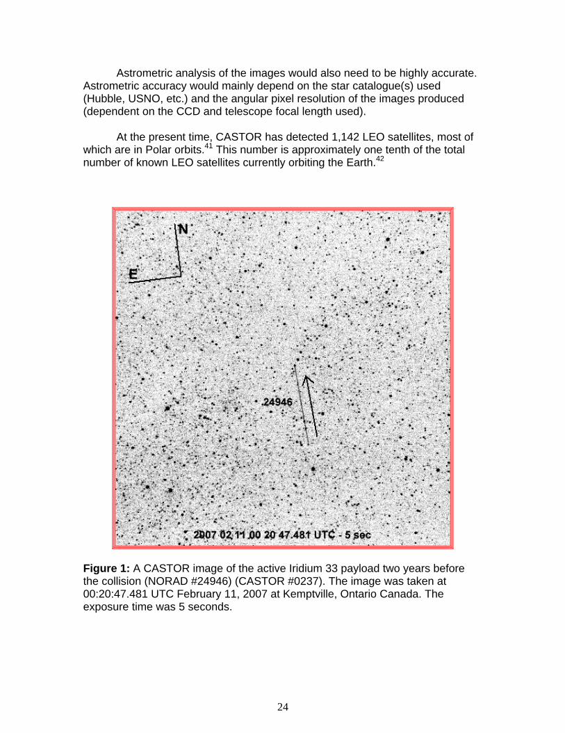
At the present time, CASTOR has detected 1,142 LEO satellites, most of
which are in Polar orbits.41 This number is approximately one tenth of the total number of known LEO satellites currently orbiting the Earth.42
Figure 1: A CASTOR image of the active Iridium 33 payload two years before the collision (NORAD #24946) (CASTOR #0237). The image was taken at 00:20:47.481 UTC February 11, 2007 at Kemptville, Ontario Canada. The exposure time was 5 seconds.
24
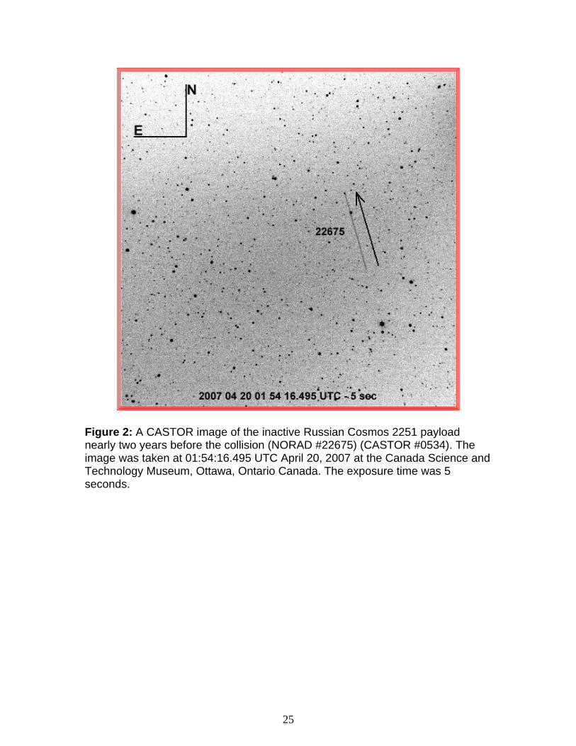
Figure 2: A CASTOR image of the inactive Russian Cosmos 2251 payload nearly two years before the collision (NORAD #22675) (CASTOR #0534). The image was taken at 01:54:16.495 UTC April 20, 2007 at the Canada Science and Technology Museum, Ottawa, Ontario Canada. The exposure time was 5 seconds.
25
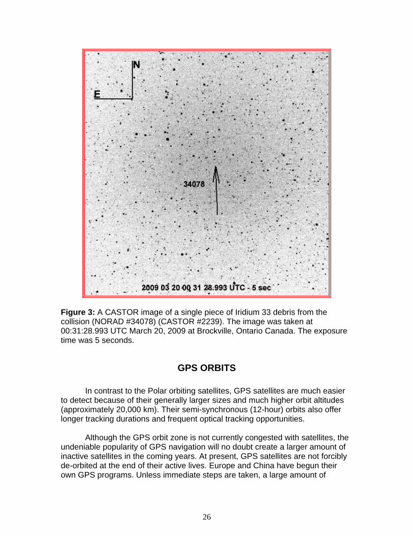
Figure 3: A CASTOR image of a single piece of Iridium 33 debris from the collision (NORAD #34078) (CASTOR #2239). The image was taken at 00:31:28.993 UTC March 20, 2009 at Brockville, Ontario Canada. The exposure time was 5 seconds.
GPS ORBITS In contrast to the Polar orbiting satellites, GPS satellites are much easier to detect because of their generally larger sizes and much higher orbit altitudes (approximately 20,000 km). Their semi-synchronous (12-hour) orbits also offer longer tracking durations and frequent optical tracking opportunities. Although the GPS orbit zone is not currently congested with satellites, the undeniable popularity of GPS navigation will no doubt create a larger amount of inactive satellites in the coming years. At present, GPS satellites are not forcibly de-orbited at the end of their active lives. Europe and China have begun their own GPS programs. Unless immediate steps are taken, a large amount of
26
inactive satellites will quickly clutter this vitally important orbit zone and increase collision probability. At the present time, CASTOR has optically detected 135 GPS payloads, including 41 American “NavStar”, 92 Russian “Glonass” and both of the European “Giove”.43
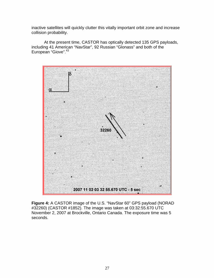
Figure 4: A CASTOR image of the U.S. “NavStar 60” GPS payload (NORAD #32260) (CASTOR #1852). The image was taken at 03:32:55.670 UTC November 2, 2007 at Brockville, Ontario Canada. The exposure time was 5 seconds.
27
GEOSYNCHRONOUS ORBITS Those satellites which are in Geosynchronous (GEO) orbits are the easiest to detect with optical satellite tracking facilities because of their large size and nearly sidereal day orbit periods. CASTOR has proven that over one half of all known geosynchronous satellites can be detected and tracked using one optical tracking facility placed in North America.44 It might be possible to detect the remainder by placing an identical optical satellite tracking facility on nearly the opposite side of the Earth from North America (such as Europe, Asia or Australia). With the exception of the Sirius Satellite Radio satellites, the geosynchronous orbit has the distinct advantage of containing satellites that all orbit within roughly the same plane. If a collision does occur between geosynchronous satellites, the collision velocity would most likely be so low that the debris field created might be much smaller than that created by the Iridium 33 – Cosmos 2251 collision. The collision angle of the Iridium33 – Cosmos 2251 collision was approximately 103 degrees. In most cases, the collision angle of a geosynchronous collision would be 15 degrees at most, which is hardly as damaging as a “head on” collision of 180 degrees. To date, CASTOR has detected 59% of the 1000 known geosynchronous satellites in orbit.45 It is assumed that an identical CASTOR facility located on the opposite side of the planet would be able to detect much, if not all, of the remaining 41%.
28
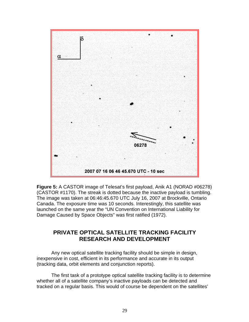
Figure 5: A CASTOR image of Telesat’s first payload, Anik A1 (NORAD #06278) (CASTOR #1170). The streak is dotted because the inactive payload is tumbling. The image was taken at 06:46:45.670 UTC July 16, 2007 at Brockville, Ontario Canada. The exposure time was 10 seconds. Interestingly, this satellite was launched on the same year the “UN Convention on International Liability for Damage Caused by Space Objects” was first ratified (1972).
PRIVATE OPTICAL SATELLITE TRACKING FACILITY RESEARCH AND DEVELOPMENT
Any new optical satellite tracking facility should be simple in design, inexpensive in cost, efficient in its performance and accurate in its output (tracking data, orbit elements and conjunction reports). The first task of a prototype optical satellite tracking facility is to determine whether all of a satellite company’s inactive payloads can be detected and tracked on a regular basis. This would of course be dependent on the satellites’
29
orbits (Polar, GPS or GEO), and the prototype’s location. The location of the facility would be critically important because of the site’s weather patterns and hours of darkness throughout the year. During the R&D phase of a private optical tracking facility, no satellite owner should be held liable if any of its inactive payloads were to collide with an active payload. Responsibility and liability would be applicable only when the satellite company officially tracks its inactive payloads after a successful accreditation process. A private satellite tracking facility would require several critical components:
1) Satellite Scheduling: Scheduling software would be designed to perform the following critical tasks at each tracking session:
a. All orbit elements for all accessible inactive satellites desired would be propagated.
b. The most effective method of tracking all desired accessible
inactive satellites would be determined. In order to satisfy the desired conjunction report accuracy requirements, the number of required tracking data points for each satellite should be determined. NORAD TLEs could be used initially, but once the first tracking data and orbit elements are produced, a closed-loop system could be sustained, independent of NORAD, if desired.
2) Detecting and Tracking: Optical telescopes and CCD cameras would
be required to detect and track all of the accessible inactive satellites of specific interest. All hardware would be required to maximize reliability, tracking data accuracy and maximize detection possibility (resolution vs. sensitivity trade-off). Timing and telescope sidereal (or other) tracking accuracies would be of significant importance, especially for Polar (LEO) orbit zones.
3) Image Analysis: All images containing satellite streak end points would
be analyzed to extract the tracking data in some coordinate format; most likely J2000.0 Equatorial (R.A. and Dec.). The resultant tracking data could be transformed into any other coordinate system(s) desired by the satellite company.
30
4) Orbit Determination: The extracted tracking data would be used to perform orbit determination. The resulting orbit elements would be propagated to produce conjunction reports and ephemerides for the next scheduling session (1).
5) Residual and Propagation Error Determination: For all orbit elements
generated, it would be necessary to continuously study the residuals and propagation errors in order to minimize the amount of unwanted tracking data that can contribute to the inaccuracy of the orbit elements and conjunction reports.
6) Conjunction Analyses: All satellite orbit elements would be propagated
to generate conjunction reports based on the known propagation errors. The threshold range between satellites will determine if a predicted conjunction will be included within a conjunction report. This threshold range will likely be determined before the conjunction analysis software is created.
7) Two-Way Communications: An internal and external conjunction
reporting infrastructure would be required to relay warnings of potential collisions as soon as technically possible. The format of such warnings should be similar, if not identical, that of other satellite companies. This communications system should have at least 99% reliability, sufficient bandwidth for immediate transfer of collision warnings and sufficient encryption. In the event of an “inactive-inactive” collision, NORAD would also have to be contacted immediately such that it can begin tracking collision debris as soon as possible.
EMERGENCY SATELLITE SEARCH AND TRACKING Using a private optical satellite tracking facility, a satellite owner can optically track a payload that, for any reason, has suddenly become inactive and cannot be communicated with using conventional TT&C facilities. When Iridium LLC suddenly lost communication with Iridium 33, it did not have satellite tracking facilities with which to optically detect the payload to make sure it was still orbiting and safe. If Iridium LLC had had a functional optical satellite tracking facility in place at the time of the collision, it might not have required NORAD’s services. Iridium LLC could have drawn its own conclusions concerning the status of its own payload and informed its customers based on that knowledge.
31
ABOUT CASTOR Canadian Satellite Tracking and Orbit Research (CASTOR) is a private business specifically created to research the feasibility of using optical satellite tracking facilities to detect and track orbiting satellites for the private sector. CASTOR is based on expertise gained from 12 years of practical optical satellite tracking experience, including the design, construction, testing and operation of remotely controlled and automated optical satellite tracking facilities. CASTOR has been detecting satellites from all orbit types (LEO, MEO, GEO and HEO) since January 1, 2007. At the present time, CASTOR has successfully detected and catalogued over 2,500 unique satellites, consisting of 1,142 Low-Earth Orbiting (LEO) satellites, 745 Mid-Earth Orbiting (MEO) satellites, 586 Geosynchronous (GEO) satellites and 21 High-Earth Orbit (HEO) satellites.46
CASTOR’s services currently include:
1) Routine tracking of inactive payloads and spent rocket stages, 2) Emergency optical satellite tracking for payloads that suddenly become
inactive and cannot be tracked with TT&C facilities,
3) Professional consulting for the design, construction, testing and operation of an optical satellite tracking facility,
4) Developing useful strategies for conjunction analysis and reporting.
The images and tracking data that CASTOR has collected has been used to develop a separate catalogue from NORAD’s. The CASTOR Satellite Catalogue (CSC) contains satellites that can be detected with commercial off the shelf telescopes and CCD cameras. CASTOR is currently pioneering the development of the emerging science of satellite tracking for the remainder of the 21st century and beyond.
32
FOOTNOTES
1 “Iridium network patched after collision in space”: Reuters: February 13,
2009: www.reuters.com/article/technologyNews/idUSTRE51D08B20090214
2 “Satellite crash prediction is plagued with uncertainty”: NewScientist:
February 13, 2009: www.newscientist.com/article/dn16592-satellite-crash-prediction-is-plagued-with-uncertainty.html
3 “U.S. Warns of Space ‘Dodgeball’ After Satellite Crash”: Reuters:
February 12, 2009: www.theepochtimes.com/n2/content/view/11901/
4 “Cartwright: US Must Better Sat Awareness”: DoD Buzz: February 12,
2009: www.dodbuzz.com/2009/02/12/cartwright-us-must-better-sat-awareness/
5 “U.S., Russia seek cause of satellite collision”: Xinhua News Agency:
February 13, 2009: http://news.xinhuanet.com/english/2009-02/13/content_10813439.htm
6 “The United Nations Treaties and Principles on Outer Space”: Section C:
“Convention on International Liability for Damage Caused by Space Objects” 1972: Article III: www.oosa.unvienna.org/pdf/publications/STSPACE11E.pdf
7 “The United Nations Treaties and Principles on Outer Space”: Section C:
“Convention on International Liability for Damage Caused by Space Objects” 1972: Article I, section (a): www.oosa.unvienna.org/pdf/publications/STSPACE11E.pdf
8 “The United Nations Treaties and Principles on Outer Space”: Section C:
“Convention on International Liability for Damage Caused by Space Objects” 1972: Article I, section (c): www.oosa.unvienna.org/pdf/publications/STSPACE11E.pdf
33
9 The Satellite Encyclopedia: Cosmos 2251 www.tbs-satellite.com/tse/online/sat_cosmos_2251.html
10 The Satellite Encyclopedia: Iridium 33
www.tbs-satellite.com/tse/online/sat_iridium_33.html
11 “The United Nations Treaties and Principles on Outer Space”: Section C: “Convention on International Liability for Damage Caused by Space Objects” 1972: Article V, section 1: www.oosa.unvienna.org/pdf/publications/STSPACE11E.pdf
12 “The United Nations Treaties and Principles on Outer Space”: Section C:
“Convention on International Liability for Damage Caused by Space Objects” 1972: www.oosa.unvienna.org/pdf/publications/STSPACE11E.pdf
13 Iridium LLC Presentation: Jeffrey White: March 21, 2009: Page 8
www.eurocontrol.int/nexsat/gallery/content/public/Steering%20Group/Meeting10/IRIDIUM_JeffWhitePresentation32109.pdf
14 “Satellite crash prediction is plagued with uncertainty”: NewScientist:
February 13, 2009: www.newscientist.com/article/dn16592-satellite-crash-prediction-is-plagued-with-uncertainty.html
15 “Billiards in Space”: Brian Weeden: February 23, 2009: Page 2
www.thespacereview.com/article/1314/2 16 “The United Nations Treaties and Principles on Outer Space”: Section C:
“Convention on International Liability for Damage Caused by Space Objects” 1972: Article III: www.oosa.unvienna.org/pdf/publications/STSPACE11E.pdf
17 “The United Nations Treaties and Principles on Outer Space”: Section C:
“Convention on International Liability for Damage Caused by Space Objects” 1972: www.oosa.unvienna.org/pdf/publications/STSPACE11E.pdf
34
18 Space Track: The Source for Space Surveillance Data: Satellite Box Score: 01:05:57 GMT May 28, 2009
19 “USA 193 Post-Shootdown Analysis”: Celestrak.com: May 26, 2009
http://celestrak.com/events/usa-193.asp 20 “The United Nations Treaties and Principles on Outer Space”: Section C:
“Convention on International Liability for Damage Caused by Space Objects” 1972: www.oosa.unvienna.org/pdf/publications/STSPACE11E.pdf
21 “Billiards in Space”: Brian Weeden: February 23, 2009: Page 2
www.thespacereview.com/article/1314/2 22 Ibid. 23 Ibid. 24 “U.S., Satellite Operators Discuss Better Tracking”: Pointrek.net: April 3,
2009: www.pointrek.net/news/article.php?id=426 25 Space Track: The Source for Space Surveillance Data 26 “The United Nations Treaties and Principles on Outer Space”: Section C:
“Convention on International Liability for Damage Caused by Space Objects” 1972: Article I, section (a): www.oosa.unvienna.org/pdf/publications/STSPACE11E.pdf
27 “Iridium 33 and Cosmos 2251”: A Historic Collision: Michael A. Earl
(CASTOR): Page 8: www.castor2.ca/08_Papers/collision.pdf
35
28 “The United Nations Treaties and Principles on Outer Space”: Section C: “Convention on International Liability for Damage Caused by Space Objects” 1972: www.oosa.unvienna.org/pdf/publications/STSPACE11E.pdf
29 “The United Nations Treaties and Principles on Outer Space”: Section C:
“Convention on International Liability for Damage Caused by Space Objects” 1972: Article III: www.oosa.unvienna.org/pdf/publications/STSPACE11E.pdf
30 “Satellite Crash: Who's to Blame?”: Space.com: February 17, 2009:
www.space.com/news/090217-satelllite-crash-future.html 31 Iridium LLC Presentation: Jeffrey White: Page 8
www.eurocontrol.int/nexsat/gallery/content/public/Steering%20Group/Meeting10/IRIDIUM_JeffWhitePresentation32109.pdf
32 “The United Nations Treaties and Principles on Outer Space”: Section C:
“Convention on International Liability for Damage Caused by Space Objects” 1972: www.oosa.unvienna.org/pdf/publications/STSPACE11E.pdf
33 “Satellite Crash: Who's to Blame?”: Space.com: February 17, 2009:
www.space.com/news/090217-satelllite-crash-future.html
34 Oral discussions between Michael A. Earl and Canadian Surveillance of Space Project personnel: July 1998
35 Oral discussions between Michael A. Earl and Canadian Surveillance of
Space Project personnel: October 1999 36 Oral discussions between Michael A. Earl and Canadian Surveillance of
Space Project personnel: February 2000 37 “Billiards in Space”: Brian Weeden: February 23, 2009: Page 1
www.thespacereview.com/article/1314/1
36
38 “Billiards in Space”: Brian Weeden: February 23, 2009: Page 2 www.thespacereview.com/article/1314/2
39 “Back on Earth, satellite collision kicks up some dust”: Boston.com:
February 13, 2009 http://www.boston.com/news/world/europe/articles/2009/02/13/back_on_earth_satellite_collision_kicks_up_some_dust
40 CASTOR Satellite Catalogue:
www.castor2.ca/13_Catalogue/
41 Ibid. 42 Space Track: The Source for Space Surveillance Data 43 CASTOR Satellite Catalogue:
www.castor2.ca/13_Catalogue/ 44 Ibid. 45 Ibid.
37
GLOSSARY OF ABBREVIATED TERMS 1SPCS: 1st Space Command Squadron α: Right Ascension δ: Declination CASTOR: Canadian Satellite Tracking and Orbit Research CCD: Charge Coupled Device CSC: CASTOR Satellite Catalogue Dec.: Declination DoD: (American) Department of Defense E: East (Azimuth 90 degrees) EOL: End of Life GEO: Geosynchronous GEODSS: Ground Based Electro-Optical Deep Space Surveillance GPS: Global Positioning System HEO: High Earth Orbit J2000.0: Julian Epoch 2000.0 km: kilometers LEO: Low Earth Orbit LLC: Limited Liability Company MEO: Mid (Medium) Earth Orbit N: North (Azimuth 0 degrees) NORAD: North American Air Defense
38
R & D: Research and Development R.A.: Right Ascension RF: Radio Frequency sec: seconds TLE: Two Line Element TT&C: Telemetry, Tracking and Control UCT: Un-correlated Target UN: United Nations U.S.: United States U.S.A.: United States of America USNO: United States Naval Observatory U.S.S.R.: Union of Soviet Socialist Republics UTC: Universal Time Coordinate
39


![2251 Mini Handball Flyer[1]](https://static.fdocuments.in/doc/165x107/55cf99a0550346d0339e5ecc/2251-mini-handball-flyer1.jpg)


![· SHIM SACD Dire Straits rLove Over Gold] (Private Investigations) ' Clear Cygnus SACD ' , IRIDIUM , IRIDIUM , IRIDIUM 11.5 AWG , , PFA 3455R IRIDIUM Clear Cygnus , 5 Trigon Exxpert](https://static.fdocuments.in/doc/165x107/60d04de1d6909b691a4f38e7/shim-sacd-dire-straits-rlove-over-gold-private-investigations-clear-cygnus.jpg)
