THE INTERSTATE HIGHWAY-SYSTEM IN OREGON - Oregon...
120
THE INTERSTATE HIGHWAY-SYSTEM IN OREGON " A HISTORIC-OVERVIEW Prepared .for the Oregon of Transportation Salem, Oregon. \ .. Prepared by George Kramer, M.S., HP · Senior Preservation Specialist Heritage Research Associates, Inc. Eugene, Oregon May 2004
Transcript of THE INTERSTATE HIGHWAY-SYSTEM IN OREGON - Oregon...

THE INTERSTATE HIGHWAY-SYSTEM IN OREGON " A HISTORIC-OVERVIEW
Prepared .for the Oregon Departme~t of Transportation Salem, Oregon.
\ ..
Prepared by George Kramer, M.S., HP · Senior Preservation Specialist
Heritage Research Associates, Inc. Eugene, Oregon
May 2004

THE INTERSTATE HIGHWAY SYSTEM IN OREGON A HISTORIC OVERVIEW
il
\
PREPARED FOR
THE
OREGON DEPARTMENT
OF
TRANSPORTATION I .. \ i)
PREPARED BY
GEORGE KRAMER, M.S. HP SENIOR PRESERVATION SPECIALIST
HERITAGE RESEARCH ASSOCIATES, INC.
EUGENE, OREGON
MAY2004

TABLE OF CONTENTS
lntroduction ................................................................................................................... 1
1.0 1.1 1.2 1.3 1.4
Historic Overview ....................................................................•......................... 5 Geographic Boundaries .................................................................................... 5 Temporal Boundaries - 1947-1988 ............................................................... 5 Earlier Oregon Highways ................................................................................. 5 Late 1940s and Early 1950s Highway Developments -- Improving the U.S. Routes ......................................................................... 10
1.4.1 Oregon's First "Expressway" -- The Banfield ......................................... 15 1.4 .2 The Pacific Highway "Couplet" .............................................................. 16
1. 5 Dwight Eisenhower and the Federal Roads Program ...................................... 18
2.0 Building Oregon's Interstate Highways .......................................................... 22 2.1. Designation -- Names and Numbers ............................................................... 22 2.2 The Interstate Standard .................................................................................. 28 2.3 Progress -- By the Mile, By Percent ............................................................... 31 2.4 Selected Sections of I-5 .................................................................................. 34
2.4.1 Minnesota (East Bank) Freeway ............................................................. 35 2.4.2 R.H. Baldock Freeway (Portland-Salem Expressway) ............................. 36 2.4.3 Myrtle Creek-Canyonville Section .......................................................... 41 2.4.4 Medford Viaduct .................................................................................... 42 2.4. 5 Siskiyou Summit (Wall Creek California State Line) ............................... 46 2.4.6 Interstate 5 Completion .......................................................................... 48
2. 5 Selected Sections of I-84 Construction Issues ................................................ 49 2.5.1 T.H. Banfield Freeway ............................................................................ 50 2.5.2 Troutdale to The Dalles .......................................................................... 51 2.5.3 The Dalles to Pendleton .......................................................................... 55 2. 5 .4 Pendleton to the Idaho Border.. .............................................................. 56
2.6 Connecting Routes and Urban Loops -- Built and Withdrawn ......................... 57 2.6.1 I-105 -- Eugene-Springfield .................................................................... 57 2.6.2 I-205 -- East Portland Freeway ............................................................... 58 2.6.3 I-305 -- Salem Spur ................................................................................ 62 2.6.4 I-405 -- Stadium Freeway ....................................................................... 65 2.6.5 I-505 -- Industrial Freeway, North Portland ............................................ 68 2.6.6 I-SON --Mt. Hood Freeway ................................................................... 72 2.6.7 I-82 -- McNary Highway ........................................................................ 75

3.0 Related Developments, Impacts and Effects ................................................... 81 3 .1 Interchanges ................................................................................................... 81 3 .2 Business Loops, Malls, Frontage Roads, and Downtown Impacts ................... 84 3.3 Safety Rest Areas ........................................................................................... 87 3 .4 Highway Beautification: Information .............................................................. 89
3.4.1 The Logo Program ................................................................................. 89 3.4.2 Traveler's InfoCentres ............................................................................ 91 3. 4 .3 Welcome to Oregon ............................................................................... 92
3.5 Highway Beautification: Landscaping ............................................................. 95 3.6 Bridges, Overpasses, and Underpasses ........................................................... 99 3.7 Sprawl, Senate Bill 100, TriMet, and Light Rail ........................................... 100
4.0 Conclusion and Recommendations ............................................................... 102
Bibliography .............................................................................................................. 107
Glossary of Interstate-Related Highway Names ...................................................... 112
- ii -

LIST OF FIGURES
Cover Figure 1.
Figure 2:
Figure 3. Figure 4. Figure 5. Figure 6. Figure 7. Figure 8.
Figure 9. Figure 10. Figure 11. Figure 12. Figure 13. Figure 14: Figure 15. Figure 16. Figure 17. Figure 18. Figure 19. Figure 20. Figure 21. Figure 22. Figure 23. Figure 24. Figure 25. Figure 26.
Figure 27. Figure 28. Figure 29. Figure 30. Figure 31.
Figure 32.
East End of Morrison Bridge, Portland, February 12, 1966 What Freeways Mean to Your City, January 1963, Automotive Safety Foundation, Washington DC ....................................................................... 4 Looking west from Shepperd's Dell along the Columbia River Highway, c. 1915 ............................................................................................................ 6 On the Pacific Highway ............................................................................... 7 Pacific Highway, Douglas County, c. 1924 .................................................. 8 Pacific Highway, California-Oregon state line, looking north, c. 1922 .......... 9 Oregon State Highway Commission map, 1926 ......................................... 10 The Banfield construction, looking east, October 1957 .............................. 17 Split traffic lanes and other improvement on the Pacific Highway at SW Barbur Blvd intersection with SW Terwilliger in Portland, 1949 ................ 18 Portland Cement Association advertisement, c. 1957 ................................. 21 Pacific Highway folder, c. 1930 ................................................................. 23 OSHD draft for interstate signage, September 1956 ................................... 24 Curt Teich postcard No. CK-414, 1950 .................................................... 28 Continuous concrete paving, c. 1963 ......................................................... 30 Oregon Interstate progress map, December 1965 ...................................... 33 Governor Mark Hatfield, ribbon cutting, 5 January 1964 ........................... 34 State selects north Portland freeway route ................................................. 36 Lombard Street interchange planning, Minnesota Freeway, March 1965 .... 37 Map of planned Portland-Salem Expressway, 1953 .................................... 38 Baldock route extension, 1956 .................................................................. 39 Cover, R. H. Baldock opening ceremony ................................................... 40 Interstate view, Douglas County, c. 1965 .................................................. 41 Interstate 5, Medford Viaduct, looking north, September 1966 .................. 45 Interstate 5, Siskiyou Mountains segment construction .............................. 47 Banfield (I-84) Expressway, NE Grand Avenue, 1966 ............................... 51 I-84 Eagle Creek Viaduct construction near Tooth Rock, c. 1969 ............. 53 Interstate 84 with parking lot located in the median, looking east toward Multnomah Falls, 1966 .............................................................................. 54 I-205, Interchange with I-5, looking east, 1977 ......................................... 59 Proposed extension to I-305, circa August 1968 ........................................ 63 Interstate 405 "Stadium Freeway" construction, March 1968 .................... 67 Interstate 405 "Stadium Freeway" construction, October 1968 .................. 69 Mt. Hood Freeway alternatives, Skidmore-Owings and Merrill Report, 1972 .......................................................................................................... 73 Interstate 82, alternate route proposals, c. 1965F]) .................................... 76
- iii -

Figure 33.
Figure 34. Figure 35. Figure 36. Figure 37. Figure 38: Figure 39. Figure 40. Figure 41. Figure 42. Figure 43. Figure 45. Figure 46. Figure 47. Figure 48.
Oregon and Washington dignitaries open a section of 1-82 near Prosser, September 1981 ........................................................................................ 79 I-82 dedication program, September 1988 ................................................. 80 I-84 interchange at Ontario, 1960 .............................................................. 83 Lloyd Center, Portland, c. 1962 ................................................................. 85 Oak Grove safety rest area construction, c. 1962 ....................................... 88 Oak Grove safety rest area, 1963 ............................................................... 89 Gov. McCall dedicates first logo board, July 1972 ..................................... 90 Logo sign, I-5, north of Albany, southbound, 2004 .................................... 91 Traveinfo brochure, c. 1975 ...................................................................... 92 Welcome to Oregon sign, c. 1965 .............................................................. 93 New welcome sign at California-Oregon border, July 21, 1982 .................. 94 Even one tree is worth saving, I-5, c. 1963 ................................................ 96 Green Thumb Program plantings, I-80N, c. 1966 ....................................... 97 Interstate 5, Biddle Road/Highway 62 interchange landscaping, 1965 ........ 98 ODOT celebrates I-5 25th anniversary, 1991 ............................................ 106
LIST OF TABLES
Table 1. Table 2.
Interstate Completion Progress by Year in Oregon .................................... 32 Oregon Interstate Finalization Dates .......................................................... 80
- Iv -

INTRODUCTION
Our National System of Interstate and Defense Highways is a Federal-State cooperation program designed to provide a coast-to-coast, 41,000 mile system of ultra-modem controlled access access highways (Phillips Petroleum Company, Interstate Highway Guide, 1968).
In the years following World War II, the pressure for an improved highway system became something of a national mania as more and more Americans came to rely on private automobile transportation for both work and vacation travel. As described in the following narrative, a widespread coalition of engineers, business, auto enthusiasts, state and local government leaders, and finally the Federal government, all played a role in the development of what became the Federal Interstate and Defense Highways program, signed into law by President Dwight D. Eisenhower in 1956.
The "Interstate," like no public works project before or since, was truly national in scope and required billions of dollars and more than 30 years to complete. Today, nearly a halfcentury after its inception, the Interstate system remains the largest public works project in history. As might be expected, the system has fervent supporters who see its construction as the lodestone of modem America, while at the same time, again as might be expected, it has equally fervent critics who see it as the root of many of the country's social and economic ills. Either way, for good or bad, it is hard to envision anything else in the past 50 years of American history that has affected so large a segment of the population as the construction of the Interstate system. Those areas adjacent to which the Interstate was located may well rue its construction, but surely depend upon it for transport and economic growth. Communities off the route--or worse, entirely bypassed by its connectivity--bemoan their isolation.
Oregon's portion of the Interstate system consists of two major routes: Interstate 5, running north-south, and Interstate 84, running generally east-west along the Columbia River. Smaller connecting sections of the Interstate--I-205, I-105 and I-405--provide increased access to I-5 at Portland and Eugene. I-82 runs from north central Oregon into Washington. In most ways, Oregon's Interstates are a microcosm of the entire national system, consisting largely of long stretches of uninterrupted pavement running through sparsely settled, rural landscapes. Both Interstate 5, tying the western portion of the state from north to south, and Interstate 84, tying the northern portion together east to west, change in character as they converge upon the Portland metropolitan area, where they become broad, multi-laned, multi-layered and many-bridged, urban routes. This mixture of long, rural freeways, coupled with densely developed and complex urban connections, typifies much of the Interstate system.

In other ways, however, Oregon's Interstate is unique, the result of Oregon's century-long commitment to good roads and nation-leading innovation in highway construction and design. Oregon's 731-mile portion of the Interstate, goodly parts of which were planned and even built before the Federal program was enacted, reflects the highway tradition in our State and embodies its long recognition of the link between good roads, prosperity, and access across its often difficult terrain. Certainly in impact, Oregon's Interstate, though national in gestation, has played a significant role in the local development of the cities and counties along its route. At the end of the construction period, as new laws and sensibilities changed the public reception to proposed highways, Oregon's experience with the Interstate became a series of episodic, decade-long dramas, most of which ended without any new Interstate construction. This too reflects national trends of the time.
Not designed or intended as an evaluatory tool akin to a typical historic context statement, this historic overview of the development of the Interstate Highway in Oregon, beginning with its post-WWII gestation and continuing through both its initial construction, challenges, and the various impacts it has had on the state over the past 40+ years, was prepared under contract to the Oregon Department of Transportation by Heritage Research Associates of Eugene. George Kramer, M.S., Senior Preservation Specialist, served as principal researcher and author with editorial oversight provided Kathryn Toepel, Ph.D. Rosalind Keeney ofODOT's Environmental Section provided project oversight with additional input from James Norman, Robert Hadlow, and Linda Dodds. Pat Soloman, ODOT Archivist in General Files, made available the extensive photo collection of that department without which this document would surely be less graphically interesting. Pat provided valuable direction in locating files, letters, internal correspondence and patiently guided me to other sources and individuals with information and materials related to the Interstate' s history. Other ODOT staff, including Margie McCormick and Frances Nichols of General Files; Garnett Elliott of the Information Center; Edward "Ted" Burney, Gary Weber and Orrin Russie of Photo and Video Services; and Christopher Leedham and Frank Nelson in Bridge, all provided me with much appreciated assistance on this project. Dennis Church, of Salem, generously shared material from the estate of his father, a long-time ODOT employee who worked for the department during the Interstate construction period.
Newspaper accounts related to the public viewpoint on various Interstate projects, as well as magazine articles and other printed materials, were gathered from various historical societies, the State Archives, and other libraries. Research for the overview began in Summer 2003 and most of the text was drafted during December 2003 and January 2004. The Interstate Highway System in Oregon was a huge undertaking, spanning virtually the entire state and nearly three decades of construction. It is far from a discrete resource, being by nature a part of a national system and one that gains value economically and
- 2 -

historically by its ability to connect this state with varying degrees of ease to every other. And while much of the Interstate was built in a comparatively short period, and by design was required to meet specific standards, each portion retains a distinct, if not necessarily unique, character.
There are many different ways to view, and consequently to assess, the impact of the Interstate system in Oregon. On one level, it is a feat of engineering, among the largest ever conceived or built. It is with little argument the single most significant element of the state's road system. But in reality it is also comprised of multiple pieces, or "segments," some with their own names and distinct identities, that were built over nearly three decades of planning, construction, and finally alteration and rebuilding. Today, from one point of view, Oregon's Interstate is largely as it was built and designed between the 1950s to 1960s. From another, it has been constantly changing and adapting to meet new requirements.
From a positive social perspective, the Interstate allowed the rapid expansion of communities by placing suburbs, and even distant communities, within easy and safe driving distance of traditional downtown cores, improving family life, providing greater employment opportunity and relieving congestion by dispersing the huge population influx that characterized much of post-war period in the West. Negatively, the Interstate is likely the single largest contributing factor to "sprawl," and as such played a role in the decline of historic downtowns and the advent of national chain stores and "supercenters" with the resulting loss of locally-owned businesses. The Interstate reduced stop-n-go traffic and the pollution caused by idling vehicles. By increasing travel distances, and the amount of miles typically driven, the Interstate added to pollution by increasing gas consumption and adds to the solid waste stream through more junker cars and millions of worn out tires. The Interstate' s controlled access design reduced the "roadside blight" that was characteristic of earlier highways. The Interstate, by encouraging national marketing and identification campaigns, resulted in a sameness that some urban critics disparagingly dub "generica," for its monotony and uniformity, reducing local character.
Few things in the last fifty years have had such comprehensive impact upon America as the Interstate Highway System. This overview covers some of the major aspects of that system in Oregon - its historical, legal, and political genesis, how it was planned and built, and finally, the impacts it has had upon Oregon cities and Oregonians. It is fully recognized that there is far more to the Interstate story than is, or can be, presented here.
- 3 -
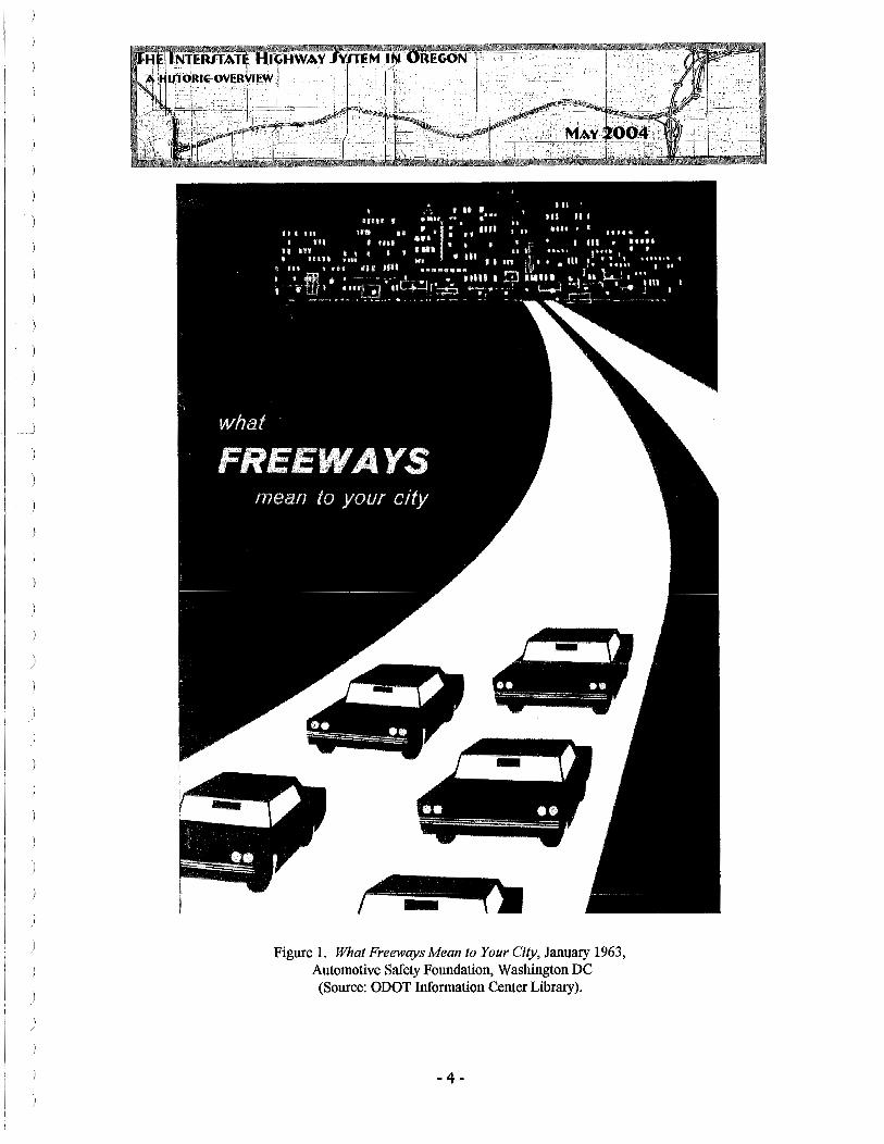
Figure 1. What Freeways Mean to Your City, January 1963, Automotive Safety Foundation, Washington DC (Source: ODOT Information Center Library).
- 4 -

\ /
)
I )
1.0 HISTORIC OVERVIEW
1.1 GEOGRAPHIC BOUNDARIES
This overview is focused upon the development history and impacts of the construction of the Interstate Highway System in the State of Oregon. Although the specific resources are by definition limited to the actual roadways and related infrastructure of the system, generally following Oregon's two major Interstate sections, I-Sand I-84, the economic and social impacts of the construction of the system effect virtually every comer of the State to a greater or lesser degree. As a result, for the purposes of this study, the geographic boundaries are established as the State of Oregon.
1.2 TEMPORAL BOUNDARIES -1947-1988 Although some planning for a four-lane route through the Columbia River Gorge occurred in the mid-1930s, the development of what would become Oregon's component of the Interstate Highway System formally began after WWII, as planning for the expansion of the existing highway system was undertaken with an eye toward compliance with some future Federal program, if and when such was adopted. The earliest work on a "freeway" type road with the hallmark features of the Interstate began in the late 1940s, following Oregon's adoption of"limited access" rules for highway construction, and so that date is taken as the general temporal beginning of the Interstate system in the state. 1 For the purposes of this study, the historic period of development ends in 1988, with the completion of the last portion of Interstate 82. Significant dates within that broad temporal range include 19S6, and the formal beginning of the Federal Interstate Highway program following U.S. Congressional action, and October 1966, the completion of Interstate S from border-to-border. Though much of this temporal period is outside the normal SO-year evaluation period, this document is intended to guide understanding of the Interstate as a whole and so includes all projects that were envisioned in 19S6, well within the SO-year period, in recognition that the lengthy construction process associated with the program was inherently a characteristic of massive scope.
1.3 EARLIER OREGON HIGHWAYS
With the arrival of the first automobile in Oregon in the late 19th century, it wasn't long before the clamor to improve the county-by-county system of dirt, plank, or at best gravel or cobblestone roads that sufficed as Oregon's travel routes. Travel between cities and towns, when not possible by railroad, still relied upon stages or private wagons, which soon shared bumpy, corduroy roads, with increasing numbers of horseless carriages.
1 Many of Oregon's earliest "freeways" were planned Wlder this State-funded program and then incorporated into the futerstate System after its creation.
- 5 -

In order to provide a more uniform and better functioning system of roads, to "Get Oregon Out the Mud," the Legislature created the Oregon State Highway Department (OSHD) in 1913. Under the direction of Major Henry Bowlby, aided initially by engineer Charles Purcell, the OSHD developed standard bridge plans, helped survey routes between counties and quickly developed a plan to build one of America's first truly statewide systems of roads and highways.
Funding for road construction was aided by Oregon's innovative use of taxes upon gasoline, adopted in 1919 (Carrick 1993:7). This Oregon first was soon copied nationwide and became, and remains, one of the primary funding mechanisms for road construction in the United States. Assured of stable funding, OSHD developed a master plan for Oregon's highway system and was soon constructing on a series of primary highways that would allow improved access. Two--the Columbia River Highway and the Pacific Highway--are of note here.
Much has been written of the Columbia River Highway (Figure 2), an east-west corridor that branched out from Portland and generally followed the waterway for which it was named toward eastern Oregon, while the western portion (which is now called the Lower Columbia River Highway) extended toward Astoria. This scenic road, one of the first designed automobile "highways" in the nation, was completed in 1922. "No ordinary pen
Figure 2: Looking west from Shepperd's Dell along the Columbia River Highway, c. 1915 (Source: postcard image, author's collection).
-6-

can describe the scenery of this highway ... [which] has become world famous ... " (Oregon News Company c. 1920).
Running south from Portland through the Willamette, Umpqua, and Rogue River valleys of western Oregon, the Pacific Highway (Figures 3 and 4) was the primary north-south route. Utilizing some sections of previously paved road through settled communities and cities, the concept of the Pacific Highway dates from the 1913 OSHD plan. Jackson County, at the extreme southern end of the route, was the first to be completely paved from border to border, including the steep portion up the Siskiyou Mountains, heading to the Oregon-California line (Figure 5). Steep and winding mountainous grades, both at the Siskiyous and then over the passes south of the Willamette Valley, taxed both the roadbuilding technologies of the time and the climbing power of early day automobiles. One
ON '!'HE PACIFIC HIGHWAY 1)1 OREGON From painting by H. H. Bagg
Figure 3. On the Pacific Highway (Source: Murphy, Oregon the Picturesque 1917).

REGON
traveler, describing the Pacific Highway south of Cottage Grove in 1917 wrote that " ... the fair road south ofEugene ... soon degenerated into a rough, winding trail ... the road
was often strewn with boulders and cut up into ruts that gave the car an unmerciful wrenching as we crawled cautiously along ... there was little respite from these conditions in the sixty miles :from Cottage Grove to Drain" (Murphy 1917: 175-76).
Jackson County's segment of the highway route was finished in 1916. It was the first county section to be entirely paved. By 1923, the entire route from the Columbia River to California was completed, making Oregon the first state west of the Mississippi able to claim a border-to-border paved highway.2
Figure 4. Pacific Highway, Douglas County, c. 1924 (Source: postcard image, author's collection).
The Pacific Highway in Oregon generally followed the center of the valleys, and as a result, went through the downtown of almost every city or town along its 341-mile route in the state. As it passed through eight of Oregon's counties, it in effect became the "Main Street" in seven county seats, and sparked roadside development such as gas stations, repair shops, cafes, and later motor courts and motels, in virtually every town and hamlet along its route.
2 California completed its treacherous segment of the Pacific Highway just south of the Siskiyou Mountains in 1926. With that, the Pacific Highway, running some 2,300 miles from Tijuana, Mexico, to Vancouver, British Columbia, was credited as being the longest continuously paved road in the world.
-8-

As the power of automobiles improved, along with the ability of road-builders to sculpt terrain to improve and straighten routes, the Pacific Highway was in a continual state of improvement. Curves were straightened, grades flattened, and by the 1930s increasingly congested towns were bypassed in favor of newer, straighter, less developed, rights-of-
3 way.
For some time it has been the objective of the Oregon State Highway Commission to modernize this great traffic arterial to eliminate hazard and to save time and expense in the transportation of passengers and commodities (Oregon State Highway Commission [OSHC] Biennial Report 1936:34).
Figure 5. Pacific Highway, California-Oregon state line, looking north, c. 1922 (Source: postcard image, author's collection).
New road building technologies allowed significant improvements. Perhaps exceptional, but indicative of the scale of change, was the 1935-36 realignment of the steep 10-milelong section between Ashland and Siskiyou Station, which eliminated 3 .45 miles of distance and 5,200 degrees of curves, " ... or 15 complete circles ... " (OHSC Biennial Report 1936:34). This pattern ofimprovement, straightening routes, bypassing towns, and reducing travel time continued throughout the 1930s as finances allowed. Road work on primary highways sought not only to improve the routes, but it was also seen as an important part of the economic recovery effort.
3 fu 1926, under the guidance of the Federal Bureau of Public Roads, Oregon's named highways were numbered as a component of national system. The Pacific Highway, while formally designated US 99 (including 99E and 99W in the Willamette Valley) was still known as the Pacific Highway (see Section 2.1 ).
-9-

1.4 LATE 1940s AND EARLY 1950s HIGHWAY DEVELOPMENTS - IMPROVING THE U.S. ROUTES
With the U.S. involvement in World War II, Oregon saw huge population increases and major Federal investments that placed an increased burden on its already over-taxed and under funded highway system. 4 This was particularly true in western Oregon, along the
~ STA'rE OF·~iEGON SYSTEM OP STA'l' •' HIGHWAYS
1926
i
Figure 6. Oregon State Highway Commission map, 1926 (Source: OHSC Seventh Biennial Report, 1926-1927).
Pacific Highway route, where two massive army training facilities, Camp White, near Medford, and Camp Adair, near Corvallis, were largely dependent upon highways for supply and travel despite a wartime resurgence in rail transport. In the Portland metropolitan area, the construction of major shipyards, aluminum plants, and other warrelated industry on the Willamette and Columbia Rivers turned that city into a major
4 Oregon population according to the U.S. Census in 1940 was 1,089,684 and grew to 1,521,341by1950, an increase of nearly 40% over its pre-war population. In general, western Oregon counties saw the most severe increases. Lane County, for example, grew from 69,000 to 125,000 residents in the same period(OregonBluebook 1951-1952:325).
-10 -

manufacturing center almost overnight and attracted more than 100,000 new residents to the area during the first two years of the war.
As a result of the war effort and new population, Oregon's roadways, in spite of gas rationing, still saw significantly increased traffic loads, for private vehicles as well as heavy freight trucks, that accelerated damage to the system and pressed capacities. Despite the state's increased reliance on its road system, scarcity of materials and skilled workers limited OSHD' s ability to improve the system. The Highway Department apparently retained only a barebones level of capacity to maintain those roads already in use.
During the Depression there was little money for road improvement. During the war, Congress forbade road construction save that necessary in the war effort. In consequence, for twelve years there was a slow spell in road construction and, as a result, a vast backlog of deferred jobs has accumulated (OSHC Biennial Report 1946-47: 12).
By the war's end, Oregon's road system was in relatively sorry shape. Increased traffic during the war, limited maintenance, and virtually no improvements saw a general decline in the state's highway system. Now, with the coming of peacetime, and with still more population increases expected, Oregon's highway situation was from OSHD's standpoint nearing a serious level and the Department began to plan for prompt and comprehensive action.
Oregon is close to a complete breakdown of its highway system, State Highway Engineer R.H. Baldock said .... The engineer blamed misguided administration of federal scarce materials controls for a situation that may bring all highway construction in the state to a halt (Medford Mail Tribune, 9 September 1951, 14:1).
Robert H. "Sam" Baldock, the Oregon State Highway Engineer, had been appointed to his position in 1932 and played an integral role in the development of Oregon's highway system prior to the war, helping to establish the state a national leader. Well-regarded, as the war wound down, Baldock began to advocate for large-scale improvements in the primary road system, with the strong support of Thomas H. Banfield and the other members of the OSHC. In 1947 the Legislature authorized the creation of the "Interim Committee for the Study of Highway, Road and Street Needs, Revenue and Taxation," which after a year-long process resulted in the comprehensive report Highway Transportation System in Oregon - Present and Future Needs (OHSC Minutes 1948:7). This study identified more than 6, 700 miles of construction needs, including more than 1,200 "immediate needs ... to correct deficiencies which are currently intolerable .... " (OHSC 1948:8).
-11 -

The Highway Commission can merely point out the problem. The Legislature will, of course, decide the final action. Highways affect the lives of all people. The growth and expansion of the state's economy is dependent upon the modernization of main truck highways, which carry the 'life blood' of the state's commerce (OSHC 1948:12).
Beginning in 1949 as a result of OSHD efforts, aided in no small part by local political leaders who saw access to efficient highways a major component of their own community's potential for post-war growth, the Oregon State Legislature undertook a series of actions to make a significant financial commitment to improving the state's highways. In 1949, legislation was passed to raise the state's gasoline tax a penny (to six cents) and to increase the automobile registration fee. In 1951, the Commission was authorized to sell $40 million dollars in bonds and to begin the Five-Year Program that had been developed for highway improvements. In 1953, the Legislature authorized another $32 million dollars in bonds.
In addition to increasing funding, however, OSHD also sought new legislation that would give it the planning and legal tools to successfully develop modern "expressways." Roads such as the Pennsylvania Turnpike, the first portion of which was opened in 1940, had established a new national standard for highway design, and Oregon looked to such models as it began to create a new, efficient, post-war highway system. Unlike other states, Oregon was determined to find alternate funding sources for its road system rather than have them subject to tolls. 5 A primary and fundamental difference between the new roads and Oregon's earlier highways was that OSHD had the ability to limit access to the roadbed.6
Limited or "controlled access" was a significant departure from early highways, where adjacent property owners could often achieve substantial financial benefits simply by being located upon on the major route of travel. Business owners catering to the traveler or auto trade, selling auto-related products or services such as gasoline, automobile repair, "road food," or lodging clearly needed visibility and ready access to the highway route. Other businesses, be they mills, farms, manufacturing plants, or various retail ventures, benefited from easy freight access for incoming supplies or customers and outgoing products. This was particularly true as motor freight began to overtake and expand upon
5 Oregon would, in several situations, build toll bridges to offset their construction cost. The most notable of these was the hlterstate Bridge West, connecting Portland and Vancouver, Washington (opened in 1958 and subject to toll between 1960 and 1966).
6 The word "freeway" is defined as "an expressway with fully controlled access" according to Merriam Webster's Collegiate Dictionary (l olh Ed) and was fust used in 1930.
- 12 -

the previously rail-dependent patterns of manufacturing businesses in the early post-WWII era. 7
The most-needed addition to the standards of highway design in many years is that of access control. ... Attempts were made to control access at least partially, but few states had the requisite legislation to impose the control of access which is needed to protect the highway investment, particularly in the suburban areas around cities. Many a highway built 20 or more years ago, which at the start had been a wide, safe, and relatively fast thoroughfare, had, through ribbon development, become a congested city street. (ODOT GF, Baldock, 11 June 1956).
Those portions of the Oregon's two primary highway routes, US 30 and especially US 99, that passed through cities and their outskirts, were lined with business and property owners who considered location a primary advantage and a financial requirement for their success. The counties along the US 99 corridor, containing more than 70 percent of Oregon's population in 1950, quickly developed an almost uniformly commercialized corridor along its route through a community, separated by long, rural, or forested sections as it moved between communities. 8 These commercial corridors, in some cases incorporating previously extant downtown cores and in others establishing entirely new strip developments, were a major component of almost every local economy along the roadway.
While business owners placed a high value upon an ability to easily and directly enter or leave the route, from the standpoint of Oregon's highway engineers, the constant flow of new, slower moving vehicles onto or off the road increased congestion, created dangerous situations, and increased the possibility of accidents. For the traffic engineer at the state level, the lack of access control severely reduced the effectiveness of the highway system for through traffic. And in this period, through traffic, as opposed to local traffic, increasingly became the primary focus in state highway design.
As with controlled access, grade separations also became a buzzword in post-war highway design that would separate the old type of highway from the new. Cross-streets created disruptions in traffic flow that decreased speed and safety as vehicles attempted to traverse the corridor. This required stop signs at side streets or, at major intersections,
7 Motor freight on the highways increased exponentially as engine power grew and road technology allowed for faster travel. The rise of truck freight is directly related to the decline of the railroad, and trucking companies became a regular and powerful voice in favor of improved highway construction.
8 US 99, beginning at California, passed through Jackson, Josephine, Douglas and Lane counties before splitting into 99E and 99W, which individually passed through Benton, Linn, Polk, Marion, Washington and Clackamas counties, before rejoining as a single entity within Multl1omah. Collectively these eleven counties had over one million residents, nearly half of whom lived in Multnomah County alone.
-13 -

traffic lights that forced through traffic to slow or stop. Railroad crossings required wigwags or crossing arms with worse effect, as long freight trains could create lengthy backup situations that compromised flow. Traffic signals and railroad crossings quickly became anathema on the modern post-war expressway.
Grade separations and controlled access along existing routes created both political and financial obstacles to the construction of new highways. Existing businesses would be affected through reduced access, numerous cross-streets and rail crossings through established communities would have to be addressed, and right-of-way acquisition, involving primary commercial frontages, would be significantly more expensive than that of more rural, open lands.
The Oregon Legislature responded to these various concerns by passing SB 121in1947, creating both the legal framework for the creation of controlled access highways and, in 1952, bond funding mechanisms to help pay for them. With these hurdles cleared, OSHD began the planning and development of what would essentially be an entire new highway system that would be superimposed over the earlier US 30 and US 99 corridors.
Armed with funding and new legal authorities, OSHD began development of new and modern highways that would eventually be incorporated into the Interstate System, before the passage of the Federal act that actually created the program. To pennit the development of entirely modern, controlled access and grade separated routes, OSHD decided almost from the start ofthis new post-war building program that it would develop largely new road corridors and remove the majority of through traffic from the earlier roadbed of both the Pacific and Columbia River highway routes. In 1952-1954 the OSHD reported upon its plan for a "New Pacific Highway."
Construction is now in progress on a new Pacific Highway. This new highway is to extend from Portland to the Oregon-California State line south of Ashland and is to traverse, in general, the same part of the state as does the existing Pacific Highway .... For the most part, however, it is to be on entirely new right of way, with entirely new alignment and entirely new pavement, and all will eventually be built to expressway standards (OSHC 21st Biennial Report 1952-1954:15).
Construction of new "freeways" inherently required that most communities would be "bypassed," with new routes established at their periphery or, in some cases, parallel but largely independent of, the existing highway route. In other segments, mostly through the Portland metropolitan area, where right-of-way costs were heavier due to dense development patterns and the lack of open or rural lands, the existing highway route
-14 -

would be expanded and re-worked to conform to the new requirements of grade separation and access control.
1.4.1. OREGON'S fIRST"EXPRESSWAY"-THE BANFIELD
Before the war, American highway engineers had started to lay the groundwork for a modem highway system. Those few routes constructed to new "expressway" standards, such as the Pennsylvania Turnpike or the Arroyo Freeway in southern California, were universally hailed. Many states, lacking a funding source to undertake construction, looked at toll roads and "pay as you go" type funding mechanisms, which in Oregon was met with little enthusiasm. In 1947, the Oregon Legislature gave the Highway Commission the ability to limit access to state highways and then, in 1952, authority to issue $40 million in bonds. OSHD engineers were finally able to begin work on Oregon's first modern expressway. 9
Among the most congested highway routes in Oregon, the access to downtown Portland from the east was high on the list. As a primary route within the state's most populous metropolitan area, the improvement of the portion of US 30 from the Steel Bridge to Troutdale would become one of OSHD's first efforts at planning and constructing a new limited-access freeway.
The existing route, given the massive wartime build-up and population increases in this area, had become increasingly congested. Sandy Boulevard, a densely developed commercial core, was typical of exactly the type of problems that unlimited access created and so formed the perfect candidate for replacement with a new, controlled- access corridor that would be free of distraction, grade crossings, and other potential trafficsnarling development.
Planning for the new section of US 30 had actually begun prior to WW II but was delayed as a result. Construction on the improved expressway was underway by the late 1940s. In March 1950, longtime OSHC Chairman Thomas H. Banfield retired due to illness and on August 22nd the Commission passed a resolution to rename the freeway then under construction in his honor.
Chairman Chandler also brought up for discussion the naming of the proposed highway through Sullivan Gulch in Portland .... in honor of Mr. T. H. Banfield ... because of Mr. Banfield's early association with the selected location, because it was largely through his personal efforts that route was adopted ... and in recognition of the valuable services rendered the state by Mr. Banfield. After due consideration the motion was made, duly seconded,
9 See Interstate Highways in Oregon (ODOT, 7 October 1977).
- 15 -

and carried unanimously that this highway be named "Banfield Expressway" (OSHC Minutes, 22 August 1950:17130-17131).
Banfield died on August 31, 1950. The corridor of US 30, now Interstate 84, between the Willamette River and Interstate 205 is still known as the T. H. Banfield Expressway, though most Portlanders simply call it "The Banfield."
The Banfield was opened between 42nd Avenue and Troutdale on October 1, 1955, with a ribbon-cutting ceremony, parade and the dedication of a new Lewis and Clark State Park. "State Highway Engineer R. H. Baldock. .. said the highway commission intends to press 'as soon as possible' to complete the freeway, extending it six lanes wide to its ultimate connection with the Burnside and Steel bridges by the fall of 195 7 ... " (Oregonian, 2 October 1955, 1:1).
The Banfield freeway, which opened last week ... gives one an .. .idea of what one may expect in rapid travel within this city in the future. Not a single traffic light bars one's progress on this multi-lane, limited-access, road. Traveling at 55 miles an hour, the drive from 42nd Avenue to Troutdale requires only 12 minutes (Oregonian, 5 October 1955).
The Banfield, begun and largely completed more than a year before the Federal government would finalize the funding mechanisms for the Interstate Highway System as we know it today, established an increasingly typical standard for highway construction in Oregon. It was of course a largely new route with both controlled access and full grade separations (Figure 7). While it was numerically designated US 30 by the Federal government, it was generally considered a named freeway by Oregonians. Constructed after considerable debate regarding its siting and impacts upon adjacent property owners, it was ultimately routed through lower income residential areas and, finally, it was opened more or less on time, on budget, and to great fanfare. Over the next decade, between 1956, when the Interstate system was established by Congress, and 1966, when Interstate 5 was completed through Oregon, all these elements, culminating with a ribbon cutting, would be repeated again and again.
1.4.2. THE PACIFIC HIGHWAY "COUPLET"
While much of the early 1950s improvements to the Pacific Highway involved the straightening of curves and construction of additional travel lanes through rural portions of the state, a number of communities saw the construction of what became a type of interim solution to increased traffic- the "couplet." Couplets involved an existing second major surface route through a downtown core, or required the construction of an entirely new parallel route, to create two one-way traffic "split traffic" corridors that divided north-south traffic on the Pacific Highway in two lanes of travel. "Couplets" were not generally any more grade separated than the earlier road, nor did they incorporate much in
- 16 -

the way of controlled access and so fell short of OSHC long-term "expressway'' goals (Figure 8). Indeed many of the new couplet segments almost immediately became the focus of exactly the sort of roadside development that new highway engineering sought to avoid. 10
Figure 7. The Banfield construction, looking east, October 1957 (Source: ODOT GF).
10 Similar roadside development occurred earlier when the Pacific Highway in the Willamette Valley was divided into 99E and 99W, early "four lane superhighways" completed by the late 1930s that separated traffic into two routes through Oregon's most populated counties.
-17 -

But, as Oregon and the west grappled with major population growth, increased travel and tourism, and other issues, many downtown couplets were constructed as a way of somehow addressing congestion. Ashland, Medford, Grants Pass, Roseburg, Cottage Grove, Eugene, Corvallis, and on up the state all saw one form or another of the couplet in the years between 1949 and the early 1950s. Couplets, an interim solution to Oregon's post-WWII highway problems, remain a key characteristic feature of many Oregon cities.
Figure 8. Split traffic lanes and other improvement on the Pacific Highway at SW Barbur Blvd intersection with SW Terwilliger in Portland, 1949
(Source: OSHC 181h Biennial Report).
1. 5 OWIGHT EISENHOWER AND THE FEDERAL ROADS PROGRAM
As Oregon was planning its post-war highway system and grappling with construction and funding issues, similar scenarios were being played out all across the country. "Auto makers could not convert from wartime production quickly enough to meet demand .... [E]very year from 1946 until 1952 produced record number of vehicle miles ... .In its 1951 annual report BPR [Bureau of Public Roads] announced 'we are being overwhelmed by a flood of traffic'" (Seely 1987:193).
-18 -

While the complex process by which the Federal Government came to enact a comprehensive national road system and the funding mechanism for the Interstate Highway system is outside the scope of this project, a brief synopsis of that process is appropriate. Oregon, going back to the earliest years of the Good Roads Movement, had long been a recognized leader among the state highway programs. State officials, most notably bridge engineer Conde B. McCullough and highway engineer R. H. Baldock, were nationally respected and well-connected through positions in (American Association of State Highway Officials (AASHO), with Baldock serving as its President. These two men, aided by Oregon's various elected members of Congress as well as certain state-level political leaders, well represented Oregon interests at the national level and sought, and achieved, impact on how Federal-level programs would work in smaller and largely rural western states.
From the earliest days of the automobile, the Federal Government's involvement with highway development had been one of expertise and funding, both of which were channeled through the BPR. The Bureau, under the direction of Thomas H. MacDonald from 1919 through 1953, played an instrumental role in the standardization of road designs through both testing standards and his support for Federal aid. Still, at the end of the WWII, America's road network remained largely spotty from state to state and longdistance travel, whether for business or pleasure, remained an infrequent and often inconvenient proposition. Under MacDonald's direction, BPR began to develop plans for a national road system during the war, so that it would be ready to implement once hostilities ended. The emphasis of this federal-aid program was one of partnership with the states, focusing on the "federal-aid system." BPR and ASSHO regularly testified at the Congressional level, attempting to increase support for state road building.
With the 1952 election of Dwight David Eisenhower to the White House, ending 24 years of Democratic leadership and, shortly, the Korean War, domestic road building had a new and powerful champion. Eisenhower, as a young military cadet, had participated in an arduous 1919 cross-country motor caravan that persuaded him ofboth the inadequacy of American roads and the critical role they would play in the event of war or natural disaster. While the highways had surely been improved by WWII, both oflke' s early perceptions were strongly reinforced when, as the Allies supreme military commander in Europe, Ike saw firsthand just how effective the German army made use of that nation's Autobahn, arguably the first true "superhighway" on the planet. A decade later, as president, looking to improve both America's road system and the economy, Ike and his advisors made a national system of connected highways a major domestic priority.
In the early 1950s, just as Oregon was passing state bond issues for road building, various Federal legislation was passed as the government attempted to develop a successful and nationally uniform highway system. None were entirely effective, in large part due to the
-19 -

inherent controversy regarding the State's suspicion of any new Federal road or fuel taxes to offset the program's cost and the BPR opposition to toll roads, which many states were looking at favorably. The states, which had long relied on road tax revenues for their own use, were unwilling to see any Federal encroachment on this form of revenue, even where they and their road systems would ultimately benefit. 11
Without going into the political, regional, and financial wrangling that came to characterize this issue nationally, suffice to say that President Eisenhower remained resolute in his determination that building a truly national system of high-speed, limited access, highways was a critical national need. After several attempts to persuade Congress and the states to his way of thinking failed largely due to financial concerns, Ike, with advice from a bevy of others, determined to craft a program paid for almost entirely by the Federal government. He intended to float this new proposal at the National Governor's Conference, considered at the time as a hostile audience, in July 1954. A family emergency, the death of his sister-in-law, resulted in Vice-President Richard M. Nixon going in Ike's place (Weingroff2003).
Speaking from the President's notes, Nixon stated that "Our highway net is inadequate locally, and obsolete as a national system." To address highway needs, Eisenhower proposed a "grand plan" with a preliminary cost of $50 billion dollars, to be funded by gas taxes, a cooperative Federal-State alliance, and a Federal program to help the states modernize their highway systems. Nixon finished his presentation by reading directly from the President's notes, "I hope that you will study the matter, and recommend to me the cooperative action you think the Federal government and the 48 States should take to meet these requirements, so that I can submit positive proposals to the next session of the Congress" (Weingroff2003).
Most of the Governors, apparently, were stunned by Eisenhower's proposal, both for its scope and the fact that it was almost diametrically opposed to most of their current thinking at the time. In September 1954, Oregon Governor Paul Patterson, who served on the committee of Governors delegated to review the President's plan, sent a memo to State Highway Engineer Baldock, along with a printed version of the Nixon speech.
You will find enclosed a tentative proposal which is not for release. No one claims any responsibility for it, but it is a rough appraisal of some of the ideas that have been advanced .... (ODOT GF, Patterson, 1 September 1954).
11 For example, in Oregon, road taxes were intended to retire the $40 million dollar bonded indebtedness. State lawmakers and highway departments were clearly not supportive of the Federal government using that income source for its purposes.
- 20 -

Eisenhower's willingness to commit the Federal government to paying 90 percent of the costs of the new highway system quickly dissolved most resistance from the states. Coupled with the strong political support and lobbying efforts of the road-building interests, including contractors, public road agencies, AASHO and similar groups, support in Congress for the new program grew. Finally, after the "yellow book" was published with potential route locations, incorporating a decision (though entirely counter to Ike's vision for the program) to include urban routes under the Interstate funding scheme, virtually every member of Congress could look to the proposal and envision jobs and investments in his or her local district, support for the package in Congress grew.
With the sponsorship of Representatives George Fallon and Hale Boggs in the House and Senator Albert Gore, the Federal-Aid Highway Act of 1956, generally known as the Interstate Highway Act, passed 388 to 19 in the House and on a voice in the Senate. President Eisenhower, recuperating in the hospital after an infection, signed the act into law without ceremony on June 29, 1956. U.S. Secretary of the Treasury George M. Humphrey summed up the national interest in the matter, stating "America lives on wheels, and we have to provide the highways to keep America living on wheels and keep the kind and form oflife we want."12
Figure 9. Portland Cement Association advertisement, c. 1957 (Source: author's collection).
12 As quoted in Seely (1987:223). Humphrey was a colorful speaker, achieving a degree of renown for his statement "It's a terribly hard job to spend a billion dollars and get your money's worth," which was published in Look Magazine (23 February 1954).
- 21 -

2.0 BUILDING OREGON'S INTERSTATE HIGHWAYS
The new roads already are remaking the face of America, transforming not only the transportation system, but the whole economy and way of life in this country (US. News and World Report, 31August1959).
As laid out in the "yellow book" that identified the basic route for each of the 41, 000 miles of new Interstate system, Oregon would have two major routes plus several connecting spurs or loops that were planned to serve the urban areas of Portland, Salem, and Eugene. Of the 700+ Interstate miles in Oregon included in the 1956 plan, some portions, most notably the Banfield Expressway and the so-called Portland-Salem Expressway, were either already complete or under construction.
Border to border, Oregon's US 99 will be a four-lane, non-stop, divided highway. It will have completed access restriction .... [I]t will have no crosstraffic and will go around cities and towns. US 30, from Portland east. .. will be the same. This tremendous highway development will be fact, not hope, thanks to approval Wednesday by [U.S.] house-senate conferees of a record $32,900,000,000 program to expand and improve the nation's highway system (Oregonian, 21June1956, 1:8).
Building upon its earlier, independent, five-year funding and planning process to improve Oregon's road system, OSHD had developed a significant running start on the Federal Interstate program and was well positioned to quickly take advantage of the new funding sources it made available for already planned projects. Still, as might be expected in any comprehensive program that would effect virtually all the state in one form or another, hundreds if not thousands of individually significant decisions were yet to be made.
In order to manage the large Interstate construction process, OSHD approached the system as series a of connected, but individually designed, located, and contracted "segments." Building from the ends of already completed portions, Oregon's Interstate would be opened, section-by-section, until the entire routes of both the Pacific Highway and the Old Oregon Trail Highway (US 99 and US 30, respectively) were completed and updated to the new Interstate standard.
2. 1 0ESIGNATION··NAMES AND NUMBERS
As alluded to earlier, Oregon does not appear to have been very comfortable with the naming conventions established for the new Interstate highway system. Dating back to 1913, the major north-south route in western Oregon had been known as the Pacific
- 22 -
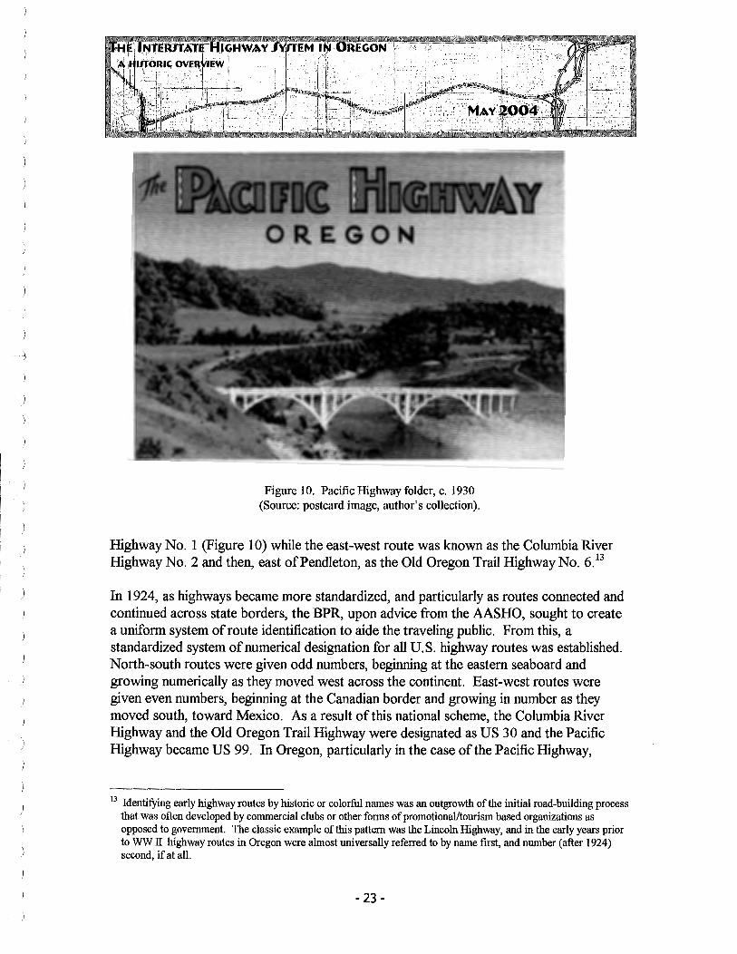
Figure 10. Pacific Highway folder, c. 1930 (Source: postcard image, author's collection).
Highway No. 1 (Figure 10) while the east-west route was known as the Columbia River Highway No. 2 and then, east of Pendleton, as the Old Oregon Trail Highway No. 6.13
In 1924, as highways became more standardized, and particularly as routes connected and continued across state borders, the BPR, upon advice from the AASHO, sought to create a uniform system of route identification to aide the traveling public. From this, a standardized system of numerical designation for all U.S. highway routes was established. North-south routes were given odd numbers, beginning at the eastern seaboard and growing numerically as they moved west across the continent. East-west routes were given even numbers, beginning at the Canadian border and growing in number as they moved south, toward Mexico. As a result of this national scheme, the Columbia River Highway and the Old Oregon Trail Highway were designated as US 30 and the Pacific Highway became US 99. In Oregon, particularly in the case of the Pacific Highway,
13 Identifying early highway routes by historic or colorful names was an outgrowth of the initial road-building process that was often developed by commercial clubs or other fonns of promotional/tourism based organizations as opposed to government. The classic example of this pattern was the Lincoln Highway, and in the early years prior to WW Il highway routes in Oregon were almost universally referred to by name first, and number (after 1924) second, if at all.
- 23 -

which had become a local street name used by local jurisdictions, the route remained known in common parlance and promotion by its earlier and original name.14
In the mid-1950s as the planning for the Interstate system was underway, SSAHO and the Federal Government decided that it would be an entirely new roadway that would in most situations augment, not replace, the existing U.S. highway system. 15 AASHO determined to develop a new numerical designation scheme for the Interstates that would minimize confusion with earlier U.S. and state highways. In order to avoid the possibility of two routes of the same or even similar numerical designations, the 1924 system devised for the U.S. highways was flipped across the continent- oddly numbered north-south routes would begin on the west coast and grow as they moved east, evenly numbered east-west
llJERSTl1E
Figure 11. OSHD draft for interstate signage, September 1956 (Source: ODOT GF).
14 Even before the overlay of the new futerstate numbers, the Pacific Highway, while designated as US 99, was known internally at OSHD as Highway "l." Similar intemal numerical designations exist for virtually all Oregon routes and remain a primary indexing system within the department.
15 The earlier, pre-futerstate, highways (US 99, US 30, US 101, etc.) are generally referred to as "Federal-Aid Highways" in the national literature, based on funding from the Federal Aid Road Act of 1916 and the Federal Aid Highway Act of 1921.
- 24 -

routes would begin at the Mexican border and grow as they moved north. This new system resulted in the Pacific Highway route becoming Interstate 5. The Columbia River Highway east of Portland and the Old Oregon Trail Highway became designated as Interstate 80 North. 16 Oregon, which had largely ignored the earlier U.S. Highway numbering scheme in the 1920s in favor of its named routes, was again concerned about the proposed overlay of yet another numbering scheme. W. 0. Widdows, OSHD Assistant Maintenance Engineer, summarized much of the State's position in a letter to R. H. Baldock in April 1956.
In August 1956, W. C. Williams, Oregon's new State Highway Engineer, wrote A. E. Johnson, the Secretary of AASHO, on this issue, relaying Baldock's comments (which relied heavily on Mr. Widdows') to the AASHO Executive Committee, of which Baldock had been a member.
I will give you the thinking of Mr. Baldock, in which I concur, relative to Interstate markings. We question the workability of any plan which would not retain our present U.S. numbers 30 and 99 and expound on the shielded design to give the Interstate System a distinctive outline .... We do not favor dual marking nor do we think US30 or US99 should lose their identity ... .It would certainly lead to confusion, in this state at least, to retain the U.S. number on the old sections of the highway and carry new Interstate numbers on the relocated sections (ODOT GF, Williams, 29 August 1956). 17
In August 1957, the new Interstate system was formally adopted and the now-familiar shield design was chosen from among more than 100 suggested alternatives (Kaszynski 2000: 169).18 Despite its new Interstate designations, Oregon would continue to rely upon named segments, a policy that could occasionally lead to somewhat confusing situations such as the following resolution, presented by the State Highway Engineer to the OSHC in early 1959, two years after the adoption of the new Federal system.
The engineer ... presented a resolution concerning designation of highways in the Grants Pass area because of highway relocation and reconstruction. He recommended that the new [Interstate] freeway bypassing Grants Pass be called the Pacific Highway, that the e{cisting Pacific Highway between the Redwood interchange and Rock Poini'be called the Rogue River Highway, that the existing section of the Pacific Highway through Grants Pass together with the future "M Street" spur be designated as a part of the Redwood Highway [US 199] and the Rogue River Loop Highway be re-designated so
16 East of Umatilla, at the junction with US 730, I-84 retains the "Old Oregon Trail Highway" name. 17 Baldock retired on August 15, 1956, apparently due to health reasons. 18 The final design was a combination of ideas submitted by the states of Texas and Missouri.
- 25 -

as to intersect the Redwood Highway in Grants Pass. The Commission approved his recommendation and thereupon adopted the attached resolution (OSHC Minutes, 5 March 1959:31246).
Oregon's Interstate designations would go through one final change after the initial design and construction phase. In 1979 it was announced that Interstate 80 North was to be renumbered as Interstate 84. This decision, made by the Federal Highway Administration, an agency of the U.S. Department of Transportation (DOT), was once again resisted by much of the State, an opposition that gained scant traction despite Congressional support and the fact that Neil Goldschmidt, former Mayor of Portland, served as the DOT Secretary.
Congressman Robert Duncan today confirmed reports that the Federal Highway Administration is considering changing the name oflnterstate 80 N to Interstate 84. Duncan said "At a cost of $18 million, this name change ought be considered for Senator Proxmire's Golden Fleece Award (ODOT GF, Duncan, 6 September 1979).
Duncan's inflated estimate created, as might be expected, a substantial amount of criticism for the decision by adding financial concerns to the general Oregon dislike of numbered highways and, apparently, change. Typical was this letter to Secretary Goldschmidt, sent by a Portland-area attorney.
It has come to my attention ... that Interstate 80 North in Oregon is scheduled for a change in numerical designation to Interstate 84 .... I ask you, Mr. Secretary, what possible rationale could there be for spending a quarter of a million dollars of your and my money just to change a few signs ... .If your agency hasn't got anything better to do than to sit around and change the designation of highway numbers, then you should close the place down (ODOT GF, Laurence L. Janke, 6 May 1980).
Apparently unmoved, Secretary Goldschmidt responded to Mr. Janke as follows.
The I-80N change involves 765 miles oflnterstate highway in Oregon, Idaho and Utah. The reason for this change is that studies have shown that letter suffixes create driver confusion which can affect traffic operations and safety ... Contrary to the reports you read, we estimate the total cost of converting I-80N in the three states to be approximately $185,000 (not a quarter ofa millionjust for Oregon) ... (ODOT GF, Goldschmidt, 2 June 1980).
- 26-
The final cost of the route signage is not clear, but the Columbia River Highway, re-named US 30 in 1925, and superceded east of Portland by Interstate 80 North in 1957, officially became Interstate 84 in 1981 and remains so today. The Columbia River Highway west of Portland was renamed the Lower Columbia River Highway No. 2W, but retained the US 30 designation.
Throughout the 1960s and into the 1980s, despite their numerical designations as I-5 and ultimately I-84, Oregon would continue to refer to portions of its Interstate routes by either name or, in some cases, the earlier U.S. highway numbers, particularly in those portions where the new route coincided exactly with the old. Even today, many parts of ISON (I-84) are dual-signed as I-SON/US 30 or I-84/US 30. And, this being Oregon, there was even discussion regarding which name ought to be used in place of the Federal number. In the mid-1960s a small issue developed surrounding the use of"Minnesota Freeway," named after its coincidence with Minnesota Avenue, for that portion of Interstate 5 that followed the east bank of the Willamette River through the Portland metropolitan core. A group of business leaders adopted a resolution urging the Oregon Highway Commission and the Portland City Council to consider changing the name.
The Oregon Roadside Council has adopted a resolution urging the elimination of the word "Minnesota" from the freeway now known by that name .... and asks that [it] be removed from all maps, travel information and signs ... [the Council urges] all appropriate steps to promote the use of the correct name, Interstate 5 North (Oregon Journal, 6 July 1966, 8:3).19
The Oregonian as well took exception to "meaningless" names like "Minnesota" and suggested that the Interstates be clearly named for stated destinations. The paper still preferred any name over numbers.
Numbers are all right for persons following a map. But freeways should have names, as well, for local usage, and the names should be descriptive. Few now commonly used in the Portland area qualify on that score .... 'Banfield' and 'Baldock,' named for men who deserve honor as Oregon road builders, give no clue to their principal termini. Banfield would be better called the Columbia River Freeway .... Baldock might be the Salem or California Freeway .... Obviously the Roadside Council didn't go far enough in its suggestion about the Minnesota designation. The entire freeway nomenclature needs thorough review and revision .... (Oregonian, 11 July 1966, 22:1-2).
19 The correct name, of course, was futerstate 5, there being no evidence whatsoever that any portion of the I-5 corridor in any of the three states it traverses, was ever designated "North" in any way.
- 27 -

1, !
REOON
Whether by formal action or passage of time, the Roadside Council got at least a portion of their request and few now seem to have any awareness of the "Minnesota Freeway" in Portland. Such is largely the pattern for most of Oregon's once-firm attachment to named routes over numbered ones. Today, when so large a portion of the state population has never lived in an Oregon without an Interstate system, the "Pacific Highway" is generally understood to refer to the older US 99 route that parallels I-5 and splits into east and west at Junction City while the "Columbia River Highway" refers to the scenic historic route located in the hills above I-80. But even now several named sections of the Interstate and its connecting loops, particularly the Banfield and Stadium :freeways (part ofl-84 and I-405 respectively) do remain in common parlance and are still heard regularly on traffic reports in the Portland metropolitan area.
Figure 12. CurtTeichpostcard No. CK-414, 1950 (Source: postcard image, author's collection).
2.2 THE INTERSTATE STANDARD
Since it was paying for 90 percent or more of the total construction costs of the new Interstate System, 20 the Federal government quite naturally adopted standards for the road to assure uniform quality across the continent. Much of this work was actually
2° Federal payments in certain rural areas were adjusted upwards to provide more relief for the States when building long stretches through largely under-populated rural areas. Oregon, with its high percentage of Federally-owned lands, received 92 percent in Federal aid to match 8 percent spent by the state (ODOT GF, January 1958).
- 28 -

undertaken through a form of partnership with AASHO, a group largely made up of State transportation officials who were intimately familiar with the needs of both the states (who would be building the roads) and the typical American driver (who would use them). Though developed over time, compliance with what essentially became a codified definition of"Interstate" road design was the threshold for Federal funding reimbursements and, by default, established a standard for virtually all Interstate highway construction.
The genius of the Interstate System is its uniformity. Wherever you find yourself along it, there are at least two travel lanes in each direction, and each lane is 12 feet wide. On the far left side of the road, drivers have a four-foot wide shoulder, and to the far right they have a 10 foot wide breakdown lane .... (McNichol 2003: 10).
The Federal Highway Administration (FHW A), an agency created as part of the new U.S. Department of Transportation under the 1966 Federal Highway Act, became the primary Federal agency in charge of the new program, and the older BPR was relocated within it. FHW A, in conjunction with AASHO, developed standard specifications for grades, tum radii, distances between interchanges, sight lines, overpass heights, lighting, rest stops, and virtually every other imaginable element associated with the design and construction of the Interstate. "The final design for the interstate was a culmination of decades of input and research from auto clubs, civil engineers, and state and federal highway officials" (Kaszynski 2000:167).
At one level the standardization was intended to create a uniformly safe highway with a 70 mph design speed that could meet traffic demand for at least 20 years. But from a financial standpoint, standardization would help reduce costs by eliminating all but the most unusual of site-specific design requirements and standard designs could be reused and shared between the states to save on design costs. Even before the final passage of the 1956 Highway Act, the states, recognizing the value of cooperation, partnered with AASHO and established a "test track" for various pavements near Ottawa, Illinois. There, at a cost of $27 million, a seven-mile-long "road to nowhere" was constructed and subjected to every form oftest the engineers could design. Heavily-laden trucks were driven in circles around and around over differing types of pavement to determine wear rates. Different types of expansion joints between sections were analyzed.21 Oregon, along with many other states, contributed to the Illinois project and used its data to help design its Interstate segments. Today, "decades later, highway officials are still designing
21 Eventually the spacing of expansion joints became a critical design factor, as regularly spaced joints led to a hannonic regularly dubbed "freeway hop." Skewed joints and Wleven spacing (varied from a standard 15-foot interval) were developed in response (see ACPA 2002).
- 29 -

and building sections of the Interstate System based on its results" (McNichol 2003:118).22
Road construction technology, as well as the scale of road-building equipment, had advanced considerably since the highway-building boom of the 1920s. Road departments, if only as the result of two more decades of on-the-job training and study, had found far more efficient and durable systems to make highways smoother and longerlasting. Larger and more powerful equipment, particularly after WW II, enabled engineers and contractors to reshape the land in ways not previously feasible from an economic or time standpoint. Drop scrapers, larger dump trucks, bigger cement mixers, bulldozers, and other road-building machines all provided important improvements that enabled the construction of the Interstate, while at the same time the huge demand and funding available for the project sparked new innovation and new technology.
Figure 13. Continuous concrete paving, c. 1963 (Source: ODOT GF).
According to the American Concrete Pavement Association, cement road building technology at the beginning of the 1950s was not substantially different than that of the 1920s (Figure 13). Steel-reinforced roads, efforts at thickened edges, and varying other design improvements had been introduced, but the basic method of road building remained essentially the same, requiring a substantial workforce that increased both cost and construction time. A significant technological improvement was the development of Slip
22 Similar national studies were undertaken by AASHO to test colors for directional sigiiage (standardized green with white letters) and informational sigiiage (blue with white letters) and other now-familiar components of the Interstate.
- 30-

Form paving, which allowed the simultaneous laying of two lanes of concrete (24 feet wide), greatly increasing the speed of highway construction. The first use of this process in Oregon was by contractor Peter Kiewit Sons Company on a nine-mile section ofl-5 north of Grants Pass.
Three massive concrete pavers work simultaneously under the new system to speed highway paving by a as much as 2,000 lineal feet a day. Time for constructing forms was cut nearly in half (Pacific Road Builder and Engineering Review, March 1962:7).
During the 1950s, other innovations included several improved bridge technologies, and greater reliance and standardization upon already developed construction processes. Chief among these was the almost universal conversion to pre-cast and pre-tensioned slab, beam and girder bridges, aided largely by AASHO adoption of standardized girder sections in 1953. As a result, pre-cast slab, beam, and girder bridges became ubiquitous for use on almost all of the Interstate grade crossings, overpasses, and smaller spans.
In Oregon, where much of the Interstate incorporated portions of the earlier, state-funded, expressway system, the original two-lane highways were augmented with a parallel twolane route, each of which then began single-direction in an Interstate standard four-lane highway. This process allowed Oregon to maintain fairly efficient through travel during construction, even in those places where the original U.S. route was to be replaced rather than bypassed by the new Interstate system. Today evidence of this two-part construction remains, particularly in sections of Interstate 5 between Salem and Portland.
2.3 PROGRESS-BVTHE MILE, Bv PERCENT
A recognized national leader in the road building and highway construction since early in the century, Oregon would once again find itself in the forefront of the states making progress toward completion of their portions of the Interstate System. Even though Oregon started, as the result of the state's own early-1950s funding and construction plan, with a percentage of its existing miles built to Interstate standards, it remained consistently among the most ambitious and rapid of the states in completing Interstate highway miles.
Beginning in 1961, as most states were starting to open routes to the Interstate standard, the percentage of miles completed was tallied nationally and Oregon appeared at the fore. That year Oregon already had opened 4 5 8 miles of its proposed 731 total Interstate miles to traffic, although only 244 were completed to full Interstate standards, which generally meant four-lanes for their entire length (Oregonian, 18 Oct 1961, 15:4-5; 31Dec1961, 12:5-8).
- 31 -

OSHD, as well as the State's elected leaders, took understandable pride in the accomplishment.
My State of Oregon has a greater percentage of its mileage under the Federal Interstate and Defense Highways rated adequate for present traffic and opened to daily traffic than any other State in the Union. In Oregon 58 percent of the interstate is rated adequate for present standards and open to daily traffic while nationally slightly more than 25 percent is now owned to traffic .... (U. S. Senator Maurine Neuberger, Congressional Record, A2722, April 24, 1961)
Every April Oregon filed a report of its progress towards completion of the Interstate which provides an overview of the program as it moved toward completion. Consistently the state was the nation's leader. Construction progress is shown in Table 1.
Table 1. Interstate Completion Progress by Year in Oregon.
Year Miles Complete Miles Contracted Percent Complete 1963 306 88 57% 1964 355 125 66% 1965 411 126 77%
As shown in Figure 14, most oflnterstate 5 north of Cottage Grove had been completed and the only remaining segments were through the passes of the Umpqua and Rogue river valleys. State Highway Engineer Forest Cooper sent the map to U.S. Senator (formerly Governor) Mark Hatfield in 1965, and pointed out the road's progress.
I have not forgotten the charge that you gave me to complete I-5 in Oregon prior to the close of the year 1966; therefore I hope to remove the green pieces of pie on the southerly portions ofl-5 as shown on the map within your deadline, as I am too cowardly to die" (ODOT GF, Cooper, letter to Mark Hatfield, 2 August 1965).
Mr. Cooper was true to his word and Oregon completed its portion oflnterstate 5 in October 1966. This event marked the first border-to-border, paved, four-lane portion of that route, mirroring the state's leading the way in paving with the completion of the Pacific Highway more than four decades earlier. Its 308 miles comprised just 4 percent of the Oregon's highway system but carried over 18 percent of the total vehicle miles of travel, accounting for 1,163,200,000 vehicle miles in 1965 alone. Travel from Washington to California on the road took at estimated 2 hours less time than had been required on US
- 32 -

)
99, a savings the department estimated to be valued at $12 million (ODOT GF, 6 October 1996). John Preston wrote:
Oregon, since the conception of the Interstate Highway System, has most consistently been the nation's leader in the percentage completed. Since the first data were made available in 1961, Oregon has been first in percentage completed, or tied for first, nine out of the last ten years ... (Preston 1973:63).
---~~~-·~~~=~-~~~···
STAT£ OF OREGON PROGRESS Of l~RSTA'fE KJGHWAY SY$TEM ~ ~·Chi>~l·:""•l-ilE' .
" /
'•
,,
Figure 14: Oregon Interstate progress map, December 1965 (Source: ODOT GF).
.'• ( (
I
Oregon was justifiably proud of its highway accomplishments. In 1972, six years after Oregon's entire 308-mile portion ofI-5 was completed, Milton Stark of the California Division of Highways wrote to the Commission regarding that state's recent completion of the 184-mile section ofI-5 between Los Banos and Wheeler Ridge. "We believe this new section of freeway now enables the motorist to travel non-stop (no stop signs or signals) from the Mexican border to the Oregon State Line ... " (ODOT GF, Stark, 17 March 1972). George Baldwin, Administrator of Highways for the State of Oregon, responded to Mr. Stark in March 1972 that as of October 22, 1966, one could travel the entire length of the state from north to south on I-5, a distance of308.4 miles, without encountering a
- 33 -

stop light or traffic signal. In other words, California did not achieve a completed Interstate Highway from border-to-border, until six years after Oregon.23
Oregon completed its 308-mile-long portion oflnterstate 5 to full four-lane standards by October 1966, and as of March 1970 nearly 90 percent of the state's 730 miles of the route were finished. "Only Connecticut and Maine have similar completion records. However both systems total about 300 miles each" (Preston 1973:63).
Figure 15. Governor Mark Hatfield, ribbon cutting, 5 January 1964 (Source: ODOT GF).
2,4 SELECTED SECTIONS OF 1·5 While it is beyond the scope of this project to create a complete catalog of the siting process and options considered before the construction and opening of each and every section of the Interstate Highway in Oregon, certain portions of the highways can be documented to provide a basic survey of the typical development pattern that characterized the process. The following are presented, in general, from north to south and from west to east, branching out from the Portland area, as this was largely the way the Interstates were built. Segments in the Portland area generally were given names, while sections in the southern portion of the state, particularly between communities, were generally referred to by their beginning and end points, as in the "Donald to Aurora" Segment.
23 California's portion ofI-5 is 797 miles long, or more than twice as long as Oregon. In 1970 the population of California was just over 20,000,000. Oregon's population in that same year was 2.3 million.
- 34-

2.4.1
/
MINNESOTA (EAST BANK) fREEWAv24
This segment oflnterstate 5 begins north of the -··-----~- I-84 intersection and continues north toward the
Columbia River Slough in northeast Portland (Figures 16 and 17). Built through densely developed residential areas just east oflnterstate Avenue (the route of US 99), its siting was among the most controversial in the state. 25 At a public hearing on the siting, held in the Portland City Council chambers before a crowd estimated at more than 300 persons, the OSHC meeting was "punctuated by noisy applause from the audience for some speakers and by noisier laughter for some whose statements did not meet general approval" (Oregonian, 25 March 1959, 7:1-8).
Among the options under consideration were two primary choices, one following Minnesota Avenue and the other following Delaware farther to the west, along with others suggested by the public to avoid residential dislocation. These latter suggestions included a route that would "follow the river" and another that involved a tunnel. Another suggestion was an entirely elevated route built above the existing Interstate Avenue (US 99) corridor.
Like many of the siting discussions that would occur all over the state, there was a considerable amount of"NIMBY-ism" from the public as they compared the pros and cons of the various possible routes while the OSHD tended to look at cost, length, and other factors in addition to relocations. In the case of the Minnesota Freeway, at the public meeting, State Highway Engineer W. C. Williams noted that factors in favor of the Minnesota Avenue route were that" ... .it would cause less damage to property values, it would be three-tenths of a mile shorter, and it would be less costly than the Delaware route by about three million dollars" (Oregonian, 25 March 1959, 7:1-8).
A neighbors' group presented a petition in favor of an elevated route and the principal of the Ockley Green Grade School pointed out the problems the Minnesota Avenue proposal would create for pupils on the east side of the route. OSHC Chairman told the audience that no decision would be made immediately. In April, the Commission in fact chose the
24 This and all subsequent annotated map sections are from the ODOT Official Oregon State Map (2000-2001 ). 25 The section of 1-5 south of the 1-84 intersection, connecting across the Willamette to the junction ofl-405 was
known as the "East Bank Freeway" and was built almost concurrently with the Minnesota Avenue segment to the north.
- 35 -

Minnesota Avenue route, which was favored by City of Portland as well as the OSHD. Highway Commission Chairman Milo K. Mclver said construction of the $21 million freeway was expected to start in Spring 1960.
Figure 16. State selects north Portland freeway route (Source: Oregonian, 17 April 1959).
Construction of the Minnesota Freeway required the removal of approximately 180 dwellings and relocation of some 400+ residents. Demolition of the houses, some of which were sold to salvagers for as little as $5, began in early summer 1959 and the Minnesota Freeway portion ofI-5 was largely completed by 1962-1963.
2.4.2 R.H. BALDOCK FREEWAY (PORTLAND-SALEM EXPRESSWAY)
Built in sections completed prior to the passage 1 of the Highway Act of 1956, the R.H. Baldock
Freeway runs south from Barbur Boulevard near Tigard and continues to Salem, connecting the metropolitan area with the state's capital (Figures 18 and 19). This road, initially planned, paid for, and constructed by the state to its own internal "expressway" standards, was later upgraded to full Interstate design using new funding made available by the Federal program. Covering a key corridor in the Willamette Valley for in-state travel, in addition to its role as a component of the US 99 through-travel system,
improvement of the highway between Salem and Portland was among the highest priority roads in Oregon following Oregon's bond issue in 1952.
- 36 -

Figure 17. Lombard Street interchange planning, Minnesota Freeway, March 1965 (Source: ODOT GF, Image 224-46).
- 37 -

)
)
)
Oregon's most ambitious single highway building project, the Salem-Portland expressway, will be the state's first major example of the famed turnpikes of Pennsylvania and other eastern states. Cost of the express-way, which will run from S. W. Barbur boulevard, north of Tigard, to Salem, will be approximately $12,000.000. It will shorten the distance between Portland and Salem from 52 to 47 miles. (Oregonian, 26 April 1953).
Figure 18. Map of planned Portland-Salem Expressway, 1953 (Source: Oregonian, 26 April 1953).
As can be seen in Figure 18, the route of the new expressway was to run west of the existing US 99E, bypassing communities and enabling controlled access and, for the most part, complete grade separations. Running through rural land, the new Expressway would also be divided for much of its length.
The 26-mile section of the Portland-Salem Expressway between Hayesville at the north end of Salem was opened to vehicles on November 1, 1955. The project was divided into three sections, each of which had a different contractor. Parker Schram, of Portland built 7.4 miles starting at Hayesville, all to be four lanes. Porter W. Yett built a two-lane section in the middle, and Newport Construction was responsible for the northernmost section of the project, also constructed as four-lane route. "In addition to saving of five miles in the distance to Portland over the old highway 99E, the new expressway will give motorists a speedy highway between the Capital City and Portland"
- 38-

Figure 19. Baldock route extension, 1956 (Source: ODOT GF).
(Statesman-Journal, 21 September 1955).26 This $13.5 million portion of the expressway was touted as the longest toll-free expressway in the nation and reportedly saved drivers 20 minutes between Portland and the capital (OSHD, "Building Oregon Through Better Highways: 1958 Annual Report," 1959:7).
As completion of this section of expressway was nearing, R. H. Baldock retired after 41 years of service, including 24 as Oregon's State Highway Engineer. The Oregon Highway Commission noted that Baldock " .... was highly instrumental in the development of modern high speed highways and specifically the Portland-Salem Expressway" and passed a Commemorative Resolution in his honor.27
The section of the Portland-Salem Expressway between the Hayesville Interchange, north of Salem, and the connection of the Portland-Salem Expressway with the Harbor Drive Section of the Pacific Highway West in Portland, is hereby designated and shall hereafter be known as the R. H. Baldock Freeway (OSHC, Misc. Resolution No. 195, July 26, 1956).
In 1956 the route for the completed Baldock Freeway into downtown Portland, continuing from SW 19th Avenue and then paralleling Macadam was decided by the Oregon State Highway Commission (Figure 19). Construction continued on this new route, as earlier two-lane rural sections north of Salem were expanded to four-lanes as
26 It is interesting to note that the Salem paper referred to the highway as the Salem-Portland Expressway while the Oregonian reversed the cities. OHSC used Portland-Salem, so that is assumed accurate.
27 Upon his retirement, Baldock, then 67 years old, became the Chief of the Highway Mission for Iraq, working under contract for the engineering firm of Edwards, Kelcey and Beck, under contract with the International Cooperation Administration (Construction World, Feb 1957:14).
- 39 -

required by the Interstate program. This portion of the Baldock Freeway, a 6.5-mile link between the Tigard Interchange and SW Harbor Drive, was opened in December 1961 (Figure 20).
Opening this section gives Interstate Route 5 (the Pacific Highway) a continuous 110-mile stretch from Portland to Eugene, making it the longest single piece of the Federal Interstate Highway System in the nation. (Oregonian, 2 December 1961, 1:8).
Figure 20. Cover, R. H. Baldock opening ceremony (Source: ODOT GF).
The ribbon-cutting celebration and dedication of the Baldock Freeway by Oregon Governor Mark Hatfield was marred by the death just two days prior of W. C. "Dutch" Williams, who had succeeded Baldock as Oregon's State Highway Engineer.
Throughout the newspaper account of the opening of this portion of the Interstate, the names "Interstate 5," and "Pacific Highway" are used interchangeably with the Baldock Freeway, but the term "Portland-Salem Freeway" appears only once, evidence of the multiplicity of names associated with this stretch of road. Today it is simply known as I-5. The rest areas along both the north- and southbound lanes ofI-5 at Wilsonville retain the Baldock name (www.storeycom.com/or locations.html).
-40-

2.4.3 MYRTLE CREEK-CANYONVILLE SECTION
This 10.2-mile portion oflnterstate 5, initially known as the Fords Bridge Unit and later referred to as the Myrtle Creek-Canyonville segment, was the first section contract of
. . Interstate in Oregon to be awarded following the · .··.' passage of the 1956 Federal Highway Act. The
"'"'--'..-- contract was finalized on September 27, 1956, and construction was completed in 1959 at a cost of $5,500,000. C.R. O'Neil was the contractor (OSHD Contract No. 4813).
The Myrtle Creek section, nestled between a large cut to the west and the Umpqua River to the east, follows a sharply curved route that still
requires flashing lights and signed speed reductions. As the road straightens out south of Myrtle Creek toward Canyonville, it follows essentially flat bottomland before sweeping along a bend in the South Umpqua River that was documented as an early postcard view (Figure 21).
Figure 21. Interstate view, Douglas County, c. 1965 (Source: postcard image, author's collection).
- 41 -

)
2.4.4 MEDFORD VIADUCT
ROSSANLEY '
Among the more idiosyncratic elements of the Interstate in Oregon is the Medford Viaduct, a 3,229-foot-long steel beam and girder bridge that carries the highway corridor through the middle of that city as an elevated freeway rather than one at grade. The construction of the viaduct, and the choice of the route for the Medford section of the Interstate was among the more controversial and protracted of the siting decisions outside the Portland area.
In the early 1950s, OSHD began to make plans to relocate the highway through Medford as a
part of the bond-funded state highway improvements. US 99 then operated as a couplet, using Central and Riverside Streets through the length of the downtown, interrupted by dozens of cross-streets. Densely developed along its entire path, OSHD sought a new route for the Pacific Highway where controlled access and complete grade separation could be provided. After initial engineering analysis, four options were proposed, ranging in cost from $18.2 to $22.4 million. On October 25, 1956, the State Highway Commission held one in a series of hearings in the Medford area to gather public input, a hearing that had to be moved to the Craterian Theater on Central Street to accommodate the large crowd.
It was the original intention of the Commission to conduct this hearing in the Medford City Hall, however the meeting place was changed ... at the request of the Hon. Earl M. Miller, Mayor of the City of Medford, because in his estimation the City Hall would not accommodate the large number of people who would be present. ... There were about 500 people present, representing [all] the cities affected by the proposed improvement ... (OSHC Minutes, 25 October 1956:17249).
Each of the four routes started at the Seven Oaks segment north of Central Point and then continued south through Medford, Phoenix, and Talent to what is now the Valley View interchange west of Ashland. North and south of Medford, the route was generally agreed upon, causing little debate. How the new highway would get through downtown Medford, however, was of considerable interest. Four main routes were proposed for study. One bypassed downtown Medford to the east, largely through rural orchard land including the Hillcrest Orchard, and was so referred to as the "Hillcrest" Route. 28 Another
28 Hillcrest Orchards, located on Hillcrest Road near its intersection with North Phoenix Road, was established early in the 20th century and was among the area's most regarded orchard tracts. In 1984 Hillcrest Orchard, including
- 42 -

route bypassed Medford to the west, through the rural lands that separated that city from Jacksonville, and two routes essentially went through the city's center, one following Bear Creek and bisecting Hawthorne Park and the other just to the east, following the creek and Genesee Street, a residential area. As might be expected, each route had both strong supporters and strong opponents in direct ratio to the impacts they brought for affected property owners.
[Medford attorney Otto J. Frohnmayer, in opposing the Hillcrest route ]29
... stated that he represents a group of land owners, property owners and tax payers who are interested in the selection of the Hawthorne Park or Bear Creek route.... Mr. Howard Bush, President of the Fruit Growers League representing 290 fruit growers in the Bear Creek Valley ... stated that the economy of the valley depends on two basic resources, lumber and agriculture. He expressed their feeling [that] ... the future is more and more going to depend on the conservation and expansion of agricultural resources. He advised that considerable acreage already has been taken by subdivisions, and in their estimation any further withdrawls should be viewed with concern (OSHC Minutes, 26 October 1956:27251)
Numerous other prominent figures in the orchard industry, including Cliff Cordy, Paul Culberston and David Holmes (the latter of Harry and David) spoke in opposition to the Hillcrest route, which would have required the taking of considerable orchard acreage. Others, mostly downtown business leaders, spoke in favor of the Bear Creek (Hawthorne Park) route, including Robert Duff, Medford City Manager, Paul Rynning, the city's Engineer, Otto Ewaldson, President of the Jackson County Chamber of Commerce, and Medford's Mayor, Earl Miller. The Rev. George R. V. Bolster, Chair of Rogue Valley Medical Hospital board " ... urged abandonment of any consideration of the Hillcrest Route because of the adverse affect that the adoption of that route would have on the new hospital that they are erecting ... "(OSHC Minutes, 26 October 1956:27251).30
It was a heated discussion, with leading citizens of the area lining up in favor of almost all the four main proposed routes, plus providing a new, fifth proposal, that was ultimately considered as well. Eric Allen Jr., the highly regarded editor of the Medford Mail Tribune, opined that
most of its original wood framed production structures and the owner's home, all designed by Medford architect Frank Chamberlain Clark, were listed on the National Register of Historic Places.
29 Otto Frohnmayer was a prominent southern Oregon attorney for more than half a century, actively supporting numerous state and national causes. One of his sons, Dave Frohnmayer, served as Oregon's Attorney General, was an unsuccessful candidate for governor, and is now President of the University of Oregon.
30 The hospital, now the Rogue Valley Medical Center, today serves as the regional medical facility for most of southern Oregon and northern California.
- 43 -

The commission has eliminated from consideration two earlier proposals, for reasons of its own. One was along the west side of the valley; the other was along Bear Creek, either on an elevated viaduct, or lowered into the channel bed proper .... Objections to the other proposals seem to be equally compelling - and the highway commission has apparently found them conclusive. It boils down (as so many decisions of a public nature do) to a choice of something which will do the least amount of harm. And, while some people will be unhappy no matter what is decided, a decision must be made. No route can be perfect, and there will be a marked divergence of opinion on which one is the best - or, rather, the least bad (Medford Mail Tribune, 20 April 1956, 4:2-3).
Despite previous statements to the contrary, the Commission did select the elevated viaduct along Bear Creek, running through the center of Medford. "The com-mission, after eliminating four other possible routes decided on the Hawthorne (Bear Creek) route because it ... will not cause as serious a disruption of home and residential areas as the Genesee Street route. It was, at least outside the Portland area, an entirely unique solution in Oregon and one that has created special difficulties for the city ever since. The elevated freeway overpass through Medford is also regretted" (Kirchmeier 1989:Bl-4).
Peter Kiewit and Sons were awarded the major contract to build the viaduct and work apparently began in the late 1950s. Progress was not as speedy as the City of Medford and local merchants hoped for. In January 1960, Medford Engineer Paul Rynning testified before the Highway Commission to plead for more progress on the route that was already becoming a physical barrier to cross-town traffic (OHSC Minutes, 27 January 1960:32271). By mid-November 1961, the foundation piers for the elevated sections were in place and the bridge over Bear Creek at Crater Lake was nearing completion.
The 15.4-mile section of Interstate 5 from Rock Point through Medford (Figure 22), including the Viaduct, was dedicated on December 21, 1962. Governor Hatfield arrived at the ceremony in " ... a mechanical veteran of the highways, a 1915 Model T touring car ... " that was at the head of fourteen antique "flivers" representing the first public traffic over the unique viaduct that travels through Medford's east side as a part oflnterstate 5 (Ashland Daily Tidings, 18 December 1962, 1 :5).
While there is no saving in distance of the new route over the existing facility this particular section of the freeway will show ... great benefit to the Rogue Valley by decreasing traffic on the street system of Medford. This section is also unique in that it is the only portion of the freeway system which traverses the heart of a city outside the Portland Metropolitan area ... (ODOT GF, Paxson Memo to Gov. Hatfield, 12 December 1962).
-44-

Figure 22. Interstate 5, Medford Viaduct, looking north, September 1966 (Source: ODOT GF).
-45-
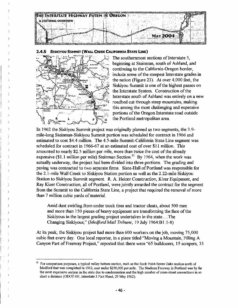
2.4.5 SISKIYOU SUMMIT (WALL CREEK CALIFORNIA STATE LINE)
The southernmost sections oflnterstate 5, beginning at Steinman, south of Ashland, and continuing to the California-Oregon border, include some of the steepest Interstate grades in
75 the nation (Figure 23). At over 4,000 feet, the Siskiyou Summit is one of the highest passes on the Interstate System. Construction of the Interstate south of Ashland was entirely on a new roadbed cut through steep mountains, making this among the most challenging and expensive portions of the Oregon Interstate road outside the Portland metropolitan area.
In 1962 the Siskiyou Summit project was originally planned as two segments, the 3.9-mile-long Steinman-Siskiyou Summit portion was scheduled for contract in 1966 and estimated to cost $4.4 million. The 4.5-mile Summit-California State Line segment was scheduled for contract in 1966-67 at an estimated cost of over $11 million. This amounted to nearly $2.5 million per mile, more than twice the cost of the already expensive ($1.1 million per mile) Steinman Section.31 By 1964, when the work was actually underway, the project had been divided into three portions. The grading and paving was contracted to two separate firms. Slate-Hall of Portland was responsible for the 2.1-mile Wall Creek to Siskiyou Station portion as well as the 2.22-rnile Siskiyou Station to Siskiyou Summit segment. R. A. Heintz Construction, Kizer Equipment, and Ray Kizer Construction, all of Portland, were jointly awarded the contract for the segment from the Summit to the California State Line, a project that required the removal of more than 7 million cubic yards of material.
Amid dust swirling from under truck tires and tractor cleats, about 500 men and more than 150 pieces of heavy equipment are transforming the face of the Siskiyous in the largest grading project undertaken in the state .... The Changing Siskiyous," (MedfordMail Tribune, 19July1964:Bl:l-8)
At its peak, the Siskiyou project had more than 600 workers on the job, moving 75,000 cubic feet every day. One local reporter, in a piece titled "Moving a Mountain, Filling A Canyon Part of Freeway Project," reported that there were "65 bulldozers, 15 scrapers, 33
31 For comparison purposes, a typical valley bottom section, such as the Rock Point-Seven Oaks section north of Medford that was completed in 1962, cost under $290,000 per mile. The Stadium Freeway in Portland was by far the most expensive section in the state due to condemnation and the high number of cross-street connections in so short a distance (ODOT GF, Interstate 5 Fact Sheet, 29May1962).
- 46-

)
off-highway dump trucks, three rollers, seven graders, seven twin-engine scrapers, four shovels and a 60" KolCal belt loader," among numerous other pieces of equipment (MedfordMail Tribune, 19 July 1964).
Figure 23. Interstate 5, Siskiyou Mountains segment construction (Source: Ashland Daily Tidings, 3 Janaury 1966).
The southbound lanes [of the Siskiyou segment] were opened to traffic on June 21, 1966. The northbound lanes were opened on December 21, 1966, to aid the Christmas holiday traffic traveling through Oregon. It has been engineered to take maximum advantage of existing terrain and yet meet the exacting standards of a high-speed, modern freeway .... In constructing the new highway, every effort has been made by the highway planner to preserve as much of this natural beauty as possible and yet provide the traveler with a safe, high-speed, freeway through a most difficult stretch of terrain ....
-47 -

(ODOT GF, Nomination to Scenic Highway Contest, Parade Magazine, 8 December 1966).32
2.4.6 INTERSTATE 5 COMPLETION
Connecting Oregon to California and Washington, the Interstate 5 route has almost always been seen as the primary economic corridor in the state and so was logically given a higher completion priority than was Interstate 80 North. Building upon the work already completed by the OSHD in the years before 1956, Oregon became and remained a consistent national leader in Interstate miles completed throughout the first decade of the national program, with the Portland-Eugene section believed to have been the longest tollfree rural freeway in the nation when it was completed. As noted earlier, Oregon Governor Mark Hatfield had apparently established 1966 as the completion date for Interstate 5 and OSHD clearly worked diligently to make that deadline.33
With the work done on the East Bank Freeway in Portland and the steep summit of the Siskyious resculpted, the last link in Interstate 5, creating an unbroken four-lane highway from the Columbia River to California, was completed on schedule. The Marquam Bridge, connecting the Baldock Expressway and East Bank Freeway across the Willamette in Portland was opened to traffic on October 18, 1966 (Carrick 1993:44). Four days later, on October 22, 1966, a dedication ceremony was held at the Cow Creek Safety Rest Area, south of Canyonville, in Douglas County. About 125 people attended the Saturday morning event, standing in the rain. Those present included the Governor, OSHC Chairman Glenn Jackson, and David S. Moffit, Lincoln County Commissioner and chair of the Association of Oregon Counties. Eugene W. Bauer, Mayor of Gladstone and president of the League of Oregon Cities declared that H ••• Interstate 5 is one of the greatest of economic arteries. It will aid tourism, which has become Oregon's No. 1 industry" (Medford Mail Tribune, 22 October 1966, 1:8).
Gentlemen, at this time I would like to report on the progress of the Pacific Highway, which is probably the most important through highway in the State. It is the intercommunicating road for nine of the 3 5 counties of the State and passes through the County seats of all but one of the nine. It is the only continuous and direct road along the Pacific Coast west of the Cascade Mountains, and connecting as it does the metropoli of the three Pacific Coast states, it is the most important interstate highway in the West. From the standpoint of the tourist, Oregon would not be on the map if it had no Pacific Highway. It is the road that makes Oregon accessible to tourists from other
32 Although nominated by State Highway Engineer Forest Cooper, it does not appear the Siskiyou segment was selected by the magazine.
33 See Section 2.3.
- 48 -

states (ODOT GF, Cooper, Statement of Highway Engineer to Highway Commission, 12 April 1967).
2.5 SELECTED SECTIONS OF 1-84 CONSTRUCTION ISSUES
Improvements to the major east-west route (US 30) in northern Oregon--the Columbia River Highway and the Old Oregon Trail Highway--had been in the planning stages since the 1930s but were interrupted by WW II. With the passage of bond funding by the Oregon Legislature, OSHD had begun implementing those improvements on a segmentby-segment basis in the early 1950s. Most notable of these was the Banfield Expressway, in the Portland area, as already documented, but other portions of the route along the Columbia River also were improved.
I have not had occasion to drive over the CRH for the past two ... years. When Mrs. Stockman and I drove to Portland a couple of weeks ago we were amazed and delighted with the progress you have made ... the new highway is perfect in every detail: and it is not only a wonderful roadway but it is also a work of art, as exemplified by the beautiful sweeping curves and artistic, as well as practical, bridges ... (ODOT GF, U.S. Rep Lowell Stockman, letter to Baldock, 5 December 1953).34
Baldock responded that "This road should have been built a long time ago, but during the war most road building was held up by the W ar Production Board .... I am indeed sorry that you are no longer in the Congress and I will miss your sympathetic understanding of the road problems of the Nation when Congressional legislation is being formed" (ODOT GF, Baldock, letter to Stockman, 16 December 1952).
With the passage of the Federal Interstate and Defense Highways Act in 1956, US 30 was scheduled to be superceded by Interstate 80 North, largely on a new and generally parallel routing, much of which was built closer to the river on flat terrain, avoiding the switchbacks of the older, higher route. This 375-mile-long route, now Interstate 84, is the longest numbered segment of the Interstate System within Oregon.35 I-84 follows the Columbia River Gorge east of Portland before turning south and inland at Boardman,
34 Lowell Stockman, born in 1901 in Helix, Oregon, lived in Pendleton and represented Oregon's 2nd District as a Republican member of Congress for four terms from 1943 to 1953. Stockman choose to return to business and did not seek a fifth term. He died August 9, 1962.
35 I-84 continues east from Oregon through Idaho, then enters Utah. It connects Portland, Boise, and Ogden, Utah, before joining with I-15. A separate section ofl-84 (originally called 1-86) also runs between Pennsylvania and Massachusetts (http://www.ihoz.com/184.html).
- 49 -
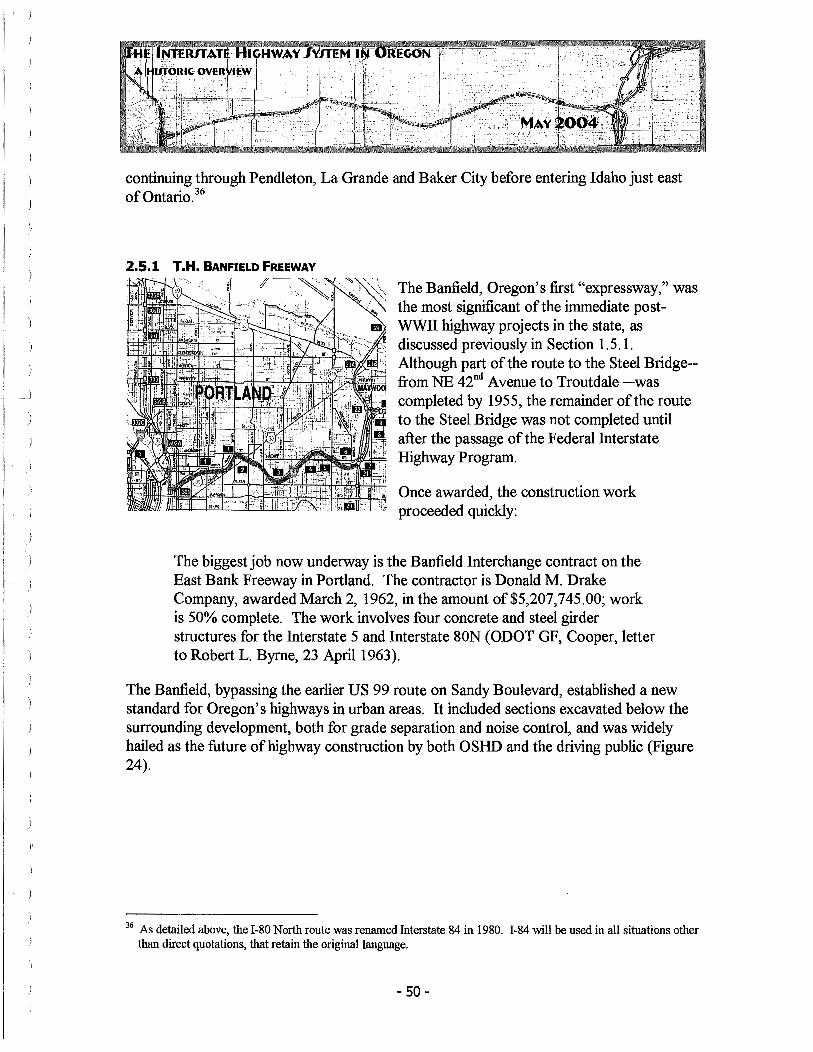
)'
continuing through Pendleton, La Grande and Baker City before entering Idaho just east of Ontario. 36
The Banfield, Oregon's first "expressway," was the most significant of the immediate postWWII highway projects in the state, as discussed previously in Section 1. 5 .1. Although part of the route to the Steel Bridge-from NE 42nd Avenue to Troutdale--was completed by 1955, the remainder of the route to the Steel Bridge was not completed until after the passage of the Federal Interstate Highway Program.
Once awarded, the construction work proceeded quickly:
The biggest job now underway is the Banfield Interchange contract on the East Bank Freeway in Portland. The contractor is Donald M. Drake Company, awarded March 2, 1962, in the amount of $5,207,745.00; work is 50% complete. The work involves four concrete and steel girder structures for the Interstate 5 and Interstate 80N (ODOT GF, Cooper, letter to Robert L. Byrne, 23 April 1963).
The Banfield, bypassing the earlier US 99 route on Sandy Boulevard, established a new standard for Oregon's highways in urban areas. It included sections excavated below the surrounding development, both for grade separation and noise control, and was widely hailed as the future of highway construction by both OSHD and the driving public (Figure 24).
36 As detailed above, the I-80 North route was renamed Interstate 84 in 1980. I-84 will be used in all situations other than direct quotations, that retain the original language.
- 50 -

Figure 24. Banfield (1-84) Expressway, NE Grand Avenue, 1966 (Source: ODOT GF, Image 252-60).
- 51 -

2.5.2 TROUTDALE TO THE DALLES
The Banfield Expressway ends at Interstate 205, and as I-84 continues east, it becomes the start of the Columbia River Highway No. 2, also known as Oregon Highway 2.37
Historically OSHD ~; ~zali 1 refers to this section of the Interstate as "Troutdale to The Dalles," though it logically includes the freeway beginning east of Interstate 205.
For much of its length outside the City of Portland, this portion ofI-84 tightly hugs the banks of the Columbia River, providing numerous scenic views as well as access to several highly regarded natural features, such as Bridal Veil and Multnomah Falls (Figure 26). Construction of this portion of the route, partially involving expansion and improvement of the earlier US 30 roadbed, also began in the 1930s, prior to the adoption of the Interstate program, and continued through the late 1960s.
In 1954, when the new Columbia River water level highway reached The Dalles, auto speed from Portland to eastern Oregon will be a matter strictly between a motorist and his conscience .... There'll be no hairpin curves, such as the ones now between Hood River and The Dalles, to slow a driver down. No tunnels, either, except the one at Eagle Creek, near Bonneville .... The new highway ... will cut eight miles off the present 90 miles between Portland and The Dalles (Oregonian, 11May1952:34).
By 1962, much progress had already been made on the route west of The Dalles. The Dodson-Bonneville Section, entirely within Multnomah County, took advantage of earlier improvements to US 30, first opened in this area as a two-lane road. "This section ... consists of constructing two lanes of asphaltic concrete paving paralleling the existing highway, thereby bringing it up to interstate standards." Similar projects, with additional lanes constructed next to pre-existing highways, occurred at several other segments of the Interstate east of The Dalles (ODOT GF 1962).
37 ill Oregon's internal route designation system, the Banfield is part of Oregon Highway 2.
- 52 -

Figure 25. I-84 Eagle Creek Viaduct construction near Tooth Rock, c. 1969 (Source: ODOT GF).
The section of Interstate 84 between Portland and The Dalles was largely completed by 1963. Complicated by the terrain, the need to maintain open traffic through the area, and the immediately adjacent rail line, the final elements ofl-84 to The Dalles were not completed to Interstate standard construction until 1969.
Construction on Interstate SON moved steadily eastward until, by the end of 1964, the freeway was completed to The Dalles except for a 13-mile section east of Cascade Locks (ODOT GF, Cooper letter to James D. Shand, 23 March 1967).
This 13-mile section included work between Cascade Locks and Mitchell Point, where 11. 89 miles of highway and 5. 88 miles of railroad had to be graded, requiring more than 3 million yards of general excavation (ODOT GF, letter to Robert L. Byrne, Western Construction, 16 April 1965).
- 53 -

Figure 26. Interstate 84 with parking lot located in the median, looking east toward Multnomah Falls, 1966 (Source: ODOT GF).

' )
2.5.3 THE DALLES TO PENDLETON
This 125-mile-long stretch of highway, following the Columbia River between The Dalles and Boardman and then heading southeast toward Pendleton, also utilized roadway improvements to US 30, as did the section west of The Dalles. This route was built in the 1950s almost entirely of two-lane roads. During the early planning effort after the creation of the Interstate System, the intent was for some portions to remain so. "During the next 13 years [Oregon's Interstates] will become four-lane :freeways, with the exception of short stretches of US 30 in sparsely populated sections of eastern Oregon, which will remain two lanes ... " (ODOT GF, January 1958). These two-lane sections included Boardman to Stanfield Junction and the Pendleton By-pass section. Later, this option was removed from the Federal standard, although that occurred after Oregon had itself decided to build all ofl-84 to four lanes.
Generally flat, the construction of Interstate 84 that began in the late 1950s was again complicated by river crossings and the proximity of the rail line and the projects of the Bonneville Power Administration, particularly at the John Day Dam.
Construction between The Dalles and Pendleton was delayed to some extent due to lengthy negotiations between the State, the Corps of Engineers, and the Union Pacific Railroad concerning highway and railroad relocation necessitated by the pool of the John Day Dam (OSHD PR 67-113-Se, 26 June 1967).
By the end of June 1964, 140 miles oflnterstate 84 were complete and opened to traffic with another 73 miles under contract, for a total of213 miles, or approximately 56 percent of the route. This mileage included the bypass of The Dalles, a six-mile section that cost some $8,000,000 and was among the more controversial siting issues on the road. In 1958, this bypass was under discussion by the OSHC.
- 55 -
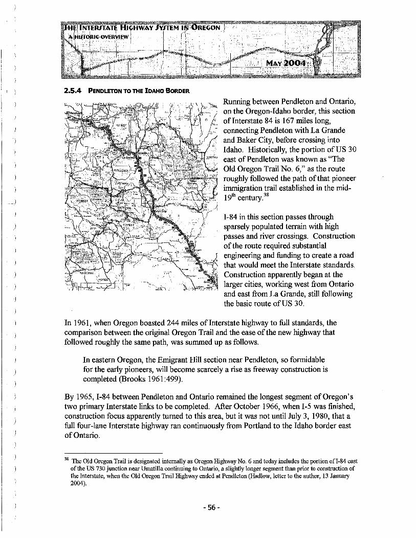
I ) 2.5.4 PENDLETON TO THE IDAHO BORDER
Running between Pendleton and Ontario, on the Oregon-Idaho border, this section oflnterstate 84 is 167 miles long, connecting Pendleton with La Grande and Baker City, before crossing into Idaho. Historically, the portion of US 30 east of Pendleton was known as "The Old Oregon Trail No. 6," as the route roughly followed the path of that pioneer immigration trail established in the mid-l 9th century.38
1-84 in this section passes through sparsely populated terrain with high passes and river crossings. Construction of the route required substantial engineering and funding to create a road that would meet the Interstate standards. Construction apparently began at the larger cities, working west from Ontario and east from La Grande, still following the basic route of US 30.
In 1961, when Oregon boasted 244 miles of Interstate highway to full standards, the comparison between the original Oregon Trail and the ease of the new highway that followed roughly the same path, was summed up as follows.
In eastern Oregon, the Emigrant Hill section near Pendleton, so formidable for the early pioneers, will become scarcely a rise as freeway construction is completed (Brooks 1961 :499).
By 1965, 1-84 between Pendleton and Ontario remained the longest segment of Oregon's two primary Interstate links to be completed. After October 1966, when I-5 was finished, construction focus apparently turned to this area, but it was not until July 3, 1980, that a full four-lane Interstate highway ran continuously from Portland to the Idaho border east of Ontario.
38 The Old Oregon Trail is designated internally as Oregon Highway No. 6 and today includes the portion ofl-84 east of the US 730 junction near Umatilla continuing to Ontario, a slightly longer segment than prior to construction of the Interstate, when the Old Oregon Trail Highway ended at Pendleton (Hadlow, letter to the author, 13 January 2004).
- 56-

I )
2.6 CONNECTING ROUTES AND URBAN LOOPS - BUILT AND WITHDRAWN
Included in the initial planning of Oregon's Interstate system, in addition to the two major routes ofI-5 and I-84, was a series of connecting routes and urban loops, all intended to improve access to the main roads from bypassed cities or, in the case of Portland, to improve the flow of through traffic in the densely developed city center. Later, after Congress authorized modest expansion to the total mileage in the Interstate System, additional routes were considered and authorized for inclusion. Each of these spurs or connecting loops offI-5 or I-84 were, by AASHO convention, given a three-number designation terminating in the number of the main Interstate fed. In the case of Oregon, there were no links from I-84 and so all the spurs were designated with a terminal "5," as connectors off that Interstate. These Oregon routes, not all of which were constructed, were among the most controversial and protracted Interstate construction projects. They are presented numerically, though their nomenclature bears little relation to geography or the order in which they were planned.
2.6.1 1-105 -- EUGENE-SPRINGFIELD
A short, 4.5-mile-long route that connects Interstate 5 with the Delta Highway and downtown Eugene, I-105 ties the Interstate with the older route of US 99, as it heads west toward Junction City. The major aspect of its construction concerned the bridge across the Willamette River, as the route turns sharply south.
I-105, alone among the states' spur routes, does not appear to have generated much controversy or opposition. As a result, fairly little specific information was located in ODOT General Files
on this route. It was apparently opened sometime in the early 1960s and was completed in 1970 (Carrick 1993:46). Governor Tom McCall joined OSHD Chairman Glenn Jackson at a ribbon cutting ceremony held on October 25, 1967, recognizing completion of the Springfield interchange that connected the route with State 126, which continues east of Interstate 5 at this point. Chairman Jackson pointed out that " ... this was the only dedication in the past eight years in which the highway department participated when it hasn't rained" (Eugene Register-Guard, 26 October 1967, Bl:l).
Eugene-based Wildish Construction was the contractor for the 1967 improvements, which were opened to traffic in late August based upon newspaper reports (Eugene RegisterGuard, 22 October 1967, D8:1-3).
- 57 -

2.6.2 1-205 -- EAST PORTLAND FREEWAY
This 26.6-mile-long route, which meets I-5 at Tualatin south of Portland, and then continues east through West Linn and Oregon City before heading north, was intended as one of the two "loops" that would form a beltway around the Portland metropolitan core. I-205 continues across the Columbia River (over the Glenn Jackson Bridge) and rejoins I-5 north of Vancouver, Washington. One of the most delayed and controversial of Oregon's Interstate segments, it was, perhaps not coincidently, one of the first of Oregon's highways to successfully follow the requirements of the National
Environmental Policy Act of 1969 (NEPA). NEPA required that " ... road projects using federal funds must have an Environmental Impact Statement [EIS] detailing the effects of the proposed work, a requirement that would have major impacts on Oregon's Interstate program" (Carrick 1993:47). I-205 was the last of the proposed I-5 connecting loops to actually be constructed, although its final form was not entirely as originally planned.
The initial idea for an eastern "loop" freeway in Portland dates to World War II, well before the passage of the Federal Interstate act, when the City of Portland and Multnomah County had jointly retained famed New York Public Works Director Robert Moses to review the area's transportation plans. Moses' report, entitled "Portland Improvement," was presented to the City in 1943 and recommended what he termed "out scenic thoroughfares," including one that roughly followed the route ofI-205 (Porter 1964:3). In June 1955 the Oregon State Highway Department, in conjunction with the Bureau of Public Roads, published Technical Report 55-5, outlining a series of freeway improvements in the Portland region. Two of the projects from that report were combined for what became the route ofI-205 as first identified and adopted following a series of public meetings and coordination with local governments, that culminated in an OSHC Resolution passed on April 21, 1966, that designated I-205 as Oregon Highway No. 64, the East Portland Freeway. The first contract for construction of any portion of the route was awarded on January 11, 1968, for the Willamette River Bridge at West Linn, which was opened to traffic on May 28, 1970, at 11 :30 a.m. (ODOT GF, background information on I-205, 26 January 1977).
- 58 -

Figure 27. I-205, Interchange with I-5, looking east, 1977 (Source: ODOT GF).
While some controversy arose during the construction of the road from 1-5 east to West Linn and Oregon City, much of the 17.9 miles of this portion, perhaps among the most scenic segments of the Interstate in any of Oregon's urban areas, was completed or under construction by mid-197 4 with the road from Tualatin to Sunnyside Road completed later that year and with plans to continue to Foster Road, in Multnomah County, thereafter.39
By July 1974, more than $130 million had been spent on 1-205, and it was estimated that $270 million would be required to complete the road to Washington (ODOT GF, "1-205," 11July1974).40
39 With regard to controversy see, for example I-205 Freeway Technical Report (TR No. 64-5) by Forrest Cooper, for the Oregon State Highway Commission, Glenn L. Jackson, Chair, October 1964. This document looks at alternative sitings in response to action of the City of Lake Oswego, which formally chose to oppose any routing though that city.
40 A large portion of the remaining costs were attributed to the construction of the bridge at the Columbia River. Washington State, which was completing 10.5 miles of its own 11 miles ofI-205, had already spent $20.7 million, with additional costs expected to reach $53 million.
- 59 -

As I-205 pushed north to Multnomah County, however, the project ran into new and considerably more virulent controversy than had previously been the case. In 1973, groups opposed to the project, including the "Committee to End Needless Urban Freeways (ENUF), allied with Sensible Transportation Options for People (STOP), the Coalition for Clean Air, the Oregon Environmental Council, the Columbia Group of the Northwest Chapter of the Sierra Club and other individual citizens, filed petitions with Environmental Quality Commission ... related to clean air/lead levels to be applied to the construction of freeways" (ODOTGF, 2 May 1973). Environmental concerns, along with new doubts about the social value of freeways in general, made I-205 a lighting rod of sorts.
The time has arrived to question the continuation of :freeway development. The neighborhood obliteration, the scenery defiling, the ecological destruction, the health menace, the smog production and the noise pollution that we suffer to worship the automobile and its habitat. ... the freeway (ODOT GF, David Lincoln, 21 July 1974).41
In July 1974, shortly after a sharply divided OSHC hearing, despite the fact that construction was already underway, the Multnomah County Board of Commissioners formally retracted its earlier approval of the I-205 route and requested that ODOT redesign a nine-mile section of the freeway. "The department has no intention ofreopening discussions on basic design, [OSHD] Director George Baldwin declared shortly after county commissioners voted 3 to 2 to ask that the eight lane freeway be slimmed to four lanes" (Oregonian, 26 July 1974, 1:8).
Multnomah County Commissioner Mel Gordon, who was to play a major role in this issue, responded that "the state should know that we are fully prepared to let the courts decide the final outcome of the issue, if that is what the state wants ... An eight lane freeway simply never will be built out there." (Oregonian, 26 July 1974, 1 :8). In July, the Clackamas County Board of Commissioners, who now enjoyed a virtually completed I-205 throughout the county, notified the Oregon State Highway Commission of its "formal remonstrance against the changes requested by Multnomah County" (ODOT GF, Clackamas County, 29 July 1974). In August, the West Linn City Council voted to support the completion ofI-205 as originally planned (ODOT GF, City of West Linn, Resolution No. 900, 21August1974).
Meetings between the OSHD and Mel Gordon followed, during which it became clear that the Multnomah County Commissioners wanted minimal interchanges and few lanes of
41 Mr. Lincoln represented the Columbia Group Pacific Northwest Chapter of the Sierra Club in testimony to the OSHC.
- 60-

)
travel with the intent that I-205 would be a "thru" route only, providing little connection for local traffic. "Mr. Gordon's philosophy seems to be that I-205 should be a bypass road for Portland only and should not be constructed in such a way that Clark County [Washington] residents, or even for that matter, Multnomah County residents, can use the facility for egress to and from the core area of Portland" (ODOT GF, Klaboe, 4 September 1974).
By the end of 1974, Glenn Jackson, OSHC Chairman, and Commissioner Gordon were working on a compromise plan. J. B. Boyd, ODOT Right of Way Engineer directed that no further action be taken on any pending right-of-way acquisitions within the I-205 corridor (ODOT GF, 18 December 1974). In April of the next year the City of Portland, led by Mayor Neil Goldschmidt, joined the fray, by passing resolution No. 31563, which suggested modification ofl-205 designs to include bus lanes and other mass transit improvements. Finally, by Summer 1975, OSHD and the local governments reached a tentative consensus that would keep the right-of-way but allow some dedication for busonly lanes while removing or redesigning several of the originally planned interchanges. On July 25, 1975, Oregon Governor Bob Straub and Commissioner Gordon held a joint news conference announcing the controversy was over and agreement had been reached.
But, of course, their agreement did not end the controversy. In November 1975, the Federal Highway Administration notified the State that it objected to portions of the compromise plan related to types of interchanges and the bus-way design. "FHW A expressed concerns that the design poses problems in terms of safety and purpose ... " (Dan Hortsch, Oregonian, 2 November 1975). In that same month, a local group calling themselves "Citizens for a Useable Freeway" published a "Report to the People" that asked ifl-205, as newly proposed and agreed to, would be functional and worth the cost.
Certain elected officials want to build a freeway that promotes Tri-met buses and pass-through interstate traffic and discourages use by your local automobile traffic .... [O]nly a few streets ... would have partial connections to the freeway .... [T]he original design ofI-205 provided for eight full interchanges along the 9.2 mile route .... [T]he new design, being promoted by some county officials, has only three full interchanges (ODOT GF, Citizens for a Useable Freeway, November 1975, emphasis original).
Finally, in December 1975, following changes to the interchanges and redesign of portions of the bus corridor, FHWA withdrew its opposition to a six-lane I-205 freeway with exclusive bus lanes, and so removed the major obstacle to construction of the route between Foster Road and the Columbia River (Don Jepsen, Oregon Journal, 15
- 61 -

' )
)
)
December 1975).42 By 1978-1979, construction on the remaining 9.2-mile section ofI-205 was underway, with the agreement that the bus transit portion would be designed but not constructed concurrently with the route. One issue that arose was the required relocation of the Rocky Butte Jail. The Glenn L. Jackson Bridge, which spans the Columbia River and connects 1-205 between Oregon and Washington, was formally opened in December 1982. Interstate 205, as a complete Interstate link between Tualatin and Vancouver, Washington, was completed in 1983 (Wood 1989:79).
As it worked out, the planned bus center that was a key element in the compromise between the State and Multnomah County was eventually incorporated into portions of the Light Rail system. The highway, as built, did include the mass transit component as desired by Multnomah County and the City of Portland.
The controversy surrounding 1-205, which questioned the focus on auto transit as opposed to bus systems or other forms of mass transit, represented a turning of the tide for freeway construction in Oregon. It was the last spur or connecting loop ofl-5 to be constructed in the state.
2.6.3 1·305 - SALEM 5PUR43
This roughly four-mile spur was to join 1-5 and connect to Salem. As originally proposed, the route was to begin at Keizer on 1-5 (at the time still referred to as the R. H. Baldock Freeway) and follow Chemawa Road, continuing into the existing Salem street grid. Later, the project was modified and extended approxi-mately 2.34 miles to include a new bridge across the Willamette River, and to meet Oregon 22 (Willamina-Salem Highway No. 30), providing increased access within Polk County.
Three different corridor options for the original design were the subject of a July 1968 public
meeting. The chosen alternative (No. 3), ratified by the Salem City Council, was submitted to the Bureau of Public Roads for approval in November of that year (ODOT
42 A amusing sidebar during this period when construction looked so uncertain is that in November 1975 a Multnomah County Parks Superintendent actually wrote the Highway Department requesting permission to build 'temporary' soccer and baseball fields on the unused I-205 right-of-way. R. L. Schroeder, the Assistant State Highway Engineer, politely denied the request (ODOT GF, 12December1975).
43 The map ofl-305, as well as all the subsequent unbuilt sections of Oregon Interstate, are of general location only, since, in each case, numerous route alternatives were considered before the project ended.
- 62 -

GF, Salem Resolution 68-156, 8 July 1968). The estimated cost for the project at this time was $14.5 million (ODOT GF, Cooper, letter to OSHC, 8 November 1968).
In January of the following year, State Highway Engineer Forest Cooper, apparently for the third time, requested an extension of the I-305 corridor from the Bureau of Public Roads under the Federal Aid Act of 1968 (Figure 28).
We are submitting for your reconsideration and approval, ... a map showing a proposed extension ofl-305 (Salem) from Pine Street westerly across the Willamette ... an addition of2.34 miles to the Oregon Interstate Highway System. This request has been previously submitted under our letters of August 2, 1963 and October 11, 1963 ... (ODOT GF, Cooper, letter to R. E. Simpson, Division Engineer, BPR, 6 January 1968).
Figure 28. Proposed extension to 1-305, circa August 1968 (Source: ODOT GF).
This request for extended mileage apparently met with little favor, as the additional Interstate miles and dollars made available by the Aid Act of 1968 were highly sought after and the proposed 2.34-mile extension ofl-305 carried an estimated cost of some $35.5 million dollars. As late as Fall 1970, a local "Third Bridge Committee" petitioned U.S. Transportation Secretary John Volpe to approve the project.
We are pleading to give our city a chance .... we need a third bridge to grow geographically [and] economically .... We strongly support our government's actions and application for the 2.34 miles across the Willamette River as a part of the Interstate Route I-305 (ODOT GF, Phil Jamison, Chair, letter to Frank Turner, FHW A, 24 September 1970).
Despite the local and state support, the cost of the third bridge and extension to 1-305 was not reviewed favorably by the Federal Highway Administration, and the project apparently
- 63 -

stalled to some degree, as various options were considered. Because of the delay, and also because of changes in Federal law adopted subsequent to the original submittals, the redesigned project was required to file an Environmental Impact Statement, which opened up the public discussion in the early 1970s, the same period in which the I-205 controversy was raging in the Portland area. As required by law, new public hearings on the route and proposed design were held. The following comments reflect some the new public concerns surrounding freeway construction.
Fifteen to twenty years ago the Baldock Freeway was constructed to connect Portland to Salem ... the planners wisely chose to route it around the city to the east [and] Salem was spared the physical division and dissection which was the fate of many other cities .... now the planners are attempting to reverse this wise, foresighted policy by constructing I-305 into the heart of Salem ... I suspect this unneeded freeway will be built simply because it can be funded 90-92% from federal highway funds while other more worthwhile highway projects can not receive this kind of funding (ODOT GF, Barbara Myles, letter to Senator Robert Packwood, 6 March 1973).
Local elected officials, responding to the growing opposition to the route through neighborhoods in northern Salem, included State Senator Keith Burbridge, who wrote the State Highway Engineer regarding impact of the route.
Although reasons have been cited to justify this route, no major urban development can be constructed without creating some degree of negative impact. I-305 is no exception. This facility, however, was designed to minimize some of these impacts. The proposed route for I-305 passes largely through vacant and low-density areas upon the periphery of the Keizer community .... (ODOT GF, Klaboe, letter to State Senator, 7 May 1974).
Complicating the construction ofI-305 were new Federal rules that allowed monies allocated for Interstate construction to be re-allocated for other transportation projects in the area, creating a potential economic windfall for local and state governments being battered by the Environmental Impact Statements, legal proceedings, and public outcry that was becoming an increasingly regular component of the Interstate highway planning process. In December 1976, the ODOT Director Robert A. Burco informed the Oregon Transportation Commission that "Today I was informally notified .... that Marion County, the City of Salem, and the local Council of Governments have all passed resolutions endorsing withdrawal ofl-305 as an interstate segment and transferring those funds to other projects in the Salem metropolitan area ... " (ODOT GF, Burco, 16 December 1976).
- 64 -

The following month, in concert with the Transportation Commission, Oregon Governor Robert Straub formally requested of the Federal Highway Administration that the Salem Spur (I-305) be withdrawn from the Interstate Highway System.
We have completed our review of your proposal ... and have determined that Interstate Route 305 is not essential to the completion of a unified and connected Interstate System .... The length of the withdrawn route is 3.3. miles ... .In accordance with the provisions of the 1976 Federal-Aid Highway Act, the current amount of Federal funds authorized by this withdrawal for substitute projects serving the Salem urbanized area is $34.3 million (ODOT GF, William M. Cox, Federal Highway Administrator, letter to Governor Robert Straub, 30 September 1977).
"One ... peculiarity about Interstate withdrawal is that the original cost of the route segments withdrawn escalate with the National Construction Cost Index ... the I-305 value has increased to $54 million" (ODOT GF, Moehring, letter to Michael C. McGuire, 13 July 1983). Some of these funds went toward widening a bridge across the Willamette River and toward the completion of the Salem Parkway, which joins I-5 at Keizer and connects to downtown Salem, following much of the route originally identified for I-305. The Salem Parkway was completed in 1986.
2.6.4 1-405 -- STADIUM FREEWAY
· ; Formally known as the Stadium Freeway and also sometimes referred to as the West Portland Freeway, the route generally now
· called I-405 is the second part of the so-called inner loop system that rims the downtown Portland area. 44 The freeway runs between Interstate 5 (across the Fremont Bridge) in the north, connects via the Vista Ridge Tunnel with US 26 (Sunset Highway) to the west, and then rejoins I-5 near the western end of the MarquamBridge, for a total length of just 4.2 miles. Requiring the total clearing of a wide swath of densely developed commercial structures near the heart of the downtown,
44 The mainI-5 corridor (consisting of the Minnesota and East Bank freeways) form the other half of the inner loop. I-205, the East Portland Freeway, was considered a bypass.
- 65 -

land acquisition, multiple grade crossings, and the depressed construction of this comparatively short route combined to make it, per mile, the most single expensive Interstate project in Oregon's history with a cost of $121 million. 45
Like what would become I-205, the Stadium Freeway was among the routes suggested by Robert Moses in his "Portland Improvement Report," prepared for the City of Portland and Multnomah County in 1943 (Porter 1964: 1).46 By June 1955, as the OSHD presented its freeway planning to the Bureau of Public Roads in Technical Report 55-5, two freeways, the Sunset and Stadium, were proposed. It was portions of these that ultimately were combined to form the final, constructed route ofI-405 (Porter 1964:3).
Given the major number of condemnations and dislocations associated with the central, urban freeway such as the Stadium, not surprisingly there was considerable debate about the route and its effects upon neighboring properties. Particular concerns were raised about the impact on various religious institutions, which feared that construction would negatively affect recent investments in property improvements.
Magic Carpet or downtown monster? Downtown Portland's escape from ruinous traffic strangulation or west side suicide? ... Discontent over the planning of the Federal Interstate Freeway System in Portland, smoldering in some areas for some two years past, exploded at a City Council hearing Feb. 16 (Oregonian, 11March1962).47
Despite some controversy, however, I-405 was a critical component of the Oregon construction program and was started early in the Interstate program, at a time when freeway construction still generally enjoyed widespread public support. 48 Perhaps more importantly, the review policies and environmental impact process was not as powerful a legal tool as it would become in the ensuing years. Condemnations proceeded and the OSHD was particularly creative in some situations to reduce the economic impacts on private property within the corridor.
45 This figure apparently includes the Fremont Bridge ($82 million) but not the Marquam ($13 million) (OSHD News
Release 70-115, 20 May 1970; see also Wood 1989:7, 43). 46 Moses identified the loop route to the west of downtown as "The Foothills Freeway," which according to Deputy
Engineer R. L. Porter was "quite similar to the Stadium Freeway." 47 This is the introductory statement from the first of a three-part series on I-405 written by Herman Edwards. The
first segment was titled ''New Freeway Sparks Grim City 'Revolt'," and the stated purpose of the generally supportive series was to "clear up some points in the controversy."
48 Two specific examples of concern were those of Trinity Episcopal Church and the Physicians and Surgeons Hospital, both of which very early in the planning process expressed concern to the State Highway Department about potential impacts to their buildings (see ODOT GF, Williams, I-405 File, ORG 1, 1957).
- 66-

When a highway is built through a metropolitan area, the purchase of right-ofway is expensive and complicated. This was true in the case oflnterstate 405. The cost [of right-of-way] is approximately $25 million. One interesting case involved the moving of an entire business structure without the tenants losing a minute's work or utility service. The building was 100 feet deep and 130 feet long and weighed 1,500 tons. Lebeck and Son, house movers ... moved the building (Paci.fie Road Builder and Engineering Review, July 1966:9-10).
Ground clearing and relocation work began for the construction ofl-405 by late 1964 (Porter 1964:3). Excavation for portions of the depressed route began in 1967. As shown in Figure 29, the right-of-way had been largely cleared by early 1968.
The excavation of an estimated 1,000,000 cubic yards of dirt for Portland's six-lane Stadium Freeway extending from S.W. Montgomery to N.W. Johnson, is a big job. However, it is dwarfed by the huge amount of structural work required on the $12,000,000 contract (Western Construction, December 1967:45-46).
Figure 29. Interstate 405 "Stadium Freeway'' construction, March 1968 (Source: ODOT GF, Image A377-38).
- 67 -

)
)
Construction ofl-405, like most of Oregon's Interstate projects, was accomplished through a series of individual contracts, with various firms over a span of years. Contractors on I-405 included Donald M. Drake Company of Portland, which was responsible for the SW Broadway to Ross Island Bridge Section as well as the SW Montgomery to SW Broadway portions. Gibbons and Reed, of Salt Lake City, built the NW Johnson Street-SW Montgomery Street portion (ODOT GF, Cooper, 1966).
With concerns about the visual impact of the freeway through downtown, OSHD went to extra lengths to make the route as attractive as possible (Figure 30).
The people of the city of Portland ... did not want the planned freeway to appear as a scar through the heart of their city, so they insisted that measures be taken to insure that this would not happen .... To answer the complaints of the citizens, design engineers of the Oregon State Highway Division decided to depress the freeway for much of its length ... .In one section, 1.17 miles in length, there are 55 retaining walls, 15 overhead structures to permit the free flow of cross traffic, and four tunnel areas. To take the dullness from the retaining walls, three-dimensional design was employed, with a 8-foot by 4-foot recessed and extruded panels arranged in a checkerboard effect (OSHD PR 70-115 Se, 20 May 1970).
Most of the Stadium Freeway was completed and opened to traffic on February 25, 1969. Its final link, the Fremont Bridge, was opened on November 11, 1973, completing Portland's "Inner Loop."
2.6.5 1-505 - INDUSTRIAL FREEWAY, NORTH PORTLAND
This proposed freeway spur was to establish an access-controlled connection between I-405 in downtown Portland and the northwest industrial area along Yeon Avenue, to St. Helens Road, a bypass from US 30. Numerous options of
- varying mileage lengths and estimated costs were considered for this route.
Although some public hearings were held about ~ improving access to this area as early as 1959,
the original plans to improve street access in Portland's northeast Industrial Section were first
announced by the OSHD in 1963, and hearings were held the following year (ODOT GF, FHWA-OR-EIS-73-08-F, 1977:iii). This project, rather than an Interstate freeway, followed the earlier one-way couplet pattern OSHD had used to improve US 99 during
- 68 -
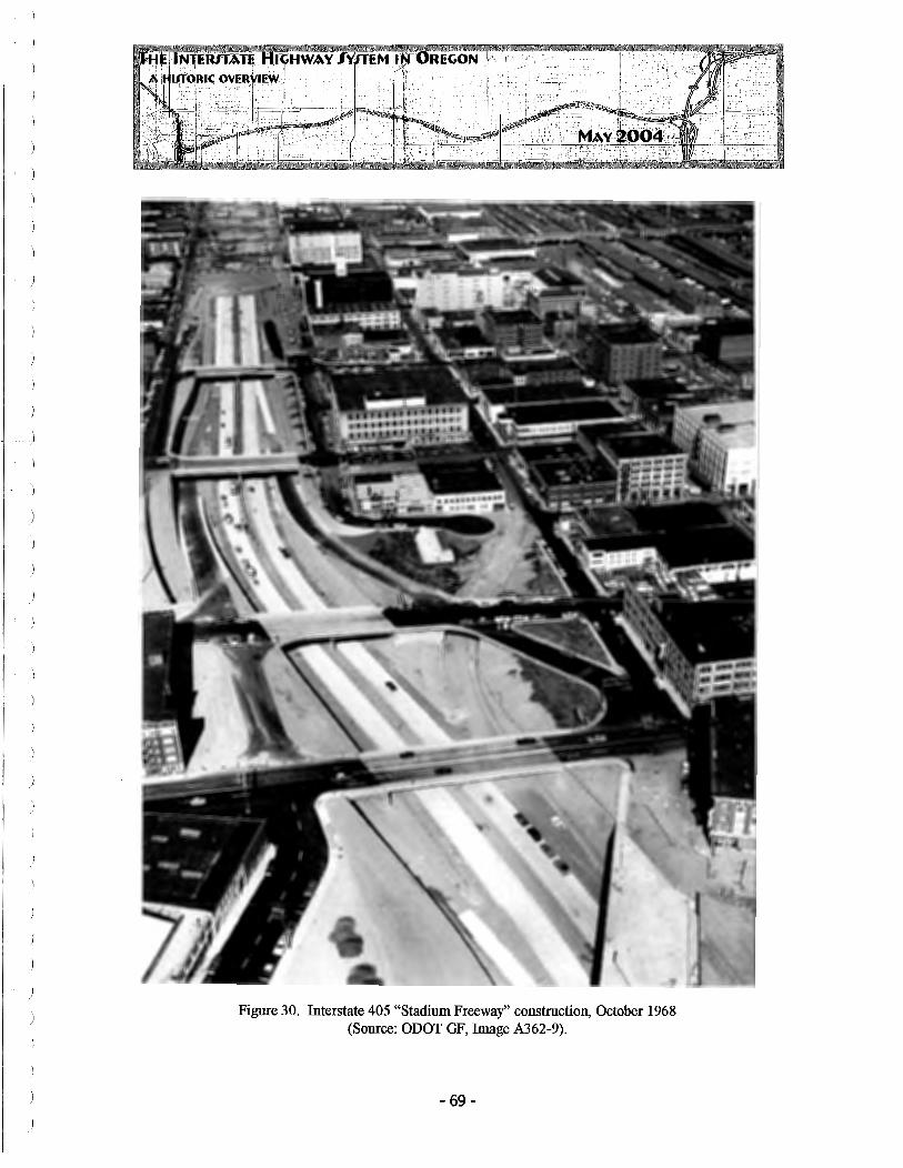
Figure 30. Interstate 405 "Stadium Freeway" construction, October 1968 (Source: ODOT GF, Image A362-9).
- 69 -

the early 1950s. In January 1965, the Portland City Council approved the plan and the Federal Highway Administration approved the acquisition of additional right-of-way to allow its construction in November 1965.
In 1968, after the U.S. Congress passed legislation to expand the mileage of the Interstate Highway System, Oregon applied for and received approval for a northwest Portland spur, designated I-505, and known within Oregon as the "Industrial Freeway" (ODOT GF, FHWA-OR-EIS-73-08-F, 1977:1). The original 1.3-mile-long route of the freeway was submitted in early 1971 following consultation with the City of Portland and northwest Portland residents and property owners.
We approve, effective December 13, 1968, [the] addition of the Industrial Freeway in Portland to the Oregon Interstate System ... The number designation 505 has been assigned to this route in conformity with the numbering procedures of the American Association of State Highway Officials. (ODOT GF, Lowell Bridwell, letter to Glenn Jackson, 24 December 1968).
As details of the project became widely known, however, local opposition grew and in August 1971 the Northwest District Association withdrew its support for the plan as presented. In September that group, joined by the Oregon Environmental Council and others, filed suit in U.S. District Court asking that all work be halted until a draft Environmental Impact Statement was prepared and filed under NEPA requirements.
By early 1973, four options for the route were under consideration, including three elevated variations and one depressed or sunken route. The depressed route was the least expensive at $83. 7 million, while the elevated options ranged to a high estimated at more than $130 million. Local concerns over displaced rental housing were joined by commercial interests faced with demolition. ODOT and the City of Portland retained a consultant to further analyze effects, and in July 1973 the "Summary Report of the I-505 Consultant Study" was direct mailed to 10,000 businesses and residents. This document now included five design alternatives.
It is my opinion that one of the critical problems facing the Division in constructing the Industrial Freeway is our ability to respond to the necessary displacement of persons with a relocation plan that will be responsive to the needs and desires of the residents in northwest Portland (ODOT GF, H.S. Coulter, OSHD inter-office memo, 11January1973).
In October 1973, the OSHD stated that "a decision on the location of the Industrial Freeway (I-505) in Northwest Portland is moving closer to fruition with a formal public hearing scheduled for October 30" (OSHD PR 73-304-Sem, 19 October 1973). By mid-
- 70-

RE.GON -,
November, however, the Oregonian editorialized that the Portland Planning Commission and Portland City Council were expected to select from the six route options within two weeks, voicing its own support for the so-called "Short Y eon" option, which included both elevated and grade sections, totaling an estimated $47 million rather than the less expensive "Upshur Corridor" option, estimated at $30 million.49 The Oregonian however concluded that "unless the final two hearings produce indisputable new information that replacement housing can be produced in Northwest Portland, not somewhere else, the Planning Commission and the City Council should select the Short Y eon route. The neighborhood should not be asked to imperil its future for benefits that will largely be enjoyed by others" (Oregonian, 19 November 1973, 30:1-2).
In December 1973, ODOT accepted the City of Portland's recommendation for the Short Y eon route and it appeared that the project would go forward. A large landowner in the area, feeling it was negatively affected by the proposal, now brought suit in Federal court claiming the EIS was incomplete. On April 30, 1974, U.S. District Court issued a judgment in favor of U.S. Steel Corporation against the Department of Transportation, the Federal Highway Administration, and ODOT, noting failure to comply with Federal law and enjoining continuation of construction until further study was undertaken. The judgment notes that of the fourteen original alternatives, only five were covered within the Environmental Impact Statement, including the Short Y eon, which required the complete taking ofU.S. Steel's facilities in the area (ODOT GF, I-505).
While ODOT mulled alternatives, Federal law regarding withdrawals from the Interstate System changed and it appears that less-expensive solutions were found that were best constructed outside the Interstate Highway system. By December 1978, the City of Portland had passed a resolution withdrawing its support for the I-505 segment in the northwest (ODOT GF, Lee Johnson, memo to Governor Vic Atiyeh, 15 December 1978). In early 1979, Governor Atiyeh petitioned the Federal Highway Administration for withdrawal of the I-505 Industrial Freeway from the system and the allocation of those funds for other transportation related projects in the area.
We have completed our review of your proposal and have determined that Interstate Route 505 is not essential to the completion of a unified and connected Interstate system ..... the length of the withdrawn route is 3 .17 miles. The current amount of Federal funds authorized by this withdrawal for substitute projects serving the Portland urbanized area is $134.4 million (ODOT GF, Karl S. Bowers, FHW A, letter to Vic Atiyeh, 14 December 1979).
49 These six routes, including the far less expensive Short Yeon, do not appear to be directly related the four routes for the Industrial Freeway considered in early 1973, thus accounting for the decline in project cost.
- 71-
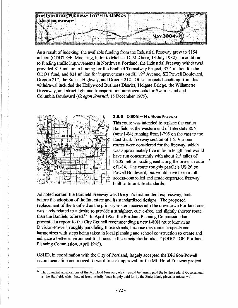
As a result of indexing, the available funding from the Industrial Freeway grew to $154 million (ODOT GF, Moehring, letter to Michael C. McGuire, 13 July 1982). In addition to funding traffic improvements in Northwest Portland, the Industrial Freeway withdrawal provided $15 million in funding for the Banfield Transitway Project, $7.4 million for the ODOT fund, and $21 million for improvements on SE 19th Avenue, SE Powell Boulevard, Oregon 217, the Sunset Highway, and Oregon 212. Other projects benefiting from this withdrawal included the Hollywood Business District, Holgate Bridge, the Willamette Greenway, and street light and transportation improvements for Swan Island and Columbia Boulevard (Oregon Journal, 15 December 1979).
2.6.6 I-SON -- MT. Hooo FREEWAY
This route was intended to replace the earlier Banfield as the western end oflnterstate 80N (now I-84) running from I-205 on the east to the East Bank Freeway section ofl-5. Various routes were considered for the freeway, which was approximately five miles in length and would have run concurrently with about 2.5 miles of I-205 before heading east along the present route ' ofl-84. The route roughly parallels US 26 on Powell Boulevard, but would have been a full access-controlled and grade-separated freeway built to Interstate standards.
As noted earlier, the Banfield Freeway was Oregon's first modem expressway, built before the adoption of the Interstate and its standardized designs. The proposed replacement of the Banfield as the primary eastern access into the downtown Portland area was likely related to a desire to provide a straighter, curve-free, and slightly shorter route than the Banfield offered. 50 In April 1965, the Portland Planning Commission had presented a report to the City Council recommending a new I-80N route known as Division-Powell, roughly paralleling those streets, because this route "respects and harmonizes with steps being taken in local planning and school construction to create and enhance a better environment for homes in these neighborhoods ... " (ODOT GF, Portland Planning Commission, April 1965).
OSHD, in coordination with the City of Portland, largely accepted the Division-Powell recommendation and moved forward to seek approval for the Mt. Hood Freeway project.
50 The financial ramifications of the Mt. Hood Freeway, which would be largely paid for by the Federal Government, vs. the Banfield, which had, at least initially, been largely paid for by the State, likely played a role as well.
- 72 -

As a part of the proposal to the Federal Government, Oregon requested that the Banfield, incorporated as a part of the Interstate System, be withdrawn and replaced with the new route. The specifics of the project, as proposed to the Bureau of Public Roads in 196S, included:
... [ e ]limination from the existing routing of I-SON that portion beginning at the intersection ofl-5 on the east bank of the Willamette River in Portland and terminating at the intersection of I-SON with 1-205 near 96th street in east Portland (known as the Banfield Expressway) and substituting therefore a new routing beginning at an intersection with 1-5 at the easterly end of the Marquam Bridge, then easterly to an intersection with 1-205 near 96th street in east Portland (known as the Mt. Hood Freeway) and thence northerly concurrent with 1-205 to a junction with I-SON. The proposed deletion is 5.79 miles and the requested addition is 5.27 miles. The concurrent mileage with 1-205 is 2.56 miles (ODOT GF, Cooper, letter to R. E. Simpson, 11 October 196S).
As might be expected, opposition to the re-routing of I-SON developed in the affected neighborhoods. Vocal opposition included the group known as Sensible Transportation Options for People or STOP (ODOT GF, 1972). In 1972, a complaint was filed in U.S. District Court seeking to halt the project pending additional corridor studies and filing of an Environmental Impact Statement.
Mt. Hood Freeway is perhaps the most complex, but demanding, project confronting transportation planners today .... Alternatives are being considered by our consultant, Skidmore-Owings and Merrill [Figure 31] .... " ( ODOT GF, December 1972). 51
Figure 31. Mt. Hood Freeway alternatives, Skidmore-Owings and Merrill Report, 1972 (Source: ODOT GF).
51 It is worth noting that this statement was made in 1972, as opposition to I-205, I-305 and I-505 was in full swing, along with the controversy surroWlding I-82 in eastern Oregon.
- 73 -

Following a similar pattern to that of the other proposed Interstate projects during this period, opposition to the Mt. Hood Freeway continued on a variety of fronts, complicated by the then severe energy crisis that created acute gasoline shortages nationwide and pointed out the reliance of the U.S. transportation system on foreign oil supplies. On July 25, 1974, the Portland City Council withdrew its prior approval of the project by a vote of 4 to 1.
Whereas, there is currently a severe shortage of all forms of energy, particularly petroleum products, and indications are that these shortages will be of long duration and .. .it would thus appear that the greater public benefit might be promoted by concentrating public expenditures on improving mass transit facilities rather than in continuing to add facilities for automobile transportation ... the Council hereby rescinds its previous approval for the construction of the Mt. Hood Freeway ... and shall seek to have the United States Secretary of Transportation withdraw his approval of the Interstate 80N freeway ... and substitute ... any equal amount of funds to be used for mass transit projects ... (ODOT GF, City of Portland, Resolution 31410, 25 July 1974).
A year later, in July 1975, Governor Robert Straub petitioned the FHW A for withdrawal of the Mt. Hood Freeway from the Interstate System, an action he referred to in his joint statement with Multnomah County Commissioner Mel Gordon when announcing a settlement in the I-205 controversy on July 25, 1975. In early 1976, the Oregon State Highway Engineer prepared a confidential "Internal Task Force Report to the Director of Transportation on Options for Withdrawing Mt. Hood Freeway Funds" that estimated some $200 million could be allocated to other projects in the Portland metropolitan area (Baldwin 1976) and Governor Straub provided additional information to the FHW A regarding his earlier withdrawal request. In May 1976, the FHWA approved Oregon's request.
Your request of July 1 1975, as amended by your letter ofFebruary 24 1976, for withdrawal of the Mt. Hood Freeway, I-80N, in Portland, has been evaluated .... The FHW A had determined that the Mt. Hood Freeway is not essential to the completion of a unified and connected Interstate System .... Therefore, in accordance with your request, ... we hereby approve, effective this date, the withdrawal ofI-80N, Mt. Hood Freeway, from the Interstate Highway System under the provisions of Section 103(e) (4), Title 23, U.S.C .... (ODOT GF, Norbert T. Tieman, FHWA Administrator, letter to Governor Robert Straub, 3 May 1976).
-74-

Again as the result of cost indexing, the estimated $200 million allocated for the construction of the Mt. Hood Freeway grew to $320 million, endangering funds that were earmarked for other Portland area transportation projects that, by law, were required to be under construction by September 1986 (ODOT GF, Moehring, letter to Michael C. McGuire, 13 July 1982).
2.6.7 1-82 -- McNARY HIGHWAY
Interstate legislation. 53
Interstate 82 (McNary Highway No. 70) connects I-84, south of Hermiston, Oregon with I-90, in Ellensburg, Washington. Of the route's 143.5 miles, only 11 (less than 10%) are within Oregon. 52 Alone among Oregon's Interstate segments, this route was not originally proposed by the state but rather added to the Interstate program at the request of the Department of Defense, which sought to assure connections to
, its southern Washington facilities, meeting one of President Eisenhower's stated purposes for the National System of Interstate and Defense Highways that was a component of the original
Interstate 82 was placed on the System by the Secretary of Commerce at that time (1956), based on a recommendation by the Department of Defense. The states of Washington and Oregon did not concur on this route and consequently a number of alternatives were studied (ODOT GF, Baldwin, letter Joseph E. Bums, 1February1972).
In 1958, Sinclair Weeks, U.S. Secretary of Commerce, had proposed a routing of the freeway that crossed the Oregon-Washington state line at Blalock Island which "involved an exceedingly long and expensive span, or in lieu of that, several spans," complicated by the reservoir behind the John Day Dam. This proposal was dismissed as technically flawed and Oregon began to push for a routing that would utilize the Umatilla Toll Bridge, built in 1954 (ODOT GF, Umatilla County, 1965).
This bridge, if necessary, can be widened to a width of 28 feet at a very nominal cost, but .. .is now capable of carrying traffic entirely satisfactorily for
52 http://www.interstate-guide.com/i-082.html 53 Both the Hanford Reservation of the US Department of Energy and the US Anny's Yakima Testing Range are
located in this area of southern Washington.
- 75 -

a period of at least 25 years ... (ODOT GF, Williams, Oregon State Highway Engineer, as quoted in Umatilla County, 1965).
Routing decisions were the subject of public hearings, many of which centered on the potential economic benefits that would accrue to communities either on, or left off, the route. Much of this was focused in Washington, where the Tri-Cities area of Pasco, Kennewick, and Richland competed to be upon the Interstate route with Walla Walla, considerably to the east. In Oregon, the issues were more focused upon where I-82 would
\V'N
ORE
KIONA .,.. PLYMOUTH
111.i (1flE!.,.. V.\NC'O.:lt Cl\N'rOl't'
Fi 9Lire 11
ALTERNATE PROPOSALS Ellensburg - Pendleton Interstate
Figure 32. Interstate 82, alternate route proposals, c. 1965 (Source: Umatilla County [ODOT GF]).
- 76-

cross the Columbia River, with the Port of Morrow, in Boardman, being a vocal advocate of a route that would benefit its position as shipping center. The economics of bridge construction, at least from Oregon's standpoint, also played a role, with the Umatilla crossing strongly favored by the State. By early 1964, both Oregon and Washington had reached consensus on a route that began at Stanfield, on I-84 and then headed northwest through Umatilla towards Prosser, Washington.54
Once this decision, which supported Route "B" in Figure 32, became public, groups in the Tri-Cities area, as well as those Boardman, Oregon, and Walla Walla, Washington, all sought political intervention to re-align the freeway so as to improve their access. Oregon U.S. Congressman Al Ullman and Washington's U.S. Senator Warren Magnuson both became involved, with the result that a re-study of options for the freeway was formally requested in August 1964 (ODOT GF, Umatilla County, 1965). This report, prepared by Transportation Consultants, Inc., of Washington, D.C., reconµnended a routing ofI-82 that would go from Prosser to Wallula, Washington, and enter Oregon at Pendleton, a significantly longer and more costly routing, but one that would meet all of Magnuson's constituents' goals. OSHD, on the other hand, remained steadfast in its desire for the Umatilla crossing, utilizing the existing bridge over the Columbia River. This action, of course, was widely supported in Umatilla County.
Tri-City efforts to get Interstate Highway 82 re-routed through Wallula instead of across the Umatilla Bridge have been labeled "D for Dangerous" by Umatilla County leaders (Tri-City Herald, 7 August 1964, 1:1).55
Debate dragged on for nearly a decade without any conclusion and finally the FHW A separately approved a spur route connecting the Tri-Cities with I-82 in Washington, largely dissipating that region's interest in supporting the Wallula Route that would benefit Walla Walla (ODOT GF, Baldwin, letter to Joseph E. Bums, 1February1972).56
[The Oregon Transportation Commission] merits [inclusion on a] dubious roll of honor ... for stubbornly sticking to its dog-in-the-manger position through years of stalemate ... [with] the [Tri-Cities] Good Roads Association's ... Benedict Arnold reversal on its regional interest commitment, provided its own self-interest is served (Walla Walla Union Bulletin editorial, as quoted in Tri-City Herald, 21 August 1973).
Tri-Cities took a more practical view of the situation. "Oregon refuses to budge and I-82 must cross the Columbia at Umatilla, or not at all ... Before Walla Wallans accuse the Tri-
54 1bis route is roughly the same as today's US 395. 55 Wallula, Washington, is located southeast of Kennewick on US 12. 56 This 15.19-mile-long spur was designated Interstate 182 and opened in 1986 (http://www.interstate-guide.com/i
l 82 wa.html).
- 77 -

Cities of sawing them off from I-82 they should cross-examine [Washington State Highway Director] Ferguson ... " (Tri-City Herald, 21 August 1973).
In March 1973, likely in connection with the determination to build I-182 to connect the Tri-Cities, both Oregon and Washington agreed upon Alternative "J,'' which utilized the Umatilla Bridge and joined I-84 southwest of Hermiston but did not go through that community. Various other local interests continued to agitate for re-evaluation and study of alternatives, and as late as September 1978 a hearing before the Oregon Transportation Commission was held to determine whether to re-open the siting discussions for I-82, as pressure for Alternative "C" from Stanfield again grew. "We really haven't heard anything new here today ... " said Glenn Jackson (Tri-City Herald, 20 September 1978).
I was appalled to learn that hearings were reopened recently regarding the route that Interstate 82 would take in Oregon to connect with Interstate 80N. Years of planning have already gone into deciding upon the J route and the issue was supposedly resolved .... Alternative C displaces the most number of people, cuts across seventeen roads ... and crosses irrigation canals six times ... I feel [it] is a route that is self-serving to a few specialized self-interest groups who have nothing to lose by beating a dead horse (ODOT GF, John F. Walchi, letter to the Oregon Transportation Commission, September 1978).
In October, the Commission reaffirmed its support of Alternative J. Construction bidding of the route was just beginning in early 1979 when progress was complicated by the gasoline shortages of the energy crisis.
Northwest Construction of Kirkland intended to shut down [its work on I-82] ... after telling ODOT it had used its fuel allocation through June ... (ODOT GF, unidentified newspaper report, 18 May 1979).
Construction on I-82 continued through the 1980s (Figure 33), including improvements at the Columbia River. The last contract for the route, and the final element of Oregon's entire Interstate system (see Table 2), was awarded in late 1985, a milestone marked by the Department.
After 3 0 years of construction, Oregon will soon complete its interstate highway system. Bids were taken this week on a $6 million contract that calls for grading work on the route between Oregon's I-84 and Washington's
- 78 -

Figure 33. Oregon and Washington dignitaries open a section of 1-82 near Prosser, September 1981 (Source: Tri-Cities Herald, ODOT GF).
I-90 at Ellensburg. That job begins the final stage of Oregon's last interstate highway .... Once the freeway is opened, it will mark the end of an era of massive highway construction for the state [Traffic Engineer Bud] George notes (ODOT PR 85-233, 8 November 1985).
Just under three years later, Interstate 82 was complete (Figure 34). "Completion of the $39 million Interstate 82 project has met with its own obstacles .... The strong joint relationship between Oregon, Washington and the local jurisdictions made the connecting route possible. The dedication ceremony, held on I-82 near Hermiston, was held on Tuesday, September 20th, at 10:30 a.m. After speeches by Oregon Transportation officials and Lt. Colonel Everette E. Gray, of the Umatilla Army Depot, the ribbon was cut at 11 :25, followed by a motorcade along the new route" (ODOT PR, 88-229 S, and ODOT Dedication Program, Oregon: Completing the Last Leg of the Interstate, Sept mber 1988).
- 79 -

)
No. I-5 I-82 I-84
I-105 I-205 I-305 I-405 I-505
Figure 34. 1-82 dedication program, September 1988 (Source: ODOT GF).
T bl 2 0 a e . I re2on nterstate F" r f D t ma IZa ion a es. Name(s) Miles Date Completed Pacific Highway 308 Oct 22, 1966, near Canyonville McNary Highway 11 (in Oregon) Sept 20, 1988, near Hermiston Columbia River, Old 375 Jul 3, 1980, near Baker City Oregon Trail Eugene Spur 4.5 Oct 25, 1967, at Eugene East Portland Freeway 26.6 Dec 1982 Salem Spur (3.3) Withdrawn, Sept 1977 Stadium Freeway 4.2 Feb 25, 1969 Industrial Freeway 3.17 Withdrawn, Dec 1979
)
3.0 RELATED DEVELOPMENTS, IMPACTS AND EFFECTS
The Interstate is, obviously, a complex system of many inter-related parts. Although primarily composed of linear, physical, roadways, there are other ancillary built elements that are integral to the system yet have individualized histories. Beyond the built element of the system, its construction had major social and economic impacts as well. This section, by no means comprehensive, provides some discussion of specific built elements of the system, as well as the impacts Interstate construction has had, both good and bad, on Oregon's economy and character.
3.1 INTERCHANGES
In earlier highways, the traveling public (i.e., the potential customer) had full access along the entire highway corridor. The Interstate, as access controlled routes, by design restricted points of entry and egress (on- and off-ramps) and shunted an ever-increasing volume of travelers into selected locations. The term "interchange" typically refers to all moving-traffic connections between two major roadways, such as between I-5 and I-205. During construction, however, the term was also used for Interstate entry and exit points, where the highway and the surface-street system connected via on- and off-ramps. These latter areas soon become intensely developed with road-related commercial businesses.
There are 189 interchanges on the Interstate, 14 under construction [and] 44 planned but not yet under construction (ODOT GF, Cooper, letter to Karen Pines, 15 February 1967).
Requiring engineering that accommodated not only standard road-building but an understanding of velocity, deceleration and acceleration, the power capability of a wide variety of vehicle types, safe turning radii, and aerodynamics, among other things, Interchanges became an important and integral element of the Interstate System. As the "entry" to the new Interstate System, particularly in areas where controlled access was unprecedented, interchanges were, in effect, the "front door" of the highway system.
Geometric design ofinterchanges is an important part of any freeway .... [A] structurally adequate and economically reasonable freeway location is ineffective if it does not allow for provision of good interchange design (Newton 1958).
Interchange design included so-called "basic" patterns that were often defined by their shape - the diamond, cloverleaf, trumpet, rotaries, and directionals. Basic pattern interchanges, the design of which largely became standardized through repetition, were
- 81 -

usually favored by engineers as lower-cost than special situation interchanges that required individual design. "Basic pattern interchanges are urged for every location where they are at all feasible. The traveling public will soon come to recognize these layouts and ... by this means confusion will be reduced" (Newton 1958). Specialized interchanges were expensive to build and engineer and, as the System continued to expand, engineers were able to assemble accident data relative to "roll-overs" and similar problems that were factored back into design decisions, further refining the quality and standardization of the interchange. "Our national flower is the concrete cloverleaf' (Mumford 1938).57
While traffic engineers tended to analyze the economics of interchange placement, meaning at which cross-street an off-ramp would be provided, or where a non-access connection to a secondary highway would be constructed, in terms of traffic volumes and predicted growth, local business and community leaders looked at the matter differently. "In order to justify a highway project from an economical point of view, the annual money saved by reason ofless travel distance and time on the new facility must equal or exceed the annual cost of the improvement" (OSHD, February 1960). That might make sense from an engineering or highway-financing standpoint, but as local leaders viewed the situation, having an Interstate run near their town without having any access to or from it, provided little benefit. Interchange placement then, soon became a politically, and economically, charged issue.
Once an interchange location was determined, typically removed from the established business core area in most of Oregon, the land immediately adjacent to the off-ramp increased rapidly in value as its potential for development grew. Often this area was located within an unincorporated area, outside the city limits, and typically subject to less restrictive land use planning requirements as a result (Figure 35). 58 The impact of interchange development, particularly in rural areas, had distinct effects on local economies and created an entirely new form of commercial development (Preston 1973). Geographers refer to this pattern as nodal clustering.
The efficiency of the interstate system was achieved, in part, by the limitations of access .... [T]his change ... profoundly altered the geography of services and retailing (Jakie et al. 1996: 3 06).
Responding to the new opportunities created by interchange construction in the 1950s and 1960s, gasoline stations and, soon, national franchise restaurants became the most
57 As quoted in Roads and Odell (1992:62). 58 This of course was particularly true in the 1960s, when much of the hlterstate was developed prior to the 1973
passage of Oregon's SB 100, which established Statewide Land Use Planning standards,

Figure 35. I-84 interchange at Ontario, 1960 (Source: 241
h Biennial Report of the Oregon State Highway Commission, 1958-1960).
common types of interchange business. National corporations like McDonalds, soon followed by Wendy's, Bob's Big Boy, Taco Bell, and others, established locations at interchanges along with Shell, Texaco, Standard, and other gasoline refiners to serve the needs of highway travelers. Motels, a word coined in an earlier generation by combining "motor" and "hotel" to reflect the auto-centric focus of their service and design, also
became increasingly chain oriented through the rise of Holiday Inn, Super 8, and others. The very term "fast food'' derives from the quick service required by a traveler, as opposed to the quality food that might have been emphasized by an earlier, traditional
- 83 -

restaurant in a downtown location. "The fast food industry took root alongside [the] interstate highway system, as a new form of restaurants sprang up beside the new offramps" (Schlosser 2002:8). Eventually, corporations born as "road food," dependent upon the Interstate system, would expand into the community core to take their successful format beyond the confines of the road. The corporatization of the American restaurant industry, a process that clearly begins with the creation of the Interstate System and the opportunities it offered, continues to revolutionize the way America eats out far beyond the off-ramp.
In the past 30 years, "Interchange Commercial" has become a fairly common zoning classification in many Oregon communities, reflecting the types and character of development that seek these areas. Cities often allow larger signage, require additional parking, or require other design standards that differ from what is allowed within the traditional downtown core, further amplifying the difference between the interchange and the community center.
3.2 BUSINESS LOOPS, MAI.LS, FRONTAGE ROADS, AND DOWNTOWN IMPACTS
As the Interstate system matured and became more and more integral to the commercial life of the community, new business forms were developed dependent upon the Interstate connectively but often restricted by the fairly compact geography of the interchange. During the early years of the Interstate, bypassed sections of US 99 were, of course, retained as elements of Oregon's road system. In many cases, local interests sought and obtained redesignation of portions of the road as "business loops" that would provide ancillary connections between two or more Interstate access points.
Regarding a request of City of Gold Hill for designation of the old route of the Pacific Highway through Gold Hill as an "alternate" or "business route" for US 99. The [State Highway] Engineer advised that normally when towns have been bypassed it has been the practice to sign the old route as a "business" route, such as at Salem, Roseburg and Cottage Grove. It was his thought the City of Gold Hill should be treated likewise and he so recommended. The commission adopted the recommendation and so ordered (OSHC Minutes, 12 September 1957, p. 28860).59
Many cities, in an attempt to maintain the economic viability of the traditional downtown core, had their earlier U.S. highway "couplets" re-designated as business loops, with signage to that effect installed at the appropriate interchange connections on either side of the community to inform the traveler of the route. At other interchanges, though, as well as elsewhere within the viewshed of the Interstate route, new forms of retail developed to
59 At this period Oregon, in typical fashion, still referred to I-5 as the "Pacific Highway," which is what is meant here, as the older route of US 99 was that that passed through downtown Gold Hill.
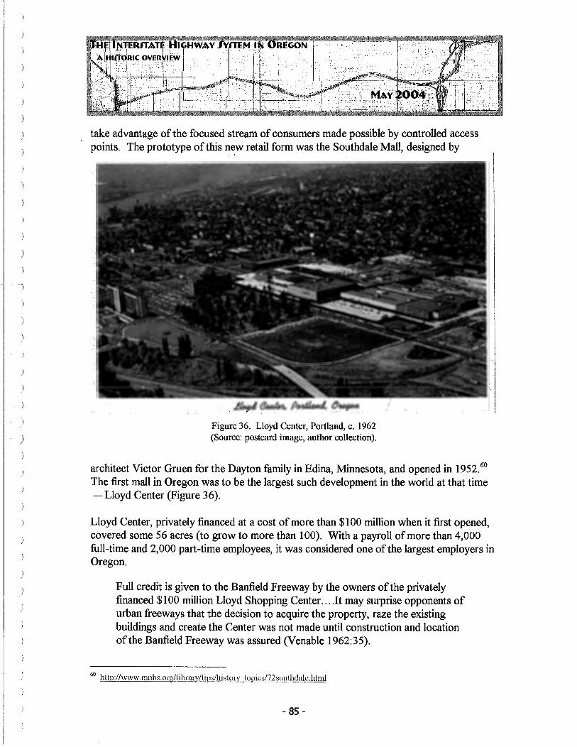
take advantage of the focused stream of consumers made possible by controlled access points. The prototype of this n~w retail form was the Southdale Mall, designed by
Figure 36. Lloyd Center, Portland, c. 1962 (Source: postcard image, author collection).
architect Victor Gruen for the Dayton family in Edina, Minnesota, and opened in 1952. 60
The first mall in Oregon was to be the largest such development in the world at that time - Lloyd Center (Figure 36).
Lloyd Center, privately financed at a cost of more than $100 million when it first opened, covered some 56 acres (to grow to more than 100). With a payroll of more than 4,000 full-time and 2, 000 part-time employees, it was considered one of the largest employers in Oregon.
Full credit is given to the Banfield Freeway by the owners of the privately financed $100 million Lloyd Shopping Center ... .It may surprise opponents of urban freeways that the decision to acquire the property, raze the existing buildings and create the Center was not made until construction and location of the Banfield Freeway was assured (Venable 1962:35).
60 http://www.mnhs.org/library/tips/history topics/72southdale.html
- 85 -

While Lloyd Center was the first mall in Oregon, many others have followed, most notably Clackamas Town Center, Valley River in Eugene, and the Rogue Valley Mall in Medford, all of which benefit greatly from proximity to the Interstate or a connecting link.
Another form of commercial development that resulted from the development of the mature Interstate system is the frontage road. Distinct from the business loop, which connected new Interstate travelers with earlier, established, commercial cores, the frontage road was an entirely new form oflinear development that directly paralleled the freeway in proximity and, in the best scenario, was almost entirely visible from it. In a sense, the frontage road is the old Federal Aid Highway "roadside" strip, kept at a polite distance. In some situations, these businesses face the :frontage road, with their rear, service areas visible to the highway but newer developments are lined up like prospective partners at a dance, best face forward to the freeway, with large signs and interesting designs in the hopes of catching the eye of the Interstate driver. This is particularly true of so-called "Outlet Malls," which often blend creative architecture with the perception oflow-priced, name-brand wares and tend to locate in visible, Interstate-close locations.
"Big Box Retail," a term that has come to describe large-volume retail stores such as WalMart or Fred Meyer, along with specialty shops (or "category-killers") such as Home Depot, Office Max, and Circuit City also often develop along frontage roads either singly or in groups dubbed "power centers" by real estate development interests. Like the fast food chains that originated in proximity to interchanges and then moved into other locations as well, big box retail malls, and to a lesser extent outlet malls, are considerably less dependent upon Interstate proximity than they once were.
Faced with reduced access to travelers, most of Oregon's downtown faced rough economic transitions following the completion of the Interstate Highway and the rise of the new commercial forms and areas it spawned. Large retailers such as J. C. Penney, long a fixture in many Oregon communities, relocated to new and larger facilities nearer the freeway, and "regional malls" began to pull consumers from once distant cities, reducing the viability of more local merchants. 61 Some communities, such as Eugene, tried to compete with malls by attempting to turn their downtowns into one. 62 Others formed "Urban Renewal Districts" or embraced the Main Street model of the National Trust for Historic Preservation as a way to re-invigorate the community. Today, many downtowns are successful, vibrant, and economically vital elements of their communities. Many retain strong integrity, through both luck and, more frequently, dedicated
61 In the early 1980s, for example, Valley River Center in Eugene offered Medford-area residents vouchers for overnight hotel accommodations with proof of minimum purchases during "Back-to-School" events at its stores.
62 This was hardly limited to bypassed Interstate communities, as other Oregon cities from Coos Bay to Medford either closed, or considered closing off, streets and imitating the indoor mall environment in the 1960s and early 1970s.
- 86-

REGON
restoration to their physical character during an earlier period. Few, however, bear any strong resemblance to the function or services that were provided prior to the construction of the Interstate Highway system. Local specialty shops, antique stores, art galleries and fine, locally-owned restaurants have largely replaced the work-a-day pharmacies, furniture stores, hotels, hardware stores and mom-n-pop operations that characterized many of Oregon's smaller communities fifty years ago. Those uses, now dominated by national or regional chains, are more likely found on frontage roads or malls, nearer the highway.
3.3 SAFETY REST AREAS
As the quality of cars and roads improved, the necessity of repair or fuel lessened and the distances between stops grew. In the early 1920s, roadside rest areas began to appear along the state's highways and drinking fountains were located in areas possessing a source of pure water (ODOT GF, 1977:3). Oregon had developed some roadside convenience stops with restrooms and picnic areas to provide for traveler comfort between the developments lining the road in the state's cities and towns, but this need, outside of long rural stretches, was largely provided by private development. 63 With the Interstate, and the controlled access and bypass routing that removed much of the road from existing commercial facilities, the Federal standards allowed for the construction of "Safety Rest Areas" at recommended 35-mile intervals along the Interstate routes "where motorists as well as over-the-road truck drivers may stop to rest and relax, thus providing for greater safety on the highways" (ODOT GF, Williams, letter to E. F. Schlensker, 16 June 1959). Like all the Interstate program, the cost of construction for safety rest areas connected with Interstate development was shared on a 90/10 percent ratio, with the Federal government paying the majority of costs.
When the subject of providing roadside rest areas along the :freeways came up, Oregon was ready to go .... The first rest area along I-5 was constructed at Oak Grove between Albany and Eugene in 1962 [Figures 37 and 38]. It was immediately apparent that popularity of a place to stop, stretch and relax for awhile in a quiet, restful atmosphere far exceeded the wildest estimate of usage, especially by truckers (ODOT GF, 1977:3).
The major costs associated with Safety Rest Areas related to the on- and off-ramps to the Intestate rather than the development of the area itself. Typical of the Interstate, standardized designs were developed to reduce planning costs. Construction of the earlier rest areas was standardized, with decorative concrete block walls, pierced concrete
63 It should be noted that prior to the construction of the Interstate, and up through 1990, the Oregon Parks and Recreation Division was an integrated department within the Oregon State Highway Department (and after 1969, within ODOT). Oregon's State Parks facilities often served as rest areas alongside the state's highway developments.
- 87 -

)
Figure 37. Oak Grove safety rest area construction, c. 1962 (Source: ODOT GF).
screening elements and simple shed roofs designed both for economy and durability. "Oregon's highway engineers and planners again were looked to as the experts in a new field and provided assistance to other states in planning rest area facilities" (ODOT GF, 1977:3).
Oregon is proud of its system of Safety Rest Areas, which are located approximately 3 5 miles apart along the Interstate System. These sites provide a relaxing facility for the weary motorist .... they have proved extremely popular with the motoring public, to the extent that most of the earlier ones have either been enlarged or will be in the near future (ODOT GF, Porter, R. L., letter to Frank L. Remington, 12 April 1971).
- 88-

Figure 38: Oak Grove safety rest area, 1963 (Source: ODOT GF).
3.4 HIGHWAY BEAUTIFICATION: INFORMATION
3.4.1 THE LOGO PROGRAM
Related to the earlier billboard eradication campaign of the 1920s "Good Roads Movement," the presence of commercial billboard advertising on entirely new, accesscontrolled, Interstate Highways was viewed by many as an unfortunate continuation of the crass roadside development of the early Federal Aid highway era. In Oregon, as was so often the case, interest in this area of highway development pre-dated and influenced later national legislation.
The concern of unsightly signs and billboards along Oregon's highway began prior to the adoption of [the Federal Highway Beautification Act of 1965]. The Scenic Areas Act was adopted in Oregon in 1961. The purpose of this act was to establish scenic areas adjacent to or along State highways where most private signs would be prohibited (ODOT GF, L.E. George, ODOT Traffic Engineer, letter to J. A. Saplis, 21 November 1983).
- 89 -

The Federal Highway Beautification Act of 1965, generally associated with President Johnson's wife, Ladybird, provided additional authority to remove roadside billboards along the Interstate corridor and, by 1983, Oregon removed more than 2, 000 such advertisements from all its highways.
LOGO BOARD behind Gov. Tom McCa!U ds 1!irst of six be, governor~nstnmtions on ·how to iat-.l'Ch another oil company Jng erected this mouth ialong Oregon d'reew?>ys, ;taking emblem to ~ogo •board 111ear Auror.a-Champoeg .\ntercllange ,place of cm•p:;ratloni9ponsored 'li!llboat'ds. !Dale VooLaancn, on Interata'te '5. Board not;iffes motorists of services avail· .Jeft, Oregon Higb'lvaY. Dej>artment sign~ iemP,lQY.e, gives .. \ahle iat next mtcrohange, :(UBI Photo)
Figure 39. Gov. McCall dedicates first logo board, July 1972 (Source: Oregon Journal [ODOT GF]).
In 1971, partially in response to concerns from the business community over the impacts of the billboard removal programs, Oregon's Legislature passed the Oregon Motorist Information Act which established policies for alternative private business signing on the Interstate, subject to restrictions and following uniform design guidelines. This program, with small, size restricted advertisements mounted upon State-owned blue Interstate standard information signs (Figures 39 and 40), was called the Logo Program.
There is a new blue sign with five or six gasoline company trademarks on Interstate 5 near the Aurora-Champoeg interchange. It's called a "logo board" and Oregon residents will be seeing a lot more of them in the future .... (Oregon Journal, 19 July 1972, 7: 14).
- 90 -

Figure 40. Logo sign, 1-5, north of Albany, southbound, 2004 (Source: author photograph).
3.4.2 TRAVELER'S INFOCENTRES
Also a part of the 1971 Motorist Information Act, Oregon created the Travel Information Council, charged with development of "substituted information devices" to replace billboards along the state's highways (Grant 1974). The logo program was limited by FHW A regulations on spacing and the number of interchanges so the Travel Information Council sought additional ways to impart tourist-related information to visitors. · lnfoCentres, as they became known were open kiosks that were installed at most rest areas along 1-5and1-84. Walter Gordon, Dean of the University of Oregon School of Architecture, was retained by the State's consultant to design the plaza buildings. Gordon designed a number, each of which provided shelter, open sides for safety, and a high degree of vandal-proof construction. The first pair of lnfoCentres, from Gordon's Plaza design, was constructed at the Wilsonville Safety Rest Area in early 1975 (Oregon Motorist, April 1975). The state contracted with TravellnfoCenter of Oregon, headed by Paul Arthur, to design and build the structures, plus manage the sold advertising space they offered (see brochue, Figure 41). Oregon received two percent of the revenues, which rose to five percent after the first two years of operation (Oregon Motorist, April 1975).
- 91 -

Figure 41. Travelnfo brochure, c. 1975 (Source: ODOT GF).
Although original plans called for a variety of Gordon's designs to be used, the Plaza form soon became the standard. By the end of 1975, thirteen of the centers had been constructed, each with maps, a telephone, and information about local businesses and attractions.64 In June 1985 the contract was terminated and the Travel Information Council took over full ownership of the kiosks (ODOT GF, c. 1987). Management and sales for the advertising space with the facilities is now contracted to Storyco, Inc., which runs a similar program for the State of Washington.
64 Not all thirteen infocenters are located along the Interstate, although the majority are, with eight on I-5 and two on I-84.
- 92 -

Figure 42. Welcome to Oregon sign, c. 1965 (Source: postcard image, author collection).
3.4.3 WELCOME TO OREGON
Oregon had long used rustic wooden signs for various purposes along its State Highways such as historic or scenic information panels and, with the construction of the Interstate, variations of that design were used to welcome tourists to the state (Figure 42), along with the statement "we hope you will enjoy your visit." This phrase was apparently adopted early in the Interstate period and the signs caused little concern. Following the administration of Governor Tom McCall (January 1967 - January 1975) the phrase took on new meaning, as McCall's oft-repeated statement regarding Oregon's growth came to be personified by what some interpreted as the closed-door welcome the Interstate signs represented. After Victor Atiyeh was elected Governor (January 1979 - January 1987) the phrase became more of a political issue. A local individual covered the slogan portion of the sign with words directed at migrating Californians and while that sign was quickly removed, the issue came to head.65 Governor Atiyeh reportedly planned to remove the sign dramatically, by blowing it up, and replacing it with a more welcoming slogan. Though this idea was quickly dropped, the earlier sign was still considered unacceptable. Denny Miles, of the Governor's staff, wrote to ODOT Assistant Director George Bell in
65 The banner read "We shoot every third Californian and the second one just went by." (Medford Mail Tn"bune, 22 July 1982, A3"5-8).
- 93 -

early 1982 that" ... there is a consensus in this office that something more positive than 'we hope you will enjoy your visit' should be on the welcome signs at Oregon's borders (ODTO GF, Miles, memo to Bell, 25 February 1982). Bell responded with a memo to State Highway Engineer Scott Coulter.
For some time now we've been receiving complaints that our signs at the highway entrances to Oregon are outdated, lack uniformity and do not have an appearance that is consistent with our state's image. Further, the 'greeting' on the signs needs to be revised with language that is warmer and :friendlier (ODOT GF, Bell, memo to Scott Coulter, 24 March 1982).
Ultimately it was determined to simply blank out the slogan portion of the sign, so that it would read "Welcome to Oregon." Near the end of July 1982, Atiyeh planned an unveiling ceremony for a new sign (Figure 43) at the California-Oregon border and " ... took the extraordinary step of inviting McCall to appear at the ceremony'' (Walth 1994:454). McCall, at the time in poor health (he would be hospitalized in early August), defended his actions and policies in protecting Oregon's quality of life. The event has become a major part of his legacy.
Figure 43. New welcome sign at California-Oregon border, July 21, 1982 (Source: Medford Mail Tribune).
-94-

3.5 HIGHWAY BEAUTIFICATION: LANDSCAPING
Figure 44. Interstate 5, near Wolf Creek, Josephine County, c. 1965
(Source: ODOT Photo & Video Services).
The construction of entirely new roadbeds or the wholesale expansion of existing routes during the construction of the Interstate system, left much of Oregon's highway system with disturbed earthen embankments, denuded slopes, and generally unattractive roadside character. To improve the appearance of the highways and to control erosion, dust, and other negative impacts, Oregon undertook a massive landscaping project as a part of Interstate construction. OSHC, in one example, referred to the right-of-way along the Interstate as "the longest lawn in the State of Oregon."
The longest lawn in the state, bordered by what must be one of the longest flower beds in the United States, requires mowing, as do all other lawns (OSHD PR 65-143-Se, 7 July 1965).
As in other areas, Oregon initiated roadside landscaping and beautification programs well in advance of the Federal mandate to do so. While landscaping had long been a component of normal highway development in Oregon, during the construction of the Interstate route and its immediate, state-funded, predecessors such as the Baldock Freeway, OSHD took extra care to create an attractive, as well as functional, roadway. In 1961, in concert with the Oregon Federation of Garden Clubs, Oregon established a pilot wildflower seeding program that would become a national model.
In June 1961 it was recommended that as conservation projects individual clubs of the Oregon Federation of Garden Clubs collect wild flower seeds. The services of the Highway Department were offered in planting any quantities along the highways [and] ... as a consequence, numerous wild flower seeds have been ... planted in parks and along the roadside ... (ODOT GF, Cooper, letter to Betty Philpot, 24 June 1969).
The Federal Highway Administration adopted a program in December 1973 called "Operation Wildflower" that was largely modeled after Oregon's success in this area.
-95 -

Figure 45. Even one tree is worth saving, I-5, c. 1963 (Source: ODOT GF).
Within the constraints of construction, efforts were made to retain original materials (Figure 45) during construction and, where original plants and trees were removed, to replant using native species to the degree possible. "Whenever practical and depending upon the availability of plant materials, native trees and shrubs are specified in rural highway plantings. In these areas, trees such as Douglas fir, shore and lodgepole pines, incense cedar, oaks and maples have been used extensively" (ODOT GF, Cooper, letter to Betty Philpot, 24 June 1969).
In 1965, in the Portland Metropolitan area, Oregon participated in the Green Thumb Program, a pilot project of Operation Mainstream, with funding through the U.S. Department of Labor's Manpower Administration (Figure 46). Oregon was one of four states in the nation selected to participate and by 1971 the program had expanded to seventeen states.
-96-

The program is sponsored by the National Farmers Union ... The purpose of Green Thumb is to provide part-time employment to low-income, retired farmers and farm workers, age 55 and over ... (OSHD, Report on the Green Thumb Program, 1971 ).
Figure 46. Green Thumb Program plantings, I-80N, c. 1966 (Source: ODOT GF, Photo and Video Services).
While much of Oregon's highway landscaping occurred in the median strips of the rural right-of-way or along the embankments of the depressed sections of the urban routes, the large expanses of interchanges also required landscaping from both a maintenance and practical standpoint. Here, unlike most of the median areas, the Department installed sprinkler systems and, in many cases, lawns (Figure 47).
-97 -

Figure 47. Interstate 5, Biddle Road/Highway 62 interchange landscaping, 1965 (Source: Oregon GF, Photo and Video Services).
By the late 1970s, the use of grass for medians and interchange area was largely replaced by lower maintenance designs. Mowing the "longest lawn" in Oregon had become an increasing burden on regional maintenance staff, who additionally sought more droughttolerant designs as Oregon experienced water shortages in much of the state.
Over the last two years the philosophy concerning highway beautification has changed radically to respond to [maintenance] problems .... We agree ... that landscape projects should be designed with minimum maintenance as a prime consideration .... Preserving native vegetation is the best possible landscape we can do .... (ODOT GF, J.W. Versteeg, letter to H. S. Coulter, 5 July 1977).
-98-

REGON
3.6 BRIDGES, OVERPASSES, AND UNDERPASSES
Among the physical aspects of the Interstate, few built elements are as individually appreciated as the bridges that were built to carry the route over water and physical impasses. Certain of the bridges on Oregon's Interstate, especially the large spans in the Portland metropolitan area such as the Fremont and Glenn Jackson Bridges have been well documented for their engineering and design. Some bridges, such as the two bridges across the Columbia (shown at left), the twin bridges over the Santiam River in Linn
County, and the paired Umatilla bridges on I-82, reflect the specific history of Oregon's highways, where an earlier two-lane road was joined with a later parallel route to create the four-lanes required under the Interstate program.
Among the major bridge projects on the Interstate, the Marquam is of particular note as representative of both the ambivalence that characterizes much of the later Interstate construction period and the decline of bridges as elegant focal points in the highway system. A long, double-decked and skewed roadbed structure that flows from I-5 (the Baldock Expressway) on the west bank of the Willamette across the river to connect with the East Bank Freeway, the Marquam was at the time viewed as an unattractive and overly functional structure that was not attractive on the order of Portland's other Willamette spans. Local critics, including the Portland Arts Commission, compared it to an erector set and petitioned Governor Mark Hatfield that the design was "gross .. .lacking in grace and so utterly inconsistent with any concept of esthetics that the Commission feels called upon to offer a formal protest" (Woods 1989:43).
The design of the Interstate required literally hundreds of individual bridges, overpasses, underpasses and other features to create full separation from the existing surface street system. Most would be far more utilitarian than the Marquam, constructed from standardized, pre-cast construction and designed for speed and low-cost, not beauty. "The resulting ... constructions are short, functional, and nondescript .... [T]hese bridges are meant to be crossed without notice ... " (McNichol 2003:164). While every span on the Interstate is identified by a simple name and a bridge identification number, only a few larger spans, mostly across the Willamette or Columbia rivers, are actually "named" in the traditional sense. The vast majority, were it not for their bridge rails, are virtually indistinguishable from the roadbed on either side.
-99 -

3.7 SPRAWL, SENATE BILL 100, TRIMET, AND LIGHT RAIL
The easy connectivity between cities and surrounding areas that was a hallmark of the concept behind the Federal Interstate and Defense Highways program was specially intended to support "suburbanization" and the ability of workers to commute from their place of work to a home outside the traditional central city. In Oregon, few cities are of sufficient size to have had the sorts of rampant urban problems that caused concerns in much of the nation, but improved highways and shortened travel times allowed the expansion of urban development farther into the hinterlands surrounding even the smallest of the state's communities along the Interstate corridors.
Without the new mobility of the automobile and the highway, the suburban housing boom never would have spread so wide (Lewis 1997:80).
By the mid-1960s "sprawl," the term that came to characterize very low-density, autodependent, residential and commercial development, was of sufficient impact on the State's agricultural interests that strategies to control urban growth led to Oregon's firstin-the-nation adoption of Statewide Land Use Planning. Senate Bill 100, passed by the Oregon Legislature in 1973, created a unique approach to regulating new development statewide, at least partially in response to the sorts of new development made possible by the state's improved system oflnterstate highways.
As related previously in Section 2.6.2, the construction ofl-205, the last spur route actually built in Oregon, was ultimately defined by a compromise between auto travel and mass-transit with some Federal funds to improve mass transit within the same travel corridor. Portland, which prior to World War I boasted one of the finest trolley systems in the West, had, like many other cities, seen that system decline in direct proportion to the investment made in private automobiles and the publicly-funded roads that improved their utility (Wollner 1990). In 1969, Tri-County Metropolitan Transportation District of Oregon (TriMet) was created to provide mass transit service in the Portland area. While the construction of a transit line within the I-205 corridor, as originally intended, was abandoned in the late 1980s, the rise of mass transit concerns within the context of Interstate construction became a standardized element in all subsequent urban area Interstate spurs. After I-205, while Interstate spurs were still planned for both Salem and Northwest Portland, neither would be built. With funds made available through I-205, and later supplemented by the withdrawn Mt. Hood and Industrial (I-505) :freeways, light rail MAX (Metropolitan Area Express) projects were developed, a marked shift from autoonly transit development.66 In 1969, the same year TriMet was created, the Oregon State Highway Department became a division of the newly created Oregon Department of
66 See www.nwvirtualtransit.com/portland/history.html
- 100-

Transportation, which also included a new Mass Transit Division (Carrick 1993:45). The unquestioned supremacy of the Interstate, and the highway, was over.
- 101 -

REGON
4.0 CONCLUSION AND RECOMMENDATIONS
I think we have been too focused on what the interstates are, on their physical nature, their engineering, their construction methods. We need to step back from that and spend some time thinking about what they mean, about where they came from, what they did, and what they do (Lynne Sebastian 2003).
By design, this document is intended not to provide information to evaluate the physical elements of the system, but to provide a historical overview that begins to answer some of the questions Ms. Sebastian, a former New Mexico State Historic Preservation Officer, poses. A national historic context statement, including the typical significance and integrity issues for the entire Interstate System is currently in preparation for the Federal Highway Administration by Stuart Paul Dixon, of the Louis Berger Group. The Interstate Highway System in Oregon is intended to augment that document by providing more indepth, Oregon-specific information on how this state, with its large land mass, limited population, and decades-old tradition of innovation and quality highway construction, responded to the challenges presented by the Federal Interstate and Defense Highway program.
Oregon's Interstate is not an artifact, nor is it, as it was first envisioned in the late-1940s, a two-lane controlled access road, or as expanded to a four-lane controlled access road after the 1956 passage of the Interstate program. It remains the primary transportation system in Oregon, carrying a percentage of total traffic volume far exceeding its percentage of mileage--just as intended. The Interstate has decreased traffic accidents by providing an improved, well-engineered, and standardized road system, with gentle curves, wide lanes, broad shoulders, and reduced distractions. It has separated slower moving local traffic from through-traffic, reducing travel time and more than returning its cost through time savings. The Interstate system has efficiently connected Oregon's manufacturing and agricultural sectors with distant markets and plays a major role in the rise of the tourism industry as the largest single component of the Oregon economy.
In 1994 the American Society of Civil Engineers (ASCE) designated the nation's Interstate Highway System one of the "Seven Wonders of the United States" (Berger 2003). In 2001, the system was again included in the ASCE's "Monuments of Millennium" Awards, one of just ten recipients. 67 Certainly in Oregon, similar claims for
67 http://\vww.asce.org/history/monuments millem1ium/highwav.cfm
-102 -

the scope of the Interstate Highway program, exclusive of its more spectacular individual components such as the Fremont or Glenn Jackson Bridges, can be easily established. Construction of the Interstate in Oregon remains one of the key defining characteristics shaping the growth and character of much of the state over the past 50 years. It is entirely ingrained in the daily life in those areas along its route and serves as collector for any number of secondary state highways that feed into its main lines, impacting Oregonians who live far removed from the cities and towns within the 20 of 3 6 counties that actually contain portions of the system in Oregon.
The 46,677 mile Dwight D. Eisenhower System of Interstate and Defense Highways is the crown jewel of America's roads. From its inception in 1956, it has been transformational, connecting our nation as never before, opening up communities to new opportunities and truly nationalizing our economy. The importance of the Interstate Highways to transportation and the economy can not be exaggerated .... (AASHTO 2004).68
In the Interstate Highway System we have done nothing less than express our vision of ourselves. In the 1950s we thought nothing was beyond us. We could do everything and do it to excess .... In the 1960s we began to have second thoughts about what roads were doing to our society ... .In the seventies ... we wondered what harm the highways and automobiles and trucks that rode upon them were causing to our environment ... .In the eighties we seemed almost embarrassed at times by the presence of the Interstates and were angry about the ways they had changed the ways we live (Lewis 1997:xiv).
In Oregon, the story of the Interstate is less black and white, growing from a longstanding tradition of road building in a state where getting from one place to another was often an arduous and time-consuming ordeal even in the years following World War II. In few places were Oregon's Interstate routes truly entirely new; they were created by laying an additional band of paving parallel to an earlier one, or continuing a pre-existing corridor through difficult rural terrain with smoother grades and gentler curves. Controversy in the early Interstate period centered around easy-to-understand local concerns about relocation, isolation, and change. But, in general, Oregon welcomed the new and improved road system as a benefit, and one that serendipitously was to be paid for largely by the Federal government rather than Oregon. There was opposition to the Interstate, however, and it grew with increasing volume in the late 1970s, strengthened to
68 http://transportation.org/bottomlinefhighways03.html; it should be noted that in 1973 AASHO, the American Association of State Highway Officials was renamed AASHTO, the American Association of State Highway and Transportation Officials, to reflect a more multi-modal transportation focus on the state level.
-103 -

a large degree by changes in Federal law that imposed additional requirements on highway designers. Interstate 205, the last of the urban area spurs to be completed, marked a turning point in Oregon and it is hard to disassociate that controversy from the state's virtually concurrent adoption of Statewide Land Use planning and the rise of various public transit and metropolitan governmental frameworks that followed.
This historical overview touches on any number of topics related directly or indirectly to the construction of the Interstate highway system in Oregon that could clearly benefit from additional and more focused research. A few such topics are defined below.
• The controversial siting discussions for urbanized areas from the Minnesota or East Bank freeways in Portland, the Medford Viaduct section in Jackson County, or the far different political battles surrounding I-82 and four spur routes planned for Interstate 5, both built and withdrawn, could provide informative case studies of the planning process in Oregon.
• Specific information on the construction and planning process of 1-84 (I-SON) was unfortunately not as prevalent in ODOT General Files as was information on 1-5. This may have resulted from the fact that much of this route's planning pre-dates the Interstate or, given the lesser options offered by the narrow landscape along the Columbia River, that siting decisions were less contentious. Further study would help clarify this route's development history.
• Similar to the above, I-105, the first of the Interstate spurs to be built, was also the only one for which there were no separate files of correspondence and planning documents. The comparison between I-105and1-305, in Salem, offers an interesting contrast and merits further study.
• The stories of the contractors, engineers, and builders who actually created Oregon's Interstate and its varying structures exist in the memories of aging retirees and engineers. If the construction of the Interstate was the pivotal event in Oregon's 20th century development that this narrative documents it to be, efforts at oral history and manuscript collections related to the people that created the system should be undertaken while those stories remain available.
• The creation of the Interstate System as a whole is approaching 50 years of age in 2006 and the golden anniversary of Interstate 5 in Oregon will occur on October 22, 2016. These events, as well as numerous segment anniversaries, will occur throughout the years both before and after that date, culminating on September 20, 2038 -the 50th anniversary of the completion ofl-82. Each such
-104-

anniversary offers an opportunity to celebrate and educate the public on this largest of Oregon's public works projects.
Like the railroad before it, the arrival of the Interstate played a major role in the development of Oregon's cities, and transformed the state's development pattern, economy, and character of life to a degree that, as AASHTO puts it, can not be exaggerated. Virtually every aspect of Oregon today has been affected by decisions related to the planning and construction of the Interstate begun nearly 50 years ago. If any particular segment of Oregon's Interstate highway sysem is in fact significant, it is almost certainly so through its association with the larger social and economic impacts of this program as a whole. Integrity, in terms of the Interstate, may well be established simply by the continuation of its original function. The significance of the Interstate in Oregon, on the other hand, relates to its massive and ongoing impact on the way Oregonians live.
-105 -
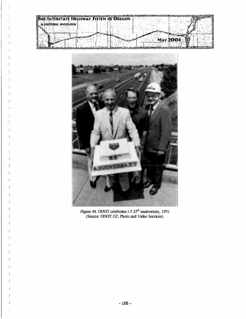
Figure 48. ODOT celebrates I-5 25th anniversary, 1991 (Source: ODOT GF, Photo and Video Services).
-106 -

BIBLIOGRAPHY
AASHTO (American Association of State Highway Transporation Officials). TransportationInvest in America: Bottom Line Report. http://www. transportation. org/bottomline/highways03. html, February 12, 2004.
ACP A (American Concrete Pavement Association). "Evolution of Concrete Road Design in the United States," from Pavement Technology, http://www.pavement.com/PavTech/ AbtConc/History/Evolution. html, January 13, 2004.
American Public Works Association, Ellis L. Armstrong, Ed. History of Public Works in the United States, 1776-1976. Chicago, IL: The American Public Works Association, 1976.
Ashland Daily Tidings (Ashland, OR), misc. issues as cited by date.
Baldock, R. H. "Our Enlarged Highway Program Demands Prompt and Positive Action by Highway Administrators," inAASHO Proceedings, Seattle, WA, Nov 9-9, 1954. Washington, D.C.: American Association of State Highway Officials, 1954.
Baldwin, George M. (Confidential/Internal Report) Internal Task Force Report to the Director of Transportation on Analysis of Options for Withdrawing Mt. Hood Freeway Funds," 1976.
Berger, Louis Group, Inc. Chronological Overview, Interstate Highway System Historic Context, 2003, in preparation.
Bourne, Russell. Americans on the Move: A History of Waterways, Railways and Highways. Golden, CO: Fulcrum Publishing, in cooperation with the Library of Congress, 1995.
Brooks, JamesE., editor. The OregonAlmanacandBookofFacts, 1961-1962. Portland, OR: Binfords and Mort, Publishers, 1961.
Cox, Wendell & Love, Jean. 40 Years of the U.S. Interstate Highway System: An Analysis of the Best Investment a Nation Ever Made. Belleville, IL: Wendell Cox Consultancy, for the American Highway Users Alliance, June 1996.
Doran, Maggie. The Building of the Oregon Country 1880-1980. Portland, OR: The OregonColumbia Chapter of the Associated General Contractors of America, 1980.
Eugene Register-Guard (Eugene, OR), misc. issues as cited by date.
Finch, Christopher. Highways to Heaven: the AUTO Biography of America. New York, NY: Harper Collins Publishers, Inc., 1992.
- 107 -

Foster, Mark S. A Nation on Wheels: The Automobile Culture in America Since 1945. Belmont, CA: Thomson Wadsworth Learning, 2003.
Grant, Nancy. "Oregon Forges Ahead with Highway Plazas instead of Billboards," Oregonian, 27-August-1974.
Gribskov, Cheryl. How to Thrive on I-5: An Exit by Exit Approach to Oregon's I-5 System. Salem, OR: Superlative Scribe Services, 1991.
Hadlow, Robert W. Elegant Arches, Soaring Spans: C. B. McCullough, Oregon's Master Bridge Builder. Corvallis, OR: Oregon State University Press, 2001.
Jakle, John and Keith Sculle. Fast Food: Roadside Restaurants in the Automobile Age. Baltimore, Maryland: The Johns Hopkins University Press, 1999.
Jakle, John, Keith Sculle, and Jefferson Rogers. The Motel in America. Baltimore, Maryland: The Johns Hopkins University Press, 1996.
Kaszynski, William. The American Highway: The History and Culture of Roads in the United States. Jefferson, NC: McFarland & Company, Inc., 2000.
Kirchmeier, Mark. "The 1-5 Story," Oregonian, 9-April-1989, Bl-B4.
Kramer, George. Slab, Beam & Girder Bridges in Oregon: Historic Context Statement. Prepared for the Oregon Department of Transportion, Heritage Research Associates, Eugene, 2004.
Leavitt, Helen. Superhighway-Superhoax. New York NY: Ballantine Books, 1970.
Lewis, Tom. Divided Highways: Building the Interstate Highways, Transforming American Life. New York, NY: Viking Penguin, 1997.
McNichol, Dan. The Roads that Built America: The Incredible Story of the U.S. Interstate System. New York, NY: Barnes & Noble Books, 2003.
Medford Mail Tribune (Medford, OR), misc. issues as cited in text.
Murphy, Thomas Dowling. Oregon - The Picturesque. Boston, MA: The Page Company, 1917.
Newton, James M. Comments on Interchanges. Bureau of Public Roads, Region 8, Portland, Oregon (Copy in ODOT General Files).
O'Donnell, Terrence. That Balance So Rare: The Story of Oregon. Portland, OR: The Oregon Historical Society Press, 1988, revised 1997.
-108-

ODOT GF. Misc. documents held in ODOT Archives/ODOT General Files, Salem, OR, as cited by Highway Engineer/ Author and date, in text.
Oregon Journal, (Portland, OR), misc. issues as cited in text.
Oregon News Company. Souvenir of the Columbia River Highway and Portland, Ore. Portland: Oregon News Company, c. 1920.
Oregonian (Portland, OR), misc. issues as cited in text.
OSHC Minutes. Minutes of the Oregon State Highway Commission, as cited by date and page number in text (Microfilm files at ODOT General Files).
OSHD. "Short-Cut Method for Determining the Economic Feasibility oflnterchange Construction," Planning Survey Section, Feb 1960.
OSHD. Report on the Green Thumb Program, 1971 (Copy in ODOT General Files).
ODOT. Interstate Highways in Oregon. 7-0ct-1977. ODOT General Files (Org 7, Gen Files #3).
ODOT. History of the Travel InfoCentres, c. 1986 (ODOT General Files).
ODOT (Carrick, Clyde). A Chronological History of the Oregon Department of Transportation-1899 to August 1993. Salem, OR: Oregon Department of Transportation, 1993.
Oregon Bluebook. As compiled by the Secretary of State, Salem, OR., dates as cited in text.
Paci.fie Road Builder and Engineering Review. "Slip Form Paving for Oregon Highway," March 1962, pg. 7.
"Portland's 'Inner Belt' Freeway Moving Along," July 1966, pgs 9-10.
Paxson, Glenn S. "Highway Bridge Practice," in Civil Engineering, January 1960, pgs. 47-49.
Porter, R. L., Deputy State Highway Engineer. "Explanation of Highway Department's Interstate 205 Report," (transcript of public hearing testimony), Portland, 11-December -1964.
Portland Planning Commission. Mt. Hood Freeway: A Report to the Portland City Council, April 1965.
Preston, John P. The Impact of the Interstate Highway System on the Spatial Distribution of Commercial Development at Rural Interchange Sites in Oregon, Doctoral Dissertation submitted to the Department of Geography, University of Kansas, 1973.
-109 -

Roades, Barbara K. and Rice Odell. A Dictionary of Environmental Quotations. Baltimore and London: The Johns Hopkins University Press, 1992.
Rose, Mark H. Interstate: Express Highway Politics, 1941-1956. Lawrence, Kansas: The Regents Press of Kansas, 1979.
Schlosser, Eric. Fast Food Nation: The Dark Side of the All-American Meal. New York: Harper-Collins Publishers, 2002.
Schneider, Kenneth R. Autokind vs. Mankind. New York, NY: W. W. Norton & Company, Inc., 1971.
Schwantes, Carols Arnaldo. Going Places: Transportation Redefines the Twentieth-Century West. Bloomington & Indianapolis, IN: Indiana University Press, 2003.
Sebastian, Lynne. "Challenging Road: Recognizing History on Our Interstate Highway System" in Common Ground, Spring 2003, pp. 12-17.
Seeley, Bruce E. Building the American Highway System: Engineers as Policy Makers. Philadelphia, PA: Temple University Press, 1987.
Smith, Dwight A., James B. Norman and Pieter T. Dykman. Historic Highway Bridges of Oregon. Salem, OR: Oregon Department of Transportation, 1986. Revised 2nd Edition, Portland, OR: Oregon Historical Society Press, 1989.
Spangenburg, Ray and Diane K. Moser. The Story of America's Roads: Connecting a Continent. New York, NY: Facts on File, 1992.
Statesman-Journal (Salem, OR), misc. issues as cited in text.
Tri-City Herald (Pasco-Kennewick-Richland, WA), misc. issues as cited in text.
Umatilla County Planning Department. Staff Memorandum re Routing of Interstate 82 Through Umatilla County, prepared at the request of Umatilla County Planning Commissioner Price for submittal to the Commission and Umatilla County Court, 1965 (copy in ODOT General Files).
U.S. News and World Report. "How the Superhighways are Changing America." 31-August-1959.
Venable, Larry. "Splendid Teamwork and Many Benefits" The Highway User, December 1962.
Walth, Brent. Fire at Eden's Gate - Tom McCall and the Oregon Story. Portland, OR: Oregon Historical Society Press, 1994.
-110-
Weingroff, Richard F. "Federal Highway Act of 1956: Creating the Interstate System." U.S. DOT/FHWA (www.fhwa.dot.gov/infrastructure/rw96e.html).
Western Construction. "Portland's Stadium Freeway Project," December 1967, pgs. 45-46.
Wollner, Craig. Electrifying Eden: Portland General Electric 1889-1965. Portland, OR: Oregon Historical Society Press, 1990.
Wood, Sharon. The Portland Bridge Book. Portland: Oregon Historical Society Press, 1989.
-111 -

' )
GLOSSARY OF INTERSTATE-RELATED HIGHWAY NAMES
Baldock Expressway (Freeway): Named for longtime Oregon State Highway Engineer R. H. "Sam" Baldock, this controlled access route ran from SW Barbour Boulevard in Portland to downtown Salem. Originally constructed as improvements to U.S. Highway 99 (the Pacific Highway), the Baldock was later incorporated into Interstate 5 (portion of ODOT Highway No. 1 ).
Barifield Expressway: Named for Oregon State Highway Commission Chairman Thomas H. Banfield, this name was given to the improved section of US 30 located in the Sullivan Gulch area of Northeast Portland, that was later incorporated into I-SON (now I-S4) (Portion of ODOT Highway No. 2).
Columbia River Highway: Name for early east-west highway between Portland and the Old Oregon Trail Highway. Incorporated into US 30 and including the T. H. Banfield Expressway, now applied to this portion of Interstate S4 (ODOT Highway No. 2) (Not to be confused with Historic Columbia River Highway, the original route of this name) (ODOT Highway No. 100).
East Bank Freeway: Portion ofl-5 south ofl-S4 along east bank of Willamette River, the East Bank Freeway begins at the eastern end of the Marquam Bridge and continues to the interchange with I-S4 (portion of ODOT Highway No. 1).
East Portland Freeway: I-205, a 26.5-mile loop route that connects from Interstate 5 at Tualatin through Clackamas and Multnomah counties, before crossing the Columbia River on the Glenn Jackson Bridge and re-connecting with Interstate 5 north of Vancouver, Washington (ODOT Highway No. 64).
Eugene Springfield Freeway: Interstate 105, connecting Interstate 5 at Oregon Highway 226 and continued west to downtown Eugene.
Eugene Spur: Alternate name for I-105, in Lane County (Oregon Highway No. 227).
Interstate 5: See Pacific Highway.
Interstate 80N· See Interstate S4.
Interstate 82: See McNary Highway.
Interstate 84: Originally built as Interstate SON and renamed in 19SO, this major east-west Interstate route in Oregon runs between Interstate 5 in Portland and continues east of Ontario, Oregon, through Boise, Idaho. Its western portion is also known as the Columbia River Highway, while the eastern portion is also known as the Old Oregon Trail Highway.
-112 -
Interstate 105: See Eugene Springfield Highway.
Interstate 205: See East Portland Freeway.
Interstate 305: See Salem Highway.
Interstate 405: See Stadium Freeway.
1-505: See Industrial Freeway.
Industrial Freeway: Withdrawn spur section to have been located in Northwest Portland, beginning roughly at the western end of the Fremont Bridge and connecting with US 30, through this area.
Laurelhurst Loop: Alternate name for west Portland-area loop, I-405. This name saw only limited usage, c. 1960, and likely relates to a discarded routing alternate running northsouth along NE/SE 39th Avenue in Portland, now the Stadium Freeway (Oregon Highway No. 61).
McNary Highway: Interstate 82 (McNary Highway No. 70), connecting I-84 near Hermiston across the Umatilla bridges to south central Washington. Named for Charles Linza McNary (1874-1944), who served in the U.S. Senate for 27 years, from 1917 until his death. As Senate minority leader he played a major role in the creation of the Bonneville Power Administration.
Minnesota Freeway: Portion ofI-5 beginning north ofI-84 interchange, built parallel to Minnesota Avenue. This freeway segment begins at the I-84 interchange and continues to north (portion ofODOT Highway No. 1).
Mt. Hood Freeway: Withdrawn re-route of portion ofI-84 that was to have replaced the Banfield Expressway east of downtown Portland. This route, which was to have connected with I-205 on the east and the East Bank Freeway (I-5) on the west, was to have been built roughly along the present-day routing of US Highway 26.
Old Oregon Trail Highway: Name for early east-west Oregon highway beginning at the eastern end of the Columbia River Highway in the state's northeast and continuing toward Ontario, on the Idaho-Oregon border. This route and name were later incorporated into US 30 and finally Interstate 84 (Old Oregon Trail Highway No. 6).
Pacific Highway: Name for the early north-south highway that connected the major cities of the western United States. Oregon's portion started at the Columbia River and continued to the Siskiyou Mountains, on the Oregon-California border. Oregon's original Pacific Highway was designated US Highway 99 in 1926 and as that route was replaced or incorporated into the Baldock Expressway or the Interstate, the Pacific
-113 -

Highway name remained as a second designation, as it does today (Pacific Highway No. 1).
Portland-Salem Expressway (Salem-Portland Expressway). Term used for a short time to refer to the Pacific Highway segment between Salem and Portland, later re-named the Baldock Expressway.
Salem Highway: Withdrawn spur section to have connected Interstate 5 near Keizer with the downtown Salem area.
Stadium Freeway: Name for west Portland-area Interstate 5 loop, now I-405, that begins at Interstate 5 near the western approach of the Marquam Bridge in the south and connects to Interstate 5 via the Fremont Bridge in the north (ODOT Highway 61).
Sullivan Gulch Freeway: Early name for the Banfield Freeway.
Umatilla-Stan.field Freeway: Alternate name for Interstate 82 (1960) (ODOT Highway 70).
Upper Columbia River Highway: Alternate name for the Columbia River Highway (first US 30 and then I-84), intended to differentiate from that portion of US 30 west of Portland, known as the "Lower Columbia River Highway."
West Portland Freeway: See Stadium Freeway.
-114 -