THE INDUSTRY OF THE LOWER ARIE Ş RIVER...
57
1 „BABEŞ-BOLYAI”UNIVERSITY CLUJ-NAPOCA FACULTY OF GEOGRAPHY THE INDUSTRY OF THE LOWER ARIEŞ RIVER BASIN. ITS SOCIAL AND TERRITORIAL IMPACT PhD thesis summary Scientific adviser: Prof. univ. dr. SURD VASILE PhD student: CAMELIA-MARIA CHINDRIŞ (KANTOR) Cluj-Napoca 2010
-
Upload
truongkhuong -
Category
Documents
-
view
216 -
download
0
Transcript of THE INDUSTRY OF THE LOWER ARIE Ş RIVER...

1
„BABEŞ-BOLYAI”UNIVERSITY CLUJ-NAPOCA
FACULTY OF GEOGRAPHY
THE INDUSTRY OF THE LOWER ARIEŞ RIVER
BASIN. ITS SOCIAL AND TERRITORIAL IMPACT
PhD thesis summary
Scientific adviser:
Prof. univ. dr. SURD VASILE
PhD student:
CAMELIA-MARIA CHINDRIŞ (KANTOR)
Cluj-Napoca
2010

2
TABLE OF CONTENTS
PREFACE………………………………………………………...……………………. pp.6
INTRODUCTION……………………………………………………………………...
pp.7-9
CHAPTER I
THE „INDUSTRY” CONCEPT WITHIN THE ECONOMIC, GEOGRAPHIC,
AND SOCIAL CONTEXT………………………………………………………………
pp.10-22
1.1. Industry-definition and classification………………………………………….. pp.10-12 1.2. Industry location theories……………………………………………………… pp.13-19 1.3. The industrial phenomenon in the social context……………………………… pp.19-22
CHAPTER II
THE SCIENTIFIC RESEARCH METHODOLOGY OF THE SOCIAL AND
TERRITORIAL IMPACT
……………………………………………………………... pp.23-45 2.1. Research methods of the geographic and social research……………………... pp.23-25 2.2. Utilized indicators…………………………………………………................... pp.25-29 2.3. General Terminology …………………………………………………………. pp.29-44 2.3.1. Systems of settlements…………………………………………………….. pp.29-32 2.3.2. Territorial impact and zone of influence notions. Associated terms………. pp.32-40 2.3.3. Phenomena influencing developments……………………………………. pp.41-46
CHAPTER III
PHISICO-GEOGRAPHIC AND ADMINISTRATIVE- TERRITORIAL DELINEATION OF THE LOWER ARIEŞ RIVER BASIN
…………………………………………………………………………………………...
pp.47-58
3.1. Physical-geographic delineation of the Lower Arieş River Basin …………….. pp.47-48 3.2. Brief history of the administrative organizing . ……………………………….. pp.48-54 3.3. Territorial- administrative units delineation………………………………........ pp.54-58
CHAPTER IV
EVOLUTION OF THE ECONOMIC ACTIVITIES IN THE LOWER ARIEŞ BASIN WITH EMPHASIS ON INDUSTRY………………………………….. pp.59-113 4.1. Geographic, historical and political factors that have determined industry development in the Lower Arieş Basin…………………………………………………..
pp.59-65
4.1.1. Geologic and morphological structure of the natural environment ……….. pp.59-60 4.1.2. Historical and political factors……………………………………………... pp.60-65 4.2. Main stages of industrial development. “Industrialization” process, effect and cause of the economic and social development of the Lower Arieş Basin ………………………………………………………………………………… pp.65-113

3
4.2.1. The stage of the industrial development during the ante and postbellum capitalism………………………………………………………………………………..
pp.65-79
4.2.1.1. National Porcelain Manufacture Turda………………………………… pp.73-76 4.2.1.2. Chemical Plant Turda…………………………………………...……… pp.76 4.2.1.3. Ciment and Gypsum Plants Turda …………………………………….. pp.77-78 4.2.1.4. The Wire Industry Câmpia Turzii……………………………………… pp.78-79 4.2.2. The stage of socialist industrial development……………………………… pp.79-94 4.2.2.1. National Porcelain Manufacture Coral SAR Turda………….................. pp.82-87 4.2.2.2. Chemical Plant Turda…………………………………………............... pp.88-90 4.2.2.3. Cement Plant Turda…………………………………………………….. pp.90-93 4.2.2.4. The Wire Industry Câmpia Turzii……………………………………… pp.93-94 4.2.3. The stage of postsocialist industrial development…………………………. pp.94-112 4.2.3.1. The Wire Industry Câmpia Turzii (Mechel)…………………………… pp.98-101 4.2.3.2. Holcim Turda…………………………………………………………… pp.102 4.2.3.3. “Glass” Turda SA………………………………………………………. pp.102-105 4.2.3.4. Argillon România SA/Lapp Insulators SA……………………………... pp.105-106 4.2.3.5. SC Electroceramics SA………………………………………………… pp.107-109 4.2.3.6. Casirom SA……………………………………………………………... pp.109-110 4.2.3.7. Cercon Arieşul SA Câmpia Turzii……………………………………… pp.110-112 4.2.4. Conclusions………………………………………………………………… pp.113
CHAPTER V
SOCIAL AND TERRITORIAL IMPACT OF THE INDUSTRIAL
DEVELOPMENT ON THE URBAN SETTLEMENTS (CITIES)
OF THE LOWER ARIEŞ BASIN …………………………………………………………………………………………... pp.114-162 5.1. The historical evolution of urban settlements………………………………….. pp.114-117 5.2. Urban space organizing based on industry influence zones of the Turda and Câmpia Turzii cities……………………………………………........................ pp.117-148 5.2.1. Industrial zone relation with the social, cultural, and educational infrastructure……………………………………………………………………………..
pp.123-128
5.2.2. Industrial zone relation with the sanitary infrastructure…………………… pp.128-132 5.2.3. Urban industrial zone and urban and rural public utilities………………… pp.130-132 5.2.4. Industrial zone liaison with the dynamic element of human settlements. pp.132-134 5.2.4.1. Demographic potential………………………………………………….. pp.135-148 5.2.4.2. Population natural movement…………………………………………... pp.135-140 5.2.4.3. Population territorial mobility………………………………………….. pp.140-146 5.2.4.4. Evolution of the occupational and professional structure of the population……………………………………………………………………………….
pp.147-148
5.3. Territorial expansion of the Turda and Câmpia Turzii cities………………… pp.149-154 5.4. Urban architecture…………………………………………………………… pp.155-161 5.5. S.W.O.T. analysis of the urban settlements (1900-1910)…………………… pp.161-162

4
CAPITOLUL VI
RURAL HABITAT COMPONENTS…………………………………………………... pp.163-228 6.2. The space and economic-social component…………………………………… pp.165-180 6.2.1. Form, structure and texture of the heart of the village…………………….. pp.168-171 6.2.2. Rural settlements altitudinal distribution……………………….................. pp.171-171 6.2.3. Size of settlements………………………………………………………..... pp.174-177 6.2.4. Functional typology of the rural settlements……………………………… pp.177-180 6.3. Aspects related to the territorial distribution of the rural settlements…………. pp.180-194 6.3.1. Dispersion index in the organizing of the Lower Arieş Basin…………… pp.181 6.3.2. Settlements density……………………………………………………….. pp.181-188 6.3.3. Other indicators of the special structure of the settlements ……………… pp.188-191 6.3.4. Evolution of the heart of the village……………………………………… pp.191-194 6.4. The demographic and the economic-social component: rural population particularities as influenced by economic development…….. pp.194-228 6.4.1. Numerical evolution of the rural population……………………………… pp.194-206 6.4.2. Aspects regarding territorial mobility of the rural population……………. pp.206-209 6.4.3. Evolution of the active rural population (industrial) sector…………….. pp.209-212 6.4.4. Economic development of the area on the rural population pp.212-228 6.4.4.1. Demographic influence factors……………………………………….. pp.212-214 A. Natural population movement…………………………………. pp.214-215 B. Sex structure …………………………………………………… pp.215-218 C. Age structure…………………………………………………… pp.218-228 6.4.4.2. Factors of influence on the population welfare………………………... pp.219-222 A. Income, richness and employment……………………………... pp.22-224 B. Living environment: rural inhabiting………………………….. pp.218-220 C. Health; Education; Recreation, comfort and relaxation………. pp.224-228
CHAPTER VII
NEW DIRECTIONS OF DEVELOPMENT …………………………………………………………………….. pp.229-239 7.1. Local economy within the national economic vulnerability context………….. pp.229-231 7.2. Current European legislation regarding the economic development and the durable social and territorial structure…………………………………………………..
pp.231-235
7.3. SWOT analysis of the human settlements of the Lower Arieş River Basin…… pp.235-237
CONCLUSIONS……………………………………………………………………….. pp.237-239
BIBLIOGRAPHY…………………………………………………………………….. pp.240-256
ANNEXE 1 Economic map (before 1989)……………………………………………. pp.261

5
ANNEXE 2 Economic map (after 1989)……………………………………………… pp.262
ANNEXE 3General overview Turda industrial area………………………………... pp.263
ANNEXE 4 “Chemical” Plant: Past and Present……………………………………. pp.264
ANNEXE 5Artistic and cultural life…………………………………………………..
ANNEXE 6 Successful enterprises…………………………………………………….
ANNEXE 7 Ruin and abandonment ………………………………………………..
pp.265
pp.266
pp.267
KEY WORDS: Lower Arieş River Basin, industry, impact
INTRODUCTION:
This paper represents a complex process toward the documentation and the analysis of
the exploratory stages of industrial development in the Lower Basin of Aries, an elaborate
analysis of the social and territorial effects (positive and negative) resulting from industry
development. Our perspective on this development was based on the modifications of the social
and territorial characteristics, without forgetting the political processes through which successive
governments create rules that directly or indirectly affect the industrial organization.
The study the lower basin of Aries falls in a relatively limited series of economic and
geographical works if we take into account papers that do not strictly refer to the economy and
the development of the two urban centers- Turda and Cȃmpia Turzii- but to the entire
geographical area, including urban and rural settlements. Therefore, this study represents the
results of five years of personal interest and research of the area, the first complex geographic,
economic, social and territorial approach of the lower basin of the Aries river.
In doing so, we started from the need for detailed knowledge of the realities of the area in
order to analyze the evolution of the human settlements, urban and rural demographic
phenomena and the geographic territory due to economic modifications as related to industry,
their degree of complexity, their territorial manifestations and perspective directions of their
evolution. The structure and the approach of this study meet some major objectives, namely:
creating a historical outline of the industrial development of the area; a comparative analysis
regarding the time evolution of space inhabiting and the study of its evolution; variable
frequency and intensity of natural movements and migratory movements in order to determine
the types of population dynamics; presenting the area in terms of economic development

6
activities, from simple craft occupations to its current structure and, last but not least,
establishing which social indicators should be used in analyzing the quality of life of the
population living in the area.
The study is aimed at understanding both the quantitative characteristics (human
potential, density, structure, territorial mobility), quantitative and dynamic characteristics (labor
resources, the degree of skill, professionalism) of urban and rural communities, as well as
qualitative characteristics (social indicators of the level of “welfare”).The evolution of the hearth
of the village and the built-up urban areas were also analyzed, as well as the function and the
evolution of the urban technical infrastructure, the intensity of living on these lands, and the way
people have adapted to the new development environment.
The research has examined the level of involvement of each rural settlement in the
development of the entire area, and has identified the economic and social activities that have
supported and encouraged the exploitation of the local potential. Of course, special emphasis was
placed on the industrial side of the integrated development of the area.
The end result is intended as a comprehensive analysis and synthesis, which, based on its
content, structure, methods and procedures, might contribute to the clarifying of many aspects of
human geography specific to this geographic area, as well as to bringing to the table a number of
elements of innovations.
The interdisciplinary nature of the themes has required the use of interdisciplinary
methods, from those purely geographical to sociological and statistical analysis, in order to
obtain a more accurate and fundamental analysis of the investigated processes and phenomena.
For the most part, the study is based on accumulation and interpretation of existent data obtained
from the National Institute of Statistics Cluj-Napoca, Cluj Chamber of Commerce and Industry,
National Archives Cluj-Napoca, as well as from other institutions, interviews with former
employees of the factories and general discussions with locals.
The completion of this work couldn’t have happened without special support from my
scientific adviser, prof. Dr. Vasile Surd. His generosity, proven over the years of preparation and
execution of this work, his willingness to share his own scientific experience, his pertinent and
valuable observations have provided methodological support and encouragement during my
hardest moments, representing an invaluable aid for which I manifest my deepest gratitude and
consideration.
7
CHAPTER I : THE “INDUSTRY” CONCEPT WITHIN THE ECONOMIC, GEOGRAPHIC,
AND SOCIAL CONTEXT
Branch of the material production (and of the national economy), in which the activities refer to
the extraction of the natural resources from the natural environment and their processing, as well as
the processing of other materials in goods production and consumer goods, the industry separated on
the basis of the social division of work (Surdu V. et al., 1991).The Encyclopedic Dictionary divides it
into three categories: extractive industries (which include activities such as separation of some useful
materials from their natural environment, or some primary processing activities), manufacturing
industry (including processing and transforming of raw materials from mining and agriculture into
finished products), and domestic industry (domestic production). Professor Vasile Surd et al. have
classified the industry according to its purpose or its economic nature of production into group 'A'
and group 'B' (producing inputs, namely producing consumer goods) in the first case, or heavy
industry , light industry, mining and manufacturing in the second case.
Basic activity of the contemporary world (although using reduced labor force as compared to
agriculture or services), the industry is divided according to the international literature (P. Merlin,
1997 M. Derruau, 1998) in three main groups: heavy industry / light industry: traditional
classification that refers to processing of raw materials (fuels and minerals) on the first case, and the
use of semi-finished products or raw "light" materials, which can be more easily transported to greater
distances in the second case ; equipment industry / consumer goods industry that refers to the
provision of equipment, facilities, semi-manufactured products and transportation to other economic
activities; and industries differentiated by location and based on the relationship between the
mobilized resources.
Regarding the concentration of industrial activities, they can be developed horizontally or
vertically. Horizontal concentration refers to grouping units with the same profile (producing similar
goods) to achieve higher efficiency, of financial cooperation, but especially in order to weaken or
even eliminate competition. Vertical concentration on the other hand, is limited to the needs of a
specific type of industry, producing parts needed for furthering the production process within the
horizontal markets.
In terms of geography, industry has developed mainly as a consequence of spatial factors as
related to the location of industrial activities, namely: along or close to the axes of communication,

8
according to availability, price and quality of land or opportunities of integration within the local
environment.
Industry location theories
Renner is one of the few “traditional” geographers that have tried to analyze factors influencing
location choice for industrial sites from a theoretical standpoint. He had a clearer understanding of
how the “industrial site” factors, namely raw materials, market output, labor (including management),
power and energy, financial capital and transportation infrastructure combine to create an optimal
point location, or as he calls it a "best access point to its components”.
However, industrial location theory has emerged about 50 years before, Rawston Alfred Weber
(1909) being among the first that brought into question “modern” theories of industrial location,
differentiated from other contemporary economists through its simplicity and clarity of the stated
premises: the existence of resource materials is limited to few localities; the size of markets is given
under conditions of perfect competition; the existence of several fixed “points” that insures the
industry with needed immobile and sufficient labor as long as it is paid at a predetermined salary.
Considering Weber's model we obtained three "optimal points" for the location of industrial units
based on the use of three parameters: the distance from residential areas, distance to resources (raw
materials) and transportation infrastructure:
� The optimally located area including the rural villages Buru, Moldoveneşti, Plăieşti, Corneşti,
Chiea,
Mihai Viteazu, Sănduleşti, Copăceni, Tureni, Comşesti, Ceanu Mare and Mărtineşti, which includes
Turda city as well. This area coincides with the actual location of the industrial platform;
� The optimal area 2, including the villages Luncani, Luna, Viişoara, as well as Cȃmpia Turzii;
� The optimal area 3, located in the north-eastern side of Turda, including the villages located
near the resource material (stone quarries, salt, sulfur, natural gas, limestone, sand), with
access to natural gas and the great communist infrastructure project development Ceanu Mare
Cluj communist led by dr. Petru Groza, great source of employment for the adjacent rural
areas.
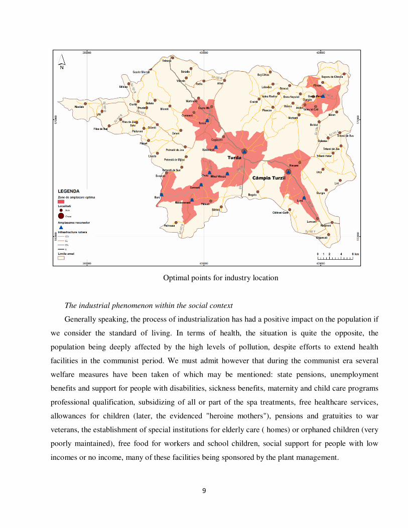
9
Optimal points for industry location
The industrial phenomenon within the social context
Generally speaking, the process of industrialization has had a positive impact on the population if
we consider the standard of living. In terms of health, the situation is quite the opposite, the
population being deeply affected by the high levels of pollution, despite efforts to extend health
facilities in the communist period. We must admit however that during the communist era several
welfare measures have been taken of which may be mentioned: state pensions, unemployment
benefits and support for people with disabilities, sickness benefits, maternity and child care programs
professional qualification, subsidizing of all or part of the spa treatments, free healthcare services,
allowances for children (later, the evidenced "heroine mothers"), pensions and gratuities to war
veterans, the establishment of special institutions for elderly care ( homes) or orphaned children (very
poorly maintained), free food for workers and school children, social support for people with low
incomes or no income, many of these facilities being sponsored by the plant management.

10
Weighing the positive and negative effects of industry on the population one cannot say that one
weighs more than the other without a subjective interpretation. A more detailed social study would
involve a representative number of the population surveyed on various perceptions related to this
period.
CHAPTER II. SCIENTIFIC RESEARC METHODOLOGY OF THE SOCIAL AND
TERITORIAL IMPACT
Social geography arose from questions related to social differences winit the geographical space.
Thus, social geography becomes relevant in situations like: the contrast between life and occupations
of people from cities, suburbs or rural areas, and how economic restructuring can affect workers,
especially their families, personal relationships, parenting and the entire community. This type of
geography shows how individual, family, community life and running economy are closely linked
and mutually interconditioned. Therefore, social geography can be applied anywhere there is a variety
of people related in different ways, acting to organize their lives in terms of physical and socio-
cultural characteristics according to the spatial dimension (social differences changed depending on
space and time ).
Literature gives a major role to two elements: "welfare" and "accessibility", which in general are
interrelated, the latter being actually a component of the first. However, even if "welfare" is generally
provided through access to employment, various services, technical and management infrastructure,
the means of enlightenment and recreation, etc. it does not mean that a remote community would
implicitly be restricted in terms of access to "welfare." Our century created a prototype of "welfare"
as conditioned by access, which translates into access to variety, medical and educational facilities,
essential social services.
In the past (and I mean the period from 1950 to 1990), social indicators were presented slightly
differently, many facilities lacking at that time (such as running water, electricity, gas, sewerage or
septic tanks at the minimum, etc.), were only broad goals for a class, especially from the rural areas,
while for us today are no longer a measure of welfare. Therefore, social indices change over time
requiring periodic adjustments.

11
Utilized indicators
Social indicators used (after Smith, 1973) provide a relatively detailed description of the
criteria that could be used. Out of Smith’s seven criteria only five have been analyzed, namely:
1) income, wealth and employment, 2) living environment, housing, 3) health, 4) education, and
5) leisure and recreation, relaxation, all with the condition of accessibility.
Rural areas face two major types of indicators: poverty caused by low income from agricultural
activities, and higher mobility due to low supply of jobs in rural areas. Shaw (1979) identifies
three types of deprivation, characteristic of rural areas, that could be organized into subclasses of
indicators of rural "welfare": household (income-housing – house size, aspect, and layout),
opportunities (employment, education, health, recreation), and not least mobility (accessibility,
costs of transportation).
The analyzed Territorial Development Indicators (TDI) were:
A. Indicators of welfare and social cohesion: informative indicators (objective):
population growth (direct effect of the attraction caused by the industrial development of the
area) population development in relation to altitude, occupational structure and population
("welfare" as a consequence of to employment ), average life expectancy; access to education,
access to utilities, transport infrastructure, as well as "partially subjective" indicators such as
poverty (measured objectively by wage levels and housing development), the rate of female
activity, culture and recreation, and leisure activities.
B. Economic performance indicators, described in Chap. IV, have been analyzed through the
evolution of the industrial production, capital and income over three historical phases, as well as
the changes suffered by the active population.
C. Indicators of territorial development. They are also divided into two categories, namely:
informative indicators: density of settlements, the index of dispersion, the degree of population
density according to distance from urban areas, the centers of polarization and the potential of
the built area, territorial expansion, size of settlements, housing development, as well as
subjective indicators: collectivization (the effect of the "liquidation" of wealthy peasants).
The mentioned indicators were organized on the basis of statistical data from 1875 to
2002/2009 period, in an effort to differentiate the level of rural and urban living conditions of the
population of the lower Aries river basin.
12
The concept of territorial impact is linked to the influence or effect. This can be quantified as
a direct result by eliminating other factors that could have appeared as alternatives. However, the
term "impact" has a stronger connotation than "influence", as it can be quantified in precise lines
and a short duration, while "the influence", a more subjective term, is a "unilateral action, slow
but effective ", determined by internal or external forces.
From the geographical and social point of view, a series of conclusions have been presented
based on the analysis of the potential impact of the industry generating the following scenarios:
Positive impact:
� Industry (since its inception) has provided employment for a significant population
residing in urban areas (Turda, Cȃmpia Turzii, Cluj-Napoca) from the nearby villages and
abroad (Hungary, Austria, Czechoslovakia, Poland, Moldavia, Russia, Italy, Yugoslavia),
the latter being represented by the skilled workforce;
� Housing developments and apartments for industry workers, government subsidized,
represented another factor of attraction;
� Collectivization of agriculture will lead to population migration, especially of the young,
towards urban areas in search of jobs in industry offering higher salaries or being
attracted by the “ urban way of life”.
� Development of transportation infrastructure due to increased commuting;
� Enrichment of the educational system by establishing schools for apprentices and other
professional high schools;
� Encouragement and financial support of cultural and sports activities by the management
of the factories;
� Almost nonexistent unemployment;
� Increased revenue and economic prosperity.
Negative impact:
� Negative environmental impact ;
� Serious threats to human health;
� Uncontrolled territorial expansion;
� Drastic reduction of the population of certain villages situated in the close proximity to
the urban industrial areas, while others become overcrowded;

13
� Loss of rural identity.
Area of influence in turn includes the villages surrounding an urban area which are directly
influenced by city developments and by the relations of cooperation developed within the
economic activities, the supply of agricultural products, the access to social facilities and
commercial elements of infrastructure, equipment and facilities for relaxation, recreation and
tourism. The dimensions of the area of influence are usually in direct relation to the size and
functions of the polarizing urban center. They are dynamic, suffering modifications from a
historical period to another according to the evolution of settlements hierarchically polarized.
Defining the limits of a city area of influence is not an easy operation given the multitude
and complexity of the established relations. Basically, the area of influence of two nearby urban
centers will expand to an extent that the two cities recorded the same intensity of relations with
the outside up to the limit where the influence of a city is close to zero. (I Ianoş, 1987). W.
Christaller (1933), quoted by J. Benedek, 2004, has made a valuable contribution to the study
area of influence of cities by developing a central place theory, based on the idea of the existence
of a territory of two cities of equal importance and close to each other.
The theoretical areas of influence of Turda and Cȃmpia Turzii were initially determined
based on the izocrones (Cap.VI). In such a case no rank is taken into account, considering that
the population residing in rural areas and under the two cities area of influence have moved on
the grounds of closeness. Therefore, in oder to calculate the zero point of attraction for Turda,
Baia de Aries, Aiud Cȃmpia Turzii and Ludus (2002 data) we used the formula:
B
A
ABB
P
P
DD
+
=
1, and DA = DAB – DB, obtaining the following results:
Db (Cluj-Turda) = 30/1+√317,953/59,525= 9.06 km
Db (Turda-Baia de Arieş) = 60/1+√59,525/4,668= 13.13 km
Db (Turda-Aiud) = 37/1+ √59,525/29,934= 15.35 km
Db (Turda-Luduş) = 33/1+√59,525/17,497 = 11.62 km
Db (Turda- Cȃmpia Turzii) = 10/1+ √59,525/26,823= 4.02 km
14
Therefore, the zero point of attraction is about 9.06 km from Turda and 20.94 km from Cluj-
Napoca, 46.87 km from Turda and 13.13 km from Baia de Aries, 21.65 km from Turda and
15.35 km from Aiud, 21.38 km from Turda and 11.62 km from Ludus, and only 5.98 km from
Turda and 4.02 km from Cȃmpia Turzii Turda, its central place proving Turda city’s attraction
toward the adjacent territories, as well as the intensity of relations between the respective cities.
Zero points of attraction for Cluj-Napoca, Turda, Baia de Arieş, Aiud, Luduş şi
Cȃmpia Turzii (population data 2002)
CHAPTER III. PHYSICAL-GEOGRAPHIC AND ADMINISTRATIVE DELINEATION
OF THE LOWER ARIES REIVER BASIN
The object of the present study is represented by the lower sector of the Aries river basin
that includes the area of the Rimetea valley upstream and Gura Arieşului downstream, the river
mouth where the Aries river flows into the Mures river. The area is located in southwestern
Transylvanian Plain, characterized by gentle hills and large terraces, favorable for the
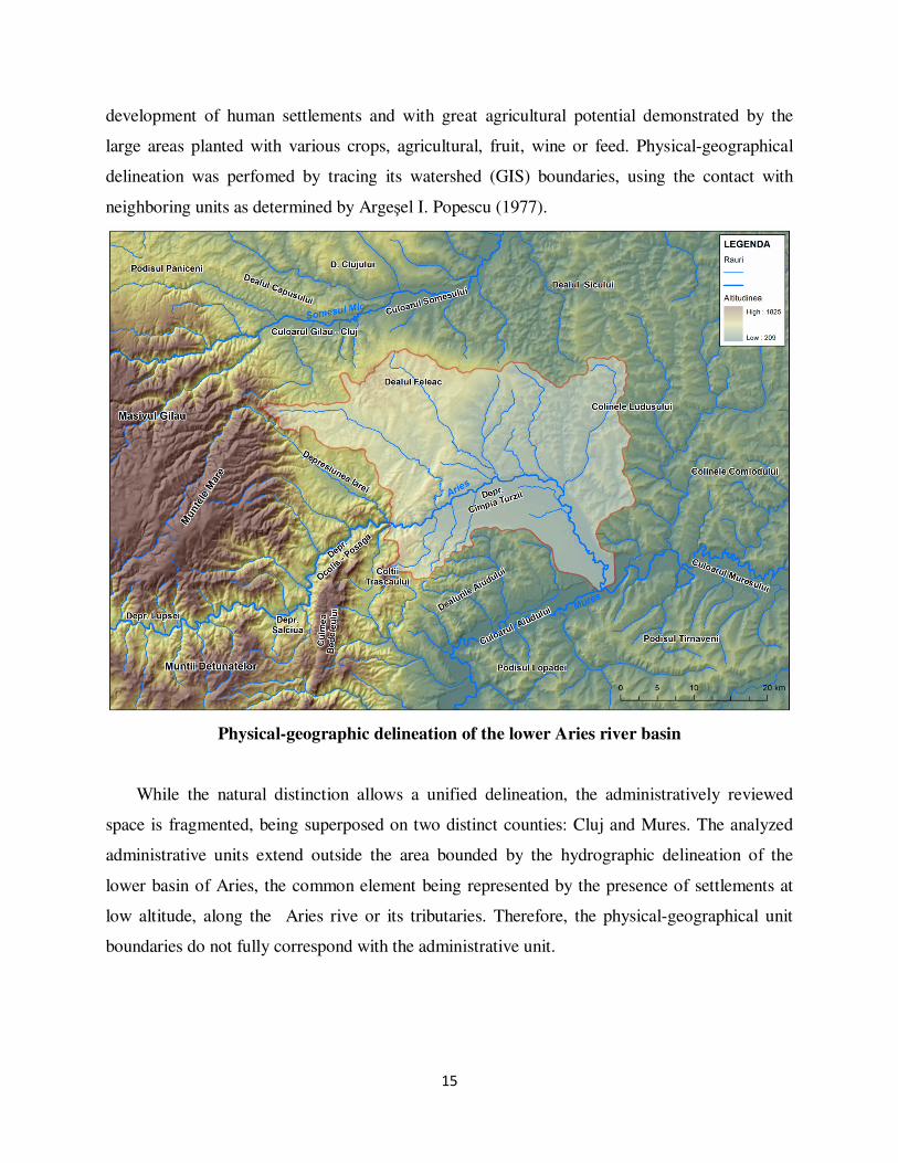
15
development of human settlements and with great agricultural potential demonstrated by the
large areas planted with various crops, agricultural, fruit, wine or feed. Physical-geographical
delineation was perfomed by tracing its watershed (GIS) boundaries, using the contact with
neighboring units as determined by Argeşel I. Popescu (1977).
Physical-geographic delineation of the lower Aries river basin
While the natural distinction allows a unified delineation, the administratively reviewed
space is fragmented, being superposed on two distinct counties: Cluj and Mures. The analyzed
administrative units extend outside the area bounded by the hydrographic delineation of the
lower basin of Aries, the common element being represented by the presence of settlements at
low altitude, along the Aries rive or its tributaries. Therefore, the physical-geographical unit
boundaries do not fully correspond with the administrative unit.

16
Administrative delineation of the territory
As for its territorial-administrative delineation, along the Aries river and its main tributary
valleys (Valley Rimetea, Hasdate Valley, Racilor Valley, Larga Valley) rural settlements with
predominantly agricultural features were initially developed. The territory comprises two urban
settlements (Turda and Campia Turzii) and 19 communes.
CHAPTER IV. ECONOMIC ACTIVITIES EVOLUTION WITHIN THE LOWER ARIES
RIVER BASIN WITH INDUSTRY EMPHASIS
The development of the two cities, Turda and Campia Turzii, was stimulated by a range of
geographical and historical factors such as its geographic position as a contact area between the
Apuseni Mountains and the Transylvanian Plain, its condition as an old crossroad for the
17
commercial exchanges in Transylvania or as a starting point for access to the gold regions, the
presence of the natural resources, as well as the historical evolution of the area.
The presence of salt, considered since the Roman occupation period, the geological
structure, favorable position with access to methane gas methane brought from Sarmas as an
effective replacement for coal, have determined the direction and the millenary existence of
Turda city as well as for its neighboring villages. Surprisingly, most of the materials utilized by
Turda industry is located in the neighboring rural villages. Thus, resources of raw materials for
the city industry were provided by quarries of Cheia, Sănduleşti, Tureni, Podeni, Buru, Făgetu
Ierii, Ocolişel, Surduc Ceanu Mare, and the gravel pits of Corneşti, Mihai Viteazu,
Moldoveneşti,, Gura Arieşului, Cȃmpia Turzii, Luna. Gypsum and alabaster operated from Cheia
industrial quarry, but also Cornesti Sănduleşti, were used in the manufacture of cement and
plaster, while the alabaster was utilized in the manufacture of art objects. From the quarries of
Tureni, Sănduleşti, Buru were extracted limestones and dolomites, used in the manufacture of
binders (lime, cement). From the Turda mine the salt was exploited until 1932, while from the
clay quarry situated on the northern side of the Aries river were exploited deposits of clay,
sandstones and Dacian tuffs. In Turda was also exploited the deposit of yellow plain clay from
the Turda quarry, connected by a narrow rail to the cement factory or carried by horse and
carriage to the Ceramics plant to produce porcelains and fire-resistant plates, as well as ballast
from the Aries meadow, only temporarily operated in Poiana quarry (until 1998). Clay
(refractory white clay) is also present in Sănduleşti, being used in the ceramics industry. In
Ceanu Mare the exploited deposits were marls, clays and Sarmatian sands, in Sănduleşti the
limestone used in the manufacture of cement, of lime, for the chemical industry, the steel
industry and for various other purposes, including roads, while from Făgetu Ierii and Cornesti
Făgetu was brought quartz sand (in a lesser amount in Făgetu Ierii).
The nationalization process of 1948 following the Soviet model (abolition of private
property and its replacement with the state property of "the whole people") represents a critical
factor of the economic development of the area, the goals of the Communist Party being is the
economic potential development of existing industries and creation of new industries. The Five-
Year Plan was closely focusing on industrialization, thus becoming a dominant factor in the
emergence and expansion of cities, population migration, and urbanization of Romania.

18
If the capitalist and socialist stage aimed to jointly develop and encourage the industrial
development, the the regime transition from communism to democracy and capitalism was
strongly and negatively felt after 1989, especially by the heavy industry and the big industrial
giants. Transition to the free market did not occur as successful in the industrial field, in
particular due to social factors (more factories were partially destroyed or abandoned during and
after the 1989 revolution), due to very old existing technology, lack of immediate capital inflow,
as well as political corruption. In the “happiest” scenarios, small units were received capital to
upgrad their technology, having as an immediate effect higher unemployment and fewer active
sections being left.
Main stages of industrial development. The process of industrialization, cause and
effect of the economic development of the lower Aries river basin area
The lower basin of the Aries river will pass through several successive stages closely
following the developments from the man-made production towards the industrialization phase.
Chapter IV presents the stages of industrial development during the early capitalism and the in
between the two wars period, the industrial development immediately After the World War II,
followed by the socialist and the postsocialist stages by describing and analyzing the evolution of
the main industrial units in Turda and Campia Turzii.
Therefore, the first factories appear in Turda in the late nineteenth century, a brick factory
that operated between 1895 and 1996, the Turdeana brewery, built in 1880, the lime factory as
"The United Lime Factories”, built in 1890, followed by the gypsum factory founded in 1901.
The period in between the two wars - 1918-1938 - Romania has undergone several stages,
the 1934-1938 period representing the high peak moment due to Romania's economic recovery
as a consequence of protectionist policies and state intervention in the economy. In 1938
Romania has reached its peak of evolution. Despite the hardships caused by war and economic
crisis in the interwar period, Turda experienced a strong industrial development. It is noted that
industrial development was focused on processing of raw materials exploited in Turda and the
nearby salt, limestone, clay quarries.
The real industrial beginnings of the area could be marked by the year 1900 with the
emergence of the industrial plant cellulose in Turda, followed by the establishment of the
19
“Societăţii pe Acţiuni a Fabricii dejene maghiare de sodă amoniacală Turda” (the later Chemical
plant) at the end of 1911, the first factory in the country with such a profile and the second core
chemical industry in the country. Besides ammonia soda plant and salt extraction, before World
War I there was also in Turda a brewery and a plaster plant, the "Cement SA” being established
on the 20th of May, 1913. The brewery was built in between 1756-1814 by the rich Jew Simon
Lazarus Mendel, known in the area for the large owned lands and his fortune. Expanded and
renovated in 1880, the main building was only completed in 1911, the factory beginning wearing
the name "Mendel Beer Factory”, renowned for good quality beer, its name changing to"
Turdeana Beer Factory "in the 20th century.
The new laws of 1912 aimed to encouraging the domestic industry and local investments has
succeeded in stimulating investors’ willingness to bring capital in various sectors in Romania,
the cement industry being at that time a promising investment. Since 1927, the cement produced
in Turda represented 23% of the total value of the Romanian cement.
In 1935 it is founded the National Manufacture of Porcelain Coral SAR Turda (today’s
Electroceramica) that included the ceramics factory Fărcaş and Tompa. The factory is located
between the main road artery linking the old town district to Oprişani and the Aries curve,
initially producing electrical insulators, tableware popular household items and handicrafts, as
then to specialize in ceramic insulators and electrical apparatus.
With a mono-industrial character (Fǎrcaş I., 1976), Campia Turzii is an atypical example of
an urban settlement, its development being influenced by its dominant function: the syderurgy,
represented by the"Wire Industry SA (now Mechel Steel Group).
The mentioned period was an important step in the transition to industrial capitalism both
from the national and local perspective. Even if it was often performed by through intensification
of work and excessive exploitation of workers, disruptions caused by the first world war, strikes
and demonstrations and amid the great economic crisis of 1929-1933 period, some important
steps were taken Turda in particular, but also Campia Turzii becoming major players in the
national and world economic market. Both localities will not only polarize the Transylvanian and
European commerce, but evolve toward fast becoming powerful industrial cities through the
development of the chemical industry, metallurgy, and building materials sectors.
Later on, the capstones of the socialist period are represented by the 1948 nationalization,
collectivization of agriculture (1949-1962) and industrial development policies with emphasis on
20
heavy industry. Thus, the state becames the most important factor influencing the settlement
system (Benedek, 2005) and their economic development. Socialism was based on a program of
rapid modernization of society, focused on industrial development and urbanization (PNAinc
2002-2004), processes that have encouraged a massive shift of population from agriculture to
industry, from village to city. Major changes occur in the organization of production, state
requirement dictating production and concentrating investments in the heavy industry in
particular.
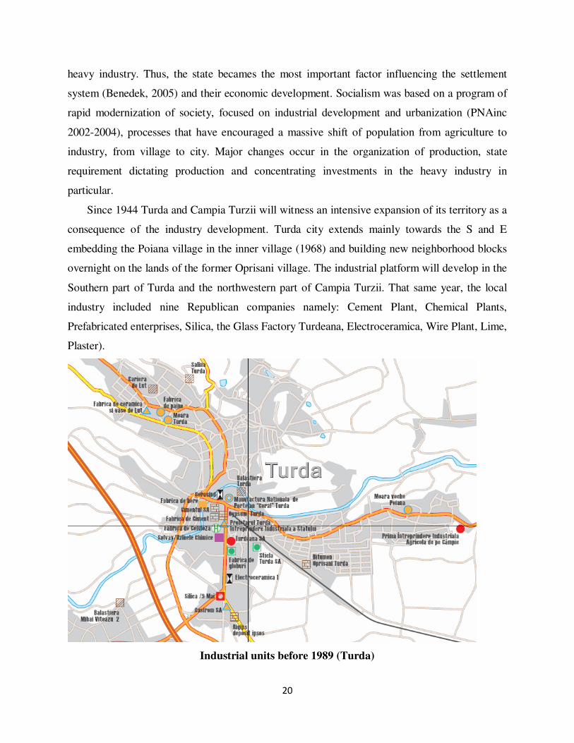
Since 1944 Turda and Campia Turzii will witness an intensive expansion of its territory as a
consequence of the industry development. Turda city extends mainly towards the S and E
embedding the Poiana village in the inner village (1968) and building new neighborhood blocks
overnight on the lands of the former Oprisani village. The industrial platform will develop in the
Southern part of Turda and the northwestern part of Campia Turzii. That same year, the local
industry included nine Republican companies namely: Cement Plant, Chemical Plants,
Prefabricated enterprises, Silica, the Glass Factory Turdeana, Electroceramica, Wire Plant, Lime,
Plaster).
Industrial units before 1989 (Turda)

21
CHAPTER V. SOCIAL AND TERITORIAL IMPACT OF THE INDUSTRU
DEVELOPMENT ON THE URBAN SETTLEMENTS OF THE LOWER ARIES RIVER
BASIN
In terms of social, cultural and educational development the industry had a significant
impact on the evolution, respectively the involution of the two cities.
Diversification of industries will result in special emphasis on creating and developing a
database of educational development designed to prepare qualified personnel necessary for the
smooth functioning of industry areas. Therefore, there are being built and initiated in between
1945-1989 boarding homes, cafeterias, gyms, labs, offices, workshops for binding theory to
practice. In Turda are established industrial schools profiled on the construction materials
industry, machine building, technical professional industry profiles for glass, mechanical design,
etc.. These high schools and vocational centers are true polls of attraction for rural students,
many of them featuring boarding homes and affordable dining.
Regarding culture, it is gaining momentum as the '60s, a period marked by the
renunciation of "Soviet culture" and the promoting of the Romanian culture. I it a high peak
moment for sports, especially because of the efforts toward encouraging urban workers through
sporting associations. Thus, after the two world wars sports associations are founded by the
Glass factories, Solvay, Cement, and Porcelain, the S.S. Arieşul stadium being first opened in
1934. More particularly, sports events attracted young employees, who came from villages and
participated in various activities. Sports clubs and associations are established within the
affiliated factories (Progress Club Factory Glassware, Cement, “Electroceramics”), football
teams (ARIES-Glass), Boxing (supported by Cement), etc.
Likewise, in the Campia Turzii, the Wire Industry Plant SA distinguishes itself by a close
link between cultural, educational and economic sectors, the latter financialy supporting the first
two in most situations. The emergence and development of industry was a "vital element that led
this rural settlement to its access to a higher level of progress, pulling it from the quasi-
anonymous" (Nemes, M. et al., 1998, p.66), which has briefly led to major urban developments,
cultural and educational advances, but mostly to the enrichment of the cultural and artistic life

22
and the educational level of the population. This happened largely because of moral support,
especially financial assistance from the factories.
The role of education in community development has been fully understood in the years
before '89, booming industry taking place in parallel with public education and training of
practical skills through it.
As far as the relations established between industry and health infrastructure it should be
noted that the upward trend of rural and urban population since 1930 due to economic and
industrial growth of the area has had a clear impact on its health status, with good or disastrous
successive periods. Lack of technical supply, unemployment still quite high, rising food prices
and clothing, heavy work conditions,use of children for work in the factories, lack of land or
high taxes, lack of proper sanitary facilities in between 1934-1944 have affected the population,
especially that from rural areas, but mostly the displaced”moţi”, strongly affected by diseases
causing deaths as pellagra, tuberculosis, syphilis. War and drought in the years 1945-1946 will
also ravage the population, worsening its health status.
Industrial development will have on the one hand positive effects, on the other hand negative
consequences due to the high level of pollution generated by them. After 1944 several measures
are taken for ensuring food needs and treating people, however, the periods of economic
recovery will result in increased pollution in the two cities with immediate or latent affects on the
urban and rural population. The urban population would be the most affected, as well as the
rural people directly employed in industrial activities, regardless of provenience. Effects of
industrial pollution in both cities were felt through the health of the population, as witnessed by
alarming statistics about the high incidence of respiratory diseases among the population.
Total Salariaţi Nesalariaţi
Copii 0-15
ani
Bolnavi în evidenţa Total 773 241 367 165
Spitalul unificat
Turda Urban 479 179 183 117
Rural 294 62 184 48
După stadiul
afecţiunii Incipient Total 374 56
Urban 183 44
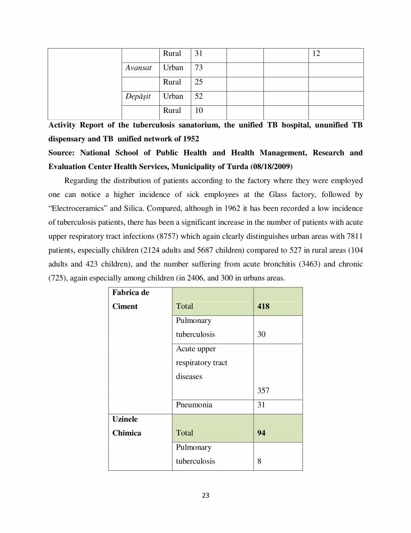
23
Rural 31 12
Avansat Urban 73
Rural 25
Depăşit Urban 52
Rural 10
Activity Report of the tuberculosis sanatorium, the unified TB hospital, ununified TB
dispensary and TB unified network of 1952
Source: National School of Public Health and Health Management, Research and
Evaluation Center Health Services, Municipality of Turda (08/18/2009)
Regarding the distribution of patients according to the factory where they were employed
one can notice a higher incidence of sick employees at the Glass factory, followed by
“Electroceramics” and Silica. Compared, although in 1962 it has been recorded a low incidence
of tuberculosis patients, there has been a significant increase in the number of patients with acute
upper respiratory tract infections (8757) which again clearly distinguishes urban areas with 7811
patients, especially children (2124 adults and 5687 children) compared to 527 in rural areas (104
adults and 423 children), and the number suffering from acute bronchitis (3463) and chronic
(725), again especially among children (in 2406, and 300 in urbans areas.
Fabrica de
Ciment Total 418
Pulmonary
tuberculosis 30
Acute upper
respiratory tract
diseases
357
Pneumonia 31
Uzinele
Chimica Total 94
Pulmonary
tuberculosis 8
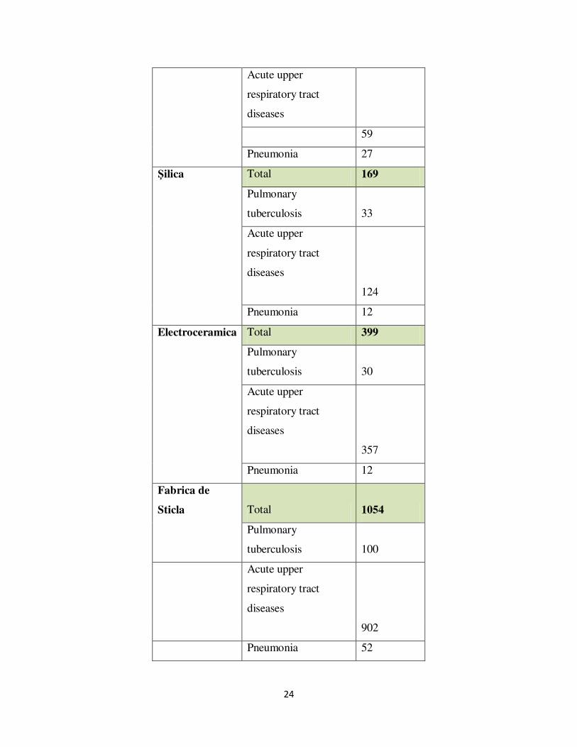
24
Acute upper
respiratory tract
diseases
59
Pneumonia 27
Şilica Total 169
Pulmonary
tuberculosis 33
Acute upper
respiratory tract
diseases
124
Pneumonia 12
Electroceramica Total 399
Pulmonary
tuberculosis 30
Acute upper
respiratory tract
diseases
357
Pneumonia 12
Fabrica de
Sticla Total 1054
Pulmonary
tuberculosis 100
Acute upper
respiratory tract
diseases
902
Pneumonia 52

25
The incidence of respiratory diseases according to factory employment
Source: National School of Public Health and Health Management, Research and
Evaluation Center Health Services, Municipality of Turda (08/18/2009)
Meanwhile, Turda country becomes known as "gray city" due to deposition of cement which
gave the city the appearance of gray rooftops and blocks.
Urban technical infrastructure development occured in parallel with the industrial
development of the area, both being critical factors in developing the other. Thus, one of the
reasons that led to the decision to develop industries in Turda and the Turzii was the presence of
methane gas from Sarmasel-Turda (1914), which ensured the needs of industrial enterprises of
both cities. If at first natural gas only covered the needs of mills and factories, in the meantime it
was extended for domestic consumption, in the urban areas at first, then to rural areas found in
close proximity to cities or having an industrial role. Surprinsingly, metane gas utilization in
Transylvania is dating from the early twentieth century, the remarkable results of drilling carried
out during 1909-1910 leading the Transylvanian Hungarian government to declare the operation
and use of natural gas a matter of state and leading to the establishment in Cluj of the Service
state for mining, the first organization in Europe which was engaged in operating gas in order to
be utilized. This again shows the advantages of the location of industrial activities in the area.
Another important role in the industrial development was attributed to railways, the narrow
railway passing through some villages (Mihai Viteazu, Cornesti), being placed in service since
1912, Turda being disadvantaged in terms public rail transportation in favor of Campia Turzii.
In terms of water and electricity facilities urban areas were evidently advantaged, followed
by suburban municipalities and the hearth of the communes over the more remote villages,
which will result in population leaving these hamlets and villages for urban centers
municipalities clearly advantaged in this regard.
Analyzing the situation in 1989 one can note a relatively good endowment of those cities,
while some remained behin in terms of minimum facilities for providing a decent living. More
remote villages or hamlets are generally forgotten, their people living in very primitive
conditions. Mihai Viteazu village seems to be most advantaged by proximity to Turda and its
importance as a supplier of raw material in industry. The situation does not seem to have

26
improved much by 2008, proving once again the deprived area status and lack of funds for
modernization and restructuring.
Demographic potential
Population growth of the lower Aries river basin is presented differently from one stage to
another depending on political factors and the economic development.
Population growth Turda and Câmpia Turzii
Therefore, analyzing the demographic evolution of Turda and Campia Turzii cities one can shed
a number of conclusions:
� In between 1857-1966 there was a significant population growth, Turda witnessing
record growth of 71% and 197% as a direct consequence of the development of
industries during these years and of the changes in the political, administrative and legal
domains, especially after 1910, regarding the Romanian population in the area. But the
most important transition is recorded in between 1910-1966 by Campia Turzii, with an
impressive growth of 593%, being elevated to the rank of city in 1952.In between 1966 -
1977 the population of two cities continues to increase at a steady but slower pace.
Population growth was largely on the account of the rural population of the surrounding
area, but represents an average annual rate much lower than other municipalities in the
county.
� In the period 1977 – 1992, the average rate of population growth in the city of Turda was
much slower compared to previous stages and to the growth of Campia Turzii, of only
11% per year. During this period, population growth rate for Turda city halved from the
average rate of county municipalities.

27
� In between 1992 and 2009 Turda significantly loses attraction as a result of regime
change, political and economic decay of the area, registering a slight decrease in
population (6.3 and 10%). The uncertain economic situation and reduced industrial
activity in that period resulted in the relocation of population to western countries.
Population natural movement
Population natural movement was analyzed for the period of 1910-2005. Following its
development, its demographic growth is evident in the years 1988-1989 in both cities, followed
by a significant decrease in 1990 (from 351 recorded positive growth at Turda, respectively in
the Campia Turzii 343 in 1988 to a positive growth of 237. 17 respectively in 1990). 1992 Turda
will record all negative growth, while the Campia Turzii will suffer from higher mortality since
1999 (except 2007 with a slight increase to + 12). The phenomenon is explained by stronger
industrial decline suffered by Turda, while at the Campia Turzii plant "Wires Industry" will be
maintained at a fairly high level of production, the redundancies being smaller in number
compared with those in Turda.
Natural increase of population and the Turzii Turda (1910-2009)
Therefore, since1992 there has been a general demographic natural decline very noticeable
in urban areas, especially at Turda, demonstrating again that the main source of attraction of the
city was the industrial character and offered labor market. Based on these findings, two major
demographic types can be revealed, namely: urban-industrial demographic type, moderated in

28
Turda city, and urban-industrial demographic type, dynamic in Câmpia Turzii. Moderate urban-
industrial subtype is characterized by low values of birth (except in 1910, when both birth and
mortality were very high), less than 15 ‰ and mortality between 9.33 ‰ and 12.14 ‰.
1910 1985 1990 1995 2001 2005 2009
Births 538 875 828 506 468 559 504
Deaths 395 588 591 658 676 701 594
Total population 15167 61000 63292 61776 60426 57726 57340
Birth rate‰ 35.47175 14.34426 13.08222 8.190883 7.74501 9.683678 8.789676
Death rate‰ 26.04338 9.639344 9.337673 10.65139 11.18724 12.14357 10.35926
Turda - rates of births and deaths
Dynamic urban-industrial subtype appears more favorable, recording higher birth rates, at
least one percent every year (except in 1985 when there has been a greater population growth),
while mortality is much lower, with frequency between 6.36 ‰ and 11.22 ‰.
1910 1985 1990 1995 2001 2005 2009
Births 91 517 421 317 252 276 243
Deaths 80 177 250 273 286 302 266
Total population 2519 27814 29817 29929 29754 26900 26386
Birth rate‰ 36.12545 18.58776 14.11946 10.59173 8.469449 10.26022 9.209429
Death rate‰ 31.75863 6.363702 8.384479 9.121588 9.612153 11.22677 10.0811
Câmpia Turzii - Rates of birth and death
Territorial mobility of population
In determining areas of industrial influence between two cities and their corresponding
territories we took into account the intensity of professional, social and educational relations
developed in time. We developed a chorematic model based on information gathered during our
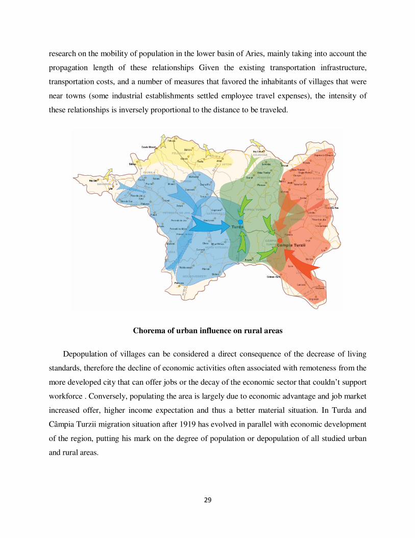
29
research on the mobility of population in the lower basin of Aries, mainly taking into account the
propagation length of these relationships Given the existing transportation infrastructure,
transportation costs, and a number of measures that favored the inhabitants of villages that were
near towns (some industrial establishments settled employee travel expenses), the intensity of
these relationships is inversely proportional to the distance to be traveled.
Chorema of urban influence on rural areas
Depopulation of villages can be considered a direct consequence of the decrease of living
standards, therefore the decline of economic activities often associated with remoteness from the
more developed city that can offer jobs or the decay of the economic sector that couldn’t support
workforce . Conversely, populating the area is largely due to economic advantage and job market
increased offer, higher income expectation and thus a better material situation. In Turda and
Câmpia Turzii migration situation after 1919 has evolved in parallel with economic development
of the region, putting his mark on the degree of population or depopulation of all studied urban
and rural areas.

30
Without being able to follow a consistent analysis of population departures and arrivals to
and from Turda, Câmpia Turzii respectively, due mainly to the small number of statistics,
however, the following conclusions can be drawn concerning the period 1857-2009, namely:
� In 1857, the eve of the industrial development is little dynamic, the „left” percentage
going very low, ie 3.95% of total population at that time inTurda (7867 inhabitants,
excluding Oprişani and Poiana that were not yet fused). However, the attraction of Turda
is obvious in terms of " alien "entrants in Turda, their number being obviously higher
than the number of „left” (11.45% vs. 3.95%) and compared with" foreigners "coming to
Câmpia Turzii (at that time Ghiriş and Sâncraiu), 3.67% respectively. We notice a
significant percentage of exits from men at Turda, while at Câmpia Turzii the percentage
between men and women is balanced.
� The period 1910-1966 is noted by an influx of people coming from all over the county,
but also from the rest of the country or abroad. Many of the factories hire in the first part
of this period qualified personnel from abroad, which is why a large number of foreigners
is recorded in Turda between 1912-1922, especially coming from Hungary,
Czechoslovakia, Moldova, Russia, Poland, Germany Austria, Yugoslavia, Italy. Counties
generating most employees are Cluj, Alba, Mures, Tarnava Mare and Tarnava Mica,
Somes, but they generally come from all over the country
� Most intensive period in terms of final migration is recorded between 1966 and 1984,
when ins and outs in most cases exceeded the values of 750 and 400 at Turda and Câmpia
Turzii.
After 1985 the development of ins and outs is fluctuating in both cities, domicile changes are
negative in most years in both cities (especially in Turda), since the departures have been the
highest in 2001 (balance -685 to Turda and -596 for Câmpia Turzii).

31
Population migration (1985-2009)
In terms of commuting, farming, vineyards and livestock industry supplementing the
income and to ensure livelihood from their products without standing in endless lines of the
communist period, were "saving" the rural the lower basin of Aries, given the increased
urbanization policies promoted between 1960 and 1989 by Ceausescu in Romania. Although the
industry continued to grow and expand, Turda and Câmpia Turzii recorded an increased influx of
population, there has been an increase in parallel of the phenomenon of commuting, which is
very high on account of the rural population nearby.
The three main poles of attraction are Cluj-Napoca, Turda and Câmpia Turzii, cities with
high attraction potential due to industrial activities and supply of labor in different economic
sectors. With a much lower intensity, commuting is manifested not only from the village the city,
but also from town to village, an example being Mihai Viteazu village, towards which traveled
daily up to 431 people mainly from Turda, most of whom are employed in industrial units (1985
data), or Sănduleşti career.
In terms of professional development and occupational structure of population statistical
data analysis confirms the prevailing characteristic of industry Aries lower basin due to the
presence and evolution of the two cities. This situation was caused in particular by the high
percentage of people active in the secondary sector compared with the other two sectors.

32
Staff working in industry
No. City 1965 1970 1975 1980 1985 1990 1995
1 Turda 10627 11565 14056 16396 17454 19340 16780
2 Câmpia Turzii 7010 8749 9235 10512 11171 11149 10485
There is an increasing share of secondary sector at Turda during 1975-1990, while Câmpia
Turzii records a gradual decrease, which is probably attributable to the begining of a process of
diversification of the economy until then almost exclusively based on Metallurgy.
Staff working in the industry as a percentage of total active population
1965 1970 1975 1980 1985 1990
Turda 55.96398 53.51937 56.77586 60.51524 61.72071 64.29521
Câmpia Turzii 79.08394 75.47447 75.09962 70.91682 73.65333 72.25535
After this period jobs aren’t available, at least in the great industry because most of the
productive units have decreased activity in the period 1991 - 1995 (employed population in the
city of Turda represents 24,558 people, respectively 40.12 % of the overall city population and
84% of the population in 1995).
Expansion of Turda and Câmpia Turzii
Historical and geographical formation and evolution of a network of settlements reveal
successive stages that led to group over several generations, and a change in their administrative
status. In this respect, the present Turda and Câmpia Turzii municipalities have suffered
themselves major changes, the increase of the degree of urbanization being obvious, without
taking into account the future consequences of what will be recorded in the average environment
of the both population.
Following this approach, urbanization began quickly, with greater intensity since 1950,
primarily by increasing the number of people in larger urban centers, adding to them a number of
other cities that have entered an emphasized process of industrialization, especially those
operating in areas of the various resources of the subsoil and the development of heavy industry.

33
From about 1965 the action of urbanization has increased further as a result of extensive
development of the Romanian industry and a gradual degradation process of agricultural
relations, with particular consequences in terms of registration a very active rural exodus,
especially between 1965-1985.
Turda city is at present the outcome of a repeated integration of smaller settlements. Cetatea
Fortress Turda documented in 1075, will join over time with the village Sȃnmiclăuş (Szent
Miklós, 1176), the village Bisericii (Egyhazfalva, 1203), Old city of Turda (1203), village
Oprişan (1278) and village Cruciatilor (1247), to encompass in the end villages Poiana andSf.
Ioan. Continued expansion of urban territory was done by a sharp population dynamics.
Built since 1960, the district Oprisani, Micro I, II and III, "workers' quarters" will replace
the former village Oprisani, a large surface of the colony Sticla and "bercul" (reg) or grove, that
existed on the current site Micro area.
Evolution of Turda localities between 1960-1997
In terms of urban expansion of the urban perimeter as a result of the industrial development,
a new district is built from in 1952, Şarât, and South district, or Workers'city as it was called at
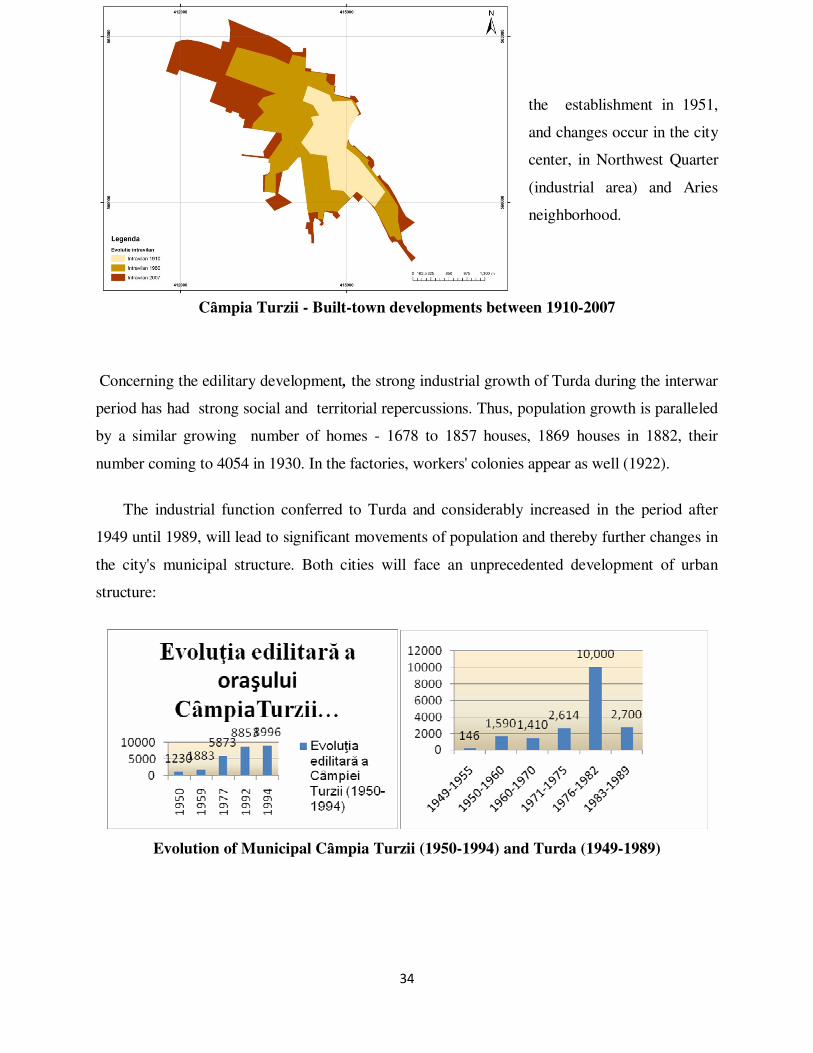
34
the establishment in 1951,
and changes occur in the city
center, in Northwest Quarter
(industrial area) and Aries
neighborhood.
Cȃmpia Turzii - Built-town developments between 1910-2007
Concerning the edilitary development, the strong industrial growth of Turda during the interwar
period has had strong social and territorial repercussions. Thus, population growth is paralleled
by a similar growing number of homes - 1678 to 1857 houses, 1869 houses in 1882, their
number coming to 4054 in 1930. In the factories, workers' colonies appear as well (1922).
The industrial function conferred to Turda and considerably increased in the period after
1949 until 1989, will lead to significant movements of population and thereby further changes in
the city's municipal structure. Both cities will face an unprecedented development of urban
structure:
Evolution of Municipal Cȃmpia Turzii (1950-1994) and Turda (1949-1989)
35
CHAPTER VI. RURAL HABITAT COMPONENTS
Based on the elements that define rural settlements (hearth, population and land), different
types of settlements can be identified based on certain criteria. The typology of rural settlements
in the lower basin of the Aries was based on predetermined criteria, namely: shape, texture and
structure of hearths, their position in relation to topography, population size and functions of
rural settlements.
In the lower basin, there is a gathered village, compact, from the contact area with the
mountains, with a high density of households (Moldoveneşti, Petreştii de Jos, Petreştii de Mijloc,
Petreştii de Sus, Livada, Iara), in the depression lanes wide area (Mihai Viteazu, Viişoara, Luna,
Luncani, Gligoreşti) and the Transylvanian Plain (Aiton, Rediu, Ciurila, Miceşti, Urca, Tritenii
de Jos, Tritenii de Sus). The scattered village, as stated before, is less common, currently found
only in the contact areas (Cacova Ierii) or the Transylvania Plain (Valcele) the built space
representing only about 10-20% of the precincts, with layout undersown of agricultural areas. A
special feature is that the lower Aries basin rural settlements are usually larger as compared to
those of its upper section, more compact, with higher accessibility and a larger number of people
(in descending order: Viişoara, Mihai Viteazu, Luna, Aiton, Ceanu Mare, Tritenii de Jos,
Sânduleşti, Copăceni, Tureni, Petreştii de Jos, Miceşti, Bădeni). Villages in the area of contact
have a modest and poorly maintained road network (Podeni).
Analyzing landforms where rural settlements in the lower basin of Aries have developed, it
is noted that most of them were shaped and expanded in the depressions, valley corridors and
morphological contact, using the main river terraces (Buru, Moldoveneşti, Corneşti, Mihai
Viteazu, Viişoara, Luncani) and secondary valleys (Miceşti, Ceanu Mare, Valea Ierii, Ocoliş).
Several grew at the the mountains and hills contact areas (Cheia, Sânduleşti, Petreştii de Jos,
Petreştii de Mijloc, Tureni, Copăceni), or inside depressions (Petreştii de Jos, Crăieşti), while
Buru was formed at the junction of Aries with Iara and Trascau (Popescu Argeşel, 1984).
36
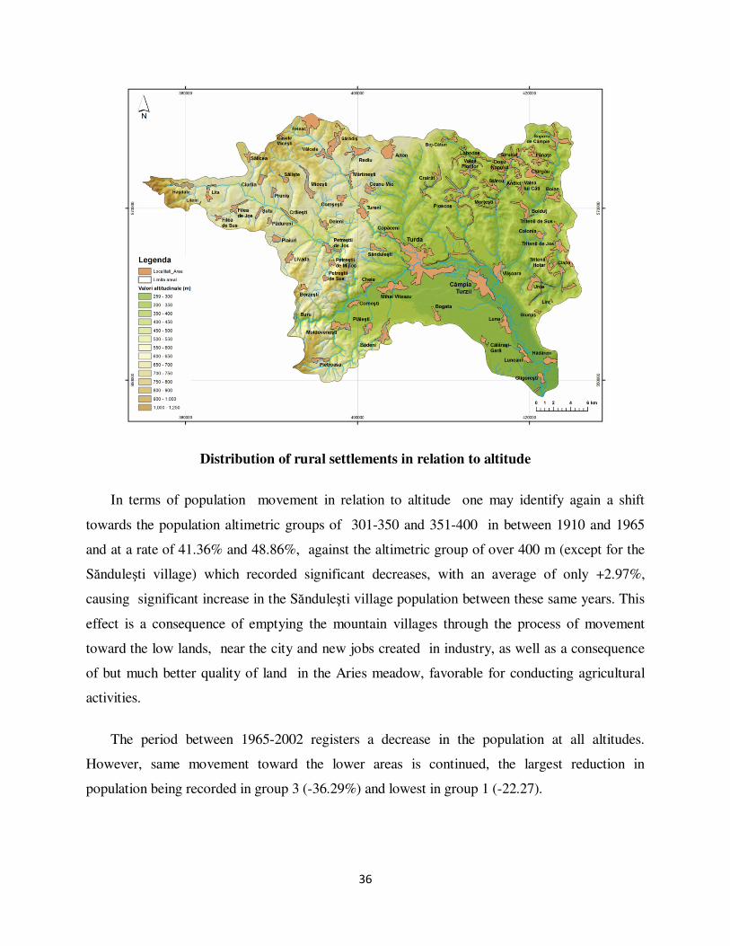
Distribution of rural settlements in relation to altitude
In terms of population movement in relation to altitude one may identify again a shift
towards the population altimetric groups of 301-350 and 351-400 in between 1910 and 1965
and at a rate of 41.36% and 48.86%, against the altimetric group of over 400 m (except for the
Sănduleşti village) which recorded significant decreases, with an average of only +2.97%,
causing significant increase in the Sănduleşti village population between these same years. This
effect is a consequence of emptying the mountain villages through the process of movement
toward the low lands, near the city and new jobs created in industry, as well as a consequence
of but much better quality of land in the Aries meadow, favorable for conducting agricultural
activities.
The period between 1965-2002 registers a decrease in the population at all altitudes.
However, same movement toward the lower areas is continued, the largest reduction in
population being recorded in group 3 (-36.29%) and lowest in group 1 (-22.27).

37
The size of settlements is a key role in demographic and economic analysis of rural areas,
representing a true indicator of the evolution, respectively of the involution of the area in parallel
with housing developments. Given the two indicators there is a clear focus on medium rural
settlements (501-1500 inhabitants), especially those from upper middle category (1001 - 1500
inhabitants) in the vicinity of the three labor polarizing urban centers: Feleac near Cluj-Napoca,
Mihai Viteazu, Copăceni, Tureni near Turda şi Viişoara, Luna şi Tritenii de Jos near Câmpia
Turzii , while small and very small settlements (> 250-500 people) are found in more remote
areas of the city, except Moldoveneşti, Ciurgău, Soporu de Câmpie and Tritenii de Sus,
explanation for the last three standing in residents’ access to rail and gas.. Of course, the areas of
influence of the three cities municipalities overlap, employment focusing to each of them in
varying degrees depending on the period of economic development and job offer, but their size is
an obvious criterion in the evaluation of their development.
The size of settlements
Large rural areas also have the role of polarization for other villages, especially for their
component villages (which are usually community centers), facilitating the transition to urban

38
areas, but often taking some of the city transfered facilities and transfering them further on to
other villages.
The Density of Settlements
The maximum concentration of settlements in the past was directly influenced by a number
of natural, social and historical factors. The evolution of density settlements in the last two, even
three centuries falls increasingly under the influence of their economic development, randomly
generating a number of facilities needed for a decent standard of living from one locality to
another, creating easier to maintain relations and exchanges between them. In this sense, we can
say that the greatest concentration of settlement will be found within maximum one hour away
from the main road, transport infrastructure being the key factor driving the concentration of
settlements. You can see a positive correlation between accessibility and the potential number of
settlements in a territorial unit, the density of settlements decreasing in proportion to the
reduction of the cosine or of the accessibility potential. We start here from two assumptions,
namely:
1. Rural settlements of the lower basin of Aries river have "gathered" near the means of
transportation (main road and railway);
2. The small distance of the two cities have led to more intensive commuting.
Therefore, one may delineate a regionalization of areas within the demarcation potential
values according to the degree of accessibility through the use of the isochronous lines. Thus,
we analyzed the accessibility of rural settlements in the lower basin of Aries to the two poles of
attraction, Turda and Campia Turzii, according to the distance in km taking into account that
closeness to the city coincides with access to transportation infrastructure. In the lower basin of
Aries there have been recorded a high average density of settlements (7031 settlements/100 km 2).
Other indicators of the spatial structure of settlements in the lower coefficient of Aries,
represented by the ratio of surface area (km 2) and the number of villages being part of the
commune. In this case, higher the density of settlements, lower the value obtained and vice

39
versa. Following the calculation made for the study area, the average ratio is 14.22
km2/settlement, below the national average (18.1 km2/settlement), showing a higher density than
other areas. Lower values are found in villages Ciurila, Frata, Tritenii de Jos şi Ploscoş,
demonstrated also by the density of the above settlements.
In relation to the density and areality coeficient we obtained a low value of the average distance
between settlements, hence close to the national average (4.998 as compared to 5.1 km), areas
with low densities also registering low values of other indicators (Ceanu Mare, Tritenii de Jos,
Ploscoş, Iara, Ciurila, Frata şi Petreştii de Jos).
Adiministrative centers centrality index, calculated using the formula I = d 1 + d 2 + ... b n / n,
where d 1, d 2 ,.... d n representing the distances between the administrative center and villages
and n being equals to the number of distances, gives us the average distance between villages
and their administrative center.
Centrality index of administrative centers

40
Given the fact that centrality increases with decreasing distance from villages, the lower
Aries river basin is characterized by high index values (average 10) demonstrating once again the
high degree of concentration of rural areas.
Time evolution of the hearth of rural settlements
As we have shown throughout this chapter, the village is under the influence of various
natural factors, social, demographic, economic, political, which coordinates and directs its
development over time. The literature identifies the three defining elements of the rural
settlements namely: hearth (municipal reality), estate (economic reality) and people (social
reality). Regarding developments in the hearth (the construction) of rural settlements in the lower
basin of Aries, they are characterized by strong dynamics and a high degree of "elasticity" of the
countryside that consists of"its ability to respond flexibly to requests internal and external
"(Surd, V., 1993).
Evolution of villages and built areas of Turda municipality and Cȃmpia Turzii city
41
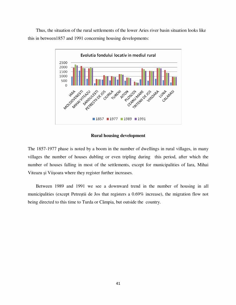
Thus, the situation of the rural settlements of the lower Aries river basin situation looks like
this in between1857 and 1991 concerning housing developments:
Rural housing development
The 1857-1977 phase is noted by a boom in the number of dwellings in rural villages, in many
villages the number of houses dubling or even tripling during this period, after which the
number of houses falling in most of the settlements, except for municipalities of Iara, Mihai
Viteazu şi Viişoara where they register further increases.
Between 1989 and 1991 we see a downward trend in the number of housing in all
municipalities (except Petreştii de Jos that registers a 0.69% increase), the migration flow not
being directed to this time to Turda or Cȃmpia, but outside the country.

42
Demographic component in relation to the socio-economic component: features of the rural
population in relation to economic development
The numerical evolution of the rural population
Evolution of the rural population (1857 – 2002)
Numerical evolution and population displacement in the lower basin area of Aries cannot
be removed from the socio-historical and economic context, prsenting major changes over the
studied period(1850-2010).
Aspects of population mobility in rural territory
From the analysis of population mobility in the lower area of Aries two stages appear:
• The stage characterized by intense migration of the rural population from rural to urban
areas as a consequence of the later fast economic development;

43
• Center-periphery stage migration, a phenomenon manifested in a significant number of
industrial centers (including Turda, Campia Turzii), characterized by a high concentration
of population , and beginning to shift toward an economic downturn resulting in a
population movement to peripheral areas, the opposite process of urbanization, which
essentially involves a movement of population from urban to rural.
During the first stage a sharp increase in output has been noticed, situation which differs
according to the period analyzed. Almost all municipalities, Moldoveneştiul, Mihai Viteazu,
Ceanu Mare , Tritenii de Jos, Viişoara şi Sânduleşti, recorded output in the period in between
1966-1991.
Between 1977-1989 migration flow is maintained at about the same level, with massive
movements of population toward the villages Ceanu Mare, Tritenii de Jos, Viişoara şi Petreşti, a
direct result of the establishment of agricultural cooperatives and state farms in the center of the
commune, which led to the contraction of certain villages and expansion of others.Rural
population migration was prompted by a need for economic development, and secondly the
socio-historical phenomenon that led to leaving other areas with less economic potential.
Evolution of the rural population working in industry
Changes in the number of industrial workers coming from rural areas (%)
1965/1970 1970/1975 1975/1980 1980/1985 1985/1990 1990/1995
Luna 30 30.77 647.06 -51.97 -55.74 -48.15
Ciurila -62.5 -33.33 150 -40 -66.67 -
Feleacu -44.44 320 -64.29 226.67 -42.86 -
Frata -23.53 -7.69 50 -16.67 -6.67 -
Viişoara 316.67 -12 81.82 5 -7.14 -84.62
Iara 80 134.34 127.80 7.85 -7.28 -21.48
Moldoveneşti 70 5.88 -98.15 2600 -29.63 -
Petreştii de
Jos 33.33 -87.5 -100 0 - -
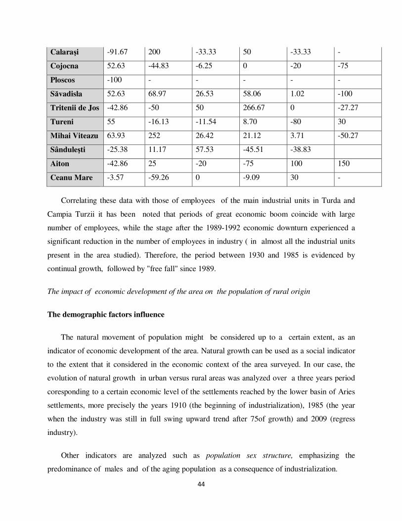
44
Calaraşi -91.67 200 -33.33 50 -33.33 -
Cojocna 52.63 -44.83 -6.25 0 -20 -75
Ploscos -100 - - - - -
Săvadisla 52.63 68.97 26.53 58.06 1.02 -100
Tritenii de Jos -42.86 -50 50 266.67 0 -27.27
Tureni 55 -16.13 -11.54 8.70 -80 30
Mihai Viteazu 63.93 252 26.42 21.12 3.71 -50.27
Sânduleşti -25.38 11.17 57.53 -45.51 -38.83
Aiton -42.86 25 -20 -75 100 150
Ceanu Mare -3.57 -59.26 0 -9.09 30 -
Correlating these data with those of employees of the main industrial units in Turda and
Campia Turzii it has been noted that periods of great economic boom coincide with large
number of employees, while the stage after the 1989-1992 economic downturn experienced a
significant reduction in the number of employees in industry ( in almost all the industrial units
present in the area studied). Therefore, the period between 1930 and 1985 is evidenced by
continual growth, followed by "free fall" since 1989.
The impact of economic development of the area on the population of rural origin
The demographic factors influence
The natural movement of population might be considered up to a certain extent, as an
indicator of economic development of the area. Natural growth can be used as a social indicator
to the extent that it considered in the economic context of the area surveyed. In our case, the
evolution of natural growth in urban versus rural areas was analyzed over a three years period
coresponding to a certain economic level of the settlements reached by the lower basin of Aries
settlements, more precisely the years 1910 (the beginning of industrialization), 1985 (the year
when the industry was still in full swing upward trend after 75of growth) and 2009 (regress
industry).
Other indicators are analyzed such as population sex structure, emphasizing the
predominance of males and of the aging population as a consequence of industrialization.

45
Influence of living standards
Following the diversification of occupations and the relative improvement in economic
circumstances of the village after the agrarian reforms, changes in the nature and ownership,
claims of the peasant world have increased as well. The level of welfare of the rural population
was therefore calculated on the basis of several criteria identified by Smith and Knox (Chapter
II): income, wealth and employment, living environment, health, education, recreation and rest,
relaxation.
CHAPTER VII. INDUSTRIAL DEVELOPMENT TRENDS IN THE AREA
Turda local economy could be described in brief, but enlightening, through Zwass Adam's
assertion (Zwass, A., 1995) "from failed communism to underdeveloped capitalism”, changes
that took place after the '89 being but good or not quite well-intentioned plans to come to the
rescue of what could still be of interest to obtain without much effort and planning a quick
profit.
Current strategies for economic growth continuously developed by the EU are associated
with the complex process of EU enlargement and elimination of gaps between countries
development levels . However, the fact that there are still differences and disparities between
countries should convince local authorities into moving towards adopting long-term regional
strategies designed to allocate resources to mitigate and then remove regional disparities. Out of
the EU regional policy objectives are highlighted those relevant in our area analysis, namely:
development and structural adjustment of underdeveloped regions, conversion of areas seriously
affected by industrial decline, tackling long-term employability of youth and promoting equality
between men and women, adapting workforce to industrial change and changes in production
systems, and development and structural adjustment of regions that have an extremely low
population density (less than 8 inhabitants / km 2), having that in the study area there is a certain
tendency in this regard.
Based on these objectives, strategies can be developed to maintain the population in the area
by providing reliable alternatives to those made redundant in the industry or those who have no
monetary means to modernize agriculture through mechanization.

46
As far as Turda and Campia Turzii, it's hard to talk about economic restructuring with
emphasis on the industry, being aware that today's diagnosis in terms of its "health" it is almost
of a "cardiac arrest”. Restructuring could be based on existing raw material for construction
materials, glass and porcelain, their placement however should be achieved this time in rural
areas, outside towns, very close to the resource, by creating smaller units. This would contribute
to a more equitable distribution of economic activities in rural areas as compared to the urban
areas. Turda could instead make a major change to its economic "profile" by shifting it to the
tourism industry.
Fortunately, in the lower basin of Aries, in both urban and rural areas, there are many
projects that take into account the principles of sustainability and that are emerging from the
local community, the only way to know the particular space which is financially supported by
EU funds.
Current SWOT analysis of human settlements in Aries lower basin
Analyzing the current situation one cannot say that the "heavy", industry which led to the
development of this region, will ever be returned to what was in 50-100 years ago. We are aware
that such a project would mean a huge financial effort and our country cannot afford such an
approach now. Therefore we would not have any sense to channel our attention to the former
business restructuring plans, their condition being now deplorable.
Problems and solutions for a sustainable development of settlements have been analyzed
through SWOT analysis, according to seven criteria, which in fact were discussed throughout
the study: the physical – geographical environment, population, economy, housing, technical
facilities, social and environmental considerations as they occur today, while trying to find the
best direction for the development of settlements in the lower Aries river basin.
CONCLUSIONS
Industry in the lower basin of Aries had a decisive role on the genesis and evolution of
settlements, particularly on the two urban centers, Turda and Cȃmpia Turzii, which rapidly
constituted themselves polls of command for the entire lower Aries basin area. Turda has been

47
noted mainly for the construction materials industry while Cȃmpia Turzii developed as a
monoindustrial city based on its steel industry.
The industrial character of the basin area was highlighted by the high percentage of sector
two in the population occupational structure as well as through the typical landscape, specific to
the "chimney" economy, with an energophagous and energy-intensive industry which resulted in
excessive pollution (dust and powder cement, silica, chemical pollutants, etc.).
At the height of industrial development (the period of 1965-1985), the entire Cȃmpia Turzii
Turda-urban complex is present as a "man-made disaster type of settlement." Industry evolution
has been closely paralleled by the unprecedented extension of industrial and residential areas.
An territorial osmosis occurred in between two rural settlements which were actually
agglutinated (former countryside Oprişani (Cristis) and Poiana), being transformed in urban
neighborhoods . Also, the impact of industrial development was crucial for all rural settlements
located within the isochronous of 45 minutes, but especially for those located within the 30
minutes isochronous, translated into over 50% of male working age population being driven by
the urban industry, the commuting phenomenon being developped on all its sides. Basically,
villages like Mihai Viteazu, Corneşti, Cheia, Sănduleşti, Viişoara, Luna, Bogata and Călăraşi
turned into “ dormitory” habitats (using the Romanian meaning of the word), in each family at
least one person having the professional status of worker-peasant (urban industry workers also
worked in the former-CAP). This translated into an accelerated pace of housing expansion r up to
or even over 95% in the mentioned villages. This effort, combined with city industry and
cooperative agriculture resulted in short time in a lift of morbidity and mortality indices among
the male population. In parallel, the roads infrastructure of the two urban centers has been
modernized, being crossed by two main axes t of national interest. It should be noted that
commuting to Cȃmpia Turzii was largely supported by the widespread use of bicycles as a
means of locomotion, no natural obstacles impeding the use of this type of personal
transportation.
Rural centers situated at the 45 minutes isochronous limit remained in the shade as
compared to the ones found in urban proximity, differences in terms of habitat conditions and
technical utilities being obvious, villages such as Miceşti, Comşeşti, Plăieşti, Petreştii de Jos,
Deleni, being "ruralized" while compared to other localities (Mihai Viteazu, Bogata, Sănduleşti,
48
Viişoara). There was a corresponding linear propagation of socio-economic indicators and
technical infrastructure in terms of distance and time to the two urban centers.
In conclusion, the lower basin of Aries is undoubtedly an area of maximum demographical
focus and of great structural complexity as a result of its past and present industrial heritage.
SELECTED BIBLIOGRAPHY
1. Andrews, F.M., Withy, S.B. (1976), Social Indicators of Well-Being, Plenum Press, New York
2. Baker, J.L.(2000), Evaluating the impact of development projects on poverty: a handbook for
practitioners, The World Bank, ISBN 0-8213-4697-0 (online version), Accesat 16/10/2009
3. Balog Iosif-Marin (2009), Habitatul şi arhitectura rurală în Transilvania în noul context
economic din a doua jumătate a secolului al XIX-lea- interferinţe şi modernizare, http://ţara-
barsei.ro/wp-content/uploads/2009/02/balog2007.pdf , Accesat 7/03/2009
4. Batinas, R.H. (2007), Studiul calităţii apelor de suprafaţa din bazinul Arieşului. Teză de
Doctorat. Cluj-Napoca, p. 5-7
5. Beaujeau-Garnier Jacqueline, Chabot G., (1971) Geografie urbană, Ed. Ştiinţifică, Bucureşti;
6. Benedek, J. (2004), Amenajarea teritoriului şi dezvoltarea regională, Editura Presa Universitară
Clujeană, Cluj-Napoca.
7. Bernhard M., Maros F., Gerd L., (2005). Rise and Decline of Industry in Central and Eastern
Europe, Springer Berlin Heidelberg, New York, Library of Congress 2004106201
8. Bold, I. (1974), Organizarea teritoriului, Editura Ceres, Bucureşti
9. Botar, F., Uzina Chimică Turda- Istoric
10. Boulding, K. (1956). The Image: knowledge in life and society. Ann Arbor: University of
Michigan Press
11. Brunet, R. (1980), La composition des modèles dans l’analyse spatiale, L’espace géographique,
9,4
12. Brunet,R. (1990), Les territoires dans les turbulences, Rechis, Montpellier
13. Bunga, M. (1975), What is a quality of life indicator ?, Social Indicators Research 2, pg. 65-79
14. Carlisle, E. (1972), The Conceptual Structure of Social Indicators, Social Indicators and Social
Policy, A. Shonfield and S. Shaw (eds), Heinemann Educational Books, London
15. Chiorean,M., Vescan,E., Visinescu,V. (2000), Viişoara, studiu monografic, Casa Cărţii de
Ştiinţă, Cluj-Napoca

49
16. Ciomac, I.L., Popa-Necşa, V. (1936), Munţii Apuseni. Cercetări asupra stărilor economice din
Munţii Apuseni, Tipografia ziarului „Universul”, Bucureşti
17. Cocean, P. (2005), Geografie regională. Evoluţie, concepte, metodologie, Ediţia a II-a, Edit.
Presa
18. Constantinescu,N.N. (1996), Mersul reformei în România şi problema căilor de redresare
economico-socială, Economistul, nr. 530
19. Cowen Michael P. și Shenton, R.W. (1996). Doctrines of development. Routledge London,
1996
20. Cucu V., (1970) Oraşele României, Ed.Ştiinţifică,Bucureşti
21. Cucu V.,(1997) Sistematizarea teritoriului si localităţilor din România, Ed. Ştiinţifică si
Enciclopedica, Bucureşti;
22. Cucu, V. (1976). Geografie şi urbanizare, Ed. Junimea, Iaşi
23. Defour,D., Baucher, I. (1977), Sistematizarea localităţilor rurale, Ed. Ceres, Bucureşti
24. Dona, I. (2001), Economie rurală, AMC – USAMV Bucureşti
25. Donisă, I. (1977), Bazele teoretice şi metodologice ale geografiei, Editura Didactică şi
Pedagogică, Bucureşti.
26. Duncan, C. D. și Howitt, D.(2004). SAGE Dictionary of Statistics, Sage Publications, Library of
Congress Control Number: 2003115348
27. Enyedi, G., Veldman,J. (1986), Rural Development Issues in Industrialized Countries, Centre
for Regional Studies, Hungary, Akadémiai Kiado és Nyomda, Budapest, Hu ISSN: 0237-3440,
ISBN: 963 01 6629 1
28. Erdeli G.(2000) Geo-demographic trends in rural România in the post-communist period, din
Post-Communist România:Geographical Perspectives, Liverpool Hope Press;
29. Fărcaș, I. (1976). Zona industrialǎ Turd- Câmpia Turzii. Studiu bioclimatic. Teză de doctorat,
UBB Cluj-Napoca
30. Floca, L., Mihailescu, R., Vescan, I. (1999), Industrial Environment impact on Rural Area in
Turda-Campia Turzii Region, Studia UBB Geographia, 1, Cluj-Napoca
31. Fong, C.O. (1980), Planning for industrial estate development in a developing economy,
Management Science, Vol.26, No. 10/October, USA, 0025-1909/80/2610/1061
32. Gergely E. (2001), Potaissa-Turda istorie, Editura BOEMA Turda
33. Gergely E. (2005), Turda. Isorie şi contemporaneitate, Editura Casa Cărţii de Ştiinţă, Cluj-
Napoca;
34. Gergely E. (2007), Comuna Mihai Viteazu Istorie şi civilizaţie, Ed.II, Editura Casa Cărţii de
Ştiinţă, Cluj-Napoca;
50
35. Gergely, E. și alții, Monografie Fabrica de Ciment Turda la 60 de ani de la existență 1913-1973
36. Gibson-Graham, J.K. (1996), The End of Capitalism (As We Knew It): A Feminist Critique of
Political Economy, Oxford UK and Cambridge USA: Blackwell Publishers
37. Groza, O. (2003), Les territoires de l’industrie, Ed. Didactică şi Pedagogică, Bucureşti
38. Grumăzescu, C. (1970), Reprezentarea cartografică a regiunilor geografice la diferite scări,
Studii şi cercetări de geologie, geofizică, geografie, seria Geografie, 1, tom XXII, Bucureşti
39. Hall A. (1999), Oraşele de mâine. O istorie intelectuală a urbanismului în secolul XX, Editura
„All”, Bucureşti;
40. Hamnett, C. (1996), Social Geography: A Reader., London: Edward Arnold.
41. Harrington, J.W., Warf, B. (1995), Industrial Location. Principles, practice, and policy, Routledge, USA,
ISBN: 0-415-10479-3, Digital printing 2004, Accesat 5/04/2008
42. Hirschhausen, von C. și Bitzer, J. (2000). The Globalization of Industry and Innovation in
eastern Europe. From Post-socialist Restructuring to International Competiveness. Edward
Elgar Publishing Limited UK
43. Hoover, E.M. ( 1948), The location of economic activity, McGraw-Hill, New York
44. Hudson F.S. (1976), Geography of Settlements, Second edition, Macdonald and Evans, Ltd,
Plymouth;
45. Iancu, G. (1988), Unificarea legislativă. Sistemul administrativ al României (1919-1939), în: V.
Vese, V. Puşcaş et all., Dezvoltare şi modernizare în România interbelică, Bucureşti.
46. Ianoş I., Popescu N.,Talânga C. (1988) Industrializarea şi organizarea spaţiului geografic,
Terra, 3-4, p.67-75;
47. Ianoş, I., Tălângă, C. (1994). Oraşul şi sistemul urban românesc în condiţiile economiei de
piaţă, Institutul de Geografie al Academiei Române, Bucureşti
48. Jackson, P. , Smith, S. (1984), Exploring Social Geography. London: Allen and Unwin
49. Knox, P.L. (1978), Territorial Social Indicators and Area Profiles: Some Cautionary
Observations, Town Planning Review Journal, Liverpool University Press, Vol.49, Number
1/January, ISSN: 1478-341 (online version), Accesat 28/07/2010
50. Knox, P.L. (1979), Subjective social indicators and Urban social policy : A Review, Policy and
Politics, 7
51. Knox, P.L. (1980), Measures of accessibility as social indicators: A note. Social Indicators
Research, Springer Netherlands, Vol. 7, Numbers 1-4/January, ISSN 1573-0921 (online version),
Accesat 28/07/2010
52. Kovacs, L. (2007), Organizarea spaţiului geografic în Culoarul Arieşului Inferior, Teză de
doctorat, Cluj-Napoca

51
53. Kuz, T.J. (1978), Quality of Life, an Objective and Subjective Variable Analysis, Regional
Studies, 12 :409-417
54. Land, K.C. (1983), Social Indicators, Annual Review of Sociology, Vol.9:1-26/August
55. Lăzărescu, C. (1977), Urbanismul în România, Editura Tehnică, Bucureşti
56. Léo, P.Y. , Philippe J. (1979), Analyze comparative des structures industrielles dès régions
économiques françaises, Revue d’Economie Régionale et Urbaine, No.1
57. Maidment, D., Djokic, D. (2000), Hydrologic and Hydraulic Modeling Support with GIS,
Environmental Systems Research Institute, Inc., USA, ISBN: 1-879102
58. Malizia, E. și Feser, E.J. (1999). Understanding Local Economic Development, Center for
Urban Policy Research, Rutgers,, New Jersey
59. Marica, G.E. (2004), Satul ca structură psihică şi socială, Edit. Argonaut, Cluj-Napoca
60. Merlin, P. (1997), Géographie humaine, Paris
61. Metes, S. (1941), Contribuţii la studiul populaţiei din Transilvania I. Populaţia din judeţele
Cojocna, Dăbâca şi Turda în secolul al XVIII-lea, Bucureşti
62. Mircea N. Nemeş si colab, (1998), Câmpia Turzii istorie, cultură, civilizaţie, Casa Cărţii de
Ştiinţă, pg. 71
63. Molnar, E., Maier, I. A., Ciangă, N. (1975), Centre şi arii de convergenţă în România, Studia
UBB, Ser. Geologia-Geographia
64. Morariu, T., Garbacea, V. (1960), Terasele râurilor din Transilvania, Comunic. Acad. R.P.R.,
nr. 6, tom X, Bucureşti
65. Morariu, T., Iacob,D. (1958), Câteva observaţii hidrologice în bazinul inferior al Arieşului,
Studia, 5, tom III, Geologia-Geographia, I, Cluj-Napoca
66. Moseley, M.J. (1979), Accessibility: The Rural Challenge, Methuen, London
67. Mureşan, I. (1925), Judeţul Turda-Arieş. Cunoştiţte folositoare, Ed. Cartea Româneasca,
Bucureşti.
68. Nae, M., Turnock, D. (2010), The New Bucharest: two decades of restructuring, Elsevier Ltd.,
versiune online, Accesat 6 august
69. Nemeş M., Bujor E., Mera L., Lechinţan V., Deac V., Suciu A., (1998), Câmpia Turzii Istorie
Cultura Civilizaţie, Editura Casa Cărţii de Ştiinţă, Cluj-Napoca;
70. Nica, Sabin şi colab.(1995), Economie rurală, Editura Artprint, Bucureşti
71. Onişoru, Gh. (1998), România în anii 1944-1948, Transformări economice şi realităţi sociale,
Fundaţia Academia Civică, Biblioteca Sighet
72. Orenstein, M. A. (2009). What Happened in East European (Political) Economies? A Balance
Sheet for Neoliberal Reform, SAGE Publications, Vol. 23, Number 4
52
73. Pacione, M.(1987), Social geography: progress and prospect, Croom Helm Ltd, New York,
ISBN : 0-7099-4026-2
74. Panelli, R. (2004), Social Geographies From Difference to Action, SAGE Publications, British
Library Cataloguing in Publication Data, ISBN : 0761968938, Library of Congress Control
Number 200313975
75. Parsons, T., Smelser, N. (1956), Economy and Society: A Study, of the Integration of
Economic and Social Theory. Free Press, New York
76. Pascu, St. (1954), Mestesugurile din Transilvania pana în secolul al XVI-lea, Ed. Academiei,
Bucureşti
77. Pieterse, J. N. (2010). Development Theory, 2nd edition, Sage Publications Ltd
78. Pop Gr., (2008), From Economic Crisis to Reform, Princeton University Press;
79. Pop Gr., Benedek J. (1996), Satele mici din România şi specificul activităţii lor, Studia Univ.
„Babeş-Bolyai”, Seria Geographia, nr. 1-2;
80. Pop, Gr. (1986), România. Geografie Economică, partea I, ed. a II-a, UBB, Cluj-Napoca
81. Pop, Gr., Benedek, J. (1997), Sisteme şi modele de aşezări rurale în Depresiunea
Transilvaniei, Studia UBB, Geographia, 1-2, Cluj-Napoca
82. Pop, Gr., Bodocan,V. (1999), Oraşele Transilvaniei în ultimul secol şi jumătate (1850-1999),
Studia UBB, Geographia, 2, Cluj-Napoca
83. Pop, P. Gr. (1988), România. Geografie economică, Partea a II-a, Ediția a II-a, Universitatea
din Cluj-Napoca.
84. Pop,Gr. (2002), Probleme ale industriei din bazinul inferior al Arieşului, Studia UBB,
Geographia, nr. 2, XLVII, Cluj-Napoca
85. Popescu, C. R. (2003), Disparităţi regionale în dezvoltarea economico-socială a României,
Editura Meteor Press, Bucureşti
86. Popescu N. (1973), Depresiunile din România, Realizări în Geografia României, Edit.
Științifică, București
87. Popescu-Argeşel I. (1984), Valea Arieşului, Editura Sport-Turism, Bucureşti;
88. Raboca N., Ciangă N., Pacurar A.(2000). Geografia economicǎ , Arad
89. Rawstron, E.M. (1958), Three principles of industrial location. Transactions, Institute of
British Geographers
90. Reimer, A, Dransch, D.(2009), Information Aggregation: Automatized Construction of Chorematic
Diagrams, Accesat 3/08/2010
http://geovisualisierung.net/geoviz_hamburg/papers/08_3_Reimer.pdf,
91. Renner, G.T. (1947), Geography of Industrial Localization, Economic Geography 23-3, Worchester
53
92. Roberts, B.K. (1996), Landscapes of Settlement prehistory to the present, Routledge
93. Ronnas, P. (1979), The Urban Transition in România. Legacies of the past, Research Papper,
6138, February, in: Ekonomiska Forskningsinstitutet vid Handelshogskolan, I, Stockholm
94. Rossi, R.J., Gilmartin, K.J. (1979), Handbook of Social Indicators, Garland Press, New York
95. Rostow, W.W., (1960), The Stages of Economic Growth: A Non-Communist Manifesto,
Cambridge University Press, Chapter 2, "The Five Stages of Growth--A Summary," pg. 4-16
96. Rotariu, T., Semeniuc, M., Mureşan, C.(1999), Recensământul general al populaţiei din 1910,
Ed. Staff, Transilvania, Studia Censualia
97. Rusu, R. (2007), Organizarea spaţiului geografic în Banat, Edit. Mirton, Timişoara
98. Săgeată, R. (2004), Funcţia politică-administrativă a aşezărilor umane din România şi
organizarea spaţiului geografic, Teză de doctorat, Bucureşti
99. Sandu, D. (1999), Spaţiul social al tranziţiei, POLIROM, Iaşi
100. Sandu, D. (2003), Sociabilitatea în spaţiul dezvoltării. Încredere, toleranţă şi reţele sociale,
POLIROM, Iaşi
101. Sandu, D. (2004), „Cultura şi experienţă de migraţie în satele României” în Sociologie
Românească, 3
102. Sandu, D. (2005), Modul: Analiză socială cantitativă în dezvoltarea regionala, program de
master UAUIM - Suport pentru prezentare
103. Shaw, J.M. (1979), Rural deprivation and planning, Geo Abstracts Ltd., University of East
Anglia, Norwich
104. Smelser, N.J. (1959), Social change in the Industrial Revolution: An Application of Theory to
the British cotton industry, Routledge and Kegan Paul Ltd., London E.C. 4, England, ISBN: 0-
415-38137-1
105. Smith, D.M. (1977), Human Geography : A Welfare Approach, London: Edward Arnold
106. Smith, D.M. (1981), Industrial location: an economic geographical analysis, 2nd ed. John
Wiley, New York
107. Smith, D.M. (1987), Neoclassical location theory in W. Lever ( ed.), Industrial change in the
United Kingdom, Longman, London
108. Suciu, C. (1967-1968), Dicţionar istoric al localităţilor din Transilvania, vol. I,II,Ed.
Academiei Republicii Socialiste Române
109. Suciu, I., Panaitescu, I.D. (1921), Dicţionarul comunelor, plaselor şi judeţelor din Ardeal,
Banat şi celelalte ţinuturi anexe
110. Suciu, P. (1929), Judeţul Turda. Schiţa monografică, Turda

54
111. Surd V., Nicoară L. (1989), Potențialul de polarizare al centrelor comunale din județul Satu-
Mare, în Studia UBB, seria Geologia-Geographia, nr. 3, Cluj-Napoca.
112. Surd, V. ( 1996), Municipiul Turda-Studii de geografie aplicată, UBB, Cluj-Napoca
113. Surd, V. (1991), Tradiţional form of organizing Geographical Space in Transylvania. The
„Lands”, în Studia UBB, Geographia, nr. 2, Cluj-Napoca
114. Surd, V. (1997), Geografia dezvoltării şi a decalajelor economice contemporane, Editura Presa
universitară Clujeană, Cluj-Napoca.
115. Surd, V. (2002), Introducere în geografia spaţiului rural, Editura Presa Universitară Clujeană,
Cluj-Napoca.
116. Surd, V., Neamtu, C. (1986), Distribuţia spaţială a aşezărilor din Câmpia Transilvaniei, Studia
UBB, Geologia-Geographia, XXXI, 3, Cluj-Napoca
117. Surd, V., Zotic, V. (2003), The Demographic Risc in the Arieş Superior Basin. Editura Studia,
Cluj-Napoca, pg. 407-446
118. Surd,V.(2004). Geografia Așezărilor, Universitatea “Babeș-Bolyai” Cluj-Napoca, Facultatea de
Geografie
119. Surd,V., Pop, Gr., Cocean, P., Raboca, N., Nicoara, L. (1991). Geografia Economică
Mondială, Universitatea “Babeș-Bolyai” Cluj-Napoca, Facultatea de Biologie, Geografie și
Geologie, Catedra de Geografie
120. Talanga, C. (2008), Dinamica spaţiului rural, Curs 1/13.10.2008
121. Teaci, D. (1983), Transformarea peisajului natural al României, Ed. Ştiinţifică si
Enciclopedica, Bucureşti
122. Varga, A.E., Transylvania’s ethnic and sectarian statistics (1850-1992);
http://varga.adatbank.transindex.ro, Accesat: februarie/martie 2006
123. Vedinaș, T. (2001), Introducere în sociologia rurală, Edit. Polirom, București
124. Vieux, B.E. (2004), Distributed Hydrologic Modeling using GIS , Water Science and
Technology Library, Second Edition, Kluwer Academic Publishers, The Netherlands, ISBN (e-
book): 1-4020-2460-6
125. Vincze M. (2000), Dezvoltare regională și rurală, Edit. Presa Universitară Clujeană, Cluj-
Napoca
126. Weber, A. (1929), Alfred Weber's theory of the location of industries, trans. C.J. Friedrich,
University of Chicago Press, Chicago (Reprinted 1971, Russell and Russell, New York), prima
ed. 1909 (germ.)
127. Zahariade, A.M. (2003), Two Books, The Communist Dream & Dacia 1300. Fragments of an
Architectural Landscape (extras), Cap. New Buildings and Forms, Acces online scribd 3/08/2010

55
128. Zaiu, M. (2005). Electroceramica şapte decenii de activitate în domeniul fabricaţiei
izolatoarelor electrice, manuscris
129. Zamfir,C.,Vlăsceanu, L. (1993), Dicţionar de sociologie, Ed. Babel, Bucureşti
130. Zotic, V. (2005), Componentele operaționale ale organizării spațiului geografic, Edit. Presa
Universitară Clujeană, Cluj-Napoca
131. Zwass, A. (1995), From Failed Communism to Underdeveloped Capitalism, M.E.Sharpe, Inc.,
USA, ISBN: 1-56324-461-6
132. *** Dicţionar Enciclopedic (1999), Vol. III, H-K, Editura Enciclopedica Bucureşti, ISBN: 973-
45-0143-7
133. *** (1918) Magyar Compess, Budapesta
134. *** (1921) Monitorul Oficial, 1 noiembrie
135. *** (1929) Buletinul industriei nr.1-2
136. *** (1930) Recensământul general al populaţiei României din 29 decembrie, IX,
137. *** (1930), Industria Sârmei SA Album jubiliar 1920-1930, Cluj
138. *** (1950) Procesul Verbal de recepție definitivă, întocmit la 7 martie 1950, “Fabrica de
Porțelan Turda, Întreprindere de Stat”
139. *** (1970) Uzinele Industria Sârmei Câmpia Turzii la 50 de ani de existenţă
140. *** (1973) Uzina Chimica Turda, întocmit 20 Martie
141. *** (1981) Monografia Fabricii de Produse Ceramice « Arieşul » Câmpia Turzii
142. *** (1983) Carta europeană a amenajării teritoriului, Carta de la Torremolinos adoptată la 20
mai 1983 la Torremolinos (Spania), CEMAT
143. *** (1986) Întreprinderea Chimica Turda în glorioşii ani ai socialismului
144. *** (1991) Chemical works Turda România, Electrolysis products, macromolecular products,
fungicide mixtures, E.D.T.A salts, Antheus Trading Comp. Ltd., Artha Grafică Printing House,
Bucharest, România
145. *** (1996) Plan Urbanistic General Câmpia Turzii Memoriu General, Beneficiar Consiliul local
Câmpia Turzii, Proiectant SC SMART Company SA Cluj Napoca
146. *** (1996) Recensământul din 1850 Transilvania, coord. Traian Rotaru, Cluj;
147. *** (1983) Carta Verde a Dezvoltării Regionale în România, Carta de la Torremolinos, adoptata
la 10 mai 1983 la Toremolinos, Spania
148. *** (1997) Recensământul din 1857 Transilvania, ed. a II-a, coord. Traian Rotaru, Cluj;
149. *** (1999) Schema de dezvoltare a spaţiului comunitar, Spre o dezvoltare echilibrată şi durabilă
a teritoriului Uniunii Europene, Aprobat la Consiliul informal al Miniştrilor responsabili de
amenajarea teritoriului la Postdam, mai 1999
56
150. *** (2001) Plan urbanistic general Turda
151. *** (2002-2004) PNAinc
152. *** (2007) Agenda Teritorială a Uniunii Europene, Leipzig, 24-25 mai 2007, CdR 164/2007
EN-RARO/hp
153. *** (2007) I.CH.T Dezvoltare 1930-1985, album de poze pus la dispoziţie de Ing. Gyorgy
Victor
154. *** (2009/2010) Date obţinute de la Centrul de Statistică Cluj-Napoca (fişa satelor)
155. *** (2010) Fişele localităţilor judeţului Cluj pentru intervalul 1965/1985-1995, Institutul
National de Statistică, Cluj-Napoca
156. *** (2010) Rapoarte anuale, semestriale și administrative Bursa de Valori Bucureşti
157. *** Enciclopedia României, vol.3, pag. 899-902
158. ***(1899-1955) Întreprinderea Chimică Turda, Inventar 1-9 şi Registru repertoar pentru
evidenţa salariaţilor 15.10.1899-04.06.1925, Fond 156, Arhivele Naţionale Române, Direcţia
Judeţeană Cluj
159. ***(1919-1949) Combinatul Metalurgic Câmpia Turzii, Fond 199, Arhivele Naţionale Române,
Direcţia Judeţeană Cluj
160. ***(1924-1952) Inventar de materiale documentare pe anul 1924-1952, Fabrica de Sticlă Turda,
Fond 169, Arhivele Naţionale Române, Direcţia Judeţeană Cluj
161. ***(1944-1945) Registru inventar bilanţ, Inventar Fabrica de Sticlărie Turda 31 dec.1944, Fond
169, Arhivele Naţionale Române, Direcţia Judeţeană Cluj
162. ***(1949) Fabrica de Sticlărie Turda, Serviciul de contabilitate, Registru bilanţ şi inventar 1949,
Fond 169, Arhivele Naţionale Române, Cluj-Napoca
163. ***(1949-1954) Situaţii statistice Întreprinderea Electroceramica Turda, Fond 129, Arhivele
Naţionale Române, Direcţia Judeţeană Cluj
164. ***(1950), Legea nr.5/1950 pentru raionarea administrativ-economică a teritoriului R.P.R. (cu
modificări prin decretele nr. 331/1952 şi nr. 12/1956), Buletinul Oficial nr.77/8 septembrie
165. ***(1952) Serviciul Cantina, Bilanţ evidenţă statistică 1952, Fond 169, Arhivele Naţionale
Române, Direcţia Judeţeană Cluj
166. ***(1966-1968) Combinatul Metalurgic Câmpia Turzii, Fond 199, Arhivele Naţionale Române,
Direcţia Judeţeană Cluj
167. ***(1974), Legea nr.58/1974, Buletinul Oficial, nr.135/1 noiembrie
168. ***(1981), Monografia Fabricii de Produse Ceramice „Arieşul” Câmpia Turzii
169. ***(1984), Geografia României, II, Geografie Umană şi Economică (coordonator Cucu, V.,
Iordan, I.), Ed. Academiei, Bucureşti
57
170. ***(1987) Micromonografia Întreprinderii Electro-Ceramica Turda, manuscris
171. ***(1994) Studii de Fundamentare PUG şi Pata Turda, privind istoricul localităţii sub aspect
socio-cultural, etnografic, urbanistic-arhitectural, faza I, contract nr. 2/7.11.1994, executant S.C.
Podex Construcţii SRL, beneficiar Primăria Municipiului Turda
172. ***(1994) Studii de Fundamentare PUG şi Pata Turda, privind istoricul localităţii sub aspect
socio-cultural, etnografic, urbanistic-arhitectural, faza II, contract IV/95, executant S.C. Podex
Construcţii SRL, beneficiar Primăria Municipiului Turda
173. ***(1997) Recensământul din 1910 Transilvania, ed. a II-a, coord. Traian Rotaru, Cluj
174. ***(1999), Turda-20 de secole de istorie, Primăria Turda, Ed. Promedia Plus, Cluj-Napoca
175. ***(2000) Principii directoare pentru Dezvoltarea teritorială durabilă a Continentului european
elaborate de către Comitetul Înalţilor Funcţionari, CEMAT, Hanovra, 7- 8 septembrie 2000
176. ***(2007) Raport Anual SC Mechel Câmpia Turzii SA Conform Regulamentului C.N.V.M. nr
1/2006, N0 C 73/108, 26.04.2007
177. ***(2008) Date despre societăţile comerciale din Turda şi Câmpia Turzii, Camera de Comerţ şi
Industrie Cluj
178. *** Informaţii preluate din cărţile de muncă a unor foşti angajaţi ai fabricilor din Turda