The Indonesian – German Contribution to the Indian Ocean ... · Warning Dept. for Com And Info...
46
© Jan Sopaheluwakan, 2006 © Jan Sopaheluwakan, 2006 The Indonesian The Indonesian – – German German Contribution to the Indian Contribution to the Indian Ocean Tsunami Warning Ocean Tsunami Warning System System Jan Jan Sopaheluwakan Sopaheluwakan Indonesian Institute of Sciences Indonesian Institute of Sciences Joern Joern Lauterjung Lauterjung GeoForschungsZentrum GeoForschungsZentrum , Germany , Germany Third International Conference on Early Warning Third International Conference on Early Warning Bonn, 27 Bonn, 27 – – 29 March 2006 29 March 2006
Transcript of The Indonesian – German Contribution to the Indian Ocean ... · Warning Dept. for Com And Info...
© Jan Sopaheluwakan, 2006© Jan Sopaheluwakan, 2006
The Indonesian The Indonesian –– German German Contribution to the Indian Contribution to the Indian Ocean Tsunami Warning Ocean Tsunami Warning
SystemSystem
Jan Jan SopaheluwakanSopaheluwakanIndonesian Institute of SciencesIndonesian Institute of Sciences
JoernJoern LauterjungLauterjungGeoForschungsZentrumGeoForschungsZentrum, Germany, Germany
Third International Conference on Early WarningThird International Conference on Early WarningBonn, 27 Bonn, 27 –– 29 March 200629 March 2006
28 March, 200528 March, 2005 EWC III, 2006EWC III, 2006 22
© Jan Sopaheluwakan, 2006© Jan Sopaheluwakan, 2005
28 March, 200528 March, 2005 EWC III, 2006EWC III, 2006 33
© Jan Sopaheluwakan, 2006

28 March, 200528 March, 2005 EWC III, 2006EWC III, 2006 44
© Jan Sopaheluwakan, 2006
28 March, 200528 March, 2005 EWC III, 2006EWC III, 2006 55
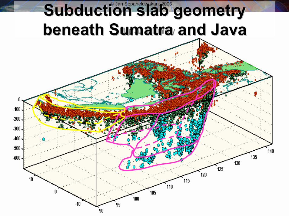
© Jan Sopaheluwakan, 2006SubductionSubduction slab geometry slab geometry beneath Sumatra and Javabeneath Sumatra and Java
© Jan Sopaheluwakan, 2006

28 March, 200528 March, 2005 EWC III, 2006EWC III, 2006 66
© Jan Sopaheluwakan, 2006© Jan Sopaheluwakan, 2005
Tsunami prone coasts
2004
2004
1994
1992
1996
1998
2000
Tsunami prone coasts in Indonesia and destructive Tsunami prone coasts in Indonesia and destructive earthquake and tsunami during the last decadeearthquake and tsunami during the last decade
••Distance to the closest shore: 10 Distance to the closest shore: 10 –– 200 km200 km••Tsunami lead time: 5 Tsunami lead time: 5 –– 40 minutes40 minutes••Seismic wave propagation: 3 Seismic wave propagation: 3 –– 30 seconds30 seconds••Early warning system in 5 minutes ?!Early warning system in 5 minutes ?!
28 March, 200528 March, 2005 EWC III, 2006EWC III, 2006 77
© Jan Sopaheluwakan, 2006
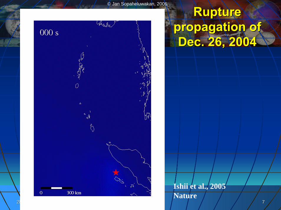
Rupture Rupture propagation of propagation of Dec. 26, 2004Dec. 26, 2004
Ishii et al., 2005Nature
28 March, 200528 March, 2005 EWC III, 2006EWC III, 2006 88
© Jan Sopaheluwakan, 2006
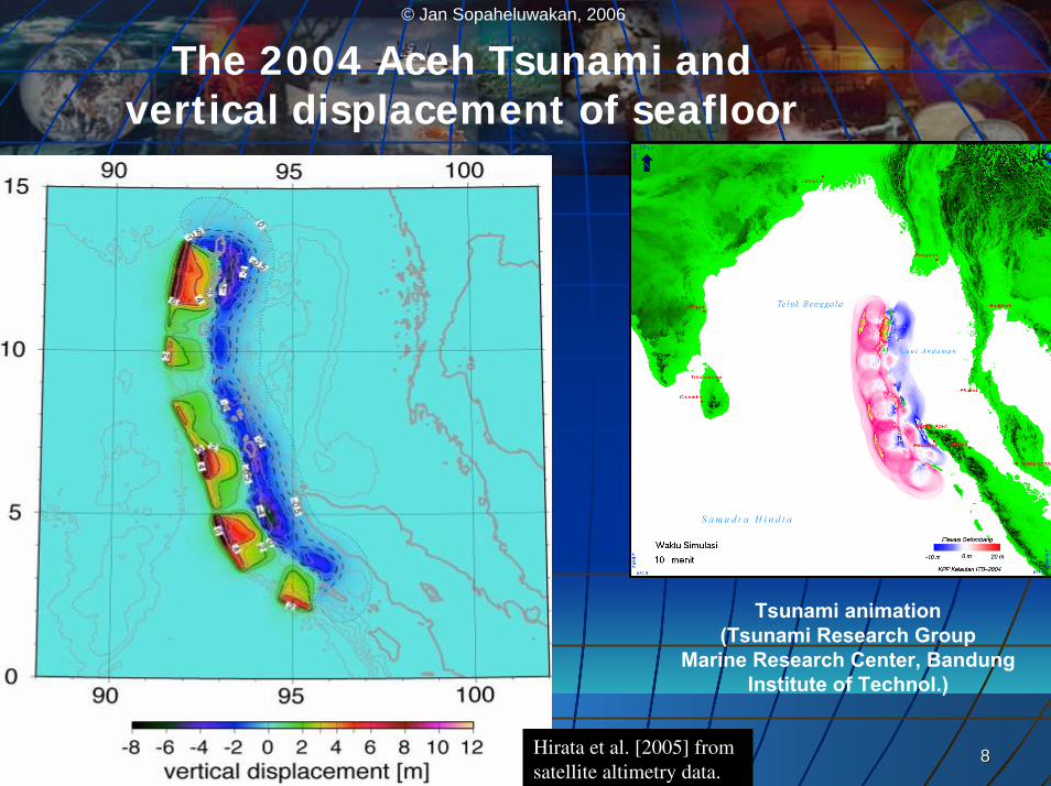
The 2004 Aceh Tsunami andvertical displacement of seafloor
Tsunami animation (Tsunami Research Group
Marine Research Center, BandungInstitute of Technol.)
Hirata et al. [2005] from satellite altimetry data.
28 March, 200528 March, 2005 EWC III, 2006EWC III, 2006 99
© Jan Sopaheluwakan, 2006
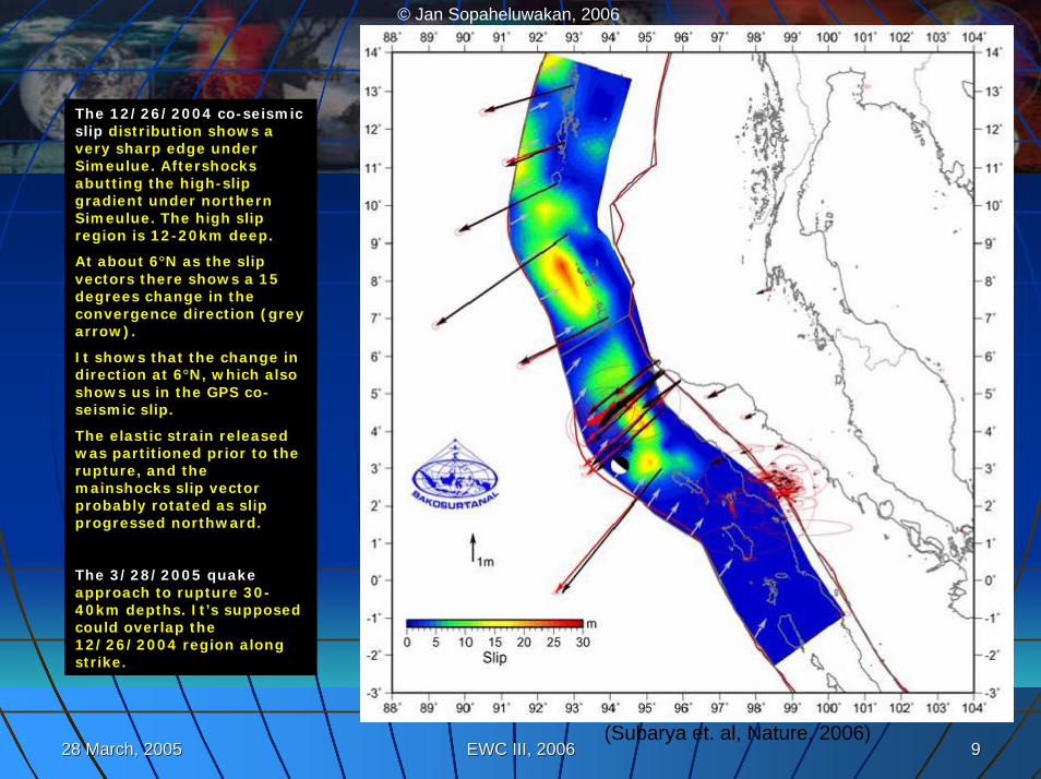
(Subarya et. al, Nature, 2006)
The 12/26/2004 co-seismicslip distribution shows a very sharp edge under Simeulue. Aftershocks abutting the high-slip gradient under northern Simeulue. The high slip region is 12-20km deep.
At about 6°N as the slip vectors there shows a 15 degrees change in the convergence direction (grey arrow).
It shows that the change in direction at 6°N, which also shows us in the GPS co-seismic slip.
The elastic strain released was partitioned prior to the rupture, and the mainshocks slip vector probably rotated as slip progressed northward.
The 3/28/2005 quakeapproach to rupture 30-40km depths. It’s supposed could overlap the 12/26/2004 region along strike.
28 March, 200528 March, 2005 EWC III, 2006EWC III, 2006 1010
© Jan Sopaheluwakan, 2006
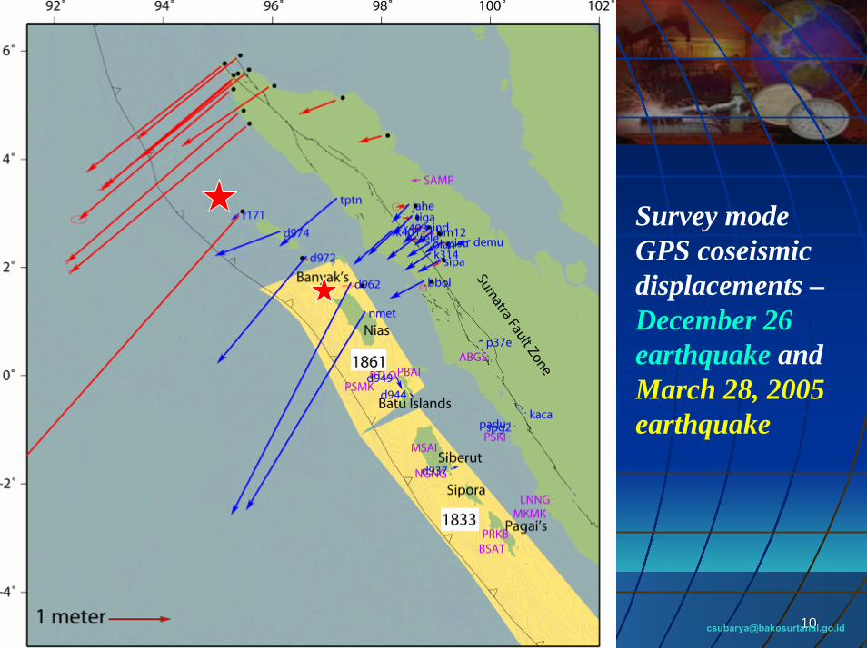
Survey mode GPS coseismicdisplacements –December 26 earthquake andMarch 28, 2005earthquake
© Jan Sopaheluwakan, 2006
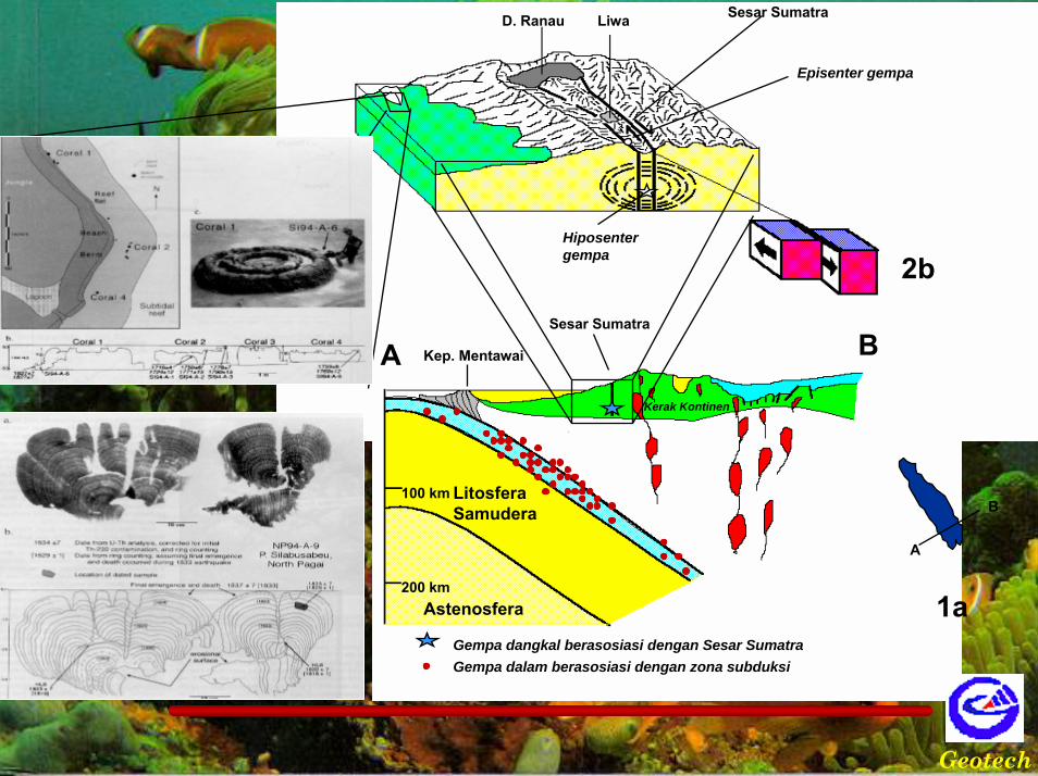
Sesar Sumatra
Kep. Mentawai
Gempa dangkal berasosiasi dengan Sesar SumatraGempa dalam berasosiasi dengan zona subduksi
100 km
200 km
Kerak Kontinen
Astenosfera
LitosferaSamudera
D. Ranau Liwa Sesar Sumatra
Episenter gempa
Hiposentergempa
1a
1b
2a
2b
A B
A
B
Geotech
28 March, 200528 March, 2005 EWC III, 2006EWC III, 2006 1212
© Jan Sopaheluwakan, 2006
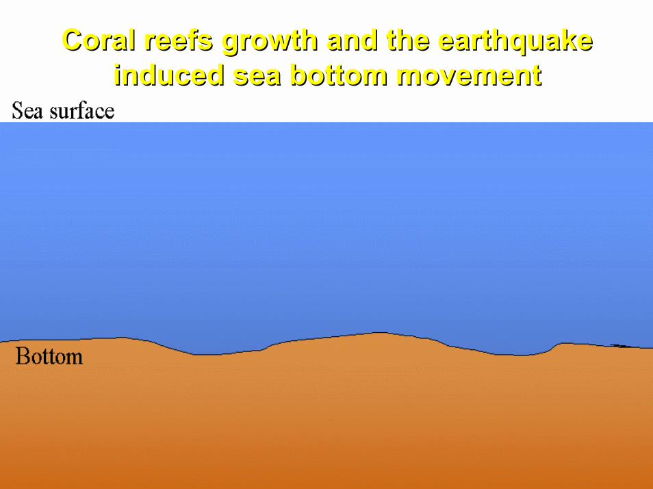
Coral reefs growth and the earthquake Coral reefs growth and the earthquake induced sea bottom movementinduced sea bottom movement
28 March, 200528 March, 2005 EWC III, 2006EWC III, 2006 1313
© Jan Sopaheluwakan, 2006© Jan Sopaheluwakan, 2005
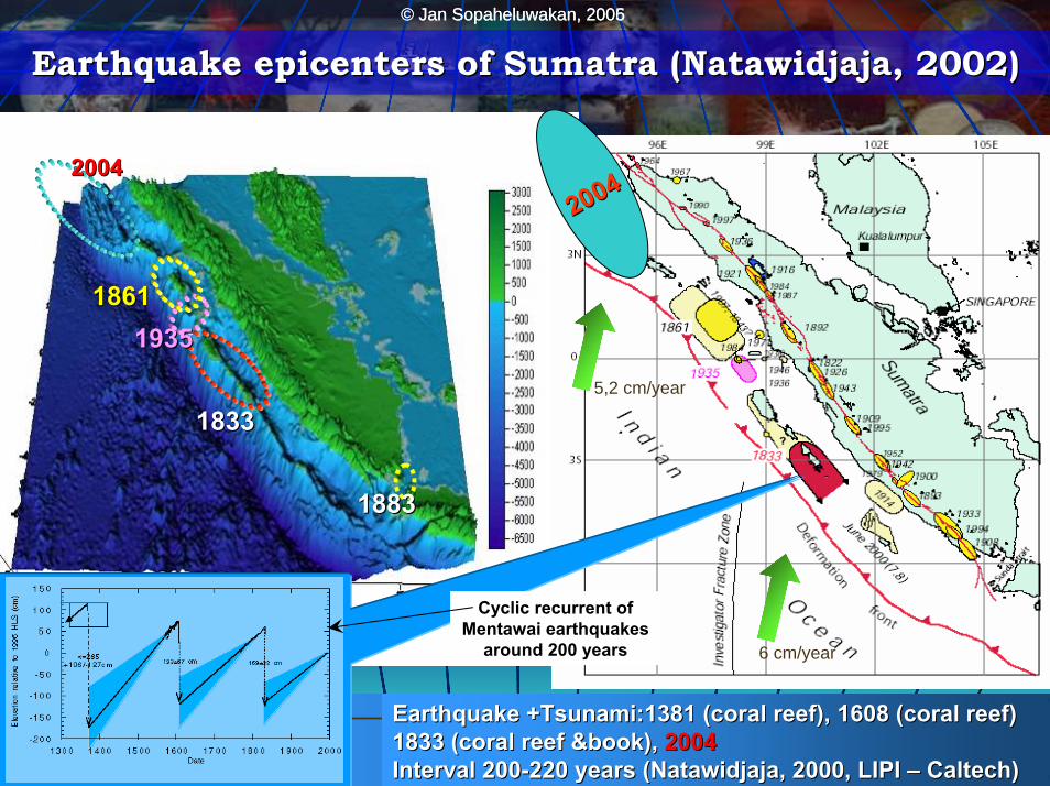
Earthquake epicenters of Sumatra (Earthquake epicenters of Sumatra (NatawidjajaNatawidjaja, 2002), 2002)
Earthquake +Tsunami:1381 (coral reef), 1608 (coral reef)Earthquake +Tsunami:1381 (coral reef), 1608 (coral reef)1833 (coral reef &book), 1833 (coral reef &book), 20042004Interval 200Interval 200--220 years (220 years (NatawidjajaNatawidjaja, 2000, LIPI , 2000, LIPI –– Caltech)Caltech)
20042004
20042004
18331833
19351935
18831883
Bathymetry around Sumatera
5,2 cm/year
Cyclic recurrent of Mentawai earthquakes
around 200 years 6 cm/year
18611861

© Jan Sopaheluwakan, 2006© Jan Sopaheluwakan, 2006
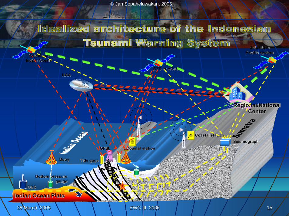
The INA TWSThe INA TWS
28 March, 200528 March, 2005 EWC III, 2006EWC III, 2006 1515
© Jan Sopaheluwakan, 2006
Satellite in Satellite in Pacific systemPacific system
Bottom pressure Bottom pressure gaugegauge
OBSOBS
BuoyBuoy
Regional/NationalRegional/NationalCenterCenter
Coastal stationCoastal station
Coastal stationCoastal station
HAAHAA
Indian Ocean PlateIndian Ocean Plate
Satellite in Satellite in Indian OceanIndian Ocean
GTS or GTS or ACeSACeS
SeismographSeismograph
Tide gageTide gage
GPSGPS
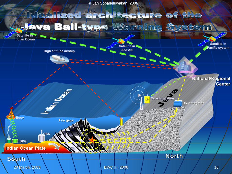
28 March, 200528 March, 2005 EWC III, 2006EWC III, 2006 1616
© Jan Sopaheluwakan, 2006© Jan Sopaheluwakan, 2005
OBSOBS
BuoyBuoy
National/Regional National/Regional CenterCenter
High altitude airshipHigh altitude airship
Satellite in Satellite in Pacific systemPacific system
Indian Ocean PlateIndian Ocean Plate
Satellite in Satellite in Indian OceanIndian Ocean
Satellite in Satellite in ASEANASEAN
SeismographSeismograph
Tide gageTide gage
BPGBPG
NorthNorthSouthSouth
Coastal stationCoastal station
28 March, 200528 March, 2005 EWC III, 2006EWC III, 2006 1717
© Jan Sopaheluwakan, 2006
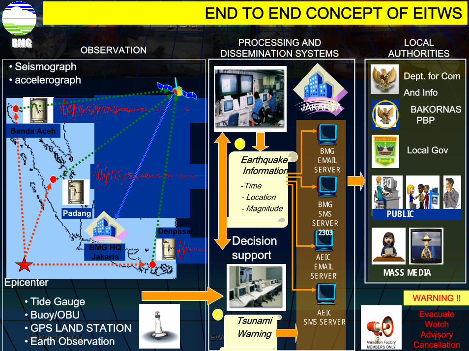
Earthquake Information-Time- Location- Magnitude
PROCESSING AND DISSEMINATION SYSTEMS
END TO END CONCEPT OF EITWS
Denpasar
Padang
BMG HQ Jakarta
OBSERVATION
Decision support
Tsunami Warning
Dept. for Com
And Info
LOCAL AUTHORITIES
JAKARTA
• Tide Gauge• Buoy/OBU• GPS LAND STATION• Earth Observation
1
2
BMG EMAIL
SERVER
BMG SMS
SERVER 2303
AEIC EMAIL
SERVER
AEIC SMS SERVER
MASS MEDIA
BAKORNAS PBP
Local Gov
WARNING !!
PUBLIC
Epicenter
• Seismograph• accelerograph
Banda Aceh
EvacuateWatch
AdvisoryCancellation
28 March, 200528 March, 2005 EWC III, 2006EWC III, 2006 1818
© Jan Sopaheluwakan, 2006
Main Activities
Seismology4 Broadbandstations installedProvisional Earthquake-Monitoring System at BMG active
Ocean-Instrumentation2 Buoy-Systems installedFirst Site Survey for Tide Gauges completedDeep-water bathymetry partly completed
GPSFirst site survey completedGNSS reflectometry study started
28 March, 200528 March, 2005 EWC III, 2006EWC III, 2006 1919
© Jan Sopaheluwakan, 2006
Main Activities
Early Warning CentreConceptual Phase for design and architecture startedFirst workshop on conceptual and architectural design in Jakarta
ModellingSource modelling group startedDeep Water modelling group startedShallow water and run-up modelling group ready to go
Capacity BuildingFact Finding Mission Conceptual discussion completedAnnouncements for PhD program publishedCapacity Building Unit in Indonesia in preparation
28 March, 200528 March, 2005 EWC III, 2006EWC III, 2006 2020
© Jan Sopaheluwakan, 2006
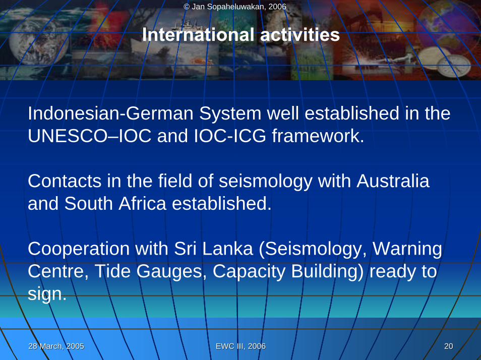
International activities
Indonesian-German System well established in theUNESCO–IOC and IOC-ICG framework.
Contacts in the field of seismology with Australiaand South Africa established.
Cooperation with Sri Lanka (Seismology, WarningCentre, Tide Gauges, Capacity Building) ready to sign.
© Jan Sopaheluwakan, 2006© Jan Sopaheluwakan, 2006
Earthquake Earthquake monitoringmonitoring
28 March, 200528 March, 2005 EWC III, 2006EWC III, 2006 2222
© Jan Sopaheluwakan, 2006
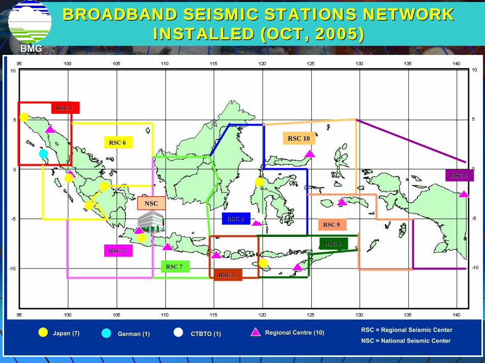
RSC 1RSC 1
RSC 6RSC 6
RSC 4RSC 4
RSC 2RSC 2
RSC 9RSC 9
RSC 7RSC 7RSC 3RSC 3
RSC 10RSC 10
RSC 8RSC 8
RSC 5RSC 5
NSCNSC
BROADBAND SEISMIC STATIONS NETWORK BROADBAND SEISMIC STATIONS NETWORK INSTALLED (OCT, 2005) INSTALLED (OCT, 2005)
BMGBMG
Japan (7)Japan (7) Regional Centre (10)Regional Centre (10) RSC = Regional Seismic Center
NSC = National Seismic CenterGerman (1)German (1) CTBTO (1)CTBTO (1)

28 March, 200528 March, 2005 EWC III, 2006EWC III, 2006 2323
© Jan Sopaheluwakan, 2006
RSC 1
RSC 6
RSC 4
RSC 2
RSC 9
RSC 7RSC 3
RSC 10
RSC 8
RSC 5
NSCNSC
BROADBAND SEISMIC STATIONS NETWORK BROADBAND SEISMIC STATIONS NETWORK INSTALLED and Planned 2006INSTALLED and Planned 2006
BMGBMG
Japan (10) Regional Centre (10) RSC = Regional Seismic Center
NSC = National Seismic CenterGerman (4) CTBTO (1)
BMG (14)’05 China (2) BMG (30), ‘06 RISTEK (10), ‘06
28 March, 200528 March, 2005 EWC III, 2006EWC III, 2006 2424
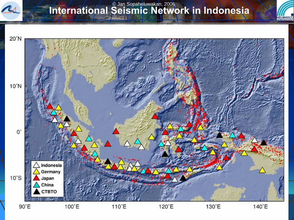
© Jan Sopaheluwakan, 2006International Seismic Network in Indonesia

28 March, 200528 March, 2005 EWC III, 2006EWC III, 2006 2525
© Jan Sopaheluwakan, 2006
Proposed Station Distribution for an Earthquake Monitoring Network for the Indian Ocean Region (Locations to be discussed)
Seismology
28 March, 200528 March, 2005 EWC III, 2006EWC III, 2006 2626
© Jan Sopaheluwakan, 2006
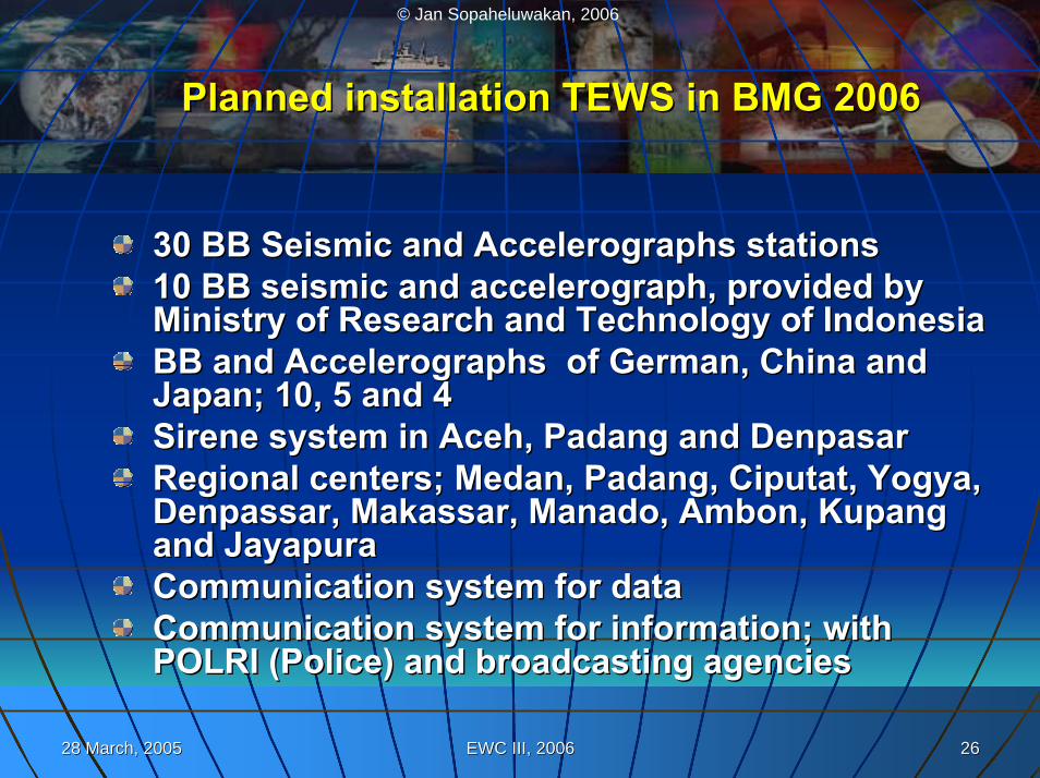
Planned installation TEWS in BMG 2006 Planned installation TEWS in BMG 2006
30 BB Seismic and Accelerographs stations30 BB Seismic and Accelerographs stations10 BB seismic and accelerograph, provided by 10 BB seismic and accelerograph, provided by Ministry of Research and Technology of IndonesiaMinistry of Research and Technology of IndonesiaBB and Accelerographs of German, China and BB and Accelerographs of German, China and Japan; 10, 5 and 4Japan; 10, 5 and 4SireneSirene system in system in AcehAceh, , PadangPadang and and DenpasarDenpasarRegional centers; Regional centers; MedanMedan, , PadangPadang, , CiputatCiputat, , YogyaYogya, , DenpassarDenpassar, , MakassarMakassar, , ManadoManado, , AmbonAmbon, , KupangKupangand and JayapuraJayapuraCommunication system for dataCommunication system for dataCommunication system for information; with Communication system for information; with POLRI (Police) and broadcasting agenciesPOLRI (Police) and broadcasting agencies
© Jan Sopaheluwakan, 2006© Jan Sopaheluwakan, 2006
Sea level Sea level monitoringmonitoring
28 March, 200528 March, 2005 EWC III, 2006EWC III, 2006 2828
© Jan Sopaheluwakan, 2006
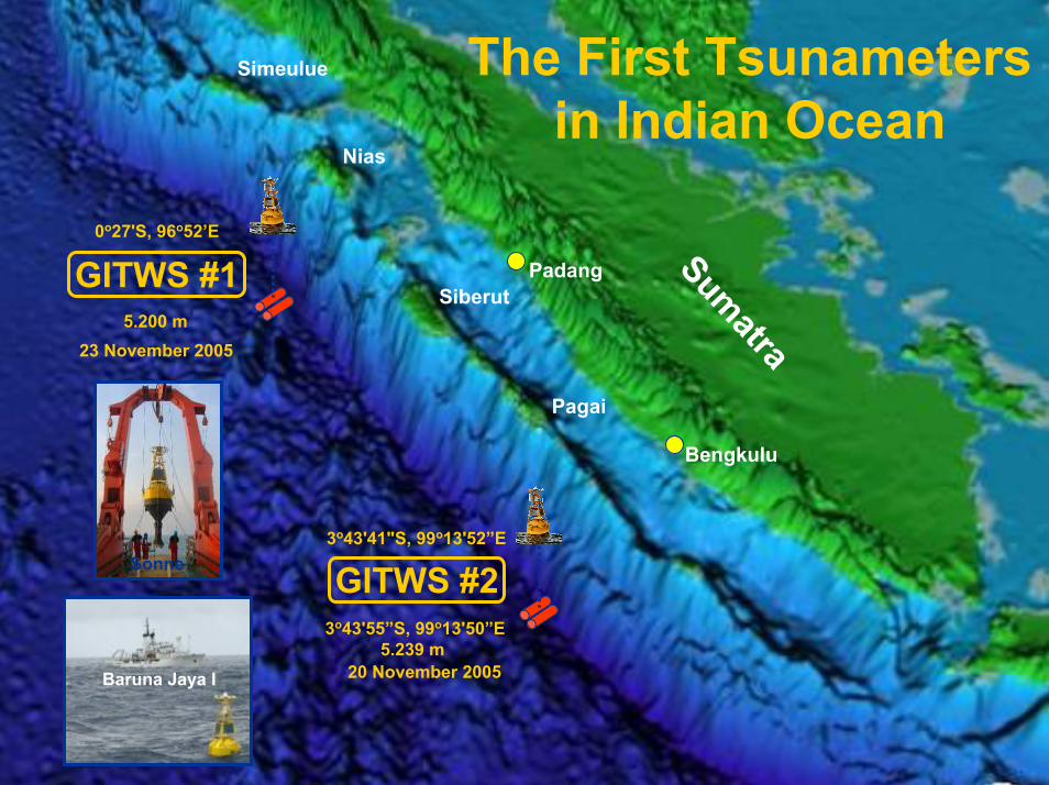
3o43'41"S, 99o13'52”E
3o43'55”S, 99o13'50”E5.239 m
Sumatra
Nias
Siberut
Pagai
0o27'S, 96o52’E
5.200 m
Padang
Simeulue
Bengkulu
The First Tsunametersin Indian Ocean
23 November 2005
20 November 2005Baruna Jaya I
Sonne GITWS #2
GITWS #1
28 March, 200528 March, 2005 EWC III, 2006EWC III, 2006 2929
© Jan Sopaheluwakan, 2006
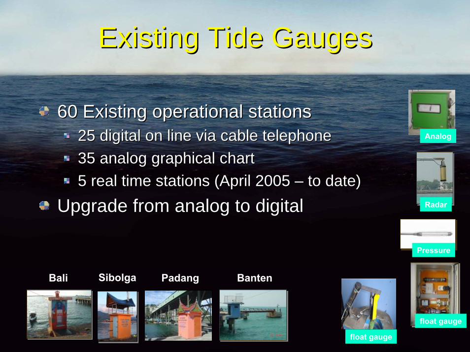
Existing Tide GaugesExisting Tide Gauges
60 Existing operational stations 60 Existing operational stations 25 digital on line via cable telephone25 digital on line via cable telephone35 analog graphical chart35 analog graphical chart5 real time stations (April 2005 5 real time stations (April 2005 –– to date)to date)
Upgrade from analog to digitalUpgrade from analog to digital
Analog
Radar
Pressure
float gauge
float gauge
Bali Sibolga Padang Banten
28 March, 200528 March, 2005 EWC III, 2006EWC III, 2006 3030
© Jan Sopaheluwakan, 2006
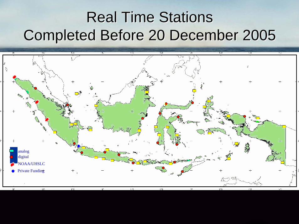
Real Time StationsReal Time StationsCompleted Before 20 December 2005Completed Before 20 December 2005
analogdigital
NOAA/UHSLC
Private Funding
28 March, 200528 March, 2005 EWC III, 2006EWC III, 2006 3131
© Jan Sopaheluwakan, 2006
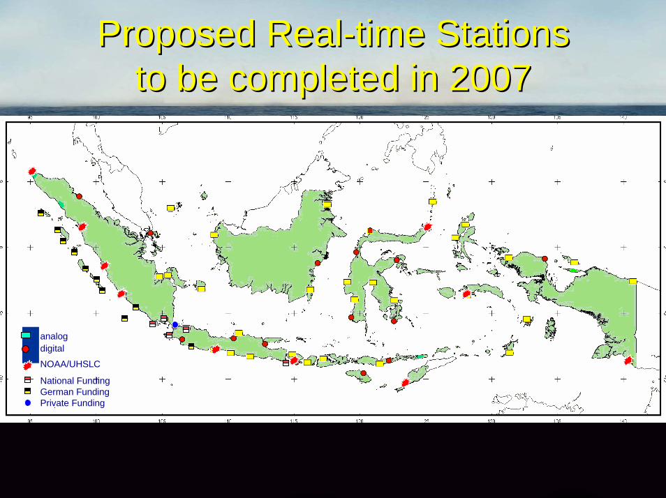
Proposed RealProposed Real--time Stations time Stations to be completed in 2007to be completed in 2007
analogdigital
NOAA/UHSLC
National FundingGerman FundingPrivate Funding

© Jan Sopaheluwakan, 2006© Jan Sopaheluwakan, 2006
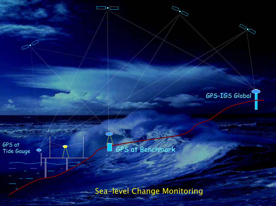
GPS TechnologyGPS Technology
28 March, 200528 March, 2005 EWC III, 2006EWC III, 2006 3333
© Jan Sopaheluwakan, 2006
GPS-IGS Global
GPS at BenchmarkGPS at Tide Gauge
•
•
••
Sea-level Change Monitoring
28 March, 200528 March, 2005 EWC III, 2006EWC III, 2006 3434
© Jan Sopaheluwakan, 2006
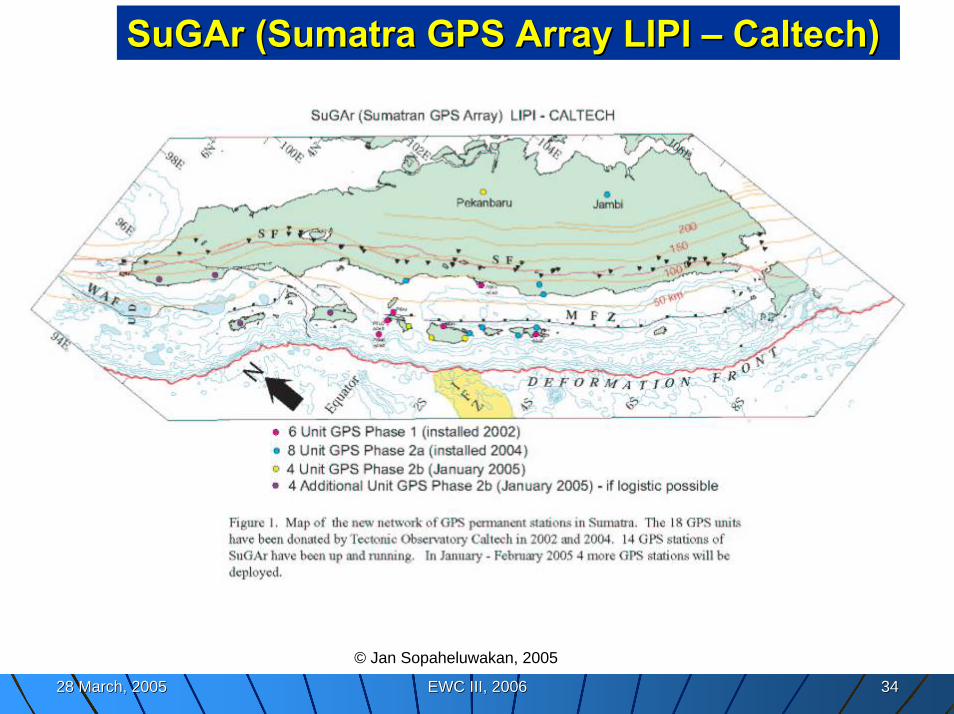
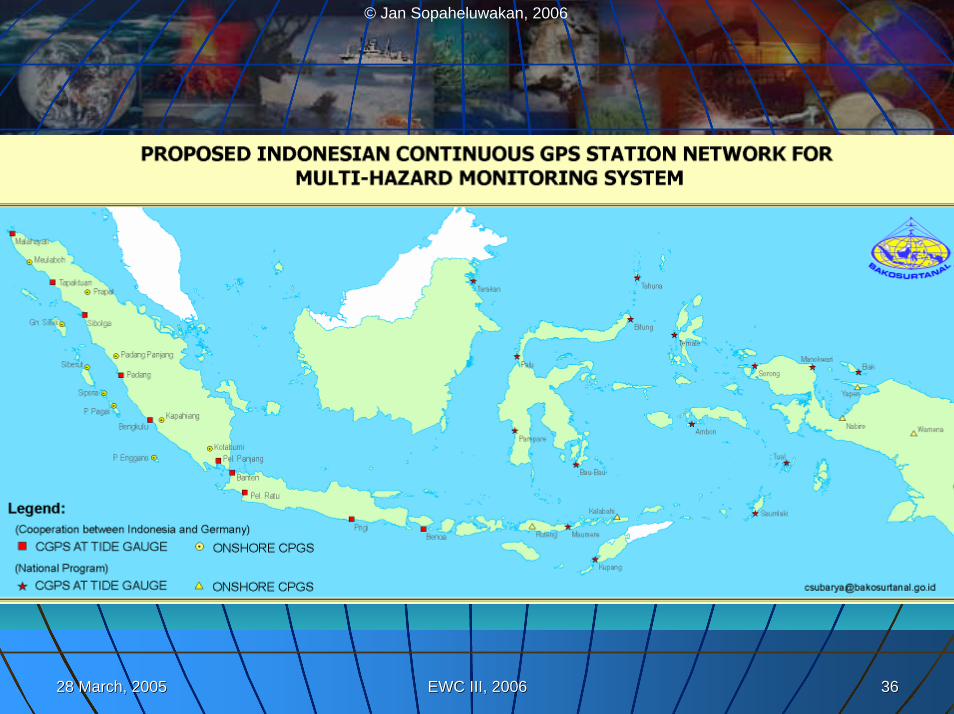
SuGArSuGAr (Sumatra GPS Array LIPI (Sumatra GPS Array LIPI –– Caltech) Caltech)
© Jan Sopaheluwakan, 2005
28 March, 200528 March, 2005 EWC III, 2006EWC III, 2006 3535
© Jan Sopaheluwakan, 2006
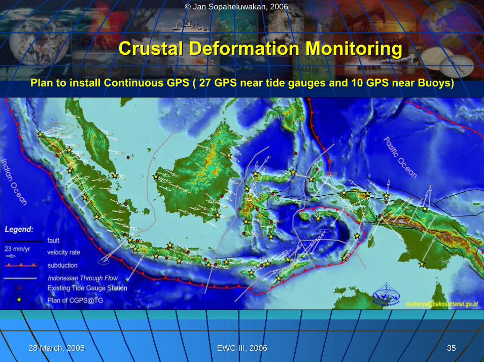
CrustalCrustal Deformation MonitoringDeformation MonitoringPlan to install Continuous GPS ( 27 GPS near tide gauges and 10 GPS near Buoys)
28 March, 200528 March, 2005 EWC III, 2006EWC III, 2006 3636
© Jan Sopaheluwakan, 2006
© Jan Sopaheluwakan, 2006© Jan Sopaheluwakan, 2006
GeoreferenceGeoreference Data, Data, Tsunami and Risk Tsunami and Risk
ModellingModelling
28 March, 200528 March, 2005 EWC III, 2006EWC III, 2006 3838
© Jan Sopaheluwakan, 2006
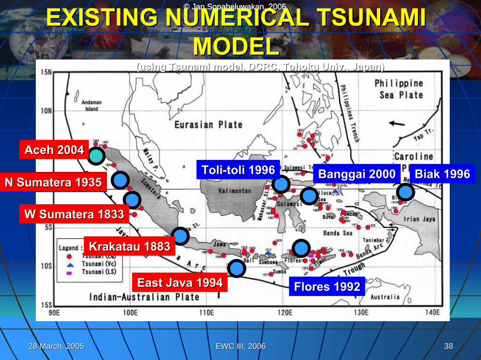
AcehAceh 20042004
N N SumateraSumatera 19351935
W W SumateraSumatera 18331833
KrakatauKrakatau 18831883
East Java 1994East Java 1994
ToliToli--tolitoli 19961996
Flores 1992Flores 1992
BiakBiak 19961996BanggaiBanggai 20002000
EXISTING NUMERICAL TSUNAMI EXISTING NUMERICAL TSUNAMI MODELMODEL
(using Tsunami model, DCRC, Tohoku Univ., Japan)(using Tsunami model, DCRC, Tohoku Univ., Japan)
© Jan Sopaheluwakan, 2005
28 March, 200528 March, 2005 EWC III, 2006EWC III, 2006 3939
© Jan Sopaheluwakan, 2006
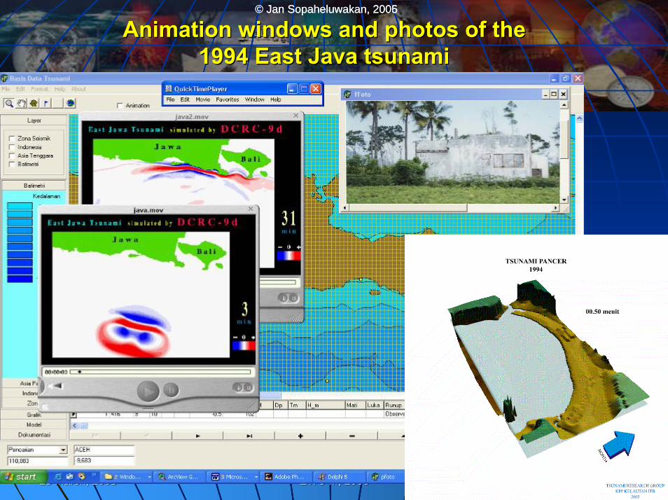
Animation windows and photos of the Animation windows and photos of the 1994 East Java tsunami 1994 East Java tsunami
© Jan Sopaheluwakan, 2005
28 March, 200528 March, 2005 EWC III, 2006EWC III, 2006 4040
© Jan Sopaheluwakan, 2006© Jan Sopaheluwakan, 2005
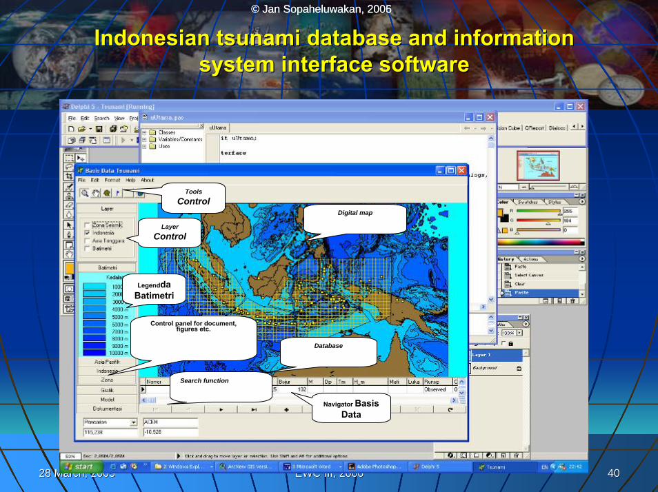
Indonesian tsunami database and information Indonesian tsunami database and information system interface softwaresystem interface software
LegenddaBatimetri
Layer Control
Tools Control
Digital map
Database
Navigator Basis Data
Control panel for document, figures etc.
Search function
28 March, 200528 March, 2005 EWC III, 2006EWC III, 2006 4141
© Jan Sopaheluwakan, 2006
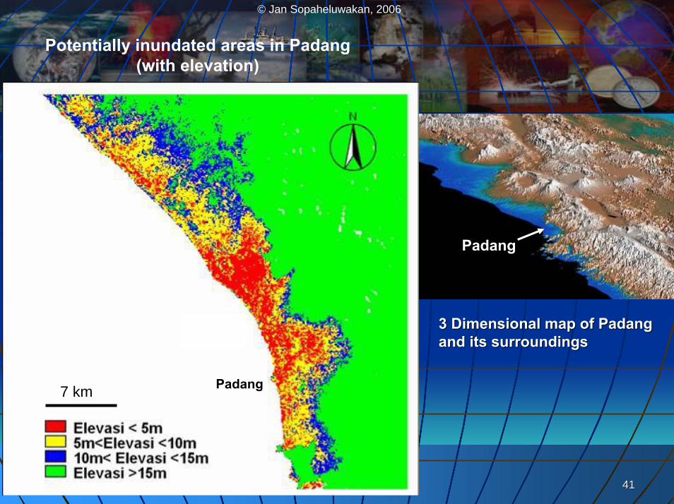
Potentially inundated areas in Padang(with elevation)
PadangPadang
Padang7 km
3 Dimensional map of 3 Dimensional map of PadangPadangand its surroundingsand its surroundings
28 March, 200528 March, 2005 EWC III, 2006EWC III, 2006 4242
© Jan Sopaheluwakan, 2006
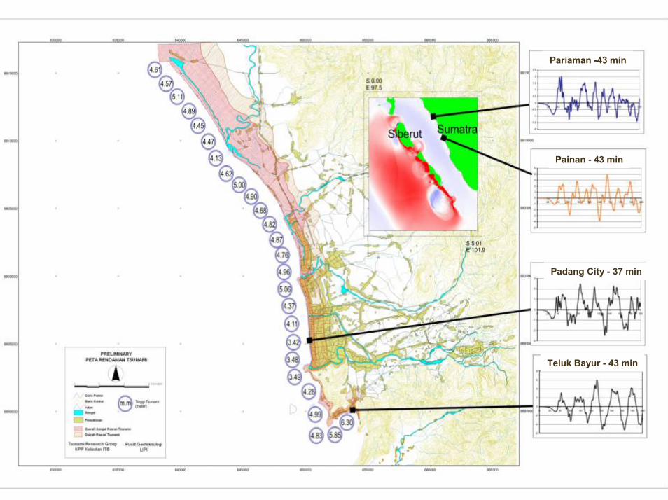
Pariaman -43 min
Painan - 43 min
Padang City - 37 min
Teluk Bayur - 43 min
28 March, 200528 March, 2005 EWC III, 2006EWC III, 2006 4343
© Jan Sopaheluwakan, 2006
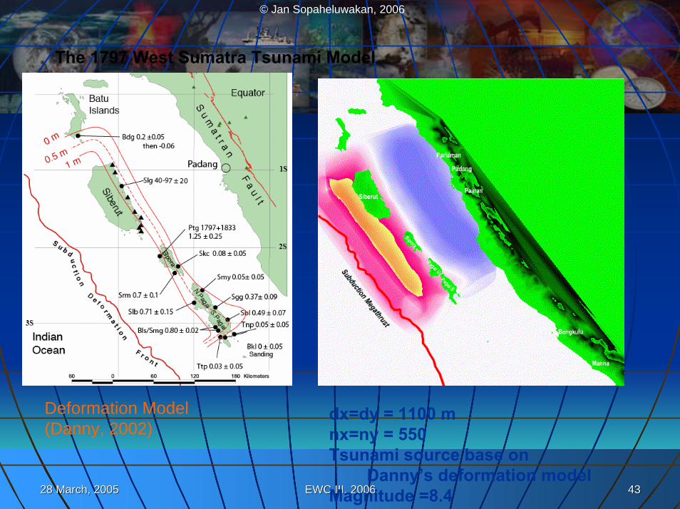
The 1797 West Sumatra Tsunami Model
Deformation Model(Danny, 2002)
dx=dy = 1100 mnx=ny = 550Tsunami source base on
Danny’s deformation modelMagnitude =8.4
28 March, 200528 March, 2005 EWC III, 2006EWC III, 2006 4444
© Jan Sopaheluwakan, 2006
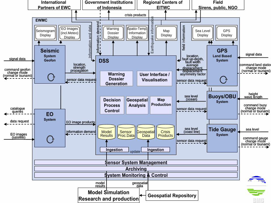
EWMC
DSS
EO Images(incl.Meteo)
Display
EO Images(incl.Meteo)
Display
EO Images(incl.Meteo)
Display
ModelResults
GeospatialData
Model SimulationResearch and production Geospatial Repository
System Monitoring & Control
SeismicSystemGeofon
SeismicSystemGeofon
location,strength
propagation
location,strength
propagation
Government Institutionsof Indonesia
Regional Centers of EITWC
Warning DossierDisplay
Warning DossierDisplay
EO image productsEO image products
sea level (ocean)
sea level (ocean)
Spatio-Temp.Information
Display
Spatio-Temp.Information
Display
MapDisplay
MapDisplay
Tide GaugeSystem
Sea LevelDisplay
Sea LevelDisplay
Sea LevelDisplay
GPSDisplay
GPSDisplay
GPSDisplay
GPSLand Based
System
GPSLand Based
System
modelresults
Ingestion
modelresults
IngestionIngestion
geospatialdata
Ingestion
geospatialdata
IngestionIngestion
sea level (coast line)sea level
(coast line)
Archiving
FieldSirens, public, NGO
update
International Partners of EWC
Sensor Proc.Data
EOSystemEO
System
sensor data requestsensor data request
sensor data requestsensor data request
info
rmat
ion
dem
and
info
rmat
ion
dem
and
information demandinformation demand
cataloguequeries
cataloguequeries
Info
rmat
ion
and
data
CrisisProducts
data requestdata request
Sensor System Management
location,fault up-depth,
fault widthaverage
displacement,displacement
asymmetry factor
location,fault up-depth,
fault widthaverage
displacement,displacement
asymmetry factor
Geospatial Analysis
MapProduction
Decision Process Control
Warning Dossier
Generation
User Interface / Visualisation
signal datasignal data
command land stationchange mode
(normal or tsunami)
command land stationchange mode
(normal or tsunami)
command buoychange mode
(normal or tsunami)
command buoychange mode
(normal or tsunami)
heightwave length
heightwave length
sea levelsea level
command gaugechange mode
(normal or tsunami)
command gaugechange mode
(normal or tsunami)sensor data requestsensor data request
sensor data requestsensor data request
command geofonchange mode
(normal or tsunami)
command geofonchange mode
(normal or tsunami)
crisis productscrisis products
field
info
rmat
ion
field
info
rmat
ion
Buoys/OBUSystem
signal datasignal data
SeismogramDisplay
SeismogramDisplay
SeismogramDisplay
EO images(satellite)
EO images(satellite)
Ear
thqu
ake
info
rmat
ion
28 March, 200528 March, 2005 EWC III, 2006EWC III, 2006 4545
© Jan Sopaheluwakan, 2006
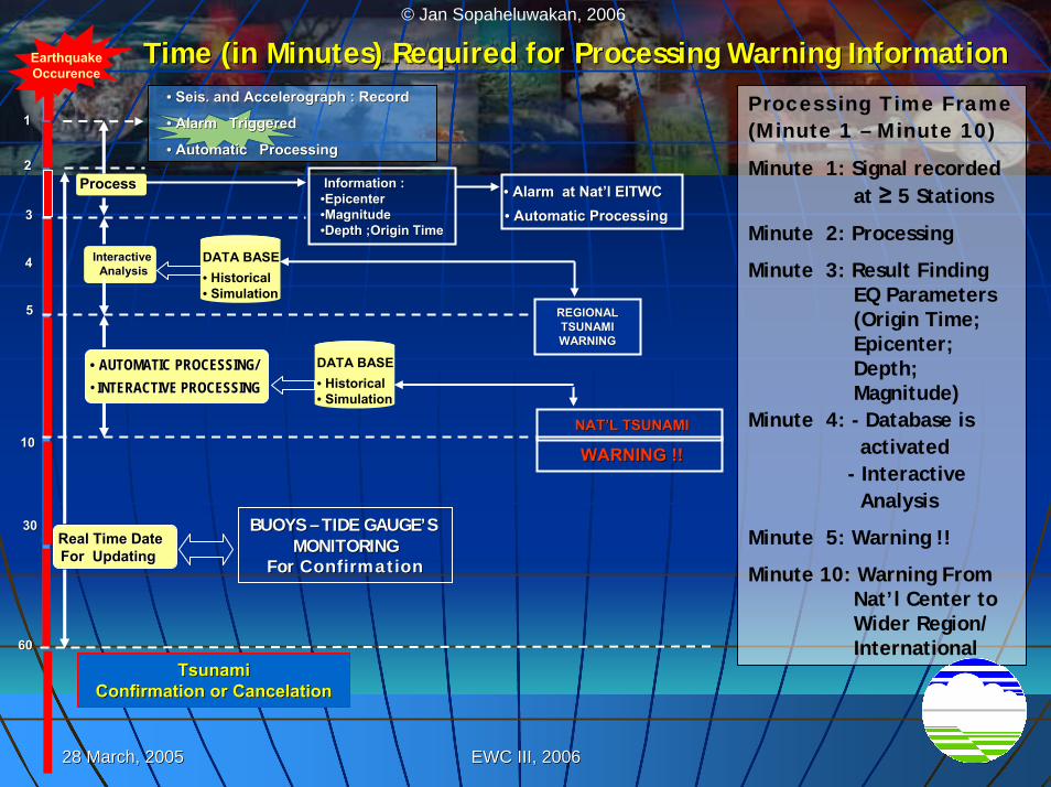
11
22
33
44
55
1010
3030
6060
Tsunami Tsunami Confirmation or Confirmation or CancelationCancelation
•• SeisSeis. and . and AccelerographAccelerograph : Record : Record
•• Alarm TriggeredAlarm Triggered
•• Automatic ProcessingAutomatic Processing
ProcessProcess Information :Information :••Epicenter Epicenter ••Magnitude Magnitude ••Depth ;Origin TimeDepth ;Origin Time
•• Alarm at NatAlarm at Nat’’l EITWCl EITWC•• Automatic ProcessingAutomatic Processing
REGIONAL REGIONAL TSUNAMI TSUNAMI WARNINGWARNING
Interactive Interactive AnalysisAnalysis
DATA BASE• Historical• Simulation
BUOYS BUOYS –– TIDE GAUGETIDE GAUGE’’S S MONITORINGMONITORING
For For ConfirmationConfirmation
WARNING !!WARNING !!NATNAT’’L TSUNAMIL TSUNAMI
•• AUTOMATICAUTOMATIC PROCESSING/PROCESSING/•• INTERACTIVE PROCESSINGINTERACTIVE PROCESSING
EarthquakeOccurence
Real Time Real Time DateDateFor Updating For Updating
Processing Time Frame(Minute 1 – Minute 10)
Minute 1: Signal recorded at ≥ 5 Stations
Minute 2: Processing
Minute 3: Result Finding EQ Parameters (Origin Time; Epicenter; Depth; Magnitude)
Minute 4: - Database isactivated
- InteractiveAnalysis
Minute 5: Warning !!
Minute 10: Warning From Nat’l Center to Wider Region/ International
DATA BASE• Historical• Simulation
Time (in Minutes) Required for Processing Warning InformationTime (in Minutes) Required for Processing Warning Information
28 March, 200528 March, 2005 EWC III, 2006EWC III, 2006 4646
© Jan Sopaheluwakan, 2006
ConclusionConclusionThe INA TWS (with significant cooperation The INA TWS (with significant cooperation and contribution from Germany, Japan, and contribution from Germany, Japan, China, France, US) has shown its remarkable China, France, US) has shown its remarkable progress, ready to part of the First Phase of progress, ready to part of the First Phase of IOTWSIOTWSSeveral challenges lie ahead:Several challenges lie ahead:
Integration of componentsIntegration of componentsCommunication component needs special Communication component needs special attentionattentionInteroperability with other national centersInteroperability with other national centersWorking on the Working on the ““the last milethe last mile”” will be the most will be the most crucial part (linking the regional crucial part (linking the regional –– national national –– local local aspects)aspects)