The Indian Summer Monsoon and the Waters around India
21
Ninth Kumari L. A. Meera Memorial Lecture The Indian Summer Monsoon and the Waters around India S. R. Shetye National Institute of Oceanography Dana Paula. Goa December 2, 2000 Kumari L. A. Meera Memorial Trust Palghat, Kerala
Transcript of The Indian Summer Monsoon and the Waters around India

Ninth Kumari L. A. Meera Memorial Lecture
The Indian Summer Monsoon andthe Waters around India
S. R. ShetyeNational Institute of Oceanography
Dana Paula. Goa
December 2, 2000
Kumari L. A. Meera Memorial TrustPalghat, Kerala

KUMARI L. A. MEERA(1961-1985)
KUMARI L. A. MEERA(1961-1985)
KUMARI L. A. MEERA (1961 - 1985)

Kumari L. A. Meera, the youngest daughter of Mr. and Mrs.L. K. Ananthakrishnan, was born on June 1st. 1961, in New Delhi.Her academic career was uniformly brilliant with a distinction atthe higher secondary level and a University rank in the B.Sc.(Honours) examination in Physics, from St. Stephens College.Delhi. After again obtaining a rank in her MSc., which was at theIndian Institute of Technology in Madras, she took up a Mastersprogramme in Computer Science at the same institution with aview to preparing herself for the emerging applications of this areato physics. She was strongly oriented towards research, havingattended summer schools at the Indian Institute of Science andthe Tata Institute of Fundamental Research. Her teachers andcolleagues recognised her promise and motivation and confidentlyexpected an outstanding career in research. Her personality waswarm and friendly with a strong streak of hard work, determination,and helping others. These characteristics endeared her to thosewho knew her.
She joined the University of Pennsylvania in Philadelphia inSeptember 1985 for doctoral studies in physics. But in Novemberof the same year, her bright career was tragically cut short by heruntimely death.

SATISH RAMNATH SHETYE
Dr. Satish R. Shetye was born in Panaji, Goa, on 25 October1950. He took his M.Sc. (Physics) from the Indian institute ofTechnology, Powai, and Ph.D. in Physical Oceanography from theUniversity of Washington, Seattle, USA. Since 1982 he has beenat the National Institute of Oceanography, Goa, where he studiesdifferent issues related to dynamics of the waters around India. Heplayed an important role in identifying the relationship betweenmonsoon winds and surface currents in the North Indian Ocean.Other areas of his interest include: tides along the coast of India.dynamics of estuaries, and interaction between the Indian SummerMonsoon and the Indian Ocean. Dr. Shetye received ShantiSwarup Bhatnagar Prize in 1992 and New Millennium ScienceMedal, Indian Science Congress, in 2000. He is a Fellow of theIndian Academy of Sciences and Indian National ScienceAcademy.
5

Ninth Kumari L. A. Meera Memorial Lecture
The Indian Summer Monsoon and the Watersaround India
Satish R. Shetye
The Indian Summer Monsoon (ISM) represents migration of therain-bearing Equatorial Trough (ET) to the Indian subcontinent andthe surrounding waters. Interaction between the ET and the seasaround lndia is important to sustain activity of the /SM. Seasurface temperature, determined by processes both in theatmosphere and the ocean, is an important intermediary in theinteraction. Winds set up by the /and-sea heating-contrastbetween the Asian /and mass and waters of the North lndianOcean cool the western Arabian Sea, leaving it incapable ofsustaining any large-scale atmospheric convection andprecipitation. This helps in making the Bay of Bengal the mostimportant centre of. ISM activity. The precipitation associated withthe activity keeps the upper layer of the Bay highly stab/e andwarm throughout the /SM. The warm waters in turn sustain eventsthat bring rain not only to the Bay, but a/so to the Indiansubcontinent, where they are crucial for sustaining life.
1. Introduction
Ong of the familiar diagrams in school text books is a globalperspective on structure of surface winds (Fig. 1). Though thisstructure must have been known for a long time, one of the first toattempt to understand its dynamics was George Hadley, a Briton.In 1735 he proposed a scheme for global atmospheric circulationthat was similar to the one depicted in Fig. 1. An importantassertion in his writings was that trade winds converge leading toformation of a region of ascent of air at the equator (belt marked“doldrums” in Fig. 1) and a region of descent farther away. Thetrades and the regions of ascent/descent form a system called theHadley cells.
6

Fig. 1. Surface winds. pressure belts. and Hadley Cells.
Over the last century there has been remarkable improvement inour ability both to observe the earth’s atmosphere (using satellites, forexample) and to understand it. The latter has particularly benefitedfrom construction of mathematical models that can now be studiedusing computers. The new observations are largely consistent with theidea that there is a region of ascent between the belts of trade winds,as Hadley had noted. The region, however, exhibits considerablespatial and temporal variability that earlier scientists would not havebeen able to document.
In this talk I will examine how this region of ascent and theaccompanying winds evolve during a typical year and the role thatthe seas around India play in this evolution over the Indiansubcontinent and the surrounding waters. This exercise gives usimportant clues on how the seas around India and the IndianSummer Monsoon (ISM) interact.
7

2. The trades and the Equatorial Trough (ET)
The word “tropic” is derived from a Greek word meaning turning.As seen in Fig. 1, at the Tropic of Cancer and the Tropic ofCapricorn winds turn and change their directions. Between theTropics sit the “tropics”, the region that has been found to bedynamically distinctly different from the sub-tropics. As pointed outby Herbert Riehl in his delightful book “Climate and Weather in theTropics” (1979), the source of all momentum and most heat for theengine we call the atmosphere are the tropics. The processes ofthis engine that we are interested in take place in a layer that isapproximately 16 km in height (a typical commercial jet airlinercruises at an altitude of about 10 km). Comparing this withcircumference of the earth (approximately 40,000 km), we realizethat the atmosphere is a rather strange fluid: a “thin” layer of gas,on a rotating platform. The gas is held in place by the gravitationalpull of the earth, and set into motion by heating, the heat energybeing ultimately derived from the Sun. Our day-to-day experiencefails to appreciate how different the rules governing the motion inthe atmosphere are. It is important therefore to get a feel for howthe atmosphere behaves, leaving the question “why” for later.
Observations have repeatedly shown that the region of thedoldrums (Fig. l), i.e. the region of ascent that Hadley identified isalso the region of high precipitation. The region has beendescribed by different names, the two popular versions being theEquatorial Trough (ET), and the Inter Tropical Convergence Zone(ITCZ). Following Riehl, we will use ET. The air of the tropics,particularly that over the oceans, is moisture laden because thetemperatures here are warm and can therefore retain moisture.When the moist air rises in the ET, some of the moisturecondenses out as precipitation. Hence the ET is a belt of highprecipitation. The condensation is accompanied by release oflatent heat, which then warms the surrounding air. The warmingmakes the air lighter and leads to a drop in pressure in the watercolumn below the warm region. The low pressure in turn leads toconvergence of air from the surroundings, encouraging furtherascent of air and condensation. The net result is that the ET formsa complex chaotic regime with rain-bearing clouds, highprecipitation and ascent of air. On the two sides of the ET lie the
8

0 50 100 150 200 250 300 350 400 450 500 550 600 650
Rainfall (mm/month)
July
January
20 m/sec

Fig. 3. Schematic representation of global thermohaline circulation.
10

Fig. 4. Evolution of climafological weekly sea surface temperature during April-October. Temperatur,es less than 27.5 C are shown in white; the dour palette forhigher temperatures IS at the battam.
11

Fig. 5. Field of precipitation minus evaporation and runoff from major rivers in theNorth Indian Ocean. The contours show precipitation minus evaporation in units ofm/year. Location of a point of discharge from a major river is shown with an arrow.The number next to a river’s name gives its discharge in trillion cubic metres pery e a r
12

belts of trade winds. This structure is more complex than thatdepicted in Fig. 1. Fig. 2 shows what the pattern of monthly-meanclimatology of precipitation and surface winds based on moderndata sets. Following are some of the observed features of the ETand the trades:
(1) The ET forms more or less a continuous belt that girdles theglobe. It shuns the equator, but stays within the tropics.
(2) Along with the belts of trade winds, the ET migratesseasonally. During southern (northern) summer it reaches itssouthernmost (northernmost) location.
(3) The ET has a complex structure. Embedded in it are intenseconvective systems, including cyclones and other atmosphericdisturbances. One can appreciate the complexity of thestructure by the satellite pictures of tropical cloud bands oftenseen in TV weather reports.
(4) Though seasonal migration of the ET is observed over theAtlantic and the Pacif ic Oceans too, it is particularlypronounced over the Indian Ocean. Here, during the northernsummer the ET becomes a wide band stretching over theeastern Arabian Sea, the Indian subcontinent, the Bay ofBengal, and then merging with the Pacific ET over themaritime continent consisting of Southeast Asia and Indonesia.At this time the precipitation associated with the ET is mostpronounced over the Bay of Bengal.
(5) A conspicuous feature of the ET during the northern summer isits absence over the western Indian Ocean leading to adiscontinuity in its structure. The discontinuity forms in Juneand lasts till about November. Hence there are strikingdifferences in the atmospheric activity exhibited by the twoseas on either side of the Indian subcontinent: the ArabianSea, particularly its western part shows weak activity, whereasthe Bay of Bengal remains extremely active throughout theISM.
13

The migration of ET as described in (4) above, is what we callthe ISM. It is a time of strong winds, intense cloudiness, highprecipitation, and generally disturbed atmospheric conditions overthe Indian subcontinent and the surrounding waters. When the ETmoves in the Indian region, we say the monsoon has set in overIndia.
It is generally accepted that helping in the large northwardmigration of the ET over the Indian Ocean is the heating of theland mass of Asia, particularly the elevated area of the TibetanPlateau, where the area with elevation of 5,000 m or higherexceeds a million square kilometres. The plateau therefore acts asan elevated source of sensible heat. Such high altitude heating isefficient in setting up a circulation in which air rises up due toheating, and is replaced by air from elsewhere, in a fashion similarto that seen in land- and sea-breeze. It is for this similarity thatISM has often been described as a global scale land-sea breeze.This classical picture of the monsoon, however, misses oneimportant feature of the ISM moist convection and precipitation.To understand the large-scale winds associated with the ISM, theclassical land-sea breeze paradigm is fine. But to understand theprecipitation associated with the ISM we must examine whathappens to the ET once it moves over the seas around India.These seas are an integral part of the global oceans. Hence it isuseful to have an overview of the oceans.
3. The global oceans and the Seas around India
The earth is almost spherical in shape with about two thirds of thesurface covered by oceans. Its radius (-6000 km) is much largerthan the average depth of the oceans (-4 km). Thus, the oceans,like the atmosphere, form a system that is rather strange: a thinlayer, stretched out on a sphere that rotates. The modern view ofthe characteristics of the oceans began appearing with theChallenger Expedition (1872-1876). One of the most valuabledata generated by the expedition consisted of vertical profiles oftemperature and salinity at stations distributed around the globe.During the last century the number of such profiles increasedsharply, and this has helped us to appreciate some importantfeatures:
14

1) Most of the ocean is in stable hydrostatic equilibrium (denserwaters sit under lighter ones). There are two exceptions. First,there is a shallow (-10-100 m) layer near the ocean surfacethat is constantly stirred by winds and by heat loss at thesurface. Second, in some polar areas, most notably in theNorth Atlantic and in parts of the seas around Antarctica,intense cooling at the surface owing to contact with cold airleads to the formation of dense waters that sink to greatdepths. Both these areas exhibit predominantly turbulentmotions.
2) The density at any location in the stably-stratified areas isdetermined by: temperature, salinity (generally expressed asparts per thousand, ppt, by weight of dissolved salts), andpressure at the location. The ranges of these variablesare: temperature ~ 0.30%; salinity ~ 30-36 ppt; pressure-0-4000 decibars (about 400 times the atmospheric pressure).Taking these variations into account, the range of density seenin the oceans is ~ 1.020-1.030 gm/cm3, i.e. the variation indensity is a small fraction of the mean density.
3) The most important factor that determines the characteristicsof this stratif ication is the global-scale “thermohalinecirculation.” The temperature and salinity at a location atsurface of the ocean is determined by local air-sea exchangeof heat and freshwater: salinity is low at places that receivehigh rainfall; temperatures are lower where loss of heat to theatmosphere is higher. Turbulent mixing in the oceans is weakenough that once a parcel of water leaves the surface andmoves at subsurface levels, it retains its identity over longdistances (thousands of kilometres). Sinking and spreading ofdenser water formed in polar areas can be traced over theentire ocean basin of the earth. The circulation associated withthis motion is called the thermohaline circulation.
4) When compared to the scales we are used to in day-to-daylife, the scales associated with thermohaline circulation areunusual: length scale ~ 10,000 km; horizontal velocity ~ 0.1 -1 .O cm/sec; time scale ~ 100 - 1,000 years.
15

5) Deep water does not form in the North Pacific because highprecipitation keeps surface density low enough to preventsurface cooling from forming dense deep waters. Thethermohaline circulation is closely linked with the Earth’sclimate, and it is the primary circulation that determines thecharacteristics of vertical profiles of temperature and salinity atany location, including those in the seas around India.
The characteristics of vertical profiles of temperature andsalinity in the Arabian Sea and the Bay of Bengal are thusdetermined largely by events that occurred elsewhere quite somedistance away, and perhaps a few centuries ago. However,temperature and salinity near the top ten percent of a watercolumn are strongly influenced by events local in space and time.It is these changes that are important in determining how theatmosphere will interact with the ocean on time-scales rangingfrom hours to months. For our discussion the most importantcharacteristic that is determined locally is near-surface salinity. Itis much lower in the Bay of Bengal than in the Arabian Sea. Infact, surface salinity in the Bay is one of the lowest foundanywhere in the world. This difference in salinity between ArabianSea and the Bay of Bengal arises primarily owing to differences inprecipitation and evaporation in the two basins. The Bay of Bengalexperiences one of the largest inputs of freshwater anywhere inthe world. This reduces the surface salinity. We shall see in thenext two sections that there exists, at least in part, a positivefeedback between the strength of the monsoon activity over theBay and the low salinities there.
4. The ET and the seas around India
The first clue that the seas around India may be playing a criticalrole to sustain the convection associated with the ET during theISM came from studies carried out in Bangalore. In 1984 studiesat the Indian Institute of Science by Sulochana Gadgil,P.V. Joseph, and Niranjan Joshi showed that for the ET to exhibitlarge-scale convection over the seas, the sea surface temperature(SST) has to exceed a critical temperature of approximately 28°C.In 1987 N. Graham and T. Barnett generalized this result to
16
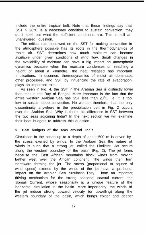
include the entire tropical belt. Note that these findings say thatSST > 28°C is a necessary condition to sustain convection; theydon’t spell out what the sufficient conditions are. This is still anunanswered question.
The critical role bestowed on the SST for making convection inthe atmosphere possible has its roots in the thermodynamics ofmoist air. SST determines how much moisture can becomeavailable under given conditions of wind flow. Small changes inthe availability of moisture can have a big impact on atmosphericdynamics because when the moisture condenses on reaching aheight of about a kilometre, the heat released has importantimplications. In essence, thermodynamics of moist air dominatesother processes, and SST by influencing the rate of evaporation,plays an important role.
As seen in Fig. 4, the SST in the Arabian Sea is distinctly lowerthan that in the Bay of Bengal. More important is the fact that theentire western Arabian Sea has SST less than 28oC, i.e. it is toolow to sustain deep convection. No wonder therefore, that the onlydiscontinuity anywhere in the precipitation belt in Fig. 2 occursover the Arabian Sea. Why is there this difference in SST betweenthe two seas adjoining India? In the next section we will examinetheir heat budgets to address this question.
5. Heat budgets of the seas around India
Circulation in the ocean up to a depth of about 500 m is driven bythe stress exerted by winds. In the Arabian Sea the nature ofwinds is such that a strong jet, called the Findlater Jet occursalong the western boundary of the basin (Fig. 2). The jet formsbecause the East African mountains block winds from movingfarther west over the African continent. The winds then turnnorthward forming the jet. The stress (proportional to square ofwind speed) exerted by the winds of the jet have a profoundimpact on the Arabian Sea circulation. They form an importantdriving mechanism for the strong seasonal coastal current, theSomali Current, whose seasonality is a unique feature of thehorizontal circulation in the basin. More importantly, the winds ofthe jet induce strong upward velocity (or upwelling) along thewestern boundary of the basin, which brings colder and deeper
17

waters of the basin to the surface. Downwelling, i.e. downwardvertical velocity elsewhere in the basin must accompany suchupwelling. The resulting vertical circulation helps to spread theheat in the surface layer to a depth of a few hundred meters.Winds over the Bay of Bengal are much weaker. As a result, thestrength of the vertical circulation too is weaker. This helps tokeep the heat gained across the air-sea interface close to thesurface.
There is another factor that discourages transfer of heat todeeper layers in the Bay of Bengal: stratification. As pointed outearlier, the Bay receives a large amount of freshwater in the formof precipitation and runoff from rivers discharging into the Bay(Fig. 5). The amount of freshwater received by the Bay from thetwo sources is approximately 4 trillion cubic metres per year. Ifspread out over the area of the Bay north of 6 N, it would form alayer about a metre and half thick. It mixes with the underlyingwater, leading to a strong density gradient near the ocean surface.It is difficult to mix heat downward across strong gradients ofdensity. In essence, the density gradient forms a “cap” that preventsheat from penetrating to layers below about 75 m. In contrast, theArabian Sea is a region of net loss of freshwater. There is no layerthat acts as a cap, making it easy to mix the heat downward.
Hence two factors help to restrict heat received across the air-sea interface to a region close to the surface in the Bay: weakvertical circulation and strong stratification. The net result of thesedifferences is that the Bay stays much warmer than the ArabianSea. The warm waters of the Bay make it more likely to have theET hang over it.
The precipitation associated with the ET over the Bay oftenspreads to areas towards the west and the northwest. Thisgenerally takes place in two forms. The first is as atmosphericcurrents that transport moisture that ultimately precipitates. Thistype of precipitation is often found along the foothills of Himalayasand on the Gangetic Plain south of the foothills. The other mode oftransport is in the form of atmospheric disturbances -depressions, cyclones, etc. -that originate over the Bay and thenpropagate westward or northwestward bringing precipitation alongthe path followed by a disturbance. Both these modes are critical
18

It
i
-
19

to bring rain to the Indian subcontinent. Without them, theavailability of freshwater would have suffered immensely.
6. Concluding comments
By staying warm, the Bay plays a critical role in making Indiahabitable. We conclude this talk with a diagram (Fig. 6) thatsummarizes the many elements that cooperate to make the ISMhappen. An interesting feature of the series of processes we haveexamined is positive feedback. Over the Bay of Bengal it acts asfollows. A warm Bay sustains high convective activity in theatmosphere; this leads to high precipitation and runoff; this-ensures that the near surface regime of the Bay is well stratified;this ensures that the Bay remains warm. Another positivefeedback occurs over the Arabian Sea, but acts in the oppositedirection.
It is important to note that though the processes summarized inFig. 6 by themselves make a rather complex system, there areother processes that are important in the ISM phenomenon.Prominent amongst these are: role of the El Nino in the Pacific;contribution of the subtropical system; influence of the dynamics ofthe upper atmosphere. Indeed, the ISM is a complex system. It istruly a wonder of nature that such a complex system self regulatesto produce precipitation with a regularity that has permitted life tonot only survive, but even to thrive, in the Indian subcontinent.
We live in an age that offers new opportunities to studycomplex natural systems. New advances in the field of computers,and new thinking in physics (nonlinear dynamical systems, forexample) offer new prospects to examine old problems with newinsights. Kumari Meera, after whom this Lecture Series is named,studied the very topics that bear the new promise: physics andcomputers. I would like to conclude this talk by paying my respectsto her. I never met her, but whatever little I have come to knowabout her brings into focus India’s greatest resource: brilliantyouth charged with enthusiasm to take on new sciences andtechnologies. It is a pity that Meera did not live -to practice theprofession of her choice. I thank the Kumari L.A. Meera MemorialTrust for giving me this opportunity to share my thoughts.
20

KUMARI L. A. MEERA MEMORIAL TRUST(Reg. No. 239 of 288.1989)
The Kumari L. A. Meera Memorial Trust was established on28.8.1989 by Mr. L. K. Ananthakrishnan in Palghat, Kerala State inmemory of his daughter, Kumari L. A. Meera. The Trust isdedicated to the service of mankind, with a wide range of activitiesin the fields of Physics, Mathematics and Computer Sciencebesides Anthropology, and welfare and charitable activities. TheTrust is managed by a Board of Trustees, the Managing Trusteebeing Mr. Ananthakrishnan until his demise in March 1998. Thepresent Managing Trustee is Prof. V. Balakrishnan.
The main focus of the Trust is to fosier scientific interaction andactivity in the fields of Physics, Mathematics and ComputerScience in various scientific institutions, and encourage scientificeducation and advanced scientific research in these and interfaceareas by providing scholarships/stipends/awards for meritoriousand deserving students. The Trust is committed to thedevelopment of excellence in Physics, Mathematics and ComputerScience. It has instituted awards and scholarships in memory ofMeera in several schools and colleges and has provided financialgrants for upgradation of library, laboratory and computer facilitiesin a number of institutions in India. In addition it assists in thepromotion of Sanskrit and traditional cultural values.
The Trust has instituted awards and prizes for theencouragement of excellence in Physics in the Indian Institute ofTechnology, Madras, St. Stephen’s College, Delhi, the Indianfnstitute of Science, Bangalore and other educational institutions.
The Trust also organises each year the Kumari L. A. MeeraMemorial Meeting on Frontier areas in Physics. The first meetingin the series, on the topic “Geometry and Topology in Physics”,was held at Dhvanyaloka, Mysore from February 8 to 14, 1996.The second meeting, on “Chaos, Complexity and Information” washeld from February 1 to 7. 1997; the third on “Optics: ModernTrends” from January 31 to February 5, 1998; the fourth on“Probability and Physics” from January 25 to January 30, 1999;and the fifth on “Soft Condensed Matter” from January 27 toFebruary 2, 2000; all at the same venue.
22

The Kumari L. A. Meera Memorial Lectures
N. Mukunda - ‘The Task of Picturing Reality’ (1990)
V. Radhakrishnan - ‘Flying s/ow/y (1993)
G. Venkataraman - ‘Parallel Computers’ (1994)
V. S. Ramamurthy - 'Molecules t o Materials -The novel transition domain ofClusters and Nano Structures’ (1995)
J. V. Narlikar ‘Myths, Beliefs and Facts inAstronomy’ (1996)
D. Balasubramanian - ‘Expanding Visions of theNew Bioiogy‘ (1997)
S. Ramanan - ‘The Role of Groups in Artsand Sciences’ (1998)
R. Rajaraman - ‘Can Relativity and QuantumMechanics Co-exist? (1999)
Special Kumari L. A. Meera Memorial Lectures
R. Chidambaram - ‘Nuclear Energy and Safety (1996)
D. D. Bhawalkar - ‘Laser Applications in Medicine (1998)
Sri L. K. Ananthakrishnan Memorial Lectures
V. Rajaraman - ‘Video on Demand’ (1999)


![Evolution of Indian Summer Monsoon intensification title: Evolution of Indian Summer Monsoon intensification Project code : OU26 [Fully funded] Host institution: The Open University](https://static.fdocuments.in/doc/165x107/5afa1cdd7f8b9ae92b8d4988/evolution-of-indian-summer-monsoon-title-evolution-of-indian-summer-monsoon-intensification.jpg)