The Geology of Sculpting Stone - Northwest Stone Sculptors ... · NOTE HOW LIGHT AND CLEAR IT IS...
26
THE GEOLOGY OF SCULPTING STONE PNW GRANITE Michael E. Yeaman 1
Transcript of The Geology of Sculpting Stone - Northwest Stone Sculptors ... · NOTE HOW LIGHT AND CLEAR IT IS...

THE GEOLOGY OF SCULPTING STONE
PNW GRANITE
Michael E. Yeaman1

WHY SHOULD YOU CARE ABOUT THE GEOLOGY OF
SCULPTING STONE?
Stone makes our chosen art form unique from all
others
Knowing more about the stone will allow you to:
Select stone that has a compelling history
Marvel at its various elements of grain, color and texture
as you work it
Consider how your chosen artistic form relates to the
science of the stone
Weave into your final art work story a geologic
component that enhances the interest in the your work
by the potential buyer
2
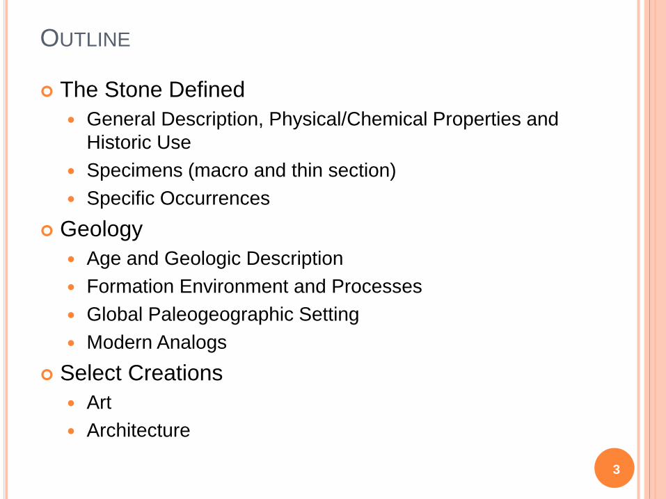
OUTLINE
The Stone Defined
General Description, Physical/Chemical Properties and
Historic Use
Specimens (macro and thin section)
Specific Occurrences
Geology
Age and Geologic Description
Formation Environment and Processes
Global Paleogeographic Setting
Modern Analogs
Select Creations
Art
Architecture
3

GENERAL DESCRIPTION, PHYSICAL/CHEMICAL
PROPERTIES AND HISTORIC USE
4
Chemical
Composition
of Snoqualmie
Batholith
SiO2 66%
Al2O3 17%
FeO 5%
Mg/Ca/Na
/K/TiO
12%
PNW granite is a general term used to describe light colored
igneous rock occurring in several localities in Washington State
and British Columbia
Historically, two major areas have been quarried for PNW
The Coastal Plutonic Belt of British Columbia, Hardy Island
area (emplacement age about 120 million years ago)
The Snoqualmie Batholith and the Index Pluton
(emplacement age of 18 and 35 million years ago
respectively)
Although different in age, both areas are composed of similar
uniform light grey Granodiorite associated with Andean-style
tectonic environment
Quarrying began in the early 1900s at both locations
Hardy Island quarried stone has been used as a foundation
stone in Canada and the United States and was used to
construct the Victoria Harbor seawall because of its durability
and attractive appearance.
Snoqualmie quarried stone was used extensively through-out
the Puget Stone region for major commercial and government
buildings
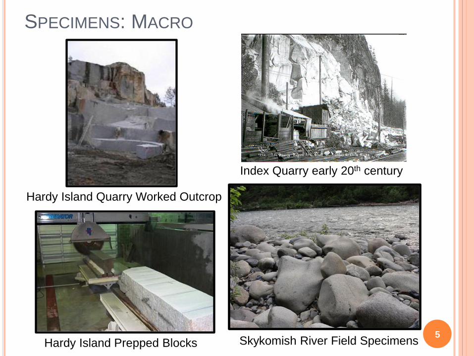
SPECIMENS: MACRO
5
Hardy Island Quarry Worked Outcrop
Skykomish River Field Specimens
Index Quarry early 20th century
Hardy Island Prepped Blocks

SPECIMENS: THIN SECTIONS(ABOUT 20X MAGNIFICATION)
6
PLANE LIGHT CROSSED POLARIZED LIGHT
GRANITENOTE HOW LIGHT AND CLEAR IT IS UNDER PPL AND GREY/WHITE/BLACK UNDER XPL; MAIN
MINERALS – FELDSPARS (OFTEN MICROCLINE), QUARTZ, BIOTITE AND MUSCOVITE
quartzquartz
muscovite
muscovi
te
biotitebiotite
plagioclaseplagioclase

SPECIFIC OCCURRENCES
7Marenakous “High Cascade” Granite
From the Crown Lakes Quarry
SKYKOMISH RIVER: INDEX PLUTON
History of the Index Quarry
o In 1904 John A. Soderberg (1866-1935), began developing the Index
Granite Company, a large quarry along the Great Northern tracks three-
quarters of a mile west of town. Seventy men were employed there
most of the time, supplying material for construction of prominent
buildings in Seattle, Spokane, and Everett, including the State Capitol in
Olympia.
o Soderberg’s quarry brought workers and stone artisans with their
families from as far away as Barre, Vermont. Photos show intricately
carved, highly polished tombstones waiting for shipment.
o In May 1932 the quarry shed with its massive crane burned, leaving
unmovable stones inside the building. The shed was never rebuilt
and the remaining broken blocks were ground and sold as chicken grit.
o Depression gripped the economy, and failing banks would not finance
what had become obsolete technology. A relatively new material,
reinforced concrete, was recognized as far cheaper for structural use
than quarried granite.
o The Index Quarry is
no longer in
operation, however
many excellent
stream specimens
can be collected
from the Skykomish
and Stillaguamish
rivers

8
An overhead view of the Hardy Island Granite
Quarry in the Jervis Inlet south of Powell River, B.C.
o The Hardy Island Granite Quarry is about 20 kilometres southeast
of Powell River. It is one of the historic Jervis Inlet Quarries
o These quarries provided stone for many of British Columbia’s
notable buildings in the early part of the last century, producing a
classic grey, “salt and pepper” granite, which Parks (1917), in his
survey of the Building Stones of Canada, referred to as “the best
in BC”.
o Products of the stone from the Hardy Island Quarry include the
lions in front of the old Vancouver Courthouse, and the Ogden
Point breakwater.
o The stone at the Hardy Island quarry splits with unusual facility
along both the rift and the grain (the primary and secondary
splitting directions). This quality, together with the favorable joint
orientation and spacing, allows the stone to be quarried easily.
o Over half the stone produced by the quarry is exported to the
United States, either as blocks or as split products.
Barge being loaded with large granite blocks
1915 Hardy
Island Quarry
Crew
HARDY ISLAND, B.C.

9
AGE AND GEOLOGIC DESCRIPTION
There are three types of rock:
Sedimentary: A rock formed from
the accumulation and
consolidation of sediment, usually
in layered deposits. (e.g.
sandstone)
Metaphoric: A rock formed by the
alteration of the minerals, textures
and/or composition of another
rock caused by exposure to heat,
pressure and/or chemical actions.
(e.g. quartzite)
Igneous: A rock formed by the
crystallization of magma (intrusive,
e.g. granite) or lava (extrusive)
PNW granites are Igneous rocks
that can be classified in a number
of ways…
Rock Example: Granite
Composed of the minerals:

AGE AND GEOLOGIC DESCRIPTION
Granitic
(felsic)
Andesitic
(intermediate)
Basaltic
(mafic) Ultramafic
Dominant
Minerals
Quartz
Orthoclase
(Alkali or K-
Feldspar)
Amphibole
Plagioclase
Feldspar
Pyroxene
Plagioclase
Feldspar
Olivine
Pyroxene
Color
Light-colored
< 15% dark
minerals
Medium-colored
15 - 40% dark
minerals
Dark gray to
black
> 40% dark
minerals
Dark green to
black
~100% dark
minerals
Coarse-grained
(Plutonic/Intrusive) Granite Diorite Gabbro Peridotite
Fine-grained
(Volcanic/Extrusive) Rhyolite Andesite Basalt Gabbro
IGNEOUS ROCK CLASSIFICATION: DESCRIPTIVE
10

AGE AND GEOLOGIC DESCRIPTION
11
IGNEOUS ROCK CLASSIFICATION: MAJOR COMPONENTS

12
AGE AND GEOLOGIC DESCRIPTION
IGNEOUS ROCK CLASSIFICATION: PLUTONIC SUBDIVISIONS

FORMATION ENVIRONMENT AND PROCESSES
The Lithosphere is made up of relatively thin plates which move slowly about the surface.
These plates interact by converging, diverging or sliding (transform) past one another.
PNW granites were formed at a convergent boundary where the North American craton collided
with the (mostly) oceanic Pacific plates
13

SUBDUCTION ZONE DETAILS
14
Sediments are scraped off the top of the subducting plate and melted
as the plate descended rising up through the North American
continental crust to form granitic plutons and associated volcanoes
“ANDEAN” STYLE SUBDUCTION, WEST COAST EXAMPLE

HOW A PLUTON CRYSTALIZES
15
BOWEN REACTION SERIES

FORMATION ENVIRONMENT AND PROCESSES
INTRUSION GEOMETRY OF PLUTONS
16

THE COAST RANGE EPISODE: (115 TO 57 MILLION YEARS AGO)
17
• The Coast Range began with
the Insular Volcanic Islands
colliding with the Pacific NW
and the associated subduction
zone ceasing
• Subduction continued on the
western Farallon Plate with
molten rock rising upward
through the accreted Insular
Belt forming another stitching
belt, the Coast Range plutonic
arc, which ranges from
Washington to Alaska
• To the west, yet another exotic
land mass “Wrangellia”
approached
• Controversy still exists about
whether significant elements of
the emplaced landmasses
came from much further south
(the “Baja to B.C.” hypothesis)

THE COAST RANGE EPISODE: (115 TO 57 MILLION YEARS AGO)
18
• Coast Range arc plutonic activity
continued into the late Cretaceous
• Sediments began to be shed off the
emerging Coast Range arc
mountains and from a Wrangellian
land mass we now know as
Vancouver Island
• The Farallon Plate fragmented into
two major pieces with the north
Pacific section being renamed the
Kula plate
• The emplacement of the
Intermontaine and Coast Range
terranes had created a large
embayment south of Washington
State
• An west-east trending spreading
center developed between these
pieces and subducting sediments
were scraped off the descending
plate creating the Melange belt of
SW Washington

THE CHALLIS EPISODE: (57 TO 37 MILLION YEARS AGO)
19
• The Challis Episode is a complex and controversial chapter in Pacific Northwest
geologic history
• The west-east trending spreading center which started during the Coastal range perios
remained active
• Northeastern subduction created a new plutonic arc; the Challis Arc, while transform
faulting to the west moved large amounts of basalts’ which accumulated at the
spreading center, north along the Fraser (i.e. Straight Creek) fault
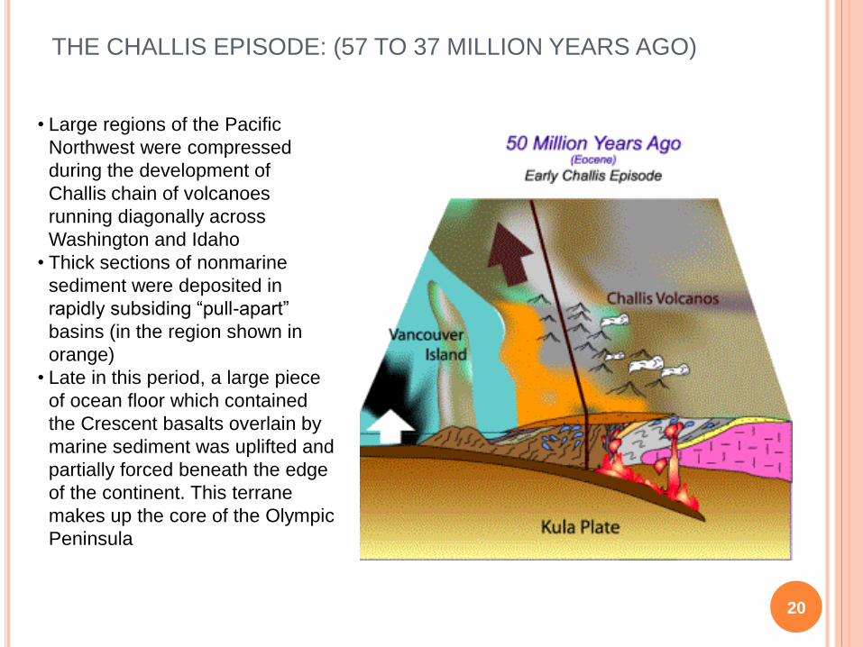
THE CHALLIS EPISODE: (57 TO 37 MILLION YEARS AGO)
20
• Large regions of the Pacific
Northwest were compressed
during the development of
Challis chain of volcanoes
running diagonally across
Washington and Idaho
• Thick sections of nonmarine
sediment were deposited in
rapidly subsiding “pull-apart”
basins (in the region shown in
orange)
• Late in this period, a large piece
of ocean floor which contained
the Crescent basalts overlain by
marine sediment was uplifted and
partially forced beneath the edge
of the continent. This terrane
makes up the core of the Olympic
Peninsula

THE CASCADE EPISODE: (37 MILLION YEARS AGO TO
PRESENT)
21
• The Cascade Episode began with a
remaining fragment of the Kula plate
(named the Juan de Fuca Plate)
subducting underneath the western
edge of the continent
• A new chain of plutonic bodies and
volcanoes were developed; the
Cascade Arc
• This ancestral Cascade mountain
arc formed in approximately the
same north-south location of our
present day Cascade range

THE GREAT ICE AGES OF THE PLEISTOCENE
22
• The past two million
years have seen
periodic episodes of
continental glaciation
• These continental
glaciers flowing down
from the mountains of
British Columbia picked
and a brought with
them large boulders
• When the glaciers
melted they dropped
these boulders, called
“erratics”
• Many of these erratics
were from the granitic
coastal mountains and
can be found on the
surface throughout the
Puget Sound lowlands
Generalized glacial flow direction
Glacial Ice Sheet Coverage about 12,000 years ago

GLOBAL PALEOGRAPHIC SETTING
23
Future
location of
Washington
State
COAST RANGE
EMPLACEMENT TIME
INDEX PLUTON
EMPLACEMENT TIME

MODERN ANALOGS
PRESENT DAY CASCADIA
24

ART
25
Tracy Powell
Sue Taves
Verena Schwippert
Pasha Stinson

ARCHITECTURE
26
Lion's Gate Bridge Footings Vancouver B.C. Vancouver Art Gallery carved lions
Washington State Capital, OlympiaSmith Tower, Seattle