the geology of goblin valley state parkfiles.geology.utah.gov/online/pdf/pi-65.pdf · ·...
24
the geology of goblin valley state park • • • • • • • • • • • • • • • • • • • • • • • • • • • • • • • • • • • • • • • • • • by mark milligan
Transcript of the geology of goblin valley state parkfiles.geology.utah.gov/online/pdf/pi-65.pdf · ·...

the geology ofgoblin valley state park
• • • •• • • • • • • • • • • • • • • • •
• • • •• • • • • • • • • • • • • • • • •
by mark milligan

The Utah Department of Natural Resources receives federal aid and prohibits discrimination on the basis of race,color, sex, age, national origin, or disability. For information or complaints regarding discrimination, contact Exec -utive Director, Utah Department of Natural Resources, 1594 West North Temple #3710, Box 145610, Salt LakeCity, UT 84116-5610 or Equal Employment Opportunity Commission, 1801 LStreet, NW, Washington DC 20507.
• • • •• • • • • • • • • • • • • • • • • •
S TATE OF UTA HDepartment of Natural ResourcesUTAH GEOLOGICALSURVEYIn cooperation with Division of Parks and Recreation
1 9 9 9Public Information Series 65
ISBN 1-55791-641-1
a c k n o w l e d g m e n t sThe Utah Division of Parks and Recreation provided funding for field expenses.Field re s e a rch for this booklet was done while I served on the Goblin Valley StatePark Resource Management Planning Team. During the planning process otherteam members contributed to the success of this publication.
Jayne Belnap, U.S. Geological Survey, Biological Resources Division, intro d u c e dme to the soils of the Colorado Plateau. Utah Geological Survey geologists SandyE l d redge and Christine Wilkerson provided helpful reviews of the original draftof this paper.
While previous geologic work specific to the area of Goblin Valley State Park hasbeen limited, numerous geologists have added to the understanding of this part ofthe Colorado Plateau. The listed re f e rences include only a few such contributors.
Cover photo: Goblin Valley by Mary Tullius, Utah State Parks and RecreationPhotographs by author except where noted.
Book design and layout by Vicky Clarke.Cartography by Jim Parker.
1594 West North Temple • P.O. Box 146100 • Salt Lake City, UT 84114-6100(801) 537-3300 • www.ugs.state.ut.us

The wonderfully grotesque stone sculptures that are Goblin ValleyState Park’s main attraction are the consequence of millions of years
of geologic history. Within the park are rocks composed of sedimentsfrom ancient seas, shorelines, river channels, and playas. With the pas-sage of time these layers of sand, silt, and clay became deeply buriedand transformed to rock. Much later, large-scale tectonic forces upliftedthe area and prompted erosion to begin to expose the deeply buried lay-ers of rock. Once the rocks were back on the surface, fractures and vari-ations in hardness within the rocks facilitated carving of the goblins bythe erosional power of water, wind, and frost.
1
Looking east from the main parking area, the light-colored Curtis Formationcaps the reddish-brown suite of rocks called the Entrada Sandstone. TheEntrada Sandstone is the preeminent rock unit in the park. Goblins form exclu-sively within it, and the campground and parking area are also built on Entradarocks and sediment.
the geology ofgoblin valley state park
• • • •• • • • • • • • • • • • • • • • ••
Understanding the rocks and structures of Goblin Valley State Parkrequires not only an investigation of past and present events that haveacted on a small scale within the park, but of past large-scale tectonicevents and processes. This booklet is intended to further your under-standing of the formation of the goblins, soils, and surrounding sceneryor “how they came to be.”
geologic s e t t i n g
Goblin Valley State Park lies within the Colorado Plateau physio-graphic province, an area of the earth’s crust that has experienced
broad, regional uplift. The Colorado Plateau encompasses southeasternUtah and parts of Colorado, Arizona, and New Mexico, and reaches ele-vations of more than 10,000 feet (3,000 meters) above sea level. Buttes,mesas, and deep, narrow canyons expose layer upon layer of nearlyundeformed, flat-lying beds of rock. These flat-lying rocks are generallysedimentary, meaning they are composed of weathered fragments ofolder rock that were transported, deposited in layers, and then consoli-dated into rock once again. The hows and whys of such a large area ris-ing to such heights with so little deformation are still somewhat a mys-tery. In any case, uplift of the Colorado Plateau seems to have begunwithin the past 10 million years. With uplift, the erosive power of watertook over to cut and sculpt theexquisite scenery of the plateau.
Within the Colorado Plateauexceptions can be found to thisrule of nearly flat-lying “layer-cake” geology. Excellent examplesof two different styles of deformedrocks can be seen from the park:the San Rafael Swell immediatelyto the northwest and the HenryMountains to the south.
Goblin Valley State Park lies withinthe Colorado Plateau physiographicprovince (green outline), an areacharacterized by broad regional upliftof layer upon layer of nearly flat-lyingsedimentary rock.
• • • •• • • • • • • • • • • • • • • • •
2
HenryMtns
AbajoMtns
UTAH
WYOMING
COLORADO
NEW MEXICO
ARIZONA
Color
ado
River
Gre
enRive
r
0 100 200
Miles
GoblinValley
San RafaelSwell
La SalMtns
San Juan River

3
san rafael s w e l l
Lying about one mile (1.6 km) northwest of the park entrance is alarge wrinkle in the earth’s crust, known as the San Rafael Swell.
Although originally horizontal, the rock layers that make up this struc-ture have been compressed into a convex-upward fold, with the older
Wild Horse Buttenear the park’sentrance, viewedfrom the west.Typical of the Col-orado Plateau,steep cliffs exposenearly flat-lyingbeds of sedimen-tary rock. Butteslike these are ero-sional islands ofonce-continuoushorizontal rocklayers.
True to the region-al pattern of flat-lying beds, gob-lins within thepark are formingin continuous,horizontal sand-stone bedsinterbedded withand underlain byhorizontally lay-ered siltstone andshale. Notice thegoblins forming inthis cliff face ofsuch rock layers.The apparentlyisolated goblins in the foreground were once part of the same, once-continuoushorizontal beds exposed in the cliff face.
• • • •• •• • • • • • • • • • • • • • •

4
rocks exposed in the center (see diagram). This fold is roughly 75 miles(120 km) long (extending northeast-southwest) and 30 miles (48 km)wide. Geologists label these types of structures anticlines. The limbs orsides of this anticline are not symmetric. As seen from Goblin ValleyState Park, the eastern limb, called the San Rafael Reef, is steeplyinclined to nearly vertical, in contrast with the more gently inclinedwestern limb. Alternating hard and soft rock layers dissected at nearlyright angles by washes account for some of the San Rafael Swell’s spec-tacular scenery
The San Rafael Swell has a complex history. It was probably originallyupwarped approximately 60 to 65 million years ago during theLaramide orogeny, a regional-scale mountain-building event that alsoformed Waterpocket Fold in Capitol Reef National Park to the south-west and the Uinta Mountains in northeastern Utah. Laramide moun-tain building presumably resulted from events that happened far to thewest. The earth’s outermost layer, or crust, is composed of individualplates that are in motion relative to one another. In the area that is nowcoastal California, two plates, the North American plate and the precur-
Diagrammatic illustration of the structure of the San Rafael Swell. Because theyhave been partially removed by erosion, the uppermost rock layers are nolonger continuous over the anticline.

sor to the Pacific plate, collided. This head-on collision created com-pressional forces far inland causing the crust to buckle and create fea-tures like the San Rafael Swell.
Following Laramide uplift, the top of the original San Rafael anticlinewas removed by erosion and may have been partially buried. It wasn’tuntil the entire Colorado Plateau was uplifted and the modern Col-orado River drainage system developed, that erosion re-exhumed thepreexisting structure of the San Rafael Swell.
h e n r y m o u n t a i n s
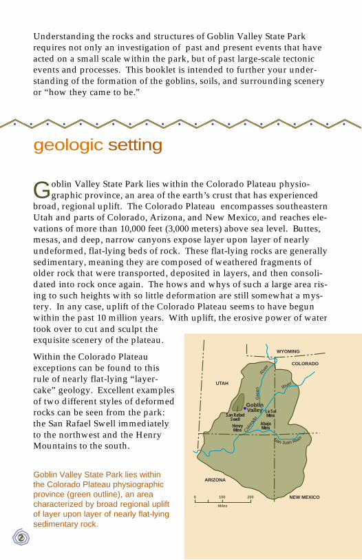
Another prominent skyline feature is the Henry Mountains, which lieto the south. In contrast to the layers of sedimentary rocks that
compose most of the Colorado Plateau, igneous rocks that cooled fromonce-rising magma form the heart of the Henry Mountains. The HenryMountains are similar to a volcano except that the rising magma cooledbefore it could reach the surface. The magma was injected through andbetween the sedimentary rock layers about 24 to 28 million years ago.Since the igneous rocks are more resistant to weathering than the sur-rounding sedimentary rocks, they stand out in relief as erosion lowersthe surrounding landscape. On a clear day, two more igneous intru-sions may be visible on the horizon, the La Sal Mountains to the eastand Abajo Mountains to the southeast.
5
As seen fromGoblin ValleyState Park, theSan Rafael Swellforms a ridgeagainst the sky-line. An exceptionto the flat-lyingrock layers orbeds found acrossthe ColoradoPlateau, the slopeseen from thisview is due to thesteep incline ofthe beds.
• • • •• •• • • • • • • • • • • • • • •
deposition of the park’s rock layers
To look at the rock layers in the park is to glimpse forces of naturethat occurred about 145 to 170 million years ago, during the middle
to latter part of the Jurassic Period on a geologic calendar. A lot haschanged in the past 170 million years; one alteration is the position ofthe earth’s continents. During the Middle to Late Jurassic, North Amer-ica and Eurasia were pulling apart from South America and Africa as
6
• • • •• • • • • • • • • • • • • • • • •
Mount Ellen, at the northern end of the Henry Mountains, is a prominent featureseen from Goblin Valley State Park. As shown in the illustration, Mount Ellen iscomposed of igneous rock bodies that include a stock (a cylindrical verticalintrusion) with branching offshoots called dikes (tabular intrusions injectedacross rock layers), sills (tabular intrusions injected parallel with rock layers),and laccoliths (dome-shaped sills).

part of the breakup of a supercon-tinent named Pangea. The areathat we now call Utah was closerto the equator at this time. Muchof eastern Utah was a dry Sahara-like desert, but shallow seas inter-mittently covered what is now thearea of Goblin Valley State Park.Northwestern Utah consisted ofgranitic highlands. The silts,sands, and clays that comprise therocks now exposed in Goblin Val-ley State Park were formed prima-rily from erosional debris shedfrom these highlands and rede-posited in seas, on shorelines, inriver channels, and on playas.
When attempting to unravel themysteries locked in rocks, geolo-gists find it useful to recognizeand name units of rock basedupon features that distinguishthem from overlying, underlying, and adjacent rock units. These fun-damental units are called formations. Four rock formations are exposedin Goblin Valley State Park. The lowest and oldest exposed formation,the one in which the goblins form, is the Entrada Sandstone. Above theEntrada lies the Curtis Formation, which is overlain by the Summervilleand Morrison Formations, respectively. To be formally named, a forma-tion must belarge enough tobe mappable.The four forma-tions exposed inthe park havebeen mappedacross south-eastern Utahand into sur-rounding areason the ColoradoPlateau. Forma-tions can becombined intogroups. The
Utah as it may have looked approxi-mately 170 million years ago (MiddleJurassic) during deposition of the gob-lin-forming Entrada Sandstone (fromStokes, 1986).
Wild Horse Butte exposes all four rock formations foundwithin Goblin Valley State Park.
7

8
lower three formations, Entrada, Curtis, and Summerville, belong to theSan Rafael Group. Two additional formations of the San Rafael Groupare exposed elsewhere, but remain buried beneath the surface in thepark. Below the San Rafael Group, a series of progressively older anddeeper formations continues far beneath the surface.
g o b l i n - f o r m i n g entrada sandstone
While formally named the Entrada “Sandstone,” shale, siltstone, andsandstone comprise this formation at Goblin Valley State Park.
Named from Entrada Point in the northern part of the San Rafael Swell,it is the same formation that erodes to arches, fins, and spires in ArchesNational Park and hoodoos in Cathedral Valley of Capitol Reef NationalPark. The Entrada in Cathedral Valley is similar to that of Goblin ValleyState Park, and consists of interbedded shale, siltstone, and sandstonedeposited on tidal flats. In Arches, however, sandstone, originallydeposited as sand dunes, dominates the Entrada. Hence this formationchanges laterally, much the same way modern landscapes change asyou drive acrosssouthern Utah.
Turn back theclock about 170million yearsand the area thatis now GoblinValley State Parkis a wide tidalflat between thesea to the northand continentalmountains andhills to the west.Oscillatorymotions of tideswere a dominantforce in the dep-osition of the
Found only within the reddish-brown Entrada Sandstone,goblins are composed of sandstone interbedded with andunderlain by shale and siltstone. Though now an erosion-al island, the beds that form this goblin were once laterallycontinuous. Below the goblin, bedding is masked by aveneer of soil, called colluvium.
• • • •• • • • • • • • • • • • • • • • •

9
interbedded sandstone, siltstone, and shale that now compose the gob-lins. Tidal channels migrated across the tidal flats, routing flowingwater to the open sea. Coastal sand dunes also covered parts of thetidal flats, an example of which is exposed in the rock along the road,just north of the park’s main parking area.
Similar to many rocks across the Colorado Plateau, the Entrada’s red-dish hue comes mainly from hematite staining. The mineral hematite isan iron oxide and the principal ore of iron. A nickel’s worth of iron willcolor a mountain red; in other words, it doesn’t take much iron to makea rock red. These rocks do not contain enough iron to be mined foriron ore.
This tidal channelin the EntradaSandstone wasproduced whenwater flowingtoward the opensea cut a channelthat later filledwith mud and silt.In this picturewater would havebeen flowingeither towards oraway from thecamera.
Careful observa-tion of some of theEntrada’s sand-stone beds revealsa structure calledherringbone cross-bedding. Noticehow the thin band-ing slants in oppo-site directions, leftnear the bottom,then right, thenleft. This iscaused by thealternating direc-tion of the incom-ing flood tide andoutgoing ebb tide.
tidal channel
0 2 inches

c u r t i s f o r m a t i o n
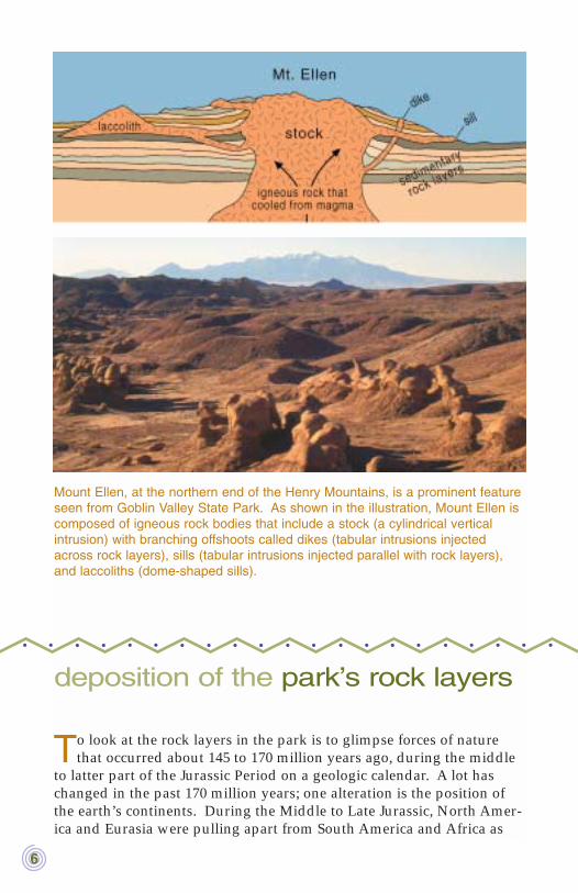
The Curtis Formation overlies the Entrada, forming the greenish-graycaprock on the buttes east of the parking area. This formation takes
its name from Curtis Point in the northern part of the San Rafael Swell.Fossils in locations outside the park show that the sandstone and silt-stone comprising the Curtis was deposited in an ancient (Late Jurassic)sea. The greenish color comes from minor amounts of glauconite, amineral that contains iron and forms in modern ocean sediments. Thepresence of glauconite in the Curtis Formation is significant because itfurther supports the idea that this rock unit was originally deposited inan ocean or sea. Another prominent feature of the Curtis Formationrock layers is the undulatory surfaces of small parallel ridges and hol-lows, called ripple marks. The type of ripple marks (see figure) dis-played in the Curtis suggests that at least parts of this area were once abeach of this ancient sea.
10
• • • •• • • • • • • • • • • • • • • • •
Found along theroad, just north ofthe park’s mainparking area, thisoutcrop displaysan interestinglayer within theEntrada Sand-stone. Linesformed by slightvariations in grainsize define indi-vidual beds ofsand. Thesebeds slope down-ward to the right.The single direc-tion and relativelylarge scale of this cross-bedding (vs. the cross-bedding in previous figure) sug-gests that this rock layer may have once been a shifting sand dune The day-pack is for scale.
A block of theCurtis Formationdisplays a surfaceof ripple marksfrozen in time.Note how someripple crests fork.The oscillatingaction of wavescreated thesebifurcating orbranching ripplemarks on thebeach of theancient CurtisSea. The block isapproximately 3feet (1 meter)long.
As seen in thiscliff face at theeastern edge ofthe park, theEntrada Sand-stone layers arenot perfectly par-allel with the over-lying Curtis For-mation. Some ofthe Entrada bedspinch out (disap-pear) against thebottom of the Cur-tis. This revealsthat the originallyhorizontal beds ofEntrada wereslightly uplifted,tilted, and planedoff by erosionbefore the CurtisSea encroachedupon the area.Called an uncon-formity, this ero-sional surfacemarks a gap inthe geologicrecord.
11

s u m m e r v i l l e f o r m a t i o n
In Late Jurassic time the deeper waters of the Curtis Sea retreatednorthward, and again the area took on the attributes of a seaside tidal
flat. The sediments preserved in these tidal flats are called the Sum-merville Formation. This formation gets its name from SummervillePoint in the northern part of the San Rafael Swell. Locally, the Sum-merville can be seen overlying the Curtis Formation on the highestbuttes at the north end of the park. It consists of distinctive, thin bedsof chocolate- to bone-colored shale, siltstone, and sandstone. Thin bedsand veinlets of gypsum found within the shale suggest a dry climatewhere ponded tidal water readily evaporated.
Surrounding WildHorse Butte nearthe park entrance,cliffs of the Sum-merville Formationexpose chocolate-to bone-coloredshale beds inter-layered with thin,whitish gypsumbeds.
• • • •• • • • • • • • • • • • • • • • •
12

13
m o r r i s o n f o r m a t i o n
Following deposition of the Summerville, this area experienced slightuplift and erosion. When deposition resumed, the seas had not
returned and exclusively continental conditions existed across the Col-orado Plateau. Floodplains or playas left behind varicolored mud-stones, and streams crossed the area depositing sandstones and con-glomerates in their channels. These deposits are called the MorrisonFormation, which takes its name from exposures near the town of Mor-rison in Jefferson County, Colorado. Within the park it is only found onthe top of Wild Horse Butte. The Morrison Formation is famous for thedinosaur bones found within it. No dinosaur bone discoveries havebeen reported on Wild Horse Butte, but they have been found just westof the park in this formation.
Just because the Morrison is the uppermost formation in the park doesnot mean deposition stopped after it was laid down. In fact, layer uponlayer of additional sediments deeply buried the four formations in thepark. These overlying formations have long since been removed by ero-sion in the park. However, some of these formations still exist outsidethe park and as many as eleven formations totaling thousands of feetoverlie the Morrison elsewhere.
Veinlets of gyp-sum form a lace-like pattern incliffs of the Sum-merville Formationaround WildHorse Butte.Beds of gypsumare also foundelsewhere in theSummerville.
• • • •• •• • • • • • • • • • • • • • •

Soon after deposition, the loose, uncemented sediments of the Morrisonand other formations found in the park began to change. Compactiondue to burial by the overlying layers, cementation by the growth of newminerals precipitated from circulating ground water, and a host of otherphysical and chemical processes converted the loose sediments into thesedimentary rocks found in the park today - a process called lithifica-tion.
weathering & erosion - sculptors ofthe goblins
After setting the geologic stage with deposition, burial, and lithifica-tion, what is left in the evolution of the Colorado Plateau and Gob-
lin Valley State Park? Weathering and erosion.
Erosion by definition includes both the decay and subsequent transportof rock and rock fragments. Weathering involves only the decay, notthe transport. Two types of processes act as the agents of weathering:chemical and physical. Chemical weathering attacks and decomposes
An area of goblins near the park’s southern boundary (view to the north).Notice the roughly north-south-trending set of vertical joints in the goblin-form-ing sandstone beds of the Entrada. Such fractures form planes of weakness.Intersecting frac-ture planes initial-ly form sharpedges and cor-ners that aremore susceptibleto attack byweathering.Called spheroidalweathering, thispreferentialbreakdown ofedges and cor-ners imparts aspherical shapeto the goblins.
• • • •• • • • • • • • • • • • • • • • •
14

rock through chemical reactions. Physical weathering disintegrates rockthrough mechanical processes such as abrasion by wind and water-borne sand and silt particles, and the expansions and contractions asso-ciated with temperature fluctuations and freeze-thaw cycles.
The various processes of weathering can go a long way in transformingsolid rock, but transport of the broken-down fragments is needed toexpose fresh rock and continue the process. Wind plays an importantrole in the removal process, but water is the workhorse of erosion.Water, however, needs the power of gravity to transport material.Therefore, topographic relief created by uplift of the affected rocks mustprecede erosion. In other words, water needs to flow downhill. As dis-cussed in the Geologic Setting section, the most recent uplift of the Col-orado Plateau began within the past 10 million years. With uplift, waterbegan to peel off layer after layer of overlying sediments and rocks untilthe Morrison, Summerville, Curtis, and Entrada Formations were even-tually exposed in Goblin Valley State Park.
In addition to exposing the Entrada Sandstone, weathering and erosionalso carve the individual goblins from this formation. Joint or fracturepatterns within the Entrada’s sandstone beds play an important role ingoblin development by creating initial zones of weakness. Unweath-ered joints intersect to form sharp edges and corners. These edges andcorners are more susceptible to weathering because they have a greatersurface-area-to-volume ratio than the faces. As a result, they weathermore quickly, producing spherical-shaped goblins through a processcalled spheroidal weathering. Spheroidal weathering helps shape the
15
This cliff faceshows progres-sive goblin devel-opment within theEntrada Sand-stone. In the cliffface in the lefthalf of the photo,continuous sand-stone beds dis-play fresh,unweathered ver-tical fracture orjoint patterns.These verticaljoints form zonesof weakness thatare more susceptible to attack by weathering. In the right half of the photo, cliffretreat and erosion along the joints leave rounded goblins standing out in relief.
16
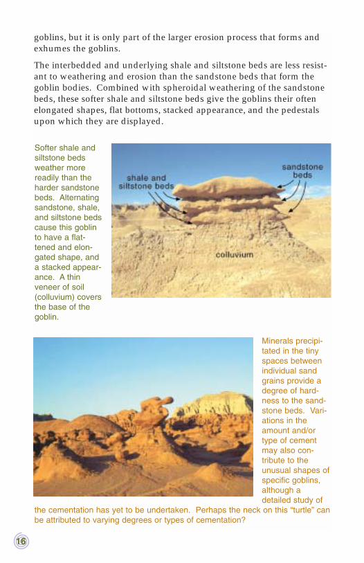
goblins, but it is only part of the larger erosion process that forms andexhumes the goblins.
The interbedded and underlying shale and siltstone beds are less resist-ant to weathering and erosion than the sandstone beds that form thegoblin bodies. Combined with spheroidal weathering of the sandstonebeds, these softer shale and siltstone beds give the goblins their oftenelongated shapes, flat bottoms, stacked appearance, and the pedestalsupon which they are displayed.
Minerals precipi-tated in the tinyspaces betweenindividual sandgrains provide adegree of hard-ness to the sand-stone beds. Vari-ations in theamount and/ortype of cementmay also con-tribute to theunusual shapes ofspecific goblins,although adetailed study of
the cementation has yet to be undertaken. Perhaps the neck on this “turtle” canbe attributed to varying degrees or types of cementation?
Softer shale andsiltstone bedsweather morereadily than theharder sandstonebeds. Alternatingsandstone, shale,and siltstone bedscause this goblinto have a flat-tened and elon-gated shape, anda stacked appear-ance. A thinveneer of soil(colluvium) coversthe base of thegoblin.
the dirt on top - q u a t e r n a r yd e p o s i t s
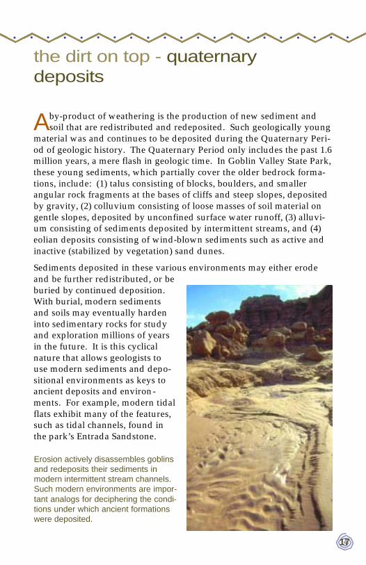
Aby-product of weathering is the production of new sediment andsoil that are redistributed and redeposited. Such geologically young
material was and continues to be deposited during the Quaternary Peri-od of geologic history. The Quaternary Period only includes the past 1.6million years, a mere flash in geologic time. In Goblin Valley State Park,these young sediments, which partially cover the older bedrock forma-tions, include: (1) talus consisting of blocks, boulders, and smallerangular rock fragments at the bases of cliffs and steep slopes, depositedby gravity, (2) colluvium consisting of loose masses of soil material ongentle slopes, deposited by unconfined surface water runoff, (3) alluvi-um consisting of sediments deposited by intermittent streams, and (4)eolian deposits consisting of wind-blown sediments such as active andinactive (stabilized by vegetation) sand dunes.
Sediments deposited in these various environments may either erodeand be further redistributed, or beburied by continued deposition.With burial, modern sedimentsand soils may eventually hardeninto sedimentary rocks for studyand exploration millions of yearsin the future. It is this cyclicalnature that allows geologists touse modern sediments and depo-sitional environments as keys toancient deposits and environ-ments. For example, modern tidalflats exhibit many of the features,such as tidal channels, found inthe park’s Entrada Sandstone.
Erosion actively disassembles goblinsand redeposits their sediments inmodern intermittent stream channels.Such modern environments are impor-tant analogs for deciphering the condi-tions under which ancient formationswere deposited.
• • • •• •• • • • • • • • • • • • • • •
17

18
In addition to being keys to the past, Quaternary deposits are funda-mental in identifying areas containing geologic hazards. Large talusblocks at the foot of a cliff are a reminder of the danger of rock falls.Many of the Entrada slopes are covered with a self-derived colluviumthat exhibits a "popcorn" texture indicative of unstable, expansive soils.(Expansive soils expand when wet and shrink while drying. Withoutproper building techniques, this instability can heave and crack founda-tions, road surfaces, sidewalks, and buried utilities and cause failure ofwastewater disposal systems.) Alluvium in normally dry stream chan-nels may serve as a warning of the potential for flooding. Sand dunesand other wind-blown deposits can be unstable. Even dunes stabilizedby vegetation can be disturbed and reactivated, leading to migrationover roads and other structures.
microbiotic & mechanical crusts
In many places, Quaternary deposits overlie bedrock formations. Inturn, microbiotic and mechanical crusts often cap Quaternary soils.
These crusts stabilize soil and affect infiltration of rainwater, seed ger-mination, and plant growth.
Soil covering thisslope is self-derived from theEntrada Sand-stone. The pop-corn-like textureindicates expan-sive soil thatshrinks andexpands with dry-ing and wettingcycles. Withoutproper buildingtechniques, theseunstable soils canheave and crackfoundations,roads, and sidewalks. Mechanical and microbiotic crusts (discussed next) forma thin but hard veneer on the top of this expansive soil. The darker areas onthe left are due to the presence of microbiotic crusts.
• • • •• • • • • • • • • • • • • • • • •

Mechanical crusts develop on theclay-rich soils derived from theEntrada Sandstone. These crustsare formed by a thin upper coat-ing of clay particles oriented paral-lel to the surface.
In contrast, microbiotic crusts areproduced by living organisms andtheir by-products that bind togeth-er soil particles at or very near thesurface. Many names (cryptogam-ic, cryptobiotic, microphytic, bio-logical) have been applied to avariety of these organic crusts thatare found throughout the world’sdeserts and semiarid grasslands,shrublands, and woodlands. Theexistence and type of microbioticcrust depends upon variables suchas soil texture,conductivity,pH, and mois-ture. The gener-al appearance ofmicrobiotic crustvaries widely,depending uponthe relativeabundance ofdifferent crust-forming organ-isms. Across theColoradoPlateau,cyanobacteriaare the mostabundant crust-forming organ-isms.
Cyanobacteriaare a group ofmicroscopicorganisms that
A web of filaments secreted by micro-scopic cyanobacteria and green algaecreate this microbiotic crust. Suchcrusts are found throughout the park.
In a microbiotic crust, a web of organic filaments binds soilparticles together, forming an interlocking network ofgrains. The filaments are composed of sticky sheathmaterial secreted around the cells of cyanobacteria andgreen algae. Magnification nearly 90x. Photo courtesyJayne Belnap, U. S. Geological Survey, BiologicalResources Division.
19
harvest the sun’s energy through photosynthesis. The cyanobacteria arenot alone, as they are commonly found with green algae (another groupof photosynthetic organisms). Mosses and lichen can also grow oncrusts already stabilized by cyanobacteria and green algae. In GoblinValley State Park, these well-developed crusts with abundant mossesand lichen can be found. However, cyanobacteria-dominated crusts(without mosses and lichen) are most common in the park.
Both microbiotic and mechanical crusts help stabilize soil. By stabiliz-ing soil, they may also help stabilize the goblins. With microbioticcrust, filamentous sheaths hold soil particles in place and directlyimprove resistance to wind and water erosion. Microbiotic crust mayalso increase infiltration of rainwater, help retain soil moisture, andencourage seed germination and growth of native plants. Similar tomicrobiotic crust, mechanical crust greatly enhances resistance to winderosion. However, mechanical crust is not nearly as resistant to erosionby water. Mechanical crust may also form an impermeable layer thatdecreases rainwater infiltration, further increasing runoff and down-stream erosion.
Foot traffic damages both microbiotic and mechanical crusts. A singlefootprint will break mechanical crust and the filaments that createmicrobiotic crusts. Repeated foot traffic can completely remove thisprotective layer. Once damaged, the erosive powers of wind areunleashed and soil particles easily blow away. The loss of microbioticcrusts increases the erosive power of water as well. Fortunately, dam-age done to crusts is reversible, though it can take a long time.
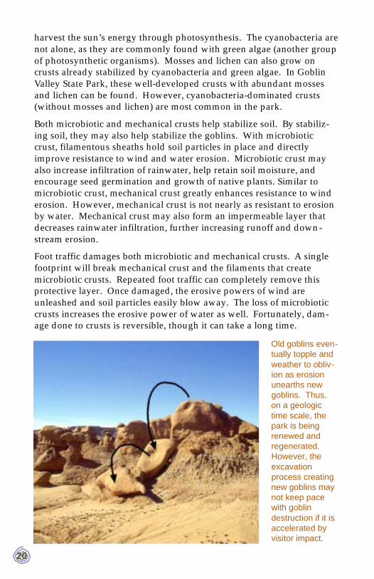
Old goblins even-tually topple andweather to obliv-ion as erosionunearths newgoblins. Thus,on a geologictime scale, thepark is beingrenewed andregenerated.However, theexcavationprocess creatingnew goblins maynot keep pacewith goblindestruction if it isaccelerated byvisitor impact.
20

21
The recovery time for mechanical versus microbiotic crust varies greatly.Mechanical crusts begin substantial recovery with the first intense rain-storm. Microbiotic crusts take much longer to recover. Cyanobacteriaand green algae secrete soil-binding sheaths only when wet, and there-fore need repeated wet periods to construct their crust-forming networkof filaments. Microbiotic crusts can begin to substantially recover in aslittle as one to five years, or may take more than 50 years, dependantupon crust type, soil type, climate, and extent of initial disturbance.These estimates are generalizations taken from other areas of the Col-orado Plateau; no detailed studies have yet been completed in GoblinValley State Park. The true extent of visitor impacts on soil stability,goblin formation, and the park’s ecosystems are subjects in need of fur-ther study.
r e f e r e n c e s
A selected list of references used to prepare this booklet.
Cooke, R.U., and Warren, Andrew, 1973, Geomorphology in deserts:Berkeley and Los Angeles, University of California Press, 374 p.
Doelling, H.H., 1985, Geology of Arches National Park: Utah Geologicaland Mineral Survey Map 74, scale 1:50,000, 15 p.
Hintze, L.R., 1988, Geologic history of Utah: Brigham Young UniversityGeology Studies Special Publication 7, 202 p.
Johnston, Roxanna, 1988, Introduction to microbiotic crusts: U.S.Department of Agriculture, 13 p.
Orkild, P.P., 1953, Photogeologic map of the Stinking Spring Creek-15,Emery County, Utah: U.S. Geological Survey Open-File Report53-209, scale 1:24,000.
Stokes, W.L., 1969, Scenes of the plateau lands and how they came to be:Salt Lake City, Publishers Press, 66 p.
— 1986, Geology of Utah: Utah Geological and Mineral Survey Miscel-laneous Publication S, 317 p.
Williams, P.L., and Hackman, R.J., 1971, Geology, structure, and urani-um deposits of the Salina quadrangle, Utah: U.S. GeologicalSurvey Miscellaneous Geologic Investigations Map I-591, scale1:250,000.
• • • •• •• • • • • • • • • • • • • • •

• • • •• • • • • • • • • • • • • • • • •
• • • •• • • • • • • • • • • • • • • • •
goblin valleystate park
Emery County, Utah
Geology modified from Orkid, 1953
Q
Je
Jc
Js
Jm
0 1 km
0 1 mi0.5
0.5
Quaternary deposits:wind-blown, stream-channel,and slope-wash sedimentsJurassic Morrison FormationJurassic Somerville FormationJurassic Curtis FormationJurassic Entrada Sandstone:goblins found exclusivelywithin this formationIntermittent streamRoad
Rangerresidence
Camp-ground
Parkingarea
WildHorseButte
Q
Q
Q
Q
Jc
Jc
Jc
Jc
Jc
Jc Je
Je Je
JeJs
Js
Js
Js
Js
Js
Jm
Jm
Jm
Js Je
Je
Je
Je
Jm
Jm
Js
Jm
Js
Js
Js
Js
Je Jc
Jc
Je
To Route 24
Jc
ToLittleWildhorseCanyon
Jc
MA
IN
GO
BL
IN
AR
EA
S