The Geology of Dampier Peninsula, Western Australia · · 2015-12-03Qf MINERAL RESOURCES,...
33
COMMONWEALTH OF AUSTRALIA DEPARTMENT OF; NATIONAL.. DEVELOPMENT S^&ttLs"-'BUREAU. Qf MINERAL RESOURCES, GEOLOGY. AND GEOPHYSICS : - //&> %• • • ' • • " . •" • " , ..'Report No, 13 THE GEOLOGY OF DAMPIER' PENINSULA, WESTERN AUSTRALIA BY R. 0. BRUNNSCHWEILER •RON-LENDING COPY NOT TO BE REMOVED FROM UBBARY Issued -under ^he Authority of Senator the Hon. W. H. Spooner, Minister for NotionalDevelopment 1957
Transcript of The Geology of Dampier Peninsula, Western Australia · · 2015-12-03Qf MINERAL RESOURCES,...
C O M M O N W E A L T H O F A U S T R A L I A
DEPARTMENT OF; NATIONAL.. DEVELOPMENT
S^&ttLs"-'BUREAU. Qf M I N E R A L R E S O U R C E S , GEOLOGY. AND GEOPHYSICS :-
//&> %• • • ' • • " . •" • "
, ..'Report No, 13
THE GEOLOGY OF D A M P I E R ' PENINSULA, WESTERN AUSTRALIA
BY
R. 0 . B R U N N S C H W E I L E R
•RON-LENDING COPY
NOT T O BE REMOVED
FROM U B B A R Y
Issued -under ^ h e Author i ty of Senator the H o n . W . H . Spooner,
Minister for No t i ona lDeve lopmen t
1957

. • " / -** • - /J' " . . / . <' - > -* / y - - r * . - - / - ^ _ -. .r ^ -,. - -
; -> / J ' . ; / L I S T O F REPORTS- / y ' ; y y - ' ; * 1 . Prel iminary .-Report on , the ^Geophysical Survey of t h e / C o I l i e C o a K B a s i n . — N . G .
Chdmberjain, 1948. , ~ : " / , / \ /~ \ ; ~ . ; / y \ > ; > . / f > ' , 2 . .Observations^ on Strat igraphy and Palaeontology o f y D e v o n i a n / W e s t e r n Portion * of
' Kimberley Division, Wes te rn , Aus t ra l i a .—C. Teieh'er iy I-94.9; - - '•; . . • >vV' r" - . ^ 3. ^Preliminary Report on Geology and Coal Resources 'of Oaklands-Coorabin Coa l f ie ld /
; Hew South W a l e s — E.'.K. Sturmfeis, 1950> ' ^ y-: -^['A , 4 . 'Ge5 logy of the /Ner r ima Dome, Kimberley Division; W e s t e r n Aus t ra l i a .—D. J . , G u p p y , / / J V , 0 : £uthber t and ' A . W . Lindner, 1950..%t''/y\. -\ •:
~5: Observations of Terrestr ial Magnet ism a t H e a r d / Kerguelen * and Macquar ie Islands, . 1947-1948 / (carr ied ouf in co-operaHopVwith the Aust ra l ian ' .Nat iona l Antarct ic
. Research /Exped i t ion , ) 9 4 7 - 1 9 4 8 ) . — ^ t ^ G . . Chamberlain^ 1952^ - . N: ~ - ' 6.-Geology- o f ; N e w Occ identa l , New Cobar and Chesney M ines , Cobar, New South
, ; : V V a l e s . - ^ C J , Su l l i van, J 9 5 1 . . , , 7 . . . : ' * t - ^
7:. Moun t 'Chalmers Copper a n d r o i d - M i n e , Queensland . ~ N . H . Fisher and H ; B. O w e n , :
• 1952. • :, C 7^7" /';" t • / • /^ ; . " ;• 8. Geological and"Geophys ica l Surveys, Ashfond^Cbal . F ie ld, Ne\v South Wale's*—-+1 B.
Owen, G . - M ^ p u r t o n and L / W . W i H i a m s / I 9 5 4 ! f r \ ' ^ 'y-'/*. ;: : .* 9. T h e Minera l Deposits and Min ing Industry, o f / P a p u a - N e w G_uineaf— P. B. N y e and
N . H . Fisher, 1954. 7 " / " ; ; ' '*"-'-,"7 7 ^ 10. Geordgical Reconnaissance o f -Sou th -Wes te rn Portion of" Nor thern Terri tory.-—G. F.
>Jpkiik, 1952.^ \ . ; - , / ^ : y 1 I . ; T h e ^ N e l s o n Bore, South -Western V ic tor ia : Mjcropalaebntplogy and Strat igraphical
- . .Succession.—-L-Crespin, M 9 5 ^ . \ [ v >
1 2 . Strat igraphy and Micropalaeontology of the Mar ine Ter t iary Rocks between Adela ide r ; : * - ' / / ' and Aldinga,, South Aus t ra l i a .—I . Crespiri, 1954.
;'l 3 ; T h e Geology of Dqmpier Peninsular, Wes te rn Aust ra l ia .— : R, O. Brunnschweiler, 1957.

C O M M O N W E A L T H O F A U S T R A L I A
D E P A R T M E N T O F N A T I O N A L D E V E L O P M E N T
B U R E A U OF M I N E R A L R E S O U R C E S , G E O L O G Y A N D G E O P H Y S I C S
Report No. 13
THE GEOLOGY OF DAMPIER PENINSULA, WESTERN AUSTRALIA
R. 0 . B R U N N S C H W E I L E R
Issued under the Authority of Senator the H o n . W . H . Spooner, Minister for Nat iona l Development
1957

COMMONWEALTH OF AUSTRALIA
D E P A R T M E N T O F N A T I O N A L D E V E L O P M E N T
Minister: SENATOR THE HON. W . H . SPOONER, M . M .
Secretary: H . . G . RAGGATT, C . B : E .
B U R E A U O F M I N E R A L R E S O U R C E S , G E O L O G Y A N D G E O P H Y S I C S
Director: P . B . NYE, O . B . E .
Deputy Director: J . M . RAYNER
This Report was prepared in the Geological Section
Chief Geologist: N . H. FlSHER

C O N T E N T S .
P A G E .
S U M M A R Y . . . . . . . . . . . . . . 1
I N T R O D U C T I O N . . . . . . 2
P H Y S I O G R A P H Y . . . . . . . . . . . . 2
Relief . . . . . . . . . . . . 2
Drainage .. .. .. .. .. .. .. .. .. 4 S T R A T I G R A P H Y . . . . . . . . . . 4
P R E C A M B R I A N . . . . . . . . . . . . . . . . 4
TRIASSIC . . . . . . . . . . . . . . . . . . &
J U R A S S I C . . . . . . . . . . . . . . . . . . 5
CRETACEOUS . . . . . . . . . . . . . . . . . . 7
T E R T I A R Y . . . . . . . . . . . . . . . . . . 1 0
Q U A T E R N A R Y . . . . . . . . . . . . . . . . . . 1 1
S T R U C T U R A L G E O L O G Y . . . . . . . . . . 1 4
G E O L O G I C A L H I S T O R Y . . . . . . . . . . . . . . 1 4
E C O N O M I C G E O L O G Y . . . . . . . . . . . . . . . . 16-
A C K N O W L E D G M E N T S . . . . . . . . . . . . . . 1 6
R E F E R E N C E S . . . . . . . . . . . . . . . . 1 7
ILLUSTRATIONS (at back of Report,)
P L A T E 1—
Fig. 1.—Precambrian quartzite and quartz-mica schist in overturned eastern flank of synclinal crossfold. Sunday Island.
Fig. 2.—Gently crossbedded Jowlaenga Sandstone with local depositional dip. Shenton Bluffy north-east coast.
P L A T E 2 —
Fig. 1.—Worm(?) tracks in Jowlaenga Sandstone. Malumbo Anchorage, north-east coast. Fig. 2.—Fraser River Basin ; view north across " Pin dan " bush.
P L A T E 3 —
Fig. 1.—Melligo Quartzite, buckled and fractured by swelling in underlying Jowlaenga Sandstone-Malumbo Anchorage.
Fig. 2.-r-Broome Sandstone. Gantheaume Point, near Broome. P L A T E 4 —
Fig. 1.—Broome Sandstone. Red Bluff.
Fig. 2.—Pender Bay Conglomerate overlying Broome Sandstone.
P L A T E 5 — Fig. 1.—Emeriau Sandstone. Carnot Peak. Fig. 2.—Jowlaenga Sandstone, overlain by rubble regolith, pisolitic limonite, etc. Cunningham
Point. P L A T E 6 —
Fig. 1.—Borda Sandstone, with basal layers from underlying Pender Bay Conglomerate. Cape-Borda.
Fig. 2.—Emeriau Sandstone overlying Broome Sandstone. Between Bell Point and Chimney-Rocks, Pender Bay.
P L A T E 7 —
Geological Map of Dampier Peninsula and Adjacent Islands.
T A B L E 1.—Schematic Summary of Stratigraphy—opposite page 4 . T A B L E 2.—Marine Transgressions in Western and Northern Australia during Mesozoic and Tertiary—
opposite page 1 5 .

S U M M A R Y
The oldest beds of the flat-lying sedimentary rocks exposed on Dampier Peninsula consist of late Jurassic marine shale, limestone, and glauconitic siltstone. These are overlain, probably conformably, by a sequence of early Cretaceous marine sandstone and siltstone. Middle Cretaceous (Aptian) quartzite overlies this sequence dis-conformably; the Aptian transgression of the sea was limited to the central and north-eastern parts of the Peninsula.
On the islands of the Buccaneer Archipelago just off the north-eastern tip of the Peninsula, the Aptian quartzites overlap steeply folded Precambrian rocks, whereas to the south-east, along and just across the Fitzroy River, late Jurassic beds overlap Upper Triassic and Permian formations.
The- marine fossils found in the late Jurassic and early Cretaceous formations are closely related to those of New Zealand (Kawhia Harbour), Eastern Queensland (Valanginian of Stanwell), the Lesser Moluccas (Misol), and the Himalaya (Spiti, Giumal). The Triassic and the Aptian assemblages are small, but they contain sufficiently characteristic species for an approximate age determination.
Post-Mesozoic sediments have been deposited on an uneven erosional surface, in places rather deeply dissected, of Cretaceous and earlier rocks. There are fluviatile conglomerate and sandstone, rubbly regolith, pisolitic limonite, fossil soil horizons, fixed dunes of varying age, coastal aeolianites and - along the west coast only - emerged oolite and beach-rock deposits. The fluviatile beds are of Tertiary age; the other terrestrial sediments and all except one of the emerged marine deposits have been formed during Pleistocene and e'arly Recent times. The youngest marine sediments are the contemporary and Recent beach-rocks along the present coast.
Considerable shifting of coast-lines and river courses during Tertiary and Quarternary times was brought a,bout by combined action of eustatic changes in sea-level and regional warping.
Petroleum prospects in the area are not unfavourable. Both Palaeozoic and Mesozoic subsurface formations contain possible source, reservoir, and cap rocks and there is evidence for both stratigraphical and structural traps. However, full assessment of the various possibilities requires more detailed geological and geophysical work.
6O38 /56 - V
I N T R O D U C T I O N
Geological mapping in north-western Australia by the Commonwealth Bureau of Mineral Resources, Geology and Geophysics, the Western Australian Geological Survey, and private organisations has in the last few years added considerably to the knowledge of the extent and nature of sedimentary deposits adjacent to and upon the West Australian shield areas. The sequence exposed is, in places, of considerable thickness, and almost every System from late Precambrian to Recent time is represented.
The writer has recently described the main outlines of the Mesozoic geology of large areas that lie to the sotithj and south-east of Dampier Peninsula (Brunnschweiler, 1954) . The present report should have been a forerunner to that paper, but unavoidable circumstances have delayed its appearance. It was written in 1952 and incorporates the work done by D.J. Guppy, A.W. Lindner, and the author (of the Bureau of Mineral Resources) in 1948/49 and by Hampton Smith, Consulting Geologist for Ampol Petroleum Ltd., and the author in 1950. This report supplements preliminary papers (Brunnschweiler, 1951 a, 1951b) and has recently been brought up to date to bring it into line with later 4iseoveries in adjacent areas (Brunnschweiler, 1954) .
The purpose of the surveys was to investigate the stratigraphy, the structure, and the oil possibilities of the Mesozoic sediments in Dampier Peninsula. Apart from superficial observations on a few outcrops near Broome, Derby, and Point Torment (18 miles north of Derby), and some records of water bores in the same areas, nothing was. known about the geology of the Peninsula.
The Peninsula had not been explored by geologists until 1947/48, when Dr. P. Reeves, Consulting Geologist for Vacuum Oil Pty. Ltd., made a reconnaissance trip through the Fraser River area. In 1948 D.J. Guppy and A.W. Lindner of the Bureau of Mineral Resources spent six weeks in the area. They visited Mt. Clarkson and other mesas south of the Eraser River* and a number of coastal localities, \including Cape Leveque and the north-east coast. They also traversed the western part of the Buccaneer Archipelago. The results of these first two reconnaissances were contained in two unpublished reports (Reeves, 1949; Guppy and Lindner, 1949) and a paper by Reeves (1951), but it was felt that further work was desirable.
In September 1949, the author accompanied Messrs. Guppy and Lindner on a trip which, unfortunately, was interrupted by the breakdown of a vehicle shortly after the start. Only the country near the mouth of the Fitzroy River, around Mt. Clarkson and Stony Ridge, had by then been thoroughly investigated. In 1950 the author accompanied Mr. Hampton Smith on an expedition which covered the whole length of the coastline from Broome round Cape Leveque to Derby, as well as the western islands of the Buccaneer Archipelago. The central and northern Praser River basin was also visited. The country to the south and south-west of the Praser River as well as Mt. Clarkson and Stony Ridge were omitted from the programme: sufficient information had previously been obtained from these localities.
The party was equipped with one Dodge "weapon-carrier" and one Ford "Blitz" truck, both four-wheel-drive vehicles. The Ford, however, could only be used on established tracks. Trips across country or on poor side tracks are possible only with vehicles such as the jeep and weapon-carrier. Beagle B»y Mission and Lombadina Mission were used as bases for the traverses of the west coast, which had to be done on foot. The coast between Skeleton Point and Swan Point was traversed on foot, but the remainder of the east coast and thejwestern Buccaneer Archipelago were explored in the Sunday Island Mission lugger, landing in a dinghy whenever necessary. D.J. Guppy also . took part in this boat trip.
Vertical aerial photographs (scale approximately 1:48,000), and an aerial photographic mosaic (4 miles to 1 inch) prepared by the National Mapping Section, Department of Interior, covered the area completely. The mosaic served as a topographical base for the geological map which accompanies this report.
P H Y S I O G R A P H Y Relief
Dampier Peninsula (Lat. 16°10! to 18° S, Long. 122O10f to 123°30 f E) is part of the northern marginal area of the Desert or Canning Basin of north-western Australia. Its outline is roughly triangular, about 100 miles along each side.
Except for two estuarine embayments on the west coast (Beagle Bay and Pender Bay) and some minor rias along the north-eastern shore-line, the Peninsula at first sight appears to be little dissected. However, despite the very low relief, it is divisible into three major physiographical units: the small (northern) Lombadina Plateau is separated from the large (southern) Dampier Plateau by the valiey-like Pender Bay Depression.
The Lombadina Plateau The Lombadina Plateau includes part of the western Buccaneer Archipelago (Jackson, Apex and Tallon
Islands), Swan Island and Leveque Island, and the northern part of the Peninsula. Its southern margin is marked by a gentle escarpment, which has been traced on aerial photographs from near Cape Borda and the north side of Pender Bay in a south-easterly direction towards Cornambie Point on the east coast. Within a broad belt along the east coast the topography of the plateau is largely controlled bv lithology. It has been formed on hard Cretaceous quartzite (Melligo Quartzite) as a gently undulating stripped pl'ajin with an average altitude of about 100 feet. The highest elevation in the Lombadina Plateau, about 200 feet at Cape Leveque, is found outside the area of outcrop of the hard quartzite. This exceptional elevation is due to a late Pleistocene dune, some 100 feet high, which overlies the Cretaceous sandstones.
- 3 -
<038 - 2
Along the west coast, south of Cape Leveque, the absence (by non-deposition) of the hard quartzite has resulted in gently westward-sloping erosional surfaces, which are covered by Quaternary dunes, fossil red soils, and remnants of emerged beach-rocks. The western shoreline in general, with its cliffed, w?ve-cut headlands, and its array of spits and wide curving beaches, suggests a compound coast in a fairly youthful stage of revival, involving slight Recent emergence after a very general submergence.
Perpendicular cliffs interrupted by small pocket beaches and inlets are the main features along the rugged east coast of the Lombadina Plateau. Crenulation of the peninsular coast-line and rias in the Buccaneer Archipelago are very youthful characters, which might suggest that the submergence of the King Sound area was either later or deeper than that of the west coast. Such an interpretation seems to be borne out also by the fact that the east coast has no bars or spits like the west coast. The array of sand bars, spits, and beaches on the west coast is largely due to its exposure to currents and winds of the open ocean, whereas King Sound is a comparatively sheltered area.
The rocky channels between the Peninsula and the islands, as well as between the islands themselves, are very shallow, although considerable scouring is caused by the extremely powerful tidal currents that race in and out of King Sound. Coral colonies do not grow as well here as on the west coast, not so much perhaps because of these strong currents or a more youthful submergence of the area as of the high mud content of the King Sound waters during the wet season when the Fitzroy River is in flood.
The Pender Bay Depression The shallow Pender Bay Depression extends as a wide valley from Pender Bay on the west coast, in a south
easterly direction across the Peninsula to Disaster Bay and Valentine Island on the east coast. It marks an ancient Tertiary river course, now occupied only by a minor creek which flows towards Pender Bay (Kelk Creek.) The depression is about 10 miles wide, and it meets the plateaux to the north and south in gentle escarpments. The axis of the depression is well marked by a series of pools and shallow lakes, which contain water only if good rain has fallen during the wet season. The low country along the bottom of the valley rises little above sea level, and the depression as a whole slopes very gently to the north-west, where it merges into the Pender Bay estuary.
The Dampier Plateau From the southern escarpment of the Pender Bay Depression the country rises gently towards the south to a
large plateau, which h 8 S a maximum altitude of about 200 feet in the upper Fraser River area, and extends over most of the central and southern interior of the Peninsula. From these inland altitudes the plateau slopes away almost imperceptibly to the west, south, and south-east. It reaches the west coast at Emeriau Point (Pender Bpy), Red Bluff (west of Carnot Peak), James Price Point (35 miles north of Broome), and Gentheaimie Point (Broome), and forms at all these localities cliffs and wave-cut headlands which rise from 50 to 80 feet above sea level.
This southern plateau, here called the Dampier Plateau, unlike the northern, is not lithologically controlled: it is not a stripped plain. The hard quartzite has been removed almost completely and the plateau surface is of soft Cretaceous sandstone (jowlaenga Sandstone and Broome Sandstone). The quartzite is preserved only on top of a number of small mesas and buttes in and around the Fraser River drainage area. The highest of these mesas, Mt. Jowlaenga, is the highest point on the Peninsula, 460 feet above sea level. The other mesas, e.g. North Cliffs, Mt. Raible, Mt. Mammoth, Reeves Hill, Dampier Hill, and Mt. Clarkson, are between 350 and 420 feet high; the Stony Ridge on the southward slope of the Dampier Plateau does not exceed 230 feet. The buttes near the west coast between Carnot and Beagle Bays, e.g. King Peaks, rise to not more than 160 feet, but they are oarved out of hard sandstone which is much younger than that forming the inland mesas. The central and southern portion of the plateau was probably developed as a stripped plain in an earlier cycle. Evidence of this earlier plateau is found in the inland mesas with their uniform quartzite capping (Melligo Quartzite); quartzite almost certainly existed formerly as a continuous sheet which has subsequently been almost completely removed by erosion.
Although the Dampier Plateau is treated here as one geomorphological unit, it is somewhat dissected at the edges, especially on the west coast. The most prominent of these low areas is Beagle Bay, an estuary similar to Pender Bay. There is some evidence that the Beagle Bay depression may also have its origin in a Tertiary river valley, but proof is not so easily obtained as for the Pender Bay Depression.
Another and rather exceptionally wide marginal gap in the Dampier Plateau opens between Cape Baskerville and Coulomb Point. It is really a small coastal plain, rather than an estuary like Beagle Bay; it is about 12 miles wide and appears to be in a fairly mature stage of development. Farther to the south, between Broome and Stony Ridge, there is another and larger coastal plain that is .known as Roebuck Plains; it probably represents another and very large Tertiary river estuary, possibly of the Fitzroy River.
In comparison with the western areas, the eastern margin of the Dampier Plateau is fairly continuous and more or less straight. Although there is no escarpment it is bounded rather abruptly by the lar^e coastal plain formed by the present Fitzroy River.
The only important feature within the eastern half of the Dampier Pl?teau is the comparatively high relief produced by the erosion of the Fraser River drainage area. This river has reached its present bed by cutting through the plateau in two steps. In the lower reaches of the system, a few miles upstream from the inner margin {
of the coastal plain, the present river and creek beds are cut 5-7 feet into almost flat-bottomed valleys. The , floor of these valleys consists of Upper Jurassic limestone, which bears a thin and patchy crust of limonite mixed with loose alluvial gravel. Over a low and gently inclined valley side, which is the older erosion escarpment, the valley grades into the Dampier"Plateau.

- 4 -
The morphological features in the Praser River drainage show that erosion in the Dampier Plateau has been renewed fairly recently; and the deposition of alluvial gravel well up in the valley indicates that the rejuvenation was preceded by a period with a higher erosion base. These relative movements of the erosion base are in accordance with the changes of sea level already mentioned (Lombadina Plateau). - - -
Drainage As could be expected from the low relief, there are very few well-defined watercourses on the Peninsula.
Even these flow only during the wet season between December and April. After the rains have ceased pools remain for a time, but, with few exceptions, they eventually dry out.
The principal drainage system is directed eastwards into King Sound. It consists of the Fraser and the Logue Rivers, which drain the central and southern portions - the most elevated areas - of the Dampier Plateau. * The gradient of this system is about 4 feet to the mile.
The name Fraser River covers two independent creek systems which debouch into the same estuary. The larger, northern, system has its upper reaches between North Cliffs, Mt. Mammoth, and Reeves Hill, in the heart of the Peninsula; the smaller, southern, system drains the area between Reeves Hill and Mt. Clarkson, and adjoins the drainage system of the Logue. River, which has its upper reaches in the country around and to the east of Stony Ridge. •
All the other eastward-flowing streams are of minor importance and consist of short creeks, which drain the immediate vicinity of estuarine embayments or small inlets such as the estuaries opposite Valentine Island, Chattur Bay, Goodenough Bay and Cygnet Bay. Melligo Creek, which flows into Cygnet Bay, is the only one of these minor streams to bear a name.
Drainage to the west has a very low gradient and appears to be more mature than the eastward drainage. The largest of the westward-flowing systems is that of Deep Creek, the dendritic pattern of which covers the south-western region of the Peninsula between Roebuck and Stony Ridge. Another fairly extensive dendritic system drains the coastal plain between Cape Baskerville and Coulomb Point. Farther north there are only two more watercourses of any importance, Beagle Creek and Kelk Creek, which flow into Beagle Bay and Pender Bay respectively. Kelk Creek drains the western end of the Pender Bay Depression, but it does not reach sufficiently far into the depression to tap the series of pools and lakes farther to the south-east. Beagle Creek has its upper reaches in the Lake Louisa area north of Mt. Mammoth. Its general drainage-direction is at first north; it is then diverted into a gentle east-west depression leading to the Beagle Bay estuary.
Climate The area has a quasi-monsoonal climate. During the wet season (north-west monsoon), which usually sets in
at the beginning of December and ends in April, 20 to 25 inches of rain fall. The rainfall during the seven dry months totals only 3-4 inches. The driest months are September and October.
During the wet season, both days and nights are hot and humid with temperatures ranging usually between 80 and 95 . During the "dry", the period of the south-east trade winds, temperatures range from about 95 in the daytime to 50 at night; the Beagle Bay Mission experiences occasional frosts on the grass, although it is only about 20 feet above sea level and 10 miles from the bay.
S T R A T I G R A P H Y
P R E C A M B R I A N
Precambrian rocks are not exposed on the Peninsula itself, but they outcrop in the Sunday Island Group of the Buccaneer Archipelago off the north-east coast. Their sequence has not been examined in detail and they are only superficially described in this report.
The entire Precambrian sequence, which strikes approximately east-west, is strongly folded, and shows steep north and south dips ranging from 70 to vertical. The major tectonic feature within the western portion of the Buccaneer Archipelago is found between Sunday Island and Tallon Island. It is a steeply plunging synclinal crossfold that is slightly overturned on its southern flank. The geomorphological features of the two islands are controlled by this prominent synclinal structure, as can be seen by the ring-shaped arrangement of the two islands and the arcuate outlines of Tallon and Sunday Island, which are situated, Tallon Island on the western and Sunday Island on the eastern closure of the structure.
The most common Precambrian rock types are coarse mica-tourmaline quartzite, granitic orthogneiss, and quartzose mica-schist, in part comparable to those described by Edwards (1938) from Yampi Sound.
On the small islands to the west of the synclinal structure, e.g. on Jackson Island and Apex Island, a rather unusual quartzite is exposed. Its relationship to the rest of the Precambrian sequence is as yet not known in detail, but aerial photographs indicate that it is a conformable member of that sequence.
Macroscopically the quartzite is medium-grained to very coarse-grained and apparently, entirely re-crystallized. Thin sections show a mosaic of closely interlocked quartz grains, cemented by enlargement. Some of the grains seem to possess an extremely thin marginal fringe.of micaceous material, put there is no other interstitial matter. The peculiar feature of this quartzite is the parallel alignment of accessory idiomorphic minerals such as muscovite, zircon, tourmaline, anatase, and possibly kyanite. These accessories occur as small inclusions in the quartz grains as well as across the grain sutures, i.e. they are independent of the texture of the ground-
T A B L E 1
D A M P I E R P E N I N S U L A N O R T H - W E S T E R N A U S T R A L I A
S C H E M A T I C S U M M A R Y O F S T R A T I G R A P H Y
S U R F A C E ( O U T C R O P )
S U B S U R F A C E
INFERRED
M A R I N E Soutti-West Coastal Area
(Broome to Carnot Bay) Central West Coast
(CarnotBay,Beagle Bay) North-West Coastal Area (Pender Bay to C Leveque)
Central and Southern Inland
Cent ra l East Coast (Fraser R.to Cygnet Bay)
North-East Coastal Area (Cygnet Bay to Swan P I )
Western Buccaneer Arch ipe lago
Y e e d a Area (Fitzroy River delta)
TERRESTRIAL P e n i n s u l a in genera l
QUATERNARY
TERTIARY
CRETACEOUS
Late-RecenLContemporary
Mid-Recent
B E A C H R O C K B E A C H — R O C K
S I L T & S A N D IN T I D A L F L A T S ^ NORTH HEAD LIMESTONE S I L T 6, S A N D IN T I D A L F L A T S
S I L T *. S A N D
( D E L T A )
Late-Recent,Contemporary
Mid-Recent
Early Recent Early Recent
WLirm Arid Cycle
Riss-WLirm p|Uvia| Cycle C H I M N E Y R O C K O O L I T E .
WUrm Arid Cycle
Riss-Wiirm Pluvial Cycle
Riss Great Arid Cycle
Early mid-Pleistocene
Riss Great Arid Cycle
Early mid-Pleistocene
COASTAL A E O L I A N I T E S
R E D S O I L S
E A S T - W E S T D U N E S
R E D S O I L S
Early Pleistocene Early Pleistocene
Miocene & Pliocene O O O O O O O O O
Palaeocene to 0! igocene AlbiantoDanian
B O R D A S A N D S T O N E :
E M E R I A U S A N D S T O N E / PENDER BAY C0W6L0MEMTE, |
0 0 0 0 0 0 0 0 0 0 0 0 0 0 0 0 0 0 0 0 0 0 0 0 * 0 0 0 0 0 0 0 0 LATERITIZATION PERIOD I O O O O O O O O O O O O O O O O O O O O O O O O O O O O O O O O O O O LATERITIZATION PERIOD E O O O O O O O O O E O O O O O O O
Miocene ..Pliocene
Palaeocene toOligocene O O O O O O O O O
o 0 0 o 0 9
Aptian
Barremian (?) L E V E Q U E SANDSTONE
Hauterivian
M E L L I G O Q U A R T Z I T E
fTEICHERT,BM,WZ)y

-5-
mass quartz mosaic. The latter shows only moderate stress texture in the direction parallel to the alignment of the the accessories. This particular type of quartzite has been described here in some detail because it is referred to when the derivation of the overlying Mesozoic clastic rocks is discussed.
M E S O Z O I C
TRIASSIC Blina Shale (Reeves, 1951)
Eight miles from Yeeda Station on the road to Fitzroy Crossing a small outcrop of red to yellow-brown soft micaceous shale is found (Lat. 17 17'30" S; Long. 123 46' E). This shale was originally called "Wonjil Shale" (Brunnschweiler, 1953)> hut it was proved to belong to the formation which Reeves (1951) named Blina Shale.
The outcrop has been quarried for road gravel and provides a good fossil locality. It was on the evidence of the small fauna collected here that the presence of Triassic beds in the Fitzroy Basin was first established (Brunnschweiler, 1953)* The following assemblage was collected (depth of outcrop not more than 5 feet):
Lingula n.sp. a. (suhcircular outline) Lingula n.sp. _b (elongate oval outline) Isaura cf. I. minuta (Goldfuss) Isaura cf. I. ipsviciensis (Mitchell) Palaeoniscidae (scales, vertebrae)
The two new Lingula species are likely to be of little diagnostic value, but both are different (very much smaller) from the Lingula species found in the Lower Permian Quinnanie Shsle (formerly Lingula Beds) of the Carnarvon Basin (Teichert, 1950).and those from the Alexander Formation (Upper Jurassic) in the Canning Desert (Brunnschweiler, 1954). The fish scales are very similar to those of the palaeoniscid genera Myriolepis and Aoateolepis. and the catopterid genus Brookvalia. which are found in the Triassic of New South Wales; but the best indication of the Triassic age of this shale is the presence in great numbers of the conchostracons Ispura cf. I. minuta and _I. cf. I. ipsviciensis. These are forms of Triassic age, which are, in New South Wales, also associated with the fish genera mentioned.
A. Wade (1924, 1937) and other earlier investigators have included the shales near Wonjil Bore in the Permian ("Upper Ferruginous" or Liveringa Beds), whereas Reeves (1949, 1951) regarded them as Jurassic and incorporated them in his "Derby Beds".
At Wonjil Bore (Lat. 17°40' S; Long. 123°43' E) shales are mentioned in the bore log from 30 feet to 5*0 feet below surface, but how much of this shale sequence is of Triassic age cannot be ascertained. The underlying Liveringa Formation of the Permian also includes shale beds.
Teichert (1950) mentions shales with Lingula and "Estheria" from a depth of 1012 feet below surface in Myall's Bore near Derby (23 miles north of Wonjil Bore). He thought that they overlay the Kimmeridgian "Buchia Beds", though the latter are recorded from a depth of less than 400 feet below the surface in the Yeeda Station Bore (5 miles north-west of Wonjil Bore). On the evidence then available the writer has previously (Brunnschweiler. 1951a) accepted Teichert's concept. However, if one considers the near horizontal dispositions of the formations it appears certain that the shales with Lingula and "Estheria" in Myall's Bore are to be correlated with the Blina Shale in the Wonjil area and therefore underlie the "Buchia Beds."
The presence of a near-shore marine facies suggests that a Triassic epicontinental sea may once have covered a considerable portion of the Canning Basin area. Whether it will be possible to prove this depends on the thickness and extent of the overlying Jurasso-Cretaceous sequence and the depth of the erosion. JURASSIC
Glauconitic siltstone On the left bank of the lower Fitzroy River, at Langey Crossing (Lat. 17°40' S; Long. 1 2 3 ° 3 3 ' E), a small
and isolated outcrop has been quarried for road material. The exposed rock consists of nodular, greenish to white, sandy and glauconitic, siliceous siltstone interbedded with thin bands of white fine sandy micaceous shale. Thin sections show the siltstone to be composed of a very fine-grained argillaceous groundmass (5C$ to IQffo) in which numerous globular glauconite grains and angular quartz fragments are embedded. The average diameter of the glauconite grains is about 0.2 mm (maximum 0.5 mm). The quartz' particles are about equal in number and size to the glauconite grains. The siltstone is partly an organic deposit because it contains numerous more or less well-preserved tests of radiolaria and infusoria.
Lithology and fossil content show that the rocks of this isolated outcrop belong to a distinct formation, but its thickness and stratigraphical relationships can only be inferred. Despite these uncertainties it was named "Langey Crossing Marl1' (Guppy et al., t952) and that name was subsequently amended to "Langey Siltstone" (Brunnschweiler, 1954). Since it appears from recent work in the area that the name may become superfluous it is not used in this report.
Information from water bores (Yeeda Homestead, Kent Bore, Cockatoo Bore) near Langey Crossing shows that sandy siltstone and shale, similar to those outcropping, prevail to ia depth of a few hundred feet from the surface. The upper part of. these bore sections belongs probably to the formation exposed at Langey Crossing, but the lower portion is likely to be of Triassic or Permian age because only 14 miles east of Langey Crossing the Triassic Blina

-6-.
Shale comes to the surface, and outcrops of Permian rocks are found only a few miles upstream from Langey Crossing. The Upper Jurassic as a whole is in this region evidently transgressive upon Triassic and Permian and cannot be very thick; in fact, probably less than half the thickness given in Teichert (1942) and Reeves (T949, 1951). On the other hand subsurface formations of Tithonian age are almost certainly present in the peninsular area except, perhaps, in the north-eastern region close to the Sunday Island ridge, where the Aptian quartzites directly overlap the Precambrian.
The marine fossils found in the glauconitic siltstone indicate a late Tithonian (Neo-Tithonian in the usage of Spath, 1950). The following forms are present:
Calpionella n. sp. (similar to C. alpina Loivenz) Bxogyra sp. indet. Radiolaria Astarte sp. indet. Rhynchonelliidae (2 sp. indet.) Opis sp. indet. Nucula sp. indet. Kossmatia cf. K. tenuistriata Uhlig Cucullea sp. indet. Kossmatia n. sp. indet. aff. K. tenuistriata Uhlig Modiola sp. indet. Belemnopsis cf. B. aucklandica (Hochstetter) Buchia malavomaorica (Krumbeck) Belemnopsis cf. B. alfurica (Bdehm) Buchia cf. B. subspitiensis (Krumbeck)
This is a Tethyan assemblage containing the cosmopolitan ammonite genus Kossmatia and the infusorian genus Calpionella as reliable age indicators.
The facies of the beds points to neritic rather than littoral environment during sedimentation. The abundance of glauconite is thought to indicate deposition just beyond the limits of wave and current action, i.e. where the muddy deposits begin.
Subsurface data gathered from water bores in the Broome and Yeeda-Derby areas (Teichert, 1940, 1942, 1947) indicate that the Tithonian siltstone is underlain by interbedded sandstones (in part glauconitic) and shales containing the following fauna (Teichert, 1940, 1942):
Buchia subspitiensis (Krumbeck) Buchia subpallasi (Krumbeck) Belemnopsis cf. B. alfurica (Boehm) Belemnopsis cf. B. incisa Stolley
These older beds with Buchia probably belong rather to the Kimmeridgian than to the Oxfordian; this was already suspected by Teichert (1940, p.111). The assemblage is apparently the direct forerunner of that found in the overlying siltstone. The similarity of the two faunas would hardly be possible if the beds wibh Buchia were as old as Oxfordian.
In the bores at Broome, the thickness of the Jurassic has been estimated at about 600 feet; it possibly begins with a basal conglomerate at about 1550 feet below surface (Teichert, 1940). The sandstones above it in the bore sections, from a depth of 960 feet ap to the surface, may belong to the Neocomian (Jowlaenga- Sandstone and Broome Sandstone); Tertiary fluviatile-estuarine sandstones (similar to Emeriau Sandstone) are also represented in the uppermost portion of the bore sections.
Limestone A hard yellowish silicified, commonly nodular, limestone.is found in small outcrops on the lower Fraser
River, especially along the banks of its southern tributary, which drains the country between Mt. Clarkson and Reeves Hill. Along the Fraser River proper only one small outcrop was found/ at Longawan Pool, but there the limestone is not nodular. It shows honeycombed weathering and, in thin sections, appears to be somewhat brecciated.
The known exposures of the limestone are unfossiliferous, but as they appear in the same stratigraphical position as the glauconitic siltstone at Langey Crossing - just below the Neocomian Jowlaenga Sandstone - they may simply represent another facies of the Upper Tithonian.
This limestone formation may continue to the west underneath the Neocomian sandstones. According to Teichert, (1940) the logs of the Broome water-bores record several "hard bands" and some thin beds of nodular limestone above the shales and sandstones that contain Buchia and Belemnopsis. The limestone bands were encountered between 960 and 1150 feet below the surface.
The limestones were regarded as a distinct formation to which the name "Fraser River Limestone" was given (Guppy et al., 1952; Brunnschweiler, 1954) but, as in the case of the siltstones at Langey Crossing, further use of the name is suspended until more detailed work establishes its necessity or otherwise. It may also be recalled that Reeves' (1949, 1951) informal reconnaissance name "Fraser River Beds" is not equivalent to "Fraser River Limestone". Reeves did not notice the limestones; his name was coined for what are now recognised as two separate formations of Cretaceous age, the Jowlaenga Sandstone and the Melligo Quartzite.

-7-
CRETACEOUS
jlfempier Group (Neocomian) The new term Dampier Group is here introduced for a sequence of three ferruginous sandstone formations
of early Cretaceous age. The three formations are, in ascending order, Jowlaenga Sandstone, Broome Sandstone, and Leveque Sandstone. The Dampier Group is limited to Dampier Peninsula. In lithology and fauns it differs con-spicously from older and younger formations: the underlying Jurassic formations consist predominantly of shales and siltstones; the disconformably overlying Aptian formation is a clean white quartzite.
In the Fraser River area the Dampier Group overlies the Jurassic limestone, whereas between Mt. Clarkson and the Fitzroy River it is believed to overlie the Upper Tithonian glauconitic siltstone. Elsewhere the base of the group is not exposed, but it seems that it has been encountered at about 960 feet below surface in the Broome bores (Teichert, 1940). The maximum thickness of the Dampier Group may therefore be estimated at about 1000 feet. The upper limit of the Group is everywhere an erosion surface. Jowlaenga Sandstone (Valanginian)
The name Jowlaenga Sandstone (Mt. Jowlaenga, 460 ft. Lat. 17°23 ' S; Long. 122°57' E) is introduced for the oldest formation of the Dampier Group. The Jowlaenga Sandstone is found in all the mesas and buttes in the Fraser River area as well as in the sections exposed on the east coast. The type locality is Mt. Jowlaenga, where a good section is exposed and capped by Melligo Quartzite.
In the type area the Jowlaenga Sandstone consists of marine quartz sandstone, fine to medium-grained, and commonly ferruginous. This Sections show that in general the quartz grains are angular; the sediment is not well sorted,, Detrital felspar -and mica flakes are present, but common only in the fine grained sandstone. The formation is generally wellbedded but contains a few cross-bedded strata which occur irregularly at several levels in the sequence. The provenance of the Jowlaenga Sandstone is essentially that of a near-shore deposit. Grain-size generally decreases towards the north: the sequence at North Cliffs, Valentine Island, and in the sections along the east coast consists almost exclusively of fine-grained sandstone and sandy siltstone.
The best sections of the Jowlaenga Sandstone are found in the mesas of the Fraser River area. The maximum observed thickness there is about 250 feet, and the estimated total thickness of the formation in that area about 400 feet. Ft thins out towards the north and is absent from the islands of the western Buccaneer Archipelago: it was either not deposited or eroded in pre-Aptian time. Its thickness probably increases towards the west, where it may attain 500-700 feet in the Broome bores.
The lower part of the Jowlaenga Sandstone contains a number of very fossiliferous beds. The fossils are poorly preserved and the fauna listed below represents only a small portion of a much larger assemblage, the identification of which was impossible. The poor preservation is probably"due to fragmentation of the shells under near-shore conditions.
The fossiliferous beds have been found at Priors Well, Mt« Clarkson, Reeves Hill, Mt. Jowlaenga, and North Cliffs. The assemblage is everywhere the same and includes the following species and genera:
Meleagrinelia n. sp. a, aff. K. superstes (Spitz) Meleagrinelia n. sp. _b. Pseudavicula sp. indet. Iotrigonia n. sp. aff. I.limatula Whitehouse Venus sp. indet. Pleuromva n. sp. Crioceras sp. indet. Belemnopsis cf. B. tanganensis (Futterer) Hibolites cf. H.subfusiformis (Raspail)
This is an early Cretaceous assemblage. The late Jurassic Belemnopsidae of the broad-grooved alfurica-gerardi group are absent, whereas they are the most common fossils in the underlying Tithonian siltstone. The fragment of an uncoiled ammonite, tentatively referred to Crioceras. and the presence of the V-ribbed genus Iotrigonia indicate a Neocomian age in general. The close relationship of Meleagrinelia n.sp. a.with the Himalayan form M. superstes (Spitz) from the Giumal Sandstone of Spiti confirms this and, as Meleagrinelia n.sp._b is probably conspecific with the Meleagrinelia species recorded from the Valanginian of Stanwell in Queensland (Whitehouse, 1946), the age of the Jowlaenga Sandstone is believed to be Valanginian also.
Teichert (1950) has attributed the Jowlaenga Sandstone (= lower portion of Reeves1 "Fraser River Beds") to the Middle Jurassic, but he expressed some doubts because the fossil material submitted to him by Reeves was too poorly preserved for clear identification. It has previously been pointed out IBrunnschweiler, 1951a, footnote p.8) that Teichert now agrees on the Neocomian age of this formation.
Marine sedimentation during the Neocomian - and later - was restricted to the peninsular area. The sea did not transgress much farther inland along, for example, the Fenton Fault into the southern portion of the Fitzroy Basin or into the Edgar Range ( 120 miles south of Derby). The sandy shales with Buchia and the sandstones

-8-
with Meleagrinella (in fact an early Maccoyella rather thah.Meleagrinella) that have been recorded from there by Reeves (1949» 1 9 5 1) all belong to the Upper Jurassic (Brunnschweiler, 1954) not to the Cretaceous as was previously conjectured (Fairbridge, 1953b p. IX /2a and X / 7 ) .
Broome Sandstone' The sandstone exposed in the coastal cliffs west of Broome and along the west coast of the Peninsula in
general has been given the preliminary name "Broome Beds" by Reeves (1949, 1951 ,) He included in them also the sandstone with grit and boulder beds do*:n to 850 feet below the surface in the Broome bores.
Reeves' informal term is here amended to Broome Sandstone and used as follows: The Broome Sandstone is a formation which consists of fine to coarse-grained, commonly friable, micaceous quartz sandstone with interbed-ded light-coloured micaceous sandy siltstone. This siltstone is scarce or absent in the sections west of Broome, but is common or even dominant in the coastal cliffs between Carnot Bay and Cape Leveque. At Cape Borda sandy siltstone alone is exposed. The Broome Sandstone differs from the Jowlaenga Sandstone by the apparentiabsence of marine fossils (other than numerous small worm-tracks), by more pronounced cross^bedding, and by comparatively high mica-content of both siltstone and sandstone. The upper limit of the Broome Sandstone - except at Cape Leveque - is an erosion surface, on which Tertiary fluviatile formations (Pender Bay Conglomerate, Emeriau Sandstone) and Quaternary marine and aeolian deposits lie. The position of the boundary between the Broome Sandstone and the Jowlaenga Sandstone is not known. There are no outcrops in the likely area.
The position of the Broome Sandstone in the Dampier Group is open to speculation. Firstly, field evidence shows it to underlie the Leveque Sandstone, but there are passage beds between the two and the Broome Sandstone may well be the base of the Leveque Sandstone. Secondly, the Broome Sandstone may be the top of the Jowlaenga Sandstone; but for this there is no known field locality showing a junction of the two. Thirdly, the Broome Sandstone may be a western lithological facies of the Jowlaenga Sandstone. Whichever be the case the Broome Sandstone, as described, is older than the Leveque Sandstone and either younger than, or the same age as, the Jowlaenga Sandstone.
Thin sections show that, apart from the mica content, there is little petrographical difference between the medium-grained types of the Broome Sandstone and the Jowlaenga Sandstone. The siltstones, however, are different in composition and texture. Those from the Broome Sandstone show a dense mixture of fine and angular quartz grains (about 40$) and clay minerals (about 60$). In many places there are also nests of slightly larger angular quartz grains. Felspar, sericite, and bleached pleochroic biotite are present as well as some glassy isotropic material. Some of these siltstones appear to be tuffaceous, whereas those of the Jowlaenga Sandstone are not.
The tuffaceous material might conceivably be derived from vulcanism associated with the post-Permian lamproite plugs in the Fitzroy Basin that have been regarded as Tertiary in age (Reeves, 1 9 5 1 ; Wade and Prider, 1940). However, Prof. R.T. Prider has recently informed me that the biotite in the tuffaceous beds of the Broome Sandstone does not show the peculiar characteristics of the biotite in the lamproite plugs, and he thinks therefore that there is no connexion with these plugs. He holds that the Neocomian source of volcanic tuff must be sought elsewhere.
A peculiar feature of the Broome Sandstone is the wavy, buckled appearance of some beds that are below high tide level. This feature can be studied*particularly well north of Carnot Bay, on the west coast. The buckled beds (but not those which underlie them) are in most places silicified and show local dips of up to 35 degrees. The buckling results in the formation of large blisters 15 to 500 feet long and about one-third to one-half as wide. In many places their crests are breached and partially filled in with debris, some of which seems to have fallen in through fissures in higher beds that have since been eroded. The blisters die out in the overlying strata, but fissures filled with debris and up to 10 feet deep can be seen in the Broome Sandstone in such coastal cliffs as do not rise higher than 1 5 - 2 0 feet above present low water. These "fossil" fissures point to the same swelling and buckling effect of sea water in sub-Recent and Pleistocene times, when the sea level was correspondingly higher.
It is rather significant that the phenomenon is observed mainly on those parts of the west coast where the finer-grained and silty types of the Broome Sandstone are found, and where the mica content of many beds is noticeably high. The swelling appears to take place predominantly in fine-grained sandy or siltstone beds with a high clay-mineral content. The overlying hardened (silicified) sandstones are gradually lifted until the crest of the blister is breached and collapses. The thickness of the lifted overlying beds can be as much as 10 feet, a figure which correspondends well with the depths of the "fossil" fissures in nearby cliffs.
In order to find out to what -extent the interbedded siltstones are expanded by water the writer has carried out a number of bentonite tests (Sadlers's Test.) Tests with ordinary tap water showed that the siltstones cannot really be called bentonitic, although a slight swelling takes place, the result of the Sadler's Test giving a value of 14$. That is higher than the value for ordinary clays or siltstones, which is less than 1 0 $ . Similar values were obtained with saltwater of 3 . 5 $ NaC1 Concentration. These results indicate that buckling may be caused.by the swelling of the interbedded siltstones.
In any case the blisters are certainly not of tectonic origin. An understanding of the phenomenon is important, because in isolated outcrops "blister" dips might be mistaken for tectonic dips and lead to a wrong conception of the structure.
- 9 -
Leveque Sandstones
The Leveque Sandstone is the youngest formation of the Dampier Group and is preserved only at Cape Leveque (Lat. 16 24' S; Long. 122 561 E.) The formation consists, of light red-brown rather coarse sandstone, which is hard and well-bedded and contains little or no mica. The maximum thickness of this sandstone is about 5Q feet, .It forms the top of the high cliffs at Cape Leveque. It is oyer lain by Quaternary fresh-water limestone, red soils and dunes. Its lower limit cannot be clearly defined, because there are passage beds, 5 to 10 feet thick, which grade into the underlying Broome Sandstone. Although the Broome Sandstone and Leveque Sandstone are iithologically very alike, the latter can be recognised in the field by its hardness, its thinner and often almost platy bedding, and the absence of* the numerous small work-tracks that are so characteristic in the underlying soft and rather massive beds of the Broome Sandstone. In addition to plant remains the Leveque Sandstone contains the marine pelecyods. -
Inoceramus n. sp. _a aff. I. npiimamri Yokoyama
Inoceramus n. sp. _b Previously only plants such as Ptilophyllum and Elatocladus (Taxites) were recorded from this locality
(Guppy and Lindner, 1949). Thg state of preservation of the Inoceramus prevents an-exact age determination. The slight affinity
of Inoceramus n. sp. a, to the Japanese species from the early Upper Cretaceous is probably only superficial, for it must be regarded as a Neocomian form, judging by the lithological uniformity of the Dampier Group and the sharp erosional unconformity between it and the Aptian Melligo Quartz it e.
It is unlikely that the Leveque Sandstone is preserved in places other than the type locality; even the highest cliff sections farther south on the west coast are not high enough to expose as much of the Cretaceous sequence as is developed at Cape Leveque. Sandstones with Inoceramus are also absent from the inland sections that are exposed in the mesas of the Fraser River area. The writer suspects that the shoreline was steadily retreating westwards during the Neocomian, and that the absence of Broome Sandstone and Leveque Sandstone in the inland and east coast sections is due to non-deposition.
Melligo Quartzite (Aptiah)
The name is derived from Melligo Creek (Lat. 16°34! S; Long. 122°56f E), a small stream draining to the east. The Melligo Quartzite has not been previously recognised as a separate formation; it was taken to be the silicified (lateritized) top portion of the Jowlaenga Sandstone. Reeves (1949,1951) included it in his "Fraser River Beds", and this concept was also followed in Smith (1951)•
The Melligo Quartzite is the youngest member of the Mesozoic sequence. It is not developed in the western portion of the Peninsula.
The formation consists of tough quartz sandstone of white or greyish colour, medium to coarse-grained, and completely silicified to quartzite. The silicification is due to some primary, intrinsic quality of the formation, not, or only to a minor degree, to subsequent lateritization. Thin sections show it to consist of well-rounded quartz grains (about 95$) and few chert grains, all completely cemented by an opaline matrix. In the Stony Ridge area the highest beds of the formation are conglomeratic, with layers of well-rounded small pebbles of vividly coloured vein quartz and chert.
It is difficult or perhaps impossible to trace the origin of the detrital quartz and chert material, but it was certainly not derived from the Precambrian quartzites in the western Buccaneer Archipelago. Quartz grains with the parallel inclusions that are so typical in the Precambrian quartzite are entirely absent in sectioned samples of Melligo Quartzite from the north-east coast. Transportation over a considerable distance is also indicated by the fact that the detritus is very well-roundSd, in marked contrast to the detritus of the underlying Dampier Group.
The Melligo Quartzite forms the uppermost formation , 40-70 feet, on almost all mesas and buttes in the Fraser River area, and outcrops extensively "from Valentine Island to Swan Point in the north. At Stony Ridge, which is a low rise trending south-east topped by a series of buttes, the exposed sequence consists exclusively of Melligo Quartzite. It is absent on Mt, Clarkson and on the east coast of Valentine Island, but this is probably due to post-Aptian erosion. As stated before, the absence of the formation in the western portion of the Peninsula is believed to be due to non-deposiiyion. This is in accordance with the observed erosional unconformity at the base of the Quartzite in the eastern and central portion of the Peninsula. The marine sedimentation in Aptian time was apparently limited to a shallow depression extending from Swan Point towards Stony Ridge. Cape Leveque and at least parts of the present west coast have remained above sea level after the deposition of the Dampier Group.
On Apex Island, 2J- miles south-east of Swan Point, the Melligo Quartzite overlaps the Precambrian. The depositional contact of the horizontal Aptian *p.th the Precambrian quartzite is well exposed at low tide. The Palaeozoic formations that are so prominent in fche Fitzroy River basin are absent near this contact.
The Melligo Quartzite contains marine fossils similar to some found in the Aptian "Roma Beds" of Queensland.
The following genera and species have been identified:
Fissilunula clarkei (Moore) Cyrenopsis cf. C. oppalites Eth. fil. Cyrenopsis cf. C . meeki Eth. fil. Panopaea cf. P. rugosa (Moore) Panopaea cf. P. maccoyi (Moore) Belemnites indet.
The fossils are very poorly preserved. The combination of genera rather than the presence of particular species leads the writer to suggest an Aptian age for the fauna.
CAINOZOIC.
TERTIARY. -The formations placed in the Tertiary contain no fossils. Their age is inferred from general consid
erations such as their stratigraphical position, the degree of rock induration, geomorphological features, and comparison with similar deposits in neighbouring regions.
Most sediments of presumably Tertiary age are either coastal, estuarine, and fluviatile conglomerates and sandstones, or terrestrial deposits weathered in situ, such as loose rubble and pisolitic limonite. Transgressions were short-lived and slight during the Cainosoic and resulted only in superficial deposits in the area of the present coastline.
Pender Bay Conglomerate and Emeriau Sandstone. Except for Pleistocene dunes, the Pender Bay Conglomerate and its non-conglomeratic facies, the
Emeriau Sandstone, are the most conspicuous of the post-Cretaceous formations. Their main development is on the central west coast from Cape Boileau in the north to Cape Borda and in the Pender Bay Depression.
The two formations have been deposited upon an erosion surface which is, in places, very dissected. The deepest erosional gullies on this surface have been found near Bell Point on the South shore of Pender Bay. Some of the gullies descend below present low-water level.
The Pender Bay Conglomerate consists of sub-rounded and rounded quartz sandstone and pebbles, with a few vein quartz pebbles. The formation is restricted to the two sides of Pender Bsy. The material for the Conglomerate is mostly derived from the Dampier Group. It is roughly graded, the largest boulders being found at the base of the bed. The matrix is a medium-grained quartz sandstone.- The whole formation is highly iron-stained, has very dark grey or deep black colour, and is well cemented and indurated. The thickness varies considerably, but does not exceed 12 feet.
The Conglomerate i as almost certainly formed by a river that debouched into an ancient Pender Bay. The course of the river is indicated not only by the wide, shallow valley*extending south-eastwards across the Peninsula (Pender Bay Depression), but also by the occurance of a fluviatile sandstone formation on Valentine Island, in King Sound. This sandstone is about 25 feet thick, hard, dark coloured, conglomeratic, and very irregularly bedded ("crumpled"), and overlies with a sharp and uneven disconformity 40 feet of soft and partly current-bedded Jowlaenga Sandstone.
It is obvious that the present drainage towards Pender Bay, the little Kelk Creek, cannot be held responsible for the erosion of a wide valley right across the Peninsula; in fact, none of the present streams on the Peninsula would be capable of such erosion. Hence the ancient "Kelk River" must have come from the hinterland south-east of the Peninsula at_ a time when there was no King Sound. The fluviatile sandstones on Valentine Island confirm this, although they seem at first sight to have nothing to do with either the Pender Bay Conglomerate or the aneriau Sandstone. The only and rather superficial similarities are (a) the Valentine Island sandstones are also rather dark-coloured, although not nearly as black as the two west coast formations, and (b) they have also been deposited upon an erosional surface (but so has the Aptian Melligo Quartzite). On the other hand there are considerable lithological differences: for example the Valentine Island sandstones contain few sandstone boulders or pebbles; their pebbly material is mostly vein quartz and chert.
However, these lithological differences are to be expected.if the ancient "Kelk River" came from the south-east across King Sound and Dampier Peninsula to Pender Bay. The detrital material on Valentine Island is probably derived from Palaeozoic and Precambrian formations along the middle and upper reaches of the river, whereas the bulk of the Pender Bay Conglomerate came from the sandstones of the Dampier Group, through which the river was cutting its lower course. Such a distribution of fluviatile deposits can be expected in rivers of low gradient. The Pender Bay Conglomerate is probably the result of several great floods, which removed blocks and rubble from the break-away escarpments and side creeks within the Dampier Group. Except during such floods the river in its braided lower course was probably a poor carrier of larger debris. Most of the material from ' the upper and middle reaches w^s already deposited upstream far from the river mouth; this is the type of fluviatile gravel found on Valentine Island. -
The Emeriau Sandstone (type locality Emeriau Point, Lat. 16 461 S; Long. 122 34' E), is the contemporaneous sandstone facies of the Pender Bay Conglomerate. It extends over a wide area along the west coast, especially south of Pender Bay. It also forms Carnot Peak and Kings Peaks, where it attains its maximum thickness of about 100 feet (at type locality 12 ft.) As might be expected it shows lithological features similar to those of the matrix of the Pender Bay Conglomerate. The Emeriau Sandstone is a black quartz sandstone , cemented with fine iron oxides, medium-grained and rather poorly graded. In many places it contains numerous worm-tracks that are much larger than those in the underlying Broome Sandstone.
Thin sections show a mixture of angular and rounded quartz grains, the rounded ones generally predom-
-11-
inating. The matrix is mainly iron oxide. The rock is rather porous, because there is not enough oxide matrix to fill in all interstitial spaces. Quite commonly there is only sufficient to give a thin coating to every quartz grain.
The peculiar accumulation of iron oxides in these fluviatile formations may be the result of a post-depositipnal, lateritic ferruginization process; other members of a lateritic profile, for example mottled and bleached zones, are in many places present in the underlying sandstones.
The wide extent of the Emeriau Sandstone suggests that in addition to the "Kelk River" other rivers-existed farther south. Guppy and Lindner (1949) have recorded iron-cemented black sandstone (which noticeably deflects the compass neddle) similar to the. Bneriau Sandstone, from Tree Hill, 30 miles south-south-west of Broome. The present Roebuck Bay together with the Roebuck Coastal Plains could also be a former river estuary, possibly of a pre-Pleistocene Fitzroy River that may have flowed from the Grant Range westwards through the shallow depression between Stony Ridge and the Edgar Range to Roebuck Bay. The warping movements that brought about King Sound deflected the course of the Fitzroy River to the north.
It is not possible to determine accurately the age of the Pender Bay Conglomerate or the Bmeriau Sandstone. They are post-Aptian and pre-Pleistocene; post-Aptian because the Tertiary "Kelk River" has eroded the Milligo Quartzite from the Pender Bay Depression, and pre-Pleistocene because the Pleistocene Chimney Rock Oolite lias been deposited upon the Bneriau Sandstone. But evidence is as yet insufficient to solve the problem fully and it seems best to place the Pender Bay Conglomerate, the Emeriau Sandstone, and the fluviatile sandstones on Valentine Island, in the Tertiary. It appears, however, to the writer that they are of early Tertiary if not late Cretaceous age, because even the overlying Borda Sandstone was deposited before the time of major later-itization, which is generally believed to be of middle to late Tertiary age.
Borda Sandstone.
At Cape Borda the Pender Bay Conglomerate is overlain disconformably by 15 feet of light-coloured sandstone, which is soft, mottled, and rather fine-grained. This sequence is named the Borda Sandstone (after Cape Borda, Lat. 16 41' S; Long. 122 451 E.). Although it appears to be unfossiliferous it must be regarded as older than any of the Pleistocene deposits. The basal beds of the Borda Sandstone contain thin layers with cobbles and pebbles, which consist of black sandstone quite indistinguishable from material of the Emeriau Sandstone or Pender Bay Conglomerate. They have obviously been reworked from these fluviatiles.
The Cape Borda section is of special interest with regard to lateritization. The Borda Sandstone lies in the mottled zone of a laterite profile topped by a surface layer of loose pisolitic limonite. It may be therefore that in this area the process of lateritization has taken place twice - a first time after the deposition of the early Teriary fluviatiles, but before the deposition of the Borda Sandstone, and a second time, after the formation of the latter, but possibly long before the Pleistocene. The first lateritization would have taken place during the Eocene-Oligocene whereas the -second represents most probably the widespread lateritization that is commonly assigned to the late Tertiary.
A bed of loose pisolitic limonite, up to 2 feet thick, is also exposed in the sections around Cunningham Point on the east coast. It rests upon a bed of ferruginous uncemented angular sandstone rubble, 3 to 10 feet thick, which in turn overlies disconformably about 60 feet of soft and well-bedded Jowlaenga Sandstone that in places shows mottling and bleaching. The pisolite bed is overlain by slightly indurated and sandy red soil (up to 10 feet in thickness) and tm top of that follow Pleistocene dunes. Here is apparently evidence for only one, probably the younger, lateritization. However, the dissected surface of the mottled Jowlaenga Sandstone points to strong weathering processes and consequently to the truncation of any older laterite profile that may have been present and it is possible that the loose and iron-stained brown rubble was part of an older laterite crust which crumbled in situ. The "rubble, regolith'1 and the pisolite beds occur only on the Lombadina Plateau.
Evidence of two lateritization processes of different age has also been found on the Dampier Plateau . Patchy remnants of a rather young limonite crust were found in flat-bottomed valleys of the southern Fraser River basin and in some places along the Logue River, for example at Priorfs Well. However, it is unlikely that this young sub-pi soli tic limonite crust was formed during the late Tertiary period of lateritization and it may be better called a local and immature creek "laterite" of the Quaternary.
Some secondary ferruginization (lateritization) is also found in the highest beds of the Jowlaenga Sandstone at Mt.Clarkson. There a hardened (silicified?) capping of ferruginized sandstone, about 6 feet thick, and an underlying slightly ble,ached and mottled zone can be distinguished.
It may once more be emphasized that the silicified zones of such lateritic profiles, which are not.a formation in the ordinary stratigraphical sense, should not be confused with the Melligo Quartzite. The latter forms a much thicker and lithologically quite different sequence. The Melligo Quartzite existed as a quartzite before lateritization affected that older Tertiary land surface of which the formation was part; its siliceous matrix is a characteristic of the original sediment1.
QUATERNARY. The subdivision of the post-Cretaceous rocks into formations of Tertiary and Quaternary age is here
based upon the presence or absence of conspicuous lateritization. Formations lacking evidence of a subsequent lateritization are placed in the Quaternary, because the last major later it e-forming period was that of the late Tertiary.

-12-
Marine Quaternary.
Correlation and,subdivision of marine Quaternary formations is difficult in Dampier Land. Their occurance is sporadic and isolated, and there are no rich fossil faunas which would lend themselves to statistical methods, which are necessary in Quaternary palaeontology. Under the circumstances the subdivisions suggested in this paper should merely be regarded as a modest-attempt to bring some stratigraphical order into a great variety of observations. In the absendeof palaeontological evidence the emphasis is necessary laid upon lithological and geomorphological characteristics.
Some attempt is made to correlate certain coastal features such as emerged platforms, undercuts, beach rocks, and aeolianites, with similar features recorded from the central and southern west coast of Western Australia (Teichert, 1947, 1948; Fairbridge, 1948a, 1948b, 1950a, 1950b). Dampier Peninsula is more than 1000 miles away from the nearest of the localities describeed in detail by Teichert and Fairbridge, but a few reports of similar features have been gathered from the literature on parts of the northern coastline (Fair-bridge, 1950b). Precise information is meagre (Cadell, 1899; Basset-Smith, 4"89?fc Clapp, 1926). Fairbridge (1948b) has pointed out that correlations may also be rendered difficult on account of the differences in the tidal range which, on the west coast south of North-West Cape, averages "2 to 3 ft., in contrast to 20 to 30 ft. along the Dampier Peninsula coast.
Chimney Rock Oolite. o o The Chimney Rock Oolite (type locality Lat. 16 45* S; Long. 122 35' E) has been found only at the
type locality. It is the oldest of the non-lateritized marine formations and lies about 40 feet above present low-water level on top of the headland bluffs between Perpendicular Point and Bneriau Point. It overlies the Baeriau Sandstone disconformably.
The rock is calcareous, has a light brown colour, and is fairly well indurated. It appears to be well-bedded. The average diameter of the oolite grains is about 1mm. Thin sections show that though a few of them have a quartz grain as centre of crystallization, most centres are empty. Calcareous foraminifera may have formed the original centres and since have been absorbed into the oolite layers. The rock contains foraminifere but they are rather rare.
The Chimney Rock oolite is probably an inter-tidal accumulation similar to a beach-rock, but formed under special and as yet unknown conditions. No evidence has been found of a marine erosion bench (emergent platform), which could be synchronous with the Oolite. However, it would be difficult to find it, because it must in most places be well inland from the present coast.
The Chimney Rock'Oolite must have been formed during a Pleistocene time of high eustatic sea-level, most probably that of the late Monastir, which corresponds with a 25-foot emergent terrace in the Mediterranean. The Oolite is older than the late Pleistocene coastal aeolianites and is deeply dissected by karst erosion, a feature recalling at once the observations made on the west coast south of North-West Cape (Teichert, 1947; Fairbridge 1948a, 1950a). There the karst erosion is ascribed to a late Pleistocene arid cycle, which is said to correspond with a low eustatic sea-level during the last glaciation.
Similar oolitesidccurjalso at Onslow, near the airport. The Onslow oolites are strikingly similar, lithologically, to those from Dampier Peninsula, and it may be significant that they also are found about 30 feet above present low water.
North Head Limestone - 10-foot Emergent Platform. The North Head Limestone is a brown sandy limestone without apparent bedding, fine grained, soft, and
almost unfossiliferous. It is found along the northern shore of Beagle Bay (North Head, Lat. 16 48 1 S, Long. 122 3V E). Its base is about on present neap-tide level. The thickness ranges up to 15 feet. The formation has been deeply dissected by wave action of the present sea.
Information on the age of the North Head Limestone' is found in remnants of a 10-foot emergent platform, which occur in sheltered areas between the headland cliffs to both sides od Pender Bay. If the limestone were older than the platform, some trace of the platform would be preserved in it: as no such trace exist, the limestone must be of the same age as, or "younger'than, the 10-foot platform, which dates back to mid-Recent time. In the writer's opinion the platform and North Head Limestone are contemporaneous features. Both were formed before the Recent eustatic drop of sea-level at a time when the neap tide was 10 feet higher than at present -the platform as an erosion feature and the North Head Limestone as an flinter-tidal deposit.
Inter-tidal deposits of that type have probably not been very widespread on the coastal plains; the subsidence was not sufficent to drown the late Pleistocene coastal aeolianites, which were only breached in a few places along the west coast. The breaches created a number of shallow embayments and muddy tidal flats which did not provide favourable conditions for the formation of beach-rock. After the,retreat of the sea since mid-Recent times these former tidal flats became dry clay-pans, of which only the lowest and most seaward portions remain within the reach of the present high tide. On aerial photographs these clay-pans still look like tidal flats (Willie Creek, Prices Creek, Carnot Bay, Fraser River Flats), but are such no longer.
The evidence of inter-tidal deposits, marine benches at about 10 feet, and the very recently emerged tidal flats and beach-lines (now fronted by mangroves) suggests that there has been since mid-Recent times an emergence of about 10 feet. This seems in accordance with geomorphological evidence elsewhere along the Australian coastline. However, before this emergence there was a marked subsidence, because the rias, which are particularly well developed on the east vcoas# of the Peninsula, are clearly drowned valleys, originally

- 1 3 -
eroded during times of low Pleistocene sea-level. Old shore benches across the outside of some embayments, as for example Beagle Bay, were also breached by these valleys: this indicates that some Pleistocene shorelines were similar to the present ones.
"During the periods of low Pleistocene sea-ievels| the large but shallow King Sound must have completely emerged. Dunes (now overgrown and fixed) arose] in at least one great arid cycle of the Pleistocene, possibly during the time of the Riss Glaciation. This is clearly seen in the "drowning pattern" of the east-trending old dunes in the south-east of the Peninsula and the Yeeda-Derby area.
Late Recent and contemporary beach-rocks'. Late recent and contemporary beach rocks are widespread along the coast of Dampier Peninsula. They
are formed between the maximum and minimum tide-level, especially on gently sloping sandy shores between the headland cliffs. The dip of beach-rocks beds corresponds with the sloping of the beach and is therefore less than 10 degrees. The common rock types are calcareous sandstones and sandy shell-breccias; they are rather coarse-grained and poorly sorted. On Apex Island the coarse quartz grains are derived directly from the nearby Precambrian quartzite: they all show the characteristic parallel and idiomorphic accessory mineral inclusions. Pure oolites of the Pleistocene type (Chimney Rock) have not been found among these youngest beach rocks.
Beach-rocks are at present not only forming, but also being broken up by wave action. Thus we find in many places prominent beach ridges (storm ridges) consisting of beach-rock boulders and shingles, which may be very large - up to 30 cubic feet. Such high-stacked shingle ridges are particularly well developed on low (for example Apex Island) and on straight and unsheltered beaches, where high headland bluffs are absent and the hinterland is a low-lying plain like the south-west region of the Peninsula.
Terrestrial Quaternary.
Most of the terrestrial, sediments on the Peninsula are of Pleistocene age. They reflect the oscillations of the eustatic sea-level caused by climatic changes which must have been quite considerable. Post-Pleistocene deposits are widespread along the coast, but in inland areas are represented only as alluvial sand in creek beds.
Soil Horizons. The oldest post-Tertiary (post-laterite) deposit is a red soil horizon of very variable thickness.
It shows fossil root structures and contains rare bleached marine gastropods and pelecypods. The presence of these is surprising but probably due to birds, land animals, or the action of cyclones. But the sea must have been close by.
This oldest soil horizon, preserved at various points on both east and west coasts (Chimney Rock, Bell Point, Cape Borda, Cunningham Point), precedes Pleistocene dunes of a great arid cycle which is regarded as contemporaneous with the great Riss Glaciation.
Another soil horizon, more sandy and yellow-brown rather than deep brick-red, overlies remnants of the oldest dunes (northern head of Thomas Bay, Cape Borda, Bells Point), but precedes the late Pleistocene (Wirm) coastal aeolianites.
Contemporary soils have not been investigated.
Inland Dunes. All the inland dunes on the peninsula originated in the earlier Pleistocene arid cycles. They were
once widespread, but remain well preserved only in the low-lying country of the Fitzroy, Logue, and Fraser River Flats and on the Roebuck Plains. In all these areas they were partly drowned during the high eustatic level of the Riss-Wtirm Interglacial and mid-Recent periods and them became overgrown and fixed. They show an easterly trend with local deflections to east-north-east or east-south-east.
On the Dampier and the Lombadina Plateaux the old dune ridges have been levelled, but the plateaux are still largely covered with sand. Owing to the climatic change from arid to semi-arid during the Recent Epoch the whole area is now overgrown by dense Acacia Melaleuca or "Pindan" bush, and there are no active dunea.
Coastal Dunes. A line of aeolianites, which are exclusively quartz sand dunes, extends along the west and north
coast of the Peninsula. The highest dune (about 100 feet highX is found at Cape Leveque. It rests on a cliff, almost 100 feet high, which consists of sandstones of the Cretaceous Dampier Group. Although this dune carries very little growth, it is not active but a fixed dune in the process of being destroyed. As there is only a narrow beach at the foot of the high cliff, sand that is constantly removed from the surface of the dune by the winds is not replaced. Most, if not all, dunes along the west coast are similarly inactive despite the fact there may not be much vegetation on them.
The coastal aeolianites were formed after the east-trending desert dunes of the great arid cycle and also after the formation of the second or yellowish-brown soil horizon. But they are older than mid-Redent , because the seas at the time of the 10-ft. eustatic rise in sea-level have breached them in places to form muddy tidal flats. From this evidence there is reason to assume that the coastal aeolianites originated from a perhaps shorter arid cycle, which followed the earlier great one after a humid interval. During the last phase of substantially lowered sea-level an area of the continental shelf to the west and north of the Peninsula was exposed again, and from this.area came fcands to form the aeolianites on the western edge of the two Plateaux.
-14-
As a working hypothesis the great arid cycle is correlated with the Riss: the last arid cycle would then he contemporaneous with the latest (WtLrm) glaciation. The coastal aeolianites of Dampier Peninsula may then *be correlated with the aeolian Coastal Limestone of the south-western coast of Western Australia. That the latter is a fairly well indurated rock is most probably due both to its lime content and to the higher rainfall in the southern latitudes, and therefore does not invalidate the suggested correlation. Fluviatile-estuarine sediments.
The youngest widespread sediments are fluviatile-estuarine infillings of tidal flats that formed during the time of the 10-foot mid-Recent rise in sea-level (Willie Creek, Carnot Bay, Roebuck Plains, Disaster Bay), and river deltas such as those formed by the Praser and the Fitzroy. The sediments are of middle and late Recent age and consist of non-indurated materials, mostly calcareous silts and silty sands. As in other estuaries and river deltas along the northern.Australian coast the contemporary crayfish Thalassina anomala (Herbst) is frequently found subfossilized in the muddy deposits (Noakes, 1949,1952).
STRUCTURAL GEOLOGY (EXCLUDING PRECAMBRIAN)
Although dips are almost imperceptible, a broad structure is discernible in the Mesozoic rocks of the Peninsula. They form a very broad upwarp or anticlinal structure, over 100 miles long, which strikes north-northwest and culminates in the central and lower Fraser River area. To the south, the structural axis dips very gently beneath the low-lying plains which extend from the Grant Range (50 miles south-south-east of Derby) towards Roebuck Bay« With a similar gentle dip the axis strikes out to sea near the northermost tip of the Peninsula.
This structure has already been recognized by Reeves (1949,1951), who named it'"Fraser River Structure". Guppy and Lindner (1949) agreed with Reeves, but Smith (1951) was convinced that the structural dips of 1 to 3 degrees, mentioned by the previous investigators, do not exist or are not measurable by ordinary reconnaissance methods. In this the writer agrees with Smith; dips are indeed imperceptible in the field. However, the fact that dips are not measurable by ordinary means does not prove that the structure does not exist; the proof of its existence lies in the delineation of the structure contours on the disconformity between Jowlaenga Sandstone and Melligo Quartzite.
On Apex Island the Melligo Quartzite rests upon Precambrian at and slightly below sea-level. The base of the'Melligo Quartzite is found successively higher (overlying the Jowlaenga Sandstone) in the sections along the north-east coast, from less than 10 feet above sea-level in the north to over 50 feet in the hinterland of Goodenough Bay. It eventually reaches an altitude of about 400 feet in the upper Fraser River area. From there it is found successively lower towards the south, and is, in the Stony Ridge area (about 200 feet above sea-level), below surface.
The Fraser River structure is probably caused by a fairly recent warping, which may be related to the down-warp in the King Sound area (Derby SJyncline of Wade (1936), and Reeves (1949,1951) ). It appears nevertheless that such warping movements started well back in the Tertiary, and one of the first effects was the truncation of the low-graded "Kelk River" and its deviation to the north into the King Sound down-warp; the Fitzroy River was similarly diverted from its previous course towards Roebuck Bay. At the same time the dissection of the stripped plain on the Melligo Quartzite began. The most prominent feature of this dissection is the easterly direction of the Fraser River drainage-system.
No other structures have been found on the Peninsula. The prominent fault systems of the Fitzroy Basin do not appear to extend farther north than Yeeda or at least are not. recognizable on the surface.
GEOLOGICAL HISTORY,
The ideas presented in this section should be regarded as a working hypothesis, because evidence for many events which have a bearing on the geological history of the Peninsula can only be found in extra-peninsular areas in which detailed field work is still going on, or which are as yet not explored.
Dampier Peninsula belongs to the part of the Canning Basin that lies west of the Fenton Fault. Except for the area close to the Fention Fault, where Jurassic formations are slightly fractured and folded (Reeves 1949, 1951; Brunnschweiler, 1954), this western portion of the Canning Basin has been a comparatively stable area since early Mesozoic times. The geological history of Dampier Peninsula is a rather mononotonous successiori of trans-gressive and regressive phases of the sea upon a continental shelf. Some of these phases may be purely eustatico
At the dawn of the Triassic at least the southern part of the Peninsula was probably covered by a shallow epicontinental sea, which then retreated to the north-west. The estuarine or lagoonal Triassic 3hale (Blina Shale) is one of the last members of a great and predominantly clastic sedimentary cycle, which started early in the Permian with a large-scale transgression and ended, after partial regression during the Upper Permian and early Triassic, with a similarly large-scale regression in the Triassic.
Nothing is known about the nature of the disconformity between Triassic and Upper Jurassic formations. But one would not expect the erosional cycle that lasted from the later Triassic until the Middle Jurassic to have produced a markedly dissected surface, because the retreating Triassic sea would have left an almost featureless coastal plain behind it.
The transgression of the late Jurassic sea took place in Oxford-Kimmeridgian times. It affected an area that was, in the Dampier Peninsula, probably similar in extent to that covered by the Triassic epicontinental sea. The numerous intercalations of glauconitic siltstones and even greensands and the occurrence of lime-
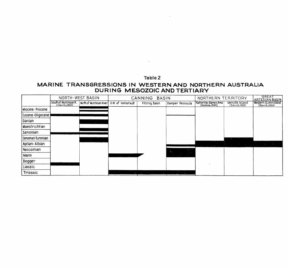
Table 2 M A R I N E T R A N S G R E S S I O N S I N W E S T E R N A N D N O R T H E R N A U S T R A L I A
D U R I N G M E S O Z O I C A N D T E R T I A R V
Miocene-Pliocene
Eocene-Qligocene
Danian Maestrichhan
Senonian Cenoman-Turonian
Aptian-Albian
Neocomian
Malm
Dogger Liass ic
T r i a s s i c
NORTH-WEST BASIN South of MurchisonR.
(David,l95Q) North of Munchison River
CANNING BASIN S.W. of FentonFault Fitzroy Basin Dampier Peninsula
NORTHERN TERRITORY Katherine-DarwinArea
(Noakes,l949) Melville Island (DavidJ950)
G R E A T A R T E S I A N BASIN Western Queensland
( D a v id.1950)
-15-
-stones point to a typical continental shelf environment, as is found today on the Sahul Shelf. During the Kimmeridge-Tithonian the Jurassic sea attained its maximum extent in the Canning Desert area, possibly covering it completely, In the late Tithonian, however, the sea has retreated considerably.
The regression continued, though at a slower rate, during the Neocomian. The Valanginian sea still covered the Peninsula completely, whereas the deposition of the later Neocomian formations may have been limited to the western and northern part of the area. Towards the end of the Neocomian the Peninsula emerged from the sea and part of the Dampier Group was eroded. However, there again the erosional cycle does not appear to have produced a markedly dissected surface.
The last member of the Mesozoic sedimentary cycle is a trans gressive formation of Aptian age (Melligo Quartzite), which was deposited on a gently undulating erosion surface on the Dampier Group. The area of deposition of the Aptian sediments was greatly reduced as compared with that of the Dampier Group. It is interesting in this connexion to see how recent geological work in sedimentary basins of northern and western Australia begins to change the conceptions previously held of their Mesozoic history. It is now clear that synchronous transgressions and regressions in the basins are exceptions. For Mesozioc and Tertiary the story may be roughly summarized as shown on Table 2 .
Of some importance is the sharp facies change from the Upper Jurassic to the Lower Cretaceous .sediments. After sandy shales, some limestones, and glauconitic silt stones, deposited during the Kimmeridge-Tithonian, the Neocomian is notably more coarsely detrital. This marked change indicates that erosion in the continental hinterland was rather abruptly accelerated. The lowering of the erosion base caused by the retreating sea may not provide sufficent explanation for such abrupt facies change. The amount of sinking appears too small to produce such marked effects, and the writer believes that some minor tectonic movements took place at this time in the rather unstable Fitzroy Basin. It is significant in this regard that intercalations of tuffaceous siltstones occur in the Broome Sandstone. However, the possibility that the lamproite plugs in the Fitzroy Basin are a result of earliest Cretaceous tectonic activity and therefore suppliers of the volcanic detritus in the Broome Sandstone has not been substantiatedc
From the Aptian onwards the Peninsula and the present King Sound area remained emergent for a long time. A late Cretaceous and early Tertiary river ("Kelk River") cuts its lower course across King Sound and across the Peninsula towards Pender Bay, and another, probably the ancient Fitzroy River, debouched into Roebuck Bay. In consequence a wide area along the present west coast was covered with fluviatile and fluviatile-estuar-ine sandstones (Sneriau Sandstone) and, near the former river mouths, with boulder beds (Pender Bay Conglomerate). These ancient rivers were then deflected to the north towards the Buccaneer Archipelago by a slow upwarp, which affected the central part of the Peninsula. This upwarp eventually resulted in what has been described as the "Fraser River Structure" and was paralleled by the downwarp of King Sound.
After the shifting of the early Tertiary rivers into the King Sound downwarp the area may have been somewhat lateritized. This is suggested by the considerable accumulation of iron oxides in the Emeriau sandstone and the Pender Bay Conglomerate. During the further development of the "Fraser River Structure" the peneplaned surface of the Peninsula became slightly dissected.by new drainage systems (Fraser River, Logue River), directed to the east.
A slight transgression affected western coastal areas of the Peninsula in mid-Tertiary times (Borda Sandstone). Thereafter no marine sedimentation took place until late in the Pleistocene, when eustatic rises of the sea-level during the last interglacial and early postglacial periods resulted in the subsidence of marginal parts of the Peninsula and of the King Sound depression.
During the later Tertiary non-marine interval the whole area was again subjected to lateritization processes which, this time, produced complete laterite profiles (Cape Borda).
The humid climates of the middle and late Tertiary were followed by a great arid cycle which, though it did not last long, turned the Peninsula into a desert area covered by long east-trending dunes. The sea-level was considerably lower and most of the now submerged continental shelf was exposed (Fairbridge, 1 9 5 1 ) • This great arid cycle, which can probably be correlated with the Riss Glaciation, was followed by a humid and warm period, during which the sea level rose to at least 25 feet above that of today, Oolitic beach-rocks (Chimney Rock Oolite) were formed along the shoreline, and sandy red soils on the land. Then the sea retreated again and a second arid cycle began that was less severe and, probably, also shorter. However, much of the continental shelf must again have been exposed. This led to the formation of aeolianites (mainly sand-dunes) along the western and northern escarpements of the Peninsular plateaux. This arid period, which would be contemporaneous with the Wurm Glaciation, did not produce such widespread deserts as the Riss arid cycle. There is no evidence of a superimposed younger dune generation apart from the coastal aeolianites.
With the beginning of the Recent Period the sea-level rose again, and attained by mid-Recent times a level about 10 feet above that of today. The younger beach-rocks (North Head Limestone) were formed, shore benches were cut into headland cliffs, and the coastal aeolianites were breached in several places by the sea. Thus shallow embayments and tidal flats were formed behind the coastal dunes and subsequently filled in with mud and sand from many small streams. King Sound, which appears to have been further downwarped during the late Pleistocene, was invaded by the sea. The great dunes of the Riss arid cycle, which had not been breached by
-16-
the high sea-level of the Riss-WtLrm Interglacial, were drowned this time. Since mi4-Recent times there has been a eustatic fall of sea level of about 10 feet. The former tidal
flats behind the coastal aeolianites have become dry clay-pans. The Fitzroy and Fraser Rivers have formed large deltas, and on the land the dunes have become fixed by the '"Pindan11 vegetation,,
ECONOMIC GEOLOGY. PETROLEUM PROSPECTS.
Somewhat differing opinions have been expressed on the petroleum possibilities of Dampier Peninsula by the two overseas experts who have visted the area in recent years. Reeves (1949, 1951) was moderately hopeful and suggested a closer study of the large domal upwarp which he called "Fraser River Structure". Smith (1951) held that the area offers no prospects as far as the Mesozoic sequence is concerned, but be, agreed with Reeves that a great wedge of Palaeozoic sediments might underlie the Mesozoic formations in the southern portion of the Peninsula. This wedge, so Reeves and Smith state, could - especially near the Fenton Fault - conceivably have petroleum potentialities similar to those of the Palaeozoic sequence in the Fitzroy Basin. On the other hand, Smith did not think favourably of the Fraser River Structure; he regarded it as insignificant and incapable of oil accumulation.
There are, of course, neither surface nor subsurface indications of oil seeps known from the Mesozoic in either the Fitzroy Basin or the Canning Desert. But the same was true of the Carnarvon Basin before the oil drilling campaign began. Although, in the Carnarvon Basin it is transgressive Cretaceous that provided both reservoir and cap rocks there is no reason to assume that similar conditions could not prevail on the Canning Shelf within the Jurassic sequence itself. Mesozoic marine siltstones are possible source rocks and the good aquifers encountered in the Broome water-bores prove the presence of porous reservoir rocks and inpermeable cap rocks. The main question appears to be,whether there is any likelihood of the oil, if present having been trapped in appreciable quantities.
The only important structure found in Dampier Peninsula is the large anticlinal warp that culminates in the central Fraser River area. Although the writer is somewhat less optimistic than Reeves (1949), he cannot join Smith (1951) in his pessimistic attitude. The Fraser River Structure is undoubtedly a major structural feature in the area and it should be further studied. It is, of course, possible that the extremely low amplitude of the warp is not sufficient to trap and retain oil against hydrostatic pressure in the aquifers. On the other hand, nothing is known about the shape in depth of the structure. It may, for instance, become more accentuated, with accordingly more favourable conditions for the trapping of oil. .However, the only way to resolve this structural problem is to apply geophysical methods.
Even 'if the common types of structural oil traps are absent the Mesozoic sequence in this area should not be regarded as entirely unpromising. Its shelf £acies, developed not too far from a major post-Palaeozoic geosyncline, could have provided stratigraphical traps for oil migrating up-slope from the geosynclinal troughs to the north. The apposition to the Alpino-Himalayan Tethys of the northern Australian shelf regions is in many ways similar to that of the oil-bearing areas of northern and central Arabia, and there are also some interesting stratigraphical analogies (Brunnschweiler, 1954). Dampier Peninsula and the Canning Desert Fitzroy Basin region in general can therefore be regarded as a potentially oil-bearing area worthy of further exploration.
O R E S A N D JGNISRALS.
Small books of mica have been observed in Precambrian rocks on Sunday Island (Guppy and Lindner, 1949). Tourmaline crystals, up to 2 inches long, are fairly common in some of the coarse-grained micaceous quartzites • However, neither the mica nor the tourmaline occurrences are of economic value.
The Mesozoic and Cainozoic sediments contain no minerals or ores of commercial value. Some Recent beach sands show locally a fair concentration of heavy pinerals. The sands occur on the
west coast, especially between James Prices Point and Coulomb Point. A random sample from that area consisted of magnetite - ilmenite compounds (66%) f magnetite (17.8$) zircon (11$), rutile (1.6$), quartz (3.2$), other minerals such as leucoxene, tourmaline, monazite (about 1$). The magnetite-ilmenite compounds appear, however, to be difficult to separate and the total ilmenite content of the sample is only about 20$.
ACKNOWLEDGMENTS.
The writer gratefully acknowledges the co-operation of Mr. Hampton Smith, Consulting Geologist for Ampol Petroleum Co., in the field. Sincere thanks are tendered to Dr. R.W. Fairbridge,formerly of the University of Western Australia,and Dr. C. Teichert, formerly of the University of Melbourne, for their helpful discussions and generous assistance in various problems.
The writer desires to record his appreciation of the industry and skill of Mr. J. King, mechanic with Ampol Petroleum Co., whose indefatigable and inspired efforts to keep the vehicles functioning were essential for the success of the 1950 field work.
Very sincere thanks are due to Bishop Raible and Sister Brunhilde Baer, of Beagle Bay Mission, and to Father Herold, of Lombadina Mission, for their overwhelming hospitality and for valuable information. The assistance received from the Sunday Island Mission of the Australian Churches, who provided their lugger for the exploration of the east coast of the Peninsula and the western Buccaneer Archipelago, is gratefully acknowledged.
BASEDOW. H.
BASSET-SMITH. P.W.
-17-
RM'ERENCES.
1918 - Narrative of an expedition of exploration in north-western Australia. Proc. S. Aust. Br. geogr. Soc. Aust.. 18„
1899 - On the formation of the coral reefs on the N.W. coast of Australia. Proc.zool. Soc. London.
ffiUNNSCHWEILER. R.O.. 1 9 5 1 a - Notes on geology of Dampier Land, north western Australia. Aust. J. Sci.. 14
1951b - Discovery of the Late Jurassic Calpionella Lorenz (Oligotric Infusoria) in Australia. Ibid.,14.
1954 - Mesozoic stratigraphy and history of the Canning Desert and Fitzroy Valley, Western Australia. J. geol. Socf Aust.. 1
CADELL. H.M.. 1899 - Some geological features of the coast of Western Australia. Trans. geol.Soc.EdinbT7.
CLAPP. F.G.. 1925 - A few observations on the geology and geography of the North-West and Desert Basins, Western Australia. Proc. Linn. Soc. N.S.W.. 2 5 .
- 1926 - Oil prospects of the Desert Basin of Western Australia, Bull. Amer.Ass.Petrol. Geol.. 1 0
COX. L.R..
DAVID. T.W.E.. ed. W.R. BROWNE,
ETHffltlDGE. R. jun.,
FAIRBRIDGE. R.W.
1940 - Notes on Jurassic Lamellibranchia, VII: On the identity of Echinotis Marwick with Meleagrinelia Whitfield. Proc.malac.Soc.London« 24.
1950 - THE GEOLOGY OF THE COMMONWEALTH OF AUSTRALIA. I. London, Arnold.
1907 - Fossils of the Port Keats Bore. S.Aust.suppl. pari. Pap.. 55 (of 1906)
1948a - Notes on the geomorphology of the Pelsart Group of the Houtman's Abrolhos ~ Islands, J. Roy.Soc.W.Aust s , 3 5 ,
1948b - Problems of eustatism in Australia (in: Problemes des Terraces). Un. geogr. int.. Louvain.
1950a. - The geology and geomorphology of Point Peron, Western Australia. J.Roy.Soc.
3tfrAust.. 34.
1950b - Recent and Pleistocene coral reefs of Australia. J. Geol.. 58.
1951 - Aroe Islands and the continental shelf north of Australia. Scope (j.Sci. Un.Univ.W.Aust.). 6 1952 - Multiple stands of the sea in post-glacial times. Proc.Tilth Pacif.Sci.Cong. (N.Z.1949)
1953a - The Sahul Shelf, northern Australia: its structure and geological relationships. J. Roy.Soc.W.Aust.. 37.
_ 1953b - AUSTRALIAN STRATIGRAPHY. Perth, Univ. W. Aust.
FAIRBRIDGE. R.W.. and 1947 - Study of eustatic changes of sea level. Aust. J. Sci.. fO.. GILL. E.PTT
GUPPY. D.J, and 1949 - Preliminary report on the geology of Dampier Land; Bur^Mn.Resour.Aust. R e c LINDNER. A.W. 1949/11 (unpublished).
GUPPY.D.J.. & LINDNER.A.W.. 1952 - The stratigraphy of the Mesozoic and Permian sediments of the Desert Basin , RATTIGAN. J.H. & CASEY. J.N. T Western Australia. Cong.geol.int. XUme Sess., Alger.: Symp. on Gondwanaland
KRUMBECK. L. 1934 - Die Aucellen des malms von Misol. N.Jb.Min.Geol.Beil. Bd^Abt. B. 71.
-18-
ffARWTCK. J..
MITCHELL. J 0.
NOAKES. L.C..
RAYMOND. P.E..
REEVES. F..
SMITH. H..
SPATH. F.E.?
SPITZ. A..
STOLLEY. E..
1926 - Myalinidae from the Jurassic of New Zealand. Trans.N.Z.Inst., 56.
1927 - The fossil Estheriae of Australia (i). Proc. Linn.Soc. N.S.W.. 52
1949 - A geological reconnaissance of the Katherine-Darwin region, Northern Territory. Bur.Min.Resour. Aust.Bull. 16.
1952 - The Bonaparte Basin, north-western Australia, a stratigraphic summary. Bur.Min. Resour.Aust.Rec. 1951/52. (unpublished)
1946 - The genera of fossil Conchostraca - an order of bivalved Crustacea. BulLMus. corny*Zool.Harv., 96.
194.9 - Geology and oil prospects of the Desert Basin, Western Australia. VacT^ Oil Co.. Melb. (unpublished report.).
1951 - Australian oil possibilities. Bull.Amer.Ass.Petrol.Geo 1.. 35
1951 - Oil possibilities of Dampier Land, Western Australia. Ampol Petrol.Co.. Sydney (unpublished report).
1950 - A new Tithonian ammonoid fauna from Kurdistan, Northern Iraq. Bull.Brit.Mus. (nat. Hist.). Geol.. 1 .
1 9 1 4 - A lower Cretaceous fauna from the Himalayan Giumal Sandstone.. Rec.geol.Surv. India. 44..
1929 - Ueber ostindische Jura-Belemniten. Palaont. Timor. 16.
1934 _ Zur Kenntnis des Jura und der Unterkreide von Misol, Pt. 1: Stratigraphischer Teil. N.ib.Min.Qeol.. Beil.BdtAbt.B. 71.
1935 - Idem., Pt. 2: Palaontologischer Teil. Ibid.. 73.
1939 - The Mesozoic transgressions in Western Australia. Aust. J.Sci.. 2.
1940 - Marine Jurassic of East Indian affinites at Broome, north-western Australia. J.Roy.Soc.W.Aust., 26.
1941 - Upper Palaeozoic of Western Australia. Bull.Amer.Ass.Petrol.Geol.. 2 5 .
1942 - Marine Upper Jurassic near Derby, north-western Australia. Aust. J.Sci.. 5.
1947 - Stratigraphy of Western Australia, Bull.Amer.Ass.Petrol.Geol., 31 •
1950 - Some recent additions to the stratigraphy of Western Australia. Ifoid.. 34.
1951 - The marine Permian faunas of Western Austrlia* Palaont. Z., 24.
1948 - Some coral reefs of the Sahul Shelf. Geogr.Rev.. 38.
1923 - Jurassic rocks of New Zealand. Quart.J. geol.Soc.London 79.
1903/10 - The fauna of the Spiti Shales. Palaeont.indica. Ser. 15, 4.
1936 - The geology of the West Kimberley District of Western Australia. Freney Oil Co.. Perth-, (unpublished report)
1937 - Geological succession in the West Kimberley District of Western Australia. Rept. Aust»As s.Adv.Sci., 2 3 .
WADE A.. & PRIDER R.T.. 1940 - The leucite-bearing rocks of the Kimberley area, Western Australia. Quart.J.geol, Soc.London. 96
TEICHERT. C ,
TEICHERT. C and FAIRBRIDGE. R.W.
TRECHMANN. C.T..
UHLIG. V..
WADE. A..

-19-
1930 - The fossil fishes of the Australian Mesozoic rocks. J.Roy.Soc0N.S.W.. 64.
1941 - Australian Triassic fishes. Ibid., 74.
1936 - Beitrage zur Kenntnis der jurassischen Molluskenfauna von Misol, Ost-Cleebes, Buton, Seran und Jamdena. N.Jb.Min.Geol.. Beil Bd Abt.B, 75.
1946 - A marine Early Cretaceous fauna from Stanwell (Rockhampton District). Proc. Roy. Soc. Old,. 57.
1890 - Versteinerugen aus der japanischen Kreide. Palaeontograuhica. 36.
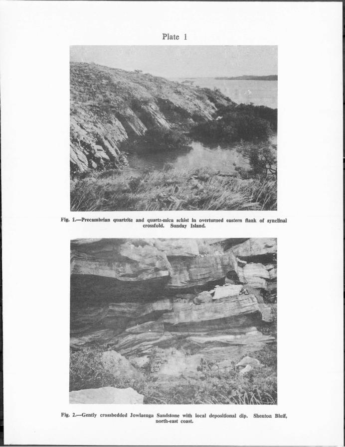
PLATE 1
Fig. 1.—Precambrian qnartzite and quartz-mica schist in overturned eastern flank of synclinal crossfold. Sunday Island.
Fig. 2.—Gently crossbedded Jowlaenga Sandstone with local dcpositional dip. Shenton Bluff, north-east coast.

Fig. 2.—Fraser River Basin: view north across "Plndan" bush. Reeves Hiil (left) is capped by Melligo Quartzite over Jowlaenga Sandstone.

Fig. 1.—Melligo Quartzite, buckled and fractured by swelling in underlying lowlaenga Sandstone: dip is not tectonic. Malumbo Anchorage.
Fig. 2.—Broome Sandstone. Gantheaume Point, near Broome.

Plate 4
Fig. 2.—Pender Bay Conglomerate overlying Broome Sandstone and overlain by two Pleistocene soil horizons separated by a band of dune sand of Wiinn age. Partly consolidated coastal aeolianites in right background. Bell Point.

Plate 5

Fig. 2.—Emeriau Sandstone overlying Broome Sandstone. Flat tops of stacks mark mid-Recent 10-foot marine terrace. Between Bell Point and Chimney Rocks, Pender Bay.
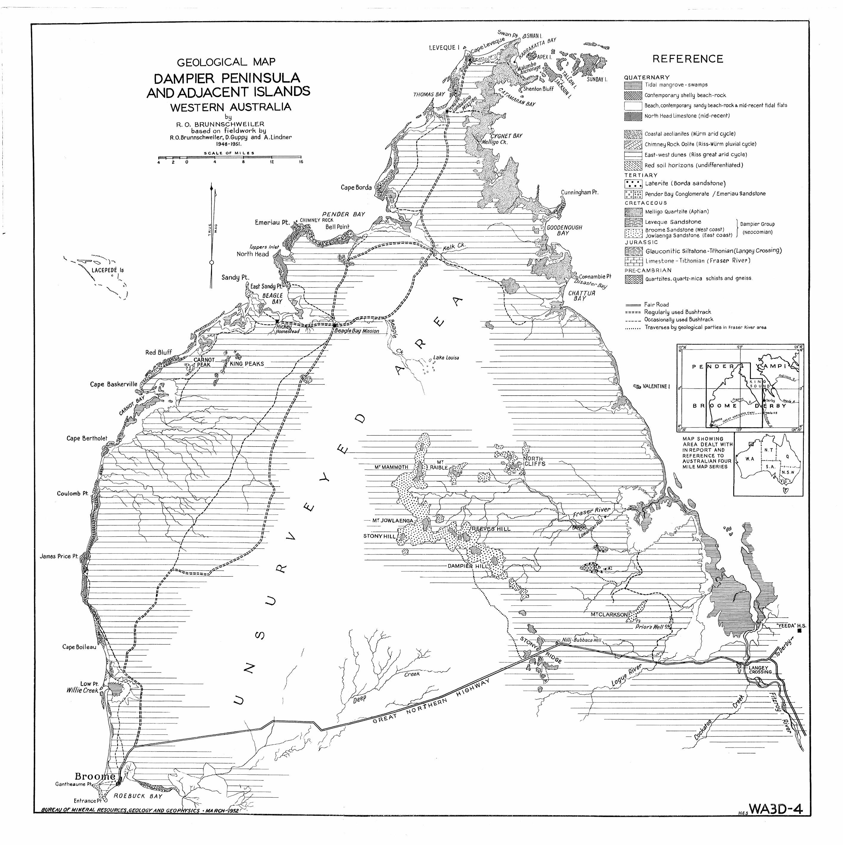
LEVEQUE I *
G E O L O G I C A L M A P
D A M P I E R P E N I N S U L A
A N D A D J A C E N T I S L A N D S
W E S T E R N A U S T R A L I A
R. O. B R U N N S C H W E I L E R based on f ie ldwork by
R.O.Brunnschweiler, D.Guppy and A.Lindner 1948-1951.
S C A L E OF M I L E S
A THOMAS BAY
M A O
CYGNET BAY 'fao CK.
PENDER BAY Emeriau Pt. C H , M N £ Y R 0 C K
Cape Baskerville $ < 4
A P E X I.
ThentonBluFf ^
5UN0AY
R E F E R E N C E
Q U A T E R N A R Y Tidal mangrove-swamps
HHH| Contemporary shelly beach-rock
Beach,contemporary sandy beach-rock & mid-recent tidal flats
IHJHH North Head Limestone (mid-recent)
i l ^ i Coastal aeolianites (Wurm arid cycle)
Chimney Rock Oolite (Riss-Wlirm pluvial cycle)
East-west dunes (Riss great arid cycle)
^ y j ^ v Red soil horizons (undifferentiated)
Cunningham Pt
G00DENOUGH BAY
hppers / /? /e / North Head
Sandy Pt. *M&2*l|>Copnambie Pt
CHATTUR BAY
Homestead ilBeagle Bay Miss/on
KING PEAKS x n Lake Louisa
Cape Bertholet
Coulomb Ph
James Price Pt.
it - A
M-
M T M T M A M M O T T W - M ' T R A I B L E
- • • • *« " T * * v . K ' . ' . ' . ' . i v : . ' * •
— M T J O W L A E N G A p.'.':!
HILL
o r D A M P I
T E R T I A R Y Laterite (Borda sandstone)
Pender Bay Conglomerate / Emeriau Sandstone C R E T A C E O U S
Melligo Quartzite (Aptian)
i r r i r r ^ Leveque Sandstone Broome Sandstone (West coast) Jowlaenga Sandstone (East coast) .
Dampier Group (Neocomian)
J U R A S S I C
Glauconitic Siltstone-Tithonian(Langey Crossing)
Limestone-Tithonian (Fraser River)
P R E - C A M B R I A N
Quartzites, quartz-mica schists and gneiss.
Fair Road Regularly used Bushtrack Occasionally used Bushtrack Traverses by geological parties in Fraser River area
< s, VALENTINE I
fORTH-CLIFFS
M A P S H O W I N G A R E A D E A L T W I T H I N R E P O R T A N D R E F E R E N C E T O A U S T R A L I A N F O U R M I L E M A P S E R I E S
9,
Cape Boileau
ft
JI
M T C L A R K S O W . : ^
-U-
-W- <0
-44-
Low Pt. WillieCreekt
B r o o Gantheaume Ph
Priors/Ve//°$-
— ^ Nilli-Bubbaca Well
e
* Y E E 0 A " H . S .
Entrance PtV; BUREAU OF MINERAL RESOURCES. GEOLOGY AND GEOPHYSICS * MA RCH-49S2T H.E.S W A 3 D - 4


![Earliest Aptian Caprinidae (Bivalvia, Hippuritida) from ...Carnets de Géologie [Notebooks on Geology] - vol. 15, n° 3 Earliest Aptian Caprinidae (Bivalvia, Hippuritida) from Lebanon](https://static.fdocuments.in/doc/165x107/5fb26b1085be0d3b5e7a09de/earliest-aptian-caprinidae-bivalvia-hippuritida-from-carnets-de-gologie.jpg)