The geology of Ben Wyvis, Carn Chuinneag, Inchbae and the ...
239
'^^j^^y.^ t " ^^^.'.'^ -<a, -. ,^ w ^ 'f^t' -* .-^ ^ U V
Transcript of The geology of Ben Wyvis, Carn Chuinneag, Inchbae and the ...
'^^j^^y.^
t" ^^^.'.'^
-<a, -. ,^ w ^
'f^t' -*
.-^ ^
U V

(S^avmll Itttoetattg 3Iibrata
atljata, ^txa gntk
BOUGHT WITH THE INCOME OF THE
SAGE ENDOWMENT FUNDTHE GIFT OF
HENRY W. SAGE1891

Cornell University Library
QE 264.P35B4 1912
The geology of Ben Wyvis, Carn Chuinneag
3 1924 004 637 942

Cornell University
Library
The original of tiiis bool< is in
tine Cornell University Library.
There are no known copyright restrictions in
the United States on the use of the text.
http://www.archive.org/details/cu31924004637942

93
MEMOIRS OF THE GEOLOaiCAL SURVEY,SCOTLAro.
THE GEOLOGYOF
BEN WIVIS, CARN CHUIMEAQ, INCHBAE
AND THE SURROUNDING COUNTRY,mCLUDING
GARVE, EVANTON, ALFESS AND KINCARDmE.(EXPLANATION OF SHEET 93.)
By
B. N. PEACH, LL.D., F.R.S.; the late W. GUNN;C. T. CLOUGH, M.A. ; L. W. HINXMAN, B.A., F.R.S.E.
;
C. B. CRAMPTON, M.B., CM. ; and E. M. ANDBESON, M.A., B.Sc.
WITH
PETROLOGICAL CONTRIBUTIONSBY
J. S. FLETT, M.A., D.Sc.
PCBLISHBD BY ORDEB OF THE LOBDS OOMMISSIONEES OP HIS MAJESTY'S TEEASTJBY.
EDINBUEGH
:
FEINTED FOE HIS MAJESTY'S STATIONEEY OFFICEBy MOEEISON & GIBB LIMITED
At Tanfibld.
And to be purchased fromE. STANFOED, 12, 13 and 14. Long AcBli, Londost;
W. & A. K. JOHNSTON, LIMITED, 2, St.' Aistdkew Squaes, Ediitbitrgh;HODGES, FIGGIS & Co., Ltd., 114, Geaftoit Street, Dotlin.
•"^om any Agent for the sale of Ordnance Survey Maps ; or through any Bookseller
;
from T. FISHEE UNWIN, 1, Adelphi Tbkbace, London, W.C., who is the
sole Wholesale Agent to the Trade outside thfe County of London.
1912.
Price Four Shillings.

LIST OF PUBLICATIONS OF THE GEOLOGICALSURVEY OF SCOTLAND.
Geological Map (25 miles to the incli) of the British Islands. Price,
Coloured, 2s. ; Unooloured, Is.
Maps on One-inch Scale. (Colour-printed.)
Arran. (New edition.) 2s.. (See refsrenoea to Sheets 13 and 21 underHand-coloured Maps.)
Glasgow District (embracing parts of Dumbartonshire, Lanar!^shire, Ken-
frewshire and Stirlingshire). 2s.
28. Knapdale, Jura and North Kiiityre. 2s. 6d.
32. Edinburghshire, Linlithgowshire; Fifeshire and Peeblesshire (parts of).
(New edition.) 2s. Sd.
33. Haddingtonshire and parts of Edinburghshire and Berinckshire. (Newedition.) 2s. -^(2.
35. Colonsay and Oronsay, with part of the Eoss of Mull. 2s. 6d.
65. Aberdeenshire, S.W. ; Perthshire, N.E. ; Forfarshire, N.W. 2s. 6d.
71. Qleuelg, Lochalsh and the South-East part of Skye. 2s. 6d.'
93. Eoss-shire, Cromartyshire (parts of). 2s. 6d. _
Maps on One-inch Scale. (Hand-coloured.)
1. Wigtownshire, South-Western Districts. 2s. Sd.
2. Wigtownshire, South-Eastern Districts. 2s. Zd.
3. Wigtownshire, Western. Districts. 5s. 9d.
i. Wigtownshire, East Part ; Kirkcudbrightshire, portion of S.W. Division.
9s. 6d.
5. Kirkcudbrightshire, Southern Districts. 13s. 3d.
6. Kirkcudbrightshire, E. margin ; Dumfriesshire, S. margin. Ss. 6d.
7. Ayrshire, South-Western Districts.' 7s. Sd.
8. Kirkcudbrightshire, Ayrshu'e and Wigtownshire (parts of). 16s. 3d.
9. Kirkoadbrightshire, N-E. ; Dumfriesshire, S.W. lis. 9d.
10. Dumfriesshire. 10s. 3d.
11. Eoxburghshire and Dumfriesshire (parts of). 5s. 9d. ','
12. Argyllshire (Kiutyre, S. half of), lis.
13. Ayrshire, Turnberry Point, and S. part of Arran (Solid, third edition, andDrift, first edition). 7s. 3d. (See Colour-printed Map of Arran.)
14. Ayrshire, Central Districts. 14s.
15. Dumfriesshire, N.W. ; A,yrs!iire, S.E. ; and Lanarkshire, S. lis. (
16. Dumfries, Selkirk, Peebles, Lanark and Roxburgh shires (parts ofj. 11*.
17. Eoxburghshire, Selkirkshire and Dumfriesshire (parts of)> 10s. 3a.
18. Roxburghshire, E. part. 2s. Sd.
19. Argyllshire (S. part of May). lOs. 3d.' 20. Argyllshire (Kintyre, Gigha L, p^rt of Islay). 9s. 6d. '
21. Argyllshire; Arran, Central and N. part; 'Bute, S. part; Cumbraes,Ayrshire (part of N.W.) Solid and Drift, first editions. 16s. 3d.
(See Colour-printed Map of Arran.
)
'
22. AyrshirBj Eenfrewshire, Lanarkshire (parts of). 14s. 9d.
23. Lanarkshire, Central Districts ; Ayrshire (part of W. ). 19s. 3d.
24. Peeblesshire, Lanarkshire, Edinburghshire, Selkirkshire (parts of). 8s. 9(2.
25. Berwick, Roxburgh, Selkirk, and Edinburgh shires (parts of). ,8j. 9d.
26. Berwickshire and Roxburghshire (paria of). 3s. 3d.
27. Argyllshire;parts of Islay, Jura and Oronsay. 8s.
29. Argyllshire, Ayrshire, Buteshire, Dumbartonshire and Eenfrewshire (parts
of). 21s. 6d.
30. Eenfrewshire; parts of 'Dumbarton, Stirling, Lanark and Ayr. 16s. 3d.
31. Lanarkshire, Stirlingshire, Linlithgowshire, Dumbartonshire, Edinburgh-Shire (parts of). ' 16s. 3d.
34. Eastern Berwickshire. 3s. 6d.
36. Seaboard of Mid Argyll (Solid and Drift editions). 16s. 3d.
37. Mid Argyll (Solid and Drift editions). 25s. 3d. '
38. Perthshire, Stirlingshire, Dumbartonshire, Argyllshire (parts of). 14s. 9d.
39. Perthshire, Clackmannanshire, Stirlingshire and Fifeshire (parts of). 17s. 9d,
40. Fife and Kinross. 14s. 9d.
41. Fife, East part ; Haddingtonshire, North part. ' 5s. 9d.
45. Argyllshire, Country near Oban and Dalmally (Solid and Drift editions).
258. 3d!.
46. Perthshire, Argyllshire (parts of). 19s. 3d.
47. Perthshire. 16s. 3d.
48. Perthshire, Forfarshire and Pifeshire (parts of), lis.
49. Forfarshire and Fifeshire (parts of). 5s.
55. Perthshire (Solid and Drift editions). 22s. 3d. and 25s. Sd.
56. Pertjishire, Forfarshire (parts of). ?2s. 3d.
57. Forfarshire and Kincardineshire (parts of), • 10s. 3d.
57a. Kincardineshire, S.E. corner. Is. 9d.
60. Eum, Canna, Eigg, !Muck. 10s. 3d.
66. Kincardineshire, Forfarshire, Aberdeenshire (pai'ts of). 23s. 9d.
67. Kincardineshire and Aberdeenshire (parts of). 5s, 9a!.
70. Inverness-shire (West-Central, Skye, with Soay). 19s. 3d.
75. Inverness-shire, Elginshire, Banffshire, Aberdeenshire (parts of). 19s. 3d.
M fc G Ltd Wt 24979/71 3-12 500


93
MEMOIRS OF THE GEOLOGICAL SURVEY^SCOTLAI^D.
THE GEOLOGYOF
BEN WYYIS, CARN CHUINNEAG, INCHBAE
AND THE SURROUNDING COUNTRY,INCLUDING
CtARVE, EVANTON, ALNESS AND KINCARDINE.
(EXPLANATION OP SHEET 93.)
By
B. N. EBACH, LL.D., F.R.S. ; the late W. GUNN;C. T. CLOUGH, M.A. ; L. W. HINXMAN, B.A., F.R.S.E.
;
C. B. CRAMPTON, M.B., CM. ; and E. M. ANDERSON, M.A., B.Sc.
WITH
PETROLOGICAL CONTRIBUTIONSBY
J. S. FLETT, M.A., D.Sc.
ruBLianED by obdeb of the lobds commissionbes oe his majesty's tbeasuey.
EDINBURGH
:
PRINTED FOR HIS MAJESTY'S STATIONERY OFFICEBy MORRISON & GIBB LIMITED
At Taneield.
And to be purchased fromE. STANFORD, 12, 13 and 14, Long Aceb, London;
W. & A. K. JOHNSTON, LIMITED, 2, St. Andeew Squabe, Edinbueqh;HODGES, FIGGIS & Co., Ltd., 114, Geaeton Stebet, Dublin.
From any Agent for the sale of Ordnance Survey Maps ; or through any Bookseller
;
from T. FISHER UNWIN, 1, Adelphi Tebeaoe, London, W.C, who is the
sole Wholesale Agent to the Trade outside the County of London.
1912.
Price Four Shillings.


PREFACE.
The district described in this Memoir includes, in the east, part of
the tract of low-lying fertile ground which adjoins the shores of theCromarty and Dornoch Firths, but the whole western half of theSheet is a mountainous region devoted almost entirely to sport.
Until the survey of the area was commenced little information was^available regarding the structure of that part of the country whichconsists of crystalline and metamorphic rocks. The existence of thecoarse granitic gneiss of Inchbae was known, but its great extensionand the remarkable features of the contact-altered zone of sedimentsaround it were quite unsuspected.
The officers of the Geological Survey have not hitherto undertakenthe description of so large an area of crystalline schists and gneisses
belonging mainly to the Moinc Series, and lying to the north of theGreat Glen. It is therefore fortunate that the geology of this Sheetprovides a key to some of the most important problems of the MoineSchists and Gneisses. The work of the Survey has proved that theaugen gneiss of Inchbae and Carn Chuinneag was a great intrusive massof granite (with subordinate masses of gabbro, etc.), and that theMoine rocks around it were originally shales, sandstones and marls of
ordinary sedimentary types. By the action of the granite-intrusion
the adjacent sediments were converted into hard banded splintery
hornfelses. At a later period the whole district was involved in
folding and earth-movement which changed the granite into a gneiss
and at the same time transformed the sediments, where they wereunaffected by the granite, into mica schists, granulites and other meta-morphic rocks. But the contact-altered rocks had been so indurated
as to offer considerable resistance to these movements, and haveconsequently, in many places, retained the characters which they
possessed before the movements took place. It has been found poss-
ible, both in the field and with the microscope, to trace the stages bywhich igneous and sedimentary rocks pass into crystalline schists andgneisses. For this reason the district described in this Memoir is of
especial interest not only to students of the geology of Scotland, but
to all who are interested in the problems of metamorphism ; as anillustration of " dynamo-metamorphism " on a large scale it could
hardly be surpassed. Somewhat similar phenomena have been
observed by Mr. Barrow in the neighbourhood of Ben Vuroch, Perth-
shire, and are described in the Memoir on Sheet 55 (Scotland).
Another point of interest is the discovery of tinstone for the first
time in Scotland. It was found on the north-west shoulder of Carn
Chuinneag, in masses of magnetic iron ore occurring in the granitic
gneiss.

IV
The survey of this Sheet was commenced in 1883 and completed
in 1904. The late Mr. Hugh Miller, jun., mapped most of the Old
Red Sandstone, and the late Mr. W. Gunn surveyed the district
around Meall a' Ghrianian. The greater part of the western half
of the map is the work of Dr. Peach, Mr. Clough, Mr. Hinxman, Dr.
Crampton and Mr. E. M. Anderson, but a small portion near the
western margin was surveyed by Mr. Pocock, who has not contributed
to this Memoir. All the other surveyors, with the exception of Mr.
Miller, are responsible for the description of the districts they surveyed.
Dr. Flett has contributed chapters on the petrology, and the rock
analyses were made by Dr. Pollard and Mr. Radley. Mr. Cloughacted as district geologist in charge of the field work from 1902 to 1904
and has edited the Memoir. The photographs of scenery and rock-
structures were taken by Mr. Lunn, and the photomicrographs byMr. T. C. Hall. Plate XII. has already appeared in the Geological
Magazine, and is reproduced here by permission of the Editor.
J. J. H. Teall, Director.
Geological Survey Office,
28, Jermyn Street, London,I'ith January, 1912.

CONTEXTS.
CHAPTER I.
Introduction.....Area and Physical FeaturesDrainage Systems, Lochs, Rainfall
Tabular List of FormationsDistribution and Relations of the FormationsScenery in relation to GeologySummary of Geological Literature
1
1
2
5
6
8
9
CHAPTER II.
Lbwisian Gneiss and Moine Schists . . . .12Lewisian Gneiss . . . . . . .12Moine Schists ....... 12
Introduction and Classification . . . .12South-western District ; Garve and Loch Luichart . . 15
Ben Wyvis District . . . . . .16Quartzose Schists . . . . .18Semipelitic Group . . . . .19Politic Gneiss . . . . . .19Tourmaline Pegmatites . . . . .20
District of Strath Rannoch . . . . .20District of Loch Glass, Loch Morie and Strath Rusdale . 22
The Lower Quartzose Group . . . .22The Garnetiferous Mica Schist . . . .23The Upper Quartzose Group . . . .24Band of Pelitic Mica Schist and Hornfels . . 25
District South-west of Kincardine . . . .26Strath Vaich District . . . . .27Gleann Beag, Gleann Mor, Coire Mor and AUadale . . 31
District of Glen Calvie and Cnoc nan Sac . . .35
CHAPTER III.
Petrology of the Moine Schists .
Granulitic (Psammitio) Gneisses .
Quartzites, Quartz Schists
Conglomerates (Conglomerate Gneiss, Psephitic Gneiss)
PeUtic Schists and Gneisses
Zoisite Granulites and Zoisite Hornblende Gneisses
3838
40
40
42
42

vl
CHAPTER IV.PAGE
Field Relations op the Older Igneous Eocks . . 46
Introduction . ...... 46
Basic Plutonic Rocks. Diorite, Epidiorite, foliated and
^unfoliated . . , . . . .49
,Acid Plutonic Rt)cka. Granite, Aplite, Pegmatite, foliated
and unfoliated . . . . . .53Introduction . . . . . .53Riebeckite gneiss . . . . .58Dark grey granite gneiss rich, in biotite . . .58Coarse biotite granite or granite gneiss, with many large
felspar phenocrysts—Augen gneiss or Inchbae rock . 59
Fine-grained biotite granite gneiss without many large
felspar phenocrysts . . . . .61Fine-grained muscovite gneiss without much biotite . 62
Pegmatites and quartz veins in or very near the
plutonic masses . . . . .63Garnetiferous Albite Gneiss with Magnetite and Tinstone . 64
Basic Dykes and Sills . . . . .67In the Moine Rooks . . . . .67In the Plutonic Masses . . . . .71
CHAPTER V.
Contact-Mbtamoephism Produced by the Older Granite . 73Introduction . . . . . . .73Types of Hornfelsed Sediment . . . . .75Distribution of the Hornfels, and its Relation to the Granite and
the Moine Schists . . . . . .75Detailed Descriptions of Districts . . . .76
Kildermorie to the south side of Meall na h-Uigeig . . 76Sgor a' Chaoruinn and Beinn nan Eun . . .78District of Strath Rannoch . . . . .80District of Glen Galvie and Cnoc an t-Saic (Cnoc nan Sac) . 81Cam an Liath-bhaid to south side of Meall na h-Uigeig . 87
CHAPTER VI.
Petrography of the Older Igneous Rooks and Hornfelses . 89Plutonic Rocks . . . . . . .89
Biotite granite gneiss . . . . .89Muscovite gneisses (pegmatite gneisses, aplite gneisses) . 91Hornblende biotite gneisses, pyroxene biotite gneisses
(tonalite gneisses) . . . . . .91RiebecMte gneiss and segirine riebeckite gneiss (paisanite
gneiss) ....... 91
Gabbros, diorites and quartz diorites . • .93Garnetiferous Albite Gneiss . . . • .96
Genesis of the Tin Ore . . • • .98

vii
Sills and Dykes of Bpidiorite, etc.
Epidiorite Bands in the Moine ScHstsThe Basic Dykes in the Carn Chuinneag Complex
The Auieole of the Cam Chuinneag Plutonic ComplexThe Hornfelses .....Efiects of Shearing and Dynamo-metamorphism on the Rocks
of the Aureole .......
100100
101
102
103
107
CHAPTER VII.
The Newer Igneous Rocks

viii
CHAPTER X.
Pleistocene and Recent .
Glaciation and Glacial Deposits .
North-eastern, Central and Southern Area
Direction of Glaciation .
Erratic Blocks .
Moraines and Morainic Drift
Boulder ClayMounds of Sand and Gravel
Terraces of Glen Glass and AUt nan Caoracli
Terraces between Allt Dearg and Stratlirory River
North-western and Northern AreaPlateau Frost Debris
Alluvia and Recent Deposits
Marine Alluvia
Cromarty Firth .
Dornoch Firth .
Freshwater Alluvia .
Peat .
Landslips
Weathering ,
PASS
149
149
149
149
150
155
155
156
157
158
158
159
160
160
160
161
161
162
164
165
CHAPTER XL
Economics

Fig.

Fig. 2. Garnetiferous biotite hornfels. Salaohie Bum.„ 3. Stippled schist. Salachie Burn.
„ 4. Garnetiferous mica schist. Near Glen Calvie
Lodge.
„ 5. Chiastolite slate (found loose)..
,, 6. Garnet crystal in stippled schist of Fig. 3.
Plate X. Photomicrographs showing Development of Schists
from Igneous Rocks . . (to face) 180
Fig. 1. Lamprophyre (vogesite), near Loch Bad a'
Bhathaich.
„ 2. Lamproschist from a thrust plane in Salachie
Burn.
,, 3. Amphibolite between Kinloch and Meall anTuirc.
,, 4. Calc-biotite schist. Near Bodach Mor.
,, 5. Epidiorite. South side of Cam Bhren.
„ 6. Biotite hornblende schist. Dyke on the south
side of Glen Diebidale.
XL Photomicrographs . . . (to face) 182
Fig. 1. Porphyritic granite. Cam Gas nan Gabhar.
,, 2. jEgirine riebeckite gneiss. Carn Chuinneag.
,, 3. Albite gneiss, lower tinstone belt, north-west
shoulder of Carn Chuinneag.
„ 4. Magnetite-cassiterite block, found loose.
,, 5. Epidiorite. Nearly half a mile north of CamDubh.
,, 6. Scyelite. Cam Cas nan Gabhar.
„ XII. Map of the Augen Gneiss District . (before Index)


THE GEOLOGY OF BEN WYVIS,
CARN CHUINNEAG, INCHBAE, ETC.
CHAPTER I.
INTEODUCTION.
Area and Physical Features.
This Sheet of the Geological Survey of Scotland represents an areaof 432 square miles, the whole of which,—with the exception of a smallpart of Sutherlandshire, less than two square miles in extent, on thenorth side of the Dornoch Firth,—falls within the county of Ross. Thedistrict under consideration extends from Creich in Sutherlandshire,
in the north-east, westwards to the Freevater Forest at the head of
Glen Carron, and in the south from the head of Loch Luichart east-
wards to the Cromarty Firth.
The wild region of mountain top and undulating peaty moorland,
traversed by deep glens and river valleys (see Plate II.), that formsthe greater part of the area under description, has been carved bythe slow forces of denudation out of an elevated plateau or series of
plateaux, relics of which still exist in different parts of the district
(see Frontispiece). The least dissected portion of this ancient table-
land is found in the north-western quarter of the map, near the upperpart of Strath Vaich and to the north of Gleann Beag and part of
Gleann Mor. The average height of the plateau is about 2000 ft., but
it rises to the north-west, where the highest summits are Am Faoch-agach, 3120 ft., Cam Ban, 2762 ft. and Bodach Mor, 2689 ft. The flat
tops of Beinn a' Chaisteil, Meall a' Ghrianain, and Beinn Tharsuinn
on the north side of Strath Rusdale, may all be taken to represent
portions of the tableland. It may be mentioned that this plateau
does not continue for any considerable distance northwards into
one-inch map 102.' In this direction it ends in a tolerably well
defined steep slope which does not correspond to any stratigraphical
boundary, and overlooks a wide expanse of lower ground, rarely
exceeding 1300 or 1400 ft. in height, that stretches to the north
beyond Strath Oykel and Loch Shin.
The mountain massif of Ben Wyvis, which rises between the
valley of the Black Water and Loch Glass, and forms the dominant
feature of Easter Ross, perhaps represents another and higher plateau.
The mean elevation of the flat-topped summit is at least 2500 ft.,
while the five principal tops or culminating points of the plateau all
reach an altitude of 3000 ft., the highest cairn being 3429 ft. above
sea-level. The mountain rises towards the west in a steep and almost

2 Introduction.
unbroken escarpment, nearly six miles in length, which coincides
with the main outcrop of the pelitic gneiss in this region, while the
eastern side of the range has been carved into a series of precipitous
rocky corries and deep glens drained by the head waters of the Allt
nan Caorach.
A lower tract of country fringes the southern shore of the Kyle
of Sutherland in the north-east corner of the map, and near Kincardine
extends inland for a distance of three miles. This plateau, which has
a mean elevation of 800-900 ft., forms part of the comparatively
low platform which can be traced almost continuously around the
northern and north-eastern coasts of Scotland.
Drainage Systems, Lochs, Rainfall.
The central and south-eastern region is drained by the Glass, the
Alness and other smaller rivers flowing into the Cromarty Firth ; the
northern third of the map lies for the most part within the basin of
the Carron, but a small area in the north-west corner belongs to that
of the Oykel ; the remaining portion of the Sheet in the west andsouth-west is included in the drainage area of the Black Water andthe Conan.
A feature common to the principal streams that flow south-east-
wards into the Firth of Cromarty is the unequal gradient of their
courses, a completely or partially graded portion of the river valley
being succeeded, sometimes more than once along the same stream,
by a steep fall.
In the case of the Glass and Alness Rivers the flat portions of the
valley have been further deepened by the erosive action of ice, andthe portions below the base level of river erosion are now occupied
by the waters of Loch Morie and Loch Glass. The barrier above whichthe grading of these two rivers and, in a lesser degree, of the Strath
Rusdale stream, has taken place, is formed by the outcrop of the OldRed Sandstone conglomerate. A second barrier higher up the Alness
River is due to the high ground formed at the junction of the augengneiss and the Moine sediments, and, separates the flat drift-filled
valley of the Abhuinn na Glasa from the steep fall immediatelyabove Loch Morie.
The Glascarnoch River, from the point where it enters the mapto Aultguish Inn, meanders sluggishly through an extensive alluvial
flat which marks the side of a former loch, fully five miles in length.
The silting up of this loch has been mainly effected by the material
brougit down by the tributary streams that drain the drift-covered
slopes on either side of the valley. The rock barrier to which this
loch was due crosses the stream immediately below Aultguish Inn.
Strath Vaich offers another example of a gently graded valley,
the fall of the stream, especially in the upper part of the glen belowLoch Toll a' Mhuic, being very slight. l. w. h.
The height of the watershed between Strath Vaich and Gleann:Mor near Deanich Lodge does not exceed 1250 ft., being only about300 ft. above the level of the adjoining part of the Gleann Mor bum.Gleann Mor is a narrow glen, and it may perhaps be supposed that it
is of comparatively recent origin, and has captured the drainage of

Drainage Systetits, Lochs. 3
-considerable tracts wMch in earlier times drained southwards into
Strath Vaich. It should, however, be pointed out that on the north
side of Gleann Mor there is no valley which can be conveniently regarded
as the continuation of Strath Vaich, and that in the burn south-east
of Deanich Lodge a strong crush line is seen striking for the low groundat the head of the strath. This line of weakness may greatly havefacilitated the work of subaerial denudation.
Near and for some distance above Deanich Lodge, the Gleann Morstream is much more sluggish than below, and appears to be traversing
the site of a silted-up loch about a mile long. The long axis of this
old loch and of Gleann Beag, to the west, is nearly in the same direc-
tion as Gleann Mor, and almost at right angles to Strath Vaich.
c. T. c.
The Eiver Glass, in the lower part of its course above the village
of Evanton, flows through the well known gorge of the Black Rock of
Novar. This remarkable chasm has been eroded in the pebbly sand-
stones and conglomerates of the Old Red Sandstone, and is an extremeexample of the deep and narrow gorges cut by most of the rivers of
the East Coast, where they breach the outcrops of the harder membersof that formation. From a careful series of measurements carried
out by Mr. Hugh Miller, jun., it was found that the depth of this chasmto the surface of the water varied from 100 ft. in the deepest portion
to 70 ft. at the upper end ; the width at the surface from 17 to 40 ft.,
with an average of 20-25 ft. The potholes seen at difEerent levels onboth sides of the chasm show that it is entirely due to the agency of
running water, the eroding power being supplied by the detritus
derived from the drift-filled portions of the upper valley. The gorge
of the Black Rock is entirely post-glacial in origin. The pre-glacial
course of the river can be traced, as pointed out by Mr. Miller,* to the
south of the upper end of the present channel, and is indicated by the
hollow, almost filled with boulder clay, that crosses the hillslope to
the north of the farm of Upper Park.
The Skiack River above Swordale flows through a wide pre-glacial
valley deeply filled with boulder clay, through which the stream is
now cutting or has already cut down to the original rock floor. Thewaterfalls on the river immediately above the mouth of the small
burn at Clare indicate the position of a former rock barrier, above
which the river winds through a series of alluvial flats which mayrepresent the sites of earlier lake basins.
The upper course of the Alness River in the Kildermorie Forest
is also through a wide drift-filled valley, but for half a mile above the
.Lodge it is flowing over rock. Below Loch Morie the river valley
has evidently been in a large measure determined by the Loch Morie
fault, and in the neighbourhood of Ardross Castle has been eroded
along the faulted junction between the conglomerates and the softer
shales and flagstones. The bed of this stream, like that of others
in the area, is filled in places with huge rounded boulders of augen
gneiss and other rocks washed out of the drift deposits..
The principal lochs within the area are Loch Morie, on the Alness
River, and Loch Glass, on the stream of that name, both situated close
* ' The Black Rock of Novar,' Trans. Scien. Soc, Inverness, 1887, vol. iii.
p 308.
Introduction.
together m the centre of +he map. The western and larger portion
of Loch Luichart also..enters within the southern margin of the
Sheet.
The waters of Loch Morie cover an area of nearly a square mile,
and are derived from a drainage area over thirty-five square miles in
extent. The loch is two and a third miles in length with a meanbreadth of half a mile, and presents the form of a simple basin with a
maximum depth of 270 ft. in the centre. The stream that issues fromthe loch flows over a rock barrier, and the loch undoubtedly lies
in a rock basin, determined in some degree by the powerful fault
-which passes through it in an oblique direction. '
Loch Glass, four miles in length and half a mile in breadth, is the
deepest loch within the drainage basin of the Cromarty Firth, maximumsoundings of 365 ft. having been obtained at a point towards the north-
eastern shore rather nearer the north-west than the south-east endof the lake. There are considerable drift deposits around the foot
of the loch, and traces of terraces along the southern shore to the east
of Culzie Lodge indicate a former .higher level of its waters. TheRiver Glass flows over a ridge of conglomerate at the Eileanach falls,
two miles below the foot of the loch, at an elevation of 650 ft., and as
the surface of the loch is 713 ft. above datum level, it follows that the
ideepest part of the basin lies at an elevation of 348 ft., or 302 ft. below
.the level of the rock barrier.
The bathymetry of Loch Luichart is fully discussed in the ex-
planation accompanying Sheet 83 of the Geological Survey. Thelargest and deepest of the three basins found on the irregular floor of
the loch, comes within the present map, and the maximum depth of
164 ft. is found about a mile and a half from the western end. LochLuichart is a true rock basin with a rock barrier at its outlet.*
Of the numerous smaller lochans scattered over the Sheet, some,
such as Loch Bealach Culaidh in the Wyvis Forest, can be shownto be true rock basins, but most are entirely or partially held in bydrift deposits. l. w. h.
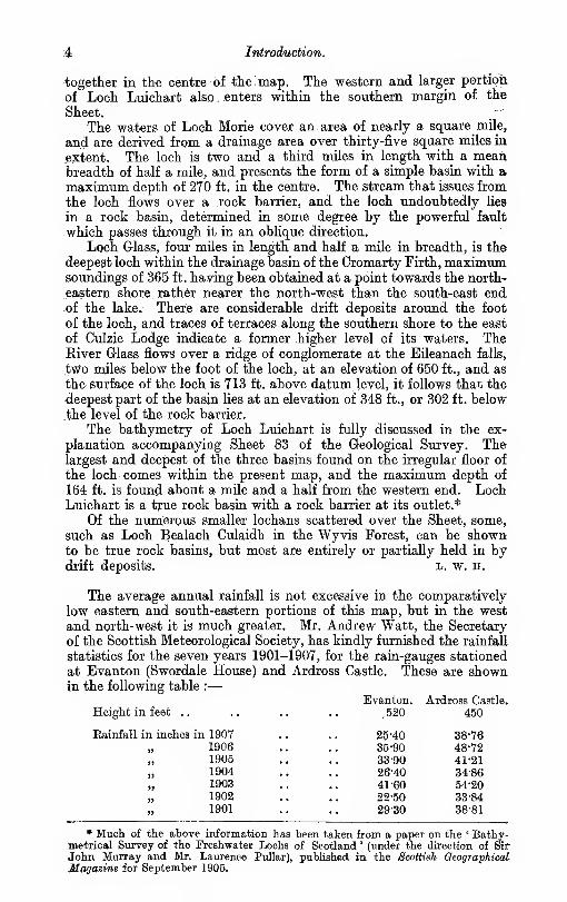
The average annual rainfall is not excessive in the comparatively
low eastern and south-eastern portions of this map, but in the west
and north-west it is much greater. Mr. Andrew Watt, the Secretary
of the Scottish Meteorological Society, has kindly furnished the rainfall
statistics for the seven years 1901-1907, for the rain-gauges stationed
at Evanton (Swordale House) and Ardross Castle. These are shownin the following table :
—
Evanton. Ardross Castle.
Height in feet .. .. .. ,. ,520 450
Eainfftll in inches in 1907190619051904190319021901
* Much of the above information has been taken from a paper on the ' Bathy-metrical Survey of the Freshwater Lochs of Scotland ' (under the direction of Sir-
John Murray and Mr. Laurence Pullar), published in the Scottish GeographicalMagazine for September 1905.
25-40

List of Formations. 5r
In the western portion of the map no rain-gauges have been set
up, hut a,t the rain-gauge at Loch Droma, about- two. miles west of
Strathdetie, and at a height of about 900 ft.,"the annual' raiiifall for the
same seven years varied from 58'02 to 109'93 in. The average fall
came to 83-63 in. c, T. c.
Tabular List of Formations.
The following list shows the different geological formations androck groups shown in the map. The chief formations, indicated bythe names outside the brackets, are placed in order of age, the youngestat the top, but the minor groups within the brackets are not necess-
arily so arranged.
C3
S Sio a)
fPeat.Freshwater Alluvia, largely represented by River Terraces at
different levels.
Marine Alluvia, including Raised Beaches at three different levels,
the highest about 85 ft.
Fluvio-glacial Sands and Gravels.
Morainic Drift.
.Boulder Clay.
^ ^ a; CMiddle 1 Shales and Flagstones.
•^ '^ g -^ or [-Sandstones.
LOrcadian.J Conglomerate and Breccia.
ri « M
rScyelite.
. Dolerite.
Peridotite.
d rgJLamprophyre and Mica Trap.
m" o i Aplite.
f.^ Granite.
'S ^Pegmatite.
MfHornblende Schist in Dykes newer than the Granitic
Gneiss.
Granitic Gneiss, including Augen Gneiss and Rie-
beckite Granulite.
Garnetiferous Albite Gneiss with Magnetite andTinstone.
Diorite, Quartz Diorite, Epidiorite representing Gabbjo,
Pyroxenic and Hornblendic Gneisses, HornblendeBiotite Schist. Consolidated before the Granitic
^ rocks.
Sills and Dykes of Epidiorite, Hornblende Schist and Garnetiferous
Amphibolite, in the Moine Series.
Igneous Com-plex of
Cam Chuinneagand
Inchbae.
g m rPelitic Gneiss and Schist representing argillaceous sediments,
o 'S ] Pelitic Hornfels, Siliceous (Psammitic) Schists- and Quartz
g M I Biotite Granulites.
PI .
SoH-l
Acid and Hornblendic Gneiss.

Introduction.
DlSTEIBUTION AST) RELATIONS OF THE FORMATIONS.
. The rocks referred to the Lemsian Gneiss occur only in a few smalt
patches in the south-west portion of the map, where they appear to
come out from below the Moine schists. The only Scottish rocks
which can at present with perfect confidence be classed with the
Lewisian Gneiss are found on the west side of the Moine thrust, andare overlain unconfbrmably by the Torridonian and Cambrian rocks.
Other masses of gneissose rock, including those in the small patches
in this map, which occur on the east side of this thrust have, however,a striking lithological resemblance to the Lewisian Gneiss further
west, and are therefore classed with it.
From evidence obtained in adjoining maps, it is believed that theLewisian Gneiss is an older formation than the Moine Series, and is
separated from it by an important unconformity. Evidence in support6i this view has been obtained, for instance, in the Strath Conan andStrath Farrar area, in one-inch map 82,* in parts of which a rock hav-ihg all the appearance of a sheared conglomerate is sometimes foundresting in isolated patches on the Lewisian Gneiss. It is to be re-
membered, however, that both this Lewisian Gneiss and the Moinerocks have been affected by intense dynamo-metamorphism, whichhas often developed a common foliation, and has helped to obliterate
the great differences, both in lithological character and tectonic
structure, which may once have existed between them.The Moine schists form a great metamorphic series which occupies
most of the area between the Old Red Sandstone of the north-east
coast of Scotland and the Moine thrust, which strikes N.N.E. nearly
through the middle of the next one-inch map to the west. They are
no doubt paraschists or paragneisses, representing a great sedimentary
series originally composed in the main of sandstones, pebbly grits andsandy shales, which has been greatly folded and altered. In original
character they probably bore considerable resemblance to the Torri-
donian rocks west of the Moine thrust, and it has been supposed byDr^ Peach and others that they are altered representatives of these
rocks.f But this correlation cannot yet be regarded as proved.
A broad band of pelitic or, more strictly, semipelitic sediment
belonging to the Moine Series is found most of the way along the
margin of the largest granitic mass, that of Cam Chuinneag. This
band is of special interest, as it is partly composed of masses of horn-
felsed rock (Plate XII.), which have never been deformed or sheared,
and enable us still to picture clearly the dark sandy muds and thin
gritty laiainsB from which most of them were formed. These completely
undeformed sediments lie in the heart of the Moine schists, as muchas twenty-five miles east of the Moine thrust, and there is clear evidence
that they are part and parcel of the same geological formation as
these schists-—schists which are for the most part in such a highly
altered condition that they might be taken as types of the rocka once
called primary or primitive, under the impression that they had been
* Dr. B. N. Peach, Summary of Progress of the Geological Survey for 1904, p. 75.
L. W. Hinxman, C. B. Crampton, B. M. Anderson and R. 6. Carruthers, Summarif
of Progress of the Geological Survey for 1905, pp. 103-109.
•fAnnual Report of the Geological Survey for 1892, p. 262.


Older Intrusive Igneous Rocks. 7
formed, much as we now see them, in the early ages of our planet,
under very peculiar conditions which have never since recurred.
Thanks to this evidence, we can now assert with confidence that
the Moine schists have been formed out of sediments which differed
id no essential particular from the sandy shales and clays of recent
formations. The injection of the great igneous masses of Carn Chuin-
neag and Inchbae has, by the alteration induced, so welded the sedi-
mentary laminae together, that, in the subsequent earth movementswhich affected the region, many parts moved as units, and escaped all
that sharp isocUnal folding and molecular change which resulted
in the manufacture of the surrounding schists.
The Older Intrusive Igneous rocks are represented by many typeaof orthogneiss, including, as they do, all those which were intrudedinto the Moine schists before the latter were foliated. The NewerIntrusions comprise, on the other hand, those which have been in-
jected after these schists were already foliated and essentially in their
present condition. This classification can in most cases be carried
out satisfactorily, but there are a few bands the correct place of whichis in some doubt.
_ The Older (foliated) Granite forms various crops which have ageneral N.N.E. strike, and stretch with but slight interruptions fromLoch Luichart to the Eiver Carron. The crop farthest to the north-east
• is much larger than all the rest combined. It is about eleven miles
long and five broad, and may be named the Carn Chuinneag mass, fromits highest hill. The boundary in some areas is of a very complicated
character, thin veins of granite extending far beyond the main area
(Plate.III.). The north-western portion of the mass includes near the.
margin a considerable proportion of basic rocks, consisting chiefly of
diorite, epidiorite (representing gabbro) and hornblendic gneiss or
hornblende schist. These basic rocks appear to be the first consoli-
dated portions of the magma, and have been pierced in a most com-plicated manner by later acid granitic veins. Besides the early basic
portions of the magma, various later dykes are also found, now in the
form of hornblende schist, which in turn cut the foliated granitic
rocks.
Sills and dykes of epidiorite, hornblende schist, etc., are not un-
common in the Moine schists, in areas which are often far distant
from the Carn Chuinneag complex. The age of these intrusions in
relation to this complex has not been determined. They are, how-ever, very frequently in a thoroughly schistose condition, and are
therefore placed with the Older Igneous Rocks.
The Newer Igneous Rocks are mainly represented by the Fearnor Corriefeam granite, which occupies an area of about 12 square
miles in the north-eastern corner of the map. Its long axis extends
in a N.N.W. direction, and is thus in striking contrast to those of
the chief masses of the Older Granite.
There is no doubt that the Newer Granite and some of the NewerDykes were intruded before the deposition of the Middle Old RedSandstone found in the district, but it is not certain that all these
dykes were. In the neighbouring one-inch map 83 a lamprophyre
dyke has been intruded into the Old Red Sandstone.
Between the period of the production of schistosity or foliation in
the Moine schists and that of the deposition of the Old Red Sandstone*
B Introduction.
an immense interval of time must have elapsed. The interval is
represented in this area only to a small extent, partly by the intro-
duction of pegmatites in the Moine rocks, partly by the intrusion of
the Newer or Fearn Granite, in the north-east corner of the map, andpartly by the great denudation which wore down the schistose area
into hill and valley prior to the deposition of the Old Red Sandstone.
The various broad pegmatites which have been introduced into
the Moine rocks, in places at a considerable distance from any granitic
mass, are never sheared, and they are therefore placed with the NewerIgneous rocks, though it is probable that they are quite independent
of and much older than the Fearn granite. They are further described
in Chapter II., in treating of the different districts where they are
found.
The Old Red Sandstone extends along the eastern margin and the
eastern half of the southern margin of the map, forming a triangular
area between the Kyle of Sutherland and the Cromarty Firth, andincludes also the low ground on both sides of the latter arm of the
sea. There are also various outliers in the western part of the map.One of these, on Meall a' Ghrianain, reaches a height of 2531 ft., and it
seems, therefore, quite possible that at one time the whole of the
schists in the map may have been covered by the Old RedSandstone.
Another immense interval of time elapsed between the Old RedSandstone and the Glacial periods. In the adjoining one-inch maps103, to the north-east, and 92, to the west, Mesozoic rocks are foundwhich represent part of this interval. The Tertiary igneous rocks of
Skye represent another later portion. c. t. c.
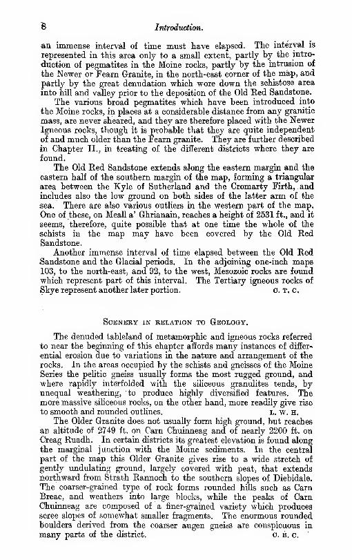
Scenery in relation to Geology.
The denuded tableland of metamorphic and igneous rocks referred
to near the beginning of this chapter affords many instances of differ-
ential erosion due to variations in the nature and arrangement of therocks. In the areas occupied by the schists and gneisses of the MoineSeries the pelitic gneiss usually forms the most rugged ground, andwhere rapidly interfolded with the siliceous granulites tends, byunequal weathering, to produce highly diversified features. Themore massive siliceous rocks, on the other hand, more readily give rise
to smooth and rounded outlines. L. w. H.
The Older Granite does not usually form high ground, but reaches
an altitude of 2749 ft. on Carn Chuinneag and of nearly 2200 ft. onCreag Ruadh. In certain districts its greatest elevation is found alongthe marginal junction with the Moine sediments. In the central
part of the map this Older Granite gives rise to a wide stretch of
gently undulating ground, largely covered with peat, that extendsnorthward from Strath Rannoch to the southern slopes of Diebidale.
The coarser-grained type of rock forms rounded hills such as CarnBreac, and weathers into large blocks, while the peaks of CarnChuinneag are composed of a finer-grained variety which producesscree slopes of somewhat smaller fragments. The enormous roundedboulders derived from the coarser augen gneiss are conspicuous in
many parts of the district. c. b. c.

Faults and Scenery.
The homogeneous nature of the Newer Granite causes it to weather
•evenly into smooth flat-topped hills with gentle slopes, which are often
covered to a considerable depth with rock disintegrating in place into
sand.
The Old Ked Sandstone strata of the coastal belt give rise to morevaried topographical features. The coarse basal breccia forms the
abrupt steep-sided bluffs of Struie Hill and Meall an Tuirc, whosecomponent strata may originally have been deposited against a steep
•cliff or face of the schistose rocks, since removed by denudation. Tothe higher pebbly conglomerate is due the rampart of Cnoc Duchaire andCnoc Fyrish, which rises steeply from the low sandstone area along
the shores of the Firth of Cromarty, while the hollow between CnocCeislein and Bendeallt has been eroded in the softer shales and mud-stones, which have also produced the gently rounded hills and soft
flowing outlines of upper Strath Skiack.
The three great lines of fault which traverse the district in differeiit
directions have also been more or less important factors in determining
the surface configuration of the country. The Strathconan fault,
which has been traced for many miles to the south-west, enters the
map at the head of Loch Luichart and has probably been the cause
of the abnormal depth that is found close up to the head of that loch,
the shattered rock having been more readily removed by subsequent
glacial action. The band of crushed rock seen on the Glascarnoch
River below Aultguish Inn, probably belongs to a branch of this fault
which runs north and N.N.W. to the corner of the map, and hasapparently determined the valleys of Strath Vaich and Coire Mor.
A portion of the straight N.N.E. course of Glen Diebidale has also been«roded along the line of a powerful fault which is believed to represent
a more direct continuation of the Strathconan and Loch Luichart
fault. Another important fault has defined the upper part of the valley
of the Alness River, while the hollow of Loch Morie, which is crossed
obliquely by the fault, is also no doubt due in some degree to this
line of weakness. Further to the west the displacements producedby this Loch Morie fault have interrupted the continuity of the junc-
tion of the augen gneiss with the hardened sediments, and haveshifted it westwards for a distance of two miles or more. l. w. h.
Summary of Geological Liteeature.
The old metamorphic rocks within this one-inch map do not seemto have received much attention from any of the older writers. Dr.John MacCuUoch, in his " New Geological Map of Scotland," coloured
all of them as gneiss, and Prof. Nicol did the same in his much smaller^' Geological Map of Scotland," published in 1858. Neither of theseauthors showed any of the foliated granitic masses.
In 1857, Hugh Miller, sen., in his "Rambles of a Geologist,"
described the structure of a boulder of granitic gneiss lying at theedge of the Auldgrande (near Bvantbn). He supposed it to havebeen transported glacially from the west, but does not say he hadseen the rock in situ. As far as is known, Mr. William Jolly was thefirst writer who called public attention to the peculiar parallel foliated
structure in the Inchbae granite. This he did in the Fifth Report

10 Inlrodudiion.
of the Boulder Committee of the Royal Society of Edinburgli,* whereim
he notes that the distinctive feature in this granite is " the existence-
of lenticular pieces of dark mica, arranged throughout its mass in^
pretty regular layers, which give the rock somewhat of the general
appearance of a stratified rock,"
It does not appear to be till a few years later that the greater
granitic mass of Carn Chuinneag was publicly referred to in a definite-
manner. This was by Mr. Wilham Morrison, again in a Report of
the Boulder Committee of the Royal Society of Edinburgh,t who-
states that Carn Chuinneag and Carn an Lochan are both entirely
composed of granite.
The Newer Granite of Feam is indicated in both the maps, already
referred to, of MacCuUoch and Nicol. Being so near the coast and animportant road to the north, it would naturally attract attention at
an early date.
One of the earhest references to the Old Red Sandstone strata of
the portion of Easter Ross included in this map is contained in thft
paper by Sedgwick and Murchison, read before the Geological Society
of London in 1828, and published in their Transactions in the year1835.J The authors give a detailed description of the rocks exposedalong the courses of the Allt Grant or River Glass and the Alness
River. They recognise an upper and a lower or basal conglomerate,,
separated by a series of bituminous and calcareous shales and flag-
stones with some red and greenish marls. The basal conglomerate
is correlated with that of the Maiden Pap in Caithness, and the close
resemblance of the shales and flagstones to many of the lower beds-
associated with the bituminous shales of that county is pointed out.
They also show that the Old Red Sandstone strata on either side of
the Cromarty Firth lie in a synclinal fold, whose eastern limb is bentsharply up against the older rocks of the Sutors of Cromarty.Reference is also made to the great alluvial terraces of sand in theupper parts of Glen Glass.
Hugh Miller, sen., in his " Rambles of a Geologist," has given a vivid
description of the chasm of the Auldgrande, now generally known as-
the Black Rock of Novar. He speculates as to the origin and history
of the fissure, and refers incidentally to the drift and carried boulders
of the neighbourhood, making special mention of the large boulder of
granitic gneiss which has been aheady alluded to on the pre-
ceding page.
In his valuable paper on the Old Red Sandstone of Western Europe.^-
Sir Archibald Geikie refers to the work of previous observers in thenorthern basin of Old Red Sandstone, to which he has given the nameof Lake Orcadie. He states that while the area occupied by this,
formation was shown with tolerable accuracy on the map published
by Ami Boue in 1820, the first attempt to work out the structure
of the region was that made by Sedgwick and Murchison in 1827 {vide
supra). Sir Archibald Geikie, in his description of the area between
* Proc. Eoy. Soc. Edin., 1878-1879, vol. x. p. 178.
t Proc. Boy. Soc. Edin., 1880-1881, vol. xi. p. 743.
j ' On the Structure and Relations of tke Deposits contained between the PrimaryRocks and the Oolitic Series in the North of Scotland,' Trans. Oeol. Soc., 2nd series,
vol. iii. p. 125.
I ' On the Old Red Sandstone of Western Europe,' Trans. Boy. Soc. Edin.,
vol. xxviii. p. 345.

Geological Literature. 11
Inverness and the Dornocli Firth (p. 444), quotes the observations andconclusions of these authors as given in their paper, to which reference
has been already made. He also records the discovery of the fish-
beds near Edderton by the Eev. Dr. Joass, of Golspie, and givea
particulars of the occurrence and genera of the fish remains, as com-municated to him by that gentleman.
c. T. c, L. w. H.
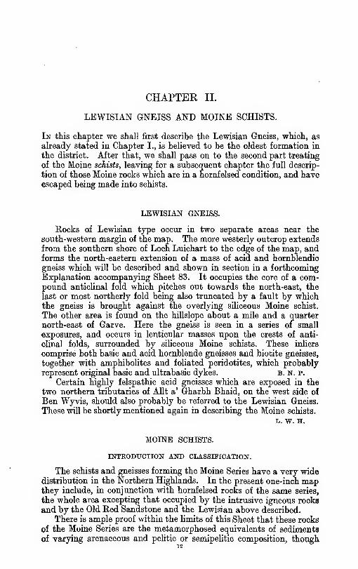
CHAPTER II.
LEWISIAN GNEISS AND MOINE SCHISTS.
In this chapter we shall first describe the Lewisian Gneiss, which, as
already stated in Chapter I., is beUeved to be the oldest formation in
the district. After that, we shall pass on to the second part treating
of the Moine schists, leaving for a subsequent chapter the full descrip-
tion of those Moine rocks which are in a hornfelsed condition, and haveescaped being made into schists.
LEWISIAN GNEISS.
Rocks of Lewisian type occur in two separate areas near the
south-western margin of the map. The more westerly outcrop extends
from the southern shore of Loch Luichart to the edge of the map, andforms the north-eastern extension of a mass of acid and hornblendic
gneiss which will be described and shown in section in a forthcoming
Explanation accompanying Sheet 83. It occupies the core of a com-pound anticlinal fold which pitches out towards the north-east, the
last or most northerly fold being also truncated by a fault by whichthe gneiss is brought against the overlying sihceous Moine schist.
The other area is found on the hillslope about a mile and a quarter
north-east of Garve. Here the gneiss is seen in a series of small
exposures, and occurs in lenticular masses upon the crests of anti-
clinal folds, surrounded by siliceous Moine schists. These inhers
comprise both basic and acid hornblende gneisses and biotite gneisses,
together with amphibolites and foliated peridotites, which probablyrepresent original basic and ultrabasic dykes. b. n. p.
Certain highly felspathic acid gneisses which are exposed in the
two northern tributaries of AUt a' Gharbh Bhaid, on the west side of
Ben Wyvis, should also probably be referred to the Lewisian Gneiss.
These will be shortly mentioned again in describing the Moine schists.
L. w. H.
MOINE SCHISTS.
INTRODUCTION AND CLASSIFICATION.
The schists and gneisses forming the Moine Series have a very widedistribution in the Northern Highlands. In the present one-inch mapthey include, in conjunction with hornfelsed rocks of the same series,
the whole area excepting that occupied by the intrusive igneous rooks
and by the Old Red Sandstone and the Lewisian above described.
There is ample proof within the limits of this Sheet that these rooks
of the Moine Series are the metamorphosed equivalents of sedimentsof varying arenaceous and pehtic or semipelitic composition, though

Groups in the Moine Series. 13
their geological age is still undetermined. A semipelitic is much more
common than a peUtic character, but, in the general descriptions to
follow, the term " pehtic " has often been used for brevity. Altered
representatives of pure hmestones are absent from this area, but^thin
bands which contain zoisite and hornblende, and accompany the
pelitic gneisses aiid hornfels, are probably altered impure calcareous
deposits.
The gneisses of pelitic or semipelitic origin form subordinate bandsin the predominant quartzose schists (Plate XII.). The most im-
portant of the former can be traced for many miles along the crop,
shown in the map, and afford the best means of working out the
structure of the country and the succession of strata.
Four groups have been separated in the Moine rocks in this Sheet.
They are shown in the following list, in which the group supposed to
he the newest is placed at the top :—
•
4. Pelitic mica schist and hornfels.
3. Quartzose schists and subsidiary micaceous bands.
2. Pelitic gneiss or garnetiferous muscovite biotite gneiss.
1. Quartzose schists with subsidiary micaceous bands.
The chief crop of the lowest group (1) is found in the eastern part
of the njap, where it forms a belt next to the Old Red Sandstone, and-extends from the east side of Little Wyvis north-eastwards nearly to
Struie Hill. As far as known, it does not include any bands of darkbiotite schist, such as are so frequently met with in the higher
quartzose group (3), and many beds are very siliceous, poor in mica,
and weather white, like quartzite. The lower pelitic gneiss (2) forms
a broad belt following the western margin of the chief crop of the
lower siliceous group (1), extending from Strathgarve to the north-east
corner of the Sheet at Easter Fearn. Evidence is given in the detailed
-description, to show that the pelitic gneiss of this belt overlies the
rocks of the sihceous group to the east (1).
Another belt of pelitic gneiss, which is considered from its litho-
logical character to belong to the same group (2), has been traced fromthe western end of Loch Luichart in a N.N.W. direction to Coire Mor,
in the north-west corner of the map. This belt has been traced
further, in Sheet 102, to the north, and has been found to bendround andenter one-inch map 93 again, near Alladale Lodge. The evidence in
the latter area suggests that this belt is the denuded top of an upfold
of the pelitic gneiss, and this inference is strengthened by the similarity,
in many places, of the rocks in the supposed overlying quartzose
group (3) on each side of the belt.
The rocks of this quartzose group (3) occupy a wide continuous
area between the belts of pehtic gneiss above referred to. They are
specially marked by the occurrence of a band of pebbly schist or
schistose grit, and by numerous thin bands of dark biotite schist.
The pebbly schist contains well preserved pebbles of quartz andfelspar, and others of igneous and sedimentary origin, which will be
more fully described in the sequel. Their preservation is, perhaps,
chiefly owing to their original large size. In the other siliceous schists
the remains of pebbles are smaller, but can still frequently be recog-
nised, together with structures which have a very close resemblance
to bedding and false-bedding.

14 Moine Schists.
2>
0,0
< <O CO
£.
^
a §
m '-'.5
It is, however, in the succeeding
group (4) of mica schist and hornfels
that the most complete evidence <A the
original sedimentary nature of the rocks
is found. The sandy shales which chiefly
compose it have been hornfelsed by the
action of the granite, and have been thiis
so welded together that in the subsequent
schist - making movements, many parts
moved en masse, and escaped the sharp
folding and molecular change which is
indicated in the neighbouring rocks. Thegroup forms a rim around, the largest
granitic mass, for most of its extent, andoccupies a central position, in all prob-
abiUty part of a syncline, in the midst
of the upper quartzose group (3), de-
scribed above.
Within the aureole of the influence of
the granite these rocks frequently havetheir bedding planes preserved uninjured,
and even the original fine clastic grains
are quite distinct. Suncracks and ripple-
marks have also been observed on the
surfaces of the bedding planes. The samebeds are in the condition of hornfelsed
shales, with no trace of foliation at one
point, while, in other places, they are
thoroughly foliated mica schists. Anoutlier of this group, in the form of micaschist, caps Carn Beag, east of Kilder-
morie.
To illustrate what is considered to be
the most probable structure of the schist-
ose area, the accompanpng horizontal
section, Fig. 1, has been drawn fromnear the north-west corner of the map in
a nearly E.S.E. direction. The augengneiss or foliated granite, believed to bea denuded laccolite, occupies the centre
of the section, and is closely embraced bythe rocks of the higher pelitic group (4),
composed of mica schist and hornfels.
The underlying siliceous schist (3), withits band of pebbly schist, occupies the
surface on either side, and is succeededby the lower peUtic gneiss (2), whichforms the surface of a denuded anticline
to the west of the augen gneiss. Thelowest sihceous schist (1) never reaches
the surface on this side of the latter
gneiss. On the eastern side the pelitic
gneiss (2) crops in one limb only of a major

Garve and Loch Luicharl 15
iold, tte eastern limb of which is nowhere seen in the map. This
"band of gneiss presents its whole thickness, and is followed on its
eastern side by the underlying quartzose group (1).
It will be observed that in most parts of the section the folds are
<of an isoclinal type, their limbs dipping at various angles to the south-
east, c. B. c.
We shall now proceed to describe more fully the development of
the Moine Schists in different districts, taking first the areas on the
south-west and south-east sides of the Older Granite.
SOUTH-WESTERN DISTRICT : GARVE AND LOCH LX7ICHAET.
In the Loch Luichart region a distinct order of succession, shownbelow, can be made out in the rocks as they are followed outwardsfrom the Lewisian inlier.
3. Upper siliceous zone ; flaggy to massive quartz biotite granulites, withdisseminated biotite in varj-ing quantity ; characterised by pebblybands on certain horizons.
2. Pelitic zone ; muscovite biotite schist and gneiss.
1. Lower siliceous zone ; highly quartzose flaggy schists, with white mica.
A description of the structure on the eastern side of the inlier will
\>Q found in the Explanation accompanying Sheet 83. On the westernside of the fold siliceous schists of zone 1 are seen on the south side
•of Loch Luichart with a south-easterly dip. The isoclinal folding
appears to carry them beneath the Lewisian Gneiss, but in reality
they are resting upon it. At the head of the loch the schists are
truncated by the Strathconan N.N.E. fault (see Chapter IX.).
A similar succession obtains round the Lewisian Gneiss inliers
north-east of Garve, which are surrounded by the flaggy, siliceous
schists of zone 1. These are followed on the south-east by a belt
of the pelitic gneiss of zone 2, and for some distance further to the
east the rocks of these two zones alternate rapidly until they are
succeeded by the broad belt of pelitic gneiss, of a peculiarly coarse andmassive character, which extends south over Carn Gorm and CarnFearna. On the eastern slopes of Carn Gorm the lower siliceous
schists (1) reappear, and, interrupted only by a few small lenticular
outliers of zone 2, occupy the whole area up to the margin of the
Old Red Sandstone.
Passing to the north-western side of the Lewisian Gneiss, we find
the lower siliceous schists (1) succeeded by a narrow band of pelitic
•Tocks (2), the small breadth of the outcrop being chiefly due to its
truncation on the west side by a fault nearly parallel to the strike.
Further to the west a wide tract of country, extending to the line
of the Strathconan N.N.E. fault, is occupied by the quartz biotite
granulites of zone 3.
For a short distance from the last outcrop of the pelitic gneiss onthe flanks of Little Wyvis, the south-easterly isoclinal dip is con-
tinuous, but between the Black Water valley and the fault the
direction of inclination is variable, the irregularity, both of strike anddip, being particularly marked round the extremity of the augen gneiss.
That the great width of the area occupied by the rocks of asingle zone is due to folding is well illustrated on the map, bythe manner in which the successive folds of the underlying pelitic

16 Maine Schists^
gneiss plunge beneath the siliceous schists along the northern shoreof Loch Luichart.
Within the area of this map the siliceous schists on the south sid*
of Loch Luichart are different in character from those on the northside. The latter, with the possible exception of those about three-*
quarters of a mile south-east of Coille Coire Mhuilidh, belong to thes
upper siliceous zone (3). They must be separated from those on the
south side, either by a folded crop of pelitic gneiss (2), which is hiddeafor the most part under the water of the loch, or by an east and westfault—possibly the continuation of the fault indicated three-quarters
of a mile south-east of Coille Coire Mhuilidh.
On the west side of the Strathconan fault, and south of the Glas-
carnoch River, the ground in the south-west corner of the sheet is
mostly occupied by the siliceous granulites of zone 3, through which'
the pelitic rocks of zone 2 appear at intervals in long lenticular
masses along the crests of successive anticlinal folds. In this area
the strike is somewhat abnormal, the direction of the axes of thesteep-sided folds swinging round from N.N.E. and S.S.W. to N.N.W.and S.S.E.
The pebbly bands of zone 3, which have been described from the
central part of this Sheet and from ground further west in Sheet 92,
occur at several .localities in this area. They are well seen in thesections laid bare by the Grudie River in the south-west corner of the
map, and form a belt which extends northwards almost parallel withits western margin.
The Moine schists around the southern margin of the augen gneiss
are much invaded by apophyses and veins of granitic material. Onthe west side of the Strathconan fault, near the head of Loch Luichart,
there is an area in which the rocks are similarly invaded by foliated
granitic material, leading to the inference that at this point the augengneiss may possibly have been formerly present at no great distance
above the surface now existing. The rocks on the east side of the
same fault are not so impregnated in this locality. b. n. p,
BEN WYVIS DISTRICT.
The mountain mass of Wyvis, which may be considered to extend
from the shores of Loch Glass to the foot of Little Wyvis, above Strath-
garve, is mainly composed of the coarse garnetiferous muscovite
biotite gneiss of the pelitic group 2, which occupies the centre of a
compound reversed synclinal fold, whose axis runs N.N.E.-S.S.W.,
parallel to the trend of the ridge, and whose limbs dip to the south-east.
The overlying rocks of the upper siliceous zone (3) appear in
numerous small synclinal folds upon the. pelitic gneiss, the principal
outcrops of the psammitic schists of the former zone being found
south and south-west of Fiachlach, on the ridge at the head of Coire
Mhoir, and on An Socach.
The complex nature of the folding is apparent in all the eastern
corries of Ben Wyvis, and especially in Coire na Feola—the deep, glen on the south side of An Socach—on whose precipitous rocky
walls the rapid alternation of the pelitic and siliceous rocks along
minor folds is finely displayed.
Passing to the eastern slopes of the mountain, we find the pelitic

Wyvis. 1
7
gneiss immediately to the north, of Loch Misirich, lying in a basin
surrounded by siliceous granulites which dip beneath the gneiss. It
thus seems probable that the psammitic rocks that form the northern
slopes of the AUt nan Caorach valley, and extend over Meall na Speireig
to AUt Gleann Sgathaich, belong to a lower series of altered arenaceous
sediments—zone 1 of the Moine Series—which underlies the pelitio
gneiss, and has been exposed by denudation along the east side of the
Wyvis range. A study of the excellent section seen in the AUt GleannSgathaich, on the southern margin of the map, tends to confirm this
interpretation of the structure. For more than a mile along the
course of this stream the pelitic and siliceous rocks are rapidly
interfolded at high angles, as shown on the map. The folds are seen
in many places to pitch steeply in a S.S.W. direction, and it is evident
that at these points the siliceous schists pass beneath the pelitic
gneiss. l. w. h.
Where observed in AUt nan Caorach and along the parish boundarywest of Meall na Speireig, the siliceous schists of this lower groupweather unusually white, like quartzite, as is also the case with the
schists of this group in other areas. Thin flaggy bands of flaky
mica schist and others of " spangle-schist," with large mica flakes
crossing the foliation, are also seen with associated pegmatites in
AUt nan Caorach. c. b. c.
The rocks of the lower siUceous zone (1) appear again on the western
side of the syncline, where they form a narrow belt along the lower
slopes at the foot of Little Wyvis and Glas Leathad Mor, and extend
northwards over the summit ridge of Wyvis through the depression,
named on the six-inch map the Bealach Tom a' Choinnich, a mile
south-east of Carn Gorm. The debris of these flaggy siliceous schists
covers the col, and the rock is seen in place on the watershed at anelevation of 2859 ft. ; sections are also exposed in the streams that
flow down the slopes of Glas Leathad Mor and Little Wyvis. In the
two northern tributaries of the AUt a' Gharbh Bhaid, bands of micace-
ous gneiss, that may be regarded as infolds from the overlying
pelitic zone, appear amongst the siliceous flagstones. The same two
streams each present a limited exposure of a highly felspathic,
epidotic, acid gneiss, unlike the normal Moine gneisses, and resembling
the more acid portions of the Lewisian Gneiss complex. It is quite
possible that these may represent small infolds of the underlying
Lewisian floor, similar to the larger inliers of undoubted Lewisian
Gneiss further to the south, at Strathgarve.
Throughout the greater portion of its extent this lower siliceous
belt is bounded on the west by the fault which runs in a north-east
direction from the shore of Loch Luichart, nearly three miles east of its
head, and almost parallel to the general strike of the rocks. On the
ridge of Wyvis, where the siliceous schists (1) pitch beneath the
pelitic gneiss (2), these two zones are thus brought into faulted con-
junction with the higher zone (3)- to the north-west. Further to the
south the lower siliceous zone (1) is in contact with the rocks of the
upper siliceous zone (3) for a distance of nearly four miles. The
fault then forms the western boundary of the pelitic gneiss on the
south-west flank of Little Wyvis, and the lower siliceous rocks, a
little further east, occupy their normal position near the centre of the
fold, with the peUtic gneiss on either side, and the Lewisian inliers

18 Moine Schists.
appearing along the core of the anticline. The siliceous schists (1)
finally pitch out beneath the pelitic rocks in the vicinity of Strath-
garve, close to the southern margin of the map. The course of the
fault along the western slopes of Wyvis is for the most part concealed
by superficial deposits, and its position is conjectural. The point
where it crosses the Allt a' Bhealaich Mhoir, west of An Cabar, is,
however, marked by crushing and brecciation of the siliceous schists.
The ground to the west, between the Loch Luichart fault and the
Allt Coire Bheachain, is occupied by the upper siliceous zone (3) of the
Moine Series, the most quartzose type alternating with rocks of moremicaceous or semipelitic character.
The rocks over a great part of this area are arranged in apparently
simple anticlinal and synclinal folds of considerable amplitude. Thedeep hollow which contains the waters of Loch Bealach Culaidh
occupies the crest of one of these broad anticlines. On the summit of
the ridge between that loch and the valley of the Allt Coire Bheachain,
the schists are, however, thrown into a sharp anticlinal ridge, along the
axis of which the beds are almost vertical.
The apparent simplicity of the structure over the central part
of the area is, however, in all probability misleading, and there is
more reason to assume the existence, in this region also, of a consider-
able amount of repetition due to minor isoclinal folds, although the
presence of such folds cannot be so readily detected in these homo-geneous rocks.
The pebbly bands referred to in the next paragraph as occurring
on the east side of Loch Bealach Culaidh, and on the slopes of
Cam Mor, occupy in both localities a position near the crest of oneof the major antichnes, and are thus possibly on the same horizon.
With regard to the structural relations of the biotite schists in the
area west of Ben Wyvis to the upper sihceous group with whichthey occur, the fact that they enter into both anticlinal and synclinal
folds of the latter group shows that they do not form part of the
underlying pelitic series, but, as suggested later, are merely local
intercalations in a generally siliceous series.
Quartzose Schists.
The siliceous schists in the region between the Ben Wyvis escarp-
ment and the valley of Loch Bealach Culaidh are usually thick-
bedded and of somewhat massive habit. Felspar in a thoroughly
granulitised condition is present in varying amount, and is mostabundant in the massive granulites of Cam Gorm, where it is of a
pinkish colour. The rock also contains a variable quantity of irregu-
larly disseminated biotite. Coarser bands, containing recognisable
clastic grains and more or less distinct pebbles, mostly of felspar,
occur at the junction of the Allt a' Gharbh Bhaid with its highest
tributary on the east bank, on the south-east shore of Loch BealachCulaidh, and on the southern slopes of Cam Mor. Intercalated with
the siliceous granulites in many places are thiui bands or seamsof fine-grained mica schist. These micaceous rocks reach a greater
development in the valley of Abhuinn Beinn nan Eun, where a belt of
dark biotite schist and biotite muscovite schist, a few hundred yards
in breadth, crosses the glen three-quarters of a mile above the head

Ben Wyvis. 19
of Loch Glass. The rock is a very fine-grained schist, often with a
silky lustre, in which biotite is the predominant mineral. The minute
puckering due to incipient ausweichungsclivage is a common feature
of these schists, and a distinct cleavage-foliation, oblique to the bed-
ding planes, can often be detected. It is to be observed that where
the mica schist is intercalated with thin bands of quartz schist,
the cleavage planes do not cut the harder siliceous material.
With the biotite schist at this locaKty is associated a thin bandof garnetiferous hornblende zoisite granulite, which presents the
spotty character and nodular weathering that prevail in these zoisite-
bearing rocks. A specimen from this band, examined under the
microscope by Dr. Mett, is described by him as follows (11129): *
" In a granulitic quartzofelspathic groundmass lie scales of biotite,
small rude prisms of pale greyish-green hornblende, idiomorphic
pale pink garnets studded with grains of quartz, and colourless zoisite
in small prisms half a millimetre in length and one-tenth of a
milUmetre in breadth. These zoisites give grey or blue interference
tints, but some are nearly isotropic. There is a little granular sphene,
and small crystals of iron oxide, but the rock contains no muscovite."
Similar bands of dark lustrous biotite schist, often with small
garnets, occur on the north-east side of the Queen's Cairn, and aboveLoch nan Druidean. It should be mentioned that, from their
structural relations to the quartzose schists with which they occur,
these micaceous bands are regarded as original argillaceous inter-
calations in the siliceous group, and not as forming part of the under-
lying pelitic group, to be presently described.
Semipelitic Growp.
A semipelitic class of schists, formed by the metamorphism of
sediments of intermediate character, or rapidly alternating between
the purely argillaceous and arenaceous types, is found on the east side
of Allt Coire Bheachain, and extends southwards to the margin of the
granite on Cam Mor. They may be described as fine-grained,
thoroughly granulitic quartz biotite granulites, in which the ferro-
magnesian mineral is disseminated through the rock in small flakes, andis not markedly orientated. There are also bands of highly siliceous
rock in which the mica is almost entirely absent. The original bedding
planes are indicated by numerous dark laminae rich in black mica,
representing muddy films in a more sandy deposit. The irregular
arrangement of these planes suggests in many places the effects of
false- or current-bedding.
Pelitic Gneiss.
No particular features have been observed in the gneisses of
Ben Wyvis distinguishing them from rocks of the same group in
other parts of the region.
The rock presents the usual character of a generally coarse,
muscovite biotite gneiss with wavy or corrugated folia, and often
highly garnetiferous, the garnets occurring either as idiomorphic
crystals or in aggregates.
A finer-grained and more evenly foliated flaggy type is also met* The number of the tnioro-section in the Geological Survey Collection.
20 Moine Schists.
with. These flaggy gneisses alternate more or less with the coarse-
grained massive rock throughout the area, but tend to become the
predominant type at the eastern edge of the main outcrop, that
is to say, in the lower portion of the group.
Tourmaline Pegmatites..
On the eastern slopes of Ben Wyvis, rather less than a mile W.N.W.of Loch Misirich, there occur, both in the pelitic and siliceous schists,
two or three thin veins of coarse muscovite pegmatite containing
garnets and idiomorphic crystals of tourmaline, the latter sometimesreaching a large size. Fragments of silvery muscovite schist with
abundant tourmaline also occur amongst the hill-wash and thin
drift that covers the hillsides above Loch Misirich, but the rock fromwhich they are derived has not been met with in place. l. w. h.
DISTEICT OF STEATH KANNOCH.
This district includes the eastern side of the strath near the keeper's
house in Strath Rannoeh, and extends eastwards to Loch Coire
Bheachain and Allt Coire Bheachain. From the foot of this burn the
boundary proceeds along Abhuinn Beinn nan Eun to the granite.
Most of the Moine schist in the area is siliceous in character. Aband of more pehtic rock occurs along the granite margin to the
north-east of Carn Loch nan Amhaichean, and, after running south-
east for a short distance, is shifted north-eastwards along with the
granite margin for a distance of nearly a mile, by a north-easterly
fault, in all probability a continuation of the Strathconan fault whichruns past the head of Loch Luichart (see Chapter IX.).
This band has been indicated on the map, but there are numerousminor occurrences of pelitic material among the siliceous schists to
the south which have not been picked out. The greater portion
of all this pehtic material is in the form of hornfels. On the westside of Loch Coire Bheachain a considerable crop of semipehtic schist,
without any indications of hornfelsing, intervenes between the north-
eastern end of the Inchbae granite and the siliceous schist, but it
appears to be cut out in a westerly direction by a transgression of
the granite across the bedding.
The sihceous schist to the east of Lochan Gobhlach is often gritty,
and sometimes contains little pebbles of quartz and felspar. Theschists for some distance south of this loch also show distinct remainsof pebbles and unmistakeable false-bedding. In one spot, about100 yds. south of the southern end of the loch, scattered blocks,
partly of sihceous and partly of semipelitic character, which are
evidently nearly in situ, show various types of pebbles of unusuallylarge size. Among these pebbles are some of sihceous granuhte,approaching granuhtic quartzite in character, and a good numberwhich show small porphyritic crystals of quartz embedded in a pinkgranulitic matrix, and have probably been derived from quartzfelsite.
Many of the felspar pebbles show no appreciable deformation(Fig. 2), and are remarkably free from granuhtisation. Thosethat have been examined under the microscope by Dr. Flett consist

Strath Rannoch. 21
of microoline or microcline-pertliite. One of the pebbles consists
of graphic granite (10905) with coarsely hatched microchne. In
Sia. 2 (xl).—Piece of Pebbly Schist nearly in situ 100 yds. S.S.E. of south endof Lochan Gobhlach. The most elongated pebbles probably represent quartzfelsites and quartzites. The large one near the bottom is quartz. Two smallones near the middle, and a third small one at the bottom are felspar.
great contrast to the felspar pebbles, those of quartz are always greatly
deformed,* and some of them form flattened, occasionally bent ribbons,
which are six or seven inches long, though hardly an inch broad andonly half an inch thick.
Even longer than the quartz pebbles are some which probablyrepresent quartz felsite. It was, indeed, this great elongation com-pared to the stumpy form of the undoubted felspar pebbles whichled to the first recognition of their composite character.
Irregular patches of greenish-grey micaceous schist occur in close
association with undoubted pebbles, but it is possible that theyrepresent contemporaneous " galls " formed of soft unconsohdatedmaterial.
In a pebbly schist 190 yds. sUghtly south of east of the south endof the loch, small grains of epidote and small octahedia of magnetiteare very abundant in certain laminae, arranged in a way which is
strongly suggestive of false-bedding. Epidote occurs in thin veins
crossing the bedding, and also as grains replacing felspar in someof the pebbles ; but it is believed, owing to the mode of distribution
described, that in the main both epidote and magnetite represent
original heavy sediments.
These interesting pebbly beds are probably only half a mile fromthe granite, but they show no clear hornfelsing. The foliation
planes are lustrous with abundant scales of white mica, large
enough to be separately discerned with a hand lens, and the matrixis thoroughly granuUtic and can often be seen to sweep round the
pebbles.
The beds close to the granite on Meall nan Sac are also usually
epidotic, and some bands, which are not quite so lustrous as the rest,
contain pebbles an inch and a half long. These pebbles are, however,
to a large extent granulitic, and it is not clear that they represent any
* A similar contrast has often been noticed before. See, for iilstanoe, ' ThaGeological Structure of the North-West Highlands of Scotland,' Mem. Oeol. Survey,
1907, p. 620.

22 Maine Schists.
substances except quartz and felspar. They are often elongated
along a foliation which crosses the bedding almost at right angles.
c. T. c, E. M. A.
DISTRICT 0¥ LOCH GLASS, LOCH MORIE AND STRATH RUSDALE.
Roughly speaking, four great bands with a north-east and south-
west strike cross this district. They are as follows :—
*
4. A band of mica schist and hornfels, witli a breadth varying from half a
mile to one mile, wliich follows the margin of the augen gneiss fromBeinn nan Eun northwards.
3. A quartzose series with subsidiary bands of mica schist, and with anaverage breadth of three miles.
2. To the east of the above quartzose series a band of garnetiferous micaschist, with a breadth varying between half and three-quarters of a mile.
This extends from Loch Glass to the margin of the Fearn granite, whichtruncates the crop.
1. Another quartzose series differing somewhat in lithological character
from (3), and extending from Loch Glass to Beinn Tharsuinn and TorrLeathann. This lies on the eastern side of the garnetiferous mica schist
(2), and is bounded on the east by the Old Bed Sandstone.
In describing these four bands, we will begin with that last
mentioned (1), which is believed to be the oldest.
1. The Lower Quartzose Group.
The rocks of this group are well displayed on the eastern flank of
Beinn Tharsuinn, on the tops of Torr Leathann, Cnoc an t- Sithein Mor,Cnoc an t- Sithein Beag, and in crags facing the lower part of Strath
Rusdale at Balnacraig. A good section can also be seen in the ToUieBurn, from its source in Beinn Tharsuinn to about a third of a mile
above Braetollie, where the Old Red Sandstone is faulted against the
schist. South of Strath Rusdale it is again exposed on Cnoc na Sroine,
and also in the bed of the Alness River, above its junction with the
Black Water. Other exposures are seen in the crags near Boathvic,
on either side of the lower part of Loch Morie, along the northernshore of Loch Glass, and in Glen Glass above the fault at Eileanach.
These quartzose rocks everywhere dip to the south-east, but theyare isoclinally folded, and it is probable, from the constant repetition
of bands of a similar nature, that no great thickness of strata is re-
presented. All the types are thoroughly granulitic. The mostcharacteristic are massive and flaggy rocks, very quartzose andweathering white hke quartzite. They are of a pale brownish colour
when broken, but contain very little mica. Others are pink and grey,
coarse-grained and with some resemblance to granite, owing to thelarge proportion of felspathic material. With these are flaggy, verysihceous " spangle-schists " with large, brilliant, rounded flakes of
mica, resembUng fish scales, scattered over the division planes : theflakes he at various angles to these planes, and are evidently of
secondary origin. These rocks are associated with schists of a" papery " character, consisting chiefly of large flakes of mica and
* The numbers in the list attached are the same as those already used In thischapter for the corresponding bands in other distriote.

Loch Glass, Loch Marie and Strath Rusdale. 23
strings of pegmatite. The " papery " schists evidently form passage-
rocks into the overlying garnetiferous mica schist, which occurs as bandsand infolds, increasing in number and size as they approach the great
band to the westward. These bands are usually flaggy, but some-times more or less massive, and often contain well developed garnets.
Dark, fine-grained mica schists are conspicuously absent. The bandsof garnetiferous mica schist are evidently mostly due to folds whichhave brought down into the quartzose series portions of the formerly
overlying garnetiferous mica schist, now removed by denudation. Ananticlinal arrangement of the quartzose bands was detected on the shore
of Loch Glass, opposite Culzie Lodge, but no other structural evidencefor the relation of the two series was observed. Better evidence has,
however, been obtained in areas to the south mapped by Messrs.
Hinxman and Peach, as already described (pp. 15, 17). It is note-
worthy that no intrusive sills of epidiorite, such as occur in association
with this group and the overlying mica schist, have been detected in
the other groups of this area.
2. The Garnetiferous Mica Schist.
This schist can be traced as a continuous band over half a mile
in width from Sithean a' Choin Bhain, on Beinn Tharsuinn, across Cnoca' Mhadaidh into Strath Rusdale between Dalreoich and Balnacraig,
whence it crosses the low ground south of Am Mam into the valley
of the Alness River below Loch Morie. Here it comes against the LochMorie fault, which on its south side shifts all the metamorphic rocks
and the Old Red Sandstone to the westward, as will be further described
in Chapter IX. The mica schist is again seen in the crags on the south
side about half-way up Loch Morie, whence it passes over Meall Beagto the north shore of Loch Glass. The best exposures of this bandare seen at Cnoc a' Mhadaidh, north of Strath Rusdale, and in the
crags beside Loch Morie and Loch Glass. In these places the rock
is a massive dark bluish grey mica schist, and breaks up into immenseblocks which lie piled in confusion at the base of the crags. It con-
sists chiefly of muscovite and biotite, in small and large scales, with
lenticles and strings of pegmatitic material. Garnets are very numerous,and in the most massive types are usually in the form of crushed
aggregates, but idiomorphic garnets, with well-developed crystal faces
and of a beautiful pink colour, are not uncommon, and are found bythemselves in the more flaggy types. About a mile north-east of the
cairn on Meall Mor, a thin calcareous band, weathering with a porous
surface, was observed near the south-east margin. It is rich in calcite,
and contains also zoisite, hornblende, and large garnets (11027). It
must have been an arenaceous limestone originally. The pegmatitic
material often occurs in the form of augen wrapped round by the other
constituents of the rock, and great lenticular masses of coarse pegmatite
are also found, which are difficult to distinguish from dyke-like masses
of similar material which occur along the strike of the rocks. These
dyke-like pegmatites are mostly associated with the more flaggy
types of mica schist to the east of the main band. They consist
of clear quartz and white felspar with plates of white mica, which are
frequently several square inches in extent, and an inch or more in
thickness. Garnets are not uncommon in the quartzo felspathic

24 Moine Schists.
material, and also lie embedded in the plates of white mica. They
then split with a perfectly smooth surface along the__same planes as
the cleavage of the mica. Where the band of garnetiferous mica schist
crosses from Loch Morie to Loch Glass it dips south-east at angles of
30°-4:5°, but the true dip is often difficult to make out, owing to the
massive character of the rock and the absence of distinctive bands.
North of Strath Rusdale the dip is in the same direction, but at higher
angles. Along its eastern margin the band is followed by constant
repetitions of the flaggy spangle-schist, and bands of more massive
mica schist with intercalations of the quartzose group already described.
The alternation must be largely due to folding together of the twogroups. The western margin, on the contrary, is generally very
abrupt, a fairly massive mica schist giving place to a flaggy siliceous
schist, with scarcely any repetition of mica schist. To the west of
Beinn Tharsuinn, however, a few folds of the same type of mica
schist occur to the west of the main band.
3. The Upper Quartzose Group.
The rocks of this group appear to dip beneath the garnetiferous
mica schist on Cnoc a' Mhadaidh, Meall Beag and the crags beside
Loch Glass. This is due to the fact that they are folded into isoclines
dipping east, so that the mica schist, which we suppose to be really
older than the quartzose rocks on its west side, appears to overlie
them. Along this boundary the rocks are rather flaggy, with finely
divided glistening micas on the division planes, but further west they
pass rapidly into a more massive type, pink and grey in colour andrather felspathic, in which original clastic grains of quartz and felspar
can often be distinguished. The amount of mica is usually small
in these massive rocks, but lines of heavy dark minerals are common,and often give an appearance of false-bedding. The bedding planes
are usually distinct, and a foliation may often be detected crossing
them. Thin layers of fine silvery mica are frequently found on the
bedding planes ; numerous smooth joint faces are also conspicuous.
Except with the most massive types, bands of fine-grained dark micaschist are found, which have a very different appearance to the
garnetiferous mica schists. Though all the constituents are small,
these dark schists evidently contain more biotite than white mica.
When they occur in large bands they have frequently a crimpedor crinkled structure, which seems connected with an incipient
strain-slip cleavage. Garnets of small size are occasionally seen.
This wide belt of rock shows constant reversals of dip, and is probablymuch folded. The best exposures are in the following places : the
bed of the Black Water in Strath Rusdale ; Leathad Riabhach andCarn Beag, both to the north of Loch Morie ; Creag a' Ghaoirr and the
crags north of Wyvis Lodge. Along the western margin of the band arather different type of rock is met with, which may in part owe its
present appearance to the thermal influence of the granite mass.This type is flaggy and contains thin bands of white quartzite whichbreak up into slabs, on the surfaces of which ripple-like markingshave been detected in the Coire nan Sgulan, south of Loch a' Chaoruinn.Original clastic grains are frequent, and pebbles have been noticed
in some bands. These quartzite bands were traced from Coire nan
Loch Morie. 25
Sgulau southward to Beinn nan Eun. A band of dark crinkledmica schist occurs on the top of Carn Beag, north of Loch Morie, anda band of similar nature was mapped south of Creachan nan Sgadan.In both these places there is reason for thinking, from the direction
of the dips, that the mica schist is lying asan outlier on the moresiliceous rocks. This is an important point 'in relation to the micaschist and hornfels band next to be described, as the rocks of MeallToll a' Choin and An Claigionn, in the neighbourhood of Kildermorie,which form the outer part of the band, are identical in character
with the mica schist of the outliers on Carn Beag . It affords evidencethat the mica schist and hornfels series overlies the quartzose groupnow described, and is therefore the highest sedimentary series in
the metamorphic rocks of the district.
4. Band of Pelitic Mica Schist and Hornfels.
In this band we have rocks of very different type associated together,
owing to some parts of the original argillaceous sediment having beenhornfelsed by the intrusion of the granite. There is evidence that
the hornfelsing took place previous to the great series of movementswhich have so powerfully affected the granite and sediments, turning
them into schists and gneisses. The band is in contact with the granite
from Meall na h-Uigeig to Beinn nan Eun. It is about half a mile
in width at the former place, but gradually widens to about a mile
near Kildermorie. On the south side of the Loch Morie fault it extendsfrom Meall a' Chaoruinn to Beinn nan Eun, but siliceous rocks comeinto contact with the granite on the western slopes of the latter
mountain, and the western boundary of the argillaceous band leaves
the granite margin, proceeds in a south-easterly direction, and joins
the eastern boundary before it reaches the Abhuinn Beinn nan Eun,the band thus coming abruptly to an end. From Kildermorie,
northward, it has been found possible to separate this band into aninner zone bounding the granite, which is chiefly composed of hornfels,
and an outer zone in which the rocks consist of mica schist. Thehornfels, and the shearing movements which have in places affected it,
will be subsequently described in Chapter V. The outer zone has beenmore or less completely turned into mica schist. On An Claigionn,
where these mica schists have a breadth of considerably over a quarter
of a mile, the bedding has been almost obliterated, and the rocks are
identical in character with the mica schist which has been described
as capping Carn Beag, more than two miles distant from the granite
margin. Much white segregated quartz is associated with this
crinkled mica schist. Between Bad a' Bhathaich and Carn Cas nanGabhar the rocks are in the form of silky phyllites in which the
bedding is still quite distinct, though crossed at a high angle by the
foliation. We can walk along the strike of the bedding from these
mica schists and phyllites on to the hornfels, and it is clear that these
three types of rock represent one band of sediment which has under-
gone diverse modes of metamorphism It is probable that muchof this outer zone was never affected by tlie thermal metamorphismwhich produced the hornfels, but that many of the beds in it were
metamorphosed directly from their original shaly condition into
mica schists. Those beds which have now the character of phyllites
26 Moine Schists.
were, however, probably more or less bornfelsed previous to tbe
advent of the mechanical metamorphism, and so resisted the thorough
change shown by the adjoining mica schist.
South of the Loch Morie fault it was not found possible to separate
zones corresponding to those just described. The hornfelsing action
of the granite has in many places extended to the outer margin of
the argillaceous band, and even afEected the siliceous bands in the
neighbourhood, which have in consequence retained more of their
original structures than is usual. c. b. c.
DISTRICT SOUTH-WEST OF KINCARDINE.
The boundary of this district is taken through Creag na Ceapaich
and Carn an Liath-bhaid, and along the margin of the granite to the
burn south of Meall na h-Uigeig. It follows this burn down to
Garbhairidh, and then crosses over Cnoc Leathad na Siorramachd to
the Old Eed Sandstone on Struie Hill.
The district includes a great part of the Newer Granite of Corrie-
fearn, the main mass of which extends in a N.N.W. direction for aboutsix miles, and is often nearly three miles broad ; the description of this
rock is reserved for Chapter VII.
Most of the area is composed of siliceous schist, but the pelitic
or semipelitic beds are also well represented by a broad band keeping
along the margin of the Older Granite, and by two others which are
cut off almost at right angles by the eastern margin of theNewerGranite.The band along the margin of the Older Granite varies in breadth
from a mile to a quarter of^a mile, and curves, with the granite margin,
from a west-and-east direction at the north end, to a north-and-south
direction, and then to S.S.W. The portion next the granite, andanother portion half a mile N.N.E. of Carn an Liath-bhaid, are differ-
entiated on the map from the rest, as they have to a large extent
escaped shearing, and still show hornfelsed characters, as described
in more detail in Chapter V.
In the Abhuinn a' Choire Bhuig an exposure of lustrous pelitic
mica schist, about 200 yds. broad, lies a little east of the pelitic bandwhich adjoins the granite, but probably merely represents a folded
portion of it.
The two pelitic bands east of the Newer Granite make a close
approach to one another just as they reach it, and there can be no doubtthat they are both folded portions of the pelitic series which is so
well seen south-west of the Newer Granite. For various reasons, already
given near the beginning of this chapter, this series is considered
to be lower in original stratigraphical sequence than the pelitic series
which margins the older granite.
The bedding of the schists is usually steep, often vertical, andisoclinally folded. Near the Older Granite the strike is nearly the
same as its margin, but further away this is not always the case,
the general strike both in Allt Eiteachan and the burns east andsouth-east of Creag na Ceapaich being somewhat north of east, nearly
at right angles to the adjacent margin of the granite, but approxi-
mately parallel to the long axis of its outcrop. On the east side of
the Newer Granite the general dip is south-east and steep.
The pelitic bands consist in the main of lustrous mica schist, often

Kincardine, Strath Vaich. 27
garnetiferous, but semipelitic and siliceous intercalations are well
represented. Thin seams containing hornblende and garnet are also
found both in the schists margining the Older Granite, and in that
band which crosses over Cnoc an Liath-bhaid, east of Corriefearn ; in
the former band they may be seen on the south side of the burn1100 yds. slightly east of south of Creag na Ceapaich, and in the latter
very near the hill-top. These seams are similar to others which are seen
still better in other districts, particularly the two (Strath Vaich andGrleann Beag, etc.) to be next described.
Perhaps the best exposures of the siliceous schists are in the following
localities : the coast near Kincardine ; the two burns south andsouth-east of Creag na Ceapaich ; the hillsides a mile east and south-
east of Meall na h-Uigeig. Many bands are so massive and siliceous
that they might be called granulitic quartzite, but these are mixedwith numerous more micaceous politic schists, much too thin to be shownon the map. Small clastic quartz grains are tolerably abundant,
but perhaps never so large as peas, and false-bedding is frequently
discernible. The bedding is repeatedly folded in the burn half a mile
south-east of Creag na Ceapaich, and on the hillsides near Meall
na h-Uigeig, but it is to be noted that while in the former locality
the axial planes of the folds strike E.N.E. and usually incline S.S.B.
at low angles, in the latter they are nearly north and south. In
the burn a quarter of a mile south-east of Creag na Ceapaich the
stretching is N.N.W.-S.S.E., nearly parallel to the dip of the foliation.
The siliceous schists between the two broad pelitic bands east of
Corriefearn are best seen on the coast.
W. G., C. T. C, L. W. H., E. M. A.
STRATH VAICH. DISTRICT.
The northern margin of the district is taken along Gleann Beag andGleann Mor to the foot of AUadale River. The eastern boundaryextends from the last-mentioned locality over Dunan Liath and BeinnTharsuinn, and thence southward along the western margins of the
granite masses as far as Strath Vaich.
Three chief zones of rock traverse this district. One of these is a
garnetiferous pelitic mica schist, which has been traced into the
garnetiferous mica schist band already described on the east side of the
foliated granite. Sihceous schists are found on both sides of this
mica schist, but are considered to belong to one group, which probably
occupies a higher stratigraphical position than the mica schist.
In the western part of the district the general dip, which perhaps
merely indicates the dip of limbs of isoclinal folds, is eastwards, but it
is decidedly less at the extreme western edge than a mile or two further
east : thus, on the west side of Meallan Ban it is 30° or 40°, but a mile to
the east of this hill it is 60° or 70°. Near Lubachlaggan, at the head
of Strath Vaich, the beds are vertical or dip steeply west or south-west,
and are often twisted along nearly horizontal axial planes, so that the
portions above certain planes may dip very differently from those
below.
In the north-eastern part of the district the dip changes from east to
south and then to south-west, as we advance north-easterly.
Two bands of garnetiferous mica schist have been traced from the
28 Moine Schists.
western slopes of Meall an Torcain, near Glascarnoch, almost con-
tinuously in a N.N.W. direction across Tom Ban Beag and Tom BanMor to Creag Rainich and Meall Gorm. These bands have a breadth
of outcrop of 50 to 100 yds. From Meall Gorm across Meallan Ban to
Glenbeg, only one band, increasing in breadth northwards, has been
mapped. At Glenbeg it has a breadth of over a mile, extending into
the adjoining one-inch map 92, and contains minor folds or bands
of siliceous rock. At Meall an Torcain the dip is about 60°, andE.N.E. Near Glenbeg it is often only 30° to the south-east, this latter
small angle possibly accounting in part for the greater breadth of
outcrop in the north-west corner of the map. Good sections of these
schists are seen on the western flank of Meall an Torcain, at CreagRainich and on Meallan Ban. Specimens from different locahties
show much the same characters. They consist chiefly of large scales
of muscovite and biotite with thin strings of pegmatitic or quartzo-
felspathic material and numerous garnets. On the whole the rock is
not so massive as the mica schist of Loch Glass and Loch Morie, andthe garnets are more usually idiomorphic than in that rock.
Thin siliceous seams, rarely more than a few inches thick andinberbanded with still thinner seams of a dark grey colour, are not
uncommon in the garnetiferous mica schist in the burn about three-
quarters of a mile N.N.E. of Meallan Ban, and they occur also in the
crags a mile north-west of Clach Sgoilte. These siliceous seams usually
contain garnet and hornblende in fairly conspicuous prisms, and the
dark grey seams are generally rich in zoisite, so that it seems probablethat they both represent layers which were originally calcareous.
Similar seams are also found in other districts in this one-inch map,and also in one-inch map 92, where they were first described byMessrs. Gunn and TealL*
Several large dyke-like pegmatites accompany the mica schists onTom Ban Mor and Greag Rainich. They are white, coarse, often showa graphic structure on a large scale, and contain garnets and large
crystals of muscovite. The rock closely resembles the pegmatiteformerly quarried on the northern shore of Loch Garve. This Garvepegmatite was a transported boulder, and may have been carried byice from one of the exposures referred to.
Among the siUceous schists in the area between the GlascarnochRiver and Abhuinn a' Ghlinne Bhig, that is, in the Strath Vaich andToUomuick Forests, and also in the ground between Deanich and the
granite margin about Beinn Tharsuinn and Crom Loch, certain groupsof rocks of distinctive character, which extend for great distances along
the strike, can be made out. Massive quartzose schists with some of
more flaggy character are found in the ground between the garneti-'
ferous mica schist and Strath Vaich. These rocks are thoroughlygranuUtic and quartzofelspathic, with varying though usually smallproportions of micas. Bands of dark mica schist, which sometimesshow the pecuUar crinkled structure due to strain-slipping, are foundon Meall an Torcain, Meall Coire nan Laogh, Carn Gorm-loch and ClachSgoilte. Dark mica schists of the same kind are also found to theeast of these localities, but are scarcer and not so thick, and at the sametime the associated schists become coarser in grain, more quartzo-
felspathic, and less micaceous. With these dark mica schists occur*Svmmary of Progress of the Oeological Survey for 1897, p. 41. ^

Beinn a' Chaisteil. 29
others of similar type to the garnetiferous mica schist, but these
latter are not so numerous and do not extend far from the maingarnetiferous band.
The siliceous schists west of the garnetiferous mica schist do not
differ appreciably from those on the east. They are best seen in the
following locaHties : the western slopes of Tom Ban Beag, Allt Airidh
Cheiridh, a mile and a half slightly west of north of Strathderie and the
western crags of Meallan Ban. In the two last localities they are
generally massive and often show indications of false-bedding, but nodistinct clastic grains were detected. On the supposition that the
outcrop of the garnetiferous mica schist is here the denuded uppersurface of a compound anticlinal fold appearing from beneath the
accompanying quartzose rocks, a repetition of rocks of the samecharacter, like this, would be expected.
In Strath Vaich, between the Lodge and Loch Toll a' Mhuic, andthence along the low hollow to Deanich, and, following the change in
the strike of the rocks on the southern slopes of Gleann Mor, we find
a more flaggy type of siliceous schist with the bedding planes covered
with silvery films of white mica. The occasional more massive rocks
in association with these are very quartzose, fine-grained, often of a
peculiar bluish colour, and contain similar films of white mica on the
bedding planes. Original clastic grains are not unfrequent in these
flaggy rocks, especially along Gleann Mor, but it is in the rocks next to
be described that the most striking evidence of such grains has beenobtained.* These rocks form the mass of Beinn a' Chaisteil, and havebeen traced across Crom Loch and Carn Feur-lochain to Dunan Liath,
and for a considerable distance further to the eastward. They form a
band considerably over a mile in width in the neighbourhood of Beinn
a' Chaisteil and Crom Loch. They are coarse-grained, pinkish andgrey, quartzofelspathic schists, poor in mica. The bedding is well
preserved, and curved lines of darker minerals, suggesting false-bedding,
are very noticeable. Numerous smooth shckensided joints are also
common. Original clastic grains are abundant, and every here andthere bands containing rounded pebbles, generally of quartz or
felspar, but more rarely of a composite nature, are seen (shdes 10438-
10444). Shde 10438 contains fragments of micropegmatite as well
as grains of magnetite, while others contain pebbles of quartzose
sediment. The quartz pebbles are usually of a pale lilac colour,
and some have been found over an inch in diameter. Quantities of
these pebbles weathered out of the rock are strewn over the flat top
of Beinn a' Chaisteil, and form in places a thin gravelly layer. Whereleast affected by shearing movement the rock has the appearance of a
coarse grit or fine conglomerate, though on close examination the matrix
is always found to be granulitic. The pebbles show every degree of
breaking down. Some are partly granulitised and traversed bycracks. Some have their ends drawn out into long tails of granulitic
material, and others are thoroughly granulitic and have shadowy
outlines. Although some of the quartz pebbles have been intensely
flattened and rolled out to perhaps more than twice their length,
others have retained their rounded outlines in a remarkable manner.
The felspathic and other pebbles are rarely of such large dimensions
as the quartzose ones described above. Lenticular masses of pelitic
summary of Progress of the Geological Survey for 1902, p. 85.
30 Maine Schists.
schist are not uncommon in these rocks, and probably represent
original " galls " which have been drawn out and twisted. The bands
containing the largest pebbles seem to be most numerous along the
strike from Feur-lochain to the summit of Beinn a' Chaisteil. It is
remarkable that the only band of pelitic character found in association
with these pebbly rocks shows a much lower degree of metamorphismthan the micaceous bands in the other groups described. This band is
only a few feet wide, and occurs near the outer margin of the pebbly
rocks seen in the burns on the western flank of Beinn a' Chaisteil. Therock is a pale grey silvery phyllite, with the original bedding still indi-
catedby distinct bands of different colours, which are crossedby the folia-
tion at a considerable angle. In degree of metamorphism, it resembles
the phyllites of Bad a' Bhathaich, which are associated with the
hornfels on the eastern side of the granite, as described in Chapter V.
On approaching the granite the siliceous schists lose their pebbly
character, no pebbles being noticeable on Creag Dhubh Bheag andBeinn Tharsuinn. They keep their massive character for some distance,
but then become flaggy and mixed with thin lenticular seams of
hornfelsed pelitic material. It is evident that these lenticular seamsare forerunners of the thick band of hornfels which is found along the
margin of the granite a little further east. C. B. C.
The southerly continuations of some of the Beinn a' Chaisteil beds
are seen in crags nearly three-quarters of a mile north of Meall a'
Grhrianain, and also in the burn which runs eastward from these
crags. In both these localities clastic grains of quartz and felspar
are fairly distinct, but are rarely more than half an inch long. Someof the grains have been pulled out into long granulitic streaks andnow strike about 45° south of the direction of dip of the beds—whichis generally west, at high angles.
. The siliceous schists east of the broad garnetiferous mica schist
sometimes contain lenticles, from several inches to several feet in
length, which are very white at the outsides, owing to the scarcity of
biotite in these positions, though flakes of biotite of unusually large
size are not uncommon near the centres. Such lenticles are well seen
near the junction of the burns half a mile south-west of Glenbeghouse, and in various parts of the burn three-quarters of a mile east
of Meallan Ban. The margins of the lenticles are not very definite,
but they often cross both the regular bedding and the minor false-
bedded laminae. In the slice of a specimen (10369) from the locality
near Glenbeg, epidote is very common in small irregular crystals, andis associated with some zoisite ; a few grains of sphene and garnet
are also present. The four minerals just mentioned are all lime-
bearing, and it appears possible that the lenticles represent old
calcareous nodules (analogous to the calcareous " lunkers " foundin some Carboniferous sandstones), which were in existence prior to themetamorphism of the rock. The best exposures, however, show noclear evidence of deformation.
Thin pegmatitic streaks, about an inch thick, and with ungranu-latised felspar, are not uncommon in the siliceous schists near Strath-
derie, and some of them have been observed to cut quartz veins.
In various parts of the burn three-quarters of a mile east of MeallanBan, the siliceous schists, which are usually so hard, have weatheredinto such a soft state that you can scoop them out of the burn-side

Oleann Beag, Coire Mor. 31
with the finger, and they have at the same time acquired an unusual
yellowish brown colour. The reason of this peculiar change is not
known.*Along a great part of the western margin of the district strong
joints incline west at 30° or 40°, almost directly opposite to the dip
of the foliation. c. T, c.
GLEANN BEAG, GLEANN MOR, COIRE MOR AND ALLADALE.
This district includes all the area north of Gleann Beag and GleanMor as far down as the foot of Alladale River.
Much the larger part consists of siliceous schists, but the western
extremity is crossed by a broad band of pelitic schist which enters
from the south and at first strikes north, but gradually assumes a
north-east direction. In the area north-west of Glenbeg house, wherethe evidences of folding are unusually abundant, and the fall of
the ground nearly agrees in direction with that of the comparatively
gentle general dip of 20° or 30°, the breadth of the band is in places
more than two miles, the western portion being in one-inch map 92.
The pelitic band, rather less than a quarter of a mile broad, which
strikes S.S.E. at the east end of the district, has been traced further
northward in one-inch map 102, and is found to broaden out and join
up with the western band just described.
In most of the district the dip of foliation, or of limbs of isoclinal
folds, is E.S.E., and increases in amount as we proceed in the direction
of dip. Thus, near Coire Mor it is only 20° or 30°, but at Deanich Lodgeoften 60°. Near the eastern end the dip changes through south-east
to south, and, finally, near the foot of Alladale River, to south-west
and W.S.W., at a steep angle, sometimes 70° or 80°.
Many of the crags on the north side of Gleann Beag, a little below
Glenbeg house, show a second foliation parallel to the axial planes of
fold and crossing the bedding, which is in places nearly horizontal.
Isoclinal folds, with axial planes inclining east or B.S.E., are repeatedly
seen in the pelitic schists north-west of Glenbeg house, and in the area
between Coire Mor and Toll Lochan ; the pitch is southerly in all
these places, and usually about 20°. Folding has not been so often
observed in the siliceous schists as in the pelitic, presumably because
the former, being in thicker beds than the latter, have moved en masse
more frequently. They are, however, repeatedly folded in the crags
two-thirds of a mile east of Coire Mor, and in a still larger and clearer
manner about half a mile west of Bodach Beag.
A large fault strikes north-west down Coire Mor, and displaces the
north-west margin of the pelitic band for about 800 yds., the north-
eastern portion of this margin towards the north-west. The apparent
displacement of the south-eastern margin is less—about 500 yds.
The direction of displacement is the same as would be expected from
a normal fault with a south-west inclination, and such an inclination
is seen in several places in the stream near the head of the glen.
The siliceous schists on the north-west side of the broad pelitic
band in Coire Mor seem somewhat more massive and less mixed with
minor pelitic bands than those on the south-east side. It was,
* The change is referred to again in Chapter X. Siliceous schists in a similar
goft condition are also mentioned in the next district described.
32 Maine Schists.
therefore, the first impression, that the beds on either side were not
likely to represent one horizon on opposite sides of a fold. But,
if the fold is of great height or depth, the original distance between
the two sides now exposed may have been sufficiently great to allow
of considerable change of sediment.
One of the commonest types of siliceous schist is sub-flaggy, being
divided into beds six or eight inches thick, which are separated bysomewhat more micaceous layers, often about a quarter of an inch
thick. This type is well seen in the crags on the north side of the
valley near Deanich Lodge, and for a mile and a half below this place.
On Cail Mhor, west of the above crags, the beds seem to dip below
those at Deanich, and are more massive, with abundant indica-
tions of false-bedding, the minor laminae being frequently disposed
in irregular curves, while the main bedding planes, a few inches aboveand below these, are quite regular ; indications of small clastic grains
of felspar are not common, but have been occasionally observed;
so also have thin streaks of heavy sediment, including many grains
of black iron ore.
North-east of the Deanich Lodge sub-flaggy schists, and apparently
coming in above them, we find in Grleaim Mor other schists which are
rather less massive than those of Cail Mhor and show much moredistinct indications of clastic grains, as is well seen in various stream
sections between a mile and three miles E.N.E. of Meall Dionach.
The grains are often distinctly elongated, and their strike usually
varies from 20° to 40° west of the dip of the foliation planes, which is
slightly east of south. This Glenmore group of schists shows its clastic
origin more and more evidently as we proceed in the direction of dip,
where it joins on to the pebbly schists of Dunan Liath, Cam Feur-
lochain, etc., already described by Dr. Crampton in the Strath Vaich
district.
Thin layers and lenticles, rarely more than an inch or two thick,
which weather into hollows and are probably somewhat calcareous,
are not uncommon in some of the siliceous schists, as, for example, in
the crags a third of a mile south-east, and again 200 yds. north of
Loch Sruban Mora. At the top of the crags half a mile E.N.E.
of Lochan nan Leac a calcareous quartzite attains a thickness of
5 in.
Dyke-like pegmatites, with red felspar and white mica, occur in the
siliceous series in the crags south and south-west of Loch SrubanMora. Several of these attain a breadth of three feet, and can be
traced 100 yds. in a direction slightly north of west, almost at right
angles to the local strike of the foliation of the schist.
Thick quartz veins are perhaps rather less common in the siliceous
schists than in the pelitic, but some big blocks of white vein-quartz
seem nearly in situ in a siliceous area on the south-east side of CamBan, and are locally reputed to have given this hill .its name, the Gaelic
word " ban " meaning " white ". The blocks indicate a vein aboutsix feet broad running N.N.E.
SiUceous schists, in a soft disintegrated condition like that already
noted in the Strath Vaich district, are also seen in the district nowbeing described, for instance, in the upper, east and west, portion
of Alltan Dubh Mor, and in the eastern crags of An Socach.
The most common type of schist in the broad pelitic band is a

Coire Mor. 35
garnetiferoTis mica schist containing both muscovite and biotite in fairly-
large flakes. The garnets are usually about the size of a pin's head andalways less than a pea, and they were evidently in existence before
the schist-maMng movements ceased, being often bordered at twoopposite sides by " tails " of quartz. In the area, between a mile anda mile and a half south-west of Loch a' Choire Mhoir, these tails strike
nearly south-east, while the direction of the dip of the foliation is
almost E.S.E. It is not clear whether the force, which led to the
dragging away of the rock matrix from the garnet, and to the con-
sequent growth of the quartz tails, came from the north-west or the
south-east.
In the least sheared pelitic hornfels and the fine-grained pelitic
schists which occasionally border the granitic gneiss the original bedding
is unusually distinct, and there is often a close lamination (Plate III.),
thin, rather sandy streaks alternating repeatedly with others of morepeUtic character.
Bands of decidedly siliceous character occur in fair number within
the broad pelitic band, but they are for the most part too small to beindicated on the one-inch map. The broadest examples occur near
the north-west margin, on either side of the Coire Mor fault, and seemidentical in character with the siliceous schists which occur en masse alittle further north-west.
Besides the comparatively broad siliceous bands referred to in
the preceding paragraph, there are also much thinner siliceous seams,
rarely more than a few inches thick, which possess a very white matrix
containing garnets and either biotite, in large flakes, or hornblende.
These are intimately associated with other thin seams, seldom morethan half an inch or an inch thick, and of a dark grey colour, which
contain numerous prisms of zoisite, and are undoubtedly similar to the
zoisite-bearing seams already described in the Strath Vaich district.
These peculiar seams are perhaps best seen near Toll Lochan and in the
S.S.E. course of the burn that passes about a mile south-west of LochCoire Mhic-mhathoin. The zoisite is unusually abundant and distinct,
in prisms often half an inch long, in a small exposure about 400 yds.
N.N.W. of the outlet of Toll Lochan. In another exposure, about
300 yds. E.N.E. of the outlet, some bands are nearly half made up of
garnets, while others contain small stellar clusters of hornblende. In
a third locality, rather more than 400 yds. slightly east of south of the
outlet, the thin hornblendic seams are repeatedly folded along axial
planes inclining south-east, and the hornblende prisms he, not along
the bedding, but parallel to the axial planes of fold.
Besides the main pelitic band, we may mention also a few other
pelitic exposures of some importance, which occur in the following
localities : on the south-west side of the Coire Mor fault, a mile south
of Toll Lochan ; at the west side of Lochan nan Leac ; in AUtan DubhMor, three-quarters of a mile above the foot ; Creag Riabhach. Thebands in the second and third localities probably unite to form one
band in an area greatly obscured by drift, and the Creag Riabhach
beds may also form an outlier of this band. In none of these localities
have we noticed seams bearing hornblende and zoisite like those de-
scribed in the main pelitic band. On the other hand, such seams have
been detected in a minor peHtic band on the east side of Toll Lochan,
and in another one in the crags a third of a mile N.N.E. of Glenbeg

34 Maine Schists.
house. Small garnets are common in the band on the south-west
side of the Goire Mor fault a mile south of Toll Lochan, but have not
been noticed in the other minor crops enumerated.
In a few localities, in the broad pelitic band, thin, rather coarse
quartzofelspathic streaks, often spoken of as pegmatites, are tolerably
abundant. They are for the most part parallel to the foliation andfolded with it, but are often very short and lenticular. They haveoften been regarded as segregation products. In one looahty, abouthalf a mile south-east of Toll Lochan, these streaks perhaps make up a
thirtieth part of the rock mass over a considerable area, and in portions
of the crags two-thirds of a mile N.N.W. of Glenbeg house they makeperhaps a tenth part. Similar streaks occur also in certain of the
thinner pelitic schists, for example a quarter of a mile north and half
a mile N.N.W. of Loch Sruban Mora, even where none of the adjoining
siliceous schists contain any. Most of the thin pelitic bands do not,
however, contain any of these pegmatitic streaks, and they are also
of somewhat finer grain and darker colour than the schists of the
broad band.
Some of the especially thin micaceous layers, often less than a
quarter of an inch thick, are almost made up of large spangles of white
mica, lying in various directions but usually at a considerable angle
to the bedding and the foliation in the adjoining schists. Goodexamples of these spangle schists are seen in the burn nearly a mile
south-west of the outlet of Loch na Gabhalach Nodha, and in
another burn nearly three-quarters of a mile north-west of this
outlet.
In some pelitic schists spots of water-clear felspar which are quite
free from granulitisation and deformation, and cannot therefore beregarded as clastic grains, are tolerably abundant, though perhapsnever larger than a pea. They are seen, for instance, in the following
localities : west side of Lochan nan Leac ; tops of the crags, a third
of a mile N.N.E. of this lochan ; Alltan Dubh Mor, three-quarters of a
mile above the foot ; a third of a mile slightly south of east of LochSruban Mora ; about a quarter of a mile north-east of the outlet of this
loch ; the Abhuinn a' Ghinne Bhig, rather more than a mile and a quarter
west of Deanich Lodge. In specimen 10371, from the locality near LochSruban Mora, the water-clear felspar has been examined by Dr. Flett
and been found to consist of albite : * it contains inclusions of
quartz and felspar, and small scales of biotite which are occasionally
bent.
In the broad pelitic schist in the area south and south-east of Locha' Choire Mhoir, veins of opaque white quartz, sometimes as muchas six feet thick, are tolerably abundant, striking N.N.E. much thesame as the foliation planes. Close on the east side of the burnnearly a mile W.N.W. of Glenbeg house, a quartz vein is as much as
12 ft. broad, but it cannot be traced far : the sides appear to have beenslightly sheared.
On the west side of Bodach Beag, where the general dip of foliation
is E.S.E., strong joints incline W.N.W. perhaps at 70°. Near LochCoire Mhic-mhathoin the foliation dip is much the same as near BodachBeag, but the main joints in the former place incline N.N.W. at 50°
* See alao last paragraph in the description of the district of Glen Calvie andCnoc nan Sao (p. 37).

Glen Calvie and Cnoc nan Sac. 35
or 60°. In the lower part of Allt Bheargais, a little W.N.W of
Deanich Lodge, prominent joints incline west, perhaps at 35°, almost
directly opposite to the dip of the bedding and foliation.
c. T. c, c. B. 0.
DISTRICT OF GLEN CALVIE AND CNOC NAN SAC.
This district includes nearly all the area (within this ohe-inch map),which drains into the river Carron below the foot of Alladale River.
Its eastern boundary is drawn through Cam an Liath-bhaid and Creag
na Ceapaich.
It includes two main bands of pelitic or semipelitic character,
which generally dip steeply south or S.S.E. These are separated by a
belt of siliceous schist about two miles in breadth, in which the appar-
ent general dip, or dip of limbs of isoclinal folds, is also S.S.E. Theschists of sedimentary origin thus usually appear in this district to
underlie the igneous complex on their south side, but it- is to be noted
that near the granite margin at Cam Salochaid the dip is sometimes
steeply north instead of steeply south. The northern pelitic band,
which we may call the Glen Cahde band, is a continuation of the mainpelitic band already described in the district of Gleann Beag, etc. Thesouthern or Diebidale band is as much as a mile broad in the eastern
portion of the district, and, save where it is displaced by faults, it
continues all along the margin of the Cam Chuinneag granite, except-
ing at the south-western end, where it appears to be gradually cut
out between the granite and the siliceous schists further north. It is
often in a hornfelsed condition, especially on Cnoc nan Sac and in the
burn to the south-west, in certain areas which escaped more or less
completely the isoclinal folding movements which converted the
neighbouring rocks into schists. The main areas of the hornfelsed
pelitic sediments are distinguished on the map (see also Plate XII.),
and detailed descriptions of their characters and of their relations to
the schists are given in Chapter V.The Grlen Calvie pelitic schist is never so much as a quarter of a mile
broad, and near the foot of the glen it appears to be shifted northward,
right out of the map, by a series of faults striking nearly north. Themost westerly of these faults shifts the south margin of the crop
nearly 700 yds.—the east portion towards the north—the direction of
displacement to be expected from a fault with downthrow to the
east. The breadth of the crop east of the fault is hardly half that onthe west—a fact which may, perhaps, be best explained on the supposi-
tion that the crops on each side represent sections taken at different
levels across an isoclinal anticline, the narrower crop being that at
the higher level, on the downthrow or eastern side. There is somedifficulty, it is true, in supposing the siliceous schists on either side of
the Glen Calvie band to be on the same horizon, because those on the
south side, for a breadth across the strike of about a quarter of a mile,
are considerably whiter and poorer in mica than those on the north,
and might, indeed, be called quartzites. But this difference may be
due to rapid changes in the character of the sediment in adjoining
localities. The most easterly of these Glen Calvie disturbances
displaces the margin of the granite, the eastern portion towards the
north, for about a mile, and is probably continuous with the

36 Maine Schists.
Strathcouan fault, which has been traced through one-inch maps 83and 82.*
The Glen Calvie band never shows any indications of hornfelsing,
but it is indistinguishable from some of the more schistose parts of the
Diebidale band. For various reasons, already mentioned in describing
the district of Loch Glass, etc. (pp. 23, 24), it is not supposed to represent
a folded portion of the Diebidale band. As an additional reason, it
may be mentioned that the siliceous schist on its southern margin
does not match well with that on the northern margin of the Diebidale
band. Siliceous seams containing hornblende and zoisite, like those
described in other districts, are well seen in the Glen Calvie band onthe west side of the faults nearly a mile south-west of Glen Calvie
Lodge. The analysis of one of these seams is given in Chapter III. Inone place a thin hornblendic seam crosses the bedding, and probably
represents an old calcareous vein which has been metamorphosed.About half-way between the two big pelitic bands comes a zone, often
about half a mile broad, in which indications of clastic grains are un-
usually clear. The northern margin of this zone seemsfairlywell definedall the way from Glen Calvie, which it crosses rather more than a mile
and a third above the foot, to the western limit of the district, where it
runs about a quarter of a mile north of the top of Leac Ghorm, but it
should be stated that equally distinct clastic grains have been observed
in two locaUties which lie considerably further north, namely, in the
biirn a mile and 200 yds. S.S.E. of Cam na Speireig, and again two-
thirds of a mile south-east of this hill. The zone is evidently faulted
by the big disturbance, already referred to, which runs along GlenCalvie, but reappears on the east, in Garbh Allt (Fig. 10), about three-
quarters of a mile north-west of Cnoc nan Sac, and has been traced
considerably further north-east, outside the limits of the map. In
the section referred to in Garbh Allt, certain of the quartz pebbles
have been pulled out to the length of an inch and a half, though they
are only a quarter of an inch broad : the direction of the stretching
lines is N.N.W.-S.S.E., while the dip of the foliation planes is nearly
S.S.E. On the west side of the Glen Calvie big faults the stretching
of the clastic grains is also well seen in many localities, but its direction
here differs considerably from the direction of the dip of the foliation,
which is still S.S.E. At the western end of the district the clastic
character is still more prominent, and is especially well seen in somecrags nearly half a mile slightly south of east of Dunan Liath, wherethe beds appear to be unusually little sheared. It is to be noted that
these crags are about a mile north of the granite boundary, and are
separated from it by schists which show little or no clastic characters.
The zone which is specially pebbly appears to be 50 or 60 ft. thick,
and contains seven or eight seams, each a few inches thick, which are
full of pebbles from half an inch to an inch and a half long. Some of
the larger specimens are finely granular and resemble quartzite, while
others are of reddish quartz, and show little or no granulitisation. Afew bear some resemblance to red jasper. Many of the smaller
specimens consist of bluish opalescent quartz or of reddish felspar.
The strata are very false-bedded, and show but little evidence of
schistosity. The more schistose beds outside the zone contain laminae
rich in grains of epidote and iron ore—^heavy minerals which would* For further details see Chapter IX. of this Explanation.

Glen Calvie and Cnoc nan Sac. 37
uaturally fall together in the course of deposition. The iron ore,
consisting of hsematite to a large extent, appears to have been recrystal-
lised, and sometimes forms a matrix enclosing round grains of quartz.
The laminae specially rich in iron ore are lenticular, and are often
confined to small shallow basins, from two to ten inches long, whichprobably mark little hollows in which the heavier sediments settled
originally : their concave surfaces face upwards ; so that it is probable
that the beds here, which dip S.S.E. at about 60°, are not in an in-
verted position.
A good many siliceous beds are found within the Diebidale pelitic
zone, but only a few are large enough to be shown on the one-inch
map. They are whiter and contain less mica than the siliceous beds
just north of the zone, and cannot, therefore, be considered folded-in
portions of it. One of the siliceous bands, dipping about 70° on the
east side of MuUach Creag Riaraidh, is 60 yds. broad, and another,
at a gentler angle, makes a big crop a little south of Cnoc nan Sac.
The Glen Calvie pelitic band contains thin seams bearing garnet,
hornblende and zoisite (like those already described in other districts)
on the hillside nearly a mile south-west of the foot of Glen Calvie ; andit shows, too, in addition, rather more than a mile sUghtly north of
east of Cam na Speireig, several thin hornblendic seams which cross
the bedding, and perhaps represent old calcareous veins. The Die-
bidale band also includes thin laminae containing garnet, hornblende
and zoisite, which are well seen nearly a mile north-west of Cam Bhren.Spots, rather less than smaU peas, of undeformed water-clear
felspar, are tolerably common in several thin bands of pelitic or semi-
pelitic schist just outside the margins of the Glen Calvie band. Inboth the specimens sliced (10916 and 10917) Dr. Flett found this newfelspar to consist of albite.* c. t. c, c. b. c.
* See also the description of the district of Gleann Beag, etc. (p. 34).
CHAPTER III.
PETEOLOGY OF THE MOINE SCHISTS.
These Moine gneisses and schists include several types of met%-
m,orphic rocks. One group comprises the granuUtio gneisses which
were originally arkosea and felspathic sar^dstones, together with th^
quartzites and quartz gchista and certain conglomerate gB«iss^
A second group of argillaceous rooks is now represented by mica schiste
and micaceous gneisses j and there are also a small number of rocks
that contain calc-siUcate minerals, such as zoisite, and_ were originally
calcareous shales or marls,. Examples of these classes are founA oy^t
the whole area occupied by the Moine Series. They often show elastic
structures, such as bedding and pebbles, but for the most part are
very highly metamorphic, and the more crystalhne sedimentary
gneisses within this Sheet could be very exactly matched in almost
any part of the great area covered by this system in the North of
Scotland.
GRANULITIC (PSAMMITIC) GNEISSES.
The quartzofelspathic granuhtes or granulitic gneisses are well
banded, rather fine-grained rocks which have in the field a certaia
resemblance to bedded micaceous sandstones. They consist essen-
tially of quartz, felspar and mica. Biotite alone is present in someof them, but most contain muscovite also. The micas are not usually
arranged in discrete folia but are scattered through the rook : they
lie between the grains of quartz and felspar, but the edges of the plates
may pierce either mineral, as has been pointed out by Dr. Teall.*
The parallel orientation of the micas is usually perfect : thin micace-
ous folia often occur several inches apart, and weathering along
these seams produces the flaggy appearance often visible in cliff andstream sections. Between these micaceous laminae the rock may benearly homogeneous or only faintly banded. The sphtting surfaces
of the " flags " are usually coated with thin films of mica. Thebiotite has a pleochroism from yellow brown to deep brown or nearly
black. It is uniaxial, never eumorphic, and weathers to chlorite.
White mica may be in parallel growth with the black mica, but moreusually occurs separately. In some rocks the muscovite forms rather
large irregular flakes that are not orientated along the foUation planes^
and enclose small grains of quartz, felspar, etc. The quartz, whichis full of fluid cavities, occurs in small anhedral grains intermingled
with the felspars. One of the most characteristic features of the
Moine granuhtes is that neither quartz, felspar, nor mica show anymarked tendency to segregate into distinct folia. Hence in micro-
* ' The Geological Structure of the North-West Highlands of Scotland,' Mem.Qeol Survey, 1907, p. 600.
38

Psammitio Gneiss. 39
scopic sections they often appear nearly massive, and the orientation
of the mica flakes is almost their only striking metamorphic feature.
The felspars are orthoclase, albite and ohgoclase. Orthoclase pre-
dominates, but albite and oligoclase are probably always present
and are sometimes rather conspicuous. The oligoclase is usually
polysjmthetic, the albite and orthoclase untwinned, but all the felspars
may be entirely free from striation between crossed nicols, and thenthe oligoclase is recognised only by its refractive indices, measuredagainst adjacent quartz grains ; while the albite is distinguished fromthe orthoclase by its stronger double refraction and positive sign in
convergent light. In the Moine granulites of some districts micro-
cUne is by no means scarce, and Mr. Barrow * has described its abund-ance in the area to the west of Glen Tilt, but mioroohne is strikingly
rare in the sedimentary gneisses from this area. Simple, untwinnedorthoclase, on the other hand, sometimes forms more than one-half
of the quartzofelspathic granuhtes.
The accessories which are always present are apatite, iron oxides
and zircon, only the latter being in good crystals. Rutile is occasion-
ally seen;
pyrites more frequently, and a little calcite occurs nowand then, wedged in between the quartz and felspar. Sphene in
very minute granules (sometimes poikiloblastic) is by no meansuncommon. Tourmaline is very unusual. One of the most interest-
ing features of these Moine gneisses is the frequent presence of lines
of heavy minerals, zircon, iron oxides (and sphene after ilmenite),
rutile and epidote, which indicate original laminae of sedimen-
tation. The dark bands are narrow, sometimes wavy, and often
cross the fohation as indicated by the disposition of the plates of
mica.
Many of these rocks are garnetiferous, though the garnets are
not as a rule very abundant or conspicuous in the hand specimens.
They are small, pale pink in section, usually rounded, with occasional
traces of angular boundaries indicating crystal facets. They are
often filled with minute inclusions of quartz, iron oxides, etc. Hollowor skeleton crystals also are seen forming a narrow rim around large
grains of quartz and felspar. Minute granules of zoisite and epidote,
though not abundant, are fairly common.In a typical Moine quartzofelspathic gramdite all the important
minerals are about equidimensional. The quartz and felspar forma granular aggregate ; the felspar as a whole tending to crystallise
around the quartz, so that of the two it has rather the more irregular
shape. The mica forms plates parallel to the foliation. There is
no clastic or psephitic structure ; and except in the micas no tendency
to elongation in a definite direction;
porphyroblastic (pseudo-por-
phjrritic) structure is evinced only rarely by garnet, muscovite, albite
and microcline, when present in exceptionally large crystals ; micro-
graphic (or myrmekitic) aggregates of quartz and felspar are exceed-
ingly rare. There is also Uttle tendency for any of the commonestminerals (except garnet) to enclose grains of the others. Hencethese rocks are typical illustrations of granoblastic, homceoblastic
structure. They were completely recrystallised in the soUd state with
obliteration of original textures, their minerals having developed
* G. Barrow, 'On the Moine Gneisses of the East-Central Highlands, and their
Position in the Highland Sequence,' Quart. Jour. Oeol. 8oc., 1904, vol. Ix. p. 406.

40 Petrology of the Moine Series.
simultaneously. The prime minerals of these rocks are such as
are stable under " regional " metamorphism ; hence there has been
little alteration in the mineral composition, but every grain of
which they consist is new in the sense that it has been formed
during the metamorphic process. Cataclastic structmres are strik-
ingly rare in the more felspathic granulites ; tailed aggregates of
quartz, crush belts and strained quartzes are seldom seen. Move-ment must have taken place through the whole rock, but so slowly
that the finer crushed material was removed by a building-up process,
being dissolved by interstitial water and deposited on adjacent grains
of similar composition. Moreover, after folding was over, the tempera-
ture probably remained for some time so high that a process of
slow growth went on, which finally obliterated all traces of " mortar
structure" or detrition of the component grains.
QUAETZITES, QUARTZ SCHISTS.
Rocks of a more siliceous type occur also in this district as in manyother portions of the Moine country. They have been described
from the Cromdale Hills by Mr. Hinxman,* from the north-west
edge of the Moines by Dr. Home, Mr. Clough and Dr. Teall,t fromthe Tilt Valley and Deeside by Mr. Barrow, J and from Central Perth-
shire by Mr. Grant Wilson.§ Many of them contain a little biotite, butmuscovite is more abundant in the majority and makes the rocks
slightly fissile. The felspars are mainly orthoclase, and the accessories
the same as those enumerated in the quartzofelspathic granulites.
Heavy bands occur in these rocks also, and are often very obvious
from their dark colour in hand specimens. The quartz appears to
recrystallise less readily than the felspar, for evidence of strain andcataclastic structures occur frequently.
conglomeeates (conglomerate gneiss, psephitic
gneiss).
Several localities are known in this Sheet where conglomerates
(more or less foliated) occur among the Moine gneisses. The principal
localities are the south end of Lochan Gobhlach, half a mile south-
west of Dunan Liath, the Crom Loch and Beinn a' Ghaisteil. Withinthe aureole of the Carn Chuinneag augen gneiss many of the hornfelsed
Moine rocks have their original pebbly structures preserved, butnone of them is so coarse as to be conglomeratic.
The pebbles of the conglomerate schists may be well rounded andan inch or more in diameter. Where the rocks are least crushedand the rounded form of the pebbles is maintained, the quartz formsa coarse mosaic under the microscope ; where shearing has been morepowerful and the pebbles are flattened or lenticular, they break up
* ' Explanation of Sheet 75, Scotland,' Mem. Oeol. Survey, 1896, p. 17.
t ' The Geological Structure of the North-West Highlands of Scotland,' Mem.Geol. Survey, 1907, p. 599.
X Op. cit.
§ ' The Geology of the Country round Blair Atholl, Pitlochry and Aberfeldy,'Mem. Oeol. Survey, 1905, p. 71.
Conglomerate Gneiss. 41
in polarised light into small areas with interlocking borders, occasion-
ally giving undulatory. extinctions. Examples can also be found in
which they have passed into lenticles, that He parallel to the foliation
of the gneisses and begin to blend with the matrix. The quartzsometimes contains scales of white mica (quartz schist) ; it is always,
however, free from felspar. Most probably it has been derived fromquartz veins, though there is a possibiUty that some of it may repre-
sent the quartz of very coarse granites or pegmatites. A few pebblesof quartz felsite have also been detected. The felspar pebblesare usually less numerous than those of quartz. They are micro-cline, albite or orthoclase, each grain being simple and consisting
merely of a worn crystal. Though less often flattened or shearedthan the quartz, they are occasionally crossed by narrow threads
of granuhtic material. In some cases the felspars are filled withfinely granular epidote ; in others they contain much white mica.The other pebbles are fine quartzofelspathic granulites usually withmuscovite and not biotite, resembhng closely the finer psammiticgneisses of the Moine complex. The only schistose fragment collected
is a dark, well fohated pebble rich in laminar iron oxide which maybe a haematite mica schist or a fine itabirite. It is rather unfortunate
that the nature of these pebbles throws very little Hght on the geologyof that formation, older than the Moine rocks, from which they werederived.
The matrix of the conglomerate gneiss, often very scanty in amount,is a granuhtic aggregate of quartz, felspar and mica, usually siliceous
and often containing a considerable amount of fine scaly muscovite.
It is often rich in iron oxides, zircon, garnet, epidote, orthite andother heavy minerals. This is quite in accordance with its conglomer-
atic character, for coarse pebbly beds are exactly those in which wemight anticipate the occurrence of deposits of minerals of high specific
gra-vity. The zircon is only in small crystals and seems rounded byattrition. Garnet is not very abundant, and always of minute size.
The epidote is finely granular : its frequency reminds us of the bedsof the Moine Series that rest on the inJiers of Lewisian Gneiss,
and of the Torridonian epidotic grits. Although in part recrystallised,
it is often an original constituent, as is shown by the rounded shapes
of its crystals, which resemble those of the quartz and felspar pebbles.
Brown grains of undoubted orthite occur in some of these rocks, andvery frequently the minute epidotes have brown cores which cannotbe proved to be orthite because they are too small. This recalls
the abundance of orthite * in some of the epidotic gneisses of the
Lewisian inliers and the adjacent Moine rocks. Iron oxides, princi-
pally magnetite, are also strikingly common : in many specimensthe matrix of schist which cements the pebbles is rendered nearly
opaque by them. That they are of clastic origin is sufficiently clear
from their abimdance and their distribution in bands which represent
original bedding planes. The occurrence also of a pebble of iron
schist is significant. It is curious that they do not show borders of
sphene ; this may be due to their containing httle titanium. Norutile and no cassiterite have been noticed in the slides.
* J. S. Flett, ' On the Petrographioal Characters of the Inliers of Lewisian Rooksamong the Moine Gneisses of the North of Scotland,' Summary of Progress of the
Oeohgical Survey for 1905, p. 159.

42 Petrology of the Maine Series.
PELITIC SCHISTS AKD GfNEISSES.
These rocks, which represent the shales and arenaceous shales of
the original Moine formation, are mica schists and micaceous gneisses,
highly metamorphic. Their fohation is very perfect, owing to theabundance of mica with a well marked parallel arrangement (Plate IX.,
Fig. 4). When quartz and felspar form a considerable part of therock, they are aggregated into lenticular folia surrounded by continu-
ous films of mica. As a rule the fohation is of a plane or linear type,
and the splitting surfaces are flattish ; in some, however, the foliation
is undulose, and the schistosity is of the crumpled type. Spots of
authigenic felspar and pink garnet crystals are often visible in thehand specimens.
The muscovite is colourless, or shows faint greenish pleochroic
halos around inclusions of zircon, etc. The biotite has colours chang-ing from clear yellow to dark brown, nearly black, as the polariser
is rotated, with pleochroic halos strongly marked. These two minerals,
though often lying side by side, do not as a rule form parallel growths.
Pale green chlorite (with dark blue and brown polarisation tints)
occurs in small amount and is presumably secondary. The quartzand felspar are in transparent subangular grains. Orthoclase andmicrocline are rare or absent ; most of the felspar is albite, withoccasionally ohgoclase. As a rule the albite is untwinned. Garnetoccurs in many of the rocks, usually in small crystals, which may benearly euhedial. It is pale pink and contains many small darkinclusions (iron oxides or graphite), which make it semi-transparent
and greyish-coloured. Spots of quartz and flakes of mica are commonalso in the garnets. Iron oxides in grains and in plates parallel to
the foliation, apatite and zircon, are always present. Pyrites, minuteyellow grains of epidote or zoisite, sphene and rutile, are occasional
accessories. The coarser rocks are muscovite biotite gneisses that
have well marked folia of quartz and felspar, but differ little in minerals
or in structure from the mica schists.
Besides the larger porphyroblastic crystals of garnet there are
sometimes white spots of albite felspar. These crystals look like
clastic grains, but are authigenic ; they never show idiomorphism,
but at their margins inosculate with the other rock components
;
often they are untwinned, but their positive sign shows that they
are not orthoclase. Simple albite-twinning occurs most frequently,
with occasional pericline bars. Frequent enclosures of rounded quartz,
minute epidotes and scales of biotite, give these large crystals apoikilitic character. Very rarely large biotite flakes may be seen.
ZOISITE GEANTJLITES AITO ZOISITE HORNBLENDE GNEISSES.
In the Moine rocks there are bands La which zoisite is an essential
and very characteristic mineral ; it may occur only in small quantity
or may forni nearly one-half of the rock. Two fairly distinct types
can be recognised ; in one the zoisite occurs only in minute grains,
invisible to the imaided eye, and the rock has much of the appearance
of the nearly massive quartzofelspathic granulites ; in the other the

Zoisite Hornblende Gneisses. 43
zpisite forms long, grey blades running Arough the matrix, andconspicuous on weathered surfaces. They have often no definite
orientation parallel to the foliation.
The fine-grained granular or granulitic type is known to occur
in many widely scattered districts. It was recognised at Ballin-
daUoeh, on Speyside, by Mr. Hinxman, and its microscopical char-
act^ra have been described in the memoir on Sheet 85.* Mr. Barrowhas found it in the Moine gneisses of North Perthshire and Aberdeen-
shire.t and has published an excellent photomicrograph of a section
of one of these rocks. This fine-grained type occurs also near SpeanBridge, in Western Invernesshire, where they were mapped by Mr.Grant Wilson and described by Dr. Teall,f and representatives of
this group are known in the £.oss of Mull at the extreme south-west
limits of the distribution of the Moines. Many of them have a pale
grey colour and an irregularly blotched appearance : as these are
tough and not markedly fissile they are extensively used for roadmetal in some parts of the Highlands. Under the microscope theyconsist of quartz, felspar, garnet, zoisite, hornblende and biotite.
The quartz is similar to that of the other granulites. The felspar is
partly clear, untwinned orthoclase and albite, but includes also poly-
synthetic oligoclase and andesine, all in minute anhedral grains, form-
ing a typical granoblastic mosaic. The garnets are sometimes large
and of very irregular shape, filled with enclosures of quartz and felspar ;
at other times they are small and nearly free from inclusioiis, buteven the small crystals are rarely eumorphic. In section they are
pale pink to colourless. The zoisite crystals vary in size from -3 milli-
metre to minute granules. They rarely show crystalline outlines,
and are never eumorphic : the largest contain inclusions of quartz,
etc. : the smallest are enveloped in the other minerals of the rock.
Pale grey and dark blue are the usual polarisation tints, but the outer
edges of some crystals may give yellows like those of epidote. Thereare also cases in which these grains have a feebly polarising browncentre, which may be orthite. The biotite differs from that of the
ordinary granulites only in being of paler brown colour and less in-
tensely, pleochroic. Muscovite is seldom seen. The principal acces-
sories are zircon, colourless or brownish sphene, iron oxides and apatite.
Some of these rocks also contain a little calcite in small anhedral
crystals filling spaces between the quartz and felspar. This, together
with the occurrence of soda-lime felspars in fair quantity, is, in fact,
one of their best marked peculiarities.
The hornblende is pale green or greyish green, having the colours
usually ascribed to actinolite. It occurs as short prisms, never boundedby good crystalline faces, and enclosing quartz, felspar and other
minerals.
The coarse-grained rocks of this group, with large bladed crystals
of zoisite and hornblende, are known only from the northern andwestern portion of the Moine area. They were first observed byMr. Gunn and Dr. Home in the Fannich district, and were described
by Dr. Teall.§ An excellent example of this group occurs among the
* ' The Geology of Lower Strathspey,' Mem. Geol. Survey, 1902, p. 46.
t Quart. Journ. Qeol. Soc, 1904, vol. Ix. p. 410.
t Summari/ of Progress of the Geological Survey for 1899, p. 40.
I
§ Summary of Progress of the Geological Survey for 1898, p. 13i
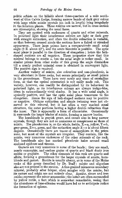
44 Petrology of the Maine Series.
pelitic schists on the hillside about three-quarters of a mile south-
west of Glen Calvie Lodge, forming narrow bands of dark grey colour
with large white zoisite crystals (an inch in length) lying irregularly
in the foliation planes. These zoisites are narrow, but in cross section
are idiomorphic, showing the usual faces.
They are spotted with enclosures of quartz and other minerals.
Tn polarised light their interference colours are light or dark grey
with straight extinction, and often the double refraction is variable,
so that between crossed nicols the sections have a flaked or streaked
appearance. These large prisms have a comparatively small axial
angle (2 E. about 40°), and the acute bisectrix is positive. The optic
axial plane is parallel to the direction of elongation ; hence the lath-
shaped sections are all negative. These properties show that this
mineral belongs to zoisite «, but the axial angle is rather small. In
similar prisms from other rocks of this group the angle diminishes
till a nearly perfect uniaxial cross is obtained in convergent light.
The positive sign is retained.
Another variety of zoisite, also colourless and non-pleochroic, is
very abundant in these rocks, but occurs principally as small prisms
in the groundmass. These have very rarely any trace of crystalline
form, so that the optical orientation is not easily made out. This
variety, however, can readily be distinguished by its behaviour in
polarised light, as its interference colours are always indigo-blue,
often in extraordinarily vivid shades. It has a wide axial angle, is
optically positive, and has the optic axial plane transverse to the
elongation. Hence the sign of lath-shaped sections may be positive
or negative. Oblique extinction and simple twinning were not ob-
served in this mineral, but it has often a very marked zonal
structure, the outer portions having a higher double refraction thanthe inner. This is apparently a form of clinozoisite. Occasionally
it surrounds the larger blades of zoisite, forming a narrow border.
The hornblende is greyish green, and occurs also in long narrowcrystals, though they are not so numerous or conspicuous as those of
zoisite. The pleochroism is, on the whole, feeble, X=a, yellow, Y=b,grey-green, Z=c, green, and the extinction angle Z— c is about fifteen
degrees. Occasionally there are traces of eumorphism in the prismzone, but most of the crystals are irregular. They contain, like the
zoisite, very numerous enclosures of the other minerals of the rock.
The hornblende also has marked pleochroic halos around small
enclosed epidotes and zircons.
Garnets are very numerous in some of the bands ; they are small,
nearly eumorphic, and enclose grains of quartz and black dusty iron
oxides or graphite. The other elements of this rock are quartz andalbite, forming a groundmass for the larger crystals of zoisite, horn-
blende and garnet. Biotite is usually absent, as in some of the Moinerocks of this group described by Dr. Teall ; calcite and oligoclase
also are not present in the section. A fine-grained micaceous secondarymineral, probably after felspar, often mingles with the zoisite, but
its nature and origin are not entirely clear. Apatite, zircon and iron
oxides represent the minor accessories ; the latter are often surrounded
by yellow rutile, a fact which is somewhat remarkable, seeing that
the abundance of lime-silicates would have led us to anticipate rather
the formation of sphene.

Zoisite Hornblende Gneisses. 45
SiOa .
.

CHAPTER IV.
FIELD RELATIONS OF THE OLDER IGNEOUS ROCKS.
Introduction.
In this chapter will be described all those intrusive igneous rocks
which are as a rule well foliated, and which have been intruded into
the sediments before the transformation of the latter into schists
was completed. A few thin bands of lamprophyre, mica trap andbasic rock that are also sheared to a variable extent will be reserved
for Chapter VIII., as these seem to have been sheared by movementsspecial to themselves, which did not affect the neighbouring sedimentsto any great degree. There is, howevei?, it is admitted, some doubtwhether certain intrusions should be classed with the Older or the
Newer Igneous focks.
The rocks to be described may be divided into four main groups,
as follows :
—
!i. Basic. Diorite, Epidiorite (representing Gabbro, foliated
and unfoliated).
ii. Acid. Granite, Aplite, Pegmatites, etc., foliated and un-foliated. The foliated types are often represented by abeautiful Augen Gneiss—the " Inchbae Rock."
iii. Garnetiferous Albite Gneiss with Magnetite and Tinstone.r iv. Basic Dykes and Sills, generally in the form of Epidiorite,
w^. Hornblende Schist or Chlorite Schist. Separable into two
f .' .
"Idivisions, namely :
—
intrusions^_ Intrusions in the Moine Books.
V- B. Intrusions in the Plutonic Masses.
It is the rule in this district, as in so many others, that the basic
plutonic rocks consoUdated before the acid.* Not only did the rocks
of group i. sohdify before those of group ii., but within each of these
groups it can often be seen that the darker, more basic varieties solidi-
fied before the paler : thus the biotite gneisses of group ii. are fre-
quently cut by veins of pale muscovite gneiss and granuUtic aplite.
Nevertheless, after the consolidation of the acid plutonic rocks, a
phase of minor intrusions supervened, as in Skye,f during which basic
rocks were again irrupted in narrow dykes.
The garnetiferous albite gneiss, group iii., which contains cassiterite,
is found only in Glen Diebidale.
The minor intrusions possibly include bands of very different ages.
None of the epidiorites or hornblende schists found in the Moine schists
can be shown to cut the plutonic masses, nor do they ever appear to
become more numerous near them, as if they might represent apophyses
from the basic parts. They have petrological resemblances to the
* Messrs. Dakyns and Teall, ' On the Plutonio Rooks of Garabal Hill and Meall
Breac,' Quart. Jour. Geol. Soc, 1892, vol. xlviii. p. 104. A. Harker, ' The Tertiary
Igneous Rocks of Skye,' Mem. Oeol. Survey, 1904.
t A. Harker, op. cit.
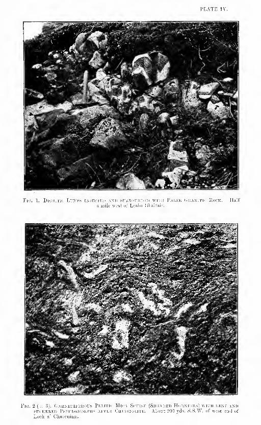
T'LATE IV.
ii^^^dSMBSk


Cam Chmhneag Plutonic Complex. 47
"basic intrusions of group iv. B., which cut the plutonio masses, butthese are no greater than those they bear to some of the plutonio rocka
themselves.
An unusually good exposure which shows the injection of
a. dioritic rock by granitic strings, both in a state perfectly free
from foliation, is seen at the margin of the peat nearly half a mile
west of the Ordnance Station on Leaba Bhaltair (Plate II, Fig. 1).
The dioritic rock is fine-grained, and the dioritic inclusions within the
granite are sharply defined and quite angular even when of the smallest
dimensions. The granitic rock has a rather fine-grained matrix.
Of all these rocks the acid gneisses (group ii.) are the mostextensive, and make the greater part of two large plutonic masses,
as well as minor bands whieh in places form a fringe outside these.
Both these large masses strike nearly north-east, approximately
parallel to the sedimentary rocks at their sides. The largest one
may conveniently be called the Cam Chuinneag mass, as it includes
Cam Chuinneag (Plate XII.), one of the highest hills in the map. This
mass extends from Cam nan Aighean in a north-easterly direction
for about twelve miles, to Cnoc an Liath-bhaid, and its breadth is often
about four or five miles. It is only in this Carn Chuinneag mass that
basic plutonic rocks are recognised with confidence, and within it these
rocks are specially abundant, as is shown in the map, near the
central and south-western portions of its north-western margin. Themargin near Cnoc na Tuppat and south of Cnoc nan Sac, and again onthe south-east side near Carn Cas nan Gabhar and Kildermorie, is
of a very complicated fringed type (Plate III.). It keeps for the mostpart to one geological horizon, a pelitic or semipelitic belt whichis considered to represent the highest stratigraphical division of the
schists in the district, but at the south-western end it comes into con-
tact with siliceous schists which are probably on a lower horizon. Onthe north-west side of the mass the sedimentary rocks generally
appear to be inclined south-east, as if they were dipping below the
plutonic rocks, but on the south-east side the reverse relation is often
found. It is allowable, therefore, to regard the mass as a huge lacco-
lite occupying the centre of a syncline, the south-eastern limb of
which is often reversed.
On the north-east side of Cam Bhren a considerable mass of granite
is seen lying with an almost horizontal fioor over somewhat shearedpelitic hornfels. The floor is almost parallel to the bedding in the
homfels, but is crossed by a foliation which affects granite and horn-fels alike.
According to the view here adopted, that the Carn Chuinneagplutonic mass is a laccolite lying in a syncline, it is necessary to supposethat the two branches of the Loch Morie fault which displace themargin of the plutonic mass near Kildermorie are wrench faults—notnormal faults with downthrows to the south-west—the latter being
the view which might on first sight be adopted from a consideration
of the effect of the fault on the Old Eed Sandstone below the foot of
the loch.
Denudation has probably considerably reduced the size of the
laccolite, but how much farther it formerly extended it is impossible
to say. It is to be noted that according to our theory the pelitic
belt with which the margin of the mass is generally in contact is the

48 The Older Igneous Rocks.
highest stratigraphical zone of the Moine Series in the map, and that
its higher members never occur at a distance from the^granite. It
is therefore not surprising that the granite is not now found again
north-west and south-east of the complex, . even though its original
extension may have been much greater than now. No plutonic rocka
of groups i. and ii. are seen* in the map in the two lowest members of
the Moine Series, and the feeders of the Carn Chuinneag mass must,therefore, lie within its present boundaries. c. T. c.
The smaller of the two plutonic masses alluded to is about five
miles long in a north-east direction and less than three miles broad.
It includes the well-known augen gneiss of Inchbae,* and may becalled the Inchbae mass. The margin of the main mass of this
granite is surrounded by a fringe of minor intrusions both on the
north-east side at Carn Mor, on the east side at Inchbae, and at thesouth end. They extend as far south as Loch Luichart, and are
represented also on the west side of the big N.N.E. fault which passes
by the head of this loch. It is noticeable that in the last mentionedlocality the rocks west of the fault are impregnated with multitudes of
thin veins of foliated granitic material,f while on the east side we find
no similar crowd for some miles to the north. Possibly on the west
side of the fault some great granitic mass may formerly have existed
a little above the present ground surface. b. n. p.
This Inchbae mass lies south-west of that of Carn Chuinneag,and is only separated from it by an interval of about a mile anda quarter, most of which is occupied by Old Red Sandstone of later
age than the granite. It is quite possible that it is connected with
the Carn Chuinneag mass at no great depth by underground roots, andthat it was also connected with it at the surface before denudationhad advanced so far as at present.
Group iv., that of the foliated basic dykes and intrusive sills, is
very widespread, but, as already stated, it includes two divisions
which may be of different ages. The rocks of the division " A," that of
the intrusions within the Moine rocks, are found in many different
parts of the map, but they are perhaps specially numerous in the west
and north-west portions and at the side of Loch Glass. Except in
the last mentioned locality, however, the individual bands are rarely
more than a few yards wide and can seldom be traced far.
The igneous rocks to be described in this chapter have suffered
greatly from shearing, and it seems clear that most of this shearing
took place after their consolidation was completed. In various
granitic sills, forming part of the plutonic fringe, the shear-lines are
not parallel to the margins of the sills but make considerable angles
therewith, J being parallel to the axial planes of the folds which affect
both sediments and igneous rocks alike. Near Inchbae the granitic
rocks often show two distinct foliations, the second having evidently
been formed by strain-slipping movements which contorted and broke
through the first, and even if the first foliation could be attributed
to shearing before complete consolidation the second could not be so.
Strong evidence that much of the shearing .in the igneous rocks
took place after their consolidation is also afiorded by sections in
* A nnual Report of the Geological Survey for the year 1896, p. 18.
•[• Dr. B. N. Peach, Summary of Progress of the Geological Survey for 1898, p. 10.
i This was first noticed by Dr. B. N. Peach, we believe. Ibidem.

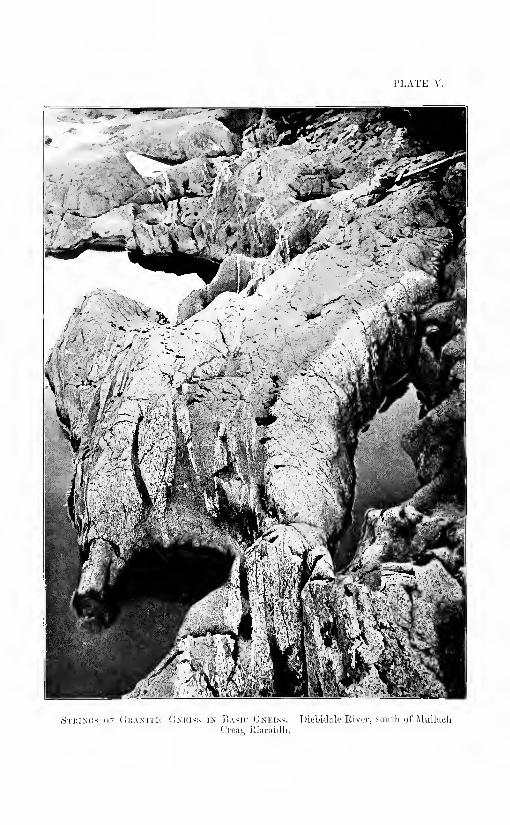
TLATE y.
,S['i:i.\i;s iiF (1i:amtic Gniuss ix ISasic Gneiss. T)irbid;ik' River, souUi uf JUillacli
<'roa<^ Ritiraidli.

Linear Foliation, 49
Glen Diebidale, in the river south of MuUacli Creag Riaraidh, whichshow basic plutonic rocks of group i. invaded by granitic strings
(Plate v.). The margins of the strings are not chilled, but they arewell defined, often folded and crossed by a foliation—either plane-
parallel or linear—which is common both to granite and diorite.
Somewhat similar sections are also seen on Carn Salochaidh, where the
augen gneiss is occasionally crossed by fime-grained strings resembling
felsite or aplite. The foliation in the gneiss continues through the
strings and often makes considerable angles with their margins.
In both the basic and acid plutonic rocks (groups i. and ii.) linear
foliation or rodding is perhaps as common as plane foUation, butit is particularly well seen in the crags of rather fine-grained granitic
rock about a mile west of the Ordnance Station on Leaba Bhaltair,*
and in the dioritie rock in the river E.N.E. of MuUaeh Creag Riaraidh
(Fig. 3). In these rodded rocks the constituents are arranged
n6t in parallel foha but in parallel rods, and in sections taken at right
angles to the rods we onlysee small, somewhat uni-
formly scattered spots,
which represent the ends of
rods. In some parts of the
Highlands a structure of asimilar appearance has beenproduced by the crumpling
and atrain-sHpping of earlier
foliation planes, which havethus been broken up into
narrow rod-like portions, but
for the structure in the CamGhuinneag mass such anexplanation does not seem
^^^ ^ i)._Hornblende Schist with Linearapplicable. We may sup- Foliation. Diebidale River E.N.E. of
pose, however, that rodding MuUach Creag Eiaraidh.
can be produced in anycube of rock by subjecting it to equal pressures from foiir sides
in apposite pairs, leaving, the constituents to squeeze out, as it were,
towards the other two sides, on which the pressure is less.f
At the beginning of this chapter it was stated that the Older Igneous
rocks included all those which are as a rule well foliated. It will be
seen in subsequent descriptions that in certain areas considerable
portions, perhaps particularly of group i., have escaped foliation,
even though, as Dr. Flett supposes, the original pyroxene has been
largely changed into hornblende.
i. BASIC PLUTONIC EOCKS. DIOEITE, EPIDIORITE, FOLIATED ANDtTNFQLIATED.
As already stated, the rocks of this group are only recognised with
certainty near the north-west margin of the Carn Chuinneag plutonic
* It is believed that this name is more correctly applicable to the landslip north
of this Ordnance Station.
t Grubenmaun, ' Die kristallinen Schiefer,' 1904, vol. i. pp. 88-89.
4

50 The Older Igneous Rocks.
mass. In their original condition they are said by Dr. Flett to have
"been gabbros, augite diorites and quartz diorites. They are never
seen to form the actual margin, though they occur in places within
40 or 50 yds. of it. They compose several exposures about three-
quarters of a mile south-east of Cnoc na Tuppat, and are well developed
south-west of this locality, as far as a mile and a half beyond Loch
na Glasa. No large exposures have been seen so far as a mile from
the margin. Much the largest mass is that near the head of Glen
Diebidale, which is probably nearly three miles long in an E.N.B.
direction, parallel to the adjacent margin of the Cam Chuinneag
complex, though never so much as half a mile broad. In the Inchbae
plutonic mass it is not certain that any rock of group i. exists. TheGlen Diebidale basic mass is excellently exposed both in the river
and in various smaller streams and crags, but most of it is in a morealtered, foliated condition than the smaller masses which are found
to the south-west of it and also than some of those to the north-east,
near Cnoc na Tuppat. In the view looking up Diebidale from near
Mullach Creag Riaraidh the large area of basic rock makes a con-
spicuous contrast with the granitic rocks at its sides, as it gives rise
to much greener and more grassy slopes and carries but little heather.
c. T. c.
The exposures of basic igneous rock occurring to the south-west
and west of Loch na Glasa and north of Cam nan Aighean, are often
isolated in the peat, but their relation to the surrounding granitic
rocks is well seen in some cases although the areas are small, never
exceeding 100 yds. in diameter. Good sections showing the relation
of the rocks are also to be seen in the small burns feeding the Abhuinnna Glasa. In the area west of Loch na Glasa the basic material
is in the form of round or oval ball-like masses. The colour of the
masses being dark, they are strongly contrasted with the pale
acid surroundings. The edges are usually very distinct, and the
dark masses are permeated with veins of acid material. In somecases these veins form an irregular network traversing the basic
material in all directions and cutting it up into angular areas. Manyof these exposures show angular masses of the basic material, with
very sharp outlines and varying in size from an inch or so up to a foot
or more, embedded in the acid granitic material, and often so packedas to give the appearance of an igneous breccia. In field exposures
the basic angular fragments weather deep into the rock, but keep a
fairly clean face, and the surrounding granitic matrix stands out all
round, so that the rock frequently has an appearance as if the basic
fragments had been pushed in, and the acid matrix had bulged upbetween them. Blebs of blue quartz and large felspar crystals occur
in some of the masses, which then have a paler colour. Accordingto Dr. Flett, this type is a hornblende granite porphyry, while the true
basic types are diorites and in some cases quartz diorites. In the
field the frequent marginal position of these types of granite porphyrysuggests the absorption of more basic lumps by the surrounding acid
magma. This impression is further strengthened by a want of defini-
tion of the margins of the associated basic masses, which causes themin places to appear like " ghosts " of the better defined masses seen
elsewhere. These angular and ball-like masses of unsheared diorite
are embedded in granitic rocks which often macroscopically show

Basic Plutonic Rocks. 5]
no sign of shearing, and specimens cut and microscopically examinedare stated by Dr. Flett to be almost free from the effects of deformation.
Where a foliation is present, it appears to have been produced morereadily in the acid than the basic material, or at least is more easily
detected in the former, as the basic masses frequently retain their
angular outlines where the surrounding acid rocks are in a sheared
condition. c. b. c.
East of the head of Glen Diebidale, those unfoliated types which
have been examined by Dr. Flett are called diorite, augite diorite,
augite biotite diorite and epidiorite, but most of the exposures, except
near Cnoc na Tuppat, are affected by foliation—either plane-parallel
or linear—to a greater or less extent, and may be classed as horn-
blende schist or hornblende biotite schist.
None of the large basic areas in Diebidale consist of quite unmixedbasic rocks, as might be inferred from their representation on the
map, being often crossed by granitic veins which are too small to beshown on the one-inch scale. These granitic veins are, as already
indicated, usually well defined, though not chilled at their margins,
,and it is probable that they have been injected into the basic rocks
after these latter were consoUdated. Apart from the presence or
absence of foliation, two main types of basic rock are to be distinguished
in the field in Diebidale. One of these is darker and moreibasic than
the other, and is frequently found in the form of small inclusions in
a paler type, in which blebs of quartz are generally abundant; Themargins of these inclusions are well defined, and it seems probable,
therefore, that the darker rock was consoUdated before the paler wasinjected into it. But in other localities, for instance in the crags nearly
half a mile south of the Ordnance Station 2250 ft. on Diebidale Eidge,
these difierent varieties are mixed with others in somewhat irregular
streaks with ill defined and cloudy margins, and it is suggested that
they were at one -time flowing together in a semi-liquid condition,
and were then partially mixed and changed by chemical reaction
between their margins. The part of the crag referred to is almost
free from foliation, and the indistinct margins cannot be due to
shearing.
Neither in the foHated nor unfoliated diorites are any conspicuous
porphyritic constituents as a rule detected. A few exceptional in-
stances may be noticed. The fine-grained unfoliated diorite pierced
by the granite in the exposure nearly half a mile east of Leaba Bhal-
tair, already referred to in the Introduction of this chapter, contains
small phenocrysts of felspar about an eighth of an inch in length, andin a hornblende schist two-thirds of a mile slightly east of south of
Cnoc na Tuppat felspar phenocrysts attain a length of half an inch.
In several exposures of unfoliated diorite south-east of Cnoc na Tuppata small proportion of the hornblende occurs in phenocrysts about aneighth of an inch in length.
On the north side of one of these diorite exposures, in a position
783 yds. shghtly east of north of the Ordnance Station on Carn Dubh,is a peculiar unfoliated rock (10923) which includes many small dioritic
patches together with small porphyritic felspars and blebs of quartz,
the latter surrounded by aureoles of hornblende. The rock may be
called quartz diorite, but is probably a " mixture rock " formed bythe union of diorite and a more acid rock.

53 Th& Older I^mous Rocks.
Gramets have not been noticed either in the foUated or unfoliated
types, but macroscopic sphene is tolerably conspicuous in the latter.
c. T. c.
On the west side of Loch na Glasa the basic masses are, as already
described, unsheared diorites. On passing northwards towards, BeinaTharsuinn and at the head of Glen Diebidale they become drawn,
out into long lenticles and strings, and are in the form ol biotite
hornblende schists, th© granite at the same time becoming gneissose.
The shearing has been so intense in some places that the acid andbasic materials are drawn out into thin parallel bands of gneiss andhornblende schist. Between these intensely sheared rooks and the
unaltered rooks west of Looh na Glasa intermediate stages oi
shearing can be seen, a foliation being frequently developed in the
basic masses and in the surrounding acid matrix before any markeddeformation of the boundaries ol the different materials is apparent.
The shearing in this locality appears ta have afieeted the basic andacid rocks simultaneously. c. b. c.
Fig. 4 (X 1).—Surface of a. piece of Banded Orthqgneisa. 1000 yds. W.W.W. ofLeaba Bhaltair. The wMte streaks are granitio ^eisSi
In the various localities, further east, for instance in some smallstreams nearly 1000 yds. W.N.W. of the Ordnance Station on LeabaBhaltair and in Diebidale River NJN.W. of Creag Illie, we find still
more extensive exposures of banded orthogneiss (Rg. 4) composedof thin alternating subparallel streaks and laminae of pale grey granitegneiss and dark grey hornblende schist, which closely resembleportions of the Lewisian Gneiss of West Sutherland. The thicknessof the individual streaks and laminae is often about half an inch, and,in the streams referred to, the total thickness fe probably 100 ft. atleast. A linear foliation or rodding in the banded gneiss often crosses
the streaks and laminae, and it is hence suggested that the parallelism
of the difEerent portions may be due to the squeezing of veins andtongues which were once of a much more irregular shape. In sections
at right angles to the direction of the rodding the pieces of dark greyhornblende schist still often retain markedly angular outlines, andso, if the rock has been much squeezed, it seems necessary to suppose

Basic Plutonic Rocks. 53
that the pressures acted in the manner described on p. 49. In parts
of a banded gneiss, 10 or 12 ft. thick, which is seen in Diebidale
River nearly 1000 yds. south-east of the Ordnance Station 2250 ft.
on Diebidale Ridge, the dark parts contain probably as much biotite
as hornblende, and the pale and dark parts are arranged in thin
parallel planes, not rods, the latter being the disposition in the neigh-
bouring gneiss, in which biotite is scarce. In this case it seems possible
that the abundance of biotite may be connected with the greater
pressure or shearing to which the rock has been subjected,* but in
other localities it does not seem probable that there is any connection
between the proportion of biotite and the amount of pressure to whichthese banded gneisses have been subjected.
In most parts of the Glen JDiebidale basic mass the foliation strikes
nearly parallel to the long axis of the mass, and the dip is southerly,
but in some places it strikes nearly north and south, and is rather
sharply twisted. Near Creag lUie the fohation is often vertical andstrikes east and west. In the river E.N.E. of MuUach Creag Riaraidh
it is sometimes twisted along axial planes striking south-west, andvarious granitic strings are twisted with it.
The hornblende schists and hornblende biotite schists producedfrom the gabbros, diorites, etc. (group i.) are sometimes indistinguish-
able in hand specimens from scMsts formed from basic dykes (grotro
iv. B.) which cut the plutonio masses, but the former are as a rule
coarser-grained. The basic sills in the Moine Series (group iv. A.),
however, though distinct petrologioally from either of the abovenamed groups of rocks, are sometimes as coarse as any of them.
In the field the foliated gabbros and diorites (group i.) are some-times cut by small granitic strings, and are thus readily distinguished
from the basic rocks of the dykes, with which otherwise they might
be confused.
A small exposure about 1020 yds. south-east of the Ordnance Statiota
on Cnoc na Tuppat, and not far inside the plutonic mass, consists
chiefly of pieces of hornblende schist, from a yard to a few inches in
length, wluch vary considerably in grain and in direction of rodding,
and are mixed with a few pieces of biotite schist and of altered pelitic
sediments. The exposure is crossed by many veins of quartz andgranite, some as much as six inches thick, which have a general E.N.E.
direction, parallel to the long axes of most of the pieCes. Possibly this
peculiar exposure represents a deeply seated friction breccia which
has been veined by granite.
U. ACID PLUTONIC SOCKS. GRANlfE, APMTE, PEGMATIME, FOtlATBDAND tJNPOLIATED.
Introduction.
The acid plutonic rooks have much the widest disteibution. la the
Cam Chuinneag mass they oeciapy probably about thirty limes the area
of all the oi^er rocks, and in the Inchbae mass they compose an even
* For parallel cases in which biotite takes the place of hOTnfclende in tocis whichhave been subjeeted to an uausMl aoiount of sheaiing, reference may be mad« to* The Geologioal Stcuctuie ot the North-West fiighkinda of Scotland,' Mem. OebLSurvey, 1907, pp. 140 and 209. See also the subsequent description of group iv.
in this chapter.

54 The Older Igneous Rocks.
greater proportion. They are divisible, however, into various types,
the most important of which are shown in the following list :
—
f . Pegmatites and quartz veins in or very near tlie plutonic masses. Rare.
Foliated in part.
e. Fine-grained muscovite gneiss without much biotite. Probably repre-
sents aplite.
d. Fine-grained biotite granite gneiss without many large felspar
phenocrysts.
c. Coarse biotite granite or granite gneiss with many large felspar pheno-crysts. "Augen gneiss" or "Inchbae rock." A very common type.
b. Dark grey granite gneiss rich in biotite.
a. Riebeckite gneiss.
As already stated (p. 46) the plutonic rocks show a sequence frommore basic to more acid types. For example, the dark grey gneiss (6),
rich in biotite, was apparently the first to consoKdate, for in Diebidale
River (at a point about 1120 yds. B.S.E. of the Ordnance Station
2250 on Diebidale Ridge) this gneiss is cut sharply by the paler biotite
gneiss {d), which is elsewhere closely connected with the augen gneiss
(c) by a series of transitional varieties. The pale muscovite gneiss (e)
and the pegmatites (a), on the other hand, sometimes form strings in
the augen gneiss (c) and the fine biotite gneiss (d). The age of the
riebeclnte gneiss with reference to the other plutonic rocks has not,
however, been ascertained. c. t. c.
In the map under description an attempt has been made to showthe main areas occupied by divisions " a " and " c," the others being
ail grouped together, but the boundaries are not in most places verydefiinite, partly owing to large areas of obscure ground and partly
because of the presence of the intermediate types, already referred to,
between divisions " c " and " d." It will be seen that the last division,
the augen gneiss, is decidedly the most widespread, and occurs all alongthe margin of the Cam Chuinneag mass except at one locality, abouthalf a mile north-west of Cam an Liath-bhaid. It may therefore besaid to have formed originally the lower part of the laccolite *—
a
position into which it seems not impossible that the felspar pheno-crysts may have sunk down from higher portions. The augen gneiss,
however, makes a much broader area on the south-east side of the
Carn Chuinneag mass than on the north-west, where the earUer basic
rocks chiefly occur. Near Lochan a' Chairn the breadth in a north-
west direction is as much as three miles. In the Inchbae mass the
augen gneiss forms an even larger proportion, but does not occur along
the northern margin at Meall nan Sac : it is excellently exposed near
Inchbae Lodge, and is hence often called the " Inchbae rock."
These granitic rocks do not usually form high ground, but on CarnChuinneag they attain a height of 2749 ft., and along the watershedwesti^ard they exceed 2000 ft. in three places. The greatest height
attained elsewhere is along the margin where they come into contact;
with the sediments. North of Strathrannoch house they form large
expanses of flat or gently undulating country stretching towards GlenDiebidale, and on the whole form lower ground than the surroundingsediments. In the hollows and lower tracts there is an enormousdevelopment of peat, and the rocks are bleached and much weathered
by the action of the peaty acids. Knobs, either rough and breaking into* See Introduction to this chapter.

Add Pkdonic Rocks. 55
blocks, or polished by ice-action, emerge here and there from the peatycovering, and are also characteristic of some of the higher elevations.
The coarse augen gneiss of Carn Bhren, 2080 ft., and of CarnSonraichte, 1684 ft., is usually in rounded glaciated forms, thoughpiled blocks frequently give a rough outline. The blocks formedby the breaking up of this coarse type are sometimes very great,
and equally large blocks characterised the weathering in or before theOld Red Sandstone period (see ChapterVIII.), and in glacial or preglacial times(see Chapter X.).
The riebeckite gneiss, a somewhat fine-
grained rock, forms the top of Carn Chuin-neag, and other fine-grained granite rocks
form the northern, southern and westernslopes of this hill, but are chiefly repre-
sented by screes, composed of blocks from 2
to 6 ft. long.
In all the acid plutonic rocks, a distinct
foliation, either plane-parallel .or linear, is
usually present. In those with linear folia-
tion it is not always easy to determine the
dip of the rods, but in the Carn Chuinneagmass the general dip, both of rods andfoliation planes, appears to be south-east,
at high angles, often between 40° and60°.
Occasionally two fohations can be seen,
a first and a second, the latter crossing the
former or else merging with, and greatly
modifying it. It is believed that the first
or main foliation was produced after con-
solidation, and that it can be matched witha foliation produced contemporaneously in the Moine sediments.
The chief reasons for this behef are summarized below :
—
1. Where the granite is in contact with unsheared Moine hornfels it is free
from foliation. Where it is -well foliated, the adjacent Moine rocks are
highly sheared.
2. The foliation frequently crosses the margins of the granite and passes
thence into the sediments.3. Tlie foliation—the only one locally observed—often crosses from one
igneous rock into another. An original flow structure would not do so.
4. Petrological examination shows that in the porphyritic granites thephenocrysts of quartz and felspar are usually less sheared than the
matrix, which must consequently have been solid before the rock wascrushed (see Dr. Flett's description in Chapter VI.).
Dr. Peach was the first to notice that the margins of the augengneiss were crossed by the foliation planes, which were apparently
continuous with those in the adjacent Moine schists : this he observed
on the north side of Loch Luichart.* A good case of the same kind
also occurs at Meall nan Sac, at the north end of the Inchbae plutonic
mass, where the foliation in a fine-grained granite gneiss dips B.S.E.,
and strikes almost at right angles to the margin, but in much the samedirection as that in the Moine rocks. At the south end of the Inchbae
* Summary of Progress of the Geological Survey for 1898, p. 9.
Fio. 5 ( X 1).—Piece of Granitic
Gneiss partly Re-sheared.Near a thru-st in GarbbAUt, 950 yds. south-east
of the foot of AlltanSgeireach. The left-hand
side is close to the thrust.

56 The Older Igneous Rocks.
Fig. 6 ( X 1).—^Augcn Gneiss with strain-slips. Westside of thrust in Garbh Allt, a,bout 960 yds.
soutt-east'of the foot of Alftari'SgeirSadi.''
mass, also, the foliation dips nearly east, and strikes parallel to thelong axes of various granitic projections that are probably due t&
folding. Again, at Cam an Liath-bhaid, at the north-east end of the
Cam Chuinneag plutonic mass, the direction of the main granite
margin is nearly north-west, but the foUation often strikes north-east.
Various places, where the foliation crosses the boundaries betweeadifferent igneous rocks, have been aheady mentioned (pp. 49, 52).
Near Cnoc na Tuppat,
an unusually interest-
ing exposure (p. 63 andFig. 9), shows foliation
planes crossing from aquartz vein into peg-
matite, and from peg-
matite into granite
gneiss ; we suppose
that the granite wassohd at the time the
quartz vein was formed,
and that it still re-
mained so at the later
period when the foha-
tion was produced.
Some of the thia
sharply defined apht6- -. -__
; _" veins in the augen gneiss
of Cam Salochaidh provide ievidenee" of a very similar character.
The second foliation is usually finer than the first. It mayentirely hide at, and in various "places it is doubtful whether we are
dealing with a. first or a second foliation.
The N.N.W. thrusts in Garbh Allt (Fig. 10), near which the sedi-
mentary rocks. are highly sheared, as d^cribed in Chapter V., affect
the granitic sills also. It is found in many places that where thesft
sills dip gently in a direction slightly east of south they show lineat
foliation or but slight- indications of plane-parallel foKation, but near
the thrusts they twist suddenly into a N.N.W. . strike, and becomevertical or bent into close folds with vertical axial planes striking
N.NiW. At the same time they become thoroughly granulitic, and are
dragged out into thin vertical foha approximately parallel to the
thrust. At the side oi a thrust which crosses the Garbh Allt about
950 ft. south-east of the foot of Alltan Sgeireach, the whole of the
granitic rock is granulitic, but the part nearest the thrust is also
closely foliated into parallel planes (Fig. 5), and shows in these planes
numerous scales l)oth of black and white mica, the latter probably
formed from the shearing of felspar, as it is not usually common in
the granite away from the thrust.
The granitic rock close to another N.N.W. thrust, some 10 or 15
yds. east of that just referred to, was originally probably of a moreporphyritic character, and many of the old felspar pheaocrysts aw*
represented by small red augen which still show br<md cleavage faces
crossing from side to ade. These augfea are often surrounded bystreaks of white quartz in a finely graauiitic conditioa. The ro©k
has a special interest^ because it shows not only a, first foliatioa, along
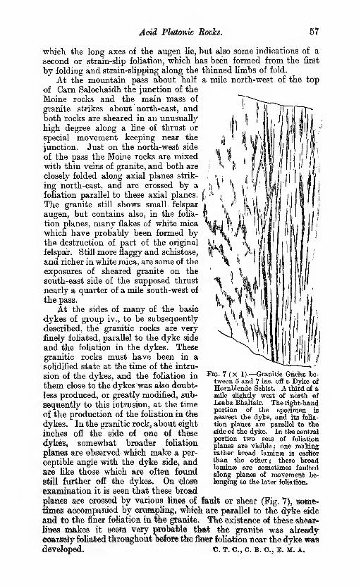
Add Platonic Mocks. 57
wMcli the long axes of the augen li«, but also some indications of a
second or strain-slip foliation, whict has been formed from the first
by folding and strain-sUpping along the thinned limbs of fold.
At the mountain pass about half a mile north-west of the top
of Garn Salochaidh the junction of the
Moine rocks and the main mass of
granite strikes about north-east, andboth locks are sheared in an unusually
high degree along a line of thrust or
special movement keeping near the
junction. Just on the north-west side
of the pass the Moine rocks are mixedwith thin veins of granite, and both are
closely folded along axial planes strik-
ing north-east, and are crossed by a
foliation parallel to these axial planes.^,
The granite still shows small felspar
augen, but contains also, in the folia-
tion planes, many flakes of white mica
which have probably been formed bythe destruction of part of the original
felspar. Still more flaggy and schistose,
and richer in white mica, are some of the
exposures of sheared granite on the
south-east side of the supposed thrust
nearly a quarter of a mile south-west of
the pass.
At the sides of many of the basic
•dykes of group iv., to be subsequently
described, the granitic rocks a,re very
finely foliated, parallel to the dyke side
and the fohation in the dykes. These
granitic rocks must have been in asolidified state at the time of the intru-
sion of the dykes, and the foliation in
them close to the dykeswas also doubt-
less produced, or greatly modified, sub-
sequently to this intrusion, at the time
of the production of the fohation in the
dykes. In the granitic rock, about dghtinches off the side of one of these
dykes, somewhat broader foliation
planes are observed which make a per-
ceptible angle with the dyke side, andare like those which ate ofteii foundstill further off the dykes. On 'dosfe
examination it is seen that these broad
plan« are crossed by various iines of feuit or shear (Fig. 7), some-tanes accompanied by crampMng, wkich are parallel to the dyke side
and to the finer foliation in lAe granite. The existence of these shear-
lines makes it Beeta very probable that the granite was alreaxly
©oarsely foliated throaghout befose the finer foliation near tiie dyke wasdeveloped. C. T. c, c. b. c, b. m. a.
Wm. 7 (X 1).—Granitic Gnass be-tween 5 and 7 ins. ofE a Dyke of
Jlornblende Schist. A thitd of d,
mile slightly west of north ofLeaba Bhaltair. The light-hamcl
portion of the specimen is
nearest the dyke, and its folia-
tion planes are parallel to theBide of the dyke. In the oentrsjportion two sets of foliation
planes are visible ; one makiflgrather broad laminse is eadierthan the other ; these broadlaminse are sometimes faultedalong planes of movemeiit be-tenj^'ng to tSie later foUatJsrti.

58 The Older Igneous Rocks.
a. Riebeckite gneiss.
A considerable band of this rock extends nearly north and south
across and east of the summit of Carn Chuinneag, though very little is
actually exposed. The total length of the band is probably about amile and a quarter. The best exposure is perhaps on Meall Eadar anda Chuinneag. Another smaller band occurs on the low watershed
west of Carn Chuinneag, but this also is chiefly represented by loose
blocks, and but poorly defined.
The rock is readily distinguished from any other in the complex byits needles of intensely black hornblende, which might at first sight bemistaken for tourmaline, and often occur in groups forming little rods
a quarter or haK an inch long. Apart from these the colour is pale grey,
sometimes with redder areas, and both felspar and quartz are granulitic,
without any admixture of phenocrysts. The neighbouring gneisses
are rather fine-grained granitic gneisses, of division " d," but nojunction with them is anywhere seen. No strings of any other type
of rock have been anywhere seen within the riebeckite gneiss, butgranulitic quartz veins with riebeckite in unusually large forms, some-times more than an inch long, are not uncommon. The foliation both
in the riebeckite gneiss and the neighbouring gneisses is chiefly of the
linear or rodded type, and at and near the summit of Carn Chuinneagthe direction of rodding is nearly south-east, at 40° or 50°—^much the
same as that usually seen in the neighbouring gneisses. Just on the
west side of the summit of the hill, the rock west of the riebeckite
gneiss is intensely sheared into thin flags, containing abundant white
mica as well as black, which might be taken for semipsammitic Moineschists. It seems probable, therefore, that the western boundary is
a thrust or line of special movement.Chemical analyses and full description of the petrological characters
are given in Chapter VI. c. t. c, o. b. c.
b. Dark grey granite gneiss rich in biotite.
This division is a small one, and is not separated on the one-inch map.
It forms various patches which are intimately mixed with and some-
times seen to cut the dioritic rocks in Diebidale Eiver north and north-
east of Creag lUie. These patches are, in turn, cut sharply by pinker
veins of more acid granite, which contain much less biotite. One of the
patches contains thin strings of some carbonate which suggests that
the original unsheared rock may have contained hornblende.* Acoarse biotite schist containing specks of carbonate occurs also within
the granitic gneiss, and seems. to pass gradually into it, in the burn
nearly a mile north-west of the summit of Carn Chuinneag. • M»« "•»
Some bands of dark grey biotite gneiss are found in the dioritic crag
on the north-west side of the river north-west of Creag lUie, and one of
thesecontainsa small proportionof hornblende aswell as biotite : another
band contains small garnets and intensely crumpled thin quartz veins.
A coarse-grained rock containing big pieces of quartz and felspar,'
with much biotite and grains of carbonate, forms a thin band striking
north-west, about 350 yds. somewhat west of north of the Ordnance
Station 2175 on Creag Ruadh. It seems to cross the foliation of the* Reference may be made to the description of group iv.

Acid Plutonic RocJcs. 59
redder gneiss at its side, but.is not sharply separated from it, and maybe a vein-like modification. Dr. Flett states that the felspathic con-
stituents comprise orthoclase, oligoclase and albite (13967). Some of
the felspars have been of large size, but much crushing has takenplace, accompanied by the development of mortar structure.
In the Inchbae augen gneiss a few thin seams of dark biotite gneiss,
only a few inches thick, in Allt an Eilean Ghuirm, may possibly belongto this division. One of these is seen about a quarter of a mile abovethe foot of the burn.
c. Coarse hiotite granite or granite gneiss with many large felspar
phenocrysts—Augen gneiss or Inchbae rock.
This forms the marginal rock all round the Carn Chuinneag plutonic
mass except for a small space about half a mile north-east of Carn anLiath-bhaid. It also appears to form nearly the whole of the Inchbaemass except the northern margin, and occupies, no doubt, a con-
siderably larger area than all the other divisions of group ii. takentogether. The limits are, however, by no means sharply defined,
there being insensible gradations along two paths from the coarse
augen gneiss into the finer granitic types of division " d." On theone hand, the felspar phenocrysts may become gradually rarer thoughstill retaining a large size individually. On the other hand, they maykeep up or increase their numbers but become so small that theycease to attract much attention. Intermediate types showing large
but rare phenocrysts are well seen a little north-east of Lochan a'
Chairn and also between Carn Salochaidh and Carn an Liath-bhaid.
A section about three-quarters of a mile west of Carri an Liath-bhaidshows several parallel bands, most of them several yards wide, whichcontain felspar phenocrysts, from half an inch to an inch in length,
in very varying abundance. These bands all show foliation in muchthe same degree, and those in which the phenocrysts are rare do notappear to be more sheared than the others : it seems quite possible that
these different types may have been flowing together in parallel bandsbefore consolidation set in. In another section rather more than three-
quarters of a mile B.N.B. of the outlet of Lochan a' Chairn somewhatsimilar parallel bands are again exposed, but in this thereisthe additional
point of interest that the foliation crosses the margins of the bands.
It seems possible, nevertheless, that in certain localities the fine-
ness of grain may be due to more intense shearing. In a section mainlycomposed of augen gneiss, nearly a mile north-east of the foot of
Lochan a' Chairn, a four-inch vein without porphyritio felspars is dis-
placed 18 in. along a thinner somewhat similar vein which is foliated
parallel to its own side. Parallel to this line of movement, and afew feet off, is another ten-inch vein which contains a number of felspar
augen, but most of these are less than half an inch long, while manyof those in the rock at its sides are as much as an inch. On closely
examining the margins of the ten-inch vein, individual streaks of
. quartz can be traced from the one rock into the other, and where theyenter the vein they are seen to be thinned and dragged almost into paral-
lelism with its side. The granitic rocks at the south-west end of the
Cam Chuinneag plutonic mass generally consist of coarse augen gneiss
with somewhat obscure foliation. But in one locality, rather more than

€0 The Otder Igneous Rocks.
a' quarter of a mile slightly east of south of the summit of Cam nanAighean, the rock is sheared out so as to resemble a mica schist with
isolated "eyes " of felspar: the direction of shearing is approxirnately
parallel to the adjacent margin of the granite. It is also noticed in the
Inchbae mass, that in the most thinned limbs and near the strain-
slips of certain folded portions, to be shortly referred to, the felspar
augen are decidedly less conspicuous than in the general mass of the
rock, while quartz and biotite seem in increased proportion.
Granitic rocks, which may be regarded as almost unsheared re-
presentatives of the augen gneiss, are found in the following localities :
close to the margin of the granite 1000 yds. shghtly north of east of
the Ordnance Station 2250 on Diebidale Ridge ; about 20 yds. within
the margin of the complex nearly half a mile north-east of Cam anLiath-bhaid ; 1800 yds. south-east of Beinn a' Chaisteil ; on Cam Casnan Gabbar ; and a little to the west of Loch na Glasa. But in noneof these places except the last do the felspar phenocrysts attain the
dimensions occasionally reached in the augen gneiss. West of Lochna Glasa the most conspicuous variety of granite is a coarse biotite
granite, or granite porphyry, with large felspar phenocrysts showingCarlsbad twinning. Microscopic examination shows that some of the
exposures are almost free from alteration, though others are consider-
ably deformed and granulitised. In this locality, too, there is some-
times, next to the earlier basic masses belonging to group i., an unusualtype of rock which has not been indicated in me list given on p. 54.
This rock is a hornblende granite porphyry, which, as already stated
in the description of group i. (p. 50), seems a mixture rock, which has
been formed by the absorption of basic material by the invading
acid magma. Some irregular granitic strings in Garbh Allt {Fig. 10),
880 yds. S.S.E. of the foot of Alltan Sgeireach, contain felspars more
than half an inch long, and numbers of bluish opalescent quartz blebs
about the size of peas, whioh show original zones of growth, not very
much deformed. Some of the felspars in the first locality men-
tioned, near Diebidale Ridge, are three-quarters of an inch long, and
are almost water-clear though the smaller felspars are reddish. In
the second locality the larger felspars are slightly more than an inch
long, nearly white, and associated with blebs of bluish opalescent
quartz, like those mentioned in the Garbh Allt. In one plaoe^ abottt
917 yds. from the Ordnance Station on Cam an Liath-bhaid, this
rock is crossed by a thin shear-zone, striking nearly east and west,
in which the quartz blebs lose their bluish colour and become drawh
cut into long granulitic streaks. At the same time the larger fdspars
lose their crystalline outlines, become granulitic at the edges ai»d
assume the form of augen. Near the inargin of the granite a little
east of Cam Bhren a very handsome variety of gneiss contains felspar
augen sparsely scattered through a granulitic matrix, which is partiy
made up of long streaks or rods of granulitic quartz, -vrfiiter and dealer
than the rest: it is evident that these streaks represent deformed
quartz blebs like those already referred to. Near Cam Bhren ths
streaks of quartz are not very abundant, but in certain localities the
quartz is in much greater proportion,and forms long continuous streaks
winding round the felspar augen : we suppose that the original rock
in these cases was unusually rich in quartz blebs, but petha^ not
ridier than some of the granitic strings in the Garbh Allt.

Acid PM&ttiio Rocks, 61
The felspar phenoorysts, as already incjicated, are generally of analmost white or pale pink colour, and in their central portions still,
often show cleavage planes and Carlsbad twinning. In the section
in the lower part of Strath Eannoch Burn, near Inchbae, the augenare often two inches long and half or three-quarters of an inch broad.
Only small portions near the centre usually remain ungranulitised.
Quartz streaks, entirely ^nulitic, and flakes of biotite form sheaths
winding round the augen. No white mica appears to occur. Abouta quarter of a mile above the bridge the first or broad foliation is
folded aloing an axial plane inclining east (Fig, 8), and in other places
higher up the stream it is again folded, along axial planes incUningeast or south-east, and is crossed by strain-slips, as already stated.
In parts of the Cam, Chuinneag plutonic mass the felspar augenare just as large as at Inchbae. In an exposure between 240 yds.
S,S,W. and 700 yds. sHghtly south of east of the summit of CamDulih» some ol the augen are more than two inches long and an inch
JFlO. a (X 1 )•—^Augeu Gaeiaa \dth Twisted FQliation. From a block.'probably uearlyin situ, in Strath Eannooh Bum a quarter of a mile above ^Inchbae Bridge.Deformed lekpar phenoerysts are seen just below " a " and above " b."
broad, and contain considerable inclusions ; some of the augen are
almost free from granulitisation and are nearly white, but others
are largely granuhtic and pinkish. A number of those which are
the least granulitised are nevertheless crossed by thin granuhtic
streaks. The matrix varies considerably in proportion to the augenand in its own character. Eather exceptionally it consists chiefly of
granuhtic quartz which forms streaks winding roimd the augen andprojecting beyond them in the weathered face. In other localities
the matrix is softer and pinker, and probably contains more felspar
than quartz. On the south side of the exposure comes a band in
which the augen are sparse but often about_an inch long.
d. Fine-grained hiotite granite gneiss without many large felspar
phenoerysts.
Hornblende has been observed macroscopically in association
with the biotite in one locality only,- in a thin string which cuts the
augen gneiss in the tributary bum flowing west nearly a mile S.S.E.
of Cnoc nan Sac. In the common types biotite is abundant in small

62 The Older Igneous Rocks.
flakes. White mica may also occur, even in samples which do not
seem unusually sheared, for instance on Carn Dubh. The rocks of
this group, on the north side of the boundary line indicated in the
map, contain numerous small specks of grantditic felspar, generally
less than a quarter of an inch in length, and sometimes surpassed in
size by other specks of granulitic quartz. The boundary line betweenthese rocks and the augen gneiss on their south side seems tolerably
definite, but no actual junction is exposed.
Further east, in the burn about a mile below Lochan a' Chairn, a
fine biotite gneiss, with felspars about a quarter of an inch long,
is seen just north of an augen gneiss with felspars often an inch long.
There is no clear indication that either rock is intrusive into the other.
About half a mile north-east of the summit of Carn Chuinneagthe boundary between the augen gneiss on the north-east and a finer
gneiss with felspars about ^ in. long appears to coincide with the base
of a steep bank, facing north-east, which may perhaps represent a
fault.
On the western slope of Carn Chuinneag most of the rock is evi-
dently of a fine-grained type, though it is chiefly represented by screes
of loose blocks. Most of it is characterised by linear rather thanplane-parallel foliation, and it contains a good number of dark grey
schistose lenticular streaks, rarely more than a foot long, which are
very rich in biotite and contain occasional small white felspars.
Good exposures of fine-grained gneisses with linear foliation are
seen on the north side of Leaba Bhaltair and east, of Creag lUie. In
the latter locaUty, in a position 630 yds. N.N.W. of the OrdnanceStation 2174, is a thin pale grey band of an unusual type whichcontains garnets, and rather more white mica than black. Perhaps
some of the white mica has been developed by shearing from felspar.
The locality is nearly 700 yds. from the margin of the plutonic complex.
Some of the fine-grained granitic strings which go through the
augen gneiss are rich in biotite, and do not appear to differ from the
larger masses belonging to the division being described, except that
they are, perhaps, still finer-grained. The little string which contains
both hornblende and biotite, in the tributary burn nearly a mile S.S.E.
of Cnoc nan Sac, is foliated vertically parallel to its side, though
the foliation of the adjacent augen gneiss is lying at gentle angles. Thestring must, therefore, have formed a line of weakness along whichshearing has proceeded. c. t. c, c. b. c, e. m. a.
e. Fine-grained muscovite gneiss without much biotite.
This rock never makes large masses, and is chiefly in the formof thin strings within the coarser gneisses. It probably represents
aplite for the most part. The general colour is pink. Perhaps the
largest exposures are in the burn which runs westward into Diebidale
River near the Lodge. The lowest exposure, about 400 yds. slightly
south of east of the Lodge, is about 30 yds. wide, and lies betweena big mass of hornblende biotite schist, belonging to group i., onthe west, and a thin band, perhaps 6 or 7 yds. wide, of a biotite
granite gneiss, belonging to division " d." Beyond this thin band,fine-grained muscovite gneisses are again exposed, but in smaller
patches mixed with other rocks.
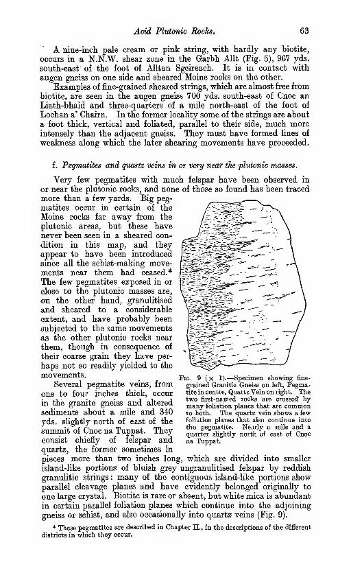
Acid Plutonic Rocks. 63
A nine-inch pale cream or pink string, with hardly any biotite,
occurs in a N.N.W. shear zone in the Garhh Allt (Fig. 5), 967 yds.
south-east of the foot of Alltan Sgeireach. It is in contact with
augen gneiss on one side and sheared Moine rocks on the other.
Examples of fine-grained sheared strings, which are almost free from
biotite, are seen in the augen gneiss 700 yds. south-east of Cnoc anLiath-bhaid and three-quarters of a mile north-east of the foot of
Lochan a' Chairn. In the former locality some of the strings are about
a foot thick, vertical and foliated, parallel to their side, much moreintensely than the adjacent gneiss. They must have formed lines of
weakness along which the later shearing movements have proceeded.
f . Pegmatites and quartz veins in or very near the plutonic masses.
Very few pegmatites with much felspar have been observed in
or near the plutonic rocks, and none of those so found has been traced
more than a few yards. Big peg-
matites occur in certain of the
Moine rocks far away from the
plutonic areas, but these havenever been seen in a sheared con-
dition in this map, and they
appear to have been introduced
since all the schist-making move-ments near them had ceased.*
The few pegmatites exposed in or
close to the plutonic masses are,
on the other hand, granulitised
and sheared to a considerable
extent, and have probably been
subjected to the same movementsas the other plutonic rocks near
them, though in consequence of
their coarse grain they have per-
haps not so readily yielded to the
movements.Several pegmatite veins, from
one to four inches thick, occur
in the granite gneiss and altered
sediments about a mile and 340
yds. slightly north of east of the
summit of Cnoc na Tuppat. Theyconsist chiefly of felspar andquartz, the former sometimes in
pieces more than two inches long, which are divided into smaller
island-like portions of bluish grey ungranulitised felspar by reddish
granulitic strings : many of the contiguous island-like portions showparallel cleavage planes and have evidently belonged originally to
one large crystal. Biotite is rare or absent, but white mica is abundant
in certain parallel foliation planes which continue into the adjoining
gneiss or schist, and also occasionally into quartz veins (Fig. 9).
* These pegmatites are described in Chapter 11., in the descriptions of the different
districts in which they occur.
Fig. 9 ( X 1 ).—Specimen showing fine-
grained Granitic Gneiss on left, Pegma-tite in centre, Quartz Vein on right. Thetwo first-named rocks are crossed bymany foliation planes that are commonto both. The quartz vein shows a fewfoliation planes that also continue into
the pegmatite. Nearly a mile and aquarter slightly north of east of Cnocna Tuppat.

64 XM QUer l§mous Rocks.
About a third of a mUe W^.W. of tte Ordnance Station 1347
oa Cam Dubh several thin pe^atites, less than an inch thick, keep
along the foliation of the fine-^ined granite gndsa, and are themselves
in a somewhat granulitic condition.
A thin pegmatite in the " stippled schists" * of the Moine Series,
a mile and 666 yds, west of Carn Hbxen, ia almost free from grannlitisa-
tion. The felspar ia pale pink or white, and the quartz bluish, tike
the quartz blebs in some of the less sheared granitic rooks.
Along the junction of the granite gneiss and Moine schists at the<
north end of the Inchbae pluto^nic mass, at Meall nan Sac, pegmatites
are seen in several places, and loose blocks ol pegmatite are also commonin the drift-covered ground a little further east. Some of the bandsindiqated must be at least two qr three feet wide and contain quartzveins six inches wide. All these pegmatites are reddish, and haveperhaps been covered by the Old Eefl Sandstone not very long ago.
Theic felspar is to a large extent granulitic, but still shows ungrantt*
litised augen, as large as a hen's egg, in which microperthite structure
can be detected.
Judging from the numerous loose pieces of vein-quartz near the.
top of Carn Chuinneag and on the west side of Loch Chmnneag, veins
consisting chiefly of quartz but with occasional specks of felspar mustbe rather abundant in these locaKties; but they can rarely exceed
six inches in breadth.
Many of these loose pieces are semi-translucent and somewhatbrown or "smoky" like "Cairngorms," in most of their substance,t
but they are frequentiy crossed by opaque white streaks of a some-
what granulitic character. Veins with similar granulitic streaks
are seen in situ in the granite gneiss in the south-east bank of the
streg,m nearly half a mUe IJ.S.E. of Meall Eadar an da Chuinneag.
In certain places crystals of translucent white, pink or smokyquartz are also not uncommon, lying loose on or below the surface
of the ground. They are sometimes attached to quartz veins andhave evidently grown out into cavities which existed either at the
side or in the interiors of such veins. Small pieces of chlorite and
specular iron are also occasionally found in association with them. In
some specimens well formed quartz crystals, perfectly free from de--
formation, are attached to one gide of a quartz vein, while the other
side is welded on to a rodded granulitic gneiss in which the rods are
pointed almost at right angles to this side. It seems necessary to
conclude in these cases that the crystals have been formed after the
rodded granulitic structure. c. T. c, c. b. c.
iii. GAKNETIFEROUS ALBITE GNEISS WITH MAGNETITE ANDTINSTONE.
In the rather fine-grained reddish granite gneiss about half a mile
south of Diebidale Lodge (Fig. 16), several dark gneissose bands are
observed which weather in roimd blocks and disintegrate readily into
* See Chapter V.
t These are referred to in the ' New Statistical Account of Scotland,' 1845,
p. 409. Whether the writer of the passage knew that the adjoining rocks consisted
of granite is not clear.
Garnetiferous Albite Gneiss with Tinstone. 65
a brownish soil. They can also be distinguished in the field by the
following characters :
—
1. The great abundance and size of the biotite flakes.
2. The presence of garnet, sometimes in round lumps an inch or two indiameter.
3. The abundance of white plagioclase, determined by Dr. Flett to bealbite.
4. The carious mode of weathering, due to the presence of scattered grainsof some carbonate.
5. The presence of strings of heavy black ore.
The strings of black ore mentioned above have been found onchemical examination to consist chiefly of magnetite mixed with variableproportions, sometimes as much as 15 or 17 per cent., of cassiterite.
Biotite is not uncommon within the strings, in flakes lying parallel
to the sides.
It seems probable, on the whole, that these garnetiferous albite
gneisses represent basic segregations of an unusual type, or else peculiar
veinstones formed in the granite gneiss.
Two main bands of this grey albite gneiss have been mapped.The crop of the more northern one runs north-east, and has beentraced about 250 yds., while the crop of a higher second band, 70 or 100yds. south-east of the other, has been followed in an E.N.E. direction for
100 yds. (see Fig. 16). The foliation in the adjacent red granite gneiss
is not always distinct, but it appears to be approximately parallel
to the bands. The northern band is as much as 15 yds. wide in places,
and contains more garnet than the southern band but a less proportion
of the black ore. In the southern band, the greatest thickness of
which is 10 yds., the strings of ore are occasionally three inches thick.
Between these two main bands comes another thinner one whichalso contains streaks of black ore.
It is possible that both the main bands continue considerably
further than they have been traced, for the hill surface is to a large
extent obscured by drift and loose blocks, both in the north-east andsouth-west directions. A small exposure of somewhat similar rock
is seen on the west side of the forest path about half a mile slightly east
of south of the Lodge, but we cannot be sure to which band it belongs.
About 200 yds. south of the southern band a number of pieces of the
black ore have been found, and some of these are as large as anyobserved in situ. It is certain, from our knowledge of the drift " carry
"
in the neighbourhood, that these pieces cannot have been derived fromany of the exposures described, and it is probable that they have been
carried from bands, now hidden under drift, which lie to the south or
south-west.
These grey gneisses show a coarse-foliated structure and seem to
pass gradually into the red gneiss, usually through an intermediate
zone about a yard wide. The neighbouring red gneiss a little distance
off the grey bands occasionally shows dark magnetite laminae and also
garnets as large as beans.
The black ore in the grey gneiss is very irregularly distributed, but
most commonly it occurs in lenses and streaks which lie nearly along
the foliation. Magnetite occurs also, however, intergrown with
garnet and in small octahedra within felspar. The margins of the
black lenses and streaks are generally slickensided, but in the middle
5
66 The Older Igneous Rocks.
band the marginal parts of the streaks interlock with felspar, and are
bordered by a fringe of scattered grains of black ore.
The south-east (higher) band is crossed by a thin dyke, now-
composed of calcareous biotite schist. The dyke is not crossed byany black ore streaks, though such streaks occur near its side andstrike at it..
It is clear from the slickensided surfaces of the ore streaks that the
bands have undergone considerable movement, and with this move-ment may perhaps also be connected the frequently rounded form bothof the garnet and of the felspar, even though, as Dr. Flett states, the
latter is almost free from gTanulitisation. In this comparative freedomfrom granulitisation these grey bands offer a great contrast to the
red gneisses in which they occur. It seems necessary to supposethat the albites of the grey bands have been formed after the gran-
ulitisation of the red gneisses was practically completed, but that
subsequently the grey bands formed lines of weakness along whichrenewed movements took place, though not with sufficient intensity
to produce much granuUtisation.
The locality in which these grey gneisses .are seen is probably
about 200 yds. east of the nearest sediments, which are of a pelitic or
semipelitic type, but it is separated from these by a powerful fault,
a supposed wrench-fault, described in Chapter IX., which appears to
shift the beds on its east side away to the north for about a mile.
Before the fault took place, the gTey gneiss bands that are exposed
were probably a mile distant from the margin of the plutonic rocks,
and the bands inferred to exist under the drift must have been still
more distant. No other rocks which can be regarded as sedimentary
inclusions occur so far within this margin.
No rock containing tourmaUne, the mineral commonly found in
association with the Cornish veins of tinstone, has been observed in the
one-inch map being described, except near Loch Misirich, on the east
side of Ben Wyvis (see Chapter II,), and again near the south end of
the Newer (Fearn) Granite (see Chapter VII.). Both these localities are
nearly ten miles from the Diebidale bands which yield cassiterite.
Fluor spar has only been detected in one locality in this one-inch map :
this is in the biotite granite gneiss, about | mile east by north of Leaba
Bhaltair, and rather more than a mile south of the tinstone-bearing
rocks.
The occurrence of albite in albite schists of the Moine series is by no
means uncommon (see Chapter II.), and this fact may give the im-
pression that the cassiterite-bearing bands, all of which contain muchalbite, probably represent altered sediments caught up in the granitic
magma. It should, however, be pointed out that a coarse-grained
albite-bearing seam (13967) has been noted within the granitic area
near Creag Euadh, Diebidale, and that this seam, though not sharply
separated from the more normal granitic rock at its sides, appears to
cross the fohation of the rock. The impression conveyed is that it mayrepresent a vein partly formed from the adjoining rock by modification
along a line of strain. It contains a considerable proportion of
ferriferous carbonate.* Veins containing quartz, albite, chlorite andferriferous carbonate are, as is well known, of common occurrence both
* For further description reference may be made to the section treating of the
dark grey granite gneisses specialiy rich in biotite, in Chapter IV.

. Basic Dyhes and Sills. ^&
-im tlie Moine schists and in the Dalradian schists of the South-WestHighlands.
L. L. Fermor has recently described* a cassiterite granulite from
Chappatand, the Hazaribagh district, Bengal, which has some points of
resemblance to the Diebidale cassiterite-bearing rocks. The Chappa-tand rock sometimes contains as much as 50 per cent, of cassiterite, the
other constituents being magnetite^ quartz, oligoclase, orthoclase, in
small quantities, green hornblende in small quantity, and biotite in still
smaller quantity.
Further petrological and chemical description, and speculations onthe mode of origin of the Diebidale bands, are given in Chapter VI. byDr. Flett.
IV. BASIC DYKES AND SILLS.
These are generally in the form of epidiorite, hornblende schist,
hornblende biotite schist, or chlorite schist. As already stated near
the beginning of the chapter, they are conveniently divided into twogeographical divisions, viz. :—
A. Intrusions in the Moine Rooks.
B. Intrusions in the Plutonic Masses.
Each of these divisions perhaps contains intrusions of more than
one period. It is also possible that some of the intrusions described
here may belong in reality to sheared types of the Newer Igneous
rocks, but it does not seem probable that the bands which may thus
have been wrongly placed are numerous.
In the following description we shall include in group iv. all those
minor intrusions which are well foliated, excepting certain schists
which have marked chemical and petrological affinities with the
lamprophyres, or which we have strong grounds for supposing havebeen intruded into the Moine rocks after these had already acquired a
foliated character.
A. Intrusions in the Moine Eocks.
Though neither large nor numerous, the rocks to be described are
well represented in some form or other in nearly all parts of the map.c. T. c.
Garnet amphibolites and epidiorites are associated with the
muscovite biotite gneiss crossing Strath Rusdale and Ben Wyvis,
and also with the quartzose series lying to the east of this band, andthey are most frequently met with near the junction of these two sets
of rocks. They may be observed on Cnoc a' Mhadaidh and Cnocan t-Sithein Mor, north of Strath Rusdale, but appear to be moststrongly developed in the crags on the west side of Loch Morie, where,
from a band of unusually great thickness, big blocks of the garnet
amphibolite have been dislodged, and lie at the base mingled with
other large blocks of muscovite biotite gneiss. Rocks of this type have
not been observed along the crop of muscovite biotite gneiss between
Aultguish and Coire Mor, and it is possible that the gneiss along this
western anticlinal fold has not been sufficiently deeply eroded to reach* Records of the Geological Survey of India, 1906, vol. xxxiii. Part 3.

68 The Older Igneous Rocks.
the horizon of these bands. Specimens from the northern shore of
Loch Glass, opposite Culzie Lodge, examined by Dr. Flett, are re-
ported by him as zoisite amphiboUte (9860) and epidote amphiboUte
(9863, 9864). These were from rocks which difiered materially to
the naked eye from the more typical ones, but were closely associated
with the latter.
The garnet amphibolites occur as lenticular bands and masses along
the strike of the schists. They vary in size from small lenticles, one
foot across, to broad bands many yards in width, the rocks in the
latter being massive in character. They consist chiefly of black
hornblende with numerous red garnets, and often show little foliation
towards the centre. The margins are, however, foliated and are chiefly
composed of black biotite in large flakes wrapping round masses of
broken garnet, often of large size. In many places the bands are
foliated throughout and often contain a little felspar. Owing to the
intensity of foliation no evidence of the intrusive nature of these rocks
was observed in this district. o. B. c.
In the north-western portion of the map various bands of horn-
blende schist are well seen in the crags of Gail Mhor on the north side
of Gleann Beag, where they usually make narrow nicks and showtheir intrusive character clearly, being in the form of dykes or sheets
which are more steeply inclined than either the bedding or foliation
of the Moine rocks. On the south side of Bodach Mor a band runningnorth-east makes a gently inclined greenish ledge, which has beentraced more than half a mile and cuts the bedding of the Moine rocks
at a slight angle, getting into apparently higher beds in a north-easterly
direction. In Glencalvie Water, about a quarter of a mile and again
nearly a mile above the foot, various thin bands behave as sills for
the most part, and the sill-like mode of occurrence is perhaps the
most common in the district generally, though no band is usually traced
far without affording satisfactory evidence of its intrusive character.
Nearly all these bands have a decidedly basic composition, and con-
sist of well foliated hornblende schist, hornblende biotite schist, biotite
schist or chlorite schist. In some cases where the evidence of intrusion
is clear the foliation is parallel to the sides of the intrusion, but in
others it crosses the sides and is continuous with the prominent
foliation in the Moine rocks. In the former cases the foliation differs
from the prominent foliation in the Moine rocks, and, as far as re-
cognised, is unaccompanied by any corresponding secondary structure
in them. The first presumption regarding such cases is that the bandswere intruded into the Moine rocks after these last had already beenconverted into schists, and that the bands have been converted into
schists by later movements confined to themselves. But this is perhaps
not a safe conclusion. It is possible that some of the bands may havebeen at one time crossed by a foliation in much the same direction
as that in the Moine rocks, but that the foliation in these intrusions
has been subsequently greatly modified and dragged out of its
original direction so as to be practically parallel to the side.
Bands which cross the bedding of the Moine rocks, and which also
show the same foliation as these rocks, have not been very often ob-
served, but examples are seen in Glencalvie Water about three-
qaarters of a mile south-west of Cnoc na Tuppat, and also on the north
tide of Gleann Mor about two miles north-east of Deanich Lodge. In

Basic Dykes and Sills. 69
a sill in the burn a mile and a quarter north-west of Deanich Lodgethe foliation crosses the margin and is continuous with that in the
Moine rocks, but it is not known that there is any clear evidence of
intrusion.
Indications of felspar phenocrysts are not common in these schists,
but some as much as half an inch long occur in tolerable abundancein large blocks of hornblende biotite schist lying at the foot of the
north end of Meall na Rainich, Gleann Mor. The blocks have probablyslipped from a band some distance up the hillside, but they could
not be traced confidently to their source. In some of the blocks the
phenocrysts are in places so abundant that they make up a quarter
of the surface, for an extent perhaps of half a square foot. Some are
granulitic, but others show broad cleavage planes across their wholebreadth.
Garnets are abundant in some bands, e.g., in those near the north
end of Loch Coire Mhic-mhathoin (10382), a third of a mile north-
east of Glenbeg house (10380) and nearly a mile north-west of DeanichLodge. In the first mentioned band it forms, in conjunction withfelspar, small spots the size of peas, which are frequently edged withthin rims of white felspar * and are accompanied with other spots, of
about the same size, which consist of granular aggregates of felspar
and quartz with a little hornblende. One or two bands, for instance,
a green schist in the burn nearly half a mile north-east of Cnoc naTuppat, contain small spots of quartz, which are suggestive of
amygdules.In the burn 1200 yds. south-west of Cam nan Aighean, near the
head of Strath Rusdale, a green schistose band which seems to trans-
gress the Moine rocks, though not very clearly, and to occupy a line
of displacement, is of a very unusual type, being of a somewhat acid
character. It contains both muscovite and biotite, and, in Dr. Flett's
opinion, may perhaps represent a sheared felsite or syenite rock
(10383).
A crag section a mile and a quarter slightly east of north of Deanich
Lodge shows a band of biotite schist, from 1 to 3 ft. thick, which
is somewhat steeper than the Moine schists at its sides. This
is displaced 60 or 70 yds. along a nearly horizontal thrust, which is
accompanied in places by patches of a crushed reddish igneous rock,
containing a good deal of biotite, which probably belongs to the
lamprophyre group. It is probable that the reddish rock represents an
intrusion which has been intruded along the thrust and then crushed
by later movements along the thrust.
f
It has been noticed almost everywhere in this district that intru-
sions in the form of biotite schist, as in the steep band just mentioned,
are also somewhat calcareous and frequently contain grains of somecarbonate, both scattered through the rock mass and collected together
with quartz into little strings. It is clear in many locaHties that the
interior portions of intrusive sheets consist of hornblende schist,
with little or no admixture of biotite, while the marginal portions
are composed of calcareous biotite schist with little or no admixture* Similar rims are common in the hornblende schists of the Lewisian Gneiss.
See for instance, ' The Geological Structure of the North-West Highlands,' Mem.Geol Smvey, 1907, pp. 118, 210, 242.
•fIt will be mentioned again in connection with the Newer Igneous Rooks in
Chapter VIT.
TO, The Older Igneous Bocks.
of kornMende. It has been noticed, also that these marginal porlaions
h^fve frequently been specially disturbed, the foliation therein being-
much crumpled or crossed by small thrusts, -while in the interior
portions the foliation of the hornblende schist is much more regular..
These phenomena suggest that the marginal portions, composed, of
caiparequs, biotite schist, have been developed out? of hornblende
schist du?;ing folding and shearing movements which haye- specially
affected the sides of the intrusions. During iiese mov;eBientSj bi*)tite
and a ferriferous carbonate seem to have taken the place of horn--
blende,* but have themselves been crumpled before moyementceased.
The sheet already referred to on the south side of Bodach Mor shows
very well the change described. About 1333: yds. S.S.W. of the top.
of the hill the interior of the sheet consists of hornblende schisl; \»th
but little biotite : the foliation planes are tolerably even in this- por-
tion, and no carbonate is discerned. But about a foot below the top;
of iie sheet the- rock changes into a contorted biotite schist which
contains httle or no hornblende, but a good many thin veins andlenticles of ferriferous carbonate, which are twisted together with,
the foliation. The change is somewhat rapid, being completed within,
a thickness of three inches. In another localityi about 1233 yds..
S.S.W. of the hilltop, the middle and bottom portions are exposedi
but not the top, and the bottom is a twisted calcareous biotitfr
schist, while the middle is a hornblende schist without any distinct
contortion.
Somewhat similar instances of change from hornblende schist
into calcareous biotite schist are well seen at the following localities
:
hvim. 700 yds. north of the outlet of Lochan PoUaig, east side of the
Eiver Carron about half a mile below the foot of Glen Calvie,f and.
again 660 yds. below.
In the burn a mile S.S.E. of the outlet of Lochan PoUaig a little
sill is exposed, the outer portions of which consist of a soft shivery
biotite schist which passes gradually towards the interior into a hard
hornblende schist. The weathered biotite schist is not calcareous,
bu}; unweathered samples would probably prove to be so, for the.
usual effect of superficial weathering in these schists is not to develop
carbonates but to carry them away in solution.
In Lubachlaggan burn, about 466 yds. south-east of the foot; o£
Loch Toll a' Mhuic, the Moine schists are very steep and considerably
twisted, while the margin of a chlorite schist which in places cuts
them is more regular. Perhaps this chlorite schist should be classed.
with the sheared bands of the Newer Igneous, rocks.
in areas where. the Moine schists are.deeply weathered, as described
in Chapter IL, the. hornblende schists: are also often, in a similar con-,
dition. The bottom part of a sill in the burn a, mile slightly.- soutlt
of east of Bodach Moi; is changed into a soft ochreous rock-with largfi»,
* For parallel inptanoqs in the Lewisian Gneiss, see ' The Geological Structureof the Nprth:West Highlands,' Mem. Geol. Survey, 1907, pp. 209-210,, 241^2...
t It is now known thfit the centre of one of these schists is not a typical hornblendeschist, but contains a good deal of biotite in addition to pale green hornblende^ which-is being replaced by chlorite and carbonates. Dr. Flett states that it does not seemto,be a lamprosohist (Chapter VII.) as.it is. garnetiferous. T-he edge rock is-a c^),».
careous mica schist, with much biotite but without hornblendp. Possibly we are*
det^lipg with; a set of composite sills. See analyses in-. Summary of, Progress of the
Geological Survey for 1911.

Basic Dykes and Sills. 71
flakes of bleached biotite, while the top is less altered and showsdistinct hornblende. In another burn, rather more than a mile
slightly south of west of Bodach Mor, the whole of a band about12 ft. thick is in much the condition of the bottom part of the sill
just referred to. c. t. c.
In one of the deep rocky burns on the western flanks of Beinn a'
Chaisteil a greenish sill-like band occurs, which, though provisionally
classed with the "intrusive rocks of the older series, may possibly not
represent a true igneous rock at all, but a " Green Bed " of sedimen-
tary origin Uke those in the Southern Highlands.* This greenish
band hes in a locality where the rocks are less sheared than elsewhere,
as described in Chapter II., and is only a short distance from a grey
phyllibe still showing the lines of bedding crossed by the schistosity.
It is weathering deeply into a green earth containing much epidote
and iron ore, but the freshest specimen obtainable (10446) is reported
on by Dr. Flett as " a fine quartz muscovite schist with granules of
epidote, sphene and iron oxide. There are a few larger crystals of
brown biotite, which cross the foliation obliquelj'- and are obvious
in the broken surface of the hand specimen. The rock is a very
perfect schist. There is nothing to show that it was originally igneous. '
'
This band occurs along the strike of some hornblende biotite schists,
and in a neighbouring burn one of these contains large flakes of brownbiotite hke those referred to above. While the field survey was in
progress, the rock described by Dr. Flett was considered to represent
one of these schists in an area of low metamorphism. If this view
be correct, the results of the microscopic examination would suggest
that some of these hornblende biotite schists f have had a sedimentary
origin, the hornblende being constructed during a period of meta-
morphism, as in some of the more altered " Green Beds " of the South-
ern Highlands. { Hornblende schists are abundant along the strike
of the schists between Aultguish and Dsanich, and also in the Kilder-
morie Forest, but are apparently very scarce or absent in the quartzose
series lying to the east of the band of muscovite biotite gneiss, which
crosses Strath Eusdale and Ben V/yvis. c. b. c.
B. Intrusions in the Plutonic Masses.
These intrusions seem always in the form of dykes foliated parallel
to their sides. They are never more than 10 or 12 ft. thick, and have
never been traced more than a few hundred yards. They consist of
hornblende schist, hornblende biotite schist or biotite schist, being
frequently richer in biotite than in hornblende. The foliation is often
finer and closer than that in the earher basic rocks of gTOup i., or in manyof the intrusions of division " A." With this quality may perhaps be
connected the great abundance of biotite and the calcareous character
often found. § In crags they always give rise to little nicks, as they
yield to weathering more readily than do the adjacent plutonio rocks,
most of which are less closely foliated.
The general greater intensity of the foliation in the dykes of this'
* See, for instance, ' The Geology of Cowal,' Mem. Genl. Survey, 1895, p. 37.
•fOthers in the same district shov/ indications of an intrusive character.
X See, for instance, ' The Geology of Mid Argyll,' Mem. Geol. Survey, 1905, p. 19.
I See preceding description of division " A."

72 The Older Igneous Rocks.
division compared with that in many of the intrusions belonging to
division " A " may, perhaps, be due to the fact that divisional planes
comparable to those represented by the sides of the dykes were probablyrare in the plutonic masses at the time the shearing movements began,
while in the surrounding sediments divisional planes were common, in
the form of bedding planes. In the plutonic masses, therefore, the
shearing movements would be specially apt to proceed along the
dykes. These shearing movements have not only led to the production
of foliation in the dykes but have also powerfully modified the granitic
gneisses at their sides. An instance of the modification has beenalready described in an earlier part of the chapter, but many other
instances of a similar kind could be cited, in which, as the side of the
dyke is approached, the foliation in the gneiss gradually becomessteeper and is dragged into parallelism with the dyke side : at the sametime the foliation planes become much closer together, and the general
colour of the rock changes from.pink to dirty white. As far as known,there is nothing to show that the dyke rocks were in a less solid con-
dition at the time of their foliation than the adjacent gneiss was. Thegeneral greater intensity of foliation in the dyke rocks seems sufficiently
explained by the supposition that the dykes formed special lines of
weakness.
These dykes are seen best in the crags on the south side of Diebidalein the Carn Chuinneag plutonic mass. About half a mile south-east
of Mullach Creag Eiaraidh, where they are sometimes so thickly
crowded that it is impossible to show them all in the one-inch map, the
general direction is not far from east and west, and the incKnation is
steeply south. A little further west, in the crags north of LeabaBhaltair, two of the dykes run nearly north and south, and the widestone is as much as 12 ft. wide.* In the river north of Creag lUie several
thin dykes striking W.N.W. are of particular interest, as they cut a
confused mass of earlier basic and granitic rocks : the distinction
between the basic dyke and the earlier basic rocks is greatly facilitated
by the absence of any granitic strings in the former. Most of these
Diebidale dykes keep nearly straight as far as they can be traced, buttwo, on the south-east side of Mullach Creag Riaraidh, have beensomewhat twisted, together with their foliation planes.
Outside Diebidale, only one dyke of this division has been noticed
within the Carn Chuinneag mass. This occurs in the burn three-
quarters of a mile wfest of the northern end of Loch na Glasa. It
strikes north-west, is 6 or 7 ft. wide, and foliated parallel to its
side, like the rest.
In Allt an Eilein Ghuirm, in the Inchbae plutonic mass, several thin
bands of biotite schist, often calcareous, appear to represent intrusions
later than the granite gneiss. Like the Diebidale dykes, they haveoften acted as lines of weakness along which shearing movements haveproceeded, that have not only sheared the bands themselves but also
greatly modified the augen gneiss at their sides. A band of this kindis seen nearly three-quarters of a mile above the burn foot, and three
others occur close together rather less than a mile above the foot. All
these appear to strike W.N.W., but, owing to the covering of drift, theycannot be traced outside the burn. c. t. c.
* The analysis of this dyke is given in Chapter VI.
CHAPTER V.
€ONTACT-METAMORPHISM PRODUCED BY THE OLDERGRANITE.
Introduction.
In 1900, Dr. Peach noticed a certain amount of contact-alteration
in thin pehtic bands in the siliceous Moine schist at their junction
with the granite mass of Inchbae. He made the following statement
in the Summary of Progress of the Geological Survey for that year
:
" The granite appears to have produced a certain amount of contact-
alteration in the schists, though this early metamorphism is nowmasked in part by the structures that have been induced both in granite
and schist by the pressure to which they have been ahke subjected,
and to which in great part, if not wholly, their present crystalline
condition is due."
It is, however, where the thick band of pelitic sediment comes into
contact with the granite of the larger Carn Chuinneag mass that the
effects of contact-metamorphism are most clearly seen. This granite is
in contact with rocks of pelitic character along all itsborder except at the
south-west end (Plate XII.), where it abuts against more siliceous types.
The pehtic rocks have been contact-altered over wide areas, andusually form a broad belt of hornfels fringing the granite outcrop.
This belt was first encountered in 1901 near Kildermorie, where the
hornfels forms a conspicuous crag on the northern shoulder of Meall
nam Bo, and is also well exposed in the bed of the Abhuinn na Glasa,
between Kildermorie Lodge and the eastern margin of the augengneiss, which crosses the stream about half a mile above the Lodge.
Other good exposures are seen in the small crags on the slopes over-
looking the stream between these points. These exposures of the
hornfels, and especially that on the crag north of Meall nam Bo, form
a striking contrast to the neighbouring Moine schists. The attention
is immediately arrested by their bluish colour, homogeneous appear-
ance, and south-westerly dip at right angles to the general direction of
dip in the schists, which is south-eastward. Shortly after the dis-
covery of the hornfels at Kildermorie, Dr. Peach suggested that the
pelitic sediments had been contact-altered by the granite previous to
the movements which have altered the surrounding sediments into
schists and converted the granite into a gneiss, and, further, that these
hornfelsed sediments, owing to their contact-alteration, had escaped
the dynamic metamorphism in which the unaltered sediments and
the granite have subsequently been involved.
Specimens of the hornfels from Kildermorie were submitted to Dr.
Flett for petrological examination, and were stated by him to show no
sign of mechanical deformation.* Further field work showed that where
* Summary of Progress of the Oeological Survey for 1901, p. 108.73

74: Contact-metamorphism produced by the Older Granite.
these sediments are of pelitic nature, they have been contact-altered
and hardened for a considerable distance from the granite margin, but,
at a subsequent period, all the rocks have been subjected to powerful
tangential pressure, and the greater part of the sediments and the
granite have together been foliated and metamorphosed into schists
and gneisses. The great hardening and mineralogical alteration
undergone by those parts of the pehtic sediments which were within
the aureole of thermal metamorphism, probably caused parts of this
hornfelsed zone to move en masse during the processes of folding
and foliation which the other rocks have undergone, and thus preserved
these parts from mechanical deformation and regional metamorphism.The band of pelitic sediment which is in contact with the granite gives
a wide outcrop, and is evidently of considerable thickness, but those
parts of it which are furthest removed from the granite, and whichprobably lay outside the original limits of its thermal alteration, are
over wide areas in the condition of mica schist. Within the contact-
aureole the hornfels is traversed by planes of shear.
Mica schists have been produced by the shearing of the hornfels,
but the schists so produced can usually be distinguished from those
lying outside the contact-aureole. They generally retain, for instance,,
some of the blue colour of the hornfels and are never coarsely crystalUne.
It may be pointed, out that phenomena of a somewhat similar
character to those observed near the Carn Chuinneag granite had beenpreviously met with by Mr. George Barrow, in the neighbourhood of
the Ben Vuroch granite, north of Pitlochry.* Mr. Barrow appears
to suppose that a thermal alteration like that observed near
Ben Vuroch once afiected the rocks over a very large area, too
large to allow it to be attributed to a localised granite intrusion. Hecame to the conclusion that the unfoliated hornfels owed its pre-
servation from shearing chiefly to the shelter afforded by the granite.
The hornfelsed rocks of Ben Vuroch are chiefly found on the western
side of the granite, which is the lee-side, in reference to the schist-
making movements of that district.
The phenomena near the augen gneiss of Eoss-shire indicate rather
that in this area the thermal metamorphism was limited to the neigh-
bourhood of the granite, and that it was the physical and mineral con-
stitution of the altered rock which chiefly led to its preservation from the
deforming influences of the subsequent movements. The largest areas
and finest sections of hornfels lie on the eastern side of the granite mass,
the side facing the quarter from which the tangential movements took
place, the isoclinals of the schists generally dipping east. There is,
indeed, reason for thinking that in this area also some of the morecoarse-grained granite has locally offered more resistance to dynamicmetamorphism than the sediments which were not thermally altered
by its intrusion. It is probable, however, that some degree of pro-tection was afforded to the granite by the hornfelsed sediments along.ita
margins, but the frequent evidence of shearing of the hornfels along;
the granite margin shows that the hornfels and the granite did not:
everywhere act as one rigid mass. c. b. e.
It ought to be stated that the shearing of the hornfels may haveproceeded at more than one period. It is probable, as will be. subse-
* 'The Geology of the Country round Blair Atholl, Pitlochry, and Aberfeldy,''
Mem. Oeol. Survey, 1905, pp. 91-94.

Hornfelsed Sediments. 75
quently shown in describing the district of Glen. Calvie and Cnoc an
t'Saic, that sonie of this shearing may be latei; than the intrusion of
certaifl lamprophyres. This later shearing is, however, probably
confined^ to snjall areas in the vicinity of thrusts along which repeated
movements have taken place. c. t. c.
Types of Hornfelsed Sediment.
To the naked eye most of the hornfels has a peculiar dark bluish
colour and a very fine-grained texture. It is frequently finely banded
or striped with darker and paler bands, which mark slight difEerences
due to original sedimentation. The rock breaks up into cuboidal
fragments, or else the fracture is conchoidal, resembling that of a
fine-grained igneous rock. Locally, fairly large slabs or flags occur
which show silvery partings of white clastic micas, separated by thin
lenticular sandy laminae, and, on these slabs, surface markings are
occasionally observed which have a close resemblance to the sun-
oracks of more recent sedimentary rocks. No trace of fossils has been
found, though from the small amount of deformation the rocks haveundergone they would be likely to have been preserved if originally
present. From the unusual distinctness of the very fine lamination,
it seems probable that difierences in original laminae of sedimentation
have been accentuated to the eye by the thermal alteration, in the
manner pointed out by Mr. Barrow in the hornfels of the Ben Vurocharea. Those types which show the original bedding clearly and are
rich in white mica may be classed as knotenschiefer, being abundantly
spotted with small specks and knots, which are stated by Dr. Flett to
consist of clustered scales of pale mica. Many specimens have been
found to contain sillimanite in tufts, and chiastolite. The last namedmineral occurs in a definite band of a darker colour than that usually
met with, and, as Dr. Flett detected specks like carbon in this rock,
the darker colour may perhaps be due to original greater organic
impurity. SilHmanite is widely distributed in the hornfels, andoccurs in specimens up to the granite margin and even in the granite
itself, perhaps in consequence of absorption of some of the sedimentary
material. Garnets, spongy with quartz enclosures, are not uncommonin the hornfels. They usually occur in special abundance along
certain bands, and along the south-east margin of the granite they
are largest and most frequent in the rocks in close contact with it,
where the rocks have clearly suffered some deformation and are nowmore or less schistose in character : it is to be noted that the garnets
themselves are also frequently deformed. Chiastolite prisms are also
found, but only in certain bands, presumably those which originally
possessed a chemical composition particularly favourable to their
development.
The- Distribution of the Hornfels and its Eelation toTHE Granite and the Moine Schists.
The crops of the hornfels are confined to the neighbourhood of
those parts of the margin of the granite which are in contact with,

76 Contact-metamorfhism produced by the Older Granite.
the pelitic sediments. These sediments form a belt following the
granite margin from Beinn nan Eun, about the middle of the south-
east margin, north-eastwards through Sgor a' Chaoruinn, Kilder-
morie, Cam Cas nan Gabhar and Meall Bhenneit. Thence the belt
curves round the northern boundary of the granite at Carn Bhren andCarn Salochaidh, and extends nearly as far south-west as BeinnTharsuinn. The crop thus extends along considerably more thanhalf of the boundary of the Carn Chuinneag granite, and has a total
length along the curve of 20 miles. The width of the band betweenBeinn nan Eun and Carn Cas nan Gabhar averages nearly a mile. Onthe northern margin near Carn Bhren it is about the same, but gradu-
ally diminishes from this place south-westward till it dies out against
the granite near Beinn Tharsuinn. On the south flank of Beinnnan Eun the outer margin of the pelitic band turns abruptly to the
N.N.W., striking almost at right to the granite boundary. Byconsulting the map, it will be seen that the continuation of this line
across the granite mass will strike the north-west margin of the granite
at the point where the pelitic mass there comes to an end. Thepresent outcrop of the pelitic mass consists, therefore, of the outer
rim of a lenticular outlier about nine and a half miles in length in
a north-east and south-west direction and six miles in breadth, the
granite occupying the centre and four miles of the south-west part
of the rim, where it passes from the pelitic into the surrounding silice-
ous rocks. Although the pelitic gneiss outcrop hugs the granite,
as shown above, it is probable that the whole breadth was not within
the aureole of thermal metamorphism.
Detailed Descriptions of Districts,
kildeemorie to the south side op meall na h-uigeig.
Within the pelitic belt from Kildermorie north-eastwards a line
has been drawn separating an inner belt of hornfels from an outer
belt of mica schist. This line can be first traced on Meall Toll a'
Choin, near Kildermorie, and thence extends several miles, more
or less parallel to the adjacent margin of the pelitic band, across AnClaigionn and Bad a' Bhathaich, on to the eastern shoulder of Meall
Bhenneit. The band of mica schist south-east of this line is in several
places a quarter of a mile in width, but the hornfelsed rocks between
this line and the granite margin are usually over half a mile, and
for some distance north of Kildermorie fully three-quarters of a mile
in width.
It is probable that the greater part of the pelitic belt between
Bad a' Bhathaich and Meall na h-Uigeig has at one time consisted
of hornfels, though much of it has been considerably altered by subse-
quent movement and has been changed into mica schist. The line
drawn on the map from Bad a' Bhathaich north-eastward to Meall
na h-Uigeig must not, therefore, be taken to indicate the original
extent of the aureole of thermal metamorphism, though the line
between Bad a' Bhathaich and Kildermorie does perhaps nearly
do so. The influence of the granite may have extended somewhat
further, but the sediments outside this line have yielded to the subse-
quent movements to the same degree, and have been as much altered

Kildermorie to Meall na H-Vigeig. 77
by dynamo-metaniorpliism as any of the pelitic beds far removedfrom the thermally influenced area. The mica schists outside the
line between the points last referred to are similar to those which form
the isolated outcrop on Cam Beag, If miles east of Kildermorie. Theyare dark grey in colour, and contain fairly large plates of mica, including
biotite. The rock is distinctly foliated, and contains many thoroughly
granulitic quartzofelspathic streaks and lenticles, and the foliation
planes are minutely puckered, causing the. rock to split along
corrugated division planes. In sections across -the foliation, the
puckering of the darker micaceous and lighter quartzofelspathic
layers is well seen, and it is apparent that the original material has
suffered a distinctly higher grade of regional metamorphism than the
blue phyllites and silky mica schists that have in many places been
produced by destruction of the hornfels.
On An Claigionn and Meall Toll a' Choin, where this mica schist is well
seen, the bedding planes cannot be easily distinguished, but the foliation
is contorted, and the axial schistose planes are more or less vertical andstrike N.N.E. and S.S.W., the same direction as in the other schists in
the vicinity. This mica schist was observed as far north as the marchfence running between Carn Cas nan G-abhar and Loch Bad a' Bhathaich.
The line of passage from mica schist to hornfels on approaching
the granite from An Claigionn and Meall Toll a' Choin is well defined,
since the hornfels is bluish in colour, and is dipping uniformly in a
southerly direction at angles of 20° to 40°. The dip becomes moregentle near Carn Cas nan G-abhar, being only 2° to 3°.
This direction of dip is maintained in the hornfels from the crag
south of Kildermorie as far north as Carn Cas nan Gabhar, and is
remarkable, since the strike of the beds makes a gTeat angle to the
granite margin on the.W.N.W., and also to the general strike of the
folds and foliation in the schists to the E.S.S. Where the hornfels
is well exposed it is generally of the spotted type and usually contains
sillimanite, and the bedding planes can be traced for long distances
maintaining their E. andW. strike, and without any sign of folding. In
several places between Kildermorie and the margin of the granite, thin
lines of shear parallel to the foliation of the schists occur, the rock
at the same time becoming a glistening phyllite, somewhat bluish but
lighter in shade than the hornfels.
North of Bad a' Bhathaich, although a boundary line has been
drawn, as described above, the separation of the mica schist from the
hornfels is difiicult, since that part of the pelitic band furthest
removed from the granite is largely in the condition of a pale bluish
phylKte in which the micas are barely visible to the naked eye, and
the complete segregation and foliation of the minerals seen in the
mica schist of An Claigionn are not found. A good section of these
phyllites is exposed in the small burn running north from Bad a'
Bhathaich to join the Amhainn Glac an t-Seilich. Many of the
phyllites exposed in this section have the bedding planes still preserved
but crossed by planes of schistosity. The separation of the hornfels
from the phyllite is also rendered more difficult, as north of Carn Cas
nan Gabhar the dip in the hornfels gradually swings round to the
S.E. and E.S.E., thus bringing the strike of these rocks more or less
parallel with that of the cleavage in the phyllites, and of the folds
and foliation in the schists. It would appear that the roclcs which are
78 Contad,-metamorfhism produced by the Older Granite.
now in the condition of phyllites lay within the aureole of thermalmetamorphism and were previously hardened and hornfelsed, and so
have escaped to some degree the intense mechanical metamorphismthat has produced the mica schists of An Claigionn. - These phylhtes
are like those seen in the planes of shear, and have probably had a
similar history.
North of the Amhainn Glac an t-Seilich the hornfels retains its
S.E. and E.S.E. dip at angles of 10° to 20°, and the rocks maybe studied on the northern flank of Meall Bhenneit and the bed of
the Allt Coire Bhenneit. A marginal zone of phyllites and fine-
grained mica schists flanks the hornfels on its south-eastern side,
but the rock still preserved as hornfels has suffered little movement,and belongs to the IcnotemcUefer type (slides 9870-9875, 9865, 9868). Inthe Allt Coire Bhenneit a finely preserved hornfels breaks up into large
slabs along the bedding planes, which are bright with scattered clastic
micas, and crossed by suncracks filled with sandy material. Theoriginal sandy layers in the peiitic sediment are also unusually thick
and conspicuous.
The rocks in contact with the granite are well exposed in the bedof the stream west of Kildermorie Lodge, and to the north as far as
Carn Sonraichte. The rocky top of Carn Cas nan Gabhar, and theprominent crag north of the road to Lochan a' Chairn, also afford goodsections of the junction. At all these localities the hornfels suffers
much contortion at distances of about 200 yds. from the granite, andnearer to the granite the contortion increases, and in the immediatevicinity the rocks are thrown into a more or less vertical position,
sometimes dipping towards and sometimes away from the granite.
A well marked schistosity is present in these upturned rocks (9866),
and large garnets are often conspicuous, standing out on the weatheredsurfaces. The schistosity is in the same plane as the original bedding.
The granite at the margin is always foliated, and the vertical position
of the rocks must have been caused by pressure against the granite
during the later regional movements.These schistose rocks are blue in colour, like the hornfels, and
usually extremely fine-grained. The garnets, which are frequently
larger than peas, are red, but spongy with quartz enclosures. Thefinely divided micaceous matrix often appears to wrap round the
garnets, which then resemble augen.
SGOR a' CHAORUINN AND BEINN NAN EUN.
The rocks in this area are, as elsewhere, partly in the condition
of hornfels and partly of mica schist, the rocks in the immediatevicinity of and those furthest from the granite being schistose in
character. The distribution of these two types is, however, so
irregular that lines could not be satisfactorily drawn to separate themon the map. Good sections of hornfels are exposed along the crest
of Sgor a' Chaoruinn, on the north shore of Loch a' Chaoruinn andon Beinn nan Eun. Where the hornfels is preserved the strike of
the beds is nearly at right angles to the granite margin and to the
strike of the neighbouring schists. On the summit of Sgor a' Chaor-uinn, and southward towards Loch Magharaidh, the dip is at 10° to 30°
to the S.W. and W.S.W., but further south, on Beinn nan Eun, the
Sgor a' Chaoruinn and Beinn nan Eun. 79
dip is to theN.E. and E.N.E., so that there is a synclinal arrange-
ment of the beds between these points. The hornfels is for the mostpart a knotted hornfels, as at Kildermorie, but in places well preserved
purely sandy beds, now in the condition of white quartzite, emphasise
the bedding. On one of these quartzite bands, on the slopes south
of Loch a' Chaoruinn, surface markings like ripplemarks were ob-
served. Both on the crest of Sgor a' Chaoruinn and on Ben nanEun these quartzite bands underlie a peculiar dark pelitic bandcontaining minute garnets and numerous pale forms resembling
crystals with oblong and square sections. The square sections
often have a well-defined cross suggesting chiastolite, and Dr. Flett
considers the mineral to be a pseudomorph after chiastolite (11021,
11022, 11232). Slide 11232 also contains a mineral which appears to
be kyanite. This band of rock is readily identified, and has beentraced about a mile in the northern locality, and for some distance
on Beinn nan Eun. Its relation to the underlying quartzose bandsin both localities, together with the regular synclinal arrangementof the rocks in this locality, indicate that the exposures of the chias-
tolite hornfels in the two localities are probably parts of the sameband. In the low ground east of Loch Magharaidh the band wasnot recognised, but this is probably owing in part to the rarity of
exposures, and partly to the fact that the more striking features of
the rocks are obliterated by shearing movement. Such an oblitera-
tion becomes evident on tracing the band on Sgor a' Chaoruinn.The band can be traced with a north-west and south-east strike
across the summit of this crag and down the north and south flanks
for about half a mile, dipping steadily to the south-west. At its
south-east extremity it abruptly twists nearly at right angles to its
former course, and assumes a S.S.W. strike and W.N.W. dip, andsimultaneously with the change of strike becomes a dark, fine-grained
mica schist with large garnets.
At its north-west extension the band is also deflected suddenlyto the N.N.B., and at the same time the chiastolite pseudomorphsbecome indistinct, and the rock passes into a fine-grained blue schist
containing " spongy " garnets, sometimes as large as peas. In the
upper part of a little bank, 200 yds. S.S.W. of the west end of Locha,' Chaoruinn, the undeformed hornfels contains many straight white
prisms, nearly an inch long, in association with small round knoten,
but in the lower part, only two or three feet below, the rock is a bluish
crumpled garnetiferous mica schist, in portions of which the remains
of the prisms can still be discerned, but often in a bent condition,
or even puckered into small " v's " (Plate IV. Fig. 2) : the garnets also
have suffered from the schist-maldng movements, their outlines
being often rounded and bordered by quartz rims.
A loose block of mica schist, found in Amhainn Glac an t-Seilich,
shows the deformation of somewhat similar long prismatic forms in
an unusually clear manner. These forms (10957) are now chiefly
occupied by white mica, but they have black cores, as chiastolite
often has.
On Beinn nan Bun the band of chiastolite hornfels could not be
traced into mica schist owing to the drift cover on the slopes of the
mountain. The rocks along the granite boundary in this area are
only well exposed between Creag Liath a' Bhaid Sgailich and Carn

80 Contact-metamorphism produced by the Older Granite.
Feur-lochain, where they are nearly vertical. A schistosity is well
developed in them and in the granite in contact with them. The- planes of schistosity dip to the south-east away from the granite
margin, and so conform with the dip of the axial planes of the over-
folds of the schists in the neighbourhood. A nearly vertical arrange-
ment of the beds near the granite is also seen on the western flank
of Beinn nan Eun, but the junction of the rocks is obscured by drift.
We may next consider shortly what field evidence there is con-cerning the disposition and condition of the sedimentary rocks atthe time of the intrusion of the granite. There is only one set of planesin the well preserved hornfels, and that these planes are beddingplanes is shown by the surface markings on some of them, and bytheir general parallelism to thicker bands, of different composition,
which undoubtedly represent sediments of a different class. Thesimple synclinal arrangement of the hornfelsed rocks in the areabetween Beinn nan Bun and Sgor a' Chaoruinn is well brought outby the chiastolite hornfels, and proves that previous to the intrusion
of the granite the sediments had not been subjected to lateral com-pression sufficient to produce overfolding. We may conclude, also,
that no slaty cleavage had been developed, in view of the absenceof any sign of deformation afEecting the bedding planes, whetherthey be dipping south-west or north-east. The effect of thermalmetamorphism on any cleavage or shear-planes which already existed
would probably be to emphasize them, by adding a greater colourcontrast, rather than to destroy them.
Only where shales were within the thermal influence of the granitewas a hornfelsed rock produced, which has partially resisted the later
regional metamorphism. The largest areas of unsheared hornfels
are found along the eastern margin of the granite where the pelitic
belt is widest. In consideration of the direction of overfolding in
the schists, the cause of the protection of the hornfels from shearing
cannot be sought in resistance to movement on the part of the granite
mass. The evidence of shearing of the hornfels along the granite
margin also indicates that the granite and the hornfels did notact as one rigid mass which resisted deformation. The cause of theresistance of the hornfels to subsequent metamorphism must mainlylie in its physical and mineralogical constitution, but other causesmay also have helped to the same end. It may be noted that thestrike of the beds in the largest area of well preserved hornfels lies
at right angles to the strike of the regional movements. Whetherthese beds had this strike at the time of the intrusion of the igneousrock it is difficult to say, but it is very unlikely that it was impressedon them during the later movements. C. B. c.
District of Strath Kannoch.*
On the west slope of Beinn nan Eun the granite of the Carn Chuin-neag mass is bordered directly by sihceous Moine schist, but westof Abhuinn Beinn nan Eun a thin margin of pelitic material againcomes in. It is shifted nearly a mile to the south-west by the large
wrench fault which runs past Loch nan Amhaichean (see Chapter IX,),
* The southern boundary is taken rather further south than that of the district
with the same name in Chapter II.

District of Strath Rannoch. 81
but reappears bordering the granite on the north slopes of Carn Lochnan Amhaichean. It then disappears under the overlying deposits
of Old Eed Sandstone and Conglomerate, and where the granite is
next seen in contact with the schist (on Meall nam Mullach) this
border is entirely absent. In this particular area the peUtic bordernever attains more than a small part of the width which it shows to
the north-east of Beinn nan Eun, but for all that it is possible that it
may in part represent the same horizon. We may in fact supposethat the margin of the sill or laccolite of granite, after transgressing
the band of pelitic material in one direction, transgresses it againto a smaller extent in the opposite way.
Both within the pelitic border in this area and without it, wher-ever a thinner band of pelitic material occurs amidst the siliceous
schists, the rock is mostly hornfelsed. It presents in general a knottedor nodular appearance, and two types may be distinguished, accordingto the fineness of this knotted character.
The first type is finely knotted, and under the microscope showslittle patches of sillimannite (11210), which often occur in the centres
of the knots. The second type is also knotted, but more coarsely
crystalline than the first (1121 .3). The knots resemble nodules and are
about as large as peas, but frequently drawn out into an ellipsoidal
form by movement subsequent to the hornfelsing. Sillimanite is notpresent, and the knots seem to consist of acciunulations of little flakes
of brown and white mica.
About 500 yds. S.S.W. from the summit of Carn Loch nan Am-haichean some loose blocks of hornfelsed material were found, contain-
ing well-marked pseudomorphs after andalusite. These blocks,
though loose, were evidently not far displaced. The pseudomorphsconsist of kyanite, white mica and quartz (11208 and 11209).
E. M. A.
The relations of the foliated granite of Inchbae to the surrounding
schists are well seen on the summit and northern slopes of Carn Mor,two miles- N.N.E. of Inchbae Lodge. The margin is a complex oneand presents a plexus of igneous and metamorphic rocks.
The usual contact-phenomena of the granite can be observed whenit is in contiguity with the originally more argillaceous or semipelitic
members of the Moine Series. These have been altered into garnetif-
erous sillimanite biotite hornfels, with an occasional sporadic develop-
ment of andalusite crystals.
L. w. H.
DISTRICT OF ,GLEN CALVIE AND CNOC AN T-SAIC (CNOC NAN SAC).
This district includes nearly all the area, within the one-inch map,
which drains into the river Carron below the foot of Alladale River.
It also extends a mile or two south-west of Beinn Tharsuinn (Diebidale).
The eastern boundary is drawn through Carn an Liath-bhaid and
Creag na Ceapaich.
The broad pehtic band which keeps along the granite boimdary
from Carn an Liath-bhaid, in a west and south-west direction, almost
to Beinn Tharsuinn, is in a hornfelsed condition in many localities,
which are for the most part roughly indicated on the one-inch map.
"Presumably the hornfelsed beds were by the hornfelsing so welded
6

82 Contact-metamorphism produced by the Older Granite.
together that large portions of them moved as units in the subsequent
folding, and escaped the shearing actions going on around them. Thehornfelsed rocks which entirely escaped shearing are connected with
the normal schists by many intermediate varieties, which were first
hornfelsed and then sheared, but not so greatly as to obliterate the" knoten " previously developed. The unsheared hornfelsed rocks still
allow us to discern the original characters of the rocks from whichthey were formed—chiefly muddy sediments with thin sandy laminse
containing small clastic grains of quartz and felspar. In the crags onthe east side of MuUach Creag Riaraidh, the clastic grains in some of
• K^.-7^i'^es.1r<p.7^/<y:.-M^K^ii^!^^W^^mm
m^kmmmm.
Siliceous rocks
Micaceous schit
^ Hornfelsedrocks
Granitic rocks
^^ Basic igneous rocks
\ Dip ofbedding\ ,, foliation fy^tolatright .
LAJ Contorted stra ta\a.ngles to trendoffa.
Thrusts & lines ofshearSCALE OF FEET
230 SOO 1000 ZOOO
Fig. 10.—Map of the district between Garbh Allt and Cnoc an t-Saio (Cnoo nan Sac).
the gritty laminaj show no appreciable deformation, though the" knoten " in the more pelitic portion are considerably elongated. In
the same crags some of the bedding surfaces of the hornfels showsmall ridges resembling ripplemarks.
The hornfelsed patches which are most free from schistosity occur
in the following localities :—The burn rather more than half a mile
south-west of Cnoc an t-Saic ; the hillside extending a quarter of a
mile north-east of this burn ; south-east and east of the top of Cnocan t-Saic ; close to the granite half a mile W.N.W. of Carn an Liath-
bhaid ; two-third i of a mile slightly west of north of Carn an Liath-
bhaid ;parts of Carn Bhren. Where the hornfelsed character is most

Garih AlU and Cnoo an i-Saic. 83
pronounced the pelitic or semipelitic rocks are extremely tough, can
hardly be broken along the bedding, even where this is quite distinct,
^nd contain abundant smaU grey spots, " knoten," often about the
size of rape seed, together with pink idiomorphic garnets of about
the same dimensions. Microscopic examination often discloses the
presence of sillimanite also. Scars usually weather with a rusty colour
owing to the abimdance of thin streaks of pyrites. In those places
where the " knoten " are spherical, the angle of dip is often no morethan 15° or 30°, and there is no evidence that the beds have ever beenfolded. Eocks of this type pass, along planes of shear and thrust, into
others which are distinctly schistose, containing garnets with roundededges, and " knoten " which have been flattened and elongated, fre-
quently across the bedding planes.
The annexed map (Fig. 10) shows various shear zones and thrust
lines in the area near Cnoc an t-Saic. The closely adjoining lines
on the south-western portion of the hill strike nearly N.N.W., and are
approximately vertical. They have generally given rise to guUeys in
consequence of the softness of the
sheared stripes compared with the
hornfels at their sides. In the
sheared stripes the bedding is
vertical and strikes about
N.N.W., while in the neigh-
l)ouring hornfels it generally
dips S.S.E. at 25° or 30°. Thehornfels close to the sides of the
sheared stripes is itself usually
somewhat modified, being
crossed by a weak verticalf„,. ll.-Diagiam of Vertical Thrust
loliation parallel to the stripes. in Garbh Allt.
The rocks in the N.N.W. shear
zones and thrusts just described, though they are lustrous
and schistose, are not so thoroughly schistose as the normal Moineschists.
Vertical thrusts striking N.N.W. are also seen in Garbh Allt,
rather more than two-thirds of a mile south of the top of Cnoc an t-Saic,
where they affect both the sediments and thin sheets of granite, in
somewhat the same way as the pre-Torridon thrusts of West Sutherland
affect the Lewisian Gneiss. Some distance off the thrusts the sedi-
ments are represented, not by hornfels like that mentioned in the
preceding paragraph, but by rather thick, somewhat indistinctly
foliated beds which are very rich in small flakes of biotite, and havein consequence been caUed " stippled schists." * These beds strike
E.N.E. and dip S.S.E. , but on approaching a line of thrust they
become vertical and much attenuated, as represented in Fig. 11,
and so many new planes of schistosity are developed in them, parallel
to the axial planes of various close folds, that the original bedding can
hardly be discerned. The rocks which in this locality strike E.N.E.
and dip S.S.E. are represented by specimens 11269 and 14155, called
by Dr. Flett garnetiferous biotite gneiss and flaggy biotite schist re-
spectively : they show no clear indication of hornfelsing, but are
certainly less distinctly fohated than many of the Moine gneisses.
* They are referred to again at greater length on p. 86.

84 Contact-metamorphism produced by the Older Granite.
Presumably they have acquired their fohated structure in consequence
of movements which proceeded parallel to the granite margin before
the N.N.W. thrusts took place.
There is evidence in favour of the view that movements were re-
peated along these N.N.W. thrusts again and again, and that the later
movements took place after the intrusion of some of the igneous rocks
of the Newer Series, and converted them into chlorite schists. Acontorted chlorite schist on the north side of Garbh Allt, 940 yds.
south-east of the foot of the little burn (Alltan Sgeireach, Fig. 10),
which runs south-west from Cnoc an t-Saic, occurs along one of these
N.N.W. thrusts, and bears a close resemblance macroscopically to a
schist which occurs in a horizontal thrust to be shortly described.
The green schist in the latter thrust is supposed by Dr. Flett
(p. 124), from chemical and petrological evidence, to have been
formed out of a rock of the lamprophyre group, and presumably the
green schist in the N.N.W. thrust has been derived from a similar
rock.
It is probable, consequently, that it belonged to one of the NewerIgneous rocks, which were certainly, in many districts intruded after
the Moine rocks had already acquired their foliated character. It
must be admitted, accordingly, that near the Garbh Allt, as also in
other localities, as will be subsequently shown in Chapter VIL, a
considerable amount of shearing has gone on after the intrusion of
some of the Newer Igneous rocks. This shearing has sufficed to convert
these igneous rocks into thorough schists, but no evidence has yet
been obtained to prove that it also sufficed of itself to make the Moinerocks into thorough schists. We suppose that the initial movements,along the N.N.W. thrust described, took place before the intrusion of
the lamprophyre from which the chlorite schist was formed, and it is
probable that these initial movements had the chief efiect in producing
the schistosity at present observed in the Moine rocks near the thrust.
A great interval of time may have elapsed between the initial and the
latest movements along this thrust.*
Near the top of Cnoc an t-Saic, also, there is further evidence in
favour of the view that the N.N.W. thrusts are later than other schist-
making movements striking B.N.E., for, though the schists north-west
and south-east of the hornfelsed rocks are not crossed by any distinct
thrusts, they are in places bent into a N.N.W. strike by twists whichmay be contemporaneous with thrusts.
The thrusts in the north-east bank of the Garbh Allt south-west
of Cnoc an t-Saic (Plate VI. and Fig. 10) are almost horizontal. Thebest example, that on the north-west of Alltan Sgeireach, is accom-panied by a thin seam of contorted unctuous schist whiclj. no doubtrepresents some igneous rock, intruded along the thrust, and subse-
quently sheared and contorted by renewed movements : parallel tothe main seam are others still thinner. Twenty feet above the thrust
the pelitic sediments are represented by hard compact hornfels withabundant spots (" knoten ") without any trace of deformation. As thethrust is approached the spots become pulled out, and splitting planes,
coated with small scales of white mica, begin to appear approximatelyparallel to the thrust. The planes become gradually closer and more
* See W. B. Wright's paper on ' The Two Earth-Movements of Colonsay,' Quart.Jour. Qeol. Soc, 1908, vol. Ixiv. p. 297.
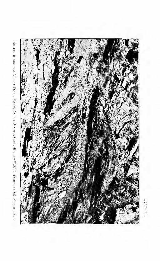

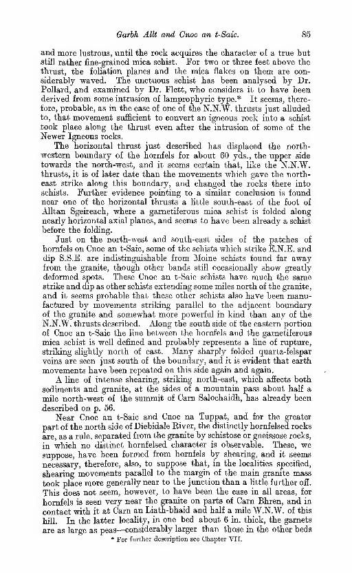
Garhh AlU and Cnoc an t-Saic. 85
and more lustrous, until the rock acquires the character of a true butstill rather fine-grained mica schist. For two or three feet above the
thrust, the foliation planes and the mica flakes on them are con-
siderably waved. The unctuous schist has been analysed by Dr.Pollard, and examined by Dr. Flett, who considers it to have beenderived from some intrusion of lamprophyric type.* It seems, there-
fore, probable, as in the case of one of the N.N.W. thrusts just alludedto, that movement sufficient to convert an igneous rock into a schist
took place along the thrust even after the intrusion of some of theNewer Igneous rocks.
The horizontal thrust just described has displaced the north-
western boundary of the hornfels for about 60 yds., the upper side
towards the north-west, and it seems certain that, like the N.N.W.thrusts, it is of later date than the movements which gave the north-
east strike along this boundary, and changed the rocks there into
schists. Further evidence pointing to a similar conclusion is foundnear one of the horizontal thrusts a little south-east of the foot of
Alltan Sgeireach, where a garnetiferous mica schist is folded along
nearly horizontal axial planes, and seems to have been already a schist
before the folding.
Just on the north-west and south-east sides of the patches of
hornfels on Cnoc an t-Saic, some of the schists which strike E.N.E. anddip S.S.E. are indistinguishable from Moine schists found far awayfrom the granite, though other bands still occasionally show greatly
deformed spots. These Cnoc an t-Saic schists have much the samestrike and dip as other schists extending some miles north of the granite,
and it seems probable that these other schists also have been manu-factured by movements striking parallel to the adjacent boundaryof the granite and somewhat more powerful in kind than any of the
N.N.W. thrusts described. Along the south side of the eastern portion
of Cnoc an t-Saic the line between the hornfels and the garnetiferous
mica schist is well defined and probably represents a line of rupture,
striking slightly north of east. Many sharply folded quartz-felspar
veins are seen just south of the boundary, and it is evident that earth
movements have been repeated on this side again and again.
A line of intense shearing, striking north-east, which afiects both
sediments and granite, at the sides of a mountain pass about half a
mile north-west of the summit of Carn Salochaidh, has already been
described on p. 56.
Near Cnoc an t-Saic and Cnoc na Tuppat, and for the greater
part of the north side of Diebidale Eiver, the distinctly hornfelsed rocks
are, as a rule, separated from the granite by schistose or gneissose rocks,
in which no distinct hornfelsed character is observable. These, wesuppose, have been formed from hornfels by shearing, and it seems
necessary, therefore, also, to suppose that, in the localities specified,
shearing movements parallel to the margin of the main granite mass
took place more generally near to the junction than a little further ofi.
This does not seem, however, to have been the case in all areas, for
hornfels is seen very near the granite on parts of Carn Bhren, and in
contact with it at Carn an Liath-bhaid and half a mile W.N.W. of this
hill. In the latter locahty, in one bed about 6 in. thick, the garnets
are as large as peas—considerably larger than those in the other beds* For further description see Chapter VII.

86 Contact-metamorpJiism produced by the Older Granite.
close to, or in the other unsheared hornfelsed rocks observed in the
district.
On Cnoc an t-Saic and Cnoc na Tuppat, two types of rock, witkboundaries approximately parallel to that of the main granite mass,-
come in between the granite and the patches of well spotted homfels..
The type next the granite is represented by specimen 11269, and maybe described as a well bedded but not very distinctly foliated rock.
Biotite is extremely abundant in this rock, not only in flakes lying^
flatly along the bedding surfaces, but also, to a less extent, in smallscales scattered through the beds, thus giving to cross fractures apeculiar grey speckled appearance, whence the name " stippled schist
"
has been given, as already stated. The abundance of biotite andits occasional collection into ill-defined small spots are both suggestive
of contact-alteration, but, on microscopic examination, these rocks
show no clear indications of hornielsing, and appear to difier butslightly from other Moine gneisses far away from the granite. Theyoften show a foliation crossing the bedding, but, apart from this, it is
believed that the prominent splitting planes represent, as a rule, bothbedding and foliation planes. The accompanying granitic sills are
often distinguished by a rodded structure, but they also occasionally
show a plane foliation parallel to the bedding of the sediments. OnCnoc na Tuppat the stippled schists are much mixed with minorgranitic intrusions, and the total breadth of crop, including the in-
trusions, is nearly a third of a mile. On its north-west side, which is
tolerably well defined, comes a micaceous somewhat schistose semi-
pelitic yellow-weathering rock, which rarely shows distinct bedding
but contains abundant garnets, about the size of peas, with roundededges and often cracked and elongated. In a few localities in the
Garbh Allt deformed " knoten " can also be perceived, sometimes
dragged out in a direction across the bedding. South-west of the
summit of Cnoc na Tuppat the garnets are distinctly elongated in one
direction, striking west of the dip of the foUation planes, and muchthe same as that of the elongation of the clastic grains in the siliceous
schists three-quarters of a mile south-west of the hill-top. In the
same exposures the garnets are repeatedly cracked in a direction at
right angles to that of the elongation, and quartz has filled in the
cracks and formed new growths at both ends of the deformed pieces.*
The elongation and the filled-in cracks are shown in Plate VII., Fig. 1.
Though it is thus evident that these garnetiferous rocks have suffered
considerably from shearing, they are less fissile and lustrous than true
schists : in the type specimens 11227 and 11228, from 983 yds. south-
west of Cnoc an t-Saic and 220 yds. south-east of Cnoc na Tuppatrespectively, the scales of mica, though parallel, are not coUected inta
separate lustrous folia, but are mixed somewhat uniformly with the
other constituents.
Distinct prisms of chiastolite or andalusite have very rarely beenobserved in the district.
About a quarter of a mile slightly east of north of the top of MuUachCreag Kiaraidh the " knoten " are flattened and drawn out into ribbons,
in a very clear manner (Plate VII., Fig. 2), in a direction which strikes
slightly west of the dip of the foliation, and is the same as that of the
* See Harker, ' On Eyes of Pyrites and other Minerals in Slate,' Oeol. Mag., 1889>
p. 396.
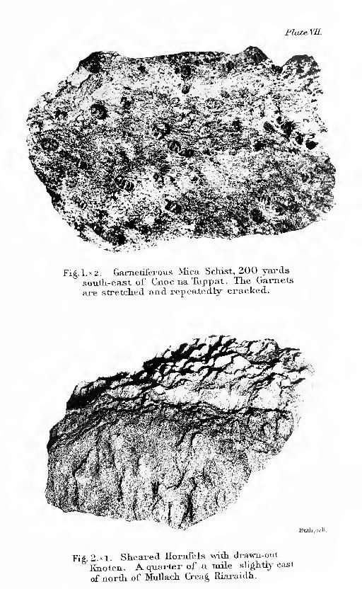
FJxu^vn.
— .t;.-.-
Fig. 1.^2. Gametiterous Mica Schist, 200 yards
south-east of Cnoc na Tuppat. The Garnets
are stretcied and repea-tedly cracked.
mF%
Huthj.ooll.
Pi^. 2.X1. Slieaied Horafels \Nith drawu-out
Enoten. A quai-ter of a laile slightly east
of nortli of Mullach Crea§, Riaraidh.


Cam Bhren, Glen Diebidah. 87
elongation of the clastic grains in a siliceous schist a third of a mile tothe north-east.
Certain thin greenish seams in a finely laminated hornfels, 10395,150 yds. S.S.E. of the summit of Cnoc an t-Saic, have been found byDr. Flett to contain pyroxene, epidote, quartz and hornblende. It is
probable that they represent laminae which were once calcareous, andthat they are closely alHed to the thin schistose seams containinghornblende and zoisite, which have already been mentioned manytimes in Chapter II.
On the north flanks of Carn Salochaidh a few patches of hornfels arefound, but most of the pelitic zone consists'of somewhat sheared rocks,which may be classed as phyllites, and resemble types already describednear Bad a' Bhathaich, in the Kildermorie district.
Near the top of Carn Bhren the beds are vertical and strike north-east, but nevertheless they are, in places, in the condition of unshearedhornfels. The unsheared rocks include thin seams (14156) withzoisite, pyroxene and some pale green hornblende. These seamsrepresent calcareous silts and are the non-schistose forms of the zoisite
hornblende granulites of the schists.
Some small patches of pelitic or semipelitic sediment entangled
in the granite in Diebidale River, rather more than two-thirds of a
mile N.N.E. of Leaba Bhaltair, have been altered to an unusual degree.
They show no obvious parallel arrangement but abundant large scales
of brown biotite lying at different angles to one another. Dr. Flett
states that specimen 11229 is coarser in grain than most hornfelses,
and that the quartz and felspar form a mosaic or " pflaster " of water-
clear recrystalhsed grains : fine needles of sillimanite occur in dense
aggregates.* c. t. c.
The siliceous beds never show such clear evidence of thermo-
metamorphism as the pelitic. At Creag Dhubh Bheag and the head of
Glen Diebidale, various pelitic seams, too thin to be shown on the
one-inch map, are intercalated in the siliceous series, and are full of
deformed spots, even in situations two-thirds of a mile from the granite.
One of these deformed spotted seams on Creag Dhubh Bheag (10437) has
been examined by. Dr. Flett and found to contain sillimanite. Thesiliceous schists in which these spotted seams occur appear to be some-
what whiter, more coarsely granular and perhaps less schistose than
usual, but they show no clear signs of hornfelsing (10859 and 10860,
from 1166 yds. north-east and a third of a mile slightly west of north
of the Ordnance Station 2250, Diebidale Ridge). The siliceous schists
close to the granite near Creag Dhubh Mhor and Creag Dhubh Bheagare nearly vertical, but have the same strike as those further
away. c. t. c, c. b. c.
CARN AN LIATH-BHAID TO SOUTH SIDE OF MEALL NA H-UIGEIG.
Pelitic or semipelitic beds which still show a spotted hornlefsed
character are found all along the granite margin in this district, but on
Meall na h-Uigeig they make an unusually broad band, from a quarter
to half a mile wide. About half a mile north of Carn an Liath-bhaid
they form a detached band, separated from any visible granite by a
broader belt of pelitic schist. For some distance east of the summit* For more complete description see Chapter VI.
88 Contact-metamorfhism produced by the Older Grange.
of Meall na h-Uigeig they are nearly horizontal, but in most localities
the inclination is steeper than in the other districts described.
It is doubtful whether any beds are so free from shearing as some of
those near Kildermorie and Cnoc an t-Saic, but the contrast betweenthe schists and the patches shown on the map as hornfels is still strike
ing, as may be seen on comparing the finely laminated spotted hornfels
just east of Cam an Liath-bhaid, where the dip is north-west from 38°
to 50°, with the lustrous garnetiferous mica schist, isoclinally folded
along axial planes striking north-west, nearly half a mile east of this
hill.
No distinct crystals of andalusite or chiastolite have been observedin this district.
In a somewhat sheared hornfels in Abhuinn a' Choire Bhuigs-ructures have been observed which may possibly represent sun-
cracks and worm-tubes.Specimen 10952, taken as a sample of various thin greenish seams
which occur in the hornfels 1030 yds. somewhat west of south of Creagna Ceapaich, was found on microscopic examination to be a garnetif-
erous hornblende hornfels, and probably represents a seam which wasoriginally slightly calcareous. Other somewhat similar seams, in
more sheared rocks 1000 yds. slightly west of south of Creag naCeapaich, contain both hornblende and zoisite (10956). c. t. c.

CHAPTER VI.
PETROGRAPHY OF THE OLDER IGNEOUS ROCKS ANDHORNFELSES.
'
PLUTONIC EOCKS.
The pre-foliation igneous complex of Carn Chuinneag and Inchbaeincludes epidiorites (metamorpliic augite diorites and gabbros, foliated
or not), biotite gneisses (granite gneisses, often with augen structure),
hornblende biotite and augite biotite gneisses (tonalite gneisses),
riebeclrite gneiss (paisanite gneiss), together with pegmatite gneisses
and aplite gneisses or granulites.
Biotite granite gneiss.
The augen gneiss of Inchbae and Carn Chuinneag is in the greater
part of its extent a coarsely crystalline, thoroughly gneissose rock withelliptical augen of pink felspar often an inch across, and smaller
porphyiitic crystals of quartz. The augen usually have their longaxes parallel ; the somewhat gTanulitic or gneissose matrix windsaround them and contains grey qiiartz, pink felspars, abundant black
biotite and a less amount of muscovite. The larger quartzes are milky,
or have a bluish opalescence.
The large conspicuous felspars are orthoclase or microcline. Inthe hand specimens they have the " corded " appearance of perthitic
felspar ; under the microscope they prove to contain numerous albite
veins. Carlsbad twinning is almost universal. The microcline structure
which many of them exhibit may be partly original, but there is reason
to believe that it has often developed by pressure after consolidation ; it
is frequently local, appearing in part of a felspar phenocryst but fading
away in other portions. The inclusions are quartz in rounded grains,
oligoclase in small eumorphio tablets, and less commonly biotite,
muscovite, zircon, apatite. Occasionally the enclosed quartz is in
graphic relation to the felspar. The large quartzes are only subhedral.
Their principal inclusions are small dark rods (rutile ?) and emptycavities. The biotite in irregular scales, often clustered, has a strong
-pleochroism ranging from clear yellow to dark brown, nearly black,
but sometimes it is greenish : it has pleochroic halos around zircon
and sphene. The muscovite is in ill-defined plates often enclosing
quartz : it is sometimes pale green in section with feebly pleo-
chroic spots. Oligoclase and albite appear in all the sections, but not
abimdantly. Frequently small grains of vermicular micropegmatite
(myrmekite) may be seen at the margins of the felspar. Of the accessory
minerals, apatite, sphene, zircon and iron oxides are most common.Brown orthite (rarely eumorphic) is found in many sections, encircled
" by clear yellow epidote ; the latter often occurs as small prisms
90 Petrography of the Older Igneous Rocks.
scattered through the other ingredients of the rock. The rarer
accessories include garnet and fluor spar : the latter has been seen,
only at one locality (11789), near the hut on the west side of CarnChuinneag (f mile east by north of Leaba Bhaltair).
In practically all the sections, efiects of crushing are very obvyus.Though some of the rocks look nearly massive in the hand specimens,
with the phenocrysts of felspar and quartz apparently unbroken(Plate XI., Pig. 1), they prove on microscopic inspection to be more orless crushed in the groundmass. Occasionally the matrix is com-pletely granuhtic, while the large felspars seem almost intact. As a
rule the crushing has affected the rock irregularly, and bands of flaser
material can be traced, though for no great distance, separating
phacoids which retain much of their original structure. In all cases
the matrix suffers most, a fact which establishes that the rock wasthoroughly crystallised before the crushing movements ceased. Thefelspars have proved far more resistant to crushing than the quartz,
and often have their centres unbroken while all the quartz phenocrysts
are reduced to granulitic mosaics. The ease with which the matrix
breaks down must be due to its heterogeneous character. Its grains of
quartz, felspar and mica are usually not in perfect contact but are
separated by small fissures. This is provedby the way in which stain-
ing and weathering by percolating solutions first affect their surfaces.
Where the pressures are sufficiently great the grains of the matrix begin
to move on one another ; the larger phenocrysts being homogeneousand free from cracks are less readily broken. The grains of the matrix
are carried past them. The first symptoms of breaking up in the
phenocrysts are the appearance of a border of detached granules which
have been dislodged by the friction of the moving granulitic matrix ;
they are swept away and become blended with it. Continued pressure
produces cracks in the quartz, and irregular strain shadows develop in
the interior of the mineral ; then it breaks up rather suddenly into a
mosaic which at first has the rounded shape of the quartz grain, butsoon flattens out into a lenticle parallel to the foliation, and finally
becomes a long granulitic streak mingled with some felspar and mica
which have worked inwards from the matrix. The felspar does not
break down by cracks spreading through it in the same way ; it loses
only by detrition at its surface, and to the last the core remains optic-
ally homogeneous. Precisely similar changes are well known to occur in
grits which contain pebbles of quartz and felspar (like the Aberfoyle
grits of the Southern Highlands*), and in the granite boulders that occur
in conglomerate gneisses, such as the Schichallion Boulder Bed.
The minerals of the granite were all of a kind which are fairly stable
under cataclastic deformation, as may be inferred from the fact that
they are common ingredients of granuhtic gneisses. Some develop-
ment of new minerals, however, has taken place either during the
crushing or at a slightly later period. Muscovite is always mostabundant in the narrow crush bands ; it has developed from the
alkali felspar. Small grains of epidote also make their appearance
with especial frequency in the crushed portions of the rock. It can
only be formed at the expense of oligoclase, which is the principal
lime-bearing mineral, and where this felspar is common it is often
* E. H. Cunningham Craig, ' Metamorphism in the Looh Lomond District,' Qiiart.
Jour. Geol. Soc, 1904, vol. Is. p. 16.,

Orthogneisses. 91
replaced by polysynthetic albite crystals filled with epidote granules.
In other rocks there are albites full of muscovite flakes, and these
may be pseudomorphs after perthitic orthoclase. Microcline structure
is often developed in the orthoclase by crushing. The microcline-
perthite, when granulitized, passes into an aggregate of small individ-
uals of microcline and clear albite.
Muscovite gneisses {pegmatite gneisses, aplite gneisses).
Though muscovite is not common in the main augen gneiss, it
occurs in great plenty in certain pale-coloured, usually fine-grained,,
granuhtic gneisses which are found both within the granite and in
the surrounding schists. These are sheared aplites and pegmatites.
They are non-porphyritic, often well foliated, and not unfrequently
contain small grains of pink garnet. Some of these rocks are so
uniform in grain and so perfectly granulitic that they bear a very
strong resemblance to the sedimentary gneisses (granulitic arkoses) of
the Moine Series.
Hornblende biotite gneisses, pyroxene biotite gneisses {tonalite gneisses).
Very seldom a crystal of green hornblende, like that of hornblende
granites, can be found in the augen gneiss. Near the north-western
margin of the laccolite (for example, half a mile north of Cam Dubhand half a mile W.N.W. of Leaba Bhaltair) there are dark-coloured
rocks containing green hornblende, sometimes also pale green pyroxene,
much biotite and a little quartz. Fine networks of sagenite are fre-
quent in the brown mica. Some of these rocks are well foliated
gneisses, others show porphyritic felspars and quartz, and are quartz
diorites or tonalites somewhat granulitised. They are finely porphy-
ritic, do not contain the large perthitic phenocrysts which characterise
the augen gneiss, and have less quartz and more plagioclase and sphene.
Their polysynthetic felspar is oligoclase and albite, in large crystals full
of minute prisms of epidote and zoisite (representing original felspars
more rich in Kme), and also in small perfectly clear rounded grains in a
granulitic mosaic. The larger epidotes have sometimes brown cores of
orthite. Orthoclase is not common, and microcline is very scarce in
these rocks.
It is extremely probable that some of these hornblende gneisses,
which occur mostly at the junctions of the acid gneiss with the darkbasic rocks, have arisen from the partial absorption of gabbro fragments
in the granite.
Riebeckite gneiss and cegirine riebecJcite gneiss {paisanite gneiss).
This rock is a pink gneiss, well foliated, with reddish felspar,
abundant quartz, and small patches of jet black riebeckite andsegirine (Plate XI., Fig. 2). It is thoroughly gneissose in character,
and though it contains augen of perthitic felspar and lenticles of quartz,
these are few and make little show in the hand specimens.
The mineral constitution of the rock is very simple : alkali felspar
and quartz make up nearly the whole of it. The femic minerals bear
only a very small proportion to the salic. The felspars are orthoclase
and microcline with a little perthite, and a good deal of albite both

92 Petrography of, the Older Igneous Rocks.
untwinned and polysynthetic. The riebeckite has the intense pleo-
chroism and nearly straight extinction which are distinctive of this
mineral : the ray vibrating parallel to the crystallographic axis is
yellow green, the two others are blue black. The axial ^angle is very^
large : on account of the intense absorption the optical sign and optical
orientation could not be made out. The segirine ranges in pleochroism
from yellow green to very dark green : it is much less abundantthan the riebeckite. All the minerals are ideally fresh. Zircon in
small four-sided and eight-sided prisms is unusually abundant ; iron
oxides are scanty, and there is a little apatite but no epidote or mica.
In structure this rock is granulitic. Except the zircon, andoccasionally the aegirine, no constituent is eumorphic. Quartz and the
felspars are in small, equidimensional grains without trace of crystalline
faces. A few larger crystals of perthite recall the phenocrysts of the
augen gneiss, but are highly irregular in form. The riebeckite forms
ragged prisms and occasionally spongy poikilitic masses enclosing
quartz and felspar, such as frequentlyoccur inpaisanitesand comendites.The segirine also is mostly anidiomorphic. Evidence of crushing is
afforded by the granulitic lenticles of quartz, but is seldom very con-
spicuous. There are also small crush belts in many of the sections. It
is clear that the rock has been granulitised, though probably it hadoriginally the structure of an aplite, which is not very distant from that
of a granulitic gneiss. But there seems no reason to believe that any newminerals have developed during the metamorphism. In particular wemay remark on the absence of muscovite in a rock so rich in alkali
felspar.
In one place Dr. Crampton obtained veins of riebeckite pegmatite,
with amphibole prisms about an inch in length. Murgoci has advo-
cated a pneumatolytic origin for this mineral,* and these pegmatites
may seem to support this hypothesis, but for the mass of the rock there
is nothing to favour such a view, as the riebeckite is as much a primary
ingredient as the quartz and alkali felspar.
Basic Plutonic Rocks. 93
I. Granite gneiss (11789), Carn Cliuinneag. At the hut f mile east by northof Leaba Bhaltair. (Anal. E. G. Radley).
II. jEgirine riebeekite gneiss (11017), 360 yds. N.N.E. of Ordnance Station,
2749 ft., Carn Chuinneag. (Anal. W. Pollard.) This rock contains rare earths
(Ce, Th, etc., 0-04 per cent.). Possibly traces of PjOj and LigO are also present.
III. Granite (14111), Glen Etive, Argyll. (Anal. E. G. Radley.)
A comparison of these three analysis shows that the Carn Chuinneaggranite gneiss has the composition of a typical granite. Its chief
peculiarity seems to be the high percentage of alkalies;probably no
other British granite as yet analysed exceeds it in this respect. Theseanalyses also prove the close similarity in composition between the
biotite gneiss and the segirine riebeekite gneiss ; the latter contains
slightly more silica and alkalies, and distinctly more iron oxide. It is
not difficult to see why riebeekite is the ferromagnesian mineral in the
one case and biotite in the other, for the riebeekite gneiss has more sodaand iron (hence the presence of soda-iron pyroxenes and amphiboles),
while the biotite gneiss has more potash and alumina, which are
essential components of biotite and muscovite.
Gabbros, diorites and quartz diorites.
In their original condition the basic rocks included gabbros, augite
diorites and quartz diorites. The gabbros consisted of greyish green
diallage, mostly with a basal striation, which with twinning on the
orthopinacoid yields a herring-bone structure. Their felspar wasbasic labradorite and contained innumerable minute black rods andplates of the type usual in schillerised plagioclase ; it is sometimeszoned with borders of andesine. Ilmenite, apatite and a variable
amount of biotite are the accessories ; these rocks were often free fromquartz and probably also from orthoclase. The structure tended to beophitic (Plate XI., Fig. 5), as though idiomorphic pyroxene occurs, that
mineral as a rule was less perfectly formed than the plagioclase, whichoccurs in elongated crystals often partly surrounded by the diallage.
No traces of olivine have been seen in these rocks.
In the diorites and quartz diorites greyish green augite was also theprevalent femic mineral, and as a rule had not the diallage lamination.
With it occurred brownish primary hornblende (often regularly grownupon the augite) and brown biotite like that of the granites. Theplagioclase was nearly eumorphic, zonal, with centres of labradorite andmargins of andesine and oligoclase. Whether original albite or ortho-
clase was present is not certain. Quartz and micropegmatite are often
seen filling interstitial spaces. A few of the quartz diorites have beenporphyritic, showing blebs of opalescent quartz and remains of felspar
phenocrysts. The other ingredientswere sphene, apatite and iron oxides.
None of the rocks of this group are in their original state ; they all
show effects of pressure, though in the least altered it is not difficult to
infer what the rock was like before metamorphism began. The first
symptoms of change are found in the pyroxene ; a narrow border of
green hornblende begins to form upon it, often partly in parallel growth.It has ill-defined boundaries both internal and external, with frayededges which emit small processes into the felspar and inwards throughthe pyroxene. In some cases the hornblende spreads regularly throughthe greater part or the whole of a pyroxene grain : the centres retain
the grey green colour of the augite, while the edges are deeper greenhornblende. A separation of iron oxides sometimes precedes the

^4 Petrography of the Older Igneous Rocks.
transformation. The paler-coloured centres of the hornblende masses
can often be distinguished from augite only by a slightly greater
pleochroism and by their extinguishing simultaneously with the horn-
blende of the periphery. At a later stage the centres also take onthe darker colour of the metamorphic hornblende.
In other cases, and this is perhaps more common, after the formation
of a continuous border of hornblende the central parts of the augite
crystals suddenly change into clusters of anhedral prisms of amphibole.
These have no definite orientation, and polarise in individual fashion
(Plate X., Fig. 5).
Plagioclase felspar, the other important constituent of these rocks,
is less susceptible to pressure than the augite, and retains its integrity
when the latter is already partly amphibolised. But before the trans-
formation of the augite is complete the plagioclase also is affected.
Needles and short prisms of colourless clinozoisite appear in it, in small
numbers at first but rapidly increasing. In some rocks they are ex-
ceedingly small, in others they are large, and this depends apparently
on the amount of lime-felspar present in the original plagioclase ; whenthat was rich in anorthite the needles are abundant and fairly large
;
but when it was oligoclase they are few and widely separated. Manyof the crystals were zoned, with basic centres and more acid margins,
and the zoisite prisms are often densely clustered in the interior of the
felspar but much scarcer in its external parts. The felspar in whichthese zoisite prisms lie retains its polysynthetic structure but loses its
turbidity and schillerisation, becoming clear and transparent. It maybe andesine, oligoclase or albite. The process in fact consists of anexcretion of the anorthite molecule as zoisite, while the remaining
felspar approaches more and more closely to albite in composition, butthe shape of the original plagioclase is fairly well preserved.
In only two slides of these rocks (12678, 12385) has garnet beenobserved, as small pink crystals which occur with zoisite in a matrix of
clear albite. Its scarcity is in striking contrast with the abundance of
this mineral in the garnetiferous epidiorites intercalated in the Moineschists. Among the changes which go on concurrently with those
described the most important is the formation of sphene after ilmenite.
It begins upon the surfaces and gradually spreads inwards through
the patches of iron ores in the rock.
In this transformation there has been, so far as we can see, no changein the chemical composition of the mass, but the components haverearranged themselves in new combinations, which are more stable
under pressure at low or moderately high temperatures than the
original minerals of the igneous rocks, formed at high temperatures froma molten magma. The conversion of ilmenite, plagioclase and augite,
into sphene, zoisite, albite, hornblende and quartz is very character-
istic of the metamorphism of basic rocks, and may be represented by achemical equation.* The biotite, apatite and quartz are in equilib-
rium under both sets of conditions. For the conversion of anorthite
into zoisite additional hme is required, and this is probably furnished
by the pyroxene, as lime is set free in the conversion of augite into
hornblende. Some silica is liberated also, and this may account for
the presence of numerous small spots of quartz in the hornblende of
many of these rocks. These mineral transformations are nearly* M. Grubenmann, ' Die krystallinen Schiefer,' 1904, vol. i. p. 36.

Basic Plutonic Rocks. 95
complete in some of the rocks before the original igneous structure
is mucli altered. The augite may be converted into hornblende, the
plagioclase into zoisite, albite and quartz, while still the ophitic relations
of the femic to the saUc minerals are perfectly clear. In these rocks
the original skeleton networks of ilmenite, partly changed to sphene, are
little distorted. The felspars retain their eumorphic shapes and are
not crushed. Hence we must conclude these changes are not due to
granulitic action breaking down the rock, but to increased pressure
acting at comparatively low temperatures. The medium whichcfiected the chemical exchanges between augite, felspar and ilmenite
must have been the interstitial water. For that reason the changes
began (in ilmenite and augite) on the surfaces of the crystals.
Before these transmutations are perfected the pressures in somecases have increased to the crushing point, and interstitial movementhas set in. The result is the production of a gneissose or foliated
structure, especially shown by the orientation of the hornblendeprisms and the plates of biotite with their faces parallel to the schist-
osity. In the dioritic rocks of the intrusive complex good schists
have not been so frequently produced as in the thin basic dykes of later
age, which have been severely crushed along lines of special shearing.
It will be seen that in the acid rocks there is much granulitisation
and cataclastic fracture and but little mineral change ; in the basic
rocks there is much mineral change but little granulitisation. Theenergy exerted by the metamorphic pressures was spent in the onecase in mechanical, in the other in chemical work. The facility withwhich the augite and plagioclase of the gabbros and diorites werereconstructed is probably one of the chief reasons why these rocks
retain their original structures so much better than the granites.
SiOaTiOaAI2O3
FeOMnO(CoNi)OCaOMgOK2ONa^OH2O at 105° C.
H2O above 105° C.
CO2
CIFeSaBaO
Total .. .. 100-33 100-07 100-08
I. Gabbro (biotite amphibolite), 11790, 783 yds. slishtly east of north of CamDubh. (Anal. W. Pollard.)
II. Gabbro (biotite amphibolite), 11792, Middle Glen, south side of DiebidaleEiver. (Anal. E. G. Eadley.)
III. Gabbro, 2 miles south of Emigrant Gap, Placer County, California.(Anal. W. F. Hillebrand.) Clarke, ' Analyses of Rocks.' (Bull. U.S. Geol. Survey,No. 168), 1900, p. 198.
I.

06 Petrography of the Older Igneous Rocks.
Two specimens of the basic rocks of the Cam Chuiimeag laccolite
have been analysed. One of them (I.) is nearly massive, contains somebiotite, and shows grains of blue quartz in the hand specimen. Theother is a good hornblende schist. It will be seen that though the
first rock is slightly more rich in silica the difierences between the twoanalyses are really unimportant ; hence there seems no reason tobelieve that the quartz has been derived from the granitic veins whichcut the basic masses. The third analysis is cited to show that there
are gabbros of similar composition ; but it is apparent that the basictypes of the Cam Chuinneag complex were not, so far as has beenascertained, olivine gabbros of normal type. They belonged rather
to the olivine-free gabbros, some of which contain primary quartz,
like the Carrock Fell rock. This is in accordance with the absenceof pseudomorphs after olivine, and the frequent presenceof quartz, even in specimens which show good igneous structure.
These rocks, in fact, lie on the boundary line between gabbrosand augite diorites.
GARNETIFEROUS ALBITE GNEISS,
The albite gneiss that occurs in the augen gneiss on the north-westshoulder of Carn Chuinneag, and contains streaks of magnetite andtinstone, is in many ways a peculiar rock. There are two main out-
crops of it, one half-way up the slope and the other near the top.
Both are similar in their essential characters, but the rock is by nomeans uniform ; in fact there is a considerable diversity of typeseven in so small an outcrop. In some places it contains large garnets
one or two inches across, not eumorphic and filled with enclosures.
In other specimens the garnets are small. The albites may formrounded spots which give the rock a nodular character (Plate XL,Fig. 3). The amount of biotite varies considerably, and the magnetite-
tinstone masses may occur only as small streaks or as irregular bandsseveral feet in length.
The minerals of which these different varieties are composed are
principally albite, green biotite, quartz and garnet. The albite
greatly predominates ; it is fresh and clear, the larger crystals showingcomplicated albite and pericline twinning, but many of the smaller
grains are quite simple and easily confounded with quartz. Thebiotite is next in importance ; its most noticeable feature is the
pleochroism, which ranges from clear yellow (slightly brown) to deepgreen. Quartz is not abundant in any of the specimens ; the garnets
are pale pink, never idiomorphic, and, especially when large, are full
of biotite, quartz and other inclusions.
Orthoclase and microcline are very seldom visible in the slides
;
muscovite is absent ; the principal accessories are apatite and zircon.
Many specimens of the rock contain little or no magnetite, but whenthat mineral does occur it forms considerable areas. There is also in
all the specimens a certain amount of carbonates, usually clear andtransparent (calcite and dolomite) but often rusty brown from the
presence of iron. The carbonate may occur as small rhombohedra
in the albite, but more commonly forms irregular groups lying between
the other ingredients. It is apparently primary, and not a product

Garnetiferous Albite Gneiss 97
of decomposition or infiltration subsequent to the recrystallisation
of the rock.
Except where mica is especially abundant, the rocks are not
schists; they have rather the texture of gneisses. The albites tend
to develop as large rounded crystals, comparatively free from en-
closures. They form white spots in the hand specimens and clear
patches in the sHdes. There is no tendency to crystalline outlines in
this mineral more than in any of the others.
These larger albites are encircled by the matrix, which consists of
biotite, albite and quartz (Plate XI. Fig. 3). There is no very obvious
parallel arrangement of the micas. Cataclastic structures and strain
phenomena are rare, all the minerals having evidently recrystallised
freely after the deformation.
The following analysis of the garnetiferous albite gneiss (11796)
from the upper stanniferous belt on the north-west shoulder of CarnChuinneag has been prepared by Dr. Pollard :
—
SiO^ .
.

98 Petrography of the Older Igneous Rocks.
usually ill developed. The usual cleavage of tinstone is visible, andthe mineral is zoned ; at the centre it is often dark and turbid with
small black enclosures, while the outer parts of the crystals are often
transparent and colourless or pale yellow. A feeble pleochroism can
usually be detected. The black enclosures are probably magnetite,
and well defined octahedra are often found in the centre of groups
of cassiterite crystals. A subradiate, almost stellate arrangementof prismatic crystals of tinstone may be observed in some oi these
aggregates.
The magnetite-tinstone masses contain a variable amount of
impurities. A mineral which has the optical properties of apatite
occurs sometimes ; the other ingredients are quartz, albite and green
mica, which are the components of the gariletiferous albite gneiss^
Garnet has not been seen in any of the magnetite blocks. Theseaccessory minerals may form only a very small proportion of the
whole mass, as in the specimen analysed, where they are about ten
per cent. ; in others they amount to about one-half, while at the other
extreme there are garnetiferous albite gneisses with five to ten per cent,
of iron oxides. As a rule, however, the transition from the ore-bodies
to the gneiss is a rapid one, and the boundaries are sharply defined
in the hand specimens. ,
One of the magnetite blocks (11233) from a point 1100 yds. slightly
south by east of the Ordnance Station 1692, Mullach Creag Biaraidh,
was analysed by Dr. Pollard with the following result :
—
SiOs .
.

Genesis of the Tin Ore. 91)
are closely related. It seems also established that neither of themis connected with the Newer Granite intrusions or the basic dykes,
since one of the latter cuts the stanniferous bands on the north-west
shoulder of Carn Chuinneag.
In some respects the albite gneiss is not unlike certain of the Moinegneisses (paragneisses). Many of these contain garnets and spots of
albite, though never in the same quantity as the albite gneisses.
Among the conglomerate-schists there are a few which have a. matrix
full of iron oxides, but no cassiterite has been found in them. On the
other hand, the chemical analysis of the albite gneiss is very peculiar,
and can hardly be interpreted as that of any common type of sediment.
It might also be expected that if the albite gneiss is of sedimentaryorigin, something like it should have been found elsewhere in the Moinerocks, and especially within the aureole of the augen gneiss. Moreover,
there are many inclusions of paragneiss and hornfels in the CarnChuinneag mass, and none of these resemble the garnetiferous albite
gneiss.
Again we might argue that the stanniferous gneiss is a foliated
and recrystallised system of veins. It cannot be regarded as identical
with the usual type of Cornish tin-vein, for quartz and tourmaline
have not been found in association with the tin ore, and in fact the
albite gneiss contains less silica than the country rock. But cassiterite
is also found in pegmatites, which sometimes contain little or notourmaline. The augen gneiss of Carn Chuinneag occasionally contains
fluor spar, and in it there are pegmatites, not unlike some of the
albite gneiss, though not stanniferous. To none of these considerations,
however, can we attach much weight, especially seeing that the
chemical analysis shows that the rock, if igneous, can only have beena very peculiar type of syenite.
It is also possible that the ore deposit is due to the metasomaticalteration of the augen gneiss along Unes of fissure, together with the
introduction of iron oxide and cassiterite. Veins of this type havebeen described by MacAlister from the east side of Dartmoor.* Inthis case also the absence of tourmahne is a difl&culty. A comparisonof the analyses of the augen gneiss with that of the stanniferous gneiss
shows that on this hypothesis there must have been an abstraction
of silica, which is so unusual that it debars us from regarding this
explanation as satisfactory.
These problematical rocks might also be basic segregations in the
augen gneiss, and this hypothesis was advanced provisionally by Mr.
Clough and Dr. Flett f in 1903, and is accepted by Thomas andMacAUster,J who are familiar with the rocks. The dark colour andliasic character of the albite gneiss, and its occurrence well within the
boundaries of the granite, are in favour of this theory, but magnetite-
cassiterite segregations have nowhere been described in granite masses.
Recently Professor Vogt§ has ascertained that the granite of the Lofoten
Islands contains segregations of magnetite (sometimes with garnet),
and he believes that at other places, such as Gellivara, the same
* D. A. MacAlister, ' Note on the Association of Cassiterite and Specular Iron in
the Lodes of Dartmoor,' Oeol. Mag., 1909, p. 402.
f Summary of Progress of the Geological Survey for 1903, p. 58.
t ' The Geology of Ore Deposits,' 1909, p. 56.
§ J. H. L. Vogt, 'Ueber magmatjsohe Aussoheidimgen von Eisenerz in Granit,'
Zeita. Prakt. Geol, 1907, vol. xv. p. 86.

100 Petrography of the Older Igneous Rocks.
phenomenon occurs. It is important to observe, however, that at
neither of these localities has cassiterite been found.
SILLS AND DYKES OF EPIDIORITE, ETC.
It has been indicated on a previous page that two groups of these
rocks can be recognised, namely those which are intruded into the
plutonic rocks and those which are intercalated in the schists. It
will be convenient to consider the second group first, because they
belong to a series which has representatives in many parts of the widearea occupied by the Moine schists, and, though presenting minorvariations, have a uniformity of character by no means difficult to
identify.
Epidiorite Bands in the Moine Schists.
These rocks are always thoroughly metamorphic, and never showremains of igneous structures, but are typical amphibolites, thoughoften not very schistose. Their main constituents are hornblende
and felspar ; the hornblende occurs in short parallel prisms, while the
felspars are granular and lie between them. Hence the rooks are
fissile, but they are not usually banded, as the hornblende and the
felspar have not segregated into distinct folia, and some of the finer-
grained specimens are fairly massive (Plate X. Fig. 3).
Though originally dolerites or olivine dolerites they contain neither
olivine nor augite, and, unlike the basic rocks of the Carn Chuinneagcomplex, they seldom show pseudomorphs after pyroxene. Their
hornblende, nearly black in the hand specimen, is green or brown in
the microscopic slides and strongly pleochroic in most sections, thoughthe colour of light vibrating parallel to the b and c axes often differs
little. Biotite occurs in many of them, but not in all, and may be as
abundant as hornblende. It is of yellow brown to reddish browncolour and most intensely pleochroic, so that rays vibrating parallel
to the cleavage are almost completely absorbed. Networks of rutile
needles, so common in the biotite of the gneisses, have not been observed
in these schists. Epidote is a frequent accessory, sometimes yellow
with strong double refraction, at other times colourless (clinozoisite
or zoisite). Pink garnet occurs in some amphibolites in crystals which
may be large and poildlitic, but are sometimes small and free fromenclosures. Quartz is nearly invariably present, often in fair quantity.
Apatite, iron oxides and pyrites are universal ; brownish sphene mayreplace the ilmenite or titaniferous magnetite partly or completely.
A small amount of muscovite may very generally be found, usually
embedded in felspar, but it is never conspicuous. Rutile also is
often present.
All the principal minerals are anhedral, and the structure is of the" granoblastic " type. Occasionally an amphibole crystal in cross
section has boundaries which indicate prism faces, and the biotite andmuscovite scales may have their basal planes defined. The felspar
and quartz are always in grains forming a mosaic. Only the little
prisms of epidote, the smallest garnets, rutile and apatite can be found
with a moderately good crystalline development. The larger garnets
are pseudoporphyritic, but the dominant feature of the rock structure
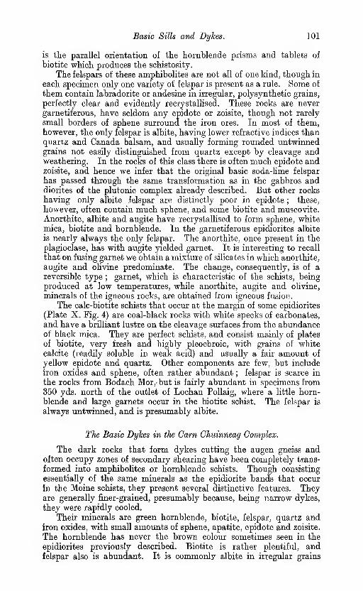
Basic Sills and Dykes. 101
is tlie parallel orientation of the hornblende prisms and tablets of
biotite which produces the schistosity.
The felspars of these amphibolites are not all of one kind, though in
each specimen only one variety of felspar is present as a rule. Some of
them contain labradorite or andesine in irregular, polysynthetic grains,
perfectly clear and evidently recrystallised. These rocks are never
garnetiferous, have seldom any epidote or zoisite, though not rarely
small borders of sphene surround the iron ores. In most of them,however, the only felspar is albite, having lower refractive indices thanquartz and Canada balsam, and usually forming rounded untwinnedgrains not easily distinguished from quartz except by cleavage andweathering. In the rocks of this class there is often much epidote andzoisite, and hence we infer that the original basic soda-lime felspar
has passed through the same transformation as in the gabbros anddiorites of the plutonic complex already described. But other rocks
having only albite felspar are distinctly poor in epidote ; these,
however, often contain much sphene, and some biotite and muscovite.
Anorthite, albite and augite have recrystallised to form sphene, whitemica, biotite and hornblende. In the garnetiferous epidiorites albite
is nearly always the only felspar. The anorthite, once present in the
plagioclase, has with augite yielded garnet. It is interesting to recall
that on fusing garnet we obtain a mixture of silicates in which anorthite,
augite and olivine predominate. The change, consequently, is of a
reversible type;
garnet, which is characteristic of the schists, being
produced at low temperatures, while anorthite, augite and olivine,
minerals of the igneous rocks, are obtained from igneous fusion.
The calc-biotite schists that occur at the margin of some epidiorites
(Plate X. Fig. 4) are coal-black rocks with white specks of carbonates,
and have a brilliant lustre on the cleavage surfaces from the abundanceof black mica. They are perfect schists, and consist mainly of plates
of biotite, very fresh and highly pleochroic, with grains of whitecalcite (readily soluble in weak acid) and usually a fair amount of
yellow epidote and quartz. Other components are few, but include
iron oxides and sphene, often rather abundant ; felspar is scarce in
the rocks from Bodach Mor,-but is fairly abundant in specimens from350 yds. north of the outlet of Lochan PoUaig, where a little horn-
blende and large garnets occur in the biotite schist. The felspar is
always untwinned, and is presumably albite.
The Basic Dykes in the Cam Chuinneag Complex.
The dark rocks that form dykes cutting the augen gneiss andoften occupy zones of secondary shearing have been completely trans-
formed into amphibolites or hornblende schists. Though consisting
essentially of the same minerals as the epidiorite bands that occur
in the Moine schists, they present several distinctive features. Theyare generally finer-grained, presumably because, being narrow dykes,
they were rapidly cooled.
Their minerals are green hornblende, biotite, felspar, quartz andiron oxides, with small amounts of sphene, apatite, epidote and zoisite.
The hornblende has never the brown colour sometimes seen in the
epidiorites previously described. Biotite is rather plentiful, andfelspar also is abundant. It is commonly albite in irregular grains
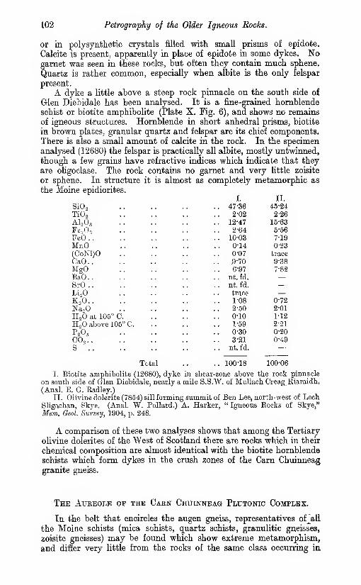
102 Petrography of the Older Igneous Rocks.
or in polysynthetic crystals filled with small prisms of epidote.
Calcite is present, apparently in place of epidote in some dykes. Nogarnet was seen in these rocks, but often they contain much sphene.
Quartz is rather common, especially when albite is the only felspar
present.
A dyke a little above a steep rock pinnacle on the south side of
Glen Diebidale has been analysed. It is a fine-grained hornblende
schist or biotite amphibolite (Plate X. Fig. 6), and shows no remains
of igneous structures. Hornblende in short anhedral prisms, biotite
in brown plates, granular quartz and felspar are its chief components.
There is also a small amount of calcite in the rock. In the specimenanalysed (12680) the felspar is practically all albite, mostly untwinned,
though a few grains have refractive indices which indicate that they
are oligoclase. The rock contains no garnet and very little zoisite
or sphene. In structure it is almost as completely metamorphic as
the Moine epidiorites.
SiO,TiO',
AU63Fe.>0„
Feb..MnO(CoKi)OCaO..MgOBaO..SrO..Li.OKo'O..
NajOH2O at 105° C.
H,0 above 105° C.
P2O5CO,..S '..
I.

The Hornfelses. 103
other parts of the Sheet. Recrystallisation, development of newminerals and of foliation, have proceeded in these exactly as in the
rocks which there is no reason to suspect have been contact-altered
by the granitic intrusion ; if any changes of thermal metamorphismhad been induced in them, they have disappeared during the epoch
of movement, and the only alterations now recognisable are of a"regional " type. But there are other rocks, as described in previous
chapters, which exhibit only thermal metamorphism, and are identical
with contact-altered rocks from regions where extensive crustal
movements have not taken place. They are hornfelses, containing
minerals such as sillimanite, andalusite and chiastolite, that do not
occur in the surrounding mica schists, and are proof of contact-
alteration. The original structures of these rocks are far less modified
than in the schists. They show the original lamination or bedding,
for example, singularly well (Plate IX. Figs. 1, 2). Where the hornfelses
have been involved in folding, and interstitial movement has beenset up, they pass by gradual transitions into schists of the types
normal in this district, and the methods and stages of the process are
traceable in microscopic sections and in the field. Within short
distances we can follow the passage of a bedded hornfels into a micaschist ; the manufacture of schists, vrhich in other districts requires
miles for its accomplishment, is here completed in yards, and the
identity of the beds in different stages of metamorphism can beestablished beyond question. Moreover, the agencies at work—Adz.,
pressure and movement—are never in doubt. Since, in the enormousarea over which the Moines are spread, they have never been foundretaining their original structures as they do within the aureole of the
Carn Chuinneag augen gneiss, these phenomena are as unusual as
they are instructive.
Semipelitic and politic rocks prevail within the aureole, as the
laccolite apparently has been intruded along a great series of shales,
like those which in other districts yield the extensive belts of micaschist and micaceous gneiss so important in the Moine series. Theserocks, by their nature, show contact-alteration and the formation
of schists especially clearly. The sandstones and arkoses, on the
other hand, that produce the quartz schists and quartzofelspathic
granuHtes, do not, as a rule, exhibit contact-alteration in any markedway, and when they recrystallise as metamorphic rocks they pass
through no very conspicuous changes in mineral composition. Thecalcareous shales which yield the zoisite hornblende gneisses andgranulites, also occur within the aureole and are represented by calc-
silicate hornfelses. The features shown by the basic intrusions are
entirely those of progressive regional metamorphism, as no diabase
hornfelses have been met with in this Sheet.
THE HORNFELSES.
The fine biotite hornfelses, intensely contact-altered but perfectly
retaining the original lamination and unafiected by movement andregional metamorphism, are well exposed on the Garbh Allt (see Fig.
10), about one mile south-east of Glencalvie Lodge. At this
locality they are greyish rocks minutely spotted and prossed by

]04 Petrography of the Aureole.
alternate paler and darker bands about one-twentietb of an inch in
breadth (Plate IX. Fig. 2). These bands are laminae of deposit. Those
which are of lighter colour consist mainly of quartz and are coarser-
grained than the others ; they are layers of fine sandy sediment. Thedarker bands are more micaceous, and were originally fine seams of
mud or shale. The banding, as seen in the hand specimens or in the
bare rock exposures in the bed of the stream, is very straight andparallel, never crumpled or contorted. It is difficult to believe that
this rock possessed any cleavage before it was hornfelsed, and notrace of augen structure, phacoids or strain-slip cleavage can be foundin the microscopic sections. All the evidence leads to the conclusion
that it was a fine greyish arenaceous shale at the time when the granite
was intruded.
The microscope shows that the principal minerals of this rock
are quartz, alkali felspar, garnet and biotite. The dark argillaceous
seams are exceedingly fine-grained ; most of the ingredients are not
over O'Ol millimetre in diameter. The biotite is reddish brown, andsome of its small tablets have hexagonal basal sections. The quartz
and felspar form a mosaic of particles so minute that their optical
characters cannot be exactly determined, but that there is a gooddeal of felspar in this part of the rock is clear from the rapidity with
which white mica develops when shearing begins. The arenaceous seamscontain the same minerals but in larger crystals (Plate IX. Fig. 1).
There is less biotite, more quartz and felspar ; the particles are often
0"05 millimetre in diameter, and the untwinned alkali felspar can be
told from the quartz by its weaker refraction, cleavage and weathering.
The quartz grains are subangular rather than rounded, and haveoften irregular outlines, as if partly corroded. The felspar tends to
envelop the quartz, and is clearly recrystallised or developed during
the thermal action of the granite. It is orthoclase or albite, andshows no polysynthetic structure. The minute specks of biotite are
sprinkled irregularly through the other minerals, occurring both
within them and between them, but principally in the felspar andthe fine quartzofelspathic mosaic which forms a matrix for the quartz
grains, no doubt because this represents interstitial argillaceous
cement, from which by recrystallisation quartz, felspar and biotite
would naturally arise.
The garnets are very small, not over O'l millimetre in diameter,
pale pink in thin section, with enclosures of quartz, iron oxides, etc.,
especially numerous near their centres. They are on the wholeeumorphic, most of the sections being six-sided, but many of the
crystals are imperfect on one or more sides. They are far most abund-ant and have the most perfect shapes in the argillaceous seams ; in
the arenaceous they are larger, but less numerous, have very irregular
outlines, and are honeycombed with large enclosures of quartz andother minerals. This is no doubt a consequence of the resistance
ofiered to their crystallisation by the comparatively large grains of
quartz and felspar.
The less abundant minerals include muscovite, in transparent
flakes, by no means common. Yellow prisms and twins of rutile are
frequent, but always of very minute size. Dark iron oxides appearas plates which are six-sided, and when very thin some of them are
transparent and dark brown. Sillimanite has not been observed
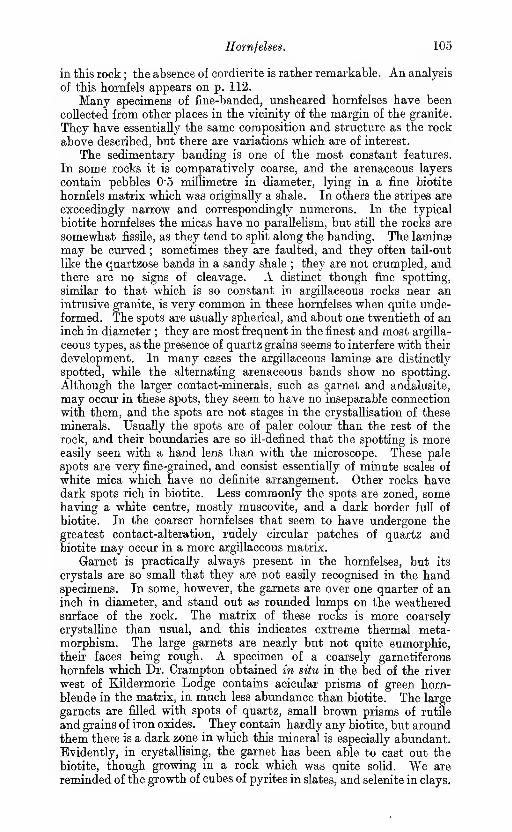
Hornfelses. 105
in this rock ; the absence of cordierite is rather remarkable. An analysis
of this hornfels appears on p. 112.
Many specimens of fine-banded, unsheared hornfelses have been
collected from other places in the vicinity of the margin of the granite.
They have essentially the same composition and structure as the rock
above described, but there are variations which are of interest.
The sedimentary banding is one of the most constant features.
In some rocks it is comparatively coarse, and the arenaceous layers
contain pebbles 0"5 millimetre in diameter, lying in a fine biotite
hornfels matrix which was originally a shale. In others the stripes are
exceedingly narrow and correspondingly numerous. In the typical
biotite hornfelses the micas have no parallelism, but still the rocks are
somewhat fissile, as they tend to split along the banding. The laminae
may be curved ; sometimes they are faulted, and they often tail-out
like the quartzose bands in a sandy shale ; they are not crumpled, andthere are no signs of cleavage. A distinct though fine spotting,
similar to that which is so constant in argillaceous rocks near anintrusive granite, is very common in these hornfelses when quite unde-
formed. The spots are usually spherical, and about one twentieth of aninch in diameter ; they are most frequent in the finest and most argilla-
ceous types, as the presence of quartz grains seems to interfere with their
development. In many cases the argillaceous laminae are distinctly
spotted, while the alternating arenaceous bands show no spotting.
Although the larger contact-minerals, such as garnet and andalusite,
may occur in these spots, they seem to have no inseparable connection
with them, and the spots are not stages in the crystallisation of these
minerals. Usually the spots are of paler colour than the rest of the
rock, and their boundaries are so ill-defined that the spotting is moreeasily seen with a hand lens than with the microscope. These pale
spots are very fine-grained, and consist essentially of minute scales of
white mica which have no definite arrangement. Other rocks havedark spots rich in biotite. Less commonly the spots are zoned, somehaving a white centre, mostly muscovite, and a dark border full of
biotite. In the coarser hornfelses that seem to have undergone the
greatest contact-alteration, rudely circular patches of quartz andbiotite may occur in a more argillaceous matrix.
Garnet is practically always present in the hornfelses, but its
crystals are so small that they are not easily recognised in the handspecimens. In some, however, the garnets are over one quarter of aninch in diameter, and stand out as rounded lumps on the weatheredsurface of the rock. The matrix of these rocks is more coarsely
crystalhne than usual, and this indicates extreme thermal meta-morphism. The large garnets are nearly but not quite eumorphic,their faces being rough. A specimen of a coarsely garnetiferous
hornfels which Dr. Crampton obtained in situ in the bed of the river
west of Kildermorie Lodge contains acicular prisms of green horn-
blende in the matrix, in much less abundance than biotite. The large
garnets are filled with spots of quartz, small brown prisms of rutile
and grains of iron oxides. They contain hardly any biotite, but aroundthem there is a dark zone in which this mineral is especially abundant.Evidently, in crystallising, the garnet has been able to cast out the
biotite, though growing in a rock which was quite solid. We are
reminded of the growth of cubes of pyrites in slates, and selenite in clays.

106 Petrography of the Older Hornfelses.
Hornblende is not often met with in the fine hornfelses, but in addition
to the rock above mentioned two others contain it. Both have small,
irregular garnets. In one specimen (10952) from 1030 yards south
of Creag na Ceapaich, biotite is absent, but small grains of pale green
hornblende are frequent. They are anhedral, and there is nothing
to prove that they are secondary after pyroxene. The other rock
contains a little biotite and not much green hornblende. It is
specially interesting from the abundance of finely granular zoisite,
which shows that this represents, within the aureole, the marl bandswhich give rise to the zoisite hornblende gneisses. In this rock
(10385) there are also many small grains of almost colourless pyro-
xene ; the hornblende is mostly fibrous, and seems to be forming
from the augite. This is the only pyroxene hornfels found in the
whole aureole, and the only sediment of the Moine Series at present
known to contain pyroxene. It was mapped by Mr. Clough 150 yds.
S.S.E. of Cnoc nan Sac.
In the more intensely altered hornfelses sillimanite is common.It occurs only in very small needles, densely clustered and embeddedin quartz, felspar or biotite, and is principally found in the fine argil-
laceous bands where biotite also is frequent. It is always prismatic,
but does not form long streams of jointed needles ; the crystals showno parallelism, but point in all directions ; where very small they
cannot always be identified with certainty, but the larger prisms
have the cross section and the optical properties which belong to this
mineral. In the sheared or foliated hornfelses it is never found,
and the evidence here, as in all the Scottish Highlands, is that
silhmanite is a purely thermal product, a typical contact-mineral.
In one very interesting rock (11229), an enclosure of sedimentary
character in the granite gneiss, which Mr. Clough obtained two-thirds
of a mile N.N.E. of Leaba Bhaltair, there is much sillimanite, but
it is entirely confined to small angular greenish patches which are
clearly pseudomorphs after some primary mineral. These patches
consist of chlorite and white mica ; from their composition and the
abundance of sillimanite in them it may fairly be deduced that they
are pinite after cordierite. No fresh cordierite has been found in the
rocks of the aureole, and seeing that the andalusite, which is far moreresistant to weathering, is always represented by alteration products,
we can hardly expect to obtain cordierite in a fresh condition.
This specimen has large fiakes of yellow brown biotite, and grains
of quartz and felspar. It is the most coarsely crystalline hornfels
which we have obtained in the district, and the entire lack of orienta-
tion in its minerals shows that it has escaped or successfully resisted
the dynamic metamorphism. The mosaic structure (pavementstructure) so typical of altered sediments from the inner portions
of granite aureoles is exceedingly well shown. The only other occui;-
rences of cordierite and sillimanite in Moine rocks, with which we are
acquainted, are at Netherly, near Rothes, where cordierite sillimanite
gneiss has been found in contact with a mass of Newer diorite byMr. Hinxman,* and in the schist adjacent to the granite of the Rossof Mull.t
* ' The Geology of Lower Strathspey,' Mem. Oeol. Survey, 1902, p. 53.
t T. 0. Bosworth, ' Metamorphism round the Rosa of Mull Granite,' Qvxirt. Jour.
Ooxil Soc, 1910, vol. Ixvi. p. 376.

Andalusite and Chiastolite. 107
Pseudomorplis after andalusite are visible in. a number of rocks
from the aureole (see pp. 79, 80), though this mineral is less frequent
than sillimanite, and is represented only by alteration products.
Three miles south-east of Lochan a' Chairn Mr. Clough obtained someparticularly interesting fragments of chiastolite hornfels. These were
not observed in situ, but very probably they were derived from near
Loch a' Chaoruinn (see p. 79). In the black lustrous matrix there are
white needles which have the rhomboidal transverse sections anddark cross-shaped enclosures which are usual in chiastolite (Plate IX.
Fig. 5). Around them there is a very narrow black border of iron
oxides or graphitic matter. The matrix shows the lamination of
original bedding, as well as small subhedral garnets and black spots
of angular form, rich in small brown flakes of biotite. The chiastolites
have a narrow white outer rim of fine scaly muscovite, but all their
central parts are transformed into brush-like aggregates of small
prisms of colourless kyanite. The bedding is so well preserved, andthe shape of the chiastolites is so perfect, that there is no reason to
believe the rock has experienced interstitial movement or shearing.
Of the three silicates of alumina (sillimanite, andalusite, kyanite),
the last named has the highest specific gravity, and, according to
the principle enunciated by Loewinson-Lessing * (and elaborated byBecke,f Van Hise J and others), should be expected to form in place
of the others in rocks subjected to intense pressures at comparatively
low temperatm'es. As a matter of fact, the andalusite of the CamChuinneag hornfelses very often is replaced by undoubted pseudo-
morphs of fibrous kyanite. The sillimanite disappears altogether
under pressure metamorphism. Kyanite never occurs in the horn-
felses in bladed prisms, which might be regarded as primary, but only
in brush-shaped clusters or tangled masses of small crystals formingpseudomorphs after andalusite.
The most striking examples of andalusite hornfels were obtained
by Mr. Anderson a quarter of a mile from the summit of Carn Lochnan Amhaichean. In all these rocks the andalusite has been com-pletely replaced by fine white mica and kyanite, and these aggregates
stand out on weathered surfaces in prominent knobs, which may be
half an inch in length. Often they retain the prismatic shapes of
andalusite, but when there has been some shearing they becomelenticular and lose their idiomorphism. The formation of white
mica after andalusite is a well-known secondary process, and probably
requires the presence of small amounts of alkalies set free by kaolinisa-
tion of the felspars in the matrix. In other circumstances, as will
be shown later, it is a metamorphic change induced by dynamo-metamorphism.
EFFECTS OF SHEARING AND DYNAMO-MBTAMOEPHISM ON THEROCKS OF THE AUREOLE.
The contact-altered semipelitic rocks within the aureole of the
Carn Chuinneag augen gneiss, when affected by regional metamorphism,
* ' Studien fiber Eruptivgesteine,' 1899, p. 327.
f F. Beoke, ' Ueber Mneralbestand und Struktur der kristallinisohen Sohiefer,'
Comptea Rendua Gongres Geol. Internat., Vienna, 1903, p. 558.
} C. R. Van Hise, ' A Treatise on Metamorphism,' 1904.

108 Petrography of the Aureole.
have acquired the characters of more or less perfect schists. Twostages may be recognised, an intermediate one in which the rock,
while no longer a hornfels, is not yet a complete schist, and a final
stage in which the metamorphic texture is well developed, and typical
schists are the result (Plate IX. Figs. 3 and 4). The latter differ
in no essential respect from the normal Moine schists outside the
aureole. In the intermediate stage the distinctive nature of the
rocks is very obvious. They are full of minute plates of muscovite
and biotite which have a parallel orientation. These rocks in con-
sequence are more fissile than the hornfelses, and split along planes of
foliation as well as along planes of bedding. Their split surfaces
are speckled with minute scales of black and white mica ; hence they
may be called stippled schists or speckled schists (Plate IX. Fig. 3).
As compared with the mica schists and pelitic gneisses they are
less perfectly foliated, and also less coarsely crystalline.
In the transformation of the banded hornfelses into mica schists
three kinds of change have gone on concurrently : (1) substitution of
new minerals for the previous ones; (2) growth of the crystals to larger
dimensions; (3) development of new structures (foliation, etc.), with
partial or complete obliteration of the old ones (sedimentary banding,
knotting, etc.). These changes, however, are not radical but only
partial, as (1) a considerable portion of the minerals of the schist are
the same as those of the hornfels though their crystals have beenenlarged, e.g., garnet, muscovite, biotite and quartz
; (2) though the
foliation may develop either along or across the original beddingplanes, it hardly ever obliterates them.
The first symptom of pressure alteration that can be detected in
microscopic sections of the hornfels is the appearance of a cloud of
infinitesimal flakes of white mica, especially in the fine argillaceous
bands. In the hornfelses which are quite unsheared these bandshave a very fine transparent mosaic-like groundmass, which may be
assumed to consist of quartz and alkali felspar, though the minerals
are not recognisable because of their minuteness. Under pressure
the felspar splits into muscovite and quartz, and newly generated
scaly mica begins to fill the clear mosaic, much as in some chemical
operations a white cloud gradually forms in a transparent liquid. Thesame change may take place (and can be seen in weathered hornfelses)
by atmospheric decomposition, but in the rocks now under description
the new mica has a well-marked parallel orientation, which is the hall-
mark of pressure. In polarised light the sections have a shimmeringaspect from the bright colours given by the scales of muscovite. Theorientation of the biotite may show no distinct parallelism, and the
other minerals (garnet, sillimanite, etc.) and the arenaceous bandsare at first quite unaffected.
The disappearance of the felspar (presumably orthoclase) in these
rocks, and its replacement by muscovite and quartz, while in the
quartzofelspathic sedimentary granulites the felspar persists in the last
stages of metamorphism and must have been continuously crystallising,
is an interesting problem. In the augen gneiss also the felspar re-
mains, and muscovite appears only locally in any quantity. Possibly
this depends on the relation of the alkalies to alumina ; in the igneous
gneisses they are in approximately equal molecular proportions, but
in the hornfelses and semipelitic schists the alkalies are about one-half

Developnent of Schists. 109
of the alumina. In the argillaceous rocks muscovite forms : in the
less aluminous and more alkaline rocks felspar maintains its place.
Two-thirds of the potash of the orthoclase is set free by the trans-
formation of that mineral into muscovite and quartz ; it is not
removed in solution, but remains to take part in important mineral
changes. One of these is the conversion of andalusite and silli-
manite to white mica. It is not possible, however, that all the potash
can be absorbed in this way, and some combines vnth magnesia,
alumina and iron to form biotite. The femic materials required are
furnished by the garnet and iron oxides, and consequently there is,
with increasing metamorphism up to a certain point, a diminution
in the amount of garnet visible in these rocks.
Although it is possible that some of the white mica is soda mica
or paragonite, formed from soda felspar, this transformation does
not seem to be so readily effected as that of potash felspar into mus-covite. Albite, in fact, is quite stable under the metamorphic pro-
cesses, and though not discernible in the fine hornfelses becomes so in
the schists ; in some of these it forms large micropoikilitic crystals.
Orthoclase, on the other hand, has not been identified as a constituent
of the mica schists, and microchne has not been seen in any of them.
Aiter the first fine micas have appeared in the groundmass mosaic,
their increase in size with continued pressure is rapid (Plate IX. Figs. 2,
3, 4). According to a well-known law of physical chemistry, the smaller
grains are dissolved, and their substance is deposited on the larger
ones. This process is very rapid at first when the particles are very
close together, as the distance through which diffusion takes place
is infinitesimal. The minute size of the grains also makes their surface
very great in proportion to their mass; and increases their solubility.
In nearly all the other constituents solution and deposition go on;
the biotites get rapidly larger and less numerous, and the quartz mosaic
becomes coarser. Albite now begins to appear mixed with the quartz
in the micaceous folia, and sometimes shows a tendency to formparticularly large porphyroblastic crystals. Even the finely divided
iron oxides increase in size. There seems to be a diminution in the
amount of rutile observable in the slides, though no quantitative
measurements can be made. It cannot be transformed into sphene,
as there is too little lime in the rock, and there is a possibility that
it is partly absorbed in the new biotite. This latter mineral mustundergo a transformation throughout, as the biotite of the schists has
a more yellow-brown, less reddish-brown colour than that of the horn-
fels, yet there is no zonal structure, and a nucleus of " thermal
"
biotite cannot be found in the larger plates of new biotite.
The regenerative processes affect also the garnets : they are fewer
and larger in the schists than in the hornfelses. In part they are
converted into biotite, but there must also be a solution of the smaller
crystals and a growth of the larger ones. The stages of the change,
however, are not easily followed with the microscope ; only the
results seem fairly clear. The new garnets, especially in their outer
zones, contain fewer dark enclosures than the little garnets of the
hornfels, but these enclosures are individually larger. They also
contain more quartz, and far less frequently have idiomorphic outlines.
Through the whole of this process of recrystallisation a well-marked
orientation is maintained, and the rock is becoming more and more

110 Petrography of the Aureole.
of a schist. The foliation wliich so rapidly becomes the most pro-
nounced feature of the mass is principally due to the micas. This
may partly be explained by a rotation of the old irregularly scattered
plates of mica in the hornfels, so as to have their long axes directed
along the axis of least pressure. More probably the dominant cause
is the deposit of new mica mainly on the edges of the crystals wherepressure is least, and to a less extent on the faces where the greatest
pressure acts. Many years ago Sorby directed attention to the
importance of this as a factor in the development of slaty cleavage,*
and under the name of " Riecke's law " it has recently been broughtinto prominence by Beckef and Grubenmann.f Hence the foliation
of the mica schist is partly a Krystallisation Schieferung. This lawseems to explain well the flattened shapes of the micas, but it is to
be remembered that for these minerals tabular forms are habitual.
The quartz and felspar in these rocks are lenticular sometimes, butoften nearly equidimensional, and Riecke's principle does not seemgreatly to affect their growth. The garnets, also, are rarely of
elongated form, even though they have certainly enlarged under the
same conditions of pressure as the micas, and the large albites whichlie in the micaceous films are never platy. From this we see that
this tendency does not overcome the molecular affinities of the
mineral particles and the conditions of least surface energy whichdetermine the usual habits and forms of their crystals.
At the same time interstitial movement is taking place, and this
is probably facilitated by the recrystallisation. We have seen that
mineral reconstruction may go on under pressure without evidence
of internal distortion of the minerals. In the chiastolite hornfels the
shape of the elongated needles of chiastolite is perfectly retained,-
while their substance has been changed to muscovite and kyanite.
In the gabbros the ophitic structure may remain when all the augite
has passed into aggregates of hornblende. Whether this indicates static
pressure as opposed to stress or unilateral pressure we shall not discuss
here : it is sufficient to show that pressure has produced mineral changewithout foliation or schistosity. There can be no doubt that internal
movement or, flow is a powerful if not a necessary agent in producing
foliation. It is difficult in fact to see how, without it, unilateral
pressures could be set up or maintained under the conditions whichobtain in the earth's crust. The components of these schists are
such as readily form at high pressures and comparatively low tem-peratures (not so high at least as those that obtain in contact-zones).
This explains their frequently small molecular volumes and their
tendency to contain combined water (micas, zoisite). But withoutdynamo-metamorphism (including displacement, folding and crushing)
the rocks we are now considering would not have reached the state
of schists.
The coarser-grained rocks contain large crystals or clastic pebbles
(Plate IX. Fig. 1), and when flow begins these become distorted,
and break down into fine mosaics. Such evidence of movement
* H. C. Sorby, Quart. Jour. Oeol. Soc, 1879, vol. xxxv., ' Presidential Address,' p. 88.
A. Harker, ' On Slaty Cleavage and Allied Eock-Structures, with special reference
to the Mechanical Theories of their Origin,' Bep. Brit. Ass., 1885, p. 846.
f F. Becke, ' Ueber Mineralbestand und Struktur der krystallinischen Schicfer,'
Comptes Bendns Oongrh Qiol. Internat., Vienna, 1903, vol. ii. p. 567.
J 'Die krystallinen Schiefer,' 1904.

Development of Schists. Ill
cannot be expected in fine sediments. Even the clastic quartz grains,
when quite small, do not readily crush. They seem gradually to
melt away as their substance is absorbed by new formed minerals,
and tailed quartzes or flaser-bands are not many. But the spots
often show elongation and deformation very well, becoming flattened
parallel to the foliation, and finally drawn out into wisps of mica.
In early stages the movement tends to follow the bedding planes,
but when it takes place across, them the bands of arenaceous character
become discontinuous, being separated into lenticles, while the softer
argillaceous or more micaceous substances flow in between them.Where the quartzofelspathic bands are thin they are invaded bygrowing plates of mica, which spread into them from each side, andif the fofiation is transverse to the bedding, these plates have their
axes crossing the sedimentary banding, and the relation of the original
to the superinduced structures of the rock is very clear.
The large garnets, however, illustrate the internal displacementsthat have gone on in the rock most clearly. These garnets are the
remains of the small garnets of the hornfels, swelled to larger size
by constant addition of new matter during the development of the
foliation. As the matrix flows past them they form eye-spots witha tail of quartz and felspar at each end. The mica folia bend roundthem, but flow past their ends, not entering the eddy behind. Onthe side which faces the movement films of mica often are pressed
close against the garnets ; on the lee side the mica is conspicuouslyabsent.
In the garnets there are dark enclosures or spots of quartz. Oftenthey are scattered irregularly, in some cases they are in lines indicating
a foliation, but often in the schistose hornfelses or stippled schists
the enclosures in the garnets are arranged in curved lines. They mayeven form spiral rings which can be traced, making a complete revolu-
tion within a single crystal. The explanation of this peculiarity
seems to be as follows : The garnet was rotating under the impulses
received from streams of material flowing with unequal velocities
past its two sides. It was being rolled along, and was growing larger,
like a snowball, during the process. The spiral bands of enclosures
mark the successive layers of new material deposited on the surface
of the crystals (Plate IX. Figs. 3 and 6).
The crystals of andalusite and chiastolite at first suffer mineral
reconstruction without losing their characteristic shapes. Then the
soft micaceous aggregates of which they consist are rapidly drawn out
into streaks and lenticular patches, which, if the crystals were close
together, may coalesce. Finally they pass into micaceous laminae
which blend with the rock matrix, becoming at the same time morecoarsely crystalline, and are soon indistinguishable. The kyanite, like
the sillimanite, is ultimately transformed into mica.
The identity of the biotite hornfelses with certain of the stippled
schists and Moine mica schists can be established by chemical
analysis as well as by field and microscopic studies. For this purpose
three specimens were selected : the first is the typical banded hornfels,
containing small garnets, but no sillimanite or muscovite ; the second
is a stippled schist, rather fissile though fine-grained, with much mus-covite in small plates and many garnets of larger size ; the third is
a Moine mica schist, well foliated, rich in white mica and coarsely

112 Petrography of the Aureole.
crystalline. The hornfels retains the bedding and not a little of the
pebbly structure of the arenaceous shale. The mica schist is com-pletely metamorphic, and was taken from a point well outside the
aureole.
SiO,TiO',
AlaOaFefi,PeO
-
MnO(CoNi)OCaOBaOMgOK2ONagOLi20H2O at 105° C. .
.
H2O above 105° 0.
P2O5 .
.
FreS2 .
.
Fe^Ss ..
I.
63-741-11
17-23
0-94
5-03
0-24
0-04
1-60
nt. frl.
1-70
3-55
2-97
1 trace
0-15
0-98
0-24
undet.0-32
II.
64-98
0-89
11-42
7-21
5-41
0-11
trace1-26
nt. fd.
1-71
3-95
1-72
trace
0-04
1-09
0-14
0130-07
100-13
III.
67-77
1-04
16-42
1-37
3-68
0-33
0-04
1-23
0-06
1-50
3-58
2-28
? trace0-04
0-74
0-15
IV.66-30
18-95
4-35
0-60
1-04
3-18
0-54
5-35
100-31
a mile soutt-east of
Total .. 99-84 100-13 100-23
I. Garnetiferous biotite liornfels, 11797, Garbli Allt,
Glencalvie Lodge. (Anal. E. G. Radley.)II. Fine-grained garnetiferous muscovite biotite schist, 11801, Garbli Allt, a
mile south-east of Glencalvie Lodge. (Anal. E. G. Radley.)III. Garnetiferous muscovite biotite -schist, 12682, on hill f mile south-west
of Glencalvie Lodge. (Anal. W. Pollard.)
IV. Shale, Aspatria, Cumberland. (Anal. W. M. Hutchings.) Oeol. Mag.,1894, p. 38.
The analyses prove the hornfels and the mica schist to be as muchalike as could be expected in two sediments belonging to the same groupand of the same type. The stippled schist also differs only in minorrespects from the others ; it contains least alumina and most iron
oxides. All three rocks have too much silica and too little aluminafor argillaceous shales ; they are poor in lime, though they contain
enough to explain the frequency of epidote and sphene in the micaschists. The comparatively large amount of alkalies is by no meansunusual in shales, and accounts for the felspar in the hornfelses andthe white mica of the schists. These analyses compare well with that
of a Carboniferous shale (IV.), containing " a good deal of quartz ... as
evenly dispersed grains," from the coal-field of Aspatria, near Carlisle.
The principal difference is that most of the water of the Moine rocks
has been dispelled during the metamorphism. j. s. F.

CHAPTER VII.
THE NEWER IGNEOUS ROCKS.
Introduction.
Under the above title will be described all the igneous rocks in
the map which appear to have been intruded after the Moine schists
had already acquired their foliated characters. They are by no meansall free from fohation, but the movements which have affected someof them are believed to have been later than those which first foliated
the Moine rocks, and to have had but little effect on these rocks.
The most important member of the group is the unfoliated Fearngranite, in the north-east corner of the map, which must be older thanthe adjacent Old Red Sandstone, as it has supplied many boulders
to the conglomerate at its base. The important group of mica trap
dykes must also in part be older than the Middle Old Red Sandstone,as pieces of mica trap have been detected in the coarse conglomeratewhich forms the bottom of this formation on Meall a' Ghrianain, near
the head of Strath Rannoch, as well as in another exposure of con-
glomerate in a neighbouring burn.*
We shall now proceed to describe, first, the Fearn granite ; secondly,
various outcrops of peridotite, scyehte and dolerite ; then the lampro-phyres and mica traps; and, finally, a few acid dykes composed of aplite.
This order of description is not intended to imply the relation in age
of the rocks described. Some of the mica traps pierce the Fearngranite, but it would be rash, perhaps, to say that all are later thanit. Petrographical descriptions by Dr. Flett are given in the latter
part of the chapter. C. T. c.
THE SEARN GRANITE.
The Fearn granite occupies an oblong area, six miles in length,
and with an average breadth of two miles and a half, that extends
in a N.N.W. direction from Torr Leathann to the further side of the
Wester Fearn Burn. The siliceous schists along the shore at Kin-cardine and inland on the Church Hill are filled with a plexus of veins
and bosses of the igneous rock, and it is probable that the main massis continued northwards to the sea at no great distance below the
surface. The east and west margins of the mass clearly truncate
the main outcrops of three divisions of the Moine Series, while the
minor folds and foliation planes are cut by the apophyses and detached
veins of the granite, which shows no signs of parallel arrangement
of the minerals.
The period of intrusion of the Fearn granite is thus clearly later
* In the adjoining one-inch map 83, however, a, mica trap dyke pierces the Old
Red Sandstone. The dykes may have had a wide range in time.

114 The Newer Igneous Rocks.
than the last movements which produced the foUation of the schists :
while the boulders which occur abundantly in the adjoining Old EedConglomerate prove that it was intruded previous to, and exposed
to denudation during the deposition of the Middle Old Eed Sandstone.
The rock is a fine or medium-grained reddish biotite granite, with
a close resemblance, both in character and in composition, to the
Cairngorm granite. It is composed of orthoclase, plagioclase andmicrocline felspars, abundant clear quartz, sometimes with a tendencyto become idiomorphic, and brown mica in small flakes, generally
scanty and almost entirely absent in the veins and apophyses. Otherconstituents are orthite, sphene and magnetite. A typical specimen
(11217) of the granite from Cnoc Thorcaill shows microscopically a
medium amount of quartz with pink felspar and flakes of biotite.
Under the microscope the felspar is seen to be partly potash felspar
and partly plagioclase, there being a fair amount of the latter thoughnot so much as of the former. The potash felspar is partly ortho-
clase and partly microcline, the latter being present in large quantity
and frequently containing perthitic intergrowths. The plagioclase
is between oligoclase and andesine ; it was evidently formed early,
as it shows idiomorphic boundaries against the quartz, and is some-times included in the potash felspar. The chief ferromagnesian con-
stituent is greenish-brown biotite, but there is also a certain quantity
of green to yellow pleochroic hornblende in small grains. Spheneand magnetite are present as accessories. The ferromagnesian con-
stituents are somewhat scarce, and the rock approaches in some respects
to the quartz syenites. l. w. h., e. m. a.
The schists surrounding the granite are filled, for a distance of a
few hundred yards from the margin of the main mass, with veins of
granitic material, some of which are coarse in texture, while others
are fine-grained or microgranitic.
Veins of more acid muscovite pegmatite occur both within andoutside the granite. In the former position they sometimes contain
large plates of black mica, in the latter garnets and large crystals
of tourmaline. Large blocks, apparently almost in situ, that contain
tourmaline are seen about 330 yds. N.N.W. of the summit of Torr
Leathann.
Good sections of the granite are exposed in the Wester and Easter
Fearn Burns and in the head waters of the Strathrory River. Atthe two latter locahties the rock is often soft and disintegrated to a
considerable depth, and in places shows spheroidal weathering. Atthe south end of the area almost vertical jointing is conspicuous, andthe direction of the joint planes appears to be parallel to the strike of
the surrounding schists. Along the Easter Fearn Burn the granite
often shows a laminated structure, the laminae lying at gentle angles.
This structure is distinct from foliation, as the minerals are not
arranged parallel to it. The summit of Beinn Clach an Fheadainpresents a complex of siliceous schist and granite veins, and bothhere and on Cnoc Muigh-bhlaraidh, the hill immediately to the south,
the igneous rock contains many inclusions of the Moine gneisses.
W. G., L. W. H., C. B. C, E. M. A.
Contact-metamorphism of the surrounding rocks has only been
observed in the southern part of the area, and appears to be but slight.
Peridotite and Scyelite. 115
The surface planes of the siliceous schist have a glazed appearance
owing to the growth of the quartz grains, while the foliation planes
of the pelitic gneiss assume a bluish colour, and are more distinct in
the neighbourhood of the granite. c. B. c.
PERIDOTITE AND SCYELITE.
Three small exposures, of a rock to be classed with the NewerIgneous rocks, protrude through the peat about 300 yds. to the north-
east of the summit of Carn Cas nan Gabhar, and two and a half miles
north-east of the head of Loch Morie. From their position they mustlie within the hornfels zone, and at a short distance (150 to 300 yds.)
from its junction with the augen gneiss. The relations of these
exposures to the surrounding rocks are, however, entirely obscured
by peat.
The rock differs somewhat in each locality. In one place it is of a
greenish colour, probably from weathering, and contains large idiomor-
phic crystals of hornblende. At another exposure the rockisalmostblack,
coarsely crystalline, and shows schillerisation. It here contains roundedmasses of a more acid rock, which appear to be inclusions entirely
surrounded by the more basic material. The margins of these masses
give the impression of having been melted by the surrounding magma.They are coarsely granitic or pegmatitic in structure, and are often
speared by long crystals of a green mineral, probably hornblende.
There is no sign of foHation in the rock, and it is doubtful if the
granitic inclusions have been derived from veins of the neighbouring
augen gneiss. Dr. Flett has described a specimen of the basic portion
of this rock (9856) as a biotite hornblende peridotite (scyelite) : onefrom the acid portion (9855) as a quartz diorite. From present observa-
tions it would seem that this intrusion is of later date than the augengneiss, and probably also later than the movements which haveproduced the foliation of the surrounding rocks. c. B. c.
A somewhat remarkable rock, which may be classed with the
scyelite of Carn Cas nan Gabhar, is intruded into the peKtic gneiss onthe east side of the Ben Wyvis range. The rock is exposed for a
distance of 200 yds. along the burn passing a quarter of a mile N.N.E.of Loch a' Choire Mhoir. A specimen (11126) of what seems to bethe normal character of the intrusion, taken from its southern end,
is described by Dr. Flett as hornblende mica peridotite (scyelite).
The rock (11127) which forms the upper or northern end of the intrusion
is more peculiar in composition. We may provisionally give it the
name of a quartz mica syenite, but should add that as a syenite it
is unique in containing garnet and muscovite. The pelitic gneiss
along the margin of this part of the intrusion has been converted into
a garnetiferous hornfels, and it has been suggested by Dr. Flett that
the abnormal characters of the quartz mica syenite referred to abovemay be due to the absorption by the igneous rock of a certain quantity
of the sediments into which it is intruded. l. w. h.
A peculiar greenish sheet inclining south-west in the burn 1300 yds.
outh-east of Dunan Liath is classed as a peridotite (11791). It is
faulted and crushed on the north side, but shows no proper foliation.
It contains specks of olivine, partly serpentinised, as large as peas.
H6 The Newer Igneous Rocks.
together with many scattered flakes of chlorite. A description of the
microscopic characters is given by Dr. Flett on p. 126, and is accom-
panied by a chemical analysis by Dr. Pollard.
DOLEEITE.
One of the N.N.W. thrusts, going through the hornfels 300 yds.
E.S.B. of Cnoc nan Sac, is accompanied by a thin dark green dyke,
about two feet thick, which shows no clear foliation, though the
hornfelsed sediments on either side are certainly somewhat sheared.
Dr. Flett states that this dyke has been an ophitic olivine dolerite
in which the augite has now passed into aggregates of small prisms
of hornblende (10411). The sedimentary rocks at the sides of the
dykes do not seem quite so schistose as might have been expected
from their position in a hne of sharp contortion, and it is suggested
that, hke some other schists to be soon mentioned (p. 118), they have,
after being first rendered schistose, been again slightly hornfelsed
by the dyke's action. In another exposure, about 80 yds. further
north, a thin band of rock, which seems to represent the dyke just
referred to, is much sheared and mylonised, but still shows a fewmore or less idiomorphic felspars (10412).
A fine-grained dark grey band of dolerite crosses the augen gneiss
about three-quarters of a mile slightly west of south of Carn Bhren.
It is of a somewhat massive character, and probably part of a dyke.
Dr. Flett states that it shows remains of ophitic structure, and de-
scribes the microscopic characters on p. 129.
LAMPEOPHYRES AND MICA TRAPS.
This group may be described in two divisions, one consisting of
bands which are in some places more or less foliated, and the other
of bands which are not known to be so. It is not clear, however,
that the unfoliated portions of the first division differ from someof the rocks in the second division. The most foliated bands of thefirst division are thorough schists from side to side, and are difficult
to separate lithologically from some of the intrusions placed with the
Older Igneous rocks ; but most of them are only foliated in part,
especially at the sides or in particular localities, while in other locali-
ties they are not so. In many cases, also, the foliation is of a veryrough type and consists apparently of close parallel fracture-lines
without any complete molecular rearrrangement in the interspaces.
The comparatively few bands that are completely foliated whereverseen have been separated from those of the older series, either becauseof strong evidence that they were intruded after the Moine rocks
had already acquired a schistose character, or on account of their
chemical composition and petrographical characters, which are closely
alHed to those of some typical lamprophyres, and unlike those of anyrock recognised with certainty as one of the Older Igneous series.
With more or less Foliation..
Intrusions of this type are common in the northern half of the
map, and appear to be generally in the form of dykes or steep sheets.

Lam-profliyres with Foliation, 117
The usual strike is slightly south of west, this direction 'being observedeven in many places where the Moine schists are striking nearly
north and south.
One of the most accessible and interesting examples is the green
unctuous chlorite schist which is found in and near the horizontal
thrust in the Garbh Allt, on the north-west side of Alltan Sgeireach
(Fig. 10), which has already been referred to in describing the district
of Glen Calvie and Cnoc an t-Saic, (Chapter V.). The main band of
green schist in this locality varies in thickness from one foot to four
feet, and the minor subparallel streaks are never more than a fewinches. The main band contains various thin calcareous strings
and many crystals of pyrites, the latter without any appreciable
deformation. It breaks up readily into small phacoids, boundedby lines of strain-slip, thus making an " oyster-shell rock." Thephacoids and fohation planes are thrown into a succession of close
folds, with axial planes generally inclining north-west, but these
folds do not affect the sides of the band nor the adjacent Moinerocks. There can be httle doubt that these green schists represent
intrusions which were first injected along the thrust and parallel
lines of weakness, and subsequently sheared by renewed movementsalong the thrust. No parts remain unsheared. From the result of
the chemical analysis, given on p. 125, Dr. Flett infers that the original
rock was of lamprophyric type, and probably a minette which con-
tained olivine or more green pyroxene than is usual in rocks of this
class.
It should be stated that, in spite of the complete foliation of this
chlorite schist, it is not probable that the shearing in the ""adjacent
hornfels was all brought on at the same time as that in the green schist.
No doubt part and possibly most of the shearing in the hornfels wascontemporaneous with the first formation of the thrust, and this wasprobably prior to the irruption of the lamprophyre. It cannot,
therefore, be maintained that the sediments near the green schist
have acquired their present schistose characters in consequence of
movements subsequent to the intrusion of the Newer Igneous rocks,
even if the lamprophyre could be definitely proved to belong to that
series.
One of the almost vertical N.N.W. thrusts in Garbh Allt, about940 yards S.S.E. of the foot of Alltan Sgeireach, is also accompanied,on the north side of the burn, by a contorted chlorite schist of muchthe same character as that referred to in the last paragraph. Thecaution given in the last paragraph respecting the age of the shearing
in the adjacent sediments may be repeated here, and has to be applied
also to the shearing in the augen gneiss.
In other parts of the Garbh Allt, 575 yds. and again 850 yds.
S.S.E. of Alltan Sgeireach, intrusive sheets cross the intermixed
sediments and granitic gneiss, and the marginal portions of these
sheets are converted into chlorite schist, with a foliation parallel to
the side, though the interiors remain quite massive. The interior of
the thickest sheet weathers with small projecting spots, about a third
of an inch in diameter, and contains many irregular reddish strings
which appear to be more felspathic than the rest. A specimen (10410)
of this interior is called biotite vogesite by Dr. Flett. The interior
of one of the sheets in the locality higher up the burn is a fine-grained

118 The Newer Igneous Rocks.
dark grey rock, and also weathers with a somewhat spotted surface
:
the specimen sUced (10409) consists of greenish biotite and felspar,
principally orthoclase, with a little quartz. The rock is regarded as
a minette, and its igneous structiures are in fairly good preservation.
The most distinct of the sheets in the higher locality is about
12 ft. thick, and inclines somewhat north of west at about 20°, while
the bands of granitic gneiss and altered sediment which it cuts are
inclined steeply south-east. Though the foliation in the marginal
portions of the sheets is well developed, no parallel foliation or clear
modification of the common foliation is discernible in the granitic
gneiss. The sheet in the lower locality inclines north-west, at about
24°, and also cuts the granitic gneiss and the sediments quite dis-
tinctly. These sediments are in the form of pelitic or semipelitic
schists,* and it is noteworthy that they have been rendered somewhathard and splintery close to their plane of contact with the sheet.
They were evidently schists before the sheet was intruded, and by its
action they appear to have undergone a certain amount of hornfelsing,
which has partly obliterated the indications of the earlier schistosity.
The later shearing which foliated the marginal portions of the sheet
cannot have again "sheared the sediments in any appreciable degree.
c. T. c.
An intrusive sheet with an even upper sm-face, inclining north-
west, is traceable 60 or 70 yds. in the burn a mile W.S.W. of the foot
of Crom Loch. It cuts the bedding and foliation of the Moine rocks
very distinctly, these being inclined south-east at high angles, but
is itself foliated throughout with a foliation parallel to its surface.
Nothing to correspond to this foliation is observed in the Moine rocks,
and it seems clear that they must have been essentially the same as
they are now, both as regards position and character, at the time
the sheet was intruded into them. The movements subsequent to
the intrusion have sufficed to convert the sheet into a schist, but they
have had no appreciable effect on the Moine rocks. c. b. c.
A dark grey sheet about 10 ft. thick, weathering in small knobs,
is well seen in the crags about 530 yds. E.N.E. of MuUach Creag
Riaraidh. The matrix appears very compact macroscopically, but
in the thin slice (10879) it is seen to consist of well foliated horn-
blende biotite schist. In this matrix are embedded many small oval
quartz blebs, felspar phenocrysts, sometimes half an inch long, bits
of hornblende an inch long, and pieces of some composite rock
—
perhaps a Moine schist.
The section in the crags a mile and a quarter slightly east of north
of Deanich Lodge shows, as already mentioned in describing groupiv. of the Older Igneous Intrusions, a sheet of lamprophyre,
intruded along a thrust. The thrust has displaced a calcareous
biotite schist, representing an intrusion, which was foliated before
the thrust took place, and, consequently, also before the intrusion
of the lamprophyre. The lamprophyre contains many flakes of
biotite and a good deal of reddish felspar, but occurs only in torn
patches along the thrust, and breaks up into phacoids with the flatter
sides parallel to the thrust plane. Further south-west, along the
direction of this crushed sheet, exposures of even more crushed rock
are seen in the burn nearly a mile north-west of Deanich Lodge, and* Of the type called stippled sohiats in Chapter V.
Lamprophyres. 119
in one place the rock is represented by a very ttin green schist. Thefoliation in this schist is parallel to its sides, and seems to be unaccom-panied by any corresponding structure in the adjacent Moine rocks.
A crushed reddish rock somewhat similar to that described in the
crags mentioned in the preceding paragraph is seen in places on the
north-west side of the valley near Deanich Lodge, in torn patches
along a nearly horizontal ledge (Plate II.). The ledge can be traced
more than half a mile, and represents an important line of movement,inclining northwards, on either side of which the Moine schists are
somewhat differently inclined. A comparatively uncrushed specimen
(10379) of the sheet occurring along the movement line is stated byDr. Flett to be a foliated minette.
About a mile further E.N.E., in the apparent direction of theintrusive patches just referred to, a sheet of lamprophyre makes a
blocky crag on the south side of Gleann Mor, and is in one place about15 ft. thick. It contains many flakes of biotite, sometimes half aninch long, and various irregular badly defined patches and strings,
which appear to be more acid than the rest of the rock. In places
this sheet is represented by many thin veins which penetrate andisolate angular pieces of brecciated siliceous Moine schist, which are
in considerable excess of the lamprophyric rock, and look like portions
of some old crush breccia formed out of schist. The ordinary un-
foliated type of the lamprophyre is occasionally seen close to
the brecciated siHceous schist, but shows no indications of
brecciation in itself. In parts, however, the lamprophyre is rudely
foliated, but never so perfectly as an adjacent calcareous biotite
schist, which occurs a little higher up the hillside, and is referred to
the group iv. of the Older Intrusions.
A rudely sheared green igneous rock which has been traced a
third of a mile, in a direction slightly south of west," in a burn on the
west side of Glen Calvie, inclines north, while the Moine schists in
which it occurs dip steeply south. It contains many veins of carbonate
and quartz, some of which contain small specks of pyrites and galena.
In the augen gneiss of the Inchbae plutonic mass, a crushed in-
trusive rock rims along the burn rather more than a mile slightly
north of west of Carn Mor. It can be traced more than 200 yds.,
and in some places, where it is but little crushed, it shows the characters
of a mica trap distinctly, though in others it is so much sheared that
it can no longer be recognised as an igneous rock.
Without Foliation.
As already stated, it is doubtful whether there was any difference
in original character between the unfoliated rocks and many of those
which are foliated. The general direction of the dykes of bothdivisions is slightly south of west, but in the unfoliated dykes there
are some notable exceptions. Among these, special mention maybe made of the group of mica traps which strike W.N.W. near Creagna Ceapaich and cross the burn further south-east (10961, minette).
A still more marked divergence is shown by a fine-grained dark dyke,
apparently a diorite, which has been traced on the south-east side of
Dunan Liath, for half a mile in a direction slightly west of north.
Several unsheared dykes are seen within the Carn Chuinneag

J 20 The Newer Igneous Rocks.
plutonic mass. One of these which occurs next an unfoliated diorite
belonging to group i. of the Older Intrusions, rather more than half
a mile north-west of Carn Dubh, Glen Calvie, is rather coarse-grained,
weathers with a knobby surface, and contains many veins which are
redder and more felspathic than the rest of the rock. It shows muchbiotite and some pale green augite, and is classed as augite minette
(10864, 10921) by Dr. Flett. c. t. c.
An east and west dyke half a mile west of Creag na Ceapaich
contains many thin needles of hornblende as weU as flakes of biotite
(10963), and is consequently allied both to the vogesites and the
minettes. c. b. c.
In Northern Kincardine some of the mica traps are intrusive
only into the schists, while others only pierce the granite, but they are
aU probably of later date than the latter. The largest of these, a
pinkish dyke about 15 ft. in width, pierces the quartz schists in Allt
Eiteachan about three-quarters of a mile above Gradal. It runs in a
direction somewhat south of east. Nearly half a mile further south,
and a httle way up a branch stream, a very soft-weathering browndyke with abundance of yellow mica cuts the schists. It has the
same direction as the last.
In the Wester Fearn Burn, three-quarters of a mile below Lub-naceardaich, and close to the upper fall, a brownish mica trap dyke3 ft. in width, with an east and west course, pierces the granite. Belowthe lower fall there are two dykes which seem to be of a more basic
character. One of these, which is 4 ft. broad and hades steeply to the
west, may be examined at the mass of rock that here projects into the
river. It contains a good deal of mica. The other forms a deep
nick in the rocks south of the fall. Both run in a north-easterly direc-
tion. Some 600 yds. west of Wester Fearn house a dark basic dyke,
rich in biotite and from 1 to 2 ft. in width; crosses the foliation of the
schist in a northerly direction. w. g.
Several dykes of unfoliated igneous rock.that may be referred to the
later intrusions traverse the schists in the valley of Loch Glass. Twoof these occur in the burns which join the Abhuinn Beinn nan Bunon the north side, above Wyvis Lodge. They are described by Dr.
Flett respectively as minette (11025), and augite minette (11024).
An east and west dyke of hornblende lamprophyre is well exposed
in the burn half a mile north of Lochluichart Lodge, and is seen at
intervals for two miles further west.
APLITE DYKES.
Two thin dykes of aplite are seen on the north-east side of the
valley a little below the foot of Loch Glass . One is exposed at the side of
a band of pelitic schist about half a mile east of Kinloch. The other
(9853) is exposed nearly a mile south-east of Kinloch, and strikes in a
nearly east and west direction. c. b. c.
Petrography.
For convenience of petrographical description the lamprophyric
dyke-rocks of this sheet )nay be divided into three groups, viz. :
—
the normal lamprophyres, the sheared lamprophyres, and the lampro-

Petrography 121
schists, the last named group including those types which are perfectly
schistose and have lost their igneous structures completely.
Lamprophyres of Normal Type.
In the north-east corner of the Sheet, around the Newer Granite
mass of Fearn and Beinn nan Oighrean, there are several dykes of
very typical augite minette. They are brownish rocks with shining
plates of biotite, and resemble closely soma of the well known lampro-
phyres of the Lake District of CHmiberland. Their most conspicuous
mineral is biotite, which in the microscopic sections has reddish brownto pale yellow colours, often with narrow dark borders and sometimesalso deep brown centres. It is uniaxial, very fresh, and in its outlines
always shows hexagonal form, though the larger crystals have zigzag
boundaries resembling the plan of a fortification. It often contains
enclosures of apatite, rarely of augite. The pyroxene is pale green,
nearly colourless, and its crystals are eumorphic. They are seldomtwinned, and are mostly somewhat decomposed into chlorite and cal-
cite. Glomeroporphyritic groups of biotite and augite occur, in whichthe two minerals are sometimes intergrown.
The felspar is nearly all orthoclase, though polysynthetic crystals
are present also ; it is often too turbid for accurate identification; butis mostly alkali felspar with low indices of refraction. Quartz occurs
interstitially in small amount in all the slides. Apatite is very abund-ant, usually in well shaped hexagonal prisms. Magnetite is the only
other ingredient, but in some shdes pseudomorphs of carbonates andmagnetite are found which probably represent original olivine.
The structure varies, being panidiomorphic as a rule, with all the
minerals except the quartz showing good development of crystalline
form. In other cases the felspars are grouped in brushes or divergent
bundles of narrow rods, a structure very characteristic of the rocks of
this group. Xenocrysts of quartz with halos of amphibole, in needles
directed towards their centres, are occasionally present. In one of
the shdes the micas have subparallel orientation and are often bentand crumpled, the result of the rock being injected into narrowsinuous fissures when partly crystalHsed. The later minerals, quartz
and felspar, however, are never crushed, and there is no gsanulitisation.
Minettes of this type have been met with in the Allt Biteachanthree-quarters of a mile south-west of Gradal (10160), and half a mile
E.S.E. of Creag na Ceapaich (10961).
Sheared Lamprophyres.
The lamprophyres of the second group consist of the same minerals,
biotite (hornblende), augite, alkali felspars and quartz, in much the sameproportions as the rocks above described (Plate X. Fig. 1). The slides
cut from the two series differ, however, in so many characters that
they are easily distinguished. The biotite of the sheared lamprophyres
is always green, with pleochroism from pale yellow and pale green
to dark green or brownish green. It very rarely shows idiomorphism;
occasionally a rectangular vertical section can be seen, but most of
them are lenticular, tailing off at both ends, and very often the micas
are frayed and wisp-like. Basal sections are never hexagonal but

122 The Newer Igneous Rocks.
quite irregular in outline ; they often contain perfect webs of sagenite.
Except apatite and iron oxides there are few inclusions, but some-
times idiomorphic yellow epidotes occur in the mica. Augite is dis-
tinctly rare in these rocks ; it is always pale green, similar in colour,
habit and optical character to that of ordinary minettes. The horn-
blende occurs in short or long prisms, six-sided in cross sections {110}
{010} but rarely terminated by crystal faces ; it is occasionally simply
twinned on the orthopinakoid. In the coarser-grained rocks the prisms
are short and broad, in the finer-grained they are long and acicular.
Exceedingly minute needles of green amphibole sometimes lie
in the quartz and felspar. The colour is nearly always green,
rarely brownish green. The felspars are alkali felspars, with indices
of refraction below those of balsam and quartz. They are ortho-
clase or anorthoclase with irregular speckled polarisation tints, micro-
cline (seldom) and albite. The albite has albite twinning, but rarely
pericline or Carlsbad twinning, and the felspars have often turbid
centres and clear borders. Quartz occurs in all the rocks as an inter-
stitial mineral. Micropegmatite, sometimes rather coarse-grained, is
not unfrequently present, but never in great quantity.
The principal accessory minerals are apatite (euhedral or in
irregular grains) and yellow epidote. Orthite also is strikingly
common ; it is often not eumorphic and is usually enveloped in epidote.
The apatite crystals are not only numerous but often of exceptionally
large size. Iron oxides are singularly scanty : many of the slides
contain none : in others they occur, but only in very small amount.
Pyrites, on the other hand, is common, being present in all the rocks
and often euhedral. Sphene in small brownish or nearly colourless
grains is frequent also : of secondary products the commonest are
chlorite and areas of granular calcite.
The structure of these rocks varies according to the amount of
crushing and recrystalhsation they have undergone. None of them
is really free from cataclastic developments, but in some the igneous
characters are fairly well preserved (Plate X. Fig. 1), and in most there
are portions where original structures can be recognised, though in
the greater part of the rock these are much disguised. The crushing,
in fact, has often been local, and phacoids remain in which its effects
are at a minimum. The femic minerals have had eumorphic forms
in the first condition of the rocks. This is still visible in the horn-
blende and the augite, both of which occur in prisms with idiomorphic
transverse sections, the augite being octagonal while the amphibole
has prism faces and clinopinakoids. In the finer-grained rocks the
hornblende prisms are long and narrow : the augite (which is dis-
tinctly rare) is two or three times as long as broad. The biotite has
more frequently lost its crystalline outlines than the other femic
minerals. Of the saUc constituents the felspars in the least crushed
areas are subhedral ; where there is a fair amount of interstitial
quartz the angular shapes of the original crystals are often discern-
ible. The quartz alone was wholly anhedral. From what has been
said it is clear that the original lamprophyres were of the panidio-
morphic type.
The effects of crushing, as usual, are twofold : (a) the development
of new minerals, and (b) the modification of original structure. Of
the new minerals the principal are biotite, epidote and sphene. The

Petrography. 123
biotite is always green, and has very often formed from hornblende,
as can be established by the occurrence of pseudomorphs in every
stage of development. In many cases the mica is in parallel growth
with the amphibole, its basal planes resting on the prism faces of the
original mineral. By complete replacement the mica forms twosystems, with basal cleavages meeting at the angle of the prism cleavage
of amphibole (Plate X. Fig. 1). Perfect pseudomorphs of this character
are not infrequent, and have often the outlines of transverse sections
of hornblende. Longitudinal sections of these amphiboles showthe cleavage of the mica parallel to that of the hornblende ; irregvilar
patches of the new mineral lie in a background of the original one.
The twinning of the hornblende, being on the orthopinakoid, has noeffect on the structure of these pseudomorphs. In other cases a
cluster of green mica shows a core of hornblende, highly irregular
in form, with the edges of the biotite plates pushing into it from all
sides. Lastly, there are tangled clusters of green biotite in whichno remains of amphibole can be foimd. These groups form lenticles,
augen or irregular streaks, having evidently suffered from pressure
and movement. The biotite clusters are one of the most character-
istic features of these rocks, and distinguish them at a glance fromall other lamprophyres. They are " relict " structures, the remainsof original femic phenocrysts. Many of the rocks have a spotted
or streaky appearance in the hand specimen from this cause.
The pale green pyroxene apparently does not sufEer transformation
into biotite but into green actinolitic hornblende, and is equally fre-
quently decomposed by atmospheric action into calcite and chlorite.
The amphibole forms on the periphery of the pyroxene, gradually
spreading inwards, and complete pseudomorphs occvir. It is not
certain that this hornblende at a later stage passes into biotite, but it
is probable, as in some of the most sheared rocks only biotite occurs
with the salic minerals. The non-occurrence of biotite after augite is
all the more remarkable, because this change is one of the best markedfeatures of the Carn Dearg lamprophyres of Northern Perthshire,*
a group with which these sheared lamprophyres have many affinities.
With secondary biotite, epidote also is formed. It is alwaysyellow, and very commonly in short, stout, eumorphic prisms. Theepidote is often found in the centre of groups of biotite, but sharply
crystallised minute prisms are sometimes embedded in single plates
of the mica, both being then of metamorphic origin. Brown orthite,
often zoned, is excessively frequent. Probably there are no other
British rocks in which this mineral is so important. Although usually
surrounded by epidote, there is nothing to show that it is secondary
;
and when its prisms are long and narrow they are often broken across,
and the fragments shifted by movements of the matrix. The sphenemay be in part primary, but its irregular outlines indicate that it
may have formed at the expense of titaniferous iron oxides during
the metamorphic process, and the absence of opaque cores of magnet-ite and ilmenite shows that the transformation has been complete.
Chlorite is rare, and probably always a decomposition product. Rutile
appears only as sagenite in the micas. The abundance of carbonates
is a characteristic of all lamprophyres.
* ' The Geology of the Country around Blair AthoU, Pitlochry and Aberfeldy,'Mem. Oeol. Survey, 1905, p. 125.

124 The Newer Igneous Rocks.
The quartz, felspar and micropegmatite become granulitised
under pressure, and pass into a mosaic in which calcite, sphene andepidote are intimately mingled. Small flakes of mica appear also
in this aggregate. Often remains of igneous structures are foundin this groundtnass where the shearing has not been excessive. Thefelspar prisms may have nearly square or rectangular outlines. Veryfrequently they are traversed by cracks, and break up under crossed
nicols into patches which indicate the effects of pressure. Small
areas of micropegmatite often also retain their identity when the
rest of the quartz and felspar are granulitised. The quartz occasion-
ally occurs as rather broad areas with irregular boundaries, and these
may be segregations of silica excreted from the other constituents,
showing mineral reconstruction under pressure. The carbonates
which often form an important part of the groundmass are alwaysgranular and anhedral. Where the rocks are much crushed they
form flaser or lenticular streaks. The apatites, which are usually
in short, stout hexagonal prisms, very abundant and sometimes as
large as the felspars (half a millimetre long), maintain their idio-
morphism in the most surprising fashion, even in rocks which showevidence of considerable movement.
A few of the localities where lamprophyres of this group occur
may be mentioned here, though it should be understood that as the
metamorphism is very variable the particulars given refer only to
the sliced specimens. Of two dykes from the east shore of LochGlass opposite Culzie Lodge one (9861) is a vogesite, nearly normal,
with brownish idiomorphic hornblende ; the other (9862) is a minette
with much epidote and pale brown biotite, and preserves a good deal of
its igneous characters, though sheared. The replacement of hornblende
by green biotite is weU seen in a lamprophyre from the burn 440 yds.
N.N.W. of the outlet of Loch Bad a' Bhathaich (12375), in another
from half a mile north-west of Carn Dubh (10864, 10921), and in one
from the burn flowing south from Creachan nan Sgadan (11024). All
of these contain augite, as also does an excellent specimen from the
Wester Fearn Burn, a mile and a half south-west of Wester Fearn.
Foliated minettes with much biotite (green or brownish) and often
containing orthite,- come from the three following localties : the
waterfall in the burn east of Creag a' Ghaoirr above Loch Glass (11025)
;
one-third of a mile slightly east of north of Deanich Lodge (10379) ;
and 1000 yds. N.N.W. of the outlet of Lochan Sgeireich (10389).
Lamproschists.
From the sheared lamprophyres we pass to the lamproschists, rocks
which have lost all igneous structures and are completely metamor-phic. These are soft fine dark green lustrous schists, with a
very perfect sinuous foliation which gives rise to wavy or crumpledsurfaces in the hand specimens. A very fine example of these rocks
is found in the thrust plane on the Garbh AUt (Fig. 10) about a mile
south-east of Glencalvie Lodge (Plate X. Fig. 2). This thrust plane is
a line of secondary movement in the banded hornfelses of the
metamorphic aureole, and the lamprophyre sheet has been con-
verted, by these movements, into a fine dark green schist
with the foliation sharply twisted into a succession of small folds, the

Lamproschists. 125
limbs of which are often considerably inclined to the boundaries of
the sheet.
Its components are pale green hornblende, yellow and greenish
yellow biotite, felspar, quartz and carbonates. Biotite on the wholepreponderates ; its scales lie in the foliation planes and are perfectly
fresh ; their pleochroism is from pale yellow to dark brown. Enclosures
are few or none, and the form of the plates is quite irregular. Theamphibole needles are sometimes bounded by simple prism faces.
At other times they show also small orthopinakoid planes. Theyare very pale green and feebly pleochroic, (X) colourless, (Y) pale
green, (Z) slightly darker green. Quartz, orthoclase, albite and car-
bonates, all in rounded or irregular grains, are the other constituents.
Epidote, orthite and sphene are rare or absent, but pyrites occurs in
all the sections.
The biotite and hornblende form moderately well defined folia
separating lenticular paler-coloured aggregates of quartz, felspar
and carbonates, containing an admixture of the other minerals.
Quartzofelspathic augen occur also, and apparently represent harderportions of the original rock which were difficult to crush, or ocelli,
such as occur in many Scotch lamprophyres. The rock is a perfect
schist, in which all traces of original igneous structures have beeneSaced.
SiO„TiOlAI2O3
FeO .
.
MnO(CoNi)OCaO .
.
MgOBaO .
.
LigOK2ONa^OH2O at 105° C.
H2O above 105° C.
P2O,CO2 .
.
FeSsV2O3
01 .
.
Total
I.
126 The Newer Igneous Rocks.
is the less amount of alumina and Mgher percentage of magnesia in
the schist, which would indicate that olivine had been present in the
latter, or that it had been more rich in the green pyroxene that is
so frequent in rocks of this class.
Peridotite and Scyelite.
A curious dark green very fine-gxained mica hornblende schist
occurs (as a dyke ?) in the Kincardine Burn, half a mile north-
east of Gradal. Under the microscope it is resolved into an aggre-
gate of pale green actinolite and yellow or greenish yellow biotite,
similar to those of the lamproschists. The hornblende forms clusters
with a tufted, subradiate arrangement. The mica occurs also in
aggregates of httle anhedral plates. The foliation, consequently,
though clear, is of a nodular rather than linear or lamellar character.
Iron oxides, sphene, quartz, alkali felspars, carbonates and apatite
are present also, though in small quantities, and complete the mineral-
ogical resemblance. The great abundance of femic minerals, however,
shows that this was probably a peridotite, of the same magmaticsuccession as the lamprophyres. We are reminded of the association
of peridotites with the Carn Dearg lamprophyres of Perthshire, thoughin these rocks there has been a considerable development of talc,
which is absent in the dyke in the Kincardine Burn. The syngenetic
association of peridotites and lamprophyres has so rarely been recorded
that this is an occurrence of the highest interest from a petrological
standpoint.
In Diebidale Forest there is an interesting altered peridotite in the
burn two-thirds of a mile south-east of Dunan Liath. The rock is very
dark and nearly massive. It contains grains of olivine, a quarter
of an inch in diameter, visible in the hand specimen. The matrix
is compact, very fine-grained, non-schistose, with a velvety lustre.
In the microscopic slides the olivine forms rounded grains, out-
lined by thick deposits of magnetite, which also fiil the cracks in the
mineral. Within the olivine, magnetite occurs in excessively small
granules, giving it a greyish colour. Colourless serpentine accompaniesthe magnetite, and carbonates and iron oxides may ultimately re-
place the olivine. The matrix of the rock consists of tremolite,
pyroxene and chlorite, intimately mixed. They are all in very small
grains, never eumorphic, but granular or fibrous, and very difficult
to distinguish from one another. The hornblende is almost colourless,
and may be assigned to tremolite ; cross sections are identified bythe amphibole cleavage. The double refraction is unusually lowfor this mineral. The chlorite is colourless and always lamellar. Theaugite also is white. It shows no traces of crystalline form, but its
grains have the cleavage angles of pyroxene and are optically positive.
These grains may be the unaltered remains of the original pyroxeneof the rock. Dusty iron oxides, patches of carbonates, and probablyalso scaly talc occur in the matrix.
The undestroyed kernels of olivine give the rock a " relict " struc-
ture. Most of the tremolite must have been formed after olivine
;
in fact, subradiate halos of colourless amphibole can be seen spreadingoutwards from the olivine grains (a kind of pihte formation). In thematrix there are many large tabular crystals of cUnochlore ; these

Peridotite. 127
are colourless, with a double refraction s.imilar to that of felspar andvery pronounced polysynthetic twinning. They are very well formed,
the basal planes being smooth and perfect, but the lateral faces are
somewhat uneven or dentate. Some of these crystals are one-twelfth
of an inch in diameter. They are evidently of metamorphic origin
(poikiloblastic) ; a very noteworthy feature is their haphazard orienta-
tion ; and this accentuates the non-foliated character of the ground-
mass in which they lie.
The rock is traversed by a system of well marked parallel cracks
which are filled with colourless serpentine. These cracks are anindication of tension, and often seen in fine serpentines, e.g., the
Lizard rocks. They traverse the olivine as well as the matrix, butare most obvious when the mineral is decomposed. In the fresh
olivine they often die out towards the centre, but appear again near
the opposite edge.

128 The Newer Igneous Rocks.
of the peridotite from Eoss-shire is the excellent preservation of the
olivine, while the diallage is almost completely altered, for this is a
reversal of the usual sequence in rocks of this type.
The scyelite of Carn Cas nan Gabhar is the third rock of this
class which has been discovered in the North of Scotland. Thetype rock is that which was found by Sir Robert Sinclair at LochScye, Achavarasdale, Caithness, and fully described by Professor
Judd,* with an analysis by Dr. H. R. Mill. Another scyelite wasobtained some years ago at Cape Wrath, though no account of it
has yet been published (3052). The macroscopic characters of these
peridotites are very distinctive ; they are all coarse-grained, with
prisms of hornblende sometimes one inch in diameter, which have their
cleavage surfaces coated with thin films of bronze-coloured biotite,
and speckled with small rounded grains of dull green serpentine
after olivine (lustre-mottling).
Their principal components are hornblende, biotite and olivine
(Plate XI. fig. 6). The amphibole shows perfect cleavage, but has
ill defined crystalline faces. It is green in thin sections, and the
tint varies from yellowish green to nearly colourless. The pleo-
chroism is seldom strong, especially in the paler crystals, and the
extinction angle about 15°, The biotite is straw yellow, or brownish
yellow, with moderately strong pleochroism, but some sections are
nearly white. Fresh olivine is present in small quantity, and there
are also many characteristic pseudomorphs of serpentine and mag-netite after that mineral. The structure, as is usual in peridotites,
is poikilitic, the olivine being enveloped in large plates of hoftiblende
and to a less extent in biotite. Professor Judd has suggested that
the hornblende has developed after augite or diallage, but there is
nothing to render this probable in the sections of the Carn Cas nanGabhar scyelite. Dark platy inclusions sometimes occur in the
hornblende, and also in the olivine, but schillerisation of this type
does not necessarily imply a secondary origin for the amphibole.
The biotite, which is often in fairly large, irregular crystals, very
frequently occurs in parallel growth with the hornblende, so that the
dominant cleavages of the two minerals have the same orientation.
The accessory constituents are magnetite, apatite and a little
chromite. Of the secondary minerals the principal are serpentine
(after olivine), chlorite (after biotite), sphene (with the iron oxides),
tremolite and talc. The two last are colourless, occurring as fibres
and scales filling irregular spaces. The white tremolite has often
grown upon the surface of the primary green hornblende, so that the
two have nearly the same extinction, and there can be little doubt
that both of these minerals are secoridary products after ohvine or
some other ferromagnesian silicate. Deposits of carbonates have been
laid down in the cleavage cracks of the biotite, and the mica is
often somewhat crumpled by the expansion which takes place whenthe ohvine changes to serpentine.
With the scyelite a massive dark green rock occurs which might
be described as a quartz diorite. It is not so coarsely crystalhne as
the scyelite, though thoroughly granitic in texture, and it is so rich
* J. W. Judd, ' On the Tertiary and Older Peridotites of Scotland,' Qvart. Jour.
Geol. Soc, 1885, vol. xU. p. 401.
t See also J. J. H. Teall, ' British Petrography,' 1888, PI. V. fig. 2.
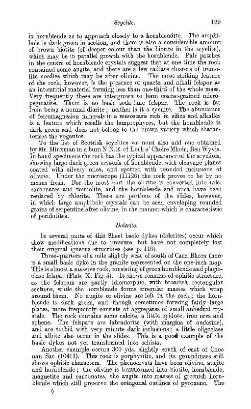
Scyelite. 129
in hornblende as to approach closely to a hornblendite. The amphi-
bole is dark green in section, and there is also a considerable amount
of brown biotite (of deeper colour than the biotite in the scyelite),
which may be in parallel growth with the hornblende. Pale patches
in the centre of hornblende crystals suggest that at one time the rock
contained some augite, and there are a few radiate clusters of tremo-
lite needles which may be after olivine. The most striking feature
of the rock, however, is the presence of quartz and alkali felspar as
an interstitial material forming less than one-third of the whole mass.
Very frequently these are intergrown to form coarse-grained micro-
pegmatite. There is no basic soda-lime felspar. The rock is far
from being a normal diorite ; neither is it a syenite. The abundance
of ferromagnesian minerals in a mesostasis rich in silica and alkalies
is a feature which recalls the lamprophyres, but the hornblende is
dark green and does not belong to the brown variety which charac-
terises the vogesites.
To the list of Scottish scyelites we must also add one obtained
by Mr. Hinxman in a burn N.N.E. of Loch a' Choire Mhoir, Ben Wyvis.In hand specimens the rock has the typical appearance of the scyelites,
showing large dark green crystals of hornblende, with cleavage planes
coated with silvery mica, and spotted with rounded inclusions of
olivine. Under the microscope (11126) the rock proves to be by nomeans fresh. For the most part the olivine is converted into talc,
carbonates and tremolite, and the hornblende and mica have been
replaced by chlorite. There are portions of the slides, however,
in which large amphibole crystals can be seen enveloping roundedgrains of serpentine after olivine, in the manner which is characteristic
of peridotites.
Dolerite.
In several parts of this Sheet basic dykes (dolerites) occur whichshow modifications due to pressure, but have not completely lost
their original igneous structures (see p. 116).
Three-quarters of a mile slightly west of south of Carn Bhren there
is a small basic dyke in the granite represented on the one-inch map.This is almost a massive rock, consisting of green hornblende and plagio-
clase felspar (Plate X. Fig. 5). It shows remains of ophitic structure,
as the felspars are partly idiomorphic, with broadish rectangular
sections, while the hornblende forms irregular masses which wraparound them. No augite or olivine are left in the rock ; the horn-
blende is dark green, and though sometimes forming fairly large
plates, more frequently consists of aggregates of small anhedial cry-
stals. The rock contains some calcite, a little epidote, iron ores andsphene. The felspars are labradorite (with margins of andesine),
and are turbid with very minute dark inclusions : a little oligoclase
and albite also occur in the slides. This is a goo# example of the
basic dykes not yet transformed into schists.
Another example occurs 300 yds. slightly south of east of Cnocnan Sac (10411). This rock is porphyritic, and its groundmass still
shows ophitic characters. The phenocrysts have been olivine, augite
and hornblende ; the olivine is transformed into biotite, hornblende,
magnetite and carbonates, the augite into masses of greenish horn-
blende which still preserve the octagonal outlines of pyroxene. The
9
130 The Newer Igneous Rocks.
groundmass shows lath-shaped felspars surrounded by granules of
hornblende, indicating the ophitic structure of the original rock.
A rounded steam cavity is visible in the section, and is occupied bycalcite, quartz and pyrites. In this case, as in some of the gabbros,
there has been considerable alteration of the minerals of the original
rock, but the igneous structures are well preserved. J. s. F.
CHAPTER VIII.
OLD RED SANDSTONE.
Introduction.
The Old Red Sandstone within the limits of the one-inch mapunder description is chiefly found in the south-eastern portion, where
it occupies an area of about 30 square miles. This may be called the
Alness and Evanton area.
Separated from this large area by wide intervals of schist, never
less than 9 miles in width, are various outliers further west (Plate XII.),
the largest of which, in Strath Rannoch and the eastern side of Strath
Vaich, amounts perhaps to 6 or 7 square miles. This may be called
the Strath Rannoch outlier. Smaller ones occur on Meall a' Ghrianain
(between Strath Rannoch and Strath Vaich), Beinn nan Cabag andBeinn a' Bhric, both a little north of Loch Luichart, and in other
places, as will be subsequently described.
The evidence afforded by the western margin of the Alness andEvanton area, and also by the outliers further west, shows that the
Old Red Sandstone strata were deposited on a very uneven surface
of the older metamorphic rocks. The basal beds in different localities
may, therefore, occur on different geological horizons. Neverthe-
less it seems quite possible that the western outliers, none of whichhave yielded distinctive paleeontological evidence, may belong to the
same division as that to which all the strata in the Alness and Evantonarea have been referred, on the evidence of the fossil fish remains
found a little within the adjoining Sheet 94 (see Appendix i.). This
is the Middle or Orcadian Division.
Attention should be called to the fact that while certain upperconglomerates, to be shortly described in the Alness and Evantonarea, contain abundant pebbles of Cambrian and Torridonian rocks
derived from areas to the west, beyond the Moine thrust, no frag-
ments of the augen gneiss have yet been detected in them. This
gneiss enters largely into the composition of the conglomerates in the
western outliers, and the inference may perhaps be drawn that the
augen gneiss, though to a large extent exposed while these western
beds were being formed, had subsequently become wholly, or almost
wholly, covered by succeeding Old Red Sandstone strata before the
upper conglomerates of the Alness and Evanton area were laid down.
If this inference be correct, we may conclude that all, or a very large
proportion of the schistose area within the map was at one period
covered by the Old Red Sandstone.
We shall now proceed to describe the Alness and Evanton area
in detail, leaving the outliers for subsequent treatment.131
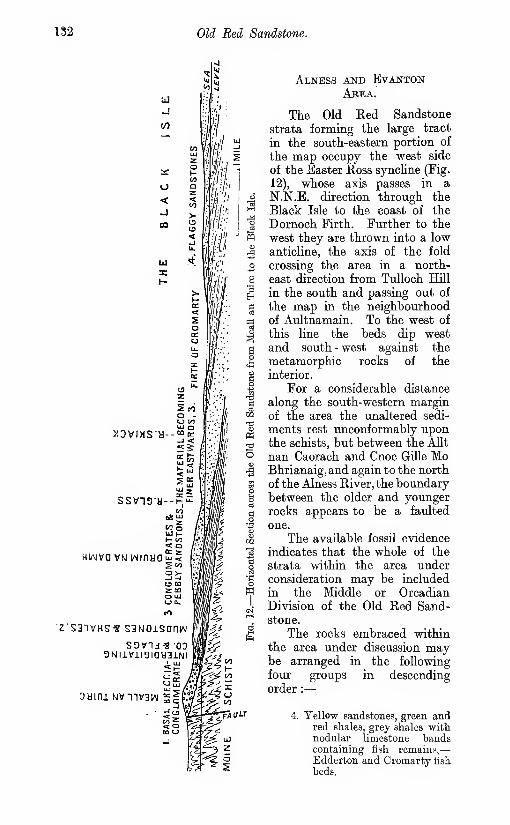
132 Old Red Sandstone.
>IDVIMSa-
ssviaa-
•Z'S31VHS« S3N0iSaniM
3NliVil3IQy3INI
oyini Nvniv3w
'/< r-H
ct^
TfAoa
Alness and EvanionAbea.
The Old Eed Sandstone
strata forming the large tract
in the south-eastern portion of
the map occupy the west side
of the Easter Ross syncline (Fig.
12), whose axis passes in a
N.N.E. direction through the
Black Isle to the coast of the
Dornoch Firth. Further to the
west they are thrown into a low
anticline, the axis of the fold
crossing the area in a north-
east direction from TuUoch Hill
in the south and passing out of
the map in the neighbourhoodof Aultnamain. To the west of
this line the beds dip west
and south - west against the
metamorphic rocks of the
interior.
For a considerable distance
along the south-western marginof the area the unaltered sedi-
ments rest unconformably uponthe schists, but between the Allt
nan Caorach and Cnoc Gille MoBhrianaig, and again to the north
of the Alness River, the boundarybetween the older and youngerrocks appears to be a faulted
one.
The available fossil evidence
indicates that the whole of the
strata within the area underconsideration may be included
in the Middle or OrcadianDivision of the Old Red Sand-stone.
The rocks embraced withinthe area under discussion maybe arranged in the following
four groups in descending
order :
—
4. Yellow sandstones, green andred shales, grey shales withnodular limestone bandscontaining fish remains,
—
Edderton and Cromarty lish
beds.

Alness and Evanton Area. 133
3. Eed and yellow sandstones with scattered pebbles and pebbly bands,
passing down into conglomerate with intercalations of sandstone,
—
Cnoc Fyrish conglomerate.
2. Green and grey shales, flagstones, fetid dark shales and calcareous mud-stones ;—equivalent to the Strathpefl:er " fish beds."
1. Basal breccia and conglomerate.
Lenticular pebbly or conglomeratic beds are also locally developed
at several horizons in groups 2 and 4.
The rocks of the highest group occupy the centre of the syncline
and form the smooth western slope of the Black Isle. They also
appear across the Firth to the north of Alness, and on the extreme
margin of the map near Aultnamain Inn. The pebbly sandstones
of group 3 form the low ground along the western shore of the CromartyFirth (Fig. 12), and pass, by the increase of the coarser sediments,
into the conglomerates of Cnoc Fyrish, which form the central ridge
of high ground between Glen Glass and Druim na Gaoithe.
The shales and flags of group 2 occupy the crest of the anticline,
and, rising from beneath the conglomerate of Cnoc Ceislein, extend
from Boath through the hollow of Strath Mor, and cover a wide area
on either side of the Skiack River.
They are faulted against the conglomerate along the valley of
the Alness River at Aidross Castle, and occupy the western marginof the area northwards from that river to Struie Hill, their junction
with the metamorphic rocks being also a faulted one.
The basal breccia-conglomerate is locally developed at several
points along the margin of the area : e.g., on Cioch Mhor on the northside of Strath Sgiack ; between Glen Glass and the Alness River ; andon the north side of Struie Hill. It is essentially a shore deposit,
laid down upon an oscillating surface in wedge-shaped masses that
thin out to the eastward and interdigitate with the finer-grained
sediments of group 2.
GROUP 1.—BASAL BRECCIA AND CONGLOMERATE.
The local base of the series is well displayed on the summit andeastern face of Meall an Tuirc, in Glen Glass (Fig 12). It presents
the appearance of a coarse breccia-conglomerate—a tumultuousaggregate of angular, subangular and occasionally rounded blocksof metamorphic rock set in a close brick-red matrix.
The included fragments are often as much as 3 or 4 ft. in length,
and may all have been derived from the immediately contiguousschistose area, no rocks of distinctly foreign origin having been ob-served.
It is possible that the junction of the conglomerate with the schists
on the west side of the hill is not altogether a natural one, and there
are indications of movement along the line of contact. The fault
is probably, however, of little magnitude, and the appearances are
almost equally compatible with the deposition of the breccia against
a steep face of the original land surface.
The Meall an Tuirc conglomerate extends northwards over Bendealltto Cnoc Gille Mo Bhrianaig, where it contains lenticular partings
of red sandstone. The inchnation of the beds, which on Meall an
134 Old Red Sandstone.
Tuire appears to be to the N.N.E., is here to the S.E. A similar
breccia-conglomerate covers the summit and eastern slopes of Meall
an Leathaid, one mile and a quarter north-west of Cnoc Gille MoBhrianaig. The sediments are there resting unconformably upon the
schists, and show considerable evidence of overlap of the higher beds
upon the steep surface of the original floor.
A good example of a locally derived conglomerate is found onAllt Dearg, at a point a mile south-east of Aultnamain Inn. Opposite
the crofter's house the stream is cutting a section in a bank of coarse
conglomerate, almost entirely composed of rounded and subangularblocks of a red unfoliated biotite granite, set in an arkose matrix formedby the disintegration of the same rock. The material has evidently
been derived from the Fearn granite area, whose eastern margin lies
two miles to the west. This conglomerate is well stratified, and dips
B.S.E. at 15°.
The Fearn granite also enters largely into the composition of thecoarse conglomerate seen along the course of the Strathrory Eiverbelow the bridge, and in the gorge cut by the stream three-quarters
of a mile above this point. At the latter locality rounded granite
boulders, 3 to 6 ft. and upwards in diameter, are set in a conglomeratic
matrix composed of subangular fragments of schist and granite, mostlyless than a foot in length.
The great majority of the stones in the conglomerate of Struie
Hill, at the northern end of the area, are, on the other hand, formed of
the metamorphic rocks of the Moine Series, and only a few small
pebbles of unfoliated granite have here been observed, though there
are many fragments of coarse muscovite pegmatite and others of apurple felsitic rock.
GROUP 2.—SHALES, FLAGSTONES AND MUDSTOiNES.
The fine-grained pelitic sediments of this group are best displayed
along the coiirses of the Alness and Skiack Eivers, and Allt nan Caorach.
For the convenience of the observer who may visit the ground, the
whole stream section will be described continuously in each case,
although members of both higher and lower groups- are included in
parts of the section.
Shiach River Section.
As we ascend the River Skiack from the bridge at Evanton, thestream below and above Milton of Katewell is found to be flowing
over yellow sandstones with pebbly bands and scattered pebbles, andoccasional intercalations of ripplemarked flagstones.
At a point a quarter of a mile S.S.W. of Upper Park, the streamis crossed by a fault with a downthrow to east, by which these pebblysandstones of group 3 are brought down against the shales and mud-stones of group 2, the latter dipping up-stream in a W.S.W. direction
at 20° to 25°. Between Swordale and Fannj^eld the course of the
stream coincides more or less with the strike of the green and purple
mudstones which are seen at intervals along the river bed. AboveFaunyfield, where the Skiack is still cutting through the boulder

Alness and Evanton Area. 135
clay which fills its pre-glacial channel, the stream turns to the north
and flows across the strike of the beds, exposing for a short distance
sections of green and grey shales (the latter sometimes fetid), mud-stones and thin calcareous flagstones, all having an easterly dip.
Similar rocks are seen in the small burns which descend the hill-slope
south-west of Clare.
The stream now passes for some distance through alluvial flats,
until at Bog nam Blast a similar series of rocks is again exposed.
The strata are now dipping S.S.E. and S.S.W. at angles of 18° to
35°, and show signs of movement, the grey shales, well seen in the little
gorge directly south of Cioch Mhor, being distinctly cleaved. It is
probable that a fault, possibly the continuation of the boundaryfault seen in the Allt nan Caorach 3| miles to the N.N.E. and de-
scribed in the sequel, here crosses the Skiack valley.
A quarter of a mile above this point the stream flows over a yellow
breccia composed of angular fragments of schist up to 18 ins. in length.
Eeddened sihoeous schists of the Moine Series are seen on the hill-slope
immediately to the south of the burn, but the relations of the schistose
and unaltered sedimentary rocks are not visible in the stream section.
On the summit of Cioch Mhor, a mile to the north, the Old Red con-
glomerate is seen resting unconformably upon an irregular siirface
of the metamorphic rocks, and the evidence favours the conclusion
that the junction along the boundary line to the south of that hill
is a natural one.
Sections in the River Glass and Allt nan Caorach.
The lower members of the series are also well displayed along
the course of the River Glass above Evanton, and of its principal tribu-
tary the Allt nan Caorach. The deep chasm of the Black Rock of
Novar has been eroded in the pebbly sandstones and conglomerateof the Cnoc Fyrish group. The sudden sharp bends in the course of
the gorge have been determined by cross joints in the rock, while
its general direction seems to be independent of any structural line.
Micaceous purple and red shales and flagstones of group 2 appearin the river at Redburn, a mile above the entrance to the gorge, andare also seen in the small burn which at this point joins the river onthe right bank. There is evidence of considerable disturbance alongthe tributary stream ; the beds are inclined at high angles to the north-
west, and a fault, along which issue calcareous springs, brings the purple
shales into contact with ohve-green shales with calcareous bituminousbeds on the south bank.
A third of a mile above the junction of the Allt nan Caorach withthe River Glass the former stream is crossed by the belt of coarse
breccia-conglomerate which forms the fine waterfall on the mainstream known as the Eas a' Chonaisg. Following the course of the
Allt nan Caorach, the observer finds the stream flowing for somedistance in a deep inaccessible gorge cut through the conglomerate.
Near the head of this gorge, and a third of a mile below the ford
I mile S. by E. of Eileanach, a fault with a hade down-stream of not
more than 50° throws down the coarse tumultuously arranged breccia-
conglomerate (containing angular schist fragments 2 and 3 ft. in length)
against a series of grey shales with bands of grey calcareous grit. The

^^^ Old Red Sandstone.
shales are cruslied and cleaved near the fault (Fig. 13, p. 147), whilethe cleavage planes, which are parallel to the line of movement, do notpass through the harder grit bands.
Above the ford follows a long series of grey and purplish micaceousflagstones with shaly partings, with a westerly dip (W. 15° S. toW. 15° N.)at angles of 16° to 35°. A third of a mile west of the ford, intercalatedbands of pebbly conglomerate begin to appear among the flagstonesand thicken westwards, until, at the point where a waterfall andnatural rock arch are seen, the rock is almost entirely a conglomerate,composed of medium-sized rounded and subangular stones set ina grey matrix. This conglomerate is less coarse and shows a far moreregular arrangement of its components than the breccia lower downthe stream. Near the boundary fault which crosses the stream about600 yds. further west it contains some very large blocks of schist andpegmatite, and finally a hard grey breccia, made up of angular frag-
rnents of the adjacent schists, is brought against crushed and brecciatedsiliceous schists of the Moine Series.
Alness River Section.
The third section to be described is that seen along the picturesque
gorge of the Alness Eiver between the foot of the Strath Eusdalestream and the village of Alness. The higher part of the river valley
has been determined by the Loch Morie fault, which passes into the
Old Red Sandstone area two miles below Loch Morie, and throwsdown the Cnoc Fyrish conglomerate to the south against the flags andshales of group 2 for a distance of two miles and a half east fromLoanroidge. There are marked signs of movement along this line of
dislocation ; the shales and flagstones are vertical or inclined at high
angles, and often show cleavage, crushing and induration.
An interval of 250 yds. separates the last place where the siliceous
Moine schists are seen in the river from the first appearance of the
shales on the north side of the stream under Inchlumpie Wood, half
a mile below the junction of the streams. Evidence obtained further
to the north indicates, however, that the boundary between the twoformations is a fault.
At this point shales with thin beds of hard flagstone are dipping
S.S.W. at 40°. The shales are well cleaved, the planes of cleavage
making an angle of 60° with the bedding. The conglomerate on the
downthrow side of the fault is seen at the next bend higher up, on the
opposite side of the river. Similar sections of cleaved and crushed
shales with bands of hard calcareous grit and flagstone, either vertical
or with a south-west or southerly dip at high or moderate angles, are
seen at many points along the stream both above and below Ardross
Castle, while the conglomerate appears on the south bank wherever
the river has cut back to the line of fault.
Between Dalreoch and Cuillich, rather more than a mile below
the Castle, the shales are succeeded on the left-hand bank by the
pebbly conglomerates and red and white pebbly sandstones of the
Cnoc Fyrish group, through which the river flows in a winding gorge,
with steep bluffs of conglomerate at the head of each bend, to the
bridge at Alness. l- w. h.
The basin-shaped valley of Boath, opposite the mouth of Strath

Alness and Evanton Area. 137
Rusdale, has been carved out of the softer strata of group 2, whicli
intervene between the conglomerates of Meall an Leathaid and of AnCorran. Soft red and purple flaggy sandstones, green and purple
mudstones and dark shales are seen in the three burns which converge
below Boathmore, and join the Alness Eiver near Knocklea. Thebeds have a general westerly to north-westerly dip at angles varying
from 5° to 30°, and strike against the Loch Morie fault, which throws
them down against the schists between Loanroidge and Knocklea.
c. B. c.
Similar rocks are exposed in the ToUie Burn, a mile to the north
of Ardioss Castle, dipping S.S.W. at 30° to 45°, and striking against
the boundary fault. The actual junction with the schists is obscured,
but a small thickness of conglomerate appears to intervene betweenthe mudstones and the older rocks. The relations of these sediments
to the metamorphic rocks can, however, be studied in the Allt Muigh-bhlaraidh, three-quarters of a mile N.N.W. of Aultnamain Inn. At a
point a third of a mile above the bridge, where this stream is crossed
by the Bonar Bridge road, purple and greenish shales with bands of
micaceous flagstone, dipping S.S.E. at high angles, are seen in faulted
conjunction with crushed and purple-stained siliceous Moine schists.
The shales as they approach the fault are often well cleaved, anda short distance below the bridge show minute overfolding or pucker-
ing, the axes of the folds being approximately parallel to the general
course of the boundary fault.
GEOUP 3.—EBD AND YELLOW SANDSTONES AND CONGLOMERATES.
An almost continuous section of the pebbly sandstones of group 3
is exposed along the western shore of the Cromarty Firth betweenEvanton and the southern margin of the map. Below Mountgeraldthe old coast-line is indicated by a low clifE of conglomerate with inter-
calated and inconstant bands of grey laminated sandstone. Thepebbles are well rounded, and range generally from 1 to 8 in.
in length, but include some large blocks of sihceous schist which lie,
as if dropped in, at angles to the bedding planes. The stream whichflows from Woodlands into the sea at the old chapel passes over analternating series of yellow sandstones and bands of conglomerate,the latter giving rise to three waterfalls below the bridge. Sandstoneswith frequent conglomeratic bands continue northwards to Foulis
Point, where the conglomerates, disappear, and false-bedded yellow,red and white sandstones with nests and irregular layers of pebblesand seams of green shale occupy the shore as far as the church of
Kiltearn, at the mouth of the Skiack River.
The lower course of that stream affords another good section of
these pebbly sandstones, succeeded by the flags and shales of group 2.
This section is discussed in an earlier paragraph (p. 134).
Excellent sections of the Cnoc Fyrish conglomeratic series are
exposed in the deep ravine cut by the Big Burn between Cnoc Fyrish
and Creag Ruadh. Thick beds of pebbly conglomerate are here
intercalated with bands, 10 to 12 ft. in thickness, of yellow sandstone,
containing a few scattered pebbles. The conglomerate is composed of
pebbles, usually well rounded, set in a tough yellow sandy matrix.
The larger fragments rarely exceed nine inches in greatest diameter,

138 Old Red Sandstone.
while the majority are less than two inches in length. The bulk of
the pebbles are derived from the crystalline schists, those of quartzite
or siliceous granulite predominating. There are also many of un-
foliated red granite and pegmatite, which may have been derived
from the Newer Granite area six miles to the north. Among those
to which a more distant origin may be definitely assigned are fragments
belonging to recognisable zones of the Durness Limestone ; dolomite
shales resembling those of the " Fucoid Beds "; and Torridonian
grits and sandstones in fair abundance. One or two examples of
a much decomposed porphjrrite have also been observed.
A closely similar assemblage of pebbles is found in the conglomerate
dlong the course of the Alness River between Dalreoch and the village
of Alness, the fragments of Durness Limestone and Torridon Sandstonebeing perhaps more numerous than in the locality last described.
Many pebbles of Durness Limestone, up to four inches in length,
occur also in the conglomerate near Stittenham, along the upper part
of the stream that flows into Loch Achnacloich. The occurrence of
Durness Limestone pebbles in these conglomerates was first noted
by Mr. Hugh Miller in the year 1887.
The entire absence from the upper conglomerate of boulders of
the augen gneiss, which enter so largely into the composition of the
basal breccias to the west and south-west, and the inference drawnfrom this difference of composition, have been already referred to
near the beginning of this chapter.
GROUP 4.—SANDSTONES WITH THIN SHALES AND MARLS.
The highest members of this division of the Old Red Sandstone
that come within the map occupy the smooth drift-covered slopes
of the Black Isle, where inland sections are rarely seen. The rocks
are, however, well exposed along the eastern shore of the Firth between
Findon Mains and Alnessferry. They include fissile and flaggy
sandstones, generally yellow, but sometimes grey or reddish in colour,
with pebbly bands, pebbly nests and scattered pebbles, clay galls
and thin seams of greenish shale and red marl. Intercalated with the
sandstones, half a mile south of CuUicudden, is a band, 12 to 15 ft.
thick, of shale containing fragments of Psihphyton, also nodules and
layers of pale brown impure limestone, and calcareous yellow flag-
stones.
Opposite Foulis the strata are nearly horizontal, but further to
the north and opposite Alness Point they dip to the east at 8° to 15°.
The strike of the beds at this point carries them across the Cromarty
Firth to the north of Alness, where the yellow sandstones and Psilo-
fhyton shales are seen half a mile E.S.E. of Achandunie, and along
the southern slope of Cnoc Navie Wood. An excellent section of these
sandstones and shales, with abundant plant remains, is exposed in a
small burn which falls into the Strathrory River on the right bank,
just outside the limits of this map.
The rocks of this group pass out of the map a little to the south
of Strathrory, but reappear further to the north, on the west side of
the anticUne, between Blackpark and Aultnamain, where they dip
to the north-west, and are thrown down against the shales and mud-
The Western Outliers. 139
stones of group 2 by the fault which runs N.N.E. a little to the west
of Polinturk.
An excellent section of the calcareous beds of this series is exposed
in the Allt Muigh-bhlaraidh at Blackpark, on the extreme margin of
the map, .and is given below in descending order.
Ft.
6. Yellow calcareous sandstone. Soft, dark purple and red sandstones.
Eed marly shale with courses of red sandstone .
.
. . 5
5. Maggy yellow and calcareous sandstones with suncracks .
.
.. 1-3
4. Greenish shales with plant remains, and irregular layers of impurelimestone .
.
.
.
.
.
.
.
.
.
.
.
1
3. Dark grey and greenish calcareous shales with nodular layers of
limestone. Fish scales and plant remains ahundant in the shales,
and fish well preserved in the nodules, especially in the upperpart of the bed .
.
.
.
.
.
.
.
.
.
. . 62. Greenish shales with courses of limestone and impure calcareous
sandstone .
.
.
.
.
.
.
.
.
.
. . 3
1. Yellow calcareous sandstone and purple shales .
.
.
.
. . 6
A series of specimens (a list of which will be found in Appendix i.)
collected from this locality by Mr. Tait, has been submitted to Dr.
Traquair, who identifies them with specimens from the Cromartyfish bed, thus establishing the Middle Old Eed Sandstone age of the
rocks of this area. This section has long been known as a productive
locality for ichthyolites, which are well preserved in flattened nodules
of grey limestone. They were first described in 1861 by the Rev. J. M.Joass, in a letter communicated to the London Geological Society
by Sir R. I. Murchison.* l. w. h.
The Western Outliers.
The large Strath Rannoch outlier appears to have been first described
by Mr. William Morrison, of Dingwall.f It was no doubt referred
to, together with various other adjacent outliers, by Mr. W. Gunn %about ten years subsequently. The rocks included in this outlier are
well seen, and consist of conglomerates, sandstones and mudstoneswith thin calcareous bands. No regular order of succession hasbeen made out, and the relation of the conglomerates to the other
sediments is an irregular one. Conglomerate occurs high up on the
flanks of Meall nam Mullach, while the fine-grained sediments appearin the valley below.
Such an arrangement may possibly in certain cases indicate alateral passage of the fine sediments into the coarser towards theshore line then existing rather than a superposition of the conglomer-ates. But in other cases it is probable that the coarse conglomeratesare superposed on finer beds. For instance, near the head of theburn south of Carn Loch nan Amhaichean, where the beds dip west-ward, down-stream, faster than the fall of the stream, a coarse boulderbed, formed chiefly of great blocks of augen gneiss, lies west of,
and apparently stratigraphically above, certain finer conglomerates.* Quart. Jour. Geol. Soc, 1861, vol. xvii. p. 553.
t ' A Minor Basin of the Old Eed Sandstone in Mid Ross,' Trans. Edin. Geol.
Soc, 1886, vol. V. p. 331; also, 'An Outlier or Minor Basin of Old Bed Sandstonein Mid Ross-shire,' Trans. Edin. Geol. Soc, 1891, vol. vi. p. 188.
J Annual Beport of the Geological Survey for the year 1896, p. 53.
140 Old Red Sandstone.
It is also the case that in this locality the coarse conglomerate , lies
further away from the probable margin of the schist than do the
finer conglomerates on the east. In these finer conglomerates pebbles
of siliceous Moine schist are much more common than those of augen
gneiss, and in one place a pebble of mica trap was detected. Thefiner conglomerates in difierent parts of the burn perhaps occupyconsiderably different stratigraphical horizons. In the conglomerates
in the lower part, the larger pebbles, often several inches long, are
almost entirely composed of siliceous schist or of vein-quartz, but thefiner ingredients comprise many grains of opalescent quartz and red
felspar, both of which have probably been derived from the augengneiss.
It is possible that the conglomerates last referred to are separated
from the coarse conglomerate of augen gneiss on its south-east side
by a powerful fault striking north-east. No fault is actually exposedwhere the fault suggested is mapped across the burn, but the schists
along the continuation of this fine appear to have been affected by a
powerful fault or lateral wrench (see Chapter IX.). It is not certain,
however, that any part of this fault is newer than the Old Eed Sand-
stone.
A conglomerate near Creag Bhreac Mhor, on the west side of
Strath Rannoch, forms a series of fine escarpments, the mostnortherly of which has an apparent dip to the south. To the
north-east of the same hill red sandstones appear, dipping south-
east at 20° to 30°, and similar rodks with a north-west and west dip
are exposed along the Strath Rannoch stream. An interesting section
of the sandstone and mudstone series is exposed in the more northerly
of the two small burns which flow off the north-eastern slope of Creag
Bhreac Mhor. In the upper part of this stream red sandstones dip
south-east beneath the soft purple mudstones which are well exposed
further down the stream. The mudstones contain hard greenish
lenticles which lie along the planes of bedding. These latter are,
however, distinctly crossed by a more prominent set of planes due to
cleavage. The cleavage dips N.W. or N.N.W. at a high angle, while
the bedding is gently inclined to the south-east.
The finer sediments, including sandstones and mudstones with
numerous bands of calcareous sandstone and thin limestones, are
also well seen along the course of the Allt a' Choire-rainich, where the
dip is generally in a north-westerly direction. A rough cleavage,
conformable in angle and direction to that described in the preceding
paragraph, has been observed in the sandstones a little to the north-
east of the keeper's house in Strath Rannoch.
On the hillside a quarter of a mile south-east of the above house,
a calcareous conglomerate contains many fragments of felspar which
have no doubt been derived from the augen gneiss. The thickness
exposed is about 12 ft., and certain lenticular bands, each about four
inches thick, are much more calcareous than the rest. A specimen
from one of these stripes (10915) has been sliced and examined byDr. Flett, who states that the calcite does not appear to be detrital,
but is perhaps a chemical deposit. It encloses a few shreds of fossil
wood.The northern boundary of this outlier is fairly distinct between
the Strath Vaich River, above Lubriach, and Meallan Donn. The
The Western Outliers. 141
iunction of the conglomerate with the schists is visible on the south-
west side of that hill, where it rests upon an irregular surface of the
older rock. Where this boundary crosses the Strath Rannoch Burn, at
a point about three-quarters of a mile south-west of Carn nan Aighean,
the section shows an Old Red Sandstone breccia, mainly composed
of large blocks of siliceous schist, banked up against a shghtly over-
hanging cliff of similar schist : some of the blocks are as much as
18 ft. long.
The outlier capping the summit of Meall a' Ghrianain, 2531 ft.,
is probably the highest ground reached by the Old Red Sandstone
formation in the North of Scotland. There is present here a thickness
of probably 400 or 500 ft. of conglomerate made up/almost entirely
of huge rounded blocks of augen gneiss many feet in length. In
several places blocks as much as 21 ft. in length have been observed,
and, to account for their transport, glacial action has been suggested
by more than one observer. A few fragments of schist are also em-bedded on the east side of the hill. The dip of the mass can rarely
be ascertained, but a bed of sandstone, only a foot thick, on the western
face of the hill, shows a dip to south or south-east. Comparatively
little of the rock is actually seen in situ, the greater part of the area
being covered by loose blocks and disintegrated debris of augen gneiss.
On the eastern side, particularly at its northern end, the under-
lying surface of the schist is of a very irregular character. If wecombine the evidence obtained from the outlier with that from Strath
Raimoch, we obtain proof of an alteration of the base level of the
Old Red Sandstone to an extent of nearly 1000 ft. in the distance of
a mile. On the western side of the outlier, various small isolated
exposures of breccia, chiefly composed of angular pieces of siliceous
schist, rest on, or in chinks in reddened schist. These breccias are
probably local basement beds of the Old Red Sandstone. One of
them occurs at an elevation of less than 1500 ft., and its base is
inclining westward towards the valley of Strath Vaich. It seems
probable, therefore, that the valleys of Strath Rannoch and Strath
Vaich were both roughly shaped even in the Old Red Sandstone
period, and, after being filled up by deposits belonging to this period,
have been brought into existence again by further denudation, which
has taken out the comparatively soft Old Red Sandstone strata morequickly than the Moine schists.
A very small patch of conglomerate, which rests upon the augengneiss at the side of the path leading from the school at the foot of
Strath Vaich to Strath Rannoch, is also made up of blocks of augengneiss. A few hundred yards west of this patch is another larger
outlier which appears to rest on the augen gneiss, while on the north
it seems to be bounded by a fault with a downthrow to the south.
The rock here is not so coarse as in the crags above, and much of it
is a pebbly or brecciated sandstone dipping about N.N.W.W. G., C. T. C, E. M. A.
The irregular nature of the surface on which the Old Red Sand-
stone was deposited is also shown by the two outliers to the south
which cover the tops of Beinn nan Cabag and Beinn a' Bhric, between

142 Old Red Sandstone.
the Glascarnoch River and Loch Luichart. On the former hill the
conglomerate appears to have been deposited against a steep cliff
of augen gneiss, an outlying sill of which forms the western side of
the mountain, and large blocks of the igneous rock enter into the
composition of the breccia-conglomerate at this point. The Beinn a'
Bhric outlier rests partly upon this outcrop of augen gneiss and partly
upon theMoine Schists, and is composed of conglomerate, almost entirely
made up of subangular blocks of sihceous schist, with a few layers of
red sandstone.
Several small patches of conglomerate seen resting upon the
schist and augen gneiss, between Beinn nan Cabag and Creag BhreacMhor, point to^the former continuity of these deposits over the inter-
vening areas, from which they have since been removed by denudation.
B. N. p.
The most northerly of these outliers is found near the head of Strath
Rannoch, and lies on the north-western slopes of Carn nan Aigheanat a distance of a quarter of a mile from the cairn. Like the Meall
a' Grhrianain mass it consists of enormous bouilders of augen gneiss,
with only enough of matrix to fill the hollows between the blocks.
One of these blocks was found to measure at least 27 ft. in length.
The breccia is resting on the schists at the south-west end of the out-
lier, but probably extends over some of the augen gneiss in the other
direction. Its actual junction with the underlying rocks is, however,
nowhere clearly seen. c. B. 0.

CHAPTER IX.
FAULTS.
In this chapter it is only intended to describe a few of the moreimportant faults. The thrust planes, which are accompanied with a
development of foliation, have been already dealt with in previous
chapters, and will not be fm:ther referred to.
Strathconan Fault.
A powerful N.N.E. fault is seen near the head of Loch Luichart, in
the stream S.S.E. of Mossford, and again in various other sections
near Lochluichart Lodge : the planes of crush are generally nearly
vertical. It is certain that near the head of the loch the fault mustbe accompanied with considerable displacement, for the siliceous schist
on the west is impregnated with multitudes of thin veins of foliated
granitic material, while on the east side such veins are seldom seen
until we go some miles further north. This fault is no doubt the
same as the Strathconan fault further south-west, and it is believed that
it proceeds in a general south-west direction as far as Loch Hourn,on the west coast of Inverness-shire, but part of the intermediate area
between Strathconan and Loch Hourn has not yet been mapped. Inthe valley of the Meig, in one-inch maps 82 and 83, the slicken-
sides along the fault are often horizontal,* and it is hence believed
that the chief movement along the fault has been a horizontal
wrench.
Excepting for the exposures near Loch Luichart, the evidence for
the fault in the southern and central parts of the map is generally of
an unsatisfactory character, the rocks along the supposed line being
to a large extent drift-covered. A broad zone of crush in Glas-
carnoch River, two-thirds of a mile below Aultguish Inn, is perhaps abranch from the Loch Luichart fault, but it is described again undera difierent heading, with the Coire Mor and Strath Vaich faults.
South-east of Cam Loch nan Amhaichean, the presence of a fault,
striking in the direction of the Loch Luichart fault, is indicated bysome crush breccias in the siliceous granulites of the Moine series.
A Uttle further to the east it shifts the margin of the foliated granite,
together with a narrow zone of pelitic material which accompanies it,
for rather less than a mile. It seems probable that this distance
forms a more or less rough indication of the actual horizontal dis-
placement in this area, the south-east side being shifted towards the
north-east, as is usual in other districts.
South of Carn Loch nan Amhaichean the fault line is drawn on the
,map as if it went through the Old Red Sandstone. It cannot be said
with confidence that the fault afiects this formation, but it is possible* Summary of Progress of the Geological Survey for 1904, p. 79.
143

144 Faults.
that it does so, there being an obscure gap along which it may pass
without being anywhere exposed. b. n. p., e. m. a.
In the stream half a mile slightly north of east of the OrdnanceStation 2076 on Leaba Bhaltair, a crush, one or two feet thick, strikes
slightly west of north and inclines west. This probably continues
north, and bounds the eastern side of the mass of hornblende schist
which is shown in the map on the N.N.E. side of Leaba Bhaltair.
Near the northern end of this side a crush is seen inclining west, andbetween this crush and the hornblende schist there is an obscure gap,
about 20 yds. wide, in which more crushed material may occur. Thisfault must twice cross the burn W.S.W. of Carn Dubh, and separates
a mass of diorite and hornblende schist on the east side from the
Moine schists on the west. Thence it proceeds in several branchesalong the west side of Cnoc na Tuppat, where the total displacement of
the outcrops, the east side towards the north, is about a mile. Thebranches on this hillside occasionally make considerable angles with
one another, but their general direction is nearly north and south. Thefault rock is sometimes highly impregnated with siliceous material.
The northerly continuations of the Cnoc na Tuppat faults are
exposed in the south bank of the Eiver Carron, close to the foot of GlenCalvie. One of them is represented by a band of crushed material,
seven or eight yards wide, which inclines westward. Another thinner
almost parallel crush, a little to the eastward, inclines east. West of
the wide crush just referred to is another, of considerable width,
which seems to strike S.S.W. Perhaps this forms the eastern boundaryof a rather broad band of pelitic schist which has been mapped in
this locality.
Still further west, a fault striking S.S.W. breaks the pelitic bandand displaces the outcrop for rather more than a quarter of a mile, in
the same direction as the Cnoc na Tuppat faults.
Coire Mor and Strath Vaich Faults.
The main line of crush is well seen in the straight part of Allt a'
Choire Mhoir near the 1250-foot contour. Its strike in this locality
is north-west, and the inchnation at a rather low angle towards the
south-west, the direction of downthrow indicated by the displace-
ment effected in the adjacent crops of schist. The base of the broad
zone of pelitic schist is displaced about half a mile, the south-west side
towards the north-west. The top of this zone is less well defined than
the- base, and the displacement effected in it cannot be calculated so
confidently, but it appears to be about 500 yds. A hard rib of fault
rock is exposed, of compact character with close parallel crush planes
welded together into one block : below this, the pelitic schist has been
crushed into small phacoids with their long axes inclined parallel to
the hard rib.
Nearly three-quarters of a mile N.N.E. of Loch Sruban Beaga the
fault divides. One branch, which itself probably subdivides a little
further south-east, is seen to be four or five yards wide at the head of
the rather straight stream, a little below the 2250-foot contour. Onthe hill-top S.S.B. of this exposure much shattered and brecciated
sihceous schist is seen, partly in situ and partly in the form of loose
blocks. Some other branches of the fault are also seen a few hundred
Strath Yaich, Loch Morie. M5
yards west of the shattered and brecciated area just referred to. In
the crags of Cail Mhor the positions of the two main crushes are rather
more than a third of a mile apart : of these the crush lying furthest
west is represented in one place by a vertical breccia about three feet
wide, while the other, which is exposed at the head of a landslip,
inclines south-west. The latter branch is indicated again by exposures
of crushed rock on the high ground west of Meall a' Chaoruinn.
Various crushes can be traced in Strath Vaich between the head of
Loch Toll a' Mhuic and the mouth of the glen. Near the foot of the loch
crushes are seen not only close to the east side of the loch but also
on the hillside between 250 and 400 yds. further east. They strike
nearly north and south, and probably represent continuations of someof the crushes already referred to, though it is to be noted that someof them are inclined eastwards. On the east side of the burn about a
third of a mile north of the Lodge, the chief area in which crushes
occur is nearly 100 yds. broad, but certain other crushes lie a little
further to the west.
A series of steep or vertical crushes striking about north and south
crosses Glascarnoch River about two-thirds of a mile below Aultguish
Inn. It is probable that they represent continuations of the Strath
Vaich crushes, and that they are near the junction of these with
another powerful fault, the Strathconan fault, which has been already
described. c. t. c.
Loch Morie Fault.
This fault has been traced from near Dalreoch, on the Alness Eiver,
in a W.N.W. direction, up the course of the valley and Loch Morie into
the Carn Chuinneag granite, in which its course has been followed
nearly as far as Mullach Coire na Gaoitheag. Its course, within the OldRed Sandstone, is described on pp. 136, 147. At Balmeanoch, further
west, it bounds the Old Red Sandstone, throwing down the mud-stones to the south against the Moine schists for a distance of a mile.
Still further up the valley it truncates the main band of pelitic
schist, and throws the crop on the south side a distance of two miles
further west. It makes a considerable mark in the cliffs on thenorth shore of the lower part of Loch Morie, and then crosses this
loch and passes to the south of Meall nam Bo, beyond which it throwsthe eastern boundary of the granite, together with the marginal bandof hornfels and mica schist, for a distance of more than a mile, in
the same direction as the great pelitic band further east.
It enters the granite on the south-east flank of Meall a' Chaoruinn,and can be traced within it for about a mile, shifting the coarsemarginal band of augen gneiss for nearly a mile, the south-west side
towards the north-west.
A branch, given off from this fault at the north-west end of LochMorie, passes on the north side of Meall nam Bo, and towards the
burn which drains Lochan Lice. It makes a good feature on the
northern flanks of Meall nam Bo, and shifts both the hornfels andaugen gneiss in the same direction as the main fault. c. b. c.
10

146 Faults.
Nearly Horizontal Crush Plane in Strath Vaich.
In Strath Vaich Eiver, about 100 yds. below the foot of Allt
Glas Toll Mor, the sihceous schist is crossed by a slickensided crush
plane which is nearly horizontal, having only a very gentle inclination
in a W.N.W. direction. The plane shows distinct brecciation, and the
foliation planes of the adjacent schist are considerablytwisted, but there
are no means of finding the amount of displaceihent effected.
c. T. c.
Faults in the Alness and Evanton Area.
The faulted relation of the sedimentary and metamorphic rocks
along the western boundary of the Old Eed Sandstone area betweenStruie and the Alness River, is indicated by the absence of the basal
conglomerate and the nature of the junction of the shales and mud-stones with the schistose rocks in the few places where the line of
contact can be observed.
In the Allt Muigh-bhlaraidh, 500 yds. west of the public road,
flags and shales, dipping at high angles, are faulted against crushed
and stained siliceous rocks. Similar phenomena are seen where the
boundary line crosses a tributary burn a mile further to the south.
In the ToUie Burn, on the east side of Cnoc an t-Sithein Beag, the
crushed schists appear to be actually in contact with a bed of con-
glomerate, but this is succeeded, a very short distance down the
stream, by mudstones and shales dipping at 45° and striking against
the fault line. The approximate position of the fault along the
smooth drift-covered hill-slopes between the streams, can only be
inferred from slight changes in feature and from springs thrown off
along the line of junction.
The exact relations of the Old Red Sandstone and schistose rocks
are not seen in the Alness River, but cleaved grey shales are visible onthe north side of the stream in Inchlumpie Wood, 250 yds. below the
fijst exposure of schist in the river bed.
The boundary fault appears to be truncated by the powerful east
and west dislocation (the Loch Morie fault) which passes down the
Alness River, and there is no evidence of its passage through the shale
and mudstone area that occupies the hollow of Boath. Between the
southern slopes of Meall an Leathaid and the Allt nan Caorach the OldRed Sandstone area is again bounded by a fault, the shales and mud-stones and the basal conglomerate being in tiirn brought against the
schists on the north side of Cnoc Gille Mo Bhrianaig. Further to the
south the fault appears to diminish, and to the west of Meall an Tuiro
is, as already mentioned on p. 133, probably of little magnitude.
The boundary fault is well seen where it crosses the Allt nanCaorach at a point three-quarters of a mile east of the junction of that
stream with the Allt Coire Misirich, bringing a locally derived breccia
into contact with crushed metamorphic rocks of the Moine Series.
To the south of the Allt nan Caorach this fault either dies out or
passes into the Old Red Sandstone, as from the summit of Cnoc nanEach to the southern margin of the Sheet the junction of the con-
glomerate with the underlying schists is a natural one. It is possible
that the lino of movement which crosses Strath Skiack at Bog namBiast may be a continuation of the above mentioned fault.

Cleavage near Faults. 147
The cleavage of the shales where they are affected by the faults
that traverse the Old Red Sandstone area has already been referred
to in the description of the various river sections (Chapter VIII.).
Attention may, however, be once more called to the particularly
well developed cleavage seen in the shales that are faulted against
the conglomerate in the AUt nan Caorach (Fig. 13), half a mile south-
east of Eileanach. In the immediate vicinity of the fault the grey
shales are closely cleaved, the cleavage planes being distinctly parallel
to the plane of movement. As the shales are followed up stream,
away from the fault, the cleavage gradually disappears. The natural
inference from these facts is, that the cleavage of the shales, the softer
and finer-grained rocks of the series, is due, both here and at the
other localities mentioned, to the crustal movements that produced
the faulting of the strata.
GHEY SffALESWITH BANDSOF GRIT.
COARSE.CONGLOMERATE-BRECCIA.
Fio. 13.—Diagrammatic Section showing Cleaved Shales in the Old Red Sandstone.Allt nan Caorach, west of Evanton.
The Loch Morie fault first touches the Old Red Sandstone rocks
near Ballavoulen, about two miles below the foot of Loch Morie, andfollows the course of the Alness River eastwards as far as Dalreoch.
Beyond that point its position is uncertain. Between Ballavoulen
and Loanroidge the fault bounds the sedimentary area, throwing downthe shales and mudstones of Boath against the metamorphic rocks
which are seen in the bed of the Alness River. At Loanroidge it enters
the Old Red Sandstone, and brings the shales and mudstones on the
north side of the stream into contact with the Cnoc Fyrish conglomer-
ate (group 3) on the south. A short distance below Dalreoch con-
glomerate and sandstone appear on both sides of the river, and the
further extent of the fault is conjectural.
The evidence as to the position of the fault in the Alness valley,
and the effect on the strata along the line of movement, havealready been discussed in the description of the Alness River section
(Chapter VIIL). l. w. h.
Faults in the Old Red Sandstone near Strath Rannoch.
Several small faults are seen to cut the Old Red sediments along
the course of Allt a' Choire-rainich, north-east of Strathrannoch house.
Most of these faults run in a north-westerly direction, and those of

148 FauUs.
this class have the pecuharity of being almost vertical in hade,while the slickensiding along them is nearly horizontal. A few of
the faults follow other directions. Near one of these which has anorth-easterly trend, a very close jointing, resembling cleavage, hasbeen developed in the sandstone, parallel to the fault, and dippingto the north-west at an angle of 70°. E. M. A.

CHAPTEE X.
PLEISTOCENE AND EECENT.
Glaciation and Glacial Deposits.
In describing the glacial phenomena obseryed, it has been foundconvenient to divide the map into two areas, one including the north
eastern, central and southern parts, and the other the north-western
and northern. The dividing line between these two areas is takenroughly from Kincardine, near the north-east corner of the map,through Carn Ghuinneag to Meall a' Ghrianain, and thence west-
wards. The north-eastern, central and southern area is much larger
than the other, and will be described first.
NORTH-EASTEEN, CENTRAL AND SOUTHERN AREA.
Most of the glacial phenomena observed in the north-eastern,
central and southern portions of the map appear to be due to ice
moving outwards across the Sheet in a direction lying generally
between E.N.E. and E.S.E., but modified locally by variations in
surface relief and other causes. The date of origin of the greater
part of these phenomena may be assigned to a phase somewhat later
than that of the maximum glaciation, when large confiuent glaciers,
issuing from mountain glens and corries far to the west, pouredin an unbroken sheet over the lower hills of Central and Easter
Boss.
Traces of an earlier and more universal glaciation are rare, andchiefly confined to a small area on the south-eastern seaboard. Thelast phase of independent valley glaciers has, however, left evidence
of the later ice-movements in many parts of the area.
The evidence bearing out the statements made above will now bediscussed in detail. l. w. h.
Direction of Glaciation.
An examination of the striae observed in the north-eastern andcentral parts of the map points to a general easterly movement of the
ice over the greater part of the area.
In the extreme north-east, between Kincardine and Struie Hill,
the striae have a general B.S.E. trend, with local variations to dueeast. Fiirther to the south-west, on Meall na h-Uigeig, and betweenthe heads of the Easter and Wester Fearn Burns, they point
E. 20° N.
Additional evidence of this change in direction is afforded by the
erratic blocks which have been carried into the tract referred to.
Among these we find not only boulders of augen gneiss but also others
of hornfels with large chiastolite crystals, of the type occurring on149

150 Glaciation.
Meall a' Chaoruinn and Beinn nan Eun, about 9 and 12 miles respect-
ively fuitlier south-west.
In the central region, the coarse augen gneiss which forms the
flat summit of Carn Sonraichte, N.N.W. of Kildermorie, is beautifully
ice-polished, and has retained the deep grooves and scratches cut byice moving due east, the direction of movement being confirmed bythe smoothed western and north-western faces of the projecting rock
masses, in contrast to the opposite faces, which are more or less rugged
and broken up. On Am Mam and Cnoo a' Mhadaidh, on either side
of Strath Eusdale, the strise run E. 30° S. Those striae which indi-
cate a considerable divergence to the north and south of east, are foundat a comparatively low altitude, and probably originated at a later
period, when the surface-configuration (of the ground) began to reassert
itself, and the mass of high ground around Beinn Tharsuinn caused
a divergence of the ice, northwards towards the Dornoch Firth, andsouthwards into Strath Rusdale and the valley of the Alness River.
w. G., c. B. c.
The E.S.E. strise on the lower ground near Kincardine were prob-
ably produced by ice moving out of Strath Oykel, down the Kyle of
Sutherland.
The high-level strise found in the country to the west of the Wyvisrange, between Loch Luichart and Loch Glass, repeat the evidence
of an easterly (E. 10° N.-E. 30° S.) ice-carry.
Much of the ground is covered with peat or drift, but ice-markings
are visible on Carn Mor and the Queen's Cairn ; in the deep hollow
between An Cabar and Little Wyvis, and on the summit of Creagan
an Eich Ghlais and the hills overlooking Loch Luichart.
Those found at lower levels in the valleys of the Black Water andthe Conan, and between Corriemoillie and Garve, are evidently dueto the later valley glaciers and follow the trend of the glens. High-
level local striffi are seen in several of the corries of Ben Wyvis,
and point out of the corrie in different directions. l. w. h.
Erratic Blocks.
The distribution of the boulders of so easily recognisable a rock
as the foliated Inchbae granite or augen gneiss affords a weight of
evidence, in addition to that supplied by the strise, as to the direction
of ice-movement during the various phases of the glacial period.
These boulders attracted attention many years ago, and among the
earlier writers who referred to them may be mentioned HughMiller,* Professor Nicol,t Mr. William Jolly,J Mr. T. D. Wallace,§
and Mr. W. Morrison.||
* ' Eambles of a Geologist.' It is not clear, however, that the writer knewthe source of the boulders.
t ' The Geology and Scenery of the North of Scotland,' Edin., 1866, p. 70.
j ' Notes by William JoUy, Esq., Inverness, on the Transportation of Rocksfound on the South Shores of the Moray Krth.' Printed in the Fifth Report of theBoulder Committee of the Royal Society of Edinburgh, Proc. Soy. Soc. Edin., 1878-
1879, vol. X. p. 178. Notes printed in the Sixth Report of the above Committee,Proc. Soy. Soc. Edin., vol. x. p. 620.
§ Notes printed in the Sixth Report of the Boulder Committee of the RoyalSociety of Edinburgh, Proc. Soy. Soc. Edin., vol. x. p. 623.
IINotes printed in Report of the Boulder Committee of the Royal Society of Edin-
burgh, Proc. Boy. Soc. Edin., 1880-1881, vol. xi. p. 756.

Erratic Blocks. 151
The granite masses from which most of these boulders must havebeen derived extend across the map in a N.N.E. and S.S.W. hne,
from Cam Bhren in the north to Loch Luichart in the south, andnearly reach the margins of the map in both directions. Boulders
have, however, no doubt, also been carried from the outlier of OldKed Sandstone conglomerate on Meall a' G-hrianain, which lies a
little west of any augen gneiss in situ. Except on the higher parts of
Ben Wyvis, augen gneiss boulders are found over the whole of thecountry included in that portion of the map which Hes to the east
of these granite masses. They occur at all levels up to 2250 ft., onthe great mass of Beinn Tharsuinn north of Strath Rusdale, and to
2400 ft., on Meall Mor, which forms the watershed between LochMorie and Loch Glass. Their size is sometimes very large, and theyare in consequence frequently used as landmarks. As examples of
the larger ones we may mention one, measuring 30 ft. x 18 ft. X 15 ft.,
which occurs half a mile east of Loch Magharaidh, in the KildermorieForest, and another, measuring 21 ft. x 15 ft. x 15 ft., near Braeantra,in Strath Rusdale.
To the south, east and west these augen gneiss boulders havebeen recognised far beyond the limits of the map being described.
In one-inch map 83, to the south, the southern limit of distribution
passes from Loch Luichart to the Beauly Firth, and crosses the RiverOrrin about a mile above its junction with the Conan. To the east
the boulders are common over the whole country between the Beaulyand Dornoch Firths, and have been reported along the coast as far
east as Buckie.* c. b. c.
Large boulders of augen gneiss, some of which are from 15 to 18 ft.
in length, derived from the conglomerate of Meall a' G-hrianain, occur
to the west, south and east of that hill ; while others have been carried
south-westwards across the Strath Vaich valley on to the higher
ground to the west. These boulders are abundant in the lower half
of the burn which runs westward past Lubachlaggan, but they havenot been observed in the higher half, and there is no indication that
the carry from the northern part of the conglomerate was at anyperiod northward. On the west side of Strath Vaich the boulders
are plentiful in the valley of Allt Coir' a' Chliabhain, but not further
northward. Boulders of the same rock are plentiful in the morainesalong the roadside between Aultguish and the western margin of
the map, and a large group may be seen on the hillside north-west
of Loch Droma, just outside the limits of the map, while large blocks
were observed Ijy Mr. Gunn still further to the west in the valley of
the Broom f (Fig. 14).
The disposition of the moraines and the nature of the material
along the upper part of the Glascarnoch valley show that they were
laid down by ice travelling eastwards, from Beinn Dearg in the north
and the Fannich Hills in the south. Many of the augen gneiss boulders
referred to above may therefore have been originally borne westwards
by the ice during the period of maximum glaciation, and subsequently
carried eastwards and redistributed by the glaciers of a later period.
The lowness of the pass near the head of the Glascarnoch River,
between the areas draining eastward and those draining westward
* Mr. W. Morrison, op. cit.
t Anmutl Report of the Geological Survey for 1896, p. 18.

152 Glaciation.
into Loch Broom, may probably be attributed to glacial erosion bythe ice-streams wbicli have proceeded along it. b. n. p.; w. g.
The distribution of the augen gneiss boulders in the western part
of the Strath Vaich Forest might, however, be accoimted for as the
result of a continued easterly carry from much further west, by con-
sidering these boulders as the scattered remnants of patches of con-
glomerate, similar to that of Meall a' Ghrianain, which formerly
had a wider development westward than at present. The situation
of the Meall a' Ghrianain conglomerate, on the schists at a very high
OLD RED SANDSTONE IN PLACE.
-.-•^H- BOULDERS OF AUGEN GNEISS. o° BOULDERS OF OLD RED SANDSTONE.'
FiQ. 14.—^Map to show the Distribution of Boxilders between Inchbae and Ullapool.Scale : 1 inch=4 miles. (Airicheirie is called Strathderie in one-inch map.)
level above and more than a mile beyond the western margin of theaugen gneiss outcrop, would favour the idea that it formerly extendedstill further in a westerly direction. The complete absence of augengneiss boulders west of the granite outcrop, except in these limited
areas of the Strath Vaich Forest and along the course of the Dirrie Moreand the Eiver Broom, the present patchy distribution of these boulders
in the Strath Vaich Forest, and their accompaniment by small blocks
of Old Red conglomerate, might be due to the fact that they havebeen derived from areas of Old Red conglomerate which once existed
further westward than any now remaining in the district. Any

Erratic Blocks. 153
formerly existing patch of conglomerate near tlie watershed would of
necessity have provided boulders for distribution both to the east andwest of the present watershed. c. b. c.
An interesting chapter in the glacial historj' of Easter Eoss-shire
is unfolded by the study of the dispersion of blocks of augen gneiss
and Old Red Sandstone over the southern and south-western
portion of the map, and especially in the area around Ben Wyvis(Fig. 15).
Erratic blocks, carried eastwards from the Inchbae granite andStrath Rannoch Old Red Sandstone areas, are abundant on the lower
Fio. 15.—Map illustrating the Ice-Movement and Distribution of Boulders onBenWyvls. Scale : 2 inches= 1 mile. Plain arrows show direction of ice-move-ment. Arrows with rings show glacial strise. (Feachdach=Fiachlach.)
ground to the south and east of the Wyvis range and through thevalley of Loch Glass on the north. They also occur plentifully upto a height of 2400 ft. on the top of Carn Gorm and Little Wyvis,the western spurs of Ben Wyvis, but have nowhere been observedabove a level of 2300 ft. on that mountain itself. It therefore seemsreasonable to suppose that the western ice of the confluent glacier
period, by which these boulders were transported, never passed overthe summit of the Wyvis range, but was deflected north through thevalley of Loch Glass, and south over the hills to the east of StrathGarve, by this great mass of high ground.
The path of the southern ice-stream along the south-eastern

154 Glaciation.
flanks of Wyvis is clearly indicated by the direction of the striae, the
trend of the moraines and the disposition of the erratics.
Crossing over Little Wyvis, it poured through the pass between
that hill and An Cabar and swept eastwards round the foot of Meall
na Speireig into the valley of Allt nan Caorach. Here it was metby the northern ice-stream which passed through the hollow of LochGlass, and the two streams, converging, forced a lobe of ice for somedistance up the eastern glens of Wyvis, as shown by the augen gneiss
boulders found up to a height of 1500 ft. on Allt nan Caorach and its
tributary, Allt Coire Misirich.
The absence of boulders of augen gneiss and Old Ked Sandstoneon the lower north-western 'slopes of Wyvis and in the bottom of
the high pass between An Cabar and Little Wyvis is attributable
to the action of the later corrie glaciers ; these, pouring out of the
high corries to the south of Fiachlach and east of An Cabar, sweptaway the material left by the earlier ice-sheet.
The level of the confluent ice-sheet on the eastern or lee-side of
Wyvis is clearly indicated, on slopes where the later vaUey glaciation
has not swept away the deposits, by a series of shore-moraines, strewn
with augen gneiss blocks, and varjdng in altitude from 1200 to 1600 ft.
This is about 800 ft. lower than the conspicuous lateral moraine
which extends along the steep western face of the mountain at a
mean elevation slightly exceeding 2000 ft., and measures the height
to which the impinging wave of the western ice rose on the weather-
side of the mountain.It may be asked why none of these erratics were carried to the
summit of Wyvis during the maximum glaciation, on the supposition
that the ice-shed may have lain over the gneiss at Inchbae. To this
we may reply that there is no evidence that, even at that period, ice
from the west passed eastwards over Wyvis, but that this great massof high ground may have occupied a position on the line of ice-shed,
or, at a slightly later period, formed an independent centre of disperr
sion.
The ice-movement which carried westwards the boulders of augengneiss found by Mr. Gunn on the shores of Loch Broom, and those
already referred to as occurring in this map west of the boundaryof the parent rock, was probably initiated within a short distance
of the eastern coast of Eoss-shire. During the succeeding phase of
great confluent glaciers, when the ice-shed lay far to the west, in a
position probably not far removed from the present water-parting,
boulders of the same rock were carried eastwards and scattered far
and wide along the seaboard of Easter Boss. l. w. h.
Next to the augen gneiss the garnetiferous mica schist has pro-
vided perhaps the most recognisable boulders. From the band of
this schist which crosses from Beinn Tharsuinn, north of Strath Eus-dale, to Loch Glass, no boulders appear to have been carried west-
ward, but large boulders referable to this band are found in profusion
over the country to the eastward, and are accompanied by others of
the garnetiferous amphibolite which is associated with this micaschist.
Carried blocks of Old Eed Sandstone conglomerate are not commonin the Strath Eusdale and Kildermorie area. One was noticed on the
north shore of Loch Glass E.S.E. of Culzie Lodge, and others occur

Moraines. ] 55
on the flat hill-top south-east of Loch Magharaidh. Further east,
boulders of Old Eed Sandstone are not uncommon on the high groundalong the parish boundary near Cam nan Con Euadha and Loch-
an Gobhlach. These have probably been carried eastward from the
Old Red Sandstone which occurs in situ a little to the west. In the
Strath Vaich Forest fragments of Old Red Sandstone conglomerate
accompany the large augen gneiss boulders on Meall Coire nan Laogh.
No boulders of the Fearn granite were noticed west of the outcrop.
Fragments of the pebbly schist in Kildermorie Forest (see Chapter II.)
were only observed either on its outcrop, or to the east thereof, andfragments of the Kildermorie hornfels, although extremely plentiful
in the drift to the east, were not noticed on the augen gneiss betweenLoch a' Chaoruinn and Loch na Glasa. Both these rocks, however,
rapidly break up into small fragments, and they do not serve, therefore,
as good indicators of ice-transport.
Moraines and Morainic Drift.
The moraines on the eastern and western slopes of Ben Wyvishave been already mentioned in describing the distribution of the
erratic blocks on that mountain. The drift of the central area is
entirely of a loose sandy character, full of fragments of the local rocks,
such as siliceous schists, pelitic schists, augen gneiss, amphibolites,
hornfels. Types of rock foreign to the district were not observed.
This morainic drift is found in the valleys and depressions, and is
rarely of any great thickness, but reaches a depth of more than 50 ft.
in the hollow between Glen Glass and Boath, and in some places
along Allt nan Caorach. Moraines marking the retreat of the valley
glaciers are numerous at the foot of Loch Glass and higher up the
valley above Wyvis Lodge. They are also found along the AlnessRiver, in the Boath district, at the foot of Loch Morie, along the course
of the Abhuinn. na Glasa (above Kildermorie) and about Balnacraig
and Balalochan in Strath Rusdale. c. b. c.
Moraines laid down at different stages in the history of the later
independent glaciers are visible in the valley of the Black Water andmost of its tributaries. Fine moraine mounds, both terminal andlateral, are seen in the valley of the Allt Coir' a' Chundrain, to the east
of Meall a' Ghrianain. One of the lateral moraines on the east side of
the burn is nearly a mile long. Conspicuous terminal moraines on the
east side of the same stream, lower down the valley, a mile south of
the keeper's house at Strathrannoch, mark different phases in the
retreat of the Strath Rannoch glacier. w. G., c. t. c, e. m. a.
Immediately south of Strath Vaich Lodge, a mound, 500 yds. in
length and serpentine in form, is the most striking of a group of
moraines extending along the west side of the strath. c. b. c.
There is also a fine display of lateral moraines in the deep corries
and glens on the head waters of the Allt nan Caorach, on the east
side of the Wyvis range.
Boulder Clay.,
The boulder clay in the north-eastern part of the map is usually
of a reddish colour from the amount of material derived from the

156 Glaciation.
Fearn red granite and from the local Old Eed Sandstone strata,
It is to be noted, however, that boulder clay is occasionally seen somedistance west both of the main area of Old Eed Sandstone and of the
Fearn granite, and that in these cases the colour is not red but grey
or greenish grey. Boulder clay of the latter colour is seen, for instance,
in the bank of the Wester Fearn Burn a little above the foot of Abhu-inn a' Choire Bhuig. In the stream sections of the Strathrory district
the boulder clay is red, from 10 to 20 or 30 ft. in thickness, and veryhard and tough in the lower portion, but passes upwards into a looser
and more morainic deposit. It is possible that the tough red clay
may represent the ground-moraine of the early ice-sheet, the looser
material that of the later confluent-glacier period.
c. T. c, L. w. H.
A large part of the pre-glacial valley of the Skiack River is deeply
filled with boulder clay, through which the stream at Fannyfield hascut a channel at least 50 ft. in depth without reaching the under-
lying rock. The section seen in the freestone quarry near Milton of
Katewell shows 40 to 50 ft. of grey boulder clay, with included stones
of locally derived Old Red sandstone and shale and conglomerate
pebbles, with larger boulders of schist and augen gneiss. In the
bed of the stream are very large boulders of these rocks and of garnet
amphibolite, evidently washed out of the drift.
Mounds of Sand and Gravel.
Sands and gravels of fluvio-glacial origin cover a considerable extent
of ground at the foot of the eastern hill-slopes between Novar and the
eastern edge of the map. The landward margin of the deposits lies
roughly between 200 and 300 ft. above sea-level, while the lower limit
merges into the highest raised beach at an elevation of 80 to 90 ft.
Immediately to the north-east of Alness, a wide expanse of gravel
extends parallel to the shore of the Cromarty Firth, presenting the
undulating uneven surface characteristic of these fluvio-glacial deposits.
Near the upper margin, where the gravels rest against the foot of the
boulder clay slopes along the 200-feet contour line, they are arranged
in a series of steep-sided mounds and confluent winding ridges which
enclose circular depressions of the natiire of " kettle-holes," and larger
hollows filled with peaty alluvium, the site of former lochans. These
ridges are shown on the map under the name of the White Hills. Theyare composed of more or less coarse well rounded or subangular gravel,
with nests and lenticular beds of sand and fine shingle. The bedding is
very irregular, andconforms generallyto the externalslope of themounds.Conspicuous kamiform ridges of coarse torrential gravels, made
up of fragments of Old Red Sandstone and Moine schists, also occur
at the foot of Glen Glass, on the slopes above Ballavoulen and behind
the village of Evanton. It seems probable that these are marginal
deposits, laid down between the hillside and the edge of a shrinking massof ice that occupied the position of the Cromarty Firth. l. w. H.
Along the southern edge of the wood between Wester Fearn andUpper Ardchronie there runs for about 700 yds. a chain of moundsin a W.N.W. direction, which, from its smooth and regular character
and the absence of boulders, seems to partake more of the nature of a
kame than a true moraine. Near the fork in the streams about three-


Terraces of Glen Glass. 157
quarters of a mile W.S.W. of the Ordnance Station 864 on Blar
Garvary, there is a beautiful set of sand and gravel mounds of the
esker type, with well rounded pebbles. These mounds are at a height
of nearly 900 ft. above the sea, and are sometimes sharply curved.
A similar mound on the south side of Abhuinn a' Choire Bhuig, just
above the foot, shows about 40 ft. of sand and gravel, mixed with
boulders in the lower part : no clear bedding is observed. A serpentine
mound, probably of the same character, may be seen at a height of
more than 500 ft. above sea-level on the hillside about one mile to the
east of Easter Fearn. w. G., c. t. c.
Terraces of Glen Glass and Allt nan Caorach.
A remarkable series of terraces fills the valley of the Glass betweenEileanach and Eedburn, and forms a striking feature in the landscapeseen from the lower part of the valley (Plate VIII.).
These terraces are fiat-topped and appear horizontal to the eye,
but are found by the Abney level to have a general gentle slope downthe valley, and at one point, half a mile above Eedburn, an inclination
of 1° in the opposite direction. At Tighnacreige, where they attain
a maximum breadth of rather more than half a mile, at least five of
these successive benches can be detected, the level of the highest
being about 760 ft., or 47 ft. above the present level of Loch Glass.
They decrease in number down the valley, and for some distance aboveEedburn, on the northern side, one high terrace only rises with a
steep front above the alluvial haughs of the Eiver Glass, which hascut a wide and deep chaimel through these earlier deposits. Sections
of the terrace above Eedburn show it to be composed of coarse torrential
gravel alternating with lenticular and inconstant beds of fine current-
bedded sand. The stones in the coarse shingle usually lie with their
higher ends pointing up the valley, indicating that they were laid
down by water coming from that direction.
A similar terraced arrangement of the deposits can be traced for
some distance up the Allt nan Caorach, where five terraces can bemade out in places on both sides of the river. They are, however,fragmentary, and often completely removed by denudation.
It seems probable that these fluvio-glacial sands and gravels werelaid down, partly by the eastern drainage of Wyvis and partly bymelt-water from the retreating ice, at a time when the two streamsof ice which swept round the Wyvis massif had ceased to meet. Thevalley below Eedburn was blocked by the southern ice-stream, whilethe extremity of the northern glacier, retreating up the hollow of
Loch Glass, lay somewhere about the position of Eileanach. Theconspicuous hummocky ridge which crosses the valley at the falls
below Eileanach is probably the terminal moraine of this glacier, laid
down during a pause in its retreat.
The successive terraces on either side of the valley represent further
pauses at different levels of the shrinking glaciers, and the deep glen
through which the Allt a' Ghlinne * flows at the foot of the boulder
clay slope beyond the terraced gravels, marks the position of the
overflow channel of the waters ponded back between these two masses
* The stream that flows just north-east of the terraced area, between Tighna-ereige and Eedburn.

158 Glaciation.
of ice. The channel has been deepened and modified, especially
towards its lower part, by subsequent erosion by the present stream
;
and its continuation further down the valley is indicated by a faintly
marked line of feature and alluvial deposits on the hill-slope east of
Redburn.
Terraces between Allt Dearg and Strathrory River.
Fine examples of lateral terraces and marginal stream-channelsare seen between the Allt Dearg and the Strathrory River, six milesnorth of Alness. They cover the ground between the Aultnamainroad and the edge of the map, and extend for a short distance into
the adjoining Sheet (94).
The sections cut by the small streams that cross the road nearthe 782-ft. bench-maik, in the deep drift that covers the slopes of
Druim na Gaoithe, show 20 to 50 ft. of drift, the lower part toughreddish boulder clay, the upper loose and morainic in character
capped with 4 to 6 ft. of fine and coarse tumultuously arranged gravel
containing large blocks of Fearn granite, Moine schist, augen gneiss
and Old Red conglomerate. This gravel capping forms a succession
of terraced features sloping gently down the valley. Along the upperside of each runs a sinuous hollow, marshy or peat-filled, cut deeply
through the drift. Many of these channels are dry ; others are
occupied by small streams, and have been considerably deepenedand modified by subsequent stream erosion. They evidently repre-
sent lines of marginal drainage at successive levels along the edgeof a shrinldng glacier which occupied the present valley of the Allt
Dearg. The marshy flat, known as Luachar Mhor, which lies just
outside the limit of this map, marks the site of a lake which occupied
the hollow left by the melting ice at the last stage in the history of
the glacier. This lake was held in by the terminal moraine whichcrosses the mouth of the Allt Dearg valley a third of a mile north-
east of Strathrory, and has now been cut through by the stream.
L. w. H.
NOETH-WESTEEN AND NORTHERN AREA.
In this area the level of the ground is generally higher than in
the area already described, though none of its mountains is so high as
Ben Wyvis. That the carry was never westward in the northern
and north-western area is indicated by the absence in this area of
augen gneiss boulders west of the crops of that rock, except in a few
localities where such boulders may have been carried during a local
late glaciation down slopes inclining westward, or where they mayhave been carried from the south-west in a direction striking morenearly north than the adjacent margin of the gneiss. As already
stated, boulders of augen gneiss, possibly derived from the Old Redconglomerate of MeaU a' Ghrianain, are tolerably common near the
lower part of the burn flowing eastward by Lubachlaggan, but not
further north. Various bands of schist strike across the area in a
north or north-east direction, but these have provided no boulders
for general distribution to the west. For instance, no boulders of
the broad zone of coarse pebbly schist, which extends over Beinn a'
Chaisteil and Carn Crom-loch to Dunan Liath, have been found on

Northern Area. 159
its west side, though such boulders are common on the east. Boulders
of augen gneiss, which are occasionally found, as already intimated,
west and north-west of the nearest crop of this gneiss, are seen near
the head of Abhuinn Coir' a' Mhalagain and along the glen north-east
of Cnoc nan Sac, but those which appear to have been transported
glacially are rare in comparison with the others, which, since the
glaciers passed away, have been carried north-westward along stream
courses, such as the Water of Glencalvie and the burn east of Cnoc nanSac.
A number of glacial striae have been found, chiefly on quartz veins,
on the high ground between Glenbeg house and the head of Coire
Mor. These strike S.S.W. and N.N.E., and are beheved to indicate anice-movement in the latter direction. Along the slopes and in the
bottom of Gleann Beag the glacial phenomena indicate a movementeastwards down the glen, many boulders of the pelitic gneiss at the
head of the glen being found some miles further down.The striations on the high ground of Carn Crom-loch, Leac Ghorm,
Dunach Liath and Cnoc nan Sac, all of which lie north-west of the
augen gneiss, strike east or north-east, or in intermediate directions.
A number of striations have been preserved on the granitic rocks
near Carn Dubh, Carn Salochaidh and Carn an Liath-bhaid, and mostof these strike E.N.E. or north-east. On the higher parts of CarnChuinneagonly a few boulders were noticed which could not have beenderived from rocks in situ on the hill : one of siliceous schist occurs at a
height of about 2550 ft., and there are also others of diorite at a height
exceeding 2500 ft. .Similar dioritic rocks form considerable areas
further west near the head of Glen Diebidale, but do not occur to the
east, and so there can be little doubt that both they and the boulders
of siliceous schist have been carried from the west.
Most of the drift is of a loose morainic character, and prominentmorainic mounds and ridges are common. A group of terminal
moraines with rude semicircular forms is seen near the foot of Toll
Lochan, and is doubtless due to a glacier descending from the corrie
south of the loch. On the north side of Gleann Beag, about a mile
below Glenbeg house, a series of morainic banks strikes north-west,
and seems to represent portions of the terminal moraines of a glacier
coming down the glen. On the north side of the valley east of BodachBeag a morainic bank is traceable in an almost straight E.N.E.direction for about a mile, the level gradually decreasing eastwards.
It is probably a lateral nioraine of the northern side of the glacier
which once filled the valley.
In a few places under the loosely compacted morainic drift we find
a stiffer, harder bouldery deposit which may be classed as boulder clay.
A deposit of this kind, of a brown colour, is well seen by the roadside
a third of a mile below the foot of Lochan a' Chairn.
Plateau Frost Debris.—The gentler slopes and flat tops at great
elevations are very often covered, not with morainic drift, but
with a smooth-surfaced material consisting of small flat slabs andsubangular fragments, which is derived from the disintegration of the
rock occurring in, situ underneath. This material is by no meansconfined to the north-western and northern area, but is generally more

160 Glaciation.
widespread therein than in the rest of the map. It is often noticeable
that this disintegrated rock changes its character sharply along lines
running just above the boundaries of the rocks from which it has been
derived. But on the lower slopes it attains a considerable thick-
ness, and may have glided or sKpped down, and is difficult to separate
accurately from drift which may be far transported. On some nearly
level hill-tops, among which we may specially mention Carn Ban,
Meallan Ban and Beinn a' Chaisteil (Frontispiece), we can walk twomiles in a nearly straight line without seeing near our course anyrock save this very porous disintegrated material, or the extensive
sheets of moss which locally cover it. Even on gentle slopes,
however, the material is subject to earth-creep (perhaps from the
abundant water which accumulates in the lower layers), and is re-
arranged in narrow subparallel terraces, separated from one another
by small nearly vertical scarps, often from one to three feet in height.
These little terraces are very well seen on the N.N.E. side of Meall a'
Grhrianain, on Meall Gorm and the west side of Carn Ban.
Such coverings of disintegrated rock have not been noticed at lowlevels, perhaps nowhere below the 1000-foot contour. It may well be
that the variations of temperature at the higher levels, being greater
than at lower, would always tend to produce a greater mechanical dis-
integration at high levels than at low, but it is also suggested
that the main sheets of disintegrated rock may have been formed while
much of the lower ground was still occupied by ice, at a time when the
cold was still very intense and had greater power than now to break
up rock exposures.
Lochs are not now abundant in the area, but were evidently
more so formerly, a considerable number having been filled up byalluvium and peat since glacial times. Among these old filled-up
lochans we may mention instances in the following localities :
—
Gleann Beag, at and just above Deanich Lodge. Half a mile south-east of
Cam na Speireig. Eatlier more than half a mile east of Loch naGabhalach Nodha. Nearly half a mile E.N.E. of Cnoo nan Sao. Halfa mile W.S.W. of Creag lUie. Half a mile north-east of Lochan a'
Chairn.
Loch Coire Mhic-mhathoin, on the north side of Gleaim Beag, andthe nameless loch half a mile E.N.E. thereof, may be cited as examples
of rock basins. The alluvial patch lying almost between these twolochs also, no doubt, represents a former rock basin which has nowbeen filled up. Toll Lochan, Gorm Loch, Crom Loch and LochanSgeireich are, on the other hand, dammed up by morainic drift.
c. T. c, c. B. c.
Alluvia and Kecent Deposits.
marine alluvia.
Cromarty Firth.
The highest of the ancient sea margins—
" the 100-foot beach "
—
forms a distinct feature along the eastern shore of the CromartyFirth. Its upper limit, which is nowhere more than 350 yds. frompresent highwater mark, is between 80 and 90 ft. above sea-level.

Alluvia. ]61
Tlie margin of this beach is also fairly well defined on the opposite
side of the Firth, though the surface is often considerably denuded.
The beach extends inland for rather more than half a mile at Alness,
where the height of the margin is 85 ft.
Fragments of the denuded 50-foot beach are found between Alness
and Evanton and near the Church at Balconie, and a lower beach with
an elevation of about 25 ft. extends for some distance westwards fromTeaninich House. The old coast-line of a later period can be seen
immediately above the present beach near Mountgerald, on the
southern margin of the map. A low sea-clifE of sandstone and con-
glomerate rises above the shore road, and a scar on the shore at the old
chapel gives a section of 12 ft. of sand and gravel resting upon dark
sandy clay filled with remains of recent estuarine and littoral shells, andtrunks of trees. A wide stretch of stony sand, known as the ArdroySand, is exposed above lowwater mark in Alness Bay, between the
projecting deltas of the Alness and Glass Elvers. A feature of the
Cromarty Firth is the number of large ice-borne boulders of igneous andmetamorphic rocks that strew the foreshores between tide-marks.
L. w. H.
Dornoch Firth.
Traces of a raised beach, at an elevation of between 40 and 50 ft.,
are found along the south side of the Dornoch Firth (at the north-east
corner of the map), and near Kincardine the railway passes through
a deep cutting in these deposits.
The hollow to the north of the promontory of Creich, on the
Sutherland shore of the Kyle, is to a large extent occupied by the
deposits of the partially denuded 100-foot beach. The highest point in
the centre of the hollow is 84 ft. above sea-level, and it is evident that
this promontory was once an island. A large mud flat has beendeposited in the eddy behind Dun Creich, caused by the constriction of
the waters of the Kyle opposite the deltas of the two Fearn Burns,
and has probably originated from the denudation of a grey clay which
is found along the shore of the adjoining bay, and seems to extend
inland beneath the beach deposits. w. g.
FRESHWATEE ALLUVIA.
There are no extensive deposits of freshwater alluvium within the
limits of this map. One of the largest is found between Gorstan andGarve, and represents the upper part of Loch Garve (one-inch map 83),
which has been filled up by the detritus brought down by the Black
Water.The alluvial flats of theGlascarnoch valley are, near Strathderie, more
than half a mile broad. These and the smaller flats in Strath SMackand in a wide part of Gleann Beag, near Deanich Lodge, probably
indicate the positions of old lake basins which are now entirely filled
up. A considerable alluvial plain occurs at the head of Loch Luichart,
and has been principally formed of sediment brought down from
the west by the River Grudie : the other river that joins the River
Grudie at Grudie comes from Loch Coulin (one-inch map 83) almost
free from sediment.
Narrow strips of alluvial sand and gravel occur along the sides of
II
162 Pleistocene and Recent.
most of the principal streams, and are well developed in Strath Vaich,
Strath Eannoch, Strath Eusdale and Glen Calvie. At the foot of the
latter glen four terraces can be distinguished, at heights of about 5, 15,
22 and 32 ft. above the normal level of the burn, and a little above the
highest of these there is also an obscure shelf of erosion which mayprobably be referred to older river action. Higher up the sameglen, at the foot of Abhuinn Coir' a' Mhalagain, four terraces can again
be distinguished, the two highest of which reach about 40 and 45 ft.
above the usual water level.
On the east side of the valley half a mile north-west of Cnoc nanSac, several terraces can be traced some distance from the side of the
burn in a north-easterly direction. Possibly they have been formed at
a time when the burn drained north-easterly down the valley whichreaches the margin of the map to the north of Carn Salochaidh.
Perhaps the burn was for a time compelled to run in this direction byice, coming down the valley of the Carron and Glen Calvie, whichblocked the natural straight drainage into the Carron. The highest
of the terraces referred to can be traced about 700 yds., and is about85 ft. above the normal level of the present burn.
At the foot of many of the steep mountain torrents, in GleannBeag, Gleann Mor and elsewhere, steep cone-shaped deltas have beendeposited. Deltas of considerable size are being laid down in the
Cromarty Firth, at Alness and Evanton by the Alness, Glass andSkiack Rivers : and a constriction of the Kyle of Sutherland opposite
Creich is being caused in a similar manner by the alluvial deposits of
the Easter and Wester Fearn Burns. b. n. p., c. t. c.
Peat.
A large extent of ground in the central and south-western portions
of the Sheet is covered with hill-peat. This is particularly the case in
the area of comparatively low ground occupied by the augen gneiss
between Strath Rannoch and the head of Strath Eusdale. Theaverage depth of the peat over most of this area is about 6 ft., but it
occasionally reaches a much greater thickness. c. b. c.
The lower slopes on the western and south-eastern side of the
Wyvis range are largely peat-covered, and the valleys drained by the
head waters of the Allt nan Caorach contain extensive peat mosses.
The depth of the peat in the mosses round Loch Misirich varies from4 to 8 ft. Throughout the area, and especially on the higher slopes,
the peat is wasting, leaving bare the large stools of Pinus sylvestris,
which occur at various levels in and sometimes at the base of the
deposit. The remains of birch trees are also found in many of the
mosses, and, where seen, they are always at or near the base of the
peat. L. w. H.
In several places on the high plateauxin the north-western portion
of the map the peat mosses reach a height exceeding 2500 ft., and a
moss on the east side of Meallan Ban touches the 2750-foot contour.
The northerly continuation of the last mentioned moss is bare of anycover of living moss over a considerable area, and presents a striking
appearance of wasting denudation. Stools of the Scots Fir {Pinus
sylvestris) are usually abundant in the peat in the north-western
district up to heights of 2000 ft.
Peat. 163
A considerable number of old locbans are still distinctly re-
presented by flat-topped peat mosses witli somewhat ill defined sides,
the neighbouring slopes being also to a large extent covered with
peat. As instances, we may mention the moss half a mile W.S.W.of Creag Illie (head of Glen Diebidale), and another example three-
quarters of a mile south-west of Glenbeg house.
The peat on some alluvial flats was not mapped,* for fear of
obscuring the history of the development of the valley.
In a district widely covered with peat, it is noteworthy that a
considerable part of the drainage is carried on by small streams whichfrequently run in tunnels, the sides and tops of which are formed of
peat. The tops of these tunnels are liable to fall in, and the streamis then exposed to daylight for a certain space. Good examples of
these broken tunnels are to be seen a little above the head of the
stream which drains north-east into Coire Bog.
In addition to the peat which represents old lochans or which hasgrown on alluvial terraces, a considerable proportion of peat lies onrather flat slopes, where the drainage must have been slow even before
the peat began to grow. In some places, however, it covers somewhatsteep slopes and is liable to slip violently downhill. On the hillside
about 1100 yds. slightly east of north of Deanich Lodge, a well
laminated peat, with some layers partly composed of birch, hasevidently slipped from the position of growth, and the laminae havebeen considerably contorted and broken.
Part of the small moss on the flattish area about three-quarters of
a mile north-west of Cnoc nan Sac is formed of plant remains, whichMr. Clement Reid has kindly examined. He states they represent stemsand rhizomes of the common reed {Phragmites) with twigs of heath[Calluna). The reeds must have grown either in a loch or a swamp,though the present position is tolerably dry and not suggestive of either.
An unusually extensive peat moss covers the comparatively lowand flattish area in the upper part of the Coire Bog, four or five miles
south-west of Kincardine. This has been carefully examined byMr. F. J. Lewis.f As a result of his examination, he states that the
earliest vegetation that took possession of the land on the passing
away of the glaciers consisted of Arctic willows : these were quickly
followed by a close growth of other creeping willows mixed with a
good deal of Potentilla comarum, Nestl., and some Empetrum nigrum,
L., and Arctostaphylos aVpina, Spreng. The dominance of Dryasoctopetala, Salix reticulata, etc., in the basal layers indicates severe
Arctic conditions. Above the Arctic beds the vegetation gradually
underwent a change—the Salix, hitherto so dominant, disappeared,
and the ground became entirely covered with Empetrum mixed with
Eriophorum— Arctostaphylos alpina, Spreng., still lingering onsparingly. After some 18 in. of peat, formed almost entirely of
Empetrum, had been deposited, the Empetrum died away, and a
growth of Betula alba of small size—most of the stems being less than
8 in. in diameter—covered the district, and persisted until 2 or 3 ft.
of Betula remains had accumulated. After this, the moss became
tenanted with a wet moorland vegetation consisting chiefiy of
* This was before the peat was shown on the maps by overprinting.) ' The Plant Remains in the Scottish Peat Mosses,' Trans. Roy. Soc. Editu,
1908, vol. xlv. p. 335.

164 Pleistocene, and Recent.
Eriophorum mixed with a good deal of Calluna (heath). This per-
sisted until 2 ft. of additional peat had been deposited, and then
came in a great growth of almost pure Calluna, representing muchdrier conditions than before. This Calluna peat became then quickly
covered with Pinus sylvestris (Scots Fir), which attained a large
size. In many places two distinct zones of Pinus sylvestris are
indicated, separated by 1 or 2 ft. of Sphagnum peat. A considerable
period seems to have elapsed between the passing away of the upperband of Pinus sylvestris and the incoming of the present type of
vegetation, for quite 2 ft. of Scirpus—Sphagnum—Eriophorum peat
lies upon the top pine zone, and indicates a considerable duration of
wetter and colder conditions than those which prevailed while the
pine was growing.
It is noteworthy that in the basal portion of the same peat mossfragments of beetles' wings are very abundant in certain layers, but
in too poor condition to admit of determination.*
In other localities a little west of the Coire Bog, for instance bythe burn iiearly a mile below the outlet of Lochan a' Chairn, it has
also been noticed that remains of Betula nana are abundant in the
lower layers of the peat, while Pinus sylvestris is common in the higher
layers.
Mr. Lewis estimated the average depth of the peat in the Coire
Bog at 12 ft., but in some places it is probable that the thickness is
considerably more than this. The nearly flat smooth-surfaced mosswhich is called Blar Garvary, about a mile east of the Coire Bog moss,
is reputed locally to be 40 ft. deep, but we do not know on whatgrounds this belief rests. o. t. c, c. b. c.
Landslips.
A considerable number of landslips have been noticed, chiefly
in the north-western part of the map, but none are large. Perhapsthe largest example is that on the east side of Bodach Beag, but this
is less than half a mile in length, though there are two minor slips
very near on the 'south side. In these three cases the direction in
which the slip has taken place is much the same as that of the dip
of the foliation. A similar relation is also seen in slips on the north
side of the valley about three-quarters of a mile below Deanich Lodge,and on the north-east side of Meall a' Ghrianain.
Part of the slipped masses three-quarters of a mile below DeanichLodge appear to have slipped again at a comparatively recent period,
subsequent to the formation of a gravel terrace, the top of which is
about 10 ft. above the usual level of the adjacent burn.
The eastern boundary of a slip on the south face of Call Mhor,Gleann Beag, is very straight, and coincides, at all events in part, withthe outcrop of a fault, a continuation of one of the Coire Mor faults (see
Chapter IX.), which inclines westward towards the centre of the slip.
A ahpped mass of granite, at the bottom of the slip in the foHatedgranite on the south side of Glen Diebidale, has the form of a needle,
and forms a striking feature in the landscape. The direction of the
dip of foliation is in this case, not down the hill-slope, but towardsrising ground.
* Summary of Progress of the Geological Survey for 1903, p. 87.
Cam Ban, etc. 165
WEATHERIKG,
A soft decayed condition, without the accompaniment of anymarked mechanical breaking up, is found in the schists in the burnhalf a mile east of Cam Ban, and in various other localities mentionedin Chapter II. There is no reason to suppose that these localities were
less exposed to glacial scour than the adjoining tracts, and it is difficult
to see how any soft superficial material existing in these localities prior
to the advent of the ice could have escaped subsequent erosion. It
seems probable, therefore, that the decayed condition has been brought
in after the localities referred to became free from ice, or at all events
from moving ice.
A considerable part of the surface of the Fearn granite is in anequally soft decayed condition down to considerable depths. In this
case the outcrop of the granite bears an unusual number of scattered
erratic blocks, and there is good reason to suppose that a considerable
part of it was for long in the path of a great mass of ice moving from the
south-west.
Considerable areas of material, in which there has been muchmechanical breaking up of rocks in situ, presumably by frost action,
have been described in an earlier part of this chapter. c. t. c.
CHAPTEE XI.
ECONOMICS.
AREAS OF DEER FOREST AND FARM LAND.
The areas of cultivation and the populated regions are practically
confined to the Old Red Sandstone country on the east side of the map.With the exception of a narrow strip of cultivated ground along the
shores of the Kyle at Creich and Kincardine, and some scattered
crofts in the lower part of Strath Rusdale, almost the whole of the
region west of the Old Red Sandstone belt is given up to deer forest
and grouse moor, and the population limited to a few shooting lodges
and keepers' houses in the glens.
The sandy boulder clay, derived from the waste of the Old RedSandstone, that covers the seaward slopes of the Cnoc Fyrish range,
the northern side of the Alness River valley and the Black Isle,
affords a fertile loamy soil which yields excellent crops of roots
and cereals on the lower ground along both sides of the CromartyFirth.
A little below the 200-foot contour-line, where the boulder clay is
succeeded by fluvio-glacial deposits and the sands and gravels of the
highest raised beach, the soil becomes very light and stony, but at a
lower level it is again of a more loamy nature, owing to the admixtureof the estuarine clays which underlie the sand and gravels of the
higher beaches.
TIMBER.
The soil that covers the well drained hill-slopes which face the
Firth of Cromarty is eminently adapted for the growth of coniferous
trees, and the plantations on the Novar Estate, which form a con-
tinuous stretch of woodland between the Glass and Alness Rivers,
are noted both for the fine quality of the timber produced and for the
scientific methods employed in their management.* The fix woods rise to a height of 1172 ft. on Cnoc Duchaire, and to
1460 on Cnoc Fyrish ; but owing mainly to the effects of the wind, the
trees, especially the Scots pine, become stunted at altitudes above 700or 800 ft. in exposed situations, and above 1000 ft. in more sheltered
localities. The older coniferous woods are 868 acres in extent, andconsist chiefly of Scots pine with an admixture of larch and spruce
and a few hardwood trees. The hardwoods cover 56 acres on thelower ground, a considerable proportion of the trees being oak, in
addition to beech, Hme, ash and elm. The younger plantations
occupy 1813 acres, in which the principal tree is Scots pine, inter-
mingled with a varying proportion of larch, spruce and silver fir.
Extensive fir woods also clothe the hill-slopes on the north side of the
* From information kindly supplied by Mr. J. Meiklejohn, Novar.166
Forestry. Peat. 167
Alness River valley above Ardioss, Stittenham and Achnacloicli ; andsmaller plantations occur in Strath Skiack, on TuUoch Hill and at
Strathgarve. l. w. h.
There are 4424 acres of woods on the Ardross estate, some 3143acres of which were planted between 1848 and 1855, so that the trees
now (1907) chiefly range between fifty-two and fifty-nine years of age.
The trees on 125 acres are seventy years old, and 212 acres have beenplanted within the last twenty years. Of the whole acreage about1400 acres are on Moine schists, the remainder being on the Old RedSandstone and nearer the sea.
In a report of a recent survey of the woods for Mr. Perrins, the
proprietor, by Professor Schlich, in the total area of 4088 acres, whichexcludes the policy grounds, 1696 acres are classed as quality 1, best
productive, 1422 as middhng quahty 2, and 701 as lowest.* Of the
1400 acres planted on the Moine Schist area, 713 acres are reported as
of quality 1, best productive, so it appears that this area is well adaptedto the growth of trees as far as the soil conditions are concerned.
In this connection it may be pointed out that the drift-carry in this area
has been from the westward, and that the superficial deposits over-
lying the Moine schists consist of glacially transported fragments of
these schists and of granite. The woods run up the hillsides to anelevation of about 1200 ft. above sea-level, but profitable forestry
may be said to cease at an elevation of 1000 ft., owing to high altitude
and strong winds combined. The most dangerous wind comes fromthe north-west. The principal trees are Scots pine and larch, andnext to these spruce. There are also in the policy grounds whichflank the river some oaks, Douglas fir and other species. c. B. c.
Natural birch wood grows freely along the lower parts of the
principal glens and valleys, especially in Gleann Mor, Strath Vaich,
and the lower part of the Black Water ; and also fringes the shores
of Loch Morie, Loch Glass and Loch Luichart. A few gnarled andancient Scots pines, the remnants of the vanished Caledonian Forest,
still survive in Alladale, Strath Vaich, and near the head of tjbe valley
of Abhuiim Coir' a' Mhalagain. In the latter locality these trees
are evidently all in a dying or dead condition. Most of them are
below the 1000-foot contour and on morainic moundy ground composedof rather loose soil. The situation is sheltered from the west wind,
and the glen has been under deer for some years, so that the want of
young Scots pines cannot be attributed to the nibbling of sheep.
c. T. c.
PEAT.
Peat is still used locally for fuel in various parts of the district bythe crofting population. In some places the cutting of it is muchimpeded by the numerous embedded stools of Scots firs, but, on the
other hand, these stools may themselves be used for fuel after they are
cut up and dried.
The most extensive deposits are those on the comparatively low
ground in the Coire Bog and in the area between the head of Strath
Rusdale and Strath Rannoch. In the latter area the average depth is
* Mr. Cuthbert, Mr. Perrins' factor, haa kindly given a, copy of this report, whichhas been freely used in writing this account.

1 68 Economics.
estim9,ted at 6 ft. In the former, Mr, F, J. Lewis supposes the average
depth to be 8 to 12 ft.* In some places the depth is no doubt con-
siderably more than the above estimates. The large flat peat mosstwo or three miles south'West of Kincardine is locally reputed to be
40 ft. deep. w, G., c. T. c.
IRON OEES.
It was known long ago that haematite iron ore occurred in or near
the Old Red Sandstone in the eastern part of the area. In " The NewStatistical Account of Scotland," f it is stated that " about five miles
from the Firth (of Cromarty), and on the property of Finlay Munro of
Lealdie,J an iron ore has been discovered which, from all appearance,
may be of considerable extent. Previous to the writing of the former
Statistical Account, a specimen was sent to the Carron Company at
their own desire, which was found to yield 75 lb. iron per cwt.§
The rock in which the vein occurs is a gneiss, and it is worthy of
remark . . . that the metallic iron is injected into the primary rock
at a point not many yards distant from its junction with the aqueousor sedimentary strata." It would naturally be supposed that in the
above passage the "gneiss " must be some rock of the Moine Series,
but our inquiries have made it probable that the locality referred to is
about half a mile from the Moine schists, and in the Old Eed Sandstoneconglomerate rather less than half a mile west by south of Ardross
Castle. Here haematite iron ore is now visible along the course of the
Loch Morie fault in the south bank of the River Alness, where the ore
occurs in branching veins and along joint faces, and fills up the inter-
stices of the shattered conglomerate along the fault.
Perhaps in reference to the same locality Mr. William Morrison
statesIIthat " in Strath Rusdale is found so large a quantity of good
haematite that a Birmingham firm offered Ardross £2000 a year for
the mining of one huge rock." It is also stated by Mr. John H. Dixon ^that " at, the iron smelting works near Alness a native haematite iron
ore was used, as well as what is termed bog iron."
In the neighbourhood of Blackpark, in the parish of Edderton, andsituated on the extreme north-eastern margin of the map, there are
small deposits of bog-iron ore. The ore appears to have been smelted
in past times in the primitive " bloomeries," traces of which are still
to be seen at Blackpark, on the Allt Muigh-bhlaraidh, and in another
locality a quarter of a mile east of Aultnamain Inn. Mr. W. Ivison
Macadam states that at the old iron works in the first mentionedlocality both bog-iron ore and haematite were used, and that at the
side of the works there is a vein of haematite.**
Pieces of iron slag are abundant on the north side of the GarbhAllt, about 360 yds. west of Salachie. l. w. h.
* ' The Plant Remains in the Scottish Peat Mosses,' Trans. Roy. Soc. Edin.,1908, vol. xlv. p. 343.
t Vol. xiv. pp. 136, 137 : 1845.
X Presumably ' Lealty ' of the Ordnance maps.
§ Pure haematite yields 78-4 lb.
IINotes printed in Report of the Boulder Committee of the Eoyal Society ol
Edinbua-gh, Proc. Roy. Soc. Edin., 1880-1881, vol. xi. v. 759.
II' Gairlooh, in North-West Ross-shire,' p. 73, Edinburgh, 1886.
** ' Notes on the Ancient Iron Industry of Scotland,' Trans. Inverness Scientific
Soc, vol. iii. p. 222. Read in 1887.

Mineral Veins. J 69
TINSTONE.
The peculiar bands of garnetiferous albite gneiss of Diebidale, in
wbicb are found black strings composed chiefly of magnetite, but with
some tinstone (cassiterite), have been already described (Chapter IV.).
It seems not impossible that in the future they may prove of someeconomic value, but, as they are situated in a deer forest, no exploring
work to test them practically has yet been undertaken. Some details
regarding their thickness, strike, etc., have been given, and their
relations are further shown in the annexed map (Fig. 16), but it
is important to remember that a considerable area of ground near the
exposures is covered with slipped material and drift, and that there is
evidence that magnetite-cassiterite rocks occur also under this super-
ficial cover.
Only two bands are exposed that seem of any importance, andthe width of the largest is not more than 15 yds. Outside these, andone or two much narrower bands, magnetite is disseminated in small
patches and crystals through the adjoining granitic rocks, but nospecimens of these adjoining rocks have yet been found by microscopicexamination to contain any cassiterite. It is therefore to be fearedthat the cassiterite is confined to the black strings.
These black strings always contain a much greater proportion of
magnetite than cassiterite. In various samples tested by Dr. Pollardthe proportion of cassiterite was found to vary from to 15 or 17 percent. The thin sections examined under the microscope by Dr. Flett
also show in some cases very little cassiterite, and in others a goodquantity. The cassiterite is not disseminated evenly through theiron oxide, but occurs in irregularly distributed patches or nodulescomposed of small brown crystals, most of which are nearly equi-
dimensional, but a few are elongated rod-like prisms.
The black strings containing the cassiterite only form a small pro-
portion of the gneiss bands in which they occur. The proportion hasnot been estimated carefully, but is thought perhaps to be about5 per cent. Occasional strings may be as much as three or four inchesthick, but most of them are less than an inch.
The following is the analysis, executed by Dr. Pollard, of blackore material obtained from chips detached from three different parts
of one hand specimen, but it cannot be regarded as an indication
of the mean composition even of this specimen :
SiOa

170 Economics.
/•,•= • ': ;v'.i° :D I E B. I.DA L Ej;.^^^'^'-.-.-. :•.•/.• /!
rV- .•:•?:?. ».;?••^ UO D.G E?^.!-;V;-.iv'-,/-/'
1S#:®
i-.-v,;;5iv..-..7;;>-.-i.-:
• "".v .";'»• V.°-'u ', .'-'•.• >. •>:»;
:'=?i•'::•;'?:•;i-^r J / > ^vi -
: :^ ^'^^
^-2^:^:m^iS^^^^
?°;?":<'..°.'A--°-i--V-»V-/
AU.UVIUM DISI^^•EG RATED MORAINICROCK DRIFT
SILICEOUS PELITICSCHIST 5CHI5T&
HORNFELS
HORNBLENDE PLUTONIC GRANITEGNEISSSCHIST HORNBLENDE. (FOLIATEDDYKES SCHIST GRANITE)
—w-"^ TINSTONE BEARING SEAMS\dIP of BEDDING \q1P QF FOLIATION
Fia. 16.—Map showing Tinstone-bearing Bands in Glen Diebidale.
(Diebidale Lodge is in ruins.) Scale: 6 in. = 1 mile.

Mineral Veins. Road Metal. 171
Sir W. Eamsay was good enough to examine two of the specimens
for radium, and reported that they show no radio-activity whatever.
If, in the future, attempts should be made to further explore the
neighbourhood, it would perhaps be advisable in the first place to take
steps to bare the rock more completely, both in the craggy ground "and
the adjacent drift-covered area. For this purpose it might be well to
resort to the system of " hushing," which has long been in use in the
mining districts of the North of England. In this method water is
collected in a reservoir above the level of the ground to be bared, andis then released in a sudden flood along a preliminary cut in anydesired direction. The cut is thus greatly deepened and widened into
a " hush," at the bottom of which the clean rock is exposed. Waterfor hushing purposes might perhaps be carried from Loch Chuinneag in
open conduit, which could collect various small streams and springs
en route.
Water could readily be got at a lower level, both to provide powerfor crushing purposes, and for washing, from Diebidale River itself.
This river flows 300 or 400 yds. west of the outcrops which contain the
magnetite-cassiterite strings.
GALENA.
In a burn running eastwards on the west side of Glen Calvie anintrusive igneous rock striking E.N.E., perhaps a lamprophyre, is
seen in several places in a greatly crushed condition, along with veins
of ferriferous carbonate and quartz. The veins contain occasional
specks of iron pyrites and galena, and the width of crushed and veined
rock is in places as much as 8 or 9 ft., but no large pieces of galena
were detected. c. T. c.
ROAD METAL.
In the Easter Ross district the roads are metalled with stones outof the drift, picked off the fields along the hne of the road andfrom the shore. The roads in the interior are repaired with gravelly
morainio material from pits at the roadside.*
The latter material is not good for use where the traffic is heavy.If it is desired to obtain some better local stone, attention should
perhaps be-directed to the less sheared portions of the pelitic hornfels,
such as that near Kildermorie (described in Chapter V.) and that in
the crag on the east side of Strath Rusdale close to the road S.S.W. of
Meall Bhenneit. Messrs. Lovegrove, Flett and Howe state that in
their experiments on stones for road metal use they found the horn-
felses to occupy a position above the average of the stones tested.
f
They suppose that the heating the horhfelses have undergone has
driven out part of their water of composition, and has recrystallised
many of their minerals : and that hence the grains are usually fresh
and comparatively hard. It is important to remember, however,
that those hornfelses which have been sheared must have lost their
original qualities in proportion to the shearing undergone.
The Older (foliated) Granites are generally in such a granulitic
condition that they probably would not stand much wear and tear.
* From information supplied by Mr. A. Joass, Surveyor of Roads, Dingwall,
f' Road - Making Stones. Attrition Teats in the Light of Petrology,' p. 60,
London, 1907.

172 Economics.
.
The Newer Granite of Fearn is usually decomposed and in a soft con-
dition for a considerable depth below the surface, l. w. h., c. b. c.
BUILDING STONE.
There are small freestone quarries in the Old Ked Sandstone at
Foulis ; on the shore at Drummond, near Evanton ; and at Alness.
The stone, which is somewhat soft and perishable, is used locally for
building purposes. l. w. h.
On the southern side of the Dornoch Firth there is, within the
Sheet being described, only one small quarry, nearly half a mile south-
east of Kincardine Church. The quarry is in one of the small bosses
of Newer Granite. The rock appears to be of good quality, but the
outcrop is not large. Most of this Newer (Fearn) Granite is in a soft
decomposed condition near the surface, as already stated. It is a
fine or medium-grained reddish biotite granite, not unlike the Cairn-
gorm granite. On the Sutherland or northern side of the Firth there
is a fairly large old quarry east of the village, and near the road,
where the ordinary siliceous schist of the district was got out. This
rock seems generally to be used for walls and buildings all over the
district, but has in most cases been obtained from the numerousscattered boulders. It is extremely durable, no doubt, but hard to
quarry and to ^hape, and therefore the stone used for doors andwindows is often obtained from the Old Eed Sandstone areas, w. G.
The Older (foliated) Granite has been considerably used for building
purposes, but the quantity needed has been supplied by boulders,
which are often found of very large size. It is said that one of the
boulders which was broken up in Strath Eusdale for building purposes
provided more than enough stone for two cottages. It is to benoticed that these boulders are more widespread than the rock in
situ, for in glacial times they have been carried far eastward of the
outcrop and to some extent westward also (Chapter X.). The granu-
litic character of most of the felspar and quartz makes the rock easier
to work than it otherwise would be.
The varieties of the Older Granite, such as the augen gneiss of
Inchbae, which possess conspicuous felspar phenocrysts, are of a very
handsome appearance, and perhaps might be used as ornamental stones
in cases where great strength is not also essential. The general colour
of the matrix is pale pink, and the porphyritic felspars are usually
rather paler or almost white : some attain a length of 2 in. or evenmore. Subparallel streaks of black biotite are generally conspicuous.
The bands of foliated granite which occur near the head of LoehLuichart, near the railway line, are also in large part composed of
augen gneiss, but the crops are much narrower than that at Inchbae,
and break along joints into smaller blocks. e. t. c, c. b. c.
WATER SUPPLY AND WATER POWER.
In the sparsely populated hill country which forms most of the
mapr an ample supply of good water from burns or springs can nearly
always be obtained without difficulty. In the lower, more thickly
populated Old Red Sandstone tract near the eastern margin it is not
so easy to obtain an ample supply.
Water Supply. 173
On the north-west face of Ben Wyvis, above Garbat, there are
copious springs, which furnish a supply to the towns of StrathpefEer
and Dingwall (both in one-inch map 83), and also some water to provide
power for the Electric Lighting Scheme for these places.
The supply for the village of Evanton is obtained from a strong
spring, coming apparently from the pebbly sandstones of the Old KedSandstone, near Assynt House, about a mile north-west of the village.
Both quality and quantity are said to be excellent, and there is a
large overflow above what is used.
The supply for Alness is believed to be chiefly from small springs.
It is understood that a scheme for obtaining a further supply in con-
junction with Invergordon is under consideration. The superficial
deposits in the neighbourhood of the village belong partly to the
85-foot raised beach and partly to glacial sands and gravels forming
mounds and ridges above the level of 85 ft. In these glacial sands onthe east of the village various wells have already been sunk for local
use. Glacial sands and gravels also form a considerably higher tract,
much of it above the 400-foot contour, between Stittenham and LochAchnacloich. An excellent well is found in this tract close to Achna-cloich Castle, and perhaps others could be obtained by sinking further
to the west.
In recent years attention has been turned to the possible sources
of water power in the Highlands. As already intimated, some of the
water from the springs on the north-west face of Ben Wyvis is used
in developing power for an Electric Lighting Scheme for Strathpeffer
and Dingwall and one or two private establishments. Most of the
water for this scheme is, however, obtained from the Rogie Burn (Allt
Gleann Sgathaich) near the southern margin of the map. A small
reservoir is fed from the burn, and supplies water by a 13-in. steel
pipe about three-quarters of a mile long, which gives a fall of 600 ft.
In this way a lighting load equivalent to about 250 H.P. can beobtained. The power is transmitted about 13 miles by overhead
mains at a high voltage. It is stated that this was the first installation
in Great Britain to employ so high a fall, or to transmit power overhead
at so high a voltage for so long a distance.*
Some information about the rainfall in the district has been given
in Chapter I., but there is great need of more rain-gauge stations,
particularly in the north-western portion. Mr. A. Newlands, C.B.,
has lately calculated the possibilities of obtaining power from various
Highland lochs and rivers.f He states that Loch Glass, with a drainage
area of 26 square miles and an elevation of 716 ft., is capable, in a
300-foot fall, of developing 600 H.P. continuously. Such a fall
could be procured at a distance of about three miles and a quarter fromthe foot of the loch. If the power were not used for all the twenty-four
hours its amount would be increased proportionately. Mr. Newlandsalso states that Loch Luichart, with a drainage area of 145 square miles
and at a height of 250 ft., could, in a fall of 100 ft., develop 1240 H.P.
continuously. This fall could be got about i mile from the outlet
of the loch, in one-inch map 83. c. T. c, l. w. h.
* The above particulars have been kindly supplied by Major E. W. Blunt-Mac-
kenzie of Castle Leod.
f' The Possibilities of Power from Highland Lochs and Eivers,' Inverness Courier,
24th and 27th November 1908.

APPEI^DIX.
I. LIST OF OLD BED SANDSTONE FISHESFROM EDDERTON.
The following Old Eed Sandstone fossil fishes, named byDr. R. H. Traquair,have been collected by Mr. D. Tait on the south-east bank of thestream two and a quarter miles W.S.W. of Edderton Church. Thelocality is within Sheet 94, but only about 100 yds. east of Sheet 93 :
—
Diplacanthus striatus Ag.Cheiracanthus murohisoni Ag.Pterichthys productus Ag.Coccosteus decipiens Ag.
_ Diplopterus agassizi Traill.
Osteolepis maorolepidotus Ag.Cheirolepis traUU Ag.Gyroptychius microlepidotus (Ag).
From the same locality Pterichthys milleri Agassiz is also re-
corded by Dr. Traquair in the " Vertebrate Fauna of the Moray Basin "
(Messrs. Harvie-Brown and Buckley), vol. ii.
It may be mentioned that Psammosteus taylori Traq. is also recordedin the work just referred to (p. 260) from beds at Balnagown Castle,
Kildary (Sheet 94). This fossil is ascribed by Dr. Traquair to the UpperOld Red Sandstone. It is probable, therefore, that the limits of this
formation extend further south than is shown in the published copy of
that geological Sheet.

Bibliographical List. 175
II. BIBLIOGEAPHICAL LIST EELATING TO LOCALGEOLOGY.
1835. Sedgwick, A., and [Sie] E. I. Muechison. "On tte Structure
and Relations of the Deposits contained between the PrimaryEocks and the Oolitic Series in the North of Scotland." Trans.
Geol. Soc, Ser. 2, vol. iii. p. 125. [Eead in 1828.]
1840. MacCullooh, J. " New Geological Map of Scotland."
1845. " The New Statistical Account of Scotland," vol. xiv. pp. 136, 404.
1857. Miller, Hugh. " Cruise of the Betsey and Eambles of a Geologist."
8th ed. pub. 1870.
1858. NicoL, J. " Geological Map of Scotland."
1859. MuRCHisoN, Sir R. I. " On the Succession of the Older Rocks in
the Northernmost Counties of Scotland, with some Observationson the Orkney and Shetland Islands." Quart. Jour. Geol. Sac,vol. XV. p. 353. [Read 1858. Contains brief references to
rocks in this area, see pp. 394-400.]
1861. JoASS, J. M. " On the Occurrence of Old Red Sandstone Fishes
at Edderton in Ross-shire." Quart. Jour. Geol. Soc, vol. svii.
• p. 553.
1866. NicoL, J. " The Geology and Scenery of the North of Scotland."
1878. Geikie, [Sir] A. " On the Old Red Sandstone of Western Europe."Trans. Roy. Soc. Edin., vol. xxviii. p. 345.
1879. Jolly, W. Notes in the Fifth Eeport of the Boulder Committeeof the Eoyal Society of Edinburgh. Proc. Roy. Soc. Edin.,
vol. X. p. 178.
1879. Jolly, W. Notes in the Sixth Eeport of the Boulder Committeeof the Eoyal Society of Edinburgh. Proc. Roy. Soc. Edin.,
vol. X. p. 620.
1879. Wallace, T. D. Notes in the Sixth Report of the Boulder Com-mittee of the Royal Society of Edinburgh. Proc. Roy. Soc.
Edin., vol. x. p. 623.
1881. Morrison, W. Notes in Report of the Boulder Committee of the
Roval Societv of Edinburgh. Proc. Roy. Soc. Edin., vol. xi.
p. 756.
1886. Dixon, John H. " Gairloch in North-West Eoss-shire," p. 73.
1886. Watson, Wm. " The Chasm called the Black Rock of Kiltearn."
Brit. Assoc. Re-p., Aberdeen, 1885, p. 1018.
1887. Macadam, W. Ivison. " Notes on the Ancient Iron Industry of
Scotland." Trans. Inverness Scientific Soc, vol. iii. p. 222.
1887. Miller, Hugh, Jun. " The Black Rock of Novar." Trans.
Inverness Scientific Soc, vol. iii. p. 308.
1888. Morrison, Wm. " A Minor Basin of the Old Red Sandstone in
Mid-Ross." [Abstract.] Trans. Edin. Geol. Soc, vol. v. p. 331.
1893. Morrison, Wm. " An Outher or Minor Basin of Old Red Sand-stone in Mid-Ross-shire." Trans. Geol. Soc. Edin., vol. vi. p. 188.
1895. Teaquaie, R. H. " Extinct Vertebrate Animals of the MorayFirth Basin." Also in " Vertebrate Fauna of the Moray Basin
"
[Harvie-Brown and Buckley], vol. ii. p. 243. [Reference to
Edderton as a locality for fossil fish.]
1897. Geikte, Sir A. Annual Report of the Geological Survey for the
year 1906, pp. 18, 53.

176 Affendix. »
1899. GtEIKIE, Sir A. Summary of Progress of the Geological Survey for
1898. [B. N. Peach and J. Home, pp. 175, 177.]
1900. Geikib, Sir A. Summary of Progress of the Geological Survey for
1899. [B. N. Peach, pp. 95, 155-156.]
1901. Geikie, Sir A. Summary of Progress of the Geological Survey for
1900. [B. N. Peach, pp. 8, 66, 144-145.]
1902. Teall, J. J. H. Summary of Progress of the Geological Survey
for 1901. [Messrs. Gunn and Crampton, pp. 104-111, 112-114,
116-117.]
1903. Teall, J. J. H. Summary of Progress of the Geological Survey
for 1902. [Messrs. Clough and Crampton, pp. 84-87, 89, 90-92,
93.]
1904. Teall, J. J. H. Summary of Progress of the Geological Survey' for 1903. [Messrs. Anderson, Clough, Crampton, Flett, Hinxman
and Pollard, pp. 58-60, 74-83, 85, 86-90, 91-92.]
1905. Murray, Sir John, and Pullar, Laurence. " Bathymetrical
Survey of the Freshwater Lochs of Scotland." Geographical
Journal, vol. xxvi. p. 42. Also in Scottish Geographical Magazine,
vol. xxi. p. 466.
1905. Teall, J. J. H. Summary of Progress of the Geological Survey
for 1904. [C. B. Crampton, p. 80, and W. Pollard, pp. 57-58.]
1906. Fermor, L. L. " Cassiterite-granulite from the HazaribaghDistrict, Bengal." Records of the Geological Survey of India,
Part III., p. 236.
1907. Teall, J. J. H. Summarv of Progress of the Geological 'Survey
for 1906. [Dr. W. Pollard, pp. 66-68.]
1908. Lewis, F. J. " The Plant Remains in the Scottish Peat Mosses."
Trans. Roy. Soc. Edin., vol. xlv. p. 343.
1910. Clough, C. T., C. B. Crampton and J. S. Flett. " The AugenGneiss and Moine Sediments of Ross-shire." Geol. Mag., p. 337.
1910. Murray, Sir John, and Pullar, Laurence. "Bathymetrical' Survey of the Scottish Freshwater Lochs." Edin. Vol. i.
p. 439. " The Scottish Lakes in Relation to the Geological
Features of the Country," by B. N. Peach and J. Home. Vol.
ii. pp. 271, 279, 281 ; Loch Luichart, Loch Glass, Loch Marie,
p. 283. " Notes on the Geology of the Conon Basin," by B. N.
Peach and J. Home. Vol. iv., Plates LX., LXII. and LXIII.
;
Loch Luichart, Loch Glass and Loch Morie.


178 Petrogtaphical Stmetures.
EXPLANATION OF PLATE IX.
Photomicrographs of Sedimentary Eocks from the Vicinity op
THE AuGEN Gneiss.
Fig. 1. Garnetiferous hiotite hornfels ( x 8), 10954, 666 yds. from MuUachCreag Riaraidli, between N.E. and E.N.E. The photograph
shows a pebbly band alternating with fine argillaceous
layers. The pebbles are nearly all quartz, and preserve well
their original rounded forms. Bedding is indicated in the
argillaceous part of the rock by seams of quartzose or
arenaceous composition and fine bands of argillaceous matter,
densely filled with minute scales of biotite.
'Fig. 2. Garnetiferous hiotite hornfels (xlO), 11797, Salachie Burn
(Garbh Allt), about a mile south-east of Glen Calvie Lodge.
In this rock the original bedding is visible as the alternation
of fine argillaceous and coarser-grained arenaceous bands of
sediment. Much biotite has been developed by the thermal
action of the granite gneiss, and small garnets appear as
dark spots scattered through the slide.
Fig. 3. Stifpled schist, same locality as above ( x 10), 11801. This
presents an early stage of foliation ; the quartz andmica are more coarsely crystalline than in the hornfels,
the bedding is less obvious and the mica flakes have an
orientation which indicates incipient foliation. The garnets
have inclusions arranged in spirals (see Fig. 6).
Fig. 4. Garnetiferous mica schist ( x 10), 12682, on hillside i mile south-
west of Glen Calvie Lodge. This photograph has been taken
with the same magnification as the two preceding ones, andshows the continued growth in size of the mineral particles
and the progressive development of foliation in the rock.
The constituent minerals are quartz, black and white micas
and garnet.
Fig. 5. Chiastolite slate ( x 28), 10955, loose piece about 3 miles south-
east of Lochan a' Chairn. The chiastolite retains perfectly
its rhomboidal outlines, but its interior has been entirely
converted into prisms of kyanite, arranged in divergent
bunches ; a white outer zone consists of scaly muscovite.
The external surface of the crystal has a dark coating of
iron oxides and graphite.
Fig. 6. Garnet crystal in stippled schist ( x 48). This is an enlarged viewof one of the garnets in Fig. 3, showing the spiral arrange-
ment of the dark inclusions.

PlatelX.
P HOTOM I CRO GRAPHS.


180 Petrographical Structures.
EXPLANATION OF PLATE X.
Photomicrogeaphs showing Development of Schists from IgneousRocks.
Pig. I. Lamprofhyre (vogesite) (x33), 12375, from tte bum J mile
N.N.W. of outlet of Loch Bad a' Bhathaich. This is one of
the sheared lamprophyres, but its igneous structures are
not greatly modified. The large crystals of hornblendeare being replaced by crystals of biotite that lie parallel
to the prism faces of the amphibole. The matrix consists
of slightly crushed felspar with needles of apatite and grains
of carbonates.
Fig. 2. Lamproschist(x 20), 11800, from a sill in a thrust plane in Salachie
Burn (G-arbh AUt) about a mile south-east of Glen Calvie
Lodge. A perfect schist with folia of dark green hornblende
and biotite and white streaks of felspar and carbonates.
Fig. 3. Amphibolite ( x 20), 9864, between Kinloch and Meall an TuircA foliated rock though of rather massive type. It consists
of brownish-green hornblende, felspar, iron ores, epidote andsphene.
Fig. 4. Calc-Uotite schist ( x 10), 10377, 4000 ft. S.S.W. of Bodach Mor.
A highly foliated schist consisting of brown biotite, quartz,
carbonates and epidote. This type of orthoschist occurs at
the margins of the epidiorite sills, where they have beengreatly sheared.
Fig. 5. Epidiorite (x35), 10960, 1433 yds. sHghtly west of south of
Ordnance Station 2080 ft. on Carn Bhien. An epidiorite
developed from a dolerite and still showing remains of
ophitic structure. The felspars, partly idiomorphie, are
enveloped in masses of dark green hornblende that havebeen formed from the original augite of the rock.
Fig. 6. Biotite hornblende schist { x 26), 12680, dyke above the rockpinnacle on the south side of Glen Diebidale, rather morethan a mUe 8.S.B. of Diebidale Old Lodge. This illustrates
the structure of the dolerite dykes that have heen greatly
sheared in the later crush zones in the augen gneiss. It
is well fohated, and the principal minerals are green horn-blende, biotite, felspar, quartz and iron oxides.

PlateX.
PHOTOMICROGRAPHS.


182 Petrogra'phical Structures.
EXPLANATION OF PLATE XI.
Fig. 1. Porphyritio granite(x 3^), 12380, near top of Cam Cas nan Gabhar.
This is a coarse-grained rock, photographed with a very lowmagnification, and shows idiomorphic felspar phenocrysts
I and large grains of quartz, in a granitic matrix that is almostunsheared.
Fig. 2. Mgirine riebeckite gneiss ( x 22), 10873b, Cam Chuinneag, at
Ordnance Station 2749 ft. The dark crystals are segirine,
riebeckite and magnetite, and the clear matrix is alkali
felspar and quartz ; the foliation of the rock is clearly
shown.
Fig. 3. Alhite gneiss ( x 1 1), 1 1796, lower tinstone belt, north-west shoulder
of Cam Chuinneag. The large clear grains are roundedalbites, and the matrix between them is rich in green biotite.
Fig. 4. Magnetite-cassiterite block (x20), 11233b, found loose 1100 yds.
slightly south of east of Ordnance Station 1692 ft. onMuUach Creag Eiaraidh. Scattered through a black mass of
magnetite are many crystals of cassiterite showing darkcentres and paler outer zones. This block is exceptionally
rich in tinstone.
Fig. 5. Epidiorite (x46), 11790, 783 yds. slightly east of north of CarnDubh. Epidiorite developed from gabbro, a basic memberof the plutonic series that includes the augen gneiss. Thefelspars partly retain their idiomorphic outlines, and traces
of ophitio structure are visible in the slide. In the interior
of the felspars small grains of epidote have formed, and theiron oxides are bordered with granular sphene.
Fig. 6. Scyelite ( x 21), 9856, Cam Cas nan Gabhar. Biotite appears onthe left, and on the right a large hornblende crystal enclosing
decomposed olivine. The biotite is surrounded by grains of
olivine changing to serpentine and magnetite.
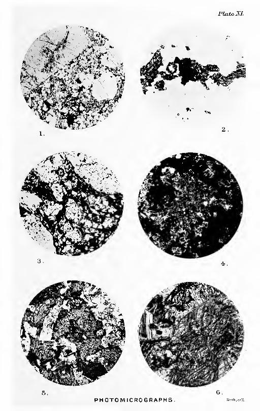
Plate^XI.
^ i^" ^
PHOTOMICROGRAPHS.


Missing Page

IFDEX.
Abhuinn a' Choibb Bhtjig, 26, 156,
157.
Ghlinne Bhig, 28, 34.
Beinn nan Eun, 18, 25, 80, 120.
Coir' a' Bhalagain, 159, 162, 167.
na Glasa, 2, 50, 73, 155.
Achandunie, 138.
Achnaoloich, 167, 173.
Acid plutonio rocks. Older, 5, 7, 9-10,46-48, 49, 53-67, 82, 83, 89-93,96-100.
^girine riebeckite gneiss, etc., 5, 54,
55, 58, 91-93, 182.
Airicheirie, 152. See also " Stratli-
derie."
Albite gneiss. See " Gametiferousalbite gneiss."
in Moine schists, 34, 37, 39, 41,
42, 43, 44, 104, 109.
Newer Igneous Eocks, 122,
129.
Older Igneous Rooks, 65,
66, 89, 91, 96, 97, 98, 101, 102.
AUadale, 13, 167.
Allt a' Bhealaich Mor, 18.
Choire Mlioir, 144.
Choire-rainicli, 140, 147.
Gharbh Bhaid, 12, 17, 18.
Ghlinne, 157.
Airidh Cheiridh, 29.
an Eilean Ghuirm, 59, 72.
Bheargais, 35.
Coir' a' ChUabhain, 151.
Chundrain, 155.
Coire Bheaohain, 18, 19.
Bhenneit, 78.
Misirich, 146, 154.
Dearg, 134, 158.
Eiteachan, 26, 120, 121.
Glas ToU Mor, 146.
Gleann Sgathaich, 17, 173.
Muigh-bhlaraidh, 137, 139, 168.
nan Caoraoh, 2, 17, 132, 134, 135,
146, 147, 153, 154, 155, 157, 162.
Alltan Dubh Mor, 32, 33, 34.
Sgeireach, 55, 56, 60, 63, 82, 84,
85, 117.
Alluvium, Freshwater, 5, 156, 161-162,
170.
Marine, 5, 160-161.
Alness, etc., 131, 136, '138, 156, 161,
162, 172.
Ahiess River, 2, 3, 9, 10, 22, 23, 132,
134, 136, 137, 138, 146, 150, 155,
161, 162, 166, 167, 168.
Ahiessferry, 138.
Am Faochagaoh, 1.
Mam, 23, 150.
Amhainn Glac an t-Seilich, 77, 78, 79.
Amphibohte (epidiorite, etc.), 5, 7, 23,
46, 47, 49-53, 67-72, 93-96, 100-102, 180, 182.
boulders, 154, 156.
An Cabar, 18, 150, 153, 154.
aaigionn, 25, 76, 77, 78.
Corran, 137.
Sooach, 16.
Analysis of asgirine riebeckite gneiss,
92.
biotite amphibolite, 95, 102.
cassiterite ore, 169.
gabbro, 95.
gametiferous albite gneiss,
97.
musoovite biotite schist,
112.
zoisite hornblende gran-
uUte, 45.
granite gneiss, 92.
of Glen Etive, 92.
hornfels, 112.
lamproschist, 125.
olivine dolerite, 102.
magnetite block, 98.
minette, 125.
peridotite, 127.
scyehte, 127.
serpentine, 127.
shale (Carboniferous), 112.
Andalusite pseudomorphs, 81, 103, 106,
107, 111.
ASTDEBSON, E. M., 6, 107.
Apatite in Moine schists, 39, 42.
Newer Igneous Bocks, 121,
122, 124, 128, 180.
Older Igneous Rooks, 89, 92,
93.
Aphte, Newer, 5, 113, 120.
Older, 5, 46, 49, 54, 56, 62-63, 89,
91.
Ardrosa, 3, 4, 133, 136, 137, 167,
168.
Ardroy Sand, 161.
I Assynt House, 173.
183

184 Index.
Augen gneiss and allied rooks, 5, 7, 8,
9, 10, 16, 20, 46-49, 53-57, 59-62,
80, 81, 83, 86, 89-91, 142, 143, 144,
145, 171, 172, 182.
boulders in drift, 9-10, 149,
150-154, 155, 156, 158, 159, 172.
in Old Red Sandstone,
131, 139, 140, 141, 142.
Auldgrande, 3, 9, 10, 135.
Aultguish, 2, 9, 71, 143, 145, 151, 152.
Aultnamain, 132, 133, 134, 137, 138,
158, 168.
Aureole. See " Hornfels."
Ausweichungsdivage. See " Strain-
slips."
Bad a' Bhathaich, 25, 30, 76, 77.
Balalochan, 155.
Baloonie, 161.
Ballavoulen, 147, 156.
BallindaUooh, 43.
Balnaoraig, 22, 23, 155.
Balnagown Castle, 174.
Babbow, G., 39, 40, 43, 74.
Basic Intrusive Rooks, Older, 5, 7, 46,
47, 49-53, 89, 93-96, 100-102.
Bathymetry of freshwater loohs, 4.
Bealaoh Tom a' Choinnioh, 17.
Beauly Firth, 151.
Bbokb, F., 107, 110.
Beinn a' Bhric, 131, 141, 142.
Chaisteil, 1, 29, 30, 40, 60,
71, 158, 160.
Clach an Fheadain, 114.
Dearg, 151.
nan Cabag, 141, 142.
Eun, 22, 25, 76, 78, 79, 80,
81, 150.
Oighrean, 121.
Tharsuinn (near Diebidale), 28,
30, 52, 76.
(near Strath Rusdale), 1,
22, 23, 24, 150, 151, 154.
Bendeallt, 9, 133.
Bending of ohiastoUte, 79.
Ben Vuroch granite, 74.
Wyvis, 1, 12, 16, 17, 18, 19, 20,
67, 71, 115, 129, 150, 151, 153, 154,
155, 157, 173.
District, Moine Schists of,
16-20.
Big Bum, 137.
Biotite hornblende schist, 69-71, 72,
102, 180.
Bituminous beds, 10, 135.
Black Isle, 132, 133, 138, 166.
Rook of Novar, 3, 9, 10, 135.
Blackpark, 138, 139, 168.
Blaokwater River, 1, 2, 15, 24, 150,
155, 167.
Blar Garvary, 157, 164.
Bloomeries, 168.
Bluish quartz in igneous rocks, 60, 64, 89.
Blunt-Maokenzib, E. W., 173.
Boath, 133, 136, 146, 147, 155.
Boathmore, 137.
Boathvio, 22.
Bodach Beag, 31, 34, 159, 164.
Mor, 1, 68, 70, 101.
Bog iron ore, 168.
nam Blast, 135, 146.
BOSWOBTH, T. 0., 106.
Boulder olay, 5, 155-166, 159.
Braeantra, 151.
Braetolhe, 22.
Breccia of hornblende schist, 53.
Broom, River, 151, 152.
Buckie, 151.
Buckley, T. E., 174.
Building stones, 172.
Gail Mhob, 32, 68, 145, 164." Cairngorms," 64.
Calcareous bands, etc., in MoineSeries, 13, 23, 28, 30, 32, 33, 36, 37,
38, 42-45, 87, 88, 103, 106.
Calc-biotite schists, 69-71, 72, 101, 180.
Cape Wrath, 128.
Carn an Liath-bhaid, 27, 54, 56, 59,
60, 82, 85, 87, 88, 159.
Lechan, 10.
Ban, 1, 32, 160, 165.
Beag, 24, 25, 77.
Bhren, 37, 45, 47, 55, 60, 64, 76,
82, 85, 87, 116, 129, 151.
Breao, 8.
Cas nan Gabhar, 25, 47, 76, 77,
78, 115, 128, 182.
Chuinneag, 6, 7, 8, 10, 35, 40,
55, 58, 62, 64, 90, 96, 97, 99, 159.
plutonic rocks, 5, 7, 46-55,
56-59, 60, 61, 62-67, 72, 73, 89-100,
171, 182.
Crom-loch, 158, 159.
Dearg lamprophyres, 123, 126.
Dubh, 51, 61, 62, 64, 91, 95, 120,
124, 144, 159, 182.'- Pearna, 15.—- Feur-lochain, 29, 32, 79.
Gorm, 15, 17, 153.
Gorm-loch, 28.
Loch nan Amhaichean, 20, 81,
107, 139, 143.
Mor, 18, 19, 48, 81, 119, 150.
na Speireig, 36, 37, 160.
nan Aighean, 47, 50, 60, 69, 141,
142.
Con Ruadha, 155.
Salochaidh, 35, 49, 56, 57, 59,
76, 85, 87, 159, 162.
Sonraichte, 55, 78, 150.
Carron, River, 2, 7, 70, 144, 162.Cabbuthers, R. G., 6.
Cassiterite, 5, 46, 64-67, 96-99, 169-171, 182.
ChiastoUte, 75, 79, 80, 86, 103, 107,
110, 111, 178.
Chlorite schist, 84, 117.
Church Hill, 113.
Cioch Mhor, 133, 135.
Qaoh Sgoilte, 28.
Clare, 3, 135.

Index. 185
Clarke, F. W., 95.
Cleavage in Old Red Sandstone, 135,
136, 137, 140, 146, 147, 148.
CLOuaH, C. T., 40, 99, 106, 107, 176.
Cnoo a' Mhadaidh, 23, 24, 67, 150.
an Liath-bhaid, 47, 63.
t-Saic. See " Cnoc nanSac."
t-Sithein Beag, 22, 146.
Mor, 22, 67.
Ceislein, 9, 133.
Duchaire, 9, 166.
Fyrish, 9, 137, 166.
conglomerate, 133, 135, 136,
137, 147.
GilleMo Bhrianaig, 132, 133, 134,
146.
Leathad na Siorramachd, 26.
Muig-bhlaraidli, 114.
na Sroine, 22.
Tuppat, 47, 60, 51, 63, 66,
63, 68, 69, 85, 86, 144.
nan Sac (Cnoc an t-Saic), 35, 36,
37, 47, 61, 62, 75, 82, 106, 116, 129,
159, 160, 162, 163.
District, Contact-meta-morphism, etc., in, 75, 81-87.
District, Moine Schists- of, 35-37.
Navie Wood, 138.
Thorcaill, 114.
CoiUe Coire MhuiHdli, 16.
Coire Bog, 163, 164, 167.
Mhoir (Ben Wyvis), 16.
Mor, 9, 13, 31, 67, 159.
fault, 9, 31, 33, 66, 144-145,
164.
na Feola, 16.
nan Sgulan, 24.
Composite sills (?), 70.
Conan, River, 2, 150.
Conglomerates, etc., in Moine Series, 13,
14, 16, 18, 20-22, 29-30, 32, 36,
40-41.
Contact - metamorphism near NewerGranite, etc., 114, 115, 116, 118.
Older Granites, 6-7, 73-
88, 102-107, 178.
Cordierite, 106.
Corriefeam gianite. See " Peamgranite."
CorriemoiUie, 150.
Cbampton, C. B., 6, 32, 92, 105, 176.
Creachan nan Sgadan, 25, 124.
Creag a' Ghaoirr, 24, 124.
Bhreac Mlior, 140, 142.
Dhubh Bheag, 30, 87.
Mhor, 87.
Illie, 52, 53, 58, 62, 72, 160, 163.
Liath a' Bhaid Sgailich, 79.
na Ceapaich, 27, 88, 106, 119,
120, 121.
Rainich, 28.
Riabhaoh, 33.
Ruadh, 8, 58, 66, 137.
Creagan an Eich Ghlais, 150.
Creich, 1, 161, 162, 166.
Crom Loch, 28, 29, 40, 118, 160.Ci-omarty Firth, 1, 2, 4, 8, 9, 10, 133,
137, 138, 156, 160, 161, 162, 168.
fish beds, 132.
CuiUich, 136.
CuUicudden, 138.
Culzie Lodge, 4, 23, 68, 124, 154.
Cunningham Craig, E. H., 90.
CUTHBEBT, T. W., 167.
Dakyns, J. R., 46.
Dalreoich, 23, 136, 138, 145. 147.
Deanich, 3, 28, 29, 31, 32, 34, 35, 68,
69, 71, 118, 119, 124, 160, 161, 163,
164.
Diebidale, 8, 51, 62, 64, 72, 169.
Forest, 126.
Ridge, 51, 63, 54, 60.
River, 49, 52, 63, 54, 58, 62, 86,
87, 95, 170, 171.
Dmgwall, 173.
Diorite boulders, 169.
Newer, 119, 128.
Dirrie More, 152.
Dixon, J. H., 168, 175.
Dolerite, Newer, 6, 116, 129-130.Dornoch Firth, 1, 11, 132, 150, 151,
161, 172.
Drainage, 2-3.
Druim na Damh, 132.
Gaoithe, 133, 158.
Drummond, 172.
Dun Creich, 161.
Dvmach Liath, 169.
Dunan Liath, 29, 32, 36, 40, 115, 119,
126, 127, 158.
Durness Limestone pebbles, 138.
Earth-creep, 160.
Eas a' Chonaisg, 135.
Easter Peam, 13, 157.
Bum, 114, 149, 162.
Economics, 167-173.
Edderton fish beds, 11, 132, 139, 174.
Bileanaoh, 22, 135, 147, 167.
Falls, 4.
Elongation of pebbles, etc. See"Stretching . .
."
Epidiorite. See " Amphibolite."Epidote, as clastic grains, 21, 36-37,
39.
Erratics, 9, 10, 149, 150-155, 158-159.Evanton, 3, 4, 131, 134, 137, 156, 161,
162, 172, 173.
False-bedding in Moine Series, 13,
19, 20, 21, 24, 27, 29, 30, 32, 36.
Fannich Hills, 43, 161.
Fannyfield, 134, 166.
Faults, General description of, 143-148.Peachdach, 153. See also " Piach-
lach."
Fearn Burn, 161.
granite, 7, 10, 22, 26, 66, 113-116,
121, 155, 156, 166, 172.

186 index.
Peam granite boulders in Old RedSandstone, 113, 134, 138.
Pebmob, L. L., 67, 176.
ITeur-looliain, 30.
Kachlach, 16, 153, 154.
Kndon Mains, 138.
Maser structure, 90, 111, 124.
Flett, J. S., 19, 20, 34, 37, 41, 49, 50,
51, 59, 66, 68, 69, 70, 71, 73, 75, 79,
83, 85, 87, 99, 115, 116, 117, 119,
120, 140, 169, 171, 176.
Fluor spar, 66, 90, 99.
Huvio-glacial deposits, 5, 156-158,
162(?), 173.
Foliation in Older Plutonic Rocks, 47,
48-49, 51, 52, 53, 55-57, 58, 61, 62,
63, 68, 69, 70, 71, 72.
Formations, Distribution and rela-
tions of, 6.
Tabular List of, 5.
Foulis, 137, 138.
Freevater Forest, 1.
" Fucoid beds," Pebbles of, 138.
Gabbbo, 5, 46, 50, 53, 89, 91, 93-96,
182Galena, 119, 171.
Garbat, 173.
Garbh Allt, 36, 55, 56, 60, 63, 82, 83,
84, 86, 103, 117, 124.
Garnetiferous albite gneiss, 5, 64-67,
96-100, 169-171, 182.
mica schist. Petrology of, 42, 178.
Garnets, Deformation of, 23, 75, 79, 86.
in hornfels, 79, 85, 104, 105, 109,
111, 115, 178.• pegmatite, 28, 114.
quartz mica syenite, 115.
schists. Growth of, 109, 111.
stippled schists. 111, 178.
Garve, 12, 15, 28, 150, 161.
pegmatite, 28.
Geikie, Sib A., 10, 175, 176.
Glacial action (?) in Old Red Sandstoneperiod, 55, 141.
Glaciation, Directions of, 28, 65, 149-
151, 152-155, 158, 159.
Glas Leathad Mor, 17.
Glascarnoch River, etc., 2, 9, 16, 28,
142, 143, 145, 151, 161.
Glass River, 2, 3, 4, 10, 135, 157, 161,
162, 166.
Gleann Beag, 1, 3, 8, 31, 68, 159, 160,
161, 162, 164.
District, Moine Schists in,
31-35.—— Mor District, Moine Schists in,
31-35.
Glen Calvie, 35, 36, 37, 70, 81, 119,
144, 162, 171.
District, Moine Schists in,
35—37'- Lodge, 36, 44, 45, 103, 124.
Water, 68, 159.
Diebidale, 9, 46, 49, 50, 51, 52,
63, 54, 87, 102, 159, 163, 164.
Glen Glass, 10, 22, 133, 155, 156.
Glenbeg (house), 28, 30, 31, 33, 34,
159, 163.
Gorm Looh, 160.
Gorstan, 161.
Gradal, 120, 121, 126.
Granite, Almost unsheared porphyritic,
60, 182.
Newer. See'
' Corriefearn granite.'
'
Sheared porphjrritio. See " Augen
Granulite and quartzite pebbles in
Moine schist, 20, 21, 36, 41.
Graphic granite pebbles in Moineschist, 21.
pegmatite, 28.
Graphite, etc., 42, 44, 75, 107, 178." Green Bed "(?), 71.
GBUBBNMAOTf, U., 49, 94, 110.
Grudie River, 16, 161.
GuNN, W., 28, 43, 139, 151, 154.
haematite, 41, 64, 168.
Haeker, a., 46, 86, 102, 110.
Habvie-Bbotcn, J. A., 174.
Heavy sediments, 21, 29, 32, 36-37, 39,
40,41.HiLLEBBAND, W. F., 95.
HiNXMAN, L. W., 6, 40, 43, 106, 129.
Hornblende biotite gneiss, 91.
granite or granite porphyry, 50-51,
60, 91.
in Moine Series, 23, 28, 33, 36, 37,
42-44, 87, 88, 105, 106.
HoBNE, J., 40, 43.
Hornfels near Newer Granite, etc., 114,
115, 116, 118.
Older Granite, 5, 6-7, 14, 20,
24,25, 26, 30, 35, 73-88, 103-112,
149, 171, 178.
Shearing of, 74-80, 81^87, 107-112, 178.
HUTCHINGS, W. M., 112.
ICHTHYOLITES, 139.
Inchbae, 7, 48, 54, 61, 81, 152, 154, 172.
Granite at, 9, 20, 48, 53, 64, 72,
73, 81, 89, 119, 172.
rock. See " Augen gneiss."
Inchlumpie Wood, 136, 146.
Invergorden, 173.
Iron ores, 65, 96-99, 168, 169-171.representing clastic grains,
21, 29, 32, 41.
Itabirite pebble in Moine schist, 41.
JoAss, A., 171.
J. M., 11, 139, 176.
Jolly, W., 9, 150, 175.
JUDD, J. W., 128
Kambs, 156-167." Kettleholes," 156.
Kildary, 174.
Kildermorie, 25, 47, 76, 77, 88, 164,
156, 171.

index. 18t
kildermorie Forest, 3, 71, 73, 151, 155.
Kiltearn, 137.
Kincardine, 2, 27, 113, 149, 150, 161,
166, 168, 172.
Bum, 126.
Moine Schists near, 26-27.
Kinlooh, 120.
Knocklea, 137.
Knoten, etc., 75, 78, 81, 82, 83, 84, 86,
103, 105.
Kyanite, 79, 81, 107, 110, 111, 178.
Kyle of Sutherland, 2, 8, 150, 161, 162,
166.
Laccolite structure, 14, 47, 54.
Lake basins filled up, 2, 3, 156, 158,
160, 161, 163.
Lamprophyres and lamproschists, 5,
7, 84, 85, 113, 116-126, 171, 180.
Landslips, 49, 164.
Leaba Bhaltair, 47, 49, 51, 52, 57, 62,
66, 72, 87, 90, 91, 106, 144.
Leac Ghorm, 36, 157.
Leathad Riabhach, 24.
Lewis, F. J., 163, 168, 176.
Lewisian Gneiss, 5, 12, 15, 17.
Limestone, etc., in Old Red Sandstone,
132, 135, 138, 139, 140.
Linear foliation or rodding, 49, 51, 52,
53, 55, 58, 62, 64, 86.
Literature, 9-11, 175.
Little Wyvis, 13, 15, 16, 17, 150, 153,
154.
Loanroidge, 136, 137, 147.
Loch a' Chaoruinn, 24, 78, 79, 155.
Choire Mhoir, 33, 34, 115,
129.
Bad a' Bhathaich, 77, 124.
Bealach Culaidh, 4, 18.
Broom, 152, 154.
Chuinneag, 64.
Coire Bheachain, 20.
Mhic-mhathoin, 33, 34, 45,
69, 160.
Couhn, 161.
Droma, 5, 151.
Garve, 28, 161.
Glass, 1, 2, 3, 4, 16, 19, 22, 23, 24,
28, 48, 68, 120, 124, 150, 151, 153,
154, 157, 167, 173.
District, Moiue Schists in,
22-26Luichart, 1, 4, 7, 9, 12, 13, 15, 16,
17, 18, 20, 48, 131, 142, 143, 150,
151, 161, 167, 172, 173.
Lodge, 120, 143.
Magharaidh, 78, 151, 155.
Misirich, 17, 20, 66, 162.
Morie, 2, 3, 4, 9, 22, 23, 24, 25,
28, 67, 115, 145, 131, 155, 167.
District, Moine Schists in,
22—26'-
fault, 9, 23, 25, 26, 47, 136,
137, 145, 146, 147, 168.
na Gabhalach Nodha, 34, 160.
Glasa, 50, 52, 60, 72, 155.
Loch nan Amhaichean, 80.
Druidean, 19.
Sruban Beaga, 144.
Mora, 32, 34.
ToU a' Mhuic, 2, 29, 145.
Lochan a' Chairn, 54, 59, 62, 63, 78,
107, 159, 160, 164.
Gobhlach, 20, 21, 40, 155.
Lice, 145.
nan Leac, 32, 33, 34.
PoUaig, 70, 101.
Sgeireich, 160.
Lochs, Bathjnmetry of, 4.
Loewinson-Lessino, ¥., 107.
loveqrove, e. t., 171.
Luachar Mhor, 158.
Lubachlaggan, 27, 70, 151, 158.
Lubnaceardaich, 120.
Lubriach, 140.
Macadam, W. Ivison, 168, 175.
MacAlisteb, D. a., 99.
MacGitlloch, J., 9, 175.
Magnetite, 64-67, 96-100, 169-171.
-representing clastic grains, 21,
29, 41.
MeaU a' Chaoruinn, 25, 145, 150.
^— Ghrianain, 1, 8, 30, 113,
131, 141, 149, 151, 152, 155, 158,
160, 164.
an Leathad, 134, 137, 146.—— Torcain, 28.
Tuiro, 9, 132, 133, 146.
Beag, 23, 24.
Bhenneit, 76, 78, 171.
Coire nan Laogh, 28, 155.
Dionach, 32.
Eadar an da Chuinneag, 58, 64.
Gorm, 28, 160.
Mor, 23, 151.
nah-Uigeig, 25, 27, 76, 87, 88, 149.—— Rainioh, 69.
Speireig, 17, 153, 154.
nam Bo, 73, 145.
MuUaoh, 81, 139.
nan Sac, 21, 54, 55, 64.
ToU a' Choin, 25, 76, 77.
Meallan Ban, 27, 28, 29, 30, 160, 162.
Meig valley, 143.
Mbiklbjohn, J., 166.
Mica trap and minette, 5, 116, 117,
118, 119, 120, 121, 122, 124, 125.—— —— pebbles in Old Red Sand-
stone, 113, 140.
MicrocUne structure. Development of,
89, 91.
Micropegmatite pebbles in Moineschist, 29.
MiLLEB, Httgh, jun., 3, 138, 175.
SEN., 9, 10, 150, 175.
Milton of Katewell, 134, 156.
Mixture rock, 50, 51, 60, 91.
Moine Schists, 5, 6-7, 8, 9, 12-45, 165,
172.
from homfels in part, 73-74,76-80, 82-87, 108-112.

188 Index.
Moraines and morainic drift, 5, 161,
154, 155, 157, 158, 159, 160, 170, 171.
MoBBisON, W., 10, 139, 150, 151, 168,
175.
Mortar structure, 40, 59.
Mossford, 143.
Mountgerald, 137, 161.
Mulloch Coire na Gaoitheag, 145.
——Creag Riaraidh, 37, 49, 50, 53,
72, 82, 86, 98, 118.
Mttbchison, Sie R., 10, 139, 175.
Mttbgooi, G. M., 92.
Mttbray, Sir John, 4, 176.
Nbthbbly, 106.
Newer Intrusive Igneous Rocks, 5, 7,
8, 9, 70, 84, 85, 99, 113-130, 155,
165, 172, 180.
Newlajstds, a., 173.
NicoL, J., 9, 150, 175.
Novar, 156, 166.
Old Red Sandstone in drift, 152,
153, 154, 155, 156, 158.
Middle, 5, 7, 8, 9,
10-11, 131-142, 143-144, 145, 146,147-148, 166, 168, 172, 173.— Upper, 174.
Older Basic Intrusions, 5, 7, 46, 47,
48, 49-53, 67-72, 93-96, 180, 182.
Granites. See " Augen gneiss.''
Intrusive Igneous Rocks, 5, 7,
35, 46-72, 142, 145, 169-171, 172,
180, 182.
in drift, 9, 10,
149, 150-154.
Ortliite, 41, 43, 89, 114, 122, 123, 124.
Paisanitb gneiss. See " .fflgirine rie-
beckite gneiss."
Pavement or Pfiaster structure, 87,
106.
Peach, B. N., 6, 48, 55, 73.
Peat, 5, 162-164, 167-168, 170.
Pebbles in Moine rocks, 13, 15, 18,
20-22, 24, 27, 29-30, 36, 40-41.
—Old Red Sandstone, 131,
138, 140, 141, 142.
Pegmatites, 8, 17, 20, 23, 28, 30, 32,
34, 134, 136, 138.
of Newer Igneous Rocks, 114.
Older Igneous Rocks, 46,
54, 56, 63-64, 89, 91, 92, 99.
Peridotite, 5, 115-116, 126, 127, 128.
Pebbins, 0. W. D., 167.
Petrography of sBgirine riebeckite
gneiss, 91-93, 182.—— Moine Schists, 38-45, 107-
112, 178.
• Newer Igneous Rooks, 120-130, 180, 182.
•Older homfelses, 102-112,
178.
Igneous Rocks, 89-102, 180, 182.
^sheared homfelses, 107-112.
Pfiaster or pavement structure, 87,
106.
Physical Features, See "Scenery in
relation to Geology."
Pitch, 12, 17, 18, 31.
Planes of denudation, 1-2.
Plateau frost debris (disintegrated
rock), 141, 159-160, 170.
Polinturk, 139.
Pollard, W., 45, 85, 93, 97, 98, 102,
112, 125, 169.
Psilophyton shales, 138.
PuLLAE, Lattrence, 4, 176.
Pyrites, 83, 100, 117, 119, 122, 130,
171.
Pyroxene hornfels, 87, 106.
Quartz Felsite peebles in Moineschists, 21.—— growth at sides of garnets, 33,
79, 86.
veins, 25, 30, 32, 34, 53, 54, 56,
58, 63, 64, 85, 159, 171.
Quartzite and granulite pebbles in
Moine schist, 20, 21, 36, 41.
Radlby, E. G., 93, 102, 112, 125.
RainfaU, 4-5.
Raised sea beaches, 5, 160-161.
Ramsay, Sir W., 171.
Redburn, 135, 157.
Reid, Clement, 163.
Riebeckite gneiss. See " jEgirine rie-
beckite gneiss."
Riecke'slaw, 110.
Ripplemarks (?) in Moine rocks, 14, 24,
79 82Road metal, 43, 171-172.Rock basins, 4, 160.
Rodding. See " Linear foliation."
Rogie Burn, 173.
Ross of Mull, 43, 106.
Rothes, 106.
Salachib, 168.
Scenery in relation to Geology, 3, 8-9,
23, 50, 54-55, 68, 71, 83, 135, 136,
137, 145, 151-152, 156.
SchiohalUon Boulder Bed, 90.
Sohlich, W., 167.
ScyeUte, 6, 115, 128-129, 182.
Sedgwick, A., 10, 175.
Serpentine, 127.
Sgor a' Chaoruinn, 76, 78, 79, 80.
SiUimannite, 75, 77, 81, 83, 103, 106.Sinclair, Sib Robert, 128.
Sithean a' Choin Bhain, 23.
Skiack River, 3, 133, 134, 137, 156,162.
SOBBY, H. C, 110." Spangle schists," 17, 22, 24, 34.
Spean Bridge, 43.
Specular iron ore, 64.
Springs, 135, 146, 173.
"Stippled schists," 83, 86, 108, 111,
118, 178.
Index. 189
Stittenham, 167, 173.
Strain-slips, 19, 24, 28, 48, 49, 56, 57,
61, 117.
Strath Mor, 133.
Oykel, 150.
Raimooli, 8, 54, 113, 140, 141,
142, 147, 153, 155, 167.
Burn, 61, 141.— District, Moine Schists in,
20—22Kusdale, 1, 2, 22, 23, 24, 67, 69,
71, 136, 150, 151, 154, 155, 162, 166,
167, 168, 171, 172.
Skiack, 9, 133, 146, 161, 167.
Vaich, 1, 2, 3, 9, 131, 141, 144,
145, 146, 151, 162, 167.
District, Moine Schists in,
27-31.
fault, 144-145.
Forest, 152, 155.— Biver, 140, 146.
Strathconan fault, 9, 15, 16, 20, 35-36,
48, 66, 80, 117, 143-144.
Strathderie, 5, 29, 152, 161.
Strathgarve, 13, 16, 17, 153, 167.
StrathpefEer, 173.
"fish beds," 133.
Strathrory, 138, 156, 158.
River, 134, 138, 158.
Stretching of pebbles, etc., 21, 27, 29,
30, 32, 36, 40, 81, 83, 84, 85, 86, 87.
Struie, 146.
Hill, 9, 13, 26, 133, 134, 149.
Sunoracks (?) in Moine rocks, 14, 75,
78, 88.
Sutors of Cromarty, 10.
Swordale, 3, 134.
Syenite, Quartz mica, 115.
Tait, D., 139.
Tball, J. J. H., 28, 38, 40, 43, 44, 46,
128, 176.
Teaninioh House, 161.
Terraces, Fluvio-glacial, 157-158.
River, 161-162.
Thomas, H. H., 99.
Thrusts and shear zones, 55, 56, 57, 60,
69, 74, 75, 77, 83, 84, 85, 103, 116,
117, 118, 124, 180.
Tighnacreige, 157.
Tinstone. See " Cassiterite."
Toll Lochan, 31, 33, 34, 45, 159, 160.
ToUie Bum, 22, 137, 146.
ToUomuick Forest, 28.
Tom Ban Beag, 28, 29.
— Mor, 28.
Torr Leathann, 22, 113, 114.
Torridon Sandstone, Pebbles of, 131,
138Tourmaline, 20, 39, 66, 99, 114.
Teaqttaib, R. H., 139, 174, 175.
TuUoch Hill, 132, 167.
Ullapool, 152.
Upper Ardchronie, 156.
Park, 3, 134.
Van Hise, C. R., 107.
Vogesite, 117, 120, 124, 180.
VoGT, J. H. L., 99.
Wallace, T. D., 150, 175.
Water supply, etc., 160, 172-173.
Watson, W., 175.
Watt, A., 4.
Wester Fearn. 120, 156.
Burn, 113, 114, 120, 124,
149, 156, 162.
White HiUs, 156.
Wilson, J. S. G., 40, 43.
Woodlands, 137.
Worm-tubes (?) in Moine rocks, 88.
Wbight, W. B., 84.
Wyvis Forest, 4.— Lodge, 24, 120, 155.
ZiKCON, 39, 41, 42, 44, 89, 92.
Zoisite granulite, etc., 19, 23, 28, 30,
33, 36, 37, 38, 42-45.
in homfels, 87, 88, 106.


List of Publications of the Geological Survey of Scotland^continueA.
Us. 9d.
13s. Zd.
8s. 9<i.
Us.
Haddingtonshire.
Fifeshire.
76. Aberdeenshire, Kiaoardineshire (parts of). 13s. Sd.77. Aberdeenshire, S.E. part; Kincardineshire, N.E. corner. 8s.
81. Eoss-shire, S.tV. ; Islands of Eaasay and Eona, part of Skye.85. Elginshire, Baliffshire, Aberdeenshire (parts of). 20s. 9d.87. North-East Aberdeenshire and Banffshire (detached portions).91. Eoss-shire (part of). 15s. ed.94. Eoss-shire, Cromartyshire, Sutherlandshire (parts of).
95. Elginshire, Banffshire (parts of). 5s. 3d.96. Aberdeenshire, Banffshire (parts of). 7s. Sd.97. Aberdeenshire and Eastern Banffshire (parts of). 4s. 6d.
100. N.W. Eoss-shire (part of). 2s. 6d.101. Eoss-shire, Cromartyshire and Sutherlandshire (parts of),
103. Sutherlandshire, E. 8s. 9'd.
107. Sutherlandshire (part of). 25s. 3d.113. Sutherlandshire, N.W. (part of). 5s. 3d.114. Sutherlandshire (part of N.}. 13s. 3d.115. Sutherlandshire, Caithness-shire (jlarts of). . 19s. 3d.
Maps on Six-inch Scale, illxistrating the Coal-flelde.Edinburghshire. Sheets 1, S."W. (and 1b, S.E.), S.E. ; 3, N.W., N.E.,
S.W., S.E. ; 4, N.W., N.E., S.W., S.E. ; 4a., S.W.;5, N.E., S.E. ; f-, N.E., S.E. ; 8, N.W., N.E., S.W.,S.E. ; 9 (and Haddington 14), N.W., S.W., S.E. ;
11, N.W., S.W. ; 12, S.E. ; 13, N.W.,N.E., S.W.,S.E. ; 14, N.W., N.E., S.W., S.E. ; 15, N.W. (andHaddington 18, N.W.) ; 18, N.E. ; 19, N.W., N.E.(revised editions). Is. 6d. (uncoloured).
Sheets 4, S.W., S.E. ; 9, N.W., X.E., S.W., S.E. :
14, N.W., N.:E., S.W., S.E. ; 18, N.W. (revised
editions). Is. 6d. (uncoloured).Sheets 24, 6s. 3d. ; 25, 4s. 3d. ; 30, 31, 8s. 3d. ; 32, 37,
5s. ; 33, 2s. ; 35, 7s. ; 36, lis.
Sheets 7, 12, 13, 17, 19, 22, 23, 24, 28, 30, 36, 42, 46,52, 8s. 3d. ; 8, 40, 8s. ; 9, 4s. 3d. ; 11, 18, 29, 34,41, 9s. 9d. ; 16, 6s. 3d. ; 26, 27, 31, 5s. 9d. ; 33, 7s. ;
35, lis. ; 47, 7s. 9d. ; 50, 10s. 3d.
Sheets 7, 11, 9s. 9d. ; 8 and 9, 13, 5s. ; 12, 8s. 3d. ; 14,3s. ; 15, 16, 7s. ; 17, 3s. 9d. (old editions).
Sheets 12, N.E., S.E. ; 13, g.W. (revised editions). Is. 6d.• (uncoloured). '
Sheets 1, 3s. 3d.; 3, 3s. 9d. ; i,' 2s. 9d. ; 5, 23j 3d.;24, 7s. ; 11, 17, 20, 31, 38, 41, 42, 8s. 3d.; 8, 23,
25, 32, 7s. 9a!. ; 9, 19, 6s. 3d. ; 12, 13, 16, Bs. 9d. ;
10, 5s. ; 18, 37, 9s. : 49, 4s. 3d. (old editions).
Sheets 1, S.E. ; 2, S.^., S.K ; 6, N.W., N.E., S.W.,S.E. ; 7, N.W., N.E., S.W., S.E. ; 8, N.W., KE. ;
10, N.W. ; 11, N.W., S.W. (revised editions).
Is. 6d. (uncoloured).Sheets 1, 3s. ; 5, 7, 5^. 9d. ; 6, 8s. 3d.
Sheets 19a, 20, 24, 2s. 3d. ; 23, 7s. 9d. ; 25, '6s. 3d. ;
26, 3s. 3d.'; 28, including 29, 3s.
Sheets 17, 28, 8s. 3d. ; 18, 31, 4s. 3d. ; 23, 27, 9s. ; 24,5.?, 9d. ; 25, 2s. 9d. ; 29, 7s. ; 30, 32, 5s. ; 33, 36,2s. 3d. ; 35, including 84, 6s. 3d. (old editions).
Sheets 27, S.E. ; 28, S.W. ; 32, N.E. ; 33, N..W. (revised
editions). Is. 6d. (uncoloured).Sheet 8, 5s. 9d. (old edition).
Sheets 1, N.E., S.E. ; 2, S.W. and N.W., S.E. ; 3,
S.W. ; 6, N.W., N.E., S.W., S.E. ; 7, N.W. andS.W. ; 9, N.E., S.E. ; 10, N.W., S.W. ; 12, N.E.(revised editions). Is. 6d. (uncoloured).
Sheets 133, 9s. 9d. ; 134, 140, 8s. 3d: ; 135, 5s. ; 139, 14^3s. ; 141, 2s. 9d. ; 143, 2s.
Maps on Six-inch Scale, illustrating Structure ofN.W. Highlands.Sutherlandshire. Sheets 5, lis. ; 71, 20s. 3d.
Skye Sheets 38, 20s. ; 39, lOs. ; 44, 22s. 9d. ; 45, 24s.
Maps on the Scale of Four Miles to One Inch.Sheet 12. Perthshire, Forfarshire, Kincardineshire, &c.
„ 16. Galloway and part of Ayrshire, &c.
,, 17., Eoxburghshire, Dumfriesshire, &c.
Printed in Colours. 2s. 6d. each.
Horizontal Sections.Sheet 1, Edinburghshire and Haddingtonshire. 3s. 9d.
„ 2. Edinburghshire, Haddingtonshire, Berwickshire. 4s. 3d.
,, 3. Peeblesshire, Edinburghshire, Linlithgowshire. 4s. 3d.
4. Ayrshire Coal-fielda (west side). 4s. 3d.
,, 6. Ayrshire Coal-fields (east side). 5s. Sd.
Ayrshire.
Eenfrewshire,
Lanarkshire.
Dumfriesshire.
Dumbartonshite.
Stirlingshire.
Linlithgowshire.
Perthshire.
List of Pvhlications of the Geological (survey of Scotland—contmuea.
Sheet 6. Kenfrewshire, Dumbartonshire, Ayrshire. 5s. 9d.
„ 7. Cheviot and Lammermoor Hills. 5s.
,, 8. Clyde Coal-field and Campsie Hills. 5s.
„ 9. Ayrshire Coal-fields (Muirkirk and New Cumnock). 5s. 9d.
Vertical Sections, is. 8d. per Sheet.
Sheet 1. Edinburgh and Haddington Coal-fields.
„ lA. Midlothian Coal Basin (middle portion).
„ IB. „ ^, „ (western side).
If if'- >) J) )» ( J
I
3i }•
„ Id.' ,, • „ „ (eastern „ ).
,, lE. East Lothian Coal Basin.
„ 2. Fife Coal-fields.
„ 2a. Fife Coal-fields.
„ 3. Kilmarnock Coal-field.
„ 4. Clyde Basin Coal-field.
„ 5. Stirling and Clackmannan Coal-fields.
„ 6. Muirkirk, Lesmahagow and Douglas Coal-fields.
,, 7. Lanarkshire Coal-fields (Rutherglen and Carluke).
Memoirs of the Geological Survey of Scotland.(1.) General Memoie:—
Silurian Rocks of Britain. Vol. 1. Scotland. 15s.
. (2.) EooNOMic Memoir :— *
The OU-Shales of the Lotliians. 4s.
(3.) Museum Gtjide :
—
Guide to the Collections of the Geological Survey. Id.
(4.) District Memoirs:^Cowal, Argyllshire. 6s.
The Geology of the Neighbourhood of Edinburgh. (Second edition.) 7s. 6d.'
East Lothian. (Second edition.) 4s. 6d.
Central and Western Fife and Kinross. 5s. 6d.
Eastern Fife. 8s.
Skye, the Tertiary Igneous Eocks of. 9s.
Islay, &c. 2s. 6rf.
The Geological Structure of the North-West Highlands of Scotland. 10s. 6d.
The Geology of the Glasgow District. 4s. Gd. <
Palaeontology. The Higher Crustacea of the Carljoniferous Books of Scotland.
4s.
(5,) Sheet Memoirs :—Sheet 1. Wigtownshire, South-Western Districts. Sd.
,, 2. Wigtownshire, South-Eastern Districts. 3d.
„ 3. Wigtownshire, Western Districts. 3d.
„ 4. Wigtownshire, E. part; Kirkcudbrightshire, portion of S.W.Division. 9d.
,,- 5. Kirkcudbrightshire, Southern Districts. Is. 6d.
„ 7. Ayrshire, South-Western Disti'ict. Sd.
,, 9. Kirkcudbrightshire, N.E. ; Dumfriesshire, S.W. Is.
,,"13. Ayrshire, Turnberry Point. Zd.
,, 14. Ayrshire, Southern District. 3d.'
,, 15. Dumfriesshire, N.W. ; Ayrshire, S.E. ; and Lanarkshire, S. 3d.
,, 21. Buteshire (Arran, Central; and N. and S. Bute), Argyllshire, Ayrshire
(parts of). 4s.
„ 22. Xyrshire, Northern District, and parts of Renfrewshire and Lanark-shire. 3d.
,, 23. Lanarkshire, Central Districts, j Is.
,, 24. Peeblesshire, Lanarkshire, Edinburghshire, Selkirkshire (parts of). 3d.
,; 28. Knapdale, Jura and North Kintyre. 3s.
,, 31. Lanarkshire, N. ; StirKngsMre, S. ; Linlithgowshire, W. . 2s. 3d.
, , 34. Eastern Berwickshire. 2s;
,, 35. Colonsay and Oronsay, with part of the Ross of Mull. 2s. 3d.
„ 36. Seaboard of Mid Argyll. 2s. 3d.
„ 37. Mid Argyll. 3s.
,, 45. Argyllsliire, The Country near Oban and Dalmally. ^s. 6d.
,, 55. Perthshire, The Counti-y round Blair-AthoU, Pitlochry, Aberfeldy. 3s.
,, 60. The Small Isles of Inverness-shire, is. Sd.
,,70. Inverness-shire. West-Central Skye, with Soay. Is.
,, 71. Inverness-shire. Glenelg, Lochalsh and the South -East part of
Skye. 3s. 6d.
,, 75. Inverness-shire, Elginshire, Banffshire, Aberdeenshire (parts of).
Is. 6d.
,, 76. Aberdeenshire, Central. Is.
,, 85. Elginshire, Banffshire, Aberdeenshire (parts of). U. 6d.
,, 87. Aberdeenshire and Banffshire (parts of). Sd.
,, 93. Ross-shire, Ben Wyvis, Cam Chuinneag, Inchbae, &o. 4s.
,, 97. Northern Aberdeenshire. Eastern Banffshire 4^.
(6.) CATALOGTrB OF GEOLOGICAL PHOTOGRAPHS. Series B and C. od.
(7.) Description of Arthur's Seat Volcano. 6d.
A detailed Catalogue may he had on application to Messrs. W. & A. K. Johnston, Ltd.,
2 St. Andrew Square, Edinburgh.


£9M
'j^ h:sy-^^
)^i
I >
,^' ^ r -
m ' -v.^