
THE FOUR SEASONSfourseasonshoa.net/images/Plats.pdf · THE FOUR SEASONS A PARCEL OF ... tV/tbmmutto...
16
3L H-Z. H THE FOUR SEASONS A PARCEL OF LAND IN THE PL. SPENCER D.L.C. No.49 SECTION 17 TIS., RIW, WM. WASHINGTON COUNTY, OREGON 'ÿ•V DATE « AUGUST 1968 N88'Z8 38" W SCALE = I =60' <S SOOO' 7S.OB 74. 95 74.99 74. 99 74.99 74.99 LC. 99 07. 93 45.QO S 00 74 99 //V/7/A7. CENTER LINE CURVE DATA C£/£>1/jT A/a. £)£-£ rA &ao/us a r//or/-/ (THO/e/D CA/O&0 &SA&/A4 a Si / 9*S3'JO" 733 /O S30.S7' /3 a.39 A/OS'/S'4S "S A S /4' /3' S*7~ 337x33' 9/.S7' 9/. /4' S<34'SS SO /Y A3 /3*S/' //- 030.00 ' / 93. <4 /93.00 S3rJ<7 33 \£~ A4 /9*so'oo~ 300.00 * /OS. /O ZO/3/ S<34'34 os /r AS 4'S4'SO" / O/S OS ' 33.37' S3.3S' S47*J0 30 A3 3'44 /S - SS/0.9S' /4J. /9' /4J . /<£ ' SOS* 33 33 /r A7 /4* so O/S OO' /SS.4/ ' /S3 00' A/S9*SS'// "S' JO S'39'43" 030.00' OS.OS' OS.OO' SOS* JO' SO' £T - — 1 — so j i 0/ REGISTERED OREGON Land surveyor JULY M. 1964 l£LANO H. ASCHER 935 LOT CURVE DATA AOT ÿVo. /D£~L 7~A &A/3/US X £A/CTA/ C//OJZ0 c//ojes> &SA&/A/C / S*43' 39 " 7 SO /<5 73. 7 4 ' 7S. 70 S <9 J' 09 '37"/V 3 - os- oj~ 7SO /<3 3 3 3 9' S3. SO- S 79* /O S3 7V S 3* SS'OOr 3 97 OS ' S33S SO.37' 3 73* SO'SJ~/V 3 AOmS/'S 4" 3 97. OS 7S 4 4' 7S.33' 3 33' OJ'SO /V 3 00*40' Sÿ~ SOOO so. /a ' SS.3 9' 774/* 49' SO £- 9 90*/9 00 SOOO' 3 / S3 SO S/' S 43*39 43 - S // O'/O /S" asJ. 39' 3 7. 7S ' 3 7. 73' /V 73*43 '4 S /V /S 0*3/ 4S~ 3S4 S9' 74.4 7 74 3/ S0/'43 O3' S" /3 3*34 /3 a 34 S 9 7S. O3' 74 99' /V33*/0 03/V /J /S* 49 3S 337 SC. 73 OS 7S.43' /VOS'OOOSS' /3 4*47/3 3 / 3 /O' 00.30' 33.33' // 79*39 33 "£~ /S /*S4 39- 33 7.33' 4 .30 3 SO A/ 77*33 OA'S" /a s*/7"szr 4/& /<?* 7S.6S' 73.3*' 7/34*4203 S
Transcript of THE FOUR SEASONSfourseasonshoa.net/images/Plats.pdf · THE FOUR SEASONS A PARCEL OF ... tV/tbmmutto...

3L H-Z.
H
THE FOUR SEASONSA PARCEL OF LAND
IN THE PL. SPENCER D.L.C. No.49SECTION 17 TIS., RIW, WM.
WASHINGTON COUNTY,OREGON
'ÿ•V
DATE « AUGUST 1968N88'Z838" W
SCALE = I =60'<S SOOO'
7S.OB 74.95 74.99 74. 99 74.99 74.99 LC. 99 07. 93 45.QO
S 0074 99
//V/7/A7.
CENTER LINE CURVE DATAC£/£>1/jT
A/a. £)£-£ rA &ao/us ar//or/-/ (THO/e/DCA/O&0
&SA&/A4aSi / 9*S3'JO" 733 /O S30.S7' /3a.39 A/OS'/S'4S "SA S /4'/3'S*7~ 337x33' 9/.S7' 9/. /4' S<34'SS SO /YA3 /3*S/' //- 030.00' / 93. <4 /93.00 S3rJ<7 33 \£~A4 /9*so'oo~ 300.00* /OS. /O ZO/3/ S<34'34 os /rAS 4'S4'SO" /O/SOS' 33.37' S3.3S' S47*J0 30A3 3'44 /S- SS/0.9S' /4J. /9' /4J. /<£ ' SOS* 33 33 /rA7 /4*so O/S OO' /SS.4/ ' /S3 00' A/S9*SS'// "S'JO S'39'43" 030.00' OS.OS' OS.OO' SOS*JO'SO'£T
-— 1—so j i 0/
REGISTEREDOREGONLand surveyor
JULY M. 1964
l£LANO H. ASCHER935
LOT CURVE DATAAOTÿVo. /D£~L 7~A &A/3/US X £A/CTA/ C//OJZ0
c//ojes>
&SA&/A/C/ S*43' 39 " 7SO /<5 73.7 4 ' 7S. 70 S <9J'09 '37"/V3 - os- oj~ 7SO /<3 33 3 9' S3.SO- S 79*/O S3 7VS 3* SS'OOr 397 OS' S33S SO.37' 3 73*SO'SJ~/V3 AOmS/'S4" 3 97.OS 7S4 4' 7S.33' 333'OJ'SO /V3 00*40'Sÿ~ SOOO so. /a ' SS.39' 774/*49' SO £-9 90*/9 00 SOOO' 3 / S3 SO S/' S 43*39 43 - S
// O'/O /S" asJ. 39' 3 7. 7S ' 37. 73' /V 73*43'4S/V/S 0*3/ 4S~ 3S4 S9' 74.47 74 3/ S0/'43 O3' S"/3 3*34 /3 a34 S9 7S. O3' 74 99' /V33*/0 03/V/J /S*49 3S 337 SC. 73 OS 7S.43' /VOS'OOOSS'/3 4*47/3 3 /3 /O' 00.30' 33.33' // 79*39 33 "£~/S /*S4 39- 337.33' 4 .30 3 SO A/ 77*33 OA'S"/a s*/7"szr 4/& /<?* 7S.6S' 73.3*' 7/34*4203 S

@>Jc, 17. fftgts 3-
[1
THE FOUR SEASONS No. 2A PARCEL OF LAND
IN THE P. L.SPENCER D.L.C. No. 49SECTION 17 TIS., R.IW., W. M.WASHINGTON COUNTY, OREGON
DATE = AUGUST 1968 SCALE:l"=IOO'/v as
TRACT
£p<?o
\jiLLACc Z *4A/£-§
a0.0/
or\ *20 ÿ>SN v
ao.sc
4000" «<?o.oo OO OO
* iP
£<erjKtr PX..Spencer h.
SURVEYORS CERTIFICATE
fj fe/ond //. Pscber, be/ny first du/y sworn,depose and say /ha/ Ihave correct/ysurveyed and mar/red wifh S/4"x 30" iron rods a// /of corners, curve points and boundary/ine changes /a direction, /be /ends described on /be annexed p/af of '7~//2~ 2~04//257/ÿ50ÿ5 /Vo. <?J' and ffia/ as /be initio/ point of sa/d survey / set an ironpipe 2"indiameter and 36" in /enyfh, <* ~ be/orv /be surface of /he ground 0/ a point which isA/or/b 0*4930~fas/ //35.64fee/ of /be 5oufbrves/ comer of /be ftf .Spencer 0./..f. A/a.49; 3arid point bcin<? on /be /Vest /fac of the Spencer 0.JL.6.y /hence A/or/b 0*4930~fdafj cr/onep /be staid /Yes/ /fne, 35./7 fee/;/fence Sou/b S3'23'3d~2<asf, pcra/fef to /heSoutb fine of See/ion /7y Tb/vnsbip / South, 5*cjayc / /Yes/ of /be /Yi//ame//e Aferidiarr $ adistance of /02O. 7/ fee/ fo /be /Yes/ 0ify fimif /ine of /be City of Scorer/onf Oreyony /beneeSou/b /*29'47"/Yesfj a/any said <Cify /fjnif fine, 237.26 fee// fbence A/or/b 39'SO'34"/Vest4/0.31 feet;fbence A/or/b f*2?V7" fas/ 36.44 fee/y fbence Sou/hrves/erfy, olony a /70 foot radiuscurve fo /be /eft {/he tony chord of which bears South 5S*4/'37" /Yes/ 46.62fee/)an arc distance ÿ
of 46.77 fee/y /hence South 47'J243"/Yes/ 3.23 fee/y /hence Sox/htvesferjy,o/o/r<y a 230 foot rad/usCurve fo /be riyhff/he /on<p chordof which bears South 62*5/24'/Yes/ //f.43 fee/) an are distance, of/2G. 73 fee/ fbence South 77m54 03" /Vest 23.54 fee/y /hence A/or/bwes/er/yJaAiny a 256-06foot radius curve to /be riyhffthe /ony chord of which bears A/or/b 6Sm03'57"/Yes/ 226.37fee/ J an arc distance of 303.39 fee/; thence A/or/h 34*05'57~ /Vest 57.23 fee/yfbence A/or/bwes/er/yj atom7 a /70.00 /oaf radius curve fo /he /eff fthe /o/ry cnardofwhich bears A/or/b <60*53'42~/Yesf /53. 72 feef ) an are distance of /5?.50 fee/ fo/be pain/ of beyinnir?<y.
REGISTEREDOREGONLAND SURVEYOR
& au—/e/and At. Ascber,O. S. A/o. <635
U- y ta »*««
H. ASCHER635 \
<2<4
1*
Subscribed and swam before n?c /bis_2_ day **f /963.
\>>>
//So/or/ /'irb/fc in ortcf fo/Y SSaf<s of Oregon
Uf iZomm/ssion £!~jrpir<2a_Mas. /37Z.
%%ij
I
1*i

THE FOUR SEASONS No. 3A PARCEL OF LAND
IN THE PL. SPENCER D.L.C. No. 49SECTIONS 17 a 20 TIS., R.IW., W.H/l
WASHINGTON COUNTY, OREGONDATE = OCTOBER 1968 SCALE !I"= 100'
. N:-"' S.
„ I",:!! I ' i „ _ > I
,r \ ' \<ti'- 'S/-y?47-4y \ T>J, so-afjo w -
\ ÿae.ja- &*<>/-( \ «S *
NA7'S043 DS.XO\
ÿF
A/77'34 'OS"A
kj axoo05 'h*)
ÿÿ
5 29 <x
JtZS. O-3
28
K'432.
TRACT
S/"SO'3S733 OO
—/e 77<TO.O0-
ÿ37 5
A/<£3~0000&O.CO
3/'£<ZJ6/Vfa OO
A/S/ *33//<2.33
fh/3
APPROVALS
c/cjy t>7_—FEFS
A/0'<tT30 £- - 3<t~6~00/y;
f7 ,/TG3
\7C/74£-C7? WC 0/X/3/074 03X73Z/CT 7VONAC3 ÿCOC/T/r/-'-'OjT) 7Vy4SN/NCTON COC/A/T .
/VDVf JO £ÿ
C/73T4T4743 \S£rJ*>7~<0/\/
*4/*/3foraJ f/ttsSiSlh. </<ry February f/ygg
&oa/?£> of" coo/STy comm/ss/oa/ff>'5*YASrt/A/Q rOA/ COOAS TF
' n-gAL- iXo. '
<ÿ*/« T»- of SrArr/ary,/sob .or or rerrr/c/r mo taxat/on— rsSCSSON) JNASN/NGTON
COONT)—'
A/fezsf o/rrc toxkjor rrcorns andm.rcr/oNs fcot/sATf-* <rzerr)yvr sN/TJGton count
ÿ/
& -y-
1li};y
Hn
$iI

t/
THE FOUR SEASONS No. 4cui<U~ÿe-- rt/
/L*..sr{i-£*.£y. fl-r- f?
A PARCEL OF LAND IN THE P. L. SPENCERD.LC. No. 49 & Wm. H. WILLIAMS D.L.C. No.50
SECTIONS 17 a 20 TIS..R.IW., W.M.WASHINGTON COUNTY. OREGON
DATE ; MAY 1969 SCALE • l" « I001
00w
__j
AWV7/<?VV30.00
\)r" > '*
mr#1*vT>-.
•y
!
A/s/'ssooe
s*o* <r
a<T5d
?Sÿ> sa'frso */
* jrr'P
CERTIFICATE
Jl>*i 36 ÿ
REGISTEREDOREGONLAND tumcroM
€2
i2 NJi*R esooaaso
SURVEYORSt,/«AiTi/ /Y 3eeher,Wwy first du/f sworn, depose Wm/ /*•/ /Nw correc//y surveyed ond portedm/fA
*4f ''JO >»/» rot/* a// /of corner*, curve points end bounderry tun* cAonyos tn direcftoa,/Ao foods described onMo onnosed pfot of ' 7fttT fOi/tf 334307/3 <Vo. 4\ and Mot OS Mo Mf/tm/ po/nf of fW surrey / so/cut ironpipo 4' tit 0/4*0**tor and 36'to tony/A,6~Ae/ow Mo surfoeo of Mo yruund 0/ o pom/ /hot is ttortA O'/f JO Cost /4S66foot 4mm Mo Sme/bmte*/ Corner of Mo 3A Spyncer 0C3 tfo 31m Section 70, JbonsA/p t South, ftonoc /West of MetV/tbmmutto A/sr*dfoa anet ruamny fAeneo AbrfA 0*4030'3osf 3443dfoot, Monro AtortA 3/*3b003ost //633/eet, /AntesAbrM ATOGOO Cost 40OO ton/, thence Ator/A 74*/6 40 fust 14433foot;Mot00 r/or/A 3**46 33 3omt 7634*Met,/Aorto*h/mr/A4*73OO£dsf 73.30 tec/, Monee AbrfH 33*00 OO'iVest 3333feof A opomt on /As South One *f Sff Vt/foyeione, thenceAMr/Awostorly eraunda 33406 to*/ rod/us cures to Mo r/yAtf/Ao Amy cAmrduf—AieA boors AtmrtA 64*3//? West 36/31tmfj ton on* obstunog of 37410fou/J thence ffurtA 34*03 37'/Vest 37.33 fee/, /After TArMusstsrA eroeod o t?0 OO footrodW cores fo /Ao /eft /The Any eAmfd o/roAteA boors 7/orfA 60*33 43 /Vest MS73footi*n ore d's/ooee of /SlfO/bei,Monee Abr/A0*3130feat 6/713foot. Me/roe TJm/h 47'3933/Zes/ /36.03 foot, Metes 7/or/h 0*4fJ0 3ma/ 3734foot 6
*pom/ «t fAg Afor/A trho of /Ao tVi//iom tttfi/fioms QIC /V» 30j tAoneo /forth is*37/0 tVest,<dmy s<**d /forth Ane,bOOOMatj /hence 3ootA O*31'SO'/Vest 16.17foot>Atoteo SotfAeoster/yoroendm /73.36 foot rtsd'us eurro to /A* /eftf/Ae Atfc/ordof **A*eA Amort South /3*4SOO 3ost tC034fo*tJon ore d'stdneo or AS3.31footitheme* 3tn/MomstsrAri orottd o /S3 43 foot rod/*sooroo to Mo rtphf/the tony eAoret oforA/eA bears SoofA //*033O"3erst 1337foot ian org fotee of IO0.31fee/ . Memo*3*otA /&*7430 /Vest 6 S3fen/j Metro SbotAemtorÿr, around 0 36l.QOfyot rodms curro to the tmftf/h* tone ohordof tuhtehboors 3oufA ff*03'30~£as/ /IS 73 foot) am ore d/s/ortee of 30033 foot, tAonru SmutAto»tor/yj around * c/O OO footradium emre f* the ripAt fMe Any oAmrd of mA/oA Poors SmuM WPO30 fast 1341foot J em org tt/s/onc* *f 43.46 Mo/,'Mom** 3ou/A 6*3330'/ost 7-3/ feet; thomee Southrvester// around 0 Z3.03 too/ rodm/s euro* fm /Ao rtph//Ms /stfoprd0/trAMA boons South 33*0430 tVo*t 3/3t tootJon ore dtifaneu of 33SS/set,thence South 33*0430' West 3737feet: theneeSuuMetostml,oroumd m 690S0tout rodtu* eurso A Me Aff/M* Any sherd 0/ rrheA boors South 74*P0'Ot A/esf /406/feefJon or* etrs/once of ft/33 foot,' thenao South 66*33X//est 333,31fret,/hence 3m*/Anostor//, ormmnd o 3O00O f**t rsdruiourro t* tAe r/yAf/the Amy otmndof nhaA boors South 74*3737'tdest 443.7/faoi'Jon ore d/s tones of 34333 foe/. Manse 3ou/Aftl4t'tVesf 73000&d fm opoint mn the AAr/A An* of Oor/s Wood, themes o/sny moid0er/s /food, Sou/A 34*0431 £otf7Qt.3t tbe/f fhenco Southcoafer//} around a 3/033 fmot radrus eu,ere t* the r/yAt /the /gny chord mfnhmh Apart S73*43/T dost 3O0.O3 /eo/Jon arc d'stones mf /0/.O3 foctj thcncc /eoeiny so/d North AnSj SmutA 33*37/03oat /54.3SMet Am the po/nf 0/ bep/nn/ny.
ÿ€f-jy. <a~3—Z.O/and ft Aschor . 0 i~3 ~?3m 633
Subscribed and onrorn before mo th/u_
'o/orjr Mubt/4 At ot*J~ttr the
£<r-dLB>SoR>ScHEH»»
s/• /9 rr tv

e<ÿk is frv
THE FOUR SEASONS No. 5A PARCEL OF LAND
IN THE PL. SPENCER D.L.C. No. 49SECTION 20 TIS., R.IW., W.M.
DATEWASHINGTON COUNTY, OREGON
MARCH 1969 SCALE = l"= 50'
:-jo-
RARK AASATRACTi/
37.15H/CKOR?r L A/VC
rv
INITIALPOINT/V 3 53'OOW
IIit
5>>
PPROVALS
_1Q cfay of_ //tr's-15._ c/cry of-_ÿL ./9C9. REGISTEREDOREGONL«ea cuxvevoa
O/VISION,OSAT.WORK'S TCOUNT yWASHING TON COONT T.
aoaro OR- COUNTT COMMISSIONCP'SWASHINGTON COUNT T zfk_J?/.ajL—
•JQ&Qay. a7rp/t. j/<7it
yfr HTVCNUC ANO TAAA T/ONsr 5OR J TVA OH/NO TON
>UNTT
s -* j
umsuLQAfiOH.ACCK2R
•S3
'{«. 6038
Atfast
Oy
DIRCCTOR OA ACCORDS ANDCiCCTIONS /COUNTY CL £TAK)WASHING TON COUNT T
V-/C.-&9
STATE OF OREGON 1County of WashingtonI. ROGER THQUSSEH. 1 ÿ***u:krd pUtlM T,CtM*d for TTterd M tkA /C ÿ
%of -4**ÿ-.* -M-. »a4 rttrrdrdmIHRn~i, ,f fbu .1mu C—+.
*• mlml.f «/iw***ÿ ' <r ~ÿdif " .P,Dii
ROGER THOUSSER.CmjCM_

* 7 ÿ
i
THE FOUR SEASONS No. SA REPLAT OF LOT 27
OF THE FOUR SEASONS No.2SECTION 17 TIS., R.IW., W.M.
WASHINGTON COUNTY, OREGON
DATE ! APRIL 1969 SCALE'IW=30
//v/ i. ro/Asr
-(•
3*AS<50'e4J*-fY
2Z2<, |ÿj
* Vl27 D
TRACT 27-A
Scxs 3f £om+r P-C- Sp&./7car O.L.C- A/o. <f9
ÿSk
REGISTEREDOREGONUNO iUfWFYOR
7&-J!$ÿJUvi m. «**
LELANO H. ASCHER635
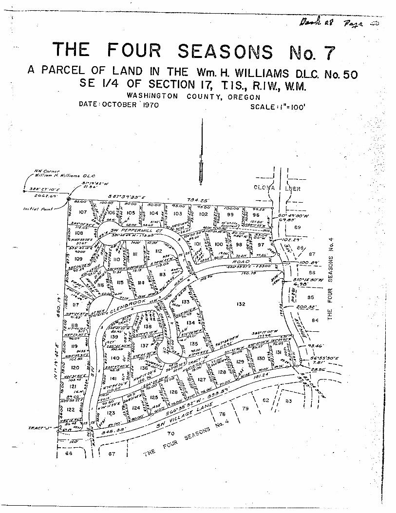
THE FOUR SEASONS No. 7A PARCEL OF LAND IN THE Wm. H. WILLIAMS D.L.C. No. 50
SE 1/4 OF SECTION 17, T1S., R.IW, W.M.WASHINGTON COUNTY, OREGON
DATE: OCTOBER 1970 SCAl F:i"=inn'
A/If/ Cornerrfif/ioir* //ÿ f/rf/iorna &£.C.
•3&&'zy /o"£~
fn/f/af Po/nf
} \ 70.00' P 77ZC' yt
&OAO\ÿSO*83 87TS - 233.00' £* /10.73

° BASIS OF BEAAINOS, THIFOi
SOUTH LINE JOHA
•Z-N08TH UNE Wh
O.L.C. LINE AS EST BY ft S.NO. 11.311
N88*27 10 W. 04/22'IB901'U88*27'lO"W
3/B l.fLF.72.0O 72.00 72.00 72.00
tS '«* S
<30-0072QO 130 00 21.54
3/8 IfLF. » INITIAL FOINT 'THE FOU150 •586*27 KTE72 OO 324(39** S88*27 10 E
CIRCLE 178 41note: allexterior lotl
10FT. AND ALi. INTERHAVE A 5FT. UTiUT
W 88*27 ICf'WIOSO&105OCT
49 & iasa S88*27 $8a*2TlCrE .157
S68*2f\(fE19.73 107. 76"
25 \25Naa*4dut
to.39'75.00 75 OO
ÿ3404942N84°l40l E
k
N89*083«"
.rfilXr*-80.00103.27n88*40 IB W AUTUMN 8 LANE
N89°08 36 W,324.97
up FOUR75.00106.10
N88r40 18 W . 65.OOÿ*>•« N1*19 42 2,(0 00-ÿ ry
C*S88*40'I8"E.I85.00' ÿ4 21« 169 40itrw
H S.W. VILLAGE CT.75.00 73.0080 OO65.00 50.36H88*37 55ti> N89°08 38
4
\ 8(0680
$ *v:S 103
¥2 182
g 2/6
IV88*40'/8"M((05.(9
850026.54
Si 2,5
M88*40'(8"W
7500 75.0075.00N88*40 18
S.W. SPRINGFIELD n LANEN89*08'38"lt(,325.00
(02.33 7500 59.83
214
NM*40'lfV
65.00
S.W,ÿ BURNTWOOD CT.-3/95 /94 2 40 (8 W<0(.70 W» 580°4O'(8 E.18500_75.64_
N89ÿ09'06ÿ75 00
N69*08'3fW800079 00 65.00 3910. _
2/3
N0#*4O'(8"W
N88®40'(9'V
*Wv
N89*14 50 * N89®0(08 W"k
ÿfejVia 109 5 -5 (08
(03.7/
58.78'(15.13*ÿ i»>roo (roc/ A/ 8(* .50oO. «4fi»49'42"wVILLAGEL»320.59' LANE *ÿ57
-- --h.i9o*j}6' ÿ,286*7' TilfT. 43 65- r'°" T
I4t»
"•TCiS.OOL»/2.(f236275'jteai93.99 - M83*10 18"W
W0<' s88«04,42"W*'2043 GO' Nf8*40 (9 W21.82
72.39 (i68*342Q-W7222.8
'JliLtZ7*96*3/56 Wt 222.59 70CM70-0370.9069.2370.19 60.59
9.4*39.23 3077 TO-OO
• 20/20S - **204a£ 2/0 r 208 q
t».»r fN/T/AL POINT3/8*1.8.F.
or 65'NI*l8'42ME,4aO€(
7489*40 18 W 70 00' moo70.0070.00 700070.007000( 792.00 ftSNO 12,627)S B9m04'Z9"E,791.83
SURVEYOR'S CERTIFICATE
< 3/8 I.R.F.
261498ScCnON (7
SECTION 20 7*88*28 38 w
223
25991'1/99*40'19 w
224
259 31'
'8*Is"l!
N88*40I8*W
225
259.91' N88*40'ltTW130.OO'
226
P«(VAT£ ffOAO XCASewewr
227
M7f*l(>29"2l29l60 5/O'OffOlCAriOM
188.00* 105.19
S88*20'/24,£, 236.18
I,RICHARD C. DIDZUN,FIRSTBEING DULY SWORN,DEPOSE AND SAY, THAT / HAVE CORRECrLVSURVEYED AND MARKED WITH 5/8"X 30"IRONRODS,ALL LOT CORNERS,CURVE POINTS ANDBOUNDARY LINE CHANCES IN DIRECTlONJHE LAND REPRESENTED IN THE ANNEXED MAP OF" THE FOUR SEASONS NO.8*AND AT THE IhDROVE A GALVANIZED IRON PIPE,2INCHES IN DIAMETER ,36 INCHES IN LENGTH,6INCHES BELOW THE SURFACE OF THEGROUND SAIDINlN88*28,38"W,2614.83FT. AND NI*I9'42"E,6I.85FT. FROM THE SOUTHEAST CORNEROF SECTION 17J* IS,R-tW.,W.M. ALSO SAID INlTIALPOINTBtTHE SOUTHWEST CORNER OF LOT65" THE FOUR SEASONS N0.4UA OULY RECORDED PLAT,RECORDED INPLATRECORDS WASHINGTON COUNTY.BEING DESCRIBED AS FOLLOWS, BEGINNING ATTHE ABOVE DESCRIBED INITIALPOINT;THENCE NI*I9'42"E,ALONG THE WEST LINE OFSAIDALONG THEWEST LINE OF"THE FOUR SEASONS N07"A DULY RECORDED PLAT,RECORDEDINPLATRECORDS WASHINGTON COUNTY,OREGlSOUTH LINEOF"JOHNSON ESTATE ADDITION", A DULY RECORDED PLAT,RECORDED INPLATRECORDS,WASHINGTON COUNTY,OREGON SAICLINE OFTHE JOHN INNES D.L.C.N056 ;THENCE N88*27'lO"W ALONG SAID SOUTH LINE OF JOHNSON ESTATE ADDITION 84I.22FT. TO THEJOHNSON ESTATE ADDITION; THENCE N1*55'0/"E ALONG THE WEST LINE OF SAID LOT 374,54I.98FT. TO A POINT ON THE SOUTH LINE01N0.852; THENCE N88*0&i5"W ALONG SAID SOUTH UNEOFS.W. DIVISION ST.206.45FT.', THENCE S 2* ll'14"W ALONG THE EAST LINE OFISTRATION RIGHT-OF-WAY I82.56FT. TO ITS INTERSECTION WITH THE NORTHERLY UNE OFTHESOUTHERN PACIFIC PIPE LINES,lNC.,EASt474 ,PAGE539 a 542 DEED RECORDS, WASHINGTON COUNTY,OREGON ;THENCE S42*48'46"E ALONG SAID EASEMENT UNE28.29FT TWE7LINE OFSAID EASEMENT I967.69FT. TO A POINT ONTHE NORTH LINEOF S.W. DAVIS ROAD;THENCE S88*28'l2"E,ALONG SAID NORTH LINETHENCE S0*44'36 "W,9.I6FT. ; THENCE N 73*45 I2"E,28.07FT. ;THENCE NI*I9'42"E,567.68FT. 't THENCE S89*04'29"E, 79I.83FT. TOTHCONTAINING 1,349,539.00SQ.FT. * 30-981ACRES
8 { G IS T E R f D
OREGONLAND SURVEYOR
SUBSCRIBED AND SWORN TOBEFORE METHIS DAY OF /V*?'
____,1971
JULY 11, 1RICHARD C. DiDZUN
8 9 3
NOTARY PUBLIC INAND FOR OREGONMY COMMISSION EXPIRES Z*,227Z—
.sjfii-r S.W. DAVIS RD. CO.*0.MO. 1029 SSXt
73*45'l2"E.28 07*
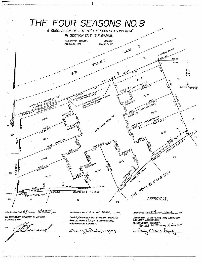
THE FOUR SEASONS NO.94 SUBDIVISION OF LOT 70"THE FOUR SEASONS NOA*
IN SECTION !7,T-IStR-IWÿW.M
WASHINGTON COUNTY ,FEBRUARY,1971
•9-3J* COH. *L.SP€NCe
O.L.C.HO.
M88~S909 f
TCZ6? ZawoocreN83m59'09"E * 143-56
5/B'LRFN86*00'OOmE, 70.00
APPROVALS
APPROVED THIS
WASHINGTON COUNTY PLANNINGCOMMISSION
1971 APPROVED' THIsZtÿDAY nfVvVÿC-Nÿ>tg7/
CHIEF,ENGINEERING DIVISION, DEPT. OFPUBUC WORKS (COUNTY SURVEYOR),WASHINGTON COUNTY.
APPROVED THIS22-DAY OfJOQjJÿh__,1971
DIRECTOR OF REVENUE AND TAXATION(COUNTY ASSESSOR),WASHINGTON COUNTY. r\ .
£ÿ ÿoorT. _

„L,
THE FOUR SEASONS NO.10A RESUBDIVISION OF LOT 142, THE FOUR SEASONS NO. 8 , IN Sec. 17IN Township ISouth, Range IWest, W.M., Washington County, OregonScale :l"= 50' Surveyed July, 1971
C- rf" .
ST**
\
Mor* : 7~//X/*X 73 0 4/r/j.-/rr &Asef?£Mr 3or// 3/o£3
09 ALA ///r£ft/0/t LOT U/V£3 /9/VOA 7*9A0OT 77T// try
A2036 JfXX 00v//r0-
**r z.//vaa gftcerr a* 0/0txo
/gr Cm*/0rj-
a /2* wVa* 20 77 37*2207-'0- 20.72L
c 72*OO 0S— fos-y ÿ/9. 20 J/6*33'X7"£ 79-/7
JO*00'oo~ 700 7A 32.70 3 9"o<?'00"0 3~X- f6
777A* 79 37 SVm7/'V3'tf 79.JV
o j»'xj '2a. * 7970V, 7079V 5/J*y|V»V 70362
£ /0j*0y \nz~ /«e*0 77 99 J22'32'29'0/ 73-94
/yv'fiyt* 70 00 73./X 327* Y3'OX "0/ 6333
£ 77*79 *7Z" 90.0O 9J.t7 3 69"79 /y"/ *9 rr
/£>9*3~X 36* 70 0O 79/9 339*9''/7*3 76-37
& 9~rr39 ~ 793 03 £7 9* /92r*3r'Y6~m/ 27.9o
37*23' v«s* /77 £.4 703 00 777/*Y£'37m m7 70/YC,
M / '37 /y* 777 c"~6 y/<; 07 6*77 23'£ V<36
73'oo'ao' /C736 23aY 7V 7V"3o -00 '9 30 /6
f *33 07* 76.22 73/3 07/7*o3X7*£ 73 73
/1 /£?*72 * 76. 22 7J37 ÿ7'« yiV S3.33
V X.-Z*/O JJ.' /aj 03 709ÿ /V 9"70'73~ ~*Y 70 -/O
W" /90 'co00* 9 71f 23.99 0/90*03 '73*7S 76.173
7/O&'X 7 /*>',
Am* /fY -M5Si 5g /Jat-a —
77m R L C*090
/ 2/*3t'*3* 7737 337/ 370*32'J3'C 93 O"
Z 30'CO OO' 7/3 76 3936 S 9*0W '06'£ 3"999
3 X0*o3'/3* 63 Z* 22/6 J//*3T XX'1*7 XX 0f
9 /3~00'0O* /X0.06 37. 69 9/V'30 00'tS 3/ 33T
S 36'00 09' /9V66 Z/6.03 3 // *00'00"£ 77*7/3
6 ja'xÿr'o/" /TO 03 9/73 3/3*32 29"£ 906V
to
r/s,A/Y/,west
SURVEYOR'S CERTIFICATE *
I,Nickolas A.Yinger, Registered Professional Land Survelots and tracts the lands represented on the attached mington County, Oregon more particularly described as folBeginning at the Initial Point,a 2"galvanized iron pipe Iand N$8°27'10 W $41.22 feet from the southeast corThence N 42°48' 46" W 28.29 feet; Thence N2*ll'Malong said line, 206.45 feet; Thane® S t*55'0/"WIfurther depose and say that the attached map is a trui
all lot corners, points of curvature and boundary fine c
registereO n E G oland surveyc
JULY 12. 196flNJCKOLAS a. YING_ 876
DEDICATION -KNOW ALL MEN BY THESE PRESENTS that I
fire the owners of the lands represented on the annexeddivided into lots and tracts as shown on the annexe«IN WITNESS WHEREOF we have hereunto set our hand
Construction Company
auaen, Prs&dent
3LiXL*tl*rA. Dow, Asst. Sic.
s.s.ACKNOWLEDGEMENTSTATE OF OREGONCOUNTY OF WASHINGTON ÿ
THIS CERTIFIES that an thi* /<? - day nf (end Lester A. Dow, Assistant Secretary of Seovg/sealed on behalf of said corporation by authority cdeed of said corporation. And before me personallyexecuted the foregoing instrument, and they acknoi
Notary Ptibli
My Commission Expires
for Oregon
<r///A
APPROVALS
Approved this day of 'Cro'V-Nÿ
Washington County Planning Commission
by
Approved this ~z.ÿ> day nt "3*V*
Chief, Engr.Div., Dept. of Public Works(Survey Sec.) Washington County
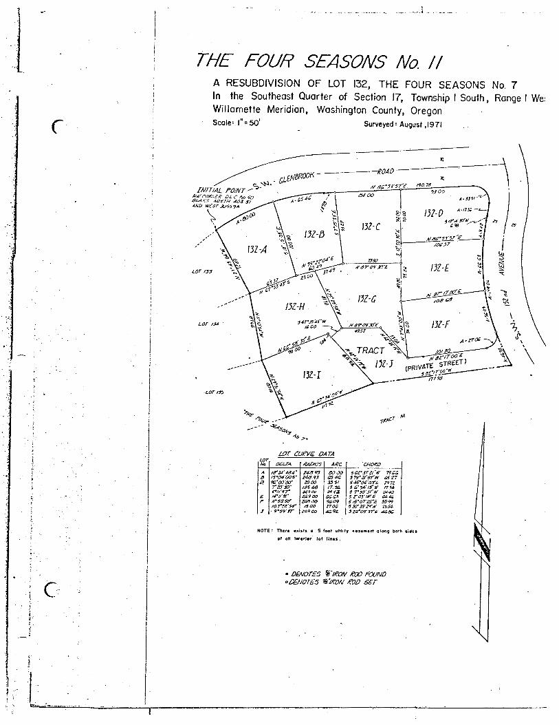
THE FOUR SEASONS No. II
C
A RESUBDIVISION OF LOT 132, THE FOUR SEASONS No. 7In the Southeast Quarter of Section 17, Township I South , Range I We:Willamette Meridian, Washington County, OregonScale: I =50 Surveyed1 August ,1971
INITIAL POINTt/i'COf.-.e,fit OIC Ao50
KO/fTH ÿi'3 S/AND WEST J0959A
/40 70/V S<2'53'57'£•93 00
G400A-33W
A-t75£ —s/<rS3Q'N „
£90 *
#69*orXT&
/OS cs
Nsro930'e
TRACTÿ
5azj::17773
LOT 134
LOT /»
LOT CU€V£ DATALOTNo. OSL.TA. RAPiUS ARC CHORD
A la'ZS484' 243 <?3 sooo 6Op3721'W 79.00a T5'Q4'OOS~ 243 93 G54C 3 79'2J'6T'tV £327p TG'oo'ocr 20 00 33 6/ S4roO'a?£ 29 72
7'20'30' /35 43 17. 30 6 C'3A'/3'iV 1734Z4900 244Z 3 T"SO'jEN 2440
£ /4'tt'St' 209 OO ££03 sr05'l4'£ 04 42F /FSPSO' ZOTfOO SQ09 S A.5'0T25'E 5699
toree's* /SOO 1700 6Xf3529'N 2564J ÿ 9'39'ST za oo 40.9Z 32a'Of37~£- 4080
NOTE: There exists a 5 foot utility easement along both sides
of aif interior lot lines .
C• DENOTES %'/PON POO POUNDO DENOTES V/PON POD SET
tas=

31 !t>A-
THE FOUR SEASONS NO. 12A RESUBDIVISION OF LOT 47, THE FOUR SEASONS NO 4In Sections !7 Q 20 Township I South, Range I West, W.B 8 MWashington County, Oregon
Scoie" l" = 50'
STATE or ORI.OON J 741Curve Data
ÿ ,v
3A _Surveyed Morch, 1972
KQC£K rilOMSSf.,\,c.
ÿ3
£ 47-53
47- *2
47-24
V47'
47- It47-6
Oq
47-7
47-8
PROFESSIONALAND SURVEYOR
a vinger
!

/S* r- /v- - 3 a-
5ÿ TKACT7T&CTAumtt
W/LM££ ' J /.W J'• MO9 5 i /m isarrv—ÿ -8 a-Mj * M
rf '!/J-* jL
I1 *AJ
»{/** a./M0 j! /$Z! J { /}-M /32S <
URVEYOR'S CERTIFICATE-I, Nick A. Yinger, Registered ftofoaatonal Land Surveyor in Oregon, bang first duly awcrn, do hereby
pose and toy that during July, 1972 Iaccurately wbdtvided Mo Ma and traeta the hmda represented ana ottrahed mop of "THE FOUR SEASONS NO. O a mubdMaton of Ma 143, 221, 222, 223, 224, 223, 226, 227 ftreef 5 , The Four Saoaora Na•, a plot of racord in Washington County, Oragon mora partieulorty described
Beginning of tha MtM Ratal, o gotvoncsd ran pipe, 2* x 36? aat 6" below .tha aurfoea of tha ground, ahfchÿ N 68*26 38 W 26*463 feet, N I1942 E HI3.23 fast and HKBCZtw!w 041.22 foot Ram tha.southeast comer of Saetion 17, t • MW., W8 0hi; thanca N00*2TK) W, 10901: thanea S 2*lfl<VE1627.16 fast; thanea SOS*28*12 E 236IOfaati thanea N7f IF28 E 2636 foot: thanea N 1*1642 E663.16 feet; thanca along o 684.37foot radius curva to the toft (etard baora N04*2zB W 25236tost)o diatonca of 233.10 faat| thanca N 2*11 14 C 60.00 feet; thanea olong o 202934 fool radiua eurvo totha right (chord baora S 63*33 34 E 135.60 faat) a diatonca of 135J53 feet; thanca along o 2029.54toot rodus compound raweraa curve to the left (chord baora S 64*41 13 E 4931 faat) o tfietanca af 4931faat: thanea along o 2000 foot rodkm compound curva to tha left (chord baora N50*06 45 E 2802faat) o .diatonca of 31.04; thanca olong a 1817.00 foot radiua oompound curve to the left (chord baoraN 2*04 36 E 226.50 faat ) a diatonca of 228.65 feet: thanca olong o 2416.00 foot radiua compoundreverie curve to tha right (chord baora N3*05 48 E 389.95 faat) o diatonca of 390.37 faat: thanca .N 7*43 18 E 11.71 faat; thanca olong o 104 84foot radiua curva to tha right (chord baora N8*34ÿ25 E 3.(2 feef) o diatonca of 3J2 foat: thanea along o 5000 foot rodw» curve to fa right (chard boarsN 12*19 41 E 76.77 footle distance of 67.53 feat; thanca olong o 53.52 foot radiua curva to tha ritf*(chord baora N 34* 10 20 W 63.05 faat) o diatonca of 67.42 faat, thanca N I*55 01 E a diatonca of67.11 faat to tha point of beginning. Containing 8.1701 ocraa -Ifurther depose ond toy that thf attached map it o true ond correct representation of the tot* and
tefs oe staked on the ground with 5/6 by 30 ateal rode of oil M corners, points of curvature end boundary
• changes of direction.
Subscribed «td sworn to before methis day of ,1972
THE FOUR5SEASONS NO. 13
A RESUBDIVISION OF LOTS 143, 221, 222, 223, 224, 225, 226, 227 ftTract "SM, THE FOUR SEASONS NO. 8 Located in Sections 17 and20, Township ISouth, Range IWest, W. B. & M.,Washington County, OregonSurveyed' July, 1972 Scale' l"«100'
Dtnoi** 90? **fk
CURVE DATA.LOT .RAO ARC .DELIA CHORO
-DEDICATION *-KNOW ALL MEN BY THESE PRESENTS that
a the mmer of the lands represented on the onnmed mapcertificate, and hove caused said lands to be suMvided rto be dedicated "THE FOUR SEASONS NO. 13 .
IN WITNESS WHEf£OF we have hereunto eat our
Homes of Portiond toe, on Oregon Corporationand porticutarty describad in tha ndfocant awvayortto Iota ond tracts oa shown on toe wrmwd mop and
bands and corporate aaal 4ÿ.87?
r REGISTEREDPROFESSIONAL
LAND SURVEYOR
Mory Public tor Oregon _My Commission —p***
Ml.dm ÿ n d ÿssogvvOQ nomas w nmaw m.
0-eÿC.Hmem, Meow (J
-ACKNOWLEDGEMENTSTATE OF OREGONCOUNTY OF WASHINGTON
THIS CERTIFIES toot on thisZftdoy ofjxzbUc.,1972 before ma, o notary public for Oregon.personolly oppaorad Owight E. Hougen, Director, John HKlein, Preiidant and Howard R. Baker, fee ftoiidmt ofWedgwood Homes of Portiond Inc., tie corporation nomad in toe foragotog instrument, that said inetnaaenfwas signed and tooled on behalf of said corporation by oufhority of its Board of Oractors, and ffwy ochwow•edged their signatures to said instrument to be the bee act ond deed of eoid corporation.
tor Oregon
My Commiston —pir— iA*Jt
APPROVALSffevembcrApproved thisJ+idoy ofApproved this/yfA day of
Director of Revenue ond Teaotien (County Aaaassor)Washington
ÿ
by f. '"Dtrwrf-
Washington County
Dirsctor of Records ond Elections (County Oert)
AW /5; mz
a*t msz kmao4 ec.ac
teeeo j*/*
mm /t»TtACTC ' tOC
• *4*4 saa** ***** out/** - n**cor)/ - a*oa*> na/*M • 9**7
mr*c jaae7C4CTA ' a*xa-a - moost$~i* ' *949
**** 94*4*04994 490/
MS779-/7 - 910449-/9 99749 7*9*7- 4*4tr *l*sa-90 9*99
79199 9424t»-v mrf *$.49act 379ir T4»f7929 44095 StariSM 460.99 91OS49-2S - M93a-*c /so* too*
2500 i9/£MOOS 9SO*
t9-tt tit7* 46.73- not its*/st* - u/r
4*00 MOO79-90 tl97 72*4
4000 *47*tsoo at*
79-90 <754 *CO*4300 46 13
73 V 19*1 *64519-tt 479* 794079-99 40*0 6S63
7X4073 4500 , At*60*0 90.it4SOO tt.ffT/6U9T4t4t
voters otto +*•!SSSt 4741
7X4£T* MM9T MOO1927 4000 SO*
jwVrW*erjott'srofos/r*r*s'Tfsetrrtrtrrtrsrrttorrts-grrtct*'rs-trfsrsrrsfosrfso'ttfrto-Tt'aavsvr*rutrrait-t*9*/S'Tf/ffOC'rsssrrxts'rtfeorto'/rsr/r-er/t'1X7*44"/posorTWO*-Mros'rr46'44'Otrrvosr/fists'44aiie»Weo'i/'/s'terttf/trttssr-ororor7rot'99'SS44404'49'SMSf*7'S9*r04soo-/rtfsrst-76'90'fturcy2it'J*'9fefssofTTtefXTo'srtrrtssr
s/fttit'f jstssstrsrvrx tens
tVlSfTM M4tinsertx*srtstcnt outisteres*/ norsr*S9st* St**srersstf osmsctroors **stsr/*4f£ 4**660*94'4rS J*0t
ssro**r/tmaxsfror/r*xtstM**J*'fT77 44S7
*am*'*/ o/o6A/roeraor* m*ssarso'srvtestAtocvr/6'tt o*o*A/CrSt'STtf 06.44
3retire 4664srrs6'*tt aooTscssrsre tstxssrtrtrr MotA/TTOSOfS t*73sxrrr's'ts son
A/4S'f9'4*£44t4szrievrw **oo34fsrS?£ 66*6A/47'00-06"£ 439*V4/r4*'4S£ OJ*£9979*0314 7490S4rt6SS-WMISsoortroce 4t*e3ir'St'Ot'M4T30Tfxsmrw 6xas3*C93M>"£M*0tarts*-* so*
17J5
Approved thH )4 doy *A Uowejv\\at.f
WoshtogKm County Ptoming Comrmaaion,ÿ'
Approved thit_L2_doy of. A/ov.Chief, Enginaaring Division, Deportmenf of Public Works(Survey Saetion) Woehington County
,1972
STATE OF OREGON ICoonry oi Wtrimpoi { *"
/. *>06* THOMSS&N. 4, Am+y crt+fj Aw
W pin Mlrnmw /«r rI.W M IA/
____/>•_
tl.....2' .* .........19 7*titoÿrimtAl*: tMrrrvArA.ÿ />*• /f m . 74._4 tf Hili »/ ini
*mmnt my k—4 ir, *,i „/ *j,.r---/ )W>*' .. A. IK r*~?+ •
ttOOt* TllumSE\ .C-mmiy Ctft
•f ---IT*

SFAfONC Ha8
inrirrwifflfcTATC CJf OiitwONC»«m«| ÿ! Wa ÿ :i]»ia
rwe fou/? seasons no. m
sc.mool 0«Tff»CT No 46
UNPLATTED
##ÿ4. - *r
«841
a RESuetnoAsm* op lots
15-18 THROUGH 13-33.. THE
FOUR SEASONS HO 13
LOCATED to SECTIONS Vm4
2O.T0WNSH1P ISOUTH, RAN8C
IWEST,VtM., WASHÿSTON
COUNTY, OPEOON
SURVEYED* JANUARY, WT4SCALE* r-5flf
CURVE DATASUKlCTOrS CSXTinOOt
LOT RADIUS DELTA
14-1 527.45 8'10'ir14-1 1864.37 2*58*57"14-2 527.45 rir42"14-2 527.45 2*29*59"14-1 527.45 ris'ir14-4 313.77 7*05*38"14-5 313.77 6*58*38*14-8 440.SS 6"30*22"14-7 449.55 1*25*50"14-7 440.55 3"29*50"14-0 440.55 l"33*38*14-9 440.55 7"09*32"14-9 25.0 34*12*49"14-10 25.0 32*31*ir14-10 15.0 111*03*51"14-11 25 JO 71*44*02"14-11 40 O 107*04*12-14-12 40 O 14*21*41"14-11 45 O 71*42*OT14-13 57.54 4*14*32"14-14 87.54 88*47*11"14-15 40 94*00*13"14-17 47.98 60*15*29"14-10 47.98 27*44*10"' 14-19 113.32 18*47*30"
14-20 113.32 24*48*03*14-21 40.0 27*28*10"14-21 27.91 49*18*2r.14-22 27.91 30*47*31"14-23 27.91 44*08*20"14-21 212.72 j'orir14-24 212.72 7*S?*07"14-25 212.72 l"36*sr14-25 480.55 4*07*25*14-28 460.55 3*58*54"14-27 460.55 5"38'0r14-29 460.55 5*36*01"14-29 460.55 0*50*45"14-29 293.77 7"29*27"14-38 293.77 4"!7*57"14-38 293.77 2*08*4r14-31 293.77 2*20*28"94-32 727.55 l*33'5<r14-JN 727.55 4*01' &<"14-3* 1664.37 3*22'0rTRACT 1664.37 1"28'35*TRACT f 60.0 76*30*51-TtoCT **" 1864.37 0*46*57"H-Jf 7T730' 0"5f 55ÿ»4-a 7TT»,' crststr
U.N87.8011.023.01u.o38.8538.0350.0311.0n.m12.055.0814.9314.1929.0031.2074.7510.03SC.315.0081.0985.8350.4523.2337.1748.9919.1024.0215.021.511.2129.525.033.1532.0145.0245.025.8038.4122.0411.012.01986StOX98.9942.4280.1224.0tO 98I2J5
55.7757.5711.023.0112.038.82J8.050.011.025.8912.055.0114.7114.024.7329.2854.3410.052.715.0078.3050.5140.1723.037.048.518.9923.2814.8220.9711.2129.58.033.1432.04S.045.08.8038.3822.0411.012.01986sun98.9842.4274.3024.0K>98&.SJ
0 3"30*27" tS 82*59*47* CR 0*10*33" Wn rii'37" rR 1*25*31" RR 1"12*38" Cff 8*13*48" Ifl 8*25*54" CR 4*28*48" ER 0"27*20* CR rsf'04" cR 4*52*20" RR 25*33*32". RR 58*55'33" RN 49*15'55" ES 37"10*43" RH 52*12*24" RR 87*04*44* ES 37*10*43" RR 70*54*27" ER 34*23*35" EH 47"00'08" ES SS*52'0r ES 1I"52'09* ER H"23*4$* ER 33*10*31" ER 59*17*38" ER 84*33'05" ES 55*23*57" CH 17"56'02" RR 2*37'3!" ER 2*51*38" RR 7*38*40" RR 5"23*2S" RR 2"20'14" RR 2"27*14" ER r03*14" CR iri8*37" ER r57'l€" EH 2*25*34" HR 3*08*12" EH 0*53*37" EW3"47'38"WN<F50'03*Ei88*59*18" R$ 80*47*02" ES 36*55*43" ES 84*53*48" E•II" 36" 2S*W
jr jr »v
T. Mather being first Ally sworn, Repose tN say tMt Ihave correctly surveyed and oerteR with |its the lands represented eo die attached m» of "Four Seasons Ho. 14". that for the Initial point
of said plat Iset o 2" a 38* galvanised Iron pipe, 6" below the surface of the tround, said Iron pipe beingR 88*28*38" R 2814.83 feet. R I*19'42» EJ113.2S feet. N 88*27*10" W 1030.23 and 5 2*11*14* R 916.03 feet froathe Southeast corner of Section 17. T lb, A Id, W.M., Washington County, 0reg®n.Froo said initial point Iran S 2*11*14" N 711.13 feet; thence S 88*28'12" E 236.18 feet; thence R 71*11*28" E28.38 feet; thence N 1*19*42* E 883.16 feet; thence along a 1664.37 foot radius curve to the left (chord bearsR 54"22'l9" R 252.86 feet) o distance 291. 10 feet to the Initial point and point of beginning of this description.
Registered Professional Engineer of Oregon Ha. 5189
Susbcrlbed and swom to before ne this t3 Ray of fimbrvarif .1974.
Know all by these fuitoi that RaRpiaai Meat
•f Portland. Inc. an Orepon Cnrpnmtfen latheuntr of the land represented on the aananod ""Pand particularly described 1n the accompanying set Mjm*tcertificate and have caused said lands to bo itodlvttodInto lots as shown on the annexed nap and to bededicated "Four Seasons Ho. 14". and hRrehydedicate all streets and eaiwtr as ihoMthereon to the public use former.
In Witness Whereof He have hereunto set ewrhand and corporate seal this ftfk day
ry Public for the lute af
PLAT HCSTmCTIOMSt
I.) 5"Afan-Mrh«vav ncccv* awaaiuf otangN*rTh rqtsf of rrey of S-tf P+r*S t?d
Z) to' «ae ÿdevfrvon e€K«er(rK cantorlm* of it roe itm*
lots *-*> and t*-rr
ACKKHLEDGOCXT
STATE OF OREGONCOUNTY OF MASMIMTTM/S.S.
This Is to certify that on tMsrstA. day efftruare _ «1974. before ne a notary public In andfor sala County and State, personally appearedJohn H. Klein. President and Dwlght Havgen. W rectoref Wedgwood Hones of Portland, Inc., the Corporationnaned in the forepolng Instrument, that saidInstrunent was signed and sealed on behalf of *a1dcorporation and that their signatures affixed tosaid tnstnaaent are their own free act and deed.
of Records aDirecWashington Co. Orepon
All taxes, assessments, fees, or other charges as pvwv1dnd kg
0RS 92.095 have been paid as *f- *. '>T1-Director of Assessment and Taxation<*• °"j£Lu w £u-&.
Or; f. >W-_-
bUry Fwolf% Cowlssion expires:ÿ
ATTACHED: J-5-74Chief Engineering DivisionDept. of Public Works (CountyWashington Co. Oregon
«mma:»/rmDepartment of Public HealthWashington Co.
0«fAPfRQVO: 3/s/WWashington Co. PU<m1n
V/
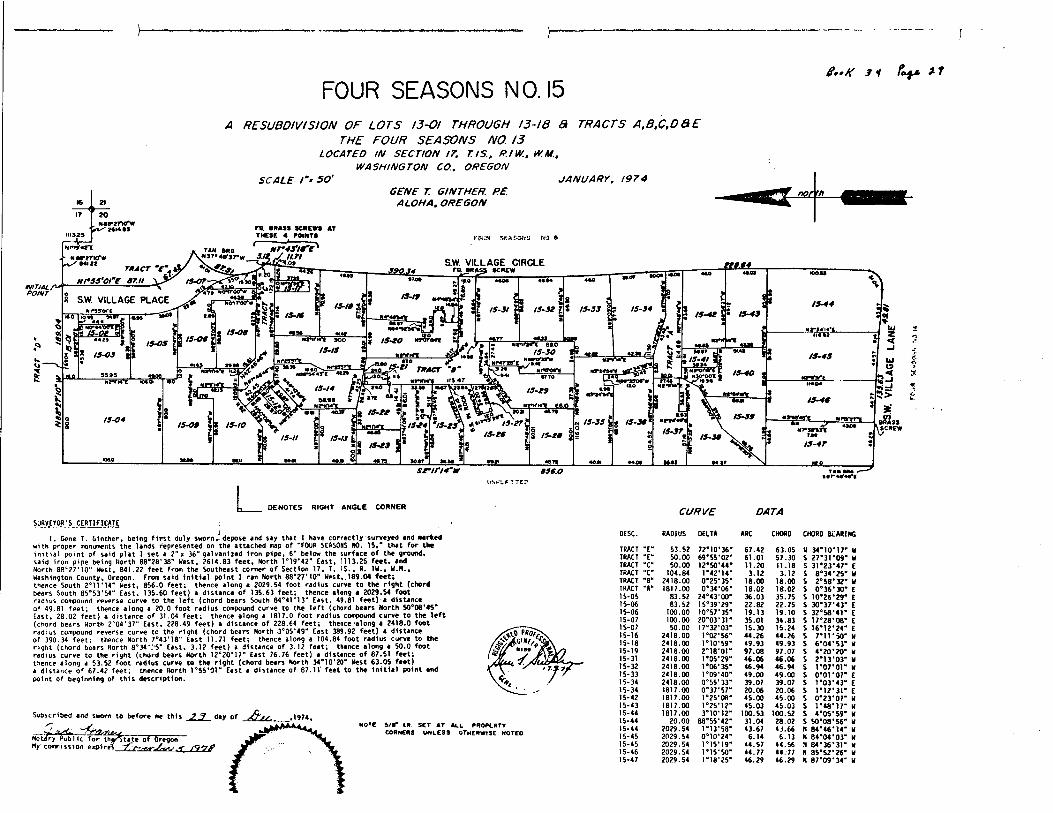
FOUR SEASONS NO. 153 i (oÿ* 3 7
A RESUBDIVISION OF LOTS I3-OI THR0U6H 13-18 3 TRACTS A,B,C,D QE
THE FOUR SEASONS NO. 13LOCATEO IN SECTION 17, T/S, RIW., W.M.,
WASHINGTON CO. OREGONSCALE I"'50' JANUARY. 1974
GENE T. GINTHER. PE. nor 'h
TO BRASS SCREWS ATTHESE 4 ROIHTS
NI4U1119.23 Ttr.iT I>
Nrw«jrtTAN BR6
wsrwN8B*27"Kj »wtX Ml12 S.W. VILLAGE CIRCLE
TRACT
NrS5'0tme 67.tI*90.3*
INITIAL/1"POINT
8 S.W. VILLAGE PLACENI*370('C
NOWTWW
IM
(5-/9 3 S (5-33 |? 15-3415-31 15-36
HfiAiA'tM«I25 15-OS f
15-SOMlMTS'I
r*7 tract 'b'113.47
NinrM'C M.235 95
S*A (5-/4
50.9B
15-69
s '*-** 'I5-04 15-67(5-66 o $
3 /5-69 | (5-39(5-47
S6m(f(4'W
l.'Nr'LA
RIGHT ANGLE CORNER CURVE DATASURVEYOR'S CERTIFICATE
I, Gene T. Ginther, being first duly sworn depose end say that Ihave correctly surveyed and markedwith proper monuments the lands represented on the attached map of "FOUR SEASONS HO. 15," that for theInitial point of said plat I set a 2" x 36" galvanned iron pipe. 6" below the surface of the ground,said iron pipe being North 88*28*38" West, 2614.83 feet. North 1*19*42" East, 1113.25 feet, andNorth 88'27'10" West, 841.22 feet from the Southeast corner of Section 17, T. IS., R. 1W., W.N.,Washington County, Oregon. From said initial point Iran North 88*27* 10" West,, 189.04 feet;thence South 2*11*14" West, 856.0 feet; thence along a 2029.54 foot radius curve to the right (chordbears South 85*53*54" East, 135.60 feet) a distance of 135.63 feet; thence along a 2029.54 footradius compound reverse curve to the left (chord bears South 84*41*13" East, 49.81 feet) a distanceof 49.81 feet; thence along a 20.0 foot radius compound curve to the left (chord bears North 50*08'45"East, 28.02 feet) a distance of 31.04 feet; thence along a 1817.0 foot radius compound curve to the left(chord bears North 2"04*37" East, 228.49 feet) a distance of 228.64 feet; thence -along a 2418.0 footradius compound reverse curve to the right (chord bears North -3°05'49" East 389.92 feet) a distanceof 390.34 feet; thence North 7*43*18" East 11.71 feet; thence along a 104.84 foot radius curve to theright (chord bears North 8*34';-5" East, 3.12 feet) a distance of 3.12 feet; thence along a 50.0 footradius curve to the right (chord bears North 12*20*17" East 76.76 feet) a distance of 87.51 feet;thence along a 53.52 foot radius curve to the right (chord bears North 34*10*20" West 63.05 feet)a distance of 67.42 feet; thence North 1*55*91" East a distance of 87.1V feet to the initial point andpoint of beginning of this description.
Subscribed and sworn to before me this 23 day of
- __thaÿState of Oregonres * "~
NotJry Publ ic forMy' commission expire!
5/«" I.R. SCT AT ACL PROPtRTVCORNERS UNLESS OTHERWISE NOTED
OESC. RADIUS DELTA ARC CHORD CH0R0 BLARING
TRACT "E" 53.52 72*10*36" 67.42 63.05 H 34*10*17" WTRACT 50.00 69*55'02" 61.01 57.30 $ 27*31"09" WTRACT "C" 50.00 12*50'44" 11.20 11.18 S 31*23*47" ETRACT "C" 104.84 P42M4" 3.12 3.12 s 8*34*25" WTRACT "8" 2418.00 0*25*35" 18.00 18.00 s 2*58*32" WTRACT "A" 1817.00 0*34*06" 18.02 18.02 s 0*36*30" E15-05 83.52 24*43*00" 36.03 35.75 s 10*26*29" E15-06 83.52 15*39*29" 22.82 22.75 s 30*37*43" E15-06 100.00 10*57*35" 19.13 19.10 s 32*58*41" E15-07 100.00 20*03*31" 35.01 34.83 s 17*28*08" E15-07 50.00 17*32*03" 15.30 15.24 s 16*12*24" E15-16 2418.00 1*02*56" 44.26 44.26 s 7*11*50" W15-18 2418.00 1*10*59" 49.93 49.93 $ 6*04*53" W15-19 2418.00 2*18*01" 97.08 97.07 s 4*20*20" w15-31 2418.00 1*0S'29" 46.06 46.06 s 2*13*03" w15-32 2418.00 1*06*35" 46.94 46.94 s 1*07*01" w15-33 2418.00 1*09'40" 49.00 49.00 s 0*01*07" E15-34 2418.00 0*55*33" 39.07 39.07 s 1*03*43" E15-34 1817.00 0*37*57" 20.06 20.06 s 1*12*31" E15-42 1817.00 1*25*08" 45.00 45.00 s 0*23*07" w15-43 1817.00 1*25*12" 45.03 45.03 s 1*48*17" w15-44 1817.00 3*10*12" 100.53 100.52 s 4*05*59" w15-44 20.00 88*55*42" 31.04 28.02 s 50*08*56" w15-44 2029.54 1*13*58" 43.67 43.66 N 84*46*14" w15-45 2029.54 0*10*24" 6.14 613 N 84*04*03" w15-45 2029.54 1*15*19" 44.57 44.56 H 84*36*31" w15-46 2029.54 1*15*50" 44.77 44.77 H 85*52*26" w15-47 2029.54 1*18*25" 46.29 46.29 H 87*09*34" w

34*Co
ÿr
$1
if+«>+
V*Ji
ip<.
r.-.Ji »
£t
sS
£*£
** fST P:s
"cs?33*13
til's+
»-i4
»V
bN
,«-
4}£+
;re
allfi<*#ÿ
o|||l'i<{jlj
y9
Pÿ
aS
m
SrI.aa
-,ffO'Z
flM
.««c?
.99
*N573Z
,{W]$
Itrÿj_
fÿP
SfJi*P
vvw
»r>
_
.w
m.-g
-
V.**tf
I—*>.
®tn
<s
n:*i$&nirh
w;M
C*w
#*-g
Jtf -Hp
ÿ• w
'4645 y
n-fii,4
?,e
iy3, s
tso#ecs
&rsfe
§5531*1 ii®s
(Sla.,-8
fe1£§
ja.e
ar*
•n®-2
1l*
s„~Bs
?l*
.W9
»',i*hp
P.IU
M-P
KH
3.*
ieei
'.•*«».ÿ
»»
:v-S
9ia
VW.si,b<7.6S
'N
8*'X
SK
1•«
*oZ»
$fjpM
,«i>o.a9Ti
i%titi
vrio
1-11
__
. ES%J
!Gi
H-v£jiil?
&as*U
in»-
*i .n
o
ÿ,fto>
<>
.-Zl ;y~
T/~
77
"
c|„*•!?-" jL
sk
•7
ÿ.< JS5-J. U
tr. jujn2TJ :
1ÿ
Nw
|Sv<s »$v3r.r
'•yfeÿt&SritaWS
3,l"Mi:Sl!


![[D. B Monro] A Grammar of the Homeric Dialect](https://static.fdocuments.in/doc/165x107/55cf8563550346484b8d7bc6/d-b-monro-a-grammar-of-the-homeric-dialect.jpg)


![A ROBBINS-MONRO ALGORITHM FOR WITH MARKOV-SWITCHING ... · arxiv:1407.3747v6 [math.st] 17 mar 2015 a robbins-monro algorithm for nonparametric estimation of nar process with markov-switching:](https://static.fdocuments.in/doc/165x107/5b3d48307f8b9a28308bcfcc/a-robbins-monro-algorithm-for-with-markov-switching-arxiv14073747v6-mathst.jpg)


