![[Fr] Présentation Spotter 2008](https://static.fdocuments.in/doc/165x107/558c7d7ad8b42a844c8b475b/fr-presentation-spotter-2008.jpg)
The Forms If you already have a spotter ID which starts with 2 letters (ST99), that will remain your...
91
The Forms The Forms If you already have a spotter ID If you already have a spotter ID which starts with 2 letters which starts with 2 letters (ST99), that will remain your (ST99), that will remain your spotter number (unless you moved). spotter number (unless you moved). Otherwise, you will be assigned a Otherwise, you will be assigned a new spotter number. new spotter number. If your mailing address is If your mailing address is different from your physical different from your physical address (911), please enter both. address (911), please enter both. Thank you, and welcome! Thank you, and welcome!
-
Upload
erick-gordon -
Category
Documents
-
view
219 -
download
0
Transcript of The Forms If you already have a spotter ID which starts with 2 letters (ST99), that will remain your...

The FormsThe Forms
If you already have a spotter ID which If you already have a spotter ID which starts with 2 letters (ST99), that will starts with 2 letters (ST99), that will
remain your spotter number (unless you remain your spotter number (unless you moved). Otherwise, you will be assigned moved). Otherwise, you will be assigned
a new spotter number. a new spotter number.
If your mailing address is different from If your mailing address is different from your physical address (911), please your physical address (911), please
enter both.enter both.
Thank you, and welcome!Thank you, and welcome!
Skywarn Spotter Skywarn Spotter TrainingTraining
Mike Cempa – Senior Mike Cempa – Senior ForecasterForecaster
National Weather National Weather ServiceService
Gray, MEGray, ME

NWS MissionNWS Mission
““To protect the lives and property To protect the lives and property of the citizens of the United of the citizens of the United States…”States…”
• Watches and WarningsWatches and Warnings
• Outreach and TrainingOutreach and Training

NWS NWS County County Warning Warning AreasAreas

The Spotter’s RoleThe Spotter’s Role
Technology at the NWS – Technology at the NWS –
• RadarRadar
• SatellitesSatellites
• Automated Observing EquipmentAutomated Observing Equipment
• Lightning Detection NetworksLightning Detection Networks
• ComputersComputers
It’s all good, but…It’s all good, but…

The Spotter’s RoleThe Spotter’s Role
What we see What we see at WFO at WFO Gray:Gray:

The Spotter’s RoleThe Spotter’s Role
Ground Truth - What’s really Ground Truth - What’s really happening:happening:

The Spotter’s RoleThe Spotter’s Role
To be the eyes of the NWS where severe To be the eyes of the NWS where severe weather is occurring or has occurred:weather is occurring or has occurred:
•Reporting storm type or structureReporting storm type or structure
•Reporting storm impactsReporting storm impacts
•Reporting damage, flooding or injury from Reporting damage, flooding or injury from stormsstorms
This is the Ground TruthThis is the Ground Truth

The Spotter’s RoleThe Spotter’s Role
Ground Truth is the single most Ground Truth is the single most important type of information important type of information we can get at the NWS office.we can get at the NWS office.
This is why spotters are so This is why spotters are so important. important.

Terms and DefinitionsTerms and Definitions
• Severe ThunderstormSevere Thunderstorm – Thunderstorm – Thunderstorm producing winds of at least 58 mph (50 kts), producing winds of at least 58 mph (50 kts), and/or ¾” diameter hail (or greater).and/or ¾” diameter hail (or greater).
• TornadoTornado – Violently rotating column of air, – Violently rotating column of air, attached to a thunderstorm base, and in attached to a thunderstorm base, and in contact with the ground.contact with the ground.
• Funnel CloudFunnel Cloud – Rotating funnel-shaped cloud – Rotating funnel-shaped cloud extending downward from a thunderstorm extending downward from a thunderstorm base, but not necessarily in contact with the base, but not necessarily in contact with the ground.ground.

Terms and DefinitionsTerms and Definitions
• DownburstDownburst – Strong downdraft – Strong downdraft producing an outrush of damaging producing an outrush of damaging winds at or near the ground winds at or near the ground (Microburst – smaller scale, but wind (Microburst – smaller scale, but wind may be more concentrated)may be more concentrated)
• Flash FloodFlash Flood – A rapid rise in water, – A rapid rise in water, usually occurring in 12 hours or less.usually occurring in 12 hours or less.
Terms and DefinitionsTerms and Definitions
• WatchWatch – Conditions are favorable for – Conditions are favorable for severe weather severe weather in and nearin and near the the watch area.watch area.
• WarningWarning – Severe weather is – Severe weather is imminent or occurring in the warned imminent or occurring in the warned area.area.

Reporting CriteriaReporting Criteria
TornadoTornado Hail (any size)Hail (any size)
Funnel CloudFunnel Cloud Winds 50 mph or Winds 50 mph or greatergreater
Rotating Wall Rotating Wall CloudCloud
Rain: 1” an hour Rain: 1” an hour or moreor more
Flash FloodingFlash FloodingRain: 2” or Rain: 2” or
greater in < 6 greater in < 6 hourshours

We need your photosWe need your photos
• Many photos from the Great Plains, Many photos from the Great Plains, where the land is flat, the air is clearwhere the land is flat, the air is clear
• New England is hills and hazeNew England is hills and haze
• Send your photos to:Send your photos to:
[email protected]@noaa.gov
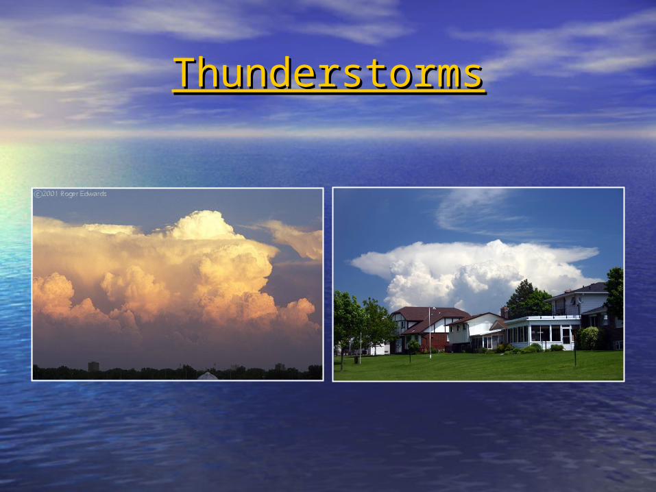
ThunderstormsThunderstorms
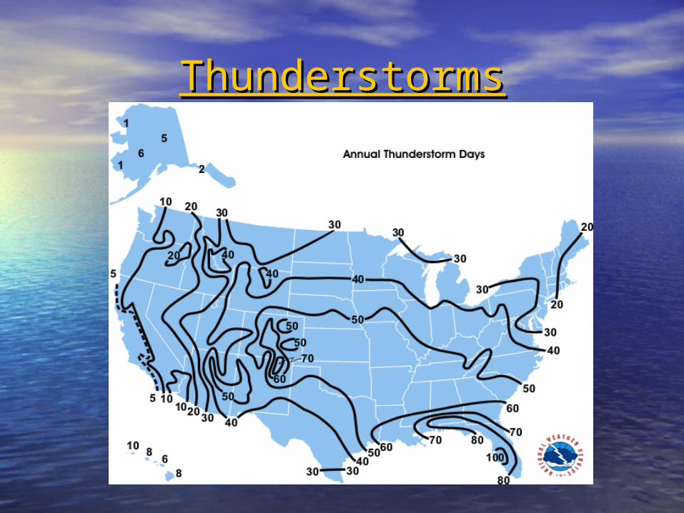
ThunderstormsThunderstorms

ThunderstormsThunderstorms
Required for thunderstorm Required for thunderstorm formation:formation:
1.1.MoistureMoisture
2.2.Lift / InstabilityLift / Instability

ThunderstormsThunderstorms
Moisture SourcesMoisture Sources
AtlanticAtlantic
Gulf of MexicoGulf of Mexico
Great LakesGreat Lakes
(Pacific)(Pacific)
ThunderstormsThunderstorms
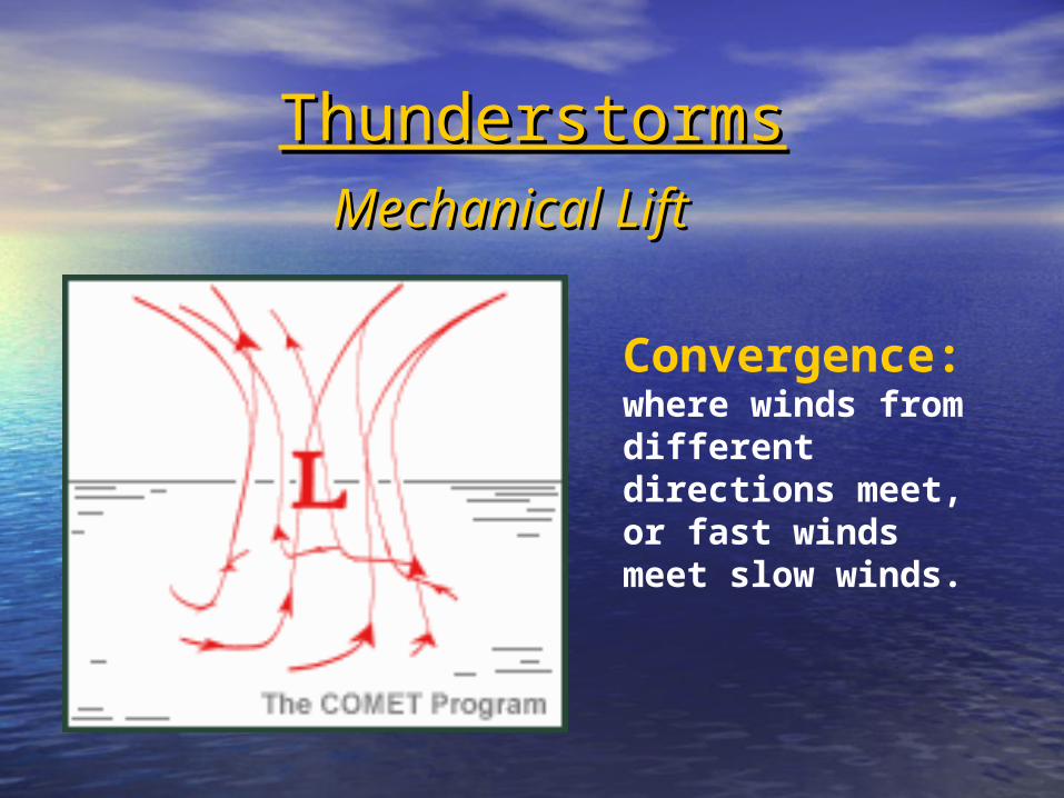
Convergence:where winds from different directions meet, or fast winds meet slow winds.
Mechanical LiftMechanical Lift
Mechanical Mechanical LiftLift
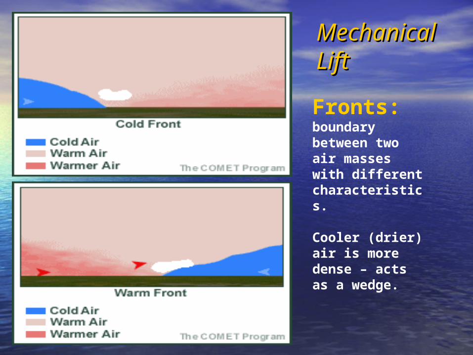
Fronts: boundary between two air masses with different characteristics.
Cooler (drier) air is more dense – acts as a wedge.
ThunderstormsThunderstorms
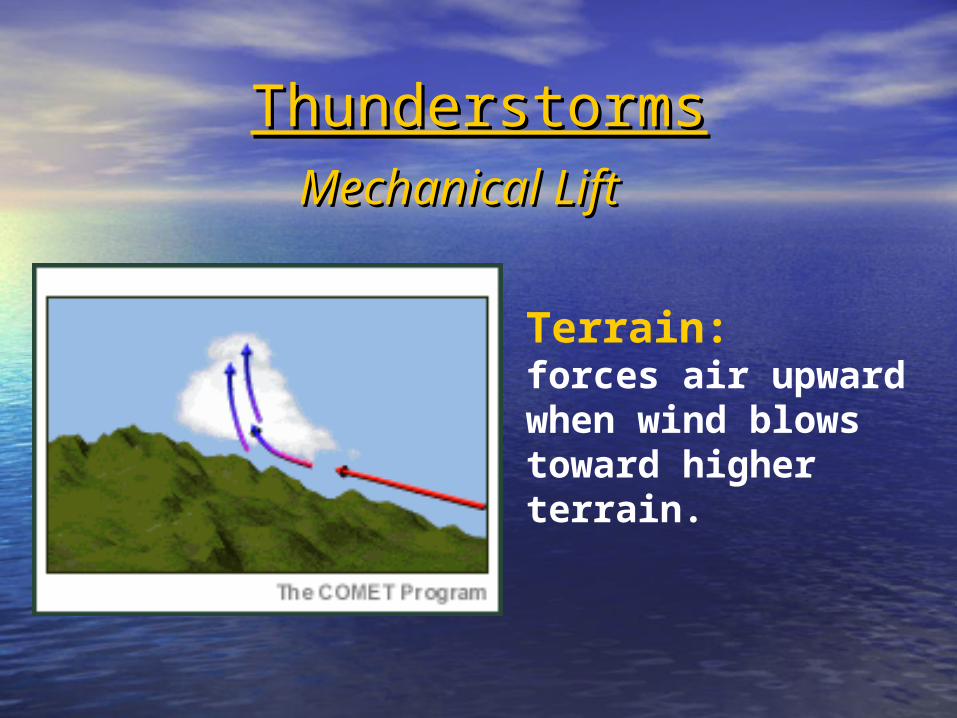
Terrain:forces air upward when wind blows toward higher terrain.
Mechanical LiftMechanical Lift

Instability (Non-mechanical Lift)Instability (Non-mechanical Lift)
Convection: The sun heats the earth’s surface, parcels of air rise like bubbles. They continue to rise as long as they remain warmer than the air around them.
Moist air will react the same way in the presence of Moist air will react the same way in the presence of drier airdrier air

Weather balloons provide a vertical Weather balloons provide a vertical profile of the air, which help us “see” profile of the air, which help us “see”
instability.instability.

ThunderstormsThunderstorms
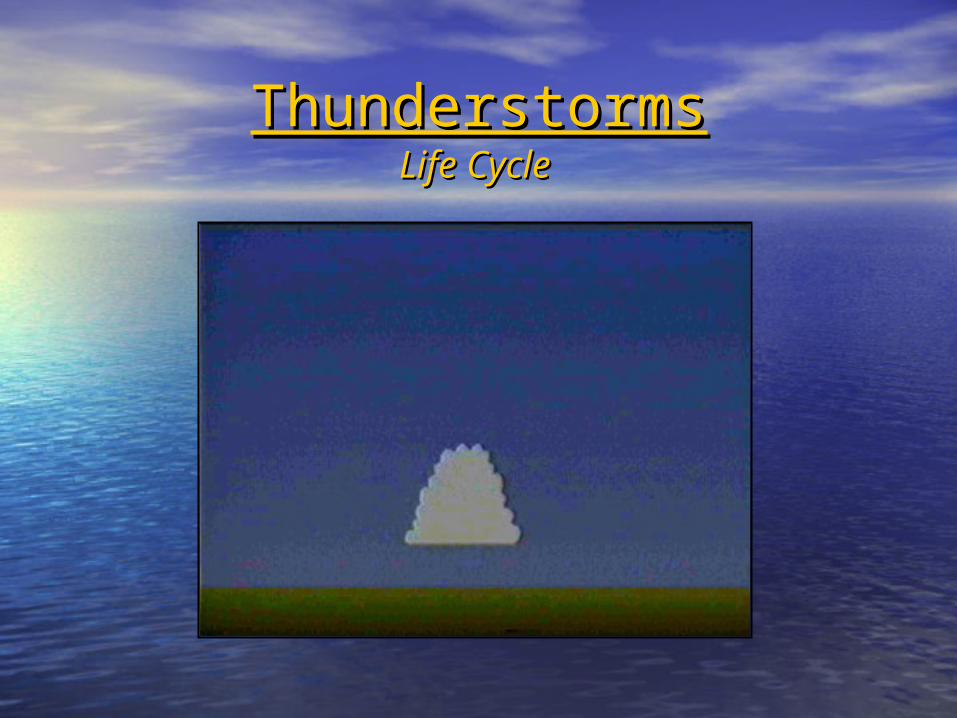
ThunderstormsThunderstormsLife CycleLife Cycle

Developing ThunderstormDeveloping Thunderstorm
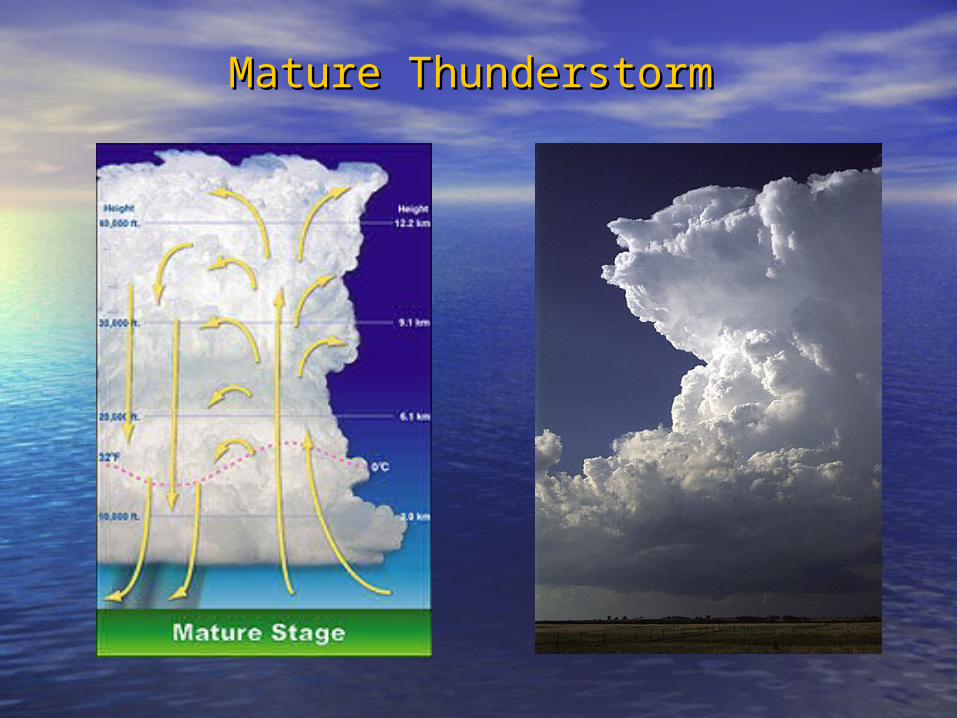
Mature ThunderstormMature Thunderstorm

ThunderstormsThunderstormsUpdraft developmentUpdraft development

ThunderstormsThunderstorms
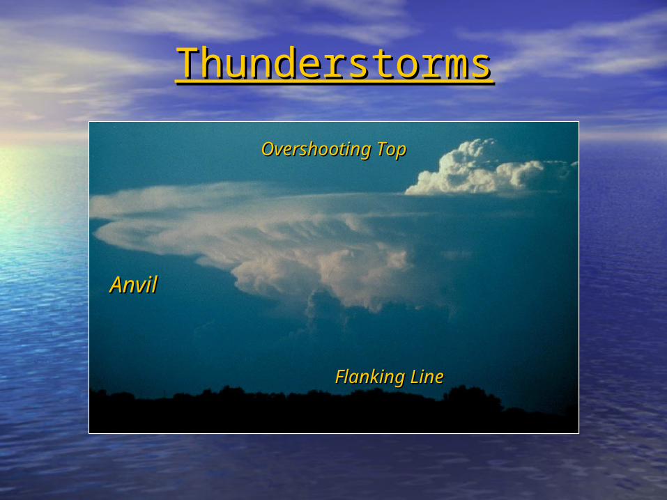
ThunderstormsThunderstorms
AnvilAnvil
Overshooting Overshooting TopTop
Flanking LineFlanking Line
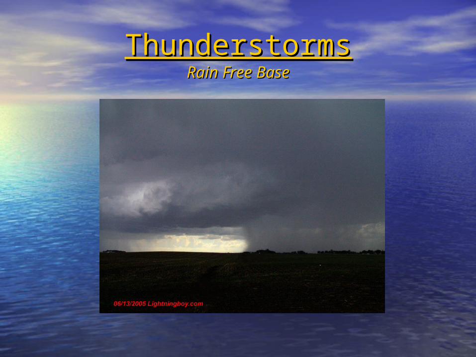
ThunderstormsThunderstormsRain Free BaseRain Free Base
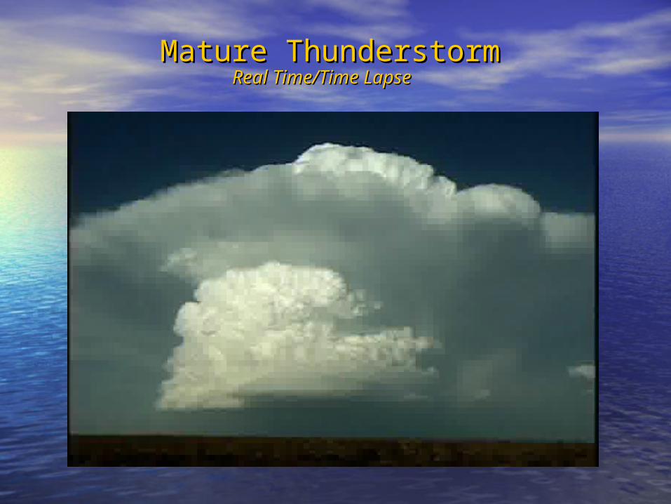
Mature ThunderstormMature ThunderstormReal Time/Time LapseReal Time/Time Lapse

ThunderstormsThunderstorms

ThunderstormsThunderstorms

Dissipating ThunderstormDissipating Thunderstorm
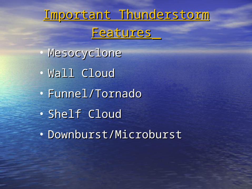
Important Thunderstorm FeaturesImportant Thunderstorm Features
• MesocycloneMesocyclone
• Wall CloudWall Cloud
• Funnel/TornadoFunnel/Tornado
• Shelf Cloud Shelf Cloud
• Downburst/MicroburstDownburst/Microburst
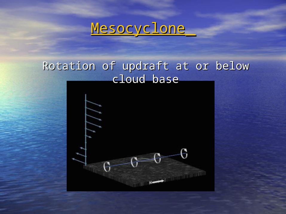
MesocycloneMesocyclone
Rotation of updraft at or below cloud baseRotation of updraft at or below cloud base

Mesocyclone in a Supercell Mesocyclone in a Supercell ThunderstormThunderstorm
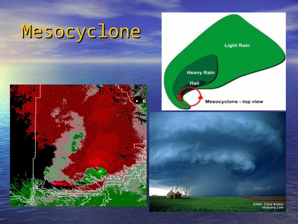
MesocycloneMesocyclone
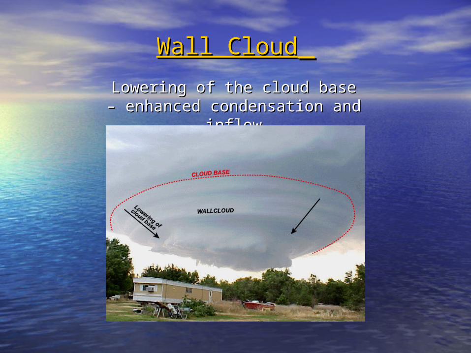
Wall CloudWall Cloud Lowering of the cloud base – Lowering of the cloud base – enhanced condensation and enhanced condensation and
inflowinflow

Tilts downward Tilts downward toward the rain toward the rain
May or may not May or may not rotate - rotation is rotate - rotation is
precursor to precursor to tornado tornado
developmentdevelopment

Wall CloudWall Cloud – give it a minute – give it a minute – watch for rotation– watch for rotation

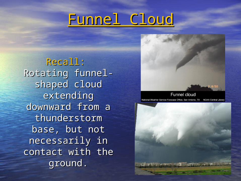
Funnel CloudFunnel Cloud
Recall:Recall: Rotating Rotating funnel-shaped funnel-shaped
cloud extending cloud extending downward from a downward from a
thunderstorm thunderstorm base, but not base, but not necessarily in necessarily in
contact with the contact with the ground.ground.

Funnel CloudFunnel Cloud - again, give it a minute - again, give it a minute

TornadoTornadoViolently rotating column of air, attached to a Violently rotating column of air, attached to a thunderstorm base, and in contact with the thunderstorm base, and in contact with the
groundground
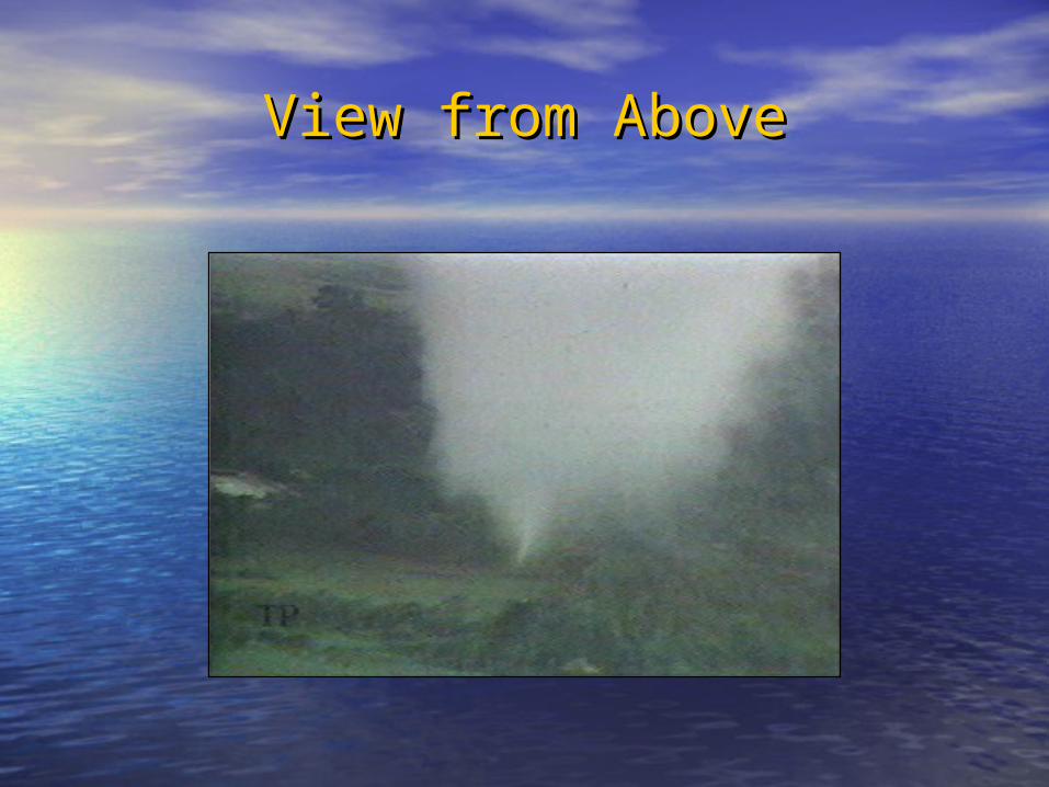
View from AboveView from Above

Look for the Look for the dust/debris dust/debris
to determine to determine contact with contact with
groundground

You make the call – Funnel or You make the call – Funnel or Tornado?Tornado?
Tornado? Maybe, but, not always Tornado? Maybe, but, not always obvious.obvious.

Multiple VorticesMultiple Vortices

Wanted a Front Row Seat?Wanted a Front Row Seat?
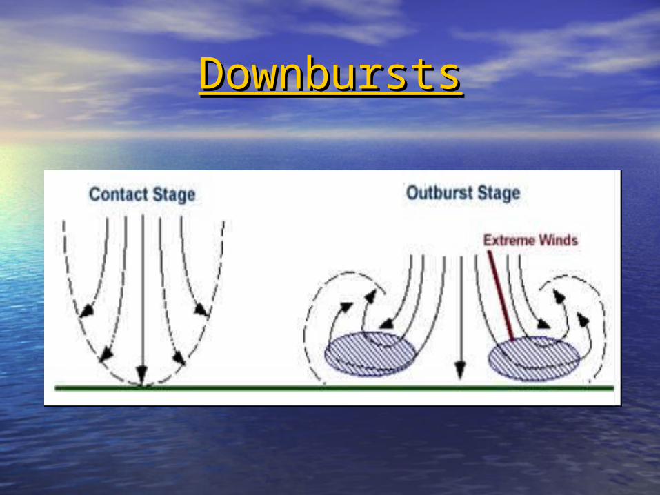
DownburstsDownbursts

DownburstDownburst(from outside)(from outside)

DownburstDownburst(from inside)(from inside)

Shelf CloudShelf Cloud
Aaron Gilstad-ND Atmospheric Resource Board
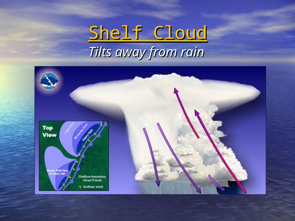
Shelf CloudShelf CloudTilts away from rainTilts away from rain

Maine Mall, South PortlandMaine Mall, South Portland9 September 20069 September 2006

Roll CloudRoll Cloud
Roll Cloud: Not Roll Cloud: Not attached to attached to
thunderstormthunderstormRoll Clouds are Roll Clouds are
long and long and tubular and tubular and rotate on a rotate on a
horizontal axishorizontal axis

ScudScud
Tom Warner
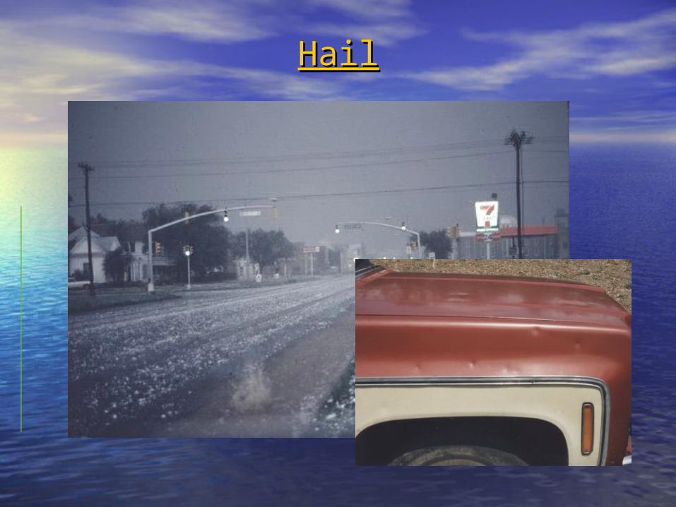
HailHail

Hail FormationHail Formation•Strong Strong updraftupdraft
•Hail nucleus Hail nucleus goes through goes through ice accretion ice accretion
multiple timesmultiple times
•Either gets Either gets blown out of blown out of updraft, or updraft, or
becomes too becomes too heavy heavy

• 0.25” - Pea0.25” - Pea
• 0.50” - Mothball 0.50” - Mothball
• 0.75” - Penny/Dime0.75” - Penny/Dime
• 0.88” - Nickel0.88” - Nickel
• 1.00” - Quarter1.00” - Quarter
• 1.25” - Half Dollar1.25” - Half Dollar
• 1.50” - Ping Pong (Walnut)1.50” - Ping Pong (Walnut)
• 1.75” - Golf Ball1.75” - Golf Ball
• 2.00” - Hen Egg2.00” - Hen Egg
• 2.50” - Tennis Ball2.50” - Tennis Ball
• 2.75” - Baseball2.75” - Baseball
• 4.50” - Softball4.50” - Softball
Coins or Sports Balls Coins or Sports Balls (or candy?)(or candy?)
(M&M)(M&M)

Thunderstorm Thunderstorm
SafetySafety
• Go indoorsGo indoors
• Stay away from windowsStay away from windows
• If you are in a vehicle, If you are in a vehicle, point it into the windpoint it into the wind
• If you are outside, get If you are outside, get down as low as you can down as low as you can without laying on the without laying on the ground. ground.
• Can be much more Can be much more damaging than a tornado!damaging than a tornado!

TornadoTornado• Go to a sturdy buildingGo to a sturdy building
• Basement, away from outer wallsBasement, away from outer walls
• If no basement, interior closet, hallway, or If no basement, interior closet, hallway, or bathroombathroom
• Stay away from windowsStay away from windows
• If outdoors, seek shelter If outdoors, seek shelter
• If driving, abandon your vehicle and seek If driving, abandon your vehicle and seek shelter. Look for a nearby ditch or shelter. Look for a nearby ditch or depression but watch out for flooding.depression but watch out for flooding.
• DO NOT seek shelter beneath an DO NOT seek shelter beneath an overpass. overpass.

Could be hit by debrisCould be hit by debris
Bad ideaBad idea

LightningLightning
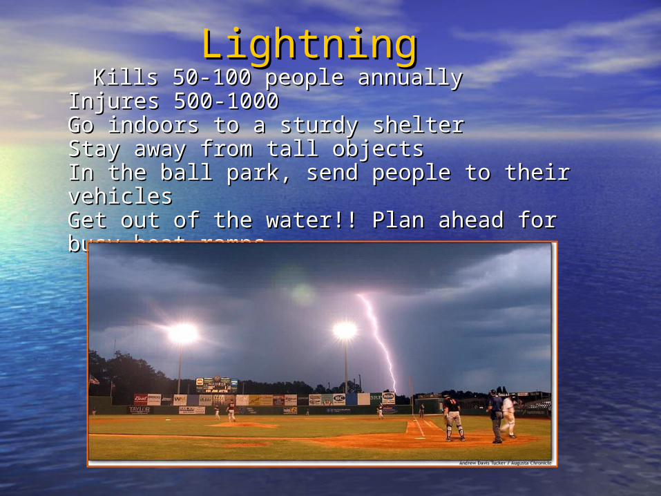
Kills 50-100 people annuallyKills 50-100 people annuallyInjures 500-1000Injures 500-1000Go indoors to a sturdy shelterGo indoors to a sturdy shelterStay away from tall objectsStay away from tall objectsIn the ball park, send people to their vehiclesIn the ball park, send people to their vehiclesGet out of the water!! Plan ahead for busy boat Get out of the water!! Plan ahead for busy boat rampsramps
LightningLightning

Bad Decisions (Part Bad Decisions (Part 1)1)
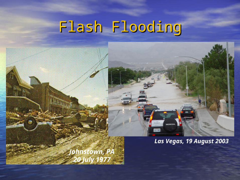
Flash FloodingFlash Flooding
Johnstown, PA20 July 1977
Las Vegas, 19 August 2003

Flash FloodingFlash Flooding
1996
Flooding kills more people in
the US and worldwide than any
other weather hazard

Westbrook, MEWestbrook, ME
Old Orchard Beach, MEOld Orchard Beach, ME
ScarboroughScarborough, ME, ME
October October 19961996

From the FEMA Web
Page
For each foot the water rises up the
side of a typical car, 1500 lbs is displaced.
1.5-2 feet can carry away almost all
cars.

Something a Little BiggerSomething a Little Bigger• Width: 6 feetWidth: 6 feet
• Length: 18 feetLength: 18 feet
• Ground Clearance: 18 Ground Clearance: 18 inchesinches
• Weight: 5,040 poundsWeight: 5,040 pounds
1 foot of water displaced by 1 foot of water displaced by this vehicle weighs:this vehicle weighs:
(6’ x 18’ x 1’ x 62.4 lbs./cu.ft.) (6’ x 18’ x 1’ x 62.4 lbs./cu.ft.) = = 6,739 pounds6,739 pounds
Bigger not always betterBigger not always better

Bad Decisions (Part Bad Decisions (Part 2)2)
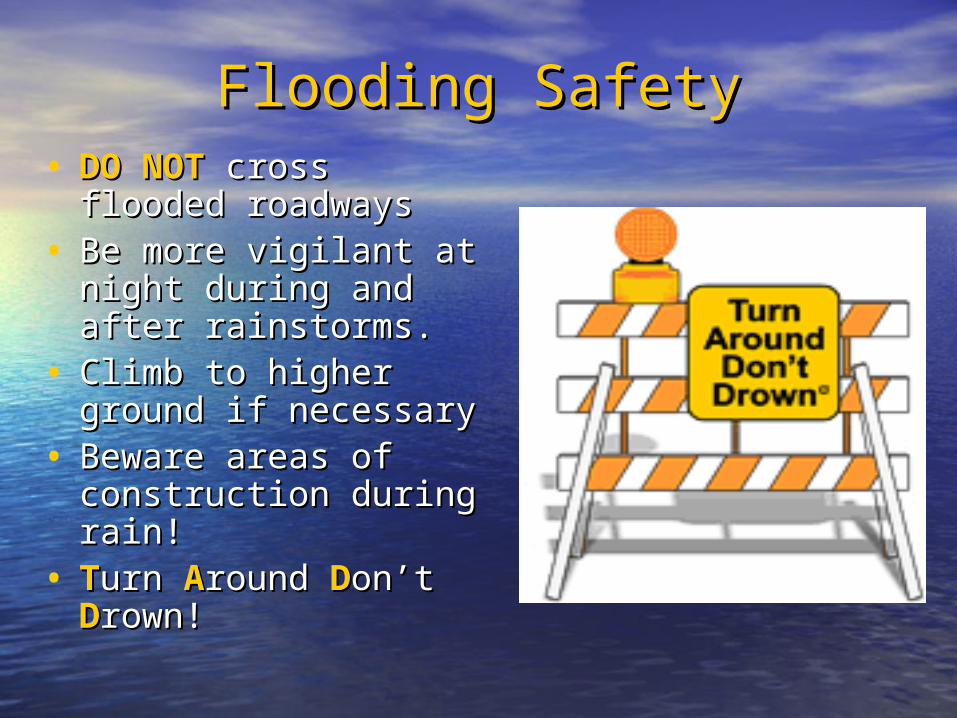
Flooding SafetyFlooding Safety• DO NOTDO NOT cross flooded cross flooded
roadwaysroadways• Be more vigilant at Be more vigilant at
night during and after night during and after rainstorms. rainstorms.
• Climb to higher Climb to higher ground if necessaryground if necessary
• Beware areas of Beware areas of construction during construction during rain!rain!
• TTurn urn AAround round DDon’t on’t DDrown!rown!

Bad Decisions (Part Bad Decisions (Part 3)3)

Planning AheadPlanning Ahead(A few days)(A few days)
• Day 2 & 3 Convective Outlooks (SPC)Day 2 & 3 Convective Outlooks (SPC)
• Day 2-7 Hazardous Weather Outlook Day 2-7 Hazardous Weather Outlook
• Area Forecast Discussion (Long Area Forecast Discussion (Long Term)Term)

Severe Weather Severe Weather Expected this Expected this
Afternoon!Afternoon!
• Day 1 Convective Outlooks (SPC)Day 1 Convective Outlooks (SPC)
• Day 1 Hazardous Weather OutlookDay 1 Hazardous Weather Outlook
• Short Term Area Forecast DiscussionShort Term Area Forecast Discussion

Convective OutlooksConvective Outlooks

Hazardous Hazardous Weather Weather OutlookOutlook(HWO)(HWO)
•Issued before 6 Issued before 6 AMAM
•By local WFOBy local WFO

Area Forecast Discussion (AFD)Area Forecast Discussion (AFD)
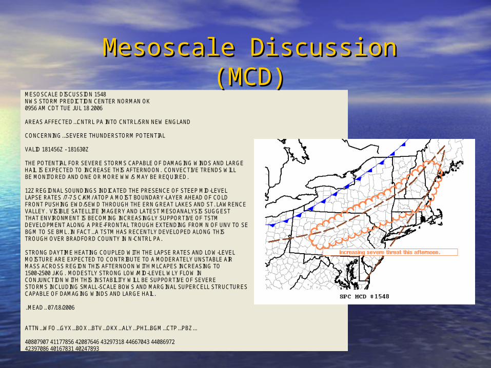
MESOSCALE DISCUSSION 1548 NWS STORM PREDICTION CENTER NORMAN OK 0956 AM CDT TUE JUL 18 2006 AREAS AFFECTED...CNTRL PA INTO CNTRL/SRN NEW ENGLAND CONCERNING...SEVERE THUNDERSTORM POTENTIAL VALID 181456Z - 181630Z THE POTENTIAL FOR SEVERE STORMS CAPABLE OF DAMAGING WINDS AND LARGE HAIL IS EXPECTED TO INCREASE THIS AFTERNOON. CONVECTIVE TRENDS WILL BE MONITORED AND ONE OR MORE WW/S MAY BE REQUIRED. 12Z REGIONAL SOUNDINGS INDICATED THE PRESENCE OF STEEP MID-LEVEL LAPSE RATES /7-7.5 C/KM/ ATOP A MOIST BOUNDARY-LAYER AHEAD OF COLD FRONT PUSHING EWD/SEWD THROUGH THE ERN GREAT LAKES AND ST. LAWRENCE VALLEY. VISIBLE SATELLITE IMAGERY AND LATEST MESOANALYSIS SUGGEST THAT ENVIRONMENT IS BECOMING INCREASINGLY SUPPORTIVE OF TSTM DEVELOPMENT ALONG A PRE-FRONTAL TROUGH EXTENDING FROM N OF UNV TO SE BGM TO SE BML. IN FACT...A TSTM HAS RECENTLY DEVELOPED ALONG THIS TROUGH OVER BRADFORD COUNTY IN N-CNTRL PA. STRONG DAYTIME HEATING COUPLED WITH THE LAPSE RATES AND LOW-LEVEL MOISTURE ARE EXPECTED TO CONTRIBUTE TO A MODERATELY UNSTABLE AIR MASS ACROSS REGION THIS AFTERNOON WITH MLCAPES INCREASING TO 1500-2500 J/KG. MODESTLY STRONG LOW/MID-LEVEL WLY FLOW IN CONJUNCTION WITH THIS INSTABILITY WILL BE SUPPORTIVE OF SEVERE STORMS INCLUDING SMALL-SCALE BOWS AND MARGINAL SUPERCELL STRUCTURES CAPABLE OF DAMAGING WINDS AND LARGE HAIL. ..MEAD.. 07/18/2006 ATTN...WFO...GYX...BOX...BTV...OKX...ALY...PHI...BGM...CTP...PBZ... 40807907 41177856 42087646 43297318 44667043 44086972 42397086 40167831 40247893
Mesoscale Discussion Mesoscale Discussion (MCD)(MCD)
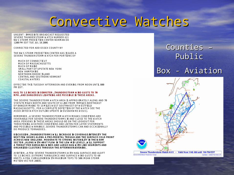
URGENT - IMMEDIATE BROADCAST REQUESTED SEVERE THUNDERSTORM WATCH NUMBER 611 NWS STORM PREDICTION CENTER NORMAN OK 1200 PM EDT TUE JUL 18 2006 CORRECTED FOR ADD ESSEX COUNTY NY THE NWS STORM PREDICTION CENTER HAS ISSUED A SEVERE THUNDERSTORM WATCH FOR PORTIONS OF MUCH OF CONNECTICUT MUCH OF MASSACHUSETTS MUCH OF MAINE SMALL PART OF UPSTATE NEW YORK NEW HAMPSHIRE NORTHERN RHODE ISLAND CENTRAL AND SOUTHERN VERMONT COASTAL WATERS EFFECTIVE THIS TUESDAY AFTERNOON AND EVENING FROM NOON UNTIL 800 PM EDT. HAIL TO 1.5 INCHES IN DIAMETER...THUNDERSTORM WIND GUSTS TO 70 MPH...AND DANGEROUS LIGHTNING ARE POSSIBLE IN THESE AREAS. THE SEVERE THUNDERSTORM WATCH AREA IS APPROXIMATELY ALONG AND 70 STATUTE MILES NORTH AND SOUTH OF A LINE FROM 70 MILES NORTHEAST OF BANGOR MAINE TO 15 MILES WEST SOUTHWEST OF WESTFIELD MASSACHUSETTS. FOR A COMPLETE DEPICTION OF THE WATCH SEE THE ASSOCIATED WATCH OUTLINE UPDATE (WOUS64 KWNS WOU1). REMEMBER...A SEVERE THUNDERSTORM WATCH MEANS CONDITIONS ARE FAVORABLE FOR SEVERE THUNDERSTORMS IN AND CLOSE TO THE WATCH AREA. PERSONS IN THESE AREAS SHOULD BE ON THE LOOKOUT FOR THREATENING WEATHER CONDITIONS AND LISTEN FOR LATER STATEMENTS AND POSSIBLE WARNINGS. SEVERE THUNDERSTORMS CAN AND OCCASIONALLY DO PRODUCE TORNADOES. DISCUSSION...THUNDERSTORMS WILL INCREASE IN COVERAGE/INTENSITY THE NEXT FEW HOURS ALONG A PRE-FRONTAL TROUGH AND THE SURFACE COLD FRONT ACROSS NEW ENGLAND. MODERATE TO STRONG INSTABILITY IN THE WARM SECTOR...ALONG WITH 40 KT FLOW IN THE LOW-MID LEVELS...WILL SUPPORT A THREAT FOR DAMAGING WINDS AND LARGE HAIL WITH LINE SEGMENTS AND ORGANIZED CLUSTERS THROUGH THE AFTERNOON/EVENING. AVIATION...A FEW SEVERE THUNDERSTORMS WITH HAIL SURFACE AND ALOFT TO 1.5 INCHES. EXTREME TURBULENCE AND SURFACE WIND GUSTS TO 60 KNOTS. A FEW CUMULONIMBI WITH MAXIMUM TOPS TO 500. MEAN STORM MOTION VECTOR 28035.
Convective WatchesConvective Watches
Counties – PublicCounties – Public
Box - AviationBox - Aviation

WarningsWarnings
NNNNZCZC PWMSVRGYXWUUS51 KGYX 182104NHC001-013-182145-/O.NEW.KGYX.SV.W.0110.060718T2104Z-060718T2145Z/
BULLETIN - EAS ACTIVATION REQUESTEDSEVERE THUNDERSTORM WARNINGNATIONAL WEATHER SERVICE GRAY ME504 PM EDT TUE JUL 18 2006
THE NATIONAL WEATHER SERVICE IN GRAY MAINE HAS ISSUED A
* SEVERE THUNDERSTORM WARNING FOR... BELKNAP COUNTY IN CENTRAL NEW HAMPSHIRE... NORTHERN MERRIMACK COUNTY IN CENTRAL NEW HAMPSHIRE...
* UNTIL 545 PM EDT
* AT 458 PM EDT...NATIONAL WEATHER SERVICE DOPPLER RADAR INDICATED A SEVERE THUNDERSTORM CAPABLE OF PRODUCING DAMAGING WINDS IN EXCESS OF 60 MPH. THIS STORM WAS LOCATED NEAR DANBURY...OR ABOUT 10 MILES NORTHEAST OF NEW LONDON...AND MOVING EAST AT 30 MPH.
* THE SEVERE THUNDERSTORM WILL BE NEAR... FRANKLIN BY 520 PM EDT... TILTON-NORTHFIELD AND TILTON BY 525 PM EDT... LACONIA BY 530 PM EDT... GILMANTON BY 540 PM EDT...
PLEASE REPORT HAIL OR STRONG WINDS TO THE NATIONAL WEATHER SERVICE BYCALLING TOLL FREE...877-633-6772...WHEN YOU CAN DO SO SAFELY.
A SEVERE THUNDERSTORM WATCH REMAINS IN EFFECT UNTIL 800 PM EDTTUESDAY EVENING FOR SOUTHWESTERN MAINE AND SOUTHWESTERN NEWHAMPSHIRE.
LAT...LON 4356 7191 4359 7186 4355 7182 4356 7173 4359 7173 4359 7168 4362 7164 4368 7145 4357 7128 4337 7125 4345 7192
$$
NNNNZCZC PWMSMWGYXWHUS51 KGYX 182112ANZ150-182200-/O.NEW.KGYX.MA.W.0019.060718T2112Z-060718T2200Z/
BULLETIN - IMMEDIATE BROADCAST REQUESTEDSPECIAL MARINE WARNINGNATIONAL WEATHER SERVICE GRAY ME512 PM EDT TUE JUL 18 2006
THE NATIONAL WEATHER SERVICE IN GRAY MAINE HAS ISSUED A
* SPECIAL MARINE WARNING FOR... CENTRAL COASTAL WATERS FROM STONINGTON (DEER ISLE) ME TO MERRIMACK RIVER MA OUT 25 NM... INCLUDING BOOTHBAY HARBOR AND PORTLAND HARBOR...
* UNTIL 600 PM EDT
* AT 502 PM EDT...NATIONAL WEATHER SERVICE DOPPLER RADAR INDICATED A THUNDERSTORM...PRODUCING STRONG WINDS OVER 35 KNOTS NEAR PORTLAND HEAD LIGHT...OR ABOUT 3 MILES SOUTH OF PORTLAND HARBOR...MOVING EAST AT 30 KT.
MARINERS CAN EXPECT GUSTY WINDS...HIGH WAVES...DANGEROUS LIGHTNING...AND HEAVY RAINS. BOATERS SHOULD SEEK SAFE HARBOR IMMEDIATELY...UNTILTHIS STORM PASSES.
PLEASE REPORT HAIL OR STRONG WINDS DIRECTLY TO THE NATIONAL WEATHERSERVICE BY CALLING TOLL FREE...877-633-6772...WHEN YOU CAN DO SOSAFELY.
A SEVERE THUNDERSTORM WATCH REMAINS IN EFFECT UNTIL 800 PM EDT TUESDAY EVENING FOR THE COASTAL WATERS OF MAINE AND NEW HAMPSHIRE.
LAT...LON 4371 7026 4353 7020 4364 6940 4388 6948
$$
• Severe Thunderstorm – 58 mph winds / ¾” Severe Thunderstorm – 58 mph winds / ¾” hailhail
• Special Marine – 34 knots / ¾” hail / Special Marine – 34 knots / ¾” hail / waterspoutswaterspouts

Reporting CriteriaReporting Criteria
TornadoTornado Hail (any size)Hail (any size)
Funnel CloudFunnel Cloud Winds 50 mph or Winds 50 mph or greatergreater
Rotating Wall Rotating Wall CloudCloud
Rain: 1” an hour Rain: 1” an hour or moreor more
Flash FloodingFlash FloodingRain: 2” or Rain: 2” or
greater in < 6 greater in < 6 hourshours
Storm Related Damage of Any KindStorm Related Damage of Any Kind

What What notnot to report: to report:
• Lightning Lightning
-We have an accurate detection -We have an accurate detection systemsystem
• ““Dark Sky,” “It’s starting to rain,” Dark Sky,” “It’s starting to rain,” “It’s raining hard,” “The winds are “It’s raining hard,” “The winds are starting to blow,” etc.starting to blow,” etc.
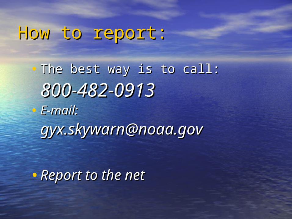
How to report:How to report:
• The best way is to call:The best way is to call:
800-482-0913800-482-0913• E-mail:E-mail:
[email protected]@noaa.gov
•Report to the netReport to the net

NOAA NOAA Weather Weather
RadioRadio
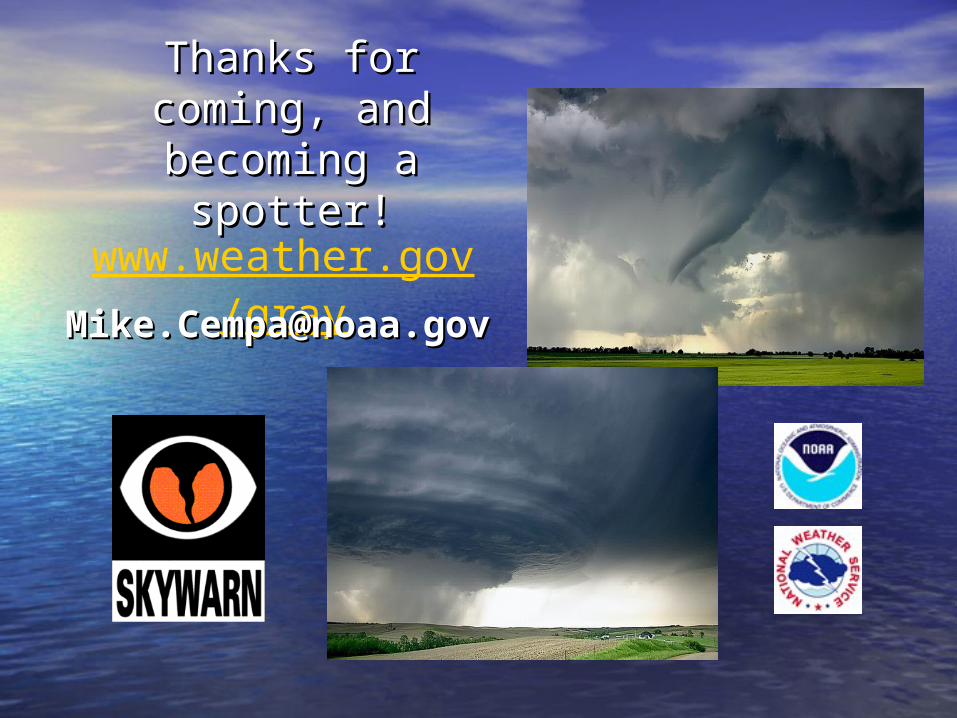
Thanks for coming, Thanks for coming, and becoming a and becoming a
spotter!spotter!
www.weather.gov/gray
[email protected]@noaa.govov


![[En] Spotter Corporate Presentation 2013](https://static.fdocuments.in/doc/165x107/558c7f0bd8b42a7f0b8b45ab/en-spotter-corporate-presentation-2013.jpg)