The Five Themes of Geography History is the study of events over time. 2000 BC 900 AD 1492 AD 1621...
24
The Five Themes of Geography
-
Upload
francine-hicks -
Category
Documents
-
view
215 -
download
1
Transcript of The Five Themes of Geography History is the study of events over time. 2000 BC 900 AD 1492 AD 1621...

The Five Themes of Geography

History is the study of events over time.
2000 BC
900 AD
1492 AD
1621 AD

Geography - the study of distribution and interaction of physical and human features on the earth.

Geographers use a variety of tools:MapsPhotographsChartsGraphs and TablesScale Models
Five Themes of Geography
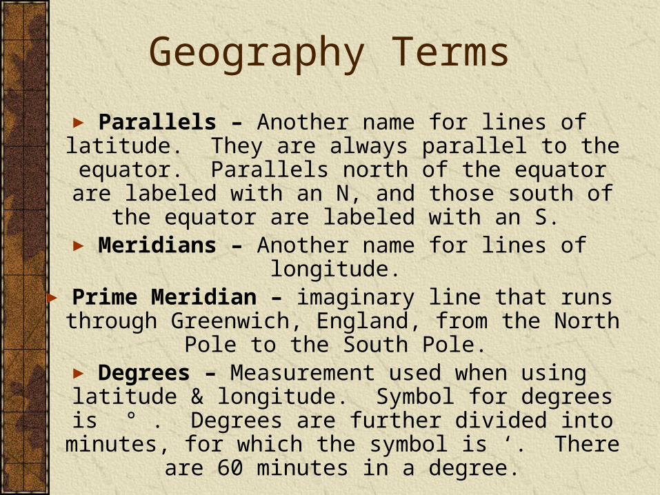
Geography Terms
► Parallels – Another name for lines of latitude. They are always parallel to the equator. Parallels north of the equator are labeled with an N, and those south of the equator are labeled with an S.
► Meridians – Another name for lines of longitude. ► Prime Meridian – imaginary line that runs through Greenwich,
England, from the North Pole to the South Pole. ► Degrees – Measurement used when using latitude & longitude.
Symbol for degrees is ° . Degrees are further divided into minutes, for which the symbol is ‘. There are 60 minutes in a
degree.

Geography Terms
►Grid – Pattern of lines that circle the globe in east-west and north-south directions.
►Latitude – lines drawn in an east-west direction and measure distance north & south of the equator. Each degree of latitude is approximately 69 miles apart.
►Longitude – lines of longitude are drawn in a north-south direction and measure distance east and west of the Prime Meridian. At the equator, a line of longitude is 69 miles apart. The distance shrinks down to zero at
the poles. ►Equator – imaginary line that circles the globe halfway
between the North Pole & South Pole.
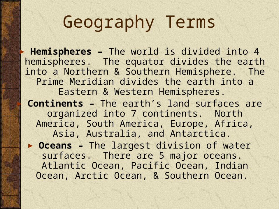
Geography Terms
► Hemispheres – The world is divided into 4 hemispheres. The equator divides the earth into a Northern & Southern
Hemisphere. The Prime Meridian divides the earth into a Eastern & Western Hemispheres.
► Continents – The earth’s land surfaces are organized into 7 continents. North America, South America, Europe, Africa, Asia,
Australia, and Antarctica. ► Oceans – The largest division of water surfaces. There are 5
major oceans. Atlantic Ocean, Pacific Ocean, Indian Ocean, Arctic Ocean, & Southern Ocean.


LatitudeImaginary lines north and and south from the equator.Equator
N
S
100
200
100
200
300
00
300
900
900
W E
Prime Meridian
100
200100
200
300 300
00
18001800
LongitudeImaginary lines east and west from the Prime Meridian.

Together, latitude and longitude form a GRID SYSTEM.

Locate the following using the map on pages 4-5.
1. City closest to 30S / 150E2. Country bounded by 0S, 15S, 15E, 30E3. City closest to 60N / 45E4. Islands between 15N, 30N, 150W,
165W5. Country through which 75N, 40W pass6. You are at 15S / 90E. Do you need a car
or a boat?7. What is at 90N / 180W?8. Country through which 55N, 0E pass.

Hemispheres
The Earth is divided at the equator into two halves. Each half is called a hemisphere or half-circle.
Equator 00
S900
Northern Hemisphere
Southern Hemisphere
N900

Use the map on pages 2-3 to determine the hemisphere in which each place is located. Write North or South.
1. United States2. Congo Basin3. Rio de Janeiro4. Gobi Desert5. Red Sea6. Cape Horn

Hemispheres
The Earth is also divided east and west.
Western Hemisphere
Eastern Hemisphere
Prime Meridian 00 Longitude
Western Hemisphere
Eastern Hemisphere
International Dateline 1800 Longitude

Use the map on pages 2-3 to determine the hemisphere in which each place is located. Write East or West.
1. Siberia2. Aleutian Islands3. Puerto Rico4. Arabian Peninsula5. Andes Mountains6. Mariana Islands

Five Themes of GeographyLocation: where is it?Place: what is it like?Region: how are places similar or different?Human-Environment Interaction: how do people relate to the physical world? Movement: how do people goods, and ideas move from one place to another?

LOCATIONWhere is it?
Absolute Location: the exact place on earth where a geographic feature, such a city, is found. Latitude/Longitude or street address. Relative Location: describes a place in comparison to other places around it.

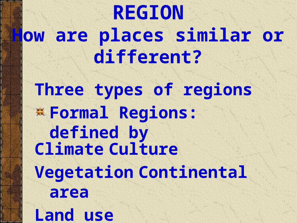
Three types of regions
Formal Regions: defined by
REGIONHow are places similar or
different?
Climate Culture
Vegetation Continental area
Land use

Functional Regions: defined interactions and connections between places. Ex.
Perceptual Regions: defined by what people perceive or “see” as characteristic of the region. Ex. The Heartland
REGION

HUMAN-ENVIRONMENT INTERACTION
How do people relate to the physical world?
Jobs
Animals
Crops
Transportation Clothes
Houses
Engineering
Food Sources
Protection

MOVEMENTHow do people goods, and ideas move from one place to another?
Linear Distance: how far
Time Distance: how long
Psychological Distance: how far away we think or feel a place is.

Map Projections
Attempts to portray the surface of the earth or a portion of the earth on a flat surface. Some distortions of conformality, distance, direction, scale, and area always result from this process.
Types: Mercator, Robinson, Goode’s Interrupted Equal-Area, Winkel Tripel

Winkel Tripel MercatorAzimuthal
Goode’s interrupted Equal Area Robinson


![IS 1492 (1970): Metric surveying chains - Public.Resource.Org · IS 1492 (1970): Metric surveying chains [PGD 22: Educational Instruments and Equipment] Title: IS 1492 (1970): Metric](https://static.fdocuments.in/doc/165x107/60add2f2f0a2e22263188419/is-1492-1970-metric-surveying-chains-is-1492-1970-metric-surveying-chains.jpg)