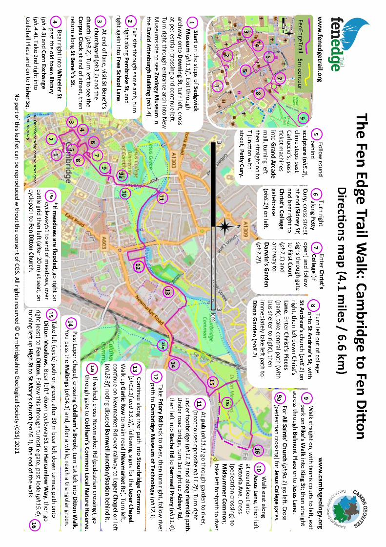
The Fen Edge Trail
6
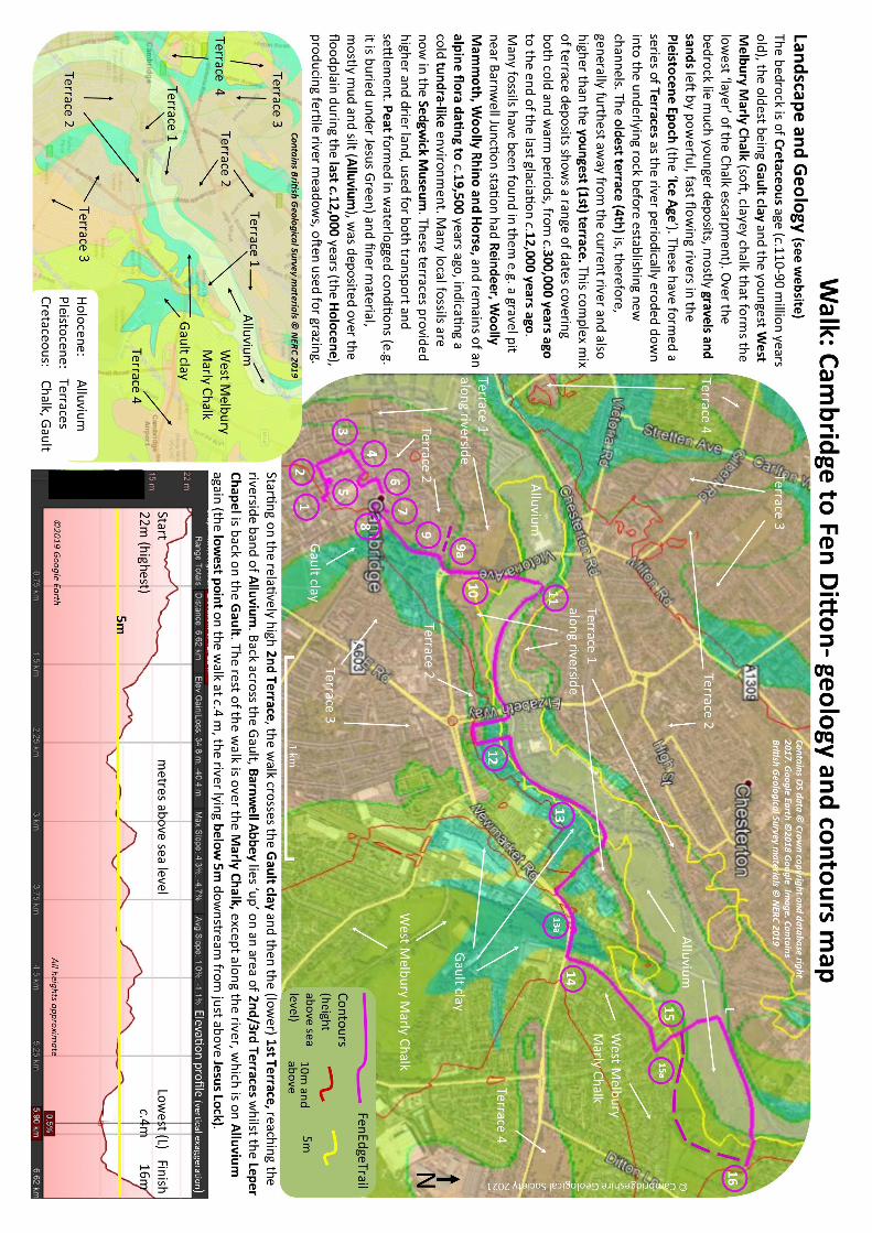
a journey across a landscape and me Praccalies As elsewhere on the Fen Edge Trail, you can walk all of a walk using transport one way or choose a shorter or longer round trip opon (or just visit some of the places on the route). The walk is divided into numbered parts as shown on the two maps. Photo numbers refer to the part they relate to and the order they are seen e.g. 13.2f is the first photo relang to part 13 (f = on this front page). The website has links to local organisaons and places of interest. The walk crosses the route of the new Chisholm Trail (cycle route) as it exits Coldhams Common, near the Leper Chapel. It also links with Fen Rivers Way and Harcamlow Way. The Sedgwick Museum has many local fossils and informaon on local geology and runs events throughout the year www.sedgwickmuseum.org. Length of walk (one way) approx. 4.1 miles/6.6km (guide me if not stopping 2hrs 40 mins). Maps O.S. Explorer 209. BGS Geology Map 188 (1:50,000, New Series). Online map viewer www.bgs.ac.uk/discoveringGeology (plus iGeology mobile app). Transport and services Buses run from Cambridge to Fen Dion village and other buses run between Cambridge, Burwell and Newmarket along the A1303 nearby (www.stagecoachbus.com). There are trains to Cambridge. There is on-street parking in some areas of Fen Dion and several car parks in Cambridge. Please only park where allowed and in consideraon of others. There are cafes, pubs and shops in Cambridge and pubs in Fen Dion. You could return by boat - there is a (bookable, one way or return) trip between Jesus Lock and Fen Dion (www.camboats.co.uk). Safety Be aware of risks you may encounter and take note of warnings given by landowners or on pathways. The terrain is generally flat, with possibly some muddy ground along the river. Take parcular care with uneven terrain, when near water, on soſt or slippery ground, in the presence of livestock or walking along or crossing roads. Ensure your dog is kept under control as needed. All Fen Edge Trail walks are on publicly accessible routes. Anyone undertaking walks on the Fen Edge Trail does so at their own risk, these notes are for general guidance only. The route: ‘from revoluonary science to riverside meadows’ This walk, on the southern limit of the Fen Edge, takes you from the centre of Cambridge, one of England’s most iconic cies, through characterisc water meadows to the riverside village of Fen Dion. Starng at the famous Sedgwick Museum of Earth Sciences and with a short visit to the University of Cambridge Museum of Zoology, you pass the buildings that have witnessed some of the most remarkable work in the history of science from Darwin’s studies to Crick and Watson’s discovery of DNA. Both museums hold internaonally important specimens and are worth extended visits themselves and the Sedgwick has published a Geology Trail featuring many of the building stones in the city. One of the other highlights of this walk to Fen Dion is the journey along the River Cam. Rising from chalk springs in the hills to the south of the city, this important river flows north to join the River Ouse on its course to the Wash. The river has been the life-blood of Cambridge since its first selements, providing food and transport and acng as a military boundary. Trade with the outside world via the North Sea allowed this ’fenland town’ to grow and flourish. Today the wharves and jees have been replaced with beauful gardens, punt staons and boathouses but the river is just as vital to the life of the city as ever, winding between historic college buildings and famous for its rowing and punng. 13.1f Stourbridge Common and River Cam starng at The Sedgwick Museum of Earth Sciences ‘I love the mix on this walk.....the history, the landscape, especially the river’ Penny, CGS Cambs Geosites Team 13.2f Stourbridge Common* The Fen Edge Trail Walk: Cambridge to Fen Dion 4.1 miles (6.6 km) 15.5f 15/16th century listed barn Fen Dion* 11.2f Boathouses on Cam 13.3f Leper Chapel 6.1f Christ’s College gatehouse made of Weldon limestone 1.1f Sedgwick Museum* 7.2f Darwin Garden Christ’s College Cambridge to Fen Dion walk Fen Dion Contours: 0m blue, 5m yellow, 10m and above red. Peakirk: Lincs border Isleham: Suffolk border © Cambridgeshire Geological Society 2021 Contains OS data © Crown copyright and database right 2017 Image Landsat Copernicus 20km N
Transcript of The Fen Edge Trail
a journey across a landscape and time
Practicalities As elsewhere on the Fen Edge Trail, you can walk all of a walk using transport one way or choose a shorter or longer round trip option (or just visit some of the places on the route). The walk is divided into numbered parts as shown on the two maps. Photo numbers refer to the part they relate to and the order they are seen e.g. 13.2f is the first photo relating to part 13 (f = on this front page). The website has links to local organisations and places of interest. The walk crosses the route of the new Chisholm Trail (cycle route) as it exits Coldhams Common, near the Leper Chapel. It also links with Fen Rivers Way and Harcamlow Way. The Sedgwick Museum has many local fossils and information on local geology and runs events throughout the year www.sedgwickmuseum.org.
Length of walk (one way) approx. 4.1 miles/6.6km (guide time if not stopping 2hrs 40 mins). Maps O.S. Explorer 209. BGS Geology Map 188 (1:50,000, New Series). Online map viewer www.bgs.ac.uk/discoveringGeology (plus iGeology mobile app).
Transport and services Buses run from Cambridge to Fen Ditton village and other buses run between Cambridge, Burwell and Newmarket along the A1303 nearby (www.stagecoachbus.com). There are trains to Cambridge. There is on-street parking in some areas of Fen Ditton and several car parks in Cambridge. Please only park where allowed and in consideration of others. There are cafes, pubs and shops in Cambridge and pubs in Fen Ditton. You could return by boat - there is a (bookable, one way or return) trip between Jesus Lock and Fen Ditton (www.camboats.co.uk).
Safety Be aware of risks you may encounter and take note of warnings given by landowners or on pathways. The terrain is generally flat, with possibly some muddy ground along the river. Take particular care with uneven terrain, when near water, on soft or slippery ground, in the presence of livestock or walking along or crossing roads. Ensure your dog is kept under control as needed. All Fen Edge Trail walks are on publicly accessible routes. Anyone undertaking walks on the Fen Edge Trail does so at their own risk, these notes are for general guidance only.
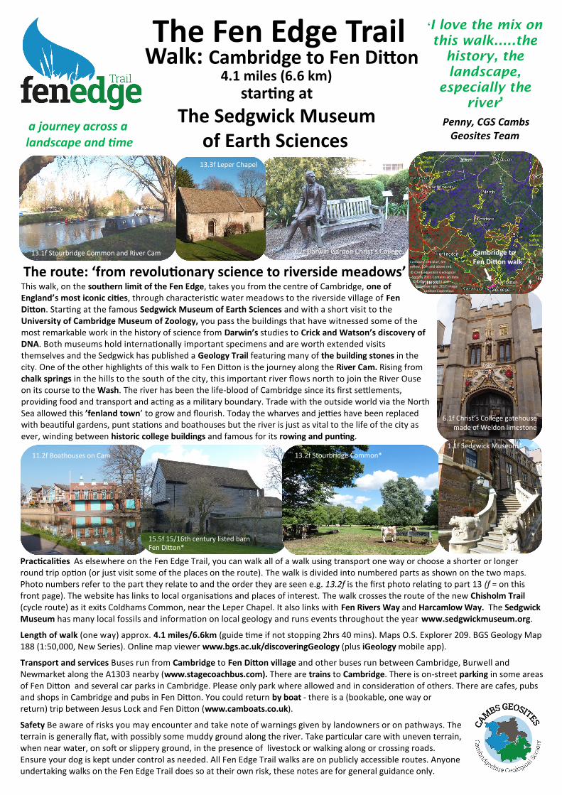
The route: ‘from revolutionary science to riverside meadows’ This walk, on the southern limit of the Fen Edge, takes you from the centre of Cambridge, one of England’s most iconic cities, through characteristic water meadows to the riverside village of Fen Ditton. Starting at the famous Sedgwick Museum of Earth Sciences and with a short visit to the University of Cambridge Museum of Zoology, you pass the buildings that have witnessed some of the most remarkable work in the history of science from Darwin’s studies to Crick and Watson’s discovery of DNA. Both museums hold internationally important specimens and are worth extended visits themselves and the Sedgwick has published a Geology Trail featuring many of the building stones in the city. One of the other highlights of this walk to Fen Ditton is the journey along the River Cam. Rising from chalk springs in the hills to the south of the city, this important river flows north to join the River Ouse on its course to the Wash. The river has been the life-blood of Cambridge since its first settlements, providing food and transport and acting as a military boundary. Trade with the outside world via the North Sea allowed this ’fenland town’ to grow and flourish. Today the wharves and jetties have been replaced with beautiful gardens, punt stations and boathouses but the river is just as vital to the life of the city as ever, winding between historic college buildings and famous for its rowing and punting.
13.1f Stourbridge Common and River Cam
starting at
The Sedgwick Museum of Earth Sciences
‘I love the mix on
this walk.....the
history, the
landscape,
especially the
river’
Penny, CGS Cambs Geosites Team
13.2f Stourbridge Common*
The Fen Edge Trail Walk: Cambridge to Fen Ditton
4.1 miles (6.6 km)
15.5f 15/16th century listed barn Fen Ditton*
11.2f Boathouses on Cam
13.3f Leper Chapel
6.1f Christ’s College gatehouse made of Weldon limestone
1.1f Sedgwick Museum*
7.2f Darwin Garden Christ’s College Cambridge to Fen Ditton walk
Fen Ditton
Contours: 0m blue, 5m yellow, 10m and above red.
Peakirk: Lincs border
Isleham: Suffolk border
© Cambridgeshire Geological Society 2021 Contains OS data © Crown copyright and database right 2017 Image Landsat Copernicus
20km
N
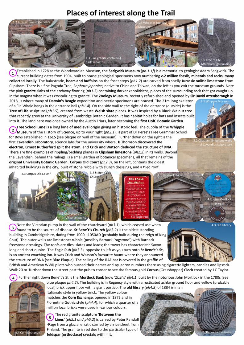
Places of interest along the Trail
2.1 Abbey wall made of Barnack Stone
3.2 wooden footbridge Free School Lane is a long lane of medieval origin giving an historic feel. The cupola of the Whipple Museum of the History of Science, up to your right (ph2.1), is part of Dr Perse’s Free Grammar School
for Boys established in 1615 (see plaque on wall of the museum). Further down on the right is the first Cavendish Laboratory, science labs for the university where, JJ Thomson discovered the electron, Ernest Rutherford split the atom, and Crick and Watson deduced the structure of DNA. There are fine examples of rippling/bedding planes in Clipsham limestone (ph2.2) in its walls. Beyond the Cavendish, behind the railings is a small garden of botanical specimens, all that remains of the original University Botanic Garden. Corpus Old Court (ph2.3), on the left, contains the oldest inhabited buildings in the city, built of stone rubble with clunch dressings, and a tiled roof.
Established in 1728 as the Woodwardian Museum, the Sedgwick Museum (ph.1.1f) is a memorial to geologist Adam Sedgwick. The current building dates from 1904, built to house geological specimens now numbering c.2 million fossils, minerals and rocks, many
collected locally. The balustrade, bears and buffalos on the front steps (ph1.2) are carved from shelly Jurassic oolitic limestone from Clipsham. There is a fine Pagoda Tree, Sophora japonica, native to China and Taiwan, on the left as you exit the museum grounds. Note the pink granite slabs of the archway flooring (ph1.3) containing darker xenolithiths, pieces of the surrounding rock that got caught up in the magma when it was crystalizing to granite. The Zoology Museum, recently refurbished and opened by Sir David Attenborough in 2018, is where many of Darwin’s Beagle expedition and beetle specimens are housed. The 21m long skeleton of a Fin Whale hangs in the entrance hall (ph1.4). On the side wall to the right of the entrance (outside) is the Tree of Life sculpture (ph1.5), created from waste Welsh slate pieces. It was inspired by a Black Walnut tree that recently grew at the University of Cambridge Botanic Garden. It has habitat holes for bats and insects built into it. The land here was once owned by the Austin Friars, later becoming the first UofC Botanic Garden.
2.3 Booth’s Hill icehouse
1.2 Jurassic limestone bears
2.2 Clipsham limestone walls of Cavendish Laboratory
Note the Victorian pump in the wall of the churchyard (ph3.1), which ceased use when found to be the source of disease. St Bene’t’s Church (ph3.2) is the oldest standing
building in Cambridgeshire, dating from 1000 –1050AD (probably built during the reign of King Cnut). The outer walls are limestone: rubble (possibly Barnack ’ragstone’) with Barnack freestone dressings. The roofs are tiles, slates and leads; the tower has characteristic Saxon long and short quoins. The Eagle Pub (ph3.3), opposite to left as you turn onto St Bene’t’s St, is an ancient coaching inn. It was Crick and Watson’s favourite haunt where they announced the structure of DNA (see Blue Plaque). The ceiling of the RAF bar is covered in the graffiti of British and American WWII pilots who burned their names and squadron numbers there using cigarette lighters, candles and lipstick. Walk 20 m. further down the street past the pub to corner to see the famous gold Corpus (Grasshopper) Clock created by J C Taylor.
3
Further right down Bene’t’s St is the Mortlock Bank (now ‘Zizzi’s’ ph4.1) built by the notorious John Mortlock in the 1780s (see blue plaque ph4.2). The building is in Regency style with a rusticated ashlar ground floor and yellow (probably local) brick upper floor with a giant portico. The old library (ph4.3) of 1884 is in an Italianate style in yellow brick. The yellow colour matches the Corn Exchange, opened in 1875 and in Florentine Gothic style (ph4.4), for which a quarter of a million local bricks were used in various colours.
4
The red granite sculpture ‘Between the Lines’ (ph5.1 and ph5.2) is carved by Peter Randall
-Page from a glacial erratic carried by an ice sheet from Finland. The granite is red due to the particular type of feldspar (orthoclase) crystals within it.
5
1
1.3 Pink granite containing dark xenoliths
6.2 footbridge
3.1 Churchyard with Victorian pump
4.3 Old Library
2
1.4 Whale in Zoology Museum*
5.2 ’Between the Lines’
1.5 Tree of Life, Attenborough Building
4.2 John Mortlock plaque
2.1 Whipple Museum
3.3 Eagle Pub
4.4 Corn Exchange
3.2 St Bene’t’s Church* 4.1 Mortlock Bank 2.3 Corpus Old Court*
5.1 Red granite showing crystals*
The walls of the Grand Arcade are clad with oolitic Jurassic limestone from Jaune-Montagne in Lorraine, France, and the floors are different Jurassic limestones from the Jura mountains between France and Switzerland. The floor is full of delightful fossils (ph5.3) such as ammonites and belemnites.
Petty Cury (‘little row of cooks’ stalls’) is a very ancient town street. Reputedly it was used for archery practice by the undergraduates. Note Alfred Waterhouse’s magnificent neo-Gothic Foster’s Bank (now
Lloyds) building opposite when emerging on to Sidney St. Between here and Christ’s College (ph6.1f) you pass through the site of the tolled Barnwell Gate, the eastern gate of the town in the 13th century, located on the Hadstock Road (Via Devana), now St Andrew’s St. Here also was a bridge across the King’s Ditch, which issued
from Tibbs Row behind St Andrew’s Church and followed Hobson St down to the river. Probably originally a Saxon boundary and defensive ditch, it ran from Mill Lane to the wharves opposite Magdalene College. Both King John and Henry II remodelled the ditch, but by late 17th century it was a foul sewer. Note the gratings in the pavement of St Andrew’s St marking the underground line of Hobson’s Conduit (ph6.2), created in the 17th century by diverting Vicar’s Brook, originating in Nine Wells springs above Shelford, to flush out the Ditch. Water still runs along it today (in Trumpington St and St Andrew’s St). Thomas Hobson funded the conduit, and used it as a supply for his horse-hire business.
Darwin, an undergraduate at Christ’s, had rooms on the first floor of the south side of First Court - the staircase on right side of the court leads to his room (not usually open to the public). The College created a garden (ph7.2f) in New Court to mark Darwin's
remarkable life and to provide a setting for Anthony Smith's bronze sculpture. The garden, consisting mostly of plants recalling Darwin's travels, was opened on 20th February 2009 as part of Darwin Bicentenary celebrations. The buildings of First Court date from the early 16th century. In 1758 the walls facing the court were re-fronted with Ketton limestone in simple classical style. Passing through the passage to the Undergraduate library you can view the south side, still the original clunch and red brick of the first college building.
The church of St Andrew the Great, possibly a Saxon foundation, would have stood just outside the Ditch. The current building is Victorian (ph8.1) and houses a memorial to
Captain Cook. In Christ’s Lane note the re-roofing of college buildings with new Collyweston Slates (limestone, not true slate). Coming off the 2nd Terrace gravels, you then walk across Gault clay underlying Christ’s Pieces, a park given the Green Flag Award for best green space in the country in 2018. At its heart lies the delightful Memorial Garden to Princess Diana (ph8.2).
King St is famous for the eponymous Run; this short street once boasted a dozen pubs, a real challenge to young men and women wishing to test their mettle at the bar: a pint at each without urinating or vomiting between! Sadly, far fewer pubs
remain. In 1469 a worthy burgess of the town, Thomas Jakenett, provided a large house adjoining Great St Mary’s Church in the centre of town for four inmates, to be selected by the churchwardens. This was replaced in 1789 by the brick almshouses (ph9.1), seen here, which were built jointly with church and university funds.
The congregation of the original All Saints’ Church, opposite St John’s College in All Saints’ Gardens in town, outgrew its space and, in the 1860s,
commissioned the Gothic-revivalist architect G F Bodley to design a new one (ph9a.1). Regarded as one of the most complete Victorian churches in Cambridge, it contains work by William Morris and stained-glass windows by C E Kempe. It is now
looked after by the Churches Conservation Trust. St Radegund’s Priory for Benedictine nuns was founded during the early 12th century and the buildings for the convent created outside the town boundary on fields in Midsummer Common c.1160. It was turned into a college, Jesus, by Bishop Alcock of Ely in 1496 after expelling the nuns for bad behaviour. Remains of its church are visible in the original cloisters now part of the college buildings (ph9a.2).
6.2 Hobson’s Conduit
Midsummer Common lies on the 1st (youngest and lowest) River Terrace and Alluvium. In the 19th century, outbreaks of cholera and typhus were blamed on the foetid state of this marshy area and drainage was carried
out in 1832 by City waste being dumped on it. Now grassed over and often cattle-grazed by our hardy Red Poll breed, it still accommodates events such as Strawberry Fair and Midsummer Fair.
The pub, the Fort St George (ph11.1), began life as a mill in the 16th century, on an island in the meandering river. With the in-filling in 1832, the river was straightened and the island
disappeared. It was the site of the first ferry to Chesterton below the Great Bridge - called the Fort St George in England for its resemblance to the first fort of St George, built in India by the East India company in Madras in 1639. This stretch of the Cam is where all the university boat houses are sited (ph11.2f). As a sport, rowing probably began in the 17th and early 18th centuries with the Oxford-Cambridge University boat race, inaugurated in 1828. The first boathouse was built for Trinity in 1872, and by the end of the 19th century most of the Colleges had built, or had started to build, their own.
7
6
8
7.1 First Court, Christ’s College
8.2 Princess Diana Memorial Garden
9
8.1 St Andrew’s Church
9a.1 All Saints Church
9.1 Almshouses on King St
9a
11
11.1 Fort St George pub
11.3 Footbridge over Cam
9a.2 Jesus college
5.3 Ammonite in limestone floor of Grand Arcade
10
Ph11.2 Start of path downhill
Walking down off the Marly Chalk, you reach the Cam again at Ditton Meadows (ph15.1 and ph15.2), riverside water meadows on the fertile Alluvium. Still grazed by cattle (ph15.3), it is all that remains of the undrained fen that surrounded Fen Ditton, ‘the village
by the (Fleam) ditch’. Note the medieval wharves abutting the lode (ph15.4). Left of the bend before the High St, is The Paddock with 2 large Black Poplars, Populus nigra v. betulifolia, of significant ecological value. A black boarded barn (ph15.5f), on the right, is one of the village’s many historic buildings, as is St Mary the Virgin church dating from the 13th century (ph16.1).
The building that is now the Cambridge Museum of Technology (ph12.1) once housed a combined sewage pumping and waste destructor station built in 1894 of grey Cambridge brick, possibly from the clay pits once on the far side of Newmarket Rd. Poverty
and disease were rife in the town caused, according to Eglantyne Jebb (founder of ’Save the Children’) by poor sanitation. Her seminal paper on the subject motivated the collection of town rubbish and its burning to provide power to pump sewage out to Milton Fields.
On the Common, you cross the end of a patch of 1st River Terrace gravels and then up a slope on the Gault clay and, higher up, the Marly Chalk on which
Newmarket Rd lies. The ‘streets’ of vendors (Mercer’s Row, Garlic Row, Oyster Row) date from the time of Stourbridge Fair. Permission for a fair on Stourbridge Common was granted to the Hospital of St Mary Magdalene in 1210 by King John; its chapel, the Leper Chapel (ph13.3f) is all that remains of the hospital but the fair grew to be the biggest in medieval Europe. Held in August, it was the region’s major trading event. Sir Isaac Newton purportedly bought his lenses here from a Dutch glassmaker. Barnwell Junction was on the Cambridge to Mildenhall branch-line from 1884 to 1966. The Leper Chapel dates from c.1125. The chancel and east nave walls are ashlar-faced, the remainder are flint pebbles and brick; the dressings are Barnack or Weldon Stone (both Lincolnshire Limestone).
Coldham’s Common, a Local Nature Reserve, lies in a depression created when the Chalk suffered freeze-thaw during the last glaciation, forming a lake. There was a
smallpox hospital here in the 17th century and the area was mined for coprolites (phosphatic nodules at the base of the Marly Chalk) in the 19th century. It is now one of the City’s largest green spaces, known for Bee Orchids and rare grasses. Coldham’s Brook flows through it, carrying water from the chalk spring at Giant’s Grave in Cherry Hinton. Barnwell Lake is a flooded clay pit, now used by fisherman.
Newmarket Road, an ancient way from Cambridge to Bury St Edmund’s along the high 3rd and 4th River Terraces, was turned into a Turnpike road c.1810, 35 years before the
railway came to the town, its toll house (Roundhouse) near the brook. A wall of Cambridge ‘gault’ brick encloses the grounds of the (water-powered) papermill (wooden building on left) originally erected for the Bishop of Ely by a German paper-maker and builder called Remigius c.1550. Replaced by the current building in 1591, it remained active until the 1820s and was then turned into a Malthouse. Rare survivors of early industrial buildings are found along Ditton Walk such as the Globe public house (now Indian restaurant), which once had its own brewery reliant on water from Coldhams Brook. Many Victorian and Edwardian cottages here are of local brick. Further up is the 19th century Old Barley Maltings (ph14.1) run by H A & D Taylor, one of the largest maltsters in the country by 1943 (now offices). It had 4 sq.m. of internal kiln maltings and its own railway siding at the back, from Barnwell Junction.
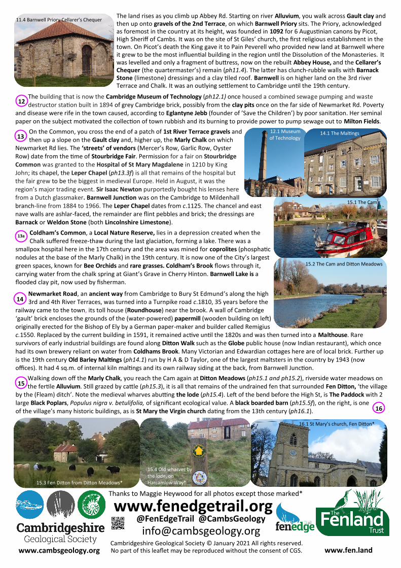
The land rises as you climb up Abbey Rd. Starting on river Alluvium, you walk across Gault clay and then up onto gravels of the 2nd Terrace, on which Barnwell Priory sits. The Priory, acknowledged as foremost in the country at its height, was founded in 1092 for 6 Augustinian canons by Picot, High Sheriff of Cambs. It was on the site of St Giles’ church, the first religious establishment in the town. On Picot’s death the King gave it to Pain Peverell who provided new land at Barnwell where it grew to be the most influential building in the region until the Dissolution of the Monasteries. It was levelled and only a fragment of buttress, now on the rebuilt Abbey House, and the Cellarer’s Chequer (the quartermaster’s) remain (ph11.4). The latter has clunch-rubble walls with Barnack Stone (limestone) dressings and a clay tiled roof. Barnwell is on higher land on the 3rd river Terrace and Chalk. It was an outlying settlement to Cambridge until the 19th century.
11.4 Barnwell Priory Cellarer’s Chequer
14
14.1 The Maltings
www.fen.land www.cambsgeology.org Cambridgeshire Geological Society © January 2021 All rights reserved.
www.fenedgetrail.org @FenEdgeTrail @CambsGeology
No part of this leaflet may be reproduced without the consent of CGS.
Thanks to Maggie Heywood for all photos except those marked*
12
16.1 St Mary’s church, Fen Ditton*
12.1 Museum of Technology
15.1 The Cam
15
16
13
15.3 Fen Ditton from Ditton Meadows*
15.4 Old wharves by the lode, on Harcamlow Way*
13a
15.2 The Cam and Ditton Meadows