The Evidence Base for Minerals Planning in Merseyside ... · The Evidence Base for Minerals...
53
The Evidence Base for Minerals Planning in Merseyside Final Report August 2008
Transcript of The Evidence Base for Minerals Planning in Merseyside ... · The Evidence Base for Minerals...

The Evidence Base for Minerals Planning in Merseyside
Final Report
August 2008

1
Evidence Base for Minerals Planning in Merseyside
Job no. Issue Status
6563 Draft
Name Position Signature Date
Prepared By:
Philippa Hothersall
Planner
Prepared By:
Carolyn Williams
Principal Planner
Checked By:
Krista Patrick Associate Director GMGU
Approved By:
Simon Talbot Director GMGU

2
FOREWORD To comply with the requirements of Minerals Policy Statement 1: Planning and Minerals (MPS1), the Merseyside districts have identified a need to produce updated minerals policies, identify potentially viable mineral deposits and related infrastructure supported by potential areas for development of minerals safeguarding areas, and identify the most appropriate mechanism to deliver minerals policy. The purpose of this report is to provide an evidence base to be used during the development of a minerals planning policy framework in Merseyside in order to meet the requirements of the Planning and Compulsory Purchase Act 2004 and MPS1. It is intended that this report provides advice on the most appropriate mechanism for Districts to deliver aggregate and minerals policy. The findings of this report are not binding and, if used, would be subject to the Local Development Framework decision-making process. It is recommended that the Merseyside districts use the information in this report when developing minerals policies in Development Plan Documents. A number of areas which districts may want to consider developing policies are included at the end of this document.

3
CONTENTS
1 Introduction ............................................................................. 4 2 Policy ...................................................................................... 7 3 Geology of Merseyside.......................................................... 10 4 Mineral Activity in Merseyside ............................................... 19 5 Assessment of future minerals supply in Merseyside ............ 23 6 Conclusions & Next Steps..................................................... 30 Appendix 1: Glossary .................................................................. 36 Appendix 2: Policy review............................................................ 40 Appendix 3: Maps....................................................................... 52 Figure 1 Distribution of Pennine Coal Measure deposits (at outcrop) in Merseyside 10 Figure 2 Distribution of Permo-Triassic deposits (at outcrop) in Merseyside 11 Figure 3 Distribution of glacial till deposits (at outcrop) in Merseyside 12 Figure 4 Distribution of tidal deposits (dark yellow) and alluvium deposits (pale yellow) (at outcrop) in Merseyside 12 Figure 5 Distribution or glacio-fluvial deposits (at outcrop) in Merseyside 13 Figure 6 Distribution of Shirdley Hill Sand deposits (at outcrop) in Merseyside 13 Figure 7 Distribution of Peat Deposits (at outcrop) in Merseyside 14 Figure 8 Distribution of sand and gravel resources including glacio-fluvial deposits (pink), sub-alluvial deposits (light yellow), inter-tidal deposits (dark yellow) and blown sand (brown) in Merseyside 16 Figure 9 Distribution of brick clay (green) and fire clay (pink) resources within Pennine Coal Measure deposits in Merseyside 17 Figure 10 Distribution of coal resources within Pennine Coal Measure deposits in Merseyside (change of colour denotes increasing depth to the southwest) 18 Map 1 Urban Area and International Environmental Designations with Buffer,
Existing Mineral Operations and Mineral Resources Map 2 Potential Sand and Gravel MSA (a), Halton Map 3 Potential Sand and Gravel Area of Search (a), Halton Map 4 Potential Sand and Gravel MSA (b) and (c), Halton Map 5 Bold Heath Quarry (existing permission and Potential extension, sand),
St. Helens Map 6 Carr Lane (existing permission and potential extension, clay), Wirral; Map 7 Cronton Clay Pit (existing permission, clay), Knowsley Map 8 Land between Garswood Old Road and Arch Lane also known as
Carter’s Fold (potential MSA, coal), St. Helens

4
1 Introduction Brief 1.1 Merseyside Environmental Advisory Service (MEAS), on behalf of the 6
Merseyside Authorities (Halton, Knowsley, Liverpool, Sefton, St. Helens and Wirral), contracted Greater Manchester Geological Unit (GMGU), part of the Urban Vision Partnership, to establish a minerals evidence base to support the development of a minerals policy framework to meet the requirements of the Planning and Compulsory Purchase Act (PCPA) 2004.
1.2 GMGU have undertaken an assessment of minerals resources in
Merseyside, including consultation with the minerals industry to identify the potential for future minerals allocations in Merseyside.
Objectives 1.3 The objectives of the study are set out below:
Task 1: (i) Identify Merseyside’s potentially viable mineral deposits and related infrastructure and indicate where the exploitation of deposits is constrained by development, or other environmental or planning policy reasons. (ii) Identify potential areas where mineral safeguarding policies could be applied, with appropriate justification. Task 2: Gauge the likely commercial interest in exploiting the identified mineral resources and related infrastructure in the period to 2020. Task 3: Provide advice on the most appropriate mechanism for Districts to deliver aggregate and minerals policy.
Background 1.4 Minerals such as crushed rock aggregates, sand, gravel and clay are
the essential raw materials that underpin development of the built environment. Policy and plans including the Regional Spatial Strategy (RSS) for the North West (formerly RPG 13 and now under review) are required to ensure the supply of raw materials to construction activity

5
will continue into the future.
1.5 Managing the supply of minerals effectively and sustainably through the planning system is essential to ensure primary resources are available for future generations. It will also serve to minimise the potential environmental impact of such developments including harmful emissions caused by road haulage and their effects on climate change. Effective management of minerals supply as part of a holistic resource plan can stimulate economic growth, resulting in improved quality of life for communities, increasing local employment opportunities and prosperity.
1.6 The six Unitary Development Plans (UDPs) of Merseyside vary in age. A number of these pre-date key changes to the planning system brought about as a result of the introduction of the PCPA in 2004, and the subsequent changes to National planning policy on minerals. As a result of these changes, the development plan system in England has been completely overhauled and new national minerals planning policies have been published. In light of this, there has been a need to review the existing minerals planning policy framework for Merseyside to ensure that the new aims and objectives of the planning system are met.
1.7 The six Merseyside Authorities, as Minerals Planning Authorities (MPAs), are required to plan for minerals within their administrative boundaries in line with Minerals Policy Statement 1: Planning and Minerals (MPS1). Existing minerals policies in the six Authorities’ UDPs do not currently identify minerals resources or safeguarding areas in detail sufficient to meet the requirements of MPS1. As a result of this, the Merseyside Authorities identified the need to develop an evidence base for minerals and this report forms the basis of that study.
1.8 A requirement of MPS1 is to identify areas of search, preferred areas, and site specific allocations for future minerals development, as well as mineral safeguarding areas (MSAs). As this has not previously been undertaken for Merseyside, a ‘call for sites’ exercise was undertaken during March 2008. The information submitted by industry has been assessed along with geological information on minerals resources in Merseyside1 to identify potential areas for future minerals working within Merseyside.
1 Minerals Resource Information in Support of National, Regional and Local Planning: Merseyside (comprising City of Liverpool and Boroughs of Knowsley, Sefton, St Helens and Wirral). BGS 2006. Minerals Resource Information in Support of National, Regional and Local Planning: Cheshire (comprising Cheshire, Boroughs of Halton and Warrington). BGS 2006

6
1.9 One of the aims of this study is to identify potentially viable minerals deposits within Merseyside for all minerals. The key commodities found in Merseyside are silica sand associated with the glass industry in St. Helens, coal and clay and these will form the focus of the study, in addition to sand and gravel. Peat will not form a component of this study as Submitted Draft RSS for the North West has identified that there are sufficient reserves already identified to meet the regional need for this mineral and therefore no new sites are required.
7
2 Policy Introduction 2.1 The English planning system operates under the Town and Country
Planning Act 1990 as amended by the 2004 Planning and Compulsory Purchase Act. A full review of plans and policies which impact upon minerals planning is included in Appendix 2. The following summary presents the key planning issues for identifying and safeguarding minerals sites in Merseyside.
2.2 National planning policy is set out through a series of Planning Policy Guidance Notes, which are being progressively replaced by Planning Policy Statements (PPS) under the 2004 Act. PPS1: Delivering Sustainable Development contains the overarching planning policies for the delivery of sustainable development through planning. The importance of the prudent use of natural resources, through efficiency of use of non-renewable resources and the use or reuse of existing resources is a key element of PPS1 which has an impact on minerals planning.
2.3 The Government recognises the unique issues surrounding minerals planning through a separate series of national policy statements. These are known as Minerals Planning Guidance Notes, some of which have been updated and replaced under the 2004 Act by Minerals Policy Statements (MPS) and accompanying companion guides.
2.4 National policy recognises the important role minerals play in the prosperity of the nation and the quality of life of its residents. A central tenet of this is the creation of sustainable communities with an “adequate and steady supply of material to provide the infrastructure, buildings and goods that society, industry and the economy needs”2.
2.5 Key National planning policy has been reviewed as part of this study, including:
• PPS1: Delivering Sustainable Development
• MPS1: Planning and Minerals, including relevant annexes
• MPS2: Controlling and Mitigating the Environmental Effects of Minerals Extraction in England
• National and Regional Guidelines for Aggregates Provision in England 2001 – 2016
2.6 The national and Regional Guidelines for Aggregates Provision in
England are in the process of being updated and were consulted on
2 DCLG (2006) MPS1

8
during Spring/Summer 2008. They are likely to be published towards the end of 2008.
2.7 The need to include on the adopted proposals map, ‘minerals and
waste matters including safeguarding areas’ is set out in Planning Policy Statement 12 (published June 2008).
Areas for future minerals working 2.8 MPS1 requires MPAs to provide for the future supply of minerals
through identification of resources. These can take the form of “specific sites”, “preferred areas” or “areas of search”, and should be supported by policies to provide clear guidance to operators on where minerals extraction is most likely to be acceptable.
2.9 Areas for future working can be identified by a variety of means, including the submission of information in the form of “specific sites” i.e. sites where viable minerals are known to exist and where landowners are supportive of minerals development taking place. Such sites are encouraged to be submitted by industry / minerals operators early in the process of plan preparation to enable full consideration of any potential impact of development to be considered, and in order for the site to be assessed in terms of sustainability, through formal sustainability appraisal and habitats regulations assessment, where appropriate.
2.10 In the case of Merseyside, existing information on specific sites relates to existing mineral operations and information put forward following the call for sites exercise. Therefore, for Merseyside, areas of search and preferred areas are likely to offer the most appropriate route forward for considering the location of future minerals operations.
2.11 In practice there may be little to distinguish between specific sites and preferred areas. Preferred areas are areas of known resources where planning permission might be reasonably acceptable, subject to the usual tests of environmental acceptability. It is the responsibility of the MPA to decide how such sites are identified as allocations within their LDF.
2.12 Planning and Minerals: Practice Guide (November 2006) defines areas of search as “broader areas, where knowledge of mineral resources may be less certain, but within which planning permissions for particular sites could be granted to meet any shortfall in supply if suitable applications are made”3.
3 DCLG (November 2006) Planning and minerals: Practice Guide
9
2.13 MPS1 does not favour the approach of identifying areas of search only, as this provides less certainty on where actual development may take place and an authority which elects to do this must be prepared to justify their approach. Authorities are encouraged to have both specific sites and / or preferred areas if sufficient acceptable sites are known at that stage. Areas of search can be used to cover the remaining plan period if sufficient sites can not be identified by the time of adoption.
Mineral Safeguarding Areas (MSAs)
2.14 The planning system has an important role to play in safeguarding
proven deposits of minerals which are, or may become, of economic importance within the foreseeable future from unnecessary sterilisation by surface development. A key requirement of MPS1 is that planning authorities should define Mineral Safeguarding Areas (MSAs) in Local Development Documents.
2.15 MSAs can be defined objectively using the best geological and minerals resource information, including BGS information on mineral resources and information made available by industry. Following identification of such areas, it is important that consultation with industry and other stakeholders is carried out in order to refine any proposals put forward.
2.16 British Geological Survey (BGS)4 have defined MSAs as “areas of known resources that are of sufficient economic or conservation value (such as building stone) to warrant protection for generations to come”.
2.17 The purpose of an MSA is not to preclude automatically other forms of development, but to make sure that minerals resources are adequately and effectively considered in land use planning decisions. Unitary authorities must include such policies in their LDF in order to alert applicants for non-minerals development to the existence of valuable mineral resources.
2.18 It is important that MSAs are identified in the emerging Merseyside Authorities’ LDDs, alongside areas of search and preferred areas, and these should be identified on an up-to-date proposals map accompanying a site allocation DPD or other LDD. They may also be supported by a development management policy on safeguarding to avoid incompatible development close to the MSA that may constrain future extraction. In addition policies on prior extraction within safeguarded areas may also need to be considered.
4 A guide to minerals safeguarding in England: October 2007

10
3 Geology of Merseyside5 Solid Geology 3.1 The oldest rocks in Merseyside can be found in the northeast of the
sub-region, primarily in St Helens but also sweeping into part of Knowsley and with a small outcrop in Liverpool. These are represented by Carboniferous Pennine Coal Measures (Westphalian), alternating sequences of mudstones, siltstones, sandstone and extensive coal seams laid down some 300 million years ago.
Figure 1 Distribution of Pennine Coal Measure deposits (at outcrop) in Merseyside 3.2 To the south and west, the Carboniferous rocks give way to younger
rocks which are represented by sedimentary sequences of the Late Permian to Late Triassic (approximately 290 – 220 Ma). The environment in the area at this time varied from deserts to tropical seas. Clastic sedimentary sequences predominate and include conglomerate, sandstone, siltstone sequences with some mudstone deposits.
5 Information Sources: Howard, A S, Hough, E, Crofts, R G, Reeves, H J and Evans, D J. 2007. Geology of the Liverpool district – a brief explanation of the geological map. BGS. Aitkenhead, N, Barclay, E J, Brandon, A, Chadwick, R A, Chisholm, J I, Cooper, A H and Johnson, E W. 2002. British regional geology: the Pennines and adjacent areas (Fourth edition). (British Geological Survey, Nottingham)

11
Figure 2 Distribution of Permo-Triassic deposits (at outcrop) in Merseyside Drift Geology 3.3 Much of the sub-region has been covered by superficial drift deposits
of Pleistocene to Recent age. These are dominated by glacial tills (‘boulder clay’) laid down by retreating ice sheets at the end of the Devensian cold stage some 10,000 years ago. The tills typically comprise silty clays with subordinate sands and gravels (ranging in size up to large boulders).
12
Figure 3 Distribution of glacial till deposits (at outcrop) in Merseyside 3.4 The latest drift deposits within Merseyside are represented by glacio-
fluvial sands and gravels, tidal sands, river terrace sands and gravels, peat, alluvium and wind blown sand. Modern day flood plains result in the deposition of alluvium. Tidal deposits consist of sand, silt and clay and are formed by the action of tidal currents and waves.
Figure 4 Distribution of tidal deposits (dark yellow) and alluvium deposits (pale yellow) (at outcrop) in Merseyside

13
Figure 5 Distribution or glacio-fluvial deposits (at outcrop) in Merseyside 3.5 Thin, wind blown sand deposits can be found in the north of the sub-
region, with some smaller deposits in the south and east. These sand deposits, known as Shirdley Hill Sand, are thought to be late glacial or immediately post glacial in origin. Shirdley Hill Sand deposits have been extensively worked for the production of glass.
Figure 6 Distribution of Shirdley Hill Sand deposits (at outcrop) in Merseyside

14
3.6 The distribution of peat deposits is focused on lowland areas in Sefton and the northern parts of Knowsley and St Helens. Peat was worked extensively in the past for fuel although submitted draft RSS does not set out any requirements for future provision.
Figure 7 Distribution of Peat Deposits (at outcrop) in Merseyside Mineral Resources 3.7 There is a long history of the exploitation of mineral resources in
Merseyside although many operations have now ceased. These have varied in nature from mining of coal to clay extraction for brick making. For the purposes of this section, the mineral resources of Merseyside have been broadly grouped into the following categories in accordance with British Geological Survey (BGS) Reports CR/05/090N and CR/05/129N.
• Superficial Deposits including glacio-fluvial sand and gravel, river sand and gravel, tidal sand and blown sand
• Brick clay including Fireclay
• Coal
• Sandstone
• Peat Superficial Deposits 3.8 Resources of sand and gravel primarily occur within superficial or ‘drift’
deposits of glacial and post glacial origin. Sand and gravel resources

15
in the sub-region can be subdivided into river sand and gravel, glacio-fluvial sand and gravel and blown sand with additional resources of bedrock sand and gravel.
3.9 Glacio-fluvial sand and gravel are the products of deposition by glacial melt waters. The most extensive glacio-fluvial sand and gravel deposits in the sub-region occur to the east of Prescot. Whilst a number of these deposits may be up to 9m thick, their lateral extent is often variable and unpredictable and significant resources have been sterilised by urban development.
3.10 River sand and gravel resources occur in modern floodplains and in terrace deposits associated with, and underlying, present day alluvium. The deposits are best developed along the River Alt in Sefton, Sankey Brook in St Helens, in the north of the Wirral and along the Fender, which runs parallel to the M53.
3.11 Silica sands contain a high proportion of silica and are used as raw materials in the glass and foundry castings industries and other industrial processes. Silica sands command a higher price than construction sands and deposits in the UK occur in limited areas. In Merseyside, silica sand used to be produced from an area known as the Horse Bank off the Sefton coast, although working here has ceased.
3.12 Wind blown sands (known locally as the Shirdley Hill Sand Formation) are generally not suitable for construction use, but historically have been exploited in St Helens for glass making. Extraction for this purpose ceased in 1977 due to economic viability, although these sands have since been exploited for horticultural use. The intertidal sand deposits off the Merseyside coast also have a high silica content and have been exploited in the past for use in the glass making industry.
3.13 There is very limited current extraction of sand and gravel in Merseyside; most is marine-dredged which is landed at coastal ports such as the Port of Liverpool and Eastham. The only operational land based quarry is Bold Heath in St Helens.

16
Figure 8 Distribution of sand and gravel resources including glacio-fluvial deposits (pink), sub-alluvial deposits (light yellow), inter-tidal deposits (dark yellow) and blown sand (brown) in Merseyside
Brick clay including Fireclay 3.14 Brick clay is a term used to describe ‘clay and shale’ used in the
manufacture of structural clay products such as facing and engineering bricks, pavers, clay tiles and vitrified clay pipes. Brick clays are essentially mudstones of different geological ages and compositions. In Merseyside, brickclay has been produced for local consumption from small brick pits for over two hundred years. Historically, a variety of clays were extracted for brick making including glacial till (‘Boulder Clay’), the Triassic Mercia Mudstone, the Downholland Silt, the Etruria (Marl) Formation and mudstone / siltstone within Coal Measures.
3.15 Fireclays are mudstones that underlie most coal seams, hence their
location in Merseyside is confined to areas where there are coal deposits. Fireclay is primarily a by-product of coal extraction and as such, is not worked at present in Merseyside.
3.16 The Pennine Coal Measures mudstones are now the principal brick clay resource in North West England. Today, only one active brick works remains in Merseyside, at St Helens, using clay extracted from a pit in Cronton (located within the Carboniferous Etruria Formation) together with material brought in from outside the area.

17
Figure 9 Distribution of brick clay (green) and fire clay (pink) resources within Pennine Coal Measure deposits in Merseyside
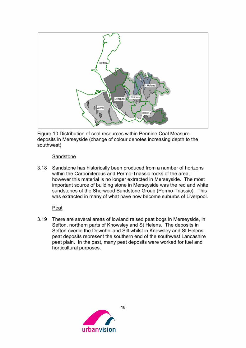
Coal 3.17 Merseyside lies predominantly within the South Lancashire Coalfield.
Coal seams are mainly present in the Pennine Lower and Middle Coal Measures, with a few additional coal seams in the lower sequences of the Pennine Upper Coal Measures. Coal seams are numerous within excess of 30 named coal seams, which vary laterally in both thickness and composition. Remaining coal resources are potentially extensive; however future extraction is likely to be restricted to opencast mining methods. The future potential for such sites is further reduced by overlying thick drift deposits (Halton, Knowsley, Sefton and Wirral), extensive urban development (Liverpool) and international environmental designations.
18
Figure 10 Distribution of coal resources within Pennine Coal Measure deposits in Merseyside (change of colour denotes increasing depth to the southwest)
Sandstone 3.18 Sandstone has historically been produced from a number of horizons
within the Carboniferous and Permo-Triassic rocks of the area; however this material is no longer extracted in Merseyside. The most important source of building stone in Merseyside was the red and white sandstones of the Sherwood Sandstone Group (Permo-Triassic). This was extracted in many of what have now become suburbs of Liverpool.
Peat
3.19 There are several areas of lowland raised peat bogs in Merseyside, in
Sefton, northern parts of Knowsley and St Helens. The deposits in Sefton overlie the Downholland Silt whilst in Knowsley and St Helens; peat deposits represent the southern end of the southwest Lancashire peat plain. In the past, many peat deposits were worked for fuel and horticultural purposes.

19
4 Mineral Activity in Merseyside Current Minerals Activity in Merseyside 4.1 There are a number of sites within Merseyside that are currently
producing primary minerals in addition to four active marine aggregate wharfs. For the purposes of this discussion current minerals activity has been divided into aggregates and non-aggregates supply. There are no crushed rock aggregate operations in Merseyside and therefore this commodity has not been examined in detail.
Aggregates 4.2 Data on the annual production of aggregates is collected by the North
West Regional Aggregate Working Party (RAWP). See Appendix 2 for further information on RAWPs. Due to a requirement to ensure the confidentiality of commercially sensitive data submitted by site operators for the annual RAWP survey, the figures for Merseyside and Halton are amalgamated with Greater Manchester and Warrington (referred to in this section as the ‘RAWP sub-area’). The latest available monitoring data for aggregates is from 20066. This has been summarised in Appendix 2 and is discussed below.
4.3 A key role of the RAWP is to apportion the regional guidelines for aggregate provision for the period 2001 – 2016 to mineral planning authority areas. This process takes account of an MPA’s ability to supply aggregates.
4.4 The sub-regional apportionment (2001 – 2016) for sand and gravel production is 4.1 million tonnes, with an annualised requirement of 0.26 million tonnes. Sand and gravel sales in 2006 were 0.4 million tonnes, the same as in the previous year.
4.5 Total sales of land won sand and gravel in the North West in 2006
stood at 2.97 million tonnes, down by 0.09 million tonnes from the previous year. Sales have generally been declining since 1994 when they stood at 5.55 million tonnes.
4.6 In contrast, in 2006, the RAWP sub-area recorded sales of sand and gravel 0.14 million tonnes higher than the annualised requirement; in fact annual sand and gravel sales have only dropped below 0.26 million tonnes in two of the past fourteen years.
4.7 Permitted reserves of sand and gravel increased from 8.91 million tonnes in 2005 to 9.89 million tonnes in 2006. There were no new permissions granted in Merseyside, Halton or Warrington during this
6 RAWP Annual Report 2007 available at www.communities.gov.uk

20
time, therefore this increase is attributed to a planning permission granted for an extension (0.7mt) in the Greater Manchester area.
4.8 The RAWP survey results indicate a general decline in primary
aggregate sales in the North West in recent years for which there are a number of possible reasons. The introduction of the landfill tax has meant that a greater proportion of construction, demolition and excavation waste (CDEW) is being recycled rather than disposed. This has a dual effect as the recycled material can be used as a substitute for low-grade primary aggregate, and it reduces the need to find new landfill capacity (a by-product of the quarrying industry).
4.9 Another potential fiscal driver was the introduction of the Aggregates Levy in 2002. The Aggregates Levy is a charge placed on each tonne of primary aggregate supplied and may encourage the use of secondary and recycled aggregates, which do not incur such a charge.
4.10 Further reasons for the decline in aggregate sales in the region include the supply of aggregate from outside sources on the periphery of the region, or an increase in the use of non-aggregate building materials.
4.11 The North West imported a total of 13.7Mt primary aggregate in 2005; this is more than any other individual region in England. Imports into Merseyside and Cheshire account for 4.4Mt of this total7, although this figure includes imports from other regions and also sub-regional imports. This can be attributed to a high demand for raw materials from construction activity in the urban areas of the sub-region. North Wales is a major exporter of aggregate into Merseyside, particularly of crushed rock (limestone). In addition, aggregate is imported by ship from Scotland via the Port of Liverpool.
Marine Sand and Gravel 4.12 Applications to dredge marine aggregate in England are under the
control of the Marine and Fisheries Agency and, if successful, a licence must then be granted by The Crown Estate.
4.13 MPS1 encourages the supply of marine-dredged sand and gravel, to
the extent that environmentally acceptable sources can be identified and exploited within the principles of sustainable development. Currently around 8% of the total national demand for primary aggregates is sourced from marine-dredged sand and gravel, and this is reviewed by CLG as part of the review of aggregate guidelines.
7 Collation of the results of the 2005 Aggregate Minerals Survey for England and Wales 2005 Page 83

21
4.14 Marine dredged sand is landed at various locations within the North West, including at four wharfs in Merseyside, and landings of mineral in recent years have remained well below the authorised limit of extraction which is c. 1.4 million tonnes8. In 2006, c. 690,000 tonnes of marine aggregate were landed from off the North West Coast, down from the 2005 total of c. 700,000 tonnes.
4.15 The most recent application for dredging in the Liverpool Bay area was granted in May 2008 to Westminster Gravels Ltd from Area 457 of the Liverpool Bay. The permission is for the dredging of 18 million tonnes of coarse sand aggregate over a 15 year period at a rate of 1.2 million tonnes per annum. Dredging is restricted to three zones which in total must not exceed 10km² at any one time, with no single zone being greater than 5km².
Landbank 4.16 A landbank is the total permitted reserves for a particular mineral
commodity within a geographic area. The reserve life of a landbank is calculated using the expected provision (supply in response to demand) included in the development plan expressed on an annual basis.
4.17 MPS1 also defines the minimum requirement for a landbank of crushed
rock aggregate (10 years) and sand and gravel (7 years). This takes into account the length of time needed to obtain planning permission and bring replacement operations into production.
4.18 The RAWP sub-regional landbank as at 31/12/2006 is calculated as
32.65 years for crushed rock and 12.59 years for sand and gravel. 4.19 It can therefore be demonstrated that permitted reserves for the sub-
region are greater than the minimum requirement of 7 years for sand and gravel and 10 years for crushed rock aggregates.
4.20 However, whilst the RAWP sub-regional landbank is more than the minimum set out in MPS1, it is not possible to demonstrate how Merseyside is actually contributing to the estimates.
4.21 The landbank is subject to a number of variables. The small number of
quarries in the sub-region means that if just one quarry is removed from landbank calculations, it is likely to have a large reduction on the total permitted reserves and life calculation for the RAWP sub-area.
4.22 In addition, the landbank assumes a continuation of present day
market demands and quality requirements. If these change, it can
8 NWRAWP Annual Report 2006.
22
render a mineral deposit uneconomic resulting in removal from the landbank.
4.23 Furthermore, landbank calculations do not consider imposed
restrictions to production capacity such as conditions limiting production rates, or time limited planning permissions.
4.24 As well as the above, the landbank calculation does not take account
of the quality of aggregates. Low and high quality crushed rock aggregate are not differentiated and therefore the landbank may not adequately reflect the ability of a sub-region to supply all of its allocation.
Non-Aggregates 4.25 The only active brickworks in the study area, Lord St Helens
(Roughdales Brickworks), is located in St. Helens. The brickworks uses clay extracted from the Carboniferous Etruria Formation at the Cronton pit (Knowsley) and material imported from outside the sub-region as the onsite quarry has been exhausted.
4.26 There has been a history of coal extraction in Merseyside and, related
to this, recent interest has been shown in the extraction of coal bed methane (CBM). Permission has been granted for exploratory work for CBM in Knowsley and St Helens. Recent interest in coal extraction has been from small-scale operators who are interested in smaller opencast extraction rather than from larger operators.

5 Assessment of future minerals supply in Merseyside Primary Minerals 5.1 The information presented in Section 3 highlights that there are
potential resources available within the Merseyside area, however the quality and quantity varies across the area and resources are heavily constrained by both urban area and environmental designations (particularly around coastal areas).
5.2 In order to gain a better understanding of the primary minerals within
Merseyside and to assess the best policy approach to developing a minerals framework for Merseyside, it is necessary to further evaluate the minerals potential within Merseyside. To do this, a desk-based exercise was undertaken and industry and landowners were invited to submit areas for further consideration.
5.3 The desk-based exercise used BGS mineral resource information as a
starting point. Using Geographical Information Systems (GIS) software, maps of constraints were layered over the top of the mineral resources. These constraints are set out in detail in paragraph 5.5 but included urban areas and European environmental designations.
5.4 The result of this exercise is a map showing where mineral resources
are not constrained by urban development or European environmental designations. This is presented as Map 1.
5.5 A number of constraints have been identified and agreed with MEAS to
assist in the assessment of preferred sites, areas of search and MSAs in Merseyside. The area of Merseyside is heavily constrained by the urban area and international conservation areas (Table 1) which severely limits the potential for future minerals extraction. Candidate Special Areas of Conservation, Potential Special Protection Areas and Proposed Ramsar Sites have been given the same level of protection as those sites which have already been designated.
Constraints
Ramsar Ramsar sites are designated under the Convention on Wetlands of International Importance, agreed in Ramsar, Iran, in 1971.
Ribble and Alt Estuaries The Dee Estuary Mersey Estuary Mersey Narrows and North Wirral Foreshore (Proposed Ramsar)
Special Protection Area (SPA)
Sites classified under the European
Ribble and Alt Estuaries The Dee Estuary

24
Community Directive on Wild Birds to protect internationally important bird species.
Mersey Estuary Mersey Narrows and North Wirral Foreshore (Potential SPA)
Special Area of Conservation (SAC)
Designation made under the Habitats Directive to ensure the restoration or maintenance of certain natural habitats.
Sefton Coast, The Dee Estuary
Table 1: International Nature Designations in Merseyside
5.6 The constraints and their reasons for identification are listed below:
Type
Status Reason
Urban Area n/a Mineral resources are sterilised by development. A standard buffer of 250m has been applied because this is set out as sufficient stand-off distance for soft rock extraction9.
Sites designated as being of international importance in terms of biodiversity (SPA, SAC and Ramsar sites)
SPA, SAC and Ramsar sites are afforded international protection through European Council Directive 92/43/EEC.
To protect internationally important sites. An indicative buffer of 250m has been applied to these areas in agreement with MEAS.
Table 2: Identified Constraints
5.7 Map 1 shows the application of the above constraints. Response from Industry 5.8 Industry and landowners were invited to submit information on sites for
consideration, for example, size of site, nature of materials, etc. An advert inviting information on known mineral resources was placed in Farmers Guardian on 29th February. In addition to this, 61 letters were sent to key national mineral operators and local operators, planning consultancies. The QPA/BAA were invited to circulated a letter
9 McEvoy, F M, Cowley, J, Hobden, K, Bee, E and Hannis, S. A guide to mineral safeguarding in England. (2007) British Geological Survey Open Report, OR/07/035. 36 pp.

25
electronically to their members, enabling approximately a further 150 organisations to be informed of the study.
5.9 As a result of this invitation, information was received from an operator
and a landowner relating to two permitted sites: Bold Heath Quarry, St Helens (sand) and Carr Lane, Wirral (clay).
5.10 A planning application for the extraction of 2.43 million cu m of sand /
sandstone and backfilling with CDEW at Bold Heath Quarry was refused in December 2007.
5.11 The site at Carr Lane is already identified as a mineral reserve in
Wirral’s UDP under policy MI1 – the control of clay extraction – where 19 hectares are reserved for future working.
5.12 Both of the sites, as well as the outcomes from the desk-based study
submitted were included as part of the second phase of consultation to identify preferred areas, areas of search and MSAs for Merseyside.
5.13 One of the major UK coal extraction companies, UK Coal, have stated
that they have no interest in exploiting coal reserves in the Merseyside area, therefore any interest in coal is likely to be linked to the potential for smaller-scale opencast operations and coal bed methane extraction.
5.14 There is currently known to be some interest from operators in the area
for opencast mining, for example at ‘Land between Garswood Old Road and Arch Lane’, in St. Helens.
Identified MSA and Areas of Search 5.15 A series of seven maps were developed as a basis for consultation
with industry and interested parties. These were based on existing permissions and submissions from industry and also Map 1. The maps identify potential MSAs and Areas of Search for sand and gravel.
• Map 1 Urban Area and International Environmental Designations with Buffer, Existing Mineral Operations and Mineral Resources;
• Map 2 Potential Sand and Gravel MSA (a), Halton;
• Map 3 Potential Sand and Gravel Area of Search (a), Halton;
• Map 4 Potential Sand and Gravel MSA (b) and (c), Halton;
• Map 5 Bold Heath Quarry (existing permission and Potential extension, sand), St. Helens;
• Map 6 Carr Lane (existing permission and potential extension, clay), Wirral;
• Map 7 Cronton Clay Pit (existing permission, clay), Knowsley;

26
• Map 8 Land between Garswood Old Road and Arch Lane also known as Carter’s Fold (potential MSA, coal), St. Helens.
5.16 MSAs and Areas of Search for coal have not been identified at this
time, other than Land between Garswood Old Road and Arch Lane. The Coal Authority is in the process of developing Coal Resource Appraisal Maps for the entire country. These maps will use BGS resource data as a starting point and refine this information using the mining reports system. These maps should provide a good evidence base for developing MSAs and Areas of Search for coal in the future and will inform LDF processes.
5.17 Coal seams are a source of methane, which can collect in void spaces
in abandoned mines if the old coal workings do not become flooded. It may be economic to recover and use this gas for local electricity generation.
5.18 MSAs and Areas of Search for clay have not been identified other than
the MSA surrounding existing reserves (Maps 6 & 7). One of these sites was submitted by Industry (Carr Lane) and the other is the existing clay pit at Cronton. Industry/landowners have not shown interest in other sites and there is no evidence that there will be a shortfall in supply.
Response from Industry Consultation 5.19 Interested parties were invited to attend the Merseyside Environmental
Advisory Service (MEAS) or Urban Vision offices to view Maps 1 – 8. The following forms of communication were used:
• Advert placed in June 2008 edition of Quarry Management
• 61 Letters sent to operators and minerals planning consultants
• QPA/BAA invited to forward information to their members (between them these organisations have approximately 150 members)
• Local Authorities put information about the study on their websites
5.20 The response was low, however, this might be related to quality and
extent of mineral resources in Merseyside as one of the major national operators stated that they were not interested in the area at this time. This same operator also mentioned that the quality of aggregates in the area is low.
5.21 Comments were also invited from Planning Officers at the six
Merseyside Authorities. These are set out below along with responses:

27
Respondent Comment Response
St Helens MBC Crock Hey is worked out and restored to agriculture.
Remove this site.
St Helens MBC Bold Heath Quarry recently refused planning permission for an extension.
Incorporate the area that was the subject of planning application within MSA because of the known mineral resource.
St Helens MBC Previous interest in opencast mining at Eltonhead Road but site has not been included for consultation.
Consider inclusion of this as MSA once information from The Coal Authority is available. Note that the identification of an MSA does not assume a site will be worked for minerals.
MEAS Proposal for coal extraction at Land between Garswood Old Road and Arch Lane is subject of current appeal.
Noted
Table 3: Comments received during consultation
5.22 The amended maps can be found in Apendix 3. Secondary and Recycled Aggregates 5.23 National minerals guidance views primary minerals as a finite resource
which should be conserved. Therefore, the use of alternatives to primary aggregates is promoted in MPS1, whilst an objective of PPS10 is to move waste up the waste hierarchy, recognising waste (i.e. construction and demolition waste) as a resource. Using alternatives to primary resources can also reduce some of the impacts associated with primary extraction, such as visual amenity and the effect of transportation and processing on the environment.
5.24 The latest national data on the use of alternatives to primary
aggregates in England10 suggests that the arisings of construction, demolition and excavation waste (CDEW) in England were 88.63 million tonnes in 2005, a similar amount to the previous two years. Of
10 Survey of Arisings and Use of Alternatives to Primary Aggregates in England, 2005 (available at www.communities.gov.uk)

28
this, just over 50% was recycled, 31% was sent to landfill and the remainder was tipped on exempt sites. The estimate for the production of recycled aggregate has risen from 39.60 million tonnes in 2003 to 42.07 million tonnes in 2005.
5.25 The Merseyside Authorities are in the process of producing a Joint
Waste Development Plan Document (Joint WDPD). A Needs Assessment11 has been developed which identifies how much waste is likely to be produced in Merseyside up to 2025.
5.26 The Needs Assessment builds on data at the national and regional
level12. It is likely that CDEW will grow at a rate of 5% per annum until 2011/2012, after which this will drop to zero growth by 2016 (the ‘baseline’ scenario). This growth rate is compared in the Needs Assessment to a growth rate of 1% and 2% per annum.
5.27 The total estimated arising of CDEW in Merseyside in 2006 was
approximately 3.5 million tonnes using the baseline scenario rising to approximately 4.5 million tonnes in 2024. This can be compared to the growth rates where the CDEW arisings start at approximately 3.5 million tonnes in 2006 but increase to approximately 5.1 million tonnes in 2024 under the 2% growth rate and around 4.2 million tonnes per annum using the 1% growth rate.
5.28 It is expected that the baseline growth rate scenario of 5% per annum
dropping to 0% per annum will result in an increase in recycled aggregate which could be used as a substitute for some of the lower quality primary aggregates in Merseyside. A WRAP (Waste & Resources Action Programme) study13 looking at the performance of recycled aggregate in concrete demonstrates that blending 20% recycled aggregate with natural aggregate does not have a negative impact on the performance of the concrete.
5.29 Given the above, substitution of primary resources will become
increasingly important if the Government’s agenda for sustainable communities is to be realised. Appendix C3 of the Waste Strategy 200714 sets out the environmental benefits of recycling aggregates and
11 Merseyside Environmental Advisory Service Waste Development Plan – Revised Needs Assessment (December 2007) 12 Survey to fill the Evidence Gaps for Construction, Demolition and Excavation Waste Streams in the North West region of England (based on data for the calendar year 2006), April 2007.
13 Http://www.wrap.org.uk/downloads/Dundee_University_Technical_Report_Final.daf417a1.pdf 14 Available at www.defra.gov.uk

29
states that the substitution of locally sourced, reclaimed materials, for primary minerals in construction projects can radically reduce the lifecycle environmental impact.
5.30 As with primary aggregates, the ‘carbon benefit’ of recycling
aggregates depends on the distance travelled. In addition to the environmental benefits of recycling aggregates, economic benefits can also be realised through the avoidance of landfill and aggregates tax by the internal supply of recycled demolition waste on large construction schemes.
5.31 In addition, since April 2008, developers must have a Site Waste
Management Plan (SWMP) for all new construction projects worth more than £300,000. Part of the remit of SWMPs is to improve materials resource efficiency within the construction sector by reducing the amount of waste produced and encouraging recovery of, as much as possible, of the remainder.

30
6 Conclusions & Next Steps Conclusions 6.1 Merseyside does not contain a significant amount of high quality
minerals and urban development has sterilised much of the sub-region’s mineral resources that are present. In addition, there are international environmental designations where it is unlikely that minerals development would be permitted and which represent major constraints.
Silica Sand 6.2 One of the major users of minerals in the sub-region, Pilkington’s,
imports silica sand for glass production rather than using local supply. The limited evidence available suggests that reserves of silica sand / Shirdley Hill Sand in Merseyside are not economically viable due to the limited depth to which they occur.
Aggregates 6.3 Notwithstanding the marine aggregate landed at wharfs on the
Merseyside coast, the sub-region is highly reliant on imports of good quality aggregate for use in the construction industry. This is likely to continue to be the case, particularly given the growth proposed within The Northern Way15. In consequence, there will be a need to ensure that the infrastructure for mineral imports is in place and safeguarded from other forms of development. This should include wharfs and depots because it is likely that marine sand and gravel will continue to be an important source of aggregate in Merseyside and beyond.
6.4 The RAWP sub-area apportionment of Northwest aggregate production is likely to be met for the period up to 2016 through identified reserves. Therefore, there is no requirement to identify further reserves to meet the apportionment at present.
6.5 However, in line with the proposed growth in the Northern Way, apportionment figures for aggregate supply are expected to increase in the next two years to meet the increased demand likely to be required to achieve the ambitious growth agenda for the region. The effect of this will be to reduce the landbank figures. Therefore, Merseyside Authorities should seriously consider identifying Areas of Search for aggregates to take account of potential changes in the landbank.
15 The Northern Way is an initiative that brings together cities and regions in the north of England to work together to improve the sustainable economic development of the North towards the level of more prosperous regions. For more information see www.thenorthernway.co.uk.

31
6.6 This study has identified three potential MSAs for sand and gravel and
one potential Area of Search which have not been identified previously. These are the only areas of potential sand and gravel resources in Merseyside which have not been constrained by the urban area or international environmental designations.
6.7 National and regional policy encourages the use of secondary and recycled aggregate as an alternative to primary aggregate. Therefore, Construction and Demolition waste recycling facilities should be safeguarded from other forms of development where appropriate.
6.8 Effective mechanisms should be put in place which enable secondary
and recycled aggregate production to be monitored. This will assist during the production of Annual Monitoring Reports (AMR) and can feed into the annual RAWP Report. In addition, a recording mechanism should be put in place to monitor land-use changes affecting minerals interests which would provide information for the AMR.
Clay 6.9 Clay is currently extracted at Cronton in Knowsley. In addition, there is
an extant planning permission at Carr Lane in Wirral. These should be considered as potential specific sites/preferred areas by the relevant Authorities. No Areas of Search have been identified for clay because there is no evidence that there will be a shortfall in supply.
Peat 6.11 Submitted Draft RSS for the North West has identified that there are
sufficient peat reserves already identified to meet the regional need. Coal 6.12 Although there are known reserves of coal within the Merseyside area,
one of the major coal operators, UK Coal, stated that they were not interested in the area. However, there has been recent interest in small-scale open-cast coal from smaller operators. There is known to be interest from an operator at ‘Land between Garswood Old Road and Arch Lane’, St. Helens.
6.13 It is likely that Coal Bed Methane will prove an important resource for
the sub-region in the future; in the last two years alone two permissions for exploration of this resource have been granted.

32
6.14 The Coal Authority is undertaking work to produce refined maps of potential coal resources based on BGS information and their own data. Authorities which will be impacted on by this work should be aware that this data will become available. This will need to be built into any future work on minerals planning policies.
Next Steps 6.15 Recommendations for each Authority are set out below. However,
there are a number of comments which each Authority should consider as part of the LDF process.
6.16 National and regional planning policy requires Mineral Planning
Authorities to make provision for future mineral supply within their local development frameworks. The objectives of MPS1 include the sustainable use of minerals and recycled alternatives, defining mineral safeguarding areas and sustainable transport of mineral. Authorities will need to meet all national and regional objectives for minerals planning.
6.17 A review of permitted reserves within the RAWP sub-region suggests
that there is a sufficient landbank to meet the short term requirements of the sub-regional apportionment. However, as existing reserves are depleted it will be necessary to find alternative sites to supply the needs of Merseyside. Therefore, it will be necessary to identify and safeguard potential resources from non-minerals development as far as possible in line with the objectives of MPS1
6.18 Authorities should consider the need to manage applications for
mineral extraction on sites which have not been identified for potential minerals development. Such a policy for ‘windfall sites’ would enable any resources which might be overlain by overburden and thus not identified, to be brought forward as part of a planning application.
6.19 Authorities should consider how they will manage the prior extraction of
minerals where there are proposals for new or re-development within MSAs. This will prevent the sterilisation of known mineral resources.
6.20 Authorities should consider how they will enable the production of
recycled aggregate to be maintained, for example by safeguarding existing construction and demolition waste recycling facilities or identifying new sites where required (although the latter will be considered through the Joint Merseyside Waste Development Plan Document).
6.21 There will be a continued requirement to import high quality minerals
into Merseyside to support construction activity and economic growth. Environmental impacts associated with importing mineral by road could

33
be alleviated by more sustainable transport solutions including rail and boat. Given this, existing rail heads and wharfs should be considered for safeguarding and new facilities provided for where/when required.
6.22 Authorities should be aware that they will need to build a degree of
flexibility into their LDF work. This is due to a number of reasons, including the impact of economic change on the viability of mineral deposits and the refinement over time of information on mineral resources. For example, aggregate apportionments are likely to be revised in the future and this may impact on sub-regional apportionments. In addition, The Coal Authority is undertaking work to refine the BGS coal data and this should be fed into any future work.
6.23 It is recommended that sites identified through the minerals
consultation are used by the Merseyside Authorities as a starting point when developing minerals policies for the LDF. As there are a limited number of sites in the sub-region, it is important they are protected from sterilisation by none mineral related development where appropriate.
Halton 6.24 There are currently no operational mineral sites in Halton and limited
evidence of previous activity. However, following the application of the methodology described in Section 5, four potential MSAs have emerged. These can been seen in Maps 2, 4, 5 and 8. One of these MSAs (Map 5) is associated with the existing Bold Heath Quarry which is located in St. Helens.
Relevant Maps:
• Map 2 Potential Sand and Gravel MSA (a)
• Map 3 Potential Sand and Gravel Area of Search (a)
• Map 4 Potential Sand and Gravel MSA (b) and (c)
• Map 5 Bold Heath Quarry (Existing quarry in St Helens, potential MSA crosses district boundary
Knowsley 6.25 There is an existing clay operation at Cronton. This operation has
been included in this study as Map 7 with a safeguarding area around the site to safeguard it from the encroachment of other forms of development.
Relevant Maps:
• Map 7 Cronton Clay Pit

34
Liverpool 6.26 This Authority is particularly constrained by urban development
however, two wharfs are located here and these should be safeguarded. Construction aggregate will continue to be required in Liverpool and therefore key considerations will be the sustainable transport and use of these materials, including the use of alternatives to primary aggregate.
Relevant Maps:
• n/a Sefton 6.27 There are no current operations in Sefton and the coast is particularly
constrained by international environmental designations. The existing Port of Liverpool wharf should be safeguarded and consideration given to the general issues set out above.
Relevant Maps:
• n/a St. Helens 6.28 There is an extensive history of mineral activity in this authority,
particularly coal extraction and related clay extraction. There is an existing sand quarry at Bold Heath and this has been included in this study with a safeguarding area around the site to safeguard it from the encroachment of other forms of development.
Relevant Maps
• Map 5 Bold Heath Quarry
• Map 8 Land between Garswood Old Road and Arch Lane
Wirral 6.29 The existing UDP identifies the existing permission and an extension
area at Carr Lane, Moreton. This has been included in this study in addition to a potential safeguarding area (the potential safeguarding area does not include the adjacent residential area).
Relevant Maps:

35
• Map 6 Carr Lane, Moreton

36
Appendix 1: Glossary
Acronym Term Definition
Aggregates Sand, gravel, crushed rock and other bulk materials used by the construction industry.
C&D Construction and Demolition Waste
Controlled waste arising from the construction, repair, maintenance and demolition of buildings and structures
CDEW
Construction, Demolition and Excavation Waste
Construction, Demolition and Excavation Waste materials produced as a waste from construction sites, or from the demolition of buildings or structures, or produced from excavation
Conditions (or 'Planning Condition')
Requirements attached to a Planning Permission to limit or direct the manner in which development is carried out.
DCLG
Department for Communities and Local Government
The Government department responsible for planning and local government.
Defra
Department for Environment, Food and Rural Affairs
Government department with national responsibility for sustainable waste management
HGV
Heavy Goods Vehicle
A large vehicle for transporting goods.
Landbank
A stock of planning permissions for reserves that ensure continuity of production for a set number of years.
LDD Local Development Document
The documents making up a local authorities Local Development Framework, including the Core Strategy.
LDF
Local Development Framework
Describes the folder of documents which contains all of a local authority's local development documents (including development plan documents, local development
37
Acronym Term Definition
scheme and statement of community involvement).
MPA
Mineral Planning Authority
The planning authority responsible for planning control of minerals development. The mineral planning authorities are the statutory bodies (county councils, metropolitan borough councils, national park authorities, etc.) which control mineral workings in their areas.
MPG
Minerals Planning Guidance
Documents issued by the DCLG setting out government policy and advice on minerals planning issues. (Currently being replaced by Minerals Planning Policy Statements).
MPS
Minerals Policy Statements
Minerals Planning Statement published by DCLG. MPSs will eventually replace minerals planning guidance notes.
MSA Mineral Safeguarding Area
Area of known mineral resources that are of sufficient economic or conservation value to warrant protection for generations to come.
Mines and Quarries Waste
Waste from a mine or quarry.
North West Regional Assembly
Body responsible for regional planning and waste strategy matters in the North West.
PPS
Planning Policy Statement
Issued by central Government to replace the existing Planning Policy Guidance notes, in order to provide greater clarity and to remove from national policy, advice on practical implementation, which is better expressed as guidance rather than policy.
Ramsar Ramsar sites are designated under the Convention on Wetlands of International Importance, agreed in Ramsar, Iran, in 1971.

38
Acronym Term Definition
Recycled Aggregates
Aggregates produced from recycled construction materials such as crushed concrete and planings from tarmac roads.
RAWP
Regional Aggregates Working Party
A working group consisting of local authority officers, representatives of the aggregates industry and Central Government.
RPG
Regional Planning Guidance
Document produced at the regional level now replaced by RSS.
RSS
Regional Spatial Strategy
This is the “development plan” for a region and provides a vision for the development in that region over a 15 to 20 year period. It sets out a framework to address the ‘spatial’ implications of issues such as healthcare, education, crime, housing, transport, communications, tourism and leisure, employment, urban/rural regeneration and the environment (including waste and energy).The Regional Spatial Strategy focuses on the general location and scale of development, but does not identify specific sites. These are dealt with at the local level through Local Development frameworks.
Secondary Aggregates
Includes by-product of waste, synthetic materials and soft rock used with or without processing as a secondary aggregate.
SAC Special Area of Conservation
Designation made under the Habitats Directive to ensure the restoration or maintenance of certain natural habitats.
SPA Special Protection Area Sites classified under the European Community Directive on Wild Birds to protect internationally important bird species.
Sustainable Development
Sustainable development is focused on providing a better quality of life for

39
Acronym Term Definition
everyone now and for generations to come. This is achieved through considering the long-term effects of social, economic and environmental impacts in an integrated and balanced manner.
40
Appendix 2: Policy review
Review of Policy: National Policy Minerals Policy Statement 1: Planning and Minerals The Government's objectives for planning and minerals are set out within MPS1, which was published in 2006 and replaces MPG1. MPS1 contains four annexes on specific minerals, Annex 1: Aggregates replaces the old MPG6. MPS1 recognises the contribution of minerals to the prosperity of the nation, not least in helping to create and develop sustainable communities. The Government's objectives for mineral planning are:
• to ensure, so far as practicable, the prudent, efficient and sustainable use of minerals and recycling of suitable materials, thereby minimising the requirement for new primary extraction;
• to conserve mineral resources through appropriate domestic provision and timing of supply;
• to safeguard mineral resources as far as possible;
• to prevent or minimise production of mineral waste;
• to secure working practices which prevent or reduce as far as possible, impacts on the environment and human health arising from the extraction, processing, management or transportation of minerals;
• to protect internationally and nationally designated areas of landscape value and nature conservation importance from minerals development, other than in the exceptional circumstances detailed in paragraph 14 of this statement;
• to secure adequate and steady supplies of minerals needed by society and the economy within the limits set by the environment, assessed through sustainability appraisal, without irreversible damage;
• to maximise the benefits and minimise the impacts of minerals operations over their full life cycle;
• to promote the sustainable transport of minerals by rail, sea or inland waterways;
• to protect and seek to enhance the overall quality of the environment once extraction has ceased, through high standards of restoration, and to safeguard the long-term potential of land for a wide range of after-uses;
• to secure closer integration of minerals planning policy with national policy on sustainable construction and waste management and other applicable environmental protection legislation; and
• to encourage the use of high quality materials for the purposes for which they are most suitable.
MPS1 states that minerals planning authorities should define Mineral Safeguarding Areas (MSAs) in Local Development Documents to prevent needless sterilisation of resources. In October 2007 BGS published ‘A guide

41
to mineral safeguarding in England’ which is designed to complement the advice given in MPS1 and provides a methodology for delineating MSA. Advice from DCLG and GONW on the need for authorities to define MSAs can be found in the box below. Minerals Policy Statement 2: Controlling and Mitigating the Environmental Effects of Minerals Extraction in England MPS2 states the principles to be followed in considering the environmental effects of mineral working and expands, in appendices, on the need for community consultation and involvement and environmental management systems. The purpose of MPS2 is to set out how MPAs should minimise any significant adverse environmental effects that may arise from minerals extraction. The principles of sustainable development and the role of minerals planning in sustainable development are recognised. Minerals Planning Guidance Note 7: The Reclamation of Mineral Workings This MPG deals with matters relating to the effective reclamation of minerals workings and explains the value of these sites to sustainable development and the countryside. In addition to this, advice on information to be submitted with mineral planning applications in order that appropriate restoration can be achieved is set out. Minerals Planning Guidance Note 10: Provision of Raw Material for the Cement Industry The cement industry is of major importance to the national economy as it supplies an essential product to the construction and civil engineering industries. MPG6 advises MPAs and industry on what is required to ensure
Unitaries with mineral resources, including met. districts and boroughs, are going to need to cover minerals issues in their core strategies, including the need to safeguard mineral resources that are, or may become, of economic importance. In defining MSAs for their areas in DPDs, unitaries can adopt an approach similar to that set out above for county councils, although it will be for each MPA to come to a view on how best they can define MSAs within the context of their programme of DPD preparation. In a case where a mineral DPD is already proceeding towards adoption, the MPA will need to take a pragmatic approach. To avoid delays developing in the plan preparation process, MPAs can base their MSAs, at least as an interim measure, on the mineral resources identified on the BGS’s resource maps. This would allow them to refine the precise boundaries of their MSAs, as necessary, at a later date post-adoption, as part of the plan monitoring process. In liaison with the minerals industry, it should then be possible to relate MSAs more precisely to areas of workable mineral resources of economic importance.

42
that there is an adequate and continuous supply of raw material to maintain production in a manner which has full regard to the environment. Planning Policy Statement 1: Delivering Sustainable Development This document sets out the Government’s objectives for the delivery of sustainable urban communities. A number of objectives are set out – of particular relevance to minerals planning is an objective for the efficient use of resources. However, objectives for the protection and enhancement of the environment will also be relevant. MPS1 states that plans and policies should minimise the need to consume new resources […] by making more efficient use or reuse of existing resources, rather than making new demands on the environment PPS1 (2005) p. 9 ODPM . This suggests the importance of the use of recycled and secondary aggregates in new development. Planning Policy Statement 7: Sustainable Development in Rural Areas PPS7 sets out national planning policy in relation to rural areas, in particular through the promotion of sustainable development. This includes improving economic performance in rural areas. Planning Policy Statement 9: Biodiversity and Geological Conservation PPS9 advises on national planning policies for the protection of biodiversity and geological conservation through the planning system. It sets out the national objectives of sustainable development, which takes into account biodiversity and geological conservation, the need to conserve, restore and enhance the diversity of England’s wildlife and geology, and enhancing urban green spaces and biodiversity in developments, in order to contribute to urban renaissance and rural renewal. Local planning authorities must take into account designated sites of international, national and local importance, protected species and biodiversity and geological interests. Where a development would harm biodiversity or geological interests, the local planning authority must be satisfied that the development cannot be located on another site which would result in less harm. Planning Policy Statement 10: Planning for Sustainable Waste Management National policies for planning for waste facilities are set out in PPS10. The key aim of PPS10 is to drive waste up the waste hierarchy. In order of most important: Reduce, reuse, recycle, energy recovery and finally, disposal to land. An element of this is increasing the use of recycled products. The use of recycled construction and demolition materials as construction aggregates has an important role to play in this. Planning Policy Guidance Note13: Transport The Government’s stance on transport and planning is set out in PPG13. Key objectives include integrating transport and planning in order to promote
43
sustainable transport for people and freight, promote accessibility to jobs and reduce the need to travel by car. Locally produces minerals for local use also has a significant role in reducing journey distances of bulk materials. Planning Policy Guidance Note 15: Planning and the Historic Environment PPG15 sets out national planning policies relating to the identification and protection of historic buildings, conservation areas and other elements of historic importance. A range of historic sites, including listed buildings and their settings, historic parks and gardens, historic battlefields and the wider historic environment are included in this remit. Planning Policy Guidance Note 16: Archaeology and Planning PPG16 sets out the Government’s policy on archaeological remains on land and how they should be preserved or recorded both in an urban setting and in the countryside. Plans and policies should reconcile the need for development with the interests of conservation, including archaeology. Planning Policy Statement 25: Development and Flood Risk The aim of PPS25 is to ensure that flood risk is taken into account during all stages of the planning process. This will ensure that inappropriate development does not take place in high risk areas in terms of flooding and that instead it is directed to lower risk areas. Mines and quarries are identified in PPS25 as potential sources of flooding where the retention of water above natural ground water increases floodwater depths and velocities in adjacent areas. Waste Strategy for England 2007 The overarching strategy for waste management is set out in this document. Key objectives which are relevant to minerals planning include an emphasis on waste prevention and increased rates of recycling. Of particular relevance is the fact that the Government is considering a target to halve the amount of construction, demolition and excavation wastes going to landfill by 2012 as a result of waste reduction, re-use and recycling. Regional Policy Submitted Draft Regional Spatial Strategy for the North West RSS, formerly Regional Planning Guidance 13, sets out the framework for the development of the North West of England for the next 15-20 years. It expresses the requirements of national policy in the context of regional resources and needs, and informs the development of Local Development Frameworks.

44
In 2006, RSS underwent an Examination in Public, the panel report for which was published in May 200716. A Partial Review of three key issues (Housing, waste and renewable energy) commenced in February 2008 with consultation on draft policies to take place between November 2008 – January 2009. RSS reiterates the requirement of national policy and states that plans and strategies should include criteria-based policies to indicate where mineral extraction might or might not be acceptable, and should safeguard known mineral deposits from other forms of development. The need to facilitate the use of secondary and recycled aggregates is also emphasised. This not only benefits the economy by reducing pressures on primary resources, it reduces the amount of waste sent to landfill. Appendix 2 of this document sets out regional minerals policies, including policies for minerals extraction, land-won aggregates, and secondary and recycled aggregates. Key issues include: Plans and policies should provide for a steady supply of minerals and the maintenance inline with regional apportionments of appropriate landbanks; Recognising opportunities for utilising rail and water links; Protecting known minerals from sterilisation by other development; Ensuring restoration and after-uses are environmentally sensitive; and Maximising the role of secondary and recycled aggregates in meeting regional apportionments. Within RSS, the apportionment of aggregate production for the North West, and a sub-regional breakdown of this figure are detailed. These figures are used to ensure the conservation of minerals whilst ensuring that a steady supply of minerals is realised. Local Policy The minerals policies relevant at this time are contained within the adopted Unitary Development Plan for each authority. These policies, developed when MPG1 was in force, have been reviewed in order to identify general themes (See Table below) District Safeguarding of
resources Maintaining of landbank
Use of secondary / recycled aggregates
Meeting sub-regional apportionment
Sefton UDP (Adopted June 2006)
Policy EMW3:Protection of Minerals Resources Proposals which would sterilise resources or make
Paragraph 9.29, bullet 3, refers to the need to maintain a landbank of permitted
Policy EMW1: Prudent Use of Resources Development should minimise the consumption of
Paragraph 9.29, bullet 2, refers to the need for proposals to assist with Merseyside’s contribution to
16 See http://www.gonw.gov.uk/gonw/Planning/RegionalPlanning/?a=42496 for further details.

45
District Safeguarding of resources
Maintaining of landbank
Use of secondary / recycled aggregates
Meeting sub-regional apportionment
extraction of nearby deposits difficult will not be permitted unless a) there is no commercial interest in the deposit or likely to be in the future b) the case for proposed development overrides prior extraction of the mineral c) there is overriding case for extracting the mineral prior to development.
reserves for minerals and aggregates within Merseyside and Greater Manchester area.
resources by adopting efficient design /construction methods and re-using / recycling existing materials.
the North West’s regional share of aggregates as set out in Draft MPG6. Bullet 1 refers to the need for proposals to assist Merseyside’s contribution to the North West’s regional share of minerals.
Liverpool UDP (Adopted November 2002)
N/a N/a Paragraph 13.151 states that the Council will encourage the use of secondary and waste materials to help conserve mineral stocks by supporting proposals for recycling operations.
N/a
Halton UDP (Adopted April 2005)
Policy MW5: Protection of minerals resources Known minerals resources will be protected from sterilisation by other forms of development where appropriate. Where practicable applicants must consider prior extraction of minerals before development proceeds.
Policy MW4 Aggregate Minerals When assessing applications for aggregate extraction the Council will have regard to the need to maintain a landbank of reserves in accordance with MPG6.
N/a Policy MW4: Aggregate Minerals When assessing applications for aggregate extraction the Council will have regard to the contribution the proposal may make towards maintaining the sub-regional share of the regional production of aggregates.
Knowsley (Adopted 2006)
Policy MW1: Protection, Winning and Working of Minerals Resources The Council will
Para. 12.13 The Council will consider the need to maintain a landbank of
Policy DQ1: Design Quality in New Development New development
Para. 12.13 When considering a proposal, the Council will look at the
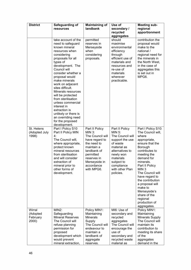
46
District Safeguarding of resources
Maintaining of landbank
Use of secondary / recycled aggregates
Meeting sub-regional apportionment
take account of the need to safeguard known mineral resources when considering proposals for all types of development. The Council will consider whether a proposal would make minerals work on adjacent sites difficult. Minerals resources will be protected from sterilisation unless commercial interest in extraction is unlikely or there is an overriding need for the proposed development.
permitted reserves in Merseyside when considering proposals.
should maximise environmental efficiency through efficient use of materials and resources and re-use of materials wherever practicable.
contribution the proposal would make to the national / regional need for the minerals in the North West, in the case of aggregates this is set out in MPG6.
St. Helens (Adopted July 1998)
Part I Policy S10 Part II Policy MIN 4: The Council will, where appropriate, protect known mineral resources from sterilisation and will consider extraction of mineral prior to other forms of development.
Part II Policy MIN 3: The Council will have regard to the need to maintain a landbank of permitted reserves in Merseyside in accordance with MPG6.
Part II Policy MIN 5: The Council will support the use of waste material as alternatives to newly won materials subject to compliance with other Plan policies.
Part I Policy S10: The Council will, where appropriate, ensure that the Borough contributes to meeting the demand for minerals. Part II Policy MIN 3 The Council will have regard to the contribution a proposal will make to Merseyside’s share of the regional production of aggregates.
Wirral (Adopted February 2000)
MIN2: Safeguarding Mineral Reserves The Council will refuse planning permission for proposed development which would prevent mineral extraction,
Policy MIN1: Maintaining Minerals Supply The Council will endeavour to maintain a landbank of aggregate reserves.
MI6: Use of secondary and recycled aggregates The Council will encourage the use of secondary and recycled waste material as
Policy MIN1: Maintaining Minerals Supply The Council will maintain its contribution to meeting its share of the aggregates demand in the

47
District Safeguarding of resources
Maintaining of landbank
Use of secondary / recycled aggregates
Meeting sub-regional apportionment
or will permit extraction of the mineral prior to development.
alternatives to virgin minerals where this is economically and environmentally acceptable,
region.
The UDP policies were developed before the new planning system came into force and as a result are outdated. However, most Districts have taken into account key issues such as safeguarding minerals reserves, maintaining minerals a steady supply of minerals and meeting sub-regional apportionment. In addition, most districts highlight the need to substitute secondary and recycled aggregates for newly won materials where appropriate. Aggregates Aggregates are granular material used in construction17 and are essential in new buildings and maintaining the built environment. They are used in concrete, roadstone, asphalt and numerous other construction materials; because of this, aggregates are essential for our economy. There are two categories of aggregates. Primary aggregates are extracted specifically for use in construction, whilst secondary and recycled aggregates are alternatives to primary aggregates. Secondary aggregates are a by-product of other quarrying or industrial processes, for example, spoil or slag. Recycled aggregates arise from sources such as construction and demolition activities. Apportionment of Aggregates National aggregates policy is set out by the Government in MPS1, specifically in Annex 1 of this document. Annex 1: Aggregates, replaces MPG6 and states a requirement for MPAs to make provision for the sub-regional apportionment of the current National and Regional Guidelines for land-won aggregate in the approved RSS18. The National and Regional Guidelines for Aggregates Provision in England sets out the revised national and regional guidelines for aggregate provision in England for a period of 16 years. It is intended that this data should be used by MPAs when developing minerals plans, and also by regional bodies when setting regional apportionments.
17 http://www.mineralsuk.com/britmin/mpfaggregates.pdf
18 MPS1 (2006) p.14 DCLG

48
Guidelines for land-won production19
Assumptions
Land-won Sand and Gravel
Land-won Crushed Rock
Marine Sand and Gravel
Alternative Materials
Net Imports to England
North West 55 167 4 101 50
England 1,068 1,618 230 919 169 Table 4: National and Regional Guidelines for Aggregates Provision in England, 2001 – 2016 (Million Tonnes)
These regional apportionments are broken down further by RAWP and expressed in regional policy through the Submitted Draft RSS for the North West, in which Policy EM8 states that MPAs should work together to make provision for the agreed regional apportionment of land-won aggregate requirements to 2016. The sub-regional apportionment of aggregates in the North West is shown below. In addition to these apportionments, it is assumed that 155 million tones will come from marine dredged aggregates, the use of secondary/recycled aggregates and imports from outside the region.
Sand and Gravel Crushed Rock
Cheshire 31.5 2
Cumbria 11.2 66
Lancashire 8.2 73
M’side/GM/Halton/W’ton 4.1 26
Total20 55.0 167 Table 5: Sub-regional Apportionment of Aggregates in the North West 2001 – 2016 (Million tonnes)
Production and Reserves The importance of aggregates to modern society is recognised within planning through the RAWP, which study production, distribution and reserves in the regions. Information collated by the North West RAWP as part of the Annual Monitoring Survey is used to inform the development of the Regional Spatial Strategy for the North West to assist in maintaining a steady supply off aggregates for our society. Due to commercial sensitivity and confidentiality, figures in the annual RAWP Reports for Greater Manchester, Merseyside, Halton and Warrington are amalgamated. Annual primary aggregate sales and reserves are shown in Primary Aggregate Sales 1996 – 2005 (Million tonnes) and Primary Aggregate Reserves 1996 – 2005 (Million tonnes).
19 National and regional guidelines for aggregates provision in England 2001 – 2016 (2003) ODPM 20 Submitted Draft Regional Spatial Strategy for the North West of England (January 2006) NWRA

49
(AM97) (AM98) (AM99) (AM00) (AM01) (AM02) (AM03) (AM04) (AM05)21
Sandstone and Igneous Rock
Merseyside22 1.9 1.9 1.8 1.4 1.4 1.3 1.4 1.5 1.2
Total NW 5.06 4.85 4.58 4.2 4.5 4.6 4.12 3.95 5.53
Sand and Gravel
Merseyside23 0.45 0.3 0.24 0.31 0.23 0.4 0.5 0.5 0.4
Total NW 4.72 4.16 4.1 3.78 3.1 3.2 3.36 2.84 3.06
Total Agg. Production
16.53 15.14 14.92 14.37 13.66 14.0 13.18 12.89 12.35
Table 6: Primary Aggregate Sales 1996 – 2005 (Million tonnes)
(AM97) (AM98) (AM99) (AM00) (AM01) (AM02) (AM03) (AM04) (AM05)
24
Sandstone and Igneous Rock
Merseyside25 32.4 35.33 32.0 30.9 30.2 27.7 22.6 22.5 23.69
Total NW 215.4 196.65 191.9 179.3 172.8 166.6 158.9 168.4 152.29
Sand and Gravel
Merseyside26 3.5 5.36 7.67 7.1 6.7 7.7 6.7 6.3 8.91
Total NW 49.7 46.64 46.27 43.2 47.9 47.3 41.34 39.24 43.02
Total Agg. Production
450.5 394.39 406.77 393.3 390.6 375.2 356.94 358.64 343.53
Table 7:Primary Aggregate Reserves 1996 – 2005 (Million tonnes)
Landbanks MPS1 Annex 1 states a requirement for MPAs to maintain a landbank of permissions for aggregate extraction for at least 7 years for sand and gravel and at least 10 years for crushed rock. Landbanks are to be taken into consideration by MPAs when determining applications for new extraction activities. When a site has not been worked for ten years it should be reviewed to assess whether production is likely to begin again and if operators agree it is unlikely, they should be excluded from the landbank calculation. Alternatives to Primary Aggregates MPS1 encourages the use of alternatives to primary aggregates. Targets for these alternatives are set out in the National and Regional Guidelines for Aggregates Provision in England27. For construction and demolition waste, this figure is 60Mt per annum by 2011, compared with the target set in the 1994 guidelines of 55Mt by 2006. A desire to maximise the role played by secondary and recycled aggregates is also stated within the Draft Submitted RSS for the North West. A target of 20% construction aggregates to be from secondary or recycled sources by 2010 and 25% by 2021 is set, and local authorities and developers will be encouraged to incorporate temporary materials-recycling facilities on the sites of major demolition or construction projects.
21 North West Regional Aggregates Working Party Annual Report 2006
22 including Greater Manchester, Halton and Warrington
23 including Greater Manchester, Halton and Warrington
24 North West Regional Aggregates Working Party Annual Report 2006
25 including Greater Manchester, Halton and Warrington
26 including Greater Manchester, Halton and Warrington
27 Survey of Arisings and Use of Alternatives to Primary Aggregates in England, 2005: Construction, Demolition and Excavation Waste (2007) DCLG
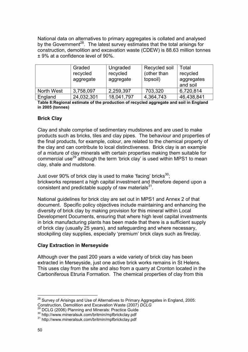
50
National data on alternatives to primary aggregates is collated and analysed by the Government28. The latest survey estimates that the total arisings for construction, demolition and excavation waste (CDEW) is 88.63 million tonnes ± 9% at a confidence level of 90%.
Graded recycled aggregate
Ungraded recycled aggregate
Recycled soil (other than topsoil)
Total recycled aggregates and soil
North West 3,758,097 2,259,397 703,320 6,720,814
England 24,032,301 18,041,797 4,364,743 46,438,841 Table 8:Regional estimate of the production of recycled aggregate and soil in England in 2005 (tonnes)
Brick Clay Clay and shale comprise of sedimentary mudstones and are used to make products such as bricks, tiles and clay pipes. The behaviour and properties of the final products, for example, colour, are related to the chemical property of the clay and can contribute to local distinctiveness. Brick clay is an example of a mixture of clay minerals with certain properties making them suitable for commercial use29 although the term ‘brick clay’ is used within MPS1 to mean clay, shale and mudstone. Just over 90% of brick clay is used to make ‘facing’ bricks30; brickworks represent a high capital investment and therefore depend upon a consistent and predictable supply of raw materials31. National guidelines for brick clay are set out in MPS1 and Annex 2 of that document. Specific policy objectives include maintaining and enhancing the diversity of brick clay by making provision for this mineral within Local Development Documents, ensuring that where high level capital investments in brick manufacturing plants has been made that there is a sufficient supply of brick clay (usually 25 years), and safeguarding and where necessary, stockpiling clay supplies, especially ‘premium’ brick clays such as fireclay. Clay Extraction in Merseyside Although over the past 200 years a wide variety of brick clay has been extracted in Merseyside, just one active brick works remains in St Helens. This uses clay from the site and also from a quarry at Cronton located in the Carboniferous Etruria Formation. The chemical properties of clay from this
28 Survey of Arisings and Use of Alternatives to Primary Aggregates in England, 2005: Construction, Demolition and Excavation Waste (2007) DCLG 29 DCLG (2006) Planning and Minerals: Practice Guide
30 http://www.mineralsuk.com/britmin/mpfbrickclay.pdf
31 http://www.mineralsuk.com/britmin/mpfbrickclay.pdf

51
formation makes it particularly suitable for manufacturing high quality facing and engineering bricks, pavers and roofing and floor tiles32. Other uses for clay include use for engineering purposes, for example lining, daily cover and capping of landfill sites and lining canals. MPS1 highlights the need for MPAs to take these other uses into consideration when developing planning policies. Peat Peat is formed when organic matter dies and decomposes under wet, acidic conditions. In some areas, peat is used as a fuel, however, its primary use in the UK today is for horticultural purposes, as a growing media or soil improver. The use of alternatives to peat is becoming more common. An important aspect of peat bogs is that they tend to have a high biodiversity value and that they are a finite resource. In addition, it is recognised that peat extraction can have a significant environmental impact. Silica Sand Planning policy for silica sand is set out in MPG15: Provision of Silica Sand in England. This note highlights the difference between the silica sand and construction sand industries. Silica sand is sand which contains a high proportion of silica in the form of quartz and is valued for both its physical and chemical properties33. Because of the higher price silica sand can command in comparison to construction sand (due to the small number of deposits containing sand suitable for use specifically as silica sand) they often serve a wider geographical market. Silica Sand in Merseyside The only operation to extract silica sand in Merseyside recently ceased due to international environmental designations in this area. This was in Sefton, in the ‘Horse Bank’ off the coast from Southport. The wind-blown sand deposits known as Shirdley Hill Sand Formation have been worked in the past in St. Helens where it was a source of glass sand. However, due to the thinness of this deposit and the large amount of sand required for glass making, it is no longer economical to work it and extraction for glass making ceased in 1977, although it has subsequently been worked for horticultural use.
32 Minchin, McEvoy, Harrison, Cameron, Evans, Lott, Hobbs & Highley (2006) Mineral Resource Information in Support of National, Regional and Local Planning: Merseyside (comprising City of Liverpool and Boroughs of Knowsley, Sefton, St Helens and Wirral BGS 33 http://www.mineralsuk.com/britmin/mpfsilica_sand.pdf

52
Appendix 3: Maps
• Map 1: Map of Merseyside showing extent of urban area with buffer, international environmental constraints with buffer and mineral resources
• Map 2: Potential Sand and Gravel MSA (a)
• Map 3: Map 3 Potential Sand and Gravel Area of Search (a)
• Map 4: Potential Sand and Gravel MSA (b) and (c)
• Map 5: Bold Heath Quarry (existing permission and Potential extension, sand)
• Map 6: Carr Lane (existing permission and potential extension, clay)
• Map 7: Cronton Clay Pit (existing permission, clay)
• Map 8: Land between Garswood Old Road and Arch Lane (potential MSA, coal)