
The EUMETSAT Satellite Application Facility on Land Surface …ufa.eumetsat.int/userfiles/file/17.10...
33
The EUMETSAT Satellite Application Facility on Land Surface Analysis (LSA SAF) Continuous Development –2 Phase Jean-Louis Roujean and many co-authors METEO FRANCE / Toulouse [email protected]
Transcript of The EUMETSAT Satellite Application Facility on Land Surface …ufa.eumetsat.int/userfiles/file/17.10...

The EUMETSAT Satellite Application Facility
on Land Surface Analysis (LSA SAF)
Continuous Development –2 Phase
Jean-Louis Roujean and many co-authors
METEO FRANCE / Toulouse

• Part of EUMETSAT Ground Segment
• To develop algorithms that allow an effective use of MSG & Metop data related to
• LAND • LAND-ATMOSPHERE Interactions • BIOSPHERIC Applications
• Generate / Archive / Distribute Satellite Data in Near Real Time (3h) and Off-line
• Consortium – 8 Institutes / 6 countries • Reviewed (~annually) by technical and scientific panels
LSA SAF Overview
Trigo et al., 2011 in Int. J. Remote Sens., DOI: 10.1080/01431161003743199

Meteosat-8 (MSG-1)
Meteosat-9 (MSG-2)
MetOp-A
Meteosat-10 (MSG-3)
MetOp-B Meteosat-11
(MSG-4)
MTG-1
MetOp-C
Development Phase: Sep 99 – Jan 05
Initial Operations Phase: Feb 05 – Feb 07
Continuous Development & Operations Phase - 2: Mar 12 – Feb 17
LSA SAF Chronogram
02 03 04 05 06 07 08 09 10 11 12 13 14 15 16 17 18 19 01 00 99 20
CDOP-2
CDOP-3
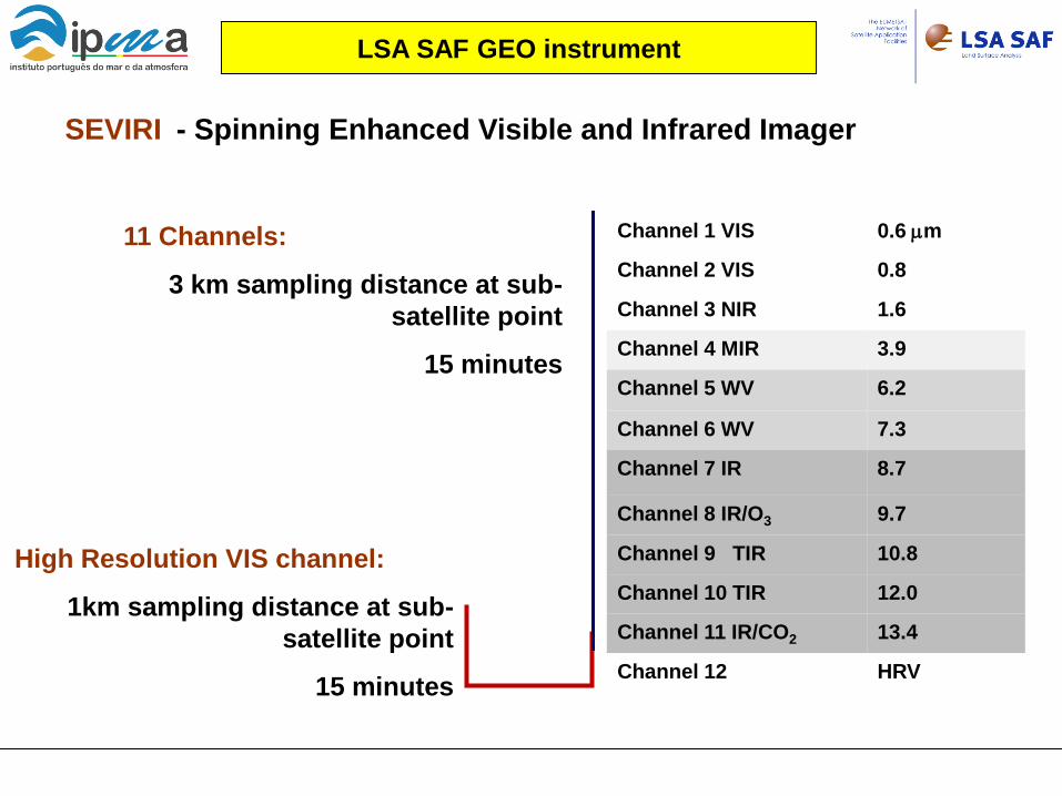
Channel 1 VIS 0.6 µm
Channel 2 VIS 0.8
Channel 3 NIR 1.6
Channel 4 MIR 3.9
Channel 5 WV 6.2
Channel 6 WV 7.3
Channel 7 IR 8.7
Channel 8 IR/O3 9.7
Channel 9 TIR 10.8
Channel 10 TIR 12.0
Channel 11 IR/CO2 13.4
Channel 12 HRV
SEVIRI - Spinning Enhanced Visible and Infrared Imager
LSA SAF GEO instrument
11 Channels:
3 km sampling distance at sub-satellite point
15 minutes
High Resolution VIS channel:
1km sampling distance at sub-satellite point
15 minutes

LSA SAF – Family of Products
LST ↓LongWave Flux
Surface Radiation
Vegetation
Fire Detection
Fire Radiative Power
Fire Risk (Europe)
Wild fires
=> Strong consistency / other satellite projects
Evapotranspiration
Reference Evapot
Water stress
Fraction Veg Cover
LAI
fAPAR
State
NDVI
↓ShortWave Flux Albedo
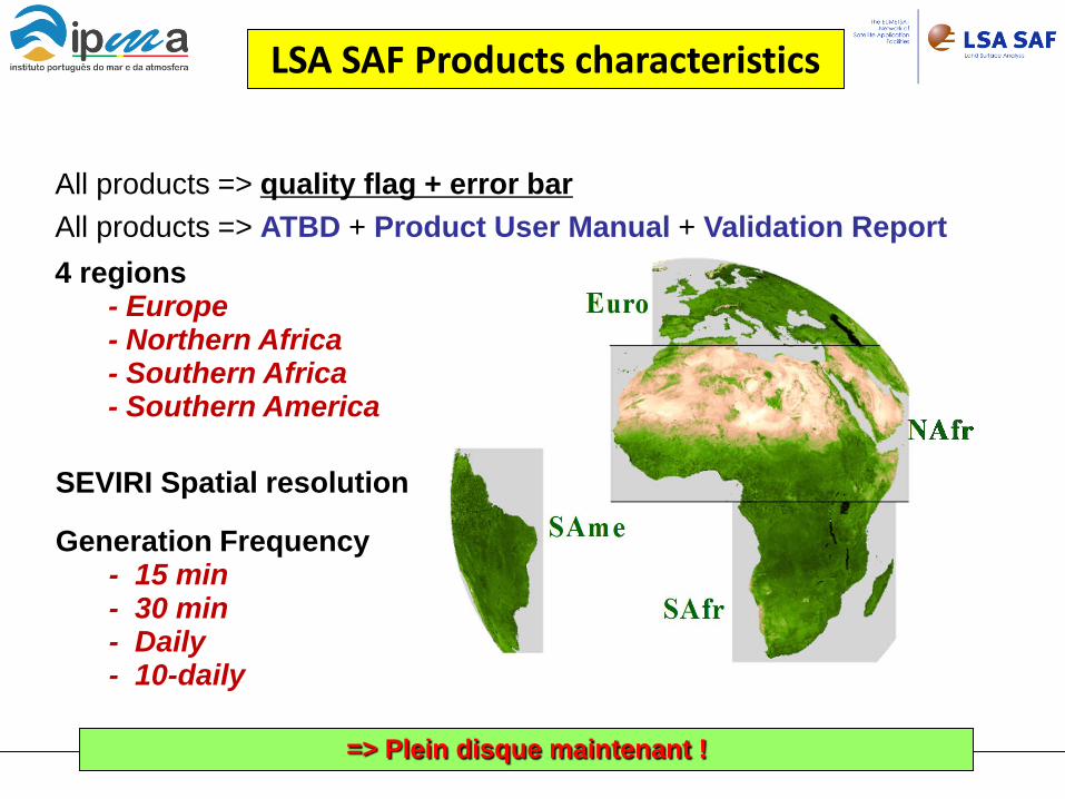
All products => quality flag + error bar All products => ATBD + Product User Manual + Validation Report 4 regions
- Europe - Northern Africa - Southern Africa - Southern America
Generation Frequency - 15 min - 30 min - Daily - 10-daily
SEVIRI Spatial resolution
LSA SAF Products characteristics
=> Plein disque maintenant !
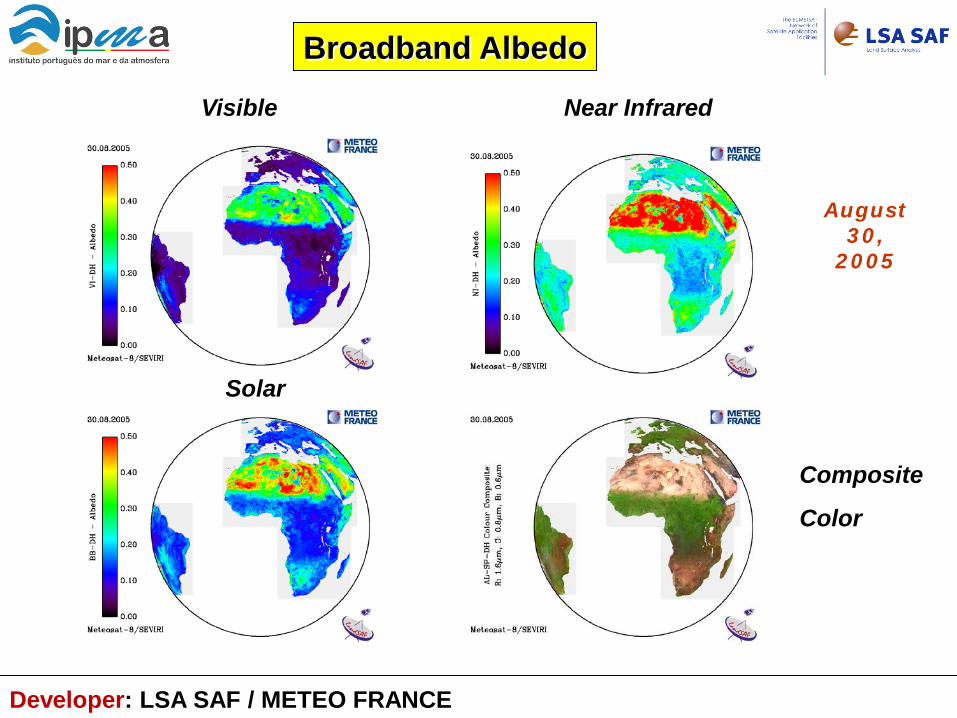
Broadband Albedo
August 30,
2005
Visible Near Infrared
Solar
Composite
Color
Developer: LSA SAF / METEO FRANCE
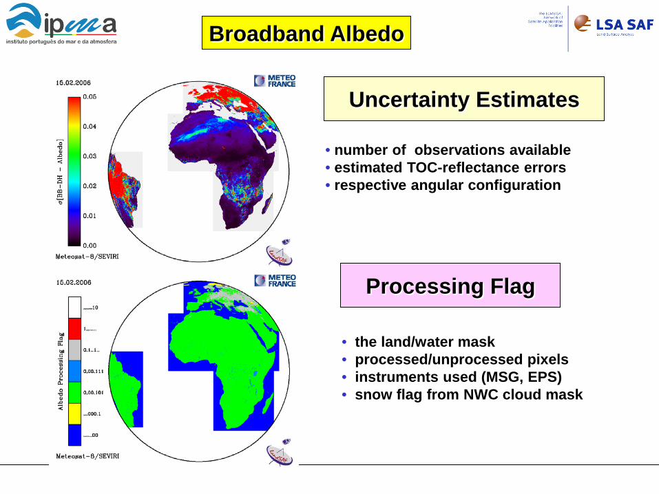
Uncertainty Estimates
• number of observations available • estimated TOC-reflectance errors • respective angular configuration
Processing Flag • the land/water mask • processed/unprocessed pixels • instruments used (MSG, EPS) • snow flag from NWC cloud mask
Broadband Albedo
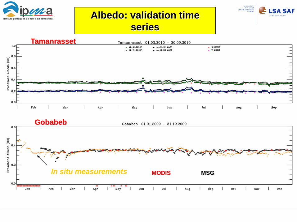
Albedo: validation time series
Tamanrasset
Gobabeb
In situ measurements MODIS MSG

Albedo < 0.15 spatial validation / MODIS
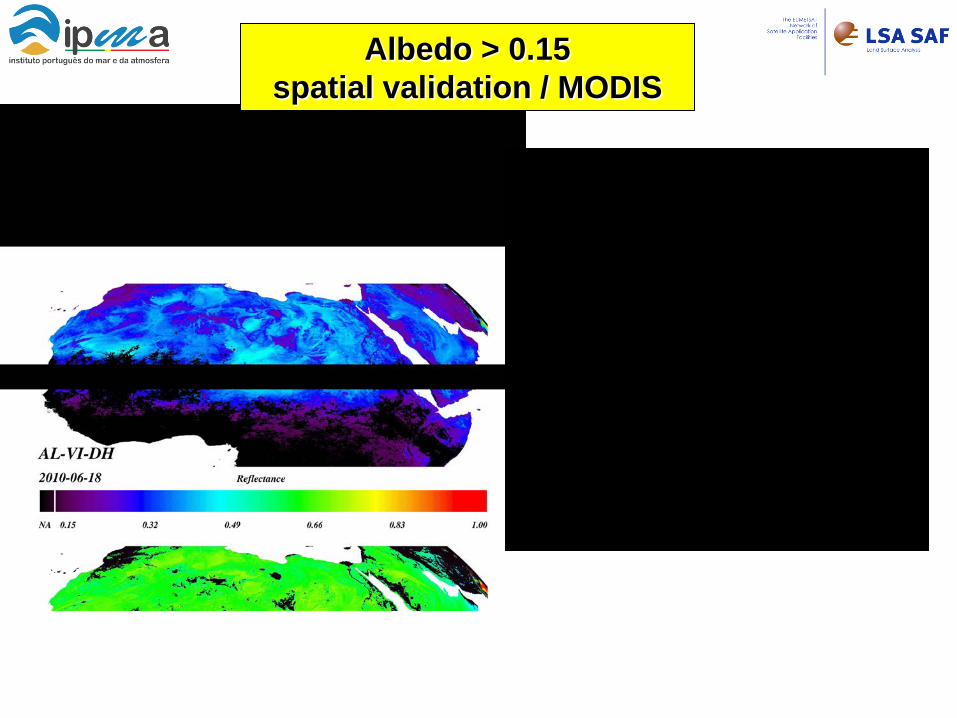
Albedo > 0.15 spatial validation / MODIS
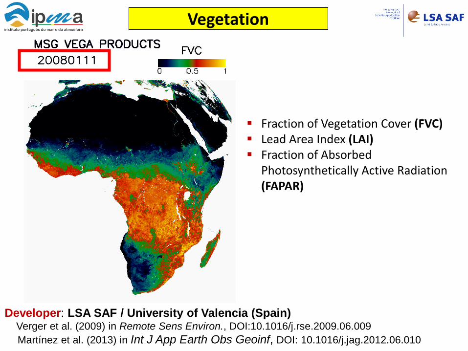
Vegetation
Fraction of Vegetation Cover (FVC) Lead Area Index (LAI) Fraction of Absorbed
Photosynthetically Active Radiation (FAPAR)
Developer: LSA SAF / University of Valencia (Spain) Verger et al. (2009) in Remote Sens Environ., DOI:10.1016/j.rse.2009.06.009 Martínez et al. (2013) in Int J App Earth Obs Geoinf, DOI: 10.1016/j.jag.2012.06.010
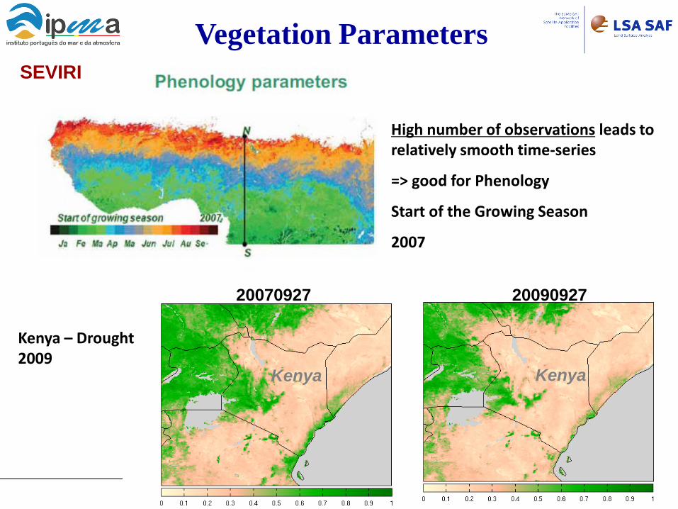
Vegetation Parameters SEVIRI
High number of observations leads to relatively smooth time-series
=> good for Phenology
Start of the Growing Season
2007
Kenya
20090927
Kenya
20070927
Kenya – Drought 2009

Land Surface Temperature
LST Available since
Europe – Feb 2005
Full disk – Jul 2005
Generation Frequency - 15 min
clear sky pixels
where estimated errors < 4K
Propagation of input uncertainties:
Emissivity
...
Developer: LSA SAF / IPMA (Portugal) Trigo et al. (2008) in J. Geophys. Res., DOI:10.1029/2008JD010035 Freitas et al. (2010) in IEEE Trans Geosc Remote Sens, DOI: 10.1109/TGRS.2009.2027697.
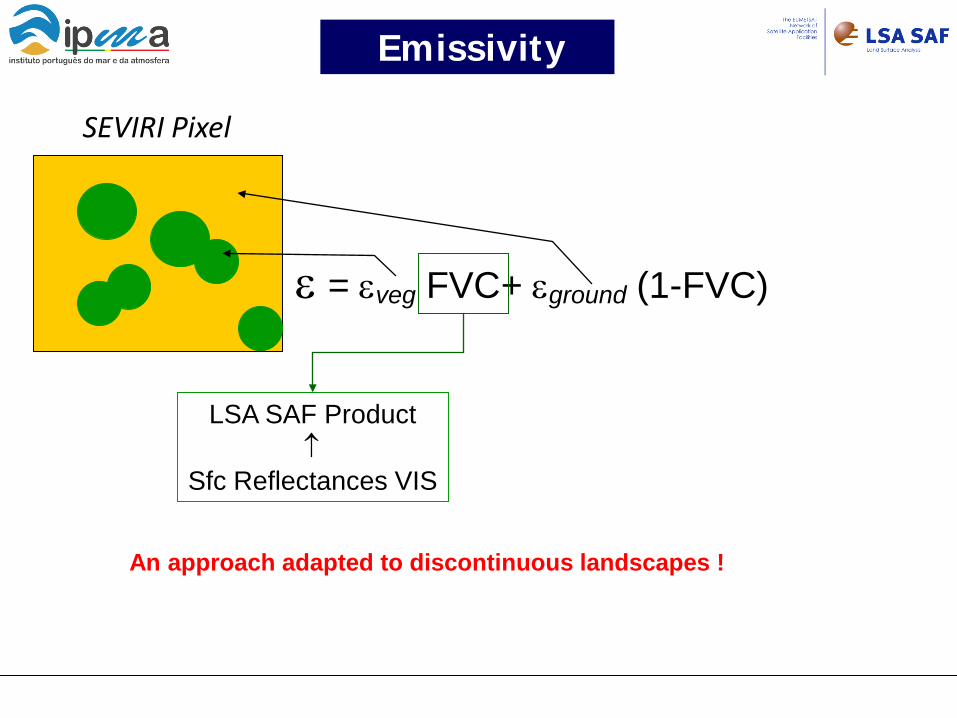
SEVIRI Pixel
ε = εveg FVC+ εground (1-FVC)
Emissivity
LSA SAF Product ↑
Sfc Reflectances VIS
An approach adapted to discontinuous landscapes !
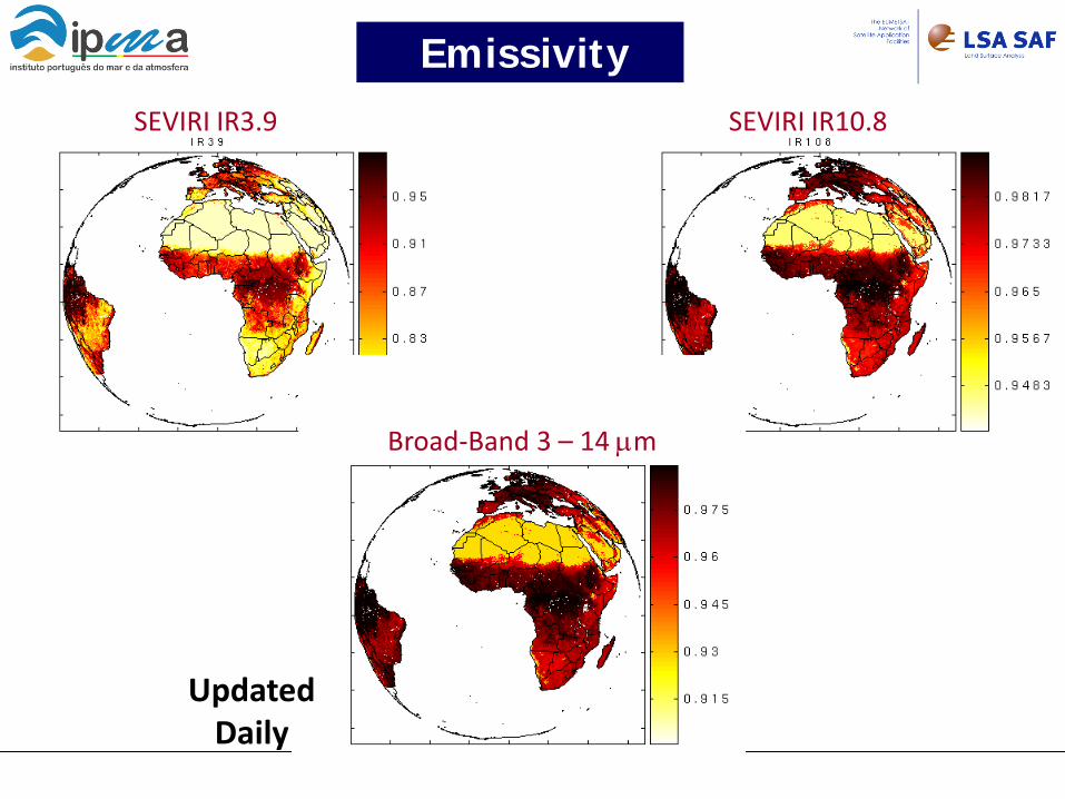
SEVIRI IR3.9 SEVIRI IR10.8
Emissivity
Broad-Band 3 – 14 µm
Updated Daily
Namibia
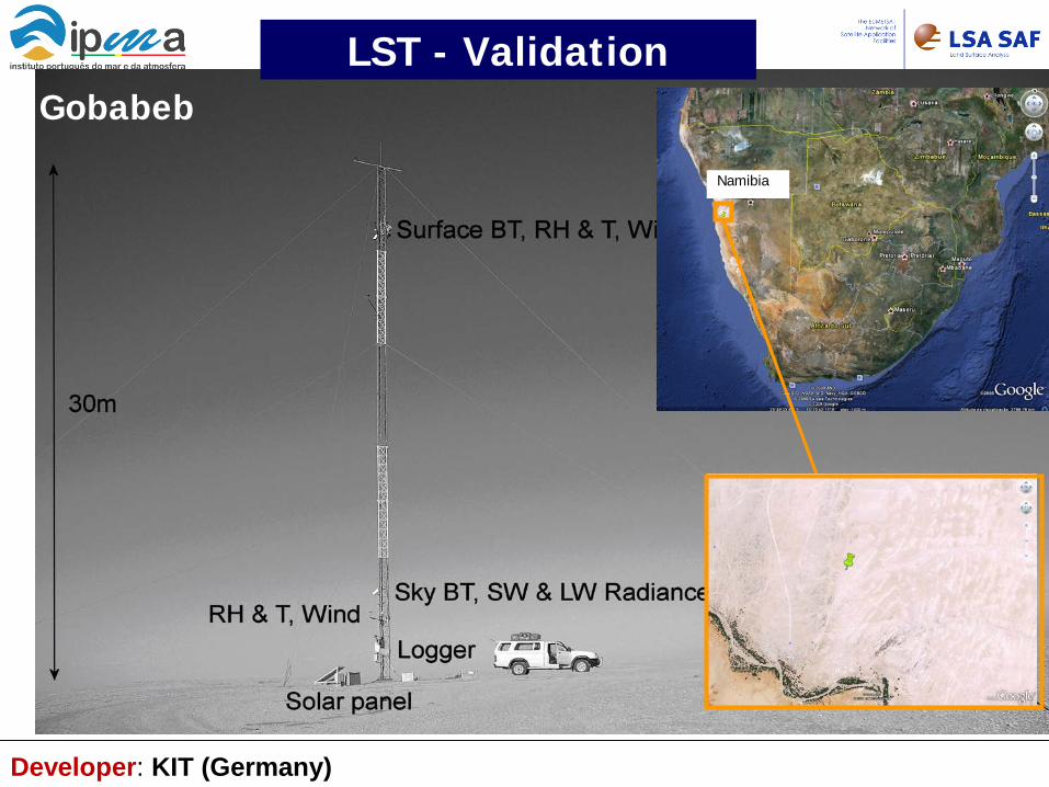
LST - Validation Gobabeb
Developer: KIT (Germany)
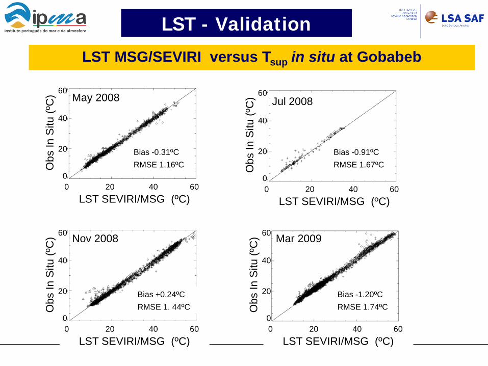
LST MSG/SEVIRI versus Tsup in situ at Gobabeb
60
40
20
0
Obs
In S
itu (º
C)
0 20 40 60 LST SEVIRI/MSG (ºC)
May 2008
Bias -0.31ºC RMSE 1.16ºC
60
40
20
0
Obs
In S
itu (º
C)
0 20 40 60 LST SEVIRI/MSG (ºC)
Jul 2008
Bias -0.91ºC RMSE 1.67ºC
60
40
20
0
Obs
In S
itu (º
C)
0 20 40 60 LST SEVIRI/MSG (ºC)
Nov 2008
Bias +0.24ºC RMSE 1. 44ºC
60
40
20
0
Obs
In S
itu (º
C)
0 20 40 60 LST SEVIRI/MSG (ºC)
Mar 2009
Bias -1.20ºC RMSE 1.74ºC
LST - Validation
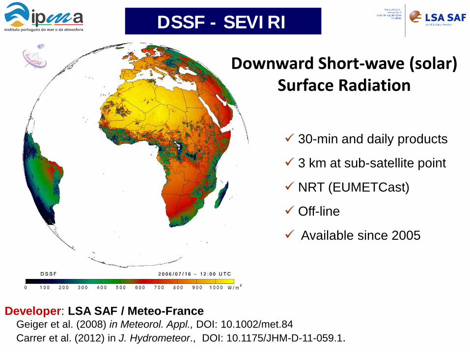
Downward Short-wave (solar) Surface Radiation
30-min and daily products
3 km at sub-satellite point
NRT (EUMETCast)
Off-line
Available since 2005
Developer: LSA SAF / Meteo-France Geiger et al. (2008) in Meteorol. Appl., DOI: 10.1002/met.84 Carrer et al. (2012) in J. Hydrometeor., DOI: 10.1175/JHM-D-11-059.1.
DSSF - SEVIRI
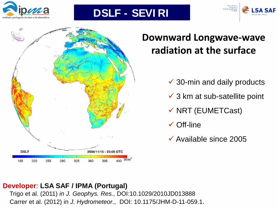
Downward Longwave-wave radiation at the surface
30-min and daily products
3 km at sub-satellite point
NRT (EUMETCast)
Off-line
Available since 2005
Developer: LSA SAF / IPMA (Portugal) Trigo et al. (2011) in J. Geophys. Res., DOI:10.1029/2010JD013888 Carrer et al. (2012) in J. Hydrometeor., DOI: 10.1175/JHM-D-11-059.1.
DSLF - SEVIRI
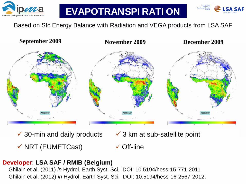
November 2009 September 2009 December 2009
30-min and daily products 3 km at sub-satellite point
NRT (EUMETCast) Off-line
Based on Sfc Energy Balance with Radiation and VEGA products from LSA SAF
Developer: LSA SAF / RMIB (Belgium) Ghilain et al. (2011) in Hydrol. Earth Syst. Sci., DOI: 10.5194/hess-15-771-2011 Ghilain et al. (2012) in Hydrol. Earth Syst. Sci, DOI: 10.5194/hess-16-2567-2012.
EVAPOTRANSPIRATION
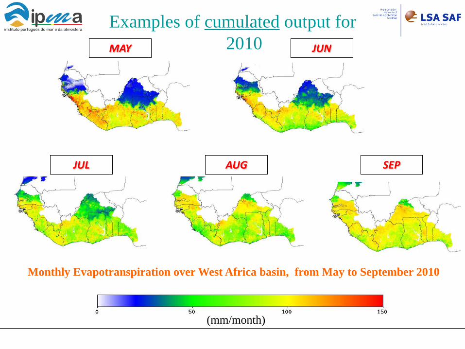
Monthly Evapotranspiration over West Africa basin, from May to September 2010
Examples of cumulated output for 2010
(mm/month)
MAY JUN
JUL AUG SEP
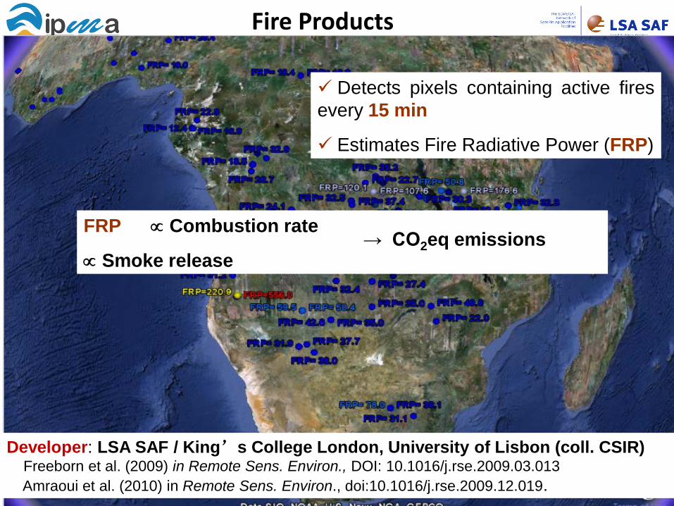
Detects pixels containing active fires every 15 min
Estimates Fire Radiative Power (FRP)
FRP ∝ Combustion rate
∝ Smoke release → CO2eq emissions
Fire Products
Developer: LSA SAF / King’s College London, University of Lisbon (coll. CSIR) Freeborn et al. (2009) in Remote Sens. Environ., DOI: 10.1016/j.rse.2009.03.013 Amraoui et al. (2010) in Remote Sens. Environ., doi:10.1016/j.rse.2009.12.019.
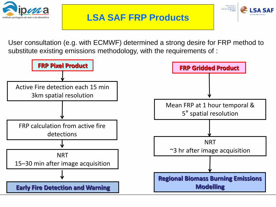
LSA SAF FRP Products
User consultation (e.g. with ECMWF) determined a strong desire for FRP method to substitute existing emissions methodology, with the requirements of :
FRP Pixel Product
Regional Biomass Burning Emissions Modelling Early Fire Detection and Warning
FRP calculation from active fire detections
NRT 15–30 min after image acquisition
FRP Gridded Product
Mean FRP at 1 hour temporal & 5° spatial resolution
NRT ~3 hr after image acquisition
Active Fire detection each 15 min 3km spatial resolution
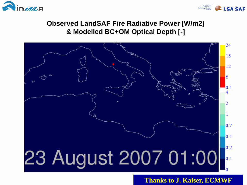
Observed LandSAF Fire Radiative Power [W/m2] & Modelled BC+OM Optical Depth [-]
Thanks to J. Kaiser, ECMWF
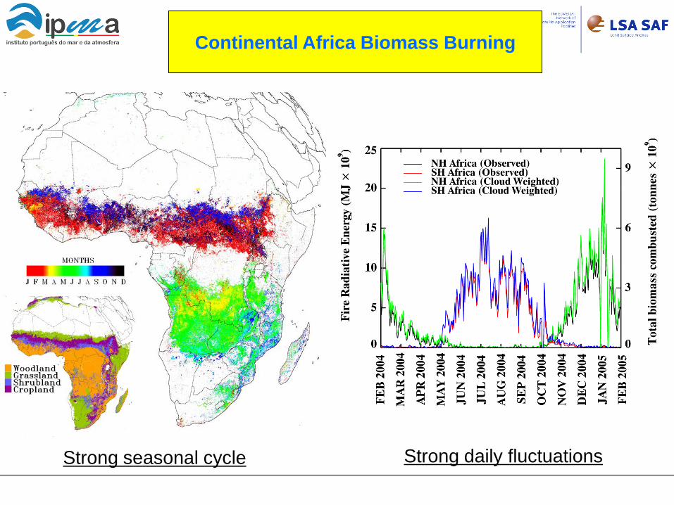
Continental Africa Biomass Burning
Strong seasonal cycle Strong daily fluctuations
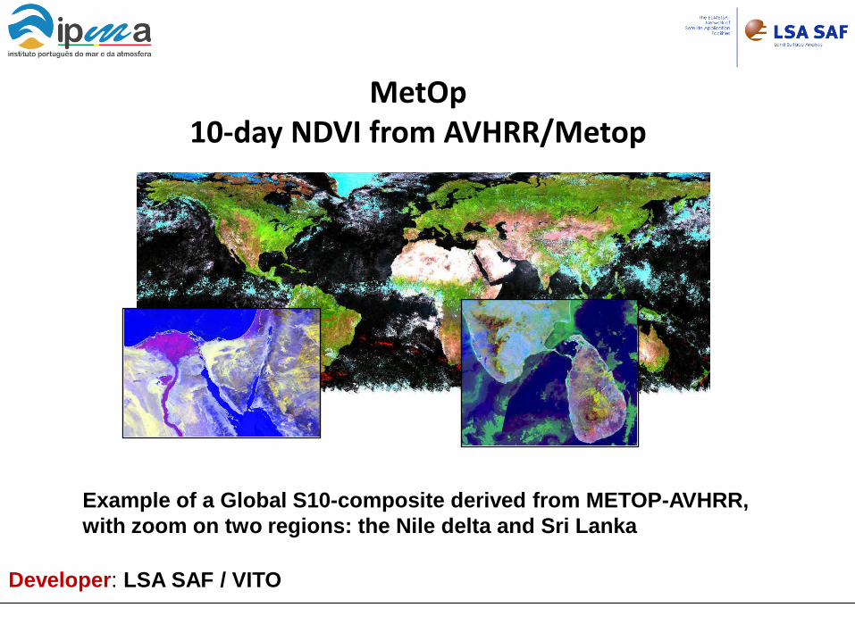
Example of a Global S10-composite derived from METOP-AVHRR, with zoom on two regions: the Nile delta and Sri Lanka
MetOp 10-day NDVI from AVHRR/Metop
Developer: LSA SAF / VITO
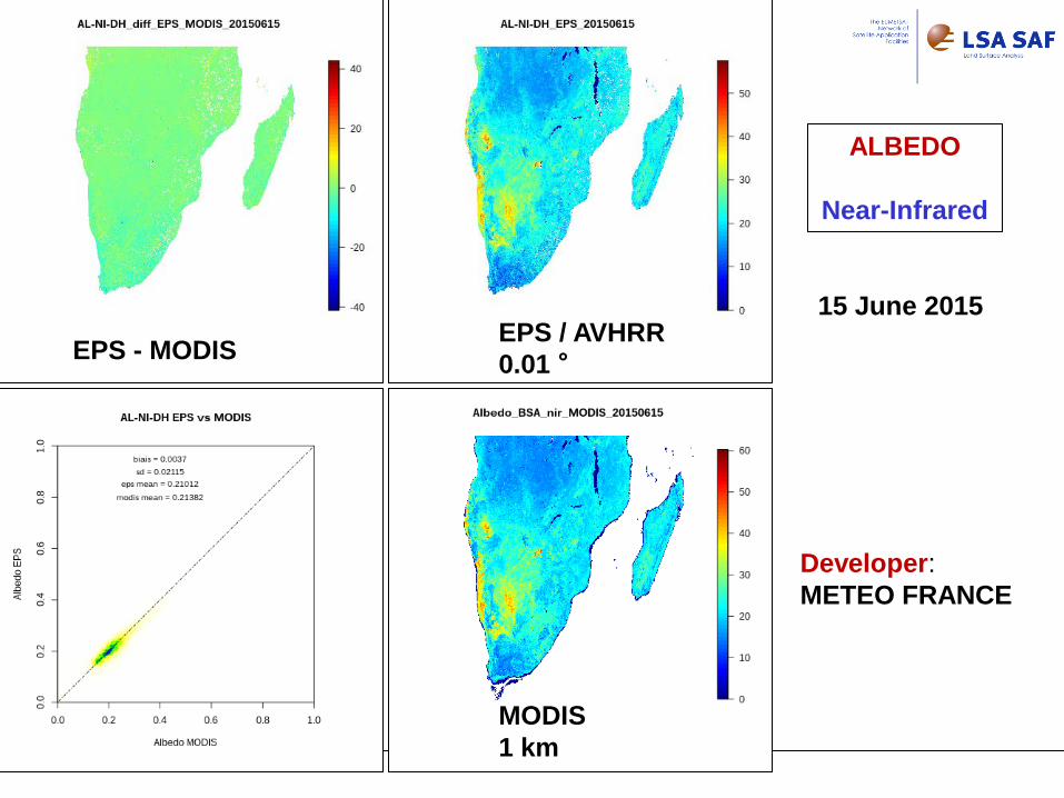
Developer: METEO FRANCE
EPS / AVHRR 0.01 °
MODIS 1 km
EPS - MODIS
ALBEDO
Near-Infrared
15 June 2015
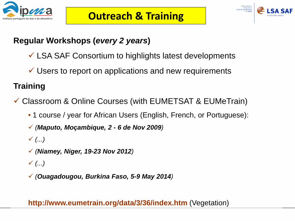
Regular Workshops (every 2 years)
LSA SAF Consortium to highlights latest developments
Users to report on applications and new requirements
Training
Classroom & Online Courses (with EUMETSAT & EUMeTrain) • 1 course / year for African Users (English, French, or Portuguese): (Maputo, Moçambique, 2 - 6 de Nov 2009)
(...)
(Niamey, Niger, 19-23 Nov 2012)
(...)
(Ouagadougou, Burkina Faso, 5-9 May 2014)
http://www.eumetrain.org/data/3/36/index.htm (Vegetation)
Outreach & Training
LSA SAF - NEXT
Near Future (CDOP-2)
Service Continuity
Reprocessing Activities (LST, AL, VEGA, FIRE, radiative flux)
AVHRR (EPS) for global + complement SEVIRI Preparation for CDOP-3 (2017-2022) Next Generation of EUM Satellites
Meteosat Third Generation (MTG) EUM Polar System – Second Generation (EPS-SG) /3MI
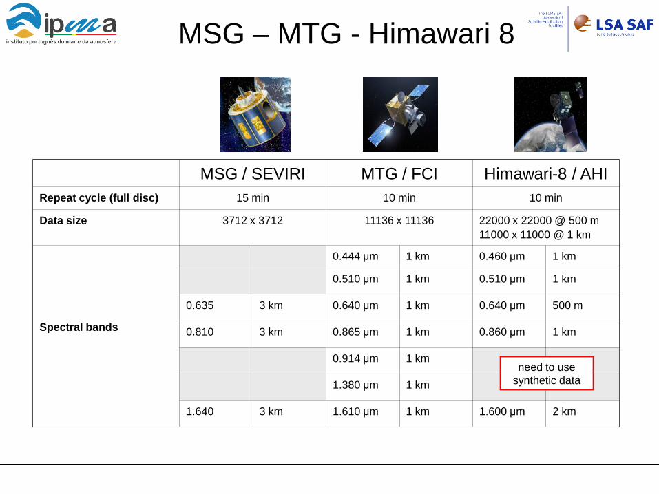
MSG – MTG - Himawari 8
MSG / SEVIRI MTG / FCI Himawari-8 / AHI Repeat cycle (full disc) 15 min 10 min 10 min
Data size 3712 x 3712 11136 x 11136 22000 x 22000 @ 500 m 11000 x 11000 @ 1 km
Spectral bands
0.444 μm 1 km 0.460 μm 1 km
0.510 μm 1 km 0.510 μm 1 km
0.635 3 km 0.640 μm 1 km 0.640 μm 500 m
0.810 3 km 0.865 μm 1 km 0.860 μm 1 km
0.914 μm 1 km
1.380 μm 1 km
1.640 3 km 1.610 μm 1 km 1.600 μm 2 km
need to use synthetic data
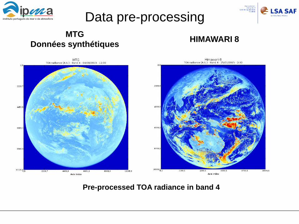
Data pre-processing
Pre-processed TOA radiance in band 4
MTG Données synthétiques HIMAWARI 8

http://landsaf.ipma.pt


![Satellite Conferences - Sally Wannop EPS.ppt [Read-Only] · 2004-12-28 · EPS Services 2004 Satellite Direct Readout Conference - Miami Page 3 Introduction • EUMETSAT Polar System](https://static.fdocuments.in/doc/165x107/5f85054f6de0f368a9761538/satellite-conferences-sally-wannop-epsppt-read-only-2004-12-28-eps-services.jpg)


