Maize yield increases and stabilisation under CA in semi-arid districts of Tanzania. Saidi Mkomwa

Pirineos, 153-154:159 a 174, JACA; 1999
THE EFFECT OF GRAZING ON SOIL AND WATER LOSSES UNDER ARID AND MEDITERRANEAN CLIMATES.
IMPLICATIONS FOR DESERTIFICATION
A. CERDA* & H. LAVÉE**
*Centro de Estudios sobre Desertificación. (CSIC-UV-GV). Camíde la Marjal sin. 46470 Albal, Valencia. Spain
**Department of Geography. Bar-Han University. 52900, Ramat-Gan. Israel
ABSTRACT.- Two sites, both affected by grazing but under different climatic conditions, were selected in Israel to study the effect of grazing on soil degradation. One site was selected in the Judean Desert, a dry environment (260 mm mean annual rainfall) with a long history of overgrazing and very little vegetative cover. The second site was selected in the Galilee Mountains where the climate is of Mediterranean type (650 mm mean annual rainfall) and the vegetative cover is much greater in spite of the grazing. Simulated rain experiments were performed in the field and in the laboratory in order to evaluate differences in hydrological and erosional response to rainfall between the two sites. The results show a clear difference between these two ecosystems. In the Judean Desert, where vascular plant cover is sparse, a crust was developed which enhanced overland flow and erosion. In the Mediterranean environment the overland flow and erosion were negligible under shrubs and relatively high at the intershrub corridors. At the hillslope scale a mosaiclike pattern of water and soil contributing and accepting patches was developed. Such a pattern usually protect the hillslope from being eroded. Runoff and erosion rates luere very high in the Judean Desert and negligible in the Galilee Mountains.
RESUME.- Afin d'étudier l'effet du pâturage sur la dégradation des sols, deux zones de caractéristiques climatiques différentes soumises au pâturage ont été sélectionnées en Israel. L'une de ces zones se trouve située dans le désert de Judée, un milieu très aride (260 mm de précipitation annuelle moyenne) avec un couvert végétal peu dense et une longue influence du surpâturage. La deuxième zone se trouve sur les montagnes de Galilée, caractérisées par un climat méditerranéen (650 mm de précipitation annuelle moyenne) et un couvert végétal bien plus dense et ce malgré l'influence du pâturage. Afin d'évaluer le comportement hydrologique et érosif des sols de ces deux zones, des expériences ont été réalisées sous pluie simulée sur le terrain et en laboratoire. Les résultats mettent en évidence une différence nette entre
159
(c) Consejo Superior de Investigaciones Científicas Licencia Creative Commons 3.0 España (by-nc)
http://pirineos.revistas.csic.es
PIRINEOS 153-154
les deux écosystèmes. Dans le désert de Judée, où la couverture végétale est faible, une croûte superficielle se développe favorisant le ruissellement superficiel et l'érosion. Dans la zone méditerranéenne, le ruissellement superficiel et l'érosion sont insignifiants dans les zones recouvertes par les plantes alors qu'ils sont relativement élevés dans les couloirs entre les plantes du maquis. A l'échelle de la pente s'organise une répartition sous forme d'une mosaïque de zones génératrices et d'autres réceptrices d'eau et de sédiments. Ce patron évite à la pente d'être érodée. Les taux de ruissellement et d'érosion se sont avérés être très élevés dans le désert de Judée et insignifiants sur les montagnes de Galilée.
RESUMEN.- Dos zonas afectadas por pastoreo pero bajo diferentes condiciones climáticas fueron seleccionadas en Israel para estudiar el efecto del pastoreo en la degradación del suelo. Una zona se encuentra en el desierto de Judea, un medio muy árido (260 mm de precipitación media anual) con una larga historia de sobrepasto-reo y muy baja cubierta vegetal. El segundo está en las montañas de Galilea donde el clima es Mediterráneo (650 mm de precipitación media anual) y la cubierta vegetal es mucho mayor a pesar del pastoreo. Para evaluar el comportamiento hidrológico y erosivo de los suelos de ambas zonas se realizaron experimentos con lluvia simulada en el campo y en laboratorio. Los resultados muestran una clara diferencia entre los dos ecosistemas. En el Desierto de Judea, donde la cubierta de plantas es escasa, se desarrolla una costra superficial, que favorece la escorrentía superficial y la erosión. En la zona Mediterránea, la escorrentía superficial y la erosión es insignificante en las zonas cubiertas con matas y relativamente alta en los corredores entre el matorral. A escala de ladera se desarrolla un patrón en forma de mosaico de zonas contribuidoras y receptoras de agua y sedimentos. Este patrón protege la ladera de ser erosionada. Las tasas de escorrentía y erosión fueron muy altas en el Desierto de Judea e insignificantes en las montañas de Galilea.
Keywords: Grazing, land degradation, overland flow, patchiness, sediment concentration, simulated rainfall.
1. Introduction
For the traditional nomad communities (beduins) in the Middle East, grazing is a basic resource. Cov^s, sheep and goats are the source for meat and milk supply. But grazing affects ecosystems in different ways and may cause land degradation (GOUDIE, 1981). Livestock induce changes in the spatial structure of the vegetation (WOOD & BLACKBURN, 1981a) and often provide favourable conditions for the invasion of low-successional species (SIMMONS, 1989). This often results in an increase of bare soil thus increasing the erosive effect of raindrop impact and overland flow. Trampling by grazing livestock reduces infiltration rates as a result of soil compaction (THUROW et ah, 1986; 1988), surface sealing, and physical crust formation
160
(c) Consejo Superior de Investigaciones Científicas Licencia Creative Commons 3.0 España (by-nc)
http://pirineos.revistas.csic.es

THE EFFECT OF GRAZING ON SOIL AND WATER LOSSES UNDER ARID AND MEDITERRANEAN
(STOECKLER, 1959; BLACKBURN, 1979; WELTZ & WOOD, 1986; WELTZ et al, 1989). This leads to increased runoff, sediment concentration and erosion rates (WOOD & BLACKBURN, 1981b; WARREN et al, 1986a; 1986b). Grazing also alters the soil organic matter content and the litter horizon (NAETH et al, 1991), thus affecting aggregate stability. The effects of grazing increase as grazing intensity increases (BLACKBURN, 1979; GAMAUGOUN et al, 1984). Seasonal grazing contributes less to soil degradation than continuous yearlong grazing due to the periods of rest that enable vegetation to recover (NAETH, 1988).
Even though, the knowledge of the effect of grazing is quite well knonw, little is knonw about his influence on the distribution of the erosion and runoff rates on semiarid environments, and how affect under different climatic conditions. The objective of this paper is to compare land degradation response to grazing in Mediterranean and arid ecosystems in terms of hydro-logical and erosional processes.
2. Materials and methods
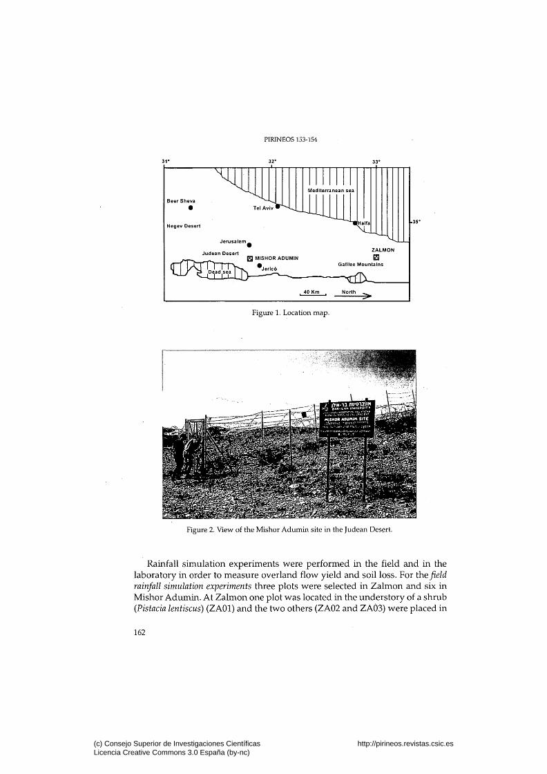
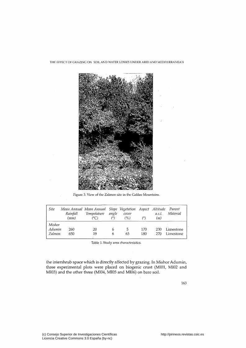
Two study sites representing typical Mediterranean and arid ecosystems were selected in Israel (Figure 1). The arid site, Mishor Adumin (MI) (Figure 2), is located in the Judean Desert, half way between Jerusalem and the Dead Sea; and the Mediterranean site, Zalmon (ZA) (Figure 1), is located in the Lower Galilee Mountains (Figure 3).
The two sites are similar in terms of lithology, topography and mean annual temperature, but very different in annual rainfall and vegetative cover (Table 1). Mishor Adumin area, comparatively with Zalmon area, is characterized by less vascular plants, much more biogenic (lichens and mosses) and physico-chemical crust patches and higher density of surface stones. The soils are lithic Xerochrept in Zalmon and lithic Serothent in Mishor Adumin. The soil structure is stronger in Zalmon, where the clay and organic matter content are higher (LAVEE et al, 1994).
The plant composition at Mishor Adumin is dominated by desert forbs such as Salsola vermiculata, Anabasis articulata, Anagallis arvensis, Halogetan alo-pecuroides, and Reaumuria hirtella, whereas Zalmon is characterized by a patchy pattern of trees, shrubs and open spaces. The trees are mainly Ceratonia siliqua and Quercus calliprinus and the shrubs are Pistacea lentiscus, Rhamnus palaestinus and Calycotome villosa. In the open spaces dwarf shrubs, perennial herbs and annuals such as Sarcopoterium spinosum, Phillyrea latifolia, Medicago sp., Plantago sp., and Brachypodium distachyon exist.
161
(c) Consejo Superior de Investigaciones Científicas Licencia Creative Commons 3.0 España (by-nc)
http://pirineos.revistas.csic.es
PIRINEOS 153-154
Figure 1. Location map.
Figure 2. View of the Mishor Adumin site in the Judean Desert.
Rainfall simulation experiments were performed in the field and in the laboratory in order to measure overland flow yield and soil loss. For the field rainfall simulation experiments three plots were selected in Zalmon and six in Mishor Adumin. At Zalmon one plot was located in the understory of a shrub {Pistacia lentiscus) (ZAOl) and the two others (ZA02 and ZAÔ3) were placed in
162
(c) Consejo Superior de Investigaciones Científicas Licencia Creative Commons 3.0 España (by-nc)
http://pirineos.revistas.csic.es
THE EFFECT OF GRAZING ON SOIL AND WATER LOSSES UNDER ARID AND MEDITERRANEAN
Figure 3. View of the Zalmon site in the Galilee Mountains.
Site Mean Annual Mean Annual Slope Vegetation Aspect Altitude Parent Rainfall Tempetature angle cover • a.s.l. Material
(mm) (°C) n {%) n (m)
Mishor Adumin Zalmon
260 650
20 19
6 6
5 65
170 180
230 Limestone 270 Limestone
Table 1. Study area characteristics.
the in tershrub space which is directly affected by grazing. In Mishor A d u m i n , three exper imental plots were placed on biogenic crust (MIOl, MI02 and MI03) and the other three (MI04, MI05 and MI06) on bare soil.
163
(c) Consejo Superior de Investigaciones Científicas Licencia Creative Commons 3.0 España (by-nc)
http://pirineos.revistas.csic.es
PIRINEOS 153-154
Simulated rainfall was applied at a rate of 50.4 mm h'̂ for 60 minutes at the Mediterranean site and 45 minutes at the arid site. The shorter duration at the arid site was due to the low infiltration rates and quick runoff response which resulted in the steady-state runoff rate being reached after some minutes. The rainfall simulator apparatus is described in CERDA et al., (1997). The calibrated nozzle produces a continuous rainshower over an area greater than 1 m^. Runoff was measured from a circular plot, 0.24 m^ in size, located at the center of the rainfed area.
The runoff was measured at 1 minute intervals, and at least four samples were taken at each experiment for laboratory determination of salinity (electrical conductivity, S) and sediment concentration. Steady-state infiltration rates were calculated by means of the Horton equation (HORTON, 1940).
In the laboratory two sets of rainfall simulation experiments were conducted, one under relatively dry soil and the other under wet soil conditions. The Morin rainfall simulator (MORIN et ai, 1967) was used, which produces realistic raindrop size (D^ :̂ 2,6 mm), distribution and kinetic energy. Three experimental runoff plots, each 1.2 m x 0.4 m in size, tilted at an angle of 10°, were simultaneously exposed to the simulated rainfall. The layout of the plots and the disposition of the soil are shown in figure 4.
The simulated rainfall was applied at an average intensity of 33.5 mm h ' \ The intensity was 29.07 mm h'̂ at plot 1, 34.87 mm h'̂ at plot 2 and 36.48 mm h'̂ at plot three. The first set of experiments (dry conditions) was undertaken with the soil as it was brought from the field in November 1993. The initial soil moisture content of the Judean Desert soil ranged between 1.8 % and 4.3 % and that of the Mediterranean soil ranged between 7.8 % and 20.6 %. The second set of experiments (wet conditions) was undertaken five days after the first set.
Both the dry and the wet sets of experiments consisted of three runs as follows: one hour rainfall, one hour break, one hour rainfall, half an hour break, half an hour rainfall. Runoff was measured till 30 minutes after the end of the rain and percolation till 90 minutes after rainfall.
Runoff and percolation were measured at three minutes intervals. Time to ponding and time to runoff were measured at each runoff plot during the first run of each set of experiments.
164
(c) Consejo Superior de Investigaciones Científicas Licencia Creative Commons 3.0 España (by-nc)
http://pirineos.revistas.csic.es

THE EFFECT OF GRAZING ON SOIL AND WATER LOSSES UNDER ARID AND MEDITERRANEAN
[ZH
stones t-JSg _ .<i822SX8 Sffix
G e o t e x t i l ^ [ i y . • . • • • • • • • • • • • • • • - • s o i l m a t r i x • .
Gravel
40 cm / \ Percolation Runoff
Figure 4. Layout of the laboratory rainfall simulation experiments. a. The runoff plots
b. Soil disposition in the laboratory plots: 2 cm of gravel layer is covered by 4 cm sou layer, with a geotextU sheet between the two layers.
3. Results
3.1 Field rainfall simulations experiments
Tables 2,3 and 4 present the characteristics of the runoff plots surface properties, soil moisture, and the hydrological and erosional response to the
165
(c) Consejo Superior de Investigaciones Científicas Licencia Creative Commons 3.0 España (by-nc)
http://pirineos.revistas.csic.es

PIRINEOS 153-154
PLOT
MIOl MI02 MI03 MI04 MI05 MI06
ZAOl ZA02 ZA03
Aspect
n
180 185 185 125 175 180
165 195 200
Slope
n
2 10 4 9 5 3
5 4 8
Lichens (%)
Mosses Plants (%) (%)
Arid ecosystem
0 0 0
25 80 80
0 0 0 0 0 0
45 2 0 1 0 10
Veg.height (cm)
0 0 0 1 1 3
Mediterranean ecosystem
0 0 0
0 90 0 5 0 35
50 2 4
Stones (%)
60 65 25 5
20 20
5 8
45
Soil dept (cm)
25 24 4 23 20 19
35 54 46
Table 2. Surface characteristics of the field experimental runoff plots.
PLOT
MIOl MI02 MI03 MI04 MI05 MI06
ZAOl ZA02 ZA03
SOIL MOISTURE
BEFORE
(0-2 cm
4.26 3.27 2.87 5.20 788 6.37
) (4-6 cm
AFTER
) (0-2 cm)
Arid ecosystem
5.73 6.41 4.70 4.74 20.75 6.63
Mediterranean
14.99 13.16 9.39
18.28 20.77 21.42
18.12 22.63 29.23 24.66 26.67 24.87
ecosystem
66.29 46.97 45.90
(4-6 cm)
5.72 12.80 22.92 5.82 739 11.37
47.52 40.99 43.90
Table 3. Soil moisture at 0-2 cm and 4-6 cm depth before and after the rainfall simulation experiments in the field.
simulated rainfall, respectively. Figure 5 presents the hydrographs, sediment concentration and the electrical conductivity.
At Mishor Adumin, the arid site, the time to ponding and the time to surface runoff were very short, 1' 04" and 1' 31" on average respectively. The quick response of the soil to rainfall is due to the very low infiltration rates (1.7 mm h'̂ on average at steady state) which is a result of the relatively large
166
(c) Consejo Superior de Investigaciones Científicas Licencia Creative Commons 3.0 España (by-nc)
http://pirineos.revistas.csic.es
THE EFFECT OF GRAZING ON SOIL AND WATER LOSSES UNDER ARID AND MEDITERRANEAN
PLOT
MIOl MI02 MI03 MI04 MI05 MI06
ZAOl ZA02 ZA03
tp
0' 50" 1' 10" r 40" 1' 23" 0' 40" 0' 40"
np 2' 15" 3' 00"
ts
r 10" r 35" 2' 10" 2' 05" 1' 00" r 05"
nr 4' 10" 4' 10"
AT- RC
mm h'^ fc
mm h'^
Arid ecosystem
45.31 0.94 43.80 0.91 44.74 0.93 39.67 0.82 43.09 0.89 44.03 0.91
Mediterranean i
0.00 0.00 5.02 0.10 4.42 0.09
0.07 0.84 0.00 3.97 3.34 1.81
zcosystem
50.36 43.00 45.39
Sc
Si-'
5.05 4.55 9.42 0.99 2.31 1.90
nr 0.52 1.27
Er g m^ h'^
228.75 199.15 421.53 39.34 99.48 83.83
nr 2.62 5.63
EC ¡uS
95.24 91.80 109.58 76.45 43.70 47.63
nr 17.71 19.38
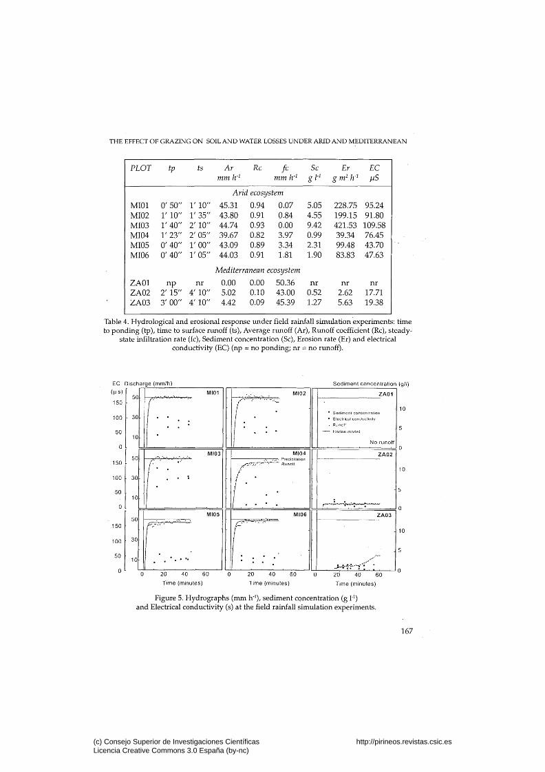
Table 4. Hydrological and erosional response under field rainfall simulation experiments: time to ponding (tp), time to surface runoff (ts). Average runoff (Ar), Runoff coefficient (Rc), steady-
state infiltration rate (fc). Sediment concentration (Sc), Erosion rate (Er) and electrical conductivity (EC) (np = no ponding; nr = no runoff).
EC Discharge (mm/h)
(MS)
150
Sediment concentration (g/l)
100
50
0
150
100
50
0
150
100
50
0
50
30
10
50
30
10
30
10
MI01
r _ •
MI03
( • : • • " - • •
MI05
Í.. •
MI02
(:•[ MI04
MI06
l.:
•
ZAOl
• Sed imnni conconlrat ion
• Eleclncal coiulucMivily
. RunotI
Norton mode l
No runoff
ZA02
-
r, ' . * ' . " • • , ' • ,
ZA03
. ' " • ' " '
20 40 60
Time (minutes)
20 40 60
Time (minutes)
20 40 60
Time (minutes)
Figure 5. Hydrographs (mm h"'), sediment concentration (g 1"') and Electrical conductivity (s) at the field rainfall simulation experiments.
167
(c) Consejo Superior de Investigaciones Científicas Licencia Creative Commons 3.0 España (by-nc)
http://pirineos.revistas.csic.es

PIRINEOS 153-154
biogenic crusted area and the quick development of physico-chemical crust. The low infiltration rates and the short time to runoff results in a high runoff coefficient (90 % on average). The large surface runoff volume induced very high erosion rates (179 g m^ h"* on average). The runoff salinity, as indicated by the electrical conductivity, was 77.4 |iS on average. Nevertheless, the spatial variability of the erosion rates is high (Table 4).
At the Mediterranean area runoff did not occur in the vegetated plot and was low even in the intershrub plots in spite of the compaction effect of trampling. Ponding was quite rapid (2' 15" and 3' for the two plots with runoff), and surface runoff appeared after 4' 10" of rain. The average runoff was very low (3.15 mm h"̂ ) due to the high steady-state infiltration rate (46.25 ram h'^). Only 6 % of the rain was transformed into runoff even at the 0.24 m^ runoff plots. The runoff in the intershrub areas demonstrate the effect of grazing on infiltration, but even these small amounts of runoff are expected to infiltrate in the adjacent shrub patch dowslope. Sediment concentration was very low (0.6 g 1'̂ on average), thus erosion rates were very low too (2.75 g m^ h'^). The runoff electrical conductivity was very low, 12.4 pS on average (Table 4). The different response of the two ecosystems can be seen clearly in Figure 5.
3.2 Laboratory rainfall simulation experiments
The hydrological and erosional parameters which v/ere measured at the laboratory experiments are presented in Table 5. The values in this table are averages for the three runoff plots. The hydrographs are presented in Figure 6. The results found in the field were confirmed by the laboratory rainfall experiments.
In Mishor Adumin, despite the relatively low initial soil moisture content, the time to ponding and the time to surface runoff were short, 8' 45" and 15' 05" respectively for the dry conditions, and 2' 05" and 2' 46" respectively for the wet conditions. The runoff coefficient under dry conditions increased from 42.9 % in the first run to 77.5 % in the third run, while under wet conditions the runoff coefficients for the first two runs were 52.4 % and 61.6 %, respectively. The soil water storage decreased under dry conditions from 43.8 % of the rain in the first run to 4.8 % in the second run and to 1.5 % in the last run due to increasing the soil moisture. Under wet conditions, the soil water storage decreased from 24.6 % in the first run, when soil moisture content was 1.9 %, to 6.7 % in the second run when the soil moisture content was 32 %. The sediment concentration and soil erosion increased remarkably under dry conditions from 0.5 g 1'̂ and 11.8 g m^ h'̂ respectively in the first run to 1.3 g 1'̂ and 34.7 g m^ h'̂ in the third run. The same trend occured under wet con-
168
(c) Consejo Superior de Investigaciones Científicas Licencia Creative Commons 3.0 España (by-nc)
http://pirineos.revistas.csic.es

THE EFFECT OF GRAZING ON SOIL AND WATER LOSSES UNDER ARID AND MEDITERRANEAN
ditions when they increased from 1.4 g 1'̂ and 33.9 g m^ h'^ in the first run to 37.8 g 1-̂ and 565.6 gm^ h^ in the third run (Table 5).
At the Mediterranean site, Zalmon, time to ponding and time to surface runoff were much longer, 55' 05" and 90' 06" repectively for the dry conditions and 8' 05" and 16' for the wet conditions. Runoff under dry conditions was very low. No runoff ocurred in the first run. In the second run only one plot contributed runoff. In the third run, after almost 70 mm of rain in the first two runs, the runoff coefficient reached 17 %. Under wet conditions the runoff started after 26 minutes in the first run (Figure 6). The average runoff coefficient for the three runs was 24.75 %. The hydrology of the Zalmon soil was dominated by the high percolation rates. The percolation ranged between 61 % and 91 %. Also the water storage capacity was very high (table 5). Soil erosion rates were very low. The averages were 0.37 g m^ h"̂ for dry conditions and 3.05 g m^ h'̂ for the wet conditions.
FIRST RUN
Runoff (%) Percolation (%)
Soil water storage (%) Sediment concentration (gr H)
Erosion (g m^ h"̂ )
SECOND RUN
Runoff (%) Percolation (%)
Soil water storage (%) Sediment concentration (gr H)
Erosion (g m^ h'̂ )
THIRD RUN
Runoff (%) Percolation (%)
Soil water storage (%) Sediment concentration (gr 1"̂)
Erosion (g m^ h"̂ )
Mishor Adumin
Dry Wet
42.88 13.31 43.81 0.53 11.75
75.81 19.34 4.85 0.76 19.88
77.45 21.05 1.50 1.32
34.72
52.40 23.00 24.60 1.44
33.89
61.60 31.70 6.70 7.09
173.89
68.78 30.09 0.32
37.77 565.63
Zalmon
Dry.
0.00 60.93 39.07 0.00 0.00
5.75 91.24 3.01 0.06 0.42
16.76 82.90 0.34 0.03 0.69
Wet
8.02 76.12 15.86 0.10 0.69
28.00 61.12 10.88 0.33 3.68
38.24 60.90 0.86 1.91 4.78
Table 5. Hydrological and erosional response under laboratory rainfall simulation experiments.
169
(c) Consejo Superior de Investigaciones Científicas Licencia Creative Commons 3.0 España (by-nc)
http://pirineos.revistas.csic.es

PIRINEOS 153-154
Discharge
(mm/h)
30
20
10
n
(\ l DRV
MISHORADUMIN WET
n ifl
n
^
i i
r*\
II' il
if v^
DRY ZALMON
•
n,
WET
n. ̂ 30 •
Discharge
(mm/h)
20
10
30 •
Discharge
(mm/h)
PLOT-3
20
1 0 •
Rainfall
Runoff
il /l IJil
u 1.1 II
A
,
1 : i
Run 1 2 3
Il il i ./ l.
(lil ij y
fi
L.
Il
• fl ,nJ L.
• Í
.,n.l r
\.a
L
1
• 200 0 200 0 200 0 200
Time (minutes) Time (minutes) Time (minutes) Time (minutes)
Figure 6. Runoff hydrographs (mm h'') at the laboratory rainfall simulation experinients.
4. Discussion and conclusions
The differences between the arid and the Mediterranean ecogeomor-phic systems are mainly a consequence of the climatic conditions (LAVEE et al., 1991). In the Judean Desert the vegetation cover is low, thus organic matter content is low and soil aggregates are small and breakable. Crusting is, therefore, very important in the drastic reduction of infiltration rates shortly after the rainfall starts, and runoff appears in relatively large quantities. In the Mediterranean Galilee mountains the ecogeomor-phic system behaves very differently. With.650 mm of average annual
170
(c) Consejo Superior de Investigaciones Científicas Licencia Creative Commons 3.0 España (by-nc)
http://pirineos.revistas.csic.es
THE EFFECT OF GRAZE^IG ON SOIL AND WATER LOSSES UNDER ARID AND MEDITERRANEAN
rainfall, the soil is more developed with high clay content and high vegetation cover. As a result soil aggregates are bigger and more stable than in the Judean Désert (LAVEE et al, 1994). At such conditions, infiltration and percolation are high and the probability for runoff generation is very low, unless the soil is saturated.
The effect of grazing on the hydrogeomorphological processes is different between Mishor Adumin and Zalmon. In the arid site at the Judean Desert, which is characterized by a low productivity, there is a significant influence of grazing. The decrease of vegetation cover to almost zero means that the pressure of sheep and goats affects the whole hillslope surface. The effect of raindrop impact and splash erosion increases; the trampling enhances aggregates breakdown and soil compaction; physico-chemical and biogenic crusts appear over a high percent of the area, and the density of surface embedded stones increases. These lead to high quantities of Horton's overland flow and high erosion rates not only at the patch scale, but also due to runoff continuity over relatively long distances, at the hillslope scale.
In the Mediterranean site the vegetation is distributed in patches of shrubs or trees and interpatch corridors of herbs. Trampling and compaction take place only in the interpatch corridors, thus runoff and erosion might increase in these areas. In the shrub patches infiltration remains very high, and overland flow is not generated. More than that, runoff flowing from the interpatch corridors infiltrates in the shrub patches and increases the vegetation growth potential. At the same time sediments which were eroded by overland flow and by rainsplash accumulate beneath the shrubs. Under such a mechanism the differences between the «arid» interpatch corridors and the «humid» shrub patches increase in time. This means that the response of surface properties and patterns to the combined effect of climate and grazing is different in the Mediterranean and arid environments of Israel. The spatial distribution of vegetation, crusts, and stones which is affected by both the long-term effect of climate and the relatively short-term effect of grazing control runoff and soil erosion in both patch and hillslope scales.
At Mishor Adumin site, where rainfall is less than 300 mm, a relatively homogeneous surface was developed which is a result of a driving force for land degradation. Due to trampling and compaction all over the hillslope, crusts and embedded stones appear in high proportions at the surface and enable runoff to flow over the hillslope for relatively long distances (LAVEE & POESEN, 1991). The low vegetation cover does not protect the soil from being eroded. This leads to loss of high quantities of soil from the hillslopes and to desertification.
At Zalmon site, where annual rainfall is 650 mm, the main effect of grazing is compacting the soil top layer at the interpatch corridors and enhan-
171
(c) Consejo Superior de Investigaciones Científicas Licencia Creative Commons 3.0 España (by-nc)
http://pirineos.revistas.csic.es

PIRINEOS 153-154
cing infiltration and sediment trapping capacity at the shrub patches. As a result a mosaic-like pattern is developed in which the probability of overland flow and erosion to generate at the shrub patches is very low, and is limited to extreme rainfall events when top soil saturation is achieved. Local overland flow and erosion occur more frequently at the interpatch corridors. The corridors function as runoff and soil contributors, while the shrub patches function as acceptors. The rate of overland flow and sediment contribution from the hillslope to the channel depends on the relative area covered by and especially on the spatial distribution of the contributing and accepting areas. Where, for example, most of the hillslope is covered by contributing areas, and especially if they are concentrated at the lower part of the hillslope, some water and soil will be contributed from the hillslope to the channel. On the other hand, where a lot of accepting patches cover the lower part of an hillslope the chance for overland flow and soil to be contributed to the channel is negligible. Other types of land disturbances, such as fire, have been proved to induce a similar mosaic-like pattern that protect the system from being eroded at the hillslope scale (LAVEE et al, 1995; KUTIEL et al., 1995). This distribution of mounds and tussocks along the slopes is found under different semiarid conditions (CERDA, 1997).
To sum up, the soils and vegetation which have been developed under Mediterranean and arid climates in the Galilee and in the Judean Desert, respectively, through the last few thousands of years created different eco-geo-morphological systems that respond differently to grazing stress. The resilience of the Mediterranean system, as represented by the Zalmon site, is much higher than that of the arid system, represented by Mishor Adumin site. Whiie in the Zalmon area, grazing is an ecogeomorphologically reasonable land use, due to the system capability to absorb the stress induced by livestock, in Mishor Adumin area overgrazing induces stress which is high above the threshold that the system can absorb, so that desertification processes take place.
Acknowledgements. A. Cerda thanks the support received from the Laboratory of Geomorphology at.Bar-Ilan University, specially the help received in field and laboratory work from O. Ackermann, S. Pariente, H. Zhevelev, A. Fragin and T. Svorai. He also thanks the Ministerio de Educación y Ciencia for a fellowship in the framework of the Perfeccionamiento de Doctores y Tecnólogos. The financial support of ERMES project (European Community Environment Programm, 1990-1994, EV5V-CT91-0023) and the Comunidad Valenciana government (Conselleria d'Educació i Ciencia) is acknowledged. Corinna Hawkes reviewed the manuscript. The project IFD-97-0551 and a contract of the Ministerio de Educación y Ciencia (Reincorporación de Doctores y Tecnólogos) supported partially the development of this research.
172
(c) Consejo Superior de Investigaciones Científicas Licencia Creative Commons 3.0 España (by-nc)
http://pirineos.revistas.csic.es
THE EFFECT OF GRAZING ON SOIL AND WATER LOSSES UNDER ARID AND MEDITERRANEAN
References
BLACKBURN, W. H. (1979). Assessment of intensive range practices on hydrologie characteristics using a mobile rainfall simulator, Nevada and Texas. Proceedings of the rainfall simulator workshop, USDA-SEA, ARS-W-10, pp. 114-117.
CERDA, A. (1997). The effect of patchy distribution of Stipa tenacissima L. on runoff and erosion. Journal of Arid Environments, 36: 37-51.
CERDA, A., CALVO, A. & IBAÑEZ, S. (1997). Design and operation of a small and portable rainfall simulator for rugged terrain. Soil Technology, 11:161-168.
GAMOUGOUN, N. D., SMITH, R. R, WOOD, M. K. & PIEPER, R. D. (1984). Soil, management, and hydrologie response to grazing management at Fort Stanton, New Mexico. Journal of Range Management, 35: 538-541.
GOUDIE, A. (1981). The human impact on the nature environment. Blackwell, Oxford, 388 pp.
HORTON, R. E. (1940). An approach toward a physical interpretation of infiltration capacity. Proc. Soil Sci. Soc. Am., 5: 399-417.
KUTIEL, R, LAVEE, H., SEGEV, M. & BENYAMINI, Y. 1995. The effect of fire-induced surface heterogeneity on rainfall-runoff-erosion relationships in an eastern Mediterranean ecosystem, Israel. Catena, 25: 77-87.
LAVEE, H., IMESON, A. C , PARIENTE, S. & BENYAMINI, Y. (1991). The response of soils to simulated rainfall along a climatological gradient in an arid and semiarid region. Catena Supplement, 19: 19-37.
LAVEE, H. & POESEN, J. 1991. Overland flow generation and continuity on stone-covered soil surfaces. Hydrological Processes, 5: 345-360.
LAVEE, H., PARIENTE, S., ZHEVELEV, H., FRAGIN, A., & SVORAI, T. (1994). Final Report, ERMES ECC Research Project: Modelling and exploring the impact of climatic change on ecosystem degradation, hydrology and land use along a transect across the Mediterranean. Bar-Ilan University, Laboratory for Geomorphology and Soils, Ramat-Gan, Israel, 38 pp.
LAVEE, H., KUTIEL, R, SEGEV, M. & BENYAMINI, Y (1995). Effect of surface roughness on runoff and erosion in a Mediterranean ecosystem: the role of fire. Geomorphology, 11: 227-234.
MORIN, J., GOLDBERG, D. & SEGINER I. (1967). A rainfall simulator with rotating disk. Transactions of the ASAE, 10: 1085-1093.
NAETH, M. A. (1988). The impact of grazing on litter and hydrology in mixed prairie and fescue grassland ecosystems of Alberta. Ph. D. Thesis, University of Alberta, Edmonton, 210 pp.
NAETH, M. A., CHANASYK, D. S. & BAILEY, A. W. (1991). Applicability of the Kostiakov equation to mixed prairie and fescue grassland of Alberta. Journal of Range Management, 44: 18-21.
173
(c) Consejo Superior de Investigaciones Científicas Licencia Creative Commons 3.0 España (by-nc)
http://pirineos.revistas.csic.es
PIRINEOS 153-154
SIMMONS, I. G. (1989). Changing the face of the earth: culture, environment, history. Blackwell, Cambridge, 487 pp.
STOECKLER, J. H. (1959). Trampling by livestock drastically reduced infiltration rate of soil in open pine woods in south western Wisconsin. Lake States Forest Expt. Station, Tech. note, 556 pp.
THUROW, T. L., BLACKBURN, W. H. & TAYLOR, C. A. Jr. (1986). Hydrologie characteristics of vegetation types as affeced by livestock grazing systems, Edwards Plateau, Texas. Journal of Range Management, 39: 505-509.
THUROW, T. L., BLACKBURN, W.H. & TAYLOR, C. A. Jr. (1988). Infiltration and interrill erosion response to selected livestock grazing strategies, Edwards Plateau, Texas. Journal of Range Management, 41: 296-302.
WARREN, S. D., BLACKBURN, W. H. & TAYLOR, C. A. (1986a). Effects of season and stage of rotation cycle on hydrologie condition of rangeland under intensive rotation grazing. Journal of Range Management, 39: 486-490.
WARREN, S. D., THUROW, T. L., BLACKBURN, W. H. & GARZA, N. E. (1986b). The iafluence of livestock trampling under intensive rotation grazing on soil hydrologie characteristics. Journal of Range Management, 39:
. 491-495. WELTZ, M. & WOOD, M. K. (1986). Short-duration grazing in central Mexico:
effects on sediment production. Journal of Soil and Water Conservation, 41: 262-266.
WELTZ, M., WOOD, M. K. & PARKER, E. E. (1989). Flash grazing and trampling: effects on infiltration rates and sediment yield on a selected New Mexico range site. Journal of Arid Environments, 16: 95-100
WOOD, M. K. & BLACKBURN, W. H. (1981a). Sediment production as influenced by livestock grazing in the Texas rolling plains. Journal of Range Management, 34: 228-231.
WOOD, M. K. & BLACKBURN, W. H. (1981b). Grazing systems: their influence on infiltration rates in the rolling plains of Texas. Journal of Range Management, 34: 331-335.
174
(c) Consejo Superior de Investigaciones Científicas Licencia Creative Commons 3.0 España (by-nc)
http://pirineos.revistas.csic.es