The Double Hedges WALKthecampsies.co.uk/Lennoxtown.pdf · the walk. This walk starts at Lennoxtown...
4
WALK Lennoxtown Seven walks in and around the village This leaflet is published by the Campsie Trails Heritage Group, part of the Lennoxtown Heritage and Preservation Trust. The local community selected and researched the routes. Design and typesetting Bob Vickers, cartography Nichola Goodliffe, editorial and project management Cicely Frew. Printed by www.qspprint.co.uk. All text and overlay route detail copyright © Campsie Trails Heritage Group 2010. Photographs copyright © Rena Shirreffs 2010. Base mapping reproduced by permission of Ordnance Survey on behalf of HMSO. © Crown copyright and database right 2010. All rights reserved. Ordnance Survey Licence Number 100020774. Every care has been taken in the preparation of this leaflet. However, the publisher accepts no responsibility whatsoever for any loss, damage, injury or inconvenience sustained or caused as a result of using this leaflet. The Double Hedges 1 Through gate and downhill to park gates. TL into North Birbiston Road and follow road to end. 2 TL up Bencloich Road. 3 Near top of road, just after Bencloich Crescent on L, cross to R and descend narrow steps leading into field. Walk across field, keeping fence on your R. 4 At ruined house, cross wall by going through gate. Continue heading E. Cross back through wall START from Memorial Hall, TR along Main Street to war memorial gates (adjacent to Co-op). Cross road and SO through gates, uphill towards High Church. Bear R as path forks and, keeping R, follow path through churchyard to top R corner and descend steps. TR (German airman’s grave against wall on R) along path to hedge and gate into High Park. by going through next gate (beside big sycamore tree). Ahead you will see the Double Hedges. In winter you can walk through the middle of them, but in summer they become overgrown so keep them to your R. Over stile at end of hedges. Continue SO and over another stile leading out of field into wood with rhododendron bushes growing alongside path. Follow path as far as vehicle track. 5 TR down track to Campsie Road where TL and continue along pavement towards Milton of Campsie. 6 Cross road opposite Valleyfield and SO into Valleyfield. TR and then diagonally L to far corner of end house and take path downhill to river. Follow path over bridge to join Strathkelvin Railway path. 7 TR along path and follow it to road. Cross road and rejoin path. After crossing second bridge, TR and follow path around playing field to join Station Road and complete the walk. This walk starts at Lennoxtown Memorial Hall and takes you across fields to the Double Hedges, returning along the Strathkelvin Railway path. Distance 3.5 miles (5.5 km) There is a small car park by the Memorial Hall. Some on-street parking is available in Chestnut Walk and walkers can park their cars in the Glazert Country House Hotel car park, but please call in and check at reception first. The X85 bus service runs from Buchanan Bus Station in Glasgow to Campsie Glen, via Lenzie, Kirkintilloch, Milton of Campsie and Lennoxtown. The X86 service runs between Glasgow and Campsie Glen, via Bishopbriggs, Torrance and Lennoxtown. The Sunday 88C service runs between Glasgow and Campsie Glen, via Bishopbriggs, Kirkintilloch, Milton of Campsie and Lennoxtown. N
Transcript of The Double Hedges WALKthecampsies.co.uk/Lennoxtown.pdf · the walk. This walk starts at Lennoxtown...

WALKLennoxtown
Seven walks in and around the village
This leaflet is published by the Campsie Trails Heritage Group, part of the Lennoxtown Heritage and Preservation Trust. The local community selected and researched the routes. Design and typesetting Bob Vickers, cartography Nichola Goodliffe, editorial and project management Cicely Frew. Printed by www.qspprint.co.uk.
All text and overlay route detail copyright © Campsie Trails Heritage Group 2010. Photographs copyright © Rena Shirreffs 2010. Base mapping reproduced by permission of Ordnance Survey on behalf of HMSO. © Crown copyright and database right 2010. All rights reserved. Ordnance Survey Licence Number 100020774.
Every care has been taken in the preparation of this leaflet. However, the publisher accepts no responsibility whatsoever for any loss, damage, injury or inconvenience sustained or caused as a result of using this leaflet.
The Double Hedges
1 Through gate and downhill to park gates. TL into North Birbiston Road and follow road to end.
2 TL up Bencloich Road.
3 Near top of road, just after Bencloich Crescent on L, cross to R and descend narrow steps leading into field. Walk across field, keeping fence on your R.
4 At ruined house, cross wall by going through gate. Continue heading E. Cross back through wall
START from Memorial Hall, TR along Main Street to war memorial gates (adjacent to Co-op). Cross road and SO through gates, uphill towards High Church. Bear R as path forks and, keeping R, follow path through churchyard to top R corner and descend steps. TR (German airman’s grave against wall on R) along path to hedge and gate into High Park.
by going through next gate (beside big sycamore tree). Ahead you will see the Double Hedges. In winter you can walk through the middle of them, but in summer they become overgrown so keep them to your R. Over stile at end of hedges. Continue SO and over another stile leading out of field into wood with rhododendron bushes growing alongside path. Follow path as far as vehicle track.
5 TR down track to Campsie Road where TL and continue along pavement towards Milton of Campsie.
6 Cross road opposite Valleyfield and SO into Valleyfield. TR and then diagonally L to far corner of end house and take path downhill to river. Follow path over bridge to join Strathkelvin Railway path.
7 TR along path and follow it to road. Cross road and rejoin path. After crossing second bridge, TR and follow path around playing field to join Station Road and complete the walk.
This walk starts at Lennoxtown Memorial Hall and takes you across fields to the Double Hedges, returning along the Strathkelvin Railway path.
Distance 3.5 miles (5.5 km)
There is a small car park by the Memorial Hall. Some on-street parking is available in Chestnut Walk and walkers can park their cars in the Glazert Country House Hotel car park, but please call in and check at reception first. The X85 bus service runs from Buchanan Bus Station in Glasgow to Campsie Glen, via Lenzie, Kirkintilloch, Milton of Campsie and Lennoxtown. The X86 service runs between Glasgow and Campsie Glen, via Bishopbriggs, Torrance and Lennoxtown. The Sunday 88C service runs between Glasgow and Campsie Glen, via Bishopbriggs, Kirkintilloch, Milton of Campsie and Lennoxtown.
N
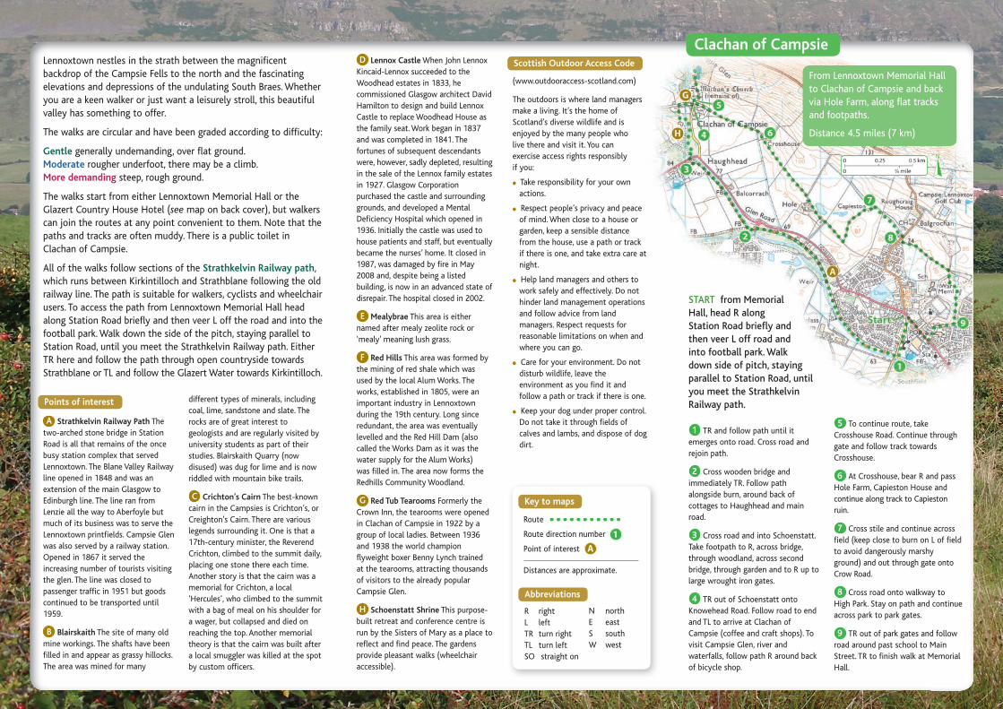
D Lennox Castle When John Lennox Kincaid-Lennox succeeded to the Woodhead estates in 1833, he commissioned Glasgow architect David Hamilton to design and build Lennox Castle to replace Woodhead House as the family seat. Work began in 1837 and was completed in 1841. The fortunes of subsequent descendants were, however, sadly depleted, resulting in the sale of the Lennox family estates in 1927. Glasgow Corporation purchased the castle and surrounding grounds, and developed a Mental Deficiency Hospital which opened in 1936. Initially the castle was used to house patients and staff, but eventually became the nurses’ home. It closed in 1987, was damaged by fire in May 2008 and, despite being a listed building, is now in an advanced state of disrepair. The hospital closed in 2002.
E Mealybrae This area is either named after mealy zeolite rock or ‘mealy’ meaning lush grass.
F Red Hills This area was formed by the mining of red shale which was used by the local Alum Works. The works, established in 1805, were an important industry in Lennoxtown during the 19th century. Long since redundant, the area was eventually levelled and the Red Hill Dam (also called the Works Dam as it was the water supply for the Alum Works) was filled in. The area now forms the Redhills Community Woodland.
G Red Tub Tearooms Formerly the Crown Inn, the tearooms were opened in Clachan of Campsie in 1922 by a group of local ladies. Between 1936 and 1938 the world champion flyweight boxer Benny Lynch trained at the tearooms, attracting thousands of visitors to the already popular Campsie Glen.
H Schoenstatt Shrine This purpose-built retreat and conference centre is run by the Sisters of Mary as a place to reflect and find peace. The gardens provide pleasant walks (wheelchair accessible).
Lennoxtown nestles in the strath between the magnificent backdrop of the Campsie Fells to the north and the fascinating elevations and depressions of the undulating South Braes. Whether you are a keen walker or just want a leisurely stroll, this beautiful valley has something to offer.
The walks are circular and have been graded according to difficulty:
Gentle generally undemanding, over flat ground.Moderate rougher underfoot, there may be a climb.More demanding steep, rough ground.
The walks start from either Lennoxtown Memorial Hall or the Glazert Country House Hotel (see map on back cover), but walkers can join the routes at any point convenient to them. Note that the paths and tracks are often muddy. There is a public toilet in Clachan of Campsie.
All of the walks follow sections of the Strathkelvin Railway path, which runs between Kirkintilloch and Strathblane following the old railway line. The path is suitable for walkers, cyclists and wheelchair users. To access the path from Lennoxtown Memorial Hall head along Station Road briefly and then veer L off the road and into the football park. Walk down the side of the pitch, staying parallel to Station Road, until you meet the Strathkelvin Railway path. Either TR here and follow the path through open countryside towards Strathblane or TL and follow the Glazert Water towards Kirkintilloch.
different types of minerals, including coal, lime, sandstone and slate. The rocks are of great interest to geologists and are regularly visited by university students as part of their studies. Blairskaith Quarry (now disused) was dug for lime and is now riddled with mountain bike trails.
C Crichton’s Cairn The best-known cairn in the Campsies is Crichton’s, or Creighton’s Cairn. There are various legends surrounding it. One is that a 17th-century minister, the Reverend Crichton, climbed to the summit daily, placing one stone there each time. Another story is that the cairn was a memorial for Crichton, a local ‘Hercules’, who climbed to the summit with a bag of meal on his shoulder for a wager, but collapsed and died on reaching the top. Another memorial theory is that the cairn was built after a local smuggler was killed at the spot by custom officers.
1 TR and follow path until it emerges onto road. Cross road and rejoin path.
2 Cross wooden bridge and immediately TR. Follow path alongside burn, around back of cottages to Haughhead and main road.
3 Cross road and into Schoenstatt. Take footpath to R, across bridge, through woodland, across second bridge, through garden and to R up to large wrought iron gates.
4 TR out of Schoenstatt onto Knowehead Road. Follow road to end and TL to arrive at Clachan of Campsie (coffee and craft shops). To visit Campsie Glen, river and waterfalls, follow path R around back of bicycle shop.
From Lennoxtown Memorial Hall to Clachan of Campsie and back via Hole Farm, along flat tracks and footpaths.
Distance 4.5 miles (7 km)
START from Memorial Hall, head R along Station Road briefly and then veer L off road and into football park. Walk down side of pitch, staying parallel to Station Road, until you meet the Strathkelvin Railway path.Points of interest
Key to maps
Abbreviations
Scottish Outdoor Access Code
(www.outdooraccess-scotland.com)
The outdoors is where land managers make a living. It’s the home of Scotland’s diverse wildlife and is enjoyed by the many people who live there and visit it. You can exercise access rights responsibly if you:
! Take responsibility for your own actions.
! Respect people’s privacy and peace of mind. When close to a house or garden, keep a sensible distance from the house, use a path or track if there is one, and take extra care at night.
! Help land managers and others to work safely and effectively. Do not hinder land management operations and follow advice from land managers. Respect requests for reasonable limitations on when and where you can go.
! Care for your environment. Do not disturb wildlife, leave the environment as you find it and follow a path or track if there is one.
! Keep your dog under proper control. Do not take it through fields of calves and lambs, and dispose of dog dirt.
A Strathkelvin Railway Path The two-arched stone bridge in Station Road is all that remains of the once busy station complex that served Lennoxtown. The Blane Valley Railway line opened in 1848 and was an extension of the main Glasgow to Edinburgh line. The line ran from Lenzie all the way to Aberfoyle but much of its business was to serve the Lennoxtown printfields. Campsie Glen was also served by a railway station. Opened in 1867 it served the increasing number of tourists visiting the glen. The line was closed to passenger traffic in 1951 but goods continued to be transported until 1959.
B Blairskaith The site of many old mine workings. The shafts have been filled in and appear as grassy hillocks. The area was mined for many
1
Route
Route direction number
Point of interest
Distances are approximate.
N northE eastS southW west
R rightL leftTR turn rightTL turn leftSO straight on
5 To continue route, take Crosshouse Road. Continue through gate and follow track towards Crosshouse.
6 At Crosshouse, bear R and pass Hole Farm, Capieston House and continue along track to Capieston ruin.
7 Cross stile and continue across field (keep close to burn on L of field to avoid dangerously marshy ground) and out through gate onto Crow Road.
8 Cross road onto walkway to High Park. Stay on path and continue across park to park gates.
9 TR out of park gates and follow road around past school to Main Street. TR to finish walk at Memorial Hall.
Clachan of Campsie
A
N

Roon the Moon
1 Continue along track past Red Hills woodland, and then veer R, passing farm and forestry tracks on L.
2 Follow track as it rises more steeply to join the tarred road at top or ‘arc’ of the moon.
3 TR to walk along arc. This point,
at around 750 feet (228.5 m) above sea level, affords panoramic views of the valley below. (To extend walk, follow forestry walk sign posts.)
4 Follow road downhill, passing house (Southfield) on R.
5 Arrive at crossroads. TR into Lovers’ Lane (signposted Glazert Bank). Continue along Lovers’ Lane as it follows the course of Glazert Water and runs parallel to Strathkelvin Railway path.
6 TL at junction with Chestnut Walk to finish walk at hotel.
Two walks above Campsie Glen, one into Fin Glen, the other to the ruin at Allanhead. Both routes will take you along rough, hillside tracks.
Distances Fin Glen 7.5 miles (12 km) Allanhead 5.5 miles (9 km)
START from Glazert Country House Hotel, TR along Chestnut Walk, over stone bridge and Glazert Water, keeping SO.
START from Glazert Country House Hotel, TR along Chestnut Walk and over stone bridge. Continue past first opening on R.
on R. It occupies a high and commanding position and is bounded on three sides by iron railings. This lofty vantage point offers striking views of the picturesque valley below.
5 Retrace route back to castle.
6 Continue along road, bearing L of castle. Pass ruins of Woodhead House on L. Follow road downhill as far as a stone bridge.
7 TL over bridge, through small wooded area until you reach Strathkelvin Railway path.
8 TR onto path and continue E towards Lennoxtown. Cross over small wooden bridge, then diagonally L across road to rejoin path. Follow Strathkelvin Railway path back through Lennoxtown to junction with Chestnut Walk where TL to finish walk at hotel.
1 TR along second opening on R (Lovers’ Lane). Follow this path as it runs parallel with Glazert Water and Strathkelvin Railway path, maintaining a higher position for entire length of path.
2 Leave Lovers’ Lane at crossroads. Go SO into Castle Road (also known as Back Road). Follow road, passing large house (Baldow) on L, Netherton Oval and lodge house on R.
3 Arrive at fork in road (just beyond large red house on L). Take L fork and follow path to just beyond white house on L.
4 Follow road to R, down to back of Lennox Castle. On L you will see a few stone steps into a forest clearing. Ascend steps and continue along well-trodden path for approximately 250 yards until you find Lovers’ Leap
START from Lennoxtown Memorial Hall and follow Clachan of Campsie walk to end of direction 3, which will bring you to the wrought iron gates at the back of Shoenstatt on Knowehead Road. From here:
1 Exit gates and TL along Knowehead Road. Follow track to abandoned buildings of Knowehead Farm. Pass by the buildings, keeping them on your L to enter a field. Here you have a choice:
2 To walk up Fin Glen take grassy track on L, heading uphill keeping burn on your L until track bends to L and crosses burn. Continue on this rough track until it ends. On return journey it is possible to vary route by heading steeply up on rough ground just before the waterfalls of Almeel Burn to find an old indistinct track which leads back down to Knowehead Farm.
3 To visit Allanhead, turn sharp R on leaving Knowehead farm buildings and follow grassy track up towards top corner of a wood. Continue on this rising track, eventually fording Aldessan Burn. You will see Allanhead ruin and shoulder of the hills above Crow Road ahead of you. Reverse your route to descend hill.
To return to Lennoxtown, walk back through Schoenstatt grounds to Haughhead. Cross road and follow Strathkelvin Railway path back to football park, Station Road and Memorial Hall.
Lennox Castle and Lovers’ Leap Fin Glen and the Allanhead Ruin
From Glazert Country House Hotel to South Brae, returning via Lovers’ Lane. The first section of the walk is roughly surfaced and fairly steep. The views across the valley are, however, enchanting. The route can easily be walked in reverse, starting from Lennoxtown Memorial Hall and up Station Road.
Some people believe that the name ‘Roon the Moon’ arose because on bright nights, when the moon was clearly visible, it was said to feel like walking around the moon. Others believe the half-moon shape of the route is what gives rise to the name.
Distance 1.5 miles (2.5 km)
A walk to Lennox Castle and Lovers’ Leap, returning along Strathkelvin Railway path.
Distance 4.5 miles (7 km)
N
N
N

Crichton’s Cairn and the Campsies Mealybrae
To Mealybrae and past the trig point, the walk goes through forestry (some of which is being felled and replanted) on rough terrain. It can be started from Lennoxtown Memorial Hall (encountering steep walk) or by driving up to the forestry parking (by Newlands) and starting the walk from there. Superb views.
Distance 5 miles (8.5 km)START from Glazert Country House Hotel. Cross Main Street and walk up Bencloich Road.
11 Take L fork. This is the Strathkelvin Railway path. Follow it back through Lennoxtown to junction with Chestnut Walk, where TL to finish walk at hotel.
8 Pass by a few cairns, including Crichton’s Cairn. Continue along path as it descends to Crow Road car park.
9 Cross car park, through gate onto path that shortly bends L and down to Clachan of Campsie.
10 Head SO down minor road to main road (or walk through Schoenstatt – see Clachan of Campsie walk). Cross road and TR to end of first cottage. TL and at end of short access road L onto footpath. Follow path around back of cottage and alongside burn until path forks.
START from Memorial Hall, TR into Station Road. Continue SO up Station Road and South Brae, following road up round past Muirhead Farm and on to forestry car park at Newlands.
2 At ruined house cross wall by going through gate. Continue heading E. Cross back through wall by going through next gate (beside big sycamore tree). Ahead you will see the double hedges. In winter you can walk through the middle of them but in summer they become overgrown so keep them on your R. Cross wooden stile at end of hedges. Continue SO and over another stile leading out of fields into a wood with rhododendron bushes growing alongside path.
3 Reach vehicle track and TL. Follow this track as it winds up hill.
4 Take L branch of track just before a block of tall conifer trees is reached. Continue uphill through fields on grass track, towards narrow waterfall tumbling down cliffs straight ahead of you. Go through three gates before emerging onto open hillside. Continue SO towards green metal box and waterfall.
5 Veer R, following main path uphill. (Look back W and, if light is right, raised mound of an Iron Age hill fort, Meikle Reive, is apparent.) Follow path as it becomes indistinct and there are side shoots off it. Continue
climbing uphill heading NE at first, then path takes a wide sweep round and up to head NW. Continue uphill on diminishing path until you come to wide metal gate in fence that runs along length of hill. Cross gate and walk up faint path, straight ahead at first then in NE direction until prominent cairn is reached.
6 At this point you can head out NNE to the trig point at Cort-ma Law (1,742 feet/531 m). Otherwise head NNW following faint path to junction with wider path.
7 TL here and follow meandering, undulating route W along tops of Campsie Fells with fabulous views over Lennoxtown and W along valley to Strathblane. On a clear day look SW to islands of Arran and Ailsa Craig.
1 Take forestry road straight ahead and follow it downhill until it splits.
2 TL and follow this track, crossing ford and then stile across path. Continue along track and go through gate, enjoying wide-reaching views of the Clyde Valley.
3 Follow rough track SO down Mealybrae until you reach tarred road leading to Tower Road.
4 TR along Tower Road and walk along road as far as Easter Blairskaith Farm.
5 TR. At farm take L fork, through wooden gate and follow old road which passes Blairskaith Quarry and reaches junction with another track.
6 TR along track.
7 TL through gate (forestry signpost) and follow path through fields, uphill and around to R. There is a lot for children to see here, including
pheasants, sheep and ponies. Blairskaith Muir on L contains remains of World War II anti-aircraft batteries. Notice something unusual about this path – at some point it has been covered in Astroturf!
8 TL over stile to visit trig point with wonderful views all around, including N as far as Loch Lomond on a clear day. Otherwise, to continue route, keep SO along path to return to Newlands and forestry car park. If you walked up from Lennoxtown, retrace route past Muirhead Farm, down South Brae and Station Road to Memorial Hall.
A hilly route heading up and along the Campsie Fells with one long steep ascent over rough ground. The hill paths are unsurfaced and can be boggy and indistinct. Great care should be taken on the Campsie Fells and this walk should only be taken during fine weather. OS maps Explorer 348 and Landranger 64 cover the area.
Distance 7.5 miles (12 km)
1 Nearing top of road, just after Bencloich Crescent on L, cross to R and descend narrow steps leading into field. Walk across field keeping fence on your R.
N
N