The Depot and Coachworks - · PDF fileThe Depot and Coachworks Widbury Hill Ware ... that...
53
January 2011 Client: CgMs Consulting Ltd/ Taylor Wimpey North Thames Issue No: 1 OA Job No: 4874 NGR: TL 36620 14115 The Depot and Coachworks Widbury Hill Ware Hertfordshire Geoarchaeological Field Evaluation Report Geoarchaeological Evaluation Field Report
Transcript of The Depot and Coachworks - · PDF fileThe Depot and Coachworks Widbury Hill Ware ... that...
January 2011
Client: CgMs Consulting Ltd/ Taylor Wimpey North Thames
Issue No: 1
OA Job No: 4874
NGR: TL 36620 14115
The Depot and Coachworks
Widbury Hi l l
WareHert fordshi re
Geoarchaeological FieldEvaluation Report
Ge
oa
rch
ae
olo
gic
al Ev
alu
atio
n Fie
ld R
ep
ort

The Depot and Coachworks, Widbury Hill, WareHertfordshire
TQ 36589 14093
Geoarchaeological Field Evaluation
CgMs Consulting Ltd.
Oxford Archaeology
January 2011

Widbury Hill, Ware, Hertfordshire v.1
Client Name: CgMs Consulting Ltd. / Taylor Wimpey North Thames.
Client Ref No: -
Document Title: The Depot and Coachworks, Widbury Hill, Ware,
Hertfordshire
Document Type: Evaluation Report
Issue/Version Number: 1
Grid Reference: TQ 36589 14093
Planning Reference: 3/08/1399/OP
OA Job Number: 4874
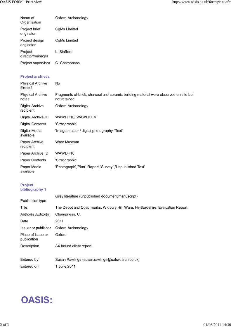
Site Code: WAWDH10
Invoice Code: WAWDHEV
Receiving Museum: Ware
Museum Accession No: -
Event No: -
Issue Prepared by Checked by Approved by Signature
1
Carl Champness
Geoarchaeologist
Liz Stafford
Head of
Geoarchaeological
Services
Liz Stafford
Head of
Geoarchaeological
Services
Document File Location Server 3/Geoarchaeological Services/Hertfordshire/Widbury HillGraphics File Location Server 21db/Invoice codes W/WAWDHEVIllustrated by Matt Bradley and Georgina Slater
Disclaimer:
This document has been prepared for the titled project or named part thereof and should not be relied upon or used for any otherproject without an independent check being carried out as to its suitability and prior written authority of Oxford Archaeology beingobtained. Oxford Archaeology accepts no responsibility or liability for the consequences of this document being used for a purposeother than the purposes for which it was commissioned. Any person/party using or relying on the document for such otherpurposes agrees, and will by such use or reliance be taken to confirm their agreement to indemnify Oxford Archaeology for all lossor damage resulting there from. Oxford Archaeology accepts no responsibility or liability for this document to any party other thanthe person/party by whom it was commissioned.
© Oxford Archaeological Unit Ltd 2011
Janus House
Osney Mead
Oxford OX2 0ES
n.yenruojnamuheht@htuosao :e 008362 5681 )0( 44+ :t et
n.yenruojnamuheht.htuosao :w 694397 5681 )0( 44+ :f et
Oxford Archaeological Unit Limited is a Registered Charity No: 285627
© Oxford Archaeology (i) January 2011

Widbury Hill, Ware, Hertfordshire v.1
Geoarchaeological Field Evaluation Report
Written by Carl Champness
illustrated by Matt Bradley and Georgina Slater
Table of Contents
1 Introduction..............................................................................................................................1
1.1 Location and scope of work.......................................................................................1
1.2 Geology and topography............................................................................................1
1.3 Archaeological and historical background.................................................................1
1.4 Acknowledgements....................................................................................................4
2 Evaluation Aims ......................................................................................................................5
2.1 Aims...........................................................................................................................5
3 Methodology.............................................................................................................................6
3.1 General approach......................................................................................................6
3.2 Stage 1: Desk-based assessment ...........................................................................6
3.3 Stage 2: Field investigation........................................................................................6
3.4 Stage 3: Reporting.....................................................................................................7
4 Results......................................................................................................................................8
4.1 Introduction and presentation of results.....................................................................8
4.2 General soils and ground conditions.........................................................................8
4.3 Deposit Model............................................................................................................8
4.4 Finds summary.........................................................................................................11
4.5 Palaeoenvironmental summary................................................................................11
5 Discussion..............................................................................................................................12
5.1 Reliability of field investigation.................................................................................12
5.2 Interpretation and significance.................................................................................12
5.3 Archaeological potential...........................................................................................14
6 References..............................................................................................................................14
Appendix A. Borehole Logs.....................................................................................................16
Appendix B. Plates...................................................................................................................17
© Oxford Archaeology (ii) January 2011
Widbury Hill, Ware, Hertfordshire v.1
Appendix C. Summary of Site Details.....................................................................................18
Appendix D. HER and OASIS Summaries..............................................................................19
© Oxford Archaeology (iii) January 2011
Widbury Hill, Ware, Hertfordshire v.1
List of Figures
Fig. 1 Site location
Fig. 2 Location of targeted boreholes and geotechnical investigations
Fig. 3 3D stratigraphic model
Fig. 4 Modelled surface of Pleistocene gravel
Fig. 5 Modelled thickness of organic/peat deposits
Fig. 6 Modelled thickness of the made ground deposits
Fig. 7 Borehole cross-section
List of Plates
Plate 1 River Lea adjacent to the site
Plate 2 Site conditions
Plate 3 Borehole sampling
Plate 4 Retrieved samples
© Oxford Archaeology (iv) January 2011
Widbury Hill, Ware, Hertfordshire v.1
Summary
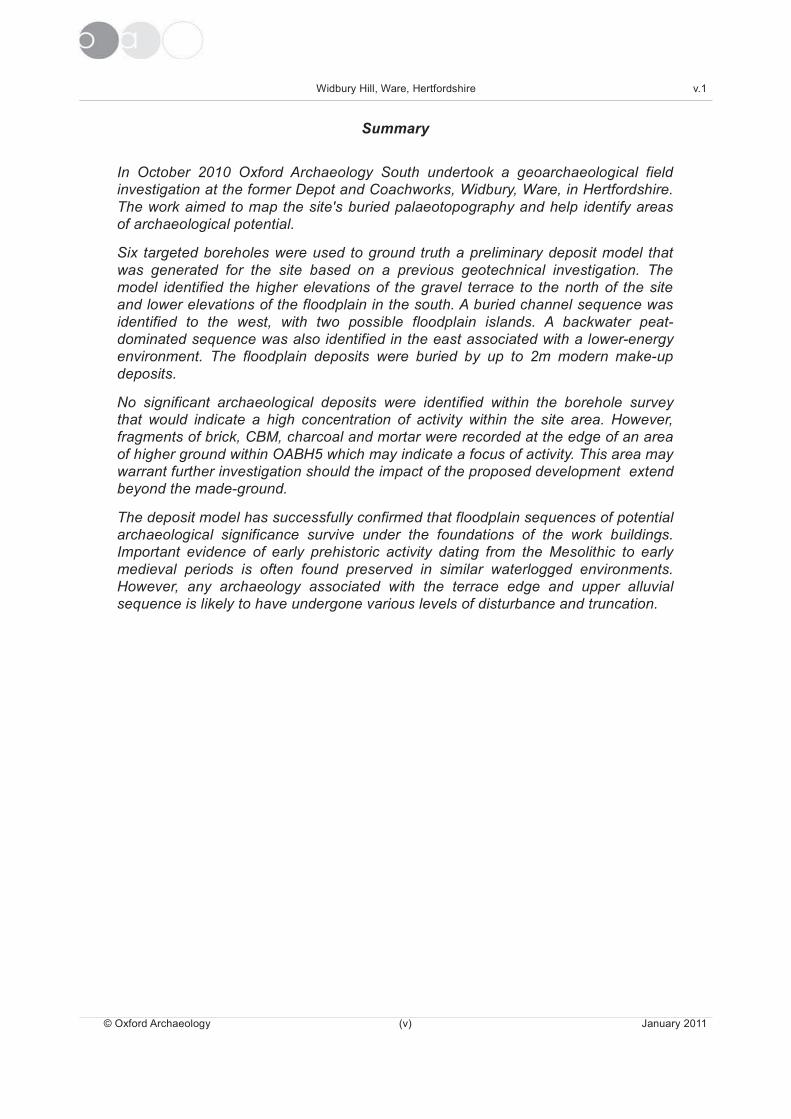
In October 2010 Oxford Archaeology South undertook a geoarchaeological field
investigation at the former Depot and Coachworks, Widbury, Ware, in Hertfordshire.
The work aimed to map the site's buried palaeotopography and help identify areas
of archaeological potential.
Six targeted boreholes were used to ground truth a preliminary deposit model that
was generated for the site based on a previous geotechnical investigation. The
model identified the higher elevations of the gravel terrace to the north of the site
and lower elevations of the floodplain in the south. A buried channel sequence was
identified to the west, with two possible floodplain islands. A backwater peat-
dominated sequence was also identified in the east associated with a lower-energy
environment. The floodplain deposits were buried by up to 2m modern make-up
deposits.
No significant archaeological deposits were identified within the borehole survey
that would indicate a high concentration of activity within the site area. However,
fragments of brick, CBM, charcoal and mortar were recorded at the edge of an area
of higher ground within OABH5 which may indicate a focus of activity. This area may
warrant further investigation should the impact of the proposed development extend
beyond the made-ground.
The deposit model has successfully confirmed that floodplain sequences of potential
archaeological significance survive under the foundations of the work buildings.
Important evidence of early prehistoric activity dating from the Mesolithic to early
medieval periods is often found preserved in similar waterlogged environments.
However, any archaeology associated with the terrace edge and upper alluvial
sequence is likely to have undergone various levels of disturbance and truncation.
© Oxford Archaeology (v) January 2011

Widbury Hill, Ware, Hertfordshire v.1
The Depot and Coachworks, Widbury Hill, WareHertfordshire
Geoarchaeological Field Evaluation
1 INTRODUCTION
1.1 Location and scope of work
1.1.1 Oxford Archaeology South (OAS) was commissioned by CgMs Consulting Ltd, on
behalf of Taylor Wimpey North Thames to undertake a geoarchaeological field
investigation at the former Depot and Coachworks, Widbury Hill, Ware, Hertfordshire.
The overall purpose of this work was to provide base-line data regarding the character,
extent and archaeological potential of the Holocene alluvium and peat stratigraphy.
1.1.2 This investigation formed part of a three stage evaluation strategy for the site
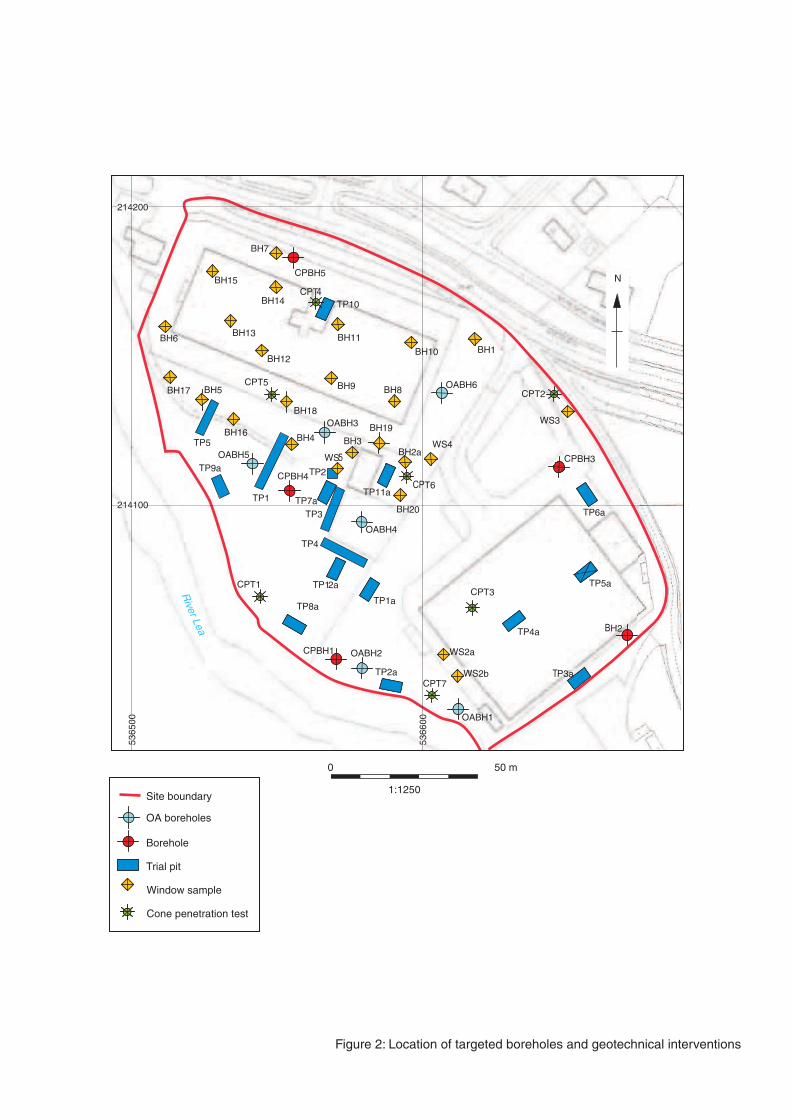
consisting of preliminary sediment mapping, targeted borehole survey and
geoarchaeological deposit modelling. Cores from six purposive boreholes were
retrieved from the site in order to record the sedimentary sequence and provide
samples suitable for palaeoenvironmental assessment.
1.2 Geology and topography
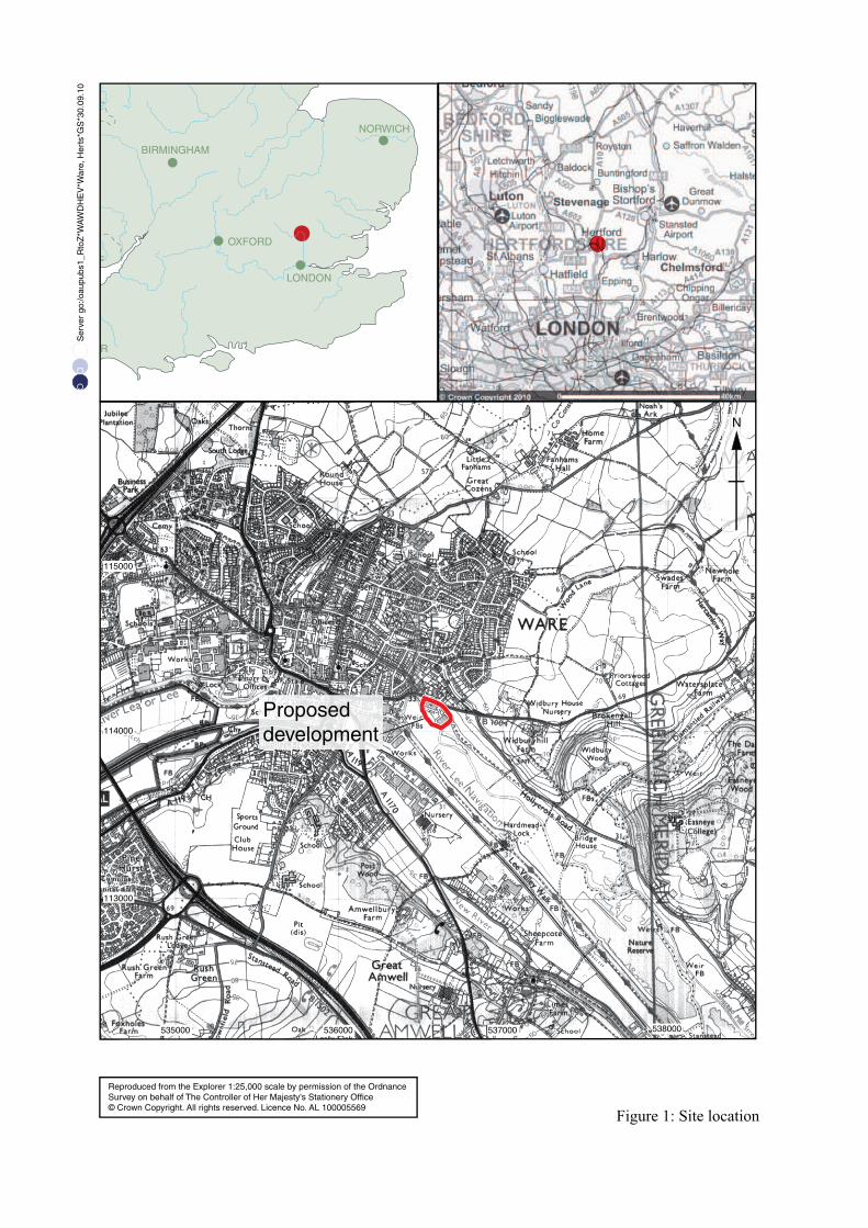
1.2.1 The proposed development is situated to the east of Ware in an area that was
previously the hamlet of Widbury (TQ 36589 14093). Located approximately 20 miles
north of London in the Lea Valley, the site is positioned beside the River Lea (Plate 1),
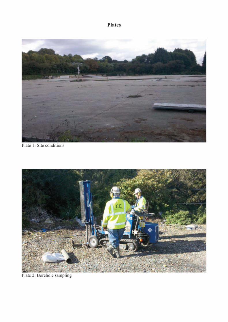
which is a major tributary of the Thames. The site is a series of former coach depots
that comprise areas of concrete foundations and hardstanding (Plate 2).
1.2.2 The site lies within the reclaimed floodplain of the River Lea. It has been cut into the
valley slope, ascending to the north east from the river to Widbury Hill Road and
beyond. Ground level falls from 40.80m AOD in the east to 32.60m AOD in the west.
1.2.3 The site lies on a geological boundary that divides the site from the north west corner
to the south east corner. The eastern section of the site is formed on Upper Chalk from
the Cretaceous period, while the western section consists of Alluvium over River Gravel
over the Upper Chalk (BGS Sheet 239; 1:50,000 Hertford, 1978).
1.3 Archaeological and historical background
1.3.1 The distribution of visible and unknown archaeological resources within the floodplain
environments is a key issue, and as such alluvial or wetland areas have to be treated
as different to ‘dryland’ archaeological sites and areas. The inability to detect
archaeological features and remains at the surface in alluvial environments is no proxy
of the distribution of its buried archaeological potential. This is because the sediments
within such environments have vertically accreted throughout the Holocene, containing
and then burying archaeological resources, effectively disguising them to surface
prospection methods, e.g. aerial photography, fieldwalking, etc. (Brown et. al. 2005).
1.3.2 In contrast dryland sites have thin soil profiles and ancient geologies, meaning that the
archaeology is cut from just below the present surface, rather than inter-stratified at
© Oxford Archaeology Page 1 of 19 January 2011
Widbury Hill, Ware, Hertfordshire v.1
depth within a vertically accreting alluvial body. This promotes a completely different
visibility of archaeology within wetland sites when compared to dryland sites. The
absence of surface finds or remains within an area, does not necessarily always relate
to the potential of the buried archaeological resource present within some wetland
areas.
1.3.3 Bearing this in mind, the archaeological background to the site, outlined in the DBA
provided by CgMs Consulting (2010a), is summarised below:
Prehistoric period (500,000BC – 43AD)
1.3.4 The Lea Valley has a rich prehistoric archaeological resource from the both the
Pleistocene and Holocene eras. However, there are no finds from the Palaeolithic or
Mesolithic periods within a 1km radius of the site. A Neolithic stone axe hammer was
found to the west of the site (HHER, 2096, TL36,14).
1.3.5 The HHER shows a number of Bronze Age and Iron Age settlements beyond a 1km
radius from the site, in the form of small farmsteads, generally located on higher
ground, although there are no known findspots or sites within a 1km radius. However, a
number of cropmarks have been identified on Widbury Hill Farm, to the east of the
study site. These cropmarks include a straight ditch, three short linear ditches (HHER
2673, TL3725, 1394), a square enclosure and several perpendicular linear features
(HHER 4787, TL 3716, 1394). There are also a number of earthwork fragments that
have been interpreted as a univallate enclosure on Widbury Hill Farm (HHER 2012, TL
3722, 1384).
Roman (43AD – 450AD)
1.3.6 A substantial number of Romano-British artefacts and features have been recovered
from Ware, suggesting a substantial settlement straddling the important Ermine Street
Roman road. This settlement which spans the length of the entire Romano-British
period is believed to cover an area of approximately 3 hectares. The core (vicus) of this
settlement is to the west of the site. A large number of Romano-British artefacts have
been found to the west including coins, building materials, amphora and a skeleton in a
stone coffin (HHER 1539, 1542, 4114).
1.3.7 The close proximity of the development to this known Romano-British activity defines a
moderate to high potential of the development site to contain Roman archaeology. A
key issue is the nature and chronology of the sediment sequence during the Roman
period and the date of the peat and alluvial deposition, which will define the potential of
the site during this period.
Saxon and early medieval (450AD – 1100AD)
1.3.8 The Post Roman and early medieval periods are poorly understood in Hertfordshire,
although Ware is exceptional as it has produced significant remains from these periods.
Excavation have shown the focus of human habitation moved eastwards from the
Roman settlement, to the natural Ford on the River Lea along Baldock Street to the
west of the development site.
1.3.9 There are no recorded findspots or artefacts within a 1km radius of the development
site. However, the invisibility of the archaeological resource contained within alluvial
environments and the general lower visibility of the archaeological resource from this
period should not be confused with defining a low archaeological potential for the site.
The original DBA does define the possibility of land division and agricultural activity
© Oxford Archaeology Page 2 of 19 January 2011
Widbury Hill, Ware, Hertfordshire v.1
from this period and in general the site contains a moderate potential to contain
archaeological features from this period.
Later medieval (1100 - 1500AD)
1.3.10 In the Doomsday Book Ware Manor was one of the largest in the county, with an
assessment of 24 hides. The manor house, known as Place House, was built in the late
13th century in East Street, to the west of the development site.
1.3.11 During the 11th, 12th and 13th centuries the Saxon settlement of Ware expanded to
form a medieval Borough. It is believed that this expansion was stimulated by the Lord
of the Manor through the construction of a new bridge and the grant of a weekly market
in 1199.
1.3.12 During this later medieval period the development site is interpreted as being used as a
water meadow and therefore has a low potential for archaeological remains from this
period.
Post-medieval (150AD – 2000AD)
1.3.13 During the Post Medieval Period the early Dury and Andrews map from 1766 shows
the development site as unenclosed land, presumably pasture. This description is
reinforced in maps published in 1821 (Bryant’s map), and an 1849 map (taken from a
public health report).
1.3.14 The 1845 Ware tithe map shows the site divided by two land drains, into three
meadows. The 1880 Ordnance Survey map shows the same pattern, although a
structure is drawn in the north east of the development site and a bridge is recorded
crossing the western drain.
1.3.15 This pattern of land use is essentially followed until 1960, when three large buildings
are constructed on the site. The two buildings in the northern section are labelled as
works and the third building in the southeast corner is labelled a depot. The structures
are surround by hard standing and two further smaller building to the north of the depot
building called Valley View. Three other structures are visible on the western boundary.
By 1972 the two works building have been amalgamated and are described as a coach
repair works. Three smaller buildings have been constructed to the south of the works.
The site remained essentially the same until 1994, when some of the buildings were
demolished.
Previous archaeological Investigations
1.3.16 The desktop studies have identified significant archaeological deposits in the
surrounding area. The initial geoarchaeological study by CgMs (2010b) also identified,
through geotechnical boreholes, the presence of buried peat deposit sealed beneath
alluvium, overlying gravel. It concluded that the site has high potential to uncover early
prehistoric archaeology associated with buried land-surfaces and a high
palaeoenvironmental potential.
1.3.17 The initial stage of the project involved preliminary mapping of the site's sedimentary
sequence based on the previous geotechnical investigations. The results of this work
was presented as a short report (OA 2010b) that formed an addendum to the written
scheme of investigation (OA 2010a). This work identified a undulating basal topography
associated with a floodplain and channel edge environment. A complex sequence of
floodplain deposits were identified that could provide an understanding of evolution of
© Oxford Archaeology Page 3 of 19 January 2011
Widbury Hill, Ware, Hertfordshire v.1
the site's sedimentary sequence. Six boreholes were proposed in order to help ground
truth this initial model and provide samples for further assessment.
1.4 Acknowledgements
1.4.1 OA would like to thank Rob Bourn of CgMs Consulting Ltd for his guidance and advice
during the project. The borehole survey was undertaken under the guidance of Carl
Champness, who also produced this report. The project was managed by Elizabeth
Stafford.
© Oxford Archaeology Page 4 of 19 January 2011
Widbury Hill, Ware, Hertfordshire v.1
2 EVALUATION AIMS
2.1 Aims
2.1.1 The main objectives of the field investigation as outlined within the specification are
summarised below:
(i) to develop a deposit model to provide a macro-stratigraphic overview of the sediment
sequence at the site;
(ii) to describe and interpret the sediment sequence from the borehole samples in the area
of impact, and to recover samples suitable for palaeoenvironmental assessment;
(iii) identify the location and extent of any waterlogged organic deposits and address the
potential and likely locations for the preservation of archaeological and
palaeoenvironmental remains;
(iv) to identify any archaeological remains (if present) or deposits that the development
may remove or impact during any future work;
(v) to assess the potential of the deposits for the use of different dating techniques, in
order to help establish a chronological framework to the floodplain sequence.
(vi) to re-assess the archaeological significance of the site and whether further mitigation
should be recommended;
© Oxford Archaeology Page 5 of 19 January 2011
Widbury Hill, Ware, Hertfordshire v.1
3 METHODOLOGY
3.1 General approach
3.1.1 A three tier approach was developed to achieve these objectives. This can be
summarised as:
� Stage 1: Desk-based assessment
Through using the existing borehole records a preliminary sediment deposit
model was constructed for the site to identify areas to be targeted for further
investigation.
� Stage 2: Field Investigation
Cores from six purposive boreholes were recovered from the site for
geoarchaeological sediment recording and palaeoenvironmental sampling.
� Stage 3: Reporting
An updated deposit model was generated based on data obtained from the
fieldwork.
3.1.2 The fieldwork was carried out according to Hertfordshire County guidelines and in
consultation with the County Archaeologist. The project followed standard guidelines for
fieldwork and reporting as outlined by the IFA (2001) and English Heritage (2002 and
2004).
3.2 Stage 1: Desk-based assessment
3.2.1 The previous geotechnical data was collated and entered into computer modelling
software (©Rockworks14) to identify the main stratigraphic units represented on the
site. From this data a preliminary deposit model was generated to examine the
sediment sequence, as an aid to identifying areas within the model that require further
sampling and ground-truthing.
3.2.2 A brief report (OA 2010b) provided a summary of the sedimentary sequence and a
case for targeting areas of the site for further geoarchaeological sampling. This
included the mapping of the surface of the terrace gravels and the extent of alluvial
deposits and modern made-ground. Six proposed sampling locations were agreed with
CgMs and the County Archaeological Officer for approval prior to starting the fieldwork.
3.3 Stage 2: Field investigation
3.3.1 A program of six boreholes were drilled using a Terrier percussion rig in order to
recover undisturbed samples suitable for sediment description and
palaeoenvironmental assessment (Plate 3). A specialist sub-contractor was employed
to operate the drilling rig. Each borehole was drilled to Pleistocene gravels. A
continuous sequence of undisturbed core samples was retrieved from each sampling
location (Plate 4).
3.3.2 A geoarchaeologist monitored the drilling and logged the cores on site. Each core was
recorded on a summary proforma sheet and this included information on sample
number, core number, elevation and location with reference to Ordnance Datum and
the National Grid, together with detailed sediment descriptions. The lithology was
recorded to according to depth below modern borehole ground level (bgl).
3.3.3 The sediments were described according to Jones et al 1999, which included
information about depth, texture, composition, colour, clast orientation, structure
© Oxford Archaeology Page 6 of 19 January 2011
Widbury Hill, Ware, Hertfordshire v.1
(bedding, ped characteristics etc), contacts between deposits. Note were also made of
any visible ecofactual/artefactual inclusions eg. pottery, daub or charcoal fragments.
3.4 Stage 3: Reporting
3.4.1 The results of the borehole survey were in-putted into geological modelling software
(©Rockworks14) in order to correlate the stratigraphy between sample locations and
allow various cross-sections to be generated. The fieldwork data was used to ground-
truth and refine the preliminary deposit model proposed within Stage 1 of the project.
3.4.2 This model was then used as a basis in which to understand and interpret the
sedimentary patterns and identify areas of the site that could preserve archaeological
and environmental material.
© Oxford Archaeology Page 7 of 19 January 2011
Widbury Hill, Ware, Hertfordshire v.1
4 RESULTS
4.1 Introduction and presentation of results
4.1.1 The results presented in the main text of this report provide a detailed overview of the
results of the fieldwork. A comprehensive listing of the individual borehole sequences
and related lithology data can be found in Appendix A.
4.2 General soils and ground conditions
4.2.1 The boreholes were drilled through thick deposits of modern make-up deposits, onto a
moderately well preserved floodplain sequence of alluvium and organic deposits. The
site comprised large areas of concrete foundations and hard-standing. Frequent
services were present across the site and these required several of the borehole
locations to be adjusted in the field. These boreholes were relocated to avoid the
services and areas of concreted foundations, but were also moved to locations that still
allowed the aims of the project to be achieved.
4.2.2 No problems of high groundwater levels were encountered and this did not hinder the
fieldwork. Groundwater was met in nearly all of the boreholes, at c. 1.5m. All boreholes
were able to prove Pleistocene gravels, but did not reach bedrock.
4.3 Deposit Model
4.3.1 The results of the borehole survey combined with the previous geotechnical data has
helped to map the site's underlying floodplain sequence. A sequence of commonly
occurring lithological deposits were identified. These have been correlated into broad
stratigraphic units in order to aid in the interpretation of the changing sedimentary
environment and to help with the comparisons with other regionally recorded floodplain
sequences (Figure 3).
4.3.2 The main stratigraphy units identified within the sequence were relatively consistent
and comprised of the following units in order of deposition:
� Bedrock: Chalk
� Sandy gravel: Grey matrix supported sandy gravel
� Lower alluvium: Grey laminated silty sand and sand deposits
� Peat/organic complex: Silty peat bedded within silty clay alluvium, and dark
brown organic silts.
� Upper alluvium: Brownish grey silty clay, slightly organic with occasional black
speckles.
� Made ground: Thick deposits of sandy gravel, with frequent brick and concrete.
4.3.3 Assignment of individual lithologies to stratigraphic units is based on texture, nature of
inclusions and sedimentary contacts. The work did achieve good spatial coverage
across the site. However, it should be noted that the correlations are based on only 50
data points and consequently may not be wholly representative of the entire site
sequence. Localised sedimentary sequences can often occur in fluvially active
environments due to variations in topography and localised sedimentation patterns.
4.3.4 Also the model includes data from the previous geotechnical investigation that record
deposits to different levels of detail. The geotechnical data used in the model derived
from paper records only and no samples were available to confirm the observations
© Oxford Archaeology Page 8 of 19 January 2011

Widbury Hill, Ware, Hertfordshire v.1
made in these records. Correlations, therefore, between the two different datasets was
problematic in some areas of the sequence and were made with varying degrees of
confidence.
4.3.5 It is also evident from visiting the site that it has been levelled in the past and partly cut
into the gravel terrace at the base of Widbury Hill. This has involved the truncation of
the terrace gravels to the north and the deposition of thick modern make-up deposits in
the south over the floodplain. It can therefore be expected a high level of truncation to
the north of the site compared to the south. Also the level of truncation is likely to have
been significantly more within the footprint of the former works buildings where the
foundations may have gone deeper.
Pre-Holocene deposits
Bedrock
4.3.6 The bedrock was recorded as firm blocky chalk, which was encountered at depths of
1.73m bgl (31.71m OD) in WS3 to the north of the site, and 4.80m bgl (27.19m OD) in
CPBH4 towards the south-west. The bedrock was not reached within any of the
purposive geoarchaeological boreholes.
4.3.7 In the very northern edge of the site modern make-up deposits were found to directly
overlie chalk bedrock, indicating that the site has been cut into the base of the hill.
Fluvial sandy gravels
4.3.8 The basal sandy gravels were reached in all six of the targeted boreholes. These
gravels were encountered at depths between 1.65m bgl within TP9a (+30.68m OD) to
the north and 3.93m bgl in OABH2 (+28.37m OD) in the south. In general higher gravel
elevations are recorded to the north of site and decrease towards the south and east.
They comprised loose light whitish yellow fine to medium well-sorted sub-rounded
sandy gravel, with inter-stratified beds (30-40mm) of moderately firm yellowish fine
sand.
4.3.9 These sediments are likely to have accumulated within high-energy braided stream
channels at the end of the last glaciation between 20,000-10,000 years ago (Devensian
glaciation). The bedded character of the deposits reflects seasonal fluctuations in river
discharge and climate fluctuations during this cold stage.
4.3.10 A degree of variation was recorded within the site data related to elevations in the
surface of the sandy gravel across the site, that is the early Holocene topographic
template (Figures 4 and 7). The higher elevations occur towards the north-west of the
site at between 30.5m - 31.0m OD. The gravel surfaces slopes down towards the River
Lea in the southeast to 28.95 m OD, but with two possible areas of higher ground or
gravel promontories located near to OABH3 / TP5 and to the northeast of TP1a. A
possible palaeochannel is located in the west of the site between the gravel terrace
and the higher ground in TP5. This is potentially a former channel of the River Lea, that
follows a similar path to a drainage channel within the site identified from the historical
mapping.
Holocene sequence
Fluvial sands
4.3.11 A sequence of well-banded yellowish sands with 20% sub-rounded pebbles was
identified within the base of the sequence overlying sandy gravels. These were thickest
© Oxford Archaeology Page 9 of 19 January 2011
Widbury Hill, Ware, Hertfordshire v.1
over the floodplain within boreholes OABH2 and OABH4. They were identified at
depths between 2.58m bgl (29.87m OD) in OABH4 and 3.21m bgl (28.79m OD) in
OABH2, although localised higher deposits were identified in OABH5, and ranged in
thickness from 0.10m to 0.72m across the lower elevations of the floodplain.
4.3.12 These deposits represent high-energy fluvial sands that accumulated at the base of the
main floodplain sequence. These deposits may represent the transition of Late-glacial
incised channels into broader, shallower, meandering channels at the start of the early
Holocene. More localised deposits at higher elevations may represent levies or channel
edge deposits.
4.3.13 Any archaeological material found within these deposits is likely to have undergone a
moderate degree of reworking. However it is possible that the higher channel edge and
sand bar areas may have offered temporary staging posts to exploit the floodplain
resources. Evidence of significant Mesolithic activity has been identified on the
stabilised surface of the sands along the Lea Valley and the other tributaries of the
Lower Thames.
Peat and organic sequence
4.3.14 A complex sequence of inter-stratified peats and organic silty clay deposits were
identified across parts of the site. These deposits were identified at a depth of 1.1m bgl
(31.2m OD) in OABH1 and 1.75m bgl (30.55m OD) in OABH2. Several peat and peaty
clays were also noted in the geotechnical logs but the actual depth was not consistently
recorded. The modelled peat thickness is shown in Figure 5, with the thickest deposits
located towards the south-eastern area associated with a possible backwater channel
or embayment, and the main area next to the present River Lea. Here the organic
sequence had a maximum thickness of 1.82m.
4.3.15 These deposits appear to represent a rise in the water-table, probably during the
prehistoric period, that created a drowned landscape over much of the lower elevations
of the floodplain. This would have resulted in creating islands on the high elevations on
the floodplain that may not have been submerged until later. These islands may have
been attractive locations for human activity in the past. Unfortunately the targeted
boreholes were not able to sample the main backwater area of the site and therefore
could not ground truth the geotechnical descriptions of this area.
4.3.16 Artefacts associated with these peat deposits are likely to have undergone only limited
lateral transportation and would have been rapidly sealed by later flooding. The rate of
channel flow appears to have been significantly reduced during the accumulation of the
peat, possibly as a result of the channel being either cut-off or dense vegetation
encroaching onto the floodplain. Early flint scatters have been previously identified
along the Lea and Colne valleys, between the peats and sands at the edge of the
floodplain.
Upper alluvium
4.3.17 The overlying bluish grey silty clay accumulated across most of the site between 0.46m
bgl (31.84m OD) in OABH1 and 1.32m bgl (30.90m OD) in OABH6. These deposits
represent periods of overbank alluviation associated with increased flooding and
floodplain sedimentation and were on average about 0.80m in thickness.
4.3.18 Previous environmental studies in the Lea Valley record a similar sequence of
minerogenic silts overlying peats sitting on gravels, reflecting rising water-level and
increased alluviation on the floodplain during the late prehistoric period.
© Oxford Archaeology Page 10 of 19 January 2011
Widbury Hill, Ware, Hertfordshire v.1
4.3.19 Any artefacts identified within these silty clay deposits are likely to have undergone a
moderate degree of lateral transportation and possible size sorting. Human activity is
likely to be found towards the edges of the floodplain or islands which would have
provided dry staging points in which to exploit the floodplain resources.
Modern made-ground deposits
4.3.20 A series of modern make-up deposits were present across the site overlying the upper
alluvium. These deposits varied in thickness from between 2.0m to the west and to
1.0m in the east. They consisted of numerous layers of mixed sands, silty sands and
gravels.
4.3.21 The modelled thickness of the made ground deposits are shown in Figure 6. The
distribution over the site varies considerably due to the localised impact of services and
building foundations. But there is a general trend of the greatest thicknesses occurring
towards the south-east over the floodplain peats. These deposits represent ground-
raising associated with the construction of the Coachworks and Depot and are of 20th
century date.
4.4 Finds summary
4.4.1 There was a very low rate of finds recovery across the site from the borehole samples,
although given the small sample size this is not always a reliable indicator of the
presence/absence of archaeology on a site. A concentration of brick, charcoal and
CBM with mortar was identified at a depth from 1.38m beneath alluvium in OABH5
(Plate 3). Most of the brick fragments were undiagnostic, but one abraded piece of
possible Roman CBM or tessarae, with mortar attached was identified. The Roman
piece is potentially residual, with clear signs of abrasion. However, the concentration of
material within the sample may indicate a brick built structure at the edge of the
floodplain island dating potentially from between the Roman to post-medieval periods.
4.5 Palaeoenvironmental summary
4.5.1 The floodplain sequence identified at the site has good potential for the preservation of
palaeoenvironmental remains and materiel for dating purposes. The waterlogged
nature of the lower alluvial sequence and peat deposits means there is good scope to
interpret the changing environmental and hydrological conditions on the floodplain. Well
dated palaeoenvironmental sequences for the upper Lea Valley are quite rare and
could add to our understanding of the sequence of environmental change within the
area.
© Oxford Archaeology Page 11 of 19 January 2011
Widbury Hill, Ware, Hertfordshire v.1
5 DISCUSSION
5.1 Reliability of field investigation
5.1.1 The borehole survey and geotechnical data provided good coverage of the available
site. The boreholes were located in such a manner as to try to maximise the probability
of mapping the main sedimentary units. The survey did not detect any significant
archaeological remains preserved within the alluvial sequence. Only a few fragments of
brick, CBM and mortar were identified within rubble deposits in OABH5, which may
indicate possible structural remains dating from the Roman to post-medieval periods.
However, this does not discount the possibility that archaeology could still be identified
within the buried floodplain sequence. Evidence may comprise flint scatters, trackways,
jetties or fish traps which are not always laterally extensive and difficult to detect during
small-scale evaluations.
5.1.2 The fieldwork also identified significant evidence for modern truncation, only the deeper
parts of the floodplain sequence were preserved in the south and east. The pre-Works
soils were only preserved in isolated pockets and much of the terrace edge deposits
have been either disturbed or removed. This truncation was more severe along the
northern end of the site.
5.2 Interpretation and significance
5.2.1 The borehole survey has been able to successfully retrieve samples of the site's
sedimentary sequence for detailed description and provide material suitable for
palaeoenvironmental assessment. This sequence can be considered in light of
previously investigated sequences in the Lea Valley (Molas 2007 and 2008; Wessex
forthcoming). More definitive correlations, however, would depend on additional
scientific dating evidence.
5.2.2 The earliest potential archaeological surface directly overlies the gravel and sands,
which would have stabilised during the early Holocene. This generally occurred within
an environment of stable channels confined by well-vegetated banks. Mesolithic activity
could be found associated with the surface of the sands and gravels, where remains of
temporary hunter camps have been found along the Rivers Lea and Colne. In-situ flint
scatters are often found associated with periods of soil formation or in an semi-abraded
condition associated with channel edge environments.
5.2.3 The wetland/dryland interface is likely to have been a key area targeted for later
Mesolithic resource exploitation, as resources from different environments would be
easily available. Thus in addition to the potential of areas in and around the
watercourses during the Early Mesolithic, the encroaching wetland front during the later
Mesolithic period will add a further zone of the slightly higher elevations found at the
floodplain edges and around floodplain islands. Mesolithic activity in this period is well
known from the basal peat/sand interface in the Rammey Marsh to Broxbourne area. It
is also known from the shores of the ‘Bermondsey Lake’ in the Thames floodplain, just
upstream of the Lea/Thames confluence.
5.2.4 The effect of rising relative sea-level on the floodplains of the Thames tributaries was
the waterlogging of previously dry river valleys. Subsequently marine and brackish
conditions (salt marsh and mudflats) progressively migrated up the tributary valleys of
the Lower Thames, causing alluviation over much of the lower elevations of the
floodplain. This had a knock on effect within the upper valley sequences by causing a
backing-up of freshwater systems and rising water-levels within the upper valley
© Oxford Archaeology Page 12 of 19 January 2011
Widbury Hill, Ware, Hertfordshire v.1
floodplains. This may have resulted in the accumulation of the organic/peat deposits
that are recorded within the site, especially within the area of the backwater
embayment. The expansion of these wetland environments across the floodplain have
been mapped by dating the base of the peat where it overlies previously dry sandy
surfaces. However more dates are urgently required, especially within the upper Lea
Valley, in order to help refine the proposed sedimentary model (Molas 2007 and 2008;
Wessex forthcoming).
5.2.5 Vast expanse of ‘blanket peat’, characteristic of the organic sequence identified at the
site, typifies the Neolithic mid valley floor of the Thames and its tributaries. A mosaic of
different environments would have existed within these wetlands. These wetland were
probably freshwater consisting of a lightly wooded reed swamp or fen environment. A
better understanding of its characteristics, would be obtained from the examination of
environmental remains from the organic sequence identified, such as insects, snails,
plants, pollen etc. Such information would contribute to our understanding of the early
prehistoric utilisation of the area and place it within the evolving landscape of the wider
region.
5.2.6 Neolithic and Bronze Age trackways have been previously identified within the peat in
the Lower Lea at Fort Street in Silvertown (Crockett et al 2002) and Bramcote Grove
(Greenwood et al 1993). These structures are typically found at the interface between
the peat and the overlying alluvial clay. Very few remains of this type have been
identified in the upper Lea Valley, but evidence for Bronze Age settlement in the form of
crannogs (dwellings set on piles driven into marginal and wetlands) have been
identified to south at Stratford. Three such similar settlements are also known at Low
Maynard Reservoir, Warwick Reservoir and Banbury Reservoir in Chingford. Although
no such finds are as yet known from the immediate area, the possibility of similar
structures having been present on the site cannot be discounted as the area has
evidence of both nearby Bronze Age and Iron Age settlements.
5.2.7 The overlying alluvial silty clays most likely accumulated in an environment of rising
water-levels on the floodplain and rivers during the later prehistoric and historic
periods. Rising sea-levels since the end of the last glaciation caused a migration of
estuarine conditions further upstream of the tributaries of the lower Thames. This would
have had a significant impact on the vegetation and hydrology of the Upper Lea. These
deposits are likely to be of late Bronze Age to historic date and represent a range of
environments of channel edge and seasonally flooded floodplain meadows.
5.2.8 Archaeological activity would probably have been forced to retreated from the former
dry landsurfaces of the floodplain to areas of higher ground during the mid-late
prehistoric periods. Terrace edges and floodplain islands like those identified within the
model would have become particular attractive environments to exploit the resources of
the floodplain and provide crossing points across the rivers. Evidence for activity and
occupation have previously been found on similar ‘islands’ in nearby areas of the
Thames Valley and its tributaries (Allen et al 1996). These floodplain deposits could
also produce evidence of wooden bridges, boats and platforms that were used to
traverse between the floodplain islands. Votive offerings have also been frequently
recovered from these wetland deposits within the Lea and Thames. The margins of the
higher areas and wetland interface zones are often found to be the focus of this activity.
Thus the areas adjacent to the higher ‘island’ might have some potential for these
remains. As might the fringes of the wetland areas themselves in this period.
5.2.9 It is also worth noting that the River Lea would have acted as a major transport link into
London during Roman times. The presence of a Roman settlement just to the west of
© Oxford Archaeology Page 13 of 19 January 2011
Widbury Hill, Ware, Hertfordshire v.1
site means that there is high potential of Roman archaeology and artefacts to be
preserved within the upper alluvial sequence and at the floodplain edges. It is not
currently known whether deposits of this date are preserved on site and by how much
they have been affected by the modern truncation. Certainly any Roman archaeology
at the edge of the gravel terrace is very likely to have been significantly disturbed and
only the deepest Roman features may still survive.
5.2.10 During the Later medieval and post-medieval the site appears to have been used as
water meadows dissected by fresh water streams and drainage channels. A possible
infilled drainage channel was identified within the model towards the west of the site.
The building remains identified within OABH5 at the edge of the island and channel
may represent the remains of a demolished building within this area. Elsewhere activity
on the floodplain may have been intermittent or seasonal. Remains may include
structures such as fishtraps, water mills or stake alignments delineating fence lines or
animal pens. However activity associated with the upper deposits and stabilised alluvial
sequence is less likely to be preserved on the site due to the level of modern truncation
present.
5.3 Archaeological potential
5.3.1 The archaeological potential of the site has clearly been significantly reduced by the
construction of the former works buildings and how these were terraced into the base
of the hillside. This would have significantly disturbed or truncated any archaeological
deposits that were present on the terrace edge or within the upper alluvial sequence.
Floodplain deposits do survive at depth within the site under between 1-2m of modern
made-ground deposits, particular towards the south. Any significant impact beyond the
depths of the made-ground deposits in this area has the potential to impact upon
deposits with archaeological potential.
6 REFERENCES
T. Allen & K. Welsh 'Eton Rowing Lake, 1996 Dorney, Buckinghamshire.South
Midlands Archaeol u» (1996) 23-9.
Brown, A. G., Carey, C. J., Challis, K., Howard and Cooper, L. 2005. Predictive
modelling of multi-period Geoarchaeological resources at a river confluence. Phase 1
Report (PNUM 3357). Unpublished report for English Heritage.
CgMs 2008a. Archaeological Desk Based Assessment: The Depot and Coachworks,
Widbury Hill, Ware, Hertfordshire, SG12 7QE
CgMs 2008b. Preliminary Geoarchaeological Assessment: Land at the Depot and
Coach Works, Widbury Hill, Ware, Hertfordshire
Crockett A D, Scaife R G, and Allen M J, 2002, 'A Neolithic trackway with peat
deposits at Silvertown, London', Proceedings of the PrehistoricSociety 68: 185-214
© Oxford Archaeology Page 14 of 19 January 2011
Widbury Hill, Ware, Hertfordshire v.1
English Heritage 2004 Geoarchaeology: Using an earth sciences to understand the
archaeological record.
English Heritage 2002 Environmental Archaeology: A guide to theory and practice for
methods. From sampling to the recovery to post excavation.
Greenwood, P. and Maloney, C 1993 'Excavation Round-up 1992: part 3' London
Archaeol 7 no 4 (1993) 10s.
IFA. 2001 Institute of Field Archaeologists 2001 Standard and Guidance for
archaeological watching brief.
Jones, A.P., Tucker, M.E. and Hart, J.K.1999. The description and Analysis of
Quaternary Stratigraphic Sections. Q. A. R Cambridge.
Museum of London Archaeological Service (2008) Olympic Park development:
Planning Delivery Zone 3, Work Package 2. Archaeological Evaluation Reports.
Museum of London Archaeological Service (2007) Olympic Park development:
Planning Delivery Zone 3. Archaeological Detailed Desk-based Assessment.
Oxford Archaeology (2010a) Written Scheme of Investigation: the Old Depot and
Coachworks, Widbury Hill, Ware, Hertfordshire.
Oxford Archaeology (2010b) Addendum to the Written scheme of Investigation:
Proposal for a Geoarchaeological field investigation.
Wessex Forthcoming Geoarchaeological Mapping of the Olympic Park Development
(working title).
© Oxford Archaeology Page 15 of 19 January 2011
Widbury Hill, Ware, Hertfordshire v.1
APPENDIX A. BOREHOLE LOGS
© Oxford Archaeology Page 16 of 19 January 2011
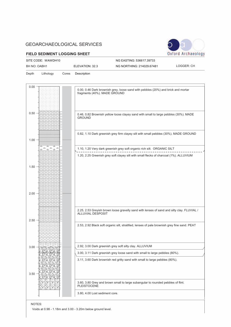
FIELD SEDIMENT LOGGING SHEET
Lithology
NG EASTING: 536617.39733
NG NORTHING: 214029.67481ELEVATION: 32.3
GEOARCHAEOLOGICAL SERVICES
Depth DescriptionCores
SITE CODE: WAWDH10
NOTES:
Page 1 of 2
0.00
0.50
1.00
1.50
2.00
2.50
3.00
3.50
BH NO: OABH1 LOGGER: CH
Voids at 0.98 - 1.18m and 3.00 - 3.20m below ground level.
0.00, 0.46 Dark brownish grey, loose sand with pebbles (20%) and brick and mortarfragments (40%). MADE GROUND
0.46, 0.82 Brownish yellow loose clayey sand with small to large pebbles (30%). MADEGROUND
0.82, 1.10 Dark greenish grey firm clayey silt with small pebbles (30%). MADE GROUND
1.10, 1.20 Very dark greenish grey soft organic rich silt. ORGANIC SILT
1.20, 2.25 Greenish grey soft clayey silt with small flecks of charcoal (1%). ALLUVIUM
2.25, 2.53 Greyish brown loose gravelly sand with lenses of sand and silty clay. FLUVIAL /ALLUVIAL DESPOSIT
2.53, 2.92 Black soft organic silt, stratified, lenses of pale brownish grey fine sand. PEAT
2.92, 3.00 Dark greenish grey soft silty clay. ALLUVIUM
3.00, 3.11 Dark greenish grey loose sand with small to large pebbles (80%).
3.11, 3.60 Dark brownish red gritty sand with small to large pebbles (80%).
3.60, 3.80 Grey and brown small to large subangular to rounded pebbles of flint.PLEISTOCENE
3.80, 4.00 Lost sediment core.

FIELD SEDIMENT LOGGING SHEET
Lithology
NG EASTING: 536617.39733
NG NORTHING: 214029.67481ELEVATION: 32.3
GEOARCHAEOLOGICAL SERVICES
Depth DescriptionCores
SITE CODE: WAWDH10
NOTES:
Page 2 of 2
4.00
BH NO: OABH1 LOGGER: CH
Voids at 0.98 - 1.18m and 3.00 - 3.20m below ground level.
FIELD SEDIMENT LOGGING SHEET
Lithology
NG EASTING: 536595.49871
NG NORTHING: 214042.83508ELEVATION: 32
GEOARCHAEOLOGICAL SERVICES
Depth DescriptionCores
SITE CODE: WAWDH10
NOTES:
Page 1 of 2
0.00
0.50
1.00
1.50
2.00
2.50
3.00
3.50
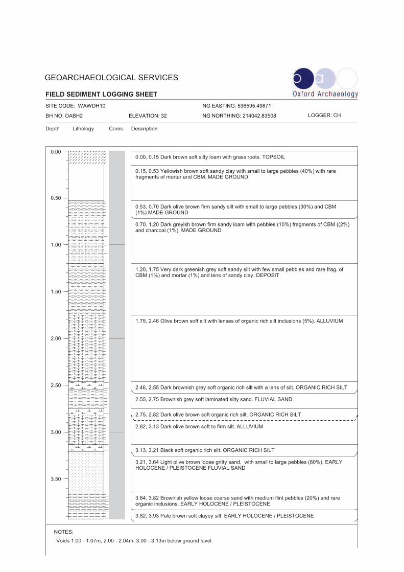
BH NO: OABH2 LOGGER: CH
Voids 1.00 - 1.07m, 2.00 - 2.04m, 3.00 - 3.13m below ground level.
0.00, 0.15 Dark brown soft silty loam with grass roots. TOPSOIL
0.15, 0.53 Yellowish brown soft sandy clay with small to large pebbles (40%) with rarefragments of mortar and CBM. MADE GROUND
0.53, 0.70 Dark olive brown firm sandy silt with small to large pebbles (30%) and CBM(1%).MADE GROUND
0.70, 1.20 Dark greyish brown firm sandy loam with pebbles (10%) fragments of CBM ((2%)and charcoal (1%). MADE GROUND
1.20, 1.75 Very dark greenish grey soft sandy silt with few small pebbles and rare frag. ofCBM (1%) and mortar (1%) and lens of sandy clay. DEPOSIT
1.75, 2.46 Olive brown soft silt with lenses of organic rich silt inclusions (5%). ALLUVIUM
2.46, 2.55 Dark brownish grey soft organic rich silt with a lens of silt. ORGANIC RICH SILT
2.55, 2.75 Brownish grey soft laminated silty sand. FLUVIAL SAND
2.75, 2.82 Dark olive brown soft organic rich silt. ORGANIC RICH SILT
2.82, 3.13 Dark olive brown soft to firm silt. ALLUVIUM
3.13, 3.21 Black soft organic rich silt. ORGANIC RICH SILT
3.21, 3.64 Light olive brown loose gritty sand. with small to large pebbles (80%). EARLYHOLOCENE / PLEISTOCENE FLUVIAL SAND
3.64, 3.82 Brownish yellow loose coarse sand with medium flint pebbles (20%) and rareorganic inclusions. EARLY HOLOCENE / PLEISTOCENE
3.82, 3.93 Pale brown soft clayey silt. EARLY HOLOCENE / PLEISTOCENE
FIELD SEDIMENT LOGGING SHEET
Lithology
NG EASTING: 536595.49871
NG NORTHING: 214042.83508ELEVATION: 32
GEOARCHAEOLOGICAL SERVICES
Depth DescriptionCores
SITE CODE: WAWDH10
NOTES:
Page 2 of 2
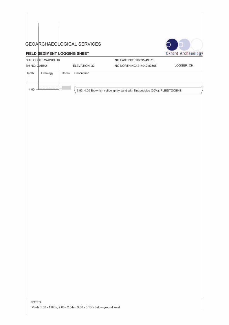
4.00
BH NO: OABH2 LOGGER: CH
Voids 1.00 - 1.07m, 2.00 - 2.04m, 3.00 - 3.13m below ground level.
3.93, 4.00 Brownish yellow gritty sand with flint pebbles (20%). PLEISTOCENE
FIELD SEDIMENT LOGGING SHEET
Lithology
NG EASTING: 536554.53844
NG NORTHING: 214118.42151ELEVATION: 32.3
GEOARCHAEOLOGICAL SERVICES
Depth DescriptionCores
SITE CODE: WAWDH10
NOTES:
Page 1 of 1
0.00
0.50
1.00
1.50
2.00
2.50
3.00
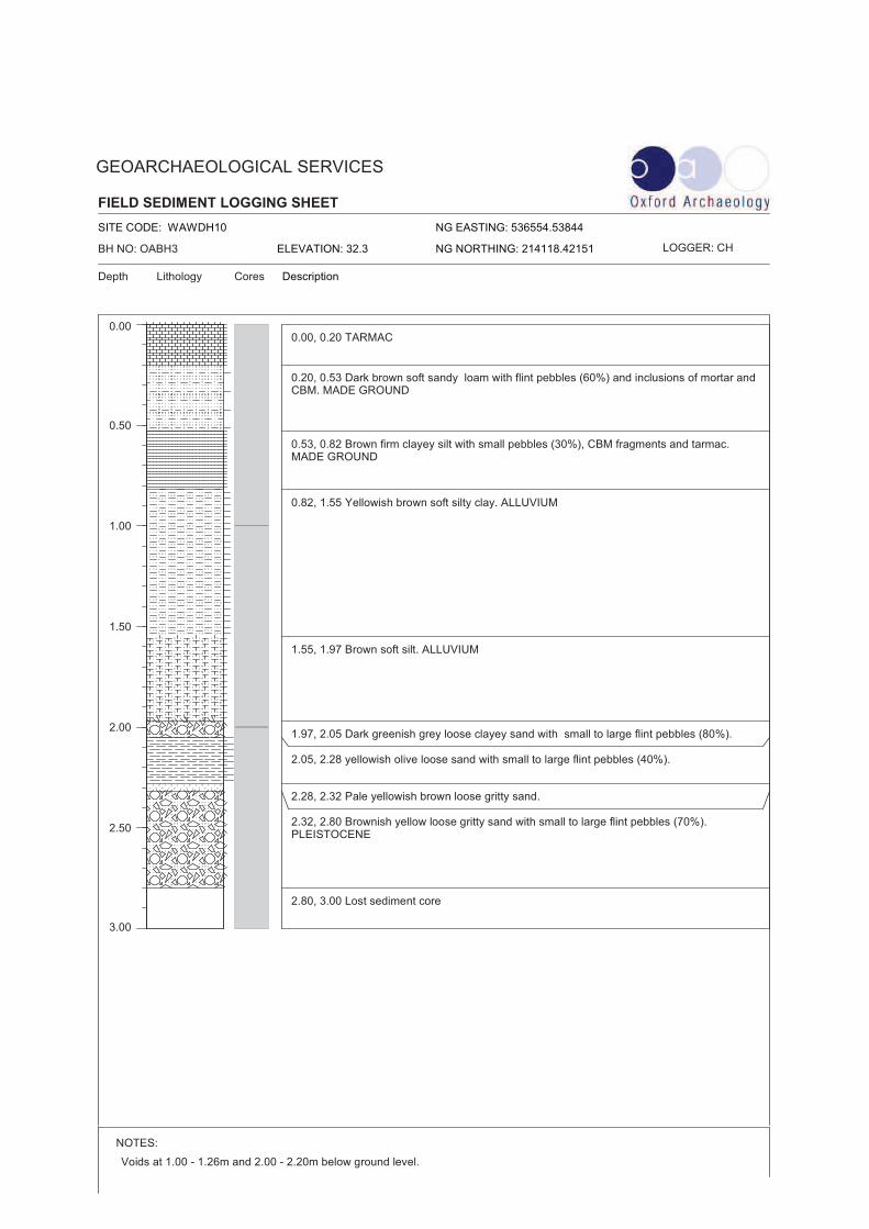
BH NO: OABH3 LOGGER: CH
Voids at 1.00 - 1.26m and 2.00 - 2.20m below ground level.
0.00, 0.20 TARMAC
0.20, 0.53 Dark brown soft sandy loam with flint pebbles (60%) and inclusions of mortar andCBM. MADE GROUND
0.53, 0.82 Brown firm clayey silt with small pebbles (30%), CBM fragments and tarmac.MADE GROUND
0.82, 1.55 Yellowish brown soft silty clay. ALLUVIUM
1.55, 1.97 Brown soft silt. ALLUVIUM
1.97, 2.05 Dark greenish grey loose clayey sand with small to large flint pebbles (80%).
2.05, 2.28 yellowish olive loose sand with small to large flint pebbles (40%).
2.28, 2.32 Pale yellowish brown loose gritty sand.
2.32, 2.80 Brownish yellow loose gritty sand with small to large flint pebbles (70%).PLEISTOCENE
2.80, 3.00 Lost sediment core
FIELD SEDIMENT LOGGING SHEET
Lithology
NG EASTING: 536557.34253
NG NORTHING: 214102.25391ELEVATION: 32.45
GEOARCHAEOLOGICAL SERVICES
Depth DescriptionCores
SITE CODE: WAWDH10
NOTES:
Page 1 of 1
0.00
0.50
1.00
1.50
2.00
2.50
3.00
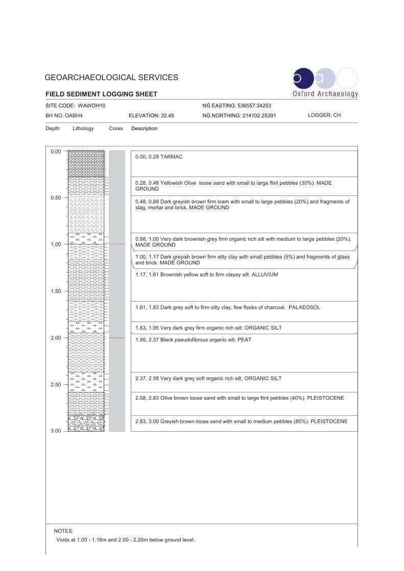
BH NO: OABH4 LOGGER: CH
Voids at 1.00 - 1.16m and 2.00 - 2.20m below ground level.
0.00, 0.28 TARMAC
0.28, 0.48 Yellowish Olive loose sand with small to large flint pebbles (30%). MADEGROUND
0.48, 0.88 Dark greyish brown firm loam with small to large pebbles (20%) and fragments ofslag, mortar and brick. MADE GROUND
0.88, 1.00 Very dark brownish grey firm organic rich silt with medium to large pebbles (20%).MADE GROUND
1.00, 1.17 Dark greyish brown firm silty clay with small pebbles (5%) and fragments of glassand brick. MADE GROUND
1.17, 1.61 Brownish yellow soft to firm clayey silt. ALLUVIUM
1.61, 1.83 Dark grey soft to firm silty clay, few flecks of charcoal. PALAEOSOL
1.83, 1.95 Very dark grey firm organic rich silt. ORGANIC SILT
1.95, 2.37 Black pseudofibrous organic silt. PEAT
2.37, 2.58 Very dark grey soft organic rich silt. ORGANIC SILT
2.58, 2.83 Olive brown loose sand with small to large flint pebbles (40%). PLEISTOCENE
2.83, 3.00 Greyish brown loose sand with small to medium pebbles (80%). PLEISTOCENE
FIELD SEDIMENT LOGGING SHEET
Lithology
NG EASTING: 536539.333
NG NORTHING: 214098.5441ELEVATION: 31.89
GEOARCHAEOLOGICAL SERVICES
Depth DescriptionCores
SITE CODE: WAWDH10
NOTES:
Page 1 of 1
0.00
0.50
1.00
1.50
2.00
2.50
3.00
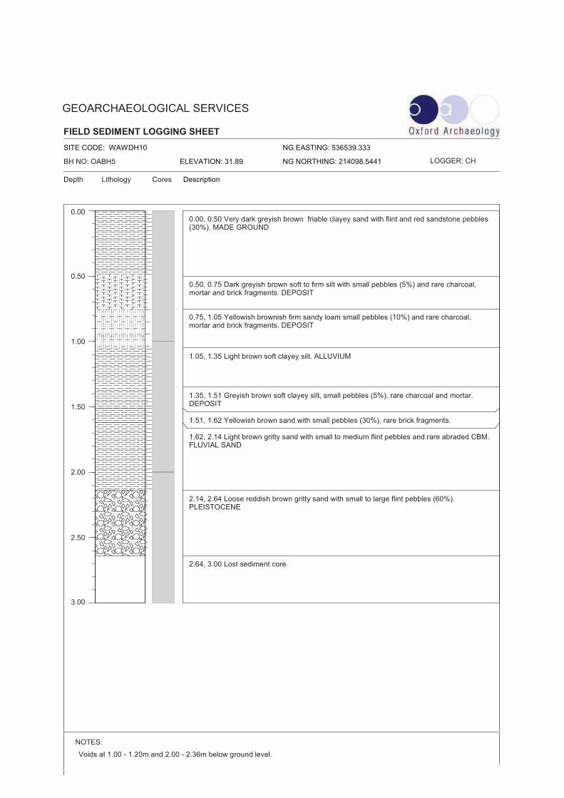
BH NO: OABH5 LOGGER: CH
Voids at 1.00 - 1.20m and 2.00 - 2.36m below ground level.
0.00, 0.50 Very dark greyish brown friable clayey sand with flint and red sandstone pebbles(30%). MADE GROUND
0.50, 0.75 Dark greyish brown soft to firm silt with small pebbles (5%) and rare charcoal,mortar and brick fragments. DEPOSIT
0.75, 1.05 Yellowish brownish firm sandy loam small pebbles (10%) and rare charcoal,mortar and brick fragments. DEPOSIT
1.05, 1.35 Light brown soft clayey silt. ALLUVIUM
1.35, 1.51 Greyish brown soft clayey silt, small pebbles (5%), rare charcoal and mortar.DEPOSIT
1.51, 1.62 Yellowish brown sand with small pebbles (30%), rare brick fragments.
1.62, 2.14 Light brown gritty sand with small to medium flint pebbles and rare abraded CBM.FLUVIAL SAND
2.14, 2.64 Loose reddish brown gritty sand with small to large flint pebbles (60%).PLEISTOCENE
2.64, 3.00 Lost sediment core.
FIELD SEDIMENT LOGGING SHEET
Lithology
NG EASTING: 536603.78152
NG NORTHING: 214138.16805ELEVATION: 32.22
GEOARCHAEOLOGICAL SERVICES
Depth DescriptionCores
SITE CODE: WAWDH10
NOTES:
Page 1 of 1
0.00
0.50
1.00
1.50
2.00
2.50
3.00
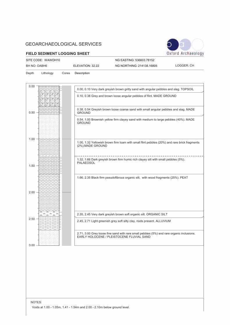
BH NO: OABH6 LOGGER: CH
Voids at 1.00 - 1.05m, 1.41 - 1.54m and 2.00 - 2.10m below ground level.
0.00, 0.10 Very dark greyish brown gritty sand with angular pebbles and slag. TOPSOIL
0.10, 0.38 Grey and brown loose angular pebbles of flint. MADE GROUND
0.38, 0.54 Greyish brown loose coarse sand with small angular pebbles and slag. MADEGROUND
0.54, 1.00 Brownish yellow firm clayey sand with medium to large pebbles (40%). MADEGROUND
1.00, 1.32 Yellowish brown firm loam with small flint pebbles (20%) and rare brick fragments(2%).MADE GROUND
1.32, 1.66 Dark greyish brown firm humic rich clayey silt with small pebbles (5%).PALAEOSOL
1.66, 2.35 Black firm pseudofibrous organic silt, with wood fragments (25%). PEAT
2.35, 2.45 Very dark greyish brown soft organic silt. ORGANIC SILT
2.45, 2.71 Light greenish grey soft silty clay, roots present. ALLUVIUM
2.71, 3.00 Grey loose fine sand with rare small pebbles (5%) and rare organic inclusions.EARLY HOLOCENE / PLEISTOCENE FLUVIAL SAND

Widbury Hill, Ware, Hertfordshire v.1
APPENDIX B. PLATES
© Oxford Archaeology Page 17 of 19 January 2011
Plates
Plate 1: Site conditions
Plate 2: Borehole sampling
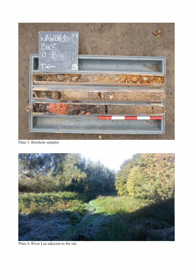
Plate 3: Borehole samples
Plate 4: River Lea adjacent to the site
Widbury Hill, Ware, Hertfordshire v.1
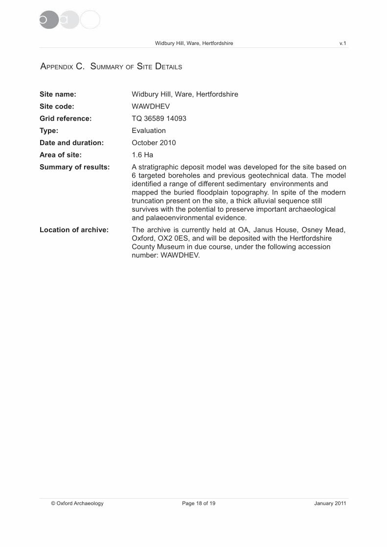
APPENDIX C. SUMMARY OF SITE DETAILS
Site name: Widbury Hill, Ware, Hertfordshire
Site code: WAWDHEV
Grid reference: TQ 36589 14093
Type: Evaluation
Date and duration: October 2010
Area of site: 1.6 Ha
Summary of results: A stratigraphic deposit model was developed for the site based on
6 targeted boreholes and previous geotechnical data. The model
identified a range of different sedimentary environments and
mapped the buried floodplain topography. In spite of the modern
truncation present on the site, a thick alluvial sequence still
survives with the potential to preserve important archaeological
and palaeoenvironmental evidence.
Location of archive: The archive is currently held at OA, Janus House, Osney Mead,
Oxford, OX2 0ES, and will be deposited with the Hertfordshire
County Museum in due course, under the following accession
number: WAWDHEV.
© Oxford Archaeology Page 18 of 19 January 2011
Widbury Hill, Ware, Hertfordshire v.1
APPENDIX D. HER AND OASIS SUMMARIES
© Oxford Archaeology Page 19 of 19 January 2011
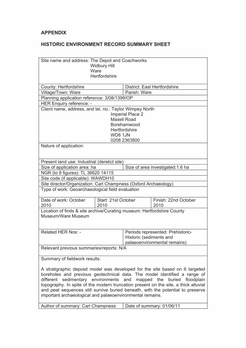
APPENDIX
HISTORIC ENVIRONMENT RECORD SUMMARY SHEET
Site name and address: The Depot and Coachworks Widbury Hill Ware Hertfordshire
County: Hertfordshire District: East Hertfordshire
Village/Town: Ware Parish: Ware
Planning application reference: 3/08/1399/OP
HER Enquiry reference: -
Client name, address, and tel. no.: Taylor Wimpey North Imperial Place 2 Maxell Road Borehamwood Hertfordshire WD6 1JN 0208 2363800
Nature of application:
Present land use: Industrial (derelict site)
Size of application area: ha Size of area investigated:1.6 ha
NGR (to 8 figures): TL 36620 14115
Site code (if applicable): WAWDH10
Site director/Organization: Carl Champness (Oxford Archaeology)
Type of work: Geoarchaeological field evaluation
Date of work: October2010
Start: 21st October2010
Finish: 22nd October2010
Location of finds & site archive/Curating museum: Hertfordshire CountyMuseum/Ware Museum
Related HER Nos: - Periods represented: Prehistoric-Historic (sediments andpalaeoenvironmental remains)
Relevant previous summaries/reports: N/A
Summary of fieldwork results:
A stratigraphic deposit model was developed for the site based on 6 targetedboreholes and previous geotechnical data. The model identified a range ofdifferent sedimentary environments and mapped the buried floodplaintopography. In spite of the modern truncation present on the site, a thick alluvialand peat sequences still survive buried beneath, with the potential to preserveimportant archaeological and palaeoenvironmental remains.
Author of summary: Carl Champness Date of summary: 01/06/11
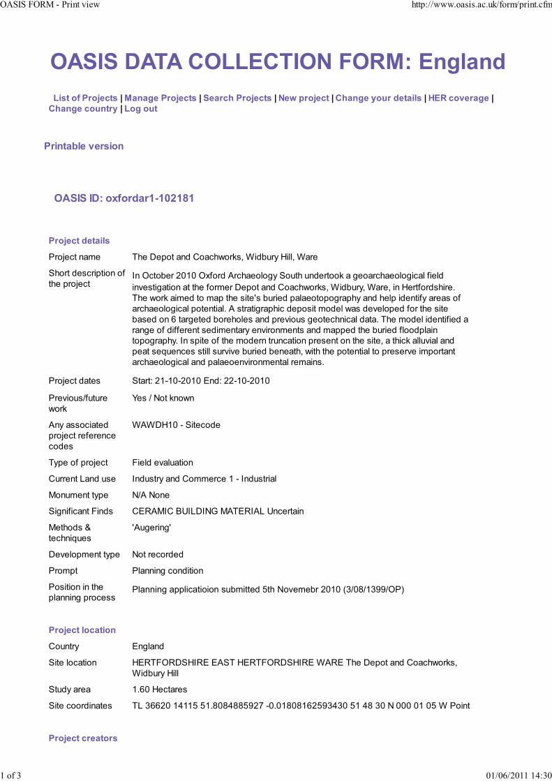
!"#"$%!&!$' (()'&# *$+ ,-.$)/012/3
$$(456$78$9:7;<=65$>$-2/20<$9:7;<=65$>$"<2:=?$9:7;<=65$>$*<@$A:7;<=6$>$'?2/0<$B7C:$3<62415$>$D),$=7E<:20<$>
'?2/0<$=7C/6:B$>$(70$7C6
9:4/62F1<$E<:547/
!"#"$#%.$7G87:32:HIHJKHLH
9:7;<=6$3<62415
!"#$%&'()*$ +,$'-$."&')(/'0")%,1"!234'56/78!9':6;;4'5)!$
<,"!&'/$3%!6.&6"('"=
&,$'.!"#$%&>('October'?@A@'BC="!/'D!%,)$";"E9'<"8&,'8(/$!&""2')'E$")!%,)$";"E6%);'=6$;/
6(F$3&6E)&6"(')&'&,$'="!*$!'-$."&')(/'0")%,1"!234'56/78!94'5)!$4'6(':$!&="!/3,6!$G
+,$'1"!2')6*$/'&"'*).'&,$'36&$H3'78!6$/'.);)$"&"."E!).,9')(/',$;.'6/$(&6=9')!$)3'"=
)!%,)$";"E6%);'."&$(&6);G'D'3&!)&6E!).,6%'/$."36&'*"/$;'1)3'/$F$;".$/'="!'&,$'36&$
7)3$/'"('I'&)!E$&$/'7"!$,";$3')(/'.!$F6"83'E$"&$%,(6%);'/)&)G'+,$'*"/$;'6/$(&6=6$/')
!)(E$'"='/6==$!$(&'3$/6*$(&)!9'$(F6!"(*$(&3')(/'*)..$/'&,$'78!6$/'=;""/.;)6(
&"."E!).,9G'>('3.6&$'"='&,$'*"/$!('&!8(%)&6"('.!$3$(&'"('&,$'36&$4')'&,6%2');;8F6);')(/
.$)&'3$J8$(%$3'3&6;;'38!F6F$'78!6$/'7$($)&,4'16&,'&,$'."&$(&6);'&"'.!$3$!F$'6*."!&)(&
)!%,)$";"E6%);')(/'.);)$"$(F6!"(*$(&);'!$*)6(3G
!"#$%&'/)&$3 <&)!&K'?ALA0L?@A@'M(/K'?2LA0L?@A@
!$F6"83N=8&8!$
1"!2
O$3'N'P"&'2("1(
D(9')33"%6)&$/
.!"#$%&'!$=$!$(%$
%"/$3
5D5-:A@'L'<6&$%"/$
+9.$'"='.!"#$%& Q6$;/'$F);8)&6"(
08!!$(&'R)(/'83$ >(/83&!9')(/'0"**$!%$'A'L'>(/83&!6);
S"(8*$(&'&9.$ PND'P"($
<6E(6=6%)(&'Q6(/3 0MTDS>0'UV>R->PW'SD+MT>DR'V(%$!&)6(
S$&,"/3'X
&$%,(6J8$3
HD8E$!6(EH
-$F$;".*$(&'&9.$ P"&'!$%"!/$/
!"*.& ;)((6(E'%"(/6&6"(
"36&6"('6('&,$
.;)((6(E'.!"%$33Planning applicatioion submitted 5th Novemebr 2010 (3/08/1399/OP)
9:7;<=6$17=2647/
0"8(&!9 M(E;)(/
<6&$';"%)&6"( :MT+QBT-<:>TM'MD<+':MT+QBT-<:>TM'5DTM'+,$'-$."&')(/'0")%,1"!234
56/78!9':6;;
<&8/9')!$) AGI@':$%&)!$3
<6&$'%""!/6()&$3 +R'YII?@'AZAA['[AG\@\Z\\[]?^'L@G@A\@\AI?[]YZY@'[A'Z\'Y@'P'@@@'@A'@['5' "6(&
9:7;<=6$=:<267:5
!"#"$% &'$($)*+,-$.+/0 1--23440005678+85795:;4<6*=42*+,-59<=
>$6<$? @>4@A4B@>>$>C3?@
!"#".
P)*$'"=
B!E)(63)&6"(
BC="!/'D!%,)$";"E9
!"#$%&'7!6$=
"!6E6()&"!
0ES3'R6*6&$/
!"#$%&'/$36E(
"!6E6()&"!
0ES3'R6*6&$/
!"#$%&
/6!$%&"!N*)()E$!
RG'<&)=="!/
!"#$%&'38.$!F63"! 0G'0,)*.($33
9:7;<=6$2:=?4E<5
,936%);'D!%,6F$
MC63&3_
P"
,936%);'D!%,6F$
("&$3
Q!)E*$(&3'"='7!6%24'%,)!%");')(/'%$!)*6%'786;/6(E'*)&$!6);'1$!$'"73$!F$/'"('36&$'78&
("&'!$&)6($/
-6E6&);'D!%,6F$
!$%6.6$(&
BC="!/'D!%,)$";"E9
-6E6&);'D!%,6F$'>- 5D5-:A@N'5D5-:M`
-6E6&);'0"(&$(&3 H<&!)&6E!).,6%H
-6E6&);'S$/6)
)F)6;)7;$
H>*)E$3'!)3&$!'N'/6E6&);'.,"&"E!).,9H4H+$C&H
).$!'D!%,6F$
!$%6.6$(&
5)!$'S83$8*
).$!'D!%,6F$'>- 5D5-:A@
).$!'0"(&$(&3 H<&!)&6E!).,6%H
).$!'S$/6)
)F)6;)7;$
H ,"&"E!).,H4H ;)(H4HT$."!&H4H<8!F$9'H4HV(.87;63,$/'+$C&H
9:7;<=6
F4F1470:2A?B$H
87;6%)&6"('&9.$
W!$9';6&$!)&8!$'a8(.87;63,$/'/"%8*$(&N*)(83%!6.&b
+6&;$ +,$'-$."&')(/'0")%,1"!234'56/78!9':6;;4'5)!$4':$!&="!/3,6!$G'MF);8)&6"('T$."!&
D8&,"!a3bNM/6&"!a3b 0,)*.($334'0G
-)&$ ?@AA
>338$!'"!'.87;63,$! BC="!/'D!%,)$";"E9
;)%$'"='6338$'"!
.87;6%)&6"(
BC="!/
-$3%!6.&6"( DZ'7"8(/'%;6$(&'!$."!&
M(&$!$/'79 <83)('T)1;6(E3'a383)(G!)1;6(E3c"C="!/)!%,G%"G82b
M(&$!$/'"( A'd8($'?@AA
$
!"#"$% &'$($)*+,-$.+/0 1--23440005678+85795:;4<6*=42*+,-59<=
B$6<$? @>4@A4B@>>$>C3?@

;$)3$'$L*)6;'M(E;63,':$!6&)E$'="!'BD<><',$;.')(/')/F6%$
e'D-<'A]]IL?@@I'0!$)&$/'79'd"'W6;,)*')(/'d$('S6&%,)*4'$*)6;'R)3&'*"/6=6$/'Q!6/)9'Y'Q$7!8)!9'?@@I !"#$%&'()$*+,*#-.%/"*0%1#*2#3*%45!5*6%/1*./!&"7861$6%/$"0!5$.49#
!"#"$% &'$($)*+,-$.+/0 1--23440005678+85795:;4<6*=42*+,-59<=
?$6<$? @>4@A4B@>>$>C3?@

495000
208000 209000 210000 211000
Reproduced from the Explorer 1:25,000 scale by permission of the Ordnance
Survey on behalf of The Controller of Her Majesty's Stationery Office
© Crown Copyright. All rights reserved. Licence No. AL 100005569
Figure 1: Site location
F
LONDON
OXFORD
NORWICH
BIRMINGHAM
R
115000
114000
113000
538000536000535000 537000
N
Proposed
development
Serv
er
go:/oaupubs1_R
toZ
*WA
WD
HE
V*W
are
, H
ert
s*G
S*3
0.0
9.1
0
CPBH1
BH2
CPBH3
CPBH4
CPBH5
CPT5
TP1a
TP2a TP3a
TP4a
TP5a
TP6a
TP7a
TP8a
TP9a
TP10
TP11a
TP12a
WS2a
WS2b
WS3
WS5
WS4
CPT1
CPT2
CPT3
CPT4
CPT6
CPT7
BH15
BH13
BH12
BH9 BH8
BH10 BH1
BH6
BH17
BH4
BH11
BH7
BH14
BH5
BH16
TP1
TP3
TP5
TP2
TP4
BH20
BH2a
BH19
BH3
BH18
N
Figure 2: Location of targeted boreholes and geotechnical interventions
OABH3
OABH5
OABH6
OABH4
OABH2
OABH1
536600
214100
214200
536500
536600
214100
214200
536500
Borehole
Trial pit
Window sample
Cone penetration test
OA boreholes
Site boundary1:1250
0 50 m
Riv
er L
ea

Figure 3: 3-D stratigraphic model
Stratigraphy
Made ground
Upper alluvium
Peat/organic sequence
Paleaochannel
Floodplain
islandBackwater
embayment
Lower alluvium
Sandy gravel
Chalk
Figure 3: 3-D stratigraphic model
WW SSEE

Figure 4: Modelled surface of Pleistocene gravel (m OD)
TP1a
TP1 2a
WS2b
BH12
BH7
BH18
OABH6
OABH5
OABH3
OABH4
OABH2
OABH1
WS2WS2WS2WS2WS2bWS2WS2
OABH1H1H1H1H1H1H1H1H1H1H1
TP1a
TP1 2a
BH12
BH7
BBBBBBBHHHHHH18
OABH6
OABH5
OABOABOABH3
OABH4H4
OABH2OAB
53
66
00
214100
214200
53
65
00
53
66
00
214100
214200
53
65
00
N
OA boreholes
Section1:1250
0 50 m
Riv
er L
ea
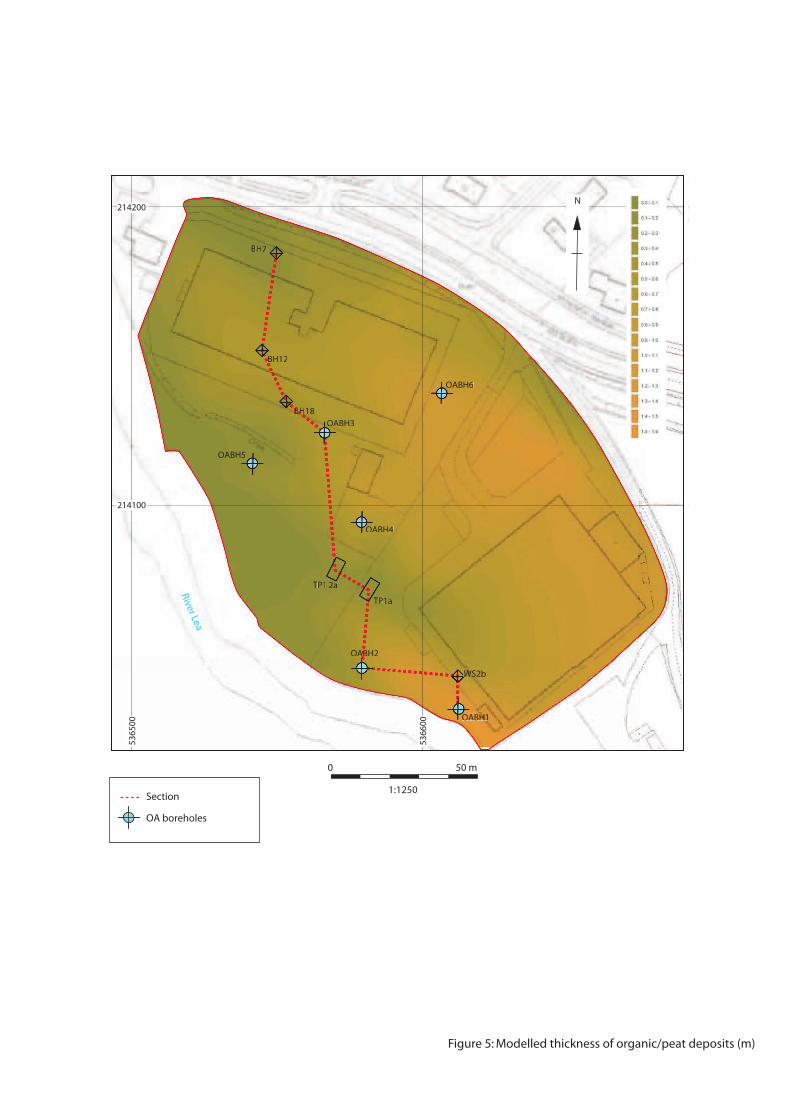
Figure 5: Modelled thickness of organic/peat deposits (m)
TP1a
TP1 2a
WS2b
BH12
BH7
BH18
OABH6
OABH5
OABH3
OABH4
OABH2
OABH1
WS2WS2WS2WS2WS2bWS2WS2
OABH1H1H1H1H1H1H1H1H1H1H1
TP1a
TP1 2a
BH12
BH7
BBBBBBBHHHHH18
OABH6
OABH5
OABOABOABH3
OABH4H4
OABH2OAB
53
66
00
214100
214200
53
65
00
53
66
00
214100
214200
53
65
00
N
OA boreholes
Section1:1250
0 50 m
Riv
er L
ea
TP1a
TP1 2a
WS2b
BH12
BH7
BH18
Figure 6: Modelled thickness of made ground deposits (m)
OABH6
OABH5
OABH3
OABH4
OABH2
OABH1
WS2WS2WS2WS2WS2WS2WS2WS2WS2WS2WS2WS2WS2WS2WS2WS2WS2bbWS2WS2
OABH1H1H1H1H1H1H1H1H1H1H1
TTTPPP1a1a1a1a1a1a
TP1 2a
BBH12
BBHH77777
BBBBBBBBBBBBHHH18
OABH6
OABH5
OABOABOABH3
OABH4H4
OABH2OAB
53
66
00
214100
214200
53
65
00
53
66
00
214100
214200
53
65
00
N
OA boreholes
Section1:1250
0 50 m
Riv
er L
ea
BH7 BH12 BH18 OABH3 TP12A TP1A OABH2 WS2B OABH1
Made ground
Upper alluvium
Peat/organic complex
Lower alluvium
Sand and gravel
NW SE
Figure 7: Borehole cross-section
33.0
32.0
31.0
30.0
29.0
28.0
27.0
m OD
0.0 25.0 50.0 75.0 100.0 125.0 150.0 175.0

Di rec t o r : Dav id Jenn ings , BA M I FA F SA
Oxfo rd A rchaeo logy L td i s a
P r i va te L im i ted Company , N o : 1618597
and a Reg i s te red Char i t y , N o : 285627
OA N or t h
Mi l l 3
Moor Lane
Lancas te r LA1 1GF
t : +44 ( 0 ) 1524 541 000
f : +44 ( 0 ) 1524 848 606
e : oanor th@thehuman jou r ney .net
w: h t tp : / / thehuman jou r ney .net
Hea d Of f i ce /Reg i s t e red O f f i ce/OA S ou t h
Janus House
Osney Mead
Oxfo rd OX2 0ES
t : +44 ( 0 ) 1865 263 800
f : +44 ( 0 )1865 793 496
e : i n fo@ox fo rdarch .co .uk
w : h t tp : / / t h eh u man jou r ney .n e t
OA E a s t
15 Tra f a lga r Way
Bar H i l l
Cam br id gesh i re
CB23 8SQ
t : +44 (0 )1223 850500
f : +4 4 (0 )1223 850599
e : oaea s t @thehuman jou r ney . ne t
w :h t tp : / / t he hu man jo u r ne y .net
OA Méd i t e r r a n ée
115 Rue Mer lo t
ZAC La Louvade
34 130 Maugu io
F rance
t : +33 ( 0 ) 4 . 67 .57 .86 .92
f : +33 ( 0 ) 4 . 67 .42 .65 .93
e : oamed@thehuman jou r ney .net
w: h t tp : / /oamed. f r /
OA Gr an d Ou es t
7 R ue des Monde r a ine s
Z I - Ou es t
14650 Carp ique t
F ranc e
t : +33 ( 0 ) 2 49 88 01 01
f : +33 ( 0 )2 49 88 01 02
e : i n fo@oago . f r
w : h t t p : / /oag o. f r