The Changing Himalayas - PreventionWeb · The Changing Himalayas 4 region. Even more importantly,...
28
The Changing Himalayas Impact of Climate Change on Water Resources and Livelihoods in the Greater Himalayas
Transcript of The Changing Himalayas - PreventionWeb · The Changing Himalayas 4 region. Even more importantly,...

The Changing Himalayas
Impact of Climate Change on Water Resources and Livelihoods in the Greater Himalayas
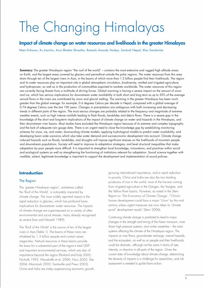
Contents Introduction
Observed and Projected Effects of Climate Change
Consequences for Livelihoods and the Environment
Lack of Knowledge – Unknown Downstream Effects
Policy Recommendations
Conclusions
References
The Changing Himalayas
1
Introduction
The Region
The ‘greater Himalayan region’, sometimes called the ‘Roof of the World’, is noticeably impacted by climate change. The most widely reported impact is the rapid reduction in glaciers, which has profound future implications for downstream water resources. The impacts of climate change are superimposed on a variety of other environmental and social stresses, many already recognised as severe (Ives and Messerli 1989).
The ‘Roof of the World’ is the source of ten of the largest rivers in Asia (Table 1). The basins of these rivers are inhabited by 1.3 billion people and contain seven megacities. Natural resources in these basins provide the basis for a substantial part of the region’s total GDP and important environmental services, which are also of importance beyond the region (Penland and Kulp 2005; Nicholls 1995; Woodroffe et al. 2006; Niou 2002; She 2004; Macintosh 2005; Sanlaville and Prieur 2005). China and India are today experiencing economic growth,
growing international importance, and a rapid reduction in poverty. China and India are also the two leading producers of rice in the world, most of the harvest coming from irrigated agriculture in the Ganges, the Yangtze, and the Yellow River basins. However, as noted in the Stern Report on ‘The Economics of Climate Change’, “China’s human development could face a major ‘U-turn’ by this mid-century unless urgent measures are now taken to ‘climate proof’ development results” (Stern 2006).
Continuing climate change is predicted to lead to major changes in the strength and timing of the Asian monsoon, inner Asian high pressure systems, and winter westerlies – the main systems affecting the climate of the Himalayan region. The impacts on river flows, groundwater recharge, natural hazards, and the ecosystem, as well as on people and their livelihoods, could be dramatic, although not the same in terms of rate, intensity, or direction in all parts of the region. Given the current state of knowledge about climate change, determining the diversity of impacts is a challenge for researchers, and risk assessment is needed to guide future action.
The Changing Himalayas
Summary: The greater Himalayan region “the roof of the world” – contains the most extensive and rugged high altitude areas on Earth, and the largest areas covered by glaciers and permafrost outside the polar regions. The water resources from this area drain through ten of the largest rivers in Asia, in the basins of which more than 1.3 billion people find their livelihoods. The region and its water resources play an important role in global atmospheric circulation, biodiversity, rainfed and irrigated agriculture, and hydropower, as well as in the production of commodities exported to markets worldwide. The water resources of this region are currently facing threats from a multitude of driving forces. Global warming is having a severe impact on the amount of snow and ice, which has serious implications for downstream water availability in both short and long term as up to 50% of the average annual flows in the rivers are contributed by snow and glacial melting. The warming in the greater Himalayas has been much greater than the global average: for example, 0.6 degrees Celsius per decade in Nepal, compared with a global average of 0.74 degrees Celsius over the last 100 years. Changes in precipitation are ambiguous with both increasing and decreasing trends in different parts of the region. The most serious changes are probably related to the frequency and magnitude of extreme weather events, such as high intense rainfalls leading to flash floods, landslides and debris flows. There is a severe gap in the knowledge of the short and long-term implications of the impact of climate change on water and hazards in the Himalayas, and their downstream river basins. Most studies have excluded the Himalayan region because of its extreme and complex topography and the lack of adequate rain gauge data. There is an urgent need to close the knowledge gap by establishing monitoring schemes for snow, ice, and water; downscaling climate models; applying hydrological models to predict water availability; and developing basin wide scenarios which also take water demand and socioeconomic development into account. Climate change induced hazards such as floods, landslides, and droughts will impose significant stresses on the livelihoods of mountain people and downstream populations. Society will need to improve its adaptation strategies, and level structural inequalities that make adaptation by poor people more difficult. It is important to strengthen local knowledge, innovations, and practices within social and ecological systems as well as strengthening the functioning of institutions relevant for adaptation. Sound science together with credible, salient, legitimate knowledge is important to support the development and implementation of sound policies.
Impact of climate change on water resources and livelihoods in the greater HimalayasMats Eriksson, Xu Jianchu, Arun Bhakta Shrestha, Ramesh Ananda Vaidya, Santosh Nepal, Klas Sandström

The Changing Himalayas
2
Himalayan Climate and Water
The Himalayas display great climatic variability. The mountains act as a barrier to atmospheric circulation for both the summer monsoon and the winter westerlies. The summer monsoon dominates the climate, lasting eight months (March-October) in the eastern Himalayas, four months (June-September) in the central Himalayas, and two months (July-August) in the western Himalayas (Chalise and Khanal 2001). The east-west variation is based on the dominance of different weather systems, which in turn cause the monsoon to weaken from east to west. The monsoon penetrates northwards along the Brahmaputra River into the southeast Tibetan Plateau, but rarely as far as the Karakoram (Hofer and Messerli, 2006; Rees and Collins, 2006). The highest annual rainfall in the region occurs in Cherapunjee in India, amounting to more than 12,000 mm.
The monsoon rainfall is mainly of an orographic nature, resulting in distinct variations in rainfall with elevation between the southern slopes of the Himalayas and the rain shadow areas on the Tibetan Plateau (Mei’e 1985). On the meso-scale, the impacts of climate are mainly due to local topographic characteristics (Chalise and Khanal, 2001), with dry inner valleys receiving much less rainfall than the adjacent mountain slopes as a result of the lee effect. This suggests that the currently measured rainfall, which is mainly based on measurements of rainfall in the valley bottoms, is not representative for the area, and the use of these data results in significant underestimates.
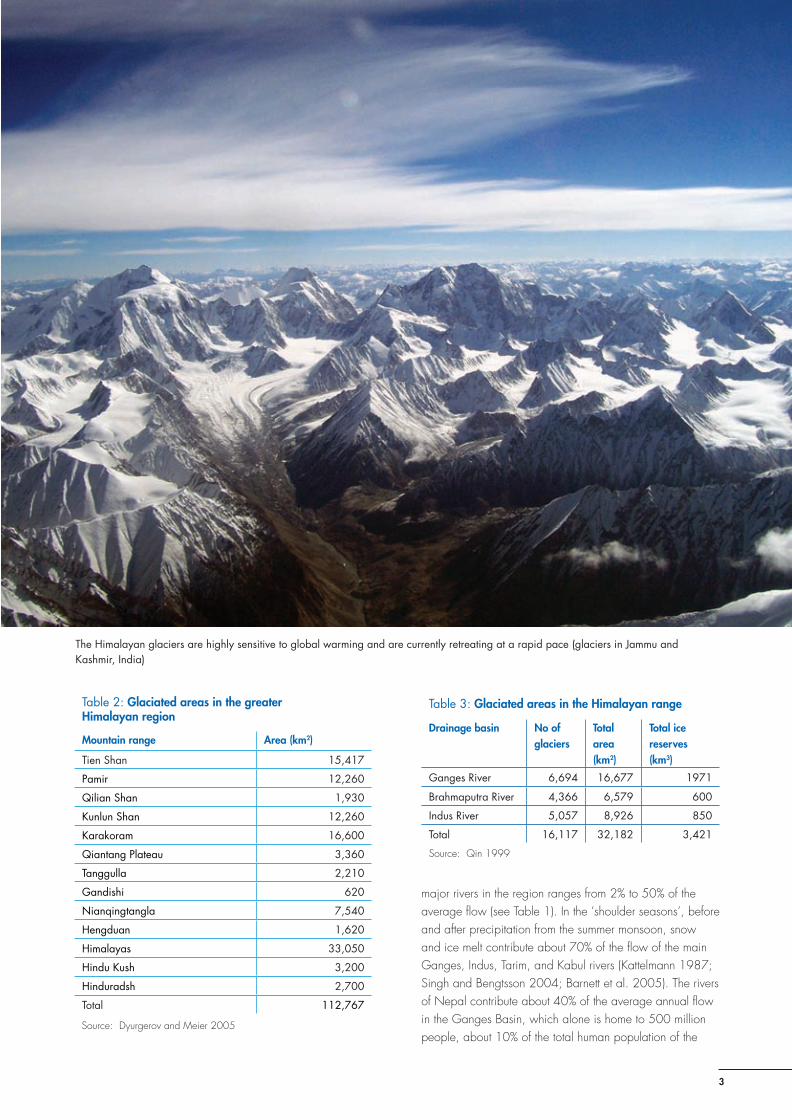
A substantial portion of the annual precipitation falls as snow, particularly at high altitudes (above 3000 masl) feeding the Himalayan glaciers. The high Himalayan and inner Asian ranges have the most highly glaciated areas outside the polar regions (Owen et al. 2002; Dyurgerov and Meier 2005). Glaciated areas in the greater Himalayan region cover an area of more than 112,000 km2 (Table 2). The Himalayan range alone (a sub-region) has a total area of approximately 33,000 km2 of glaciers or 17% of the mountain area (as compared to 2.2% in the Swiss Alps) with a total ice volume of ca 3,420 km3 (Table 3) which provides important short and long-term water storage facilities. These figures are very tentative, however, and need to be followed up with more research.
Glaciers undergo winter accumulation and summer ablation in the west, but predominantly synchronous summer accumulation and summer melt in the east. The main melting occurs in high summer; however, when this coincides with the monsoon, it may not be as critical for water supply as when the melting occurs in the shoulder seasons: spring and autumn. When the monsoon is weak, delayed, or fails, meltwater from snow and ice may limit or avert catastrophic drought.
Water from both permanent snow and ice and seasonal snow is released by melting, some to be temporarily stored in high altitude wetlands and lakes, but most flowing directly downstream in the large river systems, giving a distinct seasonal rhythm to annual stream flow regimes in these rivers. The contribution of snow and glacial melt to the
Table 1: Principal rivers of the Himalayan region – basin statistics
River River basin
River Annual mean discharge m3/seca
% of glacier melt in river flowb
Basin area (km2)
Population density (pers/km2)
Population x1000
Water availability (m3/person/year)
Amu Darya 1,376a not available 534,739 39 20,855 2,081
Brahmaputra 21,261a ~ 12 651,335 182 118,543 5,656
Ganges 12,037a ~ 9 1,016,124 401 407,466 932
Indus 5,533a up to 50 1081,718 165 178,483 978
Irrawaddy 8,024a not available 413,710 79 32,683 7,742
Mekong 9,001a ~ 7 805,604 71 57,198 4,963
Salween 1,494a ~ 9 271,914 22 5,982 7,876
Tarim 1,262a up to 50 1,152,448 7 8,067 4,933
Yangtze 28,811a ~ 18 1,722,193 214 368,549 2,465
Yellow 1,438a ~ 2 944,970 156 147,415 308
Total 1,345,241
a The data were collected by the Global Runoff Data Centre (GRDC) from the following most downstream stations of the river basins: Chatly (Amu Darya), Bahadurabad (Brahmaputra), Farakka (Ganges), Pakse (Mekong), Datong (Yangtze), Huayuankou (Yellow) b Estimation of the meltwater contribution is difficult and varies in an upstream and downstream situation; approximates are given here.Source: IUCN et al. 2003; Mi and Xie 2002; Chalise and Khanal 2001; Merz 2004; Tarar 1982; Kumar et al. 2007; Chen et al. 2007Note: The hydrological data may differ depending on the location of the gauging stations. The contribution of glacial melt is based on limited data
and should be taken as indicative only.
The Changing Himalayas
3
Table 2: Glaciated areas in the greater Himalayan region
Mountain range Area (km2)
Tien Shan 15,417
Pamir 12,260
Qilian Shan 1,930
Kunlun Shan 12,260
Karakoram 16,600
Qiantang Plateau 3,360
Tanggulla 2,210
Gandishi 620
Nianqingtangla 7,540
Hengduan 1,620
Himalayas 33,050
Hindu Kush 3,200
Hinduradsh 2,700
Total 112,767
Source: Dyurgerov and Meier 2005
Table 3: Glaciated areas in the Himalayan range
Drainage basin No of glaciers
Total area (km2)
Total ice reserves (km3)
Ganges River 6,694 16,677 1971
Brahmaputra River 4,366 6,579 600
Indus River 5,057 8,926 850
Total 16,117 32,182 3,421
Source: Qin 1999
major rivers in the region ranges from 2% to 50% of the average flow (see Table 1). In the ‘shoulder seasons’, before and after precipitation from the summer monsoon, snow and ice melt contribute about 70% of the flow of the main Ganges, Indus, Tarim, and Kabul rivers (Kattelmann 1987; Singh and Bengtsson 2004; Barnett et al. 2005). The rivers of Nepal contribute about 40% of the average annual flow in the Ganges Basin, which alone is home to 500 million people, about 10% of the total human population of the
The Himalayan glaciers are highly sensitive to global warming and are currently retreating at a rapid pace (glaciers in Jammu and Kashmir, India)
The Changing Himalayas
4
region. Even more importantly, they contribute about 70% of the flow in the dry season (Alford 1992). In western China, glacial melt provides the principal water source in the dry season for 25% of the population (Xu 2008). The Indus Irrigation Scheme in Pakistan depends 50% or more on runoff originating from snowmelt and glacial melt from the eastern Hindu Kush, Karakoram, and western Himalayas (Winiger et al. 2005).
Observed and Projected Effects of Climate Change
Climate change is currently taking place at an unprecedented rate and is projected to compound the pressures on natural resources and the environment associated with rapid urbanisation, industrialisation, and economic development. It will potentially have profound and widespread effects on the availability of, and access to, water resources. By the 2050s, access to freshwater in Asia, particularly in large basins, is projected to decrease.
Rising Temperatures
IPCC’s Fourth Assessment Report (IPCC 2007a; 2007b) concludes that there is a more than 90% probability that the observed warming since the 1950s is due to the emission of greenhouse gases from human activity. Temperature projections for the 21st Century suggest a significant acceleration of warming over that observed in the 20th Century (Ruosteenoja et al. 2003). In Asia, it is very likely that all areas will warm during this century. Warming is least rapid, similar to the global mean warming, in Southeast Asia, stronger over South Asia and Eastern Asia, and greatest in the continental interior of Asia (Central, Western, and Northern Asia). Warming will be significant in arid regions of Asia and the Himalayan highlands, including the Tibetan Plateau (Gao et al. 2003; Yao et al. 2006).
Based on regional climate models, it is predicted that the temperatures in the Indian sub-continent will rise between 3.5 and 5.5ºC by 2100, and on the Tibetan Plateau by 2.5ºC by 2050 and 5ºC by 2100 (Rupa Kumar et al. 2006). However, because of the extreme topography and complex reactions to the greenhouse effect, even high resolution climatic models cannot give reliable projections of climate change in the Himalayas.
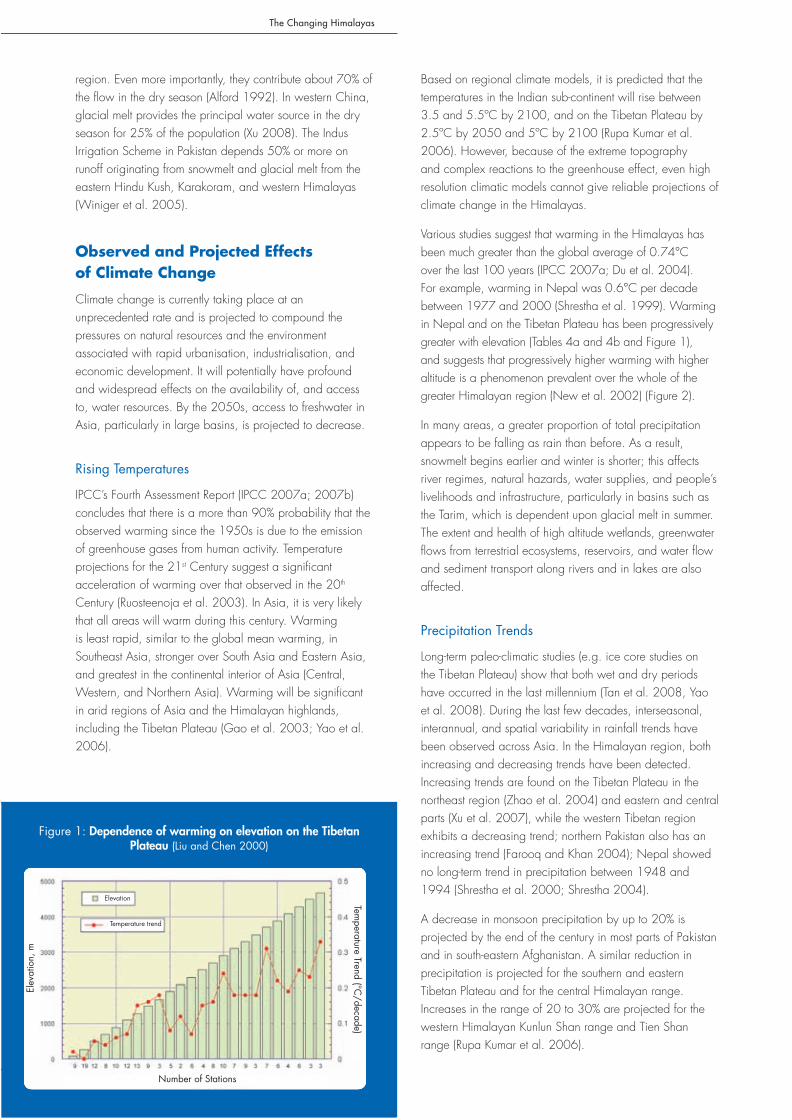
Various studies suggest that warming in the Himalayas has been much greater than the global average of 0.74°C over the last 100 years (IPCC 2007a; Du et al. 2004). For example, warming in Nepal was 0.6°C per decade between 1977 and 2000 (Shrestha et al. 1999). Warming in Nepal and on the Tibetan Plateau has been progressively greater with elevation (Tables 4a and 4b and Figure 1), and suggests that progressively higher warming with higher altitude is a phenomenon prevalent over the whole of the greater Himalayan region (New et al. 2002) (Figure 2).
In many areas, a greater proportion of total precipitation appears to be falling as rain than before. As a result, snowmelt begins earlier and winter is shorter; this affects river regimes, natural hazards, water supplies, and people’s livelihoods and infrastructure, particularly in basins such as the Tarim, which is dependent upon glacial melt in summer. The extent and health of high altitude wetlands, greenwater flows from terrestrial ecosystems, reservoirs, and water flow and sediment transport along rivers and in lakes are also affected.
Precipitation Trends
Long-term paleo-climatic studies (e.g. ice core studies on the Tibetan Plateau) show that both wet and dry periods have occurred in the last millennium (Tan et al. 2008, Yao et al. 2008). During the last few decades, interseasonal, interannual, and spatial variability in rainfall trends have been observed across Asia. In the Himalayan region, both increasing and decreasing trends have been detected. Increasing trends are found on the Tibetan Plateau in the northeast region (Zhao et al. 2004) and eastern and central parts (Xu et al. 2007), while the western Tibetan region exhibits a decreasing trend; northern Pakistan also has an increasing trend (Farooq and Khan 2004); Nepal showed no long-term trend in precipitation between 1948 and 1994 (Shrestha et al. 2000; Shrestha 2004).
A decrease in monsoon precipitation by up to 20% is projected by the end of the century in most parts of Pakistan and in south-eastern Afghanistan. A similar reduction in precipitation is projected for the southern and eastern Tibetan Plateau and for the central Himalayan range. Increases in the range of 20 to 30% are projected for the western Himalayan Kunlun Shan range and Tien Shan range (Rupa Kumar et al. 2006).
Elev
atio
n, m
Figure 1: Dependence of warming on elevation on the Tibetan Plateau (Liu and Chen 2000)
Temperature Trend (°C
/decade)
Number of Stations
Elevation
Temperature trend
Elev
atio
n, m

The Changing Himalayas
5
Figure 2: Spatial distribution of annual temperature trends in the greater Himalayan region for the period 1970–2000 (Data Source: New et al. 2002)
Table 4a: Regional mean maximum temperature trends in Nepal from 1977–2000 (°C per year)
Region Seasonal AnnualWinter (Dec-Feb) Pre-monsoon (Mar-May) Monsoon (Jun-Sep) Post-monsoon (Oct-Nov) (Jan-Dec)
Trans-Himalayas 0.12 0.01 0.11 0.1 0.09
Himalayas 0.09 0.05 0.06 0.08 0.06
Middle Mountains 0.06 0.05 0.06 0.09 0.08
Siwaliks 0.02 0.01 0.02 0.08 0.04
Terai 0.01 0 0.01 0.07 0.04
All Nepal 0.06 0.03 0.051 0.08 0.06
Source: updated from Shrestha et al. 1999
Table 4b: Average annual increase in temperature at different altitudes on the Tibetan Plateau and surrounding areas 1961–1990 (°C per decade)
Altitude (m) No. of stations Spring Summer Autumn Winter Annual average change
<500 34 -0.18 -0.07 0.08 0.16 0.00
500-1500 37 -0.11 -0.02 0.16 0.42 0.11
1500-2500 26 -0.17 0.03 0.15 0.46 0.12
2500-3500 38 -0.01 0.02 0.19 0.63 0.19
>3500 30 0.12 0.14 0.28 0.46 0.25
Source: Liu and Hou 1998
The Changing Himalayas
6
There is a major need for more research on Himalayan precipitation processes, as most studies have excluded the Himalayan region due to the region’s extreme, complex topography and lack of adequate rain-gauge data (Shrestha et al. 2000).
Glacial Retreat
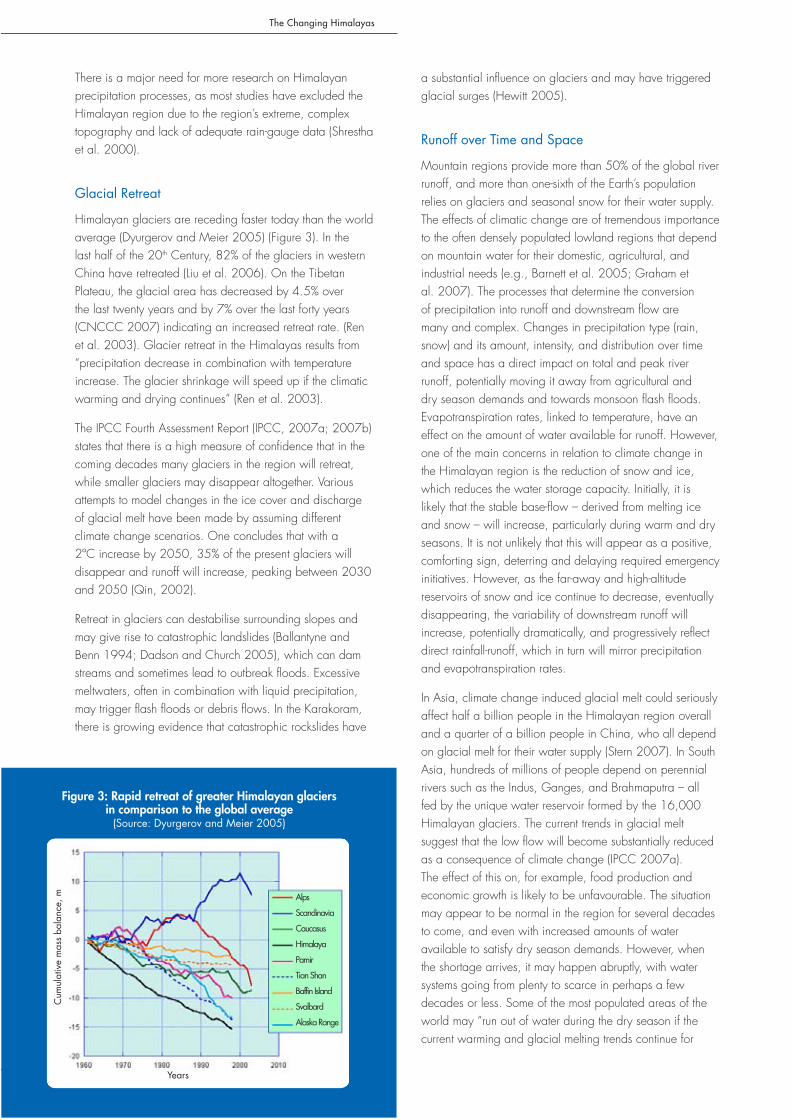
Himalayan glaciers are receding faster today than the world average (Dyurgerov and Meier 2005) (Figure 3). In the last half of the 20th Century, 82% of the glaciers in western China have retreated (Liu et al. 2006). On the Tibetan Plateau, the glacial area has decreased by 4.5% over the last twenty years and by 7% over the last forty years (CNCCC 2007) indicating an increased retreat rate. (Ren et al. 2003). Glacier retreat in the Himalayas results from “precipitation decrease in combination with temperature increase. The glacier shrinkage will speed up if the climatic warming and drying continues” (Ren et al. 2003).
The IPCC Fourth Assessment Report (IPCC, 2007a; 2007b) states that there is a high measure of confidence that in the coming decades many glaciers in the region will retreat, while smaller glaciers may disappear altogether. Various attempts to model changes in the ice cover and discharge of glacial melt have been made by assuming different climate change scenarios. One concludes that with a 2ºC increase by 2050, 35% of the present glaciers will disappear and runoff will increase, peaking between 2030 and 2050 (Qin, 2002).
Retreat in glaciers can destabilise surrounding slopes and may give rise to catastrophic landslides (Ballantyne and Benn 1994; Dadson and Church 2005), which can dam streams and sometimes lead to outbreak floods. Excessive meltwaters, often in combination with liquid precipitation, may trigger flash floods or debris flows. In the Karakoram, there is growing evidence that catastrophic rockslides have
a substantial influence on glaciers and may have triggered glacial surges (Hewitt 2005).
Runoff over Time and Space
Mountain regions provide more than 50% of the global river runoff, and more than one-sixth of the Earth’s population relies on glaciers and seasonal snow for their water supply. The effects of climatic change are of tremendous importance to the often densely populated lowland regions that depend on mountain water for their domestic, agricultural, and industrial needs (e.g., Barnett et al. 2005; Graham et al. 2007). The processes that determine the conversion of precipitation into runoff and downstream flow are many and complex. Changes in precipitation type (rain, snow) and its amount, intensity, and distribution over time and space has a direct impact on total and peak river runoff, potentially moving it away from agricultural and dry season demands and towards monsoon flash floods. Evapotranspiration rates, linked to temperature, have an effect on the amount of water available for runoff. However, one of the main concerns in relation to climate change in the Himalayan region is the reduction of snow and ice, which reduces the water storage capacity. Initially, it is likely that the stable base-flow – derived from melting ice and snow – will increase, particularly during warm and dry seasons. It is not unlikely that this will appear as a positive, comforting sign, deterring and delaying required emergency initiatives. However, as the far-away and high-altitude reservoirs of snow and ice continue to decrease, eventually disappearing, the variability of downstream runoff will increase, potentially dramatically, and progressively reflect direct rainfall-runoff, which in turn will mirror precipitation and evapotranspiration rates.
In Asia, climate change induced glacial melt could seriously affect half a billion people in the Himalayan region overall and a quarter of a billion people in China, who all depend on glacial melt for their water supply (Stern 2007). In South Asia, hundreds of millions of people depend on perennial rivers such as the Indus, Ganges, and Brahmaputra – all fed by the unique water reservoir formed by the 16,000 Himalayan glaciers. The current trends in glacial melt suggest that the low flow will become substantially reduced as a consequence of climate change (IPCC 2007a). The effect of this on, for example, food production and economic growth is likely to be unfavourable. The situation may appear to be normal in the region for several decades to come, and even with increased amounts of water available to satisfy dry season demands. However, when the shortage arrives, it may happen abruptly, with water systems going from plenty to scarce in perhaps a few decades or less. Some of the most populated areas of the world may “run out of water during the dry season if the current warming and glacial melting trends continue for
Figure 3: Rapid retreat of greater Himalayan glaciers in comparison to the global average
(Source: Dyurgerov and Meier 2005)
Cum
ulat
ive
mas
s ba
lanc
e, m
Years
Alps
Scandinavia
Caucasus
Himalaya
Pamir
Tian Shan
Baffin Island
Svalbard
Alaska Range
The Changing Himalayas
7
several more decades” (Barnett et al. 2005). Flooding may also arise as a major development issue. It is projected that more variable, and increasingly direct, rainfall runoff will also lead to more downstream flooding.
Permafrost
Areas in the high mountains and on the high plateaus not covered in perennial snow and ice are underlain by permafrost. Permafrost areas will be sensitive to degradation with climate warming. Recent studies show that the extent of permafrost is shrinking and that the active layer thickness (the upper portion of soil that thaws each summer) is increasing, and, further, that this has altered the hydrological cycle, vegetation composition, and carbon dioxide and methane fluxes that appear linked to permafrost degradation (Lawrence and Slater 2005). The areas covered by permafrost are much larger than those covered by glaciers or perennial snow, especially in China. Permafrost plays a critical role in ecology, slope stability and erosion processes, and surface water hydrology. On the Tibetan Plateau, the recent warming has been associated with decreasing areas of permafrost and a rise in the elevation of its lower altitude, as well as progressive thinning. For
example, in the past three decades, on the Central Tibetan Plateau in the Kekexeli Wildland Area, the lower limit of permafrost has risen by approximately 71 m, while the sustained thickness has decreased by at least 20 cm (Wu et al. 2001). Meanwhile, the extent of seasonal thawing has intensified over large areas of permafrost causing increased ground instability and erosion (Zhao et al. 2004), with consequences such as the activation of the soil carbon pool and northward expansion of shrubs and forests (Lawrence and Slater 2005). The disappearance of permafrost and expansion of non-permafrost will accelerate desertification on the Tibetan Plateau (Ni 2000). Notwithstanding, there is almost no information about the full extent and behaviour of high mountain permafrost areas in the region.
Water Related Hazards
According to the United Nations International Strategy for Disaster Reduction (UNISDR), in 2008, as in 2007, seven of the top ten natural disasters by number of deaths occurred in ICIMOD member countries (Afghanistan, China, India, Myanmar in 2008, Bangladesh, China, India, Pakistan in 2007), accounting for 99% of the total deaths (82% in 2007). This indicates not only the prevalence of
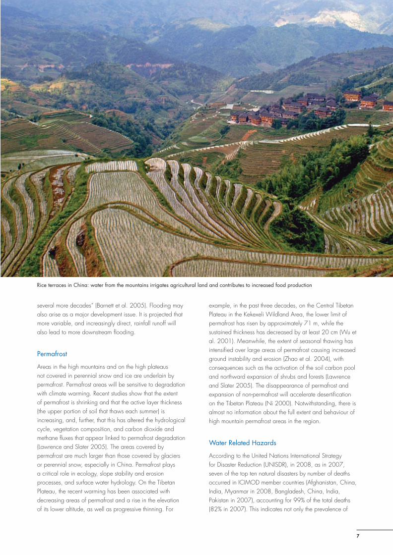
Rice terraces in China: water from the mountains irrigates agricultural land and contributes to increased food production

The Changing Himalayas
8
disasters in the region, but also the susceptibility of the region to such events (Table 5). Climate change involves, perhaps most seriously, changes in the frequency and magnitude of extreme weather events. There is widespread agreement that global warming is associated with extreme fluctuations, particularly in combination with intensified monsoon circulations.
Table 5: Top 10 Natural disasters worldwide in 2008 by number of deaths
Type of disaster (month) Country Number of deaths
Cyclone Nargis (May) Myanmar 138,366
Earthquake (May) China PR 87,476
Flood (June-August) India 1,963
Extreme winter conditions (January)
Afghanistan 1,317
Typhoon Fengshen (Franck) (June)
Philippines 644
Hurricane Hanna (September)
Haiti 529
Mass movement wet (September)
China PR 277
Flood (October) Yemen 180
Flood (June) China PR 176Flood (September) India 173
229784
Source: UNISDR 2008
The lack of data related to climate and water in the region hinders a comprehensive assessment of changes in extreme climatic events. Available studies suggest changes in climatic patterns and an increase in extreme events. An increase in the frequency of high intensity rainfall often leading to flash floods and landslides has been reported (Chalise and Khanal 2001; ICIMOD 2007a; Figure 4). In parts of Central Asia, regional increases in temperature will lead to an increased probability of events such as mudflows and avalanches that could adversely affect human settlements (Iafiazova 1997).
In the eastern and central Himalayas, glacial melt associated with climate change, has led to the formation of glacial lakes behind terminal moraines. Many of these high-altitude lakes are potentially dangerous. The moraine dams are comparatively weak and can breach suddenly, leading to the sudden discharge of huge volumes of water and debris. The resulting glacial lake outburst floods (GLOFs) can cause catastrophic flooding downstream, with serious damage to life, property, forests, farms, and infrastructure. In Nepal, twenty-five GLOFs have been recorded in the last 70 years, including five in the sixties and four in the eighties (Mool, 2001; NEA, 2004; Yamada, 1998). There is an indication that the frequency of GLOF events has increased in recent decades (Figure 4). In the HKH region two hundred and four glacial lakes have been identified as potentially dangerous
which can burst at any time (ICIMOD 2007b).
Consequences for Livelihoods and the Environment
Pastures and Agriculture
The location and area of natural vegetation zones on the Tibetan Plateau will change substantially under projected climate change scenarios. Areas of temperate grassland and cold temperate coniferous forest could expand, while temperate and cold deserts may shrink. The vertical distribution of vegetation zones could move to higher altitude. Climate change may also result in a shift of the boundary of the farming-pastoral transition region to the south in Northeast China, which may increase grassland areas and provide more favourable conditions for livestock production. However, the transition area of the farming-pastoral region is also an area of potential desertification, and if protection measures are not taken in new transition areas, desertification may occur (Li and Zhou 2001; Qiu et al. 2001). More frequent and prolonged droughts as a consequence of climate change together with other anthropogenic factors may also result in desertification.
There is significant uncertainty about the effects of global warming on the vegetation and animal productivity of large dryland ecosystems. Although high altitude drylands
Figure 4: Cumulative occurrence of GLOFs in Nepal (top, source NEA 2004) and flash floods in the greater
Himalayan region (bottom, source Xu Jianchu et al. 2007)
Cum
ulat
ive
occu
rren
ce o
f GLO
Fs
The Changing Himalayas
9
might enjoy increases in net primary productivity (NPP), locally, the greatest confidence is in predicting implications for vegetation production, with lesser confidence in implications for vegetation composition, animal production, and adaptation options (Campbell and Stafford Smith 2000). Climate change has been reported to impact on grassland productivity, ecosystems, and the distribution and composition of plant communities (Wilkes 2008). Some rangelands might suffer from degradation due to the warmer and drier climate (Dirnbock et al. 2003). Degraded rangeland already accounts for over 40% of dryland on the Tibetan Plateau (Zhong et al. 2003; Gao et al. 2005); and it is expanding at a rate of 3 to 5% each year (Ma and Wang 1999). Increases in evaporation, reduction in snow cover, and fluctuations in precipitation are key factors contributing to the degradation of dryland ecosystems.
The possibility of alterations in the overall albedo, water balance, and surface energy balance in high-altitude grasslands and the increasing degradation and desertification of arid areas is causing concern. Signs of the effects of climate change on grasslands have been documented in the northeast Tibetan Plateau where Kobresia sedge and alpine turf communities are changing to semi-arid
alpine steppes, known as ‘black bleaching’ (Ma and Wang 1999; Miller 2000). Qinghai Province in China alone has more than 20,000 km2 of degraded rangeland.
Upward movement of the tree line and encroachment of woody vegetation on alpine meadows are reported widely. In the eastern Himalayas, the tree line is rising at a rate of 5 to 10 m per decade (Baker and Moseley 2007). As temperature rises, species shift their ranges to follow their principal habitats and climatic optima.
Increasing temperatures and water stress are expected to lead to a 30% decrease in crop yields in Central and South Asia by the mid-21st Century (UNDP 2006). At high altitudes and latitudes, crop yields should increase because of reductions in frost and cold damage. It will be possible to grow rice and wheat at higher latitudes than is currently the case in China.
Irrigated lowland agriculture, found in all of the large basins receiving their runoff from the Hindu Kush-Himalayan system, is projected to suffer negatively from lack of dry season water. Considering that the reported or projected glacial meltwater component amounts to, for example, 20 to 40% in rivers in Western China (Tao et al. 2005), 50%
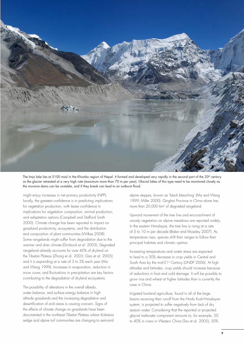
The Imja lake lies at 5100 masl in the Khumbu region of Nepal. It formed and developed very rapidly in the second part of the 20th century as the glacier retreated at a very high rate (maximum more than 70 m per year). Glacial lakes of this type need to be monitored closely as the moraine dams can be unstable, and if they break can lead to an outburst flood.

The Changing Himalayas
10
or more in the Indus (Tarar 1982), and 30% in the major rivers in Nepal during the pre-monsoon season (Sharma 1993), the implications of dry season water stress are likely to be massive. In addition, an increase in agricultural water demand by 6 to 10% or more is projected for every 1°C rise in temperature (IPCC 2007a). As a result, the net cereal production in South Asian countries is projected to decline by at least between 4 to 10% by the end of this century, under the most conservative climate production projections (IPCC 2007a).
Ecosystems
Mountain ecosystems contain a series of climatically very different zones within short distances and elevations. They display a range of micro-habitats with great biodiversity (Körner 2004). Mountain ecosystems are sensitive to global warming and show signs of fragmentation and degradation (Xu and Wilkes 2004; Körner 2004). Species in high-elevation ecosystems are projected to shift to higher altitudes, although alpine plant species with restricted habitat availability above the tree line are projected to experience severe fragmentation, habitat loss, or even extinction if they cannot move to higher elevations (Dirnbock et al. 2003). Climate warming may increase suitable habitats for the water hyacinth (Eichhornia crassipes), a noxious weed able to survive winter temperatures.
The impacts of climate change on forest ecosystems include shifts in the latitude of forest boundaries and the upward movement of tree lines to higher elevations; changes in species’ composition and in vegetation types; and an increase in net primary productivity (NPP) (Ramakrishna et al. 2003). In the eastern Himalayas, forest vegetation will expand significantly; forest productivity will increase from 1 to 10%; and it is expected that forest fires and pests such as the North American pinewood nematode (Bursaphelenchus xylophilus) will increase as dryness and warmth increase (Rebetez and Dobbertin 2004).
Human Health
The impact of climate change on health conditions can be broken into three main categories: (i) direct impacts of for example, drought, heat waves, and flash floods, (ii) indirect effects due to climate-induced economic dislocation, decline, conflict, crop failure, and associated malnutrition and hunger, and (iii) indirect effects due to the spread and aggravated intensity of infectious diseases due to changing environmental conditions (WHO 2005). The latter effect includes the expansion of vector-borne diseases such as malaria and dengue and water-related diseases such as diarrhoea. Regions such as the Hindu Kush-Himalayas, located at the fringe of the current geographic distribution of these and many other diseases, are particularity susceptible
to the negative effect of rising temperatures. It is projected that the spread of malaria, Bartonellosis, tick-borne diseases and infectious diseases linked to the rate of pathogen replication will all be enhanced. Malaria mosquitoes have recently been observed at high altitudes in the region (Eriksson et al. 2008).
Endemic morbidity and mortality due to diarrhoeal disease associated with floods and droughts are expected to rise in East, South and Southeast Asia due to projected changes in the hydrological cycle (IPCC 2007a). This will be in addition to an already very high global burden of climate change attributable diarrhoea. Empirical studies project that the population at risk of dengue fever will be larger in India and China. In these countries, a high increase in mortality due to heat stress is also projected.
However, there are also expected to be positive climate change induced effects on the health status of certain populations in the Himalayan region. High altitude areas will open up to new types of agricultural production and new livelihood opportunities, people will find their homes and villages more comfortable due to less cold conditions, and the risks associated with cold and respiratory diseases will be reduced as the use of fuelwood for heating is reduced.
Mountain Infrastructure
Valuable infrastructure, such as hydropower plants, roads, bridges, and communication systems, will be increasingly at risk from climate change. Entire hydropower generation systems established on many rivers will be in jeopardy if landslides and flash floods increase, and hydropower generation will be affected if there is a decrease in the already low flows during the dry season. Engineers will have to consider how to respond to these challenges (OECD 2003).
A specific hazard related to glacier retreat are the formation of pro-glacial lakes and in some cases the events of glacial lake outburst floods (GLOFs). These can have a devastating effect on important and vulnerable infrastructure downstream such as hydropower stations. Equally important, the operations of hydroelectric power stations will become more complex. With climate change, the complexity and variability of river flow generation will both rise (Renoj et al. 2007) and become increasingly difficult to predict. For example, although the annual average proportion of meltwater in river flow has been estimated at 13% for rivers flowing to the Ganges from Nepal, from March through May the monthly average proportion is more than 30% (Chaulagain 2006). This could have serious implications on river flows and water availability for power plants for about six months per year.
The Changing Himalayas
11
The landmark Qinghai-Tibet Railway, built at a huge cost and associated with important development objectives, is partly built on permafrost. Projected widespread permafrost melting on the Tibetan Plateau can threaten future railway services (Xu et al. 2005; Chen et al. 2005). Likewise, the Yangtze River, China’s largest river and a crucial supplier of water to industry, agriculture, and 500 million domestic users, experienced its lowest upper reaches flow since the 1920s in 2006. With upstream dryland expansion, melting glaciers, and aggravated sediment deposits that affect downstream flood discharge capacity (Wang et al. 2005), the Three Gorges Dam, the world’s largest hydroelectric installation, is also at risk.
Livelihoods, Vulnerability and Adaptation
The term ‘livelihood’ comprises the capabilities, assets (material and social resources), and activities required for a means of living (Carney 1998). Sustainable livelihood includes the idea of coping with and recovering from stresses and shocks, and maintaining or enhancing existing capabilities and assets. Climate change has made the future of mountain indigenous people and their livelihoods more vulnerable and uncertain. The available scientific evidence suggests that climate change will place significant stress on
the rural livelihoods of mountain people. Efforts to reduce vulnerability and enhance the adaptive capacity of at-risk groups need to take a proactive approach that address the social processes leading to vulnerability and the structural inequalities that are often at the root of social-environmental vulnerabilities.
Adaptation to climate change is both related to vulnerability, which can be defined as the “degree to which individuals and systems are susceptible to or unable to cope with the adverse effects of climate change” (Smit and Pilifosova 2001), and to future potential impacts, either avoidable or unavoidable. Effective adaptation includes both the establishment of adaptive capacity (awareness, governance, and knowledge) and the adaptation itself (change of behaviour, practices, and livelihoods according to new conditions) (Mirza 2007). Adaptation consists of a multitude of options depending on the scale, context, and approach. The scale of adaption may be local, national, or regional; the context of the adaptation will determine the type of adaptation (e.g., new farming practices in a rural context or water demand management in an urban context); and the approach to adaptation may focus on general poverty alleviation, enhanced transparency in decision making, or the empowerment of women, among other things.
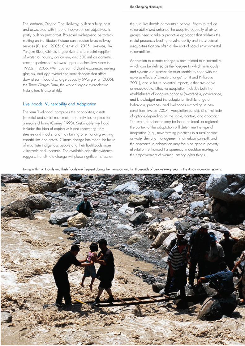
Living with risk: Floods and flash floods are frequent during the monsoon and kill thousands of people every year in the Asian mountain regions.
The Changing Himalayas
12
Structural inequalities that make adaptation by poor people more difficult will need to be levelled. It is important to note that poor and marginalised people already face all of the difficulties that we usually associate with climate change. This is nothing new to them. They are already facing poor health, susceptibility to floods and landslides, and a lack of adequate shelter, food, and water. While they do need climate change adaptation, they need poverty alleviation even more.
China and India’s rapid economic development, which has been moving many tens of thousands of people out of poverty every day, may also provide the best way to handle a changing world. It should be noted that much of the adaptation to climate change will be found outside the sphere of natural sciences. For example, to focus only on flood-safe housing or new types of pest-resistant crops is not enough. The focus must include enhanced capacity to adopt (implying a comprehensive approach) new adaptation strategies. “An adaptation strategy to reduce vulnerability to future climate change needs to be incorporated in regulatory procedures, integrated natural resources management, and other development planning procedures” (UNDP-GEF 2007). As poverty is widespread in the Himalayan region, the empowerment of poor people to adapt to climate change is critical.
Examples of adaptation at different levels may include good governance to mainstream climate change into development and institutional reform (Mirza 2007); general political reform and associated openness (ibid); health education programmes (WHO 2005); and the development of early warning systems for floods, flash floods, and droughts.
Lack of Knowledge – Unknown Downstream Effects
The impact of climate change on the Himalayan cryosphere is not understood sufficiently to be able to estimate the full scale of the downstream impact of reduced snow and ice coverage. While in-depth studies of glaciers, snow, and
permafrost have been carried out in some areas, they are scattered widely in space and time. Few detailed investigations of the response of snow and ice to climate warming have taken place in the Himalayan and other high ranges. Baseline studies are lacking for most areas, particularly for areas higher than 4,000 masl, and there has been little long-term monitoring of climatic variables, perennial snow and ice, runoff, and hydrology in the extraordinary heterogeneity of mountain topography (Liu and Chen 2000; Rees and Collins 2006; Messerli et al. 2004). In addition, the one common feature that all mountain areas share with one another – complexity caused by topography – causes temperature and precipitation to vary over very short distances (Becker and Bugmann 1997), which in turn makes projections difficult.
Three levels of impact to climate change can be identifed: i) local effects; ii) downstream effects; and iii) global feedback effects. The development of adaptive strategies can be approached from the perspective of each of these three different levels. Firstly, adaptive strategies can be developed at the local level, looking at local effects within the Himalayas and giving priority to local adaptation. Secondly, adaptive strategies can be developed from the perspective of the downstream level, evaluating the downstream effects of climate change and designing adaptive strategies around these effects. Thirdly, adaptive strategies can be on the global level, based on the potential feedback mechanism of the environmental changes in the Himalayas to global warming. All three levels are interlinked and interrelated, but full of uncertainty.
Local Effects
Few model simulations have attempted to address issues related to future climatic change in mountain regions, primarily because the current spatial resolution of models is too crude to adequately represent the topographic and land use details (Beniston et al. 2003). Most climate models and predictions for high-altitude areas (above 4,000 masl) are dependent on extrapolation from hydro-
Water from the Hindu Kush mountains supports irrigated agriculture in Afghanistan
The Changing Himalayas
13
meteorological stations at comparatively low altitudes and upon assumptions based on other, better-studied, parts of the world (Rees and Collins 2004). The importance of the most widespread cryogenic processes – avalanches, debris flows, rock glaciers, alpine permafrost, and surging glaciers – has been recognised and their incidence recorded for certain areas. Yet, almost no basic scientific investigation of these cryogenic processes has taken place in the greater Himalayan region, even though they involve significant hazards, which may increase or decrease risk in given areas. The immense diversity of local effects found within the region should be recognised: diversity of climates and topo-climates, hydrology and ecology, and, above all, of human cultures and activities. Before effective responses can be developed, much work has to be carried out to identify and predict the possible effects of climate change across different systems – from glaciers to water resources, from biodiversity to food production, from natural hazards to human health – and filtered through diverse contexts. In particular, there has been little engagement with local populations so far to learn from their knowledge and experience in adapting to unique and changing environments and to address their concerns and needs (Xu and Rana 2005).
Downstream Effects
The downstream effects of changing water flow regimes in the large Himalayan rivers are to a great extent, unknown. Few (if any) studies have attempted to model the impact of a 30-50% reduction in dry season flow on, for example, downstream economic growth, livelihood conditions, and urban water use. It is likely that these changes will have major impacts on downstream societies; however, these impacts are largely unknown. Impacts on water resources will differ depending upon the importance or influence of different sectors (such as tourism, irrigated agriculture, industry, and resource extraction), the ecosystems involved, and the mitigation measures implemented to reduce water-induced hazards. There are substantial variations within, as well as between, these sectors in different countries and valleys in the region.
Global Feedback Effects
Glaciation at low latitudes has the potential to play an important role in the global radiation budget. A climatic feedback mechanism for Himalayan glaciation shows that a higher glacier free or low albedo surface has a cooling effect over the Himalayas and a warming effect
Traditional practices have developed over generations. Will they be able to cope in a changing world?
The Changing Himalayas
14
over the Persian Gulf and the Arabian Peninsula (Bush 2000). The Himalayan region is also an important carbon sink, particularly in terms of carbon storage in the soil of grasslands, wetlands, and forests. Wang et al. (2002) estimate that the organic carbon content of soils subtending grasslands on the Qinghai-Tibet Plateau total 33,500x106 metric tonnes representing almost one quarter of China’s total organic soil carbon and 2.5% of the global pool of soil carbon. Climatic variables influence soil carbon stocks through their effects on vegetation and through their influence on the rate of decomposition of soil organic matter. In grassland ecosystems, net ecosystem productivity (that is, the amount of carbon sequestered) is very small compared to the size of fluxes, so there is great potential for changes affecting fluxes to change the net flow of carbon, and for grasslands, therefore, to shift from being a CO2 sink to a CO2 source (Jones and Donnely 2004), contributing further to global warming.
Policy Recommendations
Reducing Scientific Uncertainty
Develop scientific programmes for climate change monitoring: Credible, up-to-date scientific knowledge is essential for the development of a climate change policy, including adaptation and mitigation measures. The current review finds a severe lack of field observations. It is essential to develop a scientific basis, in collaboration with government agencies and academia. Remote sensing
allows for regular and repeated monitoring of snow cover, which can be carried out by countries such as China and India, with results shared with those lacking such technological infrastructure. Studies need to include both ground-based and satellite-based monitoring. Well-equipped stations and long-term monitoring, networking, and cooperation within and outside the region are essential. Participatory methods of assessing and monitoring climate and environmental change, local perceptions, and practices at the local level are also required. Local communities can play a role in determining adaptation practices based on local information and knowledge. School science programmes can be developed and introduced in local communities.
Application of regional climate models (RCMs): The Himalayas are not well represented in global models because of the coarse resolution of such models. Regional climate models, with a higher resolution than global ones, need to be constructed for ‘hotspots’ and run for shorter periods (20 years or so). The results of RCMs have to be downscaled and applied to impact assessments, particularly for watersheds or sub-catchments.
Mitigation Measures
Beyond the Kyoto protocol: With rapid regional economic growth, China and India, in particular, should accept equal, albeit differentiated, responsibility to developed countries for controlling increasing carbon emissions.
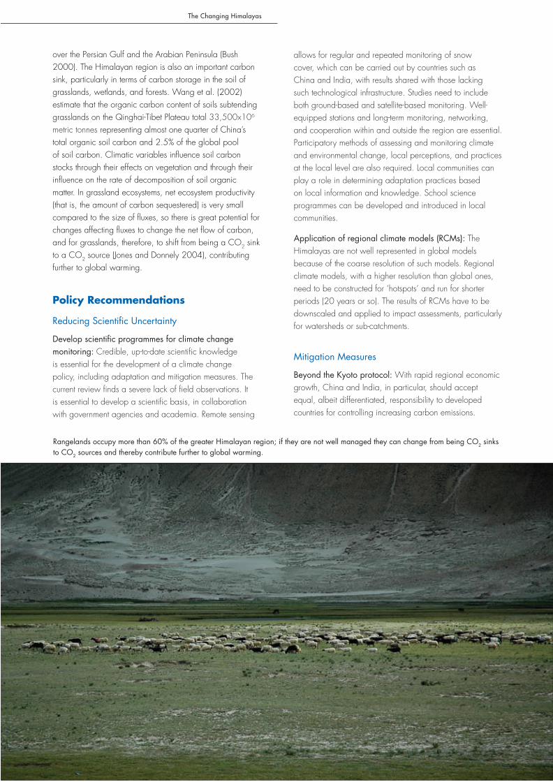
Rangelands occupy more than 60% of the greater Himalayan region; if they are not well managed they can change from being CO2 sinks to CO2 sources and thereby contribute further to global warming.
The Changing Himalayas
15
Countries should jointly develop a regional action plan for the control of emissions. Participation of all countries has to be achieved by allowing them to interpret the mandates of international agreements according to their national interests and priorities.
Land-use management for carbon sinks and reduced emissions: Many countries in the Himalayas have experienced forest recovery (or transition), through policy intervention and the participation of local communities in forest management. Examples include forest conservation in Bhutan, tree plantation in China, community forest user groups in Nepal, and joint forest management in India. The forests conserved have contributed significantly to carbon sequestration (Fang et al. 2001).
Payment for ecosystem services (PES): The mountains of the greater Himalayas provide abundant services to the downstream population in terms of water for household purposes, agriculture, hydropower, tourism, spiritual values, and transport. There is a heavy responsibility leaning on the shoulders of upstream land and water managers to ensure reliable provision of good quality water downstream. PES schemes can be developed at different scales, from local to national to regional, and involve local communities, governments, and the private sector. So far, the opportunities to establish PES schemes in the Himalayas to ensure safe provision of good quality water remain largely unexplored. However, land and water managers, as well as policy and decision makers, should be encouraged to look for win-win solutions in this context.
Development of alternative technologies: Novel and affordable technologies and energy resources that do not emit greenhouse gases are needed. Notable examples in the region include the diffusion of hydropower in Bhutan, solar energy and biogas in China, bio-diesel and wind energy in India, and biogas and micro-hydropower in Nepal.
Adaptation Measures
Disaster risk reduction and flood forecasting: Floods are the main natural disaster aggravating poverty in the Himalayas and downstream. Technical advances in flood forecasting and management offer an opportunity for regional cooperation in disaster management. Regional cooperation in transboundary disaster risk management should become a political agenda. Preparedness for disasters is essential (www.disasterpreparedness.icimod.org).
Supporting community-led adaptation: One approach to vulnerability and local level adaptation is ‘bottom-up’ community-led processes built on local knowledge, innovations, and practices. The focus should be on empowering communities to adapt to a changing climate
and environment based on their own decision-making processes and participatory technology development with support from outsiders. For example, Tibetan nomads have already noticed the earlier spring and moved yaks to alpine meadows earlier than previously practised. Farmers in the floodplains of Bangladesh build houses on stilts, and Nepali farmers store crop seeds for post-disaster recovery. Priority should be given to the most vulnerable groups such as women, the poor, and people living in fragile habitats such as along riversides and on steep slopes.
National adaptation plans of action (NAPAs): NAPAs are currently being prepared by countries under the initiative of the UN Framework Convention on Climate Change. They are expected (a) to identify the most vulnerable sectors to climate change and (b) to prioritise activities for adaptation measures in those sectors. NAPAs need to pay more attention to sectors such as water, agriculture, health, disaster reduction, and forestry, as well as the most vulnerable groups.
Integrated water resources management: Disaster preparedness and risk reduction should be seen as an integral part of water resources management. Integrated water resources management (IWRM) should include future climate change scenarios and be scaled up from watersheds to river basins. Water allocation for households, agriculture, and ecosystems deserves particular attention. Water storage, based on local practices, should be encouraged in mountain regions.
Public Awareness and Engagement
Full disclosure and prior information for grassroot societies: Indigenous and local communities should be fully informed about the impacts of climate change. They have a right to information and materials in their own languages and ways of communicating.
Engagement of the media and academia: Awareness and knowledge among stakeholders generally about the impacts of global warming and the threat to the ecosystem, communities, and infrastructure are inadequate. The media and academia together can play a significant role in public education, awareness building, and trend projection.
Facilitation of international policy dialogue and cooperation: Regional and international cooperation needs to advance in order to address the ecological, socioeconomic, and cultural implications of climate change in the Himalayas. The international community, including donors, decision-makers, and the private and public sectors, needs to be involved in regional cooperation ventures. This is of particular importance for achieving sustainable and efficient management of transboundary rivers.
The Changing Himalayas
16
Conclusions
The Himalayan region contains one of the most dynamic and complex mountain systems in the world. This mountain system is extremely vulnerable to global warming (Bandyopadhyay and Gyawali 1994). Uncertainties about the rate and magnitude of climate change and potential impacts prevail, but there is no question that climate change is gradually and powerfully changing the ecological and socioeconomic landscape in the Himalayan region, particularly in relation to water. Business as usual is not an option. It is imperative to revisit and redesign research agendas, development policies, and management and conservation practices, and develop appropriate technologies. The mitigation of carbon emissions should be a responsibility shared between citizens and the private sector in the mountains, as elsewhere. Adaptation and mitigation measures intended to cope with climate change can create opportunities as well as offset the dangers of a warming planet; but they must be identified and adopted ahead of, rather than in reaction to, dangerous trends. Policies should be ‘adaptation friendly’.
Himalayan uncertainty: We speak of uncertainty on a Himalayan scale recognising the lack of studies and basic data. In no context is this more relevant than in predicting what climate change will entail. The physical manifestations of climate change in the mountains include locally, possibly regionally, extreme increases in temperature and in the frequency and duration of extreme events. It seems certain that there will be appreciable changes in the volume and/or timing of river flows and other freshwater sources. There is, however, great uncertainty about the rate, and even the direction, of these changes, because so little is known about the dynamics of Himalayan topo-climates and hydrological processes and their response to changing climatic inputs. The global circulation models used to model climates capture global warming on a broad scale, but do not have adequate predictive power for even large Himalayan drainage basins. To reduce uncertainty, we need well-equipped baseline stations, long-term monitoring, networking, open data exchange, and cooperation between all Himalayan countries. ICIMOD can play a role in facilitating knowledge generation, exchange, and cooperation with international mountain research programmes such as the Global Observation Research Initiative in Alpine Environments (GLORIA), Global Mountain Biodiversity Assessment (GMBA), UNESCO Biosphere Reserves, Monsoon Asia Integrated Regional Studies (MAIRS), and the Mountain Research Initiative.
Adaptation: Adaptation is the need for flexibility and resilience. Climate change is not new to Himalayan people. During very long time periods every aspect of life has been adapted to, or stressed by, changing temperature regimes, water availability, and extreme events. Himalayan farmers and herders have a long history of adapting to these
uncertainties, to other related and unrelated environmental changes, and to ecological surprises, whether through mobility of people and land uses, or flexibility in livelihood strategies and institutional arrangements. Mountain people have lived with and survived great hazards such as flash floods, avalanches, and droughts for millennia. Building the capacity to adapt and strengthen the socio-ecological system in the face of climate change is extremely important and an important step in achieving sustainable livelihoods. Climate change, as a public and global issue, has evolved from a narrow interest in the hydro-meteorological sciences, to a broad recognition that both the social consequences and policies in response have implications for all aspects of human development. Adaptive policies and major efforts to reverse the human drivers of climate change have to be incorporated into all sectors: land use, water management, disaster management, energy consumption, and human health. Hazard mapping would help both decision-makers and local communities to understand the current situation and, through this, it would be possible to anticipate or assess the flexibility to adapt to future changes through proper planning and technical design.
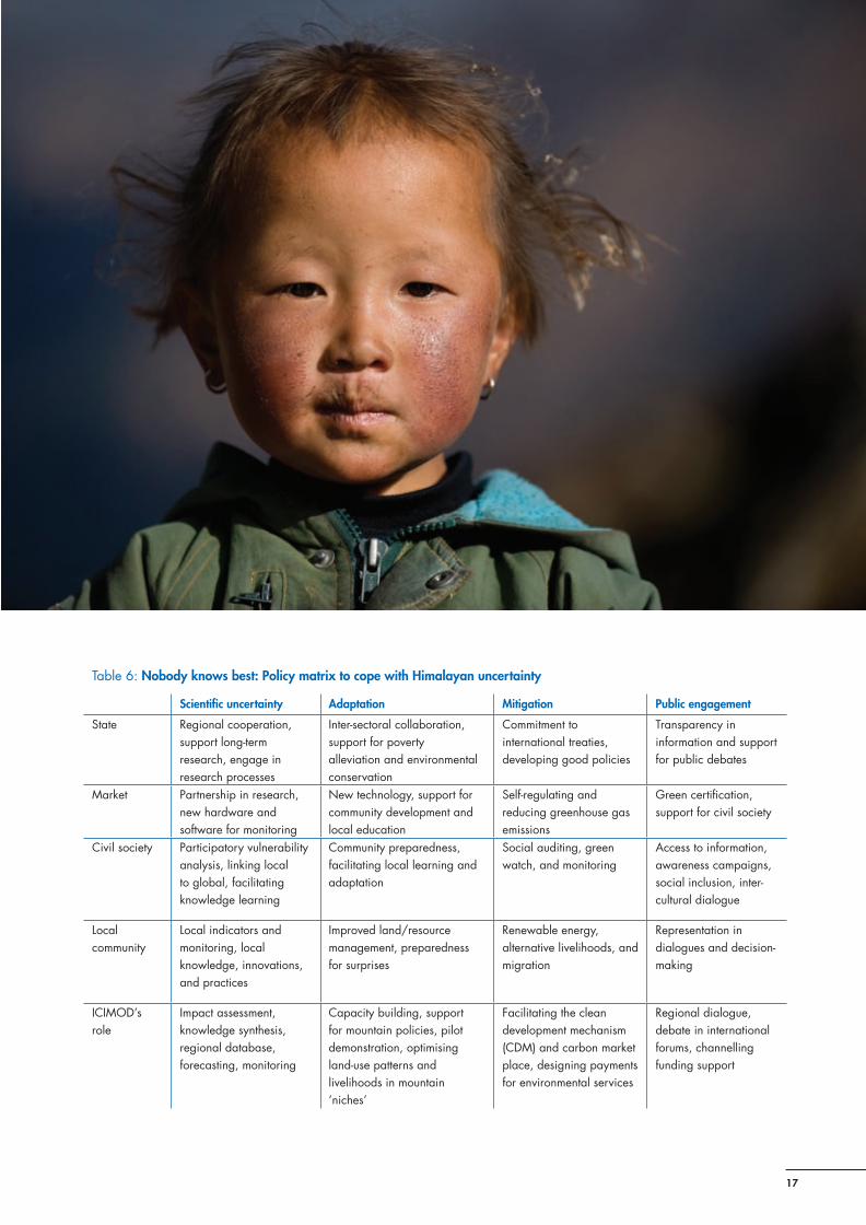
Linking science and policy in climate change: Good science based on credible, salient, legitimate knowledge can often lead to good policies in the context of climate change and mountain specificities, and vice versa (Thompson and Gyawali 2007). By credible, we mean knowledge that has been derived from field observations and tested by local communities. Salient information is information that is immediately relevant and useful to policy-makers. Legitimate information is unbiased in its origins and creation and both fair and reasonably comprehensive in its treatment of opposing views and interests. Policy is a formula for the use of power and application of knowledge. The question then is who has the power and who has the knowledge, scientific or local, or a combination of both? Scientific knowledge is useful, but limited and full of uncertainties on the complex Himalayan scale. So, ‘nobody knows best’ becomes the model (Lebel et al. 2004) (Table 6). Alternative perspectives carry their own set of values and perceptions about who should be making the rules, where the best knowledge lies to guide decisions, and about what other knowledge is needed. Four contrasting perspectives – state, market, civil society and the greens, and locals – merge together in decision-making processes. In such processes, scientists have to generate new knowledge with reduced uncertainty and facilitate dialogue with balanced perspectives. The role of different actors in contributing to resolving scientific uncertainty, adaptation, mitigation, and public engagement through this approach can be summarised in the form of the matrix in Table 6. In such processes, international cooperation is essential for the transfer of technology from outsiders to locals, to build regional cooperation into a global programme, and to develop the capacity to downscale important results to the regional HKH scale.
The Changing Himalayas
17
Table 6: Nobody knows best: Policy matrix to cope with Himalayan uncertainty
Scientific uncertainty Adaptation Mitigation Public engagement
State Regional cooperation, support long-term research, engage in research processes
Inter-sectoral collaboration, support for poverty alleviation and environmental conservation
Commitment to international treaties, developing good policies
Transparency in information and support for public debates
Market Partnership in research, new hardware and software for monitoring
New technology, support for community development and local education
Self-regulating and reducing greenhouse gas emissions
Green certification, support for civil society
Civil society Participatory vulnerability analysis, linking local to global, facilitating knowledge learning
Community preparedness, facilitating local learning and adaptation
Social auditing, green watch, and monitoring
Access to information, awareness campaigns, social inclusion, inter-cultural dialogue
Local community
Local indicators and monitoring, local knowledge, innovations, and practices
Improved land/resource management, preparedness for surprises
Renewable energy, alternative livelihoods, and migration
Representation in dialogues and decision-making
ICIMOD’s role
Impact assessment, knowledge synthesis, regional database, forecasting, monitoring
Capacity building, support for mountain policies, pilot demonstration, optimising land-use patterns and livelihoods in mountain ‘niches’
Facilitating the clean development mechanism (CDM) and carbon market place, designing payments for environmental services
Regional dialogue, debate in international forums, channelling funding support
The Changing Himalayas
18
Impact of Climate Change on Water Resources and Livelihoods in the Greater Himalayas
Five ‘take home messages’
1 Reduce scientific uncertainty There is a severe knowledge gap on a Himalayan scale in understanding the impact of climate change on the
availability of water resources in time and space, and changes in the frequency and magnitude of water-induced hazards. Appreciable changes in the volume and/or timing of river flows are likely, but there is great uncertainty about the rate, and even the direction, of these changes. There is an urgent need to close this knowledge gap in order to provide policy and decision makers with knowledge upon which well informed decisions can be made for water resources management and disaster risk reduction.
2 Reduce risk from floods and flash floods Water induced disasters such as riverine floods and flash floods are the main natural disasters in the Himalayas
and downstream river basins. Water induced disasters account for more than 70% of all economic losses and more than half of the casualties. Reducing the risks from these disasters is fundamental for poverty alleviation and sustainable development. Sharing of hydrometeorological information in a regional transboundary upstream-downstream context is crucial for the establishment of efficient early warning systems and for disaster preparedness.
3 Support community-led adaptation Local communities in developing countries are the first to encounter the adverse effects of climate change. Poor
and marginalised groups such as the Himalayan mountain population and downstream flood plain inhabitants are particularly vulnerable. One approach to reducing vulnerability and strengthening local level adaptation is that of ‘bottom-up’ community-led processes built on local knowledge, innovations, and practices. The focus should be on empowering communities to adapt to a changing climate and environment based on their own decision-making processes and participatory technology development with support from outsiders.
4 Regional cooperation for sustainable and prosperous water management Climate change (and other drivers) poses a real threat to the Himalayan region and its large rivers and to the
inhabitants of their basins. The challenges ahead are of regional and overarching nature. The countries of the greater Himalayan region need to seek common solutions to common problems. Regional cooperation needs to advance in order to address the ecological, socioeconomic, and cultural implications of climate change in the Himalayas. The international community, including donors, decision-makers, and the private and public sectors, should be involved in regional cooperation ventures. This is of particular importance to achieve sustainable and efficient management of transboundary rivers.
5 Payment for Ecosystem Services (PES) The mountains of the greater Himalayas provide abundant services to the downstream population in terms of
water for household purposes, agriculture, hydropower, tourism, spiritual values, and transport. There is a heavy responsibility leaning on the shoulders of upstream land and water managers to ensure reliable provision of good quality water downstream. PES schemes can be developed at different scales, from local to national to regional, and involve local communities, governments, and the private sector. So far, opportunities to establish PES schemes in the Himalayas to ensure safe provision of good quality water are largely unexplored. However, land and water managers, as well as policy and decision makers, should be encouraged to look for win-win solutions in this context.
The Changing Himalayas
19

The Changing Himalayas
20
References
Alford, D (1992) Hydrological Aspects of the Himalayan Region. Kathmandu: ICIMOD
Baker, BB; Moseley, RK (2007) Advancing treeline and retreating glaciers: implications for conservation in Yunnan, P.R. China. Arctic, Antarctic and Alpine Research 39 (2): 200-209
Ballantyne, CK; Benn, DI (1994) Paraglacial slope adjustment and resedimentation following recent glacier retreat, Fabergstolsdalen, Norway’. Arctic and Alpine Research 26(3): 255-269
Bandyopadhyay, J; Gyawali, D (1994) ‘Himalayan water resources: ecological and political aspects of management’. Mountain Research and Development 14(1): 1-24
Barnett, TP; Adam, JC; Lettenmaier, DP (2005) ‘Potential impacts of a warming climate on water availability in a snow-dominated region’. Nature 438(17): 303-309
Becker, A; Bugmann, H (eds) (1997) Predicting global change impacts on mountain hydrology and ecology: integrated catchment hydrology/altitudinal gradient studies, Workshop Report 43. Stockholm: International Geosphere-Biosphere Programme (IGBP)
Beniston, M (2003) ‘Climatic change in mountain regions: a review of possible impacts’. Climatic Change 59: 5-31
Bush, ABG (2000) ‘A positive climate feedback mechanism for Himalayan glaciation’. Quaternary International 65-66: 3-13
Campbell, BD; Stafford Smith, BD (2000) ‘A synthesis of recent global change research on pasture and rangeland production: reduced uncertainties and their management implications’. Agriculture, Ecosystems and Environment 82: 39–55
Carney, D (ed) (1998) Sustainable Rural Livelihoods. London: DFID
Chalise, SR; Khanal, NR; (2001) An introduction to climate, hydrology and landslide hazards in the Hindu Kush-Himalayan region. In Tianchi, L; Chalise, SR; Upreti, BN (eds) Landslide Hazard Mitigation in the Hindu Kush-Himalayas, pp 51-62. Kathmandu: ICIMOD
Chaulagain, NP (2006) Impact of Climate Change on Water Resources of Nepal. PhD Thesis. University of Flensburg, Flensburg.
Chen, YN; Li, WH; Xu, CC; Hao, XM (2007) ‘Effects of climate change on water resources in Tarim River Basin, Northwest China’. Journal of Environmental Sciences 19(2007) 488–493
Chen, Y; Ding, Y; She, Z (2005) Assessment of Climate and Environment Changes in China (II): Impacts, adaptation and mitigation of climate and environment changes. Beijing: China Science Press.
CNCCC (2007) China National Report on Climate Change 2007 (in Chinese). Beijing: China National Committee on Climate Change
Dadson, SJ; Church, M (2005) ‘Postglacial topographic evolution of glaciated valleys: a stochastic landscape evolution model’. Earth Surface Processes and Landforms 30(11): 1387-1403
Dirnbock, T; Dullinger, S; Grabherr, G (2003). ‘A regional impact assessment of climate and land-use change on alpine vegetation’. Journal of Biogeography 30: 401–417
Du, MY; Kawashima, S; Yonemura, S; Zhang, XZ; Chen, SB (2004) ‘Mutual influence between human activities and climate change in the tibetan plateau during recent years’. Global and Planetary Change 41: 241-249
Dyurgerov, MD; Meier, MF (2005) Glaciers and Changing Earth System: A 2004 Snapshot, Boulder (Colorado): Institute of Arctic and Alpine Research, University of Colorado
Eriksson M; Fang, J; Dekens, J (2008) ‘How does climate affect human health in the Hindu Kush-Himalaya region?’, Regional Health Forum 12(1):11-15
Fang, JY; Chen, AP; Peng, CH; Zhao, SQ; Ci, LJ (2001) ‘Changes in forest biomass carbon storage in China between 1949 and 1998.’ Science 292: 2320-2322
Farooq, AB; Kham, AH (2004) Climate change perspective in Pakistan. Proceedings of Capacity Building APN Workshop on Global Change Research, Islamabad, p.39-46
Gao, QZ; Li, Y; Lin, ED; Jiangcu, WZ; Wan, YF; Xiong, W; Wang, BS; Li, WF (2005) ‘Temporal and spatial distribution of grassland degradation in northern Tibet’. Acta Geographica Sinica 60(6): 965-973
Gao, X J; Li, DL; Zhao, ZC; Giorgi, F (2003) ‘Climate change due to greenhouse effects in Qinghai-Xizang Plateau and along the Qianghai-Tibet Railway’. Plateau Meteorol. 22(5): 458–463
Graham, LP; Hagemann, S; Jaun, S; Beniston, M (2007) ‘On interpreting hydrological change from regional climate models’. Climate Change: 81(supp1): 97-122
Hewitt, K (2005) ‘The Karakoram anomaly? Glacier expansion and the ‘elevation effects’ Karakoram Himalaya’. Mountain Research and Development 25(4): 332-340
Hofer, T; Messerli, B (2006). Floods in Bangladesh: History, Dynamics and Rethinking the Role of the Himalayas. New York: United Nations University Press
Iafiazova, RK (1997) ‘Climate change impact on mud flow formation in Trans-Ili Alatay Mountains’. Hydrometeorology and Ecology 3: 12-23 (in Russian)
ICIMOD (2007a) Flash Flood Hotspot Mapping in the Hindu Kush-Himalayan Region (draft DVD ROM). Kathmandu: ICIMOD
ICIMOD (2007b) Inventory of Glaciers, Glacial Lakes and Identification of Potential Glacial Lake Outburst Flood (GLOFs) Affected by Global Warming in the Mountains of the Himalayan Region (DVD ROM). Kathmandu: ICIMOD
IPCC (2007a) Climate Change 2007: The Physical Science Basis. Contribution of Working Group I to the Fourth Assessment Report of the Intergovernmental Panel on Climate Change [Solomon, S; Qin, D; Manning, M; Chen, Z; Marquis, M; Averyt, KB; Tignor, M; Miller, HL (eds)]. Cambridge and New York: Cambridge University Press
IPCC (2007b) Climate Change 2007: Impacts, Adaptation and Vulnerability. Contribution of Working Group II to the

The Changing Himalayas
21
Fourth Assessment Report of the Intergovernmental Panel on Climate Change [Parry, ML; Canziani, OF; Palutikof, JP; van der Linden, PJ; Hanson, CE (eds)]. Cambridge: Cambridge University Press
IUCN, IWMI, Ramsar Convention, and WRI (2003) Water Resources Atlas. Available at http://multimedia.wri.org/watersheds_2003/index.html (accessed 12 June 2007)
Ives, JD; Messerli B (1989) The Himalayan Dilemma: Reconciling Development and Conservation. London: John Wiley and Sons
Jones, M; Donnely, A (2004) ‘Carbon sequestration in temperate grassland ecosystems and the influence of management, climate and elevated CO2’. New Phytologist 164: 423-439
Kattelmann, R (1987) ‘Uncertainty in assessing Himalayan water resources’. Mountain Research and Development 7(3): 279-286
Körner, C (2004) ‘Mountain biodiversity, its causes and function’. Ambio 13: 11-17
Kumar, V; Singh, P; Singh, V (2007) ‘Snow and glacier melt contribution in the Beas River at Pandoh Dam, Himachal Pradesh, India’. Hydrological Sciences–Journal des Sciences Hydrologiques 52(2): 376 - 388
Lawrence, DM; Slater, AG (2005) “A projection of severe near-surface permafrost degradation during the 21st Century’. Geophysical Research Letters 32(L24401): 1-5
Lebel, L; Contreras, A; Pasong, S; Garden, P (2004) ‘Nobody knows best: alternative perspectives on forest management and governance in Southeast Asia’. International Environmental Agreements: Politics, Law and Economics, 4(2): 111-127
Li, BL; Zhou, CH (2001) ‘Climatic variation and desertification in West Sandy Land of Northeast China Plain’. Journal of Natural Resources, 16:234-239
Liu, X; Hou, P (1998) ‘Qingzang Gaoyuan jiqi linjin diqu jin 30 nian qihou biannuan yu haiba gaodu de guanxi’. Gaoyuan Qixiang, 17(3): 245-249
Liu, SY; Ding, YJ; Li, J; Shangguan, DH; Zhang, Y (2006) ‘Glaciers in response to recent climate warming in Western China’. Quaternary Sciences, 26(5): 762-771
Liu, X; Chen, B (2000) Climatic warming in the Tibetan Plateau during recent decades. International Journal of Climatology, 20: 1729-1742
Ma, YS; Wang, QJ (1999) Black soil type of rangeland degradation: an overview and perspective. Pratacultural Science, 16(2): 5-9
Macintosh, D (2005) ‘Asia, eastern, coastal ecology’. In Schwartz, M (ed) Encyclopedia of Coastal Science. pp 56-67 Dordrecht: Springer,
Mei’e, R; Renzhang, Y; Haoshend, B (1985) An outline of China’s Physical Geography. Beijing: Foreign Language Press
Merz, J (2004) Water balances, floods and sediment transport in the Hindu Kush-Himalayas. Berne: Institute of Geography, University of Berne
Messerli, B; Viviroli, D; Weingartner, R (2004) ‘Mountains of the world: vulnerable water towers for the 21st Century’. Ambio, 13: 29-34
Mi, D; Xie, Z (2002) Glacier inventory of China. Xi’an: Xi’an Cartographic Publishing House
Miller, DJ (2000) Searching for grass and water: Rangeland ecosystem sustainability and herders’ livelihoods in Western China. Unpublished manuscript submitted to ICIMOD, Kathmandu
Mirza, M (2007) Climate change, adaptation and adaptative governance in the water sector in South Asia. Scarborough (Canada): Adaptation and Impacts Research Division (AIRD), Department of Physical and Environmental Sciences, University of Toronto
Mool, P (2001) Glacial lakes and glacial lake outburst floods, ICIMOD Mountain Development Profile, MDP#2. Kathmandu: ICIMOD
NEA (2004) Upper Tamakoshi Hydroelectric Project Feasibility Study. Kathmandu: Nepal Electricity Authority
New, M; Lister, D; Hulme, M; Makin, I (2002) ‘A high-resolution data set of surface climate over global land areas’. Climate Research 21: 1 - 25
Ni, J (2000) ‘A simulation of biomes on the Tibetan Plateau and their responses to global climate change’. Mountain Research and Development 20(1): 80-89
Nicholls, RJ (1995) Coastal mega-cities and climate change. GeoJournal 37: 369-379
Niou, QY (2002) 2001-2002 Report on Chinese metropolitan development p.354. Beijing: Xiyuan Press (in Chinese)
OECD (2003) Development and climate change: Focus on water resources and hydropower. Paris: Organization for Economic Co-operation and Development
Owen, LA; Finkel, RC; Caffee, MW (2002) ‘A note on the extent of glaciation throughout the Himalaya during the global last glacial maximum’. Quaternary Science Reviews 21:147-157
Penland, S; Kulp, MA (2005) ‘Deltas’. In Schwartz, ML (ed) Encyclopedia of Coastal Science, pp 362-368. Dordrecht: Springer
Qin, D (1999) Map of glacier resources in the Himalayas Beijing: Science Press and Chinese Academy of Sciences, Lanzhou Institute of Glaciology and Geocryology
Qin, DH (2002) Glacier inventory of China (maps). Xi’an: Xi’an Cartographic Publishing House
Qiu, GW; Hao, YX; Wang, SL (2001) ‘The impacts of climate change on the interlock area of farming-pastoral region and its climatic potential productivity in Northern China’. Arid Zone Research 18: 23-28
Ramakrishna, RN; Keeling, CD; Hashimoto, H; Jolly, WM; Piper, SC; Tuker, CJ; Myneni, RB; Running, SW (2003) ‘Climate-driven increases in global terrestrial net primary production from 1982 to 1999’. Science, 300: 1560-1563

The Changing Himalayas
22
Rebetez, M; Dobbertin, M (2004) ‘Climate change may already threaten scots pine stands in the Swiss Alps’. Theoretical and Applied Climatology 79(1-2):1-9
Rees, GH; Collins, DN (2006) ‘Regional differences in response of flow in glacier-fed Himalayan rivers to climate warming’. Hydrological Processes 20: 2157-2167
Rees, GH; Collins, DN (2004) An Assessment of the Impacts of Deglaciation on the Water Resources of the Himalaya. Wallingford: Centre for Ecology and Hydrology
Ren, JW; Qin, DH; Kang, SC; Hou, SG; Pu, JC; Jin, ZF (2003) ‘Glacier variations and climate warming and drying in the central Himalayas’. Chinese Science Bulletin 48(23): 2478-2482
Renoj, J; Thayyen, JT; Dobhai, DP (2007) ‘Role of glaciers and snow cover on headwater river hydrology in monsoon regime – Micro-scale study of Din Gad catchment, Garhwal Himalaya, India’. Current Science 92(3): 376-382
Ruosteenoja, K; Carter, TR; Jylhä, K; Tuomenvirta, H (2003) ‘Future climate in world regions: an intercomparison of model-based projections for the new IPCC emissions scenarios’. The Finnish Environment 644: 83. Helsinki: Finnish Environment Institute
Rupa Kumar, K; Sahai, AK; Krishna Kumar, K; Patwardhan, SK; Mishra, PK; Revadkar, JV; Kamala, K; Pant, GB (2006) ‘High resolution climate change scenario for India for the 21st Century’. Current Science 90: 334-345
Sanlaville, P; Prieur, A (2005) ‘Asia, Middle East, coastal ecology and geomorphology’. In Schwartz, ML (ed) Encyclopedia of Coastal Science, pp 71-83. Dordrecht: Springer
Sharma, KP (1993) ‘Role of Meltwater in Major River Systems of Nepal’. In Young, GJ (ed) International Symposium on Snow and Glacier Hydrology, Kathmandu, International Association of Hydrological Sciences, Publication No. 218, pp 113 - 122. Wallingford (UK): IAHS
She, ZX (2004) ‘Human-land interaction and socio-economic development, with special reference to the Changjiang Delta’. In Proceedings of Xiangshan Symposium on Human-land Coupling System of River Delta Regions: Past, Present and Future. Beijing (in Chinese)
Shrestha, AB; Wake, CP; Dibb, JE; Mayewski, PA (2000) ‘Precipitation fluctuations in the Nepal Himalaya and its vicinity and relationship with some large-scale climatology parameters’. International Journal of Climatology 20: 317 -327
Shrestha, AB (2004) ‘Climate change in Nepal and its impact on Himalayan glaciers’. In Hare, WL; Battaglini, A; Cramer, W; Schaeffer, M; Jaeger, C (eds) Climate hotspots: Key vulnerable regions, climate change and limits to warming, Proceedings of the European Climate Change Forum Symposium. Potsdam: Potsdam Institute for Climate Impact Research
Shrestha, AB; Wake, CP; Mayewski, PA; Dibb, JE (1999) ‘Maximum temperature trends in the Himalaya and its vicinity: an analysis based on temperature records from Nepal for the period 1971-94’. Journal of Climate 12: 2775-2787
Singh, P; Bengtsson, L (2004) Hydrological sensitivity of a large Himalayan basin to climate change. Hydrological Processes 18: 2363-2385
Smit, B; Pilifosova, O (2001) Adaptation to climate change in the context of sustainable development and equity’. In Climate Change 2001: Impacts, Adaptation And Vulnerability, Chapter 18. Cambridge: Cambridge University Press
Stern, N (2006) The Economics of Climate Change. London: Cambridge University Press
Stern, N (2007) Stern Review on the Economics of Climate Change. Cambridge: Cambridge University Press.
Tan, L; Cai, Y; Yi, L; An, Z; Li, Ai, L (2008) Precipitation variations of Longxi, northeast margin of Tibetan Plateau since AD 960 and their relationship with solar activity. Climate of the Past 4: 19-28
Tao, F; Yokozawa, M; Hayashi, Lin, E (2005) A perspective on water resources in China: interactions between climate change and soil degradation. Climatic Change 68: 169-197
Tarar, RN (1982) ‘Water resources investigation in Pakistan with the help of Landsat imagery snow surveys, 1975-1978’. In Hydrological aspects of alpine and high mountain areas. Proceedings of the Exeter Symposium, July 1992, IAHS Publication No 138, 177-190. Wallingford: IAHS
Thompson, M; Gyawali, D (2007) ‘Introduction: Uncertainty revisited’. In Thompson, M; Warburton, M; Hatley, T (eds) Uncertainty on a Himalayan Scale. Kathmandu: Himal Books
UNISDR (2008) 2008 Disasters in numbers. United Nations International Strategy for Disaster Reduction. Geneva: UNISDR
UNDP (2006) Human Development Report: Beyond Scarcity: Power, Poverty and the Global Water Crisis. New York: United Nations Development Programme
UNDP-GEF (2007) Climate change impacts, vulnerability and adaptation in Asia and the Pacific. A background note for the Training Workshop on Environmental Finance and GEF Portfolio Management, 22-25 May 2007, Bangkok, Thailand
Wang, Xin; Xie, Zi-chu; Feng, Qing-hua; et al. (2005) ‘Response of glaciers to climate change in the source region of the Yangtze river’. Journal of Glaciology and Geocryology 27(4): 498-502
Wang, GX; Qian, J; Cheng, G; Lai, Y (2002) ‘Soil organic carbon pool of grassland soils on the Qinghai-Tibetan Plateau and its global implication’. Science of the Total Environment 291: 207–217
WHO (2005) Human health impacts from climate variability and climate change in the Hindu Kush-Himalaya region. Report from an Inter-Regional Workshop, Mukteshwar, India, October 2005
Wilkes, A (2008) Towards mainstreaming climate change in grassland management policies and practices on the Tibetan Plateau, Working Paper No. 67. Beijing: World Agroforestry Centre, ICRAF-China
Winiger, M; Gumpert, M; & Yamout, H (2005) Karakoram-Hindu Kush-Western Himalaya: assessing high-altitude water resources. Hydrological Processes 19(12): 2329-2338

The Changing Himalayas
23
Woodroffe, CD; Nicholls, RJ; Saito, Y; Chen, Z; Goodbred, SL; (2006) ‘Landscape variability and the response of Asian megadeltas to environmental change’. In Harvey, N (ed) Global change and integrated coastal management: the Asia-Pacific region, pp 277-314. New York: Springer
Wu, QB; Li, X; Li, WJ (2001) The response model of permafrost along the Qinghai-Tibetan highway under climate change. Journal of Glaciology and Geocryology, 23(1): 1-6
Xu, Y; Zhao, Z-C; Li, D (2005) ‘Simulations of climate change for the next 50 years over Tibetan Plateau and along the line of Qing-Zang Railway’. Plateau Meteorology 24(5): 698-707
Xu, J; Rana, GM (2005) ‘Living in the Mountains’. In Jeggle, T (ed) Know Risk, pp 196-199. Geneva: UN Inter-agency Secretariat of the International Strategy for Disaster Reduction
Xu, JC (2008) The highlands: a shared water tower In a changing climate and changing Asia. Working Paper No. 67. Beijing: World Agroforestry Centre, ICRAF-China
Xu, JC; Wilkes, A (2004) ‘Biodiversity impact analysis in Northwest Yunnan, Southwest China’. Biodiversity and Conservation 13(5): 959-983
Xu, Z; Gong, T; Liu, C (2007) ‘Detection of decadal trends in precipitation across the Tibetan Plateau’. In Methodology in Hydrology. Proceedings of the Second International Symposium
on Methodology in Hydrology held in Nanjing, China, October–November 2005) IAHS Publication 311, pp 271-276. Wallingford: IAHS
Yamada, T (1998) Monitoring of glacier lake and its outburst floods in Nepal Himalaya, Japanese Society of Snow and Ice, Monograph No.1. Tokyo: Japanese Society of Snow and Ice
Yao, T; Duan, K; Xu, B; Wang, N; Guo, X; Yang, X (2008) Ice core precipitation record in Central Tibetan plateau since AD 1600. Climate of the Past Discuss. 4: 233–248
Yao, TD; Guo, XJ; Lonnie, T; Duan, KQ; Wang, NL; Pu, JC; Xu, BQ; Yang, XX; Sun, WZ (2006) ‘δ18O Record and Temperature Change over the Past 100 years in Ice Cores on the Tibetan Plateau’. Science in China: Series D Earth Science 49(1): 1-9
Zhao, L; Ping, CL; Yang, DQ; Cheng, GD; Ding, YJ; Liu, SY (2004). ‘Change of climate and seasonally frozen ground over the past 30 years in Qinghai-Tibetan plateau, China’. Global and Planetary Change 43: 19-31
Zhong, C; He, XR; Li, HX (2003) Application of remote sensing technology to grassland degradation assessment in Naqu, Tibetan plateau’. Remote Sensing Technology and Application 18(2): 99-102

The Changing Himalayas
24
Publication details
Published by International Centre for Integrated Mountain Development GPO Box 3226, Kathmandu, NepalCopyright © 2009 ICIMOD All rights reserved
ISBN 978 92 9115 111 0 (printed) 978 92 9115 114 1 (electronic)
This publication may be reproduced in whole or in part and in any form for educational or non-profit purposes without special permission from the copyright holder, provided acknowledgement of the source is made. ICIMOD would appreciate receiving a copy of any publication that uses this publication as a source. No use of this publication may be made for resale or for any other commercial purpose whatsoever without prior permission in writing from ICIMOD.
The views and interpretations in this publication are those of the author(s). They are not attributable to ICIMOD and do not imply the expression of any opinion concerning the legal status of any country, territory, city or area of its authorities, or concerning the delimitation of its frontiers or boundaries, or the endorsement of any product.
This publication is available in electronic form at www.books.icimod.org.
Acknowledgements
This paper is a further development of the ICIMOD Technical Paper ‘The Melting Himalayas’, published in 2007. The present version was prepared as a Perspective Document for the 5th World Water Forum in Turkey in March 2009. The authors are very grateful for the hard work put in by the editors Joyce Mendez and Susan Sellars-Shrestha and the ICIMOD publications team. The production of this paper was made possible through financial support from the Swedish International Development Cooperation Agency (Sida), and the Norwegian Ministry of Foreign Affairs. The authors would like to thank all those who provided comments and suggestions and improvements in the text.
Photos
Alton Byers** - pg9, Nick Cregan* - pg7, Inderpreet Sandhu*- pg3, Shuchita Sharma*- inside cover, Alex Treadway - cover page, pgs13, 17, 19, 23, Thomas Reineke*- pg12, Robert Van Waarden* - pg11, Xu Jianchu - pg14
* Entry from the digital photo contest ‘Mountains and People’ organised by ICIMOD and APMN/Mountain Forum in 2008. Details of the competition can be found at www.icimod.org/photocontest2008 **Provided by Alton Byers under The Mountain Institute/ICIMOD cooperation agreement

The Changing Himalayas
25
About ICIMOD
The International Centre for Integrated Mountain Development, ICIMOD, is a regional knowledge development and learning centre serving the eight regional member countries of the Hindu Kush-Himalayas – Afghanistan
, Bangladesh , Bhutan , China , India , Myanmar , Nepal , and Pakistan – and based in Kathmandu, Nepal. Globalisation and climate change have an increasing influence on the stability of fragile mountain ecosystems and the livelihoods of mountain people. ICIMOD aims to assist moun-tain people to understand these changes, adapt to them, and make the most of new opportunities, while addressing upstream-downstream issues. We support regional transboundary programmes through partnership with regional partner institutions, facilitate the exchange of experience, and serve as a regional knowledge hub. We strengthen networking among regional and global centres of excellence. Overall, we are working to develop an economically and environmentally sound mountain ecosystem to improve the living standards of mountain populations and to sustain vital ecosystem services for the billions of people living downstream – now, and for the future.

The Changing Himalayas
26
© ICIMOD 2009 International Centre for Integrated Mountain Development GPO Box 3226, Kathmandu, Khumaltar, Lalitpur, Nepal Tel +977-1-5003222 email [email protected] www.icimod.org
ISBN 978 92 9115 111 0