The Challenging Place of Natural Hazards in Disaster Risk ...1 Natural Hazards Service, Royal Museum...
17
ARTICLE The Challenging Place of Natural Hazards in Disaster Risk Reduction Conceptual Models: Insights from Central Africa and the European Alps Caroline Michellier 1 • Patrick Pigeon 2 • Andre ´ Paillet 2 • The ´odore Trefon 3 • Olivier Dewitte 1 • Franc ¸ois Kervyn 1 Ó The Author(s) 2020 Abstract Based on a literature review and two case stud- ies, this article presents the difficulties inherent in the main disaster risk reduction conceptual models. The method used to highlight such evidence is to compare two pro- grams on disaster risk reduction with mainstream concep- tual models. The authors participated in these programs, which were confronted with the need to integrate contri- butions and insights from both earth and social sciences. Our analysis found that the existing main conceptual models were unable to do justice to disaster risk reduction needs. This finding encouraged us to critique these models. Further effort led us to present possible solutions to com- pensate for the shortcomings of current models while tak- ing into account the contextualization and dynamics of phenomena, as well as grappling with the more explicit integration of hazards and hazard risk into model design. Keywords Central Africa Á Conceptual models Á Disaster risk reduction Á Natural hazards Á Northern French Alps 1 Introduction In disaster risk reduction (DRR) research, conceptual models are defined as graphical representations of the relationships between disaster risk components (Birkmann 2006; Cutter et al. 2008). Disaster risk reduction concep- tual models should refer to seminal works such as those of Hewitt (1983), Blaikie et al. (1994), and Lewis (1999). Since the appearance of these groundbreaking scholarly works, the number of contributions has increased steadily in the first 2 decades of the Twenty-first Century. 1 This increase explains why presenting a comprehensive review of existing models is inconclusive (as with Nojavan et al. 2018). If different DRR conceptual models (for example, those employed by Turner et al. 2003; Wisner et al. 2004; Birkmann and Wisner 2006), or those that reflect social- ecological systems thinking (Renaud et al. 2013; Rock- stro ¨m et al. 2014) or others that do not (Shi and Kasperson 2014), are presented in the scientific literature as responses that could be adapted to various contexts, they are unconvincing. The recent rise of resilience in literature on DRR exacerbates the challenge of representing how dis- asters are prevented by conceptual models. This is notably the case with respect to disaster risk dynamics (Gunderson and Holling 2002; Cumming 2011; Pigeon and Rebotier 2016; Fra Paleo 2019). This point also depends on the various solutions that merit evaluation as to how resilience could be defined. Because resolution of this conundrum & Caroline Michellier [email protected] 1 Natural Hazards Service, Royal Museum for Central Africa, 3080 Tervuren, Belgium 2 EDYTEM Laboratory, Universite ´ de Savoie-Mont-Blanc, 73376 Le Bourget du lac, France 3 Geodynamics and Mineral Resources Service, Royal Museum for Central Africa, 3080 Tervuren, Belgium 1 Gunderson and Holling (2002), Turner et al. (2003), Garcia-Acosta (2005), Cumming (2011), Menoni and Margottini (2011), Baccini and Brunner (2012), Renaud et al. (2013), Rockstro ¨m et al. (2014), Shi and Kasperson (2014), Aitsi-Selmi et al. (2016), Fekete and Hufschmidt (2016), Pigeon and Rebotier (2016), Gill and Malamud (2017), Collins (2018) and Kelman (2018). 123 Int J Disaster Risk Sci www.ijdrs.com https://doi.org/10.1007/s13753-020-00273-y www.springer.com/13753
Transcript of The Challenging Place of Natural Hazards in Disaster Risk ...1 Natural Hazards Service, Royal Museum...
ARTICLE
The Challenging Place of Natural Hazards in Disaster RiskReduction Conceptual Models: Insights from Central Africaand the European Alps
Caroline Michellier1• Patrick Pigeon2
• Andre Paillet2• Theodore Trefon3
•
Olivier Dewitte1• Francois Kervyn1
� The Author(s) 2020
Abstract Based on a literature review and two case stud-
ies, this article presents the difficulties inherent in the main
disaster risk reduction conceptual models. The method
used to highlight such evidence is to compare two pro-
grams on disaster risk reduction with mainstream concep-
tual models. The authors participated in these programs,
which were confronted with the need to integrate contri-
butions and insights from both earth and social sciences.
Our analysis found that the existing main conceptual
models were unable to do justice to disaster risk reduction
needs. This finding encouraged us to critique these models.
Further effort led us to present possible solutions to com-
pensate for the shortcomings of current models while tak-
ing into account the contextualization and dynamics of
phenomena, as well as grappling with the more explicit
integration of hazards and hazard risk into model design.
Keywords Central Africa � Conceptualmodels � Disaster risk reduction � Naturalhazards � Northern French Alps
1 Introduction
In disaster risk reduction (DRR) research, conceptual
models are defined as graphical representations of the
relationships between disaster risk components (Birkmann
2006; Cutter et al. 2008). Disaster risk reduction concep-
tual models should refer to seminal works such as those of
Hewitt (1983), Blaikie et al. (1994), and Lewis (1999).
Since the appearance of these groundbreaking scholarly
works, the number of contributions has increased steadily
in the first 2 decades of the Twenty-first Century.1 This
increase explains why presenting a comprehensive review
of existing models is inconclusive (as with Nojavan et al.
2018). If different DRR conceptual models (for example,
those employed by Turner et al. 2003; Wisner et al. 2004;
Birkmann and Wisner 2006), or those that reflect social-
ecological systems thinking (Renaud et al. 2013; Rock-
strom et al. 2014) or others that do not (Shi and Kasperson
2014), are presented in the scientific literature as responses
that could be adapted to various contexts, they are
unconvincing. The recent rise of resilience in literature on
DRR exacerbates the challenge of representing how dis-
asters are prevented by conceptual models. This is notably
the case with respect to disaster risk dynamics (Gunderson
and Holling 2002; Cumming 2011; Pigeon and Rebotier
2016; Fra Paleo 2019). This point also depends on the
various solutions that merit evaluation as to how resilience
could be defined. Because resolution of this conundrum& Caroline Michellier
1 Natural Hazards Service, Royal Museum for Central Africa,
3080 Tervuren, Belgium
2 EDYTEM Laboratory, Universite de Savoie-Mont-Blanc,
73376 Le Bourget du lac, France
3 Geodynamics and Mineral Resources Service, Royal
Museum for Central Africa, 3080 Tervuren, Belgium
1 Gunderson and Holling (2002), Turner et al. (2003), Garcia-Acosta
(2005), Cumming (2011), Menoni and Margottini (2011), Baccini and
Brunner (2012), Renaud et al. (2013), Rockstrom et al. (2014), Shi
and Kasperson (2014), Aitsi-Selmi et al. (2016), Fekete and
Hufschmidt (2016), Pigeon and Rebotier (2016), Gill and Malamud
(2017), Collins (2018) and Kelman (2018).
123
Int J Disaster Risk Sci www.ijdrs.com
https://doi.org/10.1007/s13753-020-00273-y www.springer.com/13753

would demand a specific review and a separate, dedicated
article, the issue will not be addressed here.
This article highlights gaps that still exist between
conceptual models and their relevance to policy research
frameworks—as well as to gaps with observations from
case studies. The shortcoming related to the place given to
hazards in major conceptual models, as is the case with the
Pressure and Release (PAR) model and its iterations
(Wisner et al. 2004), or with the ‘‘disaster system’’ model
(Shi and Kasperson 2014), reinforces the need to rethink
the relevance of dominant conceptual approaches. The
same shortcoming also identifies discrepancies between
conceptual models and the basic structures of international
programs that deal with disaster risk reduction and field-
work observations. Our approach addresses discrepancies
between two dominant conceptual models and the structure
of two international programs. Our conclusion is an invi-
tation to reconsider the place devoted to ‘‘natural hazards’’
in conceptual models, while putting forward solutions to
improve existing models.
This article is based on a program carried out in eastern
Democratic Republic of Congo (DRC), and another one
located in the European Alps, at the border between
Switzerland and France. They are admittedly examples of
international programs that focus on areas with quite dif-
ferent physical and human characteristics with, neverthe-
less, the commonality of inadequate conceptual models to
deal with DRR.
GeoRisCA (Georisk in Central Africa)2 is a project of
BELSPO (Belgian Federal Science Policy Office)3 and
pursues sustainable development research and DRR efforts
aimed at analyzing earthquake, volcanic, and landslide
hazards, along with population vulnerability to those haz-
ards. The project’s aim was to support risk management in
the area stretching from North Kivu in the DRC to northern
Burundi and western Rwanda (Michellier et al. 2018). The
analysis was derived from studies at both regional and local
scales, focusing on two specific urban sites: Bukavu (South
Kivu Province) and Goma (North Kivu Province). A key
objective was to develop decision-making tools for local
institutions in charge of DRR.
The SF INTERREG4 (Swiss-French interregional
cooperation programme) contributed to preventing disas-
ters relating to floods on the upper Rhone River watershed
(Dupont and Pigeon 2008; Lopez-Pelaez and Pigeon 2011).
SF INTERREG dealt with two closely related priorities for
decision makers, territorial administrators, and scientists:
water and flood risk managements. These actors, however,
do not necessarily work together, despite obvious links
between their fields of interest. The structure of SF
INTERREG’s final report,5 moreover, reflects an absence
of synergy. The first part assesses the situation of water as
both resource for and threat to people living in the upper
catchment of the Rhone. The second part addresses the
problems the integrative assessment identified. The third
part proposes solutions to prevent further flood disasters
and failures in water provision, emphasizing how both
issues are interconnected.
Despite the geographical and policy differences between
GeoRisCA and SF INTERREG, their comparison high-
lights similarities because they both address closely inter-
linked fundamental issues. These stem from the difficulties
in finding a conceptual model on disaster risk reduction
that integrates the diverse contributions from natural sci-
ences, on the one hand, and those of social sciences, on the
other. This integration should be a prerequisite from a
conceptual perspective, however, especially considering
humankind’s capacity to transform the earth and its envi-
ronment, which has led to the development in the begin-
ning of the twenty-first century of the concept of the
Anthropocene (Magny 2019). This trend reveals the
importance of reconsidering the existing divide between
natural and social sciences. It likewise challenges the place
given to so-called natural hazards in existing models.
Indeed, both programs and international research on DRR
acknowledge the limited relevance of models to improve
disaster risk management. In response to these shortcom-
ings, both programs had to design their own solutions on
how to integrate the various contributions to DRR under-
standing and management. Yet, the solutions found remain
unsatisfactory.
The reasons why a basic conceptual model that outlines
a coherent and comprehensive research framework is dif-
ficult to design are discussed in Sect. 2. What is the place
of natural hazards in existing conceptual models? How can
relationships between basic components of disaster risk
definition and their evolution be represented? We suggest
that answering these questions could lead to a better inte-
gration of contributions from geosciences with those from
social sciences. The ultimate benefit would be greater
coherence in disaster prevention programs.
This article also addresses this challenge by going back
to the basic definitions of risk currently used in the litera-
ture on DRR. It continues by detailing three major
2 http://georisca.africamuseum.be.3 https://www.belspo.be/.4 ‘‘European Territorial Cooperation (ETC), better known as Interreg,
is one of the two goals of cohesion policy and provides a framework
for the implementation of joint actions and policy exchanges between
national, regional and local actors from different Member States.’’
https://ec.europa.eu/regional_policy/en/policy/cooperation/european-
territorial/ ETC funds programs on joint actions between European
countries, as is the case here between Switzerland and France.
5 https://www.risknet-alcotra.org/fr/index.cfm/base-donnees-projets/
haut-rhone.html.
123
Michellier et al. Challenging Place of Natural Hazards in DRR Conceptual Models

conceptual models whose shortcomings explain why we
argue for a more comprehensive, consistent, and context-
sensitive option. Lastly, the article suggests solutions for a
conceptual model that integrates more effectively contri-
butions from earth and social sciences for future DRR
research.
2 Definitions of Disaster Risk: Evolving and StillUnsatisfactory
The glossary of the Global Assessment Report 2015
(UNISDR 2015, p. 268) offers the following definition:
‘‘disaster risk is considered to be a function of hazard,
exposure and vulnerability.’’ UNISDR refers to books such
as Wisner et al. (2004), and examples of the dominant
literature appear in the references of UNISDR’s 2015
assessment report to which more than one hundred
reviewers contributed. Since then, UNISDR decided to
reconsider how disaster risk should be defined. The current
official definition is: ‘‘The potential loss of life, injury, or
destroyed or damaged assets which could occur to a sys-
tem, society or a community in a specific period of time,
determined probabilistically as a function of hazard,
exposure, vulnerability and capacity’’ (UNISDR 2017,
p. 98). In contrast to the emerging agreement on the defi-
nition of disaster risk, it is still not possible to find con-
sensus on how disaster is defined.
Disaster is usually defined in accordance with damage
intensity levels. According to the Centre for Research on
the Epidemiology of Disasters (CRED 2015), a disaster
corresponds to any event exceeding 10 fatalities and/or 100
affected individuals. This definition is highly challenged
because it differs depending on the disaster inventory
database used (Lopez-Pelaez and Pigeon 2011; Menoni and
Margottini 2011; UNISDR 2015). Shi and Kasperson
(2014, p. 3) consider that ‘‘disaster losses and damages are
consequences of the interactions of hazards (H), exposures
(S) and the environment system (E) in which disasters
occur,’’ and they do not give any quantitative threshold for
the definition of a disaster based on the intensities of
damages experienced during an event. Their definition,
moreover, does not integrate the relevant concept of
vulnerability.
Strikingly, one component of the definition of disaster
risk, which is presented last, if at all, is that of disaster risk
reduction policies. Sometimes they are integrated in the
definition by reference to capacities, as in the UNISDR
glossary (2017, p. 98), where capacity refers to ‘‘infras-
tructure, institutions, human knowledge and skills and
collective attributes such as social relationships, leadership
and management.’’ But most definitions do not explicitly
take into account disaster risk reduction policies. This is
problematic because it implies that disaster reduction does
not need to address policy issues and does not take into
account how policies are designed and implemented (Pi-
geon and Rebotier 2016).
Hazard is referred to as ‘‘a dangerous phenomenon,
human activity or condition that may cause loss of life,
injury or other health impacts, property damage, loss of
livelihoods and services, social and economic disruption,
or environmental damage’’ (UNISDR 2009, p. 17). Nev-
ertheless, the recognition of human capacity to transform
hazards, whether intentionally or unintentionally, has
increased, as noted by Kelman (2018). This shift should
challenge the usual emphasis on hazards in the basic def-
initions of disaster risk. Challenging the first place still
usually given to hazards is consistent with the under-
standing of risk as resulting mainly from the structures and
evolutions of human societies (Hewitt 1983; Blaikie et al.
1994; Garcia-Acosta 2005).
The second main component arising in the basic defi-
nitions of risk, vulnerability, may be defined as ‘‘an
intrinsic predisposition to be affected or to be susceptible to
damage’’ (Birkmann 2006, p. 12) even though ‘‘the dif-
ferent definitions or approaches show it is not clear just
what ‘vulnerability’ stands for [as] a scientific concept’’
(Birkmann 2006, p. 11). On the contrary, the definition of
vulnerability given by Shi and Kasperson (2014, p. 311)
seems clearer: ‘‘vulnerability is the severity of disasters
caused by hazards. It is interpreted by a curve or function
reflecting disaster loss […].’’ But such an understanding of
disasters—mainly driven by hazards (because vulnerability
is considered to be passive)—is under increased scrutiny
(Wisner et al. 2004; Garcia-Acosta 2005). Oliver-Smith
(1986), Hewitt (1983), and Lewis (1999) have stressed that
vulnerability refers to a social process that provides the
root causes of a disaster (Blaikie et al. 1994). According to
Lewis (2011, p. 471): ‘‘Vulnerability is dynamic, not sta-
tic.’’ This view is consistent with the broad definition of
vulnerability provided by UNISDR (2017, p. 100): ‘‘the
conditions determined by physical, social, economic and
environmental factors or processes which increase the
susceptibility of an individual, a community, assets or
systems to the impacts of hazards.’’ Based on the work of
Birkmann (2006) and Fekete and Hufschmidt (2016), it is
clear that vulnerability is an extremely controversial and
heterogeneous concept; more than 30 different definitions
can be found.
This helps explain why exposure is sometimes added to
the basic definition of risk. Exposure depicts the assets
(structures, populations, and economy) likely to be affected
by a hazard, while ‘‘vulnerability has a physical, social,
economic, and environmental dimension’’ (Birkmann
2006, p. 23). According to Shi and Kasperson (2014, p. 3),
‘‘exposures mainly include social and economic elements.’’
123
Int J Disaster Risk Sci

The UNISDR (2017, p. 99) definition of exposure looks
very similar to the position Birkmann (2006) defended:
‘‘The situation of people, infrastructure, housing, produc-
tion capacities and other tangible human assets located in
hazard-prone areas.’’
The distinction between exposure and vulnerability is
considered relevant by UNISDR (2017), mainly because
exposure is more likely to be quantified (Guillier 2017)
while ‘‘social vulnerability is poorly understood and diffi-
cult to measure’’ (Aitsi-Selmi et al. 2016, p. 10). Yet, when
it comes to understanding why a disaster occurs, this dis-
tinction between vulnerability and exposure could be
considered less crucial, as argued by Kelman (2018,
p. 285): ‘‘interactions amongst conditions, characteristics,
and circumstances are as important to disaster-related
outcomes as the conditions, characteristics, and circum-
stances themselves, blending and deepening the ideas
behind the definitions of ‘vulnerability’ and ‘exposure.’’’
As illustrated by the two buildings in the Arve River flood-
prone area (Figs. 1, 2), it makes sense to separate these
concepts. Indeed, both buildings on Fig. 2 are exposed to
floods because they were built on the river floodplain, as
shown by the last flood experience dating back to 1968
(Dupont and Pigeon 2008). Nowadays, both buildings
belong to the risk prevention plan blue zone of the area
(Fig. 1).
In France, a risk prevention plan officially maps which
areas are flood-prone, according to their degree of expo-
sure. Following the enforcement of a risk prevention plan,
it is not possible to build on red zones—a way of reducing
exposure to floods. Besides, the objective of delineated risk
prevention plan blue zones is to try reducing vulnerability.
On blue zones, it is possible to build, but landowners are
supposed to take some risk reduction measures to protect
themselves. In our example, one of the landowners
(building 2) did so, but the other one (building 1) did not
take those recommendations into consideration. Also
mapped on Fig. 1, dikes help reducing risk level: these
works contribute to set flood risk level at medium and
reinforce the feeling of safety.
Therefore, building 1 is presumed more vulnerable to
floods compared to building 2 because this latter integrates
flood risk by being raised on backfills that reduce expected
damage in case of flood. The difference between both
exposed buildings, yet not equally vulnerable, would also
consider the need to take DRR policies into consideration,
as well as examine how the policies were implemented.
While vulnerability cannot be reduced to adaptations of
buildings, and the example provided addresses only part of
the issue, it does illustrate the difference between exposure
and vulnerability, and therefore the relevance of consid-
ering them as separate elements.
This discussion of definitions is important because as a
consequence of these divergences, various questions
inevitably arise when trying to integrate the main risk
components into conceptual DRR models.
3 The Choice of Conceptual Modelsin the Literature on Disaster Risk Reduction
The main conceptual models in DRR found in the relevant
scientific literature are frequently quoted in reports pub-
lished by international institutions dedicated to disaster
prevention (Duncan et al. 2014). We have consequently
chosen to discuss three models based on previous syntheses
Fig. 1 Location of the two buildings (Fig. 2), encircled in red, on the 1997 Magland risk prevention plan
123
Michellier et al. Challenging Place of Natural Hazards in DRR Conceptual Models

(mainly in Birkmann 2006; Wisner et al. 2012; Nojavan
et al. 2018). The main model—the Pressure and Release
(PAR) model (Wisner et al. 2004)—has been considered
relevant by international institutions, including UNISDR.
This does not mean, however, that it is flawless, as shown
by its critique over time. The second selected model—the
Access model—is an important complement to PAR. The
third model—the disaster system identified by Shi and
Kasperson (2014)—highlights the difficulties that arise
when trying to use systems thinking to produce usable
models. The purpose of this article is to emphasize the
limits of these three models and to identify why these limits
exist—and what the conditions could be to mitigate them.
Numerous models and frameworks (Birkmann 2006)
have attempted to address the complexity involved in
defining risk, and have stressed the challenges such efforts
raise. But all attempts appear to be flawed because they fail
to give satisfactory solutions that depict the relationships
between hazard, vulnerability, exposure, and capacities. A
first weakness relates to the interactions between the basic
components of a risk definition before a disaster happens.
The second concerns the place devoted to natural hazards
in models and in their evolution. Both issues are intimately
linked. The rapid evolution of conceptual models
acknowledges such limitations and the necessity to find
more adequate solutions.
Consideration of conceptual models, in accordance with
their evolution, has already been done by Birkmann (2006),
but other conceptions have since been introduced by social-
ecological systems (SES) and the resilience concept of
DRR (Cumming 2011; Shi et al. 2013; Rockstrom et al.
2014). This SES approach is not exactly innovative. Hewitt
(1983) already stressed ‘‘hazards in context’’ when refer-
ring to the viewpoints of human ecology, while solutions
coming from SES were already being investigated by
Turner et al. (2003). Recent models go further, yet they still
refer to systems without displaying explicit relationships
between the basic components of risk definition (Shi and
Kasperson 2014).
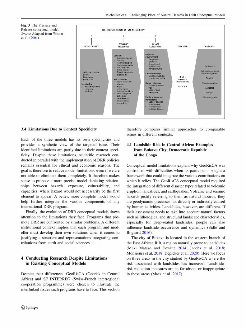
3.1 The Pressure and Release Model
The Pressure and Release (PAR) model (Wisner et al.
2004; Fig. 3), which dates to the first version of At Risk in
1994, partially addressed this issue while integrating
capacities into the progression of vulnerability. Yet, rela-
tionships between hazard and vulnerability are not explic-
itly examined. They are presented separately without clear
interactions (Fig. 3). Nevertheless, the more recent version
of the model does link dynamic pressures and hazards
(Wisner et al. 2012). In addition, Wisner et al. (2004) do
not refer to hazards as natural, mainly because Wisner and
his colleagues consider that disasters result primarily from
the structure and evolution of human societies. They stress
social root causes or underlying risk factors as the main
elements contributing to disasters.
3.2 The Access Model
The Access model (Wisner et al. 2004), which comple-
ments the PAR model, still contests the relevance of
explaining disasters mainly by natural hazards, but clarifies
this point (Fig. 4). Hazard takes only the form of a trig-
gering event, as if there was no existing relationship
between hazard and vulnerability before the disaster
happens.
3.3 The Disaster System Model
In some recent models, such as the Disaster System
(Fig. 5), relationships between hazard and exposure are
mentioned but they are not developed. Yet any system
usually refers to a group of factors interacting (Durand
1979). Figure 5 suggests that the researchers resigned
themselves to depicting interactions, and even more
coevolutions, perhaps because they considered the task
almost impossible.
Fig. 2 Difference between
exposure and vulnerability: two
buildings on the Arve River
floodplain, Magland
Municipality, Northern French
Alps a in 1999 and b in 2020
(Photograph by Patrick Pigeon,
March 1999 and February 2020)
123
Int J Disaster Risk Sci
3.4 Limitations Due to Context Specificity
Each of the three models has its own specificities and
provides a synthetic view of the targeted issue. Their
identified limitations are partly due to their context speci-
ficity. Despite these limitations, scientific research con-
ducted in parallel with the implementation of DRR policies
remains essential for ethical and economic reasons. The
goal is therefore to reduce model limitations, even if we are
not able to eliminate them completely. It therefore makes
sense to propose a more precise model depicting relation-
ships between hazards, exposure, vulnerability, and
capacities, where hazard would not necessarily be the first
element to appear. A better, more complete model would
help further integrate the various components of any
international DRR program.
Finally, the evolution of DRR conceptual models draws
attention to the limitations they face. Programs that pro-
mote DRR are confronted by similar problems. A different
institutional context implies that each program and mod-
eller must develop their own solutions when it comes to
justifying a structure and representations integrating con-
tributions from earth and social sciences.
4 Conducting Research Despite Limitationsin Existing Conceptual Models
Despite their differences, GeoRisCA (Georisk in Central
Africa) and SF INTERREG (Swiss-French interregional
cooperation programme) were chosen to illustrate the
interlinked issues such programs have to face. This section
therefore compares similar approaches to comparable
issues in different contexts.
4.1 Landslide Risk in Central Africa: Examples
from Bukavu City, Democratic Republic
of the Congo
Conceptual model limitations explain why GeoRisCA was
confronted with difficulties when its participants sought a
framework that could integrate the various contributions on
which it relies. The GeoRisCA conceptual model required
the integration of different disaster types related to volcanic
eruption, landslides, and earthquakes. Volcanic and seismic
hazards justify referring to them as natural hazards; they
are geodynamic processes not directly or indirectly caused
by human activities. Landslides, however, are different. If
their assessment needs to take into account natural factors
such as lithological and structural landscape characteristics,
especially for deep-seated landslides, people can also
influence landslide occurrence and dynamics (Sidle and
Bogaard 2016).
The city of Bukavu is located in the western branch of
the East African Rift, a region naturally prone to landslides
(Maki Mateso and Dewitte 2014; Jacobs et al. 2018;
Monsieurs et al. 2018; Depicker et al. 2020). Here we focus
on three areas in the city studied by GeoRisCA where the
risk associated with landslides has increased. Landslide-
risk reduction measures are so far absent or inappropriate
in these areas (Maes et al. 2017).
Fig. 3 The Pressure and
Release conceptual model.
Source Adapted from Wisner
et al. (2004)
123
Michellier et al. Challenging Place of Natural Hazards in DRR Conceptual Models

4.1.1 The Nyakavogo Landslide
The detailed study of the Nyakavogo landslide indicates
that it is an old deep-seated landslide of natural origin
(Mugaruka Bibentyo et al. 2017). Historical aerial pho-
tographs from 1959 show that, at that time, the landslide
area was afforested. The existing ground cover at that time
suggests that the topographic and hydrological conditions
were not suitable for agriculture.
Beginning in the 1970s, land-use patterns started to
change. In 1994, following the genocide in Rwanda
(Reyntjens 2009), the occupation of the slope by Rwandan
refugees and their needs for wood and garden plots were at
the origin of intense deforestation. In 1997, a major reac-
tivation of the landslide took place and affected most of the
slope. Within a few months, ground movements with a
collapse of up to 15 m at the main escarpment were
Fig. 4 The Access model. Source Adapted from Wisner et al. (2004)
Fig. 5 The Disaster system model. Source Adapted from Shi and
Kasperson (2014)
123
Int J Disaster Risk Sci

measured. The collapse destroyed a water pipe located at
the top of the landslide. Leakage from the broken pipe
dumped water at a rate estimated at 800 m3/h for 12 h,
accelerating the landslide. Leakage from the pipe before
the reactivation is also likely to have played a role in
starting the instability. In addition to the damaged water
pipe, this movement resulted in the destruction of more
than 40 houses, the collapse of electric power poles, and
the destruction of the road located behind the original main
scarp (Moeyersons et al. 2004). Part of the drainage system
of the broken road brought extra runoff to the head of the
landslide. Downslope of the slide, the displaced material
created a dam in the river flowing at the toe.
Significant forest loss due to cultivation, the increase in
the number of houses and related slope earthworks, a
concentration of surface runoff at the level of the main
escarpment, as well as the intrinsic evolution of the hill-
slope associated with strength degradation of the slope
material through time are all factors that probably con-
tributed to the instability between 1959 and 1997 (Mu-
garuka Bibentyo et al. 2017; Dille et al. 2019).
Subsequently, the natural reorganization of the river after
the dam formation and breaching and the erosion accen-
tuated by the exploitation of riverbed materials (stones,
gravel, sand) has certainly played an important role in
another reactivation that occurred in 2000, affecting the
foot of the landslide.
In 2016, a stabilizing trend was observed. Reforestation
in recent years probably played a role. Nevertheless, the
recent use of the main scarp as the site for the Bralima
landfill, consisting mainly of broken glass bottles, brings an
important load to the slope that could reverse this dynamic
and affect the houses located at less than 10 m from the
gully. In conclusion, human activity has slowly triggered
the reactivation of a large landslide, which has damaged
water distribution infrastructure that in turn aggravated the
hazard and the associated risk (Fig. 6).
4.1.2 The Funu Landslide
The largest landslides of Bukavu, such as the Nyakavogo
landslide described above, show morphological character-
istics of large deep-seated rotational slides. Some are quite
eroded and look old and stable while others seem more
recent and have parts that show current deformation
activity. Among those landslides stands the largest one
(1.5 km2) in the slum neighborhood of Funu (Fig. 7a). This
site is densely populated, with around 80,000 people (most
of them very poor) living on it (Michellier et al. 2018).
Its origin dates to well before the colonial period. Some
parts of the landslide are clearly active with ground
deformations of up to several tens of centimeters per year
in some places (Nobile et al. 2018). Significant damage to
buildings and other infrastructure is constantly observed
(Balegamire et al. 2017; Kalikone Buzera et al. 2017). In
other areas of the landslide, the dynamics is much more
limited, at least in the current period. The canalization of
the main brook that runs through the landslide, which dates
back to the1950s, was intended to stop the movements of
one of its most active parts, and thus allow the construction
of brick houses.
However, the work did not hold. At the end of the
1980s, due to progressive house destruction, part of the
population was displaced to another district of the city.
Trees were planted to try to stabilize the slope. But, from
1994, the population fleeing the genocide in Rwanda and
the regional conflicts that followed, settled there. After
about 10 years, the displaced population gradually trans-
formed their temporary housing into permanent ones, built
mainly from bamboo and clay. The slope, already affected
by deformations of the ground due to the dynamics of the
Fig. 6 Reactivation of an old
large landslide of natural origin
in Bukavu, Democratic
Republic of the Congo. The
landslide developed much
earlier than the construction of
the city (Photograph taken by
Olivier Dewitte, February
2014). The reactivation is linked
to interactions between natural
and anthropogenic factors
123
Michellier et al. Challenging Place of Natural Hazards in DRR Conceptual Models
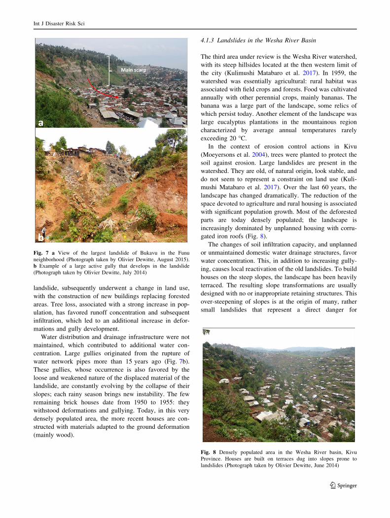
landslide, subsequently underwent a change in land use,
with the construction of new buildings replacing forested
areas. Tree loss, associated with a strong increase in pop-
ulation, has favored runoff concentration and subsequent
infiltration, which led to an additional increase in defor-
mations and gully development.
Water distribution and drainage infrastructure were not
maintained, which contributed to additional water con-
centration. Large gullies originated from the rupture of
water network pipes more than 15 years ago (Fig. 7b).
These gullies, whose occurrence is also favored by the
loose and weakened nature of the displaced material of the
landslide, are constantly evolving by the collapse of their
slopes; each rainy season brings new instability. The few
remaining brick houses date from 1950 to 1955: they
withstood deformations and gullying. Today, in this very
densely populated area, the more recent houses are con-
structed with materials adapted to the ground deformation
(mainly wood).
4.1.3 Landslides in the Wesha River Basin
The third area under review is the Wesha River watershed,
with its steep hillsides located at the then western limit of
the city (Kulimushi Matabaro et al. 2017). In 1959, the
watershed was essentially agricultural: rural habitat was
associated with field crops and forests. Food was cultivated
annually with other perennial crops, mainly bananas. The
banana was a large part of the landscape, some relics of
which persist today. Another element of the landscape was
large eucalyptus plantations in the mountainous region
characterized by average annual temperatures rarely
exceeding 20 �C.In the context of erosion control actions in Kivu
(Moeyersons et al. 2004), trees were planted to protect the
soil against erosion. Large landslides are present in the
watershed. They are old, of natural origin, look stable, and
do not seem to represent a constraint on land use (Kuli-
mushi Matabaro et al. 2017). Over the last 60 years, the
landscape has changed dramatically. The reduction of the
space devoted to agriculture and rural housing is associated
with significant population growth. Most of the deforested
parts are today densely populated; the landscape is
increasingly dominated by unplanned housing with corru-
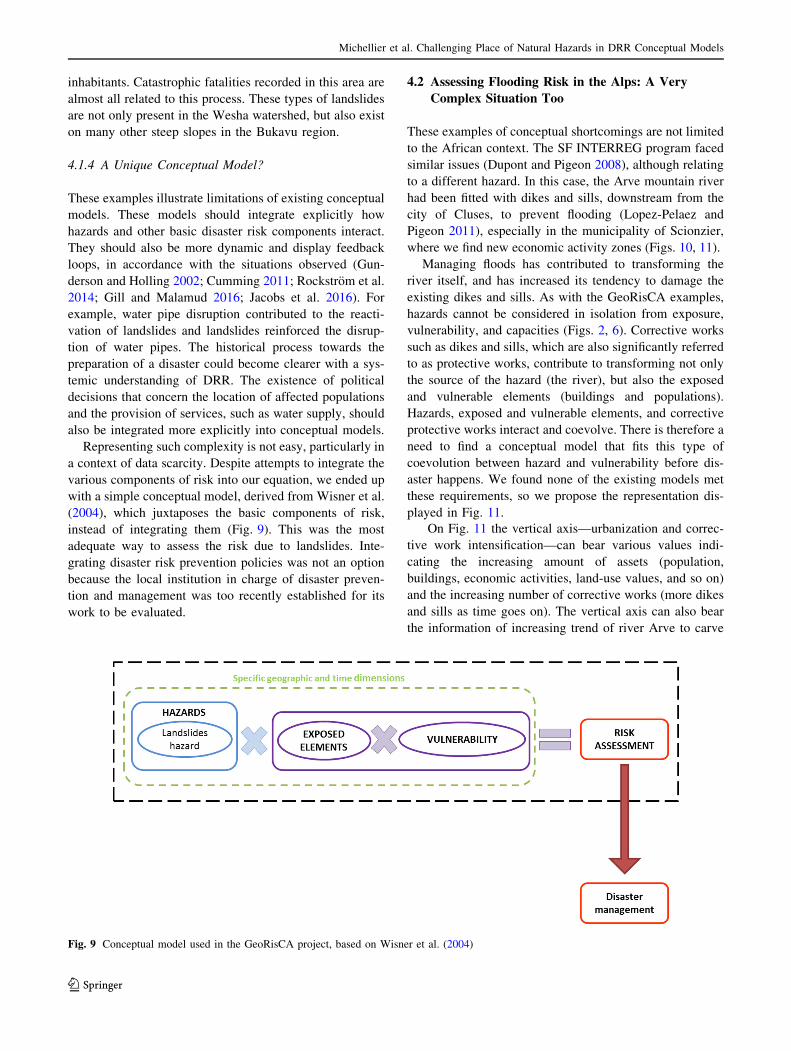
gated iron roofs (Fig. 8).
The changes of soil infiltration capacity, and unplanned
or unmaintained domestic water drainage structures, favor
water concentration. This, in addition to increasing gully-
ing, causes local reactivation of the old landslides. To build
houses on the steep slopes, the landscape has been heavily
terraced. The resulting slope transformations are usually
designed with no or inappropriate retaining structures. This
over-steepening of slopes is at the origin of many, rather
small landslides that represent a direct danger for
Fig. 7 a View of the largest landslide of Bukavu in the Funu
neighborhood (Photograph taken by Olivier Dewitte, August 2015).
b Example of a large active gully that develops in the landslide
(Photograph taken by Olivier Dewitte, July 2014)
Fig. 8 Densely populated area in the Wesha River basin, Kivu
Province. Houses are built on terraces dug into slopes prone to
landslides (Photograph taken by Olivier Dewitte, June 2014)
123
Int J Disaster Risk Sci
inhabitants. Catastrophic fatalities recorded in this area are
almost all related to this process. These types of landslides
are not only present in the Wesha watershed, but also exist
on many other steep slopes in the Bukavu region.
4.1.4 A Unique Conceptual Model?
These examples illustrate limitations of existing conceptual
models. These models should integrate explicitly how
hazards and other basic disaster risk components interact.
They should also be more dynamic and display feedback
loops, in accordance with the situations observed (Gun-
derson and Holling 2002; Cumming 2011; Rockstrom et al.
2014; Gill and Malamud 2016; Jacobs et al. 2016). For
example, water pipe disruption contributed to the reacti-
vation of landslides and landslides reinforced the disrup-
tion of water pipes. The historical process towards the
preparation of a disaster could become clearer with a sys-
temic understanding of DRR. The existence of political
decisions that concern the location of affected populations
and the provision of services, such as water supply, should
also be integrated more explicitly into conceptual models.
Representing such complexity is not easy, particularly in
a context of data scarcity. Despite attempts to integrate the
various components of risk into our equation, we ended up
with a simple conceptual model, derived from Wisner et al.
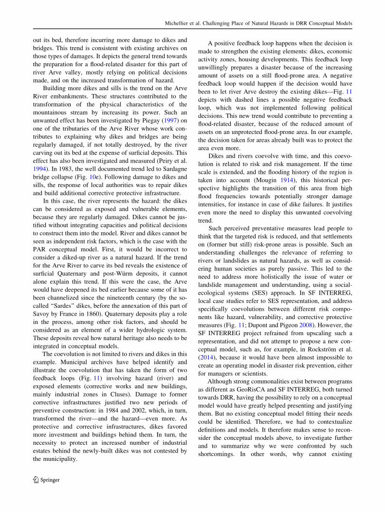
(2004), which juxtaposes the basic components of risk,
instead of integrating them (Fig. 9). This was the most
adequate way to assess the risk due to landslides. Inte-
grating disaster risk prevention policies was not an option
because the local institution in charge of disaster preven-
tion and management was too recently established for its
work to be evaluated.
4.2 Assessing Flooding Risk in the Alps: A Very
Complex Situation Too
These examples of conceptual shortcomings are not limited
to the African context. The SF INTERREG program faced
similar issues (Dupont and Pigeon 2008), although relating
to a different hazard. In this case, the Arve mountain river
had been fitted with dikes and sills, downstream from the
city of Cluses, to prevent flooding (Lopez-Pelaez and
Pigeon 2011), especially in the municipality of Scionzier,
where we find new economic activity zones (Figs. 10, 11).
Managing floods has contributed to transforming the
river itself, and has increased its tendency to damage the
existing dikes and sills. As with the GeoRisCA examples,
hazards cannot be considered in isolation from exposure,
vulnerability, and capacities (Figs. 2, 6). Corrective works
such as dikes and sills, which are also significantly referred
to as protective works, contribute to transforming not only
the source of the hazard (the river), but also the exposed
and vulnerable elements (buildings and populations).
Hazards, exposed and vulnerable elements, and corrective
protective works interact and coevolve. There is therefore a
need to find a conceptual model that fits this type of
coevolution between hazard and vulnerability before dis-
aster happens. We found none of the existing models met
these requirements, so we propose the representation dis-
played in Fig. 11.
On Fig. 11 the vertical axis—urbanization and correc-
tive work intensification—can bear various values indi-
cating the increasing amount of assets (population,
buildings, economic activities, land-use values, and so on)
and the increasing number of corrective works (more dikes
and sills as time goes on). The vertical axis can also bear
the information of increasing trend of river Arve to carve
Fig. 9 Conceptual model used in the GeoRisCA project, based on Wisner et al. (2004)
123
Michellier et al. Challenging Place of Natural Hazards in DRR Conceptual Models

Fig. 10 Location and context of the coevolution model presented in
Fig. 11 (a); general map of river Arve valley (b); dikes and sills as
reported on map (a, c); Scionzier and river Arve as on the 1854
topographical map (d); Sardagne bridge as in 1982 before its collapse
in 1983 (e). Source Archives departementales de Haute-Savoie
(‘‘departementales’’ archives of Haute-Savoie), reference 1 FI 417 for
the topographical map of Bonneville, 1854; reference 2478 W 173 for
the picture of Sardagne bridge linked with a map at scale 1/2000,
1983
Fig. 11 Representation of coevolutions between hazard (river), exposure, vulnerability (industrial zones), and corrective works (dikes and sills).
Source Dupont and Pigeon (2008); Lopez-Pelaez and Pigeon (2011)
123
Int J Disaster Risk Sci
out its bed, therefore incurring more damage to dikes and
bridges. This trend is consistent with existing archives on
those types of damages. It depicts the general trend towards
the preparation for a flood-related disaster for this part of
river Arve valley, mostly relying on political decisions
made, and on the increased transformation of hazard.
Building more dikes and sills is the trend on the Arve
River embankments. These structures contributed to the
transformation of the physical characteristics of the
mountainous stream by increasing its power. Such an
unwanted effect has been investigated by Piegay (1997) on
one of the tributaries of the Arve River whose work con-
tributes to explaining why dikes and bridges are being
regularly damaged, if not totally destroyed, by the river
carving out its bed at the expense of surficial deposits. This
effect has also been investigated and measured (Peiry et al.
1994). In 1983, the well documented trend led to Sardagne
bridge collapse (Fig. 10e). Following damage to dikes and
sills, the response of local authorities was to repair dikes
and build additional corrective protective infrastructure.
In this case, the river represents the hazard: the dikes
can be considered as exposed and vulnerable elements,
because they are regularly damaged. Dikes cannot be jus-
tified without integrating capacities and political decisions
to construct them into the model. River and dikes cannot be
seen as independent risk factors, which is the case with the
PAR conceptual model. First, it would be incorrect to
consider a diked-up river as a natural hazard. If the trend
for the Arve River to carve its bed reveals the existence of
surficial Quaternary and post-Wurm deposits, it cannot
alone explain this trend. If this were the case, the Arve
would have deepened its bed earlier because some of it has
been channelized since the nineteenth century (by the so-
called ‘‘Sardes’’ dikes, before the annexation of this part of
Savoy by France in 1860). Quaternary deposits play a role
in the process, among other risk factors, and should be
considered as an element of a wider hydrologic system.
These deposits reveal how natural heritage also needs to be
integrated in conceptual models.
The coevolution is not limited to rivers and dikes in this
example. Municipal archives have helped identify and
illustrate the coevolution that has taken the form of two
feedback loops (Fig. 11) involving hazard (river) and
exposed elements (corrective works and new buildings,
mainly industrial zones in Cluses). Damage to former
corrective infrastructures justified two new periods of
preventive construction: in 1984 and 2002, which, in turn,
transformed the river—and the hazard—even more. As
protective and corrective infrastructures, dikes favored
more investment and buildings behind them. In turn, the
necessity to protect an increased number of industrial
estates behind the newly-built dikes was not contested by
the municipality.
A positive feedback loop happens when the decision is
made to strengthen the existing elements: dikes, economic
activity zones, housing developments. This feedback loop
unwillingly prepares a disaster because of the increasing
amount of assets on a still flood-prone area. A negative
feedback loop would happen if the decision would have
been to let river Arve destroy the existing dikes—Fig. 11
depicts with dashed lines a possible negative feedback
loop, which was not implemented following political
decisions. This new trend would contribute to preventing a
flood-related disaster, because of the reduced amount of
assets on an unprotected flood-prone area. In our example,
the decision taken for areas already built was to protect the
area even more.
Dikes and rivers coevolve with time, and this coevo-
lution is related to risk and risk management. If the time
scale is extended, and the flooding history of the region is
taken into account (Mougin 1914), this historical per-
spective highlights the transition of this area from high
flood frequencies towards potentially stronger damage
intensities, for instance in case of dike failures. It justifies
even more the need to display this unwanted coevolving
trend.
Such perceived preventative measures lead people to
think that the targeted risk is reduced, and that settlements
on (former but still) risk-prone areas is possible. Such an
understanding challenges the relevance of referring to
rivers or landslides as natural hazards, as well as consid-
ering human societies as purely passive. This led to the
need to address more holistically the issue of water or
landslide management and understanding, using a social-
ecological systems (SES) approach. In SF INTERREG,
local case studies refer to SES representation, and address
specifically coevolutions between different risk compo-
nents like hazard, vulnerability, and corrective protective
measures (Fig. 11; Dupont and Pigeon 2008). However, the
SF INTERREG project refrained from upscaling such a
representation, and did not attempt to propose a new con-
ceptual model, such as, for example, in Rockstrom et al.
(2014), because it would have been almost impossible to
create an operating model in disaster risk prevention, either
for managers or scientists.
Although strong commonalities exist between programs
as different as GeoRisCA and SF INTERREG, both turned
towards DRR, having the possibility to rely on a conceptual
model would have greatly helped presenting and justifying
them. But no existing conceptual model fitting their needs
could be identified. Therefore, we had to contextualize
definitions and models. It therefore makes sense to recon-
sider the conceptual models above, to investigate further
and to summarize why we were confronted by such
shortcomings. In other words, why cannot existing
123
Michellier et al. Challenging Place of Natural Hazards in DRR Conceptual Models
conceptual models adequately respond to the needs of
international programs such as GeoRisCA or SF
INTERREG?
There is one more point concerning the relevance of
comparing DRR programs with a focus on very culturally
and physically different areas that can be made. Since
disasters such as Hurricane Katrina in 2005, international
literature on DRR acknowledges that common points are
more relevant than discrepancies between least developed
countries and more developed countries (Wisner et al.
2012). This is one of the major points revealed by the
Sendai Framework for Disaster Risk Reduction
2015–2030, in accordance with a wide range of interna-
tional research (UNISDR 2015). The most critical issues
are linked to the difficulties of reducing socioeconomic
discrepancies and taking into account power relationships,
which are considered, by far, the most important drivers of
disaster—and not only in the least developed countries.
5 Discussion: What Are the Main DifficultiesFaced by Conceptual Models on Disaster RiskReduction?
Our results allow us to argue that conceptual models have
to clearly and comprehensively depict basic risk definition
components, in line with reference definitions concerning
DRR and risk. Doing so, however, means that conceptual
models might challenge mainstream views.
We found an increased recognition that hazards can no
longer be considered as purely natural factors impacting
passive and vulnerable human societies (Pigeon 2002; Gill
and Malamud 2017). This traditional understanding gen-
erally refers to natural hazards and disasters. But existing
literature on DRR suggests that it belongs to an older
approach (Garcia-Acosta 2005; UNISDR 2015). A wide
range of corrective and protective measures, such as dikes
and drainage networks, clearly transform hazards by inte-
grating them into social-ecological systems.
Natural hazards also have a role to play when assessing
and preventing disasters due to earthquakes or volcanic
eruptions, which requires careful monitoring. For example,
deep-seated earthquakes reveal geodynamics of the litho-
sphere in rift and subduction zones. They cannot be influ-
enced by human beings and their activities. But humankind
still has the possibility to transform hazards and their
impacts locally, while using seismic building codes, or not
building on sites where surficial deposits are found, for
example. Such discrepancies justify why DRR conceptual
models should still clearly integrate natural hazards and the
possibilities for human beings to manage hazards by
interacting with them.
According to our analysis, the limitations of conceptual
models stem mainly from the difficulty of clearly
addressing the relationships between hazards and other
basic components of disaster risk definition before the
disaster occurs. This situation is exacerbated by the
increasingly blurred place devoted to ‘‘natural hazards’’ in
recent models, as if the focus of an earthquake related with
lithosphere geodynamics could be similar to a landslide
reactivated by human activities. On the contrary, they
should be considered as distinct components of larger
systems depicting risk and disaster dynamics (Baccini and
Brunner 2012; Pigeon 2002, 2005, 2014).
Systemic and social-ecological system (SES) approa-
ches may help to find solutions (Gunderson and Holling
2002). However, SES conceptual models may also reduce
the visibility of the relationships between hazards and other
basic components of disaster risk definition in programs
such as GeoRisCA and SF INTERREG. In addition, SES
tends to eliminate the still-existing contribution of natural
hazards to the understanding of disasters preparation. Even
reduced, this place should not be removed from the exist-
ing conceptual models (Pigeon 2002).
DRR conceptual models should also represent how
those components that frame risk do interact and coevolve,
while leaving room for some natural hazards that do not
interact with vulnerability factors before a disaster occurs.
Depicting clearly and comprehensively such paradigms
challenges traditional and systemic conceptual models.
Coevolution between hazards and other basic compo-
nents of disaster risk can be represented by using spirals to
illustrate feedback loops: this helps to describe trends
towards disasters on the one hand and how local choices
can contribute—or not—to disaster prevention on the
other. To achieve such a representation requires accessing
and using various archives, documents, and data, allowing
the cross-referencing of existing information. It also needs
existing knowledge and experience on past policies and
their limitations. Of course, it would be very difficult to
find similar information for a program such as GeoRisCA.
Geopolitical unrest and poverty exacerbate the challenge of
turning to DRR conceptual models.
However, the use of spirals in future conceptual models
on disaster prevention could be investigated. Spirals could
clearly depict how hazards change over time, as they
interact with other risk components. Spirals describe
feedback loops, and hazards become elements contributing
to those feedback loops. Such representations should fit the
need to reconsider how to understand risk at the beginning
of the Anthropocene. The representation we propose
(Figs. 11, 12), even though contextualized, could be a first
step in that direction.
Based on these evaluations of both programs, a repre-
sentation of relationships between hazards and other basic
123
Int J Disaster Risk Sci

components of the disaster risk definition could be pro-
posed, and used as a trade-off between existing models to
harmonize the needs of programs such as GeoRisCA or SF
INTERREG. According to our analysis, any conceptual
model on DRR should distinguish between natural her-
itage, natural hazards, and hazards by integrating the
human capacity to transform the environment, willingly or
not. Yet, representing the dynamics of partial coevolutions
across such a wide range of components that underpin the
definitions of any disaster remains a challenge. The debate
is not recent: it has been addressed by researchers who
specialize in complexity such as Morin (2010) and Dupuy
(2002) and even by philosophers focusing on knowledge
such as Bergson (1934). Figure 12 (Pigeon 2002) presents
a conceptual model that attempts to address these concerns:
it distinguishes between natural hazards and hazards that
are transformed, willingly or not, by decisions made by
human societies, and which are named physical processes.
On Fig. 12, the nature-society boundary marks the limit
between the natural environment of the system, including
natural hazards and the risk system. The latter is identifi-
able by the dynamic interactions between physical damage
processes (hazards) and exposed elements preparing
damage, their vulnerabilities depending on political deci-
sions that coping capacities refer to. This interpretation is
imposed by the fact that both the distribution and the forms
of damage are partially conditioned by the legacies of
geomorphological evolution, as well as by the fact that
plate tectonics escape anthropization. The recognition of
Anthropocene reduces the relevance of the nature-society
boundary, and challenges it, without allowing to eliminate
it.
Finally, DRR conceptual models should integrate a
dynamic and more consistent approach concerning the
place devoted to hazards. However, Fig. 12 is clearly not
dynamic enough because it does not depict any feedback
loop and it has not been contextualized, compared to
Fig. 11. A trade-off between these two conceptual models
is still needed. Figure 11 is more contextualized, more
operational, yet highly context-dependent; while Fig. 12 is
less contextualized, less operational, and therefore fits
more the holistic approach that is expected from any con-
ceptual model.
Fig. 12 Evolving conceptual
model. Source Adapted from
Pigeon (2002)
123
Michellier et al. Challenging Place of Natural Hazards in DRR Conceptual Models
6 Conclusion
The comparison between GeoRisCA and SF INTERREG
reveals the difficulty of integrating more contributions
coming from earth and social sciences into DRR concep-
tual models. This is not an original observation. One of the
authors had the opportunity to contribute to five other
international programs, in various countries including Sri
Lanka and Germany. In each case, this difficulty of finding
a more consistent conceptual model for framing the pro-
grams arose.
Such a situation draws attention to some major limita-
tions that conceptual models on DRR still meet. They
reflect the lack of consensus in defining disaster and dis-
aster risk, based on the understanding of the relationships
between its four basic components: hazard, exposure,
vulnerability, and capacities. The existing literature on
disasters has addressed and still addresses this hotly
debated issue. According to Collins (2018, p. 494), ‘‘less
progress has been made in addressing complex intersec-
tions of environmental systems, power, and cultures that
underlie emergent understanding of the nature of risk
reactions and active engagement.’’ Similar discussions
have arisen concerning the notion of resilience, which is
today considered key in disaster studies, despite debates
around its various perceptions, some of them being con-
tradictory (Pigeon 2014, 2016).
Furthermore, these difficulties are also related to the
challenge of representing relationships between the four
basic components of disaster risk. This challenge explains
the rise of SES thinking (Gunderson and Holling 2002; Shi
et al. 2013). Yet, all these models fail to address clearly and
comprehensively the existing interactions identified, as
well as their evolution. Understanding, assessing, and
preventing disasters require a dynamic approach. The
increased recognition that disasters emerge largely from
the inside of human societies and reflects their dynamics is
a trend. Consequently, divergences between Western Eur-
ope and Africa are diminished. Poverty and power rela-
tionships are of course context-specific, but they play a
major role in understanding and managing disasters (Maes
et al. 2018). As stressed by the UNISDR (2015), issues
related to poverty and power relationships are common to
all countries and are the main drivers of disasters.
Addressing them is considered key by UNISDR 2015 and
the Sendai Framework.
A particularly sensitive priority relates to the place
devoted to hazards in these conceptual models. Social-
ecological system thinking is consistent with the need to
integrate into disaster understanding the capacity of human
societies to transform their environment. However, whether
with GeoRisCA or SF INTERREG, or other international
programs, it seems unlikely to assess disasters without
taking into account natural elements and/or elements that
are unalterable by humankind. In the Democratic Republic
of the Congo, most earthquakes are still related to the
geodynamics of African rifting. A river such as the Arve
can deepen its bed not only because it has been diked
(among various other factors impacting this process), but
also because of the geological and natural characteristics of
surficial, post-glacial deposits.
Finally, DRR conceptual models should more explicitly
integrate the existing relationships between natural haz-
ards, human-transformed hazards, and such other risk
factors as exposure, vulnerability, and preventive policies.
Such models should no longer present hazards first. Yet,
such models would still integrate hazards into a dynamic
process, socially and politically driven, eventually leading
to a disaster. As Collins (2018, p. 487) wrote: ‘‘Though
much of the field has been, and often continues to be,
analysed from a natural-hazards orientation, a significant
drive has shifted the paradigm to be people centred through
more socially, politically, economically, and culturally
aware agendas.’’ But where is the conceptual model that
deals with this shift? Finding a solution would greatly help
presenting and justifying the structures of international
programs on DRR. Disaster risk reduction conceptual
models are also too static to depict the trends towards
disasters and the possibility of preventing them. It is pos-
sible to represent coevolution between risk factors such as
hazards, vulnerability, and exposure that prepare disasters,
including coping capacities, but only from local case
studies. In conclusion, scaling-up these representations
using a dynamic conceptual model as a tool to support local
DRR decision making remains a challenge.
Acknowledgements This article highlights the results of two dif-
ferent research projects: (1) the GeoRisCA project (Contract No. SD/
RI/02A) financed by the program ‘‘Science for Sustainable Devel-
opment’’ of the Belgian Science Policy; and (2) the SF INTERREG
program (Swiss-French interregional cooperation programme) cofi-
nanced by the European Union and the Swiss Confederation. Special
acknowledgment to Clarisse Baligamire, Toussaint Mugaruka
Bibentyo, Antoine Dille, Christian Kalikone Buzera, Sylvain Kuli-
mushi Matabaro, Elise Monsieurs for their helpful discussions.
Open Access This article is licensed under a Creative Commons
Attribution 4.0 International License, which permits use, sharing,
adaptation, distribution and reproduction in any medium or format, as
long as you give appropriate credit to the original author(s) and the
source, provide a link to the Creative Commons licence, and indicate
if changes were made. The images or other third party material in this
article are included in the article’s Creative Commons licence, unless
indicated otherwise in a credit line to the material. If material is not
included in the article’s Creative Commons licence and your intended
use is not permitted by statutory regulation or exceeds the permitted
use, you will need to obtain permission directly from the copyright
holder. To view a copy of this licence, visit http://creativecommons.
org/licenses/by/4.0/.
123
Int J Disaster Risk Sci
References
Aitsi-Selmi, A., V. Murray, C. Wannous, C. Dickinson, D. Johnston,
A. Kawasaki, T. Stevance, and T. Yeung. 2016. Reflections on a
science and technology agenda for 21st century disaster risk
reduction. International Journal Of Disaster Risk Science 7(1):
1–29.
Baccini, P., and P.H. Brunner. 2012. Metabolism of the anthropo-
sphere: Analysis, Evaluation, Design. Cambridge, MA: MIT
Press.
Balegamire, C., C. Michellier, J.B. Muhigwa, D. Delvaux, G. Imani,
and O. Dewitte. 2017. Vulnerability of buildings exposed to
landslides: A spatio-temporal assessment in Bukavu (DR Congo)
(Vulnerabilite du bati face aux glissements de terrain:analyse
spatio-temporelle a Bukavu [RD Congo]). Geo-Eco-Trop 41(2):
263–278 (in French).
Bergson, H. 1934. Introduction to metaphysics (Introduction a la
metaphysique). Paris: Presses Universitaires de France.
Birkmann, J. 2006. Measuring vulnerability to natural hazards:
Towards disaster resilient societies. Tokyo: United Nations
University Press.
Birkmann, J., and B. Wisner. 2006. Measuring the un-measurable:
The challenge of Vulnerability. Report of the second meeting of
the UNU-EHS expert working group on measuring vulnerability,
12–14 October 2005, Bonn, Germany. Institute for Environment
and Human Security, United Nations University.
Blaikie, P., T. Cannon, I. Davis, and B. Wisner. 1994. At risk: Natural
hazards, people’s vulnerability and disasters. New York:
Routledge.
CRED (Centre for Research on the Epidemiology of Disasters). 2015.
EM-DAT international disaster database. https://www.emdat.be/
. Accessed 27 Mar 2020.
Collins, A.E. 2018. Advancing the disaster and development
paradigm. International Journal of Disaster Risk Science 9(4):
486–495.
Cumming, G.S. 2011. Spatial resilience in social-ecological systems.
Dordrecht: Springer.
Cutter, S.L., L. Barnes, M. Berry, C. Burton, E. Evans, E. Tate, and J.
Webb. 2008. A place-based model for understanding community
resilience to natural disasters. Global Environmental Change
18(4): 598–606.
Depicker, A., L. Jacobs, D. Delvaux, H.-B. Havenith, J.-C. Maki
Mateso, G. Govers, and O. Dewitte. 2020. The added value of a
regional landslide susceptibility assessment: The western branch
of the East African Rift. Geomorphology 353: Article 106886.
Dille, A., F. Kervyn, T. Mugaruka Bibentyo, D. Delvaux, G.
Bamulezi Ganza, G. Mawe Ilombe, C. Kalikone Buzera, et al.
2019. Causes and triggers of deep-seated hillslope instability in
the tropics—Insights from a 60-year record of Ikoma landslide
(DR Congo). Geomorphology 345: Article 106835.
Duncan, D., S. Scherer, and S. Wade-Apicella. 2014. HFA thematic
review: Research area 2, priority for action 3, core indicator 1.
Background paper prepared for the global assessment report on
disaster risk reduction 2015. Geneva, Switzerland: UNISDR.
https://www.preventionweb.net/english/hyogo/gar/2015/en/
bgdocs/UNISDR,%202014c.pdf. Accessed 16 Dec 2019.
Dupont, C., and P. Pigeon. 2008. Rhone River upper montainous
watershed: Towards an integrated management of transbound-
ary territories (Le Haut-Rhone et son bassin versant montag-
neux: pour une gestion integree des territoires transfrontaliers).
Le Bourget-du-Lac: Institut de la Montagne, Universite de
Savoie (in French).
Dupuy, J. 2002. For enlightened catastrophism (Pour un catas-
trophisme eclaire). Paris: Le Seuil.
Durand, P. 1979. Systemic (La systemique). Paris: Presses Universi-
taires de France.
Fekete, A., and G. Hufschmidt. 2016. Atlas of vulnerability and
resilience: Pilot version for Germany, Austria, Liechtenstein and
Switzerland. Koln and Bonn: TH Koln and University of Bonn.
Fra Paleo, U. 2019. Timescape of disaster risk governance in
contemporary Japan: Neither state of normalcy nor constancy in
regulation. PLoS ONE 14: 1–16.
Garcia-Acosta, V. 2005. Risk as a social construct and the social
construction of risk (El riesgo como construccion social y la
construccion social de riesgos). Desacatos: Revista de Ciencias
Sociales 19: 11–24 (in Spanish).
Gill, J.C., and B.D. Malamud. 2016. Hazard interactions and
interaction networks (cascades) within multi-hazard methodolo-
gies. Earth System Dynamics 7(3): 659–679.
Gill, J.C., and B.D. Malamud. 2017. Anthropogenic processes, natural
hazards, and interactions in a multi-hazard framework. Earth-
Science Reviews 166: 246–269.
Guillier, F. 2017. French insurance and flood risk: Assessing the
impact of prevention through the rating of action programs for
flood prevention. International Journal of Disaster Risk Science
8(3): 284–295.
Gunderson, L.H., and C.S. Holling. 2002. Panarchy: Understanding
transformations in human and natural systems. Washington, DC:
Inland Press.
Hewitt, K. 1983. Interpretations of calamity. Boston: Allen and
Unwin.
Jacobs, L., O. Dewitte, J. Poesen, J. Sekajugo, A. Nobile, M. Rossi,
W. Thiery, and M. Kervyn. 2018. Field-based landslide suscep-
tibility assessment in a data-scarce environment: The populated
areas of the Rwenzori Mountains. Natural Hazards and Earth
System Sciences 18: 105–124.
Jacobs, L., J. Maes, K. Mertens, J. Sekajugo, W. Thiery, N.N. van
Lipzig, J. Poesen, M. Kervyn, and O. Dewitte. 2016. Recon-
struction of a flash flood event through a multi-hazard approach:
Focus on the Rwenzori Mountains, Uganda. Natural Hazards
84(2): 851–876.
Kalikone Buzera, C., F. Teganyi, O. Dewitte, and C. Michellier. 2017.
Ground deformation impact on the vulnerability of water and
electricity distribution networks in Bukavu (DR Congo). Geo-
Eco-Trop 41(2): 279–292.
Kelman, I. 2018. Lost for words amongst disaster risk science
vocabulary? International Journal of Disaster Risk Science 9(2):
281–291.
Kulimushi Matabaro, S., T. Mugaruka Bibentyo, W. Muhindo Sahani,
C. Michellier, and O. Dewitte. 2017. Landslides and elements at
risk in the Wesha watershed (Bukavu, DR Congo). Geo-Eco-
Trop 41(2): 233–248.
Lewis, J. 1999. Development in disaster-prone places: Studies of
vulnerability. London: Intermediate Technology Publications.
Lewis, J. 2011. Corruption: The hidden perpetrator of under-
development and vulnerability to natural hazards and disasters.
Jamba: Journal of Disaster Risk Studies 3(2): 464–475.
Lopez-Pelaez, J., and P. Pigeon. 2011. Co-evolution between
structural mitigation measures and urbanization in France and
Colombia: A comparative analysis of disaster risk management
policies based on disaster databases. Habitat International 35(4):
573–581.
Maes, J., M. Kervyn, A. de Hontheim, O. Dewitte, L. Jacobs, K.
Mertens, M. Vanmaercke, L. Vranken, and J. Poesen. 2017.Landslide risk reduction measures. Progress in Physical Geog-
raphy: Earth and Environment 41(2): 191–221.
Maes, J., C. Parra, K. Mertens, B. Bwambale, L. Jacobs, J. Poesen, O.
Dewitte, L. Vranken, et al. 2018. Questioning network gover-
nance for disaster risk management: Lessons learnt from
123
Michellier et al. Challenging Place of Natural Hazards in DRR Conceptual Models
landslide risk management in Uganda. Environmental Science &
Policy 85: 163–171.
Magny, M. 2019. Origins of the Anthropocene: Ecological crisis
mirroring a crisis of humankind (Aux racines de l’anthropocene;
Une crise ecologique reflet d’une crise de l’homme). Lormont,
France: Le bord de.l’eau (in French).
Maki Mateso, J.-C.I., and O. Dewitte. 2014. Towards an inventory of
landslide processes and the elements at risk on the Rift flanks
west of Lake Kivu (DRC) (Vers un inventaire des glissements de
terrain et des elements a risque sur les versants du Rift a l’ouest
du Lac Kivu (RDC)). Geo-Eco-Trop 38(1): 137–154.
Menoni, S., and C. Margottini. 2011. Inside risk: A strategy for
sustainable risk mitigation. Berlin: Springer.
Michellier, C., D. Delvaux, O. Dewitte, N. D’Oreye, H.-B. Havenith,
M. Kervyn, S. Poppe, B. Smets, et al. 2018. Geo-risk in central
Africa: Integrating multi-hazards and vulnerability to support
risk management. Brussels: Belgian Earth Obervation.
Moeyersons, J., P. Trefois, J. Lavreau, D. Alimasi, I. Badriyo, B.
Matima, M. Mundala, D.O. Munganga, et al. 2004. A geomor-
phological assessment of landslide origin at Bukavu, Democratic
Republic of the Congo. Engineering Geology 72(1): 73–87.
Monsieurs, E., L. Jacobs, C. Michellier, J. Basimike Tchangaboba, G.
Bamulzi Ganza, F. Kervyn, J.-C. Maki Mateso, T. Mugaruka
Bibentyo, et al. 2018. Landslide inventory for hazard assessment
in data-poor context: A regional-scale approach in Central
Africa. Landslides 15(11): 2195–2209.
Morin, E. 2010. Introduction to complex thinking (Introduction a la
pensee complexe). Paris: Points.
Mougin, P. 1914. Montainous rivers of Savoy (Les torrents de la
Savoie). Chambery: Savoy Natural History Society, Societe
d’Histoire naturelle de Savoie (in French).
Mugaruka Bibentyo, T., S. Kulimushi Matabaro, W. Muhindo Sahani,
and O. Dewitte. 2017. Anatomy of Nyakavogo landslide
(Bukavu, DR Congo): Interplay between natural and anthro-
pogenic factors (Glissement de terrain de Nyakavogo (Bukavu,
RD Congo): interaction entre facteurs naturels et anthropiques).
Geo-Eco-Trop 41(2): 249–262 (in French).
Nobile, A., A. Dille, E. Monsieurs, J. Basimike Tchangaboba, T.
Mugaruka Bibentyo, N. D’Oreye, F. Kervyn, and O. Dewitte.
2018. Multi temporal DInSAR to characterise landslide ground
deformations in a tropical urban environment: Focus on Bukavu
(DR Congo). Remote Sensing 10(4): Article 626.
Nojavan, M., E. Salehi, and B. Omidvar. 2018. Conceptual change of
disaster management models: A thematic analysis. Jamba:
Journal of Disaster Risk Studies 10(1): Article 451.
Oliver-Smith, A. 1986. The martyred city: Death and rebirth in the
Andes. Albuquerque: University of New-Mexico press.
Peiry, J.L., P.G. Salvador, and F. Nouguier. 1994. River-bed incision
in the Northern Alps: A state of the art (L’incision des rivieres
dans les Alpes du Nord: etat de la question). Revue de
Geographie Alpine 69(1): 47–56.
Piegay, H. 1997. New principles relating to the management of
braided streamways: Example of the mid-Giffre valley in Haute-
Savoie (Principes nouveaux en matiere de gestion des marges de
rivieres en tresses). Revue de Geographie Alpine 85(2): 33–48
(in French).
Pigeon, P. 2002. Reflections on the geography of so-called natural
hazards (Reflexions sur la geographie des risques dits naturels).
H.D.R. thesis, Universite de Nice-Sophia-Antipolis (in French).
Pigeon, P. 2005. Geographie critique des risques. Paris: Anthropos.
Pigeon, P. 2014. Dike risk: Defending a systemic and geopolitical
reconsideration of environmental risks (Risque digue: Une
justification a la relecture systemique et geopolitique des risques
environnementaux). L’espace Politique 24: Article 3.
Pigeon, P. 2016. Dike risk: Revealing the academic links between
disaster risk reduction, sustainable development, climate change
and migration. In Identifying emerging issues in disaster risk
reduction, migration, climate change and sustainable develop-
ment: Shaping debates and policies, ed. K. Sudmeier-Rieux, K.
Fernandez, I. Penna, I. Jaboyedoff, and J.C. Gaillard, 67–80.
London: Springer.
Pigeon, P., and J. Rebotier. 2016. Disaster prevention policies.
London: Elsevier.
Renaud, F.G., K. Sudmeier-Rieux, and M. Estrella. 2013. The role of
ecosystems in disaster risk reduction. Bonn: United Nations
University Press.
Reyntjens, F. 2009. The great African war—Congo and regional
geopolitics, 1996–2006. Cambridge: Cambridge University
Press.
Rockstrom, J., M. Falkenmark, C. Folke, M. Lannerstad, J. Barron,
and E. Enfors. 2014. Water resilience for human prosperity.
Cambridge: Cambridge University Press.
Shi, P., C. Jaeger, and Q. Ye. 2013. Integrated risk governance:
Science plan and case studies of large-scale disasters. London:
Springer.
Shi, P., and R. Kasperson. 2014. World atlas of natural disaster risk.
New York: Springer.
Sidle, R.C., and T.A. Bogaard. 2016. Dynamic earth system and
ecological controls of rainfall-initiated landslides. Earth-Science
Reviews 159: 275–291.
Turner, B.L., R.E. Kasperson, P.A. Matson, J.J. McCarthy, R.W.
Corell, L. Christensen, N. Eckley, J.X. Kasperson, et al. 2003. A
framework for vulnerability analysis in sustainability science.
Proceedings of the National Academy of Sciences of the United
States of America 100(14): 8074–8079.
UNISDR (United Nations International Strategy for Disaster Reduc-
tion). 2009. UNISDR terminology on disaster risk reduction.
Geneva, Switzerland: UNISDR. https://www.unisdr.org/files/
7817_UNISDRTerminologyEnglish.pdf.
UNISDR (United Nations International Strategy for Disaster Reduc-
tion). 2015. Making development sustainable: The future of
disaster risk management. Global Assessment Report on Disas-
ter Risk Reduction (GAR), Geneva, Switzerland: United Nations
Office for Disaster Risk Reduction (UNISDR). https://sustaina
bledevelopment.un.org/index.php?page=view&type=400&nr=
2046&menu=1515. Accessed 14 Dec 2019.
UNISDR (United Nations International Strategy for Disaster Reduc-
tion). 2017. UNISDR terminology on disaster risk reduction.
Geneva, Switzerland: UNISDR. https://www.unisdr.org/files/
52828_nationaldisasterriskassessmentpart1.pdf. Accessed 19
Feb 2020.
Wisner, B., P. Blaikie, T. Cannon, and I. Davis. 2004. At risk: Natural
hazards, people’s vulnerability and disasters, 2nd ed. London:
Routledge.
Wisner, B., J.C. Gaillard, and I. Kelman. 2012. Framing disaster: The
Routledge handbook of hazard and disaster risk reduction.
London: Routledge.
123
Int J Disaster Risk Sci