THE BREAKUP OF THE BRITISH EMPIRE - coreknowledge.org · 2004 Core Knowledge National Conference,...
43
2004 Core Knowledge National Conference, 8 th Grade, The Breakup of the British Empire 1 THE BREAKUP OF THE BRITISH EMPIRE Grade Level or Special Area: Eighth Grade History Written by: Donna Seekamp, Aurora Academy Charter School, Aurora, Colorado Length of Unit: Eight lessons (approximately 13 days; one day = 50 minutes) I. ABSTRACT During the time period of world exploration, mercantile societies pursued colonization for economic gain and political prestige. The island nation of Great Britain was an unlikely candidate for predominance in this world politic; but, by the early 1900’s, Britain controlled one-fourth of the earth’s land and one-fourth of the world’s population. Under the banner of “The White Man’s Burden,” (Kipling), Great Britain set out to civilize the world in a British likeness. By mid- twentieth century, the sun had set on the British Empire. This unit follows the rise and disintegration of the British Empire and the lasting legacies apparent today. II. OVERVIEW A. Concept Objectives 1. Understand the impact of geography on the British Colonial Empire. (Colorado State Standard (CSS) GEO 8.1.2.A) 2. Develop an awareness of how differing societal viewpoints have been influenced by nationalism, race, religion, and ethnicity. (Colorado State Standard (CSS) HIS 8.2.B) 3. Understand how competition for resources causes conflicts between societies and nations. (Colorado State Standard (CSS) GEO 8.6.1.D) A. Content from the Core Knowledge Sequence, Grade 8, p. 186 1. The Decline of European Colonialism a. Breakup of the British Empire i. Creation of British Commonwealth, independence for colonial territories ii. Troubled Ireland: Easter Rebellion, Irish Free State iii. Indian nationalism and independence iv. Geography of India and South Asia B. Skill Objectives 1. Identify the geographic extent of the British Empire on a world map by labeling and coloring British colonies. (CSS GEO 8.1.2.A) 2. Examine the chronological scope of British colonialism by creating a timeline of Irish – British conflict. (CSS HIS 8.2.B) 3. Locate cities and geographic features of India and South Asia on a map. (CSS GEO 8.1.2.A) 4. Define and list cultural mores of India and compare them to those of western societies. (CSS HIS 8.2.B) 5. Analyze the conflict arising between Britain and India as a result of colonialism by creating a satirical political cartoon. (CSS HIS 8.2.B) 6. Compare India’s move towards independence with that of the thirteen American colonies by listing similarities and differences. (CSS HIS 8.2.B) 7. Explain, in essay format, why the British Colonial Empire crumbled in the second half of the twentieth century. (CSS HIS 8.2.B) (CSS GEO 8.1.2.A) 8. Evaluate the legacy of the British Empire’s colonial influence by arranging points of lasting importance in sequence, greatest to least important. (CSS GEO 8.1.2.A)
Transcript of THE BREAKUP OF THE BRITISH EMPIRE - coreknowledge.org · 2004 Core Knowledge National Conference,...
2004 Core Knowledge National Conference, 8th Grade, The Breakup of the British Empire 1
THE BREAKUP OF THE BRITISH EMPIRE Grade Level or Special Area: Eighth Grade History Written by: Donna Seekamp, Aurora Academy Charter School, Aurora, Colorado Length of Unit: Eight lessons (approximately 13 days; one day = 50 minutes) I. ABSTRACT
During the time period of world exploration, mercantile societies pursued colonization for economic gain and political prestige. The island nation of Great Britain was an unlikely candidate for predominance in this world politic; but, by the early 1900’s, Britain controlled one-fourth of the earth’s land and one-fourth of the world’s population. Under the banner of “The White Man’s Burden,” (Kipling), Great Britain set out to civilize the world in a British likeness. By mid-twentieth century, the sun had set on the British Empire. This unit follows the rise and disintegration of the British Empire and the lasting legacies apparent today.
II. OVERVIEW
A. Concept Objectives 1. Understand the impact of geography on the British Colonial Empire. (Colorado
State Standard (CSS) GEO 8.1.2.A) 2. Develop an awareness of how differing societal viewpoints have been influenced
by nationalism, race, religion, and ethnicity. (Colorado State Standard (CSS) HIS 8.2.B)
3. Understand how competition for resources causes conflicts between societies and nations. (Colorado State Standard (CSS) GEO 8.6.1.D)
A. Content from the Core Knowledge Sequence, Grade 8, p. 186 1. The Decline of European Colonialism
a. Breakup of the British Empire i. Creation of British Commonwealth, independence for colonial
territories ii. Troubled Ireland: Easter Rebellion, Irish Free State iii. Indian nationalism and independence iv. Geography of India and South Asia
B. Skill Objectives 1. Identify the geographic extent of the British Empire on a world map by labeling
and coloring British colonies. (CSS GEO 8.1.2.A) 2. Examine the chronological scope of British colonialism by creating a timeline of
Irish – British conflict. (CSS HIS 8.2.B) 3. Locate cities and geographic features of India and South Asia on a map. (CSS
GEO 8.1.2.A) 4. Define and list cultural mores of India and compare them to those of western
societies. (CSS HIS 8.2.B) 5. Analyze the conflict arising between Britain and India as a result of colonialism
by creating a satirical political cartoon. (CSS HIS 8.2.B) 6. Compare India’s move towards independence with that of the thirteen American
colonies by listing similarities and differences. (CSS HIS 8.2.B) 7. Explain, in essay format, why the British Colonial Empire crumbled in the
second half of the twentieth century. (CSS HIS 8.2.B) (CSS GEO 8.1.2.A) 8. Evaluate the legacy of the British Empire’s colonial influence by arranging
points of lasting importance in sequence, greatest to least important. (CSS GEO 8.1.2.A)
2004 Core Knowledge National Conference, 8th Grade, The Breakup of the British Empire 2
9. Demonstrate mastery of the “Breakup of the British Empire” unit by successfully completing Appendix P, Test on “Breakup of the British Empire,” 100 points, as a summative assessment and evaluation of this unit. (CSS GEO 8.1.2.A) (CSS HIS 8.2.B) (CSS GEO 8.6.1.D)
III. BACKGROUND KNOWLEDGE
A. For Teachers 1. Lace, W., The British Empire: The End of Colonialism. 2. Ferguson, N. Empire: The Rise and Demise of the British World Order and the
Lessons for Global Power. 3. Cumming, D. India.
B. For Students 1. Geography of Western and Central Europe, Northern Ireland: Ulster and Belfast,
Catholic-Protestant strife, Core Knowledge Sequence, Grade 7, p. 163 2. European Exploration, Trade, and the Clash of Cultures, Core Knowledge
Sequence, Grade 5, p. 113 a. Geography of the spice trade b. England and France, Trading posts in India
3. England from the Golden Age to the Glorious Revolution, British Naval Dominance, Core Knowledge Sequence, Grade 5, p. 114
4. The Spread of Islam and the “Holy Wars,” Core Knowledge Sequence, Grade 5, p. 92
5. Mountains and Mountain Ranges, Core Knowledge Sequence, Grade 5, p. 91 a. Asia: Himalayas and Urals b. Asia: Everest
6. Islamic Art and Architecture, Taj Mahal, India, Core Knowledge Sequence, Grade 4, p. 97
7. Stories: The Blind Men and the Elephant (a fable from India), How the Camel Got His Hump (a “Just-So” story by Rudyard Kipling), The Tiger, the Brahman, and the Jackal (a folk tale from India), Core Knowledge Sequence, Grade 2, p. 45
8. Geography of Asia, the largest continent, with the most populous countries in the world, Core Knowledge Sequence, Grade 2, p. 47 a. India, Indus River and Ganges River b. Hinduism
IV. RESOURCES
A. Wall size world political map B. Atlases or geography books for students and teacher
V. LESSONS Lesson One: Growth of Empire (approximately two class periods, 50 minutes each) A. Daily Objectives
1. Concept Objective(s) a. Understand the impact of geography on the British Colonial Empire.
(CSS GEO 8.1.2.A) 2. Lesson Content
a. Geography of India and South Asia, Core Knowledge Sequence, p. 186 3. Skill Objective(s)
a. Identify the geographic extent of the British Empire on a world map by labeling and coloring British colonies. (CSS GEO 8.1.2.A)
2004 Core Knowledge National Conference, 8th Grade, The Breakup of the British Empire 3
A. Materials 1. Political World Map (blank outline) on a transparency for the teacher; an
excellent world map, free for classroom use, is available at: URL: http://www.eduplace.com/ss/maps/pdf/world_country.pdf
2. Political World Map (blank outline) paper copies, one for each student; an excellent world map, free for classroom use, is available at: URL: http://www.eduplace.com/ss/maps/pdf/world_country.pdf
3. Appendix A, Notes on the Rise of the British Empire, made into an overhead transparency
4. Appendix B, Teacher Notes on the Rise of the British Empire 5. Appendix C, Colonies of Britain, paper copies for the students and teacher 6. Appendix C, Colonies of Britain, made into a super size poster at a copying store
to display during the unit (cost: about $3.50 currently) 7. Wall size political world map 8. World political map in an atlas or textbook for teacher reference 9. Overhead markers for the teacher 10. Overhead projector 11. One colored pencil per student, to color British Colonies on maps 12. Paper for students 13. Pens or pencils for students
B. Key Vocabulary 1. Mercantilism – economic policy; a favorable balance of trade from colonization 2. Dominion – control or exercise of control; sovereignty 3. Protectorate – protection and partial control by a superior power
C. Procedures/Activities 1. Ask students what they think of when they hear the term: “British Colonies.”
Students may connect this term with the Thirteen Colonies in the Eastern United States. Explain that Great Britain had a world-wide empire.
2. Pass out political world maps to each student. Tell them to write their names on the maps but to wait before coloring any countries in.
3. Put the political world map in transparency form, on the overhead projector. 4. Use an overhead marker to color Great Britain on the map transparency. Ask
students to locate the nation of Great Britain on their maps and color it in. 5. Discuss the small size of this island country in comparison to the world. 6. Tell students the object of this map is to locate the colonies of Great Britain and
color them in. 7. Using Appendix C, Colonies of Britain, and a world map in an atlas or textbook
to locate the (harder to find) countries, color the larger, major colonial nations of Great Britain on the overhead. (Canada, Australia, India, Egypt, Sudan, South Africa, Nigeria, Kenya, Iraq, portions of Antarctica, the U.S. east of the Mississippi, etc.)
8. Each time a nation is filled in on the overhead map, the students will color the same nation on their maps, using a colored pencil. The nature of this lesson is to show the spread of the empire and the vast territory controlled by Britain; the map is too small for students to label the countries or locate all of the small regions of empire.
9. Save the world map transparency, with the colonies filled in, for future discussions later in the unit.
10. Put Appendix C, Colonies of Britain, made into a super size poster at a copying store, on the wall or bulletin board for the duration of the unit. Hand out paper
2004 Core Knowledge National Conference, 8th Grade, The Breakup of the British Empire 4
copies of Appendix C to the students. Challenge students to find the more obscure locales during the course of the unit.
11. Ask students to think about how the small island nation became an empire by the end of World War I. Tell them this will be the topic of the notes they will take.
12. Introduce the unit, with the notes from Appendix B, The Rise of the British Empire, on an overhead transparency.
13. Students should take notes from the overhead projector and discuss each item and rationale. Share information, using Appendix B, Teacher Notes on the Rise of the British Empire, to discuss the notes with students.
14. Discuss the scope of the empire and the reasons for growth: e. How do you think people viewed the British at the height of the empire?
(Answers vary; it may have been viewed as international bullies, as heroes, as a power that achieved its goals.)
f. What do you think it was like to be a British citizen during this time period? (They may have thought they lived in the best country in the world; a sense of entitlement to reap rich rewards of “civilizing” less fortunate regions.)
g. What do you think it was like to be a native inhabitant living in a British colony during this time? (Opinions may include: feeling oppressed anger, resentment, etc.)
h. Discuss the vocabulary words: mercantilism, dominion, and protectorate. Discuss Britain’s motivation for colonization. (Answers will include information from the notes.)
i. Share with students that many western nations felt the need to share their religion and became missionaries to societies with different beliefs.
j. What may have been the ultimate goal of Great Britain? (Answers vary; they may have wanted navy posts at many locations, they may have wanted to remain more powerful than France.)
k. How do you suppose the policy of colonialism affected the British economy? (It made many British citizens wealthy.)
l. What do you see as the primary motivation for following a policy of imperialism? (Students may review notes. Some may say for the economy, to remain a world power, for defense, to spread English civilization, etc.)
m. Are there any countries today that remind you of the British Empire? (Answers will vary; some may say the U.S.)
15. Have students take another look at the Appendix A, the Political World Map (blank outline) in transparency form on the overhead with the largest colonies filled in. Refer to Appendix B, Teacher Notes, and share the trade route strategies exercised by Britain.
16. Ask students for comments on the amount of territory Britain controlled. 17. Discuss Appendix C, Colonies of Britain, on a super size poster created at a copy
store and displayed at the onset of the lesson. Students will marvel at over one hundred locales occupied or ruled by Great Britain. Post this in the classroom so students can find the more obscure colonies over the course of the unit. In addition to the large physical regions colonized, there are copious small but strategic locations, as well.
18. Challenge Activity: Have a super-size blank outline political world map made to display in class and have students find all the British colonies and color them in.
19. Collect maps and notes; give credit and return to students. They should keep these papers for the length of the unit.
2004 Core Knowledge National Conference, 8th Grade, The Breakup of the British Empire 5
D. Assessment/Evaluation 1. As a formative assessment, students completing both the map and the notes are
given credit (10 pts. for each, the map and the notes) for their class work.
Lesson Two: Ireland: The Emerald Isle (approximately two class periods, 50 minutes each) PPPPPPPPP. Daily Objectives
1. Concept Objective(s) a. Develop an awareness of how differing societal viewpoints have been
influenced by nationalism, race, religion, and ethnicity. (CSS HIS 8.2.B) 2. Lesson Content
a. Troubled Ireland: Easter Rebellion, Irish Free State, Core Knowledge Sequence, p. 186
3. Skill Objective(s) a. Students will examine the chronological scope of British colonialism by
creating a timeline of Irish – British conflict. (CSS HIS 8.2.B) A. Materials
1. Appendix D, Timeline Data of Ireland, paper copies for each student 2. Each student brings map and notes from Lesson One 3. Paper to take additional notes for all students 4. Pencils or pens for students 5. (Optional) Large paper for timelines 6. Colored pencils for students to enhance timelines. 4. Wall size world political map 5. Markers for the white board or chalk for the black board
A. Key Vocabulary 1. Catholicism – a denomination, or sect, of Christianity 2. Protestantism – another sect of Christianity, protested beliefs of Catholicism 3. Famine – drastic food shortage and widespread starvation for many people
A. Procedures/Activities 1. Ask students what they know about Ireland. Background study from 7th grade
may afford them some geographic and cultural knowledge. Some may say there is a legend of leprechauns and four-leaf clovers.
2. Discuss the conflict of religious intolerance. Remind them of why English Pilgrims and Puritans settled in New England, for religious freedom.
3. Ask students what “hotspots” in the world continue to have conflict over religious issues. (The Middle East, Muslims, Jews, and other current events are examples.)
4. Share the objective of this lesson and ask students how religious views might affect feelings of nationalism. (People with similar beliefs are inclined to support a common government.)
5. Tell students that the people of England and Ireland have been in conflict for over five hundred years.
6. As a point of perspective, draw a quick timeline of U.S. history on the board. Begin in the early 1600’s with colonists coming to America. Show a few major events of American history: the Revolutionary War of 1776, the Civil War of 1861, World War I entered in 1917, and World War II, entered in 1941, etc.
7. Suggest to students that all during the time period you have on the board, plus, over one hundred years before that, the Irish have been in conflict with the British over religion and self-determination.
8. Tell students that even though this unit will focus on Ireland and India gaining independence from Britain, they should refer to their copy of Appendix C,
2004 Core Knowledge National Conference, 8th Grade, The Breakup of the British Empire 6
Colonies of Great Britain, as a reminder that many nations and locales were colonies of the British Empire.
9. Assign timeline project in Appendix D. A. Assessment/Evaluation
1. Grade Appendix D, Timeline Data of Ireland, using the rubric included for students.
Lesson Three: India: The Jewel of the Crown – Geography (one class period, 50 minutes) A. Daily Objectives
1. Concept Objective(s) a. Understand the impact of geography on the British Colonial Empire.
(CSS GEO 8.1.2.A) 1. Lesson Content
a. Geography of India and South Asia, Core Knowledge Sequence, p. 186 1. Skill Objective(s)
a. Locate cities and geographic features of India and South Asia on a map. (CSS GEO 8.1.2.A)
A. Materials 1. Appendix E, Geography of India and South Asia , one for each student 2. Appendix F, Map of India and South Asia, one for each student, or, an excellent
map of India and surroundings available at: http://www.eduplace.com/ss/maps/pdf/s_asia_polnl.pdf
3. Appendix F, Map of India and South Asia, made into a transparency 4. Atlas or geography book with map sections for the teacher 5. Atlases or geography books with map sections for students 6. Students need to bring their notes from Lesson One 7. Pencils for each student 8. Colored pencils, several colors for each student 9. Political world wall map
A. Key Vocabulary 1. Subcontinent - large landmass that is a major part of a continent 2. Monsoon – seasonal winds that can bring heavy rainfall 3. Ring of Fire – volcanic region surrounding Pacific Ocean, cause of earthquakes
A. Procedures/Activities 1. Hand out Appendix E, Geography of India and South Asia, to students. Have
them write their names on them. 2. Hand out copies of Appendix F, Map of India and South Asia, to each student. 3. Tell class to put their names on the maps, but to wait before coloring any
countries in. 4. Students will be responsible for labeling the physical locations and the political
designations on their maps, Appendix F, Map of India and South Asia, and learning the locations of these physical locations and political designations for a test at the end of the unit.
5. Tell them about the unit end test in the beginning of the unit so they are clear on expectations. There will be a map test at the end of the unit and many of the features on the map will be test items.
6. Point out the oversized mountain icon on the map, have students label this icon “Mount Everest,” and tell them the mountain is 29,028 feet high. Ask who can calculate the miles that this peak reaches into the sky. (About 5 ½ miles!)
7. Point out the special features that students may be unfamiliar with: a. Himalaya Mountains – tallest peaks in the world
2004 Core Knowledge National Conference, 8th Grade, The Breakup of the British Empire 7
b. Hindu Kush Mountains – located between Pakistan and Afghanistan c. Khyber Pass – in the Hindu Kush, strategic pass today and historically d. Ring of Fire, monsoon, and subcontinent should be reviewed
10. Begin labeling Appendix F, Map of India and South Asia, the transparency, on the overhead projector so students become oriented with regions of the map. Label India, Pakistan, etc. Some students may need help finding rivers and cities on their maps. The completed map will be a study guide, so accuracy counts.
11. Discuss the main occupation of India as farming. The main crop is rice. The climate of India provides good growing conditions for bamboo, a plant that can grow up to four feet per day and is used for many purposes, including home building, bridges, and irrigation pipes.
12. Students can continue labeling the information from Appendix E, Geography of India and South Asia, on their maps, using atlases, geography books, or even a classroom wall map.
13. Allow students to help each other locate specifics on the map. Encourage them to check on each other’s accuracy.
14. Maps should be completed for homework; and turned in for credit the following day. After having maps assessed and returned, students should keep them for the length of the unit.
A. Assessment/Evaluation 1. As a formative assessment, students completing Appendix F, Map of India and
South Asia, receive credit (10 pts.) for completion.
Lesson Four: India: The Jewel of the Crown - Culture (approximately two class periods, 50 minutes each) A. Daily Objectives
1. Concept Objective(s) a. Develop an awareness of how differing societal viewpoints have been
influenced by nationalism, race, religion, and ethnicity. (CSS HIS 8.2.B) 2. Lesson Content
a. Breakup of the British Empire, India, Core Knowledge Sequence, p. 186 i. Second most populous country after China ii. Subsistence agriculture iii. Caste system, ‘untouchables”
3. Skill Objective(s) a. Define and list cultural mores of India and compare them to those of
western societies. (CSS HIS 8.2.B) B. Materials
1. Students bring Appendix F, Map of India and South Asia, done the day before, to turn in for credit
2. Students bring notes from the previous lessons 3. Appendix F, Map of India and South Asia, overhead transparency, labels from
previous lesson wiped off 4. Overhead projector 5. Appendix G, The Caste System of India, on a transparency, for the teacher 6. Appendix G, The Caste System of India, paper copies for students 7. Paper for students 8. Pencils or pens for students 9. Large pieces of butcher paper or poster board for posters, one piece for each
group
2004 Core Knowledge National Conference, 8th Grade, The Breakup of the British Empire 8
C. Key Vocabulary 1. Subsistence agriculture – farming to supply the minimum food for survival 2. Caste system – social structure in which class is determined by heredity 3. Untouchables – lowest class, “outside” class system, not fit to be touched
D. Procedures/Activities 1. Appendix F, Map of India and South Asia, from the previous lesson, should be
collected and awarded credit for completion. Review the geography of India by revisiting the map transparency of Appendix F with labels cleaned off.
2. After a few review questions, segue into a discussion of India’s population. a. Share this quote with the class: “For Americans to understand the
pressure of population on resources in India, it would be necessary to squeeze the entire U.S. population [into the area] east of the Mississippi River and then multiply it by four.” (worldwatch.org) Invite comments from the class.
b. Each year, India’s population grows by 18 million people, the population of Australia. There are 338 million children under fifteen years of age in India. i. Does anyone know the population of the U.S.? (290 million
people. There are more children in India than total people in the U.S.)
ii. What problems have arisen because of overpopulation? (Famine, deforestation, lowering of water table, no jobs, decrease in standard of living, education system behind, widespread poverty and starvation)
c. Advise students to add population data to their notes from the previous lesson. In 2000, India’s population was one billion people. Only China has more people.
d. With so many people, it has become challenging to provide enough food for the population. Discuss subsistence agriculture and the potential recurring famines faced by this nation.
1. Introduce the caste system. Ask students if they have felt left out of “cliques” at school or in social situations. Talk about how some people may feel prestigious because of their occupation or level of income, etc. It is common to hear people in the U.S. referred to as “upper class,” “middle class,” or “lower class.” While this social stratification is apparent in many societies, in India, the structure is more permanent. People are born into their class or caste and they may not move out of their caste.
2. Share Appendix G, The Caste System of India, on a transparency, on the overhead projector. Discuss the lifestyle ramifications of this system.
3. Give students this assignment: List some traditions and cultural mores you’ve learned about India in one column. In the opposite column, list comparative customs or traditions from the western world. These questions/hints may help get them started. a. How do Americans view citizens of different religions? How do Indians
view citizens of different religions? (Answers will vary- tolerance, Bill of Rights, etc. for the Americans; tolerance as well for the Indian culture – Moslems, Sikhs, Buddhists, Hindus, and Christians live and work together in peace)
b. Can an American go from rags to riches? (Yes, remind them of Rockefeller, Carnegie, and Bill Gates)
2004 Core Knowledge National Conference, 8th Grade, The Breakup of the British Empire 9
c. Can an Indian? (Someone in India must remain in their caste from birth. Their level of success within the caste may vacillate.)
d. If you were a student in India, would you have the privilege of planning a career of your choice? (No, you would have to remain in the career of your family and your caste.)
e. What benefits might there be to being in a caste? (Having a group to belong to, ordered society, everyone has a specific job so all jobs get assigned, etc.)
f. How does clothing help define cultural details of the nations? (Americans dress as they choose, various apparel for occasions or levels of income, etc. whereas in India, religious beliefs may affect dress; as with Muslim women covering their faces, Sikh women wearing Punjabi suits, etc. Indian women wear saris and men may wear turbans.)
4. Inform students that the following day, (Day 2 of this lesson), they will draw numbers from a hat. The number “one” will be the Brahmin of the class for the day. The rest of the class will fall into different sectors of the caste system, depending on their numbers. The lowest one-fourth of the class will be untouchables. They will not speak or be spoken to; and they will be responsible for picking up the scraps, etc. from the floor at the end of class.
5. Each group of students will make one poster denoting their activities within the caste. They should see their copy of Appendix G, The Caste System of India, for specifics. The Kshatriya group might create a poster showing a warrior with productive farmland in the background, etc. Each poster should include the name of the caste, with the traits listed. Display the posters when finished.
6. Each student should complete a one-page journal on the problems of being confined to a caste within society.
E. Assessment/Evaluation 1. Day 1: As a formative assessment, students have made a comparative list of
cultural mores. Award credit (10 pts.) for completion of this list. 2. Day 2: As a formative assessment, students will receive credit (10 pts.) for effort
and perception in creating caste system posters, and for completing a one-page journal on the problems of being confined to a caste within society.
Lesson Five: Imperialism, or “The White Man’s Burden”? (approximately two class periods, 50 minutes each) A. Daily Objectives
1. Concept Objective(s) a. Develop an awareness of how differing societal viewpoints have been
influenced by nationalism, race, religion, and ethnicity. (CSS HIS 8.2.B) b. Understand how competition for resources causes conflicts between
societies and nations. (Colorado State Standard (CSS GEO 8.6.1.D) 2. Lesson Content
a. Indian nationalism and independence, Core Knowledge Sequence, p. 186 3. Skill Objective(s)
a. Analyze the conflict arising between Britain and India as a result of colonialism by creating a satirical political cartoon. (CSS HIS 8.2.B)
B. Materials 1. Students bring political world map from Lesson One 2. Teacher copy of political world map (blank outline) on a transparency 3. Appendix H, Contributions of India, copies for each student 4. Teacher copy of Appendix I, “White Man’s Burden” Discussion
2004 Core Knowledge National Conference, 8th Grade, The Breakup of the British Empire 10
5. Students bring notes from previous lessons 6. Paper for each student 7. Pencils or pens for each student 8. Copies of the poem “The White Man’s Burden,” by Rudyard Kipling, one for
each student; available at URL http://www.kipling.org.uk/poems_burden.htm 9. Copies of reactionary political cartoons from the time period, copied onto
overhead transparencies; available at URL http://www-personal.une.edu.au/~hbrasted/kipling/
C. Key Vocabulary 1. Satire – irony, sarcasm, or caustic wit used to attack or expose folly or vice
D. Procedures/Activities 1. Begin class by passing out copies of Appendix H, Contributions of India, and
having students read this handout. Ask for questions or comments. 2. Pass out copies of “The White Man’s Burden,” by Rudyard Kipling, and read
aloud in class. Tell students it was printed in McClure’s Magazine in February of 1899. Use Appendix I, “White Man’s Burden” Discussion, to talk about the poem with the class. What else does this poem reveal about the time? (Discriminatory views by the British toward their colonial people, racism.)
3. Use Appendix I, “White Man’s Burden” Discussion, to lead a question and answer session with the class.
4. Share political cartoons on the conflict of imperialism (available at URL http://www-personal.une.edu.au/~hbrasted/kipling/).
5. Discuss the humor of the cartoons and why they are funny. Discuss satire and the need for understanding a given situation for one to ‘get” the humor, or understand the point of the cartoon.
6. Assign students to use any and all of the information they have gathered to date to create their own political cartoons on the topic of the British Empire interacting with various cultures of the world. The cartoon should be on 8” x 10” paper, with an obvious pro or con position on this topic. Students will share cartoons with the class after completion.
E. Assessment/Evaluation 1. Students receive 10 points for completing the political cartoons and sharing the
intent of the cartoon with the class. Display results. Lesson Six: India: The Jewel of the Crown – Nationalist Movement in India (approximately one class period, 50 minutes) A. Daily Objectives
1. Concept Objective(s) a. Develop an awareness of how differing societal viewpoints have been
influenced by nationalism, race, religion, and ethnicity. (CSS HIS 8.2.B) 2. Lesson Content
a. Indian nationalism and independence, Core Knowledge Sequence, p. 186 i. Sepoy Rebellion ii. Mahatma Gandhi and the Salt March iii. Longstanding tension between Hindus and Moslems iv. Partition of India into Hindu and Muslim states
3. Skill Objective(s) a. Compare India’s move towards independence with that of the Thirteen
American Colonies by listing similarities and differences. (CSS HIS 8.2.B)
2004 Core Knowledge National Conference, 8th Grade, The Breakup of the British Empire 11
B. Materials 1. Students bring political world map from Lesson One 2. Students bring notes from previous lessons 3. Paper for each student 4. Pencils or pens for each student 5. Teacher copy of Appendix J, Historical Events Leading to Indian Independence,
on an overhead transparency 6. Teacher copy of Appendix K, Comparison of India and Thirteen American
Colonies C. Key Vocabulary
1. Partition – to divide a country into separate, independent nations 2. Hinduism – a religion, philosophy, and culture prevalent in India 3. Islam – a monotheistic religion based on the Koran
D. Procedures/Activities 1. Introduce this lesson with a reference to U.S. history. Ask if anyone knows how
long it took for the American Colonies to achieve independence from Great Britain. (Some may know the Revolutionary War lasted from 1776-1781.) Ask students if that seems like a long time to fight for independence. Remind them of Lesson Two, about Ireland, and the hundreds of years of conflict.
2. Using Appendix J, Historical Events Leading to Indian Independence, on an overhead transparency, have students take notes while you talk about events and people leading up to independence for India.
3. Have students do the math, from the Sepoy Rebellion, 1857, to independence in 1947. Ask how many years these people waited for independence (90 years).
4. Tell students they need to think back to 7th grade history for the next question. The British believed themselves to be a sort of “master race” as they moved about the globe creating colonies and bringing “civilization” to the less fortunate. What other people, or what country, believed themselves to be the “master race” in the twentieth century? (Nazis, Germany)
5. Inform students that the problems for India were far from over after the British gave up ruling this nation.
6. When the British left, ethnic and religious hatreds blossomed. 7. Briefly discuss the definitions of the vocabulary terms; the religions of Hinduism
and Islam. 8. The solution to the religious intolerance was to “partition” India into India and
Pakistan. Discuss this vocabulary word. The followers of the Hindu religion would have India for their home country, whereas the followers of Islam would have Pakistan. The rush of humanity from border to border and the ensuing conflict caused the deaths of 200,000 people.
9. Ask students, again, where in the world today there is similar evidence of religious and ethnic intolerance. (Some may say Russia and the provinces, most will say the Middle East, or Ireland.)
10. Have students take another look at their Appendix A, Political World Map, from lesson one. Briefly discuss current events and the religious tensions that continue to grip Southwest Asia. (Middle East and Oil Politics, Grade 8, Core Knowledge Sequence, p. 189)
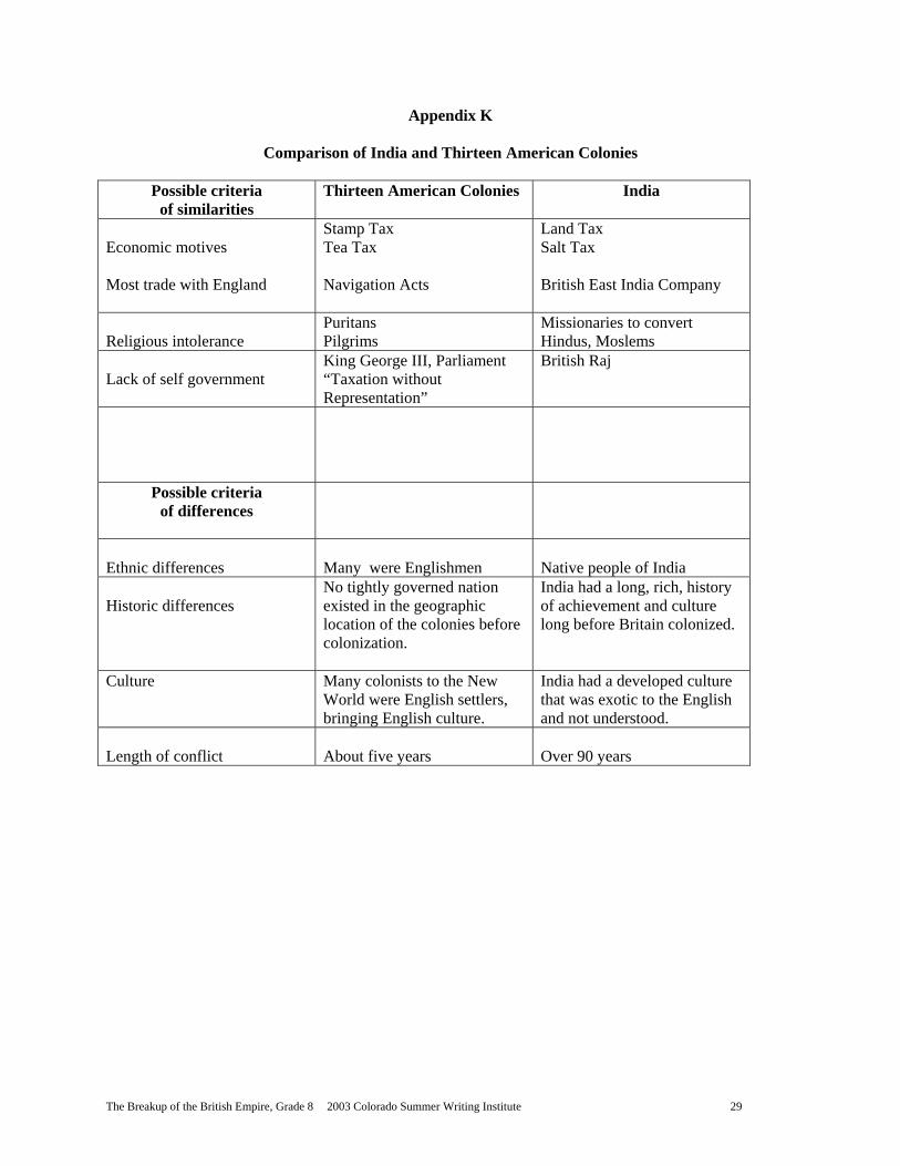
11. Assign students to compare India’s move towards independence with what they know of the Thirteen American Colonies. List the similarities and differences.
12. The point of this is assignment is two-fold; first, to remind students that the country they live in was once under the dominion of the British Empire, and two,
2004 Core Knowledge National Conference, 8th Grade, The Breakup of the British Empire 12
to show the length of time, in comparison, that India was oppressed under colonization.
E. Assessment/Evaluation 1. Collect papers comparing the period of British colonization in America with that
of India. As a formative assessment, give credit for effort in determining some similarities and differences between these British possessions. Some possible examples are included in Appendix K, Comparison of India and Thirteen American Colonies. Discuss student papers and the ideas in Appendix K.
Lesson Seven: The Sun Sets on the British Empire (1 class period, 50 minutes) A. Daily Objectives
1. Concept Objective(s) a. Understand how competition for resources causes conflicts between
societies and nations. (CSS) GEO 8.6.1.D) 2. Lesson Content
a. Breakup of the British Empire, Core Knowledge Sequence, p. 186 3. Skill Objective(s)
a. Explain, in essay format, why the British Colonial Empire crumbled in the second half of the twentieth century. (CSS GEO 8.1.2.A) (CSS HIS 8.2.B)
B. Materials 1. Students bring political world map from Lesson One 2. Appendix C, Colonies of Britain, the poster-size list 3. Students bring Appendix B , Notes on the Rise of the British Empire 4. Teacher copy of Appendix L, Two Quotes, on an overhead transparency 5. Teacher copy of Appendix M, Notes on the Fall of the British Empire, on a
transparency 6. Teacher copy of the Kipling poem, “Recessional,” available at URL:
http://www.web-books.com/Classics/Poetry/Anthology/Kipling/Recessional.htm 7. Appendix N, Essay Questions on the Breakup of the British Empire 8. Students bring notes from previous lessons 9. Paper for each student 10. Pencils or pens for each student 11. Overhead projector 12. Overhead markers
C. Key Vocabulary 1. Commonwealth – a body politic of free nations united by agreement 2. Nineveh and Tyre – ancient cities destroyed from excesses of power
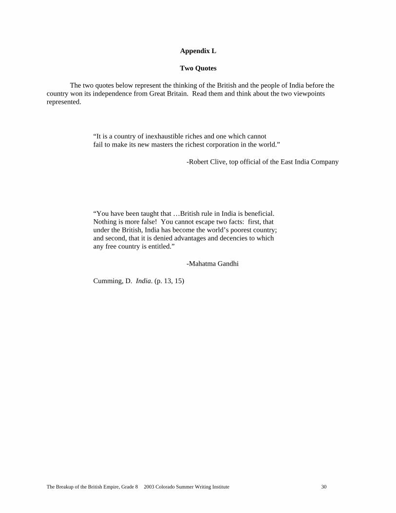
D. Procedures/Activities 1. Introduce this lesson with Appendix L, Two Quotes, on an overhead
transparency. Tell students these quotes apply to India, but they could have described many colonies under British rule.
2. Explain to students that while the focus of the unit has been Ireland and India, there were conflicts in many of the British colonies. Point out, once again, Appendix C, Colonies of Britain, the poster-size list.
3. Have students take another look at their notes they took from Appendix B, Notes on the Rise of the British Empire.
4. Talk about possible reasons for the breakup of the empire. (Some may suggest the growth of other nations, technological advances in weapons and transportation, resistance to nations controlling other countries, etc.)
2004 Core Knowledge National Conference, 8th Grade, The Breakup of the British Empire 13
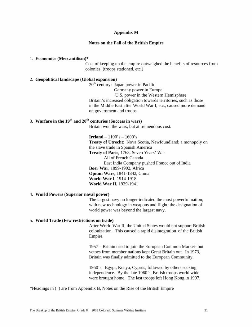
5. Put Appendix M, Notes on the Fall of the British Empire, on a transparency, on the overhead projector. Have students note that the very reasons Britain grew into an empire (refer to Appendix B, Notes on the Rise of the British Empire) support the demise of the empire, as well.
6. Have students look at the overhead and compare the information from their notes on the rise of the empire to Appendix M. Ask for questions or comments as you go through the reasons for the breakup.
7. Present to students several hypotheses about why the empire dissolved: a. Some sources say Britain’s economic decline after World War II was the
death knell of empire. The cost of the war was too high. b. Others suggest that the philosophy of allowing nations self-
determination, after the war, was too popular to support the continuation of colonization.
c. Another possibility was the United States lack of support for Britain’s imperialistic tendencies. As the most powerful nation in the world, the U.S. had enough political influence to dissuade Britain from hanging on to colonies.
d. The British may have lost their spirit for empire. Share with students Kipling’s poem, “Recessional,” (1897) emphasizing the quotes and discussing the historical allusions to Nineveh and Tyre:
The tumult and the shouting dies; The Captains and the Kings depart: (second stanza) Far-called, our navies melt away; On dune and headland sinks the fire: Lo, all our pomp of yesterday Is one with Nineveh and Tyre! (third stanza)
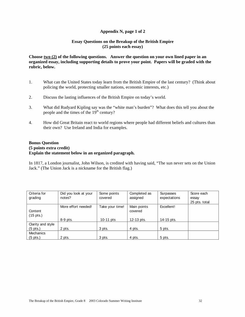
8. Tell students it’s their turn to hypothesize. They will choose two essay questions to answer from Appendix N, Essay Questions on the Breakup of the British Empire. They will follow the directions on the appendix. This assignment will be due on test day, to be handed in before the tests are passed out.
E. Assessment/Evaluation 1. Essay questions are graded according to the rubric included in Appendix N and
will be considered a summative assessment of critical thinking skills applied to this topic. An answer guide is provided on p. 2 of Appendix N, although answers will vary based on class discussion and student perceptions.
Lesson Eight: The Lasting Legacy of the British Colonial Empire (approximately one class period, 50 minutes) A. Daily Objectives
1. Concept Objective(s) a. Understand how competition for resources causes conflicts between
societies (CSS GEO 8.1.2.A) 2. Lesson Content
a. Creation of British Commonwealth, Core Knowledge Sequence, p. 186 b. Independence for colonial territories, Core Knowledge Sequence, p. 186
3. Skill Objective(s) a. Evaluate the legacy of the British Empire’s colonial influence by
arranging points of lasting importance in sequence, greatest to least in importance. (CSS GEO 8.1.2.A)
B. Materials 1. Appendix C, Colonies of Britain, poster-size list
2004 Core Knowledge National Conference, 8th Grade, The Breakup of the British Empire 14
2. Appendix O, The Legacy of the British Empire 3. Students bring notes and maps for this unit 4. Paper for students 5. Pencils or pens for students
C. Key Vocabulary 1. Legacy – something that’s handed down to future generations
D. Procedures/Activities 1. Refer students, once again, to Appendix C, Colonies of Britain poster. Have
them note the dates following some of the colonies’ names. These are the dates the colonies received independence from Great Britain.
2. The dominion became a domino game; the colonies fell into place, waiting their turn for independence like dominoes in a row, all falling down one after the other. Inform students that in many cases, such as that of Cyprus, Kenya, and Egypt, much bloodshed fell for several years before the hard won freedom was awarded. Remind students that the unit focuses on Ireland and India, but that many hard-won victories were fought in locations around the globe.
3. What had started out as competition for resources in a mercantile world became a one nation show, as Great Britain dotted the globe with colonial possessions.
4. In 1930, the Statute of Westminster was a step towards awarding independence to some of the colonies of Britain. The “white” dominions were the first to receive independence.
5. After World War I, “Empire” was dropped from the name, as empires were out of style at that time. The commonwealth concept, with former colonies having a looser association with the Crown than previously permitted, was a political segue for Britain to move the colonies to independence.
6. As Great Britain released its hold on so many locations in the world, it follows to determine the legacy of the British Empire and its long-lasting influence on the world.
7. Brainstorm with students about the possible residual influences left by Great Britain on the many colonies and possessions.
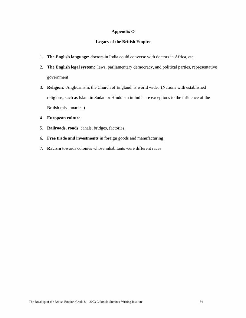
8. Using Appendix O, share some scholars’ suggested legacies of the British Empire.
9. Assign students to arrange the items in Appendix O in order of importance; with the greatest effect first and the least last, explaining the reasons for this arrangement. Tell them there are not “right” and “wrong” answers on this assignment; it is their assessment and rationale that is important.
E. Assessment/Evaluation 1. Collect student evaluations of the legacy of the British Empire. Award 10 points
for completion as assigned. VI. CULMINATING ACTIVITY
A. Demonstrate mastery of the “Breakup of the British Empire” unit by successfully completing Appendix P, Test on “Breakup of the British Empire,” 100 points, as a summative assessment and evaluation of this unit. Grade the tests using Appendix Q, Key to Test on “Breakup of the British Empire.” Collect essays from Lesson Seven.
VII. HANDOUTS/WORKSHEETS
A. Appendix A: Notes on the Rise of the British Empire (Lesson One and all lessons) B. Appendix B: Teacher Notes on the Rise of the British Empire (Lesson One) C. Appendix C: Colonies of Britain (Lesson One) D. Appendix D: Timeline Data of Ireland (Lesson Two)
2004 Core Knowledge National Conference, 8th Grade, The Breakup of the British Empire 15
E. Appendix E: Geography of India and South Asia (Lesson Three) F. Appendix F: Map of India and South Asia (Lesson Three) G. Appendix G: The Caste System of India, on a transparency (Lesson Four) H. Appendix H: Contributions of India (Lesson Five) I. Appendix I: “White Man’s Burden” Discussion (Lesson Five) J. Appendix J: Historical Events Leading to Indian Independence, on an overhead
transparency (Lesson Six) K. Appendix K: Comparison of India and Thirteen American Colonies (Lesson Six) L. Appendix L: Two Quotes (Lesson Seven) M. Appendix M: Notes on the Fall of the British Empire (Lesson Seven) N. Appendix N: Essay Questions on the Breakup of the British Empire (Lesson Seven) O. Appendix O: The Legacy of the British Empire (Lesson Eight) P. Appendix P: Test on “Breakup of the British Empire” (Culminating Activity) Q. Appendix Q: Key to Test on “Breakup of the British Empire.” (Culminating Activity)
VIII. BIBLIOGRAPHY
A. Ansprenger, F. The Dissolution of the Colonial Empires. New York, New York: Routledge, 1989. 0-415-00838-7.
B. Banting, E. Ireland, the People. New York, New York: Crabtree Publishing, 2002. 0-7787-9350-8.
C. Brasted, H. “Life and Society in Kipling’s British India, 1757-1905.” URL: http://www-personal.une.edu.au/~hbrasted/kipling/
D. Brown, J. and Louis, W., editors. Oxford History of the British Empire: The Twentieth Century. New York, New York: Oxford University Press, Inc., 1999. 0-19-820564-3.
E. Brown, L., and Halweil, B. “India Reaching 1 Billion on August 15: No Celebration Planned.” URL: http://www.worldwatch.org/alerts/990813.html.
F. Callaham, T. and Pavich, R. “The Indian Caste System.” URL: http://www.csuchico.edu/~cheinz/syllabi/asst001/spring98/india.htm
G. Core Knowledge Foundation. Core Knowledge Sequence. Charlottesville, Virginia: Core Knowledge Foundation, 1999. 1-890517-20-8.
H. Cumming, D. India. New York, New York: Thomas Learning, 1995. 1-56847-384-2. I. Ellis, E., and Esler, A. World History: Connections to Today. Upper Saddle River, New
Jersey: Prentice Hall, 1999. 0-13-434660-2. J. Ferguson, N. Empire: The Rise and Demise of the British World Order and the Lessons
for Global Power. New York, New York: Basic Books, 2002. 0-465-02328-2. K. Houghton, Mifflin Company, “Outline Maps.” URL: http://www.eduplace.com/ss/maps/ L. Houghton, Mifflin Company, “Outline Maps, World Countries” URL:
http://www.eduplace.com/ss/maps/pdf/world_country.pdf M. Houghton, Mifflin Company, “Outline Maps.” URL:
http://www.eduplace.com/ss/maps/pdf/s_asia_polnl.pdf N. James, L. The Rise and Fall of the British Empire. New York, New York: St. Martin’s
Press, 1996. 0-312-14039-8. O. Jacobs, H., Randolph, B., and LeVasseur, M. World Explorer: Asia and the Pacific.
Upper Saddle River, New Jersey: Prentice Hall, 2001. 0-13-050221-9. P. Kalman, B. India: The Culture. New York, New York: Crabtree Publishing, 1990. 0-
86505-212-3. Q. Kipling, R. “The White Man’s Burden.” URL:
http://www.kipling.org.uk/poems_burden.htm R. Kipling, R. “Recessional.” URL: http://www.web-
books.com/Classics/Poetry/Anthology/Kipling/Recessional.htm
2004 Core Knowledge National Conference, 8th Grade, The Breakup of the British Empire 16
S. Lace, W. The British Empire: The End of Colonialism. San Diego, California: Lucent Books, 2000. 1-56006-683-0.
T. Pollard, M. The Ganges. New York, New York: Benchmark Books, Marshall Cavendish Corporation, 1998. 0-7614-0504-6.
U. Raeside, R. “List of Former British Dominions, Colonies, Protectorates, Protected and Associated States, Mandated and Trust Territories,” URL: http://flagspot.net/flags/gb-colon.html#list.
V. Smith, B. Imperialism: A History in Documents. New York, New York: Oxford University Press, Inc., 2000. 0-19-510801-9.
W. Zwick, J. “Anti-Imperialism in the United States: 1898-1935.” URL: http://www.boondocksnet.com/ai/kipling/index.html.
2004 Core Knowledge National Conference, 8th Grade, The Breakup of the British Empire 17
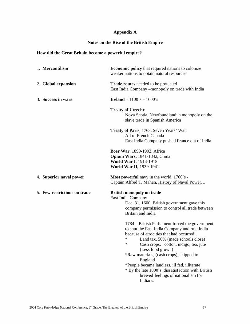
Appendix A
Notes on the Rise of the British Empire How did the Great Britain become a powerful empire? 1. Mercantilism Economic policy that required nations to colonize
weaker nations to obtain natural resources 2. Global expansion Trade routes needed to be protected
East India Company –monopoly on trade with India 3. Success in wars Ireland – 1100’s – 1600’s
Treaty of Utrecht: Nova Scotia, Newfoundland; a monopoly on the slave trade in Spanish America
Treaty of Paris, 1763, Seven Years’ War All of French Canada
East India Company pushed France out of India
Boer War, 1899-1902, Africa Opium Wars, 1841-1842, China World War I, 1914-1918 World War II, 1939-1941 4. Superior naval power Most powerful navy in the world, 1760’s -
Captain Alfred T. Mahan, History of Naval Power…. 5. Few restrictions on trade British monopoly on trade East India Company
Dec. 31, 1600, British government gave this company permission to control all trade between Britain and India 1784 – British Parliament forced the government to shut the East India Company and rule India because of atrocities that had occurred: * Land tax, 50% (made schools close) * Cash crops: cotton, indigo, tea, jute (Less food grown)
*Raw materials, (cash crops), shipped to England *People became landless, ill fed, illiterate * By the late 1800’s, dissatisfaction with British brewed feelings of nationalism for Indians.
2004 Core Knowledge National Conference, 8th Grade, The Breakup of the British Empire 18
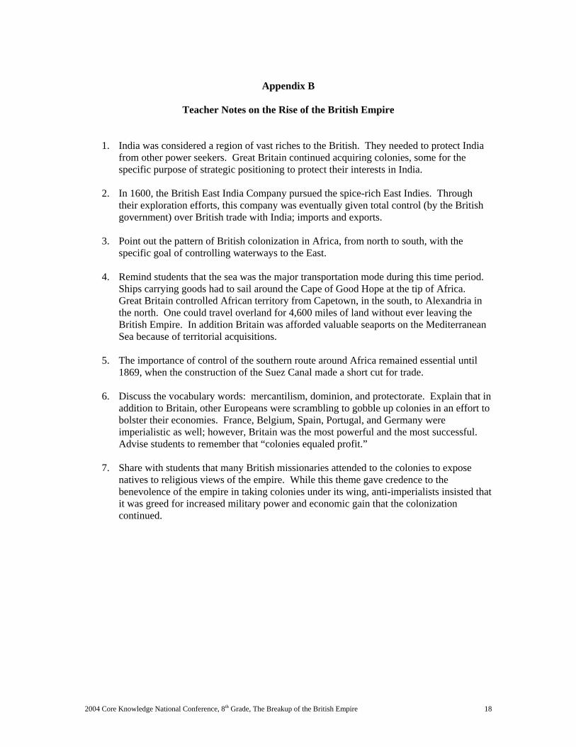
Appendix B
Teacher Notes on the Rise of the British Empire
1. India was considered a region of vast riches to the British. They needed to protect India from other power seekers. Great Britain continued acquiring colonies, some for the specific purpose of strategic positioning to protect their interests in India.
2. In 1600, the British East India Company pursued the spice-rich East Indies. Through
their exploration efforts, this company was eventually given total control (by the British government) over British trade with India; imports and exports.
3. Point out the pattern of British colonization in Africa, from north to south, with the
specific goal of controlling waterways to the East.
4. Remind students that the sea was the major transportation mode during this time period. Ships carrying goods had to sail around the Cape of Good Hope at the tip of Africa. Great Britain controlled African territory from Capetown, in the south, to Alexandria in the north. One could travel overland for 4,600 miles of land without ever leaving the British Empire. In addition Britain was afforded valuable seaports on the Mediterranean Sea because of territorial acquisitions.
5. The importance of control of the southern route around Africa remained essential until
1869, when the construction of the Suez Canal made a short cut for trade.
6. Discuss the vocabulary words: mercantilism, dominion, and protectorate. Explain that in addition to Britain, other Europeans were scrambling to gobble up colonies in an effort to bolster their economies. France, Belgium, Spain, Portugal, and Germany were imperialistic as well; however, Britain was the most powerful and the most successful. Advise students to remember that “colonies equaled profit.”
7. Share with students that many British missionaries attended to the colonies to expose
natives to religious views of the empire. While this theme gave credence to the benevolence of the empire in taking colonies under its wing, anti-imperialists insisted that it was greed for increased military power and economic gain that the colonization continued.
2004 Core Knowledge National Conference, 8th Grade, The Breakup of the British Empire 19
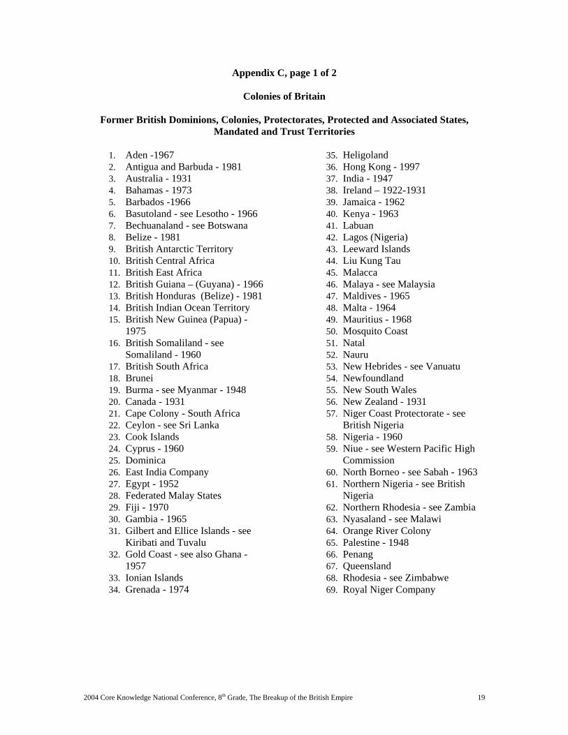
Appendix C, page 1 of 2
Colonies of Britain
Former British Dominions, Colonies, Protectorates, Protected and Associated States, Mandated and Trust Territories
1. Aden -1967 2. Antigua and Barbuda - 1981 3. Australia - 1931 4. Bahamas - 1973 5. Barbados -1966 6. Basutoland - see Lesotho - 1966 7. Bechuanaland - see Botswana 8. Belize - 1981 9. British Antarctic Territory 10. British Central Africa 11. British East Africa 12. British Guiana – (Guyana) - 1966 13. British Honduras (Belize) - 1981 14. British Indian Ocean Territory 15. British New Guinea (Papua) -
1975 16. British Somaliland - see
Somaliland - 1960 17. British South Africa 18. Brunei 19. Burma - see Myanmar - 1948 20. Canada - 1931 21. Cape Colony - South Africa 22. Ceylon - see Sri Lanka 23. Cook Islands 24. Cyprus - 1960 25. Dominica 26. East India Company 27. Egypt - 1952 28. Federated Malay States 29. Fiji - 1970 30. Gambia - 1965 31. Gilbert and Ellice Islands - see
Kiribati and Tuvalu 32. Gold Coast - see also Ghana -
1957 33. Ionian Islands 34. Grenada - 1974
35. Heligoland 36. Hong Kong - 1997 37. India - 1947 38. Ireland – 1922-1931 39. Jamaica - 1962 40. Kenya - 1963 41. Labuan 42. Lagos (Nigeria) 43. Leeward Islands 44. Liu Kung Tau 45. Malacca 46. Malaya - see Malaysia 47. Maldives - 1965 48. Malta - 1964 49. Mauritius - 1968 50. Mosquito Coast 51. Natal 52. Nauru 53. New Hebrides - see Vanuatu 54. Newfoundland 55. New South Wales 56. New Zealand - 1931 57. Niger Coast Protectorate - see
British Nigeria 58. Nigeria - 1960 59. Niue - see Western Pacific High
Commission 60. North Borneo - see Sabah - 1963 61. Northern Nigeria - see British
Nigeria 62. Northern Rhodesia - see Zambia 63. Nyasaland - see Malawi 64. Orange River Colony 65. Palestine - 1948 66. Penang 67. Queensland 68. Rhodesia - see Zimbabwe 69. Royal Niger Company
2004 Core Knowledge National Conference, 8th Grade, The Breakup of the British Empire 20
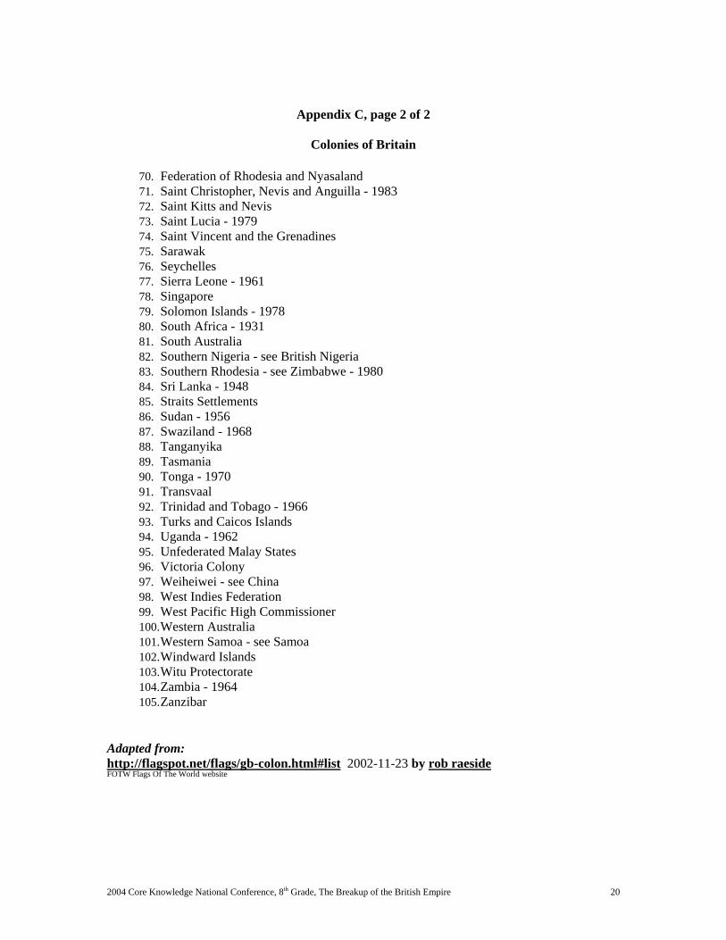
Appendix C, page 2 of 2
Colonies of Britain
70. Federation of Rhodesia and Nyasaland 71. Saint Christopher, Nevis and Anguilla - 1983 72. Saint Kitts and Nevis 73. Saint Lucia - 1979 74. Saint Vincent and the Grenadines 75. Sarawak 76. Seychelles 77. Sierra Leone - 1961 78. Singapore 79. Solomon Islands - 1978 80. South Africa - 1931 81. South Australia 82. Southern Nigeria - see British Nigeria 83. Southern Rhodesia - see Zimbabwe - 1980 84. Sri Lanka - 1948 85. Straits Settlements 86. Sudan - 1956 87. Swaziland - 1968 88. Tanganyika 89. Tasmania 90. Tonga - 1970 91. Transvaal 92. Trinidad and Tobago - 1966 93. Turks and Caicos Islands 94. Uganda - 1962 95. Unfederated Malay States 96. Victoria Colony 97. Weiheiwei - see China 98. West Indies Federation 99. West Pacific High Commissioner 100. Western Australia 101. Western Samoa - see Samoa 102. Windward Islands 103. Witu Protectorate 104. Zambia - 1964 105. Zanzibar
Adapted from: http://flagspot.net/flags/gb-colon.html#list 2002-11-23 by rob raeside FOTW Flags Of The World website
The Breakup of the British Empire, Grade 8 2003 Colorado Summer Writing Institute 21
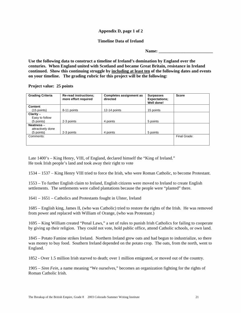
Appendix D, page 1 of 2
Timeline Data of Ireland
Name: _________________________
Use the following data to construct a timeline of Ireland’s domination by England over the centuries. When England united with Scotland and became Great Britain, resistance in Ireland continued. Show this continuing struggle by including at least ten of the following dates and events on your timeline. The grading rubric for this project will be the following: Project value: 25 points Grading Criteria Re-read instructions;
more effort required Completes assignment as directed
Surpasses Expectations; Well done!
Score
Content (15 points)
8-11 points
12-14 points
15 points
Clarity – Easy to follow (5 points)
2-3 points
4 points
5 points
Neatness – attractively done (5 points)
2-3 points
4 points
5 points
Comments: Final Grade:
Late 1400’s – King Henry, VIII, of England, declared himself the “King of Ireland.” He took Irish people’s land and took away their right to vote 1534 – 1537 – King Henry VIII tried to force the Irish, who were Roman Catholic, to become Protestant. 1553 – To further English claim to Ireland, English citizens were moved to Ireland to create English settlements. The settlements were called plantations because the people were “planted” there.
1641 – 1651 – Catholics and Protestants fought in Ulster, Ireland 1685 – English king, James II, (who was Catholic) tried to restore the rights of the Irish. He was removed from power and replaced with William of Orange, (who was Protestant.) 1695 – King William created “Penal Laws,” a set of rules to punish Irish Catholics for failing to cooperate by giving up their religion. They could not vote, hold public office, attend Catholic schools, or own land. 1845 – Potato Famine strikes Ireland. Northern Ireland grew oats and had begun to industrialize, so there was money to buy food. Southern Ireland depended on the potato crop. The oats, from the north, went to England. 1852 - Over 1.5 million Irish starved to death; over 1 million emigrated, or moved out of the country. 1905 – Sinn Fein, a name meaning “We ourselves,” becomes an organization fighting for the rights of Roman Catholic Irish.
The Breakup of the British Empire, Grade 8 2003 Colorado Summer Writing Institute 22
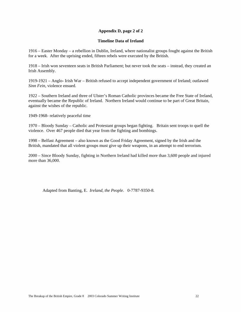
Appendix D, page 2 of 2
Timeline Data of Ireland 1916 – Easter Monday – a rebellion in Dublin, Ireland, where nationalist groups fought against the British for a week. After the uprising ended, fifteen rebels were executed by the British. 1918 – Irish won seventeen seats in British Parliament; but never took the seats – instead, they created an Irish Assembly. 1919-1921 – Anglo- Irish War – British refused to accept independent government of Ireland; outlawed Sinn Fein, violence ensued. 1922 – Southern Ireland and three of Ulster’s Roman Catholic provinces became the Free State of Ireland, eventually became the Republic of Ireland. Northern Ireland would continue to be part of Great Britain, against the wishes of the republic. 1949-1968- relatively peaceful time 1970 – Bloody Sunday – Catholic and Protestant groups began fighting. Britain sent troops to quell the violence. Over 467 people died that year from the fighting and bombings. 1998 – Belfast Agreement – also known as the Good Friday Agreement, signed by the Irish and the British, mandated that all violent groups must give up their weapons, in an attempt to end terrorism. 2000 – Since Bloody Sunday, fighting in Northern Ireland had killed more than 3,600 people and injured more than 36,000.
Adapted from Banting, E. Ireland, the People. 0-7787-9350-8.
The Breakup of the British Empire, Grade 8 2003 Colorado Summer Writing Institute 23
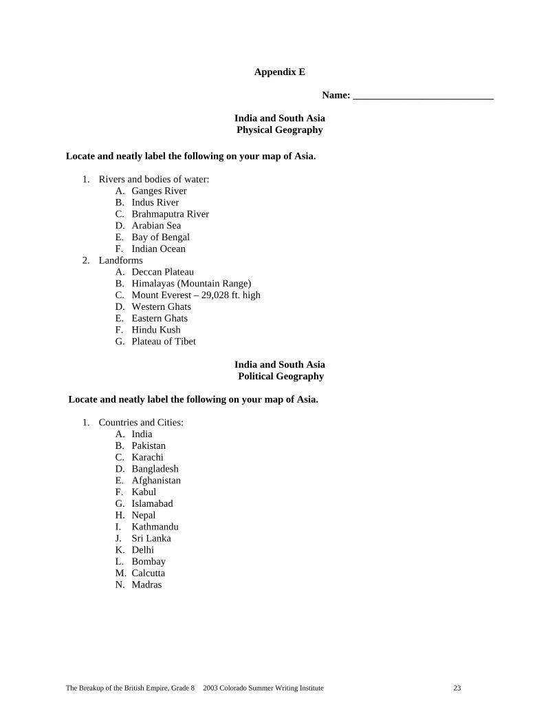
Appendix E
Name: ____________________________
India and South Asia Physical Geography
Locate and neatly label the following on your map of Asia.
1. Rivers and bodies of water: A. Ganges River B. Indus River C. Brahmaputra River D. Arabian Sea E. Bay of Bengal F. Indian Ocean
2. Landforms A. Deccan Plateau B. Himalayas (Mountain Range) C. Mount Everest – 29,028 ft. high D. Western Ghats E. Eastern Ghats F. Hindu Kush G. Plateau of Tibet
India and South Asia Political Geography
Locate and neatly label the following on your map of Asia.
1. Countries and Cities: A. India B. Pakistan C. Karachi D. Bangladesh E. Afghanistan F. Kabul G. Islamabad H. Nepal I. Kathmandu J. Sri Lanka K. Delhi L. Bombay M. Calcutta N. Madras
The Breakup of the British Empire, Grade 8 2003 Colorado Summer Writing Institute 24
Appendix F
Map of India and South Asia Name: ___________________
The Breakup of the British Empire, Grade 8 2003 Colorado Summer Writing Institute 25
Appendix G
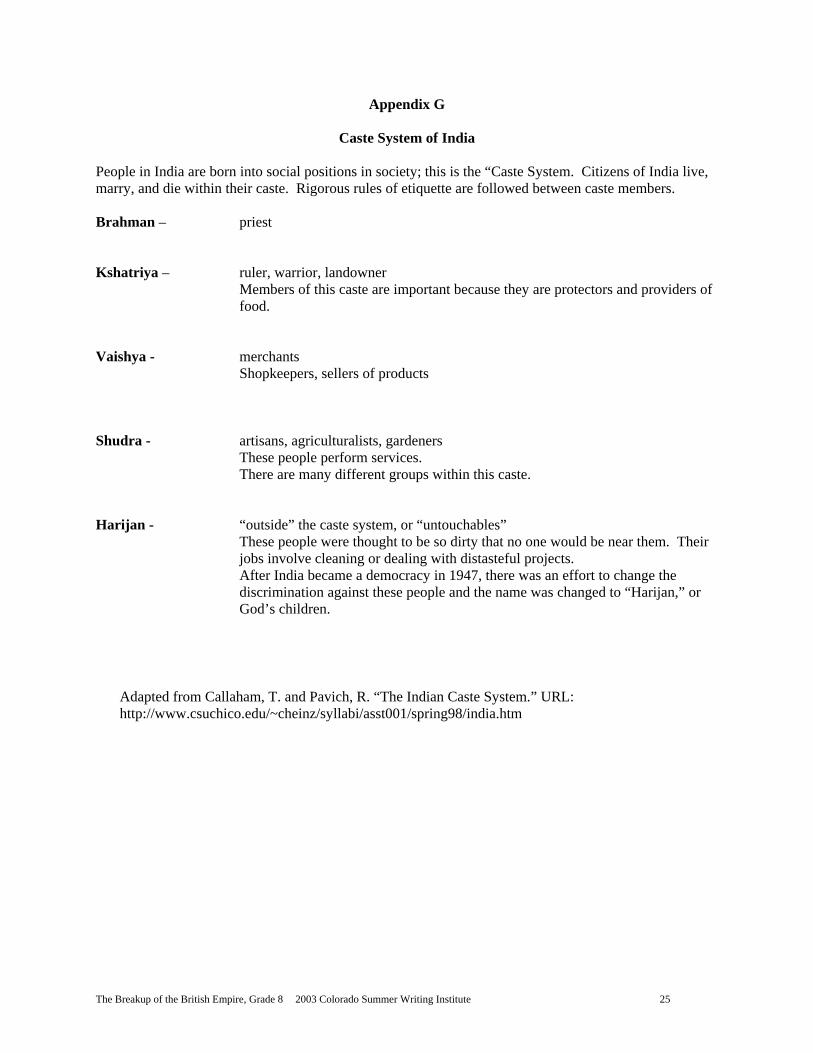
Caste System of India
People in India are born into social positions in society; this is the “Caste System. Citizens of India live, marry, and die within their caste. Rigorous rules of etiquette are followed between caste members. Brahman – priest Kshatriya – ruler, warrior, landowner
Members of this caste are important because they are protectors and providers of food.
Vaishya - merchants Shopkeepers, sellers of products Shudra - artisans, agriculturalists, gardeners These people perform services.
There are many different groups within this caste. Harijan - “outside” the caste system, or “untouchables”
These people were thought to be so dirty that no one would be near them. Their jobs involve cleaning or dealing with distasteful projects. After India became a democracy in 1947, there was an effort to change the discrimination against these people and the name was changed to “Harijan,” or God’s children.
Adapted from Callaham, T. and Pavich, R. “The Indian Caste System.” URL: http://www.csuchico.edu/~cheinz/syllabi/asst001/spring98/india.htm
The Breakup of the British Empire, Grade 8 2003 Colorado Summer Writing Institute 26
Appendix H
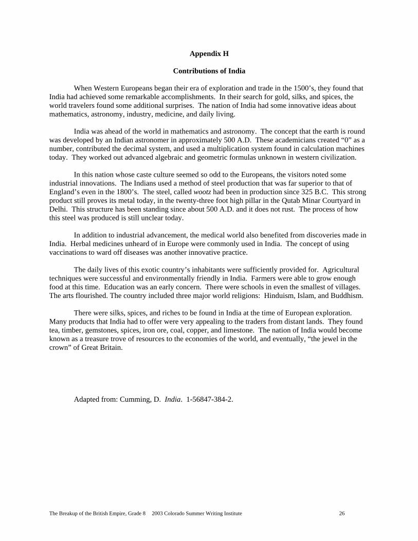
Contributions of India
When Western Europeans began their era of exploration and trade in the 1500’s, they found that India had achieved some remarkable accomplishments. In their search for gold, silks, and spices, the world travelers found some additional surprises. The nation of India had some innovative ideas about mathematics, astronomy, industry, medicine, and daily living. India was ahead of the world in mathematics and astronomy. The concept that the earth is round was developed by an Indian astronomer in approximately 500 A.D. These academicians created “0” as a number, contributed the decimal system, and used a multiplication system found in calculation machines today. They worked out advanced algebraic and geometric formulas unknown in western civilization. In this nation whose caste culture seemed so odd to the Europeans, the visitors noted some industrial innovations. The Indians used a method of steel production that was far superior to that of England’s even in the 1800’s. The steel, called wootz had been in production since 325 B.C. This strong product still proves its metal today, in the twenty-three foot high pillar in the Qutab Minar Courtyard in Delhi. This structure has been standing since about 500 A.D. and it does not rust. The process of how this steel was produced is still unclear today. In addition to industrial advancement, the medical world also benefited from discoveries made in India. Herbal medicines unheard of in Europe were commonly used in India. The concept of using vaccinations to ward off diseases was another innovative practice. The daily lives of this exotic country’s inhabitants were sufficiently provided for. Agricultural techniques were successful and environmentally friendly in India. Farmers were able to grow enough food at this time. Education was an early concern. There were schools in even the smallest of villages. The arts flourished. The country included three major world religions: Hinduism, Islam, and Buddhism. There were silks, spices, and riches to be found in India at the time of European exploration. Many products that India had to offer were very appealing to the traders from distant lands. They found tea, timber, gemstones, spices, iron ore, coal, copper, and limestone. The nation of India would become known as a treasure trove of resources to the economies of the world, and eventually, “the jewel in the crown” of Great Britain.
Adapted from: Cumming, D. India. 1-56847-384-2.
The Breakup of the British Empire, Grade 8 2003 Colorado Summer Writing Institute 27
Appendix I
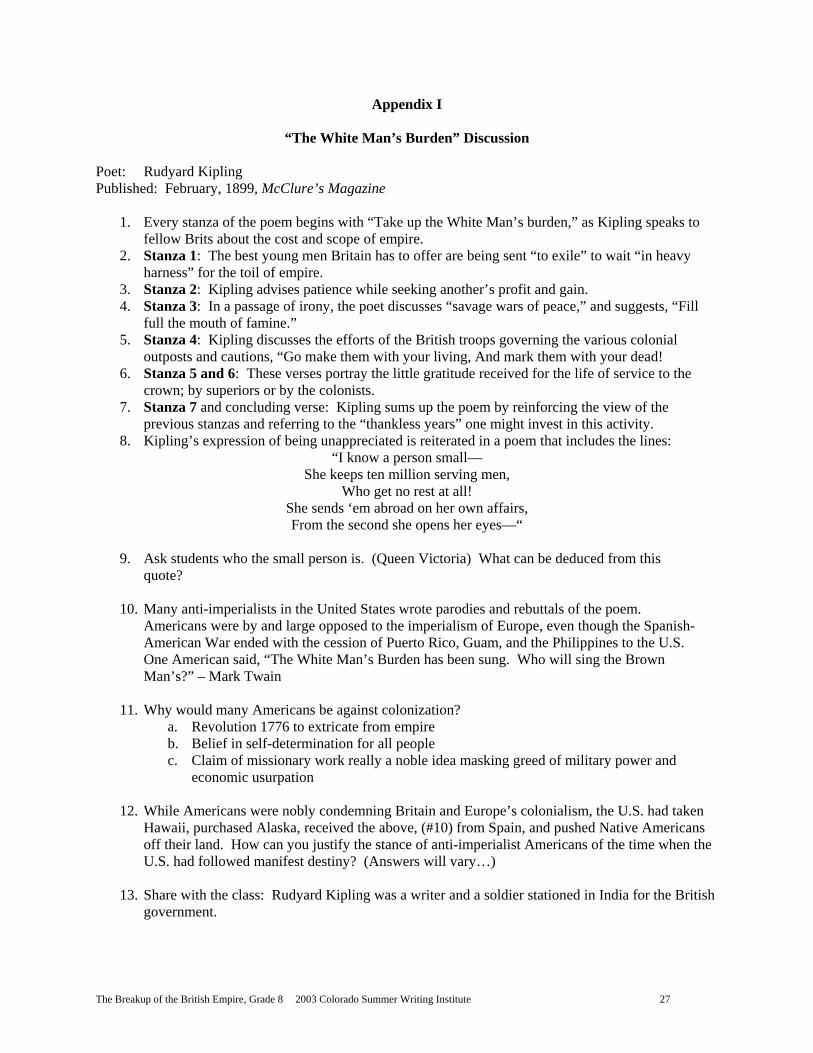
“The White Man’s Burden” Discussion
Poet: Rudyard Kipling Published: February, 1899, McClure’s Magazine
1. Every stanza of the poem begins with “Take up the White Man’s burden,” as Kipling speaks to fellow Brits about the cost and scope of empire.
2. Stanza 1: The best young men Britain has to offer are being sent “to exile” to wait “in heavy harness” for the toil of empire.
3. Stanza 2: Kipling advises patience while seeking another’s profit and gain. 4. Stanza 3: In a passage of irony, the poet discusses “savage wars of peace,” and suggests, “Fill
full the mouth of famine.” 5. Stanza 4: Kipling discusses the efforts of the British troops governing the various colonial
outposts and cautions, “Go make them with your living, And mark them with your dead! 6. Stanza 5 and 6: These verses portray the little gratitude received for the life of service to the
crown; by superiors or by the colonists. 7. Stanza 7 and concluding verse: Kipling sums up the poem by reinforcing the view of the
previous stanzas and referring to the “thankless years” one might invest in this activity. 8. Kipling’s expression of being unappreciated is reiterated in a poem that includes the lines:
“I know a person small— She keeps ten million serving men,
Who get no rest at all! She sends ‘em abroad on her own affairs, From the second she opens her eyes—“
9. Ask students who the small person is. (Queen Victoria) What can be deduced from this
quote?
10. Many anti-imperialists in the United States wrote parodies and rebuttals of the poem. Americans were by and large opposed to the imperialism of Europe, even though the Spanish-American War ended with the cession of Puerto Rico, Guam, and the Philippines to the U.S. One American said, “The White Man’s Burden has been sung. Who will sing the Brown Man’s?” – Mark Twain
11. Why would many Americans be against colonization? a. Revolution 1776 to extricate from empire b. Belief in self-determination for all people c. Claim of missionary work really a noble idea masking greed of military power and
economic usurpation
12. While Americans were nobly condemning Britain and Europe’s colonialism, the U.S. had taken Hawaii, purchased Alaska, received the above, (#10) from Spain, and pushed Native Americans off their land. How can you justify the stance of anti-imperialist Americans of the time when the U.S. had followed manifest destiny? (Answers will vary…)
13. Share with the class: Rudyard Kipling was a writer and a soldier stationed in India for the British
government.
The Breakup of the British Empire, Grade 8 2003 Colorado Summer Writing Institute 28
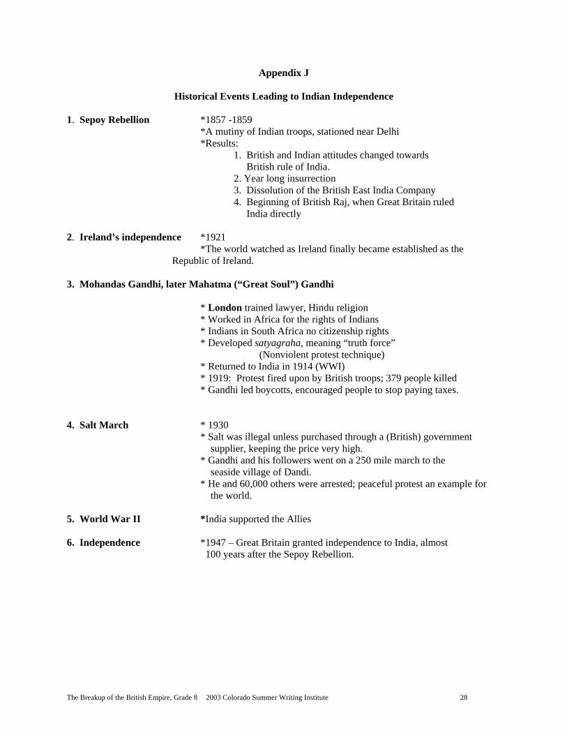
Appendix J
Historical Events Leading to Indian Independence 1. Sepoy Rebellion *1857 -1859 *A mutiny of Indian troops, stationed near Delhi
*Results: 1. British and Indian attitudes changed towards British rule of India. 2. Year long insurrection
3. Dissolution of the British East India Company 4. Beginning of British Raj, when Great Britain ruled
India directly 2. Ireland’s independence *1921 *The world watched as Ireland finally became established as the Republic of Ireland. 3. Mohandas Gandhi, later Mahatma (“Great Soul”) Gandhi * London trained lawyer, Hindu religion * Worked in Africa for the rights of Indians * Indians in South Africa no citizenship rights * Developed satyagraha, meaning “truth force” (Nonviolent protest technique)
* Returned to India in 1914 (WWI) * 1919: Protest fired upon by British troops; 379 people killed * Gandhi led boycotts, encouraged people to stop paying taxes.
4. Salt March * 1930 * Salt was illegal unless purchased through a (British) government supplier, keeping the price very high. * Gandhi and his followers went on a 250 mile march to the seaside village of Dandi. * He and 60,000 others were arrested; peaceful protest an example for the world. 5. World War II *India supported the Allies 6. Independence *1947 – Great Britain granted independence to India, almost 100 years after the Sepoy Rebellion.
The Breakup of the British Empire, Grade 8 2003 Colorado Summer Writing Institute 29
Appendix K
Comparison of India and Thirteen American Colonies
Possible criteria of similarities
Thirteen American Colonies India
Economic motives Most trade with England
Stamp Tax Tea Tax Navigation Acts
Land Tax Salt Tax British East India Company
Religious intolerance
Puritans Pilgrims
Missionaries to convert Hindus, Moslems
Lack of self government
King George III, Parliament “Taxation without Representation”
British Raj
Possible criteria of differences
Ethnic differences
Many were Englishmen
Native people of India
Historic differences
No tightly governed nation existed in the geographic location of the colonies before colonization.
India had a long, rich, history of achievement and culture long before Britain colonized.
Culture
Many colonists to the New World were English settlers, bringing English culture.
India had a developed culture that was exotic to the English and not understood.
Length of conflict
About five years
Over 90 years
The Breakup of the British Empire, Grade 8 2003 Colorado Summer Writing Institute 30
Appendix L
Two Quotes
The two quotes below represent the thinking of the British and the people of India before the country won its independence from Great Britain. Read them and think about the two viewpoints represented.
“It is a country of inexhaustible riches and one which cannot fail to make its new masters the richest corporation in the world.”
-Robert Clive, top official of the East India Company
“You have been taught that …British rule in India is beneficial. Nothing is more false! You cannot escape two facts: first, that under the British, India has become the world’s poorest country; and second, that it is denied advantages and decencies to which any free country is entitled.”
-Mahatma Gandhi
Cumming, D. India. (p. 13, 15)
The Breakup of the British Empire, Grade 8 2003 Colorado Summer Writing Institute 31
Appendix M
Notes on the Fall of the British Empire
1. Economics (Mercantilism)*
Cost of keeping up the empire outweighed the benefits of resources from colonies, (troops stationed, etc.)
2. Geopolitical landscape (Global expansion) 20th century: Japan power in Pacific Germany power in Europe U.S. power in the Western Hemisphere Britain’s increased obligation towards territories, such as those in the Middle East after World War I, etc., caused more demand on government and troops. 3. Warfare in the 19th and 20th centuries (Success in wars) Britain won the wars, but at tremendous cost.
Ireland – 1100’s – 1600’s Treaty of Utrecht: Nova Scotia, Newfoundland; a monopoly on the slave trade in Spanish America
Treaty of Paris, 1763, Seven Years’ War All of French Canada East India Company pushed France out of India Boer War, 1899-1902, Africa Opium Wars, 1841-1842, China World War I, 1914-1918 World War II, 1939-1941 4. World Powers (Superior naval power) The largest navy no longer indicated the most powerful nation; with new technology in weapons and flight, the designation of world power was beyond the largest navy. 5. World Trade (Few restrictions on trade) After World War II, the United States would not support British colonization. This caused a rapid disintegration of the British Empire. 1957 – Britain tried to join the European Common Market- but vetoes from member nations kept Great Britain out. In 1973, Britain was finally admitted to the European Community. 1950’s: Egypt, Kenya, Cyprus, followed by others seeking independence. By the late 1960’s, British troops world wide were brought home. The last troops left Hong Kong in 1997. *Headings in ( ) are from Appendix B, Notes on the Rise of the British Empire
The Breakup of the British Empire, Grade 8 2003 Colorado Summer Writing Institute 32
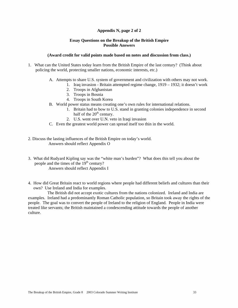
Appendix N, page 1 of 2
Essay Questions on the Breakup of the British Empire (25 points each essay)
Choose two (2) of the following questions. Answer the question on your own lined paper in an organized essay, including supporting details to prove your point. Papers will be graded with the rubric, below. 1. What can the United States today learn from the British Empire of the last century? (Think about
policing the world, protecting smaller nations, economic interests, etc.) 2. Discuss the lasting influences of the British Empire on today’s world. 3. What did Rudyard Kipling say was the “white man’s burden”? What does this tell you about the
people and the times of the 19th century? 4. How did Great Britain react to world regions where people had different beliefs and cultures than
their own? Use Ireland and India for examples. Bonus Question (5 points extra credit) Explain the statement below in an organized paragraph. In 1817, a London journalist, John Wilson, is credited with having said, “The sun never sets on the Union Jack.” (The Union Jack is a nickname for the British flag.)
Criteria for grading
Did you look at your notes?
Some points covered
Completed as assigned
Surpasses expectations
Score each essay 25 pts. total
Content (15 pts.)
More effort needed! 8-9 pts.
Take your time! 10-11 pts
Main points covered 12-13 pts.
Excellent! 14-15 pts.
Clarity and style (5 pts.)
2 pts.
3 pts.
4 pts.
5 pts.
Mechanics (5 pts.)
2 pts.
3 pts.
4 pts.
5 pts.
The Breakup of the British Empire, Grade 8 2003 Colorado Summer Writing Institute 33
Appendix N, page 2 of 2
Essay Questions on the Breakup of the British Empire Possible Answers
(Award credit for valid points made based on notes and discussion from class.)
1. What can the United States today learn from the British Empire of the last century? (Think about policing the world, protecting smaller nations, economic interests, etc.)
A. Attempts to share U.S. system of government and civilization with others may not work. 1. Iraq invasion - Britain attempted regime change, 1919 – 1932; it doesn’t work 2. Troops in Afghanistan 3. Troops in Bosnia 4. Troops in South Korea
B. World power status means creating one’s own rules for international relations. 1. Britain had to bow to U.S. stand in granting colonies independence in second
half of the 20th century. 2. U.S. went over U.N. veto in Iraqi invasion
C. Even the greatest world power can spread itself too thin in the world. 2. Discuss the lasting influences of the British Empire on today’s world. Answers should reflect Appendix O 3. What did Rudyard Kipling say was the “white man’s burden”? What does this tell you about the people and the times of the 19th century? Answers should reflect Appendix I 4. How did Great Britain react to world regions where people had different beliefs and cultures than their own? Use Ireland and India for examples. The British did not accept exotic cultures from the nations colonized. Ireland and India are examples. Ireland had a predominantly Roman Catholic population, so Britain took away the rights of the people. The goal was to convert the people of Ireland to the religion of England. People in India were treated like servants; the British maintained a condescending attitude towards the people of another culture.
The Breakup of the British Empire, Grade 8 2003 Colorado Summer Writing Institute 34
Appendix O
Legacy of the British Empire
1. The English language: doctors in India could converse with doctors in Africa, etc.
2. The English legal system: laws, parliamentary democracy, and political parties, representative
government
3. Religion: Anglicanism, the Church of England, is world wide. (Nations with established
religions, such as Islam in Sudan or Hinduism in India are exceptions to the influence of the
British missionaries.)
4. European culture
5. Railroads, roads, canals, bridges, factories
6. Free trade and investments in foreign goods and manufacturing
7. Racism towards colonies whose inhabitants were different races
The Breakup of the British Empire, Grade 8 2003 Colorado Summer Writing Institute 35
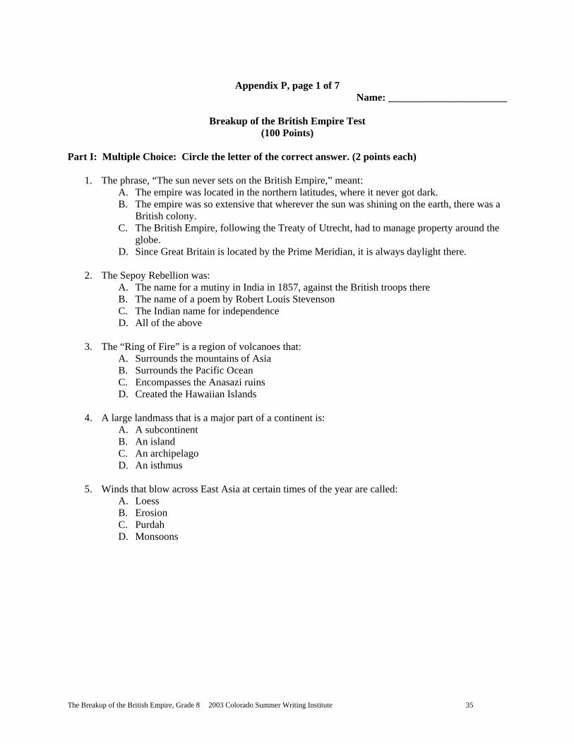
Appendix P, page 1 of 7
Name: _______________________
Breakup of the British Empire Test (100 Points)
Part I: Multiple Choice: Circle the letter of the correct answer. (2 points each)
1. The phrase, “The sun never sets on the British Empire,” meant: A. The empire was located in the northern latitudes, where it never got dark. B. The empire was so extensive that wherever the sun was shining on the earth, there was a
British colony. C. The British Empire, following the Treaty of Utrecht, had to manage property around the
globe. D. Since Great Britain is located by the Prime Meridian, it is always daylight there.
2. The Sepoy Rebellion was:
A. The name for a mutiny in India in 1857, against the British troops there B. The name of a poem by Robert Louis Stevenson C. The Indian name for independence D. All of the above
3. The “Ring of Fire” is a region of volcanoes that:
A. Surrounds the mountains of Asia B. Surrounds the Pacific Ocean C. Encompasses the Anasazi ruins D. Created the Hawaiian Islands
4. A large landmass that is a major part of a continent is:
A. A subcontinent B. An island C. An archipelago D. An isthmus
5. Winds that blow across East Asia at certain times of the year are called:
A. Loess B. Erosion C. Purdah D. Monsoons
The Breakup of the British Empire, Grade 8 2003 Colorado Summer Writing Institute 36
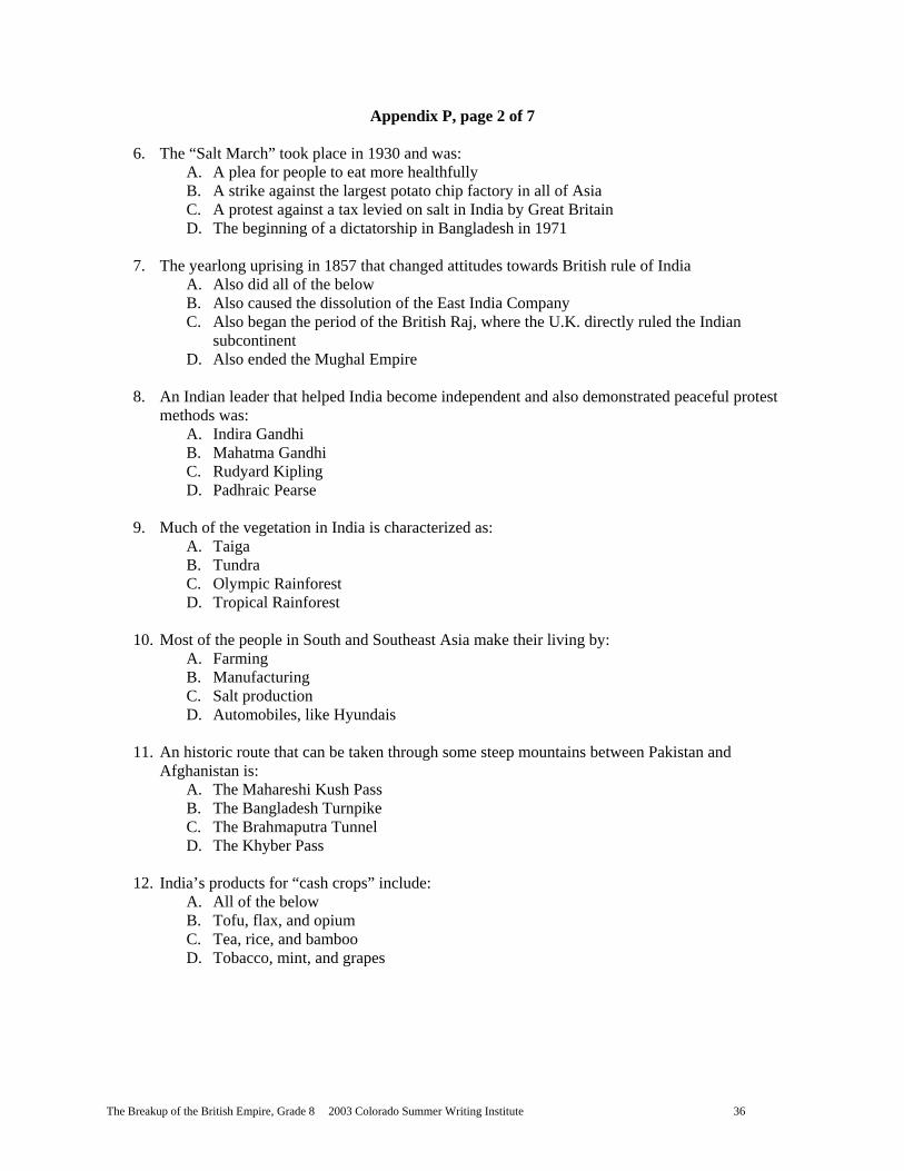
Appendix P, page 2 of 7
6. The “Salt March” took place in 1930 and was: A. A plea for people to eat more healthfully B. A strike against the largest potato chip factory in all of Asia C. A protest against a tax levied on salt in India by Great Britain D. The beginning of a dictatorship in Bangladesh in 1971
7. The yearlong uprising in 1857 that changed attitudes towards British rule of India
A. Also did all of the below B. Also caused the dissolution of the East India Company C. Also began the period of the British Raj, where the U.K. directly ruled the Indian
subcontinent D. Also ended the Mughal Empire
8. An Indian leader that helped India become independent and also demonstrated peaceful protest
methods was: A. Indira Gandhi B. Mahatma Gandhi C. Rudyard Kipling D. Padhraic Pearse
9. Much of the vegetation in India is characterized as:
A. Taiga B. Tundra C. Olympic Rainforest D. Tropical Rainforest
10. Most of the people in South and Southeast Asia make their living by:
A. Farming B. Manufacturing C. Salt production D. Automobiles, like Hyundais
11. An historic route that can be taken through some steep mountains between Pakistan and
Afghanistan is: A. The Mahareshi Kush Pass B. The Bangladesh Turnpike C. The Brahmaputra Tunnel D. The Khyber Pass
12. India’s products for “cash crops” include:
A. All of the below B. Tofu, flax, and opium C. Tea, rice, and bamboo D. Tobacco, mint, and grapes
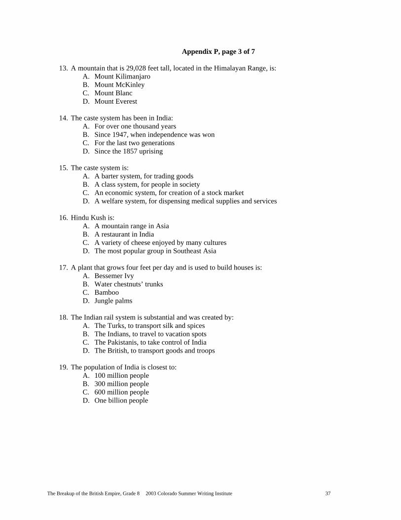
The Breakup of the British Empire, Grade 8 2003 Colorado Summer Writing Institute 37
Appendix P, page 3 of 7
13. A mountain that is 29,028 feet tall, located in the Himalayan Range, is: A. Mount Kilimanjaro B. Mount McKinley C. Mount Blanc D. Mount Everest
14. The caste system has been in India:
A. For over one thousand years B. Since 1947, when independence was won C. For the last two generations D. Since the 1857 uprising
15. The caste system is:
A. A barter system, for trading goods B. A class system, for people in society C. An economic system, for creation of a stock market D. A welfare system, for dispensing medical supplies and services
16. Hindu Kush is:
A. A mountain range in Asia B. A restaurant in India C. A variety of cheese enjoyed by many cultures D. The most popular group in Southeast Asia
17. A plant that grows four feet per day and is used to build houses is:
A. Bessemer Ivy B. Water chestnuts’ trunks C. Bamboo D. Jungle palms
18. The Indian rail system is substantial and was created by:
A. The Turks, to transport silk and spices B. The Indians, to travel to vacation spots C. The Pakistanis, to take control of India D. The British, to transport goods and troops
19. The population of India is closest to:
A. 100 million people B. 300 million people C. 600 million people D. One billion people

The Breakup of the British Empire, Grade 8 2003 Colorado Summer Writing Institute 38
Appendix P, page 4 of 7
20. The term Untouchables referred to: A. American law officers in the 1930’s B. People who have been quarantined because of disease C. The lowest members of the caste system in India D. The Brahman, or priests, in India
21. The major religion in India is:
A. Buddhism B. Christianity C. Sikhism D. Hinduism
22. The major religion in Pakistan is:
A. Islam B. Christianity C. Hinduism D. Buddhism
23. In 1899 a poem called “The White Man’s Burden” was published in McClure’s Magazine. The
poet was: A. Mahatma Gandhi B. Rudyard Kipling C. Indira Gandhi D. Jawalharlal Nehru
24. The nations of Pakistan and India were created as two separate nations in 1947 because of
religious conflict between two groups of people. This separation is referred to as: A. The partition B. The Iron Curtain C. The Bamboo Curtain D. The Great Wall of India
25. In Ireland, conflict has arisen between:
A. Protestants and Roman Catholics B. Buddhists and Christians C. Hindus and Muslims D. Historians and Progressives
26. The Easter Rebellion was:
A. An uprising about the Easter celebration in Ireland B. An uprising that occurred on Easter Monday, 1916 C. A spring celebration held outside a courthouse in Dublin D. A remembrance of an ancient revolt
The Breakup of the British Empire, Grade 8 2003 Colorado Summer Writing Institute 39
Appendix P, page 5 of 7 27. Today, the “IRA” stands for:
A. The Internal Revenue Association B. The Irish Republican Army C. The International Relief Agency D. The Investigative Reform Act
28. During the twentieth century, many British colonies gained independence. The British Empire
became the British: A. League of Nations B. United Nations C. Countries of Cooperation D. Commonwealth of Nations
29. Today, Northern Ireland remains part of Great Britain. The Republic of Ireland:
A. Wants reunification B. Wants peaceful separation from England C. Wants independence from Northern Ireland D. Wants to make a Protestant nation
30. The British Empire had acquired colonies for the purpose of:
A. All of the below B. Missionary work for uncivilized countries C. Natural resources to be used for manufacturing D. Convenient harbors for refueling ships and forming trade routes

The Breakup of the British Empire, Grade 8 2003 Colorado Summer Writing Institute 40
Appendix P, page 6 of 7
India Map Test (2 points each)
II. Map Test: Fill in the appropriate geographic location names on the lines below after you identify them on the map. A word bank is provided below; it has one extra word! 1. __________________________________________ (city name)
2. __________________________________________ (country name)
3. __________________________________________ (country name)
4. __________________________________________ (country name)
5. __________________________________________ (country name)
6. __________________________________________ (country name)
7. __________________________________________ (city name)
8. __________________________________________ (country name)
9. __________________________________________ (landform name)
10. _________________________________________ (landform name)
11. _________________________________________ (landform name)
12. _________________________________________ (landform name)
13. _________________________________________ (city name)
14. _________________________________________ (body of water)
15. _________________________________________ (landform name)
16. _________________________________________ (body of water)
17. _________________________________________ (body of water)
18. _________________________________________ (landform name)
19. _________________________________________ (river name)
20. _________________________________________ (country name)
Bangladesh Eastern Ghats Western Ghats
India Pakistan Afghanistan
Sri Lanka Ganges River Indus River
Hindu Kush Mount Everest Nepal
Deccan Plateau Arabian Sea Indian Ocean
Bay of Bengal New Delhi Islamabad
Bombay Himalayas China
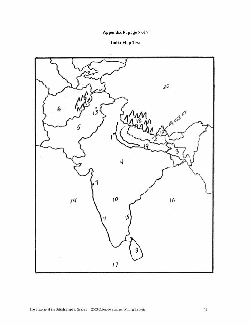
The Breakup of the British Empire, Grade 8 2003 Colorado Summer Writing Institute 41
Appendix P, page 7 of 7
India Map Test
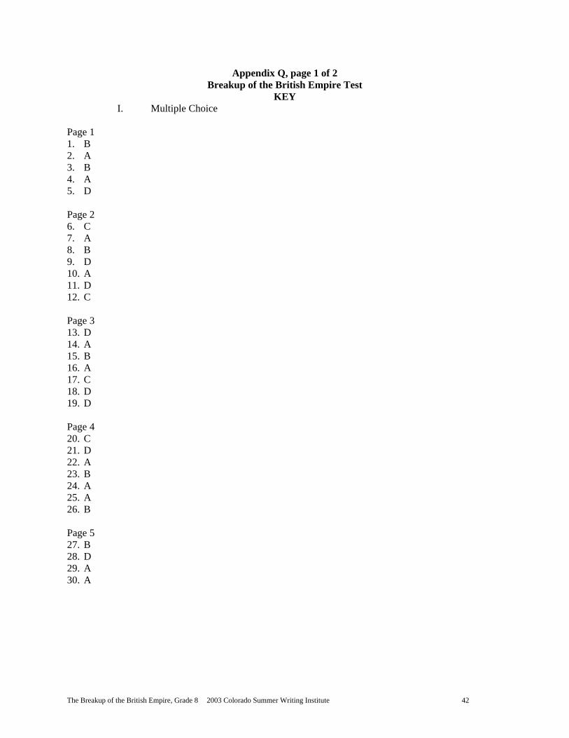
The Breakup of the British Empire, Grade 8 2003 Colorado Summer Writing Institute 42
Appendix Q, page 1 of 2 Breakup of the British Empire Test
KEY I. Multiple Choice
Page 1 1. B 2. A 3. B 4. A 5. D Page 2 6. C 7. A 8. B 9. D 10. A 11. D 12. C Page 3 13. D 14. A 15. B 16. A 17. C 18. D 19. D Page 4 20. C 21. D 22. A 23. B 24. A 25. A 26. B Page 5 27. B 28. D 29. A 30. A
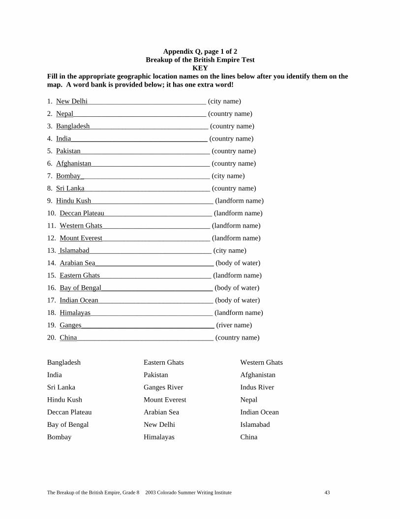
The Breakup of the British Empire, Grade 8 2003 Colorado Summer Writing Institute 43
Appendix Q, page 1 of 2 Breakup of the British Empire Test
KEY Fill in the appropriate geographic location names on the lines below after you identify them on the map. A word bank is provided below; it has one extra word! 1. New Delhi_________________________________ (city name)
2. Nepal_____________________________________ (country name)
3. Bangladesh_________________________________ (country name)
4. India______________________________________ (country name)
5. Pakistan____________________________________ (country name)
6. Afghanistan_________________________________ (country name)
7. Bombay____________________________________ (city name)
8. Sri Lanka___________________________________ (country name)
9. Hindu Kush__________________________________ (landform name)
10. Deccan Plateau______________________________ (landform name)
11. Western Ghats______________________________ (landform name)
12. Mount Everest______________________________ (landform name)
13. Islamabad__________________________________ (city name)
14. Arabian Sea_________________________________ (body of water)
15. Eastern Ghats_______________________________ (landform name)
16. Bay of Bengal_______________________________ (body of water)
17. Indian Ocean________________________________ (body of water)
18. Himalayas__________________________________ (landform name)
19. Ganges_____________________________________ (river name)
20. China______________________________________ (country name)
Bangladesh Eastern Ghats Western Ghats
India Pakistan Afghanistan
Sri Lanka Ganges River Indus River
Hindu Kush Mount Everest Nepal
Deccan Plateau Arabian Sea Indian Ocean
Bay of Bengal New Delhi Islamabad
Bombay Himalayas China