THE BLUE LINE
17
THE BLUE LINE 1st PRIZE Urban Planning, Design and Landscape Conservation, Kiev, Ukraine focus on the bustling metropolis through unique experiences by the water location Kiev, Ukraine size 2500 ha type Dniper islands masterplan role in project strategic planning and urban design schemes, graphical presentation contribution from the analysis&diagnosis process to concept development to graphical representation team Wolfhouse Productions (urb. Cristina ZLOTA, urb. Iulian CANOV, arch. Vlad Stoica, arch. Rozina DRAGOMIR) collaborators arch. Claudiu Forgaci, arch. Tamina LOLEV, designer. Iulia NAMASCO, arch. Maria PANTIR, arch. Alexandru TUDOSE date october - december 2011 status in negociation for the feasibility study The international urban planning competition for the ‘Dnieper Pearls’ called for the best proposal and authors for the preservation and development of Kyiv’s islands. The competition was initiated by Kyiv administration and Kyiv local development agency as part of the city’s sustainable urban deve opment for 2025.The competi- tion’s outcomes are to preserve and revive the valuable natural complexes and provide clear regulated facilities for tourism, sports and recreation activities within the natural enviro ment of the Dnieper Bay. The main objective of the project is to transform the Dnieper Islands in a symbol for Kyiv, considering three main principles: - Proposing an efficient and iconic scenic route along the Dnieper - The Blue Line solves the public transportation issues of Kyiv and will become a unique system that the city will become famous for. - Gradual protection zones will grant public access and implement community wide educational programs in ecology and sustainable areas. - Empowering communities to participate in the development of the islands will give them a sense of belonging to their city. 48
-
Upload
wolfhouse-productions -
Category
Documents
-
view
220 -
download
0
description
The project is the 1st prize winner for the "Dnipers Pearls" competition. Through our vision Kiev will update its public transport network bringing wilderness and recreation by the water in the very heart of the metropolis
Transcript of THE BLUE LINE

THE BLUE LINE 1st PRIZE
Urban Planning, Design and Landscape Conservation, Kiev, Ukraine focus on the bustling metropolis through unique experiences by the water
location Kiev, Ukrainesize 2500 hatype Dniper islands masterplanrole in project strategic planning and urban design schemes, graphical presentationcontribution from the analysis&diagnosis process to concept development to graphical representation team Wolfhouse Productions (urb. Cristina ZLOTA, urb. Iulian CANOV, arch. Vlad Stoica, arch. Rozina DRAGOMIR)collaborators arch. Claudiu Forgaci, arch. Tamina LOLEV, designer. Iulia NAMASCO, arch. Maria PANTIR, arch. Alexandru TUDOSE date october - december 2011status in negociation for the feasibility study
The international urban planning competition for the ‘Dnieper Pearls’ called for the best proposal and authors for the preservation and development of Kyiv’s islands. The competition was initiated by Kyiv administration and Kyiv local development agency as part of the city’s sustainable urban deve opment for 2025.The competi-tion’s outcomes are to preserve and revive the valuable natural complexes and provide clear regulated facilities for tourism, sports and recreation activities within the natural enviro ment of the Dnieper Bay.
The main objective of the project is to transform the Dnieper Islands in a symbol for Kyiv, considering three main principles:- Proposing an efficient and iconic scenic route along the Dnieper - The Blue Line solves the public transportation issues of Kyiv and will become a unique system that the city will become famous for.- Gradual protection zones will grant public access and implement community wide educational programs in ecology and sustainable areas.- Empowering communities to participate in the development of the islands will give them a sense of belonging to their city.
48

The largest economy in Ukraine, Kyiv tries to establish itself as an urban economic hub for Eastern Europe and Western Asia. Kyiv still has a low economic development status so it has to be in constant search for investment opportunities.
For this the city needs to market a clear tangible urban vision and focus on city scale integrated programmes. For start Kyiv has to assure an efficient transport & access infrastructure.
Kyiv is an expanding metropolis poorly connected from north to south.
One consequence is the conflict between urbanization and natural heritage.
Kyiv feels like a divided city: production activities lie on the west bank & residential zones lie on the east side.
Public transportation is a key element for a connected city.
Kyiv is rich in historical and cultural landmarks.
Better connectivity is needed among the city’s landmarks for tourists and citizens.
The natural protected areas bear the collateral damages done by infrastructural development.
Protection policies are essential for durable use of the islands complex.
MACRO SCALE ANALYSIS
49

Muromets Lopuhovatyi Truhaniv Dolobetsky Venetsianskyi Velykyi Galernyi Vodnikiv Zhukiv Kozachyi OlzhynPopulation
DiagnosisKyiv Islands
(existing/capacity)Area(ha) 148 56 402 128 188 36 317 150 70 222 154
=
=
= +
1871 | 2.2 %of urban srf.
0/296 0/112 0/182 0/00/10620/NA 0/2215 0/0 0/5570 | 0.20 %of urb pop.0/1069 0/634 0/NA
History
Landmarks
Flooding
Use
Flora
Fauna
Accessibility
Restrictions
Issues unclear urban status
former industrial area clearing
synanthropic species presence
Babyne lake polluted by Podilsko bridge
access control &wildlife protection
Protectionstatus
= -
MICRO SCALE ANALYSIS
50

GENERAL GROWTH SCENARIOS
Kyiv is the largest economy in Ukraine. At the same time it is a city trying to estab-lish itself as the most important East European urban hub. Attracting foreign or local investment has to be done through coherent city development strategies focused on larger city wide programs. One important such program that takes into considera-tion the broader urban impact is the development of public transportation systems.
The island archipelago in Kyiv and its ecosystem supports the most of consequenc-es of pollution. Lack of modern city wide waste management and informal use of the natural territory means that the islands function partly as waste disposal sites, espe-cially for the construction sector. Vast natural areas with no human presence and no regulated activity encourage abusive and informal use of the protected areas. There is a need for strong environmental educational programs led by prestigious national institutions. Institutional and community driven protection framework is essential for durable use of the islands complex.
Kyiv looks and acts like a divided city. It does most of its living on the left bank of the Dnieper and most of its working/production on the right bank. It is only natural that leisure and entertainment activities should be done somewhere in the middle.
The local government has to implement fast and often expensive solutions in order to keep up with Kyiv’s urban development. In the middle of this growing metropolis, Kyiv Islands, with its natural reserves and endangered species, have to take most of the collateral damage done by infrastructural development.
Kyiv is spanning along the Dnieper on a northsouth direction. In order for it to func-tion properly Kiev has to improve its connections and resolve its disparities.
Public transportation is the key element for a unified and connected Kyiv. The need for a new holistic public transportation system occurs. It has to be efficient, environmentally friendly and cheap to build and run.
Having natural and cultural landmarks in a city is vital for high quality of life stand-ards. Most kievans regard the Dnieper Island complex as the most important symbol of the city but most locals rarely use the Islands’ territory in an optimum manner.
Poor connectivity and lack of adequate urban equipment on the islands leads to under use of this territory. Having large, uninhabited and remote areas is ideal for a wildlife reserve. But when some of the country’s most important natural reservation areas are at the outskirts of a metropolis, protection policies need to be reconsid-ered. Protection of natural habitats might also be done through the use of these territories coordinated responsibly by local administration. Only by establishing its firm presence around the protected territory can local governance and scientific institutions efficiently protect natural habitats in a city this size.
51

courtesy of WOLFHOUSE PRODUCTIONS52

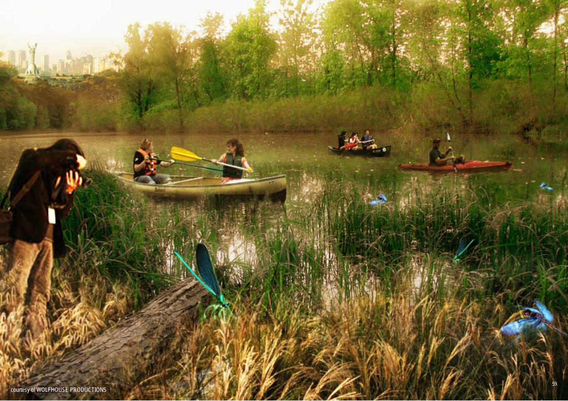
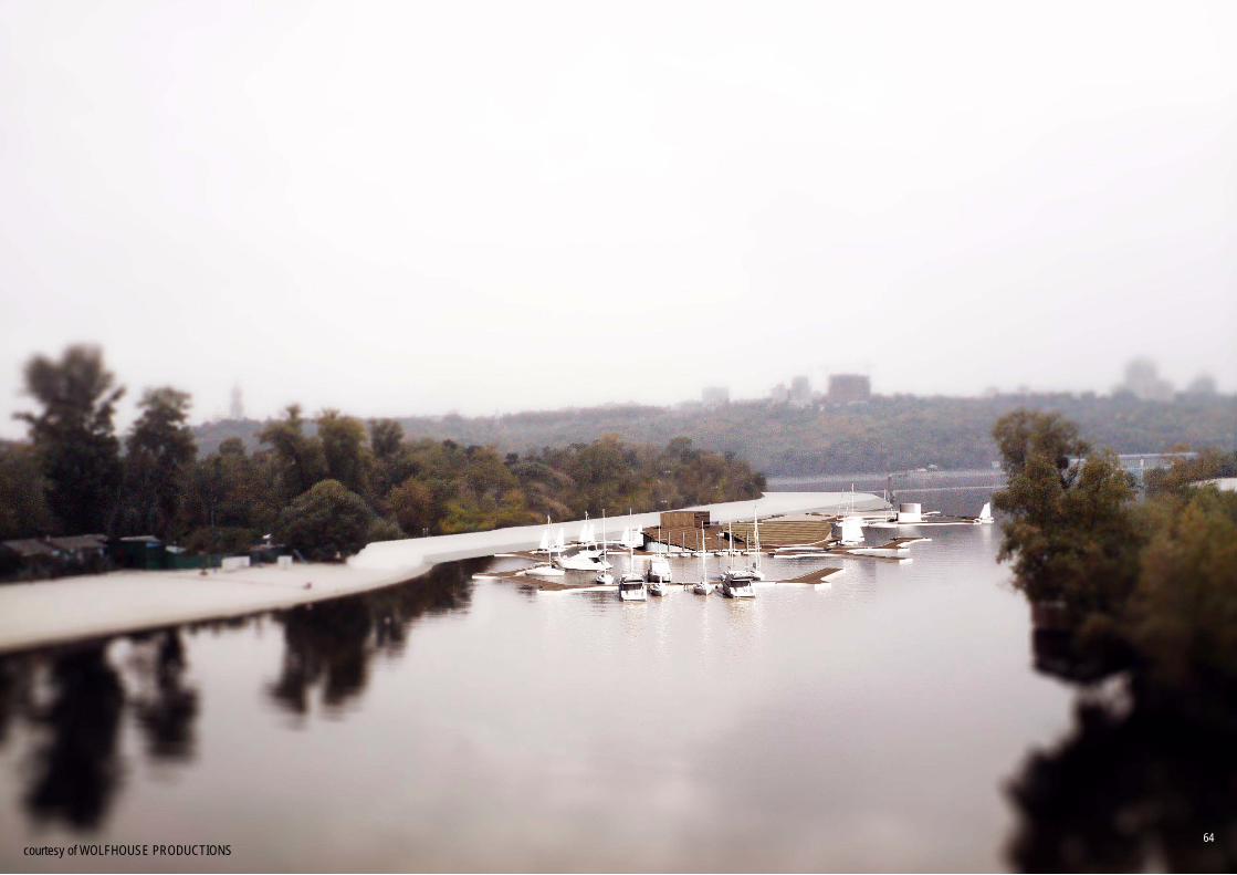
Seen from over Truhaniv, the islands appear as a vast natural corridor linking the two banks of the Dnieper River and bringing wilderness and recreation in the very heart of a bustling metropolis. They span the entire length of the urban agglomeration and ensure the city dwell-er that nature is always around the corner (by the river) when you are in Kyiv.
If urged by curiosity, one could explore in a day trip the entire landscape from Truhaniv’s Dru-zhby Narodiv Expositional Park – in the north – to Zhukiv’s BIOScience+Edu Center – in the south – using only the bicycle routes. Nevertheless, a popular way of discovering Kyiv’s Islands and historical landmarks is by embarking for a scenic ride provided by the BLUE LINE; a unique public transportation system that Kyiv is famous for.
Using this iconic transportation system locals and tourists alike can easily access the city’s main landmarks as well as the leisure and entertainment center developed around Hidropark. The river stations act as main access points and their various functional additions hint the urban vocation of the islands.
THE BLUE LINE VISION
53
ZHUKIV EDU+SCIENCE
VELYKYI
DESNIANSKI
PODIL
OBOLON
LUKOVE
MUROMETS
BIO-SCIENCE
GALERNYI
NYZHNI
GARDENS 2
NYZHNI
GARDENS 1
NAVODNYTSKYI
PARK
OSOKORKYI VILL
AGE
VODNIKOV
RIVERSTAT
ION
DOLOBETS
KYI
BRICK FACTO
RY
VENETSIANSKYI
VENETSIANSKYI
BEACH
PODILSKO VOSKRESENSKIY
DRUZHBY
NARODIV PARK
TRUHANOV
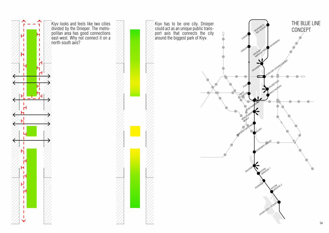
Kiyv looks and feels like two cities divided by the Dnieper. The metro-politan area has good connections east-west. Why not connect it on a north-south axis?
Kiyv has to be one city. Dnieper could act as an unique public trans-port axis that connects the city around the biggest park of Kiyv.
THE BLUE LINE CONCEPT
54

Protection and development of the Dnieper Pearls
1. Bio-diversity educational and informational campaigns for the community The main problem with valuable landscape protection in Kiev is that the local community is not properly informed about the importance of preservation and about the specific protected plants and animals. People are generally proud of the Dnieper Islands and are interested in protecting them. Community involvement tactics could prove very successful if implemented.
2. Implementing specific buffer zones for the protection of valuable landscape and objectsNatural conservation areas and valuable objects on the islands have to be surrounded by buffer zone areas. This is especially needed in the vicinity of denser human activity hot sport. Buffer zones are extension belts of natural landscape and are characterized lush natural landscape and few access points.
3. Diverting walking paths as a landscape protection tacticsWalking trails and cycle routes in the vicinity of protected areas and valuable objects should be designed so that they converge towards activities and diverge from protected landscape. This way buffer zones and wildlife reserves will be subject less human interaction.
4. Constant and distributed presence of local administration on the territoryIn order to discourage littering, informal use and illegal activities on the Islands’ territory, constant local government presence should be ensured. Developing the river transit system means local government is present throughout the territory.
5. Public awareness and use of city branding tacticsHigh public profile for the Dnieper Islands and their valuable landscape helps educational campaigns’ impact and attracts possible private investment.
STRATEGIC PRINCIPLES
55

LOPUHOVATYI natural conservation area
100%
TRUHANIV stationary recreationcultural activities
natural conservation area regulated recreational area
sports activities
28%36%
0.5%19%16.5%
DOLOBETSKY natural conservation area regulated recreational area41%59%
VENETSIANSKYInatural conservation area regulated recreational areastationary recreational areamixed-use
33%
1%
13%
53%
GALERNYIgreen public spacebusinessresidentialmixed-use
20%10%
30%
40%
VODNYKIVgreen public spaceservicesresidential
30%
5%
65%
MUROMETS
4%
96%
natural conservation area regulated recreational area
VELYKYI natural conservation area
natural conservation area
100%
ZHUKIVregulated recreation areaservicesstationary recreation
3%19%
78%
KOZACHYI & OLZHYN
100%
natural conservation
regulated recreation
stationaryrecreation
economicdevelopment
64%
20%
14%
1%
44
1
4
4
3
3
3
3
3
3
3 4
3
3
3
2
1
2
2
1
24
2
Functional zoning for the Dnieper Bay
CLUSTER FOR EDUCATION / regulated recreation area 10 % | 250 ha
CLUSTER FOR CULTURE / regulated recreation area 13 % | 325 haCLUSTER FOR SPORT / stationary recreation 12 % | 300 ha
CLUSTER FOR SPORT / regulated recreation 3 % | 75 ha
CLUSTER FOR EDUCATION / natural conservation area 33 % | 825 ha
CLUSTER FOR RECREATION / stationary recreation 6 % | 150 ha
CLUSTER FOR RECREATION / regulated recreation 15 % | 375 ha
CLUSTER FOR MIXED-USE / area of economic development 8 % | 200 ha
THE BLUE LINE MASTERPLAN
56

PRIORITY PROJECT
The newly built bridge crosses through a natural conservation habitat on Truhaniv island. As a measure to protect pedestrians the bridge will be sound-proofed and ‘renaturated’ with dense vegetation.
57
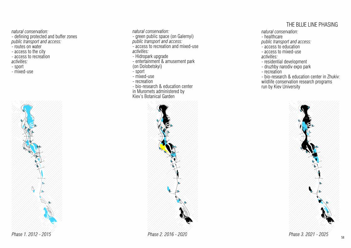
Phase 1. 2012 - 2015
natural conservation:- defining protected and buffer zones public transport and access:- routes on water- access to the city- access to recreation activities: - sport- mixed-use
1515
44
4
4
3
3
3
3
3
3
3
3
3
3
2
2
2
2
Phase 2. 2016 - 2020
natural conservation:- green public space (on Galernyi)public transport and access:- access to recreation and mixed-use activities: - Hidropark upgrade- entertainment & amusement park (on Dolobetskyi)- sport- mixed-use - recreation- bio-research & education center in Muromets administered by Kiev’s Botanical Garden
2020
4
4
4
3
3
3
3
3
3
3 4
3
3
3
2
2
2
1
24
2
Phase 3. 2021 - 2025
natural conservation:- healthcarepublic transport and access:- access to education- access to mixed-useactivities: - residential development- druzhby narodiv expo park- recreation- bio-research & education center in Zhukiv: wildlife conservation research programs run by Kiev University
2525
4
1
4
4
3
3
3
3
3
3
3 4
3
3
3
2
1
2
2
1
24
2
THE BLUE LINE PHASING
58
courtesy of WOLFHOUSE PRODUCTIONS59
Petrivs'kyj railway bridgetrPe ai
Moskow bridgeidg
kow
d1
t1
t4
d3
d4
d2
v2
v1
v3 v4
v5
t5
t5
t5
t10
t10
t11
t9
t5
t8
t7
t2 t3t6
t11
t11
t12
t13 t14
t14
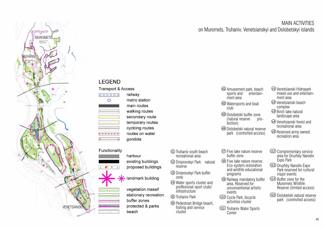
t15 Muromets Lapuhovatyi Wildlife Reserve (controlled access)
v1 Venetsianski Hidropark mixed use and entertain-ment area
v2 Venetsianski beach complex
v3 Birch lake natural landscape area
v4 Venetsianski forest and recreational area
v5 Reserved army owned recreation area
d1 Amusement park, beach sports and entertain-ment area
d2 Watersports and boat club
d3 Dolobetski buffer zone (natural reserve pro-tection)
d4 Dolobetski natural reserve park (controlled access)
t1 Truhaniv south beach recreational area
t2 Dniprovskyi Park natural reserve
t3 Dniprovskyi Park buffer zone
t4 Water sports cluster and proffesional sport clubs’ infrastructure
t5 Truhaniv Parkt6 Pedestrian Bridge beach,
fishing and service cluster
t7 Five lake nature reserve buffer zone
t8 Five lake nature reserve. Eco-system restoration and wildlife educational programs
t9 Railway mandatory buffer area. Reserved for unconventional artistic eventsCycle Park, bicycle activities cluster
t10
Truhaniv Water Sports Center
t11
Complementary service area for Druzhby Narodiv Expo Park
t12
Druzhby Narodiv Expo Park reserved for cultural major events
t13
Buffer zone for the Muromets Wildlife Reserve (limited access)
t14
Dolobetski natural reserve park (controlled access)
t15
MAIN ACTIVITIES on Muromets, Truhaniv, Venetsianskyi and Dolobetskyi islands
MUROMETS
TRUHANIV
VENETSIANSKYI
60

courtesy of WOLFHOUSE PRODUCTIONS61
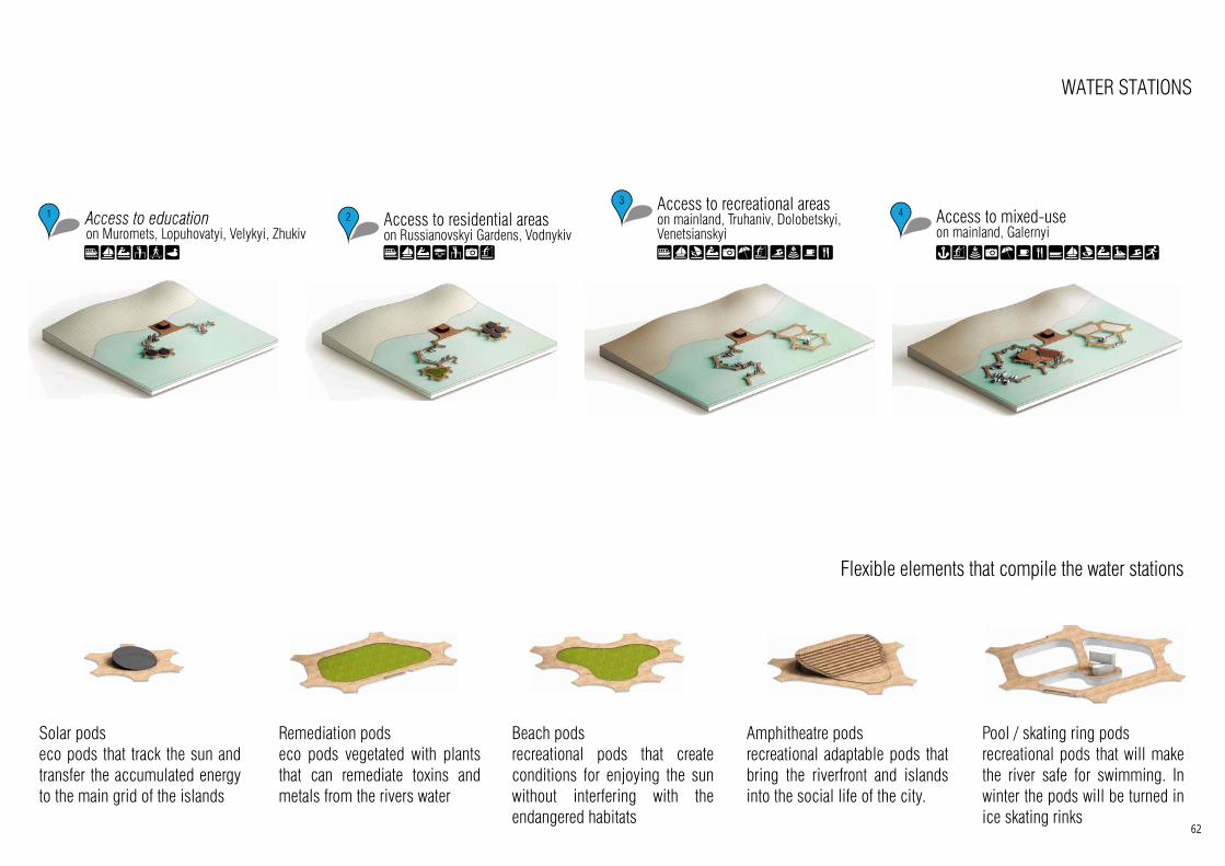
4 Access to mixed-use on mainland, Galernyi
1 Access to education on Muromets, Lopuhovatyi, Velykyi, Zhukiv
2 Access to residential areas on Russianovskyi Gardens, Vodnykiv
3 Access to recreational areas on mainland, Truhaniv, Dolobetskyi, Venetsianskyi
Pool / skating ring podsrecreational pods that will make the river safe for swimming. In winter the pods will be turned in ice skating rinks
Amphitheatre podsrecreational adaptable pods that bring the riverfront and islands into the social life of the city.
Beach podsrecreational pods that create conditions for enjoying the sun without interfering with the endangered habitats
Remediation podseco pods vegetated with plants that can remediate toxins and metals from the rivers water
Solar podseco pods that track the sun and transfer the accumulated energy to the main grid of the islands
WATER STATIONS
Flexible elements that compile the water stations
62
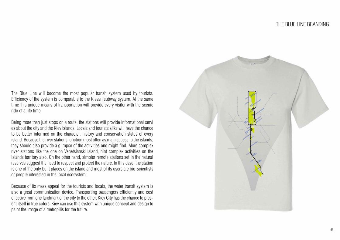
THE BLUE LINE BRANDING
The Blue Line will become the most popular transit system used by tourists. Efficiency of the system is comparable to the Kievan subway system. At the same time this unique means of transportation will provide every visitor with the scenic ride of a life time.
Being more than just stops on a route, the stations will provide informational servi es about the city and the Kiev Islands. Locals and tourists alike will have the chance to be better informed on the character, history and conservation status of every island. Because the river stations function most often as main access to the islands, they should also provide a glimpse of the activities one might find. More complex river stations like the one on Venetsianski Island, hint complex activities on the islands territory also. On the other hand, simpler remote stations set in the natural reserves suggest the need to respect and protect the nature. In this case, the station is one of the only built places on the island and most of its users are bio-scientists or people interested in the local ecosystem.
Because of its mass appeal for the tourists and locals, the water transit system is also a great communication device. Transporting passengers efficiently and cost effective from one landmark of the city to the other, Kiev City has the chance to pres-ent itself in true colors. Kiev can use this system with unique concept and design to paint the image of a metropilis for the future.
63
courtesy of WOLFHOUSE PRODUCTIONS64