Lenin to Stalin Mr. Eischen, Mr. Cleveland and Mrs. McCarthy.
Upload
elizabeth-watersCategory
view
220download
0
The Basics of LOCATIONThe Basics of LOCATIONWorld Geography World Geography Mrs. McCarthy Mrs. McCarthy

Introduction
► Geography skills provide the tools and methods for us to understand the relationships between people, places, and environments. We use geographic skills when we make daily personal decisions–where to buy a home; where to get a job; how to get to the shopping mall; where to go on vacation. Community decisions, such as where to locate a new school or how to solve problems of air and water pollution, also require the skillful use of geographic information.

Thinking Like a Geographer
• Geographers use a wide array of tools and technologies–from basic globes to high-tech global positioning systems–to understand the earth. These help them collect and analyze a great deal of information. However, the study of geography is more than knowing a lot of facts about places. Rather, it has more do with asking questions about the earth, pursuing their answers, and solving problems. Thus, one of the most important geographic tools is inside your head: the ability to think geographically.

Latitude, Longitude, and Location
• Geography is often said to begin with the question:
Where?• The basic tool for answering the question is
location. Lines on globes and maps provide information that can help you locate places. These lines cross one another, forming a pattern called a grid system. This system helps you find exact places on the earth’s surface.

Latitude and LongitudeLatitude and Longitude
► Are measured in degreeAre measured in degree°°, minutes, minutes′′, seconds, seconds″. ″. There are 60 minutes in each degree. There are 60 minutes in each degree. Each minute is divided into 60 seconds. Each minute is divided into 60 seconds.
LatitudeLatitude (Parallels): runs east to west (Parallels): runs east to west but MEASURES north and southbut MEASURES north and south
LongitudeLongitude (Meridians): runs north to south (Meridians): runs north to south but MEASURES east and westbut MEASURES east and west

LatitudeLatitude
Latitude Lines of latitude, or parallels, circle the earth parallel to the Equator and measure the distance north or south of the Equator in degrees. The Equator is measured at 0° latitude, while the Poles lie at latitudes 90° N (north) and 90° S (south). Parallels north of the Equator are called north latitude, and parallels south of the Equator are called south latitude.
Latitude Latitude
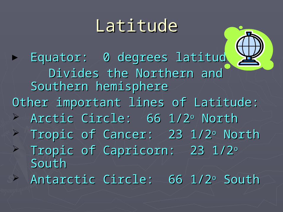
► Equator: 0 degrees latitudeEquator: 0 degrees latitude Divides the Northern and Southern Divides the Northern and Southern
hemisphere hemisphere Other important lines of Latitude:Other important lines of Latitude: Arctic Circle: 66 1/2Arctic Circle: 66 1/2oo North North Tropic of Cancer: 23 1/2Tropic of Cancer: 23 1/2oo North North Tropic of Capricorn: 23 1/2Tropic of Capricorn: 23 1/2oo South South Antarctic Circle: 66 1/2Antarctic Circle: 66 1/2oo South South

LongitudeLongitude
Longitude Lines of longitude, or meridians, circle the earth from Pole to Pole. These lines measure distances east or west of the starting line, which lies at 0° longitude and is called the Prime Meridian. By international agreement, the Prime Meridian is the line of longitude that runs through the Royal Observatory in Greenwich, England. Places east of the Prime Meridian are known as east longitude, and places west of the Prime Meridian are known as west longitude.

Longitude (Meridians)Longitude (Meridians)0 degrees to 180 degrees 0 degrees to 180 degrees
Prime Meridian: 0 degrees longitude Prime Meridian: 0 degrees longitude
Divides the Eastern and Western Divides the Eastern and Western hemispherehemisphere
There are about 67 miles between each There are about 67 miles between each longitude linelongitude line

Maps vs. Globes Maps vs. Globes
► Maps Maps 1)1) compact compact
2) are able to show more detail 2) are able to show more detail 3) focus on specific areas3) focus on specific areas
4) may be distorted4) may be distorted
► Globes Globes 1) true size 1) true size 2) too bulky 2) too bulky

From Globes to Maps
• A globe is a scale model of the earth. Because the earth is round, a globe presents the most accurate depiction of geographic information such as area, distance, and direction. However, globes show little close-up detail.
• A printed map is a symbolic representation of all or part of the planet on a flat piece of paper. Unlike globes, maps can show small areas in great detail. Another advantage of printed maps is that they can be folded, stored, and easily carried from place to place. A disadvantage would be that over large areas there may be distortion of shape and/or distance.

The Global Grid► The Global Grid Every
place has a global address, also called its absolute location (see page 9 of your textbook). You can identify the absolute location of a place by naming the longitude and latitude lines that cross exactly at that place. For example, the city of Tokyo, Japan, is located at 36ºN latitude and 140ºE longitude. For more precise readings, each degree of latitude and longitude is subdivided into 60 units called minutes and further divided into 60 units called seconds.

Global AddressGlobal Address
►Absolute locationAbsolute location is the precise point is the precise point where one line of latitude crosses a line where one line of latitude crosses a line of longitude.of longitude.
X marks the spotX marks the spot
►Coordinates written with latitude line Coordinates written with latitude line first, comma, then longitude line second.first, comma, then longitude line second.
Example: Houston, Texas (29Example: Houston, Texas (29ooN,95N,95ooW)W)

Practice:Practice:
Using your atlas, find the global address, Using your atlas, find the global address, or absolute location of these cities:or absolute location of these cities:
1.1. New Orleans, Louisiana (page 6-7) New Orleans, Louisiana (page 6-7)
2.2. Oslo, Norway (page 22-23)Oslo, Norway (page 22-23)
3.3. Quito, Ecuador (page 17)Quito, Ecuador (page 17)
4.4. Honiara, Solomon Islands (page 28)Honiara, Solomon Islands (page 28)

Common Map Projections
• The curved surface of the earth cannot be shown accurately on a flat map. Imagine trying to flatten out the peel of an orange. Every map projection stretches or breaks the curved surface of the planet in some way as it is flattened. Distance, direction, shape, or area may be distorted.
• Cartographers have developed many map projections, each with some advantages and some degree of inaccuracy. Four of the most popular map projections, named for the cartographers who developed them, are shown on the following slides.

Winkel Tripel Projection
Winkel Tripel Projection Most general reference world maps use the Winkel Tripel projection. Adopted by the National Geographic Society in 1998 for use in most maps, the Winkel Tripel projection provides a good balance between the size and shape of land areas as they are shown on the map. Even the polar areas are depicted with little distortion of size and shape.

Robinson Projection
► Robinson Projection The Robinson projection has minor distortions. The sizes and shapes near the eastern and western edges of the map are accurate, and the outlines of the continents appear much as they do on the globe. However, the shapes of the polar areas appear somewhat distorted.

Goode’s Interrupted Equal-Area Projection
► Goode’s Interrupted Equal-Area Projection An interrupted projection map looks something like a globe that has been cut apart and laid flat. Goode’s Interrupted Equal-Area projection shows the true size and shape of the earth’s landmasses, but distances are generally distorted.

Mercator Projection
Mercator Projection The Mercator projection, once the most commonly used projection, increasingly distorts size and distance as it moves away from the Equator. This makes areas such as Greenland and Antarctica look much larger than they would appear on a globe. However, Mercator projections do accurately show true directions and the shapes of landmasses, making these maps useful for sea travel.
Geographic Information Systems
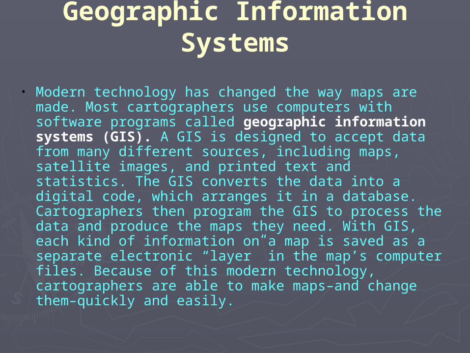
• Modern technology has changed the way maps are made. Most cartographers use computers with software programs called geographic information systems (GIS). A GIS is designed to accept data from many different sources, including maps, satellite images, and printed text and statistics. The GIS converts the data into a digital code, which arranges it in a database. Cartographers then program the GIS to process the data and produce the maps they need. With GIS, each kind of information on a map is saved as a separate electronic “layer” in the map’s computer files. Because of this modern technology, cartographers are able to make maps–and change them–quickly and easily.

Geographic Information Systems
A cartographer uses GIS to make a map.
![Truth and life - Baha'i Studies · Title: Truth and life Author: Albert Cotton Grier, Agnes Rosina [McCarthy] Lawson, Mrs. Agnes Rosina McCarthy Lawson](https://static.fdocuments.in/doc/165x107/5f5cd9036b7b006a4b530fae/truth-and-life-bahai-title-truth-and-life-author-albert-cotton-grier-agnes.jpg)