The Atmosphere - Weeblyathayer.weebly.com/.../notes_weather___climate.pdf · Notes - Climate •...
15
The Atmosphere Structure/Layers • Contains 4 major layers – See E.S.R.T – pg 14 o Troposphere All weather occurs here 99% of water vapor found here ~75 % of total mass of the atmosphere o Stratosphere Contains ozone (03 ) which absorbs uv-radiation o Mesosphere Meteorites burn up in this layer (shooting stars) o Thermosphere Satellites orbit the earth in this layer • Layers are defined by changes in temperature – see E.S.R.T. – pg 14 Composition of the Troposphere • 78 % nitrogen • 21 %oxygen • 1% other o small % of these other gases are greenhouse gases • Greenhouse gases GHG – absorb long-wave radiation (heat) given off by the earth which heat up the atmosphere o water vapor o carbon dioxide given off my volcanoes produced when fossil fuels are burned o methane naturally produced when plants decay in water & by livestock E.S.R.T.
Transcript of The Atmosphere - Weeblyathayer.weebly.com/.../notes_weather___climate.pdf · Notes - Climate •...

The Atmosphere Structure/Layers
• Contains 4 major layers – See E.S.R.T – pg 14 o Troposphere
All weather occurs here 99% of water vapor found here ~75 % of total mass of the atmosphere
o Stratosphere Contains ozone (03) which absorbs uv-radiation
o Mesosphere Meteorites burn up in this layer (shooting stars)
o Thermosphere Satellites orbit the earth in this layer
• Layers are defined by changes in temperature – see E.S.R.T. – pg 14
Composition of the Troposphere
• 78 % nitrogen • 21 %oxygen • 1% other
o small % of these other gases are greenhouse gases
• Greenhouse gases GHG – absorb long-wave radiation (heat) given off by the earth which heat up the atmosphere
o water vapor o carbon dioxide
given off my volcanoes produced when fossil fuels are burned
o methane naturally produced when plants decay in water & by livestock
E.S.R.T.

Heating of the Atmosphere
1. Radiation o Short-wave radiation (light) heats the surface of the earth
2. Conduction • The few centimeters of air in contact with the surface
3. Convection • The air heated by the surface rises because it now less dense than the
surrounding air • Cold air sinks down and fills in the space created
Greenhouse Effect
• Short-wave radiation from the sun is absorbed by the surface causing it to heat up
• That energy is then re-radiated back into the atmosphere as long-wave radiation (heat)
• The gases in the atmosphere don’t’ absorb light, but GHG do absorb heat. o This heats up the atmosphere
• w/o GHG the average temperature on earth would be 00 C (32o)
Origin and Evolution of the Atmosphere
• Original atmosphere came from outgassing associated with volcanoes o CO2, H2O(v), methane, deadly gases o No oxygen was present
• Evolution of cyanobacteria (stromoatolites) used photosynthesis and converted CO2 to oxygen
• Some of this oxygen reacted with sunlight in the upper atmosphere creating ozone (O3)

Notes - Water in the Atmosphere
States of Matter – Water
Energy Transfer During Phase Changes (latent heat)
• The temperature of water doesn’t change when ice is melting or water is evaporating b/c the energy that is added to the water is used to break the hydrogen bonds that are linking the water molecules together
• This energy is taken from the environment and is known as latent heat
o This is why you cool down when you sweat Water uses the energy from the environment (your body) and uses it to evaporate
• When water condenses or freezes it releases the energy it took back into the environment o See Properties of Water on the cover of E.S.R.T.
Hydrogen bonds linking molecules

Humidity
• Humidity - is the amount of water vapor in the air o Warm air holds more moisture than cold air
• Relative humidity – is the % of water vapor in the air (relative to how much it can hold)
o as the air cools the humidity may stay the same (total amount of water), but the relative humidity will increase b/c cold air can’t hold as much
• when the relative humidity is 100% the air is saturated (full) and condensation occurs o the temperature at which this occurs is called the dewpoint
• sling psychrometer – instrument used to determine dewpoint
o refer to page 12 in E.S.R.T. for dewpoint and relative humidity charts
Notes – Cloud Formation
Air Pressure
• Air pressure is caused by the weight of the overlying air
• Air pressure decreases with elevation o Due to less air above
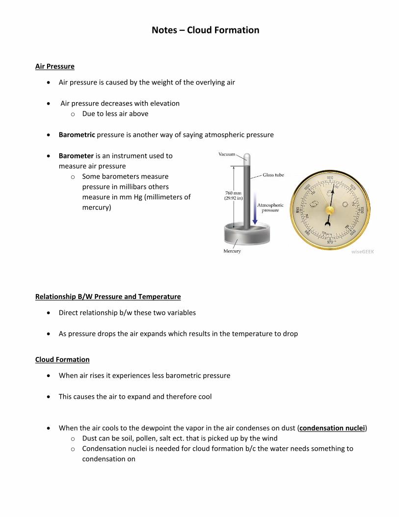
• Barometric pressure is another way of saying atmospheric pressure
• Barometer is an instrument used to
measure air pressure o Some barometers measure
pressure in millibars others measure in mm Hg (millimeters of mercury)
Relationship B/W Pressure and Temperature
• Direct relationship b/w these two variables
• As pressure drops the air expands which results in the temperature to drop
Cloud Formation
• When air rises it experiences less barometric pressure
• This causes the air to expand and therefore cool
• When the air cools to the dewpoint the vapor in the air condenses on dust (condensation nuclei) o Dust can be soil, pollen, salt ect. that is picked up by the wind o Condensation nuclei is needed for cloud formation b/c the water needs something to
condensation on

Process that Lift Air
• Mountains
• Fronts • a front is a boundary between different air masses
o refer to pg 13 in E.S.R.T. for symbols for fronts and air masses
o air masses air will take on the characteristics of the land below it (source region)
• ex: source region is tropical water = air mass maritime tropical (mT)
continental = dry & maritime = moist

• Converging Air
o When air converges is has nowhere to go but up
o This can occur at areas of low pressure and/or as a result of convection cells
Due to the lower specific heat land heats up and cools down faster than water. Differences in temp = differences in air density = differences in air pressure = convection cells forming

Wind
Wind
• wind is the result of the unequal heating of the earth o some places are warmer than other places
latitude - equator is warmer than polar regions specific heat – land heats up & cools down faster than water color – dark surfaces absorb more energy than light surfaces
o b/c air rises over warm areas and sinks over cooler airs the air pressure changes
rising air creates lower pressure sinking air creates higher pressure
• Air (wind) moves from areas of higher pressure to areas of lower pressure
• wind is named after the direction it comes from o westerly wind = the wind is coming from the west & therefore is blowing towards the east
Instruments
• wind vane – wind direction • anemometer – wind speed
Types of Local Winds
• due to the specific heat of materials, water requires more energy to heat it up than land so it takes a longer time to heat up or cool down water
• This will generate differences in temperature = differences in density = differences in pressure = wind
Sea Breeze Land Breeze

Coriolis Effect
• Due to earth’s rotation air doesn’t move in a straight line H L
• Instead the rotation of the earth causes fluids (water and air) to be deflected to the right in the northern hemisphere and to the left in the southern hemisphere
• In the northern hemisphere, this results in air around a low pressure system rotating counter-clockwise and clockwise around a high pressure system
Global Wind Patterns
• Large convection cells are generated globally due to the equator being warmer than the poles
• This combined with the rotation of the earth causes smaller convection cells (about every 30o latitude) & global wind patterns found on pg. 14 of the E.S.R.T.
• the jet stream which are strong upper winds determine the direction weather patterns will travel o most of the weather in NYS comes from the west

Notes - Weather Maps
Isotherm Map
• Isotherm – a line that connects points of equal temperature
Isobar Map
• Isobar – a line that connects points of equal barometric pressure
• b/c wind is caused by differences in barometric pressure the greater the pressure gradient the faster the wind
o closer isobars = stronger wind
Reading a Station Model
• refer to Key to Weather Map Symbols on pg 13 in the E.S.R.T.
• Below are resources for how to read this part of the reference table
o pg 150-151 in the Earth Science Reference Tables Workbook o https://www.youtube.com/watch?v=0nFGZl1h2OM&feature=plcp

Notes - Climate
• Climate is the typical weather conditions in an area over a long period of time, usually 30 years. o It’s not just the average b/c it includes extremes such as droughts, cold winters, ect.
• There are 6 major factors that affect climate and some other minor ones
o Major Factors Latitude Elevation Mountain Ranges Large Bodies of Water Ocean Currents Global Wind Patterns
o Minor Factors
Urban Heat Island Effect • Cities tend to be warmer that the surrounding country sides b/c the building
give off heat and there is a lot of darker materials (i.e. roads/parking lots) in cities
Vegetation • Plants give off water (transpiration) so areas downwind from forests will be
moist • Deforestation can result in an area being dry (desertification)
Major Factors
Latitude
• The Insolation, which is incoming solar radiation from the sun, hits the earth at different angles depending on latitude
o This is due to the fact that the rays are parallel and the earth is round
• The angle of insolation decreases as the latitude increases
• This means that the insolation at the equator is striking at a higher angle and therefore is more concentrated = warmer temperatures
• The insolation that strikes the polar regions is at a lower angle and therefore
spreads out more, making it less concentrated = lower temperatures

Elevation
• As elevation increases temperature decreases • This is due to the fact that as elevation increases pressure decreases
o As pressure decreases the air expands causing it to cool
Mountain Ranges
• As wind blows towards a mountain range, it is forced to rise causing the air to cool and the water vapor to condense creating clouds
o As a result the climate on the windward side of the mountain is cooler and wet • The air that goes over the mountain is now deprived of moisture
o Also as the air descends it warms up fast because there is little water in the air o This results in the leeward side of the mountain to be dry and warm (deserts)
Large Bodies of Water
• Because water has a high specific heat it cools and warms very slowly • As a result cities near oceans/large lakes have a more moderate climate (lower annual
temperature range) o i.e. cooler summers & mild winters o this is especially true for cities that have prevailing winds that come off of the ocean

Global Wind Patterns
• Due to the fact that the equator receives more concentrated insolation it is warmer. This creates an area of low pressure and therefore results in a wet climate
• This rising air sinks around 30o N and S latitude creating an area of high pressure. As a result these locations tend to be dry.
• Although they are not global, wind patterns can also create something called Lake Effect Snow o When cold dry air blows over the relatively warm Great Lakes, moisture is picked up from the
lakes. o When that moist air moves over land it is cooled creating clouds and snow o This effect is amplified along the Tug Hill Plateau by the rise in elevation
• Monsoons are also a result in changes in wind patterns • a monsoon is typically thought of as a wet (rainy) season, however it is really a change in wind
patterns. o Monsoons are really just large scale land and sea breezes
• Although monsoons occur on every continent, the most famous monsoons are located in SE Asia/India
o in the summer the continent of Asia is warmer than the Indian ocean so as a result there is a low pressure system that develops over Asia or Siberia this generates a strong sea breeze that brings moisture off of the Indian Ocean and
results in a rainy season • the Himalayas amplify this effect
o In the winter the ocean is warmer than the land so the wind direction changes. Now the winds are coming from the land so the air is dry resulting in a dry season.

Ocean Currents
• Prevailing surface winds create ocean currents • These ocean currents move heated water from the equator towards the polar regions • If an area is near a warm ocean current, this warm water brings with it warm air causing the
area to have a climate that is warmer than it normally would be o The most well-known example of this is the Gulf Stream current. o This warm current delivers warm air to Western Europe

Notes – Hurricanes
Formation
• Hurricanes form in late summer and early fall over warm oceans • They tend to start out as large thunderstorms called Tropical Depressions (TD) • As they grow they turn into Tropical Storms (TS) • When the wind speed exceeds a certain amount they are considered Hurricanes • Hurricanes can be categorized 1-5
o 1 is the weakest • When they move over land or colder water they lose their energy and start to die
Path
• For the United States o Hurricanes tend to form in the Atlantic or Gulf of Mexico o They initially move west and around 30o N latitude they change direction as a
result of changing global wind patterns
Effects
• Damage from hurricanes are caused by the strong winds, excessive rain, and storm surges
• Storm surges are large waves that cause flooding along coastal cities o they are created by the strong winds generated during a hurricane which push
the water in the ocean onto land


