The Animas River - 4Corners Riversports Animas River Version November 2017 ... Trimble - Durango...
13
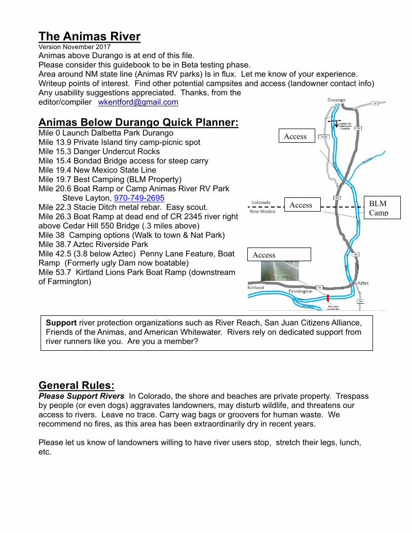
The Animas River Version November 2017 Animas above Durango is at end of this file. Please consider this guidebook to be in Beta testing phase. Area around NM state line (Animas RV parks) Is in flux. Let me know of your experience. Writeup points of interest. Find other potential campsites and access (landowner contact info) Any usability suggestions appreciated. Thanks, from the editor/compiler [email protected] Animas Below Durango Quick Planner: Mile 0 Launch Dalbetta Park Durango Mile 13.9 Private Island tiny camp-picnic spot Mile 15.3 Danger Undercut Rocks Mile 15.4 Bondad Bridge access for steep carry Mile 19.4 New Mexico State Line Mile 19.7 Best Camping (BLM Property) Mile 20.6 Boat Ramp or Camp Animas River RV Park Steve Layton, 970-749-2695 Mile 22.3 Stacie Ditch metal rebar. Easy scout. Mile 26.3 Boat Ramp at dead end of CR 2345 river right above Cedar Hill 550 Bridge (.3 miles above) Mile 38 Camping options (Walk to town & Nat Park) Mile 38.7 Aztec Riverside Park Mile 42.5 (3.8 below Aztec) Penny Lane Feature, Boat Ramp (Formerly ugly Dam now boatable) Mile 53.7 Kirtland Lions Park Boat Ramp (downstream of Farmington) General Rules: Please Support Rivers In Colorado, the shore and beaches are private property. Trespass by people (or even dogs) aggravates landowners, may disturb wildlife, and threatens our access to rivers. Leave no trace. Carry wag bags or groovers for human waste. We recommend no fires, as this area has been extraordinarily dry in recent years. Please let us know of landowners willing to have river users stop, stretch their legs, lunch, etc. Support river protection organizations such as River Reach, San Juan Citizens Alliance, Friends of the Animas, and American Whitewater. Rivers rely on dedicated support from river runners like you. Are you a member? Access Access Access BLM Camp
Transcript of The Animas River - 4Corners Riversports Animas River Version November 2017 ... Trimble - Durango...
The Animas River Version November 2017 Animas above Durango is at end of this file. Please consider this guidebook to be in Beta testing phase. Area around NM state line (Animas RV parks) Is in flux. Let me know of your experience. Writeup points of interest. Find other potential campsites and access (landowner contact info) Any usability suggestions appreciated. Thanks, from the editor/compiler [email protected] Animas Below Durango Quick Planner: Mile 0 Launch Dalbetta Park Durango Mile 13.9 Private Island tiny camp-picnic spot Mile 15.3 Danger Undercut Rocks Mile 15.4 Bondad Bridge access for steep carry Mile 19.4 New Mexico State Line Mile 19.7 Best Camping (BLM Property) Mile 20.6 Boat Ramp or Camp Animas River RV Park
Steve Layton, 970-749-2695 Mile 22.3 Stacie Ditch metal rebar. Easy scout. Mile 26.3 Boat Ramp at dead end of CR 2345 river right above Cedar Hill 550 Bridge (.3 miles above) Mile 38 Camping options (Walk to town & Nat Park) Mile 38.7 Aztec Riverside Park Mile 42.5 (3.8 below Aztec) Penny Lane Feature, Boat Ramp (Formerly ugly Dam now boatable) Mile 53.7 Kirtland Lions Park Boat Ramp (downstream of Farmington)
General Rules: Please Support Rivers In Colorado, the shore and beaches are private property. Trespass by people (or even dogs) aggravates landowners, may disturb wildlife, and threatens our access to rivers. Leave no trace. Carry wag bags or groovers for human waste. We recommend no fires, as this area has been extraordinarily dry in recent years. Please let us know of landowners willing to have river users stop, stretch their legs, lunch, etc.
Support river protection organizations such as River Reach, San Juan Citizens Alliance, Friends of the Animas, and American Whitewater. Rivers rely on dedicated support from river runners like you. Are you a member?
Access
Access
Access
BLM Camp
Float Times: Help build time/distance matrix, particularly at lower flows (ie document your mph). Mid-summer Animas loses 300 cfs between Durango and Confluence in Farmington. Email me your float times. [email protected] Trimble - Durango Raft Float times: 2000 cfs 5 hours to Durango 32nd St. 3-4000 cfs 3.5 hours trimble to 32 5000 cfs 3 hours trimble to 32 Durango Dalbetta Park– Bondad Float times 15 miles: 2000 cfs 3 hours by kayak (7mph) raft (5mph?) 1000 cfs kayak 2.7 hours 500 cfs canoes 3.5 hours non-stop 5 mph Durango Dalbetta Park to RV Park/state line 380cfs about seven hours with novices, SUPs, duckies, and kayaks. 1000 cfs 5.5 hours raft Bondad- Aztec 500 cfs canoes/kayaks 4 mph 1000 cfs raft bondad to cedar hill 1.5 hours 1000 cfs raft cedar hill to FMN westland park 7 hours 200 cfs 1 mph raft (slow water) Want more adventure? Try the San Juan River below the quality waters (putin below Navajo Reservoir) Very rough guide available on request. ANIMAS RIVER BELOW DURANGO SECTION: COLORADO Much of this section cuts through Southern Ute Indian Tribe property. Their care for the river shows with beautiful cottonwood stands and riparian zones. A smattering of private, non-indian property also adjoins the river. River drops 560 feet in these 15 miles. Recommended use: long day trips and overnighters for committed paddlers due to lack of public access. The Southern Ute Tribe allows recreational boaters (non-commercial) to float through tribal portions of navigable rivers that traverse the Southern Ute Reservation. However, this boating access does not include put-in or take-out on tribal land. Commercial trips have other requirements. The Tribe offers one exception to the put-in / take-out restriction, as follows: Fishermen who have a valid tribal fishing permit and who are engaged in fishing may put-in or take-out small, portable craft on tribal lands. Portable craft are those that can be carried by hand to and from the river, but do not include boats that must be trailered into or out of the river. From: http://www.southernute-nsn.gov/wrmweb/other-recreation/

Mile 0 ACCESS Dalbetta Park (City of Durango Boat Ramp) Mile 4.5 Basin Creek and Southern Ute Property/Access for commercial use. Animas La Plata reservoir water may someday be released to downstream users at this point. Mile 7.1 Weasleskin Bridge, no access without fishing license and equipment. Mile 13.9 Stephan and Robin Saltsman Island. Tiny campspot or picnic spot. Mile 15.3 DANGER Undercut Rocks- Proven killers. Large sized undercut rocks on river left shore. Especially dangerous at flows below 1500 cfs. Scout or portage recommended. Stay on the inside of the bend (stay on river right). Mile 15.4 ACCESS Highway 550 bridge just below "Bondad Hill" Takeout river left below bridge with a short steep carry suitable for small rafts, kayaks. Mile 16.7 Historical Train Water Tank This rail line was called the "Red Apple Flyer" and was in service 1905 until the 1960s. When the freight line from Farmington to Durango was no longer viable, the right of way was sold. For more google "red apple flyer train new mexico" or check out the book "When the Railroad Leaves Town: American Communities in the Age of Rail Line" Mile 17.4 Abandoned Train Bridge. Potentially dangerous pilings. Mile 19.4 Colorado New Mexico State Line
SECTION: NEW MEXICO
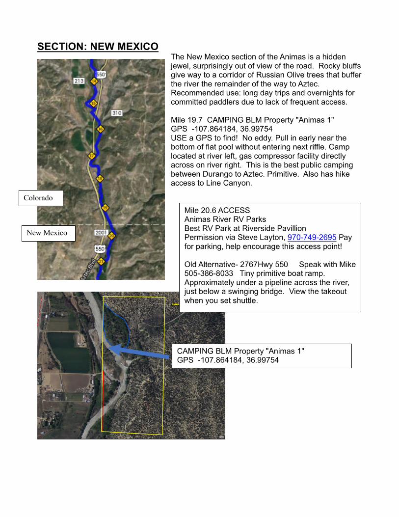
The New Mexico section of the Animas is a hidden jewel, surprisingly out of view of the road. Rocky bluffs give way to a corridor of Russian Olive trees that buffer the river the remainder of the way to Aztec. Recommended use: long day trips and overnights for committed paddlers due to lack of frequent access. Mile 19.7 CAMPING BLM Property "Animas 1" GPS -107.864184, 36.99754 USE a GPS to find! No eddy. Pull in early near the bottom of flat pool without entering next riffle. Camp located at river left, gas compressor facility directly across on river right. This is the best public camping between Durango to Aztec. Primitive. Also has hike access to Line Canyon.
CAMPING BLM Property "Animas 1" GPS -107.864184, 36.99754
Mile 20.6 ACCESS Animas River RV Parks Best RV Park at Riverside Pavillion Permission via Steve Layton, 970-749-2695 Pay for parking, help encourage this access point! Old Alternative- 2767Hwy 550 Speak with Mike 505-386-8033 Tiny primitive boat ramp. Approximately under a pipeline across the river, just below a swinging bridge. View the takeout when you set shuttle.
Colorado
New Mexico

Mile 22.2 Camping Pending BLM Approval BLM Property "Animas 3" GPS -107.869758, 36.966197 Small camping possibility on river right. Stop early, because when re-launching you will want to be on the other side for recommended scout of diversion dam very close downstream. Mile 22.3 DANGER Stacie Ditch Co. diversion dam You will want to be on river left for scout and/or portage of ugly metal raft-ripping posts. This 2 foot tall junky dam is frequently run on the far left. To avoid rebar punctures, line your boats on river left. The green wall of a Oil/Gas facility is visible high on the ridge on river left.
Camp
Scout
Mile 22.3 Nasty metal raft ripping or worse
Mile 22.3 Low water view from river right. Note gas plant on hillside as a landmark. Upright metal posts across entire river.
Direction of Flow
Mile 22.5 Abandoned bridge Mile 23.8 Roadbridge 2290 Mile 24.5 Old Bridge abutments ACCESS Mile 26.3 Abandoned Roadbridge and water flume at dead end of CR 2345 This trailer friendly boat ramp is secluded, excellent. On river right 3 feet below old bridge. Mile 26.9 Cedar Hill 550 Bridge Old ACCESS walk down river left between road and old bridges. 300 foot carry suitable for small rafts, kayaks, but 2345 boat ramp is way better. Secluded, quiet. Mile 28.6 Aztec Ditch Diversion Dam potential rebar danger, don't fall out. House on river left.
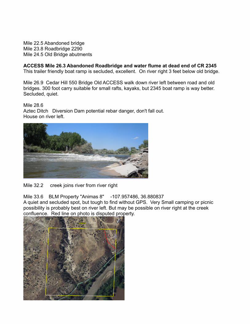
Mile 32.2 creek joins river from river right Mile 33.6 BLM Property "Animas 8" -107.957486, 36.880837 A quiet and secluded spot, but tough to find without GPS. Very Small camping or picnic possibility is probably best on river left. But may be possible on river right at the creek confluence. Red line on photo is disputed property.

Mile 34.5 Farmers Irrigation District, FMN Diversion Dam This 5 foot tall smooth ramp drop is commonly run in the middle. Scrapey below 1000cfs. Dory needs 2000+
Mile 34.7 CAMPING Contact homeowner Rod Baade (505) 330-9376 a day in advance! This is a wonderful backyard camp, right on the river, and far enough from the house that you don't feel like you are imposing too badly. Rod works at Jacks Plastic Phone: 505-334-8748 (boater friendly). His brother Errol Baade is general manager at Jacks Plastic. Their neighbor Lindal is full of river lore.
Mile 38 CAMPING River Right. Ruins Road RV park that had the tent camping along the river. Camp there for a $10/night fee. The site has city water and a pit toilet, no showers. Folks could just stop and go to the office up the hill to pay for their site. Phone is 505-334-3160, email is [email protected] Easy walk to town for dinner! Mile 38.5 550 Bridge Mile 38.7 Aztec Riverside Park Landing. Takeout for small craft.
SECTION: AZTEC- FARMINGTON Establishment of access in this zone is due to the River Reach Foundation, a private non-profit organization established in 1986 to promote and protect the unique resource of the San Juan and Animas rivers. River Reach works in cooperation with the Cities of Aztec, Bloomfield, Farmington, and San Juan County. Frequent public access allows for varied use. Mile 38.7 (Mile 0) Aztec Riverside Park Landing. Launching for small craft. Also, trailer launch river right just below footbridge at Martinez Lane, Aztec Mile 0 Aztec Ruins Trail Side Excursion http://www.nps.gov/azru/index.htm Gateway trail connection to Aztec Ruins. The path follows a section of the Old Spanish National Historic Trail, the 1000 mile course that pack mules followed from Santa Fe west to Los Angeles in the 19th century. The miles below Aztec are remarkably remote in feel. Pleasant float. Go Adventures in Aztec rents rafts and Tubes.
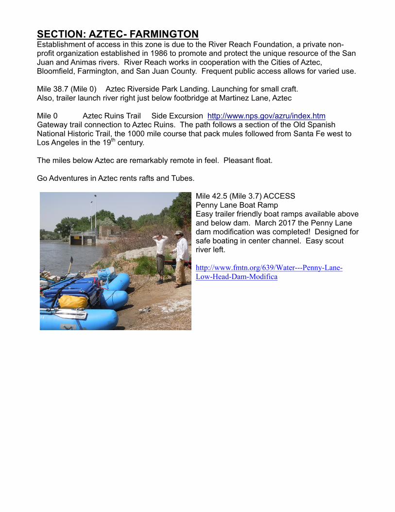
Mile 42.5 (Mile 3.7) ACCESS Penny Lane Boat Ramp Easy trailer friendly boat ramps available above and below dam. March 2017 the Penny Lane dam modification was completed! Designed for safe boating in center channel. Easy scout river left. http://www.fmtn.org/639/Water---Penny-Lane-Low-Head-Dam-Modifica
Mile 3.8 Penny Lane Diversion Dam used to be a proven killer, now is reconfigured for safe boating. Access boat ramp river right. Designed for safe boating in center channel. Easy scout river left.
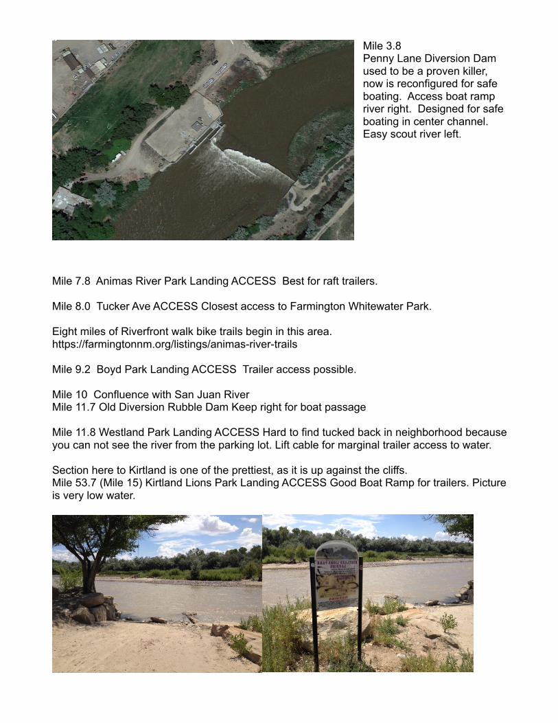
Mile 7.8 Animas River Park Landing ACCESS Best for raft trailers. Mile 8.0 Tucker Ave ACCESS Closest access to Farmington Whitewater Park. Eight miles of Riverfront walk bike trails begin in this area. https://farmingtonnm.org/listings/animas-river-trails Mile 9.2 Boyd Park Landing ACCESS Trailer access possible. Mile 10 Confluence with San Juan River Mile 11.7 Old Diversion Rubble Dam Keep right for boat passage Mile 11.8 Westland Park Landing ACCESS Hard to find tucked back in neighborhood because you can not see the river from the parking lot. Lift cable for marginal trailer access to water. Section here to Kirtland is one of the prettiest, as it is up against the cliffs. Mile 53.7 (Mile 15) Kirtland Lions Park Landing ACCESS Good Boat Ramp for trailers. Picture is very low water.
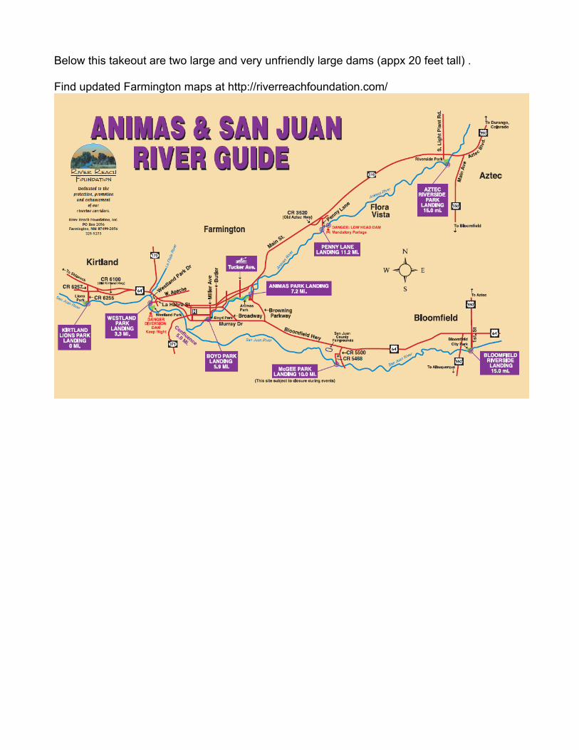
Below this takeout are two large and very unfriendly large dams (appx 20 feet tall) . Find updated Farmington maps at http://riverreachfoundation.com/
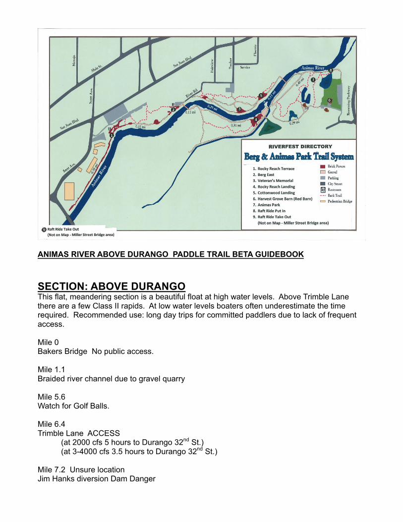
ANIMAS RIVER ABOVE DURANGO PADDLE TRAIL BETA GUIDEBOOK SECTION: ABOVE DURANGO This flat, meandering section is a beautiful float at high water levels. Above Trimble Lane there are a few Class II rapids. At low water levels boaters often underestimate the time required. Recommended use: long day trips for committed paddlers due to lack of frequent access. Mile 0 Bakers Bridge No public access. Mile 1.1 Braided river channel due to gravel quarry Mile 5.6 Watch for Golf Balls. Mile 6.4 Trimble Lane ACCESS (at 2000 cfs 5 hours to Durango 32nd St.) (at 3-4000 cfs 3.5 hours to Durango 32nd St.) Mile 7.2 Unsure location Jim Hanks diversion Dam Danger
http://www.durangoherald.com/article/20120818/NEWS01/708189954/0/20120818/Animas-culvert-sucks-in-Calif-tuber Mile 10 Ed & Patti Zink Wetlands banking project http://www.animasriverwetlands.com/ Mile 12.6 Glider Park Watch low flying tow planes and gliders land right next to you! Mile 15 United Campground Mile 16.6 (0) Oxbow Preserve (City of Durango) ACCESS Completion 2014 Mile 17.9 (1.3) 33rd Street Boat Ramp SECTION: DURANGO Progressively more difficult whitewater begins at 32nd street. Most rapids are class II except Smelter Rapids at Whitewater Park, which is a vigorous Class III. Add a level of difficulty above 2500 cfs. Frequent public access allows for varied use. Mile 0 (18.0) 33rd Putin ACCESS Boat ramp in neighborhood Mile 0.3 (18.3) (1.7) 29th Putin ACCESS Mile 1.7 (19.7) (3.1) Main Street Bridge Bridge Pilings are a hazard. Focus! Mile 1.9 (19.9) (3.3) Discovery Museum for kids and adults. Mile 2.4 (20.4) (3.8) 9th Street Bridge 9th St ACCESS Boat Ramp
Mile 2.1 (18.7) Fairgrounds/Recreation Center (near the Demon foot bridge)
Mile 4.1 (20.7) Off Leash Area (at Lightner Creek)
Mile 5.0 (21.6) Santa Rita Park (across from the ALP intake)
Mile 3.2 (21.2) (4.6) Whitewater Park and Smelter Rapids
Old superfund site on the river right is now a dog park. Mile 3.6 (21.6) (5.0) Animas La Plata Pump intakes. The "last of the Bureau of Reclamation water projects" Project was built over boater and environmental objections because it satisfys Indian Water Rights. The pumps can divert 225 cfs in the summer. Mile 4.4 (22.4) (5.8) Four Corners Riversports Boating Equipment BMX park has boating access. Mile 5.7 (23.7) (7.1) High Bridge ACCESS Boat Ramp Access by Humane Society end of WalMart parking lot. Good trailer access for low water levels. Mile 7 (25) (8.4) Dalbetta Park ACCESS Boat Ramp This park was donated to the City of Durango by a family in 1999 appx!