The Andhra Priadesh Survey Manual of Departmental...
178
The Andhra Priadesh Survey Manual of Departmental Rules Corrected up to 31st December, 1974 IN THREE VOLUMES t Volume-I GOVERNMENT OF ANDHRA PRADESH REPRINTED , 1980 BT TH« DIRBCTOH OP PRINTING, OOVERNMINT OF ANDHRA PRADI AT THK OOVIRNMENT CENTRAL °RX88. HYOfcHABAD
Transcript of The Andhra Priadesh Survey Manual of Departmental...
The Andhra Priadesh Survey Manual
of Departmental Rules
Corrected up to 31st December, 1974
IN THREE VOLUMES t
Volume-I
GOVERNMENT OF ANDHRA PRADESH
REPRINTED , 1980
BT TH« DIRBCTOH OP PRINTING, OOVERNMINT OF ANDHRA PRADI
AT THK OOVIRNMENT CENTRAL °RX88. HYOfcHABAD
The Andhra Pradesh Survey Manual
of Departmental Rules
Corrected up to 31st December, 1974
IN THREE VOLUMES
Volume -
GOVERNMENT OF ANDHRA PRADESH
REPRINTED
198O
2487—B—i
PREFACE
The first edition of the Survey Manual was published in 1859. A second edition was issued in 1861. Both these Manuals dealt only with survey, as up to 1866, demarcation was done by the Settlement Department. That department issued a pamphlet in 1861 entitled "Rules for demarcation of boundaries for the revenue survey".
On the transfer of the work of demarcation to the Survey' Depart-ment a "Revi.-ed code of rules for the guidance of the demarcation branch" was published in 1867.
For some years demarcation and survey were performed by sepa-rate survey parlies. The Parties were amalgamated in 1873, and a Manual was published in 1874 embodying rules for both demarcation and survey. A revised and abridged edition was issued in 1888. In 1911 a r.ew and most complete edition was compiled by the late Diwan Bahadur M.R.Ry. M. Ramaswami Nayudu.
Since then, the Madras Survey and Boundaries Act, No. IV of 1897, has been repei'ed and a new Act passed, and sever;
1! changes
and amendments have been made in the methods of survey.
The present M'nudl consists of three volumes. In the first it has been thought unnecessary to include the chapters in the preceding Manual giving the duties of officers, Inspectors, surveyors and clerks.
Those describing survey instruments and their use, and the chapter "Aids to survc}i.';g" h.ive also been left out. These will form Volume II. All forms of registers, returns and reports in use and special to the Survey Department have been revised and are published as Volume III.
Valuable co-operation and assistance have been received from M.R.Ry Diwan Bahadur D. Sesha Acharlu Garu, Officer-in-charge Central Survey Office, from the late M.R.Ry. S.P. Venkatarama Ayyar Avargal, Assistant Director of Surveys and from M.R.Ry. K.N. Nara simha Acharya, Assistant Director of Surveys, Central Survey Office.
em The present edition is reprinted incorporating the Matric equiva-and other amendments.
in
INTRODUCTION
In several districts of the State, registration ar.d measurement of lands was undertaken during the first quarter of the 19th century.
The account prepared therefrom which is called the "paimash", consists of a list of lands described with reference to their relative position and their tenure at the time and con'ains their approximate areas calculated from measurements taken with a pole roughly in the diixc'ion. of the cardinal points of the compass. The method of cal-culation of areas, called the khasra, was to multiply the mean of the north and south measurements by the mean of those east ar.d west.
No maps were plotted from the paimash measurements, which were not only often inaccurate but also generally insufficient to enable boundaries to be located with any certainty.
2. In 1853, under the orders of the Madras Governmerit an. ex perimental revenue f.ur.ey was commenced in the South Arrot district. Di'ri) g the two succeeding years the subject of the general survey of the whole Presidercy was fully discussed, and. in December 1856 the Court of Directors sanctioned a scheme submitted by the Cover; .mer.t of Madras ar.d stror>glv ar.d unanimously recommended by the Supreme Government. Shortly afterwards, a Superintendent of Revenue Survey was appointed and the require.
1 establishment havi; g been
sanctioned, the revenue or cadastral survey of the Presidency was commenced in 1858
CADASTRAL SURVEY
3. The object of a cadastral survey in 'he .Stute is the dea.nitation of the boundaries of villages and holdings, av.d the preparation of (1) village maps showir.g the boundaries-, of groups of holdings, called hereafter survey fields, ar.d the more important topographic.;! details (2) large-scale plans of survey fields showing the boundaries of each holding, topographical details and all measorements, and (3) Jar.d re gisters giving the number, nature, tenure, area assessment ar.d reputed ownership of each holding.
A rcscrvey is made when the changes 1>> occupation ar.d in the boundaries of fields arc too numerous to be dealt wilh by the Ordinary Revenue staff, or when the previous survey is considered defective.
A revision suivey has been made in a few districts. The work done was the replacement of missing survey marks ar.d the measure-ment of changes in occupation, or in the physical features of the country.
Revision surveys have been discontinued in favour of resurveys. A map is attached showir.g the revision surveys and rescrveys made up to date, and the areas in which resurveys are in progress arc likely to be necessary.
4. The present methods on which cadastral surveys and resurvey s dre rrr-d« are described in detail in the several chapters of the Manual while Appendix II shows the cadastral surveys made in each district of the State and describes the methods of survey previously in use. With the exception of the block map surveys, which have be
j.;n con-
demned and are to be done afresh, all these surveys are on a traverse basis, the traverses being connected with stations of the Great Trigono-metrical Survey of India, and harmonized with reference to a district origin.
The maximum error possible in the-odo'iie surveys is 112 Cms, a K.M. in co-ordinates. Under the present system, each village boun-d ry is traversed and a number of interior traverses run, dividing each village into sub-circuits, called khandams of from 40 to 100 Hectares.
Each traverse station is marked by a granite stone 90x23x23 Cms. Each khamhm is divided into surgery fields generally ()f 2 Hectares in wet and 4 Hectares in dry landj. In most di< tncts yj] bends of fields hive been dsin treated with granite stones 60x15X15 Cms., but stone dsm-ircation is now b:ing confined to Injunctions of .uirvey fields and bend; on boundaries of villages, poramboke fields and poivmboke sub-divisions.
Fields are measured by ch lining between t r i junctii ns and offsetting all bonds. Field boundary lines are also measured as a check on the offsets.
On completion of fbld measurements, lines are run between stations on village and khandam boundaries and Injunctions on the boundaries offetted. Village mips are prepared by traverse plotting village and khsand.'in stations, hung out the field trijunc ions offsetted, and plottin the fields from these lines of basis.
PUBLICATION
5. The usual maps issued are :
(1) Maps of survey fields, scale generally 1 C.M. —1 Chain (20 Metres) showing the boundaries of holdings, topographical details all measurements and the area of each survey fields.
(2) Village maps, scale 10 C. Ms.= 1 K.M. These show the boundaries of each »urvey field, all important topographical details and the area of the village.
(3) Outline sheets and traverse ehatts cv.ch 15' square, scale 1 C.M. —32 Chains, for the use of the Topographical Parties of the Survey of India working in the State. The outline sheets show all main topographical detuls except hill contours. The traverse charts show village bound iries and the values of the rectangular co-ordinates of village Injunctions from the district origin.
(4) Taluk and Zaniindan maps.—Scale 1 C.M. = 32 Chains (20 Metres Chains) showing village boundaries and notable topogra phical de-tails.
(5) District Touring maps.--Scale 1C.M.= 128 Chains. These »how towns, important villages and the most important topographical details.
vi
6. Besides cadastral surveys of Government villages, the following Special surveys are made as need arises :—
Survey of proprietary estates and villages.
Town survey.
Street survey and road surveys.
Mamul wet survey.
Soil block survey.
SURVEY OF PROPRICTORY ESTATES.
7. This is generally made on the application of the proprietor and the method now in use is the Punganur system, so called because it was first employed in the survey of the Punganur estate. As a general rule a single diagonal line is run across e; ch field, all field bends arc offsetted thereon. There is thus material for calculating distancet on field boundaries from two independent bases and measuremens is not mide unless the distances thus calculated differ by more than 4 1'iiki. The rest of the survey is nnde on the lines adopted in Govern ment villages. This system provides an automatic check on measure ment and is the most accurate yet devised, ft demands, however the demarc ition with stone of bends on fields boundaiies and for this rea;on is not likely to be adopted for the survey of Government villages.
TOWN SURVEY.
8. A survey of the Madras town was made by the Public Works Department between the years 1854 and 1864. The result of the survey were not wholly adopted in the revenue accounts, and a question having arisen as to the sufficiency of the survey, it was decided in 1891, that the survey maps were of little or no use for revenue purposes and quite out of date for topographical purposes, and a new survey was accordingly ordered.
It was considered necessary to make a survey of the mufassa municipal towns and to plot maps on a scale sufficient to make them useful for checking encroachments and defining limits of private and public properties.
9. Of the 61 municipal towns in the Presidency, the survey o towns, viz.—•
(1) Madras, (15) Srirangam. (2) Ootacamund, (16) Madura, (3) Coonoor, (17) Dindigal, (4) Vaniyambivdi, (18) Periyakulam, (5) Tiruppattur, (19) Palani, (6) Vellore, (20) Mangalore, (7) Walajapet, (21) Palghat, (8) Tirupati, (22) Coimbatore, (9) Gudiyattam, (23) Karur,
(10) Conjeevaram, (24) Erode, (11) Thanjavur, (25) Salem, (12) Kurnbakonam, (26) Cuddalore, (13) Mayavaram (27) Mannargudi., (14) Tiruchinopoally, (28) Negapatnam.
vii
was. completed by a special survey party between the years 1895 and 1901.
In the 20 towns first named, a map and a register were prepare for each of the blocks into which the town w.is divided, the size of th
e
blocks being generally 10 acres, if the locality was close, i.e., densely occupied, and 40 acres, it
;t was medium or op;n. [n the manuscript
block map were recorded in blue ink all the measurements by which the block was plotted. From this ma-p was prepared a field book, in which each holding was plotted roughly to scale, and for such of the lines as held actually been measured 0,1 the ground the measurements were copied in black ink from the block map. The diagonal and offset measurements necessary for calculating the areas arithmetically were s.aled from the block m\p and entered in the field book in blue ink. The manuscript maps which were plotted on a scale of 163 or 80 inche; to the mile were printed on half scale.
In the remaining eight towns, the method of survery v\as the same as that described above, except tint the size of the open blocks was fixed as 160 acres and the imp was plotted on a scale of 40 inches to the mile. No Held rm.-surement book was prepared for the eight towns, but instead of one imp there were three map?, called the rough block map, the fair block imp and the re;ord of measurement. The rough block map w.is prepared by thesurveyor and showed all measure-ments and details in b'ick ink. From this the f.-ur block map was plotted in office and showed only the field boundaries and details. The record of measurements w.is prep ;red by copying the field bounda-ries, not detail?, from the fair blo,'k m '.p and all measurement* from the rough block imp. The areas of rectangular fields alone were calculated arithmetically. Tne are is of other fields were taken by the computing scale from the fair block imp. Th.: fair block 'imp was reduced to half sc.lie, but the record of measurement wis printed on the same scale. Steps have been t.iken to provide each of the first 20 towns also witk a record of measurement similar to that prepared for the other 8 towns.
The town survey of Mid MS has recently been brought up to date b/ a special establishment working under a Special Land Records and Survey Officer.
The town of Eilore was surveyed in 1903 and 1904 by a detachment of d cadastral survey party on the method adopted for the last 8 townj.
Seven more towns, viz., Bezwad.i, Masulipatam, Anantapue, Calicut, Cannanore, Tellicherry and Cochin, were surveyed betwee 1890 and 1896, while the cadastral survey or resurvey of the taluks in which they are situated was in progress, but not in such detail as th* above mentioned 29 towns. The sc: le of map of these seven towns varied from 32 to 160 inches to the mile. When maintenance of the survey of the first 28 town", was taken up, the cadastral survey records of the seven towns were prepared in the Centr.il Survey Office as far as possible on the town survey methoi \\ith a view to introduce mainte-nance into them t.Lo. The actual work of maintenance having, how-ever, proved the inadequacy of the cadastral survey records for the purpose of m intenance, a fresh survoy h;s been made of the towns »f Bezwada and Masulip itam, and it is probable that the same will have to be made in the other five towns.
viii
10. The following towns have been surveyed recently on the method described in sub-paragraph (3) of paragraph 9 above and the maps will be published shortly :—
Tiruvannamalai. Narasaraopet. Anakapdle. Ellpre extension. Ongole. Bimlipatam. Chingleput. Tenali. Vizagapatam. Dharapuram. Bezwada. Vizianagrarn. Chicacole. Bodinayakkanur. Mayavaram exten- Parlakimedi. Srivilliputtur. sion. Cocanada. Tiruvalur. Nagapatam „ Peddapurarn. Palamcottai. Dindigul „ Rajahmundry. Tinnevelly. Coimbatore „ Guntur. Tuticorin. Madura ,,
11. The published mips (f towns are on the scale 10" = 1 mile and show the boundaries of wards, streets and properties. In future the cale 8" = 1 mile will be adopted. Records of measurement are supplied to the municipal authorities on the scale of 160", 80" or 40" = 1 mile according a? the area is congested, medium or open.
STREET SURVEY AND ROAD SURVEYS.
12. Street Survey.—This is generally confined to streets within a union which does not desire a regular town survey. The records pre pared are a m'.p of the union, scale 40" = 1 mile, showing the streets but no house-site details, and an atlas of street field maps, scale 160" = 1 mile, showing measurements.
Roads Surveys are made of Local Fund roads in unsurveyed pro-prietary estates. The roads are traversed and surveyed as fields each about 10 inches long. These are plotted on the 40" scale and show all measurements
MANUAL WET SURVEY.
13. In the Godavari, Krishna and Guntur districts, owing to the introduction of large irrigation projects, considerable areas.which till then had been waste or only fit for dry cultivation were brought under wet cultivation. In order to levy water-rate on these areas, and also to determine the extent of" roamul wet" lands which had been deprived of their original sources of irrigation and were entitled to water free of charge from the new canals, it was found necessary to make a detailed survey of the non-ryotwari villages in the deltas in these three districts. The mamul wet areas were demarcated en block. The newly irrigated areas outside the manul wet blocks were formed into survey fields of about 10 acres e;>,ch, and demarcated and measured. The registered holdings within the 10-acre fields were also measured. A field measure ment book, field register and map were prepared for each village. For 56 out of 302 villages in the Godavari delta, village maps showing field boundaries were prepared on the 16-inch scale and printed on the 8-inch scale. In the remaining 246 villages the map served only as a key to the field ineasureme.it book, as it did not show the boundaries of each individual field but only of books of fields ; but at the request of Public Works Department, 8-inch village maps showing the boundaries of fields have been drawn and printed for all the 246 villages. The survey
ix
began in 1890 and was completed in 1896. The area surveyed was 1,226 square miles.
In the Ganjam district, a similar survey of inam villages, area 136 square miles, which had come under the influence of the Rushikulya system, was carried out between 1891 and 1894 under the supervision of the Collector.
Seven inam villages, area 19 square miles, irrigated by channels from the Palar anicut in the Walajapet taluk, were also similarly surveyed under the orders of the Collector of North Arcot in the years 1904 and 1905.
Owing to the construction of the Peryair Water-Works the non-ryotwari villages in the Melur, Madura and Nilakottai talukc, area 88 square miles, were also surveyed during the years 1896 to 1898. This survey was made in such detail that it was practically a cadastral survey.
SOIL BLOCK SURVEY.
14. For the purpose of determining the land cess, a block survey of whole inam villages was made in the districts of Godavari, Kristna, Guntur, Nellore, Tanjore and Trichinopoly in the Berhampur taluk and in the Serugada, Dharakota and Kurla estates of the Ganjrm district between the years 1895 and 1902. The villages were divided by settle ment classifiers into blocks according to peculiarities of soil and demar cated with pegs or earthen mounds. The blocks were measured and mapped by the Sur/ey Department, and the areas of the blocks entered in the classification registers prepared by the Settlement Department. In the South Arcot district, both demarcation and survey were made by the Settlement Department. The Survey Department has since made their similar surveys in the districts of Vizagapatam, Madura, Ramnad and Tinnevelly.
TOPOGRAPHICAL SURVEY.
15. The earliest topographical surveys were made by officers of the Madras Quartermaster-General's department at the end of the eighteenth century. The topographical survey of the Madras Pres- dency was completed by about the year 1840 and the results of the survey were embodied in 23 Ordinance sheets or, as they are called, sheets of the Atlas of India, published by the Surveyor-General's Office, Calcuta, on scale 1"=4 miles. The atlas sheets are revised at Calcutta from time to time as the materials of late topographical survey sand of cadas tral surveys become available ; they are published in quarter sheets. Up to date 39 quarter sheets relating to theMadras Presidency have been revised and published. The sheets of the Attas of India are being gra dually superseded by those of the degree sheet series. Forty-three of these have been published up to date.
16. When the cadastral survey of the Presidency was first instituted in 1858 the topographical survey, which had till then remained under the direction of theSurvcyor-General, was amalgamated with the cadas tral survey. Up to 1878, the topographical survey of hill tracts by the Madras Survey Department was not based the any trigonometrical on points, the cadastral survey traverse stations at the foot of the hills being
the only fixed points the topographical surveyors had for starting and closing their work. Siace 1878, however, the topographical survey of the hill tracts of the Godavari, Kistna and Guntur districts, the Nalla-malais in Kurnool, the Javadis in North Arcot. The Shevaroys and Kollimala is in Salem, the Warsanad hills in Madura, theBiliginrangam hills and Anamalais in Coimbatore, the Attipadi valley in Malabar and South-East Wynaad in the Nilgiris was based on Madras Survey minor-Triangulation,startingfrom and closing on stations of the Great Trigono-metrical Survey of India. The great and minor trigonometrical points were projected in office on the scale of 1 inch to the mile on plane table sheets on which was also plotted any traverse work that might have been executed in the tract under survey. The sheets were then mounted on plane table heads and sent to field, where topographical features, such as hill, rivers, tanks, village sites, roads, etc., were delineated on them.
17. In the case of large zamindaris, such as Ramnad and Sivaga- naga, to which the operations of the cadastral survey did not extend, the exterior boundaries and some interior divisional lines were traversed with the .theodolite and the traverse work was plotted on plane tabJe •heets. In the cr.se of proprietary estates and other non-ryotwari villages of small area which were often surrounded by ryotwari land, it generally happened that the true boundaries had already been demarcated and surveyed with the theodolite. For large zamindaris, the scale of the map was either 2 inches or 1 inch to the mile. For small proprietary estates, the scale was 4 or 2 inches to the mile.
18. The topographical survey was transferred to the survey of India in 1886, and that department was expected to complete the survey of 13,508 square miles of country which had been excluded from the operations of the Madras Cadastral survey in the districts of Ganjam, Vizagapatam, Tiichinopoly, Madura, Tinnevelly, Malabar and south Kanara. A considerable portion of this area was surveyed during the course of forest surveys made by a Party of the Survey of India Depart ment.
19. It has been stated in paragraph 16 above that the topographical survey of some 01 the hill tracts in the Presidency was made on a triangu- lation basis and that in other hill tracts the traverse station at the foot of the hills formed the only groundwork of the topographical survey. In both cases,,the survey was defective in as much as the hill contours were not drawn with reference to heights.
20. During the years 1904 and 1905, the Indian Survey Committee appointed by the Government of India, and presided over by Mr. J. O. Miller, c.s.i., Secretary to the Government of India, visited the various provinces and discussed with the local authorities the materials availa ble and the measures necessary for bringing up to date the topographi cal mips of India. As a result of the report of this Committee, the Government of India decided that a fresh topographical survey of the whole of India should be made by the Survey of India Department. This survey was commenced in the Madras Presidency in 1907, and in 1908 a conference of officers of the Survey of India and of the Madras survey was held at Bangalore to decide how far the Madras Survey professional data could be utilized by the Survey of India. It was first
xi
agreed that values of village Injunctions and selected theodolite stations should be supplied. Later, two outline sheets showing details according to the Madr j,s Survey village maps were furnished for verification on the ground. The result hiving been found satisfactory outline sheets and traverse charts for various areas are being supplied since 1911.
CONSTITUTION OF THE MADRAS SURVEY DEPARTMENT.
21. The Director of Survey is the head ol the department, and is subject to the supervision of the Commissioner of Revenue Settlement and Survey.
The norm1.! strong .h, of survey p-irties is six, each in charge of a
senior Assistant Director. Under him are one junior Assistant Director and Inspectors. Tiiere .ire generally three field sections, two for cadastral and one for the odolite surveys.
Each ca.1i>tral sectton is in charge of a Inspector, and is divided into two sub-sections e-.;c!i under a Deputy Inspector. The strength of each cadastral survey sub-section varies according to the area for survey, but the minimum would be four ranges of nine Deputy Surveyors each range being sup r v i s . d by a Suneyor. An Inspector supervises the theodolite survey section consisting ol one Deputy f.'iip.-ctor six Deputy surveyors for theodolite survey, and ten surveyors for demarcation.
The P.irty office is supervised by the fourth Inspector, generally the most senior. He is directly responsible for the correctness of the mapping.
MAINTENANCE OF SURVEYS.
22 The question of maintenance of boundary marks and survey records h.s engaged the attention of the authorities ever since 1864, but it was not ui i i i i lb')3 that any practical steps were taken in that direction. In the latter yci:r, survey schools were opened in order to train karnaim in the duiies of m inteiunce, and by the beginning of 1895, all the karnams in the Presidency had been put through a course of instruction in survey. Soon c-.ftervfe.rds, the Presidency was divided into six gjrvey divisions, each comprising three or four districts. A Survey Oificer \vj.s appointed to each survey division and a district surveyor to each distiict. To keep up the karnam's knowledge of survey work, armiu.i schools, lasting for 10 or 15 days, were held in each taluk, under the supervision of Survey and Re\enue Divisional Officers. The 1. st schools were held at the end of 1899. The results «f these school
0 showed that the survey qualifications of more than 50
per cent of the k rn'Jms were cither " indifferent " or " bad ". More-over, the arrears under the items of me; suremert of sub-divisions and, repkcing mi-sing stones, which had been accumulating for many years were too heavy to be c!e red off by k'irnams. Field measurement books plotted scale had been prepared by the Karnams, for a large number of
xii
Xlll
villages, but t he books were far from complete and required t o be care-fully checked before they could be accepted as correct. The original arrangements for maintenance having thus proved ineffectual, the survey divisions were abolished from April 1900. Towards the end of 1903 a special department was, created to look ; ficr maintenance, it was essen-tially a supervising staff, there being for this purpose a Land. Records Inspector in each taluk, a Land Records Tahsildar in each district, an Assistant Director of Land Records in charge of each of the five groups of districts into which the- preside rcy was divided, and a Direct of of Land Records for the gen.enl ydministr, tion of the department. This Land Records Department w;;s tboH:hed in 1921 end the suff absorbed into the Revenue Department, but ; Diputv Surveyor ; nd a Draft man rcmainatitchtd o ;he Collectoi'sOffice in each district. Dcuilsofthe lines on v.fvch maintenance is to be cc tried on in the future arc still under the consideration of Government-
LAW
23. The legal provisions under which the survey work of this Presidency was conducted up to 1897, were thore contained in Act XXVIII of 1860. " An. Act for the establishment ; nd rnainter.; r.ce of boundary marks and for facilitating the set krncrt of bour.dciy disputes in the Presidency of Fort St. George ". Under this Act, Government bore the cost of all survey station stones which were not boundary marks and of all boundary marks in unoccupied ryoiwari line's, and the owners bore the cost oft he survey marks which defined .he boundaries ofoccupied fields. For the better maintenance of boundaries after the completion of survey and for the recovery, from the ryots concerned, of the cost of restoring survey marks, Act II of 1884 v/a-e promulgated. This Act made the owner or occupier responsible for t he rnaint ens net of boundary marks of his estate and enabled the Collectory to enforce the matinlcnenc of demarcation the generall and to recover, where necessary the expence incurred in the repair of bounciar. marks from owner or occupier of land- The two Acts wererepealedbythe Madrass Sunxyand Boundaries ActIVofl897. " An Act to amend the law relating to sumy ofland and settlement of boundary disputes ". While embodying in effect the provisions of the two previous Acts, this Act enabled the Government toundertake the siuvey of private c; itu; crthe application and at the expense of the propreitors. It also empowered th Collector to enforce the maintenance of survey marks in estates under conditions similar 10 tho*e prescribed for Government villages. Chapter IV provided for the icttkment of the bounc'aiy ciipuu:-. aiin'r.g oihcwi:e than in the course of a survey, by the Collector himself or by one of his subordinates specially empowered as a Suivey Officei specially appointed for the purpose.
Act IV of 1897 was repealed early in 1923 and a new Act passed consolidating and amending the law re-It ling to ;umy of lands end to seu'emert of boundary disputes. The most important amendment provides that the record of tin :umy shall be conclusive proof that the boundaries determined and r corc'cd have been correctly determined and recorded unless the survey had been modified by a decice of a Civil Court within three years of , he notification of it« completion-
CONTENTS
CHAP. PAOI
I. Initial Cadastral Survey Preliminaries .. .. 1
II. Do.Boundary demarcation .. 4
HI. Do.Traverse survey .. 7
IV, Do.Traverse computation .. 10
V. Do. Traverse plotting .. 13
VI. Do. Field demarcation .. 17
VII. Do. Field measurement .. 25
VIII. Do. Plotting village map .. 30
IX. Do, Finishing village map and area 33
computation
X. Resurvey, Preliminaries .. .. .. 39
XI. Resurvey, Field measurement.. .. .. 41
XII. Inspection of Field work .. .. .. 43
XIII. Rules for the conduct of Town Survey. Preliminaries 48
Appendix—Rules for the guidance of municipal coun- 70 cils and Government Officers in carrying out street alignment operations in Munici-palities.
XIV. Boundary Disputes .. .. .. 76
APPENDICES
APPX.
I. A.P. Survey and Boundaries Act, 1923 .. 82 I-A. A.P. Survey and Boundaries Act, 1923 (Valida
tion Act, 1924) .. .. .. 91
I-B. Rules framed under section 26 of the Madras
Survey and Boundaries Act, VIII of 1923 .. 92
II. Programme of re-surveys, and description of methods
followed during initial surveys .. 104
III. Constant corrections to be applied for the reduction of Lambtcn's values to correspond with modern series values »j .. .. .. 120
IV. Diagram for determining the number of sheets of
a traverse and the position of station-A .. 124
xv
APPX PAGE
V. Reference sheet topographical details appearing in 16-inch or other scale village maps, etc., inten ded for half-reductions .. .. .. 122
VI. Specimen field plan .. .. .. 127
VII. Table of representative fractions .. .. 12S VJII. Delienation of altered river boundary between
Government and non-Government villages. .. 129
X. Extract from the Code of Civil Procedure .. 133
XI. Appointment and training of Upper SuborJinatei 150
XII. Appointment and training of Probationary Aisr -
tant Directors of Survey .. .. .. 153
XIII. Corrections and alterations in completed survey
records 155
ndcx to Chapters I to XIVI « .. .. 1
THE ANDHRA
PRADESH SURVEY MANUAL
OF
DEPARTMENTAL RULES
VOLUME I
CHAPTER I.
INITIAL CADASTRAL SURVEY
PRELIMINARIES.
1. Cadastral survey is a survey in which the boundaries, area, reputed ownership and position of each holding or revenue unit are determined. A survey of this kind made for the first tirne is called Initial Cadastral Survey.
2. Before a survey can be undertaken it should be sanctioned by Government or by the Board of Revenue under the powers delegated to it by the Madras Survey and Boundaries Act, 1923, and a notifica tion published in the Andhra Pradesh Gazette under section 5 of the Madras Survey and Boundaries Act, 1923, if the survey is of Govern ment lands, or under section 17 of the Act if the survey is of proprietary estates or other private lands. The survey should be made under the provisions of the said Act and under the rules issued thereunder.
3. When a survey has been ordered the Survey Officer concerned wffl publish in two successive issues of the District Gazette a notifi cation in Form No. 1 under section 6 of the Act.
4. An Inspector or Deputy Inspector of Survey and Land Records will then be deputed to collect information as to the extent and nature of the lands to be surveyed. He should be provided with a map of the area on a convenient scale enlarged from the atlas sheet, and should prepare with its help a preliminary sketch of the country for survey on the scales approximately of 2 C.M. = 1 K.M. = 1/50,000. This sketch will be called the eye-sketch, and will show the names of all villages, and approximately their boundaries, also railways, roads and rivers, important tanks and hills, stone quarries and other notable features. The villages will be numbered consecutively, commencing at the northvwest corner of the sketch.
After being redrawn and passed by the Assistant Director the sketch will be sent to the Central Survey office to be printed.
2487—B-J
2 THE ANDHRA PRADESH SURVEY MANIJAL [CHAP. I
5. [Deleted].
6. The stones used for making boundaries should be granite or other durable stone if granite is not available.
7. The dimensions of the different kinds of stones required and the marks which should be cut on each are given below:—
Class /.—Theodolite stations, size 90 Cm x 23 Cnrx 23 Cm., used en village or khandara boundaries.
Marks—Broad arrow on the side and a plummet hole, 3 Cms. in depth on the top, with in addition a triangle surrounding the plumment hole for village tri-junction stations, or with two parallel lines, one on each side of the hole, for other village boundary stations.
Class II.—Field stones, size 60cm x 15 Cmx 15 Cm.
Marks—-Broad arrow on the side, also a St. George's cross when planted at bends on village boundaries.
Note.—-1. When a stone is required for the demarcation of a subdivision of a class II stone is used with the letter S on the top.
Note.—2. In estates, the letter E. Z. or any other distinguishing mark, as may be decided on in consultation with the proprietor may be cut instead of the board arrow.
8. The Assistant Director should publish a notification in the gazette of the district inviting tenders for the supply of stones to be delivered in each village. The notification should give the descrip tion of the different kinds' of stones and the estimated number of each kind required. At least one month time from the date of publi cation of the notification should be allowed for the submission of tenders.
Note.—In cases where the area ordered for survey is small and the cost of stones required does not exceed Rs. 500, the Director of Survey may dispense with the required formalities of calling for tender, subject to ratification by the Commissioner.
9. When a tender has been accepted, an agreement should be entered into between the contractor and the officer in charge as far as possible in the terms of Form No. 2. A very careful estimate should be prepared showing the number of stones required village war. It is advisable to order at first but three-fourths -?f the estimated number.
10. As soon as the contractor reports that stones are ready, a subordinate, ordinarily not below the rank of Deputy Inspector, should be sent to pass them at the depots or at the quarries in case the latter are themselves the depots. He should see—
(1) that the stones are of proper size and of approval quality;
(2) that all theodolite station stones have a plummet hole ; drilled in the centre of the upper surface, 3 centimetres deep and 2 centimetres in diaraeter.y
2487—B—l*
CHAP. I] INITIAL CADASTRAL SURVEY—PRELIMINARIES 3
(3) that the broad arrow on the side and the distinguishing marks on the upper surface are cut not less than 1 cms. in deep and —0 cms. long.
(4) that all stones are roughly squared to one-third of their length from the top.
11. No stone should be accepted of which any one dimension is shorter man the size ordered by more than 2 cms.
12. Passed stones be marked with tar or paint on the broad arrow to distinguish them from unpassed stones.
13. The officer passing the stones will prepare pass lists in dupli- .cate, in Form No. 2, showi.ig the number of the different kinds, of stones passed. He will hand over the original pass list to the contractor amd send the duplicate to the headquarter office on the same day.
14. Pass lists should be numbered consecutively for each depot.
15. Pass lists must not contain any corrections. If a correction is necessary, the original must be destroyed and a fresh pass list pre pared. The number of stones passed must be entered in words as well as in figures.
16. The stones passed will be left in the custody of the contractor, and his signature or that of his agent taken on the back of the both pass list. He should keep a depot account in Form No. 4 and submit a copy to the Party Officer every month.
17. As soon as stones have been' passed, the contractor will begin to send them to the villages wbere they will be placed in charge of the village munsifs whose receipts will be obtained. These receipts will be the vouchers on which payment will be made to the contractor in the Survey Office.
18. The village munsif should maintain an account of receipt and expenditure of stones and should not issue stones to surveyors except in return for their signed indents (Form No. 4).
19. The surveyor should keep an account of stones received and expended in Form No. 5. This should be submitted with the records of the khandam.
CHAPTER II.
BOUNDARY DEMARCATION.
1. When a sufficient number of stones has been stocked in villages, the fixing of theodolite stations on village and khandara boundaries should be commenced.
2. Before beginning work each surveyor will be furnished with
a credential in Form No. 7.
3. He should give a written notice in Form No. 8 to the village authorities on both sides of a bonudary about to be demarcated.
4. For Goveinment villages, the kainam and the village munsif and the chief landholders are the representatives ; for estates village* the proprietors must be written to and requested to attend in person or by duly authorized agent.
5. When the lands neai the boundary are cultivated, notict should also be sent to the holders of such lands in Form No. 9.
6. The notice should be served through the village servants who will obtain therein the signatures of the parties concerned.
7. When parties, whose attendance is essential, refuse or fail to attend, a report of non-attendance should be sent to the Inspector, who will take steps to secure the attendance cf the parties by having recourse to the Act, if necessary.
8. Before demarcating a distiict boundary, the Assistant Director of the Survey will inform the Collectors of both districts and ask them to appoint some revenue officials to assist and give information in case of dispute. Before demarcating a taluk boundary, the Tabsildars of both taluks must in like manner be written to.
9. Taking with him the village authorities and other person! whose presence may be necessaiy, the surveyor will commence at the junction of three 01 more villages and fix theodolite stations at con venient distances apart on the village boundary. All points of junction of three or more villages must be marked by theodolite stations. The stations should be planted, if possible, on field tn-junctions, and with a view to their being ut'lized later as starting points for khandara lines.
10. Each station must be as far as possible from the next one but must be clearly visible fiom it. The further the stations are apart, the less will be the effect produced by bad centering of the theodolite or flag over the plummet holes on the stations. It may sometime* be advisable to fix what is called an interpolated station between two theodolite stations to avoid heavy line clearing. This should be a second class stone, on which a plummet hole should be cut, and should
CHAP. II] INITIAL CADASTRAL SURVEY BOUNDARY DEMARCATION 5
be, if possible, on the village boundary and always on a field boundary.
11. A straight line drawn from one station to the next must in no place be more distant than 10 chains from the true boundary.
12. Every stone must be firmly imbedded. Not more than one- third of its length should be visible above the ground. The pit to receive the stone should be made slightly larger than the stone and a small quantity of earth put in at a time and well tamped.
13. There shou d be sufficient level space round each station stone to allow of the theodolite being set up.
14. Where a rock other than laterite is found conveniently situa ted, it should b« utilized as a station, the broad arrow ana the distingui shing mark being cut on it, as also a circle round the latter.
15. When a portion of a boundary of a village, which is beinS demarcated, touches a Foreign State and such boundary has been already demarcated accoiding to the survey rules of that State and accep ted as correct by the Local Government the marks already erected should be accepted and utilised for the new survey. If necessary, additional stones can be placed between such marks, but the new stones must be ou the true boundary.
16. When a river forms the village boundary, khandam station stones should be erected on each bank, and the middle of the tiver bed will be considered the true boundary, provided, however, that existing rights are not interfered with.
17. When defined rights exist within the river bed, they must be recorded and the occupation shown on the boundary demarcation sketch to be prepared by the surveyor under rule 23 below.
18. When a reserved forest adjoins the village boundary, the boun dary should be demarcated excluding the forest, except in the case of forests of C'P.SS III. These forests are selected for management by village pancliayats or in the alternative, for disaforestation, and should be included within the village limits. Khandam station stones should be used. If, however, the village happens to be an inam village, stones with village boundary station marks should be used. The stones should be fixed close to the cairns or other marks put up by the Forest depart ment. But the number of such stones should be reduced by cutting, with the consent of the Forest department, the broad arrow and plu mmet hole on the forest boundary pillars were such exist and can be utilised as theodolite stations.
19. Where the forest cairns or pillars are not placed on the outer «dge of the cleared line as required by the Forest demarcation rules, the survey stones should b« planted on the other edge only and not close to the forest marks.
20. On completion of demarcation of the village boundary, the village should be divided into kbandams of from 40 to 80 hectares. In open country the larger size should suffice.
21. Khandam boundaries should be chosen so as to avoid line clearing, but must follow existing and natural boundaries.
6 THE ANDHRA PRADESH SURVEY MANUAL [CHAP. II
22. The khandam boundaries should present as few irregularities as possible. They should be from 30 to 40 chains apart and should commence and close on village boundary or other khandam boundary stations.
23. A sketch should be prepared in duplicate showing the stones fixed on the village and khandam boundaries. Each stone should be numbered, a different series being given for those on village and for those on khandam boundaries. Lines on which coolies have been employed to clear growth should be marked with red crosses.
Stones on village boundaries not fixed by the surveyor who pre pares the sketch should be shown in red ink. The symbols to be used are : 1 village tri-junctions. 2 village boundary station, 3 khandam boundary station ; 4 rock mark station.
24. The khandams should be numbered consecutively beginning at the north-west corner of the village. On the upper part of the sketch should be written the number and name of the village, of the villages adjoining, and the names of any reserved forests that may touch the village boundary.
25. The surveyor will sign the sketch in the lower light-hand cor ner and enter the dates of commencement and completion of demar cation. An abstract of the number of each kind of stone fixed should also be shown. m
26. The Deputy Inspector should inspect 50 per cent of the theo dolite stones fixed in each village and the Inspector 10 per cent. Spe cial attention should be paid to lines marked with red crosses (rule 23 above), and the amounts claimed in coolie bills should be checked and passed for what the inspector considers is the cost of the work done.
27. Detailed instiuctions regarding inspection of boundary demar cation are given in Chapter XII. Inspectioa of field work.
CAAPT.ER III.
TRAVERSE SURVEY.
1. If the tract ordered for survey allows of it the area should be divided into two or more portions called main circuits, each containing 250 to 400 sq. K.Ms, and running along village boundaries.
2. The main circuit boundaries should be marked on the eye-sketch referred to in rule 4, Chapter I.
3. As soon as the demarcation of the villages comprised ir» a main circuit or of those adjoining the main circuit boundary has been com pleted, a Deputy Inspectoi or an experienced and capable theodolite surveyor, should be deputed to make a traverse survey of the main circuit.
4. The main circuit surveyors should be furnished with sketches showing the stations planted.
5. Each will be given a transit theodolite, 2 chains, of 20 metres 1 chain of 30 metres, a steel tape, a Sailer's spring balance, and a number of blank field books.
6. The handle; of one of the 100 link chains should be painted red, and it should be used only &.•> a standard for daily comparison with the other being tested now and»again with the steel tape.
7. Angles should be read by repetition using a different zero for each series, and continuing until agreement is secured within the defi nition tb which the vernier is graduated to read.
8. Aft^r the angles have been taken at a station, the distance bet ween it and the next station should be measured twice, once with 20 metres chain, and once with the 30 metres chain. The results should be compared, and the line rechained, if there is a difference of more than 1 per thousand.
9. All entries in the main circuit field book must be in ink. They may be recorded in pencil while in field, but if so, the entries in ink should not be written over the pencil figures but apart from them. If a correction is made, the original entry must be scored through, not erased, and should be distinctly visible. The correct entry should be complete in itself ; thus, if one of three figures needs correction, the three correct figures should be entered, not one only.
10. The main circuit surveyor should observe the angles to khan- dam stations adjoining the village boundary, but he need not measure the lines to these. The survey of the khandams will be done by another surveyor.
11. The nature of the ground, whether level or uneven, should be noted in the field book, and the names and taluk numbers of villages oa each side the main circuit boundary should be centered.
8 THE ANDHRA PRADESH SURVEY MANUAL [CHAP II
12. If the distance between two stations cannot be chained, it must be triangulated from two separate bases, and the bases must be chained twice. Alternatively it may be measured by using the substense bar.
13. The main circuit traverse should be connected with as many principal or secondary Great Trigonometrical and Madras Survey Tri gonometrical stations as practicable. A descriptive list of the Trigo nometrical stations to be connected will be furnished to the main circuit surveyor.
14. The connection should be made by triangulation from two adjoining base lines and the observations recorded in Form No. 10. The triangles should contain no angle less than 30° or more than 120°.
15. If such triangles cannot be obtained close to the main circuit boundary, a series of minor triangles or a traverse may be necessary to connect the main circuit with the Trigonometrical station. There should be a separate sketch for each connection and the sketches should either be drawn in the main circuit field book or attached to it.
16. The true azimuth of the common side of the two triangles of the first distance connecting the Trigonometrical station must be obser ved and the observations recorded in Form No. 13.
17. Azimuths must also be observed at intervals of 40 or 50 sta tions throughout the main circuit boundaries.Village tri-junctions should, as a rule, be selected for this purpose.
18. Observations foi azimuth should be taken by a senior Deputy Inspector or Inspector in charge of the traverse section.
19. Village boundaries should be surveyed by theodolite surveyors in the same way as the main circuit boundary. On khandam bounda ries no rechaining nor observation for azimuth is needed.
20. The surveyor will traverse the boundary on the side of villages bearing higher taluk number than the one in which he is working. Thus in Village No. 20, which is surrounded by villages Nos. 18, 19, 21 and 24, he will survey the boundary on the sides of villages Nos. 21 and 24, not on the sides of villages Nos. 18 and 19.
21. High and low water levels should be surveyed at the survey of maritime villages. Surveyors should be in a position to fix the high water level with accuracy by personal observation at new moon or full moon. It should be noted that low water levels should be indicated by dotted lines but in black ink.
22. The boundaries of these villages along the coast will follow the ayakut, subject to such modification as may be necessitated by reason of encroachment or recession of the sea.
23. The high tide line should be offsetted in the same way as any other village boundary, the points being marked by pegs, but not demarcated with stones.
24. The line of low tide, that if, the line the tide reaches about six days before full or new moon, should also be surveyed, but not demar cated, and should be shown in the village nap by dotted lines. It will,
CHAP. Ill] INITIAL CADASTRAL SURVEY TREVEVSE SURVEY 9
of course, run outside the high tide line, which should also be shown by dotted lines.
25. The work should be done by the A. B. section officer or by Deputy Inspector. The high tide lin; should be surveyed the mornimg after it is marked and the sam-j Deputy Inspector or A. B. section officer should go again to the village five dayi before new « oon to mark and survey the low tide line. Separate offse* field books for high and low tide Lvels should be submitted for each maritime village.
26. In tiacls under survey all Great Trigonometrical stati s, principal and secondary, should be inspected, and the condition of each reported on in the prescribed form. No attempt should, however, be made to repair any ; nor need intersected points, such as pagodas, mos ques, etc., be inspected and reported on unless there should be something special about their condition, e.g., disappearance thereof by demolition, etc.
CHAPTER IV.
TRAVERSE COMPUTATION.
1. The traverse computation of main circuits and of the village circuits adjoining should precede that of the other circuits.
2. As soon as the field books of a main circuit are received in the headquarter office, they will be. numbered and entered in < register in Form No. 14.
f 3. The field books will be examined by the senior computer who will see that the deduced angles agree within the limit of the minimum graduation of the theodolite used.
4. Triangulated distances must be worked out by a computer and examined by the head computor ; and the computed distances should be entered in the field book in red ink and attested by the head compu ter's initials.
5. The senior computer will note the reiul' of his examination in the regif ter mentioned in rule 2 above, and submit the same to the Asst. Director for orders.
6. The true tarings of traverse lines for which azimuths have been observed will be computed in Form Nos. 13, 13-A by two different com puters and the computations examined by the senior computor.
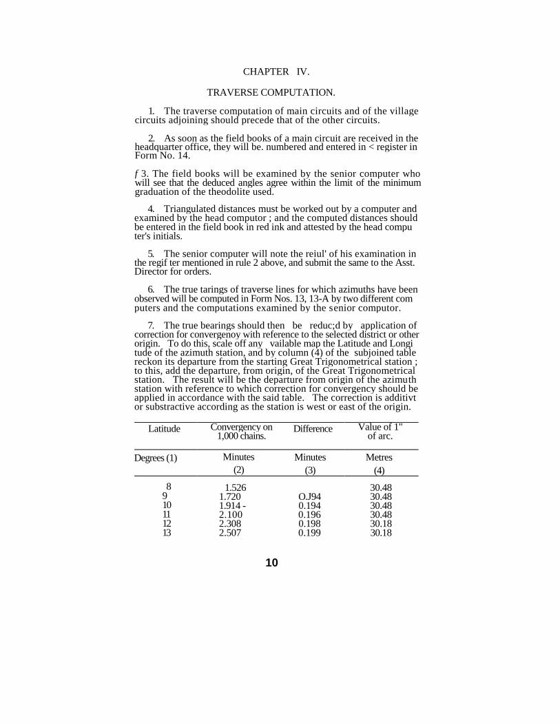
7. The true bearings should then be reduc;d by application of correction for convergenoy with reference to the selected district or other origin. To do this, scale off any vailable map the Latitude and Longi tude of the azimuth station, and by column (4) of the subjoined table reckon its departure from the starting Great Trigonometrical station ; to this, add the departure, from origin, of the Great Trigonometrical station. The result will be the departure from origin of the azimuth station with reference to which correction for convergency should be applied in accordance with the said table. The correction is additivt or substractive according as the station is west or east of the origin.
Latitude Convergency on 1,000 chains.
Difference Value of 1" of arc.
Degrees (1) Minutes
(2)
Minutes
(3)
Metres
(4)
8 9 10 11 12 13
1.526 1.720 1.914 -2.100 2.308 2.507
O.J94 0.194 0.196 0.198 0.199
30.48 30.48 30.48 30.48 30.18 30.18
10
CHAP. IVJ INITIAL CADASTRAL SURVEY TRAVERSE COMPUTATION 11
Latitude Convergency Difference Value of 1*
1,000 chains of arc.
Degrees Minutes Minutes Metres
(1) (2) (3) (4)
14 2.707 0.200 29.87
15 2.909 0.202 29.87 16 3.113 0.204 29.87 17 3.319 0.206 29.57 18 3.528 0.209 29.57 19 3.738 0.210 29.26 20 3.952 0.214 28.96 21 4.168 0.216 28.96 22 4.386 0.218 28.65 23 4.608 0.222 28.35 24 4.834 0.226 28.35 25 5.063 0.229 28.04
8. The traverse angles and distances from the main circuit field book will be copied into rough traverse sheets, Form No. 14-14A in which the reduced bearings, will be entered in. red ink.
9. The bearings of all the traverse lines will then be worked, and if the angular error between any two bearings be greater than 1 minute in 5 angles, the incorrect work will be sent out for examination.
10. The double measurements for each line will also be compared and all discrepancies greater than 1 link in a thousand brought to the notice of the Asst. Director. If the rules for the guidance of the main circuit surveyor are attended to, such discrepancies will not be found. If any are found, the main circuit surveyor will be severely punished.
11. If the two distances agree within the above limit or error, the long chain measurements should be taken for the traverse.
12. When discrepancies in angles and distances have been adjusted, the computation of the main circuit traverse will commence on fair traverse sheets, Form No. 15-15A.
13. The main circuit is divided into portions. Each portion starts from a Trigonometrical station and closes on another Trigonometrical station. The angles and distances for each portion will be entered in the traverse sheets, as also the names, latitudes and longitudes of the Trigonometrical stations.
14. Latitudes and longitudes of "modern series" Great Trigono metrical stations car be copied from the synoptical volumes published by the Survey of India, with a minus correction of 2' 27" in longitude, and those of the Madras Survey Trigonometrical stations, which are based on Preliminary chart values from the charts or registers in the Central Survey Office, Hyderabad after application of the following corrections :—
1. A minus correction of 2'.5* in latitude and
2. A minus correction of 2'27" ,93 in longitude.
12 THE ANDHRA PRADESH SURVEY MANUAL CHAP. IV
] The latitudes and longitudes of Lambton's Great Trigonometrical
stations require correction to reduce them to modem series values. The corrections to be applied to Lambton's values have been ascertained for each district, and they are shown in Appendix No. HI.
15. The rectangular co-ordinates (latitude and departure) from the selected district or other origin of all the Great Trigonometrical stations concerned will then be computed in Form No. 16, from Tables XXVI to XXVI11 of the Auxiliary Tables of the Survey of India, Fourth Edition, 1906. In the traverse sheets of the main circuit must be ente red the difference between the two sets of co-ordinates of the pair of Great Trigonometrical stations concerned.
16. The deduced bearings of traverse stations will be worked from one bearing to another, the necessary small corrections being applied to close the angular work.
17. The latitude and departure of each station will be taken from the traverse table and entered on a sheet of paper which should be kept in the custody of the head computer, while they are retaken by another man who enters them in the traverse sheets. The two computations will then be compared. If they do not agree, a third computation and, if necessary, a fourth computation, will be made and so on, until any two computations agree.
18. When the senior computer has satisfied himself that there is no error in the calculations, the latitudes and departures will be added up from one Trigonometrical station to another, and each portion of the traverse formed into a complete circuit by adding the co-ordinates between the two Great Trigonometrical stations concerned ascertained as per paragraph 15.
19. If the difference between the northings and southings and bet ween the eastings and westings does not in either case exceed 1 in 1,000 links, the traverse may be accepted as correct. If it be more, there must be error either in the measurements, or in the computations or in the identity of the Trignometrical stations connected, and immediate steps should be taken to detect and rectify the error. Before sending out work for correction, the village circuits adjoining the main circuit should be set up to assist in locating the error.
20. The traverse sheets of all main circuits will be signed by th« Asst. Director and forwarded to the Central Survey Office for examina tion, as soon after they have been closed as possible, together with the traverse field books, sketches of connection of Trigonometrical stations and all Dther records connected with the computation of the main circuit.
Corrections in main circuit traverses, once approved by the Direc-tor, of errors subsequently located therein at village traverse comput-ations should on no account be effected without his special approval.
21. The purpose of main circuit traverses which have no app-arent connection with the work in hand is not difficult to conceive. Balancing the co-ordinates of a closed circuit is not sufficient by it-self to determine its accuracy as the co-ordinates would agree, even had an inaccurate chain been used, provided the chain was uniformly
CHAP. IV] INITIAL CADASTRAL SURVEY TRAVERSE COMPUTATION 13
inaccurate and no mistake had been made in reading it. A combina tion with other points fixed independently is therefore needed, and this is securred by connecting the main circuit with Great Trigonome-trical stations and by dividing and setting it up into as many lines as there are. ' Great Trigonmetrical connections, each line starting from and closing on a Great Trigonmetrical station. The Great Trigono-metrical co-ordinates are fixed and the Revenue Survey Co-ordinates should accord with them, differences of less than 1 per 1,000 being allowed as negligible. Thus, while the accuracy of angular work is proved by azimuth observations, that of measurement is ensured by connection with Great Trigonmetrical stations.
22. The registry of village and fchandam circuit field book and their examination by a computor should be done in the same manner as for the main circuit field books.
23. The traverses of village circuits will next be set up, the angles, bearings and distances common to them and to the main circuits being first copied into the traverse sheets.
24. The traverses of kbandam circuits will then be set up in Form No 17. The village bondary lines need not be copied in the khandam circuit traverse, nor those of adjoining khandams already set up, but remarks will be made at the foot of the traverse, showing the lines added to foim the khandam into a complete circuit, thus ; "Add village boundary from distance 1,083 to 842" ; "Add second khandam from distance 750 to 845."
25. The setting up will be examined and, if the error does not exceed I minute in 5 angles in village circuits and 1 minute in 2 angles in fchandam circuits, the angles will be closed by applying the required corrections.
26. when applying corrections, care must be taken that, in each ease the corrections tend to close the adjoining traverses.
27. The bearings will then be worked and the traverse submitted to the Asst. Director for initials.
28. The latitude - and departures of the distances common to the main circuits will be copied into the village traverse sheets, and the same calculated for the remaining stations in the manner described in rule 17 above.
29. When the workings have been compared and the senior com putor has satisfied himself that there is no error in the computations, he will have the work added up and submit the traverse to the Asst. Director with the amount of error noted at the foot.
30. In village circuits, the maximum error allowed is 1 link per 1,000 and in fchandam and minor circuit, 2 links per 1,000.
31. The distance of a village circuit should not be worked unitl the angular work of all its khandams has been proved.
32. It may occasionally be found inconvenient to carry out the above rule strictly. In cafes where there can be no doubt that an
14 THE ANDHRA PRAPESH SURVEY MANUAL CHAP. IV
•rror exists in a line common to two villages or fchandams, the re-maining portion of the traverse may be worked while the incorrect lines is sent out for correction.
33. An examination of the traverse of adjoining villages and kh/ndamas will be of use in discovering where the error in a village circuit may lie. It will be a rule, therefore, that, before sending any traverse work for correction, the adjoining and included circuits must be set up and pro\ed.
34. Faulty work must be shown in Form No. 18 and submitted to the Asst. Director for orders, or to the addition il Officer or Manager in case the Asst. Director is in camp and must not be sent out for correction until orders have been obtained.
35. An error in distance may often be discovered by a crefull examination of the field books.
36. When the angles are wrong, r.n extract from the field boote showing only the distances will be sent to the surveyor, and if the dista nce do not close, the angles only will be given. In both cases the surveyer who corrects the work will retake angles and remeasure the distances.
37. Correction field books will be bound up with the orginal field books and reference to their number and date made in the traverse sheets and in the orginal field book by the computer who makes the corrections in them.
38. When the distances close within the allowed error, the necess ary small corrections will be applied to the latitudes and departures, care being taksn that, in each case the corrections tend to close the adjoining traverses.
39. The corrected latitudes and departures will be entered in the traverse sheets, and plotting lines worked from the first station of the village traverse.
40. The traverse area will then be computed and the traverse initialled by the Asst. Director. They will then be handed over to the Senior. draftsman for plotting.
41. Traverse area computation may, if necessary, be deferred until the traverse plotting has been completed.
42. The computers will sign their names at the back of the traverse sheet in the space provided for the purpose.
CHAPTER V.
TRAVERSE PLOTTING.
1. Village maps are plotted to the scale of 1cm.=2.5 chains or 20cm.=lK.M. (R.F.1/5,000). In the case of villages, however, whose area exceeds 40 Sq. kms. the village map may be on 1 cm. =5 chains or 10 C.M.=1 Km. <RF 1/10,000)
2. The plotting is done on sheets of drawing double elephant paper, ISOGrms. size of whole sheet, 100 cm. by 75 cm. of half sheet, 75 cm. by 50 cm.
3. The section or rectangle within a whole sheet will measure 80 c.m. by 60 c.m. and within a half sheet, 60 C.m. by 40 c.m.
4. The number of sheets required is ascertained from the column of plotting lines in the village boundary traverse. The greatest northing Plus the greatest southing and the greatest easting plus the greatest westing will give ths height and ba;e of a rectangular parallelogram that will exactly contain the ploygon formed by the traverse. The number of sheets will be known by dividing the base expressed in centimetres by 80 c.m. and the height by 60 c.m.
5. If in dividing the base, the quotient contains a fraction not exceeding half, a half sheet, base 40 c.m. and height 60 c.m. may be used instead of a full sheet.
6. In arranging sheets to contain a village, the shifting must be bv half sheets east and west and by whole sheets north and south.
7. Squared sheets will be supplied from the Central Survey Office The squaring should be tested before the sheets are used.
8. A full sheet will contain 12 squares, four east and west and three north and south. A half sheet will contain six squares, two east and west and three north and south.
9. The position of the first staton in the traverse has then to bt fixed. This is done in the following manner :—
A diagram 12 c.ms. square, should be drawn on a paste board, on scale, lc.m.=25 chains. The diagram should be divided into 12 rectangles, four from north to south and three from east to west. Each rectangle should be divided into 1? one cm squares. The sides of the rectangles should be drawn in black ink and those of the squares blue ink. In diagram which represents 12 full sheets, the sheet mar-gins are supposed to be cut off and the rectangles placed in contact. The rectangles should be numbered from west to east by Roman num-erals and similarly the squares within each rectangle by Arabic numerls Vide Appendix No. IV. A plot of the rectangular parllelogram men-tio.ied in rule 4 above should be made on tissue paper and so placed over the diagram that the opposite sides of the parallelogram may be equidistant from the adjoining sheet lines in the digaram. The greatest
15
16 THE ANDKBU PRADESH SURVEY MANUAL
easting and the greatest northing laid off from the east and north sides of the parallelogram respectively and at right angles to the sides will, where they intersect indicate where exactly, in the diagram of rectangles and squares, station A of the traverse will fall.
10. Whenever station A of the traverse placed in the most advan tageous manner with reference to the number of sheets to be used falls within a short distance of an interesection of the 25-chain (20 Metre) squares, it should be shifted to the interesection to facilitate plotting.
11. If shifting to an interesection would entail marked disadvan tages, such as bringin small corners of the v
;llage into separate sheets
and causing waste of paper, then the paper can be re-squared from station A as it falls in the rectangle of 2 K.M x HK.M.
12. The traverse will then be plotted from the meridian passing through the first station.
13. The distance on the meridian will be laid off above or below the first station according a? the distance is north or south.
14. At each mark on the meridian line another line, will be drawn at right angles, and the distance on the perpendicular taken from the traverse set off to the right or left according as the entries correspond ing to meridian distances are east or west.
15. The points thus successively fixed on the lines perpendicular to the meridian are the stations or angles of the polygon. As each station is plotted, the dirtance between it and the last will be tested.
16. If there should be more than one sheet for a village, a key showing the arrangement of the sheets and their numbers should be drawn in the margin of each sheet. The rectangle denoting the sheet should be distinguished by hachure lines.
CHAPTER VI
FIELD DEMARCATION
Note.—The term "poramboks", wherever it occurs in this volume* means land which is reserved for State or communal purposes such as :
1. River and stream. 11. Railroads. 2. Tarfcs. 12. Burning and burial grounds. 3. T..r.k-beds. 13. Cattle-stands. 4. Channel. 14. Grazing grounds. 5. Barks. 15. Village-site.
" 6. Pond. 16. Forest. 7. Ditch. 17. Pr.goda. 8. Fort. 18. Threshing floor. 9. Well. 19. Saltpans.
10. Topes. 20. Public buildings. 21. Cart-tracks.
1. Field demarcation and survey will begin after a sufficient number of stones have been stocked in the village.
2. The work will be done by Deputy surveyors under the supervi sion of surveyors, d- puty Inspectors and Inspectors. A batch of nine Deputy surveyors will form a surveyor's range and four such ranges will form a Deputy Inspectors sub-section. Two such sub-sections will form a Inspectors section.
3. As soon as the Deputy surveyor arrives in the village, he should ascertain by personal enquiry whether any of the landholders are willing to supply their own stones and labour and then send to the range surveyor a special report regarding this and the state of stone supply in the village, etc. The surveyor should go to the vill age if any difficulties have been reported, do his best to over come them and write to his Deputy Inspector only in case of fiilure .
4. The Deputy surveyor should give a writen notice in Form No. 8 to the village autbories requiring their attendance during demar cation. He should ascrtain the names of the owners or occupiers of the lands he has to demarcate the next day and serve on them, through the village servants, written notices in Form No. 9,
5. When parties, whose attendance is esstntial, refuse or fail to attend, a report of non-attendance should be sent to the Inspector who will teke steps to secure the attendance of the parties by having recourse to the Act, if necessary. It is of DO use whatever reporting persons for non-attendance unless it can be shown clearly that they received the notice in due time, that their attendance was necessary and that they were absent without good and sufficient cause.
6. The Deputy surveyor should be accompanied by the karnam, the v.llage munsif and the owners of the properties be is demarcating but if, for any sufficient rea^d)a,l3»e village sothjorit^es diDnW be absent
17 2487—B~-2
18 THE ANDHRA PRADESH SURVEY MANUAL [CHAP. VI
from their village, as on jamabandi or other work, the surveyor must not be idle. He must go on marking the fields according to possession, guided by the latest revenue accounts.
7. The Deputy surveyor will be furnisl ed with the boundary demarcation sketch of the village. He should demarcate the fields commencing with the first khandam of the village and be guided by the following rules.
8. A revenue field, i.e., field registered in the .revenue accounts may be either occupied or unoccupied. If occupied, it is a distinct piece of land of one description of soil and held on one tenure by one man or jointly by more. If unoccupied, it is either poramboke, or waste assessed or unassessed. Occupied revenue fields always form distinct items in a patta. A paimash field may be a revenue field or it may contain two-or more revenue fields.
9. Subject to rules 10,11,12 and 18 below, revenue fields should be clubbed to form survey fields up to a miaximum of 2 Hectares in wet 1 ind and 4 Hectares in dry land. In a survey field so formed, each revenue field will form a separate subdivision. If two or more pre viously existing revenue fields (still seperately registered) which are con- tinguously situated have passed into the enjoyment of a single individual or the enjoyment of a number of persons who hold and enjoy them jointly and in common and are of the same description of soil and tenure they should be formed into a single subdivision of the survey field.
10. No survey field thus formed should contain more than 20 subdivisions unless its area is below one hectare in wet and 2 Hectare in dry land when no limit is placed on the number of sub-divisions.
» 11. In clubbing revenue fields, great care and judgment are re
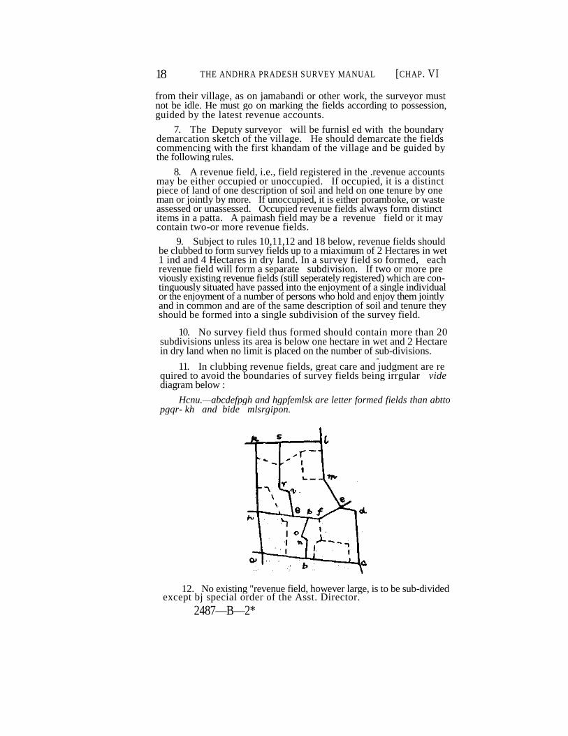
quired to avoid the boundaries of survey fields being irrgular vide diagram below :
Hcnu.—abcdefpgh and hgpfemlsk are letter formed fields than abtto pgqr- kh and bide mlsrgipon.
12. No existing "revenue field, however large, is to be sub-divided except bj special order of the Asst. Director.
2487—B—2*
CHAP. VI] INITIAL CADASTRAL SURVEY FIELD DEMARCATION 19
13. In demarcating fields existing limits of occupticn should be adhered to and all bends recognized except such as are within 10 links from a line between the marks on each side where the land is valuable or within 20 links in dry land of little value. When such smal! bends are ignored, care should be taken that the marks at each end of the line are so placed on the boundary that there is no appreciable loss of land or of trees to either party. Bends on subdivision boundaries should not be marked with stones unless the subdivision is a poram-bofce.
The letter 'S' should be cut on the the top of field stones planted at bends subdivision boundaries and the St. George's cross on those mar-king bends on village boundaries.
14. When field boundaries are found to be very crooked beyond the limits within which equalizatoin of bends is admissible as provided in rule 13 above, every endeavour must be made to induce land holders to consent to their being straightened; it must be explained that the, saving in stones will be very great, and that they can lose nothing, be cause just as much will be added to each field as is taken away from it.
15. If ryots agree to straighten their boundaries, they must demolish the old and set up the new bunds at once. Unless they do this, the field boundaries will have to be marked as they exist; in no case is any bend beyond the limits laid down in rule 13 above to be ignored, because ryots 'say they will form |the newjbunds after the marks have been put up.
16. When there are bunds or hedges-between fields, the centre of these will, as a rule be considered to be the boundary unless there is evidence to the contrary.
17. Where the registered holder is absent or where the boundary between two revenue fields is disputed, the line must be laid down according to the village records or as ascertained from the village officers and from such other eveidence as may be available.
18. All roads.cart-tracks and channels shown as proramboke* in the revenue accounts and those which are included in the ryotwari holdings and which exceed 20 links in width should be demarcatd as separate survy fields half a chain or over in width; but the Asst. Director of Survey unit, may ,at his discretion, survey such a cart-track or channel as a subdivision in order to secure well-shaped survey fields,. The former should be surveyed as subdivisions when they are less than 50 links and the latter when over 20 links and less than 50 links in width. Those included in ryotwari holdings which do not exceed 20 links i» width and those included in large waste blocks which are not to be sur veyed in detail, should not, except in special cases/to be determined by the Revenue Officer, be subdivided but marked as details.
When a waste block is surveyed in detail, those roads, cart-tracks and channels in it.which do not exceed 20 links in width, need not be , undivided and should be shown as details.
20 THE ANDHRA PRADESH SURVEY MANUAL [CHAP VI
19. Before demarcating the boundaries of Government cr Local Funds roads, reserved forests, charnels or other public works, notice must be sent by the sub-assistant to the local office!s concerned to depute a responsible subordinate to attend with acquisition sketches and point oiu the boundaries of such lands. Tht subordinates deputed should cert fv to the conectness of the demarcation of the laned and the certificates should le filed with the records of the village. If there is any difference between the boundaries pointed out by them and by the ryots the matter nust be reported and to the Asst, Director for orders.
20. Encroachments on put lie lands stt apart for burial groundsr market places, top?s, village-sues, etc., yhculd be set back and suffi cient width reserved for village roads.
21. The boundaries of communal poramboke fields and sub-divi sions should be straightened by cutting off sharp projecting berds pro vided the usefulness of the porambckes is not impaired. Any bit of land so excluded from the poramboke should be marked as a waste subdivision, if the area which will be otherwise added to an adjacent revenue field is more than 2 Ares or if it contains valuable trees. If ICFS than 2 Ares and containing no valuable trees, it should be sur veyed as part of the adjoining revenue field. Such part of the land as may contain valuable trees should be surveyed as an assessed was'e subdivision or sub-divisions irresueclive of area. When however the poiamboke adjoins a waste field, the r>art excluded should be surveyed with the waste field without subdividing it.
22. When no patta can be shown for any appartent encroachment of over 2 Ares which on the poramboke side of the straight boundary, fixed as directed in rule 21 above, it should be measured and plotted as an encroachment sketch to be attached to the land register, a remark being entered there against the fields giving the encrcacher's name and the area encroached upon. When the encroachment is less than 2 ares a remark in the land register will suffice.
23. Large waste block fit for cultivation should be divided into 4 hectares fields, following where convenient the limits of sivayijama cultivation, care being taken to secure regular field boundaries.
24. Where a road runs through Government waste, its limits should be marked at a maximum distance of one chain on each side of the ceatre line of roadway.
25. Before marking out the boundaries of railwav lands, the local railway authorities must be communrcated with, asked for copies of land plans and written permission obtained to enter on thfir premises when necessary.
26. Railway lands in the case of Railways constructed by comra- panies which receive land free of cost are divided into four classes A, B, C, D —first class A, land which the railway company receives, free of charge for penn£:ient occupation; second class B,'land also provided free of cost but only for temporary occupation; third
CHAP VI] INITIAL CADASTRAL SURVEY FIELD DBMERCATTON 21
fourth class D, land which being required in consequence of the wo ks of a lailwa) still dots not come directly into the occupation of the rail-way company at all.
27. Under class A is included all land required for the permanent works of the railway, including the formation of the line with its side •lopes, terms, ridges, etc., and for all station-', workshops, permanent •tore-houses and the like necesary for the line when opened.
28. Under class B is included all land essential for the execution of the permanent wcrks of the railway but not required af'cr the com pletion of the line in part or whole. Such is land icqaiied for spoil banks, for extra excavations to make banks, or for the s^xvsge of ma- teiials held in stock by the railway company pending the construction of the line or thtir despatch to the works.
29. Under class C is included all land which is required for the provision or preparation of materials, for purposes contingent on the actual execution of the worko on the line or for other miscellaneous objects.
30. Under class D is included all land required outside the com pany's boundary, for the diversion of road? oj rivers and for the con- •truction of roads which are made for public purposes but will not after wards be maintained by the company.
31. "A" class lands should be surveyed as separate fields. "B" class lands should bo ru ,-veyed as subii/isions ol the Acids in which they lie. "C" class lands should be surveyed as new rields or as subdivi sions according to their ar--a or impjr:aace.
"D" class lands.—New roads and channels if 50 links or more in width, should be surveyed as ent.re field*., about 1C chains in length. If below 50 links in w
:dth, they shoad be surveyed a? sao-divisions of
the rields in which they lie.
32. In the case of railways cojtructed by 3j/3ranjnt or by Companies not entitled anlsr c:i.j,r contrasts to l a i l iVee of cost, land is divided into two clasps, 'pa .a i i i i ; ' and 'ce.np.Kary'. Tue former corresponds to A class land and .'iiai;! jj maiKul as separate survey fields the latter wrucrx comprise* iaaJ re q .tired for temporary occupa tion on.y aaJ wlii-h will eventually jj roundish-id, saoald oe marked as sub-divisions or as survey fields according to area.
33. Long narrow fields, such as roads, cart-tracks, channels, rail ways, etc., should be split up into survey rields each measuring about 1U chains in length.
34. Inam fields should, as a rule, be surveyed in accordance with the inam title-deeds cr the inam register. Uneafrachised mam fields, should not be sub-divided exceni to exclude porambokes; ooramookes channels, can-tracts and too.paths, registered as subdivisions or an iuurn ticid >n the revenue accounts and existing ori the giouud, shoi.U be surveyt-d as sub-division? whether the width exceeus 2\J irnks or not; where channels, though registered as sub-divisions m the revenue
22 T*HE ANDHRA PRADESH PURVEY MANUAL [<JHAP
Vl
accounts, no longer exist on the ground the question of their separate sub-division should be decided on its merits. Enfranchised inam fields may be sub-divided according to enjoyment.
35. Public Works Department channels, Local Fund roads and cart-tracts passing through village-sites should be marked as fields or sub-divisions according as they have been marked outside the" village- site.
36. Government lands which are situated in villages included in municipal towns arid are assessed to revenue (including ground-rent) or are available for disposal on payment of assessment or ground-rent as also lands in the possession of Government in such villages, should be surveyed if their extent is not less than 0.5 of an are.
During the survey of estates, the lands in wnich Government have an interest should ordinarily be surveyed as entire survey fields. Where however such lands are contiguous,they may be clubbed with one another and surveyed as subdivisions of the same field. They should not be clubbed with estate lands and surveyed as subdivisions of estate lands. Before such survey is made, a notification under section 5 of the Madras Survey and -Boundaries Act should be published.
37. Cultivation in forest blocks, if recognised as enclosures, should be marked separately according to the existing limits on the ground If the area of an enclosure thus marked is more than that allowed, at the forest settlement, the excess should be formed as a separate sub division and the same reported to the Collector for such action as he may deem necessary.
38. Stones erected by the Public Works Department on the banks of canals, etc., by the Railway Department to define A class lands, and by the Forest Department to define forest boundaries, should, with the consent of the departments concerned, be utilized as survey marks by cutting the broad arrow on them.
39. From the boundary demarcation sketch of the village supplied to him, the Deputy surveyor will prepare a skeleton .field demarcation sketch for each khandam, on scale 1 cm=2 chains on a quarter sheet of paper, 130 Grams size 30 cm. by 50 cms. As he demarcates the boundaries of survey fields and the included subdivisions, he will sketch them in pencil in the skeleton demarcation sketch.
40. As each field is sketched, the surveyor will note in the sketch in pencil the paimash numbers and the number of each registered hol ding and other particulars necessary for writing up the field or land register.
41. The sketch must be neatly drawn so as to admit of every field and subdivision bend being clearly shown.
42. The pencil lines in the sketch should be inked as soon as the stones have been erected and not before.
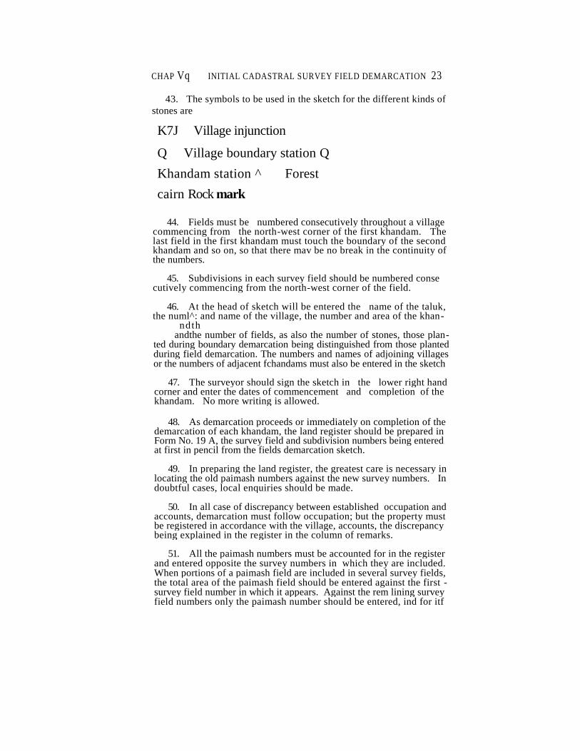
CHAP Vq INITIAL CADASTRAL SURVEY FIELD DEMARCATION 23
43. The symbols to be used in the sketch for the different kinds of
stones are
K7J Village injunction
Q Village boundary station Q
Khandam station ^ Forest
cairn Rock mark
44. Fields must be numbered consecutively throughout a village commencing from the north-west corner of the first khandam. The last field in the first khandam must touch the boundary of the second khandam and so on, so that there mav be no break in the continuity of the numbers.
45. Subdivisions in each survey field should be numbered conse cutively commencing from the north-west corner of the field.
46. At the head of sketch will be entered the name of the taluk, the numl^: and name of the village, the number and area of the khan-
ndth andthe number of fields, as also the number of stones, those plan-
ted during boundary demarcation being distinguished from those planted during field demarcation. The numbers and names of adjoining villages or the numbers of adjacent fchandams must also be entered in the sketch
47. The surveyor should sign the sketch in the lower right hand corner and enter the dates of commencement and completion of the khandam. No more writing is allowed.
48. As demarcation proceeds or immediately on completion of the demarcation of each khandam, the land register should be prepared in Form No. 19 A, the survey field and subdivision numbers being entered at first in pencil from the fields demarcation sketch.
49. In preparing the land register, the greatest care is necessary in locating the old paimash numbers against the new survey numbers. In doubtful cases, local enquiries should be made.
50. In all case of discrepancy between established occupation and accounts, demarcation must follow occupation; but the property must be registered in accordance with the village, accounts, the discrepancy being explained in the register in the column of remarks.
51. All the paimash numbers must be accounted for in the register and entered opposite the survey numbers in which they are included. When portions of a paimash field are included in several survey fields, the total area of the paimash field should be entered against the first - survey field number in which it appears. Against the rem lining survey field numbers only the paimash number should be entered, ind for itf
24 TOT ANDHRA PRADESH SURVEY MANUAL [CHAP VI
area reference should be made in the last column the register to the first survey field number against which the same was noted.
52. The register must show distinctly for each property the num ber of the registered holding and the name of the registered holder. In the case of inam fields, if enfranchised, the title-deed t.umbered and the name of the im-.mdar should be entered, and if un-enfranchised the name of the institution or service to which each relates.
53. For joint holdings, the names of all the shareholders should be entered aghinst the first survey field number. In all subsequent fields in which the s; .me joint holdings appear, it will be sufficient to note the name of the first shareholder and the number of the other share holders.
54. The deputy surveyor will initial every page of the land register and the last page will bear the signatures of the deputy surveyor, range surveyor, Deputy Inspector, Inspector and village officials.
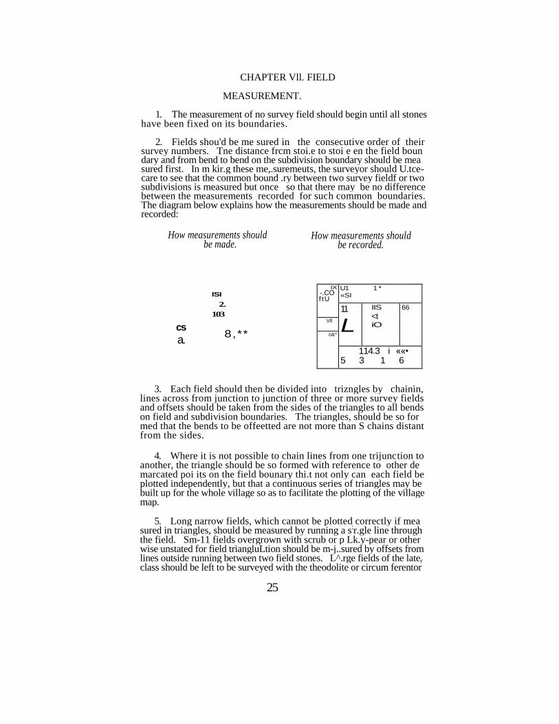
CHAPTER Vll. FIELD
MEASUREMENT.
1. The measurement of no survey field should begin until all stones have been fixed on its boundaries.
2. Fields shou'd be me sured in the consecutive order of their survey numbers. Tne distance frcm stoi.e to stoi e en the field boun dary and from bend to bend on the subdivision boundary should be mea sured first. In m kir.g these me,.suremeuts, the surveyor should U.tce- care to see that the common bound .ry between two survey fieldf or two subdivisions is measured but once so that there may be no difference between the measurements recorded for such common boundaries. The diagram below explains how the measurements should be made and recorded:
How measurements should be made.
How measurements should be recorded.
cs
a.
ISI 2.
103
8,**
IX
-.CO f tU
U1 1 * «SI
11
L
IIS <t iO
66
Vfl
o&*
114.3 i ««• 5 3 1 6
3. Each field should then be divided into trizngles by chainin, lines across from junction to junction of three or more survey fields and offsets should be taken from the sides of the triangles to all bends on field and subdivision boundaries. The triangles, should be so for med that the bends to be offeetted are not more than S chains distant from the sides.
4. Where it is not possible to chain lines from one trijunction to another, the triangle should be so formed with reference to other de marcated poi its on the field bounary thi.t not only can each field be plotted independently, but that a continuous series of triangles may be built up for the whole village so as to facilitate the plotting of the village map.
5. Long narrow fields, which cannot be plotted correctly if mea sured in triangles, should be measured by running a s
;r.gle line through
the field. Sm-11 fields overgrown with scrub or p Lk.y-pear or other wise unstated for field triangluLtion should be m-j..sured by offsets from lines outside running between two field stones. L^.rge fields of the later
class should be left to be surveyed with the theodolite or circum ferentor
25
JJ6 THE ANDHRA PRADESH SURVEY MANUA! [CHAP VII
6. Enclosures within forest reserves, and other detached fields whether situated within or outside the village boundary, should be con nected with one another and with the main work by chain triangulation or by traverses "run with the theodolite or Stanley's circumferentor. When enclosures within reserved forests lie at a considerable distance from the village boundary they need not be connected and will be plotted in the margin of the village map with an explanatory note.
7. The position of all important topographical details, such as village-sites, public buildings, channels, streams, tanks, wells, cart-tracks, foot-paths, etc., whether separately marked or not as survey fields or subdivisions, should be fixed by measurements.
Note:—Only those foot-paths which lead from Village to Village or from one hamle to another should b3 regarded as important.
8. Measurements need not, however, be taken to unimportant details or to such as are likely to change., Small gravel pits, shallow water-courses which are usually ploughed over, small rocks, temporary paths or tracks, old unused wells, temporary dams and temporary sluices should be ignored altogether. It is difficult to lay down exact rules on this point. The surveryor must use his discretion bearing in mind that the first object of the survey is to measure and map field boundaries.
9. The relative importance of each topographical feature should be considered; any feature that attracts special notice on the ground should be measured to; a single large tree, a small temple or large rock in an open country and a narrow pathway across an otherwise impassable mountain range are important details and should be fixed by measure ment.
10. Arrows indicating the direction of streams should be inserted in the field measurement book. Care should be taken that the direc tion of the arrow shows the direction of the stream correctly.
11. All permanent lines of communication, such as foot-paths, cart-tracks, earthen roads, gravelled roads and metalled roads, should be distinguished from each other by their appropriate symbols—see AI pendix No. V.
12. At the point where a railway, road or path crosses the village boundary, the place from or to which it leads should be entered with its distance from that point.
13. The name of evry village-site, hamlet, tank, hill, river, channel or other topographical feature, which has a distinguishing name, must be entered in the field measurement book,and care must be taken to en sure its correct spelling.
14. When detailing village-sites, the boundaries of bl®cks of houses on either side of the streets should be offsetted from chain lines measured along the streets. The depths of each block of houses and backyards and prominent bends on the back of them should also be measured and offsetted. Temples and important public buildings should however be measured separately. When the village-site is too large for measure ment by the chain and cross staff, a skeleton traverse plot of it will be supplied to the surveryor on scale 2cml chain and on it the blocks of houses should be plotted.
CHAP VII] INITIAL CADASTRAL SURVEY£" FIELD MEASUREMENT 27
15. As each field is measured, a plan thereof should be plotted by the surveyor in a field measurement book with the triangulation mea surements and offsets—vide Appendix No. VI. As a rule the top of the page will reprsent the north, but when it does not, the north point line should be drawn.
16. The accuracy of the triangulation and offset measurements and of the plotting should be tested by the measurements taken round the field and subdivision boundaries. The bounaries should not be inked until the plotting has been so tested and found correct.
17. The field measurement book should be prepared in duplicate. All topographical details fixed by measurement should be plotted in both copies.
18. The scale on which the fields should generally be plotted will depend on the area, thus—
Up to 2 Hectares 1cm. -J chain or 2cms=l chain (1/1000). 2
to 8 Hectares lcm-1 chain (1/2000).
Over 8 Hectares lcm-2.5 chains 2cms-5 chains 20cm-lk.m.— (R.F. 1/5000).
The point to bear in mind is that the scale must be large enough to enable all measurements to be shown distinctly.
19. The fields must be plotted in the field measurement book in the consecutive order of their survey nurhbers.Tbe scale should be noted at the foot of each field map.
20. Not more than one field should be plotted on each page of the field measurement book, and one field should not occupay more than one page.
21. If a field cannot be plotted on the prescribed scale on a single page, as in the case of long narrow strip of land, such as a cha nnel or pathway measuring less than 2 Hectares, it may be plotted on a smaller scale, provided all measurements can be clearly shown.
22. Where, however, the field is too large to be plotted on one page on a sufficiently large scale to admit of all measurements being recorded legibly, it should be plotted on sheets of field measurement book form mounted on clotb (allowing about 1 to 2cm. margin for stitching, to fold to the size of the field measurement book.)
23. The area of each survey field and of its subdivisions should be taken by the field surveyor with the area square from the plotted map ia the field measurement book and entered in pencil in the column pro vided for it ia the field register and in the duplicate field measurement book.
24. At the foot of each page of the field measurement book the sur veyor should sign his name in black ink and enter the date of Measure ment.
2fc THB ANDHRA PRAWESH SURVEY MANTJA& [CBAP V
25. As the mr.surement of fields in the- kVind'm progress the de puty surveyor should number the stores in n.k in the field demarca tion sketch. The number of stor.es pLnted each month should be written at the foot of the sketch and the tot. .Is ei.tered on completion of the khuid im. Eich stone should be given a number in the t-kitch and the num'jer of the last stone planted each m>uth should be nuiked with a red circle.
26. On completion of field survey the surveyor must measure line* from one kh.and..m station to another along the khi.nd. m boundaries •offsetting field trijunctions on the boundaries. To prevevit duplication of wo k the surveyor who completes kh.-.dm No. 1 will measure the sides along the vill ge boundary leaving the rest to be done by the •surveyors who measure the side khand;.ms. These measurement! should be recorded in the field demarcation sketch.
27. The accuracy of the measurements m .de by the deputy surveyor should be tested by all inspecting officers, viz., rar.ge surveyors, Dep- puty Inspectors, Inspectors and g izetted officers, by means of measure ment and check-measuremsnt in accordance with the instructions cont ained in Chapter XII, Inspection of Field Woik.
28. Inspecting officers should sign their nrmes in full in red irk in the original field measurement bock at the bottcmof the mrp of each fied inspected by them, noting above their signatures the number of lii.es tested. The deputy survyeors' measurements should be ticked off in red ink if they agree with the m&.surements of the inspector within the ntirgin of error allowed in rule 17, Chapter XII. When the difference exceeds that allowed, the inspector's m?..suremints should be entered and attested in red ink in both copies ot the field measurement book and the surveyor's measurements scored out.
29. On completion of filed inspection, the field register, a fair copy of the demarcation sketch showing only field boundaries, and the dupli cate field measurement bock, should be sent to the SpecLl Revenue Officer or the Revenue Divisional Officer as may be ordered.
In estate surveys these records should be sent to the proprietors or to their representatives. When the estates is nuxf ged by the Court of Wards, the Manager or whoever he may depute will recieve the records.
30. On receipt of the records, the Revenue or estate officials will make such inspection, as nuy be necessary, of the work of the surveyor* in field and will stitisfy themselves as to the completeness of the work before finally passing the field register and causing it to be used for the correction of the permanent village accounts.
31. The records will be returned after check to the survey Inspec tor with lists ami sketches illustrating the t.dduioru.1 subdivisions or chauges considered nau ss-.ry. These should be i.t ei cled 10 promp ly. but any p' p^sal, w uc \ seem at ariance with stuiding orders, or winch require alteration ol field boundaries entiling consider, ble remc;.sur- ment when the object desired can be secured by a subdivision, should be reported to the Assistant Director.
CttA» VII] INITIAL CADASTRAL SURVEY FIELD MEASUREMENT
29
In the case of estate surveys, the records should be returned to the Assistant Director of the party within two manths from the date of re-ceipt of the iccords by the proprietors or their representatives.
32. The Assistant Director should refer such of these charges as be tbii.ks necessary to the Revenue or esti.te officials ai d mty, if tht:e is still disagreement, refer them to the Director of Survey.
CHAPTER VIII.
PLOTTING VILLAGE MAP.
1. As soon as the original and duplicate field measurement books are received in office and before the plotting of the village map is taken up, they should be compared with each other.
2. The numbers of side fields and all the masurements of lines in the plan of the first field in the original copy of the field measurement book should be compared with the side numbers and measurements of the corresponding lines in other field plans, both orignals and duplicates. As each number or measurement is compared, it should be ticked off in pencil so that it may not be compared again. The measurements and numbers not checked should then be compared in all the fields in turn.
3. Discrepancies found on comparison should be noted in Form No. 22.
4. Discrepancies between the orignal and duplicate field measure ment books should be rectified by correcting the duplicate to agree with the original.
5. Where different measurements are recorded for the same line in rejoining fields, and the difference is not more than three links in dis tances of five chains and under, not more than one link per chain in dis tances of over five and under ten chains, and not more than ten links in distances of ten chains and over, that measurements should be retained which is nearer the theoretical length of the line as calculated from the recorded diagonal and offset distances the other measurement cor rected.
6. Where the difference, though within the margin allowed, cannot be adjusted with reference to calculated distances, or when no diagonal and offset measurements are available, the measuiement recorded for the field bearing the lower number should be retained and that in the field bearing the higher number corrected.
7 Differences within the margin of error allowed will be adjusted by the draughtsman who compares the field measurement books, the measurement adopted being entered in the column provided for the pur pose in Form No. 22.
8 Differences above the prescribed limit should be examined with reference to diagonal and offset measurements and reported to th« Assistant Director for orders.
30
CHAP VHTJ INITIAL CADASTRAL SURVEY PLOTTING VILLAGE MAP 31
10. The plotting of the fields in the village map should begin after the traverse plotting of the boundary and khandam circuits, and the laying out of the points offsetted from the village and khandam boundary and cross purtal lines have been completed. In special cases the Asst. Director may permit field plotting of a portion of a village being proceeded with, while the traverses or purtals not affecting t hat portion remain unplotted.
11. Fields should be plotted from the measurements in the field measurement book. Sub-divisioas phould not be plotted in the village map.
12. Enclosures within forest reserves and other detached fields situated outside the village boundary should be plotted in their correct relative position wherever possible. When they lie far off the village boundary, they should be plotted in the margin of the map without reference to their correct position ?,nd a remark to that effect printed in the map.
13. When the measurements appear to be wrong in any part, the plotting in that part had better not be continued but carried to it from some other direction.
l^r With the help given by the points offsetted from purta lines' an<H>y the several theodolite station points, it should be possible to Ascertain exactly in what line an error of measurement lies.
15. Errors will be shown in.the map by a cross mark on the line itself and also noted in a discrepancy list in Form No. 23.
16. The erasure of pencil marks injures the surface of the map for Vandyke printing and the pencil should be used only for tbe field and village numbers and field boundaries which it is desirable to write first in pencil and type or ink afterwoards. Topographical de-tails should be drawn or typed direct in ink.
17. An experienced draughtsman should test 25 per cent of the plotting in each sheet of the village map. He should also examine the plotting of the fields in which errors have been located by tbe field plotter.
It. The cummer shovld check the discrepancy list (rule 15). write Ike action suggested and submit the list and records to thi senior
19. After scrutiny, the Senior draughtsman will submit the list to the Asa. Director who will order remeasurement to be 'made where be "m*df * it necessary.
2DL On receipt of the correction sketches fiom field with the distances entered in them conections will be applied in the mtm and in the field measurement book.
21. The field measurement book prepared by the Deputy surveyor wiD mot ifcow the fields traversed as minor circuits with the theodolite. A U*»UK plot of each of these fields should be prepared from the
CHAPTER IX. FINISHING VILLAGE MAP AND AREA
COMPUTATION.
1. The field boundaries should be irked, the v'llage and khandam boundaries being drawn slightly thicker than the field boundaries. The lines should be drawn evenly with a steady hand, and care should be taken to show the bends on field boundaries by well-defined inter sections of the lines constituting the boundaries to secure a clear de- lineat'on of these latter in the printed mips. The Indian ink used should be of sufficient consistency and not watery.
2. The field number* should be neatly typed, the figures heading north, as a rule. When necessary, the numbers may be typed trans versely, but such instances should be rare. To ensure clearness in the printed maps, the field numbers in the original ,map must be quite dis tinct. This can only be secured by keeping the types perfectly clean. They should be thoroughlv cleaned with turpentine and a bard brush daily. They should never be wiped with cloth but always with soft leather.
3. If the ord'nary types for field numbers would over-crowd the map, smaller types should be used.
4. Where a field 's too mall or narrow to admit of its number being typed with clearness even by using small types, the number should be typed in the nearest open space and its icference to the field indicated by an arro'.v.
5. In the case of fields which are divided by the sheet lines and which consequently lie pirtly in one sheet and partly in an another, the field nunibc s should be typed within the sheet which contains the larger portion of the field. In the other sheet which contains the smaller portion, the field number should be typed outside the sheet line in smaller type. When sheets are joined, only one number must appear in each field.
6. Adequate enlargements of small fields, not roads or chunnels, less than 10 Ares , or narrower than half a chain, should be plotted in the margin of the map.
7. While the inking of field boundaries and the typing of field numbers are in progress, the area> of survey fields and sub-divisions should be tnken with the area square from the field measurement book and entered in Form No. 24, field measuiement book area computa tion sheet.
8. This will be called the first computation sheet, and it should be handed over to the Senior computor who will then direct the recoinputation of area
5; by another computor.
-• - 9. Tho recomputed areas will also be entered in Form No. 24 and , this Will be called the second computation sheet. ' .. .
'
33
2 4 S7 -
32 THE ANDHRA PRADESH SURVEY MANUAL [CHAP
surveyor^ rough plans and inserted in the field measurement book. The traverse lines where they are not coterminous with the field boun-dary should be drawn in red ink.
22. When, as provided in rule 16 Chapter II. the middle of a river bed forms the trut boundary of the vllage, the feld map for the river portion should be pricked from tne village map. The conven tional lines denoting the boundary of the river portion should be shown in the field map by orcken lines and the measurements for tne lines shorld be obtained by scale from the village map. A note should be entered at the foot of the field map that the broken line;. ?re conven- t-onal lines.
23. The village boundary should be compared with the boun daries shown in the maps of the adjoining villages, and correction list prepaied for adjustment of discrepancies, after verifications on the giound, if necessary.
24. Tracings should be taken from the village map for the boun- daiies of villages of which the maps have yet to be prepared for com* parison when those maps are read),
34 THE ANDHRA PRADESH SURVEY MANUAL [CHAP XI
10. The first and second computations should be compared by ano
fher compeer, who will sccre out neatly in red ink in the second
comp'itati n sheet all entries which agree within the percentage of dif.e.ence allcwed, vi/., —
1 to 10| Ares .. . . . . J Are 1 1 to 20-J Ares . . . . . . 1 Are 21 to 30^ Ares .. .. .. 1/J Arcs 31 to40| Ares .. .. .. 2 Ares 41 to 200 Ares . . . . . . 2J Ares,
Aoove 200 Ares or 2 Hectares 1 per cent.
11. A list of fields not scored out in the second computation sheet should be p;epared for third computation which will be performed by a third cornp.itor.
12. The first and third computations will be compared and if they agree within the allowed percentage, the third and second com putations should b.; scored out in led ink and the first computation, letained.
13. If iho first and third computations do not agree and the second and thud do, the fiist commutation should be corrected in red ink as psr th'rd computation and the second and third computation*; scored out as befo c. Ta) ramt course should be adopted if more than three co;up x.uic.ns a. e fou.ni necessary.
14. The first rorvvr: iticn srcct will then be the rough computa tion shee; f.<r ;.rc A . ;ai;>i'ci fr 'in :ho fmii nv;asj.reint,nt book. In this computation siicoi, the a:c.~s cf sub-divisions should be totalled for each survey fit Id by the conrp.uor who compares the diflerent com* putations.
15. As soon as the field boniirles hive been inked and the field numbers typ d, the village m;;p t . i l l bt handed over to the Senior computor for area computation.
16. The area of s irvey fields wi!) be comv>"ited with the computing scale and ente;od in Form No. 24 map a tia computation shtet.
17. The areas obtained from the Hold aicasuremeat book and village map will be compared.
18 For fields of which the areas agree within the percentage of difference mentioned in rule 10 above, the entries in the map area com-putaticn sheet should be scored out in red ink, and from this sheet « list of fields not scored out should be prepared *or tecomputation.
19. In the case of such of the fields in this list as contain sub-divK sions, the totals in the rough computation heet should be examined and fields in which tha difference was due to incorrect totalling should be eliminated from the list.
,20. The tecomputation of the remaining ge]^s should first Otttie in the village map. -
CHAP IXl-IiflTiAL CADASTRAL SynvfiY FINISHING VILLAGE MAP ETC 35
21. If tha re^3 njirol area agrees with that in the rough com putation s'vset, thD entries in the map area comput?tion and recom- putation sh3<j:s s'iculd be ssorel out in red ink. But if it does not agree, the plotting in the fiei-i measurement boak should be examined, and the area of the field and its sub-divisions, if any, should be recom puted with the area tquare. If difference should still exist, the plotting of the field in the village map should be examined and its area recom- pMtei with thj confuting :scah. Th ; Proces. of n.:omp"itation should be continued until the comput'ng scale area taken from tha village map agrees with the atea, squire area, taken from the filed measurement book within the percentage of difference allowed.
22. The computing scale area should then Le scored out and the field measuiement bock area as iccorded in the rough computation sheet should be aaoptec as final.
23. From the final rough computation sheet, a rough area list will be copied in Form No. 24 showing the areas of survey fields and Sub-divisions.
24. After the entries in the rough area list have besn carefully compared, the areas of fields should be totalled up.
25. The areas of offsets on the village boundary should be com puted with the comput
:ng -'rcale and entered in Form No. 25 .
26. The area of offsets outsi le the travarse lines will be added to, and that of offsets inside the traverse lines deducted from the traverse arra. The result thus obtained will be the true area of the village.
27. This area should be compared with the total area of the village by fields, and the difference should not exceed 1 per cent.
28. If the difference exceeds 1 per cent, it points to error in the computation of either trevcrse 01 field areas or both.
29. The traverse computation should first be examined, and <fcen, if necessary, the field area computations and the difference adjusted.
30. When this has been done, the areas of fields and sub-divisions sh->*.M be copied from the rough area list into the field register, and the abstract at the end of the register filled in. The areas of survey fields will, at the same time, be copied into the field measurement book.
31. A fair area list should be prepared from the rough area list in Form No. 26.
32. The rough and fair area lists, field measurement book and register wll be compared with.one. another.
33. Important details shown in the field measurement book Should be plotted in the village map.
34. The detail? should be examined to see that channels and rof.ds are contM.uous and that the names .of village-sites, public buildjngs, riyerSj chiinuels, eteM are entered in
; tip igjapu Tli*
" " ......... ' .... • • • ' • • • •" •"'•• •"•
36 THE ANDHRA PRADESH SURVEY MANUAL [CHA> D8
35. As the light is supposed to fr.Il on the p?.per from the upper left-h nd corner in p; rallel n.y- ft an angle of 45° to the horizon, t.l\ objects in elevat'on, such as hu-ldings. banks and raistd roads, must be shown by (hick lines on the right hand and lower sides, or if the top of the drawing represent the north, the outlines east and south should be thickened, while all depressions, such as rivers, tanks and wells should be thickened on the north and west sides.
36. All names ar d woids should be printed so as to suit the map of the villr.ge when the sheets are joined together. Pu-t of a name will, u-.der this nrnxr.gement, often fi.ll in oj.e sheet nd p..rt in ano» other. When this is the cr.sc, the contirui.tion of the word or n;.me should be printed
:r. sm.ill type on the nu.rgir of the sheet in which it
commences, and Ikewise, the beginning oi the word or iu,me on the margin of the sheet in which it ends.
37. The map should show where roads and tracks lead. The name of the place is sufficient without adding ' from or to" and care should be taken to piint names only where necessary and where omis sion would leave destination doubtful.
38. The names of adjoining villages should be typed symmetri cally across the blank space left on the sheets, but only once in the case of each vill; ge. The -. umber of e; ch sheet should be tjped close to but outside the sheet line aid above the right-hard corner. The number should extend beyond the e-st sheet line produced.
39. In a line with the sheet number will be typed the number and name of the vilh.ge of which the sheet i? a part. The numbers of the adjoinhg sheets should be typed outside the sheet liies on «.ch side in the middle of their length. It is not necessity to ;.dd the words " adjoiiJLg sheet " .
40. The heading of the mrp should show the names of the dis trict and taluk, and the tduk number, nr.me and trr.verse area of th» village. The vill< ge n;.me should be in larger type than that used for district End t;.luk names.
41. The herding should be placed in or.e of the upper sheets of the map, so th°.t it may occupy a conspicuous position- when all the sheets ?.re joined or printed. The north point should be drawn close to the heading.
42. The scale of the map and the proportional linear magnitude, otherwise called the representative .fraction, should be typed just below the..area.;, and underneath the area, the scale itself should be drawn. Below the scale -:,hould be drawn a square representing 40. Ares or the scale of the map.
: 43. .Appendix No. V -is a standard sheet ofreferev.c* for the guidance
of-draftsnuifi in k-feins-i/5000 viU^eHii.psaiid-A|igCTidix No.
'*' '
CHAF IX] iMrrut CADASTRAL FINISHING VILLAGE MA? •: 37
44. Each topographical details is distinguished by a symbol to which a separate i.umber is assigned. No sep~rO.e table of reference should be dn.wn OK or att.ched to the vill, ge nr.p. It will suffice if the referei ce j.umbers required for the vill; ge are printed in small tjpe under the headii g of the m p. The corresponding references as per stand-rd sheet will be printed with the Hup in the Central Survey Office.
45. After the map has been inked and finished as above, each sheet •hould be carefully compared with the adjoining sheets to see that all bendf and topographical details agree.
46. Tracii gs frcm vill; ge n>. .ps showir g the bou- d; lies of reserved forests as surveyed should be sent to the District Iciest Cfixer.
47. Vill .ge m ps shoula baked by a thiii sheet of waste paper.
48. The persoT.s responsible for each item of m. ppir.g should sign their r,; mes in a printed list, Foim No. 27, which should be pasted on the first p..ge ol field measurement bock.
49. The mr.p and ill other records should be finally exi mined by the Senior ccmputor, senior dn.ftt.mun tj.d office m..r;ger i,nd the result of their ex; mira.tioi recorded in the final exumiixtion report Foim No. 28. Tae find eximiiiion report j.i.d i.ll other records should be signed by the Asst. Director.
50. After completion of m ppii g, a third ;.\ d fair ccpy of the field measurement bock should be p.epc.red in the Saivey office.
51. When the survey is that of an estnte, the land register should be prepared in Foim No.
;8. A fair copy of the register should :.lso
be p,ep,.red ir» the Survey office, \vheu not lollowed by record o! rights operations.
When the lands in estates r.re surveyed at the ii.st i ce of Goven ment in order to f;.cilit;.te collection of w<~ter-rate, theL.i.d register should be prepared in Foim No. 38-A.
When the lands in properietery villr ges are surveyed tt the instance of the loci.l boards to f;.cilit;.te the levy of knd cess, the Li.d register should be prepared in Form No. 388.
52. The Asst. Director will then cause notices in Form No. 29 to be served under section 9 (2) of the Act. These notices should be acccuo- p..nied by an t i k owledgme; t, Form No. 30-B which should be sig: ed in t( ken of the receipt 01 the notice and retur; ed to the office? who issued it.
53. Appe Is from the orders in these notices ;;.! d from those pc.s:,ed urder section 10 (2) ;.re to be filled within three m > ths oi the dat of theserv'ce of he nojec, tu the p, riod of ap^u.l i me shall uotiucL.de tho t'.me taken to secure a copy of the deision und map.
54. The r.ppell te authority can admit of ;.r. ; p-p3..1 p.fter the lapse of appeal time.provided he iss.tisfied that ST. ?ppe!L.nt had good and sufficient cause for not prelernng the appeal within the time allowed.
55. On completion of the survey in accordance with the orders passed mnder section 9, 10 or 11 of the Act, the Asst. Director sh; 11 publish the notification, required by section 13 of the Act, in Form No. 45 in the District Gazette.
56. The intitial survey records of a village will consist of the follow ing :—
(1) Boundary demarcation {ketch.
(2) Traverse field books.
(3) Traverse sheets.
(4) Field dem .rcation sketches.
(5) Filed register (in duplicate in the case of estate villages not followed by record of rights.)
(6) Field measuremet book (in triplicate.)
(7) Inspection reports.
(8) Village map.
(9) Area list (rough and fair).
(10) Final examination report.)
57 When the survey is of a Government area the duplicate and triplicate field measurement books and the fair area lists should be sent to the Collector of the distirct. When an estate b;.s been surveyed the duplicate land register should be sei.t to the Collectoi of the district and *he duplicate arid triplicate field met suicmei t bocks, fair area Hits, and original knd register should be set t to the proprietor or to the manager if the estate is mar.aged by the Court oi Waids.
58. The remaining records excepting field demarcation sketches, inspection reports, area lists (rough), aid fii al ex; miration reports should be.seiJ: to the Central Suivey Cffice where the authorized number of copies of village maps will be prittcd atd distributed.
CHAPTER X.
RE-SURVEY
PRELIMINARIES.
1. The cadistr?.! survey, for any reason, of tr.luk of other area* once before surveyed c..d..stn.lly. is r,uV a re-survey.
2. The Director o:' S.- vey f.h?u!d ccmmT.ic.te to the Collector
theprobc.ble dr.te of cTiunj cc-mc--.t o: survey open .ti>./. s i - . t;ch of the taluks of his district w. j h h .*"„• been put down tor ic-r,u vcy. Before the comme!\cemc,.t o> survey, the Collector s,h-uld obt n. the s;*,ction Of the Bo^.rd for e.r-.y p<"c p-^;.. .1V :.ub-divide . .i.v 01 the exi .ti. g vill. .ee- s, and should furjsh fhe Ass*. D>e<tor o sieve." with . - st tcme:.t of the sub-division, if s. i ctici cd. Ei.t'rc icvc. uc v'11. gcs ;,hould i ot be iifl;.J- gam. .ted but should be ie-surve)cd sop. .r. ttly. kevis>ioi oi village boun daries which m.,y be i.ece&s .ry ior u.y re .soi. m. y, hcwever, be dor.e.
3 (a) Before the c'o-nme .com n" of sur'/ey, -w:> rooois b!e off cers one from each of the S.i-vey <••.& Ri '-e uo Dcp unv,- tt, .;.h uld be de-puted to ex. .mi, e the stock of stone;:; ^•. i h • v 11 g> • i li.-p. is i.; d to sep .K.te the ur-dersizcd stc-.es 'nm the st' (k. S .•• •<•• Jie p c«. . bed dimco-sioiiS p ssed by the two cfiice;s sho ;i!d be i L\. i-vvi by the Survey Dep .rtment up to the limit 01 their requium
v ii>, ;.i.d p id ior t.t the
fixed selling price to the Revenue Dep .rime. .t.
(t) The officers of the Reva.ue Dep .rlmer.t should prepare a list and h;.ve it couvtersigi ed by the Survey Officers co; cen ed ;.r.d get the i.ecessr.ry ?dju'. m. -s effected ii the tic. sury ;.cccu-..ts. The cost ot the stoi.es should be debi ed to "Revenue Survey Adv, .i cet-Survey Officers" by transfer credit to "Revei.uc Suivey Adv. .1 .ces—Collectors' by att;.chii g the cou tersigi.ed list in support o; the credit to the L.tter' her.d. The Treasury Officer should se:,d to the S.^vcy Dep .rtmei.t a statement of >:he debits mxde against th:^t dep..r:mcat.
4.' In districts where the thcodolit survey b. s to be m de .fresh, the instructions in Ch, .pteis II u.d III oh?uld betclkwed.
> 5. When the theodolite work of the foimer survey Is ou d. to be satisf .ctory it will be sufficient to repl .ce missn g theodolite st. tio:^ with the linear me. .surtments i.v...il;.ble. Repl .cement of massing •theodolite stations must Uwt.ys be inspected by a Surveyor or Deputy Inspector.
Where, however, a station cannot be replr.ced in its former position, angles should be observed over the new station and over the staions bn either side and observation and measurement exte< ded, if i .ecss. .ry, to other stations uiitil the old and new angles i.gree within a difference of 2 minutes per angle.
6. The rules in Chapters VI and VII apply to re-surveys, but, before ^re-survey proper or the dem .rcation and measurement of holdii gs is com-
menced, it is necessary th.:t the revenue registry ot these should be brought op to date. To this end, preliminary laud registers and location sketches
46 tHB ANDHRA PRADESH SURVEY MANUAL [CnA> &
•howing the positions of field and sub-divisions, are to be prepared kbandam war by surveyors showiug the registered and existing revenue holdings.
The verification of (1) the registry of all fields, (2) the demarcation of porambokes and (3) the transfer of registry is made by a special staff working under a Revenue Officer, who will ordinarily also be the Settlement Officer where a settlement is due. This officer will for con-venience be referred to as he Revenue Officer throughout these rules.
7. The location sketch should be prepared f6r each khandam on a conveniently large scale showing the registered field boundaries and r um bers in black ink. Within the shape of each old field should be i ot jd ts area and the description of the land as given in the la t adangd.
8. _ Surveyors should then go to field and mark in pencil the boundaries of existing holdings in the sketch after m. kii g inquiries from cultivator! and village officers, writing the enjoyer's rame in e;.ch sub-division and the adangal sub-division number, if any. New sub-division numbers should not be given. The nature of porambokes should be stated, whether they are true porambokes or only waste land.
9. Sivaijama cultivation and the names of the cultivators should be shown in the location sketch.
10. On completion of the location sketch, 50 per cent of the preli minary registration made should be inspected by the range surveyor and 10 per cent by the Deputy Inspector.
11. The range surveyor should then form survey fields following the rules in Chapter VI. The new field and sub-division boundaues should be inked in red in the location sketch, broken for sub division and continuous lines for field boundaries.
12. Field and sub-division numbers should then be assigned and a fair sketch prepared leaving out enjoyers' names but containing all the other information.
Sub-divisions of survey fields should be numbered and not lettered. The numbering should, as far as practicable, follow that adopted in the icvenue adangals, and should be departed from only when such adherence would result in numbering not being controlled by continguitv. Where the numbering in the adangals is irregular, the sub-division should be renumbered starling from the north-west corner of the field, BO
that each may adjoin the one bearing the next number.
13. The land register form No. 35 should then be written. Every old survey or sub-division number must have a corresponding LCW survey or sub-division number or be otherwise accounted for. The registered holder's name should be written in the appropriate column. When the registered holder is not the enjoyer, and enjoyment is not disputed, the enjoyer's name should be written in the last column, but only after making inquiries from the adjoining landholders and the villagt officers. If enjoyment is disputed a note to that effect should be written
. in the remarks column.
14. At the end of tke register for each khandam should be writtem a rtattment correlating the old and new sub-division and survey field Humbert.
CHAPTER. XL RE-
SURVEY FIELD
MEASUREMENT.
1. Surveyors will be supplied with the preliminary land register and khandam location sketches and should proceed as directed in Chaptis VII, but the follwoing additional instructions are special to re-surveys and should be obeyed carefully. ' .. /;
2. Stone* should be planted at trijur.ctics of fell fields, and, in &ddf- tion, at bends on villi ge pon mbcke field i.rd sub-division bcund; rie*. Old stores which do not mark a boundary should be removed and ufi- lieed and few new stones should be required.
3. In the case of village boundaries m; rchirg with proprietary Tillages or estates, old survey measurement's must be fc lie wed. WBpn a Government village adjoins another, dem; rct.tion should'fclKw 'en joyments, provided the changes are not mutcrid. The orders ql the Asst. Director should be obtained in the case of any which exceeds tea cents in area. :
4. Where, however, a river or stream forms the boundary betweei a Government village f.j d a proprietary, or an estate, village, and the old boundary lies in the channel bed, demarcation should follcw enjoy ment, but the old measurement should.be plotted in blue ink in the fiejkl measurement bock. This should also be done between two Govern ment vill ges for such 01 he fields as are inam. See Appendix No. Vlll.
5. Rules 21 and 22, Chapter VI, give instrucior.s for the straigthe' ning-of the boundaries ol porambcke fields s.nd subdivisions r,nd for dee* ing with encrotxhments. During k. it-survey Ihe me; smements cfthel , former survey, when reliable, should be used to see porc.mbckes have dot been encrot-ched upon.
During the re-survey of all ror.ds, paths, etc., whether dr not they rest in and ere uctiuJly nu.intair.ed byrthe LOG 1 Bo;.rds, the'?.ct\ al roi d, ptth, etc., in existence on the ground sh; 11 be t< ken into coi>iders,tion and with reference to this, after the^issue pt the notice prescribed by rule 19 of Chapter VI, a definite re; .sonfible width (which should usually be one chain or such smaller width as the pon.mbcke field permits but, should be not less than the actual existing width on the ground of the road, pi.th etc.) shall be demi.rc; ted ts the ro; d-, pi.th, e^c., por; m-bcke whichprimafacie vests in the I oc;.l Board. The \\ords "the existing road, path etc." mean so much of the poramboke fuld as is necessary for the control, maintenance and portection of the road as a highway and should be interpreted librally to include ordinarily the drains, avenue trees and sufficient space for stocking road materials, etc., and reasonable road margin to allow for the provision of these conveniences if they do not exist. ThI. rest of each existing pon.mboke field through which the road, pah, etce rt»« thall, if occupied be separately demarcated for assignment or shal
41
42 fa» AK&HEA PHADBSH Swvgv MANWAI CHA> X
be merged with the fields of the adjacent holders as the c?se may be and* if unoccupied, shall be separately demarcated and registered ac assessed Waste, unassessed or poramboke, as the case any be, pending objections
Wherever roads vesting in local bodies run on the banks or bund* of rivers, canals or channels or tanks, under the control of the Public WorksDepartment or on the bunds of tanks or back? of channels under Jtbe control of the Revenue, Department, the portion covered by the, roads , oeed not be subdivided and demarcitedssp^rtdy, and in all such ca$es i the ban^s ,or bunds with the road and road mi-rfcins should be registered as Public wo Its or Revenue Dpeaitment poiunboke of the appro priate kind. -
; 6. Any omissions or discrepancies found in the location wqrk should be remedied and the necessary entires made in the land register.
7. On completion of field inspection of sach khandam (see Chapter tbe. range surveyor the duplicate field measurement bock,preli-and register and location sketch should be sent for final check o the;|lieven\ie Officer.
8. The duplicate field measurement book should be obtained frpm the Revenue Officer when required for inspection by the Deputy Inspector or Inspector or by an Asst. Director. This wl\ oridnfirily be easy as the record will gei_erallv be with one of the Reveaue Officer's fulx>rdinat«s in the village it self or in the one adjoinii g it.
j-9. ?-The alternations asked for by the Revenue Officer, see rule, 31 Chapter VII, should be made, promptly and as a rule before the , village is finished.
Doubtful cases may be referred for orders, see rules 31 and 32 Chap-ter VI 1.
On. completion of mapping (Chpf.ter JX) the duplicate field ment bof k and fair area list s-hould be sei.t to the Revenue Officer and the triplicate field measurement book to theCollector of the district.
. U. The records tp^be sept tp the Central Survey Office will be:~
(J) ^Traverse field book 3 and triangulation sketches, if any.
,^s(2) ^Traverse sheets.
(original).
CHAPTER XII.
INSPECTION OF FILED WORK
1. The following rule epply to initk.1 surveys, re-surveys and soil block surveys :—
2. Field work is divided into two het.ds—
; (a) Theodolite surveys.
(b) Field surveys.
In theodolite surveys orJy stpV.e planting ard line cle-.rirg require inspection. Instructions for this are given in rule 26, Chi.pter II.
Inspection of field surveys consists of—
(1) Inspection of registry.
(2) Inspection of demarcation £.r_d measurement.
3. A preliminary inspection of registry sep?.rc tely from demarca tion r.nd me. surement is doi.e only in re-surveys.
.The inspector should see . —
(1) that the location sketch is r_e;.t and complete and is signed by the Deputy surveyor.
(2) th'.t the boundaries drawn for existing holdings represent roughly the limits on the grcurd ard thj.t; dar g* 1 subdivision Lumbers and nwnes of erjoyers bi.ve been ente-ed correctly.
Each omission or incorrect entry will be treated r s in error.
The minimum daily outturn of an inspector is the check of 75 sub-divisions.
4. In both initial surveys and re-surveys the entries in the land register will be checked at the same time as demarcation and measure ments. The inspector should see that the register has been written as directed in rules 12 and 13, Chapter X.
5. The following will be treated as errors in demarcation ;—
(a) Omission to plant or repa r stones.
(t) Omission to cut appropriate, marks on stones.
(c) Plantirg stones in incorrect positions.
(d) Onajesion to take notice of encroachments.
6. No percentage of inspection of demarcation will be fixed, but an inspector other than a purbJler (rule 10 below) is responsible for the .correctness of demaraction on- lines he has remeasured, either by eikulation or directly.
43
44 WHI ANDHRA PRADESH SUEVBT MANUA& [C«A?. Jttj
7. All errors in boundary and field demarcation should be rectified ard i.11 omisMOT s supplied by the inspecting officers both cm the ground and in tLe records.
8. Inspection of measurement it of two kh.ds—
(1) Re-measurement directly, or by calculation.
(2) Check measurement or purtalling.
9. The first explains itself. The inspection should be distributed over a khindun i-nd in fields which are difficult to measure.
10. Check-measurement or purtalling is the measurement, acres t khandam, of long Hi.e with offsets, by means of which the accuracy of some of the surveyor's measurements is verified and a series of ba* tei are piovided for plotting the village nu.p. Where the village map ba* already been plotted, the purtal'serves to check the plotting of the map.
11. Purtal lines should as a rule start from and close on theodolite stations, but, where this is no' easy, the line may start from or close on a point on the line between two theodolite stations.
12. All field trijunctiors within 5 chdns of the lire should be off - settedar.d the di.stuces betweei trijuictia s c;.lcul;.tcd, where possible using the hypotenuse ti.bles. These distances should be remeasured when the difference between the surveyor's and the c^lcu'tited distance exceeds the limit of error (rule 17 below).
13. The purtr.l line should be dr£.wri in the kbr.r.dun sketch, ecch point offsetted being numbered. The cruin and offset measurements should be entered in the margin and the lattei numbered to correspond with the sketch.
14. For inspection purposes surveyors are divided into two class f In the first class will be placed those who have been select, d by the Assistant Director f.r.d whose wuik h; s been cor sistei.tly good, Mid the rest in the secoi.d cl..ss. The Amount of inspection—remea- turement —required is 20 per cent of the linear measurement done by a Deputy surveyor.
15. The distribution of this percentr.ge will be as follows :—
Deputy Inspector or Inspector —5 per cent.
Range Surveyor 15 per cent.
16. An inspection report, Form No. 34, must be written when au inspection is. rm.de or 9 purtfcl line run. Calculated me:suremenst should be shown in red irk . id <hese reme sured in black M k. Officers f nd Inspectors need not fill up page 3 in detail. It will be sufficii nt to show the number of lines and chains inspected in ea.h field, but the euginal anc inspector? measurement mutt be given when errors are found.
17. Differences found in measurements should te classed as error8
as follows :—
Measurements of diagonals and field and subdivision boundaries.
In Hoes of 5 chains and under » difference exceeding 3 links it an error.
XUi INSPECTION OF FEID WORK 45
In line* of over 5 chrins a difference of more thr.n one lirk per chain it an error up to a linmit of 10 links, but ar.y difference of over 10 links is an error.
Mefourements on diagonal lines, where'the cross staff has been ustd, or offset measurements.
In lines of 5 chains and under, a difference exceeding 4 links it aa error.
In lines of over 5 ch lins, a diffemce of more than ore lii k per chain is an error up to a limit of 10 lii ks, but hi.y difference of over 10 lis.ks is an error.
18. The qu lity of work will depe; d on the percer.Uge of error either in regist.y, demarc: .tion or measurement. When registry find demar-cation aie inspected < t the s;.me time, the items under e?.ch should be combin"d for valui.tior... Items inspected under me; .surement should be valued by themselves . Differences in me. .surement consequent on alter, .ti ;n of dem re. .tion by inspecting cfficeis thculd not be reckoned as errors in me. .surement.
19. The cL.ssifici,tion should be determined as follows :—
Number of errors per 100 li;,es me .sured or per 100 Qurlity of items inspected under registry or dcm rcation. work'
Under 5 .. .. .. ..Gosd.
From 5 to 10 .. .. .. . .R i r
Moreth- n 10 .. .. .. ..B;.d.
But no work should be cLssed as bad unless 11 errors have been found.
20. For the purpose of the preceding two rules, every measurement, whether F line,G line or offset, should be counted ; s one Ih.e. But where in a G li ,e fxom which a j.umber of offsets h- .s been me, .sured HP. error ma<i
e in
onf
cn- i^ line distuce is cfrried forward to succeeding
chain line disti.rces, the errors in the litter should.not be reckoned as such for ckssifyh .g the quality of woik.
21. The unit for determining the quality of the Deputy surveyor's work will be the kk.ndc.rn.
22. EverJ' inspection report should be carefully examined by the Assitti.nt Director who should write bis orders in the sptce provided for the purpose in the first page.
23. Work cl ssed r.s "brd" should, as a rule, be ordered for revision, But before doing so, the Assisttmt Director i,hould satisfy himself that the nature of errors is such as to warrant revision. For example, if in IPO lines rteieasured there are 8 errors under 5 links and 4 er,rors under l&.links,revjsion of woik should not b? tAccessary. Tfae ^rveyor t»ljoy|d •be-flmBWih^ fb'f iwditotnt chaining. • '" '•• - . . . . ; . . ,. ,,;vr".

46 THB AKDHRA PRADESH SURVEY MANUAL
1.4. Work nr.y require revision in registry, demr.rcr.tion or mertu-remet.t. Wh*n revision is ordered the revisirg surveyor, who should KOt be below the gr de of the surveyor, should u.spect the fields not alre: .dy checked de lir.g 01 ly with the cl. .ss of items u: dcr which the . wort' hr.s be en condemned f.nd should cor.tir.ue his ir sp^ction until the work can be cLssed'ts fur on the combined inspecion reports.
25. A statement showing the cost of revision should be attached to the inspection reports and submitted to the Assistant Director who will decide how much should be recovered from the surveyor respon sible.
26. When measurements or items cheeked by an inspector are fo-. und incorrect, the other fields examined by him should be checked.
27. Inspectors should sign their names .in full in red ink m the ori ginal field measurement book, at the bottom of the map of each field, nspected by them, noting above theii signatures the number, of line* tested. If the surveyor s measurements agree with the inspector's within the margin of error allowed (rule 17 above) they should be ticked off in red ink. If this margin is exceeded the surveyor's measure-ments should be lightly secored through red ink and the inspector's measurements written abo"e them with the inspectois. initials. This should be done in both copies of the field measurement book.
28. Inspectors should also compare the measuiemets and test the plotting in maps of fields bordering those inspected and the corres ponding ones in the duplicate field measurement book. Comparison should be continued as follows :—
Ranne Surveyors.—18 per cent of the fields in the khandam inclu-ding those already compared.
Deputy Inspectors or Inspectors—5 per cent.
The result of the comparison should be written on the second page of the inspection report. If more than one error is 'fouud.'pec field map, the rest of the maps should be compared.
29. When a surveyor attends during inspection, his chain should be tested and the result written in his diary. Chains found incorrect should be put right.
30. A- tange surveyoi Deputy Inspectoi 01 Insr-ectoi is expected to check 65 lineai K. Ms. a month by re-measurement or calculation.
31. Every kbaadam must be inspected by a. Deputy Inspector or WL Inspector...
32. An Inspector's inspection should be distributed over bis chargt gs widely as possible and should deal generally with, .the.: woik.of tja second-class surveyors.
33. A gazetted officer should inspect every village, but, are small, .it will «ulhee, if one msptction is done. i
$: 'J$
CHAP XII) INSPECTION OF FIELD WORK 47
no additional officer in an office an Inspector may be deputed for ga-zetted officer's inspection with the previous sanction of tht Director. An Inspector should not be allowed to do a gazetted officer's inspec-tion in his own sect on.
34. The completed records of each khandam should be examined by the Inspector and the result of his eaxamination recorded in the field final examination report—Form No* 35.
CHAP XIII] RULES FOR THE CONDUCT OF TOWN SURVEYS 49
9. The size of a block should be ?bout 4 Hectares in cowded loca-lities such as streets end bezaars, 16 Hectares in less crowded localities such as gardens and compounds and 65 Hectares in cultivated and more open localities such as paddy fileds and waste lands.
10. The sides of "he block should as far as possible, be made equal, so that each block when mapped may not occupy more than one sheet, »ize 400 Cm. x 75 Cm.
11. The block boundaries should follow streets, rofds, rivers, etc. except in open localities where they should run along filed boundars.
12. Village and khandam boundaries, traversed in the past should, as a rule, be adopted rs block boundaries so that the j mount of theo-dolite work required for the town survey may be reduced to a mini-mum.
13. As the marking of block proceeds, a rough estimate should be prepared of the stones required for demarcation. In town surveys filed stones will not be required to mark the boundaries of properties defined by masonry walls.
14. The stones should be of granite. They should be of three kinds as described below.
Theodolite stations >f.''ze 90Cm x23Cm x23Cm or45Cm x20Cm x20Cm with a flittop on which ihe broad arrow should be deeply cut. The point of the irrow should be cut in the middle of the top of the stone and should serve as a plummet hole. The three lines forming the broad arrow should each be not less than 6 Cm. long and ICra deep.
[N.B. Stones of the larger size should be used for marking the boundaries of the municipality and of open blocks. The smaller are intended for use in streets).
Ctain Survey Stones. Size 30CmXl5Cm xlJCm with a St. Geor-ge's cross on the top and arrow mark on the side.
Field Stones. Size 60Cms. long by 15 Cms. xlJ Cms. with the arrow cut on one side.
When these are used to demarcate subdivisions, the letter *S' should be cut on them at ihe time of planting.
15. The rules in Chapter I should, as far as possible, be followed in regard to the supply, of stones required for demarcation.
16. The surveyors employed on town surveys should be specially selected men of experince and tried ability not below the grade of Sur veyor.
Boundary demarcation.
17. Having for his guidance the index map on which the block boun daries are shown, the surveyor will demarcate the boundaries of blocks fixing theodolite stations at points where three or more streets or roads meet and at important bends on block boundaries
2487—B-4
CHA TER XIII. RULES FOR THE
CONDUCT OF TOWN SURVEYS.
PRELIMINARIES.
1. Immed:ately tre survey of a town has bean ordered under sec
tion 5 01 17, or bo*h, of the Madras Survey and Boundaries Act, 1923, the Assistant Di ecfor of the survey should publish in two su ccessive iss ses of the District Gazette a notification in Form No, 1 under section 6 (1) of ihe Act, A similar notification should be pos ed in the Municipal office as well as in tne village chavadi, or, if there it no village chavadi,
;n some conspicuous p'ace in the villages, compri
sed ;a the town, as soo . as the survey is about to commence.
2. Before commencing the survey, the Assistant Director should send spoclal notices to the Municipal Chairman, District Collector and the Revenue Divisional *. fficcr, intimating the date of commencement of survey.
3. He should also request the Collector to obtain the sanction ef the Commissioner for the appointment of the Special Officers under G. Cs. No. 1584, Revenue, dated 2rd June 1914, and No. 2038, M., dated I8rh November 1917, specifying the dates by which the services of each will probably be required.
4. The Assistant-D'.rectoi should obtain from the Central Survey Office the maps and records of all surveys cadastral or topographical wh ch may have been rru dc of the Villages included in the town. This is very important since, if the open fields in such villages have already been cadasirally surveyed, and the survey meets the requirement* of the Revenue Department, all that is necessary during the Town Survey it merely to incorporate that survey in the Town Survey records carry ing out only such supplemental survey as may be required under rule 109 infra.
5., With such cadastral and topographical maps of the town ac are available, the Inspector cr Deputy Inspector in company with the Municipal suboid'nate vhom the Chairman should be requested to de-pute for the purpose, should inspect the town ana mark in the maps the boundaries of the municipality and of the wards or divisions into which it is divided.
6. From these maps a tracing or an enalargement, where neces- lary, should be prepared showing the municipal and ward boundaries and, also tne boundaries of the cadastrally surveyed fields in the villages or portions of villages included within the town.
7. The theodolite stations and field stones fixed during the cadas tral survey should be noted in the tracing.
8. The blocks ;nto which the town should be divided for survey
should then be marked in t,he tracing. This tracing will be called th,g "ind.exmap",
43
50 THE AKDHRA PRADESH SURVEY MANUAL [CHAP.
18. As the theodolite survey of the exterior boundaries of blocks will not afford sufficient data for plotting the fields in the interior there-of, additional points should be fixed along roads and streets witbin the blocks on straight lines between two theodolite stations.
19. The additional points snould be marked with chain survey If these stones are planted m roadways, care should be takm to bury them at least 5 to 7 Cms. below the surface of the ground.
20. Where it is obterved that any street, lane, etc., cannot be fixed in position, otherwise than by a theodolite traverse, theodolite stations should also be planted along such streets, lanes, etc.
21. In close or 4 Hectares blocks, the theodolite stations should not be more than 150 Metres apart.
22. In medium and open blocks of IS and 65 Hectares, respect very, theodolite stations may be, as far apart as possible, provf&si eafcfc station is clearly visible from the adjoining station on either side.
23. Where block boundaries run along roads or streets, the sta tion stones must be planted at the sides of the roads or streets, not in the middle. They should be planted alternately on the right and the left sides of the road, so that the chain lines may, for facility of measure ment traverse the road diagonally; thus if station No. 2 is on the right side of road, stations No . 1 and 3 will be on the left side. These stone* should be buried 5 to 7 Cms. below the surface of the ground so as not to interfere with traffic.
24. In open localities, however, the stones should be fixed so as to be visible above the ground for one-thirdj>f their length.
25. A new station should be fixed at the point where a block boun dary crosses a village or khandam boundary already traversed if there is no theodolite station at the point already.
26. The distance between theodolite stations should be carefully measured with the 30 Metres chain and recorded in a field book.
27. The position of each theodolite and chain survey station em bedded in a road or street should be independently determined by mea suring with the tape and recording to the nearest centimetre in a' field book, the tie lines to it from neighbouring permanent objects.
28. From the index map a sketch map should be prepared for each ward, roughly to scale 50 Cm=l Km. The sketch map should show the block boundaries, distinguishing old theodolite stations from the new. The symbol for new theodolite stations will be a triangle, wbik for old ones the symbol shown in .the cadastral survey maps should be adopted.
29. The sketch map should also show in approximate positions all important buildings, temples, tanks, rivers, rail A roads etc.,
30. The blocks in each ward should be numbered consecutively commencing from the north-west corner.
2487—B—4*
CHAP XIII] RULES FOR THE CONDUCT OF TOWN SURVEYS 51
31. On the upper part of the sketch should be entered the names of the distr?ct and town and the letter of the waid. The letter of the adjoining wards should also be shown in the sketch.
32. The surveyor should sign the sketch in the lower right hand corner and enter the dates of commencement and completion of demar cation.
33. Traverse survey with the theodolite will begin as soon as possible after the demarcation of the blocks has been inspected and passed by a Deputy Inspector or an Inspector.
Traverse survey*
34. The Deputy Inspector or Inspector will give notice to the chairman each day of the streets to be surveyed the next day and the chairman will close these streets to traffic under section 172 of the Madras- Municipalities Act, 1920, while measurement is in progress.
35. For bis guidance the theodolite surveyor should be furnished with-
(1) a copy of the sketch map; and
(2) a copy of the field book referred to in rule 27; showing only the tie line measurements and no traverse distances.
36. The outer boundary of the town should surveyed first. The survey should start from and close on old traverse work. The anflrs and distances should be entered in their proper places in the tie line field books.
37. The ward boundaries should next be surveyed and then tht block boundaries in the order of the numbers of the blocks as a rule.
38. Such of the boundaries as have been surveyed in the past should not be surveyed again, but the new traverses should be connected with the old ones wherever possible.
39. Trigonometrical stations, if any within the town, should be connected with the nearest traverse work.
40. "The town and ward boundaries should be surveyed by an Inf pector or a Deputy Inspector. Their survey should be executed with the same precision and care as that of main circuits in cadastral surveys. The survey of block boundaries may be entrusted to first-class surveyor*.
41. Each theodolite surveyor will be given two peons and four measurers and will be provided with a good 150 or 175 M.M. the dolite, two 30 Metre chains, four flags, one 30 Metre steel tape and a spring balance.
42. He should carefully test his chain daily with the steel tape and correct it if necessary. At every station he should observe angles in accordance with the instructions in Rule 7, Ckapter III. The obiter* vations should be made as far as possible to arrows, not to flag-staves, so that greater precision in observation may be secured.
52 THE AMDHRA. PRADESH SURVEY MANUAL [CHAP.
XTO
43. After angles have been taken at a station the distances between that and the next station should be carefully measured. The surveyor must himself see that the chain follows the straight line between the two stations.
44. All the entries in the traverse field book must be in ink. If a correction is made, the original entry must be scored through, not erased and should be distinctly visible.
45. Observations for azimuth should be taken by the Asst, Director or by an Inspector at intervals of 40 stations on town and ward boun daries. But this will not be necessary where the available cadastral survey traverses are sufficient for checking the accuracy of the town survey traverses.
Traverse computation.
46. Traverse computation should be done in general accordance with the instructions contained in Chapter IV, with this difference that no main circuit lines from G.T.S. need be taken.
47. The town boundary and ward traverses should be dealt with in the same manner as village boundary tiaverses and the block traverses as khandam traverses in ordinary cadastral surveys, only the limit of error in distances in the former is 1 in 2.000 and in the later 1 in 1,000.
48. Correction for convergency of meridian need be, applied only if similar corrections have been applied in the connected old traverse work.
49. Co-ordinates from the origin of the tarverse should be com puted for each G.T. station mentioned in rule 39 supra. •
Traverse plotting,
50.' The traverse of each block together with the G.T. station contained in it should be plotted in a separate sheet, the scale of the plot depending on the area thus—
7 ' - . 4 hectares or close block, scale 1 cm=250 cms. or 400 cms=lK.M.
15 hectares or medium block, scale 1 cm=500 cms. or 200 cm=l K.M.
65 hectares or open block, scale 2 cm=l chain or 100 cm=l K.M.
51. The plot should be in duplicate, on sheets of drawing cartridge roll paper cut to size 100 cms. by 75 cms. and in it should, also be shown the interior chain survey stations. The section cr rectangle within the sheet will measure about 96 cmx64 cm. and will be divided into 24 squares. The side cf each squaie on the 400 cm=l K.M. scale will measure 40 Metres, on 200 cm = l K.M. scale will measure 80 Metres and on 100 cm=l K.M. scale will measure 160 Metres.
52. A triplicate copy of the plot should be pricked from the original or duplicate, on 130 Grams paper to serve as the basis of the demarcation sketch referred to in rule 83 infra.
CHAP. XIII] RULES FOR THE CONDUCT OF TOWN SURVEYS 53
53. The traverse of each ward should be plotted on scale 50 cm= 1 K.M. or 1 cm=20 Metres, and that of the town on scale 1C =1 K.M. or 1 cm = 100 Metres.
54. These plots should be on full sheets of drawing cartridge roll paper cut to siz« 100 cms. by 75 cms. The section or rectangle within the sheet will measure about 96 cms. by 64 cms. and will be divided into 24 squares. The side of each square will measuie 320 Metres oa the 50 cm=l K.M. scale and 1,600 Metres on the 10 cm=l K.M. scale.
55. The block boundaries should be plotted in the traverse plot of each ward and the ward boundaries in the traverse plot of the own.
56. The Senior draughtsman should carefully examine the squaring of each sheet and also the scale drawn upon the map.
57. The traverse plotting should be examined and the stations inked in blue. The traverse lines should be drawn in pencil.
Field demarcation.
58. Before field demarcation commences, the Asst. Director should obtain from the Municipal Chairman three separate lists showing—
(i) streets in which street alignments are proposed to be laid down ;
(li) encroachments registered in the municipal accounts; and
(Hi) all municipal lands including all roads and streets.
59. He should also obtain from the Tahsildar of the taluk a list of Government lands together with a list of encroachments registered in the revenue accounts.
60. These lists should be furnished to the Inspector in charge of the section for the guidance of the surveyors in the demarcation of properties.
61. The demarcation and measurement of properties will be conducted by surveyors under the supervision of Deputy Inspectors and Inspectors.
62. A batch of five surveyors will form a Deputy Inspectors' sub-section and four sub-sections will form an Inspector's section.
63. The Assistant Director should send a notice in Form No. 1 to the Chairman of the Municipality concerned, asking him to proclaim the survey impending, by beat of tom-tom.
64. Before he begins work, each surveyor will be furnished with a credential in Form No. 39
65. He will also be furnished with (1) the skeleton traverse plot—see rule 51—and (2) the triplicate copy referred to^>in rule 52 supra, »f the block to be surveyed by him.
54 THE NDHRA PRADESH SURVEY MAKUAL [CHAP, XIII
66. The. nspector will furnish to the surveyor extracts from the lists of Government and municipal fields and of encroachments referred to in rules 58 and 59 supra, so far as they relate to the block issued to him.
67. The surveyor should ascertain the names of the owners and occupiers of the properties which he has to demarcate and measure the next day and serve on them written notices in Form No. 9.
68. The survey of the blocks in which street alignments have to be laid down should be taken up first and then the other blocks in serial of wards and blocks.
69. The surveyor should commence his work from some con venient point on the block boundary.
70. The boundaries between streets, roads, etc., and private pro perty should be ascertained and demarcated in accordance with account*, all encroachments inclusive of those listed under rules 58 (2) and 59 supra being excluded from private properties and included in the streets, etc.
71. In the case of streets subject to the street alignments opera tions, all encroachments should be shown in the skeleton traverse plot and the triplicate copy of it for the information of the special officer to be appointed for me conduct of such operations but should not be demarcated.
72. Every separate holding whether built upon or not, to which a separate number is assigned by the municipal or revenue authorities, should be considered a separate property and be formed into and demar cated as a separate suivey field.
73. Where property originally owned by a single person is now in the occupation of more individuals than one, each holding should be demarcated as a separate survey field, although the division of owner ship is not recognized in either municipal or revenue registers. Pro perty whose registry may have been dispensed with under sections 83 and 84 of the District Municipalities Act V of 1920, should also be de marcated as a separate survey field.
Where properties owned by different individuals and bearing different assignment numbers pass into the ownership of a single indi-vidual they may be clubbed to form one field provided there is alteration or obliteration of the structures and the different numbers form one entire holding on ground.
74. Roads, streets, lanes, rivers, canals, tanks, and other Govern ment and municipal lands should be demarcated as separate survey fields.
75. The demarcation of all public lands other than streets, whether municipal or Government, should be conducted with reference to muni cipal and revenue accounts and land plans, if any.
76. In demarcating the boundaries between private properties present occupation will be adhered to. Trifling disputes about th
AP C i RULES FOR THE CONDUCT OF TOWN SURVEYS 55
boundaries between neighbouring properties should, as far as possible, be amicably settled.
77. Where there is no distinct boundary between two properties which should be separately marked or where the boundary is disputed, it must be laid down according to the revenue or municipal records or as ascertained from the village officers and from such other evidence as may be available.
78. In the cultivated and more open parts of the town, boundaries of properties must be demarcated with field stones; but in the more crowded parts of the town, field stones will not be required where permanent masonry structures define the boundaries.
79. Open localities falling within the limits of a municipality may be of the following descriptions :—
(1) Government lands once cadastrally surveyed but not re-sur veyed.
(2) Government lands resurveyed.
(3) Non-Government lands cadastrally surveyed.
(4) Non-Government lands not cadastrally surveyed.
80. In areas under item 1, survey and demarcation should be made in accordance with the rules in Chapters VI, VII, X and XI. Where old marks have disappeared new stones should be planted according to the existing limits of enjoyment, care being taken however, to see that ^he resurvey field boundaries do not materially differ from those of the original survey. A comparison of the original survey village map with the ground will show where such material differences, if any, exist; and in those cases, the surveyor should restore the original survey field boundaries as far as may be practicable with reference to the village map. Missing theodolite stations should be replaced with only the chain and cross staff except where they are contiguous to stations of the new town survey traverse, or are altered oy reason of their falling in the bed of a stream, etc.
. 81. In areas under items (2) and (3) the "wn survey operations will be confined to the demarcation and survey of any new roads, railways, canals, etc., that may have come into existence after the survey.
82. In areas under item (4) no cadastral survey should be conducted unless specially ordered.
83. On the triplicate copy of the skeleton block map referred to in rules 52, 65 and 71 supra should be shown in black ink the survey field formed in that block. This will be called the demarcation sketch of the block. In this sketch, limits of encroachments on streets subject to street alignment operations should also be shown, but in blue ink, to distinguish them from property limits as fixed at survey.
. ' 84. The fields should be numbered consecutively for each block in Arabic numerals beginning with I and a rough field register in Form No. 41 should be prepared for the fields in each block, but in it, only columns (1)—(5) and (16)—(18) should be filled in by the surveyor.
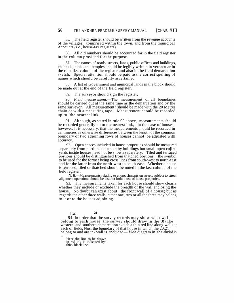
56 THE ANDHRA PRADESH SURVEY MANUAL [CHAP. XIII
85. The field register should be written from the revenue accounts of the villages comprised within the town, and from the municipal Accounts (i.e., house-tax registers).
86. All old numbers should be accounted for in the field register in the column provided for the purpose.
87. The names of roads, streets, lanes, public offices and buildings, channels, tanks and temples should be legibly written in vernacular in the remaiks. column of the register and also in the field demarcation sketch. Special attention should be paid to the correct spelling of names which should be carefully ascertained.
88. A list of Government and municipal lands in the block should be made out at the end of the field register.
89. The surveyor should sign the register.
90. Field measurement.—The measurement of all boundaries should be carried out at the same time as the demarcation and by the same surveyor. All measurement? should be made with the 20 Metres chain or with a measuring tape. Measurement should be recorded up to the nearest link.
91. Although, as stated in rule 90 above, measurements should be recorded generally up to the nearest link, in the case of houses, however, it is necessary, that the measurements should be recorded in centimetres as otherwise differences between the length of the common boundary of two adjoining rows of houses cannot be adjusted with accuracy.
92. Open spaces included in house properties should be measured separately from portions occupied by buildings but small open cojirt- yards inside houses need not be shown separately. Tiled and terraced portions should be distinguished from thatched portions, the symbol to be used for the former being cross lines from south-west to north-east and for the latter from the north-west to south-east. Whether a house is terraced, tiled or thatched should be noted in the last column of the field register.
N. B.—Measurements relating to encroachments on streets subject to street alignment operations should be distinct frohi those of house properties.
93. The measurements taken for each house should show clearly whether they include or exclude the breadth of the wall enclosing the house. No doubt can exist about the front wall of a house; but as 'regards the other three walls, either one, two or all the three may belong to it or to the houses adjoining.
fco 94. In order that the survey records may show what walls
belong to each house, the survey should draw in the 3!) The western and southern demarcation sketch a thin red line along walls in each of fields Nos. the boundary of that house in which the 20,21 belong to and are in- wall is included— Vide diagram in the eluded in it.
Here the line to be drawn in red ink is indicated bya thick black line.
21
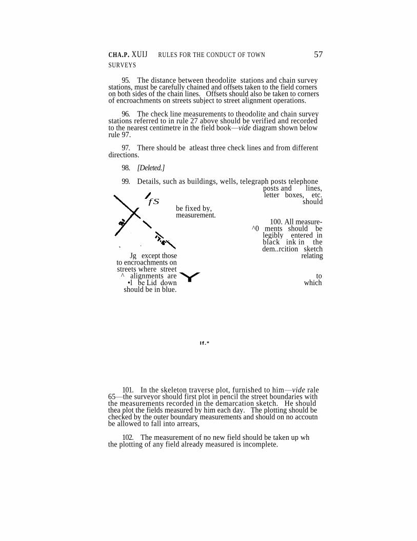
CHA.P. XUIJ RULES FOR THE CONDUCT OF TOWN
SURVEYS
57
95. The distance between theodolite stations and chain survey stations, must be carefully chained and offsets taken to the field corners on both sides of the chain lines. Offsets should also be taken to corners of encroachments on streets subject to street alignment operations.
96. The check line measurements to theodolite and chain survey stations referred to in rule 27 above should be verified and recorded to the nearest centimetre in the field book—vide diagram shown below rule 97.
97. There should be atleast three check lines and from different directions.
98. [Deleted.]
99. Details, such as buildings, wells, telegraph posts telephone posts and lines, letter boxes, etc.
fS should be fixed by, measurement.
100. All measure- ^0 ments should be
legibly entered in black ink in the dem..rcition sketch
Jg except those relating to encroachments on streets where street
^ alignments are to •l be Lid down which
should be in blue.
I f .*
101. In the skeleton traverse plot, furnished to him—vide rale 65—the surveyor should first plot in pencil the street boundaries with the measurements recorded in the demarcation sketch. He should thea plot the fields measured by him each day. The plotting should be checked by the outer boundary measurements and should on no accoutn be allowed to fall into arrears,
102. The measurement of no new field should be taken up wh the plotting of any field already measured is incomplete.
Y
58 THB ANDHRA PRADESH SURVEY MANUAL [CHAP.
XIH
103. The plot completed under rule 101 will be called the rough block map. In it will be drawn in pencil field boundaries by continuous Unes and the limits of encroachments by dotted Hues. The lines should be drawn very fine.
104. When the plotting of all the fields in the block has been completed, the field bound :des should be neatly inked and all measure ments neatly and legibly entered i n black ink, the boundaries and mea surements pertaining to encoachments being drawn in blue.
105. Where chain line and. offset measurements tend to overcrowd the map, they should be recorded in the margin of the map, the starting and closing points of each distance measured being di&tinuished b> letters in the map and in the margin.
106. Theodolite stations and field stones fixed during the town survey should be distinguished by traingles and small squares res pectively. Chain survey stones should be denoted by a circle With a dot in the centre. All other stones and details should be shown by their appropriate symbols — vide Appenidx V.
107. The surveyor should sign the field demarcation sketch and the rough block map at the lower left-hand coiner and enter in both the dates of commencement and completion of survey.
108. As soon as the survey of a block is completed he should forward the demarcation sketch, fold register and rough block map to the Deputy Inspector.
109. Open localities falling within the limits of a municipality should be dealt with as directed in rules 79-82.
110. The fields so dealt with should be measured with a chain of 20 metres.
111. In the case of fields cadastrally surveyed, and not dealt with during the town survey, the measurement, to be entered in the rough block maps should be those of the cadastral suivey converted into metric units but measurements to details need not be entered-
Field Inspection.
112. The Deputy Inspector should inspect the work of the surveyors under his charge while the survey of each block is in progress ana also after its completion.
113. He should inspect the blocks in which street alignments have to be laid in advance of other blocks so that there may be no delay in furnishing records to the special officer appointed for the pur pose. "
114. He should verify the entries in the field register for all the fields in the block and test not less than 15 per cent of the surveyor's work preparaing at the same item inspection reports in Form No. 40.
115. When verifying the entries in the field register, he should see whether the red lines in the demarcation sketch corrrectly indicate the ownership of walls.
CHAP. XIII] RULES FOR THE CONDUCT OF TOWN SURVEYS 59
116. The Deputy Inspector's testing will chiefly consist of renfea- surements of the outer boundaries of bouses.
117. He should carefully examine the list of Government and municipal lands and see that they have been correctly demarcated and measured.
The Register of Encroachments in Form No. 106 should be c®m-pleted in accordance with the instructions in rule 198.
118. He should see that all names which should appear in the map have been legibly written and correctly spelt.
119. The Inspector should inspect 5 per cent of the work of the surveyors in his section and prepare bis inspection reports in Form No. 40.
120. His inspections, which will generally be made after ;the completion of each block, should be distributed so as to afford a cri terion of the general accuracy of the survey. Blocks, the records of which have to be furnished to the special officer for laying down street alignments, should be taken up for inspection and completed before others.
121. No error of more than 30 c.m. should be passed by inspecting officers either in measurement or in plotting.
122. All errors should be neatly corrected in red ink in the field demarcation sketch and in the rough block map.
123. If the inspection of the Deputy Inspector discloses errors in more thaa 10 per cent of the lines measured in any block the inspector should himself, inspect that block and if the two inspections combined should still indicate a similar percentage submit a special report to the Asst. Director who will, after himself inspecting i necessary portion or portions of the surveyor's work, decide whethe* he work should be revised. r
124. When revision is ordered, the revision surveyor should be furnished with a fresh skeleton of plot the block, a copy of the field demarcation sketch without measurements and the field register.
125. The Asst. Director should do, not less than twenty days inspection a month. At the rate of even one block a day, be should be able to inspect the work of twenty surveyors each month and form SL correct idea of the quality of the work of each surveyor ana get rid of such men as are not up to the mark.
126. All complaints under section 10 of the Act, i.e., disputes arising during the course of the survey, should be inquired into and disposed of by the Deputy Inspector. .
127. As soon as the survey and inspection of a sufficient numbers of blocks are completed, the Asst. Director should address the- Collector for the appointment of the special officers contemplated in G.Os. No. 1584, Revenue, dated 2nd June 1914, and No. 2038, M., oated 28th
60 THE ANDHRA PRADESH SURVEY MANUAL CHAP. XHjQ
November 1917. He will at the same time advise the Collector, as to the desirability of appointing one and the same officer for performing the functions of both.
128. The completed records should be finally examined by the Inspector and the demarcation sketch encroachmert register and field register furnished witho.it delay to the special officer for verification of the boundaries of the streets as well as other lands which belong to Government and the municipality.
129. The chief duties of the Special Officer appointed to watch the interests of Government will be—
(1) To see that all Government lands and lands assessed to Government revenue including quit-rent are properly registered and surveyed, to inspect every Irae of demarcation between tre street and private property and not merely the encroachments marked 'by the survey staff, verify whether any boodary requires alteration, detect cases of encroachments not noticed by the survey staff and sign e\ery one of the demarcation sketches. For this purpose, in areas not previously surveyed, he should treat all temporary structures and all projections that tend to make the streets too narrow as encroachments and should investigate every such case. Unobjectionable enroachments or those unsupported by any reasonable evidence of public ownership may be excluded from the streets. The unobjectionable encroac'utnents will then be dealt with under the assignment rules applicable to them by the authority competent to do so. In areas previously surveyed, the previous survey record should prove a useful guide.
(2) to reconcile the old cadastral survey numbers with ithe new town survey numbers and revise the adangds for villages or portions of villages situated within the municipal lirrats by bringing up to date or correctly entering the registry of lands issessed to Government revenue under the supervision of the Special Settlement Officer or if the survey is not followed by re-settlement of the Revenue Divisional Officer and Collector ;
• (3) to fill in carefully the remaining columns except 13 of the
field register handed over to him ;
(4) to accept notices under sections 9(2) and 10(2) of Act VIII of 1923 on behalf of Government, to verify whether lands in ^vhich Government have an interest have been prejudicially affected as a result of the survey and to file appeals wherever necessary under the orders of the Settlement Officer or Revenue Divisional Officer and Collector as the case may be ; and
(5) when the town survey is not immediately followed by resettle ment to hand over to the Collector a fair adangal and a fair chitta based on the town survey for the portions of each revenue village included in the municipality. This cannot be done until the survey is final and fair areas known but they can be got ready except for the entry of areas and assessment which will not be a long process. When resettlement follows the town survey, the fair adangal and chitta will be issued by the Special Settlement Officer as part of his fair accounts to the Collector.
[CHAP. XHI RULES FOR THE CONDUCT OF TOWN: SURVEYS 61
The special officer will, after filling in the remaining columns of field register and verifying the registry and bringing it up to date, return the records to the Inspector, furnishing him with a list of such alter-ations as be thinks necessary stating reasons for each.
130. The Inspector will, on receipt of the records, give efect to such of the alterations proposed by tie special officer as he accepts, and as regards the others advise him to prefer land complaints under the Act stating his reasons in each case in the appropriate column of the list.
131. The land complaints preferred by the special officer should be promptly disposed of, those relating to streets in which street align ments have to be laid down being given preference.
132. The records will then be finally examined by the Inspector and the result of his examination recorded in Form No. 37.
133. Tracings of folds in which street alignment work is to be under taken, and a copy of the land register containing entries for the street fields and those adjoining, will be furnished to the special officer.
Street alignment.''
134. The Appendix to these rules contain the rules issued by government in the matter of the determination and survey of street alignments.
135. A surveyor should 'be placed at the disposal of the special officer to assist him generally.
136. As the street alignments will eventually form the common boundaries of properties and the • treets on which they abut, the special officer will plot them in the tracings supplied— vide Rule 133.
137. Where the street alignments are not conterminous with boun daries of properties as demarcated at the survey the stones planned at the survey should be removed and utilized for street alignments as far as may be necessary.
138. The numbering of sub-divisions as per A, B,C registers should be consecutive and separate for each street field.
139. When the street alignments shall have been determined, surveyed and plotted, the special officer will send the records of the blocks concerned to the Asst. Director of the survey. The rpecir.1 officer will issue notices under section 9 (2) and notification rnder section 13 for street alignment operations simultaneously for the whole town or any part thereof.
Mapping,
140. On receipt of the records cf each block in office, the rreasusre- ments recorded in the rough block map should be corrpared with those jn the field demarcation sketch.
62 THE ANDHRA PRADESH SURVEY MANUAL fCHAP. XH1
141. The measurements for the common boundaries between adjoining properties and blocks should then be carefully examined to see whether they agree. There should be no difference between the measurements of the same lines in adjoining fields and blocks. Discre-pancies, if any, should be noted in Form No. 38 and adjusted with reference to the measurements recorded in the field demarcation sketch or to the diagonal and offset measurements. If they cannot be so adjusted, the lines concerned should be sent out for remeasuremeat and the remeasured distances adopted.
142. With the measurements recorded in the rough block map, the fair map should be plotted on the second copy of the skeleton traverse plot. Where the plotting does not close, the errors will bt shown in the map by a cross mark on the lines that do not close and also noted in a discrepancy list in Form No. 23. For such errors as cannot be rectified in office, sketches showing the lines where errors are suspected should be prepared and sent out Jo field for remeaiure- ment.
143. Field boundaries and details should be neatly drawn in pencil. Boundaries of sub-divisions as per A. B, C. registers should be indicated by broken pencil lines. The plotting should be examin ed and the shapes and details compared with those of the adjoining blocks.
144. For portions cadastrally surveyed the block maps should be plotted on the 2 CM=1 chain scale or 1/1000.
145. The conversion of measurements from feet te metric unit Rule 111—should be checked.
146. Fields, including cadastrally surveyed fields, should bo numbered consecutively for each block.
147. [Deleted].
148. The field and sub-division boundaries and details should then be linked—the sub-division boundaries being shown in continuous blue lines—and field numbers typed to suit photo, reduction to half scale.
Area computation.
149. The area of each field should be recorded in Hectares, ares and square metres. Areas of fields rectangular or nearly so should be calculated by the khasra method from measurements entered in the rough block map. The calculations should be entered in the area calculation sheet form No. 43 .
150. Areas of the fields already cadastrally surveyed should not be recomputed except where they are broken up into new fields under rule 109 supra but should be converted to hectares, ares and square metres and recorded in the area computation sheet form No. 44 The areas of the excepted fields should be computed from th« block map with area square.
CHAP. Xm] RULES FOR THE CONDUCT OF TOWN SURVEYS 63
151. The areas of all other fields should be taken by computing seale.
152. The town survey maps will be on three different scales, viz.—
1 cm =250 cm or 8 cm=l chain. 1
cm=500 cm or 4 cm = l chain. 1
cm=1000 cm or 2= cm = l chain.
153. The computing scales and area papers to be used for the three kinds of maps will be as follows :—
Scale e-f map. Computing Scale. Area Paper.
8 cm = l chain
4 cm=1.chain Metric computing Paper divided to seale on
scale. R.F. 1/250
2cm =^=1 chain
154. The metric computing scale contains 5 main.divisions,^25 minor divisions 1,000 sub-divisions.
155. As stated in rule 154 above, the metric computing scale contains 125 minor divisions. So when using this scale for computing areas in maps of scale 8 cm=l chain one sweep will read 5 Ares each minor division being 4 Square Metres. In respect of the plots on scale 4 cm= 1 chain and 2 cm = l chain also the same computing scale and Square paper will be used and the areas arrived will be multiplied by 4 and 16 respectively to get the true areas. »~
156. [Deleted].
157. [Deleted].
158. The area as read on the compvting scale should be entered in form No. 45 field area computation sheet. The areas should be retaken by another computer and the two computations compared. The following difference is allowed :—
1 to 25 Sq. Meters. .. .. .. 1 Sq. Metre.
26 to 50 „ .. -.. . . 2
51 to 75 ,............................................ 3
76 to 100 „ . . . . .. 4
101 to 500 „ . . . <x .. 5
Above 500 „ .. .. .. 1 per cent.
159. Fields of which the difference exceeds the above limit should be issued for third computation and also for fourth computation if necessary, and so on, until any two computations agree whithin the limit of difference allowed.
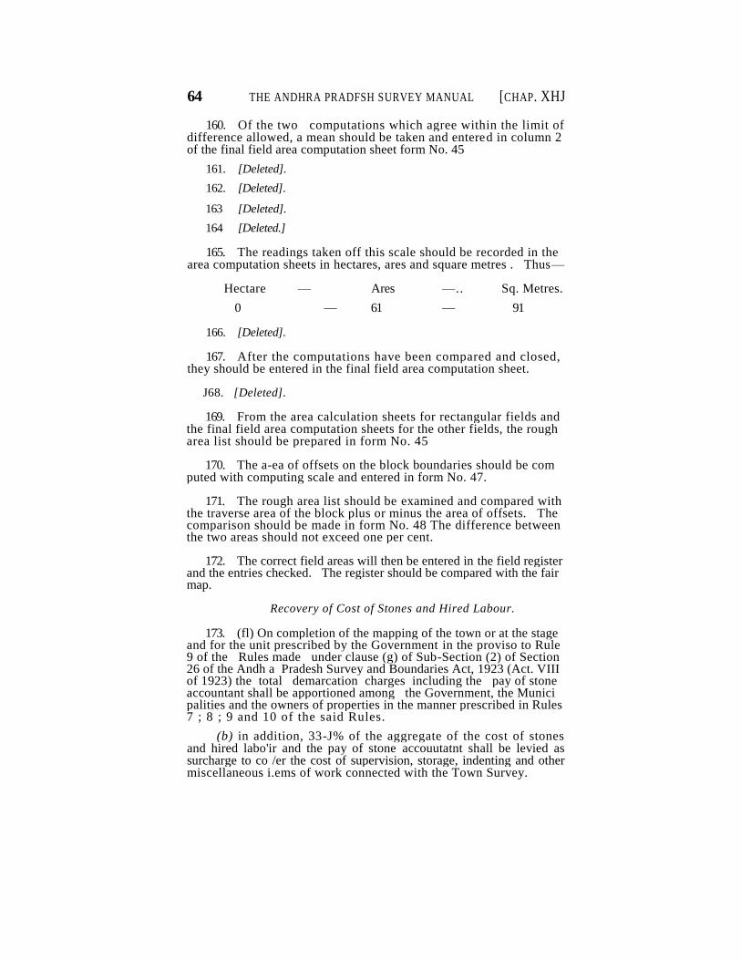
64 THE ANDHRA PRADFSH SURVEY MANUAL [CHAP. XHJ
160. Of the two computations which agree within the limit of difference allowed, a mean should be taken and entered in column 2 of the final field area computation sheet form No. 45
161. [Deleted].
162. [Deleted].
163 [Deleted].
164 [Deleted.]
165. The readings taken off this scale should be recorded in the area computation sheets in hectares, ares and square metres . Thus—
Hectare — Ares —.. Sq. Metres.
0 — 61 — 91
166. [Deleted].
167. After the computations have been compared and closed, they should be entered in the final field area computation sheet.
J68. [Deleted].
169. From the area calculation sheets for rectangular fields and the final field area computation sheets for the other fields, the rough area list should be prepared in form No. 45
170. The a-ea of offsets on the block boundaries should be com puted with computing scale and entered in form No. 47.
171. The rough area list should be examined and compared with the traverse area of the block plus or minus the area of offsets. The comparison should be made in form No. 48 The difference between the two areas should not exceed one per cent.
172. The correct field areas will then be entered in the field register and the entries checked. The register should be compared with the fair map.
Recovery of Cost of Stones and Hired Labour.
173. (fl) On completion of the mapping of the town or at the stage and for the unit prescribed by the Government in the proviso to Rule 9 of the Rules made under clause (g) of Sub-Section (2) of Section 26 of the Andh a Pradesh Survey and Boundaries Act, 1923 (Act. VIII of 1923) the total demarcation charges including the pay of stone accountant shall be apportioned among the Government, the Munici palities and the owners of properties in the manner prescribed in Rules 7 ; 8 ; 9 and 10 of the said Rules.
(b) in addition, 33-J% of the aggregate of the cost of stones and hired labo'ir and the pay of stone accouutatnt shall be levied as surcharge to co /er the cost of supervision, storage, indenting and other miscellaneous i.ems of work connected with the Town Survey.
CHAP. XIII] RULES FOR THE CONDUCT OF TOWN SURVEYS 65
174. For the charges thus due from the municipality and owners of properties, demand notices under Section 8 of the Act shall be prepared m form No. 50 by the Inspector of Survey and Manager and forwar ded to the Collector of the District concerned with a statement, showing the total demand in accordance with rule 4 (a) of the rules under clause (2) (e) of Section 26 of the Act.
A register of these total demands should be kept in form 119.
The Collector, should on receipt of the notices and the statement, adjust the total amount to the credit of "Revenue Survey advance* Survey Officers" by debit to "Cost of Survey marks-Survey Officers" and intimate the fact to the Assistance Director of the Survey Party.
175. Where however, the municipality is situated in a district othei than the one in which the temporary advance of the part stands, the Inspector and Manager shall besides forwarding to the Collector con cerned the demand notices and the statement of total demand as laid down in rule-174,also send two copies of the statement of total demand to the Collector of the district in which the temporary advance of the party stands, who will forward one copy of the statement to his treasury officer with instruction to adjust the amount at once in his accounts ky credit to "Revenue Survey Advances—Survey Officers" and intimate t he fact to the Assistant Director and forward the duplicate to the Coll ector of the district in which the municipality lies, for keeping a plus and minus memorandum in his treasury accounts.
176. The amount chargeable to Government should be drawn in a contingent bill and remitted into the treasury to the credit of the tem porary advanc*.
Finishing.
177. The map should be completed by printing the heading and all names. The area of the block should be entered below the heading.
178. The procedure prescribed under Section—9 (2), 11 and 13 of the Act and the rules framed there under should then be completed.
Record of measurement and fair register.
179. A record of measurement should then be prepared. For thil purpose, a tracir g will be made of the fair block map on bank post paper showing field boundaries, and theodolite and .chain survey stations.
180. The walls of houses shown by red lines in the demarcation sketch should also be delineated in the tracing by thin black lines drawn close to, but not touching, the field boundaries. The tracing should then be inked.
181. Measurements of chain lines and offsets and of the outer boundaries of survey-fields should be neatly copied from the rough block map.
2487—B—5
66 THE AKDHRA PRADESH SURVEY MAJSTUAI; [CHAK XEH
182. Portions of Villages included in the town survey area should be excluded from the village maps. Village nups showing this alteration should be sent to the Central Office, whence corrected maps wall be issued.
183. Field numbers and mesaurements should be written ; not typed.
184. Wherever it is not possible to enter the measurements of chain lines and offsets legibly in the body of the tracing, they should be entered in the margin. Buildings and theii measurements should be omitted. The tracing must be neatly prepared for reproduction by the ferro-prussiate process. <'•"
185. Headings and side names should be printed.
186. Names of streets should not be written or typed in the body of the tracing but a list of the streets with thier corresponding survey field numbers should be printed at the bottom of the trac- ingor in the margin as space may allow. , , ".. »;H."
:..',^
187. A fair area list should be prepared in form No. 42 and furnished along with the demarcation sketch and field register to the Special Officer who will then prepare in English a fair field register in duplicate and send the same to the Municipal Chairman direct, returning the other records to the Assistan Director of the Survey.
188. The persons responsible for each item of mapping should sign thier names in printed lists, form No. 43 which should be pasted on the back of the maps concerned. •'-
Final examination.
189. The maps and all other records should be finally examined by an Inspector and his result of his examination recorded in the' final examination—Report form No- 44 . This report and all other reocrds should be signed by the Assistant Director.
190. The following is the list of records to be sent to the -Central Survey Office : ; .
1. Idndex map for the town.
2. • Traverse field books.
3. Traverse Sheets.
4. Filed demarcation sketches.
5. Rough block maps.
6. Fair block maps.
7. Inspection reports.
8. Rough and fair area lists.
9. Rough field register.*
10- Record of measurement.
11. Final examination reports.
12. Traverse skeleton plots of wards.
13. Traverse skeleton plot of the town. • ----------
: --------------- • --------------------- • ------------ 1—— ' ------ 1——r-4—> ' <i
*Rough field registers are to be sent to the Collector's Office fbr lodging vide B.P. No. Mis. 2256, dated 29th July, : 1 "
2487—B—5*
CHAP . XPI] , RULES FO R THE CONDU C T OF TOWN SURVEYS 67
Survey of Streets, generally confined to Unions :
191. Tbe town survey rules should be followed in substance.
The points of difference are explained in the rules below :
192. On areas previously surveyed cadastrally, only streets are to be surveyed and bends on the street boundary, not being corners of masonry buildings, are to be demarcated with stones.
• As the street survey has to be combined with the previous cadastral survey of the locality, a verification of the cadastral survey fields or boundaries within the limits of the Panchayat should also be made and any fresh topographical datas availabe should be furnished so as to provide inform tion about the density of the buildings important, new topographical feature or appreciable changes in the existing ones. Changes in the limits of the area occupied by buildings.
In areas not previously cadastrally surveyed, the perimeter deter-mined with reference to Rule 196 (4) below should be surveyed by the-ddotite in addition to the streets important topographical details and blocks of buildings should be measured by offsetti ng the major bends on the traverse lines or on the conrecting lines between them. Additional traverses on pegs may be run for the purpose ir> extensively built up areas.
193. After obtaining from the Chairman of the Union a list of the Streets to be surveyed and thier approximate length, to enable an estimate of stone requirements to be made, the procedure ordered in rules 1-57 above should be followed so far as it is applicable to theSurvey.
194. It will suffice if the area for survey is. divided into convenient circuits, each about 100 Hectares for a town, or one for each nattam when the survey is in a union. Theodolite connections should be made to the previous cadastral Survey, so as to have the street survey
elds correctly exhibited in the Cadastral frame work.
195. The nattams must be linked together either by special connect- •Hg lines or b> connection with earlier theodolite work.
196. The chairman should be asked also to supply : —
(1) a list of encroachments recorded during the last Pve years, permissive and objectionable ;
(2) a copy of the latest house-tax registers, ard any records o previous surveys conducted under the Chairman's supervision
(3) Information about the limits of the Union.
(4) The area to be mapped.
197. The streets should be measured in fields, each about 120 Meters long, and plotted in duplicate on the scle 400 C.M.=1 K.M., aot more than one field being plotted on a sheet, and all measurements being shown.
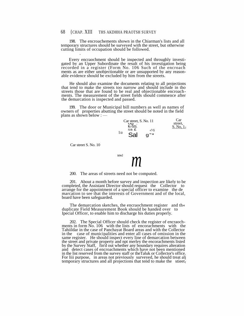
68 {CHAP. XIII THS AKDHHA PRAOTSH SURVEY
198. The encroachements shown in the Chiarman's lists and all temporary structures should be surveyed with the street, but otherwise cutting limits of occupation should be followed. .
Every encraochment should be inspected and throughly investi-gated by an Upper Subordinate the result of his investigation being recorded in a register (Form No. 106 Such of the encroach ments as are either unobjectionable or are unsupported by any reason-able evidence should be excluded by him from the streets.
He should also examine the documents relating to all projections that tend to make the streets too narrow and should include in tho streets those that are found to be real and objectionable encroach-ments. The measurement of the street fields should commence after the demarcation is inspected and passed.
199. The door or Municipal bill numbers as well as names of owners of properties abutting the street should be noted in the field plans as shown below : —
Car street S. No. 10
m
200. The areas of streets need not be computed.
201. About a month before survey and inspection are likely to be completed, the Assistant Director should request the Collector to arrange for the appointment of a special officer to examine the de marcation to see that the interests of Government and of the local, board have been safeguarded.
The demarcation sketches, the encraochment register and th« duplicate Field Measurement Book should be handed over to Ipecial Officer, to enable him to discharge his duties properly.
202. The Special Officer should check the register of encraoch- ments in form No. 106 with the lists of encorachments with the Tahiildar in the case of Panchayat Board areas and with the Collector in the case of municipalities and enter all cases of omission in the same register. He should inspect every line of demarcation between the street and private property and npt merley the encorachments listed by the Survey Staff, fin'd out whether any boundary requires alteration and detect cases of encroachments which have not been mentioned in the list reserved from the survey staff or theTaluk or Collector's office. For liii purpose, in areas not previously surveyed, he should treat alj temporary structures and all projections that tend to make the stieet f
og : fc-SS. SB £
Sal «?-S
g"* S co
Car street,
S. No, 12
Car street, S. No. 11
sowJ
. XHIJ RULES PCJR THE CONDUCT OP TOWN SURVEYS i 69
too narrow as encroachments. In areas alredy sureyed the record of th« previous survey should prove a useful guide to detect encroachments. He should thoroughly examine each case with reference to the documents, if any, in the possession of the parties and record his conclusion in Form No. 106 as to whether it constitutes an encroachment and if so whether it is objectionable or not. In other cases of encroachments and in cases where he thinks mistakes have been made at survey, he will prepare lists and illustrate sketches with the assistance of Surveyor and send them to the Inspector who will arrange for a joint inspection of the localites and alter demarcation where he agrees with the Special Officer. He should also verify the registery made in the Filed Measurement Book of all the lands adjoining the streets and sign every sheet of the Field Measurement Book.
203. The Spcial Officer will prefer land complaints under the Madras Survey and Boundaries Act, 1923, where he is dissatisfied with the Inspector's action.
204. The Union map should be prepared on the scale 1/5000 (or) 20 c.m=l fc.m for reproduction to scale and exhibit the street fields, the
'Cadastral Survey data upto the limits required by the president Pan-chayat Board and important details already availabe or furnished during Survey. The'"numbers assigned to the Steet Survey Fields should be circled to distinguish them from Cadastral Survey numbers. The names of Streets should be typed on the map.
205. Where the Union lies partly in surveyed and partly in un-surveyed areas the union map should be prepared on the same lines as in para 192 and 204.
206. As soon as mapping is completed, the usual procedure under the Act will be followed and the survey made final.
APPENDIX
RULES FOR THE GUIDANCE OF MUNICIPAL COUNCILS AND GOVERNMENT OFFICERS IN CARRYING OUT STREET
ALIGNMENT OPERATIONS IN MUNICIPALITIES
The laying down of street alignments should be undertaken in the course of every survey or resurvey conducted under the Madras Survey and Boundaries Act, 1923, in a municipal town.
2. Street alignment operations should be conducted under the super \ision of a special officer whose rank should not be lower than that of a Deputy Tab sildar. Tlu powers of a survey officer should be conferred on him under the Madras Survey and Boundaries Act. The special-officer should not be employed until (a) the municipal council has decided in which streets a street alignment should be laid down and (b) the Asst. Director of the town survey section has stated that he has ready the maps of the streets selected referred to in rule 4 infra.
The special officer will work under the technical supervision of the officer-in-charge of the town survey and under the administrative control of the Collector.
Note.—A street alignment will constitute a boundary of a survey field compris-ing the street vesting in ths municipal council and including any private property which it is proposed to acquire for the purposes of such street. It is therefore convenient that the special officer who assists in the operation of laying down a street alignment should also be the survey officer who prepares the final street map.
3. The municipal council should decide which of the streets of the town are of sufficient importantce to make it desirable that align-ments should be laid down for them.
4. The Asst. Director of town survey will furnish the special 'officer of each street in which street alignments are to be laid down with tracings showing in one view the whole street with all measurements of the street and of the F lines of adjoining survey fields which end on the street boundary. The original record of measurements will remain in the cus tody of the town survey officer. He will also give the special officer a copy of the land register for the streets to be aligned ard adjoining" properties.
In dealing with streets which are to be the subject of street alignment operations, the Asst. Director of the town survey will determine the boundary as in the case of other streets, excluding all encroachments from private properties and including them in the streets but he will show in the maps supplied to the special officer all encroachments on the streets with full measuremets. The encroachments should not be de-marcated.
5. The special officer should perambulate the streets with the above mentioned maps, should verify all encroachments shown tbrein with reference to the records available in the municipal ?nd revenue officersf and with reference to personal inspection and should satisfy himself
70
APPX RULES FOR THE GUIDANCE OF MUNICIPAL COUNCIAL, ETC, v71
.that all encroachments have been correctly brought to account. Any ' additional encroachments which be may detect should be shown on the maps with the measurements necessary to locate and plot them. All encroachments should be shown in colour wash for facility of reference by the committee.
6. The municipal council should appoint a committee consisting of not less than three and not more than five councillors to mark the street "alignments in the above mentioned maps, which will be placed by the special officer before the committee for the purpose. The revenue divi-sional officer of the division in which the municipality is situated should be one of the members of the committee..
7. For the purpose of identifying the limits laid down in the prelimi nary survey and fixed by the maps, the committee should be accompanied and assisted by the special officer and by a surveyor deputed from the town survey section.
8. The committee should determine the street alignments with re ference to the following consignations :—
(1) Uniformity of breadth as far as this object can be attained with-out seriously sacrificing the existing width of the street.
(2)The present and future requirements of traffic. (3)
The expenses involved in extensive acquisions.
9. Steps and other structures, which stand vertically over drains should be treated as part of a street, the alignments being made to run en the house side of such drains and structures.
10. The committee, after the determination of the street alignment should have the alignment properly demarcated and should have it, the encroachments and the assignable sub-divisions on the house side of the alignment measured on the ground and plotted in the maps by the deputy surveyor, and should sign the maps after satisfying themselves that their intentioas have been correctly represented therein.
11. The committee should then publish by notice in the office of the municipal council and by beat of tom-tom in the streets considered that such maps have been prepared and are open to public inspection in the municipal office and that objections will be considered by the committee if presented within thirty days of such publication. The committee may, if they think fit, after their street alignments with reference to any objec tions presented to them. In such cases, revised copies of the maps should be prepared by the surveyor and signed by the committee.
12. The committee should then place the maps before the municipal council together with all objections received and their decisions thereon. The" municipal .council, if, they accept the committee's proposals, should pass the. maps and should send them to the special officer after noting on each map under the signature of the Municipal Chairman, the num ber and date of the resolution of the municipal codncil in which it has been passed- In the event of the council's not accepting the commi ttee's proposed street alignment in any case, the reasons for their disagreement should be embodied in the resolution and the question referred to the Collector of the district, whose decision shall be final. The number and date of any such order of the Collector should be, entered on the maps under his own signature-
72 THE ANDHRA. PRADESH SURVEY MANUAL (Appx
13. The special officer, on receipt of the maps mentioned in the fore-going rule.should satisfy himself that the sub-divisions and street alignment points, as finally determined, have been properly measured on the ground offsetted on the traverse lines and plotted in the maps by the surveyor.
The points where the street alignment cuts the boundaries of adjacent survey fields should be demarcated in the same manner as points where the street boundary cuts adjacent field boundaries. Demarcation stones planted by the town survey for the demarcation of assignable frontage sub-divisions should be removed and used for the demarcation of the new street boundary, i.e., the street alignment, e.g., the stones on the southern boundary,of 17 B,18 B and 19B in the specimen map should be removed and used for the northern boundary of those subdivisions.
APPX] RULES FOR THE GUIDANCE OF MuNicifAE 73
COUNCILS, ETC.
14. To accompany and elucidate the maps, the special officer should prepare three registers in the forms annexed to these rules—
(1) Register A (acquisition register) containing all cases of private property which fall on the street side of alignments and which have therefore been mapped as subdivisions of the street survey fields and will necessitate acquisition under the Land Acquisition Act or under section 168 of the Madras District Municipalities Act, 1920.
(2) Register B (encroachment register) containing all cases of encroachments, which fall on the street side of the alignment and which therefore have to be removed. Structures mentioned in rule 9 should not be entered in this register. These encroachments are not to be shown in the final, street map and are not to be treated as subdivisions of the street field. For each encroachment a sketch with measurements should be put up in the Remarks column of register B showing.its position and dimensions. •
(3) Register C (assignable frontage register) containing all cases of Government land which fall on the house side of street alignments and are therefore capable of-assignment, e.g., subdivision B of survey No. 17 and subdivision B of survey No. 19. '
Note 1. An encroachment will sometimes be partly on the street side and partly on the house side of an alignment. In such a case, the portion lying on the street
side will appear in register B, while the portion lying on the house side will appear in register C (e. g., subdivision B of survey No. 19). In such cases cross references
' should be made in registers B and C. Note 2, Land tntered in register A should be numbered and shown in the town
survey records as a subdivision of tha street field, while land entered in the register C should be numbered and shown as a subdivision of the survey field adjoining the street survey field.
15. When the street alignment has been finally 'approved by the municipal council or settled by the Collector, the special officer should prepare the notification as .prescribed in the Madras Survey and Boundaries Act of 1923 in respect of the streets dealt with and should send immediately the street alignment records to the Town Survey Officer so that the street alignments may be entered in the original record of measurements. The notification and notices should not be issued until the survey officer has informed the special officer that he has ready the notification and notices for the other fileds, so that they may be issued simultaneously for the whole town or any part thereof. Notices should be issued by the special officer not only to the owners of private properties abutting the streets, but also to the municipal chairmaa representing the municipal council in which the street is vested and to the taluk tahsildar repiesenting the Government as the ultimate owner. The appellate authority in regard to street alignment notices is th« Revenue Divisional Officer.
16. After all the formalities provided in the Survey and Boundaries Act have been gone through, including where necessary, the hearing of appeals and the correction of maps, the special officer should make corresponding entries in registers A, B and C. He should then send registers A and B to the chairman of the municipal council in order that steps may be taken for the acquisition of the land mentioned in register A and for the removal of encroachments entered in register B. H«
?4 THf" ANDHRA PRADESH SURVEY MANUAL
should send register C to the Revenue Divisional Officer for action in accordance with the provisions of Board's Standing Order No. 26 He should send the maps to the Assistant Director of the town survey section.
17. If (as will often be the case) the special officer is not likely to remain in office for three or more months from the date of issue of notices, the survey records vi;h the special officer, the original notices and the registers of acknowledgments, should be sent to the Town Survey Officer as soon as notices have been issued. The special officer should, in such cases, deposit the registers A,. B and C in the Revenue Divisional office and should state in the notices that copies of maps required by parties can be obtained from the Town Survey Officer. The Revenue Divisional Officer will communicate his appellate decisions to the Town Survey Officer who will make such alterations in the survey records and in the demarcation as are necessitated by these decisions. The Revenue Divisional Officer will at the same time get the necessary changes made in the registers A, B and C. r;;'
18. In cases in which there is reasonable doubt as & the validity of the existing survey of a town and in which it is desired to lay dowa street alignments in that town, the foregoing rules should be applied in their entirety.
19. In other cases of towns already surveyed, the foregoing rules should be applied, subject to the modifications that (1) the process will be carried on as a part of maintenance under the notification published in G. O. No. 3204, Revenue, dated 10th October 1917, (2) the town surveyor will take the place of the surveyor mentioned in the preceding rules, (3) a spare copy of the record of measurement kept in the municipal office will take the place of the map mentioned in rule 4 above.
The special officer as soon as he has signed the final copy of the record of measurements should have the street alignments marked in the town surveyor's copy of the record of measurements and in the town
J
surveyor's and municipal chairman's copies of the revenue maps.
Note. Street alignment operations include the laying down of lines in streets other than those in which a municipal council has already laid down street align-ments and also include the relaying of the alignment of a street for which an align-ment has previously been laid.
ANNEXURE. • • •:
Register-A. . . ' • , Serial num-ber.
Ward, block Name of and survey Sub-division Area. Remarks, street. number. number. - . : . . ' . , .
(1) (2) (3) (4) (5) <6).
APPX. RULES FOR THE GUIDANCE OF MUNICIPAL
75
COUNCIL ETC.
Register—B.
Serial Ward,
No. Name block and Sab- • Name Nature of of survey division Area. of encroach- Remarks. street. number. number. encroacher. ment.
(1) (2) (3) (4) (5) (6) (7) (8)
Register—C.
Serial num-ber.
Name of street. Ward, block and survey number.
Subdivision number. Area. Remarks.
<*> (2) (3) (4) (5) (6)
DIAGRAM—I.
Plan 1.
CHAPTER XIV.
BOUNDARY DISPUTES.
• . 1. The investigation and settlement of disputed boundaries under
the Madras Survey and Boundaries Act of 1923 rests with survey officers appointed as such by Government under section 4 of the Act.
2. The settlement of disputes as to water-right, easement, right of way, etc., is not within the competence of survey officers.
3. Deputy Surveyors and surveyors are not allowed to settle boundary disputes.
4. The following are the classes of cases which survey officers will have to deal with :—
. (1) Disputes under section 10 (I).
(2) Appeals under section 11 from decisions under section 10 (1).
(3) Appeals under section 11 from decisions under section 9 (1).
5. Cases under class f 1) will lie to the survey officer conducting the survey, those under class (2) to a survey officer senior to the officer who passed the original decision, and those under class (3) to a survey officer senror to the officer publishing the notices under section 9 (2).
6. Appeals under secticfr 11 must be presented within three months of the communications of the decision under section 10(2) or within three months from the date of receipt of the notice under section 9 (2), but the time taken to, secure "a copy of the decision and of the map shall not be included in the period of three months allowed for appeal, and the appellate authority may admit an appeal after the expiry of the said period on his being statisfied that the appellant had good and sufficient cause for not preferring the appeal within suph, period.
7. Original complaints and appeals including those on behalf of Government preferred to officers below the grade of Director of Survey should bear a court-fee of stamp Rs 3/- irrespectively.
8. Appeals preferred to the Director of Survey should bear a ••art-fee stamp of Rs. 3/- irrespectively.
9. The Act does not allow second appeals being entertained by any survey officer.
10. Petitioas and appeals regarding disputed boundaries presen ted to any survey officer should be forwarded to the headquarter office of the survey party where they will be registered. There will be foul separate registers, two in Forms Nos. 46 and 47 for village and field boundary disputes, and two in Forms Nos. 48 and 49 fot appeals against decisions on village and field boundary disputes. These registers will to maintained separately for each taluk.
76
Gut- XIV] BOUNDARY DISPUTES 77
11. Unstamped or insufficiently stamped petitions or appeals will be returned to the parties for resubmission duly stamped. Peti tions,or appeals which do not clearly describe the locality in dispute and the nature of the dispute or which relate to more than one patta will be returned for amendment.
12. Appeals against orders passed, by survey officers under sec tion 10 (1) if not accompanied by the order appealed against, will be returned for resubmission with a certified copy of the order.
When a petition or appear is returned under rule 11 or 12, it should be stated in the order returning it that the document should be presen-ted again, amended or with omission supplied, as the case may be, within a specified time, failing which the petition or appeal will be liable {•rejection.
One month should ordimmrily bt l«ng enough to allow of the «or-••tion of initial defects, but the Asst. Director of parties should exercis* their discretion in fixing the period in each individual case.
13. Wkea petitions or appeals have been entertained, the Asst. Director miy himself enquire into an dispose of such of them as he may con ider necessary and refer the rest to any subordinate survey officer for disposal or for enquiry and report. When complaints or appeals are so referred, they will be accompanied by extracts from the original survey records of measurement and such other papers and records as may be considered necessary for the disposal of the complaint or appeal. •
14. The proceedings of the survey officer in regard to the service of summonses, the siftnmoning of parties and witnesses and enforcing their attendance, the examination of parties and witnesses, and the production of documents will be regulated, so far as may be practicable by the sections of the Code of Civil Procedure which are printed as Appendix No. X. . ,
15. When a ccimplaint is entertained, the survey officer should issue a notice to the plaintiff in Form No. 50, mentioning the date and place fixed for hearing and requiring him to take out.in sufficient time before the date fixed for hearing, summonses to the defendant or de fendants and to such of his witnesses as he wishes to be summoned by the survey officer. Complaints and appeals should, so far as possible be disposed of in, or in close proximity to the villages concerned. As a general rule, all complaints and appeals relating to a particular village should be t^ken up simultaneously at a station of which notice has been previously given to the ryots of the village concerned.
lo. The notice should also require the plaintiff to deposit an amount sufficient to meet the cost of service of process, when a separate establishment is employed for that purpose and for batta to witnesses.
17. The process fee to a single defendant, respondent or witness the case of original proceedings, ana in the case of appellate proceed-ings will be as ordered from time to time.
78 THE AMDHRA PRADESH SURVEY MANUAL ' [CHAP. XIV
18. To every additional defendant, respondent or witness residing, in the same village, if the process be applied for at the same time the process fee in original proceedings and in appellate proceedings will be as ordered from time to time. *
19. The batta to witnesses will be such a sum of money as ap pears to the survey officer to be sufficient to defray the travelling and other expenses of the persons summoned in passing to and from the place of enquiry and for one day's attendance.
20. When the plaintiff has deposited the necessary fees, sum mons should be issued to the defendant in Form No. 51, and to wit nesses in Form No. 52.
21. The summons should be in duplicate and should be signed by the survey officer.
22. The summons to the defendant should specify the. time: and place at which he is required to attend.
23. The summonses to witnesses should specify the time and place at which they are required to attend and also state whether their attendance is required for the purpose of giving evidence or to produce a document or for both purposes ; and any particular ( document which the person is called on to produce should be described in the summons with reasonable accuracy.
24. The date on which the defendant and witnesses should be required to attend should be the same as that fixed in the notice issued to the plaintiff under rule 15 above. But if that date should happen to be too near for the appearance of the defendants and witnesses with reference to their place of residence and the tyne necessary for the service of summonses, it should be altered and the altered date com municated to the plaintiff.
25. When the defendant or witness is a Government servant, the summons should be served through the head of his office.
26. Where the parties to a comp'aint do not apply for summonses to the village officers, the survey officer may summon them, if neces sary, and record their evidence.
27. In a dispute in which the inteiests of Government are con cerned, and the case is not of tiiffling nature, the Asst. Director should address the Tahsildar, Divisional Officer, or the Collector, in order that the in :erests of Government may be properly represented. In triffling cases, the village authorities will represent Government.
28. Where the dispute relates to Government lands whose con trol is vested in the Public Works, Local Fund, Forest or other de partment, t \e district head of that department should be similarly, addressed.
29. If on receipt of a complaint, the survey officer finds tha verificati in of the disputed locality is necessary, he may do the same on the date fixed for inquiry or at any time before that date ; or he
CBM». XTV] BOUNDARY DISPUTES 79
may depute one of his subordinates to inspect the grounds and prepare a measurement sketch, to any convenient scale, of the disputed locality, showing the land claimed by each party as also the adjoining lands where necessary.
30. The subordinate may also be directed to submit his report on the facts of the dispute for the information of the survey officer, but the order of the survey officer should be based on evidence recorded by himself and not upon the report of his subordinate.
31. Summonses should be served ordinarily by the village esta blishment or by the process peon if one has been duly sanctioned and attached to the survey officer.
T. , 32. Service of summons should be made by delivering or tender-ing the duplicate summons to the defendant or witness personally Or 'to his agent. v
33. The village servant or process peon should take on the back of the original summons the signature of the person to ' whom the implicate,is delivered.
"• '••*•-- -•-- . " -" 34. If the defendant or the witness refuses to sign the acknow
ledgement, or if. owiig to his absence or other cause, the summons cannot be served personally, the village servant or process peon should affix a copy of the summons on the outer door of the house in which the defendant or witness ordinarily resides and return the original summons to the survey officer with an endorsement thereon that he so affixed the copy and the circumstances under which he did so.
35. On the day fixed for the hearing of the case or on any other day to which the hearing is adjourned, the inquiry will begin by the -plaintiff stating his case and producing his evidence in support thereof.
36. The statements of parties and the evidence of witnesses' should be taken on oath and should be in the language with which they are familiar.
37. As the examination of each witness proceeds, the survey officer should, when he does not take down the evidence in his own handwriting, make a memorandum of the substance of what each witness deposes, and such memorandum should be written and signed by the survey officer with his own hand and should form part of the record.
38. The defendant will then state his case whid will be recorded, together with the evidence of his witnesses, as explained in the preced-
; ing two rules.
' 39. If on the date fixed for the hearing of the case, the plaintiff fails to appear, the survey officer will unless the defendant admits the claim, dismiss the complaint.
- 40. If the plaintiff appears but not the defendant, though sum-mons was duly served on him, the survey officer will proceed to pass -* decision on the evident merits of the case, with the ud of such re- cords as are available.. . ' - ,
CHAP. XIV] BOUNDARY DISPUTES 81
51. Copies of depositions and of documents filed in the course of the hearing of a dispute and of the memoranda of evidence made by the survey officer or the appellate authority may be granted to parties, whenever required and at their cost. Parties may also be allowed to inspect such documentary evidence as is filed. On com pletion of hearing and after an order or decision has been passed all documents filed should be returned to the parties filing them, and the fact that this procedure will be adopted should be intimated to the parties s.s an addendum to the order or decision passed in the case.
52. The District Collector, or Survey Officer, may, with the consent of all the parties concerned, refer to arbitration any dispute as to a boundary.
53. The decision of the District Collector or the survey officer passed in accordance with such award, shall be conclusive between the parties to such arbitration and those claiming under them.
54. Any survey officer generally or specially authorized in that behalf, or the District Collector, or any officer to whom an appeal is preferred under any of the provisions of this Act, may, for the pur poses of any survey inquiry or other proceeding under this Act, sum mon and enforce the attendance of any person for giving evidence and for the production of documents, or for the purpose rendering assistance in the survey of any land in which such person has an interst.
55 The procedure described in the Code of Civil Procedure for summonofng and enforcing the attendance of witnesses and for the re cording of evidence shall be followed as far as it can be made applicable.
56 Original records connected with each dispute decided under the Act sould be sent to the Central Survey Office on the completion of suryy of each taluk or estae. The records should be accompanied by a listin Form No. 57.
57. In re-surveys, the original survey records will form part of the documentary evidence for the survey officer to base his order or decision. Such records cannot, however, prevail against the pres-criptive right acquired by a party by twelve years' advese possession in the case of patta or inam lands, and sixty years' adverse possession in the case of Government waste or poramboke lands.
2487—B—6
80 • THE AttoHRA PRADESH SURVEY MANUAL [CHAP. XIV
41. The survey officer will in each case pass his order and record the grounds on which the order was based.
42. The proceedings of the survey officer should be recorded in Form No. 53.
43. Tie purport of the survey officer's order should be commu nicated to the parties on the day the order is passed.
44. In communicating the purport, the parties should be infor med of the time within which and the person to whom an appeal may be presented, see Form No. 54.
45. When an appeal is preferred under section 11, from an order under section 10 (1), the appellate authority should issue a notice in duplicate, in Form No. 55 to the respondent fixing a date for the hear-, ing of the same. Notice in duplicate, in Form No. 56, should also be sent to the appellant.
, 46. In the case of an appeal preferred under section 11 from an order under section 9 (1), notice in duplicate should be given to all registered holders the boundaries of whose holdings may be affected by the proceedings in appeal.
47. The survey officer shall dismiss the appeal if the appellant be absent uid proceed ex parte if the respondent be absent.
After the parties have been heard and such evidence as may be necessary has been recorded, the appellate authority will pass his de-cision and record the grounds on which it is based.
48. All decisions should be communicated the day they are passed and should be accompanied by a printed acknowledgement.
49. A copy of the order of the survey officer or of the decision of the appellate authority may be furnished to the parties on their application! and'at their cost. Where from its wording, the interpre tation of the order of the survey officer is made to depend upon a plan, sketch or diagram, a copy of such plan, sketch or diagram should be supplied free of cost with the copy of the order ; but, where copies of plans, -sketches or diagrams are required merely to supplement and not to explain the order, they should be supplied after deposit of the required fee by the party applying for the copy. The usual fee for the copy of the plan of a field shall be as ordered from time to time, but for special cases special fees may be fixed by the officer passing the orders. In ell c.:.ses to which Government is a party, copies of the order and of p.ny necessary plans, sketches or diagrams should be sent to the Collector "without application on his. part.
f
50. The Border of the survey officer or the decision of the appel late authority' should be given effect to as soon as possible after the order or decision has been passed, and a certificate to that effect should be made in the records connected with the case, noting the date on which the order or decision was given effect to.
APPENDIX 1.
THE A.P. SURVEY AND BOUNDARIES ACT,
1923.
AC T No. VIII OF 1923.
An Act to amend the law relating to survey of lands and settle-ment of boundary disputes.
Preamble. WHEREAS it is expedient to consolidate and amend the law relating to survey of lands and settlement of boundary disputes and whereas the previous sanction of the Goverrufr-General has been obtained under section 80-^4 (3) of the Government of India ^, Act, It is hereby enacted as follows : —
CHAPTER I.
Preliminary.
1. (1) This Act may be called "the Madras Survey and Boun-daries Act, 1923."
Local extent @) It extends to the whole of the Presidency of Madras.
Repeal. 2. The Madras Survey and Boundaries Act, 1897, is hereby
repealed.
Interpreta- '• 1° this Act, unless there is something repugnant in -the sub-
tion clause, -jtct or context, —
"Estate" W "Estate" means — (a) any permanently settled estate whether a zamindari
Jaghir, Mitta or palaiyam :
(b) any portion or such permanently settled estate which has been separately registered in the office of the Collector.
(c) any unsettled palaiyam or jaghir ;
(d) any inam village of which the grant was made or has been confirmed by the British Government;
(e) any portion, consisting of one or more villages of any of the estates specified above in clauses (a), (b) and (c), which is held on a permanent undertenure.
"Govern- ^ "Government land" means any land not forming
mentland". *a estate or any portion thereof.
««n~. •«. •> (iii) "Prescribe" means prescribe by rules framed under
Prescribe .
'Proprietor". Ov) "Proprietor" means any person in whose name any
estate is for the time being registered in the office of the Collector of the district wherein the estate is situated 'and, in respect of an estate specified in clause (e) of sub-section (i), the holder thereof.
(v) "The registered holder" of any Government land "Registered means the person in whose name the land in question is registered holder". jn ^ Government accounts of the village ;
82 2487— B— 6*
APPX-I THE ANDHRA PRADESH SURVEY AND BOUNDARIES 83
ACT,
Provided that when any person other than the registered holder is in lawful management of Government land otherwise than as agent or servant of the registered holder or as mortgagee or lessee such person shall be deemed to be the registered holder in respect of such Government land.
(vi) Where an estate or Government land is so registered "Proprietor in the names of two or more persons jointly, the proprietor or ^j^f j
tered
regsitered holder, as the case may be, shall, for the purpose of case of joint this Act, be the persons who i? recognized by the other joint holders registration. as the manager of the estate or who, in case of dispute, is recognized by the Collector as senior joint holder.
(vii) "Survey" includes all operations incidental to the "Survey." determination, measurement and record of a boundary or boundaries or any part of a boundary and includes are survey.
(viii) "Survey mark" means any mark or object erected, "Survey made, employed or specified by a survey officer to indicate or
mark"-
determine or assist in determining the position or level of any point or points.
(ix) "Sunrey officer," means any person appointed to be 0^^ a survey officer under section 4.
4. (1) The Local Government may by notification appoint Gove nment any person either by name or by virtue of his office to be a survey to appoint officer for all or any of the purposes of this Act.
s"£
vey
officers. (2) Subject to the control of the local Government and of any Local
officer or authority appointed by it in this behalf every person Government so appointed iball exercise and perform the powers and duties •°I.P<,
r(fv
Ct"
be
of a survey officer within such loc?l limits, and for such periods Of survey
of time as the Local Government may direct. officer.
(3) The Local Government may delegate its powers under Local sub-sections (1) and (2) to such officer or authority as it thinks fit.
Goveij
nmfint
powers of CHAPTER II. control.
The survey of Government lands.
5. The Local Government or, subject to the control of the Local Local Government, any officer or authority to whom this power Government may be delegated by it may by notification order a survey of any
may direct
Government land or of any boundary of sucn lands or the boun- c/Govern- dary forming the common limit of Government land and land ment land that is not Government land. or of any
boundary
6. (1) When any survey is ordered under section 5 the survey Notification* officer shall publish a notification in the prescribed manner inviting to be all persons having any interest in the land or in trje boundaries published by of which the survey has been ordered, to attend either in person survey or by agent at a specified place and time and from time to time the officers. after when called upon for the purpose of pointing out boundaries and supplying information inconnection therewith.
84 THE ANDHRA PRADESH SURVEY MANUAL [Appx -
(2) A notification published under sub-section (1) shall be held to be a valid notice to every person having any interest in the land or in the boundaries of which the survey has been ordered.
7. The Survey officer shall carry out the survey in the pres cribed manner.
8. (i) The cost, if any, of the labour employed and of the survey marks used in any survey notified under section 5 shall be determined and apportioned in the prescribed manner among the persons who have any interest in the land or in the boundaries of which the survey has been ordered and shall be
recoverable from such persons as an arrear of the land revenue. Notice of such determination and apportionment shall be given in the prescribed manner to the persons aforesaid.
(ii) Any person affected by a decision under sub-section (ty may appeal to the prescribed officer whose decision, with reasons therefor, shall be recorded in writing; and noitce of such decision shall be given in the prescribed manner to the parties to the appeal
(iii) An appeal under sub-section (2) shall be preferred-within three months from the date of service of notice under cube section (1) after excluding the time taken to obtain a copy of th decision.
Provided that the appellate authority may admit an appeal after •the expiry of the said period on his being satisfied that the appellant had good and sufficient cause for not preferring the appeal within that period.
Explanation : The fact that notice under sub-Section (1) was not served personally on the appellant shall be deemed to be good and sufficient cause within the meaning of the above proviso.
(iv) A copy of the order under sub-section (2) shall be fur-of survey^ nished to any person interested in such order on his application Officer to and at his cost."
an record (1) The Survey officer shall have power to determine and and undispu- record as undisputed any boundary in respect of which no dis-ted boundary pute js brought to his notice.
Notice to registered holders of lands affected.
10. Power ofg survey Officer to determine and record a disputed boundary. Notice to parties to the dispute and to registered holder! of land affected. :
(2) Notice of every decision of the survey Officer, under section 9 (1) shall be given in the prescribed manner to the regis-tered holders of the lands the boundaries of which may be affected by the decision.
(1) Where a boundary is disputed, the survey. Officer, after making such inquiry as he considers necessary, shall determine the boundary and record it in accordance with his decision, •j-he survey officer shall record in writing the reasons for his decision.
(2) Notice of every decision of the Survey officer under Sec tion 10 (1) shall be given in the prescribed manner to the parties to the dispute and other registered holders of the lands the boun daries of which may be affected by the decision.
Such notifi-cation to be valid notice to persons interested.
Survey Officer to carry out the survey in the prescribed manner.
Costs to be charged to persons interested in the lands surveyed.
THE ANDHRA PRADESH SURVEY AND BOUNDARIES 85 ACT,
11. (1) Any person affected by a decision under Section 9 or 10 Appeals may appeal to the prescribed officer. The decision of the appellate against authority with reasons therefor shall be recorded in writing and J^der* notice of such decision shall be given m the prescribed manner to the Section 8; parties to the appeal. Any modification of the survey officers 9 or 10. decision, ordered by the appellate authioity, shall be noted in the record prepared under Section 9 or 10, as the case may be.
(2) A copy of the order under Section 10 or 11(1) and a copy of the order regarding the boundaries as determined under Sec-tion 9; 10 or 11 (1) shall be furnished to any person interested in such orders, as tha case may be, on his application and at his cost.
12. (a) An appeal under Section 11 shall be preferred within Period three months from the date of service of notice under section 9 or
wj??
1!^
10 provided that the time taken to obtain a copy of the decision ^ppeai and of the map shall not be included in the period of three months should be allowed for appeal. preferred.
(6) No appeal preferred after the expiry of the said perio^ P*0™
0* shall
be admitted, provided that the appellate authority may admit an appeal after the expiry of the said period on his being satisfied that the appellant had good and sufficient cause for not preferring the appeal within such period.
Explanation.—The fact that notice under section 9 or 10 was not served personally on the appellant shall be deemed to be good and sufficient cause within the meaning of the above proviso.
(c) No appeal shall be admitted under sub-section (6) after the issue of the notification specified in section 13.
13. When the survey of any land or boundary which has Completion been notified under section 5 has been completed in accordance of demarca- with the orders passed under section 9, 10 or 11, the survey officer tion to be shall notify the fact in the DistrictGazette and a copy of such notifi-
notlfied-
cation shall be posted in the village chavadi, if any, of the village to which the survey relates, unless the survey so notified is modified by a decree a civil court under the provisions of section 14, the re-eord of -the survey shall be conclusive proof that the boundaries determined and recorded therein have been correctly determined and recorded.
•, A A i • , • I,. , , . Institutio* 14. Any person deemrng himself aggreived by the determination of a suit ia
of any boundary under section 9,10 or 11 may, subject to the pro- civil court visions of Parts II and III of the Indian Limitation IX of 1908 Act
within thr
«« 1908, instiute a suit within three years from the date of the noti- establish fication under section 13 to set aside or modify the said determina- rights tion and the survey shall, if necessary, be altered in accordance claimed in with the final decree in the suit and the alternation,if any, shall be JS!^!,°j , noted in the record. of the
y
property The plaintiff in such suit shall join as parties to it all persons surveyed.
whom he has reason to believe to be interested in the boundary which is the subject of the suit.
86 THE ANDHRA PRADESH SURVEY MANUAL
15. (1) Subject to such conditions as may be prescribed in e*
ia^>
every registered holder of Government land shall be bound to maintain,renew and repair the survey marks on or within the boundaries of his holding and in default of his doing so the survey officer or the Collector may, at the cost of the Local Govern-ment, maintain renew and repair such suvey marks, determine and apportion the cost of so doing and recover such cost as an arrear of land revenue. Such cost may include the cost of all operations incidental to such renewal or repair but not charges on account of survey officers and supervising establishment.
Notice to the (2) Before a survey officer or Collector maintains, renews or rgistered repairs any survey marks, the shall serve a notice in writing on the registered holder in he prescribed manner giving the particulars of the survey marks in respect of which default has been committed and
calling upon him to maintain,renew or repair the same within a time to be specifid in such notice which shall be not less than fifteen days from the date of service thereof.
Notice to (3) if the notice under sub-clause (2) cannot be served persona- a^
y on
t^
ie re
gistere
d holder, a copy of the same shall be served a'so
on
tne
cultivator or other person interested in the land.
16. It shall be the duty of every village headman and of tYery village accountant —
(a) to prevent the destruction, injury, removal or altera tion of any survey mark on or within the limits of his jurisdiction, and
(b) when he becomes aware that any such mark has been destroyed, injured, removed or altered, to report the fact to the prescribed officer.
CHAPTER III.
The Survey of estates.
Lecal 17. The local Government, or subject to the control of the
Government Local Government any officer or authority to whom this power may direct may be delegated by it, may by notification direct the survey of of an*
ryey
any
estate or
portion of an estate or of any boundary therein. •stata in (a) on the application in writing of the proprietor of such es- certain cases. tate or> jn ^ case of a boundary, of any person interested there-
in; or
(6) without such application whenever in the opinion of the Local Government such survey is necessary.
(i) for the better or more convenient assessment or levy of irrigation cess ;
(ii) for any other reason to be recorded prior to the issue of such notification ;
Provided (1) that any person making an application under cla-use (a) shall forward with his application a statement in writing signed by him to the effect that he will pay the whole cost of the survey and if required will deposit the amount in a Government
Registered
r°lde
ns'ble for the maintenance of survey marks.
* er-
interested.
Duties of village officers.
APPX-!] THE ANDHRA PRADESH SURVEY AND BOUNDARIES 87
ACT,
treasury before the survey is commenced and (2) that any survey commenced under that clause may be stopped on the withdrawal of his application by the applicant unless the Local Government sees reason to direct the continuance of the survey in virtue of the power conferred on it by clause (6).
18. Except as provided in sections 19 and 20 the conduct such Procedure to survey and the proceedings of the survey officer shall, as far as be observed may be, be regulated by the procedure laid down in Chapter II during with regard to the survey of Government lands; and the provisions
survey-contained
in that chapter in regard to appeals from the orders of a survey officer, the granting of copies thereof and the effect of such orders, and of the decisions passed in appeals therefrom and in regard to the right of suit in respect of such orders and decisions shall, as far as may be, apply to all orders passed by a survey officer under this chapter and to the decisions passed in appeals against such orders.
19. All costs incurred by the Local Governmenrt on account Cost of of a survey directed under caluse (a) of section 17 shall be survey recoverable from the persons who have any interest in the estate, recoverable portion of estate, or boundary of which the survey has been ordered fr°
mP
r°pri«-
as an arrear of land revenue; the cost of a survey directed under clause (b) (i) and (ffj of section 17 shall be borne by the Local Go -vernment unless otherwise provided by any law for the time being in force»
20. (1) On the application of the proprietor of an estate in Local
which any survey has been made the Local Government or any Governmeat officer, or authority to whom this power may be delegated' by may direct it, may direct the survey officer to apportion among the holders apportion- of the lands or persons interested in the boundaries which have ™™* °L been surveyed the whole or a speified protion of the cost of such lands * survey; Provided that no tenant under a proprietor shall be called surveyed, upon to pay a larger sum on account of such survey than be would be liable to pay if he held his land directly under the Government
(2) The apportionment under sub-section (1) shall be made' APPf°tioa
in the .prescribed manner. S
(3) The amount apportioned under this section when it is Cost
s?
due by the tenants of a proprietor shall be recoverable as if it were reroverabf1
an arrear of rent due by tenant to his land holder. by proprie-
(4) For the purpose of this section and section 21 the expre- tenac?™ ssion "tenant" shall include the holder of a rent-free grant.
21. When an estate or a portion of an estate or a boundary 0™.-in an estate has been surveyed in pursuance of a notification iss- es ensuing OH ued under section 17, the survey officer shall report the comple- completion tion of the survey to the District Collector and to the proprietor, of survey
and the following consequences shall thereupon ensue: of.a? estate.
(0 Subject to such conditions as may be prescribed in this Duty Of behalf, every tenant of the land surveyed, and where there is not»«a»ti.
88 THE AKDHRA PRADESH SURVEY MANUAL tApp0-f
tenant, the proprietor, shall be bound to maintain, renew and re pair the survey marks on or within the boundaries of his holding-and in default of his doing so the Collector may, after giving no, tice to the tenant or proprietor, as the case may be in the manner-provided in sub-sections (2) and (3) of section 15, at the cost of the Local Government, maintain, renew and repair such sur -vey marks as and recover the cost of so doing as an arrear of land revenue. Such cost may include the cost of all operations inci-dental to such renewal or repair but not any charges on account of survey officers and supervising establishment.
Duties of (//) it shall De the duty of the headman and of the accountant
officers °f everv
village the whole or a part of which has been surveyed.
(a) to prevent the destruction, injury, removal or alteration of any survey mark on or within the limits of his village ; and
(b) when he becomes aware that any such mark has been destroyed, injured, removed or altered, to report the fact to the proprietor of the estate and to the Collector or to such officer sub ordinate to the Collector as the District Collector may, from time to time, direct.
CHAPTER IV.
Miscellaneous.
Power to 22. .For the purposes of any survey, inquiry or other procee-
enter upon, dmg under this Act, the survey officer or the District Collector ef1tt"obstruc
or an
y °f t^
ie subordinates of such officers shall have power to en-
tion on ter
upon, examine and measure any land under survey and to clear lands. by cutting down or removing any trees, jungle, fences standing
crops or other material obstructions, the boundaries or other lines the clearance of which may be necessary for the purposes of the survey.
Power to 23. Any survey officer generally or specially authorized in summon that behalf, or the District Collector or any officer to whom an ancTrequire
aPP
ea' *
s preferred under any of the provisions of this Act, may,
production f°r the purpose of rendering assistance in the survey of any land
of documnt. summon and enforce the attendance of any person who has an interest therein and may for the purposes of any survey enquiry or other
proceedings under this Act summon and enforce the attendance of any person for giving evidence and for the production of documents; and the procedure prescribed in the Code of Civil Procedure for summoning and
enforcing the attendance of witnesses and for the recording of evidence shall be followed as far as it can be made applicable.
,!*
Reference to 24. (1) The District Collector or the survey officer may, with arbitration, the consent of all the parties concerned, refer to arbitration any dispute as to a boundary.
(2) The decision of the District Collector or the survey officer passed in accordance with such award shall be conclu-sive between the parties to such arbitration and those claiming under them.
Am-I] THE ANDHRA PRADESH SURVEY AND BOUNDARIES 8
Acir 1923
Proprietor
25. (/) In the absence of a contract to the contrary a propri- °™gjjs*^
d
etor or registered holder of any estate or Government land under recover survey, who incurs any expenses or from whom any expenses are expenses recovered under this Act in respect of such survey, shall, if he be paid by not the owner thereof, acquire a charge on such estate or Govern- Downer of ment land to the extent of the expenses so incurred or recovered the estate or from him with interest thereon at the rate of 9 pei cent per annum. Government
land and may acquire a charge upon the land to that extent.
(ii) It shall be lawful for any person claiming an interes* Person in an estate or Government land under survey to pay the charges claiming an payable under this Act in respect of the survey of such estate or ^^harees
y
Government land, though he be not the proprietor or registered payble by holder thereof; and all such sums, if paid by a tenant or lessee, proprietor er may be deducted from any rent then or afterwards due by him J.
e8,|f
teredH in
respect of such estate or Government land and if paid by any acquirea other person interested or bona fide claiming an interest in the es- charge. tate or Goverrnment land, shall be a charge upon such estate or Government land. Such sums shall bear interest at 9 per cent per an num.
(HZ) Where a person entitled under this section to a charge Extent on an estate or Government land is a co-owner of such estate or
of such
Government land such charge shall extend only to so much of rge>
the amount iccovered from or expended or paid by him as is due in respect of the share of the other co-owners in such estate or Government land with interest at the rate aforesaid.
26. (1) The Local Government may after previous publica- Local tion make rules to carry out the purposes of the Act. Government
(2) In particular and without prejudice to the generality of rutes'under the foregoing power such rules may.— the Act.
(a) prescribe for different localities the unit of survey, the sub-divisions thereof and the description of the survey marks; and provide for maintenance, renewal and repair of such marks.
(b) provide for the collection and record of any informa tion in respect of any land which has been or is about to be sur veyed ;
(c) define the classes of officers to be appointed to do duty under this Act and the powers to be exercised by such officers ;
(d) prescribe and regulate the procedure to be followed by those officers inte the conduct of proceedings under this Act ;
(e) provide for the publication of all notifications issued under this Act and for the form, issue and service of all orders, communications and notices to be issued, communicated, given or served under this Act ;
(/) regulate the furnishing of survey marks, labour and other matters necessary to surveys notified under this Act and the recovery of charges incidental thereto where they are recovera-ble ;
90 THE A^HRA PRADESH SURVEY MANUAL [App -I
(g ) provide for the apportionment of all charges directed to be apportioned by this Act and for the determination of the cost of labour employed and of the survey marks used in any such survey.
(K) prescribe the fees payable for processes issued and co-pies granted under this Act ; and
(0 prescribe the manner in which arbitrations are to be appointed and regulate the procedure to be followed by them.
(3) All such rules shall be laid before the Legislative Coun-cil for a period of not less thin two months while the Council is in session.
Immunity 27. No suit or other legal proceedings ?hajl lie against any for acts done person for anything in good faith done or purporting to be done
ag to t* so dome.
APPENDIX I-A.
THE ANDHRA PRADESH SURVEY AND BOUNDARIES ACT, 1923 (VALIDATION) ACT, 1924.
ACT No. II OF 1925.
An Act to remove all doubts as to the validity of the Madras Survey and Boundaries Act, 1923.
WHEREAS it appears that the Madras Survey and Boundaries Act' Preamb 1923, as assented to by the Governor on the 21st day of February 1923, and
by the Governor-Geneial on the 12th day of March 1923 and as published in the Fort St. George Gazette on rhe 29th day of May 1923 contained the words " order regarding " in sub-section (2) of section 11 of the said Act instead .of the words "map recording" which occurred in the said sub-section as passed by the Local legislative Council;
AND WHEREAS doubts have arisen as to the validity of the said Act and of things done under the same ;
AND WHEREAS it is expedient to remove all such doubts; it is hereby enacted as follows:—
1. This Act may be called the Madras Survey and Boundaries Short ti Act, 1923 (Validation) Act, 1924.
Mad VIII 2- In this Act, " The Madras Survey and Boundaries Act,.prjncjpj of 1923. 1923," shall mean what was published under that title at pages 121 Act.
to 126 in Part IV of the Fort St. George Gazette, dated the 29th day of May 1923.
Mad VIII 3- The provisions contained in the Madras Survey and Boun- ^mendi of 1923. daries Act, 1923, are hereby enacted with <he substitution of the Of sectie
word?, " A copy of the order and a copy of the map recording the of the boundaries as determined tnder section 9, 10 or 11 (1) shall be Prin furnished to any person interested in such order or map " for the
act-
words " A copy of the order under section 10 or 11 (1) and a copy of the order regarding the boundaries as determined under section 9, 10 or 11 (1) shall be furnished to any person interested in such orders " occurring in sub-section (2) of section 11 of the Madras Survey and Boundaries Act, 1923.
And the said provisions with the said substitution shall be deemed to have been in force with effect from the 29th day of May 1923.
91
Mad. Vm of 1923.
APPENDIX I-B.
RULES FRAMED UNDER SECTION 26 OF THE ANDHRA PRADESH SURVEY AND BOUNDARIES ACT, VIII OF 1923.
Rules under clause 1.
1. In the case of an estate surveyed under section 17 (a) of the Act the Board of Revenue may require that the estimated cost of the Survey shall be deposited in the district treasury either in whole or in part before survey is begun or from time to time thereafter.
2. If default is made in the payment of any advance, the survey shall be stopped after three months' notice to the proprietor.
Rules under clause 2 (a) * * (Applicable
to both Government and Estate lands.)
1. Survey marks shall be of the following descriptions and shall be set up at the points indicated—
(1) (a) Theodolite stones (cadastral surveys)—
Descriptions.—Stones of durable quality roughly squared of approximate dimensions measuring 90 CM by 23 CM by 23 M with a plummet hole cut on the top and a broad arrow on one side.
At village trijunctions and their pointers on the boundaries between ryotwari villages and at the places marked on the village map or other record prepared at the time of survey as stations at which a theodolite has bee.i set up on the boundaries between a ryotwari village and a proprietary village.
(b) Theodolite stones (Town surveys)—
Description.—Stones of durable quality roughly squared of approximate dimensions measuring 90 cm by 23 cm by 23 cm or 45 cm by 20 cm by 20 cm with a plummet hole and broad arrow cut on the top
N.B.—Stones of the larger size shall be used for making the boundaries of the municipality and of open blocks. The smaller sized stones shall be used in streets.
Points.—At the places where three or more streets or roads meet and at important bends on the block boundaries, marked in the Revenue map or other record prepared at the time of survey as stations at which a theodolite has been set up.
(2) Chain survey stone —
Description.—Stpne of durable quality roughly squared of approximate dimensions measuring 30 cm by 15 cm by 15 cm with a St. George's cross on the top and arrow mark on the side.
92
APPX I-B] RULES UNDER ANDHRA PRADESH SURVEY AND 93
BOUNDARIES AcM923
Points.—In town surveys at points on the straight lines between two theodolite stations.
(3) Field stones—
Description. Stones of durable quality roughly squared of approximate dimensions measuring 60 CM by 15 CM by 1.5 CM with a broad arrow cut on one >ide.
Points.—Areas surveyed on the system of simple tirangulation or on the town survey system. At'the bends and tri junctions on the boundaries of all survey fields, poramboke sub-divisions and sub-divisions belonging to or vested in local bodies.
All other cases.—(i) (a) At the places marked on the village map or other record prepared at the time of survey as stations at which a theodo-lita has been set up with the exception of the points mentioned in sub-clause (a) of clause (1) ;
(6) at the beads and injunctions on the boundaries of villages adjoining proprietary estates, at Injunctions on the boundaries between ryotwari villages and at the bends and trijunctions of poramboke survey field* and sub-divisions, of survey fields and sub-divisions belongings to or vested in local bodies, as also of minor circuits, i.e., survey field which have been surveyed with an angular instrument.
(») At the trijunctions of other survey fields.
(Hi) At the ends of G lines which do not coincide with field tri-junctions or theodolite stations.
Note. Wken two porambokes whether whole fields or sub-divisions belonging to Government adjoin each other, the bends on the common boundary need not be demarcated with stones, except where the bends are in the boundary of a field sur-veyed on tke system of limple triangulation.
Exceptions—
(0 In Estate surveys the letter E or Z or any other distinguishing mark (other than a broad arrow) as may be decided upon by the Survey Officer in consultation with the proprietor may be used.
(«) To suit special local conditions or requirements, the Loca Government may by special order—
(1) vary the size and description of stones, or
(2) dirtct the demarcation with stones of all bends on field boundaries.
2. In addition to the symbols prescribed in rule 1, symbols as described below, may, if so directed by the Director of Settlemen ts survey and land records, be cut on the stones below specified :•—
(1) On a theodolite stone at a village trijunction station, a triangle enclosing the plummet hole.
(2) On a theodolite stone at any other point on a village boundary two parallel lines, one on each side of the plummet hole.
94 THE ANDHRA PRADESH SURVEY MANUAL (Arox-lB
(3) On a field stone on the boundary of minor circuit, on a theodo- lit* station other than a village Injunction and its pointers in the case of boundaries between ryotwari villages and at a khandam station, a plummet hole on the top.
(4) On a field stone on the boundary of a sub-division, the letter " S " on the top.
(5) On a filed stone at the trijunction of blocks, a triangle on th* top.
(6) On a field stone on the boundary of a village a St. George's cross on the top.
3. Survey marks which have been planted under proper authority before the issue of the rules shall be deemed to be of the prescribed description.
4. A stone shall be deemed to require repair when it is—
(a) out of its correct position, or
(b) entirely covered with earth or overgrown with vegetation so as to be invisible or inaccessible for purposes of measurement.
5. (1) The cost of renewing missing stone under sections 15 and 21 shall comprises the following items :—
(/) The actual cost at the depot of a stone of the required size, description shall be calculated by the Collector from time to time accord-ing to contractor's terms and local conditions at a uniform rate for villages similarly circumstanced.
(ii) The actual cost of hired labour.
(2) The cost of repairing a stone under the same sections shall be the actual cost of hired labour.
6. The cost incurred for the renewal or repair of a stone in ac cordance with the preceding rule shall, in the case of Government lands, be apportioned in equal proportions among the registered holder? of all adjacent fields touching it ; in the case of estates, it shall be apportioned in equal prpooitions among the tenants of all adjacent fields touching it and whertheere is no tenant, it shall be collected from the proprietor.
In the case of a stone touching Government lands and estate lands (both cadastrally surveyed) the cost shall be apportioned in equal pro-portions among the registered nolders and tenants of all adjacent lands touching the stone, and where there is no tenant, among the registered holders and the proprietor or proprietors concerned. In all cases, the co st may be recovered as an arrear of land revenue.
7. The report which village headman or village accountant is roquired to make under section 16 shall be made to the revenue inspector in the form of an entry in an inspection register to be submitted period- cally to the revenue inspector or other survey officer empowered in thjs behalf.
APPX. I-B] RULES UNDER ANDHRA PRADESH SURVEY AND BOUNDARIES ACT
Rules under clause 1 (b)
95
1. When the survey officer has published a notification under section 6 (1), or in the case of an estate under section 6 (1) read with section 18 in respect of any land or boundaries about to be surveyed, such officer, or any subordinate of such officer not below the grade of field surveyor, may, by written notice, call upon any person claiming to be interested in such land.
c (a) to attend either in person or by agent at a specified place
asind time and from time to time thereafter, in order to pointout boun-laries and supply information in conneetion therewith;
(b) to produce before such officer or subordinate for inspection P22&I registry all grants, title-deeds and other documents relevant, jn his -^opinion, to the survey.
2. The survey officer or the said subordinate of such survey officer may, by written notice, call upon the village officers to produce the village records and also to attend during the survey whenever necessary.
• 3. For the cadastral survey of every village, estate, or other defined
local area, the following records shall be prepared by the survey officer before the completion of the survey of such area is notified under section 13, or, in the case of an estate, under section 13 read with sectioa 18 of the Act :—
(1) Field register showing the number and area of each survey field and sub-division and, as far as ascertainabla, the tenure and ownership of the same.
(2) Record of measurement or field measurement book plotted to scale and showing the measurements taken for each field and sub-division.
(3) Map plotted to scale showing all survey fields with important topographical details.
Rules under clause 2 (c)
" Survey Officers or authorities.appointed under section 4 of the Act specified in column Cl) of the Schedule hereto, shall exercise the powers specified against each in the columns (2) and (3) thereof
SCHEDULE.
Class of Survey Officers or authorities empowered.
Brief description of powers conferred. Section of the Act under which powers art given.
(1) (2) (3)
Board of Revenue
Assistant Directors of Survey and Land Records, Inspectors of Survey and Land Records, Land Records Assistants, Revenue Divisional Officers, Tahsildars and Deputy Tahsildars in independent charge and die Executive Authorities of Municipalities.
To notify surveys .. 5 and lT(a).
To hear appeals from orders under 8 (2) aid 11 sections 8(1), 9(1) and 10(1) passed by officers sub-ordinate to them.
AFP* 1-g] RULES UNDER ANDHRA PRADESH SURVEY 97
AND BOUNDARIES ACT
Rules under clause 2 (d)
The proceedings of all officers authorized to conduct pioceedings under section 23 of the Act, shall be summary, but shall be governed ' so far as may be practicable', by the following provisions in the first schedule of the Civil Procedure Code :—
(a) As to the service of summonses—Order V, rules 9 to 12, 15 to 21 and 23 to 30.
(b) As to summoning parties and witnesses and enforcing their- attendance—Order V, rules 1, 3, 4 and 6 ; Order IX, rules 1, 3, 4 and 6 to 14 ; Order XVI, rules 1 to 5 and 7 to 21 and Order XLI, rules 12 (2), 14, 15, 17, 19 and 21.
(c) As to the hearing and the examination of parties and witnesses- Order XVm, rules 1, 2, 4, 6, 8 to 12, 15 (1) and 16 to 18 ; Order XXVI ; rules 1 to 3 and Order XLI, rule 16.
(d) As to the production of documents—Order V, rule 7 ; Order XI, rules 12 to 15 and 17 to 21 ; Order XII, rule 2 ; Order XII', rules 1 to 11 and Order XV.I mle 6 :
'"- Provided that—
(1) The power of imposing fine uader Order XVI, rules 12 and 17 shall not be exercised by any officer below the grade of Assistant Director in the Survey Department or of Deputy or Assistant Collector in the Revenue Lepartment.
(2) The amount of fin? shall, in no case, exceed fifty rupees.
Rules under clause 2 (e)
1. All notifications made under sections 4 (1), 5 and 17 of the Act shall be published in the 'A.P.' Gazette and also in the official gazettes of the districts affected by the notifications, when such Gazettes are published.
Provided that in the case of transferred territories, the notification shall be published in the A. P. Gazette until a District Gazette is published for the Districts in the said terretories.
2. The notifications under section 6 (1), or in the case of an estate under this section read with section 18, shall in cases where the survey relates to one or more village, be published in two successive issues of the village sheets of the official gazettes of the district concerned and shall be affixed to <he village chavadi or where there is no chavadi, in some other conspicuous place in the village.
Where the survey relates to part only of a village, the notification shall contain particulars- of the fields to be surveyed and publication in the village chavadi fhall be sufficient.
In both cases the fact of such publication shall be announced by beat of torr-rom in the village. *
3. Where any person other than the owner is registered as proprietor of an estate or of a portion of an estate under the Madras Limited Proprietors Act, 1911, all communications and notices to be made or given under sections 9 (2), 10 (2), 11 (1) and 15(2) read with, section 18, to the proprietor of such estate or portion of an 'estate shall be made or given to the owner as well as to the person icgistered as limited proprietor of such estate or portion of an estate.
2487—B—7
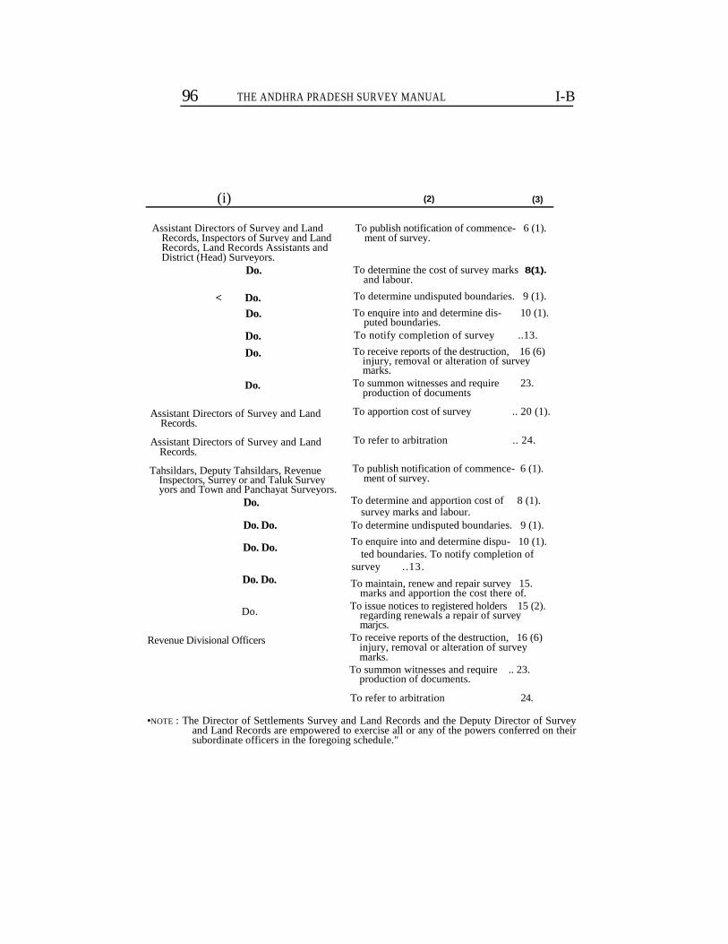
96 THE ANDHRA PRADESH SURVEY MANUAL I-B
(i) (2) (3)
Assistant Directors of Survey and Land Records, Inspectors of Survey and Land Records, Land Records Assistants and District (Head) Surveyors.
Do.
< Do.
Do.
Do.
Do.
Do.
Assistant Directors of Survey and Land Records.
Assistant Directors of Survey and Land Records.
Tahsildars, Deputy Tahsildars, Revenue Inspectors, Surrey or and Taluk Survey yors and Town and Panchayat Surveyors.
Do.
Do. Do.
Do. Do.
Do. Do.
Do.
Revenue Divisional Officers
To publish notification of commence- 6 (1). ment of survey.
To determine the cost of survey marks and labour.
To determine undisputed boundaries. 9 (1).
To enquire into and determine dis- 10 (1). puted boundaries.
To notify completion of survey ..13.
To receive reports of the destruction, 16 (6) injury, removal or alteration of survey marks.
To summon witnesses and require 23. production of documents
To apportion cost of survey .. 20 (1).
To refer to arbitration .. 24.
To publish notification of commence- 6 (1). ment of survey.
To determine and apportion cost of 8 (1). survey marks and labour.
To determine undisputed boundaries. 9 (1).
To enquire into and determine dispu- 10 (1). ted boundaries. To notify completion of
survey ..13.
To maintain, renew and repair survey 15. marks and apportion the cost there of.
To issue notices to registered holders 15 (2). regarding renewals a repair of survey marjcs.
To receive reports of the destruction, 16 (6) injury, removal or alteration of survey marks.
To summon witnesses and require .. 23. production of documents.
To refer to arbitration 24.
•NOTE : The Director of Settlements Survey and Land Records and the Deputy Director of Survey and Land Records are empowered to exercise all or any of the powers conferred on their subordinate officers in the foregoing schedule."
8(1).
98 AppxI-B] THE ANDHRA PRADESH SURVEY MANUAL
4. (a) In the case of town surveys, the Inspector of Survey shall prepare in duplicate a demand notice under section 8 (1) showing the fields held by each person concerned and the charges recoverable for the survey thereof and forward it to the Collector who-shall cause a copy fo be posted in the Municipal Office and send the other copy to the Tahsildar of the taluk for service on the registered holder or other person interested in the fileds. Acknowledgments in token of the receipts of the notice which shall be signed and dated shall be obtained by the Tah sildar of the taluk in the book maintained for the purpose.
NOTE. In respect of estate lands in the town no such notice need be given, as th» cost will be included in the survey charges to be borne by Government and the Municipality.
(b) In the case of other cadastral surveys in ryotwari areas, the Tahsildar shall piepare in duplicate a demand notice under section 8(1) showing the fields held by each person concerned according to the latest village accounts and the charges recoverable for the survey thereof and forward it to the village headman who shall post a copy in the village chavadi and leave the other copy with the registered holder or ofbeV person interested in the fields. Acknowledgments in token cf the receipt of the notice, which shall be signed and dated, shall be obtained by the village headman in a book maintained for the purpose.
5. The notices issued under section 9 (2) shall, except in the case of street surveys and boundary suiveys, be in the form of an extract from the field register iclating to the holding, shall state the time within which and the officer to whom an appeal may be presented, and shall be acc- ompftined by a printed form of acknowledgment which shall be signed and dated in token of the receipt of the notice and returned to th* offi( ,>/ who issued it.
•o. The communications required by sections 8 (1), 10 (2) and 11 (1) shall give the purport of the decisions passed and those required by section 10 (2) state the time within which and the officer to whom an appeal may be presented. Acknowledgments which shall be signed and chted in token of receipt of the communications shall be obtained at th< time of the crni.uunicatiou, if the parties concerned are present, other vise, through the post by sending them registered.
7. Where an appeal is filed against a decision under section 9 (1) aotice shall be given by the appellate authority to all the registered holders, the bouadaiics of whose holdings may be affected by the pro ceedings in appeal. In the case of an appeal against a decision under section 10 (1), notice shall similarly be given to the other parties to the dispute.
8. The notices prescribed in section 15 (2) shall specify the numbers of the survey fields or subdivisions on or within the boundaries of which the survey marks requiring renewal or repair are situated. Acknow ledgements which shall be signed and dated in token of the receipt of the notices sha.ll be obtained in a book maintained for the purpose.
9. All notices and communications required under the Act shall be in writing.
2487—B—7*
RULES UNDER ANDHRA PRADESH SURVEY AND
BOUNDARIES ACT,
10. When the registered holder or other person on whom any of the notices or communications referred to in the foregoing rules is to be served is absent, service may be effected by delivering the notice on communication to some adult male member of his famliy at his usual place of abode or to his authorized agent or by affixing it on some con-spicious part of his last known residence or on some conspicious part of the land to which the notice or communication relates or by sending it to him at his last known place of residence by Registered post, Ack-nowledgement due. When service is effected by -
;o affixing the notice,
the serving officer shall note the method of service on the printed form of acknowledgment which is returned to the officer issuing the notice or communication.
Rules under clause 2 (/).
The survey marks used and the labour employed under section 8 (1) shall ordinarily be supplied in (he first instance at the cost of Govern-ment. Where, however, a registered holder of land or his tenant offiers to supply survey marks and labour at his own cost, the survey, officer may grant permission accordingly if he is satisfied that the pro-,gress of survey will not be retarded thereby. The survey officer shall be competent, however to rescind such permission if he . should find at any time that delay in the landholder's supply of either survey rnarki or laboui has set back progress of operations.
Rules under clause 2 (g) CADASTRAL
SURVEYS OTHER THAN TOWN SURVEYS
1 The total charges advanced under section 8 (1) of the Act for any Government village or part of, a Government village shall be appor-tioned on the lands surveyed in proportion to the area thereof as as-certained in the manner explained below :—
(1) The area of fields for which the holders have supplied labour and survey marks shall be deducted from the total area dealt with.
(2) 16 Hectares of wet land shall (save in the delta tracts in Godavari, Krishna Guntur and Thanjavur districts and in the districts of Malabar and South Kanara where all classes of land are for this purpose treated alike) be considered as equivalent to 24 Hectares of dry, waste or poram-boke. All fields of over 20 1 ectars in extent snail be charged at one-fourth the acreage rate (3) adopted lor dry land.
(3) The total charges shall be divided by the conventional area in hectars in terms of dry resulting from the operations of sub-rules (1) and (2) The rate of charge per hcctrc of dry, waste or poramboke having been thus determined tnat for wet shall be computed at half as much again as the dry rate and that for fields of over 20 hectres in extent shall be computed at one-fourth of the dry rate. In the districts and tracts expected in sub-rule (2), the rate per (8) shall be the same for dry and for wet The charges shall be recovered from all registered holders at the rates so computed, Government being treated as the registered holder of unoccupied land.
2. The determination of the rates at which the charges have to bt levied shall begin as soon as the survey of one or moie villages has beea completed,
100 THE ANDHRA PRADESH SURVEY MANUAL [APPX I-B
First month — The charges incurred up to the end of the month be aveiaged over the area surveyed so far and the Hectare rate shall be calculated in accordance with the procedure prescribed in rule 1. The demand on the villages the survey of which has been completed shall be arrived at by applying the average rate calculated as above to the area according to the latest revenue adangals after excluding therefrom the fields for which the holders have supplied stones and labour. The demand together with a list of the excluded fields shall be sent to the Revenue department for collection. The remainder of the cost of re-lating to the surveyed area of incomplete villages shall be carried for-ward for appoi tionment in the succeeding month.
3 Second month — The total of the amount left over in the prece-ding month and of the cost incurred in the month shall be averaged as in the first, month over the tc<al of the surveyed area left over in the preceding month and of the area surveyed in the month after deduc-ting excluded fieldr. At the rate so airived at the demand for the village?, the sutvey of which has been completed shall be worked out arid communicated to the Revenue department as in rule 2, the balance of the surveyed area of incomplete villages and the cost being left over for apportionment in the succeeding month.
** The pioceduie shall be repeated until the survey of the tract is com-
pleted. The cost of .any further survey necessary for supplying omi-ssion or for disposing of objections shall be apportioned and recovered in the manner above prescribed
4. As soon as each demand is received, the Tahsildar shall work out the demand separately for each holding and forward the demand notice in duplicate to the village headman for collection.
» 5. The whole or a specified portion of the cost of survey of an estate
or po.tion of an estate shall on application by the proprietor of the estate: be apportioned as may be directed on the following principles by Government or by any officer or authority to whom the power has been < legated by it airier section 20 (i) of the Act, among the holders of th 'ands or the persons interested in the boundaries which have been ; rve>ed :-—
(a) The cost per Hectare shall be calculated in accordance with the instructions laid clown in rurle 1 above for Government lands.
('•) The apportionment shall be made only in cases where the proprietor admits in wiiting that his tenants have occupancy rights.
TOWN SURVEYS
6. Tlie rate for the recovery of the cost of stones and hired labour shall be obtained in the following manner : —
The blocks into which the town has been divided during survey have been classified as close, medium and open according to the number of houses on them.
An Hectare of close area shall be considered as equivalent to 4 Hectars of medium and 16 Hectares of open area.
I-B THE ANDHRA PRADESH SURVEY AND BOUNDARIES ACT,
101
7. The total charges shall be divided by the conventional area in Hectars in terms of open area. The rate for open area having been determined, that for medium area shall computed at four times the rate for open area and that for close area at sixteen times.
8. The determination of the rates at which the charges have to be levied shall be made when the mapping of the town has been com pleted. The demand shall be sent to the Revenue department for, collection.
9. In determining the demand against the municipality, the charges in respect of the lands owned by, vested in, or alienated to the muni cipality shall be worked out and only two-thirds of the cost recovered from the municipality, the remaining one-third being borne by Government.
Rules under clause 2 (h).
Processes issued under the Act shall be served by iii>j village establi-shment and no fees shall be charged for such service. The Deputv Director of Survey, may however, sanction the employment of a special establishment for the service of such notices, and in such event the, following swales of fees shall be payable for process served by such special establishment, viz—
Amount leviable by survey officer in exercise of
Original Appellate Jurisdiction. Jurisdiation.
For each summons or notice— Rs. Np. Rs. Np. (a) to a single defendant respondent or 0—50 1— 0-0
witness (b) to every adcitional defendent,r espon-
dent or witnness residing in the same 20—5 0— 50 village, if thejprocessesjbe applied for at tne same time,
NOTE—For processes aPPHed for and orders lo be served urgeatly, the fee shall be li times the ordinary fee, where the fees so calculated is not a whole multiple of 5 p. shall b* rounded off to the next high multiple of 5 p.
2. Two copies of orders passed under sections 8 (2) 9 (1), 10 (1) and 11 (1) of the Act shall be granted to applicants on payment of a fe» which will be levied in the form of copy-stamp. The value of a copy paper is 35 np. A maximum number of 175 words may be written on the first page and a maximum number of 240 words on the reverse side of the copy stamped paper on payment of additional fees in the form of adhasive court fee stamps of the value of 35 np. when the number of words written does not exeed 175 and 45 np. when that number is exeeded. Applications for copies shall be stamped .with court fee stamps as prescribed in Schedule II of the Andhra court fees and suits Valuation Act, 1956 (Andhra Act VII of 1956).
NOTE—For the information of the Public in the Telangana area, a copy of the rales made under the Madras Survey and Boundaries Act, 1923, will be made available for inspection at the offices of every collector of the District in the saie area.
The fee for copies of plans, sketches and 'diagrams shall be fixed at three Rupees per sheet of paper of the size usea for a page of the Field Measurement Book, and three rupees for every additional sheet required.
102 THE ANDHRA PRADESH SURVEY MANUAL [Aprx-l-B
The methods of survey adopted during the initial surveys of the State were—
(1) Khasra.
(2) Triangles.
(3) Plane table.
(4) Block map
(5) Kallikote and Atagada.
(6) Theodolite combined with Prismatic Compass and Plane table.
(7) Diagonal and offset.
(8) Punganur.
(9) Ray system.
Khasra followed from 1862 to 1874.—Boundaries only of quadrila-teral survey fields measured. If shape was irregular, the field Wai divided into quadrilaterals or triangles and the sides of these measured. In some cases, the diagonals of the quadrilaterals were also measured. Subdivisions were measured by Settlement department. Sketches of survey fields showing measurements were prepared but these weie often incomplete. Village maps were prepared on a traverse basis.
Triangles from 1876 to 1888.—Measurements were taken from stone to stone to divide each survey field into triangles. In 1877 surveyors were permitted to take offsets to stones at bends less than SO links front a line between any two other stones, but this was not done to any ap-preciable extent. Subdivisions were measured by Settlement depart-ment. Village maps were prepared on a traverse basis.
Plane table from 1887 to 1891,—So called because the traverse plotted skeleton village map was pricked off on two sheets each containing, about 160 acres on the 40 scale, the size of a plane table head as used in the Madras Survey. The plane table was not used at all. Boundaries of survey fields were sketched into this sheet as demarcation progres-sed. The sides of the triangles formed by the theodolite stations were measured and offsets taken to all field marks. Measurements were entered on the sheets. The outer boundaries of fields containing sub-divisions were also measured and the subdivisions divided into quadri-laterals and triangles and measured. Measurements of these were pre-served in a record called the subdivisions interstitial field book.
Block map from 1891 to 1896.—Theodolite stations were fixed at village trijunctions and at other points to form blocks of about 160 acres. These were plotted on the 40 scale. The blocks were divided into large triangles and the boundaries of survey fields and subdivisions fixed by offsets taken from the sides of the triangles. All the measure-ments taken were entered on the block sheets. Village maps were, formed by super-imposing reductions the block maps on the traverse of skeletons.
Kallikote and Atagada.—Followed during the survey of the Kalli-kote, Atagada and Dharakota Estates, 1912-1917. A modification of the plane table system. Each holding became a survey field. Lines were run between theodolite stations and offsets taken to all field bendl
APPX. I-B] RULES UNDER ANDHRA PRADESH 103 SURVEY AND BOUNDARIES ACT
Field boundaries were not measured. Measurements were recorded-in Khandam sketches and in field books. The areas have since been transferred to Andhra Pradesh State.
Theodolite, Prismatic Compass and Plane table.—Done in the Nil-giris district and in the Malabar, Wynaad, chiefly with the theodolite and chain supplemented with the plane table and prismatic compass.
Diagonal and offset.—See Chapetrs I to IX. This is the method now employed during the survey and re-survey of Government lands.
Ptmganur.—So called because first employed during the survey of thePunganur Estate during 1914 to 1916. The re-survey of the Govern-ment taluk Repalle (Guntur )was done under this system and it is now generally employed for the survey of estates. For description see paragraph 7, Introduction.
Kay system of survey.—(see note at 2 to 4).
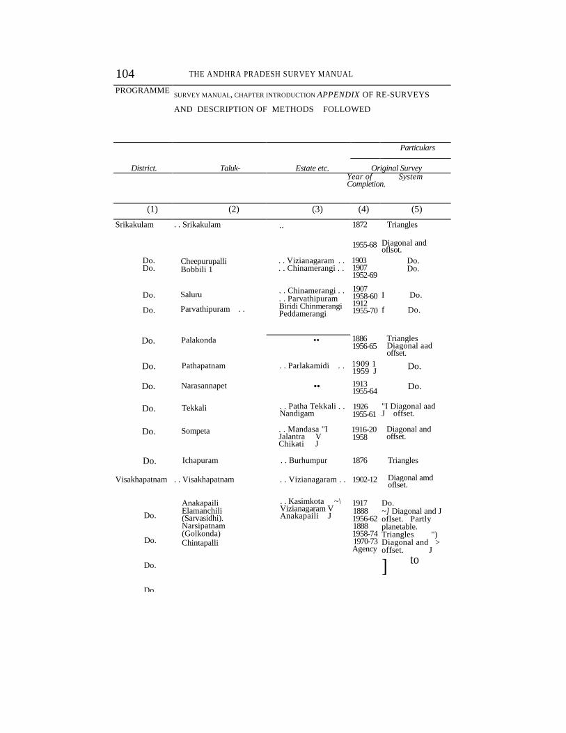
104 THE ANDHRA PRADESH SURVEY MANUAL
PROGRAMME SURVEY MANUAL, CHAPTER INTRODUCTION APPENDIX OF RE-SURVEYS
AND DESCRIPTION OF METHODS FOLLOWED
District. Taluk- Estate etc.
Particulars
Original Survey Year of System Completion.
(1) (2) (3) (4) (5)
Srikakulam . . Srikakulam .. 1872 Triangles
1955-68 Diagonal and oflsot.
Do. Do.
Cheepurupalli Bobbili 1
. . Vizianagaram . .
. . Chinamerangi . . 1903 1907 1952-69
Do. Do.
Do.
Do.
Saluru
Parvathipuram . .
. . Chinamerangi . .
. . Parvathipuram Biridi Chinmerangi Peddamerangi
1907 1958-60 1912 1955-70
I Do.
f Do.
Do. Palakonda • • 1886 1956-65
Triangles Diagonal aad offset.
Do. Pathapatnam . . Parlakamidi . . 1909 1 1959 J
Do.
Do. Narasannapet •• 1913 1955-64
Do.
Do. Tekkali . . Patha Tekkali . . Nandigam
1926 1955-61
"I Diagonal aad J offset.
Do. Sompeta . . Mandasa "I Jalantra V Chikati J
1916-20 1958
Diagonal and offset.
Do. Ichapuram . . Burhumpur 1876 Triangles
Visakhapatnam . . Visakhapatnam . . Vizianagaram . . 1902-12 Diagonal amd oflset.
Do.
Do.
Do.
Do.
Anakapaili Elamanchili (Sarvasidhi). Narsipatnam (Golkonda) Chintapalli
. . Kasimkota ~\ Vizianagaram V Anakapaili J
1917 1888 1956-62 1888 1958-74 1970-73 Agency
Do. ~] Diagonal and J oflset. Partly planetable. Triangles ") Diagonal and > offset. J
] to
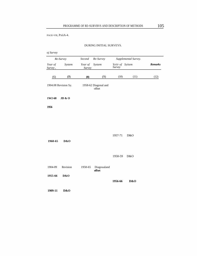
PROGRAMME OF RE-SURVBVS AND DESCRIPTION OF METHODS 105
PAGE-VIE, PxiiA-4.
DURING INITIAL SURVEYS.
oj Survey
Re-Survey Second Re-Survey Supplemental Survey.
Year of System Year of System Survey , Survey
Yeiir of Syitem Survey
Remarks
(6) (7) (8) (9) (10) (11) (12)
1904.08 Revision Sy. 1958-62 Diagonal and offset
1W2-68 JD & O
1956
1960-65 D&O
1904-09 Revision 1958-65 Diagoualand offset
1955-66 D&O
1909-11 D&O
1957-71 D&O
1958-59 D&O
1956-66 D&O
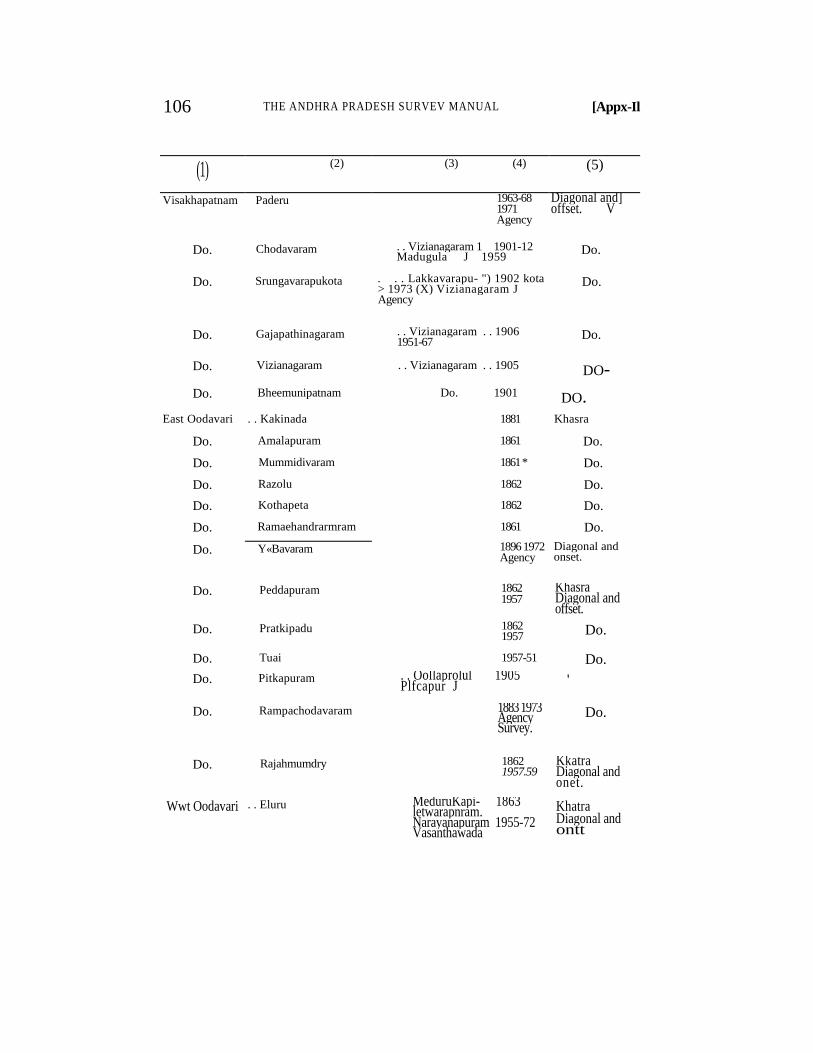
106 THE ANDHRA PRADESH SURVEV MANUAL [Appx-Il
(1) (2) (3) (4) (5)
Visakhapatnam Paderu 1963-68 1971 Agency
Diagonal and] offset. V
Do. Chodavaram . . Vizianagaram 1 1901-12 Madugula J 1959
Do.
Do. Srungavarapukota . . . Lakkavarapu- ") 1902 kota > 1973 (X) Vizianagaram J Agency
Do.
Do. Gajapathinagaram . . Vizianagaram . . 1906 1951-67
Do.
Do. Vizianagaram . . Vizianagaram . . 1905 DO-
Do. Bheemunipatnam Do. 1901 DO. East Oodavari . . Kakinada 1881 Khasra
Do. Amalapuram 1861 Do.
Do. Mummidivaram 1861 * Do.
Do. Razolu 1862 Do.
Do. Kothapeta 1862 Do.
Do. Ramaehandrarmram 1861 Do.
Do. Y«Bavaram 1896 1972 Agency
Diagonal and onset.
Do. Peddapuram 1862 1957
Khasra Diagonal and offset.
Do. Pratkipadu 1862 1957 Do.
Do. Tuai 1957-51 Do.
Do. Pitkapuram . . Oollaprolul 1905 Plfcapur J
'
Do. Rampachodavaram 1883 1973 Agency Survey.
Do.
Do. Rajahmumdry 1862 1957.59
Kkatra Diagonal and onet.
Wwt Oodavari . . Eluru MeduruKapi- 1863 letwarapnram. Narayanapuram 1955-72 Vasanthawada
Khatra Diagonal and ontt
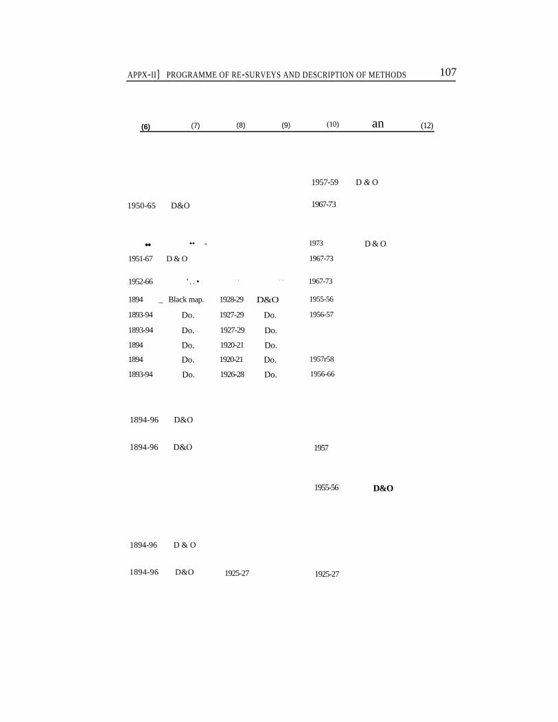
APPX-II] PROGRAMME OF RE-SURVEYS AND DESCRIPTION OF METHODS 107
(6) (7) (8) (9) (10) an (12)
1950-65 D&O
1957-59 D & O
1967-73
• • •• - 1973
1951-67 D & O 1967-73
1952-66 ' . . • . , . . 1967-73
1894 _ Black map. 1928-29 D&O 1955-56
1893-94 Do. 1927-29 Do. 1956-57
1893-94 Do. 1927-29 Do.
1894 Do. 1920-21 Do.
1894 Do. 1920-21 Do. 1957r58
1893-94 Do. 1926-28 Do. 1956-66
D & O
1894-96 D&O
1894-96 D&O 1957
1955-56 D&O
1894-96 D & O
1894-96 D&O 1925-27 1925-27
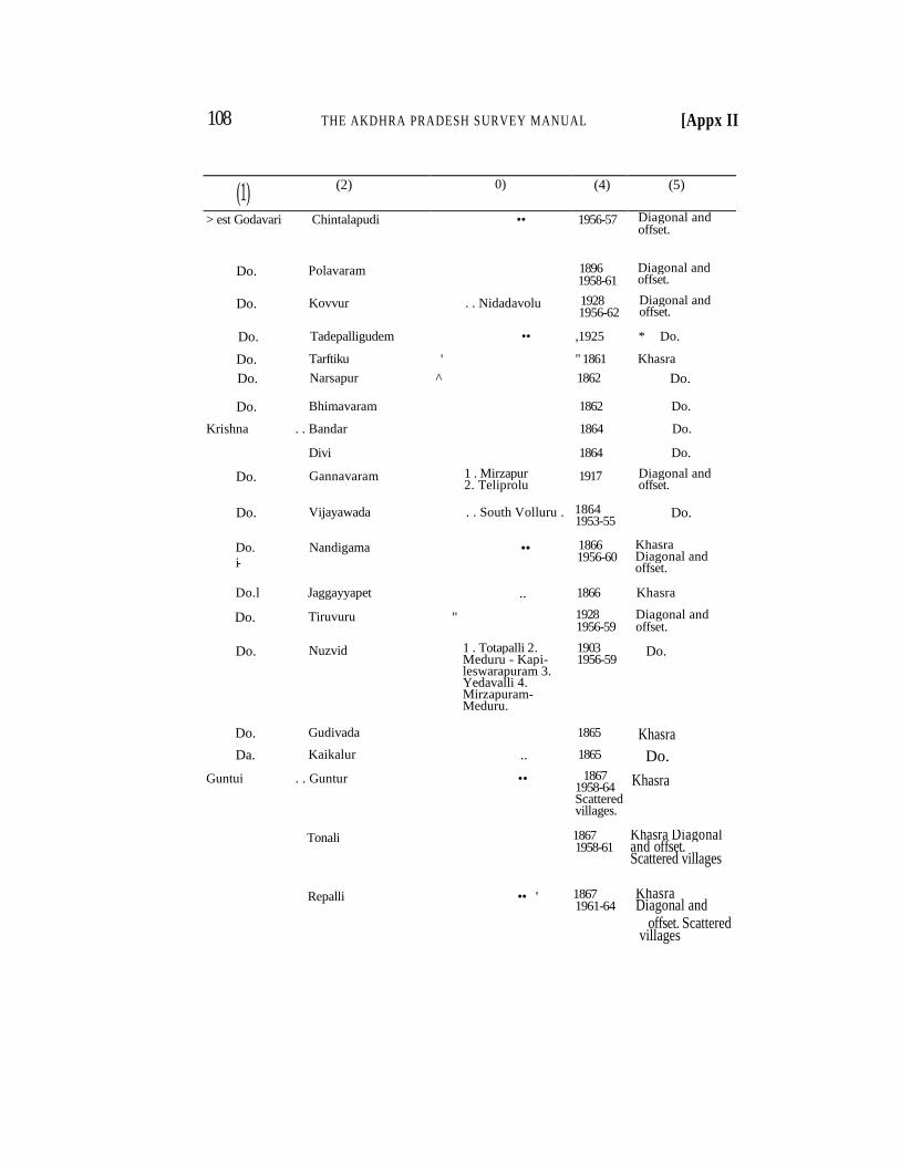
108 THE AKDHRA PRADESH SURVEY MANUAL [Appx II
(1) (2) 0) (4) (5)
> est Godavari Chintalapudi •• 1956-57 Diagonal and offset.
Do. Polavaram 1896 1958-61
Diagonal and offset.
Do. Kovvur . . Nidadavolu 1928 1956-62
Diagonal and offset.
Do. Tadepalligudem • • ,1925 * Do.
Do. Tarftiku ' " 1861 Khasra
Do. Narsapur ^ 1862 Do.
Do. Bhimavaram 1862 Do.
Krishna . . Bandar 1864 Do.
Divi 1864 Do.
Do. Gannavaram 1 . Mirzapur 2. Teliprolu
1917 Diagonal and offset.
Do. Vijayawada . . South Volluru . . 1864 1953-55
Do.
Do. i-
Nandigama •• 1866 1956-60
Khasra Diagonal and offset.
Do.l Jaggayyapet .. 1866 Khasra
Do. Tiruvuru " 1928 1956-59
Diagonal and offset.
Do. Nuzvid 1 . Totapalli 2. Meduru - Kapi-leswarapuram 3. Yedavalli 4. Mirzapuram-Meduru.
1903 1956-59
Do.
Do. Gudivada 1865 Khasra
Da. Kaikalur .. 1865 Do.
Guntui . . Guntur • • 1867 1958-64 Scattered villages.
Khasra
Tonali 1867 1958-61
Khasra Diagonal and offset. Scattered villages
Repalli •• ' 1867 1961-64
Khasra Diagonal and
offset. Scattered villages
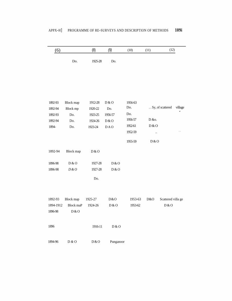
APPX-H] PROGRAMME OF RE-SURVEYS AND DESCRIPTION OF METHODS 109i
(6) (8) (9) (10) (11) (12)
Do. 1925-28 Do.
1892-93 Block map
1892-94 Block mp
1892-93 Do.
1892-94 Do.
1894- Do.
1912-28 D & O
1920-22 Do.
1923-25 1956-57
1924-26 D & O
1923-24 D A O
1956-63
Do. . . Sy, of scattered village
s Do.
1956-57 D &o.
1952-61 D & O
1952-59 .. t t
1955-59 D & O
1892-94 Block map D & O
1896-98
1896-98
D & O
D & O
1927-28
1927-28
Do.
D & O
D & O
1892-93 Block map 1925-27 D&O 1953-63 D&O Scattered villa ge
1894-1912 Block maP 1924-26 D & O 1953-62 D & O
1896-98 D & O
1896 1916-11 D & O
1894-96 D & O D & O Punganoor
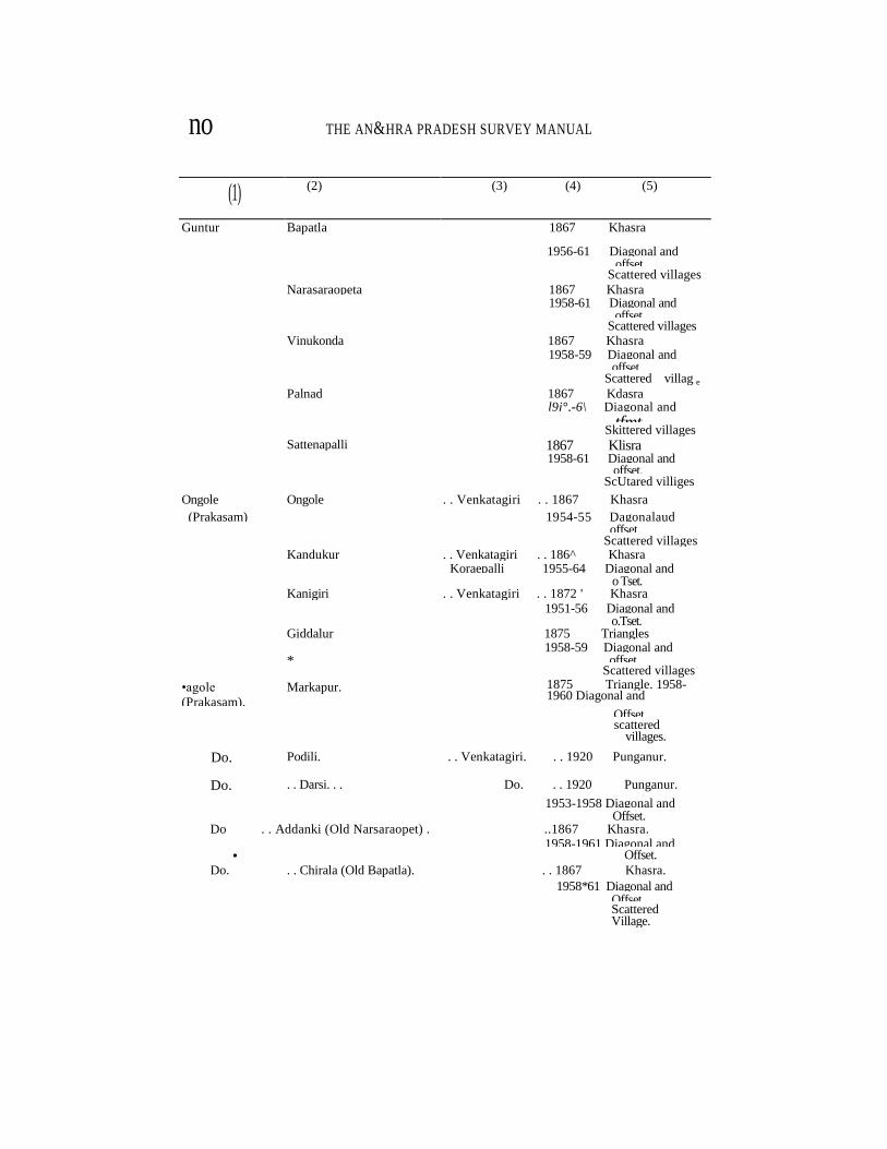
no THE AN&HRA PRADESH SURVEY MANUAL
(1) (2) (3) (4) (5)
Guntur Bapatla 1867 Khasra
1956-61 Diagonal and offset. Scattered villages Narasaraopeta 1867 Khasra 1958-61 Diagonal and offset. Scattered villages Vinukonda 1867 Khasra 1958-59 Diagonal and offset. Scattered villag e
Palnad 1867 Kdasra l9j°,-6\ Diagonal and tfmt. Skittered villages Sattenapalli 1867 Klisra 1958-61 Diagonal and offset. ScUtared villiges
Ongole Ongole . . Venkatagiri . . 1867 Khasra
(Prakasam) 1954-55 Dagonalaud offset. Scattered villages Kandukur . . Venkatagiri . . 186^ Khasra Koraepalli 1955-64 Diagonal and o Tset. Kanigiri . . Venkatagiri . . 1872 ' Khasra 1951-56 Diagonal and o.Tset. Giddalur 1875 Triangles 1958-59 Diagonal and * offset. Scattered villages
•agole
(Prakasam). Markapur. 1875 Triangle. 1958-
1960 Diagonal and
Offset. scattered villages.
Do. Podili. . . Venkatagiri. . . 1920 Punganur.
Do. . . Darsi. . . Do. . . 1920 Punganur.
1953-1958 Diagonal and Offset.
Do . . Addanki (Old Narsaraopet) . ..1867 Khasra. 1958-1961 Diagonal and
• Offset. Do. . . Chirala (Old Bapatla). . . 1867 Khasra.
1958*61 Diagonal and Offset. Scattered Village.
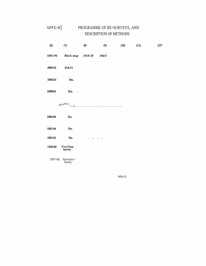
APPX-H] PROGRAMME OF RE-SURVEYS, AND
DESCRIPTION OF METHODS
(6) (7) (8> (9) (10) (11) (12*
1893-96 Block map 1918-20 D&O
1899-02 D&O
190143 Do.
189943 Do. .
r^Do
-_( ...................................................................................
1904-06 Do.
*
1902-04 Do.
1903-05 Do. . . . .
190648 l*tvi*km Survey
1907-08 Revision • Survey.
1950-53
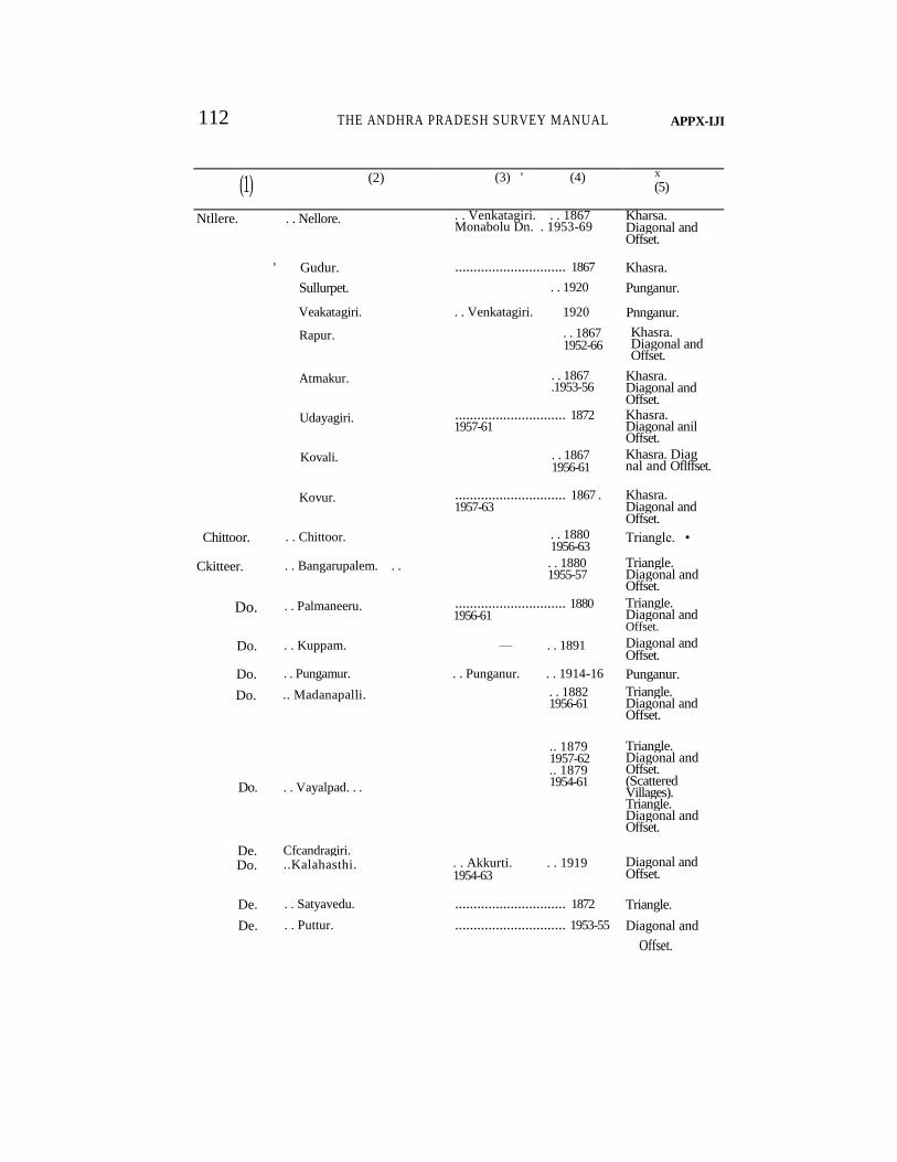
112 THE ANDHRA PRADESH SURVEY MANUAL APPX-IJI
(1) (2) (3) ' (4) X (5)
Ntllere. . . Nellore. . . Venkatagiri. . . 1867 Monabolu Dn. . 1953-69
Kharsa. Diagonal and Offset.
' Gudur. .............................. 1867 Khasra.
Sullurpet. . . 1920 Punganur.
Veakatagiri. . . Venkatagiri. 1920 Pnnganur.
Rapur. . . 1867 1952-66
Khasra. Diagonal and Offset.
Atmakur. . . 1867 .1953-56
Khasra. Diagonal and Offset.
Udayagiri. .............................. 1872 1957-61
Khasra. Diagonal anil Offset.
Kovali. . . 1867 1956-61
Khasra. Diag nal and Oflffset.
Kovur. .............................. 1867 . 1957-63
Khasra. Diagonal and Offset.
Chittoor. . . Chittoor. . . 1880 1956-63
Triangle. •
Ckitteer. . . Bangarupalem. . . . . 1880 1955-57
Triangle. Diagonal and Offset.
Do. . . Palmaneeru. .............................. 1880 1956-61
Triangle. Diagonal and Offset.
Do. . . Kuppam. — . . 1891 Diagonal and Offset.
Do. . . Pungamur. . . Punganur. . . 1914-16 Punganur.
Do. .. Madanapalli. . . 1882 1956-61
Triangle. Diagonal and Offset.
Do.
De.
. . Vayalpad. . .
Cfcandragiri.
.. 1879 1957-62 .. 1879 1954-61
Triangle. Diagonal and Offset. (Scattered Villages). Triangle. Diagonal and Offset.
Do. ..Kalahasthi. . . Akkurti. . . 1919 1954-63
Diagonal and Offset.
De. . . Satyavedu. .............................. 1872 Triangle.
De. . . Puttur. .............................. 1953-55 Diagonal and
Offset.
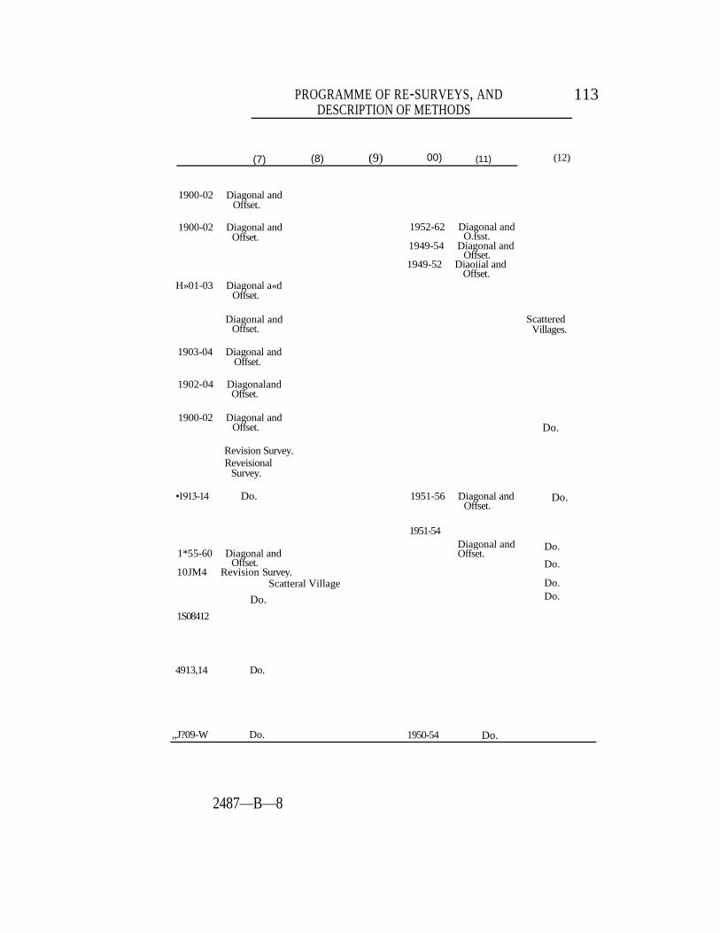
PROGRAMME OF RE-SURVEYS, AND DESCRIPTION OF METHODS
113
(7) (8) (9) 00) (11) (12)
1900-02 Diagonal and Offset.
1900-02 Diagonal and Offset.
1952-62 Diagonal and O.fsst.
1949-54 Diagonal and Offset.
1949-52 Diaoiial and Offset.
H»01-03 Diagonal a«d Offset.
Diagonal and Offset.
Scattered Villages.
1903-04 Diagonal and Offset.
1902-04 Diagonaland Offset.
1900-02 Diagonal and Offset. Do.
Revision Survey. Reveisional
Survey.
•1913-14 Do. 1951-56 Diagonal and Offset.
Do.
1*55-60 Diagonal and Offset.
10JM4 Revision Survey. Scatteral Village
1S08412
1951-54
Diagonal and Offset.
Do.
Do.
Do. Do.
4913,14 Do.
,,J?09-W Do. 1950-54 Do.
2487—B—8
Do.
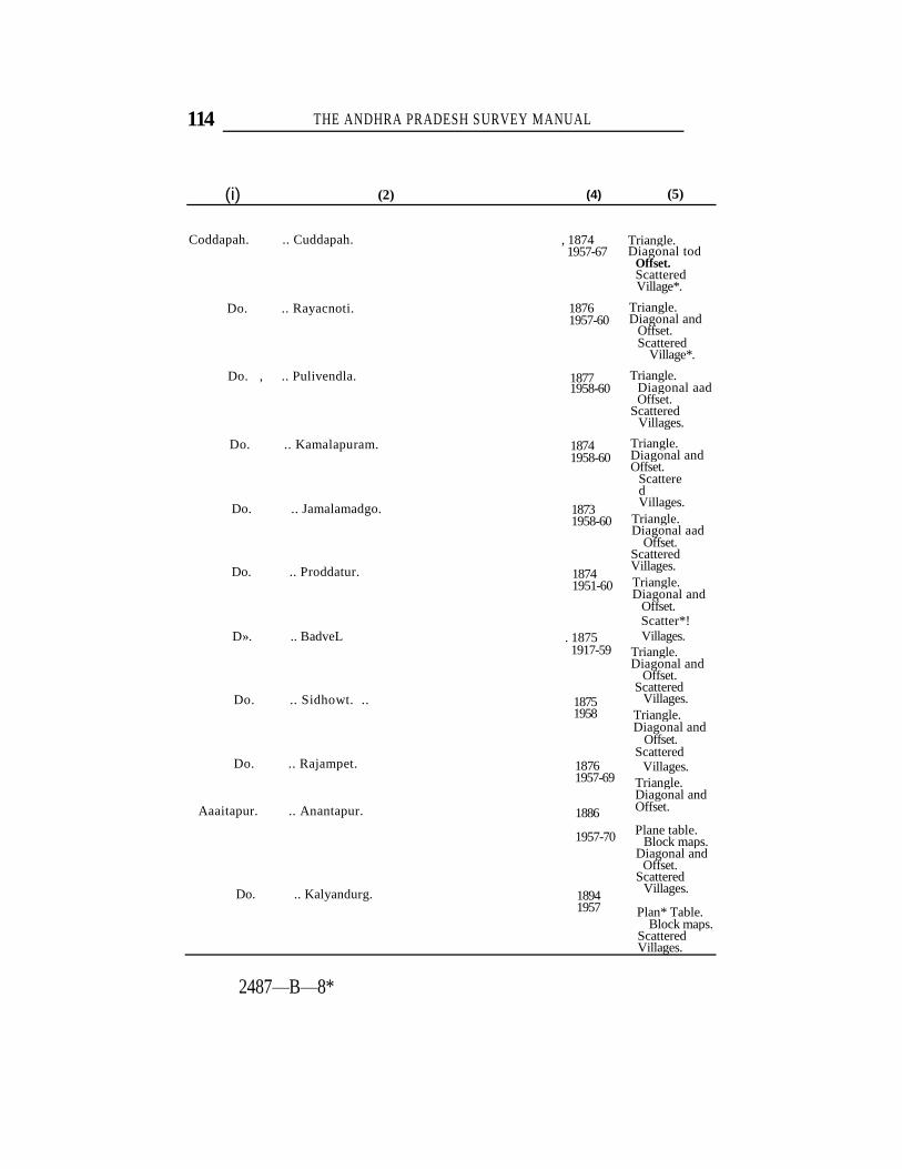
114 THE ANDHRA PRADESH SURVEY MANUAL
(i) (2) (4) (5)
Coddapah. .. Cuddapah.
Do. .. Rayacnoti.
Do. , .. Pulivendla.
Do. .. Kamalapuram.
Do. .. Jamalamadgo.
Do. .. Proddatur.
D». .. BadveL
Do. .. Sidhowt. ..
Do. .. Rajampet.
Aaaitapur. .. Anantapur.
Do. .. Kalyandurg.
, 1874 1957-67
1876 1957-60
1877 1958-60
1874 1958-60
1873 1958-60
1874 1951-60
. 1875 1917-59
1875 1958
1876 1957-69
1886
1957-70
1894 1957
Triangle. Diagonal tod
Offset. Scattered Village*.
Triangle. Diagonal and
Offset. Scattered
Village*.
Triangle. Diagonal aad Offset.
Scattered Villages.
Triangle. Diagonal and Offset.
Scattered Villages.
Triangle. Diagonal aad
Offset. Scattered Villages. Triangle. Diagonal and
Offset. Scatter*! Villages.
Triangle. Diagonal and
Offset. Scattered
Villages. Triangle. Diagonal and
Offset. Scattered
Villages. Triangle. Diagonal and Offset.
Plane table. Block maps.
Diagonal and Offset.
Scattered Villages.
Plan* Table. Block maps.
Scattered Villages.
2487—B—8*
POT JTOOtBId Ml
f»-S06t
•OQ " •• " <• -OQ
(rr) (rft [(01) (6) (8) 0) <»
DESCRIPTION OF METHODS ONV '

116 PRADESH .SURVEY MANUAL [Aw*1 '-II
0)] (2) (3) (4) (5)
Anantapur. | .. Rayadurg.
Do.' .. Uravakonda."^
Do.' .. Gooty.
Do. .. Tadipatri.
Do. j .. Dhannavaram.
Do. .. Kadiri.
Do." .. Penukonda.]
Do. .. Hindupur.
L Do. .. Madakasira.
Kurnool. .. Kurnool.
Do.^ .. Nandikothkur.
Do. ] .. Nandiyal.
Plane table. Diagonal and
Offset. • Scattered '
Villages.
Triangles. 1886
.. 1886 Triangles. 1957-64 Diagonal and
Offset. Scattered Villages.
.. 1886 Triangle. 1957-66 Diagonal and
Offset. Scattered Villages.
.. 1894 Block map. 1957-66 Diagonal end Offset.
Scattered Villages.
.. 1881 Triangles. 1958-69 Diagonr.1 and
Offset. Scattered Villages.
.. 1885 Triangles. 1957-69 Diagonal and
Offset. Sci ttered Villages.
.. 1894 Block mop. 1957-69 Diagonal and Offset. Scattered Villages.
.. 1894 Block map. 1958-70 Diagonal and
Offset. Scattered Villages.
.. 1862 ' 1959
Khasara. Diagonal and
Offset. Scattered
Villages.
Khasra. Diagona' and
Offset. Scattered Villages.
Khasra.
.. 1869
1890 1957-72
1866 1958-59
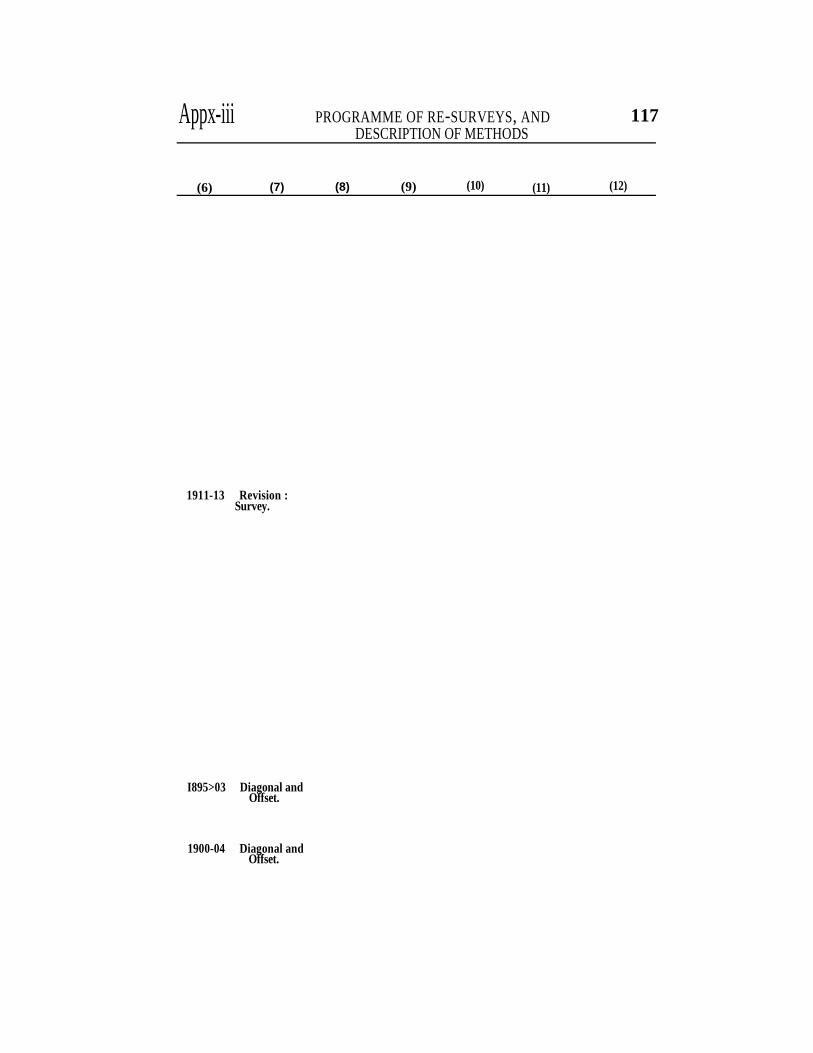
Appx-iii PROGRAMME OF RE-SURVEYS, AND DESCRIPTION OF METHODS
117
(6) (7) (8) (9) (10) (11) (12)
1911-13 Revision : Survey.
I895>03 Diagonal and Offset.
1900-04 Diagonal and Offset.
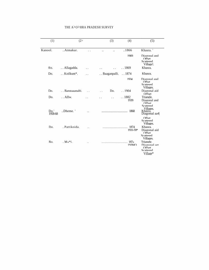
THE A>O>HRA PRADESH SURVEY
(1) (2> (3) (4) (5)
Kanool. ..Atmakur. . . .. .. ..1866 Khasra. '
1969 Diagonal and Offset. Scattered Village!.
®o. . . Allagadda. . . . . . . . . 1869 Khasra.
Do. . . Koilkunt*. . . . . Baaganpalli. . . 1874 Khasra.
1934 Diagonal and Offset. Scattered Villages.
Do. . . Bangaaapalti. . . . . Do. . . 1904 Diagonal aid Offset
Do. . . AIIw. . . . . . . . . 1882 Triangle. 1939 Diagonal and
Offset Scattered Villages.
Do.' ..Dheme. ' .. .............................. 1868 1958-68
Khasra. Diagomal aa4|
Offset. Scattered Villages.
Do. ..Pattikoida. .. ............................. 1874 Khasra. 1931-59* Diagonal aid
Offset. Scattered Villages.
Bo. ..M«*i. .. .............................. 187» Triangle. 19JMO Diagonal art
Offset Scattered Village*
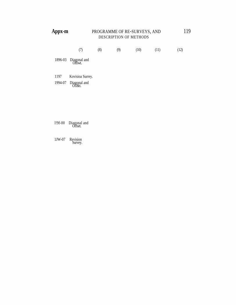
Appx-m PROGRAMME OF RE-SURVEYS, AND 119
DESCRIPTION OF METHODS
(7) (8) (9) (10) (11) (12)
1896-03 Diagonal and Offiwt.
1197 Kovisioa Surrey.
1994-07 Diagonal and Ofl&t.
l!9f-00 Diagonal and Offset.
1JW-07 Revision Survey.
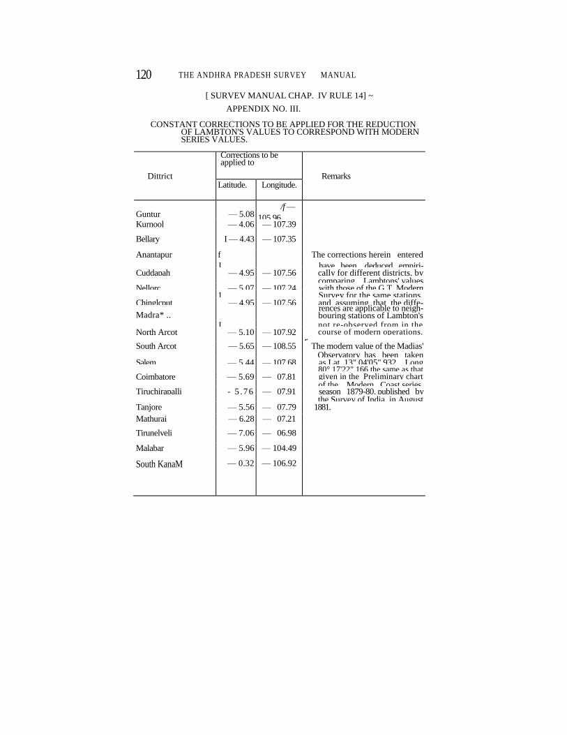
120 THE ANDHRA PRADESH SURVEY MANUAL
[ SURVEV MANUAL CHAP. IV RULE 14] ~
APPENDIX NO. III.
CONSTANT CORRECTIONS TO BE APPLIED FOR THE REDUCTION OF LAMBTON'S VALUES TO CORRESPOND WITH MODERN SERIES VALUES.
Dittrict
Corrections to be applied to
Remarks Latitude. Longitude.
Guntur — 5.08 /f —
105.96
Kurnool — 4.06 — 107.39
Bellary I — 4.43 — 107.35
Anantapur f The corrections herein entered
J have been deduced empiri- Cuddapah — 4.95 — 107.56 cally for different districts, by comparing Lambtons' values Nellorc — 5.07 — 107.24 with those of the G.T. Modern 1 Survey for the same stations, Chinglcput — 4.95 — 107.56 and assuming that the diffe-
Madra* .. rences are applicable to neigh-
bouring stations of Lambton's J not re-observed from in the North Arcot — 5.10 — 107.92 course of modern operations. r South Arcot — 5.65 — 108.55 The modern value of the Madias' Observatory has been taken Salem — 5.44 — 107.68 as Lat. 13" 04'05" 932, Long 80° 17'22".166 the same as that Coimbatore — 5.69 — 07.81 given in the Preliminary chart of the Modern Coast series, Tiruchirapalli - 5 .76 — 07.91 season 1879-80, published by the Survey of India, in August Tanjore — 5.56 — 07.79 1881.
Mathurai — 6.28 — 07.21
Tirunelveli — 7.06 — 06.98
Malabar — 5.96 — 104.49
South KanaM — 0.32 — 106.92
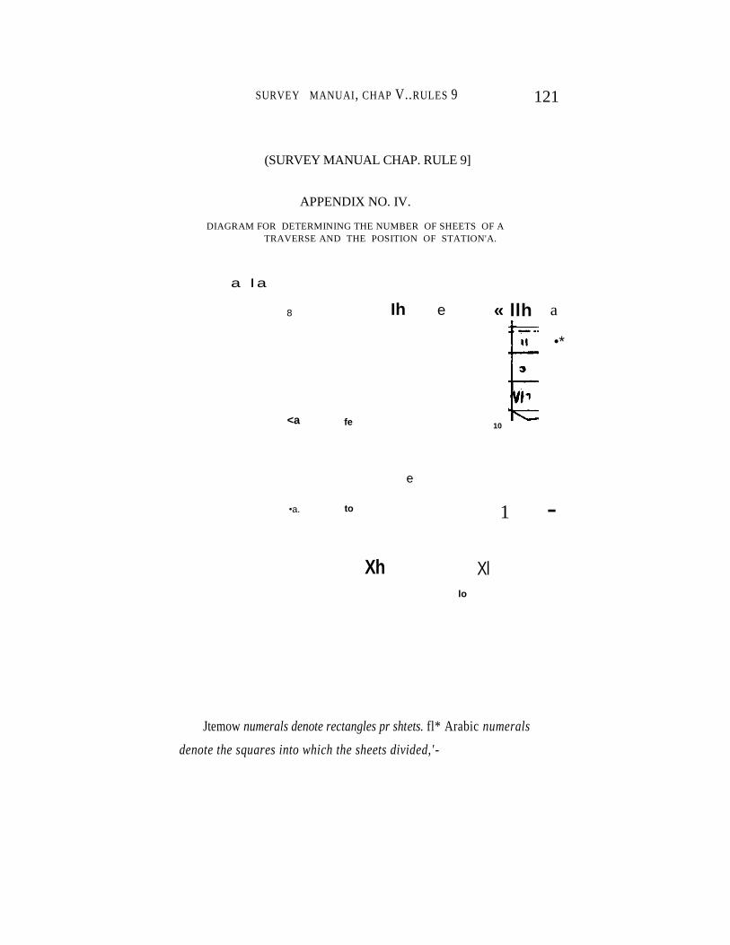
SURVEY MANUAI, CHAP V..RULES 9 121
(SURVEY MANUAL CHAP. RULE 9]
APPENDIX NO. IV.
DIAGRAM FOR DETERMINING THE NUMBER OF SHEETS OF A
TRAVERSE AND THE POSITION OF STATION'A.
a I a
8
<a fe
Ih e « llh
10
a
•*
e
•a. to 1 -
Xh Xl lo
Jtemow numerals denote rectangles pr shtets. fl* Arabic numerals
denote the squares into which the sheets divided,' -
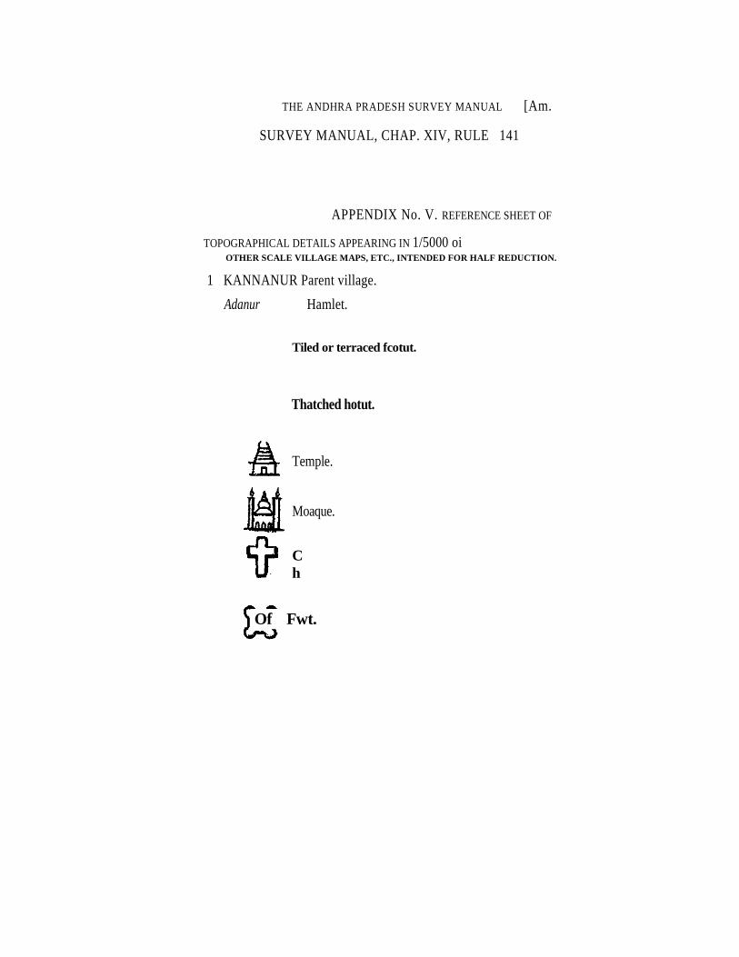
THE ANDHRA PRADESH SURVEY MANUAL [Am.
SURVEY MANUAL, CHAP. XIV, RULE 141
APPENDIX No. V. REFERENCE SHEET OF
TOPOGRAPHICAL DETAILS APPEARING IN 1/5000 oi OTHER SCALE VILLAGE MAPS, ETC., INTENDED FOR HALF REDUCTION.
1 KANNANUR Parent village.
Adanur Hamlet.
Tiled or terraced fcotut.
Thatched hotut.
Temple.
Moaque.
C
h
Of Fwt.
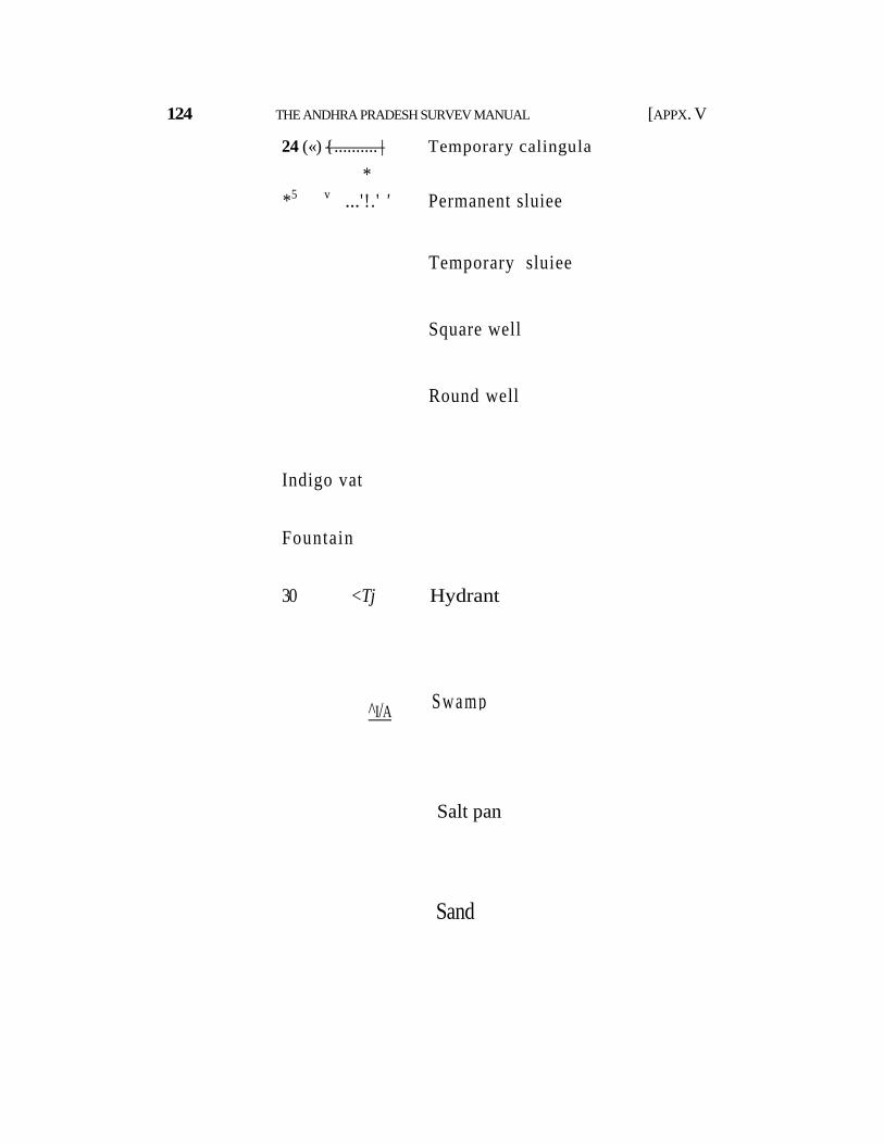
124 THE ANDHRA PRADESH SURVEV MANUAL [APPX. V
24 («) { .......... | Temporary calingula
*
*5 v ... '!.' ' Permanent sluiee
Temporary sluiee
Square well
Round well
Indigo vat
Fountain
30 <Tj Hydrant
Swamp ^I/A
Salt pan
Sand
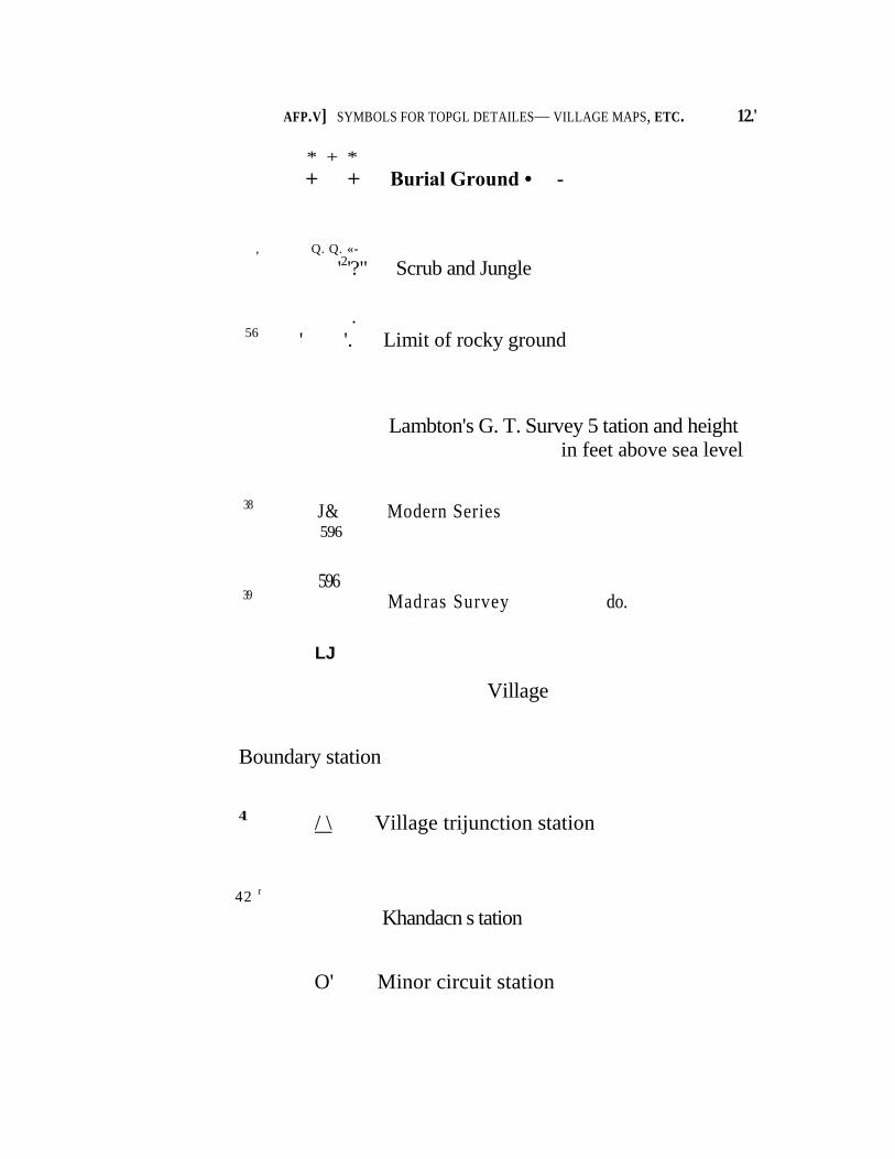
AFP.V] SYMBOLS FOR TOPGL DETAILES— VILLAGE MAPS, ETC. 12.'
* + *
+ + Burial Ground • -
, Q. Q. «-
'2'?" Scrub and Jungle
• 56
' '. Limit of rocky ground
Lambton's G. T. Survey 5 tation and height in feet above sea level
38 J& Modern Series
596
596 39 Madras Survey do.
Village
Boundary station
41 / \ Village trijunction station
42 r
Khandacn s tation
O' Minor circuit station
LJ
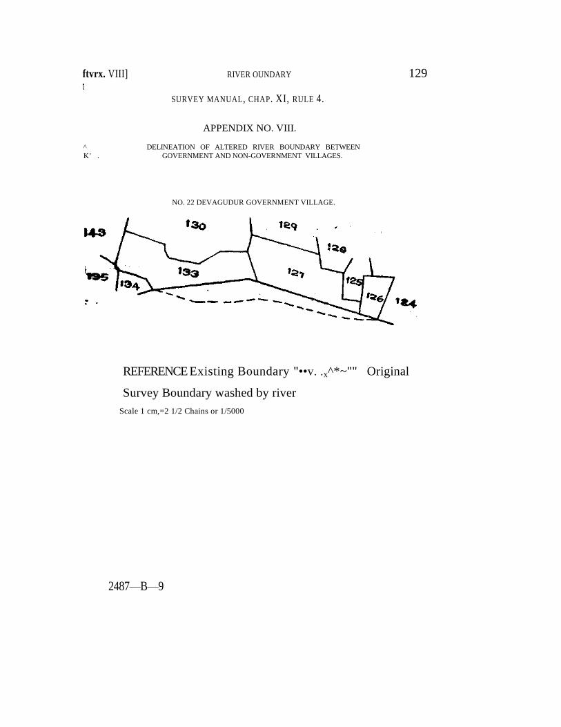
ftvrx. VIII] RIVER OUNDARY
t
SURVEY MANUAL, CHAP. XI, RULE 4.
APPENDIX NO. VIII.
^ DELINEATION OF ALTERED RIVER BOUNDARY BETWEEN K' . GOVERNMENT AND NON-GOVERNMENT VILLAGES.
NO. 22 DEVAGUDUR GOVERNMENT VILLAGE.
129
REFERENCE Existing Boundary "••v. .x^*~"" Original
Survey Boundary washed by river
Scale 1 cm,=2 1/2 Chains or 1/5000
2487—B—9
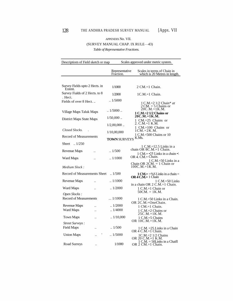
128 THE ANDHRA PRADESH SURVEY MANUAL [Appx. VII
APPENDIX No. VII.
(SURVEY MANUAL CHAP. IX RULE—43)
Table of Representative Fractions.
Descriptiom of Field sketch or map Scales approved under metric system.
Representative Fraction.
Scales in terms of Chain in which is 20 Metres in length.
Survey Fields upto 2 Hects. in Extent.
Survey Fialds of 2 Hects. to 8 . Hect. Fields of over 8 Hect. ..
Village Maps Taluk Maps
District Maps State Maps
Closed Slocks. .
Record of Measurements
Sheet .. 1/250
Revenue Maps .. .. 1/500
Ward Maps .. .. 1/1000
Medium Slock :
Record of Measurements Sheet .. 1/500
Revenue Maps .. .. 1/1000
Ward Maps .. .. 1/2000
Open Slocks :
Record of Measurements ... 1/1000
Revenue Maps .. .. 1/2000
Ward Maps .. .. 1/4000
Town Maps .. .. 1/10,000
Street Surveys :
Field Maps .. .. 1/500
Union Maps .. ' .. 1/5000
Road Surreys .. 1/1000
1 C.M.=2 1/2 Chain* at 2 CM. = 5 Chains or 20C.M.=1K.M.
1 C.M.=2 1/2 Chains or 20C.M.=1K.M. 1 CM.=25 Chains or 2. C.M.=1 K.M. 1 CM.=100 Chains or 1CM.=2K.M. 1 C.M.=500 Chains or 10 K.Ms.
1 C.M.=12.5 Links in a chain OR 8C.M.=1 Chain.
•25 Links in a chain •\ Chain. 1 C.M.=50 Links in a
Chain OR 2CM. = 1 Chain or 100C.M.=1K.M.
=%S Links in a chain = 1 Chain
1 C.M.=50 Links in a chain OR 2 C.M.=1 Chain.
1 C.M.=1 Chain or 50CM. = 1K.M.
1 C.M.=50 Links in a Chain. OR 2C.M.=OneChain.
1 CM.=1 Chain. 1 C.M.=2 Chains or 25C.M.=1K.M. 1 C.M.=5 Chains
OR 10C.M.=1K.M.
1 C.M. =25 Links in a Chain OR 4 C.M.=1 Chain.
1C.M.=2 1/2 Chains OR 20 C.M.=1 K.M.
1 C.M. = 50Links in a Chaifl OR 2 CM.=1 Chain.
1/1000 2 CM.=1 Chain.
1/2000 1C.M.=1 Chain.
.. 1/5000
.. 1/5000 ..
1/50,000 ..
1/2,00,000 ..
1/10,00,000
TOWN SURVEYS
1 CM.= OR 4. CM.=
1 CM.= OR 4 C.M.=
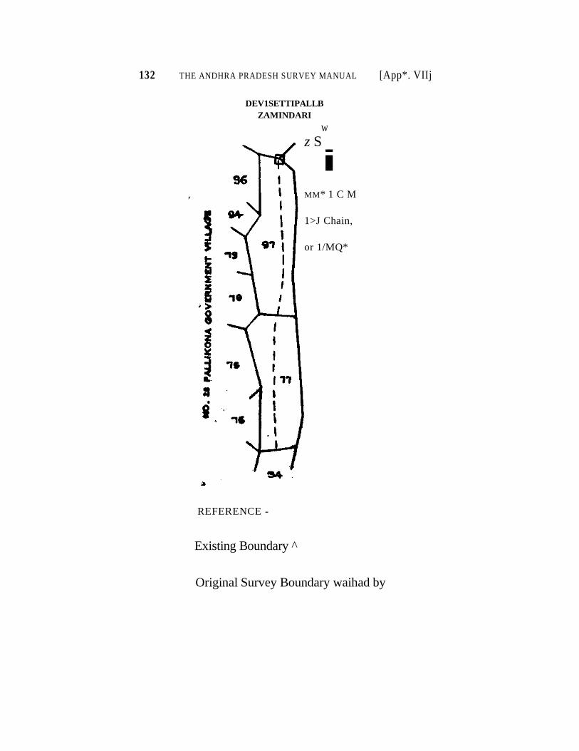
132 THE ANDHRA PRADESH SURVEY MANUAL [App*. VIIj
DEV1SETTIPALLB
ZAMINDARI
w
z S
i
, MM* 1 C M
1>J Chain,
or 1/MQ*
REFERENCE -
Existing Boundary ^
Original Survey Boundary waihad by
Appendix No. IX deleted
APPENDIX NO. X.
EXTRACT FROM THE CODE OF CIVIL PROCEDURE ACT V OF 1908. SECTIONS GOVERNING THE PROCEEDINGS OF SURVEY OFFICERS UNDER
MADRAS ACT VTO OF 1923.
(a) As to the Service of Summonses.
ORDER V. '
9. (1) Where the defendant resides within the jurisdiction of tie court in which the suite is instituted,or has an agent resident within that jurisdiction, who is empowered to accept the service of the summons the summons shall, unless the court otherwise directs, the delivered or lent to the proper officer to be served by him or one of his subordinates.
(2) The proper officer may be an officer of a court other than that in which the suit is instituted, and, where he is such an officer, the sum-<mon» may be sent to him by post or in such other manner as the court may direct. .
-^-««**.il,P' Service of the summons shall be made by delivering or tender-lag 4 feopy "thereof signed by the judge or such officer as he appoints in this behalf, and sealed witn the seal of the court.
11. Save as otherwise prescribed, where there are more defendants than one, service of the summons shall be made on each defendant.
12. Wherever it is practicable, service shall be made on the de fendant in person, unless he has an agent empowered to accept service, ]'a which case, service on such agent shall be sufficient.
15. Where in any suit the defendant cannot be found and has no •feat empowered to accept service of the summons on his behalf, service may be made on any adult male member of the family of the defendant who is residing with him.
Explanation.—A servant is not a member of t&« family within the meaning of this mle. ,
1 16. Where the serving offictr delivers or tenders a copy of the sum
mons to the defendant personally, or to an agent or other person en his behalf, he shall require the signature of the person to whom the copy is 10 delivered or tendered, to an acknowledgement of service endorsed on the orignal summons.
17. Where the defendant 01 his agent or such other person as afore said refuses to sign the acknowledgement or'where the serving officer, after using all due and reasonable diligence, cannot find the defendant, and there is no agent empowered to accept service of the summons on his behalf, nor any other person on whom service can be made, the serving officer shall affix a copy of the summons on the outer door or some other conspicuous part of the house in which the defendant ordinarily resides or carries OH business or personally works for again, and shall then return
133
134 THE ANDHRA PRADESH SURVEY MANUAL [Appx. X
the original to the court from which it was issued with a report endorsed thereon or annexed thereto, stating that he has so affixed the copy, the circumstances under which he did* so, and the name and address of the persons (if any) by whom the house was identified and in whose presence the copy was affixed.
v 18. The serving officer shall, in ail cases in which the summons has
been served under rule lf>: endorse or annex, or cause to be endorsed or anmexed, on or to the original summons, a return stating the time when, and the manner in which, the summons was served, and the name and address of the person (if any) indftnttfymg the person served, and witness ing the delivery or ttndter of the summons.
19. Where a summons is returned under rule 17, the court shall if the return under that rule has not been verified by the affidavit of the •ervmg officer, and may, if it has been so verified, examine the serving officer on oath, or cause him to be so examined by another court, touch- iag his proceedings, and may make such further inquiry in tHe matter as it thinks fit, and shall either declare that the summons has been duly served or order such service as it thinks fit.
20. (1) Where the court is satisfied that there is reason to believe that the defendant is keeping out of the way for the purpose of avoiding service, or that for any other reason the summons cannot be served in the ordinary tray, the court shall order the summons to be served by affixing a copy thereof in some conspicuous plaice in the court-house, ami also upon some conspicuous part of the house (if any) in which the defendant is known to have last resided 01 carried on business or person- nally worked for gain, or in sifch other manner as the court thinks fit.
(2) Service substituted by order of the court shall be as effectual as if b had been made on the, defendant pesonally.
(3) Where service is substituted by order of the court, toe court shall fix such time for the appearance of the defendant as the case may require.
21. A summons may be sent by the court by which it is issued, wkether within or without the province, either by one of its officers or by post to any court (not being the High Court) having jurisdiction in the place where the defendant resides. f
23. The court to which a summons is sent under rule 21 shall, upon receipt thereof, proceed as if it had been issued by such court and snail tkea return the summons to the court of issue, together with the record (if any) of its proceedings with regard thereto.
24 Where the defendant is confined in a prison, the summons shall b« delivered or seat by post or otherwise to the officer in charge of the prise* for service on the defendant.
25. Where the defendant resides oul of British India and has no ageat in British India empowered to accept serivce, the summons shall be addressed to the defendant at the place where he is residing and sent o him, by post, if there is postal communication between such place and he place where the court is situate
PX. X] IXTTUCT noil CODE o? Civit PROCEDUKI 135
26 Where—
(a) In the exercise of any foreign jurisdiction yetted in His Majesty or in the Governor-General in Councils, a Political Agent has been appointed, or a court has been established or continued, with power to gerve a summons issued by a court under this code in any foreign territory jn which the defendant resides, or
(b) the Governor-General in Council has, by notification in the Gazette of India, declared that any summons so issued may be served by any court situate in any such teiritory and not established or continued in the exercise of any such jurisdiction as aforesaid, the summons may be sent to such Political Agent or court, by post or otherwise, for the ' purpose of being served upon the defendant; and, if the Political Agent
returns the summons with an endorsement signed by such . J.....V-1 Agent or by the Judge or other officer of the court that the summons has been served on the defendant in manner hetein before directed such endorsement shall be deemed to be evidence of service.
•••••-. *?-'33!.*. Where the defendant is a public Officer (not belongingto His Majesty's Military or Naval forces or His Majesty's Indian Marine Service), or is the servant of a railway company or local authority, tho c«urt may, if it appeas to It that lh* summons may be most conveniently so served, send it for service, on the defendant to the head of the office in which he is employed; together with a copy to b* retained by the defendant.
28. Where tkedefendamt is a soldier, the court shall send the sum-mons for service to hi« Comalafldin g Officer together with a copy of to be retained by the defendant.
- . , XijLWliere a summons is delivered or sent to any person for service under rule 24, rule 27 or rule 28, such person shall be bound to serve it, if possible and to return it under his signature, with the written acknowledgment of the defendant, and such signature shall be deemed to be evidence of service.
(2) Where, from any cause, service is impossible, the summons shall be returned to the couit with a full statement of such cause and of the steps taken to procure service* and such statement shall be deemed to be evidence of non-service.
30. (1) The court may, notwithstanding anything hereinbefore contained, substitute for a summons a letter signed by the Judge or such officer as he may appoint in this behalf, where the defendant is, in the opinion of the court, of a rank entitling him to such mark of considera-tion.
(2) A letter substituted under sub-rule (1) shall contain all the particulars required to be stated in a summons, and, subject to the pro-visions of sub-rule (3), shall be treated in all lespects as a summons.
i (3) A letter so substituted may be sent to the defendant by post or by a special messenger selected by the court, or in any other manner which the court thinks fit ; and where the defendant has an agent empo-wered to accept service, the letter my be delivered or sent to such agent.
136 THE ANDHRA PRADESH SURVEY MANUAL APPX- X
• (b) As to Summoning Fortieses and Witness and Enforcing their
Attendance.
ORDER V.
1. (1) When a suit has been duly instituted, a summons may be issued, to'the defendant to appear and answer the claim on a day to be therem specified.
Provided that no such summons shall be issued when the defendant has appeared at the presentation of the plaint and admitted the plain-tiff's claim.
(2) A defendant to whom a summons has been issued under suJt>- rule (1) may appear.—
(a) in person, or
(7>) by a pleader duly instructed and able to answer all material questions relating to the suit, or t
(c) by a pleader accompanied by some person able to a'nswer all such questions.
(3) Every such summons shall be signed by the Judge or such officer as he appoints, and shall be scaled with the seal of the .court.
3. (1) Where the court sees reason to require the personal appear ance of the defendant, the summons shall order him to appear in person m court on the day therein specified.
(2) Where the court sees reason to require the personal appearance of the plaintiff on the same day, it shall make an order for such appea-rance.
4. No party shall be ordered to appear in person unless he resides—
(a) within the local limits of the courts' ordinary original jurisdic tion, or
(b) without such limits but at a place less than fifty or (where there is railway or steamer communication or other established public convey- an e for five sixths of the distance between the place where he resides air,I the place where the court is situate) less than two hundred miles distance from the court-house.
6. The day for the appearance of the defendant shallbe fixed with reference to the current business o5f the court, the place of residence of the defendant and the time necessary for the service of the summons; and the day shall be so fixed as to allow the defendant sufficient time to enable him to appear and answer on such day.
ORDER IX. Appearance of parties and
consequence of non-appearance.
1. On the day fixed in the summon? for the defendant to appear and answer, the parties shall be in attendance at the court-house in person or by their respective pleaders, and the suit shall then be heard, unless the hearing is adjourned to a future day fixed by the court.
A . X\ . EXTRACT FROM CODE OF CIVIL PROCEDURE 137
4 3. Where neither party appears when the suit is called on for hearing
the court may make an order that the suit be dismissed.
4, Where a suit is dismissed under rule 21 or rule 3, the plaintiff may (subiect to the law of limitation) bring a fresh suit; or may apply for an c Jt the dismissal aside, and if he satisfies the court that the court-fee and postal charges (if any) required within the time fixed before the issue of the r, rnmons or for his non-appearance, as the case may be, the court make an order setting aside the dismissal and shall appoint a .- .or proceeding with the suit.
6. (1) Where the plaintiff appears and the defendant does not appear when the suit is called on for hearing, then—
(a) if it is proved that thp summons was duly served, the court may proceed ex parts ; . t
(b) if it is not proved that the summons was duly served, the cour shall direct a second summons to be issued and served on the defendant;
(c) if it is proved that the summons was served on .the defendant t but not in sufficient time to enable him to appear and answer to on the
day i»^ in the summons, the court shall postpone the hearing of the suit to a future day to be fixed by the court, and shall direct notice of such day to be fiven to the defendant. ^
(2) Where it is owing to the plaintiff's default that the summons wa* not duly served or was not served in sufficient time, the court shall order the plaintiff to pay the costs occasioned by the postponement.
7. Whera the court has adjourned the hearing of the suit ex pane and the defendant, at or before such hearing, appears and assigns good cauie for his previous non-appearance, he may, upon such terms as the court directs as to cost or otherwise, be heard in answer to the suit, as if he hftd appeared on the day fixed for his appearance.
8. Where the defendant appears and the plaintiff does not appear when the suit is called on for hearing, the court shall make on order that the suit be dismissed, unless the defendant admits the claim, or part thereof, in which case the court shall pass a decree against the defendant upon such admission, and, where part only of the claim has been admitted, shall dismiss the suit so far as it relates to the remainder.
9. (1) Where a suit is wholly or partly dismissed under rule 8, the plaintiff should be precluded from bringing a fresh suit in respect of the same cause of action. But he may apply for an order to set the dismissal aside, and if he satisfies the couit that there was sufficient cause for his non-appearance when the suit was called for hearing, the court shall make an order setting aside the dismissal upon such terms as to costs or otherwise as it thinks fit, and shall appoint a day for proceeding with the suit.
(2) No order shall be made under this rule unless ' notice of the application has been served on the opposite paity.
10. When there are more plaintiffs than one, and one or mo of hem appeal, and the others do not appear, the court, may at the instoic
138 THE ANDHRA PRADESH SURVEY MANUAL [Ap?x. X
of the plaintiff or plaintiffs appearing, permit the suit to proceed ia the same way as if all the plaintiffs had appeard, or make such order as it thinks fit.
11. Where there are more defendants than one, and one or more of them appear and the others do not appear, the suit shall proceed, and the court shall at the time of pronouncing judgement, make such order as it thinks fit with respect to the defendants who do not appear.
12. Where a plaintiff or defendant, who has been ordered to appear is person, does not appear in person, or show sufficient cause to the satisfaction of the court for failing so to appear, he shall be subject to all the provisions of the foregoing rules applicable to plaintiffs and defendants, respectively, who do not appear.
Setting aside decrees ex-parte.
13. In any case in which a decree is passed ex-parte against a defen dant, he may apply to the court by which the decree was passed for an order to set it asidev; and if he satisfies the court that the summons was not duly served, or that he was prevented by any sufficient cause from appearing when the suit was called on for hearing, the court shall make an order setting aside the decree as against him upon such terms as to costs, payment into court or otherwise as it thinks fit, and shall appoint a day, for proceeding with the suit :
Provided that, where the decree is of such a nature that it 9annot b« set aside as against such defendant only, it may be set aside as against all or any of the other defendants also.
14. No decree shall be set aside on any such application as afore said unless notice thereof has been served on the opposite party.
* * * * *
ORDER XVI.
Summoning and attendance of witnesses.
1. At any time after the suit is instituted, the parties may obtain on application to the court or to such officer as it appoints in this behalf summonses to persons whose attendance is required either to give evidence or to produce documents.
2. (1) The party applying for a summons shall, before the summons is granted and within a period to be fixed, pay into court such a sum of money as appears to the court to be sufficient to defray the travelling and other expenses of the person summoned, in passing to and from the court in which he is required to attend, and for one day's attendance.
(2) In determining the amount payable under this, rule, the court may, in the case of any person summoned to give evidence as an expert, allow reasonable remuneration for the time occupied both in giving evidence and in performing any work of an expert character necessary for the case. ,
APPX. X] EXTRACT FROM CODE OF CIVIL PROCEDURE 139
1 (3) Where the court is subordinate to a High Court, regard shal
be had, in fixing the scale of such expenses, to any rules made in tha behalf.
3. The sum so paid into court shall be tendered to the person sum moned, at the time of serving the summons, if it can be served personally.
4. (1) Where it appears to the court or to such officer as it appoints in this behalf that the sum paid into court is not sufficient to eover such expenses or reasonable remuneration, the court may direct such further sum to be paid to the person summoned as appears to be necessary on that account, and, in case of defavlt in payment, may ofder such sum to be levied by attachment and sale of the movable property of the party obtaining the summons ; or'the court ma> discharge the person summo ned without requiring him to give evidence ; or may both order such levy and discharge such person as aforesaid.
(2) Where it.is necessary to detain the person summoned for a longer period than one day, the court, may, from time to time, order the party, at whose instance he was summoned, to pay into court such sura Us Is sufficient to defray the expenses of his detention for such further period, and, in default of such deposit being made, may order such sum to be levied by attachment and sale of the movable property of such party ; or the court may discharge the person summoned without re-quiring him to give evidence ; or may both order such levy and discharge such person as aforesaid.
5. Every summons for the attendance of a person to give evidence or to produce a document shall specify the time and place at which he is required to attend, and also whether his attendance is required for the purpose of giving evidence or to produce a document, or for both purposes ; and any particular document, which the person summoned is called on to produce, shall be described in the summons with reason able accuracy.
7. Any person present in court may be required bj the court to give evidence or to produce any document then and there in his possession or power.
8. Every summons under this order shall be served as nearly as may be in the same manner as a summons to a defendant, and the rules in order V as to proof of service shall apply in the case of all summonses served under this rule.
9. Service shall in all cases be made a sufficient time before the tirae specified in the summons for the attendance of the person sum moned, to allow him a reasonable time for preparation and for travelling to the place at which his attendance is required.
10. (1) Where a person, to whom a summons has been issued either to attend to give evidence or to produce a document, fails to attend or to produce the document in compliance with such summons, the court shall, if the certificate of the serving officer has not been verified by affidavit, and may, if it has been so verified, examine the serving officer on oath, or cause him to be so examined by another court, touch ing the service or non-service of the summons.
140 THE ANDHRA PRADESH SURVEY MANUAL [Appx. X
(2) Wh^e the court sees reason to believe that such evidence or production is material," and that such person has, without lawful excuse, failed to attend or to produce the document in complience with such summons or has intentionally avoided service, it may issue a pro clamation requiring him to attend to give evidence or to produce the document at a time and place to be named therein ; and a copy of iuch proclamation shall be affixed on the outer door or other conspicuous part of the house in which he ordinarily resides.
(3) In lieu of or at the time of issuing such proclamation, or at any time afterwards, the court may, in its discretion, issue a warrant, either with or without bail, for the arrest of such person, and may make an order for the attachment of his property to such amount ai it thinks fit not exceeding the amount of costs of attachment and of an> fine which may be imposed under rule 12 :
i Provided that no Court of Small Causes shall make an order for
the attachment of immoveable property. 8
11. Where, at any time after the attachment of his property and person appears and satisfies the court, —
(a) that he did not, without lawful excuse, fail to comply with the summons or intentionally avoid service and
(b) where he has failed to attend at the time and place named in a proclamation issued under the last proceeding rule, that he had no notice of such proclamation in time to attend, the court shall direct that the property be released from attachment, and shall make such order as to the costs of the attachement as it thinks fit.
12. The court may, where such person does not appear, or appears but fails so to satisfy the court, impose upon him such fine not exceeding five hundred rupees as it thinks fit, having regard to his condition in life and all the circumstances of the case, and may order his property or any part thereof, to be attached and sold or, if already attached under rule 10, to be sold for the purpose of satisfying all costs of such attach ment, together with the amount of the said fine, if any :
Provided that, if the person whose attendance is required, pays into court the costs and fine aforesaid, the court shall order the property to be released from attachment.
13. The provisions with regard to the attachment and sale of property in the execution of a decree shall, so far as they are applicable, be deemed to apply to any attachment and sale under this order as if the person whose property is so attached were a judgment-debtor.
14. Subject to the provisions of this code as to attendance and appearance and to any law for the time being in force, where the court at any time thinks it necessary to examine any person other than a party to the suit and not called as a witness by a party to the suit, the court may, of its own motion, cause such person to be summoned as a witness to give evidence, or to produce any document in his possession, on a day to be appointed, and may examine him as a witness or require him to produce such document.
APPX, X] EXTRACT FROM CODE OF CIVIL PROCEDURE 141
15. Subject as last aforesaid, whoever is summoned to appear and give evidence in a suit shall attend at the time and place named in the summons for that purpose, and whoever is summoned to produce a document shall either attend to produce it, or cause it to be produced, at such time and place.
16. (1) A person so summoned and attending shall, unless the court otherwise directs, attend at each hearing until the suit has been disposed of.
• • "(2) On the application of either party and the payment through the court of all necessary expenses (if any), the court may require any person so summoned and attending to furnish security to attend at the next or any other hearing or until the suit is disposed|'of and, in default of his furnishing such security, may order him to be detained in the civil prison.
17. The provisions of rules 10 to 13 shall, so far as they are applicable, be deemed to apply to any person who having attended in compliance with a summons departs, without lawful excuse, in contra vention of rule 16.
18. Where any person arrested under a warrant is brought before the court in custody and cannot, owing to the absence of the parties or any of them, give the evidence or produce the document which he has been summoned to give or produce, the court may require him to give reasonable bail or other security for his appearance at such time and place as it thinks fit, and, on such bail or security being given, may release him, and in default of his giving such bail or security, may order him to be detained in the civil prison.
•',,.• ,wV- '•• : '
19. No one shall be ordered to attend in person to give evidence unless he resides—
(a) within the local limits of the court's ordinary original juris diction, or
(b) without such limits but at a place less than fifty or (where there is railway or steamer communication or^other established public conveyance for five-sixths of the distance between the place where he resides and ihe place where the court is situate) less than two hundred •tiles distance from the court-house.
20. Where any party to a suit present in court refuses, without lawful excuse, when required by the court, to give evidence or to produce any document then and there in his possession or power, the court may pronounce judgment against him or make such order in relation te the suit as it thinks fit.
21. Where any party to a suit is required to give evidence or to produce a document, the provisions as to witnesses shall apply to him so far at they are applicable.
142 THE ANDHRA PRADESH SURVEY MANUAL [APPX. X
(c) As to the Examination of Parties and Witnesses.
ORDER XVIII.
1. The plaintiff has the right to begin unless the defendant admits the facts alleged by the plaintiff and contends that either in point of law or on some additional facts alleged by the defendant the plaintiff is not entitled to any part of the relief which he seeks, in which case the defendant" has the right to begin.
•»
2. (1) On the day fixed for the hearing of the suit or on any other day to which the hearing is adjourned, the party having the right to begin shall state his case and produce his evidence in support of the issues which he is bound to prove.
(2) The other party shall then state his case and produce his evidence (if any) and may then address the court generally on the whole case.
(3) The party beginning may then reply generally on the whole case.
X X X 4. The evidence of the witnesses in attendance shall be taken orally
in open court in the presence and under the personal direction and superintendence of the judge.
X X X
6. Where the evidence is taken down in a language different from that in which it is given, and witness does not understand the language in which it is taken down, the evidence as taken down in writing shall be interpreted to him in the language in which it is given.
* * * * * *
8. Where the evidence is not taken down in writing by the judge, h« shall be bound, as the examination of each witness proceeds, to make a memorandum of the substance of what each witness deposes, and such memorandum snail be written and signed by tlie judge and shall form part of the record.
9. Where English is not the languge of the court, but all the parties to the suit who appear in person, and the pleaders of such as appear by pleaders, do net object to have such evidence as is given in English taken down in English, the judge may so take it down.
10. The court may, of its own motion or on the application of any party or his pleader, taken down any particular question and answwr, or any objection to any question, if there appears to be any special reason for so doing.
11. Where any question put to a witness is objected to by a party or his pleader, and the court allows the same to be put,, the judge shall take down the question, the answer, the objection and the name of the person making it, together with the decision of the court thereon.
12. The court may record such remarks as it thinks material respect ing the demeanour of any witness while under examination.
APPX. X] EXTRACT FROM CODE OF CIVIL PROCEDURE 143
15. (1) Where a judge is prevented by death, transfer or other cause from concluding the trial of a suit, his successor may deal with any evidence or memorandum taken down or made under the foregoing rules as if such evidence or memorandum had been taken down or made by him or under his direction under the said rules and may proceed with the suit from the stage at which his predecessor left it.
* ' * * * * *
16. (1) Where a witness is about to leave the jurisdiction of the court, or other sufficient cause is shown to the satisfication of the court why his evidence should be taken immediately, the court may, upon the application of any party or of the witness, at any time after the institu tion ef the suit, take the evidence of such witness in manner herein before provided.
(2) Where such evidence is not taken forthwith and in the presence of the parties, such notice as the court thinks sufficient of the day fixed for the examination, shall be given to the parties.
(3) The evidence so taken shall be read over to the witness, and if lie admits it to be correct shall be signed by him, and the judge shall, JILftigessary, correct the same, and shall sign it, and it may then be read
~atal^lJelriHg of the suit.
17. The court may at any stage of a suit recall any witness who has been examined and may (subject to the law of eivdence for the time beiag in force) put such question to him as the court thinks fit.
18. The court may at any stage of a suit inspect any property or thing concerning which any question may arise.
X X X X
ORDER XXVI.
Commissions to examine witnesses.
s^stjfc-Aajr-owrt may in any suit issue a commission for the examina-tion on inferrogatories or otherwise of any person resident within the local limits of its jurisdiction who is exempted under this code from attending the court or who is from sickness or infirmity unable to attend it.
"2. An order for the issue of a commission for the examintion of a witness may be made by the court either of its own motion or on the application supported by affidavit or otherwise of any part to the sujt or of the witness to be examined.
3. A commission for the examination of a person who resides within the local limits of the jurisdiction of the court issuing the same may be issued to any person whom the court thinks fit to execute it.
- * * * * * *
(d) As to the Production of documents.
ORDER V.
* * * * * *
7. The summons to appear and answer shall order the defendant te produce all documents in his possession or power upon which he intends te rely in support of his case.
144 THE ANDHRA PRADESH SURVEY MANUAL [Appx. X
ORDER XI.
,* * * * * * *
12. Any party may without filling an affidavit, apply to the court for an order directing any other party to any suit to make discovery on oath of the documents, which are or have been in his possession or power, relating to any matter in question therein. On the hearing of such application, the court may eithei refuse or adjourn the same, if satisfied that such discovery is not necessary or not necessary that stage of the suit or make such order, either generally or limited to certain classes of documents as may, in its discretion, be thought fit. Provided that dis covery shall not be ordered when afid so far as the court shall be of opinion that it is not necessary either for disposing fairly of the suit or for saving costs.
13. The affidavit to be made by a party against whom such order as it mentioned in the last preceding rule has been made, shall specify which (if any) of the documents therein mentioned the objects to pro&iicfcfited it shall be in form No. 5 in appendix C with such variations as circumstan ces may require. •
14. It shall be lawful for the court at any time daring the pendency of any suit to order the production by any party thereto, upon path, of such of the documents in his possession or power, relating to any matter ia question in such suit as the court shall think right; and the court deal witk such documents, when produced, in such manner as shall appear just.
15. Every party to a suit shall be entitled at any time to give notice to any other party in whose pleading or affidavits reference is made to any document, to produce such document for the inspection of the party giving such notice or of his pleader, and to permit him or them to take copies thereof; and any party not complying with such notice shall not afterwards be at liberty to put such document in evidence on his behalf in such suit unless he shall satisfy the court such document relates only to his own title, he being a defendant to the suit, or that he had some other cause or excuse which the court shall deem sufficient for not complying with such notice, in which case the court may allow the same to be put in evidence on such terms as to costs and otherwise as the court shall think fit.
x x
17. The party, to whom such notice is given, shall, within ten days from the receipt of such notice, deliver to the party, giving the same a notice stating a tune within three days from the delivery thereon at which the documents or such of them as he does not object to produce may be inspected as the office of his pleader, or in the case of bankers, books, or other books of account or books in constant use for the 'pur poses of any trade or business, at their usual place of custody, and stating which (if any) of the documents the objects to produce, and on what ground. Such notice shall be in form No. 8 in appendix C, with such variations as circumstances may require.
18. (1) Where the party served with notice under rule 15 omits to give such notice of a time for inspection or objects to give ins* pection or offers inspection elsewhere than at the office of his pleader,
\
APPX. X) EXTRACT FROM CODE OF CIVIL PROCEDURE 145
the court may on the application of the party desiring it, make an order for inspection in such place and in such manner as it may think fit; pro-vided that the or,der shall not be made when and so far as the court shall be of opinion that it is not necessary either for disposing fairly of the »uit or for saving costs.
+ (2) Any application to inspect documents, except such as are refer-red to in the pleadings, particulars or affidavits of the party against whom the application is made or disclosed in his affidavit of documents, shall be founded upon an affidavit showing of what documents inspection is sought, that the party applying is entitled to inspect them, and that they are in the possession or power of the other party. The court shall not make such order for inspection of such documents when and so far as the court shall be of opinion that it is not necessary either for disposing fairly of the suit or far saving costs.
19. (1) Where inspection of any business books is applied for, the court may, if it thinks fit, instead of ordering inspection of the original bdoW^tfiBP-aeopy of any entries therein to be furnished and verified by the affidavit of some person who has examined the copy with the original entries, and such affidavit shall state whether or not there are in the original book any and what erasures, interlineations,'or alterations, provided that not withstanding that such copy has been supplied, the court may order inspection of the book from which copy was made.
(2) Where on an application for an order for inpection, privilege is claimed for any document, it shall be lawful for the court to inspect the document for the purpose of deciding as to the validity of the claim of privilege.
(3) The court may, on the application of any party to a suit at any- tinw, and whether an affidavit of documents shall or shall not have already been ordered or made, make an order requiring any other party to state by affidavit whether any one or more specific documents, to be specified in the application, is or are, has or have at any time been, in his possession or power and, if not then in his possession, when he parted with the same and what has become thereof. Such application shall be made on an affidavit stating that in the belief of the deponent, the party against whom the application is made has, or has at some time, had, in his possession or power the document or documents specified in the application and that they relate to the matters in question in the suit or to some of them.
,20. Where the party from whom discovery of any kind or inspection is sought, objects to the same or any part thereof, the court may, if satis-fied that the right to the discovery or inspection sought depends on the determination of any issue or question in dispute in the suit, or that for any other reason it is desirable that any issue or question in dispute in the •uit should be determined before deciding upon the right to the discovery or inspection, order that such issue or question be determined first, and reserve the question as to the discovery or inspection.
21. Where any party fails to comply with any order to answer inter-rogatories or for discovery or inspection of documents, he shall, if a plaintiff, be liable to have his suit dismissed for want of prosecution and, if a defendant, to have his defence, if any, struck out, and to be placed
2487—B—10
146 THE ANDHRA PRADESH SURVEY MANUAL [APPX. X
xn the same position as if he had not defended, and the party interroga-ting or seeking discovery or inspection may apply to the court for an order to that effect, and an order may be made accordingly.
ORDER XII. X X X
Admissions,
2. Either party may call upon the other party to admit any document saving all just exceptions and in case of refusal or neglect to admit, after such notice, the costs of proving any such documents shall be paid by the party so neglecting or refusing, whatever the result of the suit may be, unless the court otherwise directs; and no cost of proving any document shall be allowed, unless such notice is given, except where the omission to give the notice is, in the opinion of the court, a saving of expanse.
ORDER XIII.
Production, impounding and return of documents.
1. (1) The parties or their pleaders shall produce, at the first hearing of the suit, all the documentary evidence of every description in their possession or power on which they intend to rely and which has not already been filed in court, and all documents which the court has ordered to be produced.
(2) The court shall receive the documents so produced, provided that they are accompanied by an accurate list thereof prepared in such form as the High Court directs.
2. No documentary evidence in the possession or power of any party, which should have been but has not been produced in accordance with the requirements of rule 1, shall be received at any subsequent stage of the proceedings unless good cause is shown the satisfaction of the court for the non-production therpof and the court receiving any such evidence shall record the reasons for so doing ;
3. The couit may at any stage of the suit reject any documents which it considers irrelevant or otherwise inadmissible recording the grounds or such rejection.
4. (1) Subject to the provisions of the next following sub-rule, there shall be endorsed on every document which has been admitted in evidence in the suit the following particulars :—
(a) the number and title of the suit;
(b) the name of the person producing the document;
(c) the date on which it was produced; and
(d) a statement of its having been so admitted ; and the endorsement shall be signed or initialled by the judge.
(2) Where a document so admitted is an entry in a book account or record.^and a copy thereof has been substituted for the original under
2487—B—10*
APPX. X] EXTRACT FROM CODE OF CIVIL PROCEDURE 147
the next following rule, the paiticulars aforesaid shall be endorsed on the copy and the endorsement thereon shall be signed or initialled by the Judge.
5. (1) Save insofar as is otherwise provided by the Banker's Books Evidence Act, 1891, where a document admitted in evidence in the suit is an entry in a letter book or a shop book or other account in current use, the party on whose behalf the book or account is produced may furnish a copy of the entry.
(2) Where such a document is an entry in a public record produced from a public office or by a public officer, or an entry in a book or account belonging to a person other than a party on whose behalf the book or account is produced, the court may requite a-copy of the entry to be furnished.
(a) Where the record, book or account is produced on behal of a party, then by that party, or
^.•.v,_i^(6) Where the record, book or account is produced in obedi-ence t%*&n ottier of the court acting of its own motion, then by either or any party.
(3) Where a copy of an entry is furnished under the foregoing provisioms of this rule, the court shall after causing the coy to be examined, compared and certified in manner mentioned in rule 17 of Order VII* mark the entry and cause the book, account or record in which it occurs to be returned to the person producing it.
6. Where a document relied on as evidence by either party is con sidered by the court to be inadmissible ia evidence there shall be end or- sed thereon the particulars mentioned in clauses (a), (b) and (c) of rule, 4, sub-rule (1) together with a statement of its having been rejected, and the endorsement shall be signed or initialled by the Judge.
7. (1) Every document which has been admitted in evidence or a copy thereof where a copy has been substituted for the original under rule 5 shall form part of the record of the suit.
(2) Documents not admitted in evidence shall not form part of the record and shall be returned to the persons respectively producing them.
8. Notwithstanding anything contained in rule 5 or rule 7 of this order or in rule 17 of Order VII,* the court may, if it seems sufficient cause direct any document or book produced before it in any suit to be impounded and kept in the custody of an officer of the court, for such period and subject to such conditions as the court thinks fit.
"Order VII, Rule 17.— (1) Save in so far as is otherwise provided by the Bankws. Books Evidence Act, 1891, where the document on which th« palintiff sues is an entry in a shop-book or other account in his possession or power, the plaintiff stall produce the book or account at the time of filing the plaint, together with a copy of the entry on which he relies.
(2) The court or such officer as it appoints in this behalf, shall forthwith mark the document for the purpose of identification ; and, after examining and compair-ing the copy with the original, shall, if it is found eorrect certify it to be so and return the book to the plaintiff and cause the copy to be filed.
148 *THE ANDHRA PRADESH SURVEY MANUAL [Aprx. X
9. (1) Any person, whether a part to the suit or not desirous of receiving back any document produced by him in the suit and placed on the record shall, unless the document is impounded under rule 8, be entitled to receive back the same.
(a) Where the suit is one in which an appeal is not allowed when the suit has been disposed of, and
(b) where the suit is one in which an appeal is allowed when the court is satisfied that the time for preferring an appeal has elapsed and that no appeal has been preferred or if an appeal has been preferred, when the appeal has been disposed of :
Provided that a document may be returned at any time earlier than that prescribed by this rule, if the person applying therefor delivers to the proper officer a certified copy to be substituted for the original under-takes to produce the original if required to do so :
Provided also that no document shall be returned which, by ^ force of the decree has become wholly void or useless. *
(2j On the return of a document admitted in evidence a, receipt shall be given by the person receiving it.
10. (1) The court may of its own motion, and may in its discretion upon the application of any of the parties to a suit, send for either from its own records or from any other court, the record of any other suit or proceeding and inspect the same.
(2) Every application made under this rule shall (unless the Court otherwise directs) be supported by an affidavit showing how the record is material to the suit in which the application is made, and that the appli cant cannot without unreasonable delay or expense obtain a duly -authen ticated copy of the record or of such portion thereof as the applicant requires, or that the production of the original is necessary for the pur poses of justice.
(3) Nothing contained in this rule shall be deemed to enable the court to use in evidence any document which under the law of evidence would be inadmissible in the suit.
11. The provisions herein contained as to documents shall, so far as may be, apply to all other material objects producible as evidence.
ORDER XVI.
Summoning and Attendance of Witnesses.
6. Any person may be summoned to produce a document without being summoned to give evidence ; and any person summoned merely to produce a document shall be deemed to have complied with the sum-mons if he causes such document to be produced instead of attending personally to produce the same.
ORDER XLI.
Appeals from Original Decrees.
12. (2) Such day shall be fixed with reference to the current busi ness of the Court, the place of residence of the respondent, and the time necessary for the service of the notice of appeafso as to allow the respon dent sufficient time to appear and answer the appeal on such day.
Am. X] EXTRACT FROM CODE OF CIVIL PROCEDURE 149
14. (1) Notice of the day fixed under rule 12 shall be affixed in the Appellate Court-house, and a like notice shall be sent by the Appellate Court to the Court from whose decree the appeal is preferred and shall be served on the respondent 01 on his pleader in the Appellate Court in the manner provided for the service on a defendant of a summons to appear and answer ; and all the provisions applicable to such summons, and to proceedings with reference to the service thereof, shall apply to the service of such notice.
(2) Instead of sending the notice to the Court from whose decree the appeal is preferred, the Appellate Court may itself cause the notice to be served on the respondent or his pleader under the provisions above referred to.
15. The notice to the respondent shall declare that, if he does not appear in the Appellate Court on the day so fixed, the appeal will be heard ex pane.
16. (1) On the day fixed, or on any other day to which the hearing may be adjourned, the appellant should be heard in support of the
(2) The Court shall then, if it does not dismiss the appeal at once, hear the respondent against the appeal, and in such case the appellant ihall be entitled to reply.
17. (1) Where on the day fixed, or on any other day to which the hearing may be adjourned, the appellant does not appear when the appeal is called on for hearing, the Court may make an order that the appeal be dismissed.
(2) Where the appeallant appears and the respondent does not appear the appeal shall be heard ex pane.
* * 19. Where an appeal is dismissed under rule 11, sub-rule (2), or rule 17 or rule 18, the appellant may apply to the Appellate Court for the re-admission of the appeal, and, where it is proved that he was prevented by any sufficient cause from appearing when the appeal was called on for hearing or from depositing the sum so required the Court shall re-admit th« appeal on such terms as to costs or otherwise as it thinks fit. * ' *
21. Where an appeal is heard ex pane and judgment is pronounced against the respondent, he may apply to the Appellate Court to re-hear the appeal ; and if he satisfies the Court that the notice was not duly served or that he was prevented by sufficient cause from appearing when the appeal was called on for hearing, the Court shall re-hear the appeal on iueb terms as to costs 01 otherwise as it thinks fit to impose upon him.
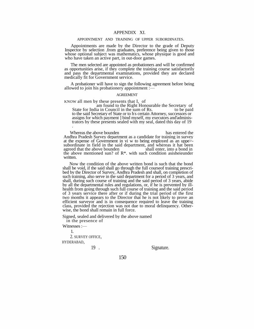
APPENDIX XI.
APPOINTMENT AND TRAINING OF UPPER SUBORDINATES.
Appointments are made by the Director to the grade of Deputy Inspector by selection .from graduates, preference being given to those whose optional subject was mathematics, whose physique is good and who have taken an active part, in out-door games.
The men selected are appointed as probationers and will be confirmed as opportunities arise, if they complete the training course satisfactorily and pass the departmental examinations, provided they are declared medically fit for Government service.
A probationer will have to sign the following agreement before being allowed to join his probationery appointment :—
AGREEMENT
KNOW all men by these presents that I, of am found to the Right Honourable the Secretary of
State for India in Council in the sum of Rs. to be paid to the said Secretary ef State or to h
:s certain Attorney, successors or
assigns for which payment ] bind myself, my executors and'adminis-trators by these presents sealed with my seal, dated this day of 19 .
Whereas the above bounden has entered the Andhra Pradesh Survey department as a candidate for training in survey at the expense of Government in vi w to being employed as an uppe>- subordinate in field in the said department, and whereas it hat been agreed that the above bounden shall enter, into a bond in the above mentioned sun? of R*. with such condition asisheieunder written.
Now the condition of the above written bond is such that the bond shall be void, if the said shall go through the full courseof training prescri-bed by the Director of Survey, Andhra Pradesh and shall, on completion of such training, also serve in the said department for a period of 3 years, and shall, during such course of training and the said period of 3 years, abide by all the departmental rules and regulations, or, if he is prevented by ill-health from going through such full course of training and the said period of 3 years service there after or if during the trial period of the first two months it appears to the Director that he is not likely to prove an efficient surveyor and is in consequence required to leave the training class, provided the rejection was not due to moral delinquency. Other-wise, the bond shall remain in full force.
Signed, sealed and delivered by the above named in the presence of
Witnesses :—
1.
2. SURVEY OFFICE, HYDERABAD,
19 . Signature.
150
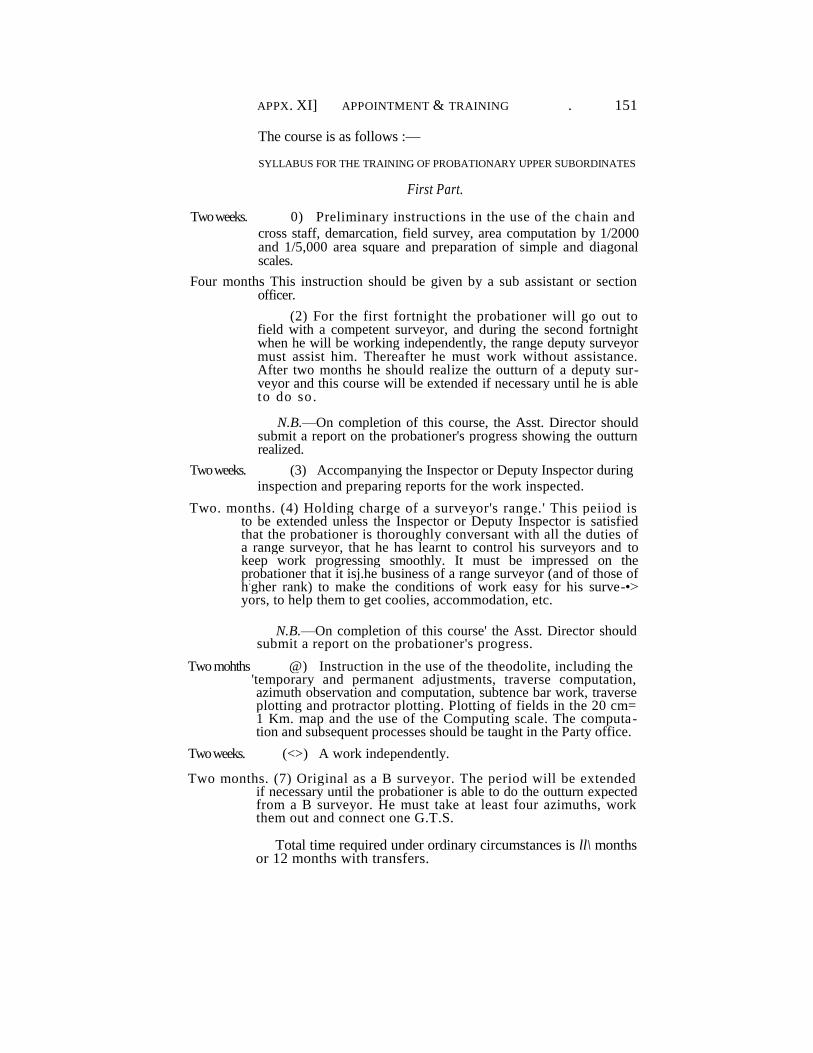
APPX. XI] APPOINTMENT & TRAINING . 151
The course is as follows :—
SYLLABUS FOR THE TRAINING OF PROBATIONARY UPPER SUBORDINATES
First Part.
Two weeks. 0) Preliminary instructions in the use of the chain and
cross staff, demarcation, field survey, area computation by 1/2000 and 1/5,000 area square and preparation of simple and diagonal scales.
Four months This instruction should be given by a sub assistant or section officer.
(2) For the first fortnight the probationer will go out to field with a competent surveyor, and during the second fortnight when he will be working independently, the range deputy surveyor must assist him. Thereafter he must work without assistance. After two months he should realize the outturn of a deputy sur-veyor and this course will be extended if necessary until he is able to do so.
N.B.—On completion of this course, the Asst. Director should submit a report on the probationer's progress showing the outturn realized.
Two weeks. (3) Accompanying the Inspector or Deputy Inspector during
inspection and preparing reports for the work inspected.
Two. months. (4) Holding charge of a surveyor's range.' This peiiod is to be extended unless the Inspector or Deputy Inspector is satisfied that the probationer is thoroughly conversant with all the duties of a range surveyor, that he has learnt to control his surveyors and to keep work progressing smoothly. It must be impressed on the probationer that it isj.he business of a range surveyor (and of those of h
:gher rank) to make the conditions of work easy for his surve-•>
yors, to help them to get coolies, accommodation, etc.
N.B.—On completion of this course' the Asst. Director should submit a report on the probationer's progress.
Two mohths @) Instruction in the use of the theodolite, including the 'temporary and permanent adjustments, traverse computation, azimuth observation and computation, subtence bar work, traverse plotting and protractor plotting. Plotting of fields in the 20 cm= 1 Km. map and the use of the Computing scale. The computa-tion and subsequent processes should be taught in the Party office.
Two weeks. (<>) A work independently.
Two months. (7) Original as a B surveyor. The period will be extended if necessary until the probationer is able to do the outturn expected from a B surveyor. He must take at least four azimuths, work them out and connect one G.T.S.
Total time required under ordinary circumstances is ll\ months or 12 months with transfers.
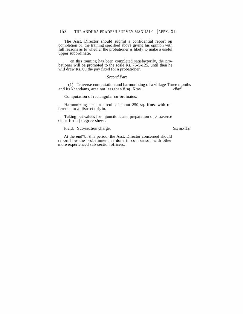
152 THE ANDHRA PRADESH SURVEY MANUAL^ [APPX. Xt
The Asst. Director should submit a confidential report on completion bT the training specified above giving his opinion with full reasons as to whether the probationer is likely to make a useful upper subordinate.
en this training has been completed satisfactorily, the pro-bationer will be promoted to the scale Rs. 75-5-125, until then he will draw Rs. 60 the pay fixed for a probationer.
Second Part
(1) Traverse computation and harmonizing of a village Three months and its khandams, area not less than 8 sq. Kms. office*
1
Computation of rectangular co-ordinates.
Harmonizing a main circuit of about 250 sq. Kms. with re-ference to a district origin.
Taking out values for injunctions and preparation of A traverse chart for a | degree sheet.
Field. Sub-section charge. Six months
At the end*bf this period, the Asst. Director concerned should report how the probationer has done in comparison with other more experienced sub-section officers.
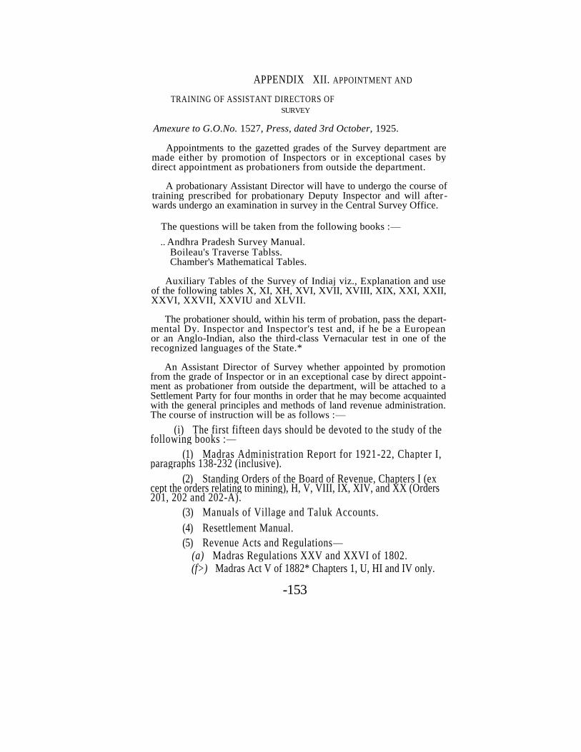
APPENDIX XII. APPOINTMENT AND
TRAINING OF ASSISTANT DIRECTORS OF SURVEY
Amexure to G.O.No. 1527, Press, dated 3rd October, 1925.
Appointments to the gazetted grades of the Survey department are made either by promotion of Inspectors or in exceptional cases by direct appointment as probationers from outside the department.
A probationary Assistant Director will have to undergo the course of training prescribed for probationary Deputy Inspector and will after-wards undergo an examination in survey in the Central Survey Office.
The questions will be taken from the following books :—
.. Andhra Pradesh Survey Manual. Boileau's Traverse Tablss. Chamber's Mathematical Tables.
Auxiliary Tables of the Survey of Indiaj viz., Explanation and use of the following tables X, XI, XH, XVI, XVII, XVIII, XIX, XXI, XXII, XXVI, XXVII, XXVIU and XLVII.
The probationer should, within his term of probation, pass the depart-mental Dy. Inspector and Inspector's test and, if he be a European or an Anglo-Indian, also the third-class Vernacular test in one of the recognized languages of the State.*
An Assistant Director of Survey whether appointed by promotion from the grade of Inspector or in an exceptional case by direct appoint-ment as probationer from outside the department, will be attached to a Settlement Party for four months in order that he may become acquainted with the general principles and methods of land revenue administration. The course of instruction will be as follows :—
(i) The first fifteen days should be devoted to the study of the following books :—
(1) Madras Administration Report for 1921-22, Chapter I, paragraphs 138-232 (inclusive).
(2) Standing Orders of the Board of Revenue, Chapters I (ex cept the orders relating to mining), H, V, VIII, IX, XIV, and XX (Orders 201, 202 and 202-A).
(3) Manuals of Village and Taluk Accounts.
(4) Resettlement Manual.
(5) Revenue Acts and Regulations— (a) Madras Regulations XXV and XXVI of 1802. (f>) Madras Act V of 1882* Chapters 1, U, HI and IV only.
-153
154 THE ANDHRA PRADESH SURVEY MANUAL AEPX.
Xlt
(c) Madras Act I of 1908, Chapters I, II, XI and XII and the executive rules printed in B.P. No. 4, dated 3rd February, 1925, and
1
the legal rules in B.P.No. 211, dated 22nd April, 1910, as revised in G.O. No. 2495, Law (General), dated 13th October, 1923.
(ii) Revision of registration (special staff work, etc.) and settlement in ryotwari areas—Two months.—(a) Principles on which ryotwari hold-ings are registered and transferred.
(b) Preparation of records for rough patta objection hearing-
hearing of objections and preparation, check and inspection of miscella
neous accounts; and
(c) General principles of revenue settlement and resettlement.
(iii) Registers prepared by a Settlement Party—Fifteen days,—•
Method and principles on which the registers are prepared; use of these
registers by the district revenue officials.
(iv) Maintenance—Ten days.—Preparation of demarcation sket-
ches, stone registers, inspection of stones.incorporatioo of subdivisions
in field measurement books and recording of changes in the other main-
tained records.
(v) Record of rights and settlement of rents—Proprietary estates—•
Twenty days.—(a) General principles of the preparation of a record of
rights and settlement of rents in proprietary estates.
(b) Registers prepared by the Revenue Officer; method and
principles on which they are prepared; use of these registers by Govern
ment and Zamindari Officials ; and
(c) Classes and treatment of Government lands in non-Govern
ment villages and Government Revenue accounts maintaiaed in connec
tion with them.
At the end of the course, the Special Settlement Officer should examine
the Assistant Director in the subjects prescribed above and report the
result to the Commissioner.
APPENDIX NO. xin.
CORRECTIONS AND ALTERATIONS IN COMPLETED SURVEY
RECORDS.
1. Maps and records once finished and sent to the Central Survey Office cannot be returned to Survey offices for correction except under special circumstances which should be reported in detail to the Director of Survey and" Land Records.
»
2. When correction is necessary, the following course should be followed :—
(i) CHANGES IN VILLAGE BOUNDARIES. -' ?
3; Theodolite stations should not be moved unless they lie off the new boundary. In this case a fresh traverse should be run, connecting it wiih the old stations in site on either side. Field stones should be used to mark the boundary as altered. The space included between the origi-nal and corrected boundaries should, wherever possible, be treated as an additional survey field and given the last number in the village concerned, irrespective of its position. Where the alteration is so slight as not to allow of an additional field being formed, the space should be included with the adjoining field or fields by removing existing field stones and planting new stones as may be necessary.
(ii) CHANGES IN FIELD BOUNDARIES.
4. The map should not be altered. The only records which should require alteration are—
1. Field measurement book.
2. Field register.
3. Area list.
5. If a portion of field No. 1 is found, after the map is finished, to belong to the owner of the adjoining field No. 2, it should not be included in field No. 2, but made a subdivision of field No. 1.
6. Immediately after the alterations on the ground are made, the necessary corrections should be made in red ink in all the records and maps affected and a memorandum of alterations sent to the Central Survey Office, in Form No. 84. The reason for the alterations should be fully explained.
155
156 THE ANDHRA PRADESH SURVEY MANUAL [Appx Xlll
(iii) CHANGES DUB TO DECREES OF COURTS.
7. The following is the procedure adopted for correction of boun daries in pursuance of decrees of Civil Courts. «
8. When decrees have been passed by Civil Courts affecting boun daries demarcated by the Survey department, the Courts themselves execute their decrees ; and where the decree alters a survey boundary line, the Amin of the Court entrusted with the execution, plants"the new boundary marks and removes the old ones where necessary.
9. He prepares a tracing from the village map and marks upon it the alteration made by him in execution. This tracing or sketch is then returned to the Court along with the warrant of execution by the Amin.
10. A copy of the decree, together with the Amin's racing or sketch of the alteration, will be sent immediately after execution fej'the Deputy Director of Survey and Land Records through the District Judge. The Survey department will then make the necessary alterations in the records concerned.
INDEX 157
INDEX TO CHAPTERS I TO XIV.
Chapter. Rule.
Amalgamation villages . I . . 5 Appeals, sec. 11, Act . IX . . 53, 54 XIV . . 4, 5, 6 Appeals, second, aot allowed . XIV . . 9 Arbitration . . . XIV .. 52,53 Area lists, preparation of —
Cadastral survey . IX .. 30—33 Town survey . XIII .. 169—171
Arrow marks, .stones . I . . 7, 10 XIII .. 14 Arrow to show direction of streams . VII .. 10 Azimuth—
observation of — . m .. 17,18,19 XIII .. 45
unnecessary in khandam circuit . in .. 19 computation of— . IV . . 6
B
Balance- spring, Salter's . m . . 5
XIII .. 41 Bearings —
deduced . IV .. 16 reduced . IV . . 7 true . IV . . 6
Bends— equalization of — . VI .. 13
Bill.. landholders . XIII . . 175
Block- Town survey — size of — . xm . . 9
.town survey numbering . xm .. 30 Board of Revenue..
departmental control of — . Intrdn. . .21 Boundaries- disputed settlement of— survey of— proprietary villages
. XTV . XI
.. Whole
.. 3 province or state . II .. 15 district or taluk . n . . 8 block — town survey . XIII .. 11 khandam . n .. 21,22 municipal . XIII . . 5 property town survey . . . XIII . . 77 reserved forest . ii . . 18, 19 river . ii .... 16, 17 river .. .. . . XI . . 4 streets XIII . . 90-91 and ward XIII .. 5
village — comparison of — village — tracings of — . vin
. VIII
.. 23 .. 24
Broad arrow — to be eut oa stones planted by other departments
if utilized as survey marks . VI ..38
158 INDEX
Chapter. Rule.
Cadastral- areas once surveyed ia towns .. .. XIII .. 109—111 object of survey .. .. .. Intrdn. .. Para. 3 survey definition .. .. .. 1 . . 1
Chain— Feet .. .. .. .. XIII .. 26 Standard .. .. .. .. Ill . . 6
Chaining— B work .. .. .. .. Ill . . 8
C h ar t - Traverse ,. .. .. .. Intrdn. .. Paras, 50,20
Check, final— .. Initial surveys ., ,. .. IX .. 51, 54 Resurvey .. .. .. .. XI .. 7—10
Check liaes— .. .. . . . . - , •* :'--'"*-' • Town surveys .. .. .. Xllf ."96—98
Circuits— Main and sab formation of— .. .. Ill . . 1 Once closed corrections of fotbidden without sanc
tion. .. .. .. .. f V .. 20 „ »urvey of— .. Ill . , 3
Village and kkandam, computation of— .. IV .. 22—42 „ survey of .. Ill .. 19
Classification Field work .. .. .. ..XII . . 18 ,19 ,2 0
Collecto— Amalgamatiom villages .. .. I . . 5 Boundary disputes .. .. .. XIV .. 27 Commemcement of smrvey, notice of— .. X . . 2 to receive triplicate F.M.B.'s .. . . X I . . 1 1
Convergency-meridian— application of correction and table .. .. IV . . 7
Co-ordinates, sectangular— computation of .. .. .. IV . . 15 values in traverse charts .. .. .. Int dn. .. Para. 5
Corrections— Latitude and longitude .. .. .. IV .. 14 Traverse field extracts .. .. .. IV .. 36
Correlation— Old and new field numbes .. .. X .. 14
Court-fee stamps— Land complaints and appeals .. .. XIV .. 7, 8 Required on appeals on behalf of Government. .. XIV . , 7
Credential— Surveyors .. .. •. .. II •. 2
D
Demarcation—See boundaries Fields, burial grounds .. .. .. VI ., 20
Cart tracks .. .. . . V I . .18 ,32 ,34,35 Canals .. .. .. XIII .. 74,81 Footpaths . .. . . V I . 3 4 Inams .. . .. .VI . 3 4 Irrigation channels .. . V I .18, 19, 32, 34 Lanes .. . .. . XIII . 74 Marketplaces . .. .VI . 2 0 Properties . .. . XIII . 78 Public Works . .. . V I . 1 9 Railway lands .. .. . V I . 25—32
XIII . 81
INDEX 159
Chapter. Rule.
D—(contd.)
Demarcation—(Contd.) Fields, Reserved forests ..
„ Rivers „ Roads
„ Streams „ Streets „, Tanks .. .. „ Topes „ Town survey blocks „ Town survey fields „ Village sites „ Description of errors in „ Rectification of mistakes in .. „ 'Percentage inspection not fixed „ Stones required on field and sub-division
boundaries
„ Town surveys-general Discrepancies— E.M.B. measurements Disputes—
Boundary—settlement during the course of survey VI Boundary—General rules .. .. XIV Boundary—Government, a party .. .. XIV
Definition- Cadastral survey .. .. . . 1 Resurvey • • • • • • . . X
. 18,19 19 74 19,19,2024, 32,35 74,81 18 74 74 20 17 58 20 5 7 6
13 2 58—78
4—8
17 Whole Chap. 27,28
1 1
E
Easements— Survey officer not authorized to settle
Enclosures— Reserved forests in
Encroachments Poramboke
Streets Enlargement
Small field maps Error—
Angular Wmit allowed Distance limit allowed
Measurement field survey.. Passable in town surveys (field)
Evidence— How to be recorded To be taken on oath
XIV VII
VI XI XIII
IX
IV IV XIII XII XIII
XIV XIV
22 5 196,198
6
9 19 47 17 121—123
37,38 35,36
FFee, process (Field—
Clubbing Inam
XIV
VI VI
17,18
9—12, 18 34
II VI XIII VI
XIII VI XIII XIII VI XIII XIII VI XII XII XII
VI XI XIII
VIII
160 INDEX
Chapter. Rule.
F—(Contd.)
Field— (Co«tf.) Measurement .. vn . . 1—5. New formation during survey . . X .. llv Numbering — initial survey .. VI .. 44.
,, resurvey . . X . . 12. • ,, town survey . . XIII . . 84, 146, 147.
Numbers, old and new, correlation of — . . X . . 14. I aimash .. VI .. 8. Revenue .. VI . . 8. . ' Survey .. VI . . 9, 10. Stone demarcation required .. XI .. 13.
Field books . . Traverse, examination of — .. IV .. 3.
,, Preparation of — cadastral .. Ill j.JM*. . ; ,, ,, towns . . XIB ---- - rrsO?. 44. Field measurement book, cadastral — . .
Plotting and scale required .. VII .. 15—22. .. VIII .. 21.
Specimen plot . . Appx. VI To be signed by surveyors .. VII .' '. 25.
,, inspectors .. VII .. 29. Comparison .. VIII . . 1—8.
XII .. 28. Area taking . .VII .. 23.
. . IX . . 7—14. Preparation of triplicates .. IX .. 55.
Field measurement book, street surveys — Preparation .'.' XIII .. 197—199. Area taking unnecessary . . XHI . . .200.
Field measurement book, town surveys —
Preparation . . XIII .. 110,111,145
Field register—
Rough, towns . . XIII . . 84. .. XIII . . 85, 89.
Fair .. .. .. XIII . . 187. Fields, small- Enlargements of — Field work —
.. IX .. 6.
Inspection of — .. xn . . Whole. Final examination . . Field, cadastral— . . XII .. 34.
,, towns .. XIII . . 128—132. Office, cadastral .. IX .. 49.
„ towns .. XIII . . 189, 190. Forest, reserved —
Cultivation in . .. .. VI .. 37. Detached bits .. VII .. 6. Enclosures in . . .. VII .. 6. Tracings for D.F.O. . .. . . IX . . 46.
G.
Government — Lands in municipalities . . .. VI .. 36.
,, inam villages .. VI .. 33. Ground rent-Lands assessed for
VI 36.
161
INDEX
Chapter. Rule.
H
Hedges- treatment of as boundaries • • VI | .. 16.
Holdings. — Joint, entry of names in register . '* .. 53
I Inam fields. —
Excess area in .. . 24. Index map- Town suveys Inspection —
jj ..8,17,28.
Distribution among inspectors. . .. XII . . 9,32,33. Inspection
Report . .
. . 16,22. . . XIII ..119-
The<}dsjjie demarcation .. II . .26. . • ••'•' -̂ ^̂ ^̂ 3 :̂.. ;'*y . -•. Inspectors-
duties of— ' .. VII . . 28,29. .. XII . . 26,29. . . XIII ..112,125-
J. K.
Karnam— • Atteadance during survey .. VI .. 6.
Khandam— Formation of — .11
20—22. Inspection of . XII - 31. Numberingf of — .11 24. sketch . .. . VI 39.
. XII 13. survey of— . . .III 10.
Khasra . Intrdn. Para. I.1
L.
Lambton's stations —
correction to values of — .. IV. .. 14. table of corrections . . Appx. Ill
Land register- Initial survey .. VI . . 48—54. resurvey .. X . . 13,14.
Levels- High and low side of— . . . . . . Ill . . 21—2*.
LwMjty- open (Towns) .. XIII .. 79.
Line clearing-
check of— ..II . . 26. M.
Madras survey department, constitution etc. . . Intrdn. . . Para. 21. VHf n lfltM|*|%{**
. . ibid. |>flfa 0^ Maps — • . t aicit 4*&*
Outline sheets . . Intrdn. . . Para 5. Village traverse plotting .. V . .2—16.
,, filed-plotting ..VIII ..10—13.
2487—B—11
162 INDEX
Chapter. Rule.
M.— (Contd.). Maps— (Contd.)
Village tracing and correcting errors „ trating plotting „ boundary comparison . .
. .VIII » ..14,15,18-20
.'.'23,24. „ inking . . IX. .. 1, „ typing >3 ..2,3,4,5 33.
37—42. „ area computation . . 15—22,26,27 „ area comparision ..27—29. ,' detailing .'. . . 34-36,43,44. „ mounting .. 47. „ persons responsible for work . .48. „ final examination .. 49. „ list of records ••SO.
Towns-preparation— Traverse plotting ..X m . . 50—57. „ mapping .. .. . . 140—148. „ area computation
t . . 149—172. ,, finishing , . . 177—190.
Towns, miscellaneous — Fair block map J > . . 142—148. Final examination t 9 . . 189. Index map t > ..8,17,28. Scales, block map . • . . 50. Town map . . . Intrdn. ..Para, 11.
N. Non-attendance—
of parties .. II . .7 , . .VI. . . 5. . . XIV. .. 39. Notification-
sections 5 and 17. ..I . .2 . XIII .. 1.
section 6 ..I. 3. ..xnii! 1.
section 13 ..IX. 1 55. ..xraj 178.
section 9 (2) . . IX .. 52. XIII . . 178. Notices— " Cadastral survey, boundary ii . . 3,4,5.
field . .VI . .4 . to Government departments * * 99 . . 19. . service of ..II . . 6. Town survey — Commencement of work . . . . XIII . .2 .
„ Completion of work » . . 178. „ Closing of streets .. 9» .. 34.
O.
Occupation — Discrepancy between ground and accounts Present, to be respected
...VI • * 9
T . .50. ..13.
. . XIII .. 76. Officers— Appointment and
training of— Appx. XII
163
Chapter. R*le.
O.— (Contd.)
Offsets- Village boundary, maximum distance from area, computation of
. . II . . IX
11. 35, 26.
. . XIII 170. Orders —
Communication of— under Act . . XIV 43, 44, 4». Origin — District . . . . . . IV 7.
Outline shettt .. . . Intrdn. Para. 5. Outturn — of inspection of registry . . . .XII 3.
„ measurement • • » " • 30. P.
Paimash — Description of — v. Intrdn. Para. 1. field. 8. ttSfflfeKltobe accounted for '.'. Vl" '.'. 51.
Party — survey, composition of—- . . Intrdn. Para. 21.
Petitions — Bound ry dispute registers . . XIV 10. unstamped » 11.
Plotting— Test by inspections . . XII 28. General — Set Maps
Poramboke — Communal, list of— . . Note - 1 he- d
of Chapter VI. Demarcation of, exclusions from enoro?chi»ent in
. . VI 21. 21, 22.
straightening boundaries of— „ 21, 22. Preliminary enquiry — Bounds ry disputes . . XIV 29, 30.
Possession — adverse • * » * • 57.
Procedure- Code of Civil- • • >» • • 55.
Process fee— .. amout of— . . .'.'Appx. x
• • • • • . . XIV 17,18." '* Process pee* • • ji • • 31, 33.
Programme — surveys . . Appx. II ..
Properietary estates — survey, notification of — ..I 2.
Province- Boundary, demarcation of— . . II 15.
Intrdn. Para»-5. Purtal— Description of and method of measuring . . VII 27.
XII 8, 10—13. Q.
Quality — Field work, determination of— *. . . . XII 18. Unit for • * ]9 * i 21.
164 INDEX
Chapter. Rule.
R.
Range— , Deputy surveyors, composition of— Rechaining— B work
Comparsion of— • • unnecessary on khandam boundaries- Records— . Initial survey, to be prepared • • to be sent to special officer " disposal of.. Resurvey, to be prepared and their disposal
to bo sent to special officer Collector..
Town survey, to be prepared and their disposal to bo sent to special Officer
Boundary .disputes Complied iterations in> ..
Record of measurement Registry, chock of—
preparation of, Cadastral Survey, initial * „ resurvey .. " ,, Town survey
Repetition angles, reading by , Representative fraction Resurvey—
Definilion of— Prelimiii"ties .. . •• . Th<;odo'.iu< survey required during ..
Revenue Officer
Revenue Divisional Officer ..
Revision-Bad work
. Cost of, recovery Survey
River boundaries
Illustrative sketches Rock marks-Symbol for ..
S.
Section and sub-section .. • • Sevaijamma, survey oi •. to be
shown in location sketch
Sketch-Boundary demarcation
Correction •• . ,,." Demarcation, sketch field Eye
Location
VI
Ill . . 8. IV .. 10. .III . . 19.
. IX .. 50.
., 51. .. 60. '. Xl" .. 12. .. 7. .. 11. '. XIII . . 190. .. 133. .'xiv ..56. . Appx. Xllt .Xffl '.'. 109, 179—188 . X . . 6, 10. . XII .. 2. . VI . . 48—54. . X .. 13,14. .XIII . . 85—89, 187. .. Ill . .7 . ,. IX . . 42, 43. ,. Appx. VII. .. .. X .. 1. . . Whole.
* . 5.
:: ix" .. 51.
.. XI .. 7. .11.
. . IX . . 51, 52.
..XIV .. 27.
. .XII ..23,24.
.. 25. . . IntrdH. . . Para. 3. .. II . . 16, 17. . . VIII .. 22. . .XI .. 4.
. . Appx.
vm
..
. . II . . 14.
Appx. V . . . . .
.. VI . . 2 , . . 23;
::x" ::r
..ii ..23.
VI ..7,39. . . VIII . . V I
.. 20. . . 39, 43.
. .V I I . . 26, 27.
.. I .. 4.
. Ill .. 2.
.. X ..7—10.
. .X I .. 6.
INDE 165
Chapter. Rule.
S.— (Contd.)
Sketch— (Contd.) Town survey-block . . XIII . . 94,96,98,
v ' 140, 141. ,, ward * " *t . . 28,29,31,32
Special Officer »» • -3,127,128,130, . . 130,131, . . 135,136,
Standard chain . . Ill . . 201,202,203, . . 6.
Stations — Chain sruvey . . XIII . . 19,95,106. Theodolite (cadestral survey) fixing .. II . . 9,10.
„ depth to be planted • • » .. 12. Interpolated • • Jl .. 10. Missing, replacement of .. X .. 5. Theodolite (town survey) planting . . XIII . . 20—24. Great Trigonometrical, connecting — .. Ill . . 13—15.
„ inspecting — • • »l ..26. ' "«>% ..;.-v ̂ Utility explaned . . .. IV .. 13,15,18,21.
Lambtens .. • • s» . . 14. Madras survey • • » .. 14.
Stones- Accounts kept by village munsif .. I . . 18.
Chairman, Municipality . . XIII .. 15. field surveyor .. .. I .. 19.
General supply, etc., material description, mariks .. I ..6,7. • tenders . . >» . .8 .
contract . .9 . passing . . ' • • » .. 10,11,12. pass lists » • 99 . . 13,14,15,16. delivery in villages . . 17.
Miscellaneous abstract sketch "ll .. 25. Numbering in field sketch .. VII .. 26. Old stones, removal of .. XI .. 2. Planted by other departments Where required in cadastral surveys
.. VI. • • Jl
.. 38. .. 13.
. . X I ..2. • „ in town surveys . . XIII .. 13,78.
Straightening field boundaries „ poramboke boundaries
.. VI • • •»
. . 13—15. .. 21.
Street, survey of . . XIII . . 191—206, Street alignments • • f* ,. 120,134—139
Sub-Assistant Inspecting for officer .. . .XII .. 33.
Sub-divisions — Slumbering during intial survey . .VI . . 43.
,, resurvey ..X .. 12. Maximum number in survey field .. VI .. 10.
Summonses, service of . .XIV . . 14,15,20— 26,31—34.' ' Code of Civil Procedure applicable . . . . , , . . 54,55; Survey, Methods explained— system — Block map . . Appx. II
Initial cadastral survey, revision survey and resurvey Kaiiikate and Atagad
. . Intrdn. . . Appx. II
. . Paras. 3,4.
Mamul wet . . Intrdn. .'.'Para'l'3. Plane table . . Appx. II Punganur system . . Intrdn. .'.'?. Revision .. . '• » .. 3.
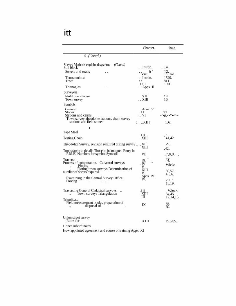
itt
Chapter. Rule.
S.-(Contd.).
Survey Methods explained systems— (Contd.) Soil block . . Intrdn. .. 14.
Streets and roads . . . . it ' 12. XIII 191 206. Topographical . . Intrdn. 1520. Town • • ,, 811.
XJII 1 190. Trianagles . . . . Appx. II
Surveyors Field two classes .. .. .. XII 14. Town survey . . XIII 16.
Symbols
General . . Appx. V. Stones . . I I 23. Stations and cairns . . VI - "•& ••*••>- Town survey, theodolite stations, chain survey
stations and field stones
T. Tape Steel
Testing Chain
Theodolite Survey, revision required during survey ..
Topographical details Those to be mapped Entry in F.M.B. Numbers for symbol Symbols
Traverse Process of computation. Cadastral surveys
,, Ploting ,, Ploting town surveys Determination of
number of sheets required
Examining in the Central Survey Office .. Proving .. . . . .
Traversing General Cadastral surveys .. ,, Town surveys Triangulation
Tripolicate Field measurement books, preparation of
„ disposal of .. .,
Union street survey Rules for . .XIII 19120S.
Upper subordinates
How appointed agreement and course of training Appx. XI
1 ..XIII 106.
. I l l XIII
, XII XIII
, 5. 41,42.
29.
,42.
,4,5. VII » >
IX. Appx. V.
7,8,9. , 13. 44.
Whole.
50,57. 4,5,6.
20. " 18,19.
. IV V. XIII
. V. Appx. IV. IV.
. I l l XIII III
Whole. 34,45. 12,14,15.
IX 55. 60.
INDEX 167
Chapter. Rmlt.
^ f ^ V.
Vernier Angles to be read to minimum (radiation of . . III . . 7 .
Tillage sites Detailing of .. .. .. . .VII . .14 .
Village officers Attendance during surrey .. . . II .. 9.
smrrey ekeqwry into a bora- VI . . 4 6 . dary dispute .. .. .. XIV 26.
Village Munsif To take charge of sirreystoaes .. . . I . . IS .
Villages Numbering of ia eye-sketck .. .. .. 4.
W.
•••'ifljjffftfa .̂ <
Unsnrreyed treatment of '.'. ,\ '.'. VI .. 23. Water rights .. .. . . .. XTV . . 2 . Witness batta . . . . . . . . 1 9 .
Witeness CoTernment servant .. . . . . .. 25.
X.
Y.
2
Copy of:
Sndt.No.A4/1170 9/34
COPY COMMUNICATED.
Offie- of th; S e 111 e me n t s , S • A r Y e- y y •" r:,:i
''Dt. 7-3-" 1336
P. S a 1 b a ba, f o r D i rector.
Copy of: T OP. AKDHiiA ?RAD .m ABSTRACT
MANUALS - Andhra Pradesh Survey Manual iunGiidraonts to De£artmental_Rules_Vol._I__and _XJ_ 7__ Orders _r ..lasued..
11 xvV.uIJU.fi; (it) D^i'jiiffiiii^O:
(j.O.Ma.i'io. 92. -Uated the 2?th Jaii.t36.
lie a d the f o 11 ow. in '̂;
1. Prom the Commissioner,Settlaments,Survey
and Land Hecords,Re.So.J34/11709/84,dt.1,9.84.
2,From the Director,Survey & ^and Records, Re.No.A4/11709/84,dt.11.7.1985.
ORDER: The following amendments I and II to the Andhra
PradeshSurvey Manual of Departmental Rules Vol.1 and II are i-ss^il.
Existing Paragraph. The following are the inst ruments generally used in cadastral Survey iu AP. _______ (11 _______ „. ________
.1.Chain
In S2.Cross Staff Pie\3.Off-set Pole Id. U. Theodolite
• 5.Circumferenter
i6.Prismatic Compass
'7.Plain Table.
1.Plotting Compasses
2.Proportional Compasses
3.Beam Compass
4.Ben Compasses
5.Drawing Pen
6..faralle Kulo
7. Scales
8.Protractor
9.Pantagraph 10.Computing Scale 11.Area Sqaare.
Revis e.d
The following are the inst-ruments used in Cadasfe-ral Survey in A.P.
_. (2) _ _ ______
1.Electronic Distance Measuring instruments with prisms.
2.High Precision Optic Scale Theodolite or Transit Theodolite.
3.Chain
4.Cross-btaff
5.Off-Set Pole.
6 . C i re uia£e rent e r. 7.Prismatic Compass.
tj.Plane 'iable
In i Fie: Id.
In }9.Scientific Electronic „ Fiel calculator.
Id MO.Computer as well as Office
11.Plotting Compass 12.Proportional Compass 13.Beam Compass 14.Drawing Pen 15.Parallel rule 16.Scale 17.Protractor iS.Pantagraph 19.Computing Scale 20.Area Square.
This chapter deals with This chapter deals with th
the dsscription and use description and use of the
of these instruments. instruments.
The following words and terms as they appear in'the A.P Survey Manual of Dept.Rules, Volume.I and the AP Purvey and Settlements Manual, and proposed to be with the addition of some more words and terms as indicated below.
The words and terms as To be read as; existing in the Manuals
1 .Theodolite. Optic scale theodolite of
transit theodolite.
2. Chain, Cross-Staff. Chain and cross-staff or
optic scale theodolite coupled with an electronic distance measuring instruments. 5. Chamber's Tables, Chamber's Tables, Bicler's
Boiler's Traverse Traverse Tables, Square Roots, Tables, Square Roots Hypotenuse Tables, Clarke 's Hypotenuse Tables and Tables, Scientific Electronic other ready reckoners. Calculators and other ready
reckoners.
4. Diagonals, Off-sets, Diagonals, Off-sets, Iambi'.;
lambis and rundts. rundis, polar and rectangular
c o - o r d i n a t e s .
(BT ORD^,R AND IN THE NAME OF THE GOVEiiNOE OP A1SDHRA EttADESE)
SR1H IVASAHAG SUBNAVIS , DEPUTY SJCR^TAKY i'G GGVj-iRMMT.
To
The Commissioner, Settlements) Survey and JJand Coords, Hyd The Director of Survey and -uand &e©oi-rds,Hyd. All CollectorsCScfcLRs.)
_____ . — Office of the Dy.DirecJgr(S&I*Rs)
- C en t rM. Surrey7 XJ^Et^STaerat
RC.C2/1096/86 Dt. 4-4- 1986
Copy communicated to the SPs of Dy.Directo. ,Asst . Directors, Superintendents, MT;F1 and C2. Copy to the Books of AP. Survey Manual Vol.I&II in Stock through '02' who will paste them and report compliance.
vL-Stovl to C I "
> ' *- •• / / t - c - f -b -o - / / SdX-M.K.A.SUBHAN
f Deputy Director
vu~~^!H
yl)
VK* Superintendent